draft mark youngdahl urban conservation area … public with viewing opportunities of urban wildlife...
TRANSCRIPT

DRAFT Mark Youngdahl Urban
Conservation Area
Twenty-Year Area Management Plan FY 2018-2037
To submit a comment on this document, click on the following link: https://mdc.mo.gov/node/10013?ap=14602

May 2017 - DRAFT Mark Youngdahl Urban Conservation Area Management Plan Page 2
OVERVIEW
• Official Area Name: Mark Youngdahl Urban Conservation Area, #8330 • Year of Initial Acquisition: 1983 • Acreage: 85 acres • County: Buchanan • Division with Administrative Responsibility: Forestry • Division with Maintenance Responsibility: Forestry • Statements of Purpose:
A. Strategic Direction Manage Mark Youngdahl Urban Conservation Area (CA) to demonstrate urban conservation landscapes (including demonstration plantings, savanna, wildflower meadows, and old fields) while providing public recreational opportunities. Provide the public with viewing opportunities of urban wildlife habitat and upland game and non-game species.
B. Desired Future Condition Maintain a healthy and sustainable urban conservation landscape while providing public recreational opportunities.
C. Federal Aid Statement N/A
GENERAL INFORMATION AND CONDITIONS
I. Special Considerations A. Priority Areas: None B. Natural Areas: None
II. Important Natural Features and Resources
A. Species of Conservation Concern: None observed. B. Caves: None C. Springs: None D. Other: Mark Youngdahl Urban CA is located within the loess hills soil formation.
Loess soil is a unique natural feature formed as the ice age glaciers melted, leaving behind very fine wind-blown deposits. The soil is prone to erosion, especially if the original columnar structure is disturbed. Because loess soils are very well-drained and contain only small amounts of clay, permanent water impoundments are difficult to create. Local relief can be as much as 200 feet of loess soil on top of a base limestone shelf.

May 2017 - DRAFT Mark Youngdahl Urban Conservation Area Management Plan Page 3
III. Existing Infrastructure • Two concrete/asphalt parking lots, American Disabilities Act (ADA) accessible. • Two picnic pavilions (ADA accessible) • Two grills • Six picnic tables (two are ADA accessible) • One drinking water fountain (ADA accessible) • One privy (ADA accessible) • Marsh Trail, 0.67-mile multi-use hike/bike trail • Ridge Trail, 0.76-mile asphalt ADA-accessible trail • Pond Trail, 0.70-mile asphalt ADA-accessible trail • Two wooden footbridges • Two wetlands, including dam structures and drain tubes • One concrete observation deck • Two fishless wildlife watering holes
IV. Area Restrictions or Limitations
A. Deed Restrictions or Ownership Considerations: There are no deed restrictions. In March 1983 the Missouri State Commissioner of Administration reassigned the property from the Missouri Department of Mental Health to the Missouri Department of Conservation. In July 1984, Missouri Governor Christopher “Kit” Bond deeded the property to the Missouri Conservation Commission.
B. Federal Interest: Federal funds may be used in the management of this land. Fish and wildlife agencies may not allow recreational activities and related facilities that would interfere with the purpose for which the State is managing the land. Other uses may be acceptable and must be assessed in each specific situation.
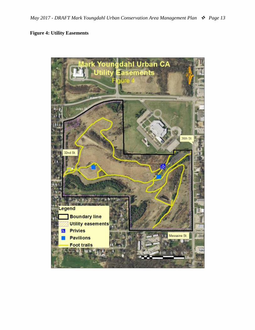
C. Easements: Public road, buried cable (Southwestern Bell Telephone Company), and overhead power line rights of way
D. Cultural Resources Findings: No known cultural resources. E. Endangered Species: None observed. F. Boundary Issues: None
MANAGEMENT CONSIDERATIONS
V. Terrestrial Resource Management Considerations
The Mark Youngdahl CA contains 45 acres of mixed tree and shrub plantings that cover 53 percent of the area. The plantings were installed for a variety of reasons, including wind and visual barriers, wildlife habitat and urban conservation demonstration. Of the 45 acres, 7 acres are native riparian woodlands containing mostly mulberry, cherry, ash, cottonwood, and boxelder trees. Approximately 2 acres near the west pavilion were

May 2017 - DRAFT Mark Youngdahl Urban Conservation Area Management Plan Page 4
planted as a savanna re-creation consisting of widely spaced oak species, including black, swamp white, white, and bur oaks, warm-season grasses and wildflowers. The remaining 36 acres are plantation type plantings of mixed native and non-native species. Twenty-one acres are a mix of non-native pines (red, white, jack, Austrian, scotch, fir, and spruce) and cedar. Fifteen acres are a mix of native hardwood species, including red and white oaks, walnut, hickory, ash, birch, sweetgum, and others. A variety of native and non-native specimen trees are planted along the foot trails and parking lots to demonstrate tree selection options. Warm-season grasses and wildflowers have been established on approximately 8 acres (not including the savanna re-creation). The area’s remaining 30 acres are managed as old field or groom mowed (approximately 8 acres) in high use areas that contain a mix of cool-season grasses, including brome, redtop, orchard, and fescue. Challenges and Opportunities:
1) Maintain the urban conservation habitat on the area. 2) Monitor for and control invasive plants, diseases, and animals. 3) Future challenges may include threat of infestations of Japanese knotweed,
thousand canker disease of black walnut or gypsy moth.
Management Objective 1: Maintain a diverse mix of habitats that serve educational needs and highlight how Missouri’s native plants can be successfully used in urban landscapes.
Strategy 1: Mow and maintain limited high-use areas using contract services. (Forestry) Strategy 2: Provide diverse cool- or warm-season grassland habitat using mowing, disking, chemical treatments, or prescribed fire, as needed and practical. (Forestry) Strategy 3: Where practical, convert non-native grasses to native cool- or warm-season grasses and forbs. (Forestry) Strategy 4: Replace dead or damaged trees and shrubs. Replacement plantings will be done primarily using native species. In select circumstances replacement planting may be non-native species that are recommended by the Department. (Forestry)
Management Objective 2: Monitor and control for invasive plants, insect pests, and diseases.
Strategy 1: Monitor and control existing invasive plants. Invasive plant species in the area include bush honeysuckle, autumn olive, Callery pear, black locust, tree-of-heaven, chaste tree, burning bush, Johnson grass, pampas grass, fescue grass,

May 2017 - DRAFT Mark Youngdahl Urban Conservation Area Management Plan Page 5
white poplar, and sericea lespedeza. Control methods used for invasive plants may include, but are not limited to, chemical, biological, mechanical, or other means determined to be appropriate. (Forestry, Resource Science) Strategy 2: Monitor and control existing insect pests. Pest insects on the area include emerald ash borer. Control pest insects as warranted using pheromones, detection traps, live traps, observation, and other available resources and technologies. (Forestry, Resource Science) Strategy 3: Monitor for new invasive plants, diseases, and animals including but not limited to thousand canker disease of black walnut and Japanese knotweed. (Forestry, Resource Science)
VI. Aquatic Resource Management Considerations
There are two small wetlands (3 acres total) and two small waterholes (approximately 1 acre total) on the Mark Youngdahl Urban CA. These water bodies are fishless and are managed to promote insects and amphibians drawn to shallow-water habitats.
Challenges and Opportunities:
1) Maintain area waterholes and wetlands as fishless bodies of water. Control introduced fish (goldfish) and invasive plants (cattails).
Management Objective 1: Maintain the waterholes and wetlands as shallow and fishless to promote aquatic insect and amphibian habitat.
Strategy 1: Maintain these resources as shallow fishless waterholes and wetlands. Monitor for and periodically remove any introduced fish or animals, as needed. (Forestry, Fisheries) Strategy 2: Manage invasive aquatic plants using mechanical and chemical treatments. (Forestry)
VII. Public Use Management Considerations
Wildlife species that can be found on the conservation area include rabbits, squirrel, raccoons, deer, foxes, and numerous species of birds. The area receives moderate use by birders and other wildlife watchers, and heavy use by walkers.
Challenges and Opportunities:
1) Provide public access to the area’s resources and opportunities for outdoor recreation, such as walking and wildlife viewing.
2) Continually evaluate area regulations to provide an accessible and safe place for public recreation.

May 2017 - DRAFT Mark Youngdahl Urban Conservation Area Management Plan Page 6
3) Provide outdoor educational opportunities for the public and information about the area.
Management Objective 1: Maintain infrastructure and regulations to provide the public with access to the area’s resources and recreational opportunities.
Strategy 1: Annually monitor area regulations. (Forestry, Protection) Strategy 2: Provide a quick response to issues or questions that arise from area users or activities. (Forestry, Protection) Strategy 3: Allow year-round access for area users to enjoy Missouri’s urban outdoors appropriately and in accordance with area regulations. (Forestry) Strategy 4: Partner with volunteer groups (such as Loess Hills Chapter of Missouri Master Naturalist, Boys Scouts of America, Friends of the St. Joseph Animal Shelter) to maintain and enhance the area. (Forestry) Strategy 5: Prune trees and shrubs, as needed, to provide clearance for users and equipment, especially along foot trails and around facilities. (Forestry) Strategy 6: Maintain area infrastructure in accordance with Department guidelines to ensure that signage, parking lots, trails, pavilions, and privies are in good condition. (Forestry, Design and Development)
Management Objective 2: Provide area information and educational opportunities to the public.
Strategy 1: Ensure that information regarding the area is accurate, consistent, and available to the public through contact with area staff, the Conservation Atlas database, posted signage, and area brochures. (Forestry) Strategy 2: Communicate to teachers, students, scout groups, and youth groups the uniqueness of the area to facilitate as a possible destination for ecology classes, school programs, and workshops. (Forestry, Outreach and Education)
VIII. Administrative Considerations
Challenges and Opportunities:
1) Maintain area boundaries. 2) Consider acquisition of land, when available.
Management Objective 1: Maintain area boundaries.
Strategy 1: Maintain area boundaries every five to seven years, or as needed. (Forestry)

May 2017 - DRAFT Mark Youngdahl Urban Conservation Area Management Plan Page 7
Lands Proposed for Acquisition: When available, adjacent land may be considered for acquisition from willing sellers. Tracts that improve area access, provide public use opportunities, contain unique natural communities, and/or species of conservation concern, or meet other Department priorities, as identified in the annual Department land acquisition priorities, may be considered.

MANAGEMENT TIMETABLE
Strategies are considered ongoing unless listed in the following table: FY
18 FY 19
FY 20
FY 21
FY 22
FY 23
FY 24
FY 25
FY 26
FY 27
FY 28
FY 29
FY 30
FY 31
FY 32
FY 33
FY 34
FY 35
FY 36
FY 37
Administrative Considerations Objective 1 Strategy 1 X X X

APPENDICES
Area Background: Mark Youngdahl Urban Conservation Area (CA) is located inside the city limits of St. Joseph (population 75,000), in Buchanan County. In March 1983 the Missouri State Commissioner of Administration reassigned the property from the Missouri Department of Mental Health to the Missouri Department of Conservation. In July 1984, Missouri Governor Christopher “Kit” Bond deeded the property to the Missouri Conservation Commission. The area was named after a prominent local politician, Mark Youngdahl, who helped with the transfer of the land to the Department. The area currently contains 85 acres. The conservation area was originally transferred and deeded to the Department to provide recreational opportunities for a large metropolitan area. Approximately 53 percent of the conservation area is currently covered in planted native and non-native trees and shrubs. The remaining acres are old fields, closely mowed high-use areas, native warm-season grasses, wildflower plantings, watering holes, wetlands, and area facilities (parking lots, trails, and pavilions). Special facilities include three hiking trails (two are ADA-accessible) and two picnic pavilions, including picnic tables and grills. Current Land and Water Types:
Land/Water Type Acres Feet % of Area Old field 30 36 Tree plantings (mixed pine) 21 25 Tree plantings (mixed hardwood) 15 18 Native forest/woodland 7 8 Native warm-season grasses 7 8 Tree plantings (savanna) 2 2 Wildflower plantings 1 1 Water 1 1 Infrastructure (parking lots, trails) 1 1 Total 85 100 Stream frontage 0
Maps: Figure 1: Area Map Figure 2: Aerial Map Figure 3: Vegetation Map Figure 4: Utility Easements

May 2017 - DRAFT Mark Youngdahl Urban Conservation Area Management Plan Page 10
Figure 1: Area Map

May 2017 - DRAFT Mark Youngdahl Urban Conservation Area Management Plan Page 11
Figure 2: Aerial Map

May 2017 - DRAFT Mark Youngdahl Urban Conservation Area Management Plan Page 12
Figure 3: Vegetation Map
May 2017 - DRAFT Mark Youngdahl Urban Conservation Area Management Plan Page 13
Figure 4: Utility Easements

May 2017 - DRAFT Mark Youngdahl Urban Conservation Area Management Plan Page 14
To submit a comment on this document, click on the following link: https://mdc.mo.gov/node/10013?ap=14602