{draft} kenya coastal development project
TRANSCRIPT

PROCESS FRAMEWORK
{Draft}
KENYA COASTAL DEVELOPMENT PROJECT
Prepared by Government of Kenya
Kenya Marine and Fisheries Research Institute KMFRI
APRIL 30, 2010
Pub
lic D
iscl
osur
e A
utho
rized
Pub
lic D
iscl
osur
e A
utho
rized
Pub
lic D
iscl
osur
e A
utho
rized
Pub
lic D
iscl
osur
e A
utho
rized
Pub
lic D
iscl
osur
e A
utho
rized
Pub
lic D
iscl
osur
e A
utho
rized
Pub
lic D
iscl
osur
e A
utho
rized
Pub
lic D
iscl
osur
e A
utho
rized

Table of Contents
1.0 Project Components .............................................................................................. 5
2.0 Socio Economic Characteristics ............................................................................ 7
3.0 Community Mobilisation .................................................................................... 11
4.0 Methodology for the Consultation ....................................................................... 11
5.0 Key Findings ...................................................................................................... 12
5.1 Conflicts and Resolution Mechanism .................................................................. 15
6.0 Monitoring and Evaluation .................................................................................. 16
7.0 Grievance ........................................................................................................... 17
8.0 Disclosure ........................................................................................................... 17
ANNEXES .................................................................................................................... 18
A��EX 1: Outline of an Action Plan ..................................................................... 18
A��EX 2: Summary of Stakeholder Meetings ...................................................... 19
A��EX 3: Map of the project operational area .................................................... 23
A��EX 4: Terms of Reference for Developing a Process Framework ................. 24
A��EX 5: Policy Requirements for a Process Framework in OP4.12 Annex A 26


List of Abbreviations
KEFRI: Kenya Forest Research Institute
KWS: Kenya Wildlife Service
KMFRI: Kenya Marine and Fisheries Research Institute
KCDP: Kenya Coastal Development Project
BMU: Beach Management Unit CBO: Community Based Organisation CFA: Community Forest Association IP: Indigenous Peoples KFS: Kenya Forest Service MPA: Marine Protected Area NEMA: National Environment Management Authority NGO: Non-Governmental Organisation NRM: Natural Resource Management

1.0 Project Components The Kenya Coastal Development Project (KCDP) focuses on promoting growth and reducing poverty in one of the poorest provinces in Kenya, the Coast Province. The project design internalizes a framework for environmental and sustainable utilization of natural resources within which all activities of the project will be implemented. The project focuses on the marine and the in-shore and coastal environment and promotes policy, legislative and institutional reform geared at increasing revenue, productivity, incomes and quality of life for the poor. The project also has a strong focus on the Exclusive Economic Zone (EEZ) of Kenya, the 200 nautical miles zone adjacent to the coast which is under Kenyan jurisdiction under the UN Law of the Sea Convention (UNCLOS). It emphasizes the establishment of an effective regulatory and institutional framework and participatory processes for spatial planning, land capability mapping, integrated coastal management and private investment. The project promotes direct investment in: (i) increasing revenue from improving licensing of commercial fishing vessels in the EEZ; and (ii) in supporting a network of marine protected areas to conserve and sustainably manage the unique marine and coastal resource base upon which livelihoods, productivity and growth in sectors such as tourism are based. The network will include community managed areas and co-managed areas as well as the existing government managed areas. The project will promote, technology, training, facilitated access to affordable credit and markets to achieve value addition and a greater share of the value from natural resource exploitation. The project also promotes public private partnerships to ensure the economic viability and sustainability of the investments. Kenya’s coastline extends about 600 km along the seafront, from Somalia’s border at Ishakani in the north (Longitude 1° 41’ S), to Tanzania’s border at Vanga in the south (Longitude 4° 40’ S). Kenya’s coast includes thirteen districts, seven of which are targeted by the project: Kilifi, Kwale, Lamu, Malindi, Mombasa, Taita Taveta and Tana River. The coastal region extends 150 km inland from the seafront, covering an area of 67,500 km2 constituting about 11.5% of the total area of the Republic of Kenya. A fringing coral reef runs parallel to the coastline, from Vanga to Malindi Bay. Other unique features include: (a) the Lamu archipelago with its extensive mangrove forests and cultural sites; (b) Mombasa Island; (c) the southern complex of Gazi Bay; (d) Chale Island; (e) Funzi Bay and Wasini Island; (f) Tana and Sabaki rivers that drain into the Indian Ocean. Kenya has about 500 km2 of mangrove forest which are a vital part of the coastal ecosystem, providing economic development, environmental services and social and cultural values. The Coast province covers an area of 83,603 km² and has a population of 2,487,264 inhabitants according to the 1999 census. About 62% of the coastal population lives below the poverty line, making this province the second poorest of Kenya’s eight provinces. Key reasons include the inequitable land tenure regimes and weak institutionalization and lack of proper integration of urban planning into the development agenda. Although the exact number of villages has not yet been determined, the project would cover at least 15 villages in 8 coastal districts that have natural resource-based economies related to the following three geographic areas of the coastal and marine environment: (i)

inshore areas beyond the reef and offshore fisheries resources extending to the outer EEZ limits; (ii) inshore area including coral reefs, beaches, mariculture areas, and mangroves; and (iii) land areas of the coast districts, particularly where use of terrestrial resources impacts on marine resources.
B. Project Objectives and Components
The objectives of the KCDP are: (i) to promote environmentally sustainable and equitable growth among coastal populations in the pilot areas through improved livelihoods and more sustainable and profitable use of natural resources; and (ii) the Global environmental objective of strengthening conservation and sustainable use of marine and coastal biodiversity and to support climate change mitigation initiatives. Careful selection of pilot sites the KCDP to identify the most progressive and socially organized villages that will receive initial project support; and create opportunities for learning from real-life examples for other coastal stakeholders. As described in the Project Appraisal Document PAD (2010), KCDP has four components: (i) Sustainable Management of Fisheries Resources; (ii) Sound Management of Natural Resources; (iii) Support for Alternative Livelihoods; and (iv) Capacity building, Monitoring & Evaluation System, Project Management and Communication. The Project would target the following three geographic coastal and marine areas: offshore resources of the 200 nautical mile EEZ; inshore resources including coral reefs, fish, mangroves, and mariculture; and land-based resources of the coastal districts, in particular, use of terrestrial resources that impact on the near and offshore marine resources: Component 1: Sustainable Management of Fisheries Resources. The activities under this component involve: (i) capacity building for the Fisheries Department; (ii) procurement and operationalization of a vessel monitoring system (VMS) and mariculture and sustainable fishing (MCS) programs with linkages to neighboring countries; (iii) establishment of a legal and regulatory framework for fisheries management; and (iv) identification and support for development of mariculture and sustainable fishing techniques. The credit will support the construction of an MCS facility, procurement of VMS and MCS equipment, technical assistance on rights of access, sustainable fishing practices, mariculture, and improvements to the Fisheries Act and related implementation regulations. KCDP will also support short courses and formal training on VMS equipment setup, operation and maintenance, MCS and Observer Corps.
Component 2: Sound Management of �atural Resources. This component involves the sustainable management and regeneration of natural resources and biodiversity in the nearshore coastal marine environment and comprises: (i) establishment of a natural resources information management system; (ii) enhanced management interventions to improve the status and delivery of ecosystem services; (iii) promotion of a marine cooperative area; (iv) enhancement of coastal tourism and cultural heritage; and (v) capacity building and institutional support. The KCDP will support the rehabilitation of existing infrastructure, procurement of equipment, technical assistance and consulting services for baseline studies, ecosystem management interventions, capacity building for the Implementing Agency, sub-Agencies, inter-country treaties, workshops, study tours, trade and tourism fairs, entrepreneurial skills etc

Component 3: Support for Alternative Livelihoods. The third component will support alternative livelihoods in the Coastal Zone and comprises: (i) development of a spatial planning process; (ii) research and technological support for extension services for development of MSMEs; (iii) establishment of a Coastal Community Action Fund (CCAF); and (iv) financing of MSMEs. The KCDP will support procurement of equipment, office furniture and related equipment, technical assistance and consultant services on legal and regulatory framework, entrepreneurial and business management skills and training
Component 4: Capacity building, Monitoring & Evaluation System, Project
Management and Communication. The fourth component will support capacity building of the project coordination and implementation teams; promote dialogue among national partners and regional stakeholders; and develop a communication strategy for development outreach. The KCDP will support procurement of goods (vehicles, computers and computer accessories, office furniture and equipment, etc.), technical assistance, consultant services (M&E, Outreach services, information and communications strategy, etc), training and workshops, study tours etc.
2.0 Socio Economic Characteristics
The population in the project’s eight coastal communities that were covered by the initial social assessment is listed in Table 1 and disaggregated by gender. Except for Marereni Village, these are generally sparsely populated settlements. In Table 2, a breakdown by gender and economic activity is presented for the former Malindi District area (combines Malindi and Magarimi districts). The figures show that almost one-half of the population are economically inactive and another 30% work in family farms.
Table 1: Population distribution by gender
Village Male Female Total
1 Marereni 6,115 6,680 12,795
2 Dabaso 4,640 4,358 8,998
3 Mida 2,407 2,564 4,971
4 Mijomboni 1,801 1,961 3,762
5 Ngomeni 2,462 2,468 4,930
6 Msabaha 2,558 2,724 5,282
7 Jilore 3,665 4,085 7,750
8 Kakuyuni 1,555 1,755 3,310
TOTAL 25,203 26,595 51,798
% 49% 51% 100%

Table 2. Population Distribution by Gender and Economic Activity in former Malindi
District*
Worked for Pay Unpaid Workers
in Family
Business
Unpaid Wkers in
Family Farm
Unemployed
Person
Economically
Inactive
MALE 354,696 120,350 477,298 47,133 828,909 1,828,386
FEMALE 150,963 125,062 670,022 33,069 1,007,542 1,986,658
TOTAL 505,659 245,412 1,147,320 80,202 1,836,451 3,815,044
% of Total 13% 6% 30% 2% 48% 100% *Note: This distribution is based on data provided in the 1999 Population and Housing Census
which combined the current Malindi District and Magarimi District under Malindi District
Source: Republic of Kenya (2001). 1999 Population and Housing Census, Central Bureau of
Statistics. Nairobi.
Affected Communities and Issues to be Covered in the Process Framework (PF)
Because the type and nature of restrictions adopted by local coastal communities determine which groups will be affected and the extent of the impact on those groups, identification of the specific groups and estimation of the probable loss to them can only be assessed locally. This will be concluded after a full social assessment is completed, which will be done after the selection of villages is finalized. At this time, KCDP can only cover the broad coastal zone and assume that the entire zone would have possible access and resource restrictions. Once implemented, and once the villages and sub-projects are selected, KCDP will use the guidelines outlined in this PF as a basis for local consultations for defining the rules for access by each participating community. This PF also describes the potential consequences if any restrictions to access from co-management are enforced on local fishermen and workers in fishery-allied occupations. Kenya’s marine fisheries comprise artisanal and off-shore commercial fishery, spread in the 12 nautical miles territorial waters and the 200 nautical miles of the Exclusive Economic Zone (EEZ). The territorial waters, including creeks and reef, are traditionally fished by artisanal fisher, and commercial prawn trawlers. However, due to persistent conflict between trawlers and artisanal fisher, trawling has been banned in the inshore waters. Typically, districts on the coast are dominated by small fishing communities dependent to a large extent on fishing. Use of these marine resources is intensive with exploitation predominantly in areas accessible to fishers. This access depends in many instances on rudimentary landing sites located between developments along the coast, often from the shelter of inner reefs. There were about 141 fish landing sites in 20071, a considerable increase by twenty-six since 2005. The number of artisanal fisher stood at 12,077 (including 2,536 foot fishers), up from 10,254 in 2005, while fishing craft were 2,687 compared to 2,368 in 2005 (Department of Fisheries 2007). Kwale, Lamu and Malindi districts had the highest numbers of fishers while Kwale and Mombasa has the largest number of artisanal fishing vessels. Fishing beyond the reef is limited not only by access
1 40% of the landing sites, around 56, are on privately owned land

to the beach, but also by the limitations of vessels and also the seasonality associated with the monsoons2. The isolation and poor infrastructure makes it difficult for fishers to develop export markets similar to Lake Victoria. Fishers along the coast are desperately poor and lack basic technology and skills needed to improve fishing skills and also need entrepreneurial mentoring. Because the fishing intensity inside and around the fringing reefs is so strong, reef deterioration is ongoing, catches of fish have declined systematically and fishers are increasingly unable to support the communities that depend on them. Furthermore, ecosystem impacts from anthropological influences will continue to exacerbate the problem of poverty as will the global impact of climate change. Without timely support, the coastal communities will become increasingly poorer, ecosystem degradation will escalate, and fish resources will continue to be overexploited to sub-economic levels. Fish stocks in and around the reef areas are unlikely to be sustained, depriving fishers of their basic means of food and income.
To support affected coastal communities, the KCDP will establish a Coastal Village Fund (CVF) to support the preparation and implementation of community-demand driven (CDD) micro-projects, which will focus on livelihood-enhancing interventions and simultaneously will improve the condition of natural resource base development. The CVF, which is implemented by the parallel Arid Land Resources Management Project (ALRMP)3, will target the following coastal districts4: (1) Kilifi, (2) Kwale, (3) Lamu, (4) Malindi, (6) Taita Taveta. It is expected to cover 80 communities over a period of four years as stipulated below:
Communities covered by CVF
District Total
communities
Year 1 Year 2 Year 3 Year 4
Kilifi 16 4 8 12 16
Kwala 16 4 8 12 16
Lamu 16 4 8 12 16
Malindi 16 4 8 12 16
Taita Taveta 16 4 8 12 16
80 20 40 60 80
The CVF will target community groups, for example, common-interest groups, women and youth groups, and the disabled-body and food insecure groups, and the vulnerable and marginalized men and women in the community. The identified communities are expected to implement a maximum of up to 16 community demand driven micro-projects during four years. This will translate up to 840 of micro-projects or small grants at and an average value of US $10,000 each is likely to be required. Groups receiving grants will be expected to contribute cash or “in-kind” inputs (30% of the total costs for income-generation and 10% for other activities) and to the objective of the grant. The table below summarizes these grants by villages that may be covered by KCDP.
2 North East monsoon (Kaskasi) from October to April, with calm warm weather, moderate winds and increased fishing activity. South East monsoon, from May to September, with strong winds rough seas and low productivity 3 Arid Lands Resource Management Project (ALRMP) is under the Ministry of State for Development of Northern Kenya and other Arid Lands, in the Office of the Prime Minister and is committed to uplifting the living standards of the vulnerable communities in 28 districts of its operation with the following vision and mission. 4 ALRMP is not currently working in Mombasa. Tana River is covered by the ALRM’s CDD Programme currently.

Micro-projects to be supported by CVF
District Total micro-
projects per
district
Year 1 Year 2 Year 3 Year 4
Kilifi 168 8 40 72 48
Kwale 168 8 40 72 48
Lamu 168 8 40 72 48
Malindi 168 8 40 72 48
Taita Taveta 168 8 40 72 48
840 40 200 360 240
KCDP covers some areas with culturally and historically significant physical resources. The Kenya coast is rich in history and archaeology, a remnant of centuries of Swahili culture. The ruins of mosques and other buildings reflect different ensembles of Islamic architecture using lime, coral stone and timber. The sites include mosques, groups of tombs located inside or outside city walls, mounds and house walls representing the old city houses. The Project will be implemented within a framework of spatial planning and land capability and this information will be used to gather sufficient information about cultural sites to enable prioritization of the areas to be restored or rehabilitated under KCDP. The Project will provide the needed support (legal and physical in terms of works and services) to the Kenya Museum and other relevant authorities (for cultural antiquities and historical artifacts) and for the protection and restoration of important cultural heritage sites. In undertaking this task, the project needs to ensure adherence to both the national and international (UNESCO) guidelines for restoration of valuable cultural sites. There are also coastal sites occupied by vulnerable indigenous communities. Subprojects to be financed under KCDP will be screened and if Indigenous Peoples are a factor in the subproject, specific Indigenous Peoples Plans (IPP) will be prepared through an open, fair and culturally appropriate manner. A Social Assessment (SA) will be prepared prior to any project activities, It will provide information on practical measures in which the Indigenous Peoples and other marginalized groups can be helped to benefit from the project activities. Gender considerations will also be addressed so that women as well as men among the Indigenous Peoples are able to benefit from the project. The SA will also identify mechanisms that can be adopted to address any grievances that may arise through project implementation.
Gender and Youth. Gender issues in the Coast are manifested in issues such as early marriages for young girls, failure to complete basic education, and prostitution. The issue also affects young boys that are drawn to prostitution, drug abuse and alcohol. These groups of young men and women are vulnerable as they are also exposed to Sexual Transmissible Diseases (STDs), early pregnancies and HIV/AIDs. These are issues that the Project through its CVF activities will address by providing opportunities that will protect young people and women while at the same time enhancing their livelihood. Project committees at the local level will have at least 30% women representatives. There will also be resources earmarked for youth development.
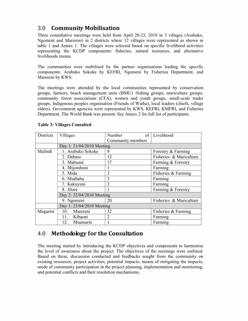
3.0 Community Mobilisation Three consultative meetings were held from April 20-23, 2010 in 3 villages (Arabuko, Ngomeni and Marereni) in 2 districts where 12 villages were represented as shown in table 1 and Annex 1. The villages were selected based on specific livelihood activities representing the KCDP components: fisheries, natural resources, and alternative livelihoods means. The communities were mobilised by the partner organisations leading the specific components: Arabuko Sokoke by KEFRI, Ngomeni by Fisheries Department, and Marereni by KWS. The meetings were attended by the local communities represented by conservation groups, farmers, beach management units (BMU) /fishing groups, mariculture groups, community forest associations (CFA), women and youth groups, small-scale trader groups, Indigenous peoples organisation (Friends of Watha), local leaders (chiefs, village elders). Government agencies were represented by KWS, KEFRI, KMFRI, and Fisheries Department. The World Bank was present. See Annex 2 for full list of participants.
Table 3: Villages Consulted
Districts Villages Number of Community members
Livelihood
Day 1: 21/04/2010 Meeting
Malindi 1. Arabuko Sokoke 9 Forestry & Farming
2. Dabaso 12 Fisheries & Mariculture
3. Mabuani 17 Farming & Forestry
4. Mijomboni 1 Farming
5. Mida 3 Fisheries & Farming
6. Msabaha 3 Farming
7. Kakuyuni 2 Farming
8. Jilore 1 Farming & Forestry
Day 2: 22/04/2010 Meeting
9. Ngomeni 20 Fisheries & Mariculture
Day 1: 23/04/2010 Meeting
Magarini 10. Marereni 32 Fisheries & Farming
11. Kibaoni 2 Farming
12. Msumarin 1 Farming
4.0 Methodology for the Consultation The meeting started by introducing the KCDP objectives and components to harmonise the level of awareness about the project. The objectives of the meetings were outlined. Based on these, discussion conducted and feedbacks sought from the community on existing resources; project activities; potential impacts; means of mitigating the impacts; mode of community participation in the project planning, implementation and monitoring; and potential conflicts and their resolution mechanisms.

5.0 Key Findings As indicated above these villages main sources of livelihood are fishing, forestry and farming. The key findings from the consultative meetings included:
• There is varying level of awareness about the project among the communities hence the need for more communication outreach and sensitization by the respective lead agencies.
• There is general agreement on the seriousness of natural resources degradation within the coastal region hence a strong support from all the community on the need for better natural resources management and thereby welcome for the KCDP.
• There is varying organisational and leadership capacity among communities calling for targeted trainings for respective community groups. e.g. Arabuko Sokoke and Marerena were more organised with functioning CBO’s such as Gede Forest Community Association, Jilore Forest Community Association, Arabuko Forest Conservation, Dabaso, Mijomboni, Majaoni and Mida conservation group
• Various type land tenure rights and interests e.g. customary entitlements of the Watha to forestland, public access the beach, encroachment of community land by private developers as in the case of the private company ‘Solar Salt Production’ versus local communities
• Similarity in proposed management structures such formation of umbrella community project management committee with emphasis on transparency, accountability, regular feedbacks, involvement in project planning and monitoring
• Gender differentiated activities Women with strong preference for alternative income generating activities as demonstrated by ongoing mariculture, orphanage, poultry and other small scale business; Youths with strong preferences for service sector like transport business, boat rental, eco-tourism; while fishermen had a preference for offshore fishing with better fishing equipment.
• All the community groups requested facilitation in access to finance and training in financial management, business skill, and leadership skills.
The communities identified various activities and the stakeholders to be involved as summarized in table 2. From these activities several potential conflicts and their resolution mechanisms were identified as summarised in table 3.
Figure 1: Mangrove Replanting and Prawn Farming
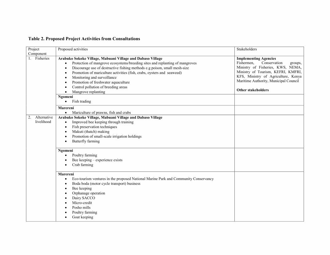
Table 2. Proposed Project Activities from Consultations
Project Component
Proposed activities Stakeholders
1. Fisheries Arabuko Sokoke Village, Mabuani Village and Dabaso Village
• Protection of mangrove ecosystems/breeding sites and replanting of mangroves
• Discourage use of destructive fishing methods e.g poison, small mesh-size
• Promotion of mariculture activities (fish, crabs, oysters and seaweed)
• Monitoring and surveillance
• Promotion of freshwater aquaculture
• Control pollution of breeding areas
• Mangrove replanting
Implementing Agencies Fishermen, Conservation groups, Ministry of Fisheries, KWS, NEMA,
Ministry of Tourism, KEFRI, KMFRI, KFS, Ministry of Agriculture, Kenya Maritime Authority, Municipal Council
Other stakeholders
�gomeni
• Fish trading
Marereni
• Mariculture of prawns, fish and crabs
2. Alternative livelihood
Arabuko Sokoke Village, Mabuani Village and Dabaso Village
• Improved bee keeping through training
• Fish preservation techniques
• Makuti (thatch) making
• Promotion of small-scale irrigation holdings
• Butterfly farming
�gomeni
• Poultry farming
• Bee keeping – experience exists
• Crab farming
Marereni
• Eco-tourism ventures in the proposed National Marine Park and Community Conservancy
• Boda boda (motor cycle transport) business
• Bee keeping
• Orphanage operation
• Dairy SACCO
• Micro-credit
• Posho mills
• Poultry farming
• Goat keeping

3. Natural
resources Arabuko Sokoke Village, Mabuani Village and Dabaso Village
• Establishment of tree nurseries (casuarina)
• Mushroom farming
• Medicinal tree planting
• Eco-tourism
• Firewood harvesting
CFAs, KFS, Community, KWS
�gomeni
Eco-tourism activities such as mangrove boardwalk
Marereni
Rainwater harvesting
4. Capacity Building
Arabuko Sokoke, Mabuani, Dabaso Village, �gomeni and Marereni
• Revision of Forest Act 2005 to ensure equitable sharing of benefits among communities living near forests
• Training for community forest scouts
• Provision of support infrastructure
• Improve capacity to access offshore fishery resources
• Training on conservation skills e.g. mangrove planting

5.1 Conflicts and Resolution Mechanism Table 3: Conflicts Resolution Mechanisms Communities Sites Conflicts Resolution Stakeholders
Arabuko Sokoke
Village, Mabuani
Village and Dabaso
Village
• Use of poison to catch fish
• Small mesh-size nets
• Poaching of forest products
• Need to create a forum for discussing these issues.
• Need to harmonize laws and sectoral policies
• Need for a negotiation committee to be established
Fishermen, Conservation groups, Ministry of Fisheries,
KWS, NEMA, Ministry of Tourism, KEFRI, KMFRI, KFS, Ministry of Agriculture, Kenya
Maritime Authority, Municipal Council
�gomeni • Weak and less cohesive community groups that has led to dying out of some community groups in the area
• Poor leadership facing the existing community groups and mistrust among the members
• Poor and segregative communication among community members
• Natural catastrophes such as beach erosion and
predictable spring high tides that destroy the existing prawn ponds
• Lack of training in mariculture, project management, conflict resolution, book keeping and financial management.
• Public confirmation of the leaders of all the existing CBOs at Ngomeni to be spearheaded by the relevant Government Agencies
• Improved communication within the groups and between community and the government agencies
• Feedback dissemination of committees’ meetings to the entire Ngomeni community
• Transparency and accountability by CBOs
committees.
• Follow-up and monitoring of CBOs progress by the concerned government agencies
• Regular and fair elections of committee members in all existing CBOs
• Leadership training and promotion of awareness among the community
• Establishment of an open forum to evaluate the performance of the elected officials.
Marereni
• Lack of transparency by the elected project committee
• Possibility of misappropriating project funds
• Unpleasant leadership character e.g bossy committee members
• Mistrust of project committee members
• Ignorance of both project members and committee due to lack of training
• Accounts and record keeping
• Democracy in free and fair elections
• Group constitution and by-laws
• Creation of special committees
• Regular election of project committee members
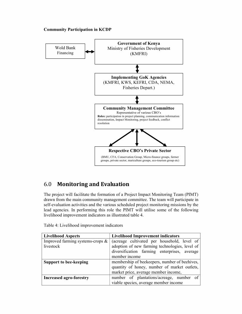
Community Participation in KCDP
6.0 Monitoring and Evaluation
The project will facilitate the formation of a Project Impact Monitoring Team (PIMT) drawn from the main community management committee. The team will participate in self-evaluation activities and the various scheduled project monitoring missions by the lead agencies. In performing this role the PIMT will utilise some of the following livelihood improvement indicators as illustrated table 4. Table 4: Livelihood improvement indicators
Livelihood Aspects Livelihood Improvement indicators
Improved farming systems-crops & livestock
(acreage cultivated per household, level of adoption of new farming technologies, level of diversification farming enterprises, average member income
Support to bee-keeping membership of beekeepers, number of beehives, quantity of honey, number of market outlets, market price, average member income,
Increased agro-forestry number of plantations/acreage, number of viable species, average member income
Government of Kenya
Ministry of Fisheries Development
(KMFRI)
Wold Bank Financing
Implementing GoK Agencies
(KMFRI, KWS, KEFRI, CDA, NEMA,
Fisheries Depart.)
Community Management Committee Representative of various CBO’s
Roles: participation in project planning, communication information dissemination, Impact Monitoring, project feedback, conflict
resolution
Respective CBO’s Private Sector
(BMU, CFA, Conservation Group, Micro-finance groups, farmer groups, private sector, mariculture groups, eco-tourism group etc)

Strengthening fish trade Number of fish traders supplied with fish freezers, volume of fish traded, average members income
Strengthening thatch-making:
‘makuti’-making business volume & quality of thatch /makuti produced, gender participation, average member income
Short term Support for
establishment micro-enterprises:
-kiosks and other small-scale
businesses
number started, survival rate, product diversification, number of people employed, average member income
7.0 Grievance The project will try and exhaust all the conflict within the stipulated mechanism including the community management committees which can co-opt the local leadership (such as administration, community elders), NGO’s, Faith-based organisation, and Private sector. Where disputes fail to be resolved at this level all the grievances shall be referred to an independent institution with such mandate such as the Kenya National Commission on Human Rights which could constitute an ad hoc high level commission to serve this purpose as it may deem necessary.
8.0 Disclosure The process framework and its implementation is to be disclosed in the various communities within the proposed project operational area through focused community meetings. In addition, the final document will be shared by the World Bank in the public accessible infoshop.

ANNEXES ANNEX 1
Outline of an Action Plan Based on the Process Framework
I. BACKGROUND
o Project Description and Overall Context o Rationale for Preparation of the Action Plan from Process Framework o Objectives of the Action Plan o Potential for Adverse Social Impacts
II. INSTITUTIONAL FRAMEWORK
o Project Organization and Implementation Arrangements o Principles and Practices of Coastal and Fisheries Sub-Projects
III. LEGAL FRAMEWORK IV. ORGANIZATION
o Implementation Process and Organization (KMFRI) o Grievance Mechanism
V. OPERATIONAL PROCEDURES
o Stakeholder Analysis o Institutional Arrangements o Project Implementation
VI. SOCIO-ECONOMIC BACKGROUND
o Approach for Identifying Project Affected Persons (PAPs) o Creation of Baseline Information o Social Impacts
VII. METHODS FOR ENSURING ACCESS
o Organization Procedures o Methods for Evaluation of Access to Resources
VIII. BUDGET AND SOURCES OF FUNDING IX. CONSULTATION AND STAKEHOLDER PARTICIPATION
o Involving Stakeholders o Documenting Consultation and Participation
X. MONITORING AND EVALUATION
o Content of Monitoring and Evaluation Program o Mechanisms for Monitoring and Evaluation (Internal and External
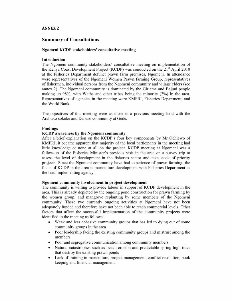
ANNEX 2
Summary of Consultations
�gomeni KCDP stakeholders’ consultative meeting
Introduction
The Ngomeni community stakeholders’ consultative meeting on implementation of the Kenya Coast Development Project (KCDP) was conducted on the 21
st April 2010
at the Fisheries Department defunct prawn farm premises, Ngomeni. In attendance were representatives of the Ngomeni Women Prawn farming Group, representatives of fishermen, individual persons from the Ngomeni community and village elders (see annex 2). The Ngomeni community is dominated by the Giriama and Bajuni people making up 98%, with Watha and other tribes being the minority (2%) in the area. Representatives of agencies in the meeting were KMFRI, Fisheries Department, and the World Bank. The objectives of this meeting were as those in a previous meeting held with the Arabuko sokoke and Dabaso community at Gede.
Findings
KCDP awareness by the �gomeni community
After a brief explanation on the KCDP’s four key components by Mr Ochiewo of KMFRI, it became apparent that majority of the local participants in the meeting had little knowledge or none at all on the project. KCDP meeting at Ngomeni was a follow-up of the Fisheries Minister’s previous visit in the area on a survey trip to assess the level of development in the fisheries sector and take stock of priority projects. Since the Ngomeni community have had experience of prawn farming, the focus of KCDP in the area is mariculture development with Fisheries Department as the lead implementing agency.
�gomeni community involvement in project development
The community is willing to provide labour in support of KCDP development in the area. This is already depicted by the ongoing pond construction for prawn farming by the women group, and mangrove replanting by some members of the Ngomeni community. These two currently ongoing activities at Ngomeni have not been adequately funded and therefore have not been able to reach commercial levels. Other factors that affect the successful implementation of the community projects were identified in the meeting as follows:
• Weak and less cohesive community groups that has led to dying out of some community groups in the area
• Poor leadership facing the existing community groups and mistrust among the members
• Poor and segregative communication among community members
• Natural catastrophes such as beach erosion and predictable spring high tides that destroy the existing prawn ponds
• Lack of training in mariculture, project management, conflict resolution, book keeping and financial management.

The meeting proposed the following measures as remedy for the above factors:
• Public confirmation of the leaders of all the existing CBOs at Ngomeni to be spearheaded by the relevant Government Agencies
• Improved communication within the groups and between community and the government agencies
• Feedback dissemination of committees’ meetings to the entire Ngomeni community
• Transparency and accountability by CBOs committees.
• Follow-up and monitoring of CBOs progress by the concerned government agencies
• Regular and fair elections of committee members in all existing CBOs
• Leadership training and promotion of awareness among the community
• Establishment of an open forum to evaluate the performance of the elected officials.
Other activities proposed as alternative livelihood means were identified as:
• Poultry farming
• Bee keeping – experience exists
• Fish trading
• Crab farming
• Eco-tourism activities such as mangrove boardwalk
Proposed natural resource management and structure in the area
Offshore resources in the area are not fully utilised due lack of capacity. The meeting proposed training and availability of modern fishing boats at a loan equipped with navigation aids. A surveillance/rescue boat at a loan was also proposed for the area, and apart from relying on wild stocks of prawn seed, a modern prawn hatchery be established to provide quality seed to prawn farmers not only at Ngomeni but to other areas of mariculture activities. The following structure was proposed for the project management and implementation in the area:
Marereni KCDP stakeholders’ consultative meeting
Introduction
Figure 2: Proposed project management structure

This stakeholder’s consultative meeting in preparation for the implementation of the World Bank funded Kenya Coast Development Project was held on the 22nd April 2010 at Mlangilangi restaurant, Marereni. The local community participants in the meeting represented CBOs operating in the area including Beach Management Unit (BMU), fishermen, micro-enterprise groups, farmers, conservation groups, vulnerable groups, fish traders, youth groups, and others at individual capacity. Government agencies in the meeting were represented by KMFRI and KWS. The World Bank was also represented as the donor agency. The objectives of this meeting were as those in the previous meetings held with the Dabaso community at Gede and the Ngomeni community.
Findings
KCDP awareness by the Marereni community
It was the first time KCDP was being introduced to the community to be implemented in the area in collaboration with government lead agencies. All the four KCDP components were overwhelmingly received as they contribute directly to the community’s proposed Marereni Marine National Park and a Community-based Conservancy to be established with the assistance of KWS. Already plans are underway to establish the Marine Park with KWS in the process of compiling the biophysical information of the area. Adjacent sand dunes to the proposed Marine Park have been identified as nesting sites of the endangered sea turtles with the entire area being within the designated Important Bird Area (IBA). KCDP was therefore received by the local community as a golden opportunity for the realisation of the Marine Protected Area (MPA) that is hoped to end the existing near-shore land use conflicts with the salt farm owners in addition to contributing to the sustainable utilisation of the fishery and near-shore resources. The community also views KCDP as an opportunity for receiving various trainings, source of adequate funds to buy modern fishing gears, boats and storage facilities as a way to improve their livelihood.
Marereni community involvement in project development The Marereni community is composed of more than twenty registered CBOs ranging from conservation groups, micro-enterprise, Locational Development Committees (LDCs), welfare organisations, fisher groups, and natural resource use groups. A representative committee (Marereni Management Committee) of all the registered CBOs was proposed in the meeting to be the coordinating organ of KCDP implementation in the area. For efficiency, members of this coordinating committee should receive trainings in leadership, project and financial management, and should be under supervision by the lead government agencies. Figure 1 is the proposed project management structure for the Marereni community.

Figure 1. Proposed project management structure for the Marereni community with A, B, C, D, E etc representing individual registered CBOs
Conflicts
The CBOs represented in the meeting seem to have a relatively better leadership and project management skills. However, the meeting identified the following likely sources of conflicts during KCDP implementation in the area:
• Lack of transparency by the elected project committee
• Possibility of misappropriating project funds
• Unpleasant leadership character e.g bossy committee members
• Mistrust of project committee members
• Ignorance of both project members and committee due to lack of training It was agreed in the meeting that the above sources of conflicts can be avoided by the following:
• Accounts and record keeping
• Democracy in free and fair elections
• Group constitution and by-laws
• Creation of special committees
• Regular election of project committee members In addition to their key livelihood sources, the community identified the following as good candidates for alternative sources of livelihood:
• Eco-tourism ventures in the proposed National Marine Park and Community Conservancy
• Boda boda (motor cycle transport) business
• Mariculture of prawns, fish and crabs
• Bee keeping
• Orphanage operation
• Dairy SACCO
• Micro-credit
• Posho mills
• Poultry farming
• Goat keeping
• Rainwater harvesting

ANNEX 3: Map of the project operational area showing areas that were
visited
Arabuko Sokoke
Marereni
Ngomeni

ANNEX 4: Terms of Reference for Consultancy to Assist in Developing a
Process Framework
A. Objectives of the Consultancy
A Consultant is needed to assist the KCDP in developing a Process Framework (PF) that will describe the guidelines for identifying impacts on affected communities. The PF will also assist in developing programs for enhancing livelihoods and improving incomes since there is a possibility that demarcation of coastal areas, and the implementation of potential restrictions on use of marine and coastal resources, may result in significant social impacts. Under the World Bank’s operational policy on involuntary resettlement (OP 4.12), the PF will ensure that by managing the KCDP’s impacts on livelihoods and incomes of marine resource users, the project addresses the needs of affected populations.5 The objectives of this Consultancy are to:
• Conduct village consultations and focus group meetings in at least 4 villages affected by the KCDP regarding their views about the project, specifically the co-management arrangements;
• Provide inputs to a Process Framework (PF) for the KCDP, based on findings from the village consultations and focus groups that may help in the formulation of guidelines for a participatory process in design and implementation of co-management and other activities of the project; and
• Produce a brief report summarizing the findings and recommendations following the village consultations on community based resource management, including co-management of coastal and marine resources; regeneration of natural resources and biodiversity in the coastal and marine environment; identification of biodiversity products and markets for promoting eco-tourism; and promotion of sustainable livelihoods.
B. Summary of the Contents of a Process Framework
The proposed PF is expected to contain the following sections:
1. Analysis of the socio economic profile of affected people 2. Nature of potential impacts on affected communities 3. Possible mitigation measures and guidelines for addressing the needs
of affected population 4. Potential activities for livelihood restoration, stabilization, community
infrastructure, etc
5 Footnote 6 of OP 4.12 states that “the policy does not apply to restrictions of access to natural resources under community-based projects, i.e., where the community using the resources decides to
restrict access to these resources, provided that an assessment satisfactory to the Bank establishes that the community decision-making process is adequate, and that it provides for identification of appropriate measures to mitigate adverse impacts, if any, on the vulnerable members of the
community.”

The Consultant will report to the Project Coordination Unit (PCU) and the PCU’s counterpart (Senior Social Scientist) in the World Bank-Kenya office. The PCU will have the major and overall coordinating function. The Consultant will meet with representatives of the PAPs and conduct focus groups. The format for consultations is contained in Annex 2.
C. Institutional Arrangements
The Consultant will be recruited as part of project preparation, primarily to conduct village consultations and focus groups. The Consultant will report to the PCU and the World Bank Senior Social Scientist working on the preparation of the KCDP.
D. Outputs and Timetable
The Consultant is expected to submit the following:
• Field Report summarizing the findings from 2 to 3 village meetings and 4 focus groups in the affected communities two days after completion of field work;
• Brief Synthesizing Report that integrates the findings from the consultations and focus groups prior to end-contract; and
• File (in electronic and hard copy) of the proceedings of the consultations and focus groups at end-contract.
The Consultant will start work immediately upon approval of the contract. The Consultant will report to Nyambura Githagui ([email protected]) in the World Bank-Nairobi Office. The period of contract is 10 days, from the time of start of contract up to end-June 2010, of which 8 days are expected to be spent in the field. E. Confidentiality All materials, including meeting notes, should be submitted only to the Task Team (William Leeds Lane and Nyambura Githagui). The findings, interpretations, and conclusions expressed in any of the outputs produced by the Consultant are entirely based on the Consultant’s findings and should not be attributed in any manner to the project, and to the World Bank, to its affiliated organizations, or to members of its Board of Executive Directors or the countries they represent. The World Bank does not guarantee the accuracy of the data included in any of the reports produced by this Consultancy and accepts no responsibility whatsoever for any consequences of their use.

ANNEX 5: POLICY REQUIREMENTS FOR A PROCESS FRAMEWORK
I� OP 4.12, A��EX A
Process Framework
31. For projects involving restriction of access in accordance with para. 3(b) above, the borrower provides the Bank with a draft process framework that conforms to the relevant provisions of this policy as a condition of appraisal. In addition, during project implementation and before to enforcing of the restriction, the borrower prepares a plan of action, acceptable to the Bank, describing the specific measures to be undertaken to assist the displaced persons and the arrangements for their implementation. The plan of action could take the form of a natural resources management plan prepared for the project.
Assistance to the Borrower 32. In furtherance of the objectives of this policy, the Bank may at a borrower's request support the borrower and other concerned entities by providing
(a) assistance to assess and strengthen resettlement policies, strategies, legal frameworks, and specific plans at a country, regional, or sectoral level;
(b) financing of technical assistance to strengthen the capacities of agencies responsible for resettlement, or of affected people to participate more effectively in resettlement operations;
(c) financing of technical assistance for developing resettlement policies, strategies, and specific plans, and for implementation, monitoring, and evaluation of resettlement activities; and
(d) financing of the investment costs of resettlement.
33. The Bank may finance either a component of the main investment causing displacement and requiring resettlement, or a free-standing resettlement project with appropriate cross-conditionalities, processed and implemented in parallel with the investment that causes the displacement. The Bank may finance resettlement even though it is not financing the main investment that makes resettlement necessary.
___________________________________________________________________________
1. "Bank" includes IDA; "loans" includes credits, guarantees, Project Preparation Facility (PPF) advances and grants; and "projects" includes projects under (a) adaptable program lending; (b) learning and innovation loans; (c) PPFs and Institutional Development Funds (IDFs), if they include investment activities; (d) grants under the Global Environment Facility and Montreal Protocol, for which the Bank is the implementing/executing agency; and (e) grants or loans provided by other donors that are administered by the Bank. The term "project" does not include
programs under adjustment operations. "Borrower" also includes, wherever the context requires, the guarantor or the project implementing agency. 2. In devising approaches to resettlement in Bank-assisted projects, other Bank policies should be taken into account, as relevant. These policies include OP 4.01 Environmental Assessment, OP 4.04 �atural Habitats, OP 4.11 Safeguarding
Cultural Property in Bank-Assisted Projects, and OD 4.20 Indigenous Peoples. 3. The term "displaced persons" refers to persons who are affected in any of the ways described in para. 3 of this OP. 4. Displaced persons under para. 3(b) should be assisted in their efforts to improve or restore their livelihoods in a manner that maintains the sustainability of the parks and protected areas. 5. Where there are adverse indirect social or economic impacts, it is good practice for the borrower to undertake a social assessment and implement measures to minimize and mitigate adverse economic and social impacts, particularly upon poor and vulnerable groups. Other environmental, social, and economic impacts that do not result from land taking may be identified and addressed through environmental assessments and other project reports and instruments. 6. This policy does not apply to restrictions of access to natural resources under community-based projects, i.e. where the community using the resources decides to restrict access to these resources, provided that an assessment satisfactory to the Bank establishes that the community decision-making process is adequate, and that it provides for identification of appropriate measures to mitigate adverse impacts, if any, on the vulnerable members of the community. This policy also does not cover refugees from natural disasters, war, or civil strife (see OP/BP 8.50, Emergency
Recovery Assistance). 7. For purposes of this policy, "involuntary" means actions that may be taken without the displaced person's informed consent or power of choice. 8. "Land" includes anything growing on or permanently affixed to land, such as buildings and crops. This policy does not apply to regulations of natural resources on a national or regional level to promote their sustainability, such as watershed management, groundwater management, fisheries management, etc. The policy also does not apply to disputes between private parties in land titling projects, although it is good practice for the borrower to undertake a social assessment and implement measures to minimize and mitigate adverse social impacts, especially those affecting poor and vulnerable groups. 9. For the purposes of this policy, involuntary restriction of access covers restrictions on the use of resources imposed on people living outside the park or protected area, or on those who continue living inside the park or protected area during and after project implementation. In cases where new parks and protected areas are created as part of the project, persons who lose shelter, land, or other assets are covered under para. 3(a). Persons who lose shelter in existing parks and protected areas are also covered under para. 3(a). 10. The Resettlement Sourcebook (forthcoming) provides good practice guidance to staff on the policy. 11. "Replacement cost" is the method of valuation of assets that helps determine the amount sufficient to replace lost assets and cover transaction costs. In applying this method of valuation, depreciation of structures and assets should not be taken into account (for a detailed definition of replacement cost, see Annex A, footnote 1). For losses that cannot easily be valued or compensated for in monetary terms (e.g., access to public services, customers, and suppliers; or to fishing, grazing, or forest areas),
attempts are made to establish access to equivalent and culturally acceptable resources and earning opportunities. Where domestic law does not meet the standard of compensation at full replacement cost, compensation under domestic law is supplemented by additional measures necessary to meet the replacement cost standard. Such additional assistance is distinct from resettlement assistance to be provided under other clauses of para. 6. 12. If the residual of the asset being taken is not economically viable, compensation and other resettlement assistance are provided as if the entire asset had been taken. 13. The alternative assets are provided with adequate tenure arrangements. The cost of alternative residential housing, housing sites, business premises, and agricultural sites to be provided can be set off against all or part of the compensation payable for the corresponding asset lost. 14. Such support could take the form of short-term jobs, subsistence support, salary maintenance or similar arrangements 15. See OD 4.20, Indigenous Peoples. 16. See OP 4.04, �atural Habitats. 17. As a general principle, this applies if the land taken constitutes less than 20% of the total productive area. 18. Paras. 13-15 do not apply to impacts covered under para. 3(b) of this policy. The eligibility criteria for displaced persons under 3 (b) are covered under the process framework (see paras. 7 and 30). 19. Such claims could be derived from adverse possession, from continued possession of public lands without government action for eviction (that is, with the implicit leave of the government), or from customary and traditional law and usage, and so on. 20. Resettlement assistance may consist of land, other assets, cash, employment, and so on, as appropriate. 21. Normally, this cut-off date is the date the census begins. The cut-off date could also be the date the project area was delineated, prior to the census, provided that there has been an effective public dissemination of information on the area delineated, and systematic and continuous dissemination subsequent to the delineation to prevent further population influx. 22. For projects that are highly risky or contentious, or that involve significant and complex resettlement activities, the borrower should normally engage an advisory panel of independent, internationally recognized resettlement specialists to advise on all aspects of the project relevant to the resettlement activities. The size, role, and frequency of meeting depend on the complexity of the resettlement. If independent technical advisory panels are established under OP 4.01, Environmental Assessment, the resettlement panel may form part of the environmental panel of experts. See BP 17.50, Disclosure of Operational Information (forthcoming) for detailed disclosure procedures. 24. An exception to this requirement may be made in highly unusual circumstances (such as emergency recovery operations) with the approval of Bank Management (see BP 4.12, para. 8). In such cases, the Management's approval stipulates a timetable and budget for developing the resettlement plan. 25. Impacts are considered "minor" if the affected people are not physically displaced and less than 10% of their productive assets are lost. 26. For purpose of this paragraph, the term "subprojects" includes components and subcomponents.
Process Framework

26. A process framework is prepared when Bank-supported projects may cause restrictions in access to natural resources in legally designated parks and protected areas. The purpose of the process framework is to establish a process by which members of potentially affected communities participate in design of project components, determination of measures necessary to achieve resettlement policy objectives, and implementation and monitoring of relevant project activities (see OP 4.12, paras. 7 and 31). 27. Specifically, the process framework describes participatory processes by which the following activities will be accomplished (a) Project components will be prepared and implemented. The document should briefly describe the project and components or activities that may involve new or more stringent restrictions on natural resource use. It should also describe the process by which potentially displaced persons participate in project design. (b) Criteria for eligibility of affected persons will be determined. The document should establish that potentially affected communities will be involved in identifying any adverse impacts, assessing of the significance of impacts, and establishing of the criteria for eligibility for any mitigating or compensating measures necessary. (c) Measures to assist affected persons in their efforts to improve their livelihoods or restore them, in real terms, to pre-displacement levels, while maintaining the sustainability of the park or protected area will be identified. The document should describe methods and procedures by which communities will identify and choose potential mitigating or compensating measures to be provided to those adversely affected, and procedures by which adversely affected community members will decide among the options available to them. (d) Potential conflicts or grievances within or between affected communities will be resolved. The document should describe the process for resolving disputes relating to resource use restrictions that may arise between or among affected communities, and grievances that may arise from members of communities who are dissatisfied with the eligibility criteria, community planning measures, or actual implementation. Additionally, the process framework should describe arrangements relating to the following (e) Administrative and legal procedures. The document should review agreements reached regarding the process approach with relevant administrative jurisdictions and line ministries including clear delineation for administrative and financial responsibilities under the project). (f) Monitoring arrangements. The document should review arrangements for participatory monitoring of project activities as they relate to beneficial and adverse) impacts on persons within the project impact area, and for monitoring the effectiveness of measures taken to improve (or at minimum restore) incomes and living standards. ______________________________________________________________________ 1. With regard to land and structures, "replacement cost" is defined as follows: For agricultural land, it is the pre-project or pre-displacement, whichever is higher, market

value of land of equal productive potential or use located in the vicinity of the affected land, plus the cost of preparing the land to levels similar to those of the affected land, plus the cost of any registration and transfer taxes. For land in urban areas, it is the pre-displacement market value of land of equal size and use, with similar or improved public infrastructure facilities and services and located in the vicinity of the affected land, plus the cost of any registration and transfer taxes. For houses and other structures, it is the market cost of the materials to build a replacement structure with an area and quality similar to or better than those of the affected structure, or to repair a partially affected structure, plus the cost of transporting building materials to the construction site, plus the cost of any labor and contractors' fees, plus the cost of any registration and transfer taxes. In determining the replacement cost, depreciation of the asset and the value of salvage materials are not taken into account, nor is the value of benefits to be derived from the project deducted from the valuation of an affected asset. Where domestic law does not meet the standard of compensation at full replacement cost, compensation under domestic law is supplemented by additional measures so as to meet the replacement cost standard. Such additional assistance is distinct from resettlement measures to be provided under other clauses in OP 4.12, para. 6. 2. Provision of health care services, particularly for pregnant women, infants, and the elderly, may be important during and after relocation to prevent increases in morbidity and mortality due to malnutrition, the psychological stress of being uprooted, and the increased risk of disease. 3. Negative impacts that should be anticipated and mitigated include, for rural resettlement, deforestation, overgrazing, soil erosion, sanitation, and pollution; for urban resettlement, projects should address such density-related issues as transportation capacity and access to potable water, sanitation systems, and health facilities. 4. Experience has shown that local NGOs often provide valuable assistance and ensure viable community participation. 5. OPN 11.03, Management of Cultural Property in Bank-Financed Projects. 6. In case some of the displaced persons lose more than 10% of their productive assets or require physical relocation, the plan also covers a socioeconomic survey and income restoration measures.