draft environmental impact report for the rancho … · draft environmental impact report . for the...
TRANSCRIPT

DRAFT ENVIRONMENTAL IMPACT REPORT FOR THE RANCHO LAGUNA 2 PROJECT July, 2006 Submitted To: TOWN OF MORAGA 329 RHEEM BOULEVARD MORAGA, CA 94556 Prepared By: SPONAMORE ASSOCIATES A SUBSIDIARY OF P.R.I.S.M., LLC ENVIRONMENTAL PLANNING 1205 McDONALD AVENUE SANTA ROSA, CA 95404

RANCHO LAGUNA 2 EIR TABLE OF CONTENTS
TOC - 1
L:\ Rancho Laguna 2 EIR \ Table of Contents \ 7/7/06 \12:00 pm
TABLE OF CONTENTS
1.00 INTRODUCTION AND EXECUTIVE SUMMARY
1.10 Introduction ............................................................................. 1.00 - 1 1.20 Environmental Procedures and Scope of Environmental Review 1.00 - 2 1.30 Public Review Process ............................................................. 1.00 - 4 1.40 Report Format and Organization ............................................... 1.00 - 5 1.50 Summary of Impacts ................................................................ 1.00 - 6
2.00 PROJECT LOCATION AND DESCRIPTION
2.10 Site Location ............................................................................ 2.00 - 1 2.20 Project Description ................................................................... 2.00 - 1 2.30 Project Sponsors ...................................................................... 2.00 - 8 2.40 Project Objectives .................................................................... 2.00 - 8 2.50 Responsible and Trustee Agencies and Agencies with
Jurisdiction by Law and Project Entitlements, Discretionary Actions or Approvals ............................................ 2.00 - 9
3.00 ENVIRONMENTAL ANALYSIS
3.00 Environmental Analysis............................................................. 3.00 - 1 3.10 Land Use ................................................................................ 3.10 - 1 3.15 Jobs, Population and Housing................................................... 3.15 - 1 3.20 Geology and Soils .................................................................... 3.20 - 1 3.25 Hazards and Hazardous Materials............................................. 3.25 - 1 3.30 Hydrology, Drainage and Water Quality ..................................... 3.30 - 1 3.35 Visual Quality, Parks, Recreation and Open Space.................... 3.35 - 1 3.40 Traffic, Transportation and Circulation....................................... 3.40 - 1 3.45 Air Quality ................................................................................ 3.45 - 1 3.50 Noise ....................................................................................... 3.50 - 1 3.55 Biological Resources ................................................................ 3.55 -1 3.60 Public Services and Utilities...................................................... 3.60 - 1 3.61 Fire Protection.......................................................................... 3.61 - 1 3.62 Law Enforcement...................................................................... 3.62 - 1 3.63 Schools .................................................................................... 3.63 - 1
3.64 Water Supply............................................................................ 3.64 - 1 3.65 Wastewater Services ............................................................... 3.65 - 1 3.66 Solid Waste Disposal ................................................................ 3.66 - 1 3.67 Cable/Communication and Energy ............................................ 3.67 - 1 3.70 Cultural Resources ................................................................... 3.70 - 1
4.00 ALTERNATIVES 4.10 Alternatives Eliminated from Further Discussion ........................ 4.00 - 3 4.20 No Project Alternative ............................................................... 4.00 - 6 4.30 General Plan Minimum Density Alternative ................................ 4.00 - 9 4.40 Alternatives Site Alternative ...................................................... 4.00 -12

RANCHO LAGUNA 2 EIR TABLE OF CONTENTS TOC - 2
L:\ Rancho Laguna 2 EIR \ Table of Contents \ 7/7/06 \12:00 pm
4.50 Mitigated Plan Alternative ......................................................... 4.00 -14 4.60 Rheem Boulevard Alternative .................................................... 4.00 -20 4.70 Comparative Analysis ............................................................... 4.00 -25
5.00 CEQA ISSUES
5.10 Effects Not Found to be Significant ........................................... 5.00 - 1 5.20 Significant Unavoidable Adverse Impacts .................................. 5.00 - 1 5.30 Growth Inducing Impacts of the Proposed Action ....................... 5.00 - 4
5.40 Cumulative Impacts .................................................................. 5.00 - 5 6.00 REPORT PREPARATION
6.10 Persons and Organizations Contacted During Preparation of the Report
6.20 Preparers and Contributors to the Report 6.30 References Cited 6.40 Glossary 6.50 Acronyms and Abbreviations - By Phrase
Acronyms and Abbreviations - By Abbreviation
LIST OF FIGURES
Follows Page Figure 2.00 - 1 Vicinity Map
Figure 2.00 - 2 Site and Vicinity
Figure 2.00 - 3 Conceptual Site Plan
Figure 2.00 - 4 Conceptual Remedial Grading Plan of the Valley Buttress
Figure 2.00 - 5 Preliminary Grading Plan
Figure 2.00 - 6 Limits of Grading
Figure 2.00 - 7a Preliminary Landscape Plan
Figure 2.00 - 7b Preliminary Section
Figure 3.20 - 1 Regional Geology Map
Figure 3.20 - 2 Site Geology
Figure 3.20 - 3 Regional Faulting and Seismicity Map
Figure 3.20 - 4 Local Landslides
Figure 3.20 - 5 Debris Bench Detail
Figure 3.30 - 1 Proposed BMPs and Drainage System
Figure 3.30 - 2 Wetlands Delineation and Drainage Sheds

RANCHO LAGUNA 2 EIR TABLE OF CONTENTS TOC - 3
L:\ Rancho Laguna 2 EIR \ Table of Contents \ 7/7/06 \12:00 pm
Figure 3.35 - 1 Key of Viewpoints
Figure 3.35 - 2 Bollinger Canyon (Existing)
Figure 3.35 - 3 Bollinger Canyon (Proposed)
Figure 3.35 - 4 Cattle Chute Road (Existing)
Figure 3.35 - 5 Cattle Chute Road (Proposed)
Figure 3.35 - 6 Fernwood Drive (Existing)
Figure 3.35 - 7 Fernwood Drive (Proposed)
Figure 3.35 - 8 Joseph Drive (Existing)
Figure 3.35 - 9 Joseph Drive (Proposed)
Figure 3.35 - 10 Rheem Boulevard (Existing)
Figure 3.35 - 11 Rheem Boulevard (Proposed)
Figure 3.35 - 12 St. Mary’s Road (Existing)
Figure 3.35 - 13 St. Mary’s Road (Proposed)
Figure 3.35 - 14 Birchwood Drive (Existing)
Figure 3.35 - 15 Birchwood Drive (Proposed)
Figure 3.35 - 16 Rohrer Drive (Existing)
Figure 3.35 - 17 Rohrer Drive (Proposed)
Figure 3.40 - 1 Existing Volumes AM and PM Peak Hours
Figure 3.40 - 2 Project Trips AM and PM Peak Hours
Figure 3.55 - 1 Revised Wetlands and Water Impacts for the Rheem Valley Portion of the Rancho Laguna Property (Full Site)
Figure 3.55 - 2 Revised Wetlands and Water Impacts for the Rheem Valley Portions
of the Rancho Laguna Property Figure 4.00 - 1 Mitigated Plan Alternative
Figure 4.00 - 2 Rheem Boulevard Alternative with Frontage Road
Figure 4.00 - 3 Rheem Boulevard Alternative

RANCHO LAGUNA 2 EIR TABLE OF CONTENTS TOC - 4
L:\ Rancho Laguna 2 EIR \ Table of Contents \ 7/7/06 \12:00 pm
LIST OF TABLES
Table 1.00-1 Summary of Impacts and Mitigation Measures 1.00 - 7
Table 3.40-1 Existing and Projected Intersection Operation 3.40 - 3
Table 3.40-2 Project Trip Generation 3.40 - 8
Table 3.40-3 Projected Intersection Operation with General Plan Buildout 3.40 -13
Table 3.45-1 Major Criteria Pollutants 3.45 - 4
Table 3.45-2 California and National Ambient Air 3.45 - 8
Table 3.50-1 Definitions of Acoustical Terms 3.50 - 1
Table 3.50-2 Typical Sound Levels Measured in the Environment and Industry 3.50 - 3
Table 3.50-3 Evaluation Criteria with Points of Significance 3.50 - 5
Table 3.50-4 Noise Levels by Construction Phases 3.50 - 8
Table 3.55-1 Summary of On-Site Vegetation Communities 3.55 - 2
Table 3.55-2 Summary of Habitat Impacts 3.55 -31
Table 3.55-3 Mature Native Trees to be Removed and Mitigation 3.55 -38
Table 3.55-4 Prohibited Landscaping Species 3.55 -61
Table 3.63-1 School Enrollments and Capacity 3.63 - 1
Table 3.64-1 EBMUD Demand and Supply Projections 3.64 - 3
Table 3.64-2 Projected Water Demand in Gallons/Day Unless Otherwise Noted 3.64 - 7
Table 4.00-1 Onsite Alternatives Eliminated from Further Evaluation 4.00 - 4
Table 4.00-2 Comparison of Impacts of the Alternatives to the Proposed Project 4.00 -25
Table 5.00-1 Approved and Proposed Projects 5.00 - 6

L:\ Rancho Laguna 2 EIR \ Table of Contents \ 7/7/06 \12:00 pm
LIST OF APPENDICES
Appendix A: NOTICE OF PREPARATION (FEBRUARY 13, 2003); COMMENTS RECEIVED ON NOTICE OF PREPARATION; LETTERS RECEIVED, AND MINUTES OF THE SCOPING SESSION (FEBRUARY 24, 203)
Appendix B: GREEN STREETS - INNOVATIVE SOLUTIONS FOR STORMWATER
AND STREAM CROSSINGS Appendix C: RELEVANT TOWN OF MORAGA GENERAL PLAN GOALS AND
POLICIES DISCUSSION, BY ALTERNATIVE Appendix D: ENGEO GEOTECHNICAL EVALUATION REPORT ON RHEEM
BOULEVARD ROAD WIDENING Appendix E: BIOLOGICAL RESOURCES Appendix E-1: Regulatory Agency Responsibilities
Appendix E-2: Scientific Names of Plans and Animals Discussed in Text
Appendix E-3: Explanation of Sensitivity Status Codes
Appendix E-4: Potentially-Occurring Special-Status Plant Species at the Rancho Laguna Project Site
Appendix E-5: Potentially-Occurring Special-Status Animal Species at the Rancho
Laguna Project Site Appendix E-6: Biological Survey
Appendix E-7: Site Assessment for California Red-Legged Frog
Appendix E-8: Site Assessment for Alameda Whipsnake Appendix E-9: Wetlands
Appendix F: TRAFFIC INFORMATION
Appendix F-1: Level of Service Definitions Appendix F-2: Traffic Information Appendix F-3: Unsignalized Intersections Worksheets
Appendix G: HYDROLOGY
Appendix G-1: Flood Hydrograph Package Appendix G-2: BMP: Extended Detention Basins (Municipal Handbook) Appendix G-3: Appendix D: Municipal Handbook Appendix G-4: Conceptual Master Drainage Plan and Report

1.00 INTRODUCTION AND EXECUTIVE SUMMARY

RANCHO LAGUNA 2 EIR 1.00 INTRODUCTION AND EXECUTIVE SUMMARY
p. 1.00 - 1
L:\Rancho Laguna 2 \ 1.00 Introduction and Executive Summary \ 6/29/06 10:20 am
1 2 3 4 5 6 7 8 9
10 11 12 13 14 15 16 17 18 19 20 21 22 23 24 25 26 27 28 29 30 31 32 33 34 35 36 37 38 39 40 41 42 43 44 45
1.00 INTRODUCTION AND EXECUTIVE SUMMARY Preface Chapter 1, Introduction and Executive Summary, describes the Environmental Impact Report (EIR) process; the public review process; and, report format. Table 1.00-1, Summary of Impacts and Mitigation Measures, summarizes the project, its impacts and available mitigation measures. For more detailed information regarding the individual impacts and mitigation measures, please see Chapter 3.00 of this DEIR. 1.10 INTRODUCTION The Rancho Laguna 2 application is for both a conditional use permit and approval of a Conceptual Development Plan. During subsequent phases of the project the Town will review the:
● General Development Plan; and, ● Precise Development Plan
Additional approvals are detailed in Section 2.50. All subsequent phases of the project will be subject to additional environmental review as appropriate by the Lead Agency. This Draft Environmental Impact Report (DEIR) addresses the potential environmental impacts associated with the development of the proposed 180.2 acre Rancho Laguna 2 project. The document is designed to inform the Town of Moraga decision-makers, Responsible and/or Trustee agencies, and the public-at-large of the nature and environmental effects of the Proposed Project. The DEIR has been prepared in accordance with, and in fulfillment of, the California Environmental Quality Act (CEQA) requirements. The Town of Moraga is the Lead Agency for the project. The Rancho Laguna 2 project is a proposed residential community of 35 units on 35 lots and related improvements, including: ● The dedication of 136± acres of permanent open space for public use; ● Recreation of 0.66 acre of wetlands; and,
● Stabilization of Rheem Boulevard using a valley buttress fill concept.
Throughout this report, the term “Proposed Project” or “Project” refers to the proposed Rancho Laguna 2 project submitted to the Town of Moraga in September 2002 (Status Determination) and amended in February 2005 as further described in Section 2.00 of this EIR.

RANCHO LAGUNA 2 EIR 1.00 INTRODUCTION AND EXECUTIVE SUMMARY
p. 1.00 - 2
1 2 3 4 5 6 7 8 9
10 11 12 13 14 15 16 17 18 19 20 21 22 23 24 25 26 27 28 29 30 31 32 33 34 35 36 37 38 39 40 41 42 43 44
This DEIR identifies mitigation measures or environmental performance standards for the development of the site that are consistent with the project described in this DEIR. As the Project Sponsors seek design review approval and the issuance of building permits from the Town for the construction of the homes comprising the Project, the Project Sponsors will be required to meet the performance standards identified in this DEIR. 1.20 ENVIRONMENTAL PROCEDURES AND SCOPE OF ENVIRONMENTAL
REVIEW On September 13, 2005 the Town of Moraga issued a Notice of Preparation (NOP) for the Proposed Project. Numerous written comments were received (see Appendix A). On September 19, 2005, the Town of Moraga Planning Commission conducted a Scoping Session for the Proposed Project. The primary issues discussed at that meeting, or submitted in written format, included:
● Development within Open Space - Planned District (OS - PD) lands; ● Geotechnical issues; ● Grading, drainage and water quality; ● Visual quality; ● Traffic and circulation; ● Biological resources; ● Public services and utilities; ● Construction impacts; and, ● Cumulative impacts.
Both public testimony given at the scoping session and written comments received in response to the NOP were considered in developing this DEIR and the alternatives to the Proposed Project. This DEIR has been prepared in accordance with CEQA, California Resources Code § 21000, et seq.; the Guidelines for California Environmental Quality Act (California Code of Regulations, Title 14, Chapter 3); and the rules, regulations, and procedures for implementing CEQA as adopted by the Town of Moraga. CEQA requires that all state and local agencies evaluate the environmental consequences of projects over which they have discretionary authority before taking action on those projects.
L:\Rancho Laguna 2 \ 1.00 Introduction and Executive Summary \ 6/29/06 10:20 am

RANCHO LAGUNA 2 EIR 1.00 INTRODUCTION AND EXECUTIVE SUMMARY
p. 1.00 - 3
1 2 3 4 5 6 7 8 9
10 11 12 13 14 15 16 17 18 19 20 21 22 23 24 25 26 27 28 29 30 31 32 33 34 35 36 37 38 39 40 41 42 43 44
In addition to analyzing the potential environmental effects of the Rancho Laguna 2 project, this DEIR indicates ways to reduce or avoid potential environmental impacts resulting from the Proposed Project, and identifies mitigation measures which will help reduce or avoid environmental impacts. During the Final Environmental Impact Report (FEIR) process a draft Mitigation Monitoring and Reporting Program (MMRP) will be prepared for the project as selected by the Town. CEQA requires each public agency to mitigate and avoid significant effects on the environment of projects it approves or implements if it is feasible to do so. If the significant impacts of the project are unavoidable, the public agency may approve or implement the project if the agency makes Findings of Fact and adopts a Statement of Overriding Considerations. The Town is not obligated to make such findings and may choose to not approve an application. The Statement of Overriding Considerations must set forth the specific social, economic, legal, technical, or other reasons supporting the agency's decision and must be based on substantial evidence in the FEIR or elsewhere in the administrative record. If the social, economic, or other benefits of the project outweigh the unavoidable environmental effects, those effects may be considered acceptable (per Section 15093 of the State CEQA Guidelines). This DEIR discusses:
● significant environmental effects that cannot be avoided; and, ● growth-inducing effects.
The potential for impacts has been determined utilizing the criteria included in the latest CEQA Guidelines, or (if appropriate) against the Town of Moraga’s performance standards (noise, air quality, traffic and public services). Prior to any approval of the project, the Lead Agency must make one or more of the following findings (along with a brief explanation of the rationale), for each significant impact identified in the EIR: ● Changes or alterations have been required or incorporated into the Project which
avoid or substantially lessen the significant environmental effect as identified in the EIR;
● Such changes or alterations are within the responsibility and jurisdiction of another
public agency and not the agency making the finding. Such changes have been adopted by such other agency or can and should be adopted by such other agency; and,
● Specific economic, social, or other considerations make infeasible the mitigation
measures or project alternatives identified in the FEIR. These findings must be supported by substantial evidence in the administrative record.
L:\Rancho Laguna 2 \ 1.00 Introduction and Executive Summary \ 6/29/06 10:20 am

RANCHO LAGUNA 2 EIR 1.00 INTRODUCTION AND EXECUTIVE SUMMARY
p. 1.00 - 4
1 2 3 4 5 6 7 8 9
10 11 12 13 14 15 16 17 18 19 20 21 22 23 24 25 26 27 28 29 30 31 32 33 34 35 36 37 38
Numerous alternatives to the Proposed Project were considered. Table 4.00-1 identifies several onsite alternatives that were eliminated from further discussion. Four alternatives to the Rancho Laguna 2 project are evaluated in more detail in Section 4.00 of this EIR:
The No Project Alternative envisions the project site would remain in its existing state and its current use. There would be no new environmental impacts associated with this Alternative.
The General Plan Minimum Density Alternative is a variation of the No Project Alternative and assesses development allowable under the current General Plan and Zoning (1 unit/20 acres).
Alternatives Sites is an alternative which evaluated alternative sites within the Town of Moraga that also meet the Project Sponsors’ stated project objectives.
The Mitigated Plan Alternative evaluates a development plan that reduces impacts as compared to those associated with the Proposed Project. This Alternative incorporates all of the mitigation measures identified during the preparation of this DEIR and public review process. The intent of this alternative is to show a layout of the greatest number of units while still reducing the severity of potential environmental impacts.
1.30 PUBLIC REVIEW PROCESS In accordance with CEQA, a good faith effort has been made during the preparation of this EIR to contact affected agencies, organizations, and persons who may have an interest in this project. This includes the circulation of the NOP dated September 13, 2005. The Town of Moraga will hold several public hearing on the DEIR. The public is invited to attend the hearing(s) to offer oral comments on the DEIR. A Notice of Availability of the DEIR and the date of the public hearing will be published concurrently with distribution of this document. This DEIR will be available for review by the public and interested parties, agencies and organizations for a 45-day review period (from the date of the Notice of Availability). In reviewing a DEIR, reviewers should focus on the adequacy of the document when identifying and analyzing the potential impacts on the environment and ways in which the significant effects of the project may be avoided or mitigated. Comments may be made on the DEIR before the end of the comment period, either in writing, or verbally at the public hearings.
L:\Rancho Laguna 2 \ 1.00 Introduction and Executive Summary \ 6/29/06 10:20 am

RANCHO LAGUNA 2 EIR 1.00 INTRODUCTION AND EXECUTIVE SUMMARY
p. 1.00 - 5
1 2 3 4 5 6 7 8 9
10 11 12 13 14 15 16 17 18 19 20 21 22 23 24 25 26 27 28 29 30 31 32 33 34 35 36 37 38 39 40 41 42 43 44
Written comments on the DEIR should be sent to:
Town of Moraga Planning Department 329 Rheem Boulevard, Suite 2 Moraga, CA 94556
Following the close of this public comment period, a Final EIR (FEIR) will be prepared in order to respond to all substantive comments regarding this DEIR. Responses to comments on the DEIR will be prepared and published as a separate document. The DEIR text and technical appendices, together with the Responses to Comments document, will constitute the FEIR. The FEIR will include a Mitigation Monitoring and Reporting Program (MMRP) for all mitigation measures listed in the DEIR. 1.40 REPORT FORMAT AND ORGANIZATION The content and format of this DEIR are designed to meet the requirements of CEQA and the State CEQA Guidelines. The report is organized into the following chapters:
Chapter 1, Introduction and Executive Summary, describes the EIR process; the public review process; and, report format. Table 1.00-1, Summary of Impacts and Mitigation Measures, summarizes the project, its impacts, and available mitigation measures.
Chapter 2, Project Location and Description, describes the Proposed Project, its objectives and the approvals and the entitlements necessary for project implementation.
Chapter 3, Environmental Analysis, describes the existing conditions and environmental setting before project implementation (as of the date of the NOP); potential impacts that would result from the Proposed Project; and, mitigation measures that would eliminate or reduce significant environmental impacts.
Chapter 4, Alternatives, provides a discussion of alternatives.
Chapter 5, CEQA Issues discusses the long-term implications of the Proposed Project, including: unavoidable adverse impacts, significant irreversible impacts resulting from this project, and growth-inducing aspects of the project.
Chapter 6, Report Preparation, lists the individuals involved in preparing this EIR; persons contacted; references; a glossary; and, acronyms and abbreviations.
The Appendices include:
Appendix A: The Notice of Preparation (September 13, 2005); letters received, and minutes of the Scoping Session (September 19, 2005)
L:\Rancho Laguna 2 \ 1.00 Introduction and Executive Summary \ 6/29/06 10:20 am

RANCHO LAGUNA 2 EIR 1.00 INTRODUCTION AND EXECUTIVE SUMMARY
p. 1.00 - 6
1 2 3 4 5 6 7 8 9
10 11 12 13 14 15 16 17 18 19 20 21 22 23 24 25
Appendix B: Green Streets
Appendix C: Relevant Town of Moraga General Plan Goals and Policies Discussion, by Alternative
Appendix D: ENGEO Geotechnical Evaluation Report on Rheem Boulevard Widening
Appendix E: Biological Resources
Appendix F: Traffic Information Appendix G: Hydrology
1.50 SUMMARY OF IMPACTS The Proposed Project’s potential impacts, their level of significance before and after application of mitigation measures, along with the proposed mitigation measures is briefly summarized in the following table, Table 1.00-1, Summary of Impacts and Mitigation Measures. For a detailed discussion of the Proposed Project’s impacts and detailed mitigation measures, see Section 3.00 of this EIR. Those impacts of the project which are also cumulatively considerable, significant and unavoidable are discussed by environmental factor in Chapter 3.00, and summarized in Section 5.30.
L:\Rancho Laguna 2 \ 1.00 Introduction and Executive Summary \ 6/29/06 10:20 am

RANCHO LAGUNA 2 EIR TABLE 1.00-1: SUMMARY OF IMPACTS AND MITIGATION MEASURES
p. 1.00 - 7
LTS = Less Than Significant; PS = Potentially Significant; SU = Significant and Unavoidable
TABLE 1.00-1
SUMMARY OF IMPACTS AND MITIGATION MEASURES
The following is a brief summary of impacts and mitigation measures by environmental factor. Please see Section 3.00 for a more detailed discussion.
IMPACTS
SIGNIFICANCE BEFORE
MITIGATION MITIGATION MEASURES
SIGNIFICANCE AFTER
MITIGATION
Land Use and Planning Impact 3.10 #1. Division of Community: The Proposed Project is a residential project with a mix of lot sizes ranging from 15,043 to 32,714 square feet. The Proposed Project can be perceived as an extension of the existing or approved developments (Palos Colorados, Track 5968 and Rheem Glenn) to north, northwest and south. The Proposed Project will not physically divide an established community as it is a continuation of development in an urban setting surrounded by other housing projects. The Proposed Project will not affect an established, or proposed, habitat conservation plan (as there are no such plans established on, or near, the subject site). A USACE approved wetland mitigation plan, which calls for both on- and off-site mitigation, will be required (potential wetlands impacts are discussed in Section 3.55, Biological Resources). As this Proposed Project is comparable and therefore compatible with surrounding residential uses, these impacts are considered less than significant.
LTS
Mitigation Measure 3.10 #1: None Required.
LTS
Impact 3.10 #2. Conversion of Agricultural Land: The project site is designated in the 2005 Contra Costa General Plan as part of the Moraga Sphere of Influence. The most recent revision to the County’s Urban Limit Line (ULL), adopted in 2002, includes this parcel within the Urban Limit Line. The County’s agricultural lands map shows the property as Important Farmland. The property is not in a Williamson Act contract, nor will development conflict with any existing lands zoned for agricultural use.
LTS Mitigation Measure 3.10 #2: The open space areas of the property shall be subject to an open space management plan that will ensure that the undeveloped portion of the property continue to be grazed as a means of fire protection and open space preservation subject to the implementation of Mitigation Measure
LTS

RANCHO LAGUNA 2 EIR TABLE 1.00-1: SUMMARY OF IMPACTS AND MITIGATION MEASURES
p. 1.00 - 8
LTS = Less Than Significant; PS = Potentially Significant; SU = Significant and Unavoidable
IMPACTS
SIGNIFICANCE BEFORE
MITIGATION MITIGATION MEASURES
SIGNIFICANCE AFTER
MITIGATION
Onsite soils are comprised of two soil types: Millsholm loam (MeF), 30-50% slope, and Los Osos clay loam (LhF), 30-50% slope These soils are identified as having low capability (for agriculture) units, and are primarily suited for dry land grain, range, watershed or wildlife habitat uses. Due to the steep slopes associated with most of the property, its agricultural viability is limited to the flatter slopes. The property subject to development is clustered on 44 of the 180 acres. Providing the mitigation measures identified in both the Hydrology, Drainage and Water Quality Resources, and Biological Resources sections of this EIR (Sections 3.30 and 3.55, respectively), are respected, continued agricultural use (grazing) of the open space portions of the property is feasible, thereby reducing impact on its long term agricultural viability. In support of Goal LU5 and Policy LU5.1, it is recommended that the property’s agricultural values be protected by grazing. Continued grazing will also assist with fire suppression. However, grazing can be (and has been) destructive to vegetation and drainages. Unless an open space management plan and fencing is implemented, this on-going impact will be exacerbated. This is a potentially significant impact.
3.55 #33.
Impact 3.10 #3. Neighborhood Compatibility: The proposed project is consistent with the Town of Moraga’s neighborhood compatibility goals and policies. Guiding Principles 1, 2, 3, and 9, Goals LU1, LU 1.1, LU1.2, LU1.4, LU1.10, LU5 and OS2, all provide guidance for development. Taken together these principles, goals and policies direct that any new development preserve, protect and enhance the quality of existing neighborhoods; that new homes be single family, primarily detached. The subject project proposes estate sized single family homes. The
LTS Mitigation Measure 3.10 #3: None Required.
LTS

RANCHO LAGUNA 2 EIR TABLE 1.00-1: SUMMARY OF IMPACTS AND MITIGATION MEASURES
p. 1.00 - 9
LTS = Less Than Significant; PS = Potentially Significant; SU = Significant and Unavoidable
IMPACTS
SIGNIFICANCE BEFORE
MITIGATION MITIGATION MEASURES
SIGNIFICANCE AFTER
MITIGATION
project is consistent with the Town’s request that there be no more than two two-story homes adjacent to one another. While the architecture of the homes will not be finalized until a later stage in the Town of Moraga’s three part development process, the design theme is comparable to nearby existing homes. Appendix 6 of the Project Sponsors’ Application available for review at the Town of Moraga offices identifies the various architectural styles proposed for the project site. The 14 homes along “D” Drive will use stucco, sash windows, clay roofs and sparse wood trim details. Homes along “B” Drive, “B” Court and “C” Drive all have distinct (custom) architecture. The Town’s Design Review Board will be responsible for architectural review and the residential structures will need to meet the Town’s design guidelines. The proposed lot sizes of 15,043 to 32,714 square feet are comparable to adjacent residential in Rheem Glen and across Rheem Boulevard, as well as with the proposed Palos Colorados project to the northeast, all of which have lots varying in size from approximately one quarter to larger than one acre. Although the subject project would result in the conversion of the site from undeveloped to residential uses, no significant land use conflicts would be expected to occur with neighboring residential communities. The closest of the proposed residential lots (Lots 14 and 19) would be located approximately 900 and 500 feet, respectively, away from the southwestern portion of the houses at the adjacent (to the south) Rheem Glen subdivision. Proposed Lots 1 and 2 are located 300 feet from the houses across Rheem Boulevard. However, as currently proposed, these lots would be buffered by extensive vegetation. Land use conflicts would be limited to increases in ambient noise associated with residential use of these parcels and changes in the local visual environment (see Section 3.35 for a discussion of proposed mitigations). Due to the large lot size of these proposed parcels, distances between existing and proposed residential uses would minimize land use disturbances. The project proposes a trail connection on the site to eventually tie

RANCHO LAGUNA 2 EIR TABLE 1.00-1: SUMMARY OF IMPACTS AND MITIGATION MEASURES
p. 1.00 - 10
LTS = Less Than Significant; PS = Potentially Significant; SU = Significant and Unavoidable
IMPACTS
SIGNIFICANCE BEFORE
MITIGATION MITIGATION MEASURES
SIGNIFICANCE AFTER
MITIGATION
into the connecting off-site trail that is located between the Rheem Glen subdivision and Rancho Laguna 2. That off-site trail connects to the Lafayette-Moraga Trail. Potential impacts related to land use compatibility are therefore considered less than significant.
Impact 3.10 #4. Density: The proposed density is one unit less than the maximum allowable by the General Plan assuming that the Proposed Project is determined by the decision-making body to adequately mitigate for potential risks. Nine units are allowed at the lowest density of one unit per 20 acres (180 acre / 20). If the highest density (of one unit per five acres) is deemed appropriate by the Planning Commission, then 36 units are allowable (180 acres / 5). However, the higher density is predicated upon design which must address: ● environmental constraints,
● availability of public services, ● site planning issues, and,
● provisions for open space and recreation areas. The Guidelines for determining consistency with MOSO are discussed under Impact 3.10 #5, below. This DEIR has identified methods (mitigation measures) by which the project can reduce potential environmental impacts related to high risk areas to less than significant as: ● there are available public services (or mitigations are available to
provide for these services without impacting current service levels);
● 76% of the site is to be left in open space; and, ● trails provided for public recreational use are provided.
PS Mitigation Measure 3.10 #4: The following recommendations to mitigate for inconsistencies with the Town’s policies and guidelines have been identified: ● relocated SW4B beneath the cul-de-
sac at “C” Court or relocate it to Lot 25 (eliminating Lot #25);
● eliminate Lot Numbers 13, 14 and
24. Implementation of these mitigation measures would reduce impacts related to site constraints that affect allowable density to levels of less than significant.
LTS

RANCHO LAGUNA 2 EIR TABLE 1.00-1: SUMMARY OF IMPACTS AND MITIGATION MEASURES
p. 1.00 - 11
LTS = Less Than Significant; PS = Potentially Significant; SU = Significant and Unavoidable
IMPACTS
SIGNIFICANCE BEFORE
MITIGATION MITIGATION MEASURES
SIGNIFICANCE AFTER
MITIGATION
The Proposed Project layout has avoided most of the high risk areas/environmentally constrained areas. Mitigation measures have been identified that will allow for the reduction of these potential impacts to levels of less than significant. There are adequate public services to accommodate development as discussed in Section 3.60 of this EIR. The project does provide for open space (136± acres) as well as for trails and a staging area. There remains a few site planning issues that necessitate a redesign of the project. These include:
Relocation of the Water Quality Basin: The water quality basin is proposed to be located below Lot 25 on slopes that exceed 20%. Significant excavation would need to occur in order to construct the proposed basin. Lot Numbers 13, 14 and 24 Slopes: Lot Numbers 13 and 14 are located at the eastern end of “D” Drive have slopes exceeding 25% slope at their connection with “D” Drive. It is unlikely that either a driveway or a house pad could be developed on slopes consistent with OP-PD criteria as slopes exceed 25%. The same constraint is associated with Lot Number 24, located south of “C” Court. Development is inconsistent with criteria for development on non-MOSO lands.
These two constraining issues would lead to development impacts that are potentially significant.
Impact 3.10 #5. MOSO/Non-MOSO Land Use: In 1986, Measure A, the Moraga Open Space Initiative (MOSO) redefined hillside open space designated lands to include all lands designated private and public open space. The associated new open space designation is OS-M and OS-PD. All development on the subject property (as currently proposed) is located on lands designated OS-PD. Development density in OS-PD designated lands is one (1) dwelling unit per twenty (20), ten (10), or five (5) acres, depending upon the Town’s interpretation.
LTS Mitigation Measure #5: Implementation of the Mitigation Measures 3.20 #1 - 3.20 #10 and 3.30 #1 - 3.30 #3 all impacts relevant to geotechnical and hydrologic constraints will be mitigated.
LTS

RANCHO LAGUNA 2 EIR TABLE 1.00-1: SUMMARY OF IMPACTS AND MITIGATION MEASURES
p. 1.00 - 12
LTS = Less Than Significant; PS = Potentially Significant; SU = Significant and Unavoidable
IMPACTS
SIGNIFICANCE BEFORE
MITIGATION MITIGATION MEASURES
SIGNIFICANCE AFTER
MITIGATION
The Guidelines for Interpreting and Implementing the Moraga Open Space Initiative (June, 1999) state the following in Section 2C:
“To protect the remaining open space resources, within the Town in the interest of: 1. preserving the feel and character of the community; 2. ensuring the adequacy of recreational opportunities which are
contingent on such open space; 3. ensuring the protection of local and regional wildlife resources
which are dependent on the habitat provided by such open space;
4. ensuring that development does not occur in sensitive
viewshed areas; 5. protecting the health and safety of the residents of the Town
by restricting development on steep or unstable slopes; and, 6. ensuring that development with the Town is consistent with
the capacity of local and regional streets and other public facilities and does not contribute to the degradation of local or regional air quality.”
With respect to the Rancho Laguna 2 project, development is prohibited in the following circumstances for Open Space designated lands as noted in the discussion of non-MOSO lands, above.
Design Review Development on land located on a major or minor ridge is subject to design review control. A road may cross a ridge only if the Planning Commission finds that the crossing is necessary for orderly development and does not otherwise conflict with the Municipal Code.

RANCHO LAGUNA 2 EIR TABLE 1.00-1: SUMMARY OF IMPACTS AND MITIGATION MEASURES
p. 1.00 - 13
LTS = Less Than Significant; PS = Potentially Significant; SU = Significant and Unavoidable
IMPACTS
SIGNIFICANCE BEFORE
MITIGATION MITIGATION MEASURES
SIGNIFICANCE AFTER
MITIGATION
An area shall be classified as a high risk area depending upon both (1) its own site characteristics, and (2) its location in relation to other geological and topographical conditions. The standards for classification of a high risk area as they relate to a site’s characteristics include evidence or history or both of soil instability, steepness of slopes, difficulty of access, and adverse drainage conditions. Other standards to be included are whether the site is adversely affected by an off-site landslide and whether or not these characteristics can be adequately mitigated consistent with the California Environmental Quality Act (CEQA), the Towns’ Environmental Guidelines and the Goals and Policies of the General Plan. The Conditions that determine classification as a high risk area include, but are not limited to: 1. whether the area has the potential to be adversely impacted
by a landslide, unstable soil, soil with a history of slippage, or a slope subject to severe surface erosion or deterioration;
2. whether it serves as a natural drainage way or swale, with a
drainage basin of 50 acres or more or crossed by a perennial or ephemeral (intermittent) drainage channel;
3. within 50 feet of a known active or dormant fault trace; 4. containing a regular or intermittent spring or adverse ground
water conditions; 5. within 100 yards upstream or 500 yards downstream of a
reservoir, detention basin or pond of one acre or more in surface area;
6. within an area subject to enhanced seismically induced
ground shaking or a seismically induced ground failure, such as landslide, lateral spread, rockfall, ground lurching,

RANCHO LAGUNA 2 EIR TABLE 1.00-1: SUMMARY OF IMPACTS AND MITIGATION MEASURES
p. 1.00 - 14
LTS = Less Than Significant; PS = Potentially Significant; SU = Significant and Unavoidable
IMPACTS
SIGNIFICANCE BEFORE
MITIGATION MITIGATION MEASURES
SIGNIFICANCE AFTER
MITIGATION
liquefaction, soil settlement, differential compaction and compression; and,
7. within an area subject to the effect of seismically induced
flooding and/or dam or stock pond failure.
An area which is classified as high risk through the application of the foregoing criteria may be changed from that classification, upon submittal by the Project Sponsor, if it is found and determined to the Town’s satisfaction that the characteristics making it high risk and may be abated by appropriate remedial efforts which are consistent with CEQA, the Town’s environmental guidelines, and the Goals and Policies of the General Plan. Within a single parcel one area could be determined to be a high risk area and another may not. If a high risk area exists on a parcel, each cell within the parcel which is not designated high risk must be at least 10,000 square feet in area to be excluded from the high risk area classification. “The Status Determination process described in the MOSO Guidelines requires that the Planning Commission make findings to support its decision to the applicable criteria. Numerous maps and analyses must be prepared to document (and enable review) as to the steepness of slopes, the areas of “high risk” due to soil or geologic conditions, and the appropriate density.”
The site and status determination information has been evaluated and it has been determined that risk can be reduced after implementation of the mitigation measures identified by environmental factor, in the text of this EIR. A brief assessment of the seven high risk factors is contained in Sections 3.20 (Geology and Soils) and 3.30 (Hydrology, Drainage and Water Quality). This is a less than significant impact.
Impact 3.10 #6. Lot Size: Lot sizes in open space areas (designated non-MOSO Open Space or MOSO Open Space) may be less than 40,000 square feet, but not less than 15,000 square feet, when part of
LTS Mitigation Measure 3.10 #6: None Required.
LTS

RANCHO LAGUNA 2 EIR TABLE 1.00-1: SUMMARY OF IMPACTS AND MITIGATION MEASURES
p. 1.00 - 15
LTS = Less Than Significant; PS = Potentially Significant; SU = Significant and Unavoidable
IMPACTS
SIGNIFICANCE BEFORE
MITIGATION MITIGATION MEASURES
SIGNIFICANCE AFTER
MITIGATION
the overall project will provide outdoor recreational facilities with guaranteed permanent access to the general public (LU1.6 e). All of the proposed lots are greater than 15,000 square feet and the project includes outdoor recreational facilities with guaranteed permanent public access. Therefore the project is consistent with this aspect of the Land Use policy. This is a less than significant impact.
Impact 3.10 #7. Zoning Consistency: Section 8.52.140.2 of MOSO Guidelines states “Development shall be prohibited on minor ridgelines immediately adjacent to and extending into MOSO open space lands if slopes exceed twenty (20) percent and elevation of the ridges is greater than eight hundred (800) feet above mean sea level.” Lot Numbers 25, 34 and 35 are adjacent to MOSO lands; however, the proposed development areas (housing/driveway pads) are located below the 800 foot elevation and are on slopes less than 25%. The average slopes of the lots is less than 25%; therefore, these lots are consistent with the zoning code. This is a less than significant impact.
LTS Mitigation Measure 3.10 #7: None Required.
LTS
Jobs, Population and Housing Impact 3.15 #1. Growth Inducement: The project will provide housing, helping to meet the Town’s requirement to meet ABAG projections for housing. If approved as proposed, the Proposed Project will increase the housing supply by 35 units. These additional 35 homes will help the Town of Moraga achieve its regional housing needs as mandated by ABAG (e.g., market rate housing). Under the OS-PD zoning, a maximum density of nine units can be realized for the 180 acres (20 acre minimum zoning), unless it can be demonstrated that the conditions set forth under the MOSO Guidelines can be met (see Section 3.10 Land Use and Planning for a discussion of planning policy issues).
LTS
Mitigation Measure 3.15 #1: None Required.
LTS

RANCHO LAGUNA 2 EIR TABLE 1.00-1: SUMMARY OF IMPACTS AND MITIGATION MEASURES
p. 1.00 - 16
LTS = Less Than Significant; PS = Potentially Significant; SU = Significant and Unavoidable
IMPACTS
SIGNIFICANCE BEFORE
MITIGATION MITIGATION MEASURES
SIGNIFICANCE AFTER
MITIGATION
Impact 3.15 #2. Displacement of Housing/Population: The Proposed Project will not displace any existing housing nor any existing population as the project site is vacant land.
LTS Mitigation Measure 3.15 #2: None Required.
LTS
Geology and Soils Impact 3.20 #1. Ground Shaking: Strong ground shaking associated with a major earthquake in the region is considered to be a significant impact on the planned development.
PS
Mitigation Measure 3.20 #1: The new buildings and other improvements will be designed and built in accordance with the latest UBC, and other code requirements. Buildings designed and constructed in accordance with these requirements, and the recommendations of the geotechnical report, may experience some damage during a major seismic event but are unlikely to collapse or result in the loss of life.
LTS
Impact 3.20 #2. Liquefaction: Liquefaction is a phenomena in which saturated, loose, sandy and silty soils lose strength during seismic shaking. Liquefaction can result in significant lateral and vertical movement of structures founded on these soils. The preliminary investigations by ENGEO indicates that the site is generally underlain by stiff to very stiff silty clay and very dense sandstone, siltstone and claystone bedrock, as investigated to depths of up to 36 feet. Perched groundwater was encountered within the depths explored above the bedrock surface. Since the soils overlying bedrock were found to have a high relative density and contained a high percentage of clayey fines, the likelihood of soil liquefaction during ground shaking at the site is considered low. Because of the soil's inherent resistance to liquefaction, mitigation measures to prevent liquefaction at the site are not required. The weaker soils encountered in the Rancho Laguna Creek Valley, such as landslide material and old fill, will be removed or reworked during the site grading, which will eliminate the liquefaction potential of
LTS Mitigation Measure 3.20 #2: None Required.
LTS

RANCHO LAGUNA 2 EIR TABLE 1.00-1: SUMMARY OF IMPACTS AND MITIGATION MEASURES
p. 1.00 - 17
LTS = Less Than Significant; PS = Potentially Significant; SU = Significant and Unavoidable
IMPACTS
SIGNIFICANCE BEFORE
MITIGATION MITIGATION MEASURES
SIGNIFICANCE AFTER
MITIGATION
these soils. This is considered to be a less than significant impact.
Impact 3.20 #3. Expansive Soils: The near surface clay soils and bedrock have a moderate to high plasticity and a high expansion potential as discussed in the ENGEO report. Expansive soils can detrimentally affect building foundations, slabs, pavements, retaining walls and other site improvements. The impacts due to soil expansion are, therefore, potentially significant.
PS Mitigation Measure 3.20 #3: The ENGEO report provides recommended measures for mitigating the effects of expansive soils on the project improvements. These protective measures are to be implemented during the design and construction phase of the project and are to be documented by the project geotechnical engineer: a. overexcavation of cut and fill lots; b. moisture conditioning of fills to over
optimum; and, c. presoaking slab subgrade areas. The following additional measures can also be taken to minimize the effects of expansive soils: d. providing a layer of non-expansive
granular materials beneath slabs-on-grade as a cushion against building slab movement;
e. the use of aggregate base under
exterior flatwork; and, f. control of irrigation adjacent to the
new buildings.
LTS
Impact 3.20 #4. Groundwater: The subsurface conditions reported in the preliminary ENGEO study included relatively shallow groundwater at some locations. Shallow groundwater can cause foundation and
PS Mitigation Measure 3.20 #4: The ENGEO report provides recommended measures for mitigating the effects of
LTS

RANCHO LAGUNA 2 EIR TABLE 1.00-1: SUMMARY OF IMPACTS AND MITIGATION MEASURES
p. 1.00 - 18
LTS = Less Than Significant; PS = Potentially Significant; SU = Significant and Unavoidable
IMPACTS
SIGNIFICANCE BEFORE
MITIGATION MITIGATION MEASURES
SIGNIFICANCE AFTER
MITIGATION
pavement problems, and lead to instability of cut and fillslopes. The impacts due to shallow groundwater are, therefore, potentially significant.
shallow groundwater on the project improvements. The following protective measures are to be implemented during the design and construction phase of the project and are to be documented by the project geotechnical engineer: a. construction of subdrains in
keyways, swales to be filled, overexcavation areas and at the toe of cutslopes;
b. construction of subdrains for
reconstructed landslide areas and geogrid reinforced fillslopes; and,
c. presoaking slab subgrade area.
Impact 3.20 #5a. Landslides: A total of 44 landslides have been mapped on the subject property by ENGEO with an additional four landslides mapped on the west side of Rheem Valley which extend below Rheem Boulevard onto the property. A number of these slides are mapped in the area of the planned new lots. Therefore, the impacts due to existing landslides on the proposed development are potentially significant. Impact 3.20 #5b. Landslides (Rheem Boulevard): Of the three methods analyzed for stabilizing Rheem Boulevard, the valley buttress fill concept was selected. The below grade retaining wall was rejected due to cost and that it would not allow for a balance of cuts/fill on the site as houses would be located on the portions of the project site. The keyway buttress was also rejected due to (1) cost, (2) it would impact a sizeable portion of the wetlands and (3) that exportation of fill would be likely. The valley buttress fill concept was peer reviewed. The landslides were analyzed with the buttress fill in-place and the factors of safety were found to be acceptable as
PS Mitigation Measure 3.20 #5: The ENGEO report recommends that landslide mitigation methods such as providing setbacks from the slides using debris benches up to 50 feet wide, removal and replacement of slide material and buttressing be used to mitigate the impact of existing landslides on the planned development.
LTS

RANCHO LAGUNA 2 EIR TABLE 1.00-1: SUMMARY OF IMPACTS AND MITIGATION MEASURES
p. 1.00 - 19
LTS = Less Than Significant; PS = Potentially Significant; SU = Significant and Unavoidable
IMPACTS
SIGNIFICANCE BEFORE
MITIGATION MITIGATION MEASURES
SIGNIFICANCE AFTER
MITIGATION
discussed in the ENGEO report. The stabilizing fill will need to control development of longitudinal cracking resulting from soil creep associated with the existing buttress fill. Remedial subgrade reworking and installation of a new structural pavement section would then be performed. Secondary visual and biological impacts related to this stabilization measure are discussed in impact/mitigation discussion 3.35 #3, 3.35 #4, 3.55 #3, 3.55 #4, 3.55 #5, 3.55 #9, 3.55 #17, 3.55 # 18, 3.55 #19, 3.55 #20, 3.55 #21, 3.55 #23, 3.55 #24, and 3.55 #26.
Impact 3.20 #6. Soil Creep: Local areas of near surface clayey soils encountered at the site in the ENGEO study may be undergoing soil creep on the moderately inclined slopes found at the site. Creeping soils on slopes at the site present potentially significant impacts.
PS Mitigation Measure 3.20 #6: The ENGEO report recommends that within proposed fill areas, soils subject to creep are to be removed prior to fill placement. Alternately, improvements should be set back from potential creep zones, or below grade retaining walls and deepened foundations could be used to minimize potential creep impacts. These measures, or other appropriate measures as recommended by the geotechnical engineer and subject to the review and approval by the Town Engineer, shall be incorporated onto the foundation and site improvement plans and shall be verified and tested by the project geotechnical consultant.
LTS
Impact 3.20 #7. Erosion: The potential for erosion of the clayey surface soils on the project site is moderate to high. Erodible soils at the site present potentially significant impacts.
PS Mitigation Measure 3.20 #7: The impacts from erosion can be mitigated by incorporating appropriate grading and drainage measures into the project design. The grading and drainage plan shall provide for positive drainage on building pads and removal of water
LTS
RANCHO LAGUNA 2 EIR TABLE 1.00-1: SUMMARY OF IMPACTS AND MITIGATION MEASURES
p. 1.00 - 20
LTS = Less Than Significant; PS = Potentially Significant; SU = Significant and Unavoidable
IMPACTS
SIGNIFICANCE BEFORE
MITIGATION MITIGATION MEASURES
SIGNIFICANCE AFTER
MITIGATION
from foundation areas into area drains and closed pipe systems connected to a suitable drainage facility. The pads should be drained individually so that flow does not move from lot to lot. Slopes should be graded so that water is directed away from the slope face. Permanent slopes should be protected against erosion through the use of erosion resistant vegetation and jute netting. Temporary erosion control measures such as positive gradients away from slopes, straw bales, silt fences and swales should be used during construction. The implementation of drainage control, and temporary and permanent erosion control measures will result in a less than significant hazard of erosion.
Impact 3.20 #8. Cuts and Fills: The preliminary grading plan for the project indicates finished slopes are to be 3:1 over most of the planned development, with 2:1 (horizontal:vertical) fillslopes shown for the area below Lots 15 - 18 and Lots 24 and 25. These slopes are steeper than that stated in the Town of Moraga’s Design Guidelines: “Neither cuts nor fills shall result in slopes steeper than 3:1 except where natural slopes are greater.” ENGEO recommends that cut slopes and fill slopes 10 feet or greater in height be no steeper than 3:1 (horizontal:vertical), and that cut and fill slopes less than 10 feet high be no steeper than 2:1. Special mitigation measures, supported by the findings of additional slope stability analyses, would be required to demonstrate that the slopes shown on the preliminary grading plan meet the Town’s minimum factor of safety requirements.
PS Mitigation Measure 3.20 #8: The project grading plans shall be reconfigured to have finished slopes no greater than 3:1, or additional slope analysis shall be prepared by the Project Sponsor demonstrating that steeper slopes are feasible. The following performance standards for increasing slope gradients shall be developed that identify techniques such as: ● the use of geogrid reinforcement; ● utilization of only granular materials
in engineered fills; and
LTS

RANCHO LAGUNA 2 EIR TABLE 1.00-1: SUMMARY OF IMPACTS AND MITIGATION MEASURES
p. 1.00 - 21
LTS = Less Than Significant; PS = Potentially Significant; SU = Significant and Unavoidable
IMPACTS
SIGNIFICANCE BEFORE
MITIGATION MITIGATION MEASURES
SIGNIFICANCE AFTER
MITIGATION
● provisions for drainage benches on the fillslopes.
As recommended in ENGEO’s report, subdrains will likely be required at the toe of cutslopes, keyways and swales to intercept shallow groundwater seepage. If 2:1 slopes were to be considered, ENGEO would show that slopes would be stable as discussed above. An exception to the Town’s Design Guidelines will be required. The mitigated design consistent with the mitigation measures that allow for screening of these fills and slopes, while not compromising the stability of the slopes, shall be developed and subject to additional environmental review.
Impact 3.20 #9. Building Pads: Fills up to 40 feet deep will be placed in several swales to create level building pads and some building pads will be founded in both cut and fill. The impacts associated with building pads resting on deep fill and compound (cut and fill) lot pads include differential settlement resulting from fill settlement caused by the weight of the fill, particularly in deep swales where the greatest settlement occurs in the center of the swale, and where foundation support crosses the “daylight line” from cut to fill. Additionally, wetting induced collapse resulting from drainage, runoff and direct infiltration of precipitation into the fill can cause engineered fill to settle following construction.
PS Mitigation Measure 3.20 #9: The ENGEO report recommends that deep fills be placed at a higher relative compaction and that the fill be moisture conditioned to above optimum moisture as determined from future design-level geotechnical testing and analysis. The placement of residence foundations on cut and fill building pads should utilize methods that will minimize differential settlements as determined by further study. Techniques that can be used to mitigate differential settlement on compound lots include such measures as overcutting and replacing the cut
LTS

RANCHO LAGUNA 2 EIR TABLE 1.00-1: SUMMARY OF IMPACTS AND MITIGATION MEASURES
p. 1.00 - 22
LTS = Less Than Significant; PS = Potentially Significant; SU = Significant and Unavoidable
IMPACTS
SIGNIFICANCE BEFORE
MITIGATION MITIGATION MEASURES
SIGNIFICANCE AFTER
MITIGATION
portion with an engineered fill cushion and the use of a rigid type foundation such as drilled pier and grade beam or structural slab.
Impact 3.20 #10. Foundations: Based on data collected during ENGEO’s preliminary investigation, it is their opinion that the site is suitable for the proposed residential construction from a geotechnical engineering standpoint. ENGEO recommends that a drilled pier and grade beam system, which obtains support in stiff native soils and bedrock below expansive upper soils, be used for support of the new structures. As an alternative, the report recommends a structural mat (conventional or post-tensioned) system.
PS Mitigation Measure 3.20 #10: The new residential construction and any other site improvements would need to: a. Comply with the provisions of Title
24 of the California Administrative Code, and the most recent edition of the Uniform Building Code, Seismic Zone 4 standards, or local seismic requirements, whichever is most stringent.
b. Meet all of the recommendations
included in the August 8, 2002 ENGEO preliminary soil investigation report including:
1. review of all plans and
specifications including observation of foundation excavations; and,
2. observation and testing of
engineering fill, finish subgrade and aggregate base.
LTS
Impact 3.20 #11. Mineral Resources: No significant mineral resources are known to exist at the project site and no mining activities are known to have occurred in the past at this location.
LTS Mitigation Measure 3.20 #11: None Required.
LTS

RANCHO LAGUNA 2 EIR TABLE 1.00-1: SUMMARY OF IMPACTS AND MITIGATION MEASURES
p. 1.00 - 23
LTS = Less Than Significant; PS = Potentially Significant; SU = Significant and Unavoidable
IMPACTS
SIGNIFICANCE BEFORE
MITIGATION
MITIGATION MEASURES
SIGNIFICANCE AFTER
MITIGATION
Hazards and Hazardous Materials Impact 3.25 #1. Hazardous Materials: No increase in hazards to the public or the environment due to reasonable foreseeable upset and accident conditions involving the release of hazardous materials to the environment is expected. The zoning code would prohibit uses that would be likely to use high concentrations, or store or dispose, of hazardous materials. The project proposes residential uses that do not involve the use and storage of hazardous materials of a quantity that could pose a significant risk. Therefore, this has been identified as a less than significant impact.
LTS
Mitigation Measure 3.25 #1: None Required.
LTS
Impact 3.25 #2. Construction-Related Hazardous Materials: There is the potential for accidental release of oil, gasoline or diesel during construction. This is a potentially significant impact.
PS Mitigation Measure 3.25 #2: The Proposed Project shall comply with all Federal, State and local laws regarding use of hazardous materials at construction sites. The Proposed Project shall comply with the Town of Moraga code provisions relating to the methods for reducing the potential for fuel spills during construction. Compliance with Federal, State and local regulations shall ensure that the risk of potential spills during construction is reduced to a level of less than significant.
LTS
Impact 3.25 #3. Proximity to Schools: The Proposed Project is not located within one-quarter mile of an existing or proposed school and therefore the risk is not considered a significant impact.
LTS Mitigation Measure 3.25 #3: None Required.
LTS
Impact 3.25 #4. Existing Hazardous Materials: The project site is not included on the list of hazardous materials sites compiled pursuant to Government Code 65962.5, and is therefore not
LTS Mitigation Measure 3.25 #4: None Required.
LTS

RANCHO LAGUNA 2 EIR TABLE 1.00-1: SUMMARY OF IMPACTS AND MITIGATION MEASURES
p. 1.00 - 24
LTS = Less Than Significant; PS = Potentially Significant; SU = Significant and Unavoidable
IMPACTS
SIGNIFICANCE BEFORE
MITIGATION
MITIGATION MEASURES
SIGNIFICANCE AFTER
MITIGATION
considered a significant impact.
Impact 3.25 #5. Proximity to Airports: The project site is not located within an airport land use plan or within two miles of a public airport or public use airport. The project site is not located within the vicinity of a private airstrip. Therefore, no safety hazards for people residing or working in the project area are anticipated and thus is considered a less than significant impact.
LTS Mitigation Measure 3.25 #5: None Required.
LTS
Hydrology, Drainage and Water Quality Impact 3.30. #1 Storm Drainage: The runoff from the 35 proposed building pads will be collected to at least four separate drainage systems (Figure 3.30-1). Three enter the Rheem Boulevard drainage from the access roads “A” Way and “D” Drive; the fourth enters the steep northeast ravine of a Las Trampas Creek tributary. The existing Rheem Boulevard drainage adjacent to “D” Drive is to be re-created under criteria for a stable fluvial system. Creek flows must pass through a proposed bridges on “D” Drive, “A” Way and the existing private culvert in the Rheem Glen subdivision. Post development peak flow rates, if unmitigated, could increase more than 20 percent. Proposed Drainage Modifications The Project Sponsor is proposing the following drainage modifications/objectives to meet regulatory requirements: The Proposed Project will be designed with structural detention controls in order to mitigate any post-development downstream impacts from increases in water quality or significant runoff timing for the 2-year and 100-year peak flow events in accordance with Town of Moraga and Contra Costa County Flood Control Standards.
PS
Mitigation Measure 3.30 #1a: Estimated increases in peak flows due to development can be reduced to the existing peaks with properly designed settling/detention basins similar to the proposed “Conceptual Master Drainage Plan and Report, (ENGEO, 4/14/06), or the “Extended Detention Basins,” TC5, contained in the California Storm Water, Best Management Practice Municipal Handbook. Typical design will retain the runoff from common storms (1"± /12 hr) for a 40 hour settling time and detain the additional development runoff from the larger 2-year through 100-year average recurrence storms sufficiently to reduce the peak flows to less than existing conditions. Proposed sites for Rheem and Las Trampas Tributary watersheds settling/detention basins are shown
LTS

RANCHO LAGUNA 2 EIR TABLE 1.00-1: SUMMARY OF IMPACTS AND MITIGATION MEASURES
p. 1.00 - 25
LTS = Less Than Significant; PS = Potentially Significant; SU = Significant and Unavoidable
IMPACTS
SIGNIFICANCE BEFORE
MITIGATION
MITIGATION MEASURES
SIGNIFICANCE AFTER
MITIGATION
The created channel for the Rancho Laguna 2 project will not result in significant erosion or siltation, and will not substantially increase the rate or amount of surface runoff which may result in flooding. Structures will not be placed within a 100-year flood hazard area such that they would impede or redirect storm runoff. Runoff from 2-year and 100-year peak flow events will be evaluated to confirm that facilities will not aggravate erosion. Based on the Project Sponsors’ Figure 3.30-2, Wetland Delineation, Figure 2.00-3, Conceptual Plan, 2.00-5, Preliminary Grading Plan, Figure 3.20-1, Proposed BMPs and Drainage System in: Conceptual Master Drainage Plan and Report, (Appendix G-4), the following proposed drainage modifications were identified: Development (Streets and Pads Drainage) Outfalls Concentrated street and lot runoff flows will replace the currently diffused overland flow potentially exacerbating the local erosion and gullying that is currently progressing along the north bank of Rheem Boulevard drainage west of the Rheem Glen Tract. a. Rheem Boulevard drainage adjacent to the existing land fill: Pads
1 - 8, draining through a proposed Detention Facility and Water Quality/ Hydromodification BMP (D&BMP) Facilities at SW1A,B (Figure 3.30-1).
b. Relocated Rheem Boulevard drainage downstream of the existing
land fill: Pads 9 - 14, draining through D&BMP at SW2A, B. c. Rheem Boulevard drainage at the “A” Way culvert: the ridge crest
“B” Court Pads 15 - 20 and 32 - 35 draining through D&BMP at SW3A, “A” Way and SW3B, C.
d. Las Trampas Creek Tributary: the ridge crest “C” Court Pads 21 -
31 draining through D&BMP at SW4B, C into a tributary ravine at a point approximately 600 feet upstream of the main stem of Las Trampas Creek.
as Detention Facility and Water Quality/ Hydromodification BMP (D&BMP) Facilities on Figure 3.30-1. In order to determine whether or not there will a net increase to off site peak flows and volumes, an Expanded Master Drainage Plan (Drainage Plan) shall be prepared based upon the final development plan (which shall specifically identify all impervious surfaces, define the collection system, detention cells and outlets, and details all BMP), the “Drainage Plan” shall comply with the following Performance Standards: a. Provide parallel hydrologic and
hydraulic analyses and calculations of Existing pre-development and of Proposed post-development runoff flows and volumes from all tributary areas accounting for all changes in runoff characteristics and drainage area;
b. clearly identify differences
between Existing and Proposed conditions by providing at identical or equivalent geographic points in the watersheds directly comparable tables of runoff analysis, tabulation of characteristics, and drainage maps;

RANCHO LAGUNA 2 EIR TABLE 1.00-1: SUMMARY OF IMPACTS AND MITIGATION MEASURES
p. 1.00 - 26
LTS = Less Than Significant; PS = Potentially Significant; SU = Significant and Unavoidable
IMPACTS
SIGNIFICANCE BEFORE
MITIGATION
MITIGATION MEASURES
SIGNIFICANCE AFTER
MITIGATION
Rheem Boulevard Drainage: The Rheem Boulevard drainage is impacted by proposed lot and street grading along “A” Way, “D” Drive and recreation of approximately 1,600 feet of channel. The design proposes that the existing dispersed inflow to the creek be: a. Collected within the developed areas by street gutter and storm
drain, detained in D&BMP facilities of SW1, 2, 3 and released into the creek channel at three concentrated points. The rate of release is to be less than existing.
b. Collected from the natural slopes above “D” Drive (Sub-
Watersheds SW1, 2) by a V-ditch and released to the creek through Detention Facility SW2A.
c. Collected from the natural slopes above “A” Way (Sub-
Watersheds SW3) by the “A” Way gutter and released to the creek through Detention Facility SW3B.
Las Trampas: The 5.2 acres “C” Court development (Sub-Watersheds SW4) located on the ridge crest will intercept a portion of the existing dispersed inflow to the 15.9 acre Las Trampas tributary drainage. Street and storm drain flows are proposed to be detained in D&BMP Facilities SW4B, C1 which are potentially capable of reducing common (less than 10-year recurrence) peak outflow to existing conditions. The proposed grading of a portion of the “B” Court Pads 15 - 20 will direct less than two acres of drainage away from this small tributary basin into the 67 acre Rheem Boulevard drainage, thus providing a small reduction in the tributary total flow. Coyote Creek: Proposed grading along the Coyote drainage divide for “B” Court Pads 32 - 35 should have no material effect on either Coyote or Rheem Boulevard drainage.
c. demonstrate that the required
capacities detention and BMP facilities can be constructed at the proposed sites without exceeding grading, landscape and other project criteria;
d. show that any uncontrolled
overflow of the facilities due to blockage or other malfunction will follow an identified flow path to the major channels and will result in no more than nuisance flooding;
e. demonstrate that individual lot
grading will direct all drainage from the building pads to the street. No overland drainage from the pads or street shall be discharged into the fills or natural slopes;
f. confirm capacity of the existing
system and evaluate whether the Proposed Project’s contribution exceeds the capacity of the existing (plus planned) drainage facilities, or contain those contributions in acceptable storm drains or non-erodible open channels;
g. confirm that any increase in the
velocity and duration of erosive flows in the natural and recreated

RANCHO LAGUNA 2 EIR TABLE 1.00-1: SUMMARY OF IMPACTS AND MITIGATION MEASURES
p. 1.00 - 27
LTS = Less Than Significant; PS = Potentially Significant; SU = Significant and Unavoidable
IMPACTS
SIGNIFICANCE BEFORE
MITIGATION
MITIGATION MEASURES
SIGNIFICANCE AFTER
MITIGATION
Runoff: Review of initial hydrologic analysis of the proposed development provided by ENGEO indicates the following potential significant impacts to drainage: a. Increase to initial peak runoff due to rapid collection and
discharge from impervious street and driveways; b. Increase in the volume of runoff due to the introduction of
impervious surfaces, including roofs, driveways and streets totaling approximately 17 acres;
c. Increases in storm runoff flow and volume in the Rheem
Boulevard and Las Trampas Tributary drainage; d. Potential local erosion and gullying due to concentrated street
and lot flows replacing current diffused overland flow; and, e. Increased velocities and water levels in Rheem Boulevard
drainage at “A” Way Entrance and adjacent to the Rheem Glen residences.
drainage ways within the Project and downstream of Project facilities do not aggravate erosion from storm runoff of 2-, 10- and 100-year average recurrence (50% through 1% annual probability);
h. if the Proposed Project’s
contribution to the existing peak flows and volumes exceeds capacity of the existing (plus planned) facilities (both on and off site) the Drainage Plan shall identify required drainage enhancements and long term (in perpetuity) finding for these enhancements. These enhancements shall include:
1. either on-site detention
facilities which can be demonstrated to preclude any increase in the flows and volumes to pre-project conditions and thereby preclude increased flooding and erosion risks; and/or,
2. reduce the size of the Proposed Project.
Mitigation Measure 3.30 #1b: The Project Sponsor shall construct needed drainage improvements both on-site and off-site.

RANCHO LAGUNA 2 EIR TABLE 1.00-1: SUMMARY OF IMPACTS AND MITIGATION MEASURES
p. 1.00 - 28
LTS = Less Than Significant; PS = Potentially Significant; SU = Significant and Unavoidable
IMPACTS
SIGNIFICANCE BEFORE
MITIGATION
MITIGATION MEASURES
SIGNIFICANCE AFTER
MITIGATION
Impact 3.30 #2. Groundwater Recharge: Groundwater recharge, which supports the flow at the springs and seeps within and downslope of the project site, is contributed to by rainfall infiltration into the exposed and near surface bedrock outcrops along the ridge crests. The proposed development will decrease recharge by capping these areas with roads, structures and fills. Conversely, the development may increase the recharge due to deep lawn irrigation. The grading, as proposed, will divert approximately six acres of existing drainage from the Coyote Creek watershed which may further impact Coyote Creek springs. Small, undetectable leakage from the EBMUD Fay Hill Reservoir located on the high point of the ridge crest to the west could account for nearly all current recharge.
LTS Mitigation Measure 3.30 #2: As part of the Drainage Plan reviewed and approved by the Town of Moraga, the Project Sponsor shall demonstrate that the existing springs and seeps are not dependent on the recharge from the developed area. However, if found to be dependent, a supplemental water supply shall be provided, possibly necessitating further environmental analysis and review by the Town of Moraga.
LTS
Impact 3.30 #3. Water Quality: Decreases in water quality are primarily attributable to: a. roadways; b. erosion (both short and long term); c. urban related pollutant contribution such as daily runoff and lawn
irrigation from excess lawn fertilization; d. increased population; and, e. grazing. Water quality impacts are both short-term, associated with project construction, and long-term, associated with daily runoff. Lawn irrigation may also introduce pollutants from excess lawn fertilization. On-site grading is a significant contributor to the existing erosion along the drainages and seeps.
PS Mitigation Measure 3.30 #3: The Drainage Plan shall identify appropriate BMPs for erosion and siltation control. A “Notice of Intent” shall be prepared which conforms to the SFBWQCB’s general permit for storm water discharge under the National Pollutant Discharge Elimination System, including Provision C3, and Storm Water Pollution Prevention Plan. The following performance standards shall be met: a. During project construction, all
exposed soil and other fill shall be permanently stabilized at the earliest practicable date;
b. All drainages shall be fenced to
LTS

RANCHO LAGUNA 2 EIR TABLE 1.00-1: SUMMARY OF IMPACTS AND MITIGATION MEASURES
p. 1.00 - 29
LTS = Less Than Significant; PS = Potentially Significant; SU = Significant and Unavoidable
IMPACTS
SIGNIFICANCE BEFORE
MITIGATION
MITIGATION MEASURES
SIGNIFICANCE AFTER
MITIGATION
preclude grazing animals from entering into the drainages and exacerbating erosion;
c. Suitable storm drainage control
system and permanent landscaping shall be provided as part of the construction and ongoing operation of the project. If runoff is widely dispersed on the existing grasslands, potential pollutants common to a development of this size may be absorbed before reaching an active stream;
d. The project shall include
recharge-contaminant interceptors (grease interceptors and storm drain filtration) as part of the SWPPP;
e. The Drainage Plan shall be
prepared by a registered Civil Engineer (or other licensed professional acceptable to the Town) and reviewed and approved by the Town Engineer, and it shall include, as a minimum, the following provisions that must be adhered to post construction:
1. The Project Sponsor shall
prepare a pavement cleaning and maintenance program, which shall, at a minimum, consist of regular street

RANCHO LAGUNA 2 EIR TABLE 1.00-1: SUMMARY OF IMPACTS AND MITIGATION MEASURES
p. 1.00 - 30
LTS = Less Than Significant; PS = Potentially Significant; SU = Significant and Unavoidable
IMPACTS
SIGNIFICANCE BEFORE
MITIGATION
MITIGATION MEASURES
SIGNIFICANCE AFTER
MITIGATION
cleaning and asphalt maintenance program for all on-site roads and parking areas.
2. The Project Sponsor shall prepare a three-part program designed to limit direct disposal of contaminants into streets and storm drains that shall be monitored and maintained, in perpetuity by the HOA:
● labeling all catch basins -
“No Dumping - Drains to Creek”;
● strictly limiting the use of
non-biodegradable fertilizers or pesticides; and,
● prohibiting the regular
washing or maintenance of vehicles in paved areas that drain directly into the storm drain system.
Impact 3.30 #4. Floodplain: The site is neither within the 100-year floodplain, nor within the 500-year floodplain. Therefore, there are no impacts related to this issue.
LTS Mitigation Measure 3.30 #4: None Required.
LTS
Impact 3.30 #5. Flooding: The project will be required to retain runoff and release the flow such that they do not contribute to flooding down stream (see Mitigation Measure3.30 #1a, above). The
LTS Mitigation Measure 3.30 #5: None Required.
LTS

RANCHO LAGUNA 2 EIR TABLE 1.00-1: SUMMARY OF IMPACTS AND MITIGATION MEASURES
p. 1.00 - 31
LTS = Less Than Significant; PS = Potentially Significant; SU = Significant and Unavoidable
IMPACTS
SIGNIFICANCE BEFORE
MITIGATION
MITIGATION MEASURES
SIGNIFICANCE AFTER
MITIGATION
risk of flooding and exposure to flooding related hazards is not considered to be a potential impact as the Proposed Project will not, after mitigation, exacerbate, peak flows.
Visual Quality, Parks, Recreation and Open Space Impact 3.35 #1. Change in Community Character: Development of the project site will occur in phases with the first phase consisting of rough grading of the entire site, site preparation, re-contouring for drainage and roadways; and the second phase will consist of final grading and construction of 35 homes. Concerning the trees onsite, the grading plan indicates minimal disturbance or removal of the stands of native valley oaks on the hillsides and within the Coyote Creek corridor. (Potential impacts to trees are discussed in Section 3.55, Biological Resources.) Existing wildflower fields will not be impacted nor disturbed by site grading. A portion of the site will be irreversibly altered from its current undeveloped character to a rural-residential site with the majority of natural vegetation intact. The preliminary grading plan for the project indicates finished slopes of generally 3H:1V over most of the planned development with the exception of limited locations at the southern end of “C” and “B” Court where slopes are steeper at 2H:1V. The Town of Moraga’s Design Guidelines states: “Neither cut nor fills shall result in slopes steeper than 3.1.” Utilizing 2H:1V slopes exceeds the Town’s guidelines recommendation but given their limited application, and the fact that several of the hillsides on the property are 2H:1V (or steeper), their visual impact is limited. Furthermore, steeper slopes do minimize the overall area impacted by grading, though geologic stability may remain an issue needing to be addressed. Maps submitted pertaining to “Proposed BMPs and Drainage System” indicate drainage sub basins located in two locations along “D” Drive (SW1B and SW2B), one along Rheem Boulevard west of “A” Way ((SW3B) one along “B” Court at “A” Way (SW3A) and one at the eastern end of “C” Court (SW 4B). Significant grading will be needed to accommodate the basins, particularly SW3A and SW4B. These
PS
Mitigation Measure 3.35 #1: Grading shall comply with Mitigation Measure 3.20 #8. Water quality BMP facilities SW 1B, SW2B and SW 3C shall be sensitively incorporated into the grading and landscape plan along Rheem Boulevard so as not to appear incongruous with the landscape design. Water quality BMP facilities SW 3A and SW 4B should, if possible be constructed beneath the cul-de-sacs at the eastern end of “B” Court and “C” Court in such a way that the tops of the facilities are open and accessible for maintenance and enough right-of-way is available for on-way vehicular movement around the facility. The open section of the facility shall be attractively landscaped with plant material appropriate for bio-remediation purposes. Alternatively SW 4B could be relocated to Lot 25.
SU

RANCHO LAGUNA 2 EIR TABLE 1.00-1: SUMMARY OF IMPACTS AND MITIGATION MEASURES
p. 1.00 - 32
LTS = Less Than Significant; PS = Potentially Significant; SU = Significant and Unavoidable
IMPACTS
SIGNIFICANCE BEFORE
MITIGATION
MITIGATION MEASURES
SIGNIFICANCE AFTER
MITIGATION
potential impacts are considered significant.
Impact 3.35 #2. Ridgeline Development: Development of the Proposed Project would irreversibly alter the character of the project site with development along the ridgelines of the South Plateau impacting views from Moraga and Lafayette. Several Moraga General Plan policies (Policy CD1.1, CD1.3, CD1.4, and CD1.5) pertain to the importance of protecting views of ridgelines, though not outright prohibiting development. The Moraga Open Space Ordinance (MOSO) defines a “minor ridgeline” as “the centerline or crest of ridge other than a major ridgeline, which rises above 800 feet from mean sea level.” The ridgeline bisecting the site is considered a minor ridgeline and regardless of its location within or adjacent to MOSO designation, the ridge is the most prominent visual feature on the site. The development plan submitted illustrates no development on the ridgelines in the MOSO-designated portion of the site and no development on ridgelines above the 800 foot elevation line. Rather, development is sited below 800 feet in elevation, though remaining on the top of ridgelines on the South Plateau. Regardless of elevation, due to the potential high visibility of these lots, the impact is considered to be significant.
PS Mitigation Measure 3.35 #2: All of the project components shall incorporate street configuration sensitive to the natural topography. Landscape buffering and screening shall be with broadleaf deciduous and conifer trees and shrubs planted so as to replicate the natural vegetation groupings on site. Even with mitigation these impacts remain significant and unavoidable.
SU
Impact 3.35 #3. Site Characteristics: Development of the Proposed Project would irreversibly alter the character of the project site from the current semi-rural open space to a suburban setting and significantly impact the views to the site from within Moraga and Lafayette. The Moraga General Plan (Policy CD1.2) specifies site and building design that retains a low visual profile and dense landscaping to blend structures with the natural setting. The development plan submitted provides illustrations of architectural character and location of home sites. The architectural styles illustrate one and two story homes in the Mediterranean and Colonial styles. Square footages of the homes’ footprint are not provided, but the minimum building pad size appears to be approximately 8,200 square feet. The Preliminary Landscape Plan submitted illustrates an informal and "layered" tree planting pattern (a combination of
SU Mitigation Measure 3.35 #3: Development shall comply with Mitigation Measures 3.35 #1 and #2. To ensure a project that is consistent with its surroundings and support the small town image, the Project Sponsor shall provide complete landscaping and building design that concentrates on the following distinct features: a. Landscaping shall utilize existing
oak trees and supplement them
SU

RANCHO LAGUNA 2 EIR TABLE 1.00-1: SUMMARY OF IMPACTS AND MITIGATION MEASURES
p. 1.00 - 33
LTS = Less Than Significant; PS = Potentially Significant; SU = Significant and Unavoidable
IMPACTS
SIGNIFICANCE BEFORE
MITIGATION
MITIGATION MEASURES
SIGNIFICANCE AFTER
MITIGATION
deciduous, evergreen and broadleaf evergreen trees) on top of a 4H:1V berm along the southern edge of “B” Drive and “B” Court. Significant landscaping in naturalistic clusters occurs at the western end of “B” Court and “C” Court, and along “A” Way. Rheem Boulevard itself is situated on a portion of an active landslide that is currently destabilizing the integrity of the roadway. A landslide buttress has therefore been proposed within the existing Rheem Boulevard creek channel to buttress the toe of the landslide in order to prevent further movement of the roadway. The landslide buttress consists of engineered fill that will subsequently raise the existing creek channel up to 15 feet vertically from its existing alignment. The new creek illustrated in the Preliminary Landscape Plan (Figure 2.00-7) is associated with a dense planting of “riparian transition trees.” On the east side of the channel, “D” Drive and the 14 building pads along “D” Drive are also situated atop this buttress with a “debris bench” indicated in the rear of the majority of the building pads. The debris bench is essentially a retaining wall that appears, in some locations, to be in excess of 15 feet high. Due to the intensity of the change, the impact is considered to be significant and unavoidable.
with medium-sized broadleaf deciduous street trees and shading canopy trees;
b. Building height shall be restricted
to a maximum of 35 feet to the highest point of the roof for two-story homes and 18 feet for single story homes. Not more than two two-story homes shall be placed side by side; and,
c. Color selection for facades and
roofs should be restricted to colors that blend with the landscape during the dry season (i.e., tans and light browns).
Impact 3.35 #4. Scenic Corridors: General Plan Policy CD3.1 specifically addresses view impacts along scenic corridors and views both from within Moraga and from adjacent jurisdictions. Views from along Rheem Boulevard, St. Mary's Road, and Bollinger Canyon Road (designated scenic corridors in the Town of Moraga's General Plan), as well as from additional public streets in Moraga and Lafayette would be irreversibly changed as a result of the Proposed Project. Rheem Boulevard The foreground view from along Rheem Boulevard, a designated scenic corridor in the Town of Moraga General Plan, will be irreversibly changed as a result of the Proposed Project (Figure 3.35-11). The conceptual site plan submitted has fourteen homes fronting
PS Mitigation Measure 3.35 #4: Rheem Boulevard Proposed development shall comply with Mitigation Measures 3.35 #1, #2 and #3. In order to give the homes along “D” Drive a more integrated appearance with their surroundings, landscaping shall be added to the hillside behind the homes (above the debris bench) in natural-appearing vegetation groupings. These landscape
SU
RANCHO LAGUNA 2 EIR TABLE 1.00-1: SUMMARY OF IMPACTS AND MITIGATION MEASURES
p. 1.00 - 34
LTS = Less Than Significant; PS = Potentially Significant; SU = Significant and Unavoidable
IMPACTS
SIGNIFICANCE BEFORE
MITIGATION
MITIGATION MEASURES
SIGNIFICANCE AFTER
MITIGATION
onto a local street (“D” Drive) situated approximately 100 to 150 feet from Rheem Boulevard and above the grade of Rheem Boulevard. The Preliminary Landscape Plan submitted illustrates the existing Rheem Boulevard creek channel and wetlands being filled and replaced with a landslide buttress (as discussed in Impact 3.35 #3). The resulting new creek channel is approximately 1.2 acres and includes significant deciduous and conifer tree planting in dense, naturalistic patterns. The Proposed BMPs and Drainage System plan illustrates two drainage sub-basins within this area as well, though no detail is given in their design or landscaping. The dense, naturalistic tree planting continues along “A” Way, and along the western side of “B” Drive and “B” Court where planting is atop a 4H:1V berm. The Grading Map submitted indicates that off-site grading occurs at the entry of “A” Way between the Rheem Boulevard right-of-way and the development's western boundary that is within MOSO land. This is a significant impact. St. Mary's Road Existing dense vegetation along St. Mary's Road effectively blocks views to the site with the exception of one location south of Cattle Chute Road in Lafayette. At this location the existing vegetation is low enough to allow views toward the minor ridgeline and, at a minimum, the roofs of the proposed development will be visible. (Figure 3.35-5). This is potentially a significant impact. Bollinger Canyon Road Development on the South Plateau is partially visible in views north along Bollinger Canyon Road north of Joseph Drive (Figure 3.35-3). This is potentially a significant impact. Additional Public Roads in Moraga and Lafayette
groupings shall continue down the hillside to the new creek channel through landscape “easements” each with a minimum width of 25 feet. These easements shall be spaced so that no more than six building pads are constructed between any two easements. Achieving this will entail either narrowing the building pads, moving pads closer to each other (if grading allows), and/or eliminating one building pad from along “D” Drive. St. Mary's Road Proposed development shall comply with Mitigation Measures 3.35 #1, #2 and #3. Bollinger Canyon Road Proposed development shall comply with Mitigation Measures 3.35 #1, #2 and #3. Additional Public Roads in Moraga and Lafayette Proposed development shall comply with Mitigation Measure 3.35 #1, #2 and #3.

RANCHO LAGUNA 2 EIR TABLE 1.00-1: SUMMARY OF IMPACTS AND MITIGATION MEASURES
p. 1.00 - 35
LTS = Less Than Significant; PS = Potentially Significant; SU = Significant and Unavoidable
IMPACTS
SIGNIFICANCE BEFORE
MITIGATION
MITIGATION MEASURES
SIGNIFICANCE AFTER
MITIGATION
The site and its subsequent development is visually prominent in views from Birchwood Place (Figure 3.35-15), and Joseph Drive (Figure 3.35-9) in Moraga, and only partially visible from Fernwood Drive (Figure 3.35-7) in Moraga, and Cattle Chute Road (Figure 3.35-5) and Rohrer Drive (Figure 3.35-17) in Lafayette. This is potentially a significant impact.
Impact 3.35 #5. Light and Glare: The project will introduce new sources of light and glare into the study area and increase ambient light in the site vicinity. Effects will be visible from Rheem Boulevard, St. Mary’s Road, Bollinger Canyon Road and several public streets and private residences in Moraga and Lafayette. This is a potentially significant impact.
PS Mitigation Measure 3.35 #5: Compliance with Mitigation Measure 3.35 #2 will effectively reduce the effect of light and glare. Additionally, compliance with Mitigation Measure 3.55 #4 will significantly reduce the effects of light and glare visible from the designated scenic corridors. To minimize the reflective light and glare, and ensure long-term maintenance, the Proposed Project shall: a. Use non-reflective material and
finishes. b. The Project Sponsors shall ensure
that all exterior lighting used for pathways, internal streets and parking area lighting shall be reflected downward. If any monument signs are proposed, they shall be non-illuminated internally or externally.
c. Safety lighting shall incorporate
low voltage lighting and/or
LTS

RANCHO LAGUNA 2 EIR TABLE 1.00-1: SUMMARY OF IMPACTS AND MITIGATION MEASURES
p. 1.00 - 36
LTS = Less Than Significant; PS = Potentially Significant; SU = Significant and Unavoidable
IMPACTS
SIGNIFICANCE BEFORE
MITIGATION
MITIGATION MEASURES
SIGNIFICANCE AFTER
MITIGATION
treatments designed to reduce the amount of spill over into surrounding areas.
d. Provide for a Homeowners
Association that will undertake the responsibilities of the landscape lighting and distribution..
Impact 3.35 #6. Recreation & Trails: The proposed development will increase demand for public open space and trails. Currently the Town of Moraga requires five acres of parkland for every 1,000 residents; or 0.54 acres for the 108 residents (Policy GM1.5). The development plan shows 35 dwelling units and a total of 158.5 acres, or 88% of the site set aside in perpetuity as public open space including the approximately 1.2 acre creek channel area along Rheem Boulevard. The development plan also illustrates a series of new open space trail connections. The northerly most proposed trail connection between the Lafayette-Moraga Trail and Palos Colorados crosses a patch of land designated OS-PD. The trail connection between “B” Court west (along Lot #35) and the connection to the Lafayette-Moraga Trail is very steep and could result in significant disturbance to Coyote Creek. These are potentially significant impacts. The impact is considered potentially significant.
PS Mitigation Measure 3.35 #6. The northerly trail connection shall be eliminated. The trail from “B” Court west shall also be eliminated. In lieu of these onsite trails the Project Sponsors shall, if possible, work with East Bay Regional Park District (EBRPD) to expand the parking facility located just south of the Rheem Boulevard/St. Mary’s Road intersection. If this is not possible the Project Sponsors shall contribute their fair share of funds toward the development of a community park/trail system.
LTS
Impact 3.35 #7. Wetlands Restoration: The development plan and conceptual landscape plan submitted include the construction of new creek channel (approximately 1.2 acres in size) along Rheem Boulevard. In addition to the creek and new tree planting, two drainage sub-basins are included in this area and illustrated in the Proposed BMPs and Drainage System plan but not the Preliminary Landscape Plan. Depending upon the design of the creek and drainage sub-basins, the development of the new creek channel might or might not have an adverse effect on the environment and therefore the impact is considered potentially significant.
PS Mitigation Measure 3.35 #7: Development shall comply with Mitigation Measure 3.35 #4 (Visual Quality, Parks, Recreation, & Open Space Visual), Mitigation Measure(s) 3.55 #3b, #4b, #5a, #5b and #5c (Biological Resources), and Mitigation Measure(s) 3.30 #1a, #2 and #3 (Hydrology, Drainage and Water Quality).
LTS

RANCHO LAGUNA 2 EIR TABLE 1.00-1: SUMMARY OF IMPACTS AND MITIGATION MEASURES
p. 1.00 - 37
LTS = Less Than Significant; PS = Potentially Significant; SU = Significant and Unavoidable
IMPACTS
SIGNIFICANCE BEFORE
MITIGATION
MITIGATION MEASURES
SIGNIFICANCE AFTER
MITIGATION
Traffic, Transportation and Circulation Impact 3.40 #1. Intersection Operation: The baseline plus project intersection conditions are outlined in Table 3.40-1. As indicated, all of the intersection LOS would be unchanged with project trips. The signal controlled intersections would experience a maximum increase of 0.01 in their v/c ratios. At St. Mary’s Road/Rheem Boulevard, the delays for outbound left-turns from Rheem Boulevard would increase by 1-2 seconds. This is considered a less than significant impact.
LTS
Mitigation Measure 3.40 #1: None Required.
LTS
Impact 3.40 #2. Traffic Control Needs and Vehicle Queues at St. Mary’s Road/ Rheem Boulevard: The peak hour volumes at the St. Mary’s Road/Rheem Boulevard intersection would remain well below the minimum thresholds at which a traffic signal could be warranted. The conditions at this intersection also do not warrant all-way stop sign controls. The volumes are below the minimum thresholds and the intersection has not had an accident level (at least five accidents per year) that would be corrected by the installation of all-way stop sign controls. The current striping on the Rheem Boulevard approach includes a left-turn lane and a limited (2-3 car length) right-turn lane. The predominant flow on this approach is left turns, and the left-turn queues can occasionally block access to the right-turn lane. However, this situation does not appear to significantly impact the intersection’s operation. It is also noted that sight distance to the north on St. Mary’s Road is somewhat limited by foliage and the hillside. As noted with existing conditions, PM peak hour conditions could warrant a left-turn lane on northbound St. Mary’s Road. The project would add 3-5% to existing left turn volumes, adding to the need for a left turn lane. This is considered a potentially significant impact.
PS Mitigation Measure 3.40 #2: The Project Sponsors shall contribute a proportional share toward the eventual construction of a northbound left turn lane from St. Mary’s Road to Rheem Boulevard. The project’s share of this left turn lane would be 3.6% (the average of the project’s AM and PM peak hour volume shares).
LTS
Impact 3.40 #3. Access Intersection Operations: The peak hour LOS of the Proposed Project access points have been calculated (LOS calculations in Appendix F). The delays for outbound vehicles are all calculated in the LOS B range, indicating minimal delays for
LTS Mitigation Measure 3.40 #3: None Required.
LTS

RANCHO LAGUNA 2 EIR TABLE 1.00-1: SUMMARY OF IMPACTS AND MITIGATION MEASURES
p. 1.00 - 38
LTS = Less Than Significant; PS = Potentially Significant; SU = Significant and Unavoidable
IMPACTS
SIGNIFICANCE BEFORE
MITIGATION
MITIGATION MEASURES
SIGNIFICANCE AFTER
MITIGATION
outbound project traffic. This would be considered a less than significant impact.
Impact 3.40 #4. Access Intersection Design: The project access intersections have been reviewed in terms of their proposed design. The peak hour volumes at the access intersections have been compared with design guidelines (Transportation Research Board [TRB], National Cooperative Highway Research Program Report 279 - Intersection Channelization Design Guide, November 1985). Although left-turn lanes would not be warranted, the project proposes to include new left-turn lanes at all three of the access points. No other turn lanes would be warranted at these access points. Another key factor related to access design is the available sight distance. Based on Caltrans design standards, the prevailing vehicle speeds on Rheem Boulevard (35-39 mph critical speed) near the proposed north access would require about 385 feet (north) and 430 feet (south) of “corner sight distance.” The Rheem Boulevard speeds near the proposed middle and south access points (42-44 mph critical speed) would require about 460 feet (south) and 485 feet (north) of “corner sight distance” (Caltrans Highway Design Manual). The Caltrans corner sight distance standards state that “a substantially clear line of sight should be maintained between the driver of a vehicle waiting at the cross road and the driver of an approaching vehicle in the right lane of the main highway.” Based on approximate field measurements and a review of the project plans, it is apparent that these corner sight distances could generally be provided. In the vicinity of the proposed middle and south accesses, there is substantial foliage along the project side of the roadway, and this foliage would need to be removed to provide the appropriate sight distance. At the proposed north access, visibility to the south is somewhat limited by the hill and foliage. However, it appears that minor grading and foliage trimming could provide the appropriate sight distance. To the north, sight distance is limited (by horizontal and vertical curves in Rheem Boulevard) to about 325 feet. It is not clear if this sight distance could be measurably increased. It is
PS Mitigation Measure 3.40 #4: The Project Sponsors shall, as part of their Precise Development Plan, provide design details that demonstrate that appropriate sight distances are provided at the Proposed Project access points and removes vegetation that impedes sight distance.
LTS

RANCHO LAGUNA 2 EIR TABLE 1.00-1: SUMMARY OF IMPACTS AND MITIGATION MEASURES
p. 1.00 - 39
LTS = Less Than Significant; PS = Potentially Significant; SU = Significant and Unavoidable
IMPACTS
SIGNIFICANCE BEFORE
MITIGATION
MITIGATION MEASURES
SIGNIFICANCE AFTER
MITIGATION
recommended that the corner sight distance be more precisely determined as a part of the final site design. This would be considered a potentially significant impact.
Impact 3.40 #5. Internal Circulation: The Town generally adheres to the Contra Costa County street standards that require a 32 foot width on “minor streets” (Contra Costa County, Contra Costa County Code; telephone discussion with Mr. Bob Dunn, Town Engineer, June 16, 2003). The Proposed Project’s internal streets would be 32 feet in width. The Contra Costa Fire District requires a minimum width of 20 feet for access roads with a 28 foot roadway allowing parking on one side and a 36 foot roadway allowing parking on both sides. These standards would suggest that the project’s internal streets could have parking on one side only. This would be considered a potentially significant impact.
PS Mitigation Measure 3.40 #5: A “Green Street” approach to street design shall be developed. The objective is to identify roads that are only as wide as necessary to provide access for emergency vehicles with clustered parking areas that have a pervious treatment (see Appendix B for Green Street for specific treatment options).
LTS
Impact 3.40 #6: The project will not result in any affect on air traffic patterns, as it is not located near an airport. It will not result in inadequate access as two accesses are proposed. There will be no impact on parking capacity as there will be opportunity for on-street parking. There will be no conflict with plans and policies related to alternative transportation as bike lanes are proposed.
LTS Mitigation Measure 3.40 #6: None Required.
LTS
Impact 3.40 #7. Cumulative Traffic Flow Conditions: The added trips due to the Proposed Project would increase the cumulative projections at signal controlled study intersections by a maximum of 0.8%. At St. Mary’s Road/Rheem Boulevard, the project would add about 2-3% to the PM peak hour left-turns from Rheem Boulevard. These changes would not be measurable within typical daily fluctuations in traffic flows. Existing vehicle speeds near the Proposed Project’s south access (42 mph northbound and 44 mph southbound) are measurably higher than the 35 mph posted speed limit on Rheem Boulevard. The project would add vehicle trips to this section of Rheem Boulevard, increasing the potential for vehicular conflicts. The project design
LTS
PS
Mitigation Measure 3.40 #7: At the project’s south access, Rheem Boulevard could incorporate a “bulb out” curb. This bulb out would effectively narrow Rheem Boulevard
LTS

RANCHO LAGUNA 2 EIR TABLE 1.00-1: SUMMARY OF IMPACTS AND MITIGATION MEASURES
p. 1.00 - 40
LTS = Less Than Significant; PS = Potentially Significant; SU = Significant and Unavoidable
IMPACTS
SIGNIFICANCE BEFORE
MITIGATION
MITIGATION MEASURES
SIGNIFICANCE AFTER
MITIGATION
should incorporate a traffic calming measure to help reduce vehicle speeds on Rheem Boulevard. Although speed humps are most effective at reducing vehicle speeds, the grade of Rheem Boulevard and its function as a through route would preclude the use of these devices.
to the width of the two travel lanes. Signs on either side of this section (“road narrows”) would alert motorists to this design. This traffic calming feature could reduce vehicle speeds by about 4%, or 2 mph, on the southerly section of Rheem Boulevard. (Institute of Transportation Engineers, Traffic Calming, State of the Practice, August 1999.)
Air Quality Impact 3.45 #1. Consistency with Clean Air Plan: A key element in air quality planning is to make reasonably accurate projections of future human activities that are related to air pollutant emissions. When the 2005 Ozone Strategy was developed for the Bay Area it utilized the most recent projections developed by the Association of Bay Area Governments (ABAG). These projections are based on the most recent projections using land use designators developed by Cities and Counties through the General Plan process. The Bay Area Clean Air Plan utilized ABAG’s household and employment projections from the Town’s General Plan designations (nine housing units). The difference between the 35 units (proposed) and the nine units assumed in the Clean Air Plan is considered well below the thresholds of significance by the BAAQMD (as the difference of 26 units would not be measurable). Additionally, since adoption of the General Plan, several projects have been developed at densities less than what is allowable under the General Plan projections. The project is, therefore, considered consistent with the BAAQMD plans as the resulting growth would be considered consistent with projections used to develop the most recent Clean Air Plan. That is, development of Rancho Laguna 2 project would not interfere with population projections used to develop the latest regional clean air
LTS
Mitigation Measure 3.45 #1: None Required.
LTS

RANCHO LAGUNA 2 EIR TABLE 1.00-1: SUMMARY OF IMPACTS AND MITIGATION MEASURES
p. 1.00 - 41
LTS = Less Than Significant; PS = Potentially Significant; SU = Significant and Unavoidable
IMPACTS
SIGNIFICANCE BEFORE
MITIGATION
MITIGATION MEASURES
SIGNIFICANCE AFTER
MITIGATION
planning projections. This would be a less than significant impact.
Impact 3.45 #2. Construction Activities: Dust generation from short-term construction activities associated with development of the project site would cause potential health and nuisance air quality impacts to adjacent land uses. Although temporary, this would be a potentially significant impact.
PS Mitigation Measure 3.45 #2: Incorporate measures to reduce dust and equipment exhaust emissions into construction plans. a. Water all active construction
areas at least twice daily and more often during windy periods. Active areas adjacent to residences shall be kept damp at all times.
b. Cover all hauling trucks or
maintain at least two feet of freeboard. Dust-proof chutes shall be used, if appropriate, to load debris onto trucks during demolition.
c. To prevent blowing dust, pave, or
apply water three times daily or as necessary depending upon wind and temperature, or apply (non-toxic) soil stabilizers on all unpaved access roads, parking areas, and staging areas at construction sites. To ensure that these emissions are less-than-significant, visible dust clouds should be prevented from extending beyond construction sites.
d. Sweep daily (with vacuum
LTS

RANCHO LAGUNA 2 EIR TABLE 1.00-1: SUMMARY OF IMPACTS AND MITIGATION MEASURES
p. 1.00 - 42
LTS = Less Than Significant; PS = Potentially Significant; SU = Significant and Unavoidable
IMPACTS
SIGNIFICANCE BEFORE
MITIGATION
MITIGATION MEASURES
SIGNIFICANCE AFTER
MITIGATION
sweepers) all paved access roads, parking areas, and staging areas and sweep streets daily (with vacuum sweepers) if visible soil material is deposited onto the adjacent roads. If water sweepers are utilized, they shall meet the requirements of the SWPPP (such as filtering of runoff to prevent residual materials from entering the drainage system).
e. Hydroseed or apply (non-toxic)
soil stabilizers to inactive construction areas (previously graded areas that are inactive for 10 days or more).
f. Enclose, cover, water twice daily,
or apply (non-toxic) soil binders to exposed stockpiles.
g. Provide signage to limit traffic
speeds on any unpaved roads to 10 mph.
h. Install sandbags or other erosion
control measures to prevent silt runoff to public roadways.
i. Replant vegetation in disturbed
areas as quickly as possible. j. Install wheel washers for all
exiting trucks, or wash off the tires or tracks of all trucks and equipment leaving the site.

RANCHO LAGUNA 2 EIR TABLE 1.00-1: SUMMARY OF IMPACTS AND MITIGATION MEASURES
p. 1.00 - 43
LTS = Less Than Significant; PS = Potentially Significant; SU = Significant and Unavoidable
IMPACTS
SIGNIFICANCE BEFORE
MITIGATION
MITIGATION MEASURES
SIGNIFICANCE AFTER
MITIGATION
k. Install wind breaks at the westerly
or windward side(s) of construction areas.
l. Suspend excavation and grading
activity when winds exceed 25 mph and cause visible dust clouds that extend beyond construction boundaries. An on-site wind gauge shall be installed that can be monitored by inspection personnel.
m. Properly maintain construction
equipment and avoid unnecessary idling near residences.
n. Designate a disturbance
coordinator that would respond to complaints regarding construction-related air quality issues. The phone number for this disturbance coordinator shall be clearly posted at the construction sites.
LTS Impact 3.45 #3: Consistency with Transportation Control Measures. The 2005 Ozone Strategy (i.e., BAAQMD’s most recent Clean Air Plan) includes 20 transportation control measures, which require participation at the local level and/or apply to residential projects. The latest set of adopted TCMs, where local governments are considered as implementing agencies, are listed by the BAAQMD in their CEQA Guidelines. Future development at the Rancho Laguna 2 site cannot individually implement the listed measures for each
Mitigation Measure 3.45 #3a: None Required.

RANCHO LAGUNA 2 EIR TABLE 1.00-1: SUMMARY OF IMPACTS AND MITIGATION MEASURES
p. 1.00 - 44
LTS = Less Than Significant; PS = Potentially Significant; SU = Significant and Unavoidable
IMPACTS
SIGNIFICANCE BEFORE
MITIGATION
MITIGATION MEASURES
SIGNIFICANCE AFTER
MITIGATION
project; however, the Town’s General Plan policies should include all those measures that are consistent with the Town’s responsibility. The measures that require action by the Town (and future development projects to implement) are described below. ● TCM# 9. Improve Bicycle Access and Facilities The Town’s General Plan includes policies and implementation
plans that reasonably implement this TCM. The Rancho Laguna 2 project proposes opportunities for bicycle and pedestrian trips to replace trips normally made using motor vehicles. Goal C4 and Policy C4-1 of the General Plan sets forth the Town’s objective to facilitate bicycle and pedestrian use.
● TCM #12. Improve Arterial Traffic Management The Town’s General Plan includes policies and implementation
plans that reasonably implement this TCM. Policy CI.I and OS4.3 of the General Plan is aimed at improving traffic flow along arterials by limiting driveway access and providing appropriate acceleration/deceleration lanes at major drive entries and provision of reciprocal access between non-residential uses.
● TCM# 15. Local Clean Air Plans, Policies and Programs The Town’s General Plan does include policies that specifically
focus on subdivision, zoning and site design measures to reduce automobile trips. TCM #15 is implemented through the development of city-wide air quality programs and policies specifically oriented to reduce air quality emissions. General Plan Policy OS4.1 and Program IP-E-2, IP-K2 describes, in a broad sense, the policies that the Town would apply to developments. The BAAQMD encourages Cities and Counties to develop air quality elements of their General Plans to be consistent with this TCM. In general, this TCM would not be directly applicable to development at Rancho Laguna 2 as they are more effective for larger projects, mixed use or commercial projects.
● TCM# 17. Conduct Demonstration Projects
This TCM is designed to improve air quality by conducting
RANCHO LAGUNA 2 EIR TABLE 1.00-1: SUMMARY OF IMPACTS AND MITIGATION MEASURES
p. 1.00 - 45
LTS = Less Than Significant; PS = Potentially Significant; SU = Significant and Unavoidable
IMPACTS
SIGNIFICANCE BEFORE
MITIGATION
MITIGATION MEASURES
SIGNIFICANCE AFTER
MITIGATION
demonstration projects to develop and/or encourage new strategies to reduce motor vehicle emissions such as public or private fleets of low-emission or zero emission vehicles. The Town’s General Plan includes policies and implementation plans that reasonably implement this TCM. Policy OS4.5 calls for minimization of motor vehicle use and encouragement of the use of alternative modes of transportation. The Town could apply public outreach projects to development of planning areas, such as Rancho Laguna 2. These could include recognition and promotion of the Spare the Air Days program operated by the BAAQMD. In general, this TCM would not be directly applicable to development at Rancho Laguna 2 as they are more effective for larger projects, mixed use or commercial projects.
● TCM# 19. Pedestrian Travel The City’s General Plan includes policies and implementation
plans that reasonably implement this TCM. Policies supporting efforts to improve and encourage pedestrian use are similar to those described for TCM #9 (above). Additional implementation measures include the following General Plan action items:
P.E2: Pedestrian Environment to create interconnected
sidewalk/pathway linkages to adjacent neighborhoods, commercial centers and community facilities such as parks and schools; provide for pedestrian-oriented lighting; and, where feasible, encouraging landscape strips between the sidewalk and curb to buffer pedestrians from automobiles.
● CM# 20. Promote Traffic Calming Measures The General Plan includes specific traffic calming strategies or
measures to reduce the number and speed of motor vehicles and increase the attractiveness of transit bicycling and walking. Additionally, these measures are detailed in IP-G5, IP-G6 and IP-67.
● IP-G5 Town Beautification Program Develop and implement a beautification program to enhance

RANCHO LAGUNA 2 EIR TABLE 1.00-1: SUMMARY OF IMPACTS AND MITIGATION MEASURES
p. 1.00 - 46
LTS = Less Than Significant; PS = Potentially Significant; SU = Significant and Unavoidable
IMPACTS
SIGNIFICANCE BEFORE
MITIGATION
MITIGATION MEASURES
SIGNIFICANCE AFTER
MITIGATION
the natural beauty and aesthetic qualities of the Town’s scenic corridors, commercial centers, community facilities, and residential neighborhoods.
● IP-G6 Tree Planting Program Develop and implement a comprehensive tree-planting
program. ● IP-G7 Air Quality Management Program Refer significant development proposals to the Bay Area Air
Quality Management District for review, and maintain consistency with the Bay Area Regional Air Quality Management Plan, as updated from time to time.
The Beautification Program is developing standards for trails, traffic safety and air quality mitigation (in the form of additional tree plantings).
Mitigation Measure 3.40#7 calls for traffic calming as part of the project design.
The Town has General Plan Policies that reasonably implement TCMs 9, 12, 15, 17, 19 and 20. Because the Town has policies and implementing measures that are reasonably consistent with the TCMs, the plan for Rancho Laguna 2 is consistent with the Bay Area Clean Air Plan. This is not a significant impact.
Impact 3.45 #4: Buffers for Sources of Air Toxic Contaminants and Odors. Buffer zones to avoid odors and toxics impacts should be reflected in local plan policies, land use maps, and implementing ordinances. In April 2005, CARB released the final version of the Air Quality and Land Use Handbook, which is intended to encourage local land use agencies to consider the risks from air pollution prior to making decisions that approve the siting of new sensitive receptors near sources of air pollution. Unlike industrial or stationary sources of air pollution, siting of new sensitive receptors does not
LTS Mitigation Measure 3.45 #4: None Required.
LTS

RANCHO LAGUNA 2 EIR TABLE 1.00-1: SUMMARY OF IMPACTS AND MITIGATION MEASURES
p. 1.00 - 47
LTS = Less Than Significant; PS = Potentially Significant; SU = Significant and Unavoidable
IMPACTS
SIGNIFICANCE BEFORE
MITIGATION
MITIGATION MEASURES
SIGNIFICANCE AFTER
MITIGATION
require air quality permits, but could create air quality problems. The primary purpose of the CARB document is to highlight the potential health impacts associated with proximity to common air pollution sources, so that those issues are considered in the planning process. CARB makes recommendations regarding the siting of new sensitive land uses near freeways, truck distribution centers, dry cleaners, gasoline dispensing stations, and other air pollution sources. CARB acknowledges that land use agencies have to balance other siting considerations such as housing and transportation needs, economic development priorities and other quality of life issues. The Town’s General Plan includes policies (OS4.3) to require that projects provide physical separations between sources emitting toxic air contaminants and sensitive receptors. There are no identified major sources of air toxic contaminants and odor emissions that affect the Rancho Laguna 2 project. Development of the Rancho Laguna 2 project is not expected to expose future sensitive receptors to existing sources of odors or air toxic contaminant emissions. Development does not appear to include substantial sources of air toxic contaminant emissions that could affect existing or future sensitive receptors. This would be a less than significant impact.
Noise Impact 3.50 #1. Consistency with Plans: As this is a low density residential development, the Proposed Project would fall in the conditionally acceptable category with respect to the Town of Moraga noise and land use compatibility guidelines. The project will contribute around 5% to the peak hour traffic on Rheem Boulevard, resulting in a noise level increase of < 1 dBA. Noise level increases of less than 3 dBA are not discernable to the human ear. This is considered a less than significant impact.
LTS
Mitigation Measure 3.50 #1: None Required.
LTS
Impact 3.50 #2. Construction Activities: During construction, there would be a temporary short-term increase in noise levels outside of residences surrounding the site. These noise level
LTS Mitigation Measure 3.50 #2: The following construction mitigation shall be implemented:
LTS

RANCHO LAGUNA 2 EIR TABLE 1.00-1: SUMMARY OF IMPACTS AND MITIGATION MEASURES
p. 1.00 - 48
LTS = Less Than Significant; PS = Potentially Significant; SU = Significant and Unavoidable
IMPACTS
SIGNIFICANCE BEFORE
MITIGATION
MITIGATION MEASURES
SIGNIFICANCE AFTER
MITIGATION
increases would represent a short-term significant impact. Construction activities would include site clearing, grading, roadway paving, building construction and finishing work. During the most active construction periods, site clearing and grading, several pieces of construction equipment and haul trucks would be active. The type and quantity of construction equipment or the schedule for usage is not known at this time. Typical construction noise levels are shown in Tables 3.50-4 and 3.50-5. The noise resulting from construction activities would vary from hour to hour, daily, and by phase of construction. Typical noise levels from this activity would be about 85 to 88 dBA at 50 feet from the center of activity. Construction noise levels drop off at a rate of approximately 6 dBA for each doubling of distance. Noise levels are reduced further by noise barriers (such as terrain shielding) and ground absorption. With exception of the access road, the vast majority of the construction (site cleaning and re-grading) on the site would take place distant from existing receptors. Noise levels generated during grading and building erection phases could reach 75-80 dBA outside these homes for short periods of time. These noise levels would be high enough to interfere with indoor and outdoor activity. During the majority of the time, however, noise levels would be 10-15 decibels lower and would not significantly interfere with indoor or outdoor activity. Nonetheless, construction on the site would represent a significant short-term impact and the following mitigation measures are proposed.
a. Construction Scheduling: Limit
noise-generating construction activities, including truck traffic coming to and from the site for any purpose, to daytime, weekdays, and non-holiday hours (8:00 am to 5:00 pm). No engine idling between 8 am or after shall be allowed.
b. Construction Equipment Mufflers
and Maintenance: Properly muffle and maintain all construction equipment powered by internal combustion engines.
c. Equipment Location and Shielding:
Locate all stationary noise-generating construction equipment, such as air compressors, as far as practical from existing nearby residences and other noise-sensitive land uses. Acoustically shield such equipment with temporary solid barriers (e.g., plywood).
d. Quiet Equipment Selection: Select
quiet construction equipment (e.g., equipment which includes noise control devices such as mufflers), particularly air compressors, whenever possible. Fit motorized equipment with proper mufflers in good working order.
e. Notification: Notify neighbors
RANCHO LAGUNA 2 EIR TABLE 1.00-1: SUMMARY OF IMPACTS AND MITIGATION MEASURES
p. 1.00 - 49
LTS = Less Than Significant; PS = Potentially Significant; SU = Significant and Unavoidable
IMPACTS
SIGNIFICANCE BEFORE
MITIGATION
MITIGATION MEASURES
SIGNIFICANCE AFTER
MITIGATION
located adjacent to the construction site of the construction schedule in writing. Notification shall be at least one week prior to commencement of construction.
f. Disturbance Coordinator:
Designate a "noise disturbance coordinator" (hired by the Town of Moraga and paid for by the Project Sponsor) who would be responsible for responding to any local complaints about construction noise. The disturbance coordinator would determine the cause of the noise complaint (e.g., starting too early, bad muffler, etc.) and would require that reasonable measures warranted to correct the problem be implemented. Conspicuously post a telephone number for the disturbance coordinator at the construction site and include it in the notice sent to neighbors regarding the construction schedule.
Impact 3.50 #3. Proximity to Airports: The site is not located within two miles of any type of airport or airstrip and thus will not expose a new population to excessive noise levels. This is not an impact.
LTS Mitigation Measure 3.50 #3: None Required.
LTS
Impact 3.50 #4. Vibration: The site is not located within proximity of a use that generates ground vibration and thus will not expose a population to ground borne vibration or noise levels.
LTS Mitigation Measure 3.50 #4: None Required.
LTS

RANCHO LAGUNA 2 EIR TABLE 1.00-1: SUMMARY OF IMPACTS AND MITIGATION MEASURES
p. 1.00 - 50
LTS = Less Than Significant; PS = Potentially Significant; SU = Significant and Unavoidable
IMPACTS
SIGNIFICANCE BEFORE
MITIGATION
MITIGATION MEASURES
SIGNIFICANCE AFTER
MITIGATION
Biological Resources Impact 3.55 #1. Loss of Annual Grasslands: Grading for lots, roadways, slope repair and habitat mitigation/restoration would result in the permanent loss of 27.89 acres of non-native grassland. Non-native grassland on site is dominated by non-native species, and is not protected, under any local, state or federal legislation or policies. Because 126 acres of annual grassland will be preserved on site, and similar habitat is present on surrounding lands, the loss of this habitat is not considered significant either in terms of the habitat itself or the values it provides to local wildlife. This is considered a less than significant impact.
LTS
Mitigation Measure 3.55 #1: None Required.
LTS
Impact 3.55 #2. Loss of Coast Live Oak Woodland: Grading for lots, roadways, slope repair, and habitat mitigation/restoration would not result in the loss of coast live oak woodland. However, project implementation would result in the loss of a total of five individual trees, which are regulated pursuant to policies (see Impacts 3.55 #5 and #6, below and Table 3.55-3). This is considered a less than significant impact.
LTS Mitigation Measure 3.55 #2: None Required.
LTS
Impact 3.55 #3. Loss of USACE - Jurisdictional Wetlands: Grading for lots, roadways, slope repair and habitat mitigation/restoration would result in the loss of 0.66 acres (37.1 percent of the total site) of waters of the U.S. (including wetlands) falling under the jurisdiction of the USACE. Impacts to wetlands are regulated under the Clean Water Act (Sections 401 and 404) and Section 1600, et seq. of the State Fish and Game Code. Specifically, project implementation would result in direct impacts to seeps, seasonal wetlands, and vegetated and unvegetated intermittent drainages. A summary of all wetland impacts is provided in Table 3.55-2, above. Impacts to waters of the U.S. are restricted to lands adjacent to the Rheem Boulevard drainage. Impacts would result from the construction of the proposed “A” Way access road and from the placement of fill adjacent to Rheem Boulevard for slope
PS Mitigation Measure 3.55 #3a: Impacts to waters of the U.S., including wetlands, are regulated by the USACE, CDFG, and RWQCB and would be subject to permit conditions imposed by these agencies. Prior to the placement of fill into waters of the U.S., the Project Sponsor is required to obtain permits under Section 404 and Section 401 of the Clean Water Act, as well as Section 1600 et seq. of the state Fish and Game Code. The mitigation measures imposed on the project are subject to regulatory
LTS

RANCHO LAGUNA 2 EIR TABLE 1.00-1: SUMMARY OF IMPACTS AND MITIGATION MEASURES
p. 1.00 - 51
LTS = Less Than Significant; PS = Potentially Significant; SU = Significant and Unavoidable
IMPACTS
SIGNIFICANCE BEFORE
MITIGATION
MITIGATION MEASURES
SIGNIFICANCE AFTER
MITIGATION
stabilization purposes. This is considered a potentially significant impact.
review and approval. Prior to the issuance of grading permits by the Town of Moraga, approvals by the USACE, CDFG, RWQCB are required. Mitigation Measure 3.55 #3b: The Project Sponsor has developed a revegetation and monitoring plan for the proposed re-creation of the Rheem Boulevard drainage. In addition to these efforts, a Wetland Mitigation and Monitoring Plan specifically outlining mitigation measures for unavoidable impacts to 0.66 acre of wetlands and 2,042 linear feet of channel shall be prepared and submitted for agency review. The Project Sponsor has indicated that wetland mitigation will be accommodated off site, as on-site mitigation options are limited. Off-site wetland mitigation is subject to the approval of the regulatory agencies, and project approval is subject to the issuance of the appropriate wetland permits. Detailed wetland protection, replacement, and restoration plans shall be prepared by a qualified wetland restorationist. The plans shall accurately identify the total wetlands and other jurisdictional areas affected by the project. The plans shall provide for re-establishment, enhancement, and/or replacement of wetland habitat and vegetation “in-kind” at a minimum replacement ratio of 2:1, subject to
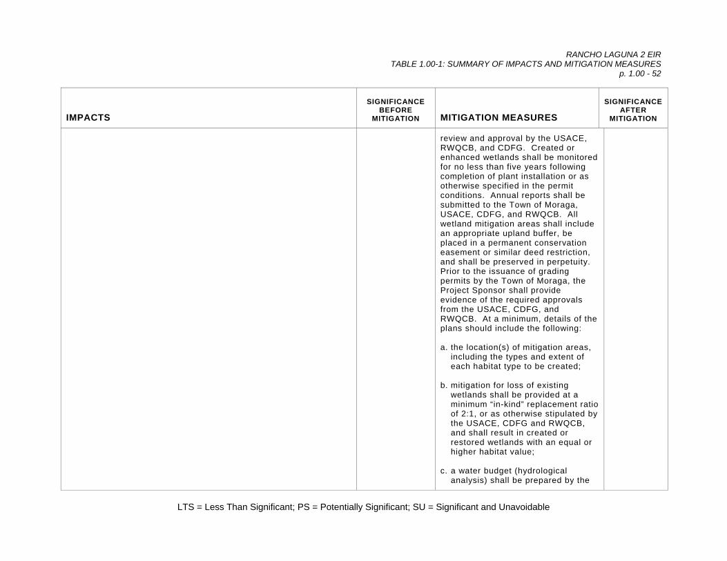
RANCHO LAGUNA 2 EIR TABLE 1.00-1: SUMMARY OF IMPACTS AND MITIGATION MEASURES
p. 1.00 - 52
LTS = Less Than Significant; PS = Potentially Significant; SU = Significant and Unavoidable
IMPACTS
SIGNIFICANCE BEFORE
MITIGATION
MITIGATION MEASURES
SIGNIFICANCE AFTER
MITIGATION
review and approval by the USACE, RWQCB, and CDFG. Created or enhanced wetlands shall be monitored for no less than five years following completion of plant installation or as otherwise specified in the permit conditions. Annual reports shall be submitted to the Town of Moraga, USACE, CDFG, and RWQCB. All wetland mitigation areas shall include an appropriate upland buffer, be placed in a permanent conservation easement or similar deed restriction, and shall be preserved in perpetuity. Prior to the issuance of grading permits by the Town of Moraga, the Project Sponsor shall provide evidence of the required approvals from the USACE, CDFG, and RWQCB. At a minimum, details of the plans should include the following: a. the location(s) of mitigation areas,
including the types and extent of each habitat type to be created;
b. mitigation for loss of existing
wetlands shall be provided at a minimum “in-kind” replacement ratio of 2:1, or as otherwise stipulated by the USACE, CDFG and RWQCB, and shall result in created or restored wetlands with an equal or higher habitat value;
c. a water budget (hydrological
analysis) shall be prepared by the

RANCHO LAGUNA 2 EIR TABLE 1.00-1: SUMMARY OF IMPACTS AND MITIGATION MEASURES
p. 1.00 - 53
LTS = Less Than Significant; PS = Potentially Significant; SU = Significant and Unavoidable
IMPACTS
SIGNIFICANCE BEFORE
MITIGATION
MITIGATION MEASURES
SIGNIFICANCE AFTER
MITIGATION
Project Sponsor analyzing water demand for each mitigation habitat type to be created and the ability of the watershed to support the target wetland habitats;
d. the stated goal of the mitigation
effort shall be to establish self-sustaining native riparian vegetation that shall not require long-term irrigation or maintenance;
e. the mitigation site shall include the
establishment of a vegetated upland buffer no less than 50 feet wide on all sides, where practicable;
f. a detailed mitigation and monitoring
plan shall be prepared summarizing the total area of habitat to be restored, grading details, analysis of site hydrology and its ability to support the proposed riparian vegetation, location and quantities of all indigenous plant materials to be installed, the location, application rate, and minimum germination rates of all native seed mixes to be used on all bare ground surfaces, monitoring procedures and schedules, identification of remedial measures, and performance criteria to be used by the agencies to assess success or failure of the mitigation effort; and,

RANCHO LAGUNA 2 EIR TABLE 1.00-1: SUMMARY OF IMPACTS AND MITIGATION MEASURES
p. 1.00 - 54
LTS = Less Than Significant; PS = Potentially Significant; SU = Significant and Unavoidable
IMPACTS
SIGNIFICANCE BEFORE
MITIGATION
MITIGATION MEASURES
SIGNIFICANCE AFTER
MITIGATION
g. mitigation areas shall be protected in perpetuity through the creation of a conservation easement or other deed restrictions, or as otherwise stipulated by the regulatory agencies.
Impact 3.55 #4. Non-Corps Jurisdictional Wetlands: The proposed development would result in impacts to a total of 0.65 acre of riparian habitats not otherwise qualifying as federally regulated wetlands; i.e., Central Coast riparian scrub. Impacts to isolated wetlands and other aquatic habitats not specifically regulated by the USACE may be regulated separately under the Clean Water Act (Section 401) and Section 1600, et seq. of the California Fish and Game Code. Pursuant to Section 401 of the Clean Water Act, a water quality certification or waiver must be issued by the RWQCB before the USACE could issue a Section 404 permit to fill any wetlands. The RWQCB routinely consults with the CDFG for technical assistance regarding an assessment of appropriate mitigation measures for unavoidable impacts to isolated wetlands and riparian habitats. Although a formal wetland delineation has been performed and verified by the USACE, additional potential isolated wetlands and riparian habitats are present within the study area. A preliminary map of these habitats has been prepared and was considered in this impact assessment (Figure 3.55-1). Grading for lots, roadways, slope repair and habitat mitigation/restoration would result in the loss of 0.65 acres (72.2 percent of the total on site) of Central Coast riparian scrub habitat, which falls under the jurisdiction of the CDFG and/or RWQCB. No impacts to isolated seeps or non-native blackberry scrub would result from project implementation. Impacts to Central Coast riparian scrub are restricted to habitat
PS Mitigation Measure 3.55 #4a: Prior to site grading, the Project Sponsor shall obtain permits under Section 401 of the Clean Water Act and Section 1600, et seq. of the State Fish and Game Code. These permits, administered by the RWQCB and CDFG, respectively, would identify specific mitigation measures to be imposed on the project as permit conditions. Mitigation Measure 3.55 #4b: A Revegetation and Monitoring Plan for the proposed re-alignment of the Rheem Boulevard drainage has been prepared by the Project Sponsor (Sycamore Associates LLC 2005c). The Revegetation and Monitoring Plan provides detailed revegetation goals and objectives, conceptual design and typical planting seeding plans, schedule, site preparation, invasive species control, soil salvage, planting and seeding specifications, maintenance, monitoring methodologies, performance standards, reporting, contingency measures, and responsibilities and
LTS

RANCHO LAGUNA 2 EIR TABLE 1.00-1: SUMMARY OF IMPACTS AND MITIGATION MEASURES
p. 1.00 - 55
LTS = Less Than Significant; PS = Potentially Significant; SU = Significant and Unavoidable
IMPACTS
SIGNIFICANCE BEFORE
MITIGATION
MITIGATION MEASURES
SIGNIFICANCE AFTER
MITIGATION
adjacent to the Rheem Boulevard drainage. Impacts would result from the construction of the proposed “A” Way access road, and from the placement of fill adjacent to Rheem Boulevard for slope stabilization purposes. This is a potentially significant impact.
funding. The Revegetation and Monitoring Plan shall be submitted to the RWQCB, CDFG, and the Town of Moraga for review and approval. The plans provide for the re-creation and enhancement of approximately 1,500 linear feet of surface channel, which will be revegetated with native species. In addition, the implementation of this plan shall result in the establishment of at least 1.3 acres of Central Coast riparian scrub habitat. Mitigation plantings shall be monitored for no less than five years following completion of plant installation or as otherwise specified in the permit conditions. Annual reports shall be submitted to the Town of Moraga, USACE, CDFG, and RWQCB. Additionally, the Town of Moraga shall ensure that all mitigation areas, along with an appropriate upland buffer, be placed in a permanent conservation easement, or similar deed restriction, and preserved in perpetuity. Prior to the issuance of grading permits by the Town of Moraga, the Project Sponsor shall provide evidence of the required approvals from the CDFG and RWQCB. The final mitigation measures imposed on the project are subject to Agency review and must meet the requirements of the USACE, CDFG and RWQCB. At a minimum,
RANCHO LAGUNA 2 EIR TABLE 1.00-1: SUMMARY OF IMPACTS AND MITIGATION MEASURES
p. 1.00 - 56
LTS = Less Than Significant; PS = Potentially Significant; SU = Significant and Unavoidable
IMPACTS
SIGNIFICANCE BEFORE
MITIGATION
MITIGATION MEASURES
SIGNIFICANCE AFTER
MITIGATION
mitigation measures shall include the following: a. the total area of willow canopy
impacted shall be replaced at a minimum ratio of at least two acres for each acre impacted, or a total of 1.3 acres of re-created Central Coast riparian scrub. Willow planting areas shall utilize a combination of pole cuttings collected from trees on site, in addition to 201 willow tree plantings (see Mitigation Measure 3.55 #5b, below);
b. a water budget (hydrological
analysis) shall be prepared analyzing water demand for each mitigation habitat type and the ability of the watershed to support the target habitats;
c. impacted non-wetland native tree
species associated with riparian corridors (e.g., coast live oak, valley oak, arroyo willow, California buckeye, black walnut) shall be replaced at a minimum of one 1½-gallon sized tree for every six inches of aggregate trunk diameter that is uprooted, using trees from East Bay stock (see Mitigation Measure 3.55 #5a, below);
d. the stated goal of the mitigation
effort shall be to establish self-

RANCHO LAGUNA 2 EIR TABLE 1.00-1: SUMMARY OF IMPACTS AND MITIGATION MEASURES
p. 1.00 - 57
LTS = Less Than Significant; PS = Potentially Significant; SU = Significant and Unavoidable
IMPACTS
SIGNIFICANCE BEFORE
MITIGATION
MITIGATION MEASURES
SIGNIFICANCE AFTER
MITIGATION
sustaining native riparian vegetation that shall not require long-term irrigation or maintenance;
e. the mitigation site shall include an
upland buffer of no less than 50 feet on all sides;
f. the mitigation effort shall conform
to the Revegetation and Monitoring Plan, prepared by Sycamore Associates LLC (2005c), or to the permit conditions, whichever is more rigorous; and,
g. Mitigation areas shall be protected
in perpetuity through the creation of a conservation easement or other deed restrictions, or as otherwise stipulated by the regulatory agencies.
Impact 3.55 #5. Loss of Native Trees: The majority of impacts to mature native trees would occur along Rheem Boulevard. Impacts would result from the construction of the proposed “A” Way access road, and from the placement of fill adjacent to Rheem Boulevard for slope stabilization purposes. A total of 64 mature native trees (55 willows, nine upland trees) would be directly impacted by construction adjacent to Rheem Boulevard (see Table 3.55-3). A tree survey was been prepared for all trees with a diameter of six inches or greater adjacent to the Rheem Boulevard drainage (Foothill 2002a). The EIR team mapped and measured trees on the east side of the ridge adjacent to lots 15, 16, 17, 18, and 24. A summary of tree impacts and proposed mitigation is provided in Table 3.55-3. Impacts to mature willows are also addressed separately in Mitigation Measure 3.55 #4, above. This is considered a potentially
PS Mitigation Measure 3.55 #5a. Native Upland Trees: Potential direct impacts to a total of nine mature native trees (247 cumulative inches) including coast live oak, valley oak, California buckeye, and black walnut, could result from tree removal as well as grading or filling within the dripline. All direct impacts to native trees shall be mitigated through planting of a minimum of 42 container-grown trees in the designated open space preserve in the re-aligned Rheem Boulevard drainage corridor or within
LTS

RANCHO LAGUNA 2 EIR TABLE 1.00-1: SUMMARY OF IMPACTS AND MITIGATION MEASURES
p. 1.00 - 58
LTS = Less Than Significant; PS = Potentially Significant; SU = Significant and Unavoidable
IMPACTS
SIGNIFICANCE BEFORE
MITIGATION
MITIGATION MEASURES
SIGNIFICANCE AFTER
MITIGATION
significant impact. In addition to direct removal of native trees, direct impacts to trees result when grading or trenching occurs within the dripline (defined the area beneath the extent of a tree’s canopy). Grading can sever main support roots and injury to branches and the trunk can result from equipment operating too close to the tree. Direct impacts from surface disturbances within the dripline may cause the ultimate death of a tree by reducing root support or root surface area, and by making a tree susceptible to disease or insect attack through limb injury. Trees were considered to be directly impacted if proposed grading or filling would encroach with the dripline. This is a considered to be a potentially significant impact. Additional impacts to native trees could result from the installation of a sewer line that would extend from the end of “C” Court through the existing woodland to the Lafayette-Moraga Regional Trail. Details of this potential project component have not been completed and impacts have not been quantified. If installation of this sewer line would require excavation of an open ditch is very likely to result in direct removal of native trees, as well as indirect effects on the root systems of native trees. One alternative to the use of an open ditch might include boring a tunnel down the wooded slope, thus avoiding the need to remove trees and, at least potentially, avoiding impacts to native tree root systems. Another alternative includes the construction of a lift station to pump wastewater upslope to the proposed gravity sewer line in “B” Drive, thus avoiding the need for tying the line into the main sewer line at the Lafayette-Moraga Regional Trail. This alternative mitigation measure is discussed in Mitigation Measure 3.65 #2a and #2b. Impacts to native trees would be considered potentially significant.
the conservation easement. Direct impacts to native trees shall be mitigated by planting one 1½ gallon-sized tree or comparable for every six inches of aggregate trunk diameter that is impacted. Replacement trees shall be from local East Bay sources. As a measure of the successful implementation of this mitigation measure, the survivorship of container plantings shall be at least 60 percent by the third year and 75 percent by the fifth year. The health and vigor for the tree plantings shall be at least two (good) at the end of the five-year monitoring period, as described in the Revegetation Plan (Sycamore 2005c). Mitigation Measure 3.55 #5b. Native Willows: Potential impacts to a total of 55 mature native arroyo willow (1,024 cumulative inches) shall be mitigated through planting of a minimum of 201 container-grown arroyo willows in the designated open space preserve in the re-aligned Rheem Boulevard drainage corridor. A combination of pole cuttings and container plantings shall be incorporated in the revegetation of the re-aligned Rheem Boulevard drainage corridor in order to provide at least 1.3 acres of new willow canopy (see Mitigation Measure 3.55 #4b). The survivorship of all willow container plantings shall be at least 60 percent by the third year and 75 percent by

RANCHO LAGUNA 2 EIR TABLE 1.00-1: SUMMARY OF IMPACTS AND MITIGATION MEASURES
p. 1.00 - 59
LTS = Less Than Significant; PS = Potentially Significant; SU = Significant and Unavoidable
IMPACTS
SIGNIFICANCE BEFORE
MITIGATION
MITIGATION MEASURES
SIGNIFICANCE AFTER
MITIGATION
the fifth year. The health and vigor for the tree plantings shall be at least two (good) at the end of the five-year monitoring period, as described in the Revegetation Plan (Sycamore 2005c). Replacement trees shall be from local East Bay sources. Pole cuttings shall be collected from source trees on site and planting adjacent to existing or constructed water courses where the water table is no more than three feet below the soil surface. Willow pole cuttings shall be collected from dormant donor plants between November and the first of February. Cuttings shall be a minimum of three to five feet long, ¾ to two inches in diameter at the lower end, and consist of non-succulent stems. To distinguish the top from the bottom, the root end should be cut at an angle during collection, with the top end cut squarely. This will also facilitate inserting the cuttings into the ground. The cuttings shall be planted the same day they are collected, or, if necessary, stored for up to two nights. During interim storage, cuttings will be kept cool and moist, but not wet. Pole cuttings should be stuck into wet ground at least two feet deep. Mitigation Measure 3.55 #5c: A Revegetation and Monitoring Plan for the proposed re-alignment of the Rheem Boulevard drainage has been prepared by the Project Sponsor
RANCHO LAGUNA 2 EIR TABLE 1.00-1: SUMMARY OF IMPACTS AND MITIGATION MEASURES
p. 1.00 - 60
LTS = Less Than Significant; PS = Potentially Significant; SU = Significant and Unavoidable
IMPACTS
SIGNIFICANCE BEFORE
MITIGATION
MITIGATION MEASURES
SIGNIFICANCE AFTER
MITIGATION
(Sycamore Associates LLC 2005c; see Mitigation Measure 3.55 #4b, above). The plans shall provide for the planting and establishment of at least 243 1.5 gallon-sized native trees, as summarized in Table 3.55-3, above. The Revegetation and Monitoring Plan provides detailed revegetation goals and objectives, conceptual design and typical planting seeding plans, schedule, site preparation, invasive species control, soil salvage, planting and seeding specifications, maintenance, monitoring methodologies, performance standards, reporting, contingency measures, and responsibilities and funding. The Revegetation and Monitoring Plan shall be submitted to the RWQCB, CDFG, and the Town of Moraga for review and approval. The plans provide for the re-creation and enhancement of approximately 1,500 linear feet of surface channel, which will be revegetated with native species. In addition, the implementation of this plan shall result in the establishment of at least 1.3 acres of Central Coast riparian scrub habitat. Mitigation plantings shall be monitored for no less than five years following completion of plant installation or as otherwise specified in the permit conditions. Annual reports shall be submitted to the Town of Moraga, USACE, CDFG,

RANCHO LAGUNA 2 EIR TABLE 1.00-1: SUMMARY OF IMPACTS AND MITIGATION MEASURES
p. 1.00 - 61
LTS = Less Than Significant; PS = Potentially Significant; SU = Significant and Unavoidable
IMPACTS
SIGNIFICANCE BEFORE
MITIGATION
MITIGATION MEASURES
SIGNIFICANCE AFTER
MITIGATION
and RWQCB. The survivorship of container and willow plantings shall be at least 60 percent by the third year and 75 percent by the fifth year. The health and vigor for the tree plantings shall be at least two (good) at the end of the five-year monitoring period, as described in the Revegetation Plan (Sycamore 2005c). Additionally, the Town of Moraga shall ensure that all mitigation areas, along with an appropriate upland buffer, be placed in a permanent conservation easement, or similar deed restriction, and preserved in perpetuity. Prior to the issuance of grading permits by the Town of Moraga, the Project Sponsor shall provide evidence of the required approvals from the CDFG and RWQCB. The final mitigation measures imposed on the project are subject to agency review and must meet the requirements of the CDFG and RWQCB.
Impact 3.55 #6. Loss of Native Trees on the East Slope: Trees located within the areas of disturbance and along the immediate edge of the limits of grading on the east side of the ridge were mapped and measured by the EIR team. Grading would encroach within the dripline of one mature valley oak at Lot 15. Additional tree impacts could result from grading on the east side of the ridge at Lot Numbers 15-18, 24, 25, and 29. This is a potentially significant impact.
PS Mitigation Measure 3.55 #6a: Mitigation for grading within the dripline of a single mature valley oak at Lot 15 is included under Mitigation Measure 3.55 #5a, above. Mitigation Measure 3.55 #6b: A tree survey of all trees located within 50 feet of the limits of grading on the east side of the ridge shall be
LTS

RANCHO LAGUNA 2 EIR TABLE 1.00-1: SUMMARY OF IMPACTS AND MITIGATION MEASURES
p. 1.00 - 62
LTS = Less Than Significant; PS = Potentially Significant; SU = Significant and Unavoidable
IMPACTS
SIGNIFICANCE BEFORE
MITIGATION
MITIGATION MEASURES
SIGNIFICANCE AFTER
MITIGATION
prepared by a qualified arborist. Trees shall be tallied as being directly impacted wherever grading overlaps with a tree’s dripline. Direct impacts to protected trees shall be mitigated as described in Mitigation Measure 3.55 #5a, above. Mitigation Measure 3.55 #6c: Prior to the issuance of a grading permit by the Town of Moraga, the Project Sponsor must develop a final plan to handle waste water for lots along “C” Court. If a sewer line extension between the lower end of “C” Court and the Lafayette-Moraga Regional Trail using open trench construction is proposed, a detailed tree survey must be completed within 50 feet of the centerline of the sewer alignment. The alignment itself should be sited to minimize the need to remove native trees, to the maximum extent feasible. If the sewer line extension to the Lafayette-Moraga Regional Trail can be implemented by boring, thus eliminating the need for open trench construction, a detailed tree survey must be completed within 50 feet of the edge of all construction areas, included but not limited to temporary staging and access areas, boring and receiving pits, or other areas of surface disturbance. Construction-related work areas should be sited to minimize tree removals, grading or stockpiling of soil within the root

RANCHO LAGUNA 2 EIR TABLE 1.00-1: SUMMARY OF IMPACTS AND MITIGATION MEASURES
p. 1.00 - 63
LTS = Less Than Significant; PS = Potentially Significant; SU = Significant and Unavoidable
IMPACTS
SIGNIFICANCE BEFORE
MITIGATION
MITIGATION MEASURES
SIGNIFICANCE AFTER
MITIGATION
protection zone of native trees, to the maximum extent feasible. If wastewater is to be handled by use of a lift station, thereby eliminating entirely the need to connect with the sewer main at the Lafayette-Moraga Regional Trail, no additional tree surveys or mitigation measures are needed. Trees shall be tallied as being directly impacted wherever grading overlaps with a tree’s dripline. Direct impacts to protected native trees shall be mitigated as described in Mitigation Measure 3.55 #5a, above.
Impact 3.55 #7. Eviction of Wildlife: Project implementation would result in the permanent loss of approximately 28 acres of non-native annual grassland and smaller portions of other habitats by the construction of roads and home lots. A total of 136 acres will be placed in permanent open space and managed as natural habitat for the benefit of common and special-status plant and wildlife species. Another 26 acres will be placed in open space to be owned by the Homeowner’s Association (HOA). Impacts resulting from construction of fencing, lighting, increased human activity and domestic animals could degrade the quality of the habitat for wildlife and potentially preclude wildlife activity from a portion of the project site. However, given the acreage that will be preserved on the project site, this is a less than significant impact.
LTS Mitigation Measure 3.55 #7: None Required.
LTS
Impact 3.55 #8. California Red-Legged Frog Movement in Coyote Creek: Grading and fill activities could result in direct mortalities of CRLF unless protective measures are implemented and adequate mitigation is provided. As proposed, no grading or construction would occur within 300 feet of Coyote Creek, which is presumed to function as a dispersal corridor between breeding populations on the
LTS Mitigation Measure 3.55 #8: None Required.
LTS

RANCHO LAGUNA 2 EIR TABLE 1.00-1: SUMMARY OF IMPACTS AND MITIGATION MEASURES
p. 1.00 - 64
LTS = Less Than Significant; PS = Potentially Significant; SU = Significant and Unavoidable
IMPACTS
SIGNIFICANCE BEFORE
MITIGATION
MITIGATION MEASURES
SIGNIFICANCE AFTER
MITIGATION
adjacent Palos Colorados site and Las Trampas Creek. Additionally, all grading and construction work would be conducted during the dry season (April through October) when CRLF would not be present in upland habitats. Dispersal of CRLF through the Coyote Creek corridor would not be impaired by the proposed project. This is considered a less than significant impact.
Impact 3.55 #9. California Red-Legged Frog: As proposed, the construction of the eastern access road from Rheem Boulevard, and filling to stabilize Rheem Boulevard would result in direct impacts to the Rheem Boulevard drainage. Specifically, the project would result in impacts to a total of 0.02 acre of unvegetated intermittent drainages, 0.37 acre of vegetated intermittent drainages, 0.01 acre of seasonal wetland, 0.16 acre of seep, 0.10 acre of freshwater marsh, and 0.65 acre of Central Coast riparian scrub. Although no suitable CRLF breeding habitat is present within the Rheem Boulevard drainage, and although it is unlikely to function as a dispersal corridor for CRLF between Las Trampas Creek and occupied habitats upstream, the tributary could provide seasonal habitat for CRLF. Work within the tributary could result in direct mortalities of CRLF present at the time of construction. This is considered to be a potentially significant impact.
PS Mitigation Measure 3.55 #9a: As part of the Clean Water Act permitting process, the USACE must assess the potential for a project to have an adverse effect on endangered species. A general condition of the authorization from the USACE to fill wetlands is that the proposed activities would not jeopardize any listed species. The USACE has been provided a copy of the CRLF Site Assessment (Wood Biological Consulting and Rana Resources 2003a). The USACE has initiated consultation with the USFWS. Before work could proceed, a permit would be required from the USACE. The permit would include conditions of approval intended to ensure no “take” of CRLF would result. In addition to the mitigation measures outlined below, additional mitigation in the form of habitat preservation, creation and/or enhancement might be warranted, based on review by USFWS. Evidence that the Project Sponsors have complied with the requirements of these agencies shall be submitted to the Town of Moraga
LTS

RANCHO LAGUNA 2 EIR TABLE 1.00-1: SUMMARY OF IMPACTS AND MITIGATION MEASURES
p. 1.00 - 65
LTS = Less Than Significant; PS = Potentially Significant; SU = Significant and Unavoidable
IMPACTS
SIGNIFICANCE BEFORE
MITIGATION
MITIGATION MEASURES
SIGNIFICANCE AFTER
MITIGATION
prior to issuance of any grading or building permits. Mitigation Measure 3.55 #9b: A Special-Status Species Mitigation and Monitoring Plan has been prepared by the Project Sponsor (Sycamore Associates LLC 2005b) to offset impacts to potential CRLF dispersal habitat. The Plan shall be submitted to the USACE, RWQCB, CDFG, USFWS, and the Town of Moraga for review and approval. At a minimum, all measures outlined in the Plan, including implementation of the grazing management plan, and invasive species control, shall be implemented. Additional mitigation measures may be required by the regulatory agencies. The following measures shall be implemented: 1. a total of 136 acres of grassland,
scrub and oak woodland shall be designated as a permanent conservation easement, and conveyed to a third-party entity approved by the Town of Moraga, USFWS and CDFG for preservation in perpetuity;
2. enhance suitable CRLF dispersal
habitat in the Coyote Creek corridor by implementation of the grazing management plan described in Sycamore (2005b);

RANCHO LAGUNA 2 EIR TABLE 1.00-1: SUMMARY OF IMPACTS AND MITIGATION MEASURES
p. 1.00 - 66
LTS = Less Than Significant; PS = Potentially Significant; SU = Significant and Unavoidable
IMPACTS
SIGNIFICANCE BEFORE
MITIGATION
MITIGATION MEASURES
SIGNIFICANCE AFTER
MITIGATION
3. the eastern edge of the Coyote Creek corridor shall be protected from grazing by a permanent fence to exclude livestock from the channel banks;
4. existing springs within any areas
proposed for grazing shall be fenced to exclude livestock. If access to water is required, water may be piped from the springs to water troughs outside of the exclosure fencing.
5. adaptive management shall be
utilized to identify and respond to problems that arise and which threaten to degrade potential CRLF dispersal habitat;
6. signs shall be installed identifying
the site as a sensitive habitat area;
7. habitats within the conservation
easement shall be monitored in the spring and fall for no less than five years following installation of fencing;
8. an education brochure shall be
produced for future homeowners describing the purpose of the conservation easement and other mitigation measures, the species and habitats being protected, prohibited activities, and

RANCHO LAGUNA 2 EIR TABLE 1.00-1: SUMMARY OF IMPACTS AND MITIGATION MEASURES
p. 1.00 - 67
LTS = Less Than Significant; PS = Potentially Significant; SU = Significant and Unavoidable
IMPACTS
SIGNIFICANCE BEFORE
MITIGATION
MITIGATION MEASURES
SIGNIFICANCE AFTER
MITIGATION
homeowner responsibilities; 9. monitoring of the average grass
height shall be conducted one month after “green-up” following the first inch of rain. Around mid-March, and monthly thereafter, average grass height shall be monitored to determine the residual dry matter level and timing of grazing cessation, adjusting grazing levels, or the need for supplemental feeding for no less than five years;
10. annual reports documenting
observations made during monitoring visits shall be submitted to the USACE, RWQCB, CDFG, and USFWS, by the end of each calendar year for no less than five years;
11. prior to the issuance of grading
permits by the Town of Moraga, the Project Sponsor shall provide evidence of the required approvals from all relevant regulatory agencies;
12. Moraga, USACE, USFWS, CDFG
and RWQCB to determine if the success standards have been achieved. If the permit conditions have not been met, the agencies will identify the appropriate remedial measures. The Project
RANCHO LAGUNA 2 EIR TABLE 1.00-1: SUMMARY OF IMPACTS AND MITIGATION MEASURES
p. 1.00 - 68
LTS = Less Than Significant; PS = Potentially Significant; SU = Significant and Unavoidable
IMPACTS
SIGNIFICANCE BEFORE
MITIGATION
MITIGATION MEASURES
SIGNIFICANCE AFTER
MITIGATION
Sponsor shall be responsible for completing all remedial measures and achieving sign-off from the agencies.
13. a long-term management plan
shall be prepared and submitted to the Town of Moraga for review and approval. The plan shall provide details of on-going monitoring and maintenance to be implemented in perpetuity.
14. to ensure the long-term
management of the open space, the Project Sponsor shall establish an endowment to provide for its maintenance and monitoring. The endowment shall include sufficient funding for the following functions: (a) the estimated cost of performing monitoring and annual reporting, (b) funding in perpetuity to perform weeding, trail maintenance, erosion control/repair, grazing management, and fence repair, and (c) funding in perpetuity for a designated preserve manager to periodically visit the site and report to the Town of Moraga. Funding sources might include seed money provided by the Project Sponsor, annual contributions from the HOA, and income from grazing leases. No

RANCHO LAGUNA 2 EIR TABLE 1.00-1: SUMMARY OF IMPACTS AND MITIGATION MEASURES
p. 1.00 - 69
LTS = Less Than Significant; PS = Potentially Significant; SU = Significant and Unavoidable
IMPACTS
SIGNIFICANCE BEFORE
MITIGATION
MITIGATION MEASURES
SIGNIFICANCE AFTER
MITIGATION
grading or building permits shall be issued by the Town until an endowment amount has been agreed upon and funded.
Mitigation Measure 3.55 #9c: Grading and filling of the Rheem Boulevard drainage could result in direct mortalities of CRLF present during construction. Construction within the tributary should be initiated after the peak season of CRLF dispersal (after May 1). Pre-construction surveys by a qualified wildlife biologist shall be conducted no more than 48 hours prior to clearing and grubbing the site (e.g., two night surveys immediately prior to construction), or as otherwise required by the USFWS. If CRLF are encountered, work must cease immediately and the USFWS must be contacted for further instructions. If no CRLF are encountered, the site may be considered ready for construction.
Mitigation Measure 3.55 #9d: All grading in and around creeks and wetlands shall conform to permit conditions issued by USACE, CDFG, RWQCB, and USFWS, intended to preserve habitats, water quality, and avoid “take” of CRLF. Mitigation Measure 3.55 #9e: Sensitive areas adjacent to but
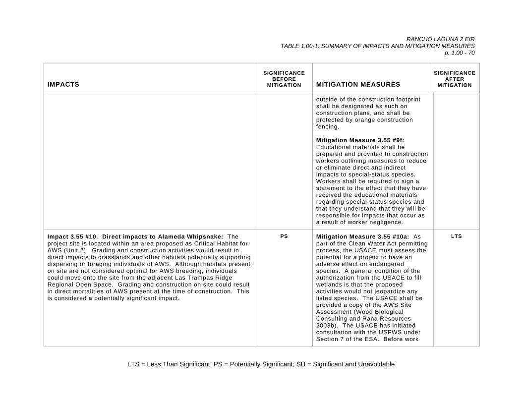
RANCHO LAGUNA 2 EIR TABLE 1.00-1: SUMMARY OF IMPACTS AND MITIGATION MEASURES
p. 1.00 - 70
LTS = Less Than Significant; PS = Potentially Significant; SU = Significant and Unavoidable
IMPACTS
SIGNIFICANCE BEFORE
MITIGATION
MITIGATION MEASURES
SIGNIFICANCE AFTER
MITIGATION
outside of the construction footprint shall be designated as such on construction plans, and shall be protected by orange construction fencing. Mitigation Measure 3.55 #9f: Educational materials shall be prepared and provided to construction workers outlining measures to reduce or eliminate direct and indirect impacts to special-status species. Workers shall be required to sign a statement to the effect that they have received the educational materials regarding special-status species and that they understand that they will be responsible for impacts that occur as a result of worker negligence.
Impact 3.55 #10. Direct impacts to Alameda Whipsnake: The project site is located within an area proposed as Critical Habitat for AWS (Unit 2). Grading and construction activities would result in direct impacts to grasslands and other habitats potentially supporting dispersing or foraging individuals of AWS. Although habitats present on site are not considered optimal for AWS breeding, individuals could move onto the site from the adjacent Las Trampas Ridge Regional Open Space. Grading and construction on site could result in direct mortalities of AWS present at the time of construction. This is considered a potentially significant impact.
PS Mitigation Measure 3.55 #10a: As part of the Clean Water Act permitting process, the USACE must assess the potential for a project to have an adverse effect on endangered species. A general condition of the authorization from the USACE to fill wetlands is that the proposed activities would not jeopardize any listed species. The USACE shall be provided a copy of the AWS Site Assessment (Wood Biological Consulting and Rana Resources 2003b). The USACE has initiated consultation with the USFWS under Section 7 of the ESA. Before work
LTS

RANCHO LAGUNA 2 EIR TABLE 1.00-1: SUMMARY OF IMPACTS AND MITIGATION MEASURES
p. 1.00 - 71
LTS = Less Than Significant; PS = Potentially Significant; SU = Significant and Unavoidable
IMPACTS
SIGNIFICANCE BEFORE
MITIGATION
MITIGATION MEASURES
SIGNIFICANCE AFTER
MITIGATION
could proceed, a permit is required from the USACE, and potentially the issuance of a Biological Opinion and/or incidental take permit by the USFWS. The permit and Biological Opinion will include conditions of approval intended to ensure no “take” of AWS would result. In addition to the mitigation measures outlined below, additional mitigation in the form of habitat preservation, creation and/or enhancement might be warranted, based on review by USFWS. Evidence that the Project Sponsors have complied with the requirements of these agencies shall be submitted to the Town of Moraga prior to issuance of any grading or building permits. Mitigation Measure 3.55 #10b: A Special-Status Species Mitigation and Monitoring Plan has been prepared by the Project Sponsor (Sycamore Associates LLC 2005b) to offset impacts to potential AWS dispersal habitat. The Plan shall be submitted to the USACE, RWQCB, CDFG, USFWS, and the Town of Moraga for review and approval. At a minimum, all measures outlined in the Plan, including implementation of the grazing management plan, and invasive species control, shall be implemented. Additional mitigation measures may be required by the regulatory agencies. The following

RANCHO LAGUNA 2 EIR TABLE 1.00-1: SUMMARY OF IMPACTS AND MITIGATION MEASURES
p. 1.00 - 72
LTS = Less Than Significant; PS = Potentially Significant; SU = Significant and Unavoidable
IMPACTS
SIGNIFICANCE BEFORE
MITIGATION
MITIGATION MEASURES
SIGNIFICANCE AFTER
MITIGATION
measures shall be implemented:
1. a total of 136 acres of grassland, scrub and oak woodland shall be designated as a permanent conservation easement, and conveyed to a third-party entity approved by the USFWS and CDFG for preservation in perpetuity;
2. enhance suitable AWS dispersal
habitat by implementation of the grazing management plan described in Sycamore (2005b);
3. a minimum of eight rock piles
covering 25 square feet and 3-4 feet in height shall be created using sandstone boulders salvaged on site during excavation;
4. bare soil areas associated with
the boulder placement sites shall be broadcast seeded using the native shrub and grassland mix described in Sycamore (2005b);
5. scrub habitat below the old ranch
road shall be fenced with permanent fencing to exclude grazing livestock;
6. existing springs within any areas
proposed for grazing shall be fenced to exclude livestock. If

RANCHO LAGUNA 2 EIR TABLE 1.00-1: SUMMARY OF IMPACTS AND MITIGATION MEASURES
p. 1.00 - 73
LTS = Less Than Significant; PS = Potentially Significant; SU = Significant and Unavoidable
IMPACTS
SIGNIFICANCE BEFORE
MITIGATION
MITIGATION MEASURES
SIGNIFICANCE AFTER
MITIGATION
access to water is required, water may be piped from the springs to water troughs outside of the exclosure fencing;
7. adaptive management shall be
utilized to identify and respond to problems that arise and which threaten to degrade potential AWS dispersal habitat;
8. signs shall be installed identifying
the site as a sensitive habitat area;
9. habitats within the conservation
easement shall be monitored in the spring and fall for no less than five years following installation of fencing and placement of boulder piles;
10. an education brochure shall be
produced for future homeowners describing the purpose of the conservation easement and other mitigation measures, the species and habitats being protected, prohibited activities, and homeowner responsibilities;
11. monitoring of the average grass
height shall be conducted one month after “green-up” following the first inch of rain. Around mid-March, and monthly thereafter, average grass height shall be

RANCHO LAGUNA 2 EIR TABLE 1.00-1: SUMMARY OF IMPACTS AND MITIGATION MEASURES
p. 1.00 - 74
LTS = Less Than Significant; PS = Potentially Significant; SU = Significant and Unavoidable
IMPACTS
SIGNIFICANCE BEFORE
MITIGATION
MITIGATION MEASURES
SIGNIFICANCE AFTER
MITIGATION
monitored to determine the residual dry matter level and timing of grazing cessation, adjusting grazing levels, or the need for supplemental feeding for no less than five years;
12. annual reports shall be submitted
to the USACE, RWQCB, CDFG, and USFWS, by the end of each calendar year for no less than five years;
13. prior to the issuance of grading
permits by the Town of Moraga, the Project Sponsor shall provide evidence of the required approvals from all relevant regulatory agencies;
14. at the end of the five-year
monitoring period, the Project Sponsor shall coordinate with the USACE, USFWS, CDFG and RWQCB to determine if the success standards have been achieved. If the permit conditions have not been met, the agencies will identify the appropriate remedial measures. The Project Sponsor shall be responsible for completing all remedial measures and achieving sign-off from the agencies;
15. a long-term management plan shall be prepared and submitted

RANCHO LAGUNA 2 EIR TABLE 1.00-1: SUMMARY OF IMPACTS AND MITIGATION MEASURES
p. 1.00 - 75
LTS = Less Than Significant; PS = Potentially Significant; SU = Significant and Unavoidable
IMPACTS
SIGNIFICANCE BEFORE
MITIGATION
MITIGATION MEASURES
SIGNIFICANCE AFTER
MITIGATION
to the Town of Moraga for review and approval. The plan shall provide details of on-going monitoring and maintenance to be implemented in perpetuity; and,
16. to ensure the long-term
management of the open space, the Project Sponsor shall establish an endowment to provide for its maintenance and monitoring. The endowment shall include sufficient funding for the following functions: (a) the estimated cost of performing monitoring and annual reporting, (b) funding in perpetuity to perform weeding, trail maintenance, erosion control/repair, grazing management, and fence repair, and (c) funding in perpetuity for a designated preserve manager to periodically visit the site and report to the Town of Moraga. Funding sources might include seed money provided by the Project Sponsor, annual contributions from the HOA, and income from grazing leases. No grading or building permits shall be issued by the Town until an endowment amount has been agreed upon and funded.
Mitigation Measure 3.55 #10c: Brush clearing and grading could

RANCHO LAGUNA 2 EIR TABLE 1.00-1: SUMMARY OF IMPACTS AND MITIGATION MEASURES
p. 1.00 - 76
LTS = Less Than Significant; PS = Potentially Significant; SU = Significant and Unavoidable
IMPACTS
SIGNIFICANCE BEFORE
MITIGATION
MITIGATION MEASURES
SIGNIFICANCE AFTER
MITIGATION
result in direct mortalities of AWS present during construction. Initial brush clearing and surface grading should be initiated after the peak season of AWS dispersal (after June 1). Pre-construction surveys by a qualified wildlife biologist shall be conducted no more than 24 hours prior to clearing and grubbing the site. If AWS should be encountered, the USFWS would be contacted for further instructions. If no AWS were encountered, the site could be considered ready for construction. A biologist shall be present to supervise brush removal until the site has been cleared of vegetation. The role of the biological monitor will be to ensure that no take of AWS occurs. The biological monitor shall also move other common wildlife species out of harm’s way during removal of surface vegetation. Monthly construction monitoring reports shall be prepared by the biological monitor and submitted to the Town, USFWS, and CDFG.
Mitigation Measure 3.55 #10d: All grading and construction activities shall conform to permit conditions issued by USACE, CDFG, RWQCB, and USFWS, intended to preserve habitats and avoid “take” of AWS. Mitigation Measure 3.55 #10e: Sensitive areas adjacent to but outside of the construction footprint

RANCHO LAGUNA 2 EIR TABLE 1.00-1: SUMMARY OF IMPACTS AND MITIGATION MEASURES
p. 1.00 - 77
LTS = Less Than Significant; PS = Potentially Significant; SU = Significant and Unavoidable
IMPACTS
SIGNIFICANCE BEFORE
MITIGATION
MITIGATION MEASURES
SIGNIFICANCE AFTER
MITIGATION
shall be designated as such on construction plans, and shall be protected from encroachment by construction workers and equipment by orange construction fencing. Mitigation Measure 3.55 #10f: Educational materials shall be prepared and provided to construction workers outlining measures to reduce or eliminate direct and indirect impacts to special-status species. Workers shall be required to sign a statement to the effect that they have received the educational materials regarding special-status species and that they understand that they shall be responsible for impacts that occur as a result of worker negligence.
Impact 3.55 #12. Direct Impacts to Nesting Raptors and Other Nesting Migratory Birds, Occupied Nests, and Active Bat Roosts: Potential impacts include the destruction of occupied nests and roosts, direct mortalities of eggs and young, and causing breeding adults to abandon nests and roosts. This is a potentially significant impact.
PS Mitigation Measure 3.55 #12a: Active nesting sites of migratory birds including raptors are protected under the Migratory Bird Treaty Act and the California Fish and Game Code. In order to ensure that occupied nests of migratory birds are not impacted, land-clearing activities (grading, grubbing and clearing of vegetation, or the removal or trimming of trees) shall be performed between September 1 and January 30. Mitigation Measure 3.55 #12b: If land-clearing activities are scheduled
LTS
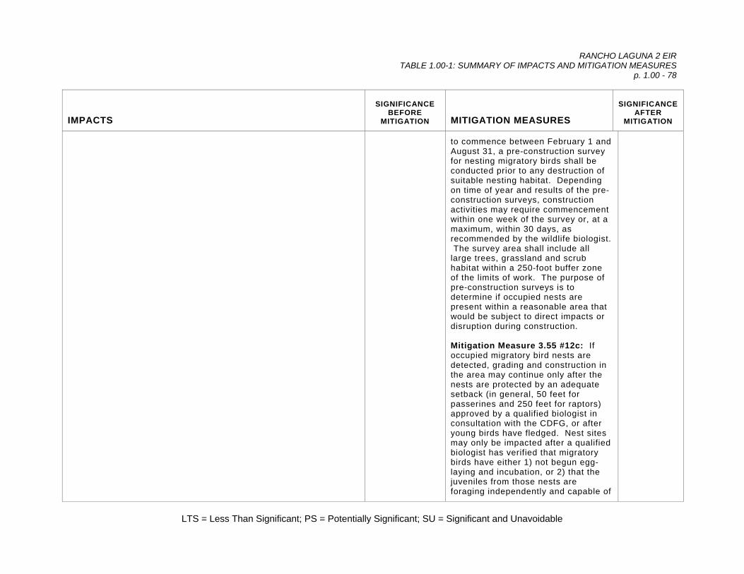
RANCHO LAGUNA 2 EIR TABLE 1.00-1: SUMMARY OF IMPACTS AND MITIGATION MEASURES
p. 1.00 - 78
LTS = Less Than Significant; PS = Potentially Significant; SU = Significant and Unavoidable
IMPACTS
SIGNIFICANCE BEFORE
MITIGATION
MITIGATION MEASURES
SIGNIFICANCE AFTER
MITIGATION
to commence between February 1 and August 31, a pre-construction survey for nesting migratory birds shall be conducted prior to any destruction of suitable nesting habitat. Depending on time of year and results of the pre-construction surveys, construction activities may require commencement within one week of the survey or, at a maximum, within 30 days, as recommended by the wildlife biologist. The survey area shall include all large trees, grassland and scrub habitat within a 250-foot buffer zone of the limits of work. The purpose of pre-construction surveys is to determine if occupied nests are present within a reasonable area that would be subject to direct impacts or disruption during construction. Mitigation Measure 3.55 #12c: If occupied migratory bird nests are detected, grading and construction in the area may continue only after the nests are protected by an adequate setback (in general, 50 feet for passerines and 250 feet for raptors) approved by a qualified biologist in consultation with the CDFG, or after young birds have fledged. Nest sites may only be impacted after a qualified biologist has verified that migratory birds have either 1) not begun egg-laying and incubation, or 2) that the juveniles from those nests are foraging independently and capable of

RANCHO LAGUNA 2 EIR TABLE 1.00-1: SUMMARY OF IMPACTS AND MITIGATION MEASURES
p. 1.00 - 79
LTS = Less Than Significant; PS = Potentially Significant; SU = Significant and Unavoidable
IMPACTS
SIGNIFICANCE BEFORE
MITIGATION
MITIGATION MEASURES
SIGNIFICANCE AFTER
MITIGATION
independent survival at an earlier date. Mitigation Measure 3.55 #12d: Prior to removing oak trees and large snags, pre-construction surveys should be conducted to check for the presence of bats. A pre-construction survey for bats shall be conducted no more than 30 days prior to the removal of any large tree. The survey shall be conducted by a qualified wildlife biologist. If no evidence of bat roosting is identified during the pre-construction survey, then no impacts to bats would be expected to occur from tree removal. If evidence of bat roosting is identified, a focused survey by a qualified wildlife biologist shall be performed to determine the species present, number of individuals present, and their reproductive status. Appropriate mitigation measures shall be developed to protect roosting bats in consultation with the CDFG. Mitigation Measure 3.55 #12e: The presence of any maternity sites shall be reported to the California Natural Diversity Database (CNDDB).
Impact 3.55 #13. Direct Impacts on Sensitive Plant Communities: During grading and construction of the subdivision, inadvertent impacts to sensitive habitats such as oak woodland, riparian woodland, wetlands, seeps, springs, and scrub habitat could result. Inadvertent impacts include accidental grading or vehicle traffic
PS Mitigation Measure 3.55 #13a: All sensitive habitat areas to be avoided shall be clearly marked on project maps and provided to the contractor. These areas shall be designated as
LTS

RANCHO LAGUNA 2 EIR TABLE 1.00-1: SUMMARY OF IMPACTS AND MITIGATION MEASURES
p. 1.00 - 80
LTS = Less Than Significant; PS = Potentially Significant; SU = Significant and Unavoidable
IMPACTS
SIGNIFICANCE BEFORE
MITIGATION
MITIGATION MEASURES
SIGNIFICANCE AFTER
MITIGATION
outside the proposed limits of grading, stockpiling earth or construction materials, toxic spills, and fugitive dust. This is a potentially significant impact.
“no construction” or “limited construction” zones. These areas shall be flagged in the field, as approved by the project biologist, prior to the initiation of construction activities. In some cases, resources may need to be fenced or otherwise protected from direct or indirect impacts, as determined by the project biologist. Contractors shall be provided with copies of all state and federal permit conditions and shall be made aware of the consequences for non-compliance. Mitigation Measure 3.55 #13b: Heavy equipment and construction activities shall be restricted to existing roadways and development areas, and vehicle access through creeks shall be prohibited, except where specifically authorized and permitted. Creeks, wetlands, woodland and scrub habitat not within the development envelope shall be designated as off-limits; their use for staging areas, equipment storage, and disposal or temporary placement of excess fill shall be prohibited. Mitigation Measure 3.55 #13c: Equipment maintenance and fueling areas shall not be located within 100 feet of any creek or wetland. All fuel and hydraulic fluid spills shall be contained within the maintenance area and managed appropriately.
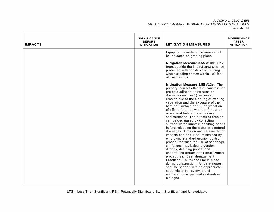
RANCHO LAGUNA 2 EIR TABLE 1.00-1: SUMMARY OF IMPACTS AND MITIGATION MEASURES
p. 1.00 - 81
LTS = Less Than Significant; PS = Potentially Significant; SU = Significant and Unavoidable
IMPACTS
SIGNIFICANCE BEFORE
MITIGATION
MITIGATION MEASURES
SIGNIFICANCE AFTER
MITIGATION
Equipment maintenance areas shall be indicated on grading plans. Mitigation Measure 3.55 #13d: Oak trees outside the impact area shall be protected with construction fencing where grading comes within 100 feet of the drip line. Mitigation Measure 3.55 #13e: The primary indirect effects of construction projects adjacent to streams or drainages involve 1) increased erosion due to the clearing of existing vegetation and the exposure of the bare soil surface and 2) degradation of offsite (e.g., downstream) riparian or wetland habitat by excessive sedimentation. The effects of erosion can be decreased by collecting surface water runoff in desilting ponds before releasing the water into natural drainages. Erosion and sedimentation impacts can be further minimized by employing standard erosion control procedures such the use of sandbags, silt fences, hay bales, diversion ditches, desilting ponds, and undertaking stream bank stabilization procedures. Best Management Practices (BMPs) shall be in place during construction. All bare slopes shall be seeded with an appropriate seed mix to be reviewed and approved by a qualified restoration biologist.

RANCHO LAGUNA 2 EIR TABLE 1.00-1: SUMMARY OF IMPACTS AND MITIGATION MEASURES
p. 1.00 - 82
LTS = Less Than Significant; PS = Potentially Significant; SU = Significant and Unavoidable
IMPACTS
SIGNIFICANCE BEFORE
MITIGATION
MITIGATION MEASURES
SIGNIFICANCE AFTER
MITIGATION
Mitigation Measure 3.55 #13f: Although there is little information on the effects of dust on plant life, there is some indication that excessive dust can reduce the overall vigor of some plant species by reducing their ability to photosynthesize and by increasing their susceptibility to pests or disease. While any noticeable adverse impact from dust would likely require long-term exposure, preventive measures shall be included in the construction documents for the project. Fugitive dust emissions caused by prolonged grading activities shall be mitigated by employing standard air quality control procedures as noted in Air Quality (Mitigation Measure 3.45 #2).
Impact 3.55 #14. Bridges’ Coast Range Shoulderband Snail: Project implementation would result in the loss of suitable habitat for the Bridges’ Coast Range shoulderband snail (BCRSS). Although the species is currently afforded no formal protection under state or federal legislation, impacts to it in the region are routinely evaluated and mitigation measures proposed. The majority of the oak woodland and grassland habitats within the project area would be preserved in a conservation easement, providing abundant suitable habitat for BCRSS. Due to the relatively wide distribution of BCRSS, development of this property would not jeopardize the continued existence of the subspecies. This is a less than significant impact.
LTS Mitigation Measure 3.55 #14a: None Required.
LTS
Impact 3.55 #15. Degradation of Wildlife Habitats and Decrease in the Carrying Capacity for Wildlife and Special-Status Species: Project implementation would result in increased human activity in and access to currently undeveloped wildlife habitats. These habitats include sensitive wetlands, regionally valuable oak
PS Mitigation Measure 3.55 #15a: A total of 136 acres of undeveloped land consisting of existing grasslands, oak woodland, intermittent channels, and seeps, would be designated as
LTS

RANCHO LAGUNA 2 EIR TABLE 1.00-1: SUMMARY OF IMPACTS AND MITIGATION MEASURES
p. 1.00 - 83
LTS = Less Than Significant; PS = Potentially Significant; SU = Significant and Unavoidable
IMPACTS
SIGNIFICANCE BEFORE
MITIGATION
MITIGATION MEASURES
SIGNIFICANCE AFTER
MITIGATION
woodlands, scrub, and wildflower fields, which could potentially support special-status wildlife species such as California red-legged frog, Alameda whipsnake, and migratory birds. Although the proposed project calls for the designation of 136 acres as permanently protected open space, without ecologically based management, the habitats could become degraded over time through benign neglect or abuse. Erosion, sedimentation of creeks, off-road vehicle activity, and invasive plant species could result in the permanent loss of the wildlife habitats that presently occupy the site. In addition, as homeowners move into the development, their personal interests and those of the HOA could change over time, and come into conflict with the stated goals of preserving these habitats for the benefit of wildlife, biological diversity, and, ultimately, the residents and citizens of the area. This is a potentially significant impact.
permanently preserved open space and placed into a conservation easement. A Special-status Species Mitigation and Monitoring Plan has been developed (Sycamore Associates LLC 2005b) to provide guidance on managing and monitoring preserved aquatic and upland habitat for special-status and common wildlife species. Details of the plan and the required measures are outlined in Mitigation Measures 3.55 #9b and #10b, above. Mitigation Measure 3.55 #15b: The Project Sponsor shall retain the responsibility for these activities as the permittee until final sign off by the regulatory agencies and the Town of Moraga, presumably after five years. Mitigation Measure 3.55 #15c: Upon sign-off, an appropriate conservation-oriented third party entity (or the Town of Moraga) shall be designated as a preserve manager, subject to the approval of the Town of Moraga, USACE, CDFG, RWQCB, and USFWS. The preserve manager shall retain fee ownership interest in the 136 acre conservation easement, and shall assume the responsibility for providing the maintenance and management of the preserve after the five-year monitoring period. Mitigation Measure 3.55 #15d: To

RANCHO LAGUNA 2 EIR TABLE 1.00-1: SUMMARY OF IMPACTS AND MITIGATION MEASURES
p. 1.00 - 84
LTS = Less Than Significant; PS = Potentially Significant; SU = Significant and Unavoidable
IMPACTS
SIGNIFICANCE BEFORE
MITIGATION
MITIGATION MEASURES
SIGNIFICANCE AFTER
MITIGATION
ensure the long-term management of the open space, the Project Sponsor shall establish an endowment to provide for its maintenance and monitoring. The endowment shall include sufficient funding for the following functions: (a) the estimated cost of performing monitoring and annual reporting, (b) funding in perpetuity to perform weeding, trail maintenance, erosion control/repair, and fence repair, and (c) funding in perpetuity for a designated preserve manager to periodically visit the site and report to the Town of Moraga.
Impact 3.55 #16. California Red-Legged Frog Habitat: Increased human habitation adjacent to occupied CRLF habitat could result in an increase in CRLF predators such as raccoons and skunks, which are attracted to dwellings by unsecured trash and outdoor pet food dishes. This is a potentially significant impact.
PS Mitigation Measure 3.55 #16a: Future residents shall be provided with guidelines for safely co-existing with wildlife. Leaving pet food out-of-doors shall be prohibited, unless in a fully fenced kennel. In addition, trash receptacles shall have tight-fitting lids to discourage wildlife from using as forage. Mitigation Measure 3.55 #16b: A Special-Status Species Mitigation and Monitoring Plan (Sycamore Associates LLC 2005b) has been developed to provide guidance on managing and monitoring preserved aquatic and upland habitat for special-status, including CRLF. Details of the plan and the required measures relative to CRLF are outlined in Mitigation Measures 3.55 #9b, above.
LTS

RANCHO LAGUNA 2 EIR TABLE 1.00-1: SUMMARY OF IMPACTS AND MITIGATION MEASURES
p. 1.00 - 85
LTS = Less Than Significant; PS = Potentially Significant; SU = Significant and Unavoidable
IMPACTS
SIGNIFICANCE BEFORE
MITIGATION
MITIGATION MEASURES
SIGNIFICANCE AFTER
MITIGATION
Impact 3.55 #17. Indirect Recreational Effects on California Red-Legged Frog: Recreational activities along the proposed re-aligned Rheem Boulevard drainage wetland area and trail system could contribute to the likelihood of an unauthorized “take” of CRLF individuals by residents and visitors. Harassment and predation by people and pets could become a serious problem, particularly where creeks and movement corridors border residential development and improved parks. The creation of ponds in the mitigation area could attract CRLF, placing them in danger of predation, especially if the ponds were to become colonized by bullfrogs or other predators such as bass or western mosquitofish. This is a potentially significant impact.
PS Mitigation Measure 3.55 #17a: The proposed revegetation of the re-aligned Rheem Boulevard drainage shall not include the construction of perennial ponds or any year-round water features to avoid attracting CRLF. Mitigation habitats shall be consistent with those present on site currently, specifically, woody riparian, seasonal wetlands, and annual grasslands. Such habitats would continue to provide the same functions as those lost to construction. Dispersing CRLF would not be inclined to remain on site, reducing the likelihood that individuals would be subject to predation. Mitigation Measure 3.55 #17b: A Special-Status Species Mitigation and Monitoring Plan (Sycamore Associates LLC 2005b) has been developed to provide guidance on managing and monitoring preserved aquatic and upland habitat for special-status, including CRLF. Details of the plan and the required measures relative to CRLF are outlined in Mitigation Measures 3.55 #9b, above.
LTS
Impact 3.55 #18. Indirect Impacts on California Red-Legged Frog Habitat: Grading and the intensification of human activities could result in the degradation of water quality in the Rheem Boulevard drainage, thereby resulting in an indirect loss of CRLF habitat. While
PS Mitigation Measure 3.55 #18a: Grading and filling of the Rheem Boulevard drainage could result in short-term sedimentation and
LTS

RANCHO LAGUNA 2 EIR TABLE 1.00-1: SUMMARY OF IMPACTS AND MITIGATION MEASURES
p. 1.00 - 86
LTS = Less Than Significant; PS = Potentially Significant; SU = Significant and Unavoidable
IMPACTS
SIGNIFICANCE BEFORE
MITIGATION
MITIGATION MEASURES
SIGNIFICANCE AFTER
MITIGATION
grading associated with the proposed re-aligned Rheem Boulevard drainage would ultimately serve to improve habitat, it could also contribute to short-term sedimentation and temporary loss of potential dispersal routes for CRLF. This is considered a potentially significant impact.
temporary loss of potential dispersal routes for CRLF. Appropriate sedimentation controls must be designed, installed, and maintained during construction to prevent the accumulation of sediment in the tributary downstream of the construction site. Grading shall be performed outside of the peak season of CRLF dispersal to reduce the likelihood of individuals migrating into the construction area. The optimal season for grading corresponds with the driest months of the year, before the onset of fall or winter rains. Periodic monitoring shall be performed by a qualified wildlife biologist, as required in permit conditions. A silt fence and construction fence barrier shall be erected around the site to prevent construction workers from straying outside the construction site and preventing frogs from potentially accessing the site. The fence shall be monitored weekly by a qualified wildlife biologist to make sure it is properly maintained. Additional permit conditions could be imposed on the project.
Impact 3.55 #19. Indirect Effects on Alameda Whipsnake: Intensification of proposed residential use and human activity, and the associated degradation of upland habitats could cause indirect loss of AWS, occupied habitat, or suitable habitat unless protective measures are implemented and adequate mitigation is provided.
PS Mitigation Measure 3.55 #19a: The proposed revegetation of the re-aligned Rheem Boulevard drainage shall not include the construction of perennial ponds or any year-round
LTS
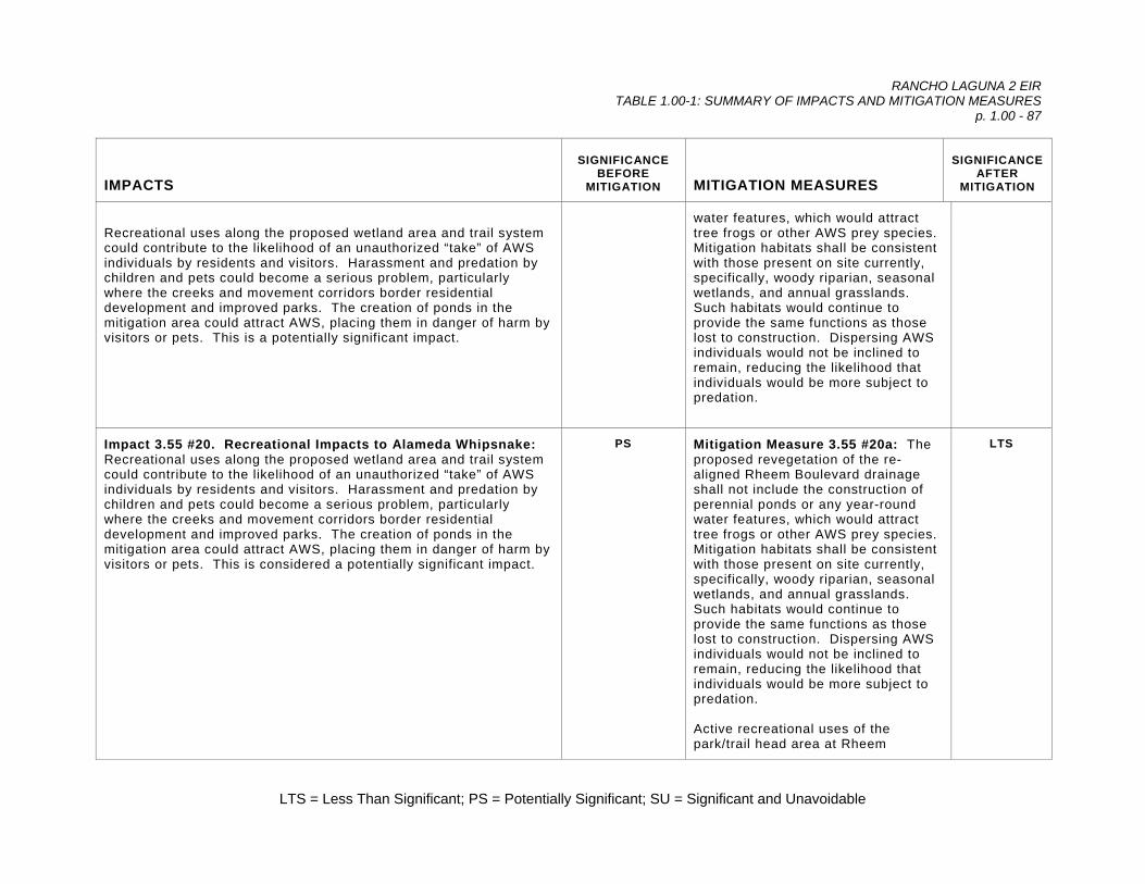
RANCHO LAGUNA 2 EIR TABLE 1.00-1: SUMMARY OF IMPACTS AND MITIGATION MEASURES
p. 1.00 - 87
LTS = Less Than Significant; PS = Potentially Significant; SU = Significant and Unavoidable
IMPACTS
SIGNIFICANCE BEFORE
MITIGATION
MITIGATION MEASURES
SIGNIFICANCE AFTER
MITIGATION
Recreational uses along the proposed wetland area and trail system could contribute to the likelihood of an unauthorized “take” of AWS individuals by residents and visitors. Harassment and predation by children and pets could become a serious problem, particularly where the creeks and movement corridors border residential development and improved parks. The creation of ponds in the mitigation area could attract AWS, placing them in danger of harm by visitors or pets. This is a potentially significant impact.
water features, which would attract tree frogs or other AWS prey species. Mitigation habitats shall be consistent with those present on site currently, specifically, woody riparian, seasonal wetlands, and annual grasslands. Such habitats would continue to provide the same functions as those lost to construction. Dispersing AWS individuals would not be inclined to remain, reducing the likelihood that individuals would be more subject to predation.
Impact 3.55 #20. Recreational Impacts to Alameda Whipsnake: Recreational uses along the proposed wetland area and trail system could contribute to the likelihood of an unauthorized “take” of AWS individuals by residents and visitors. Harassment and predation by children and pets could become a serious problem, particularly where the creeks and movement corridors border residential development and improved parks. The creation of ponds in the mitigation area could attract AWS, placing them in danger of harm by visitors or pets. This is considered a potentially significant impact.
PS Mitigation Measure 3.55 #20a: The proposed revegetation of the re-aligned Rheem Boulevard drainage shall not include the construction of perennial ponds or any year-round water features, which would attract tree frogs or other AWS prey species. Mitigation habitats shall be consistent with those present on site currently, specifically, woody riparian, seasonal wetlands, and annual grasslands. Such habitats would continue to provide the same functions as those lost to construction. Dispersing AWS individuals would not be inclined to remain, reducing the likelihood that individuals would be more subject to predation. Active recreational uses of the park/trail head area at Rheem
LTS

RANCHO LAGUNA 2 EIR TABLE 1.00-1: SUMMARY OF IMPACTS AND MITIGATION MEASURES
p. 1.00 - 88
LTS = Less Than Significant; PS = Potentially Significant; SU = Significant and Unavoidable
IMPACTS
SIGNIFICANCE BEFORE
MITIGATION
MITIGATION MEASURES
SIGNIFICANCE AFTER
MITIGATION
Boulevard shall be prohibited to minimize the potential for harassment of wildlife. Creation of rock piles for AWS shall not be located near any high activity areas such as trail heads to lessen the chance of disturbance by humans. Mitigation Measure 3.55 #20b: An On-site Wetland and Special-Status Species Mitigation and Monitoring Plan has been developed (Sycamore Associates LLC 2005b), providing guidance on managing and monitoring preserved aquatic and upland habitat for special-status and common wildlife species (see Mitigation Measures 3.55 #9b and #10b).
Impact 3.55 #21. Recreational Impacts to Wildlife and Wildlife Habitat: It is the desire of the Town to provide a trail link between the Lafayette-Moraga Regional Trail through the Coyote Creek canyon and across the Palos Colorados project site to connect to Moraga Road. However, a trail system through this protected open space could increase the effects of increased human activity and access to sensitive habitats. Introduction of pets and off-trail travel by pedestrians, bicycles, and horses could result in harassment and accidental mortalities of wildlife, as well as inhibition of wildlife activity and utilization of the preserved open space, in conflict with the stated goals of Town of Moraga General Plan. This is considered a potentially significant impact.
PS Mitigation Measure 3.55 #21a: An On-Site Wetland and Special-Status Species Mitigation and Monitoring Plan has been developed (Sycamore Associates LLC 2005b), providing guidance on managing and monitoring preserved aquatic and upland habitat for special-status and common wildlife species (see Mitigation Measures 3.55 #9b and #10b). Mitigation Measure 3.55 #21b: In order to minimize potential human impacts and preserve and enhance the existing habitats on site for wildlife, the proposed trail system shall be reoriented to consist of a
LTS
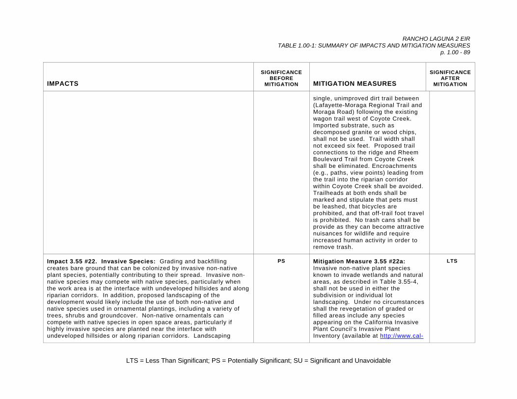
RANCHO LAGUNA 2 EIR TABLE 1.00-1: SUMMARY OF IMPACTS AND MITIGATION MEASURES
p. 1.00 - 89
LTS = Less Than Significant; PS = Potentially Significant; SU = Significant and Unavoidable
IMPACTS
SIGNIFICANCE BEFORE
MITIGATION
MITIGATION MEASURES
SIGNIFICANCE AFTER
MITIGATION
single, unimproved dirt trail between (Lafayette-Moraga Regional Trail and Moraga Road) following the existing wagon trail west of Coyote Creek. Imported substrate, such as decomposed granite or wood chips, shall not be used. Trail width shall not exceed six feet. Proposed trail connections to the ridge and Rheem Boulevard Trail from Coyote Creek shall be eliminated. Encroachments (e.g., paths, view points) leading from the trail into the riparian corridor within Coyote Creek shall be avoided. Trailheads at both ends shall be marked and stipulate that pets must be leashed, that bicycles are prohibited, and that off-trail foot travel is prohibited. No trash cans shall be provide as they can become attractive nuisances for wildlife and require increased human activity in order to remove trash.
Impact 3.55 #22. Invasive Species: Grading and backfilling creates bare ground that can be colonized by invasive non-native plant species, potentially contributing to their spread. Invasive non-native species may compete with native species, particularly when the work area is at the interface with undeveloped hillsides and along riparian corridors. In addition, proposed landscaping of the development would likely include the use of both non-native and native species used in ornamental plantings, including a variety of trees, shrubs and groundcover. Non-native ornamentals can compete with native species in open space areas, particularly if highly invasive species are planted near the interface with undeveloped hillsides or along riparian corridors. Landscaping
PS Mitigation Measure 3.55 #22a: Invasive non-native plant species known to invade wetlands and natural areas, as described in Table 3.55-4, shall not be used in either the subdivision or individual lot landscaping. Under no circumstances shall the revegetation of graded or filled areas include any species appearing on the California Invasive Plant Council’s Invasive Plant Inventory (available at http://www.cal-
LTS

RANCHO LAGUNA 2 EIR TABLE 1.00-1: SUMMARY OF IMPACTS AND MITIGATION MEASURES
p. 1.00 - 90
LTS = Less Than Significant; PS = Potentially Significant; SU = Significant and Unavoidable
IMPACTS
SIGNIFICANCE BEFORE
MITIGATION
MITIGATION MEASURES
SIGNIFICANCE AFTER
MITIGATION
associated with the project could result in the introduction of invasive non-native plants that could colonize wetlands and open space areas, displacing desired native species. This is a potentially significant impact.
ipc.org/pest_plant_list/). Mitigation Measure 3.55 #22b: An On-Site Wetland and Special-Status Species Mitigation and Monitoring Plan has been developed (Sycamore Associates LLC 2005b), outlining measures to eradicate the existing infestation of artichoke thistle throughout the site, including the conservation easement. The plan also includes a grazing management plan intended to prevent over-grazing of the conservation easement lands, which would aid in the control of detrimental invasive species. The measures outlined in the plan shall be paid for and administered by the Project Sponsor. Proper implementation of these measures shall be documented by the site monitor and confirmed in reports submitted to the Town. As stated in Mitigation Measures 3.55 #9b and #10b, the Project Sponsor shall fund an endowment to ensure the long-term management and maintenance of the conservation easement. Mitigation Measure 3.55 #22c: All disturbed areas shall be visited by the restoration ecologist after one rainy season has passed since seeding. Site visits should be made during the spring, and each site shall be visited at least once. Sites shall be monitored for the revegetation. Sites

RANCHO LAGUNA 2 EIR TABLE 1.00-1: SUMMARY OF IMPACTS AND MITIGATION MEASURES
p. 1.00 - 91
LTS = Less Than Significant; PS = Potentially Significant; SU = Significant and Unavoidable
IMPACTS
SIGNIFICANCE BEFORE
MITIGATION
MITIGATION MEASURES
SIGNIFICANCE AFTER
MITIGATION
that fail to show suitable vegetative cover shall be noted and mapped, and shall be re-seeded in the fall. The restoration ecologist shall make notes on the occurrence of particularly noxious non-native plant species, and make recommendations for their eradication.
Impact 3.55 #23. Habitat Loss and Fragmentation: Implementation of the proposed project would result in the permanent loss of 0.65 acres of riparian habitat and 27.89 acres of non-native annual grassland, as well as the potential degradation of habitat values of adjacent habitats by increased human activity including traffic, night lighting, noise, run-off containing noxious chemicals, increased risk of wildfires, and trampling. These plant communities provide suitable foraging, resting, and cover habitats and other benefits for a variety of native wildlife. The loss of and degradation to this habitat could potentially decrease local native biodiversity by decreasing the availability of these wildlife resources and could fragment existing communities. This is a potentially significant impact.
PS Mitigation Measure 3.55 #23a: The remaining natural habitat (approximately 80% of the project area) would be preserved in a conservation easement as publicly managed open space, as well as preserved open space managed by the HOA. Mitigation Measure 3.55 #23b: In order to prevent the incremental degradation of preserved habitats, the following measures shall be followed: a. all areas not proposed for
development shall be protected from construction disturbance and left in existing vegetation. Construction fencing shall be installed to delimit the areas subject to disturbance and to protect native vegetation outside the limits of grading;
b. soil and other debris shall not be
stockpiled in areas designated as preserved open space or for
LTS

RANCHO LAGUNA 2 EIR TABLE 1.00-1: SUMMARY OF IMPACTS AND MITIGATION MEASURES
p. 1.00 - 92
LTS = Less Than Significant; PS = Potentially Significant; SU = Significant and Unavoidable
IMPACTS
SIGNIFICANCE BEFORE
MITIGATION
MITIGATION MEASURES
SIGNIFICANCE AFTER
MITIGATION
conservation; c. security night lighting shall be
minimized by facing lights (street lamps, parking lights, etc.) toward developed portions of the project and not toward native wildlife habitat or open space areas (construction hours shall be limited to 8AM to 5PM);
d. habitats within the conservation
easement shall be managed according to the On-Site Wetland and Special-Status Species Mitigation and Monitoring Plan (Sycamore Associates LLC 2005b), and summarized in Mitigation Measure 3.55 #9b and #10b.
e. human encroachment and predation
by domestic pets shall be minimized by the designation of trail access, informative signage regarding the sensitive nature of the native habitats and wildlife, homeowner education, and restrictions on pet access.
Impact 3.55 #24. Interruption to and Loss of Wildlife Movement Corridors: The staging area along Rheem Boulevard is relatively isolated and somewhat discontinuous from the rest of the open space. Terrestrial wildlife might have difficulty moving through this portion of the site. However, project implementation is not considered to result in the creation of any significant barriers to wildlife movement. The position of the residential development on
PS Mitigation Measure 3.55 #24a: Habitat lost to accommodate the proposed stabilization of Rheem Boulevard and to provide access to the proposed development would be mitigated by the recreation of similar habitats at the same location, as
LTS

RANCHO LAGUNA 2 EIR TABLE 1.00-1: SUMMARY OF IMPACTS AND MITIGATION MEASURES
p. 1.00 - 93
LTS = Less Than Significant; PS = Potentially Significant; SU = Significant and Unavoidable
IMPACTS
SIGNIFICANCE BEFORE
MITIGATION
MITIGATION MEASURES
SIGNIFICANCE AFTER
MITIGATION
the ridgeline might disrupt raptor and mammal foraging patterns in the immediate area. However, terrestrial and volant wildlife would be able to continue to utilize open space present surrounding the residential units. Project implementation is not considered likely to result in a significant restriction of movement of wildlife. Within the study area, Coyote Creek and the associated undeveloped open space could serve as a corridor for animal movement through the area. No construction in or near the Coyote Creek is proposed (with the exception of the sewer easement) and, therefore, no long-term or short-term disruption to wildlife movement is anticipated due to project implementation. The Rheem Boulevard drainage would be substantially altered to accommodate construction of an access road, and as a result of proposed filling to stabilize Rheem Boulevard. Approximately 2,042 linear feet of creek channel and 0.65 acre of associated riparian vegetation would be impacted. While the drainage and associated vegetation have value to wildlife, the tributary is not expected to currently function as an important wildlife connection between Las Trampas Creek and upland habitats on site or to the north. Nonetheless, the loss of mature woody riparian vegetation could disrupt wildlife movement out of the Las Trampas Creek corridor into the upper reaches of the tributary only. In addition, the proposed fill would result in a very steep gradient between the habitat restoration area and undisturbed riparian habitat downstream. The current proposal has not yet specified whether the “A” Way crossing of the Rheem Boulevard drainage would require construction of a buried culvert or a bridge structure. Installation of a buried culvert would represent an additional impediment to wildlife movement in the creek corridor. This is a potentially significant impact.
specified in the Revegetation Plan for re-aligned Rheem Boulevard drainage. The restored habitats would be contiguous with existing, undisturbed riparian habitat downstream of the proposed “A” Way crossing. Mitigation Measure 3.55 #24b: Final grading plans showing the interface between the fill area and the existing channel grade downstream shall consider and remediate the potential for disruption of wildlife movement along the Rheem Boulevard drainage corridor. For example, construction of a span bridge over the creek would reduce the impediments to the movement of wildlife. The final design of the crossing at “A” Way shall conform to permit conditions, as specified by the CDFG and RWQCB.
Impact 3.55 #25. Indirect Impacts of Domestic Animals On Wildlife: Project implementation would result in an increase of domestic animals, which could result in impacts to special-status species and common wildlife species in preserved open space.
PS Mitigation Measure 3.55 #25a: CC&Rs, enforced by the Homeowner’s Association, shall prohibit unleashed pets outside of the owner’s private
LTS

RANCHO LAGUNA 2 EIR TABLE 1.00-1: SUMMARY OF IMPACTS AND MITIGATION MEASURES
p. 1.00 - 94
LTS = Less Than Significant; PS = Potentially Significant; SU = Significant and Unavoidable
IMPACTS
SIGNIFICANCE BEFORE
MITIGATION
MITIGATION MEASURES
SIGNIFICANCE AFTER
MITIGATION
Potential impacts to both special-status and common wildlife species from the anticipated increase of domestic animals include predation on wildlife, disturbance to wildlife, and disruption of wildlife breeding. This is a potentially significant impact.
property (e.g., within areas held in conservation easement or in open space). Signs shall be posted at the edges of open space areas identifying the areas as sensitive wildlife habitat and stating that leash laws are enforced by the Homeowner’s Association, Contra Costa Animal Control, and the Moraga Police Department.
Impact 3.55 #26. Grading Impacts: Grading of hillsides would result in the temporary loss of vegetative cover and could contribute to the degradation of upland habitats and downstream water quality. Grading of hillsides could lead to erosion, degrading water quality by the resulting in sedimentation of Coyote Creek and the Rheem Boulevard drainage. This is a potentially significant impact.
PS Mitigation Measure 3.55 #26a: Erosion and sedimentation impacts shall be minimized by employing standard erosion control procedures such the use of sandbags, silt fences, hay bales, diversion ditches, desilting ponds, and undertaking stream bank stabilization procedures. Best Management Practices shall be in place during construction. All bare slopes shall be seeded with an appropriate seed mix to be reviewed and approved by a qualified restoration biologist. Mitigation Measure 3.55 #26b: Upon completion of surface disturbances, bare ground shall be seeded with a mixture of native species indigenous to the geographic region including native perennial grasses to increase the diversity of the grassland cove prior to the onset of fall rains. Highly invasive annuals
LTS

RANCHO LAGUNA 2 EIR TABLE 1.00-1: SUMMARY OF IMPACTS AND MITIGATION MEASURES
p. 1.00 - 95
LTS = Less Than Significant; PS = Potentially Significant; SU = Significant and Unavoidable
IMPACTS
SIGNIFICANCE BEFORE
MITIGATION
MITIGATION MEASURES
SIGNIFICANCE AFTER
MITIGATION
often included in commercial erosion control mixes shall not be used. The proposed erosion control seed mix shall be reviewed and approved by a qualified restoration ecologist. Under no circumstances shall the revegetation effort include any species appearing on the California Invasive Plant Council’s Invasive Plant Inventory (available at http://www.cal-ipc.org/pest_plant_list/).
Impact 3.55 #27. Construction Noise and Lighting Impacts: Project construction and operation could result in noise levels that could temporarily reduce wildlife use of adjacent natural habitats. Construction would be restricted to daylight hours; no artificial lighting and nighttime work is permitted. This impact is considered less than significant due to its temporary nature.
LTS Mitigation Measure 3.55 #27: None Required.
LTS
Impact 3.55 #28. Increased Human Activity: The proposed project would result in the construction of 14 new single-family homes along the Rheem Boulevard drainage corridor and another 21 homes on the east side of the ridgeline. Occupation of these homes will result in an increase in noise generated by people, vehicles, and equipment associated with normal day-to-day life. This minor, yet a long-term source of increased noise levels is considered less than significant because wildlife will have unimpeded access through the Coyote Creek corridor and can reasonably be expected to habituate to regularly occurring disturbance. This is considered a less than significant impact.
LTS Mitigation Measure 3.55 #28: None Required.
LTS
Impact 3.55 #29. Pollutants: The use of fertilizers, herbicides, pesticides and other chemicals as well as urban runoff from streets and driveways could pollute Coyote Creek, the Rheem Boulevard
PS Mitigation Measure 3.55 #29: The Project Sponsor shall incorporate Best Management Practices (BMPs) into
LTS

RANCHO LAGUNA 2 EIR TABLE 1.00-1: SUMMARY OF IMPACTS AND MITIGATION MEASURES
p. 1.00 - 96
LTS = Less Than Significant; PS = Potentially Significant; SU = Significant and Unavoidable
IMPACTS
SIGNIFICANCE BEFORE
MITIGATION
MITIGATION MEASURES
SIGNIFICANCE AFTER
MITIGATION
drainage, and Las Trampas Creek. Runoff from residences and paved surfaces could contaminate downstream aquatic habitats. Pollutant runoff lowers water quality, adversely affecting aquatic invertebrates, amphibians, other aquatic wildlife and foraging mammals and birds. This represents a potentially significant indirect effect of the proposed project. This is a potentially significant impact.
the project design to minimize incremental contamination of downstream aquatic habitats. Specific measures addressing erosion and sedimentation, non-point source pollution, and peak runoff volumes will be required under Contra Costa County’s C3 requirements and by the RWQCB as a condition of issuance of a water quality certification, pursuant to Section 401 of the Clean Water Act. (See 3.30, Hydrology and Drainage and Water Quality Mitigation Measure 3.30 #3.)
Impact 3.55 #30. Long-Term Adverse Effects on Native Oak Trees: Standard landscaping designs and irrigation practices can be detrimental to the health of mature oak trees. Native oaks, which are adapted to long, dry summers, can be adversely affected by summer time irrigation of lawns and ornamental landscaping. Landscaping design can result in mortalities of mature oak trees. This is a potentially significant impact.
PS Mitigation Measure 3.55 #30a: Mature native oaks shall be protected in the planning area, and disturbance within the tree drip line minimized, to the maximum extent feasible. Any incidental tree impacts shall be mitigated for as outlined above. Mature native oaks shall be protected from disturbance through restrictions on siting of structures and landscaping on each lot. Plans for house and landscape improvements shall be reviewed by a certified arborist to ensure that oaks are adequately protected and their long-term health not compromised.
LTS
Impact 3.55 #31. Impacts to Semaphore Grass: Proposed grading would impact a single population of Semaphore grass, a regionally significant species as identified in Lake (2004). In Contra Costa and Alameda counties, this species is at the southern limits of its
PS Mitigation Measure 3.55 #31: The preferred mitigation measure is to avoid impacts to this population. However, it is not know to what
LTS

RANCHO LAGUNA 2 EIR TABLE 1.00-1: SUMMARY OF IMPACTS AND MITIGATION MEASURES
p. 1.00 - 97
LTS = Less Than Significant; PS = Potentially Significant; SU = Significant and Unavoidable
IMPACTS
SIGNIFICANCE BEFORE
MITIGATION
MITIGATION MEASURES
SIGNIFICANCE AFTER
MITIGATION
geographic range. It has been recorded historically from 13 locations, but many of these records date from the late 1800s or early 1900s. Only a single record (dated from 1862) puts the species in the vicinity of the project site. The only recent sitings for the species are from Hercules and Point Pinol, Sunol, and the Livermore Valley (Springtown). The presence of this species at the project site represents a unique resources. This is a potentially significant impact.
degree grading in the vicinity of the population would affect its long-term viability. Because grading at this location is part of a larger slope stabilization effort, merely avoiding direct impacts are not likely to ensure its survival. Nonetheless, the first goal should be avoidance. Therefore, the Project Sponsor shall investigate the feasibility of avoiding this population and maintaining the hydrologic conditions that are supporting this small wetland. ● the population size shall be
estimated during the spring when plants are in flower and readily identifiable;
● it shall be determined if plants on
site are annuals or perennials; ● seeds shall be collected and stored
for subsequent sowing the following fall;
● if determined to be perennial,
plants shall be salvaged and grown in containers for subsequent transplantation during the following winter;
● seeds (and plants) shall be
transferred to the existing wetland below lots 15-18, or another suitable on site location; and,

RANCHO LAGUNA 2 EIR TABLE 1.00-1: SUMMARY OF IMPACTS AND MITIGATION MEASURES
p. 1.00 - 98
LTS = Less Than Significant; PS = Potentially Significant; SU = Significant and Unavoidable
IMPACTS
SIGNIFICANCE BEFORE
MITIGATION
MITIGATION MEASURES
SIGNIFICANCE AFTER
MITIGATION
● specific methods for preparing the site, sowing, planting, and monitoring shall be prepared and submitted to the CDFG for review and approval as part of the Streambed Alteration Agreement. The mitigation plan shall include success standards and remedial measures that must be performed in the event the success standards are not met.
Impact 3.55 #32. Off-Road Vehicle Activity: Improved access to the hillsides of the planning area could result in off-road vehicle activity through undeveloped land and designated open space, particularly during the construction phase of specific developments. Off-road vehicle activity could degrade sensitive habitats, disturb wildlife, and contribute to erosion of hillside areas and sedimentation in creeks. This is a potentially significant impact.
PS Mitigation Measure 3.55 #32: Physical barriers shall be installed to prevent vehicles and motorcycles from traveling off designated roadways to minimize future disturbance to grassland cover and other vegetation in the surrounding undeveloped lands and open space.
LTS
Impact 3.55 #33. Long-Term Degradation of Open Space and Conserved Habitats: With project implementation, surrounding open spaces would need to be managed to prevent wildfires. Open space management strictly for fire control is frequently contrary to the ecological requirements of the habitats being preserved. Unmanaged grazing can reduce the risk of fire but can also result in the degradation of upland and aquatic habitats, reduced wildlife habitat values, and reduced water quality.
PS Mitigation Measure 3.55 #33: To ensure that open space lands are managed in an ecologically appropriate manner, an On-site Wetland and Special-status Species Mitigation and Monitoring Plan has been developed (Sycamore Associates LLC 2005b). The plan includes a grazing management plan intended to prevent over-grazing of the conservation easement lands. The measures outlined in the plan shall be paid for and administered by the Project Sponsor. Proper implementation of these measures
LTS
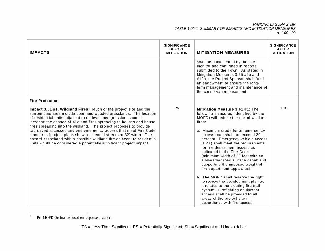
RANCHO LAGUNA 2 EIR TABLE 1.00-1: SUMMARY OF IMPACTS AND MITIGATION MEASURES
p. 1.00 - 99
LTS = Less Than Significant; PS = Potentially Significant; SU = Significant and Unavoidable
IMPACTS
SIGNIFICANCE BEFORE
MITIGATION
MITIGATION MEASURES
SIGNIFICANCE AFTER
MITIGATION
shall be documented by the site monitor and confirmed in reports submitted to the Town. As stated in Mitigation Measures 3.55 #9b and #10b, the Project Sponsor shall fund an endowment to ensure the long-term management and maintenance of the conservation easement.
Fire Protection Impact 3.61 #1. Wildland Fires: Much of the project site and the surrounding area include open and wooded grasslands. The location of residential units adjacent to undeveloped grasslands could increase the chance of wildland fires spreading to houses and house fires spreading into the wildland. The project proposes to provide two paved accesses and one emergency access that meet Fire Code standards (project plans show residential streets at 32’ wide). The hazard associated with a possible wildland fire adjacent to residential units would be considered a potentially significant project impact.
PS
Mitigation Measure 3.61 #1: The following measures (identified by the MOFD) will reduce the risk of wildland fires: a. Maximum grade for an emergency
access road shall not exceed 20 percent. Emergency vehicle access (EVA) shall meet the requirements for fire department access as indicated in the Fire Code (minimum width of 20 feet with an all-weather road surface capable of supporting the imposed weight of fire department apparatus).
b. The MOFD shall reserve the right
to review the development plan as it relates to the existing fire trail system. Firefighting equipment access shall be provided to all areas of the project site in accordance with fire access
LTS
2 Per MOFD Ordinance based on response distance.
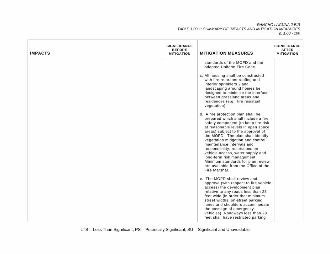
RANCHO LAGUNA 2 EIR TABLE 1.00-1: SUMMARY OF IMPACTS AND MITIGATION MEASURES
p. 1.00 - 100
LTS = Less Than Significant; PS = Potentially Significant; SU = Significant and Unavoidable
IMPACTS
SIGNIFICANCE BEFORE
MITIGATION
MITIGATION MEASURES
SIGNIFICANCE AFTER
MITIGATION
standards of the MOFD and the adopted Uniform Fire Code.
c. All housing shall be constructed
with fire retardant roofing and interior sprinklers 2 and landscaping around homes be designed to minimize the interface between grassland areas and residences (e.g., fire resistant vegetation).
d. A fire protection plan shall be
prepared which shall include a fire safety component (to keep fire risk at reasonable levels in open space areas) subject to the approval of the MOFD. The plan shall identify vegetation mitigation and control, maintenance intervals and responsibility, restrictions on vehicle access, water supply and long-term risk management. Minimum standards for plan review are available from the Office of the Fire Marshal.
e. The MOFD shall review and
approve (with respect to fire vehicle access) the development plan relative to any roads less than 28 feet wide (in order that minimum street widths, on-street parking lanes and shoulders accommodate the passage of emergency vehicles). Roadways less than 28 feet shall have restricted parking
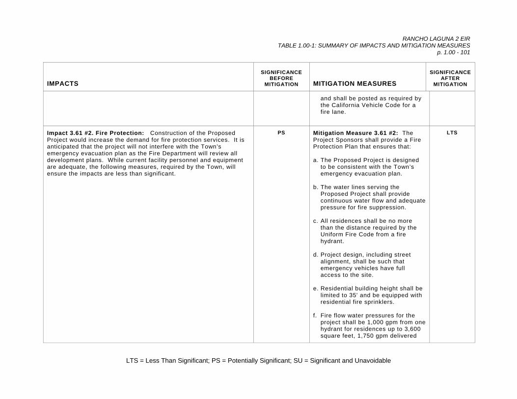
RANCHO LAGUNA 2 EIR TABLE 1.00-1: SUMMARY OF IMPACTS AND MITIGATION MEASURES
p. 1.00 - 101
LTS = Less Than Significant; PS = Potentially Significant; SU = Significant and Unavoidable
IMPACTS
SIGNIFICANCE BEFORE
MITIGATION
MITIGATION MEASURES
SIGNIFICANCE AFTER
MITIGATION
and shall be posted as required by the California Vehicle Code for a fire lane.
Impact 3.61 #2. Fire Protection: Construction of the Proposed Project would increase the demand for fire protection services. It is anticipated that the project will not interfere with the Town’s emergency evacuation plan as the Fire Department will review all development plans. While current facility personnel and equipment are adequate, the following measures, required by the Town, will ensure the impacts are less than significant.
PS Mitigation Measure 3.61 #2: The Project Sponsors shall provide a Fire Protection Plan that ensures that: a. The Proposed Project is designed
to be consistent with the Town’s emergency evacuation plan.
b. The water lines serving the
Proposed Project shall provide continuous water flow and adequate pressure for fire suppression.
c. All residences shall be no more
than the distance required by the Uniform Fire Code from a fire hydrant.
d. Project design, including street
alignment, shall be such that emergency vehicles have full access to the site.
e. Residential building height shall be
limited to 35' and be equipped with residential fire sprinklers.
f. Fire flow water pressures for the
project shall be 1,000 gpm from one hydrant for residences up to 3,600 square feet, 1,750 gpm delivered
LTS

RANCHO LAGUNA 2 EIR TABLE 1.00-1: SUMMARY OF IMPACTS AND MITIGATION MEASURES
p. 1.00 - 102
LTS = Less Than Significant; PS = Potentially Significant; SU = Significant and Unavoidable
IMPACTS
SIGNIFICANCE BEFORE
MITIGATION
MITIGATION MEASURES
SIGNIFICANCE AFTER
MITIGATION
from one hydrant for residences between 3,601 - 4,800 square feet, and 2,000 gpm delivered from two hydrants for residences between 4,801 and 6,200 square feet.
g. The project shall pay fire flow tax.
The rate is based on fire protection systems and square footage.
Impact 3.61 #3. Fire Flow: The project would result in an increased water demand for fire flow requirements necessitating the construction of new facilities, and/or the upgrading of existing facilities required to meet the fire flow requirement demands of the Proposed Project site. Distribution system improvements that would occur with development of the Proposed Project would be designed to accommodate the increased demand for water to meet the fire flow standards as noted in Mitigation 3.61 #2, above. This is a potentially significant impact
PS Mitigation Measure 3.61 #3: The project shall comply with Mitigation Measure 3.62 #2, above.
LTS
Law Enforcement Impact 3.62 #1. Police Protection: The Proposed Project would result in increased demand for police protection services that are provided by the Moraga Police Department. Current staffing levels are recognized as being lower than the standards of one officer per 1,000/population. The addition of 35 new homes will increase calls, potentially impacting the Department’s ability to maintain response times. This is considered a potentially significant impact.
PS
Mitigation Measure 3.62 #1: The Project Sponsor shall pay permit fees or other contributions to the General Fund to offset impacts from the Proposed Project. These fees would be utilized to improve police services and response times.
LTS
Schools Impact 3.63 #1. School Capacity: The Proposed Project would result in the generation of approximately 30 new students as shown on Table 3.63-1. As the three schools all have residual capacity and
LTS
Mitigation Measure 3.63 #1: The Project Sponsors will be responsible for the payment of school impact fees
LTS

RANCHO LAGUNA 2 EIR TABLE 1.00-1: SUMMARY OF IMPACTS AND MITIGATION MEASURES
p. 1.00 - 103
LTS = Less Than Significant; PS = Potentially Significant; SU = Significant and Unavoidable
IMPACTS
SIGNIFICANCE BEFORE
MITIGATION
MITIGATION MEASURES
SIGNIFICANCE AFTER
MITIGATION
with this payment of school fees, this contribution does not represent a significant impact.
at the time of building permit. Assuming an average sized home of 4,000 square feet, and based upon the current fee rate, the impact fees would be approximately $287,000.
Water Supply Impact 3.64 #1. Water Demand: The Rancho Laguna 2 project would increase demand for potable water by 64,705 gallons/day (gpd), during the summer months, as shown on Table 3.64-2. As previously stated, the EBMUD’s existing water supply currently falls short of drought planning targets. If a drought comparable to the 1976/77 drought occurred after project build-out and before a water supply project is operational, project demand could nominally, yet incrementally, increase the severity of supply shortages. During a drought, the homes within the project site would be subject to the same short-term water supply management measures as other residences in EBMUD’s service area. When EBMUD has imposed overall mandatory water rationing of 25 percent, single-family residences, as a category, have responded by reducing demand by 32 percent. Severe water shortages could affect consumers in several ways. The shortage could force the EBMUD to impose water rationing above 25 percent. EBMUD indicates that imposition of a 35 percent cut-back level in response to the 1976/77 drought and consequent cessation in landscape irrigation led to loss of lawns, shrubs and trees, which also affected customers’ property values. Other environmental effects associated with significant water shortages including reduction in the amount of water available for firefighting and other emergencies, and adverse effects on drinking water quality resulting from increased algae and turbidity as reservoir levels drop. The EBMUD could supplement the water supply during shortages with an alternate source.
PS
Mitigation Measure 3.64 #1a: The Project Sponsors must commit to the following conservation measures for the project: a. Installation of water efficient
irrigation systems for residential units that include efficient sprinkler heads or drip irrigation.
b. Installation of ultra-low flow toilets,
as required by state law. c. Installation of drought-tolerant
landscaping. d. The Town will refer the project to
EBMUD and then determine whether to require dual piping and the use of recycled water for the project.
e. The Project Sponsor shall comply
with the Assembly Bill 325, Model Water Efficient Landscape Ordinance (Division 2, Title 23, California Code of Regulations, Chapter 2.7, Sections 490 through
LTS

RANCHO LAGUNA 2 EIR TABLE 1.00-1: SUMMARY OF IMPACTS AND MITIGATION MEASURES
p. 1.00 - 104
LTS = Less Than Significant; PS = Potentially Significant; SU = Significant and Unavoidable
IMPACTS
SIGNIFICANCE BEFORE
MITIGATION
MITIGATION MEASURES
SIGNIFICANCE AFTER
MITIGATION
Recycled Water EBMUD’s Policy 73 requires “ . . . that customers . . . use non-potable water for non-domestic purposes when it is of adequate quality and quantity, available at reasonable cost, not detrimental to public health and not injurious to plant life, fish and wildlife” to offset demand on EBMUD’s limited potable water supply. Preliminary analyses indicated that EBMUD may be able to serve recycled water to the proposed Rancho Laguna 2 development project through a satellite treatment system (rather than previously thought through the Lamorinda Recycled Water Project). Installation of dual plumbing for use of recycled water within the subdivision for irrigation of parks, open spaces, greenbelts, and common landscaped areas within homeowners’ associations shall be developed consistent with the Town of Moraga’s Municipal Code. The ordinance regulating recycled water directs the Town to send projects to EBMUD for recommendations as to the appropriateness for use of recycled water. The Town then determines whether the use of recycled water will be required. Unless conservation measures are implemented, impacts to water supply could be potentially significant.
495). Mitigation Measure 3.64 #1b: The Project Sponsors shall commit to additional Demand Reduction Measures, commensurate with the amount of the project’s water demand. The Project Sponsors shall be subject to the Water Service Regulations and Schedule of Rates and Charges.
Impact 3.64 #2. Pressure Zones: EBMUD’s Fay Hill Pressure Zone, with a service elevation range between 650 and 850 feet, will serve the proposed development, with site elevations ranging between approximately 700 and 790 feet. EBMUD owns and operates a distribution pipeline in Rheem Boulevard which provides continuous service to customers in the area. The integrity of this pipeline needs to be maintained at all times. Impacts to the pipeline are considered potentially significant.
PS Mitigation Measure 3.64 #2: Relocation of the existing pipeline in Rheem Boulevard, at the Project Sponsor’s expense, may be required if modifications are made to Rheem Boulevard as part of the proposed development. A water main extension, also at the Project Sponsor’s expense, will be required to serve the proposed development.
LTS
Impact 3.64 #3a. Encroachment into EBMUD Properties: EBMUD owns a piece of property and has four right-of-ways (R/W) that
PS Mitigation Measure 3.64 #3a: Development shall avoid EBMUD

RANCHO LAGUNA 2 EIR TABLE 1.00-1: SUMMARY OF IMPACTS AND MITIGATION MEASURES
p. 1.00 - 105
LTS = Less Than Significant; PS = Potentially Significant; SU = Significant and Unavoidable
IMPACTS
SIGNIFICANCE BEFORE
MITIGATION
MITIGATION MEASURES
SIGNIFICANCE AFTER
MITIGATION
traverse the proposed development: Property CVC 304, R/Ws 745, 1806, 1807, and 1978 (see Figure 3.64-1). R/W 745 is a 50 foot wide easement that provides access to EBMUD’s Property CC 30-4, a piece of land reserved for recycled water infrastructure. R/Ws 1806 and 1807 are 20 foot wide tunnel easements. R/W 1978 is a 50 foot wide easement that provides access to EBMUD’s Fay Hill Reservoir located adjacent to the proposed development at the northwestern end of the project site. Encroachment into EBMUD properties is considered a significant impact.
right-of-way. Prior to approval of the Precise Development Plan, the Town shall review the agreements that the Project Sponsor has with EBMUD. If off-site lands are disturbed by development, the Town shall conduct additional environmental review and certify the environmental analysis of those properties.
Impact 3.64 #3b. Fay Hill Access Road: The development proposed a realignment of the access road to Fay Hill Reservoir, Right-Of-Way 1978. Impacts to the access road to Fay Hill Reservoir are considered potentially significant impacts.
LTS Mitigation Measure 3.64 #3b. Realignment of the Fay Hill Reservoir access road, at the Project Sponsors’ expense, shall be required as part of the proposed development as determined by the EBMUD. EBMUD requires that the Project Sponsors provide continuous and all weather access to the Fay Hill Reservoir during and after the road realignment construction.
a. No concrete pavements (or certain types of vegetation) is allowable within its rights-of-way. A list of approved vegetation is available from EBMUD.
b. No building or structure may be
placed upon EBMUD’s right-of-way. c. Changes in surface elevation
(grade) greater than one foot require written consent from EBMUD.
LTS

RANCHO LAGUNA 2 EIR TABLE 1.00-1: SUMMARY OF IMPACTS AND MITIGATION MEASURES
p. 1.00 - 106
LTS = Less Than Significant; PS = Potentially Significant; SU = Significant and Unavoidable
IMPACTS
SIGNIFICANCE BEFORE
MITIGATION
MITIGATION MEASURES
SIGNIFICANCE AFTER
MITIGATION
d. Any proposed construction activity
in EBMUD right-of-ways would be subject to the terms and conditions determined by EBMUD including relocation of the right-of-ways, at the project sponsors’ expense.
Impact 3.64 #5. EBMUD Distribution System: EBMUD owns, operates and maintains pipelines in Rheem Boulevard. Potential improvements to Rheem Boulevard (including possible roadway stabilization, the development of bike lanes the addition of turning lanes near the proposed entrances) could impact the existing waterlines. These pipelines are extremely critical to EBMUD’s water supply and distribution system and are necessary to provide continuous service to EBMUD’s customers in the area. When modifications to the street occur, the pipelines may have to be relocated at the Project Sponsors’ expense. Impacts to EBMUD’s distribution system are considered potentially significant.
PS Mitigation Measure 3.64 #5: Measures to prevent any impacts to the existing pipeline, including those related to adequate pipeline cover and construction equipment wheel loads, shall be identified on the (offsite) Precise Development Plans if the Project Sponsors propose construction within the public street.
LTS
Impact 3.65 #2. Off-Site Sewer Line: The project proposes to service all lots within the subdivision by gravity flow. While most sewer lines would be located beneath streets, construction of a sewer line is proposed between the end of “C” Court and the existing manhole in the Lafayette-Moraga Trail right-of-way. This sewer line would cross over drainages to Coyote Creek (and possibly a cross over Coyote Creek). This is considered a potentially significant impact.
PS Mitigation Measure 3.65 #2a: The project shall be designed so that it allows wastewater to flow by gravity to the CCCSD system. The sewer line shall be located within public roads or a dedicated 15 foot wide easement, where appropriate. The easement shall have a minimum 10 foot wide all weather pavement at the manholes. To avoid disturbance to onsite drainages or Coyote Creek, CCCSD will allow the Project Sponsor to undertake directional drilling3 so that
LTS
3 Directional drilling would allow for sewer lines to be installed below the surface and below the creek so that no disturbance occurs to the surface except at the
in-fall and outfall.

RANCHO LAGUNA 2 EIR TABLE 1.00-1: SUMMARY OF IMPACTS AND MITIGATION MEASURES
p. 1.00 - 107
LTS = Less Than Significant; PS = Potentially Significant; SU = Significant and Unavoidable
IMPACTS
SIGNIFICANCE BEFORE
MITIGATION
MITIGATION MEASURES
SIGNIFICANCE AFTER
MITIGATION
the sewer line undercross the drainages. The following conditions shall apply: a. Construction shall be undertaken
during the dry season; b. Undercrossing shall meet with
USFW standards; c. Permits for riparian habitat
disturbance shall be obtained from CDFG if needed; and,
d. Construction shall comply with
CCCSD’s Hillside and Creek Area Sewer Policy.
Mitigation Measure 3.65 #2b: If a gravity line is infeasible for Lots 22 - 30, a pumping system acceptable to CCCSD is an option, although not preferred. The lots will need to individually pump to the manhole (on “B” Drive) or possibly tie together in one sewer line managed by the HOA.
Impact 3.65 #3. Transmission Facilities: The existing project area main sewers are adequate for the additional wastewater that will be generated by the Proposed Project based upon current conditions. Some downstream District facilities do not have adequate flow carrying capacity under the District’s current design criteria for ultimate build out buildout conditions. Improvements to correct the deficiencies are in the District’s Capital Improvement Plan and are expected to be completed prior to buildout. Improvements to the District’s existing facilities that are required as a result of new
LTS Mitigation Measure 3.65 #3: The Project Sponsors will be required to pay fees and charges at the time of connection to the sewer system. The Project Sponsors shall secure a will serve letter that address transmission capacity.

RANCHO LAGUNA 2 EIR TABLE 1.00-1: SUMMARY OF IMPACTS AND MITIGATION MEASURES
p. 1.00 - 108
LTS = Less Than Significant; PS = Potentially Significant; SU = Significant and Unavoidable
IMPACTS
SIGNIFICANCE BEFORE
MITIGATION
MITIGATION MEASURES
SIGNIFICANCE AFTER
MITIGATION
development will be funded from applicable District fees and charges. This would be considered a less than significant impact.
Impact 3.65 #4. Treatment Plant Capacity: The Proposed Project would not substantially contribute to the use of the CCCSD’s wastewater treatment plant. This would be considered a less than significant impact.
LTS Mitigation Measure 3.65 #4: None Required.
LTS
Solid Waste Disposal Impact 3.66 #1. Solid Waste Generation: The Proposed Project will generate solid waste. Development of the site for residential uses was anticipated when the capacity of the Keller Landfill was calculated. As the project will generate no more solid waste than that anticipated by the County in its General Plan, this is not expected to be a significant impact.
LTS
Mitigation Measure 3.66 #1: None Required.
LTS
Impact 3.66 #2: Solid waste generated by the project is not expected to inhibit or impact Moraga’s ability to maintain its 50 percent diversion rate. However, construction and demolition activities necessary for project development could generate significant levels of solid waste, vegetative waste, and construction debris if proper mitigation measures are not implemented.
LTS Mitigation Measure 3.66 #2: The Project Sponsors shall be required to complete a construction debris recycling plan indicating they comply with the Town’s requirement for diversion of construction and demolition debris per the Town’s ordinance. Compliance with this will help maintain the Town’s 50 percent diversion.
LTS
Cable/Communication and Energy Impact 3.67 #1. Communications: The project will increase demand for telephone and cable service, both of which are available along Rheem Boulevard.
LTS
Mitigation Measure 3.67 #1: None Required.
LTS
Impact 3.67 #2. Energy: The project will be conditioned to meet the LTS Mitigation Measure 3.67 #2: None LTS

RANCHO LAGUNA 2 EIR TABLE 1.00-1: SUMMARY OF IMPACTS AND MITIGATION MEASURES
p. 1.00 - 109
LTS = Less Than Significant; PS = Potentially Significant; SU = Significant and Unavoidable
IMPACTS
SIGNIFICANCE BEFORE
MITIGATION
MITIGATION MEASURES
SIGNIFICANCE AFTER
MITIGATION
most current Title 24 energy requirements which require the development to incorporate conservation features into residential orientation, siting and design and provide equipment which is energy efficient. All residential utility lines will be required to be undergrounded once brought onto the site.
Required.
Cultural Resources Impact 3.70 #1. Archaeological Resources: There is the possibility that buried archaeological deposits could be present and accidental discovery could occur, a potentially significant impact.
PS
Mitigation Measure 3.70 #1: If archaeological remains are uncovered, work at the place of discovery should be halted immediately until a qualified archaeologist can evaluate the finds (§15064.5 [f]). Prehistoric archaeological site indicators include: obsidian and chert flakes and chipped stone tools; grinding and mashing implements (e.g., slabs and handstones, and mortars and pestles); bedrock outcrops and boulders with mortar cups; and locally darkened midden soils. Midden soils may contain a combination of any of the previously listed items with the possible addition of bone and shell remains, and fire affected stones. Historic period site indicators generally include: fragments of glass, ceramic, and metal objects; milled and split lumber; and structure and feature remains such as building foundations and discrete trash deposits (e.g., wells, privy pits, dumps). All cultural materials recovered as part of the monitoring program shall be
LTS
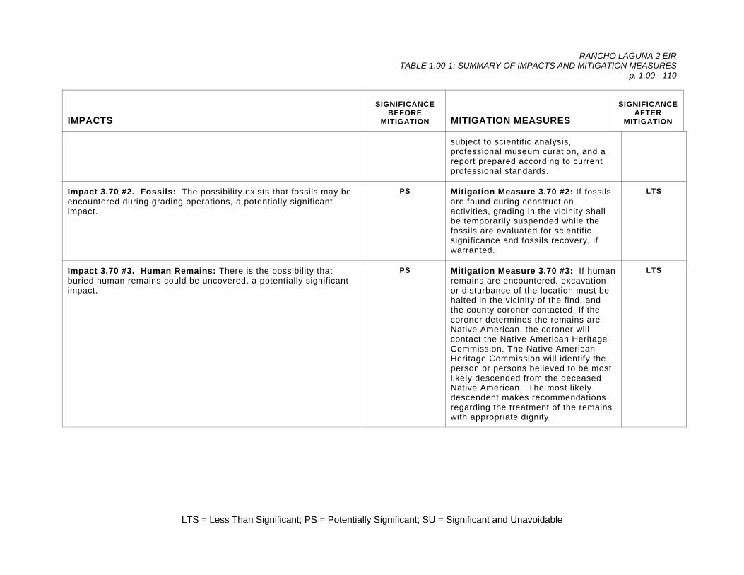
RANCHO LAGUNA 2 EIR TABLE 1.00-1: SUMMARY OF IMPACTS AND MITIGATION MEASURES
p. 1.00 - 110
LTS = Less Than Significant; PS = Potentially Significant; SU = Significant and Unavoidable
IMPACTS
SIGNIFICANCE BEFORE
MITIGATION
MITIGATION MEASURES
SIGNIFICANCE AFTER
MITIGATION
subject to scientific analysis, professional museum curation, and a report prepared according to current professional standards.
Impact 3.70 #2. Fossils: The possibility exists that fossils may be encountered during grading operations, a potentially significant impact.
PS Mitigation Measure 3.70 #2: If fossils are found during construction activities, grading in the vicinity shall be temporarily suspended while the fossils are evaluated for scientific significance and fossils recovery, if warranted.
LTS
Impact 3.70 #3. Human Remains: There is the possibility that buried human remains could be uncovered, a potentially significant impact.
PS Mitigation Measure 3.70 #3: If human remains are encountered, excavation or disturbance of the location must be halted in the vicinity of the find, and the county coroner contacted. If the coroner determines the remains are Native American, the coroner will contact the Native American Heritage Commission. The Native American Heritage Commission will identify the person or persons believed to be most likely descended from the deceased Native American. The most likely descendent makes recommendations regarding the treatment of the remains with appropriate dignity.
LTS

2.00 PROJECT LOCATION AND DESCRIPTION

RANCHO LAGUNA 2 EIR 2.00 PROJECT LOCATION AND DESCRIPTION
p. 2.00 - 1
L:\Rancho Laguna 2 \ 2.00 Project Location and Description \ 7/6/06 \ 8:45 pm
1 2 3 4 5 6 7 8 9
10 11 12 13 14 15 16 17 18 19 20 21 22 23 24 25 26 27 28 29 30 31 32 33 34 35 36 37 38 39 40 41 42 43
2.00 PROJECT LOCATION AND DESCRIPTION Preface This chapter describes the Proposed Project, known as Rancho Laguna 2, including the proposed site improvements, objectives, approvals and entitlements necessary for project implementation. 2.10 SITE LOCATION The study area is located along the east side of Rheem Boulevard, between Moraga Road and St. Mary=s Road, in Contra Costa County, as shown on the Las Trampas Ridge Map, California 7.5' USGS topographic quadrange (see Figure 2.00-1). It consists of approximately 180 acres of gentle to steeply sloping terrain. The project site consists of largely undeveloped ranch land that is currently used for cattle grazing. Elevations range from 650 to 950 feet above mean sea level. The site has steep east and west-facing slopes with two wooded valleys. A portion of Coyote Creek flows south through the eastern portion of the study area, and an unnamed seasonal creek flows south in the western portion of the study area near Rheem Boulevard. This unnamed creek is referred to as Rheem Boulevard drainage in this document. Both are tributaries to Las Trampas Creek, a perennial stream located 100 feet south of the site. A small portion in the northwestern corner of the property drains to San Leandro Creek. The project area and its surroundings include nearby freshwater sources and some moderately well-drained soils that support a variety of plants and provide habitat for numerous animals. The surrounding areas to the south and west are generally characterized by a mix of low-density residential development and open space. Palos Colorados, a proposed 123-unit planned community, is located to the north and east of, and adjacent to, the subject site. St. Mary=s College is located approximately 0.5 miles south of the site. Commercial land uses are located approximately one-half mile to the northwest of the subject site at the intersection of Rheem Boulevard and Moraga Road. Due east of the project site is open space, including a section of the Lafayette - Moraga Regional Trail. All of these uses are within the Town of Moraga Town Limits (see Figure 2.00-2). 2.20 PROJECT DESCRIPTION 1
The Rancho Laguna 2 project is a proposed residential development of 35 homes on 35 lots ranging in size from 15,043 to 32,714 square feet. The Project is a conceptual
1 The Project Description has been provided by the Project Sponsors.

RANCHO LAGUNA 2 EIR 2.00 PROJECT LOCATION AND DESCRIPTION
p. 2.00 - 2
L:\Rancho Laguna 2 \ 2.00 Project Location and Description \ 7/6/06 \ 8:45 pm
1 2 3 4 5 6 7 8 9
10 11 12 13 14 15 16 17 18 19 20 21 22 23 24 25 26 27 28 29 30 31 32 33 34 35 36 37 38 39 40 41 42 43 44 45
development plan and conditional use permit application (subsequent approvals are discussed in Section 2.50, below). Related improvements include the dedication of 136 acres of permanent open space for public use (see Figure 2.00-3). Fourteen units will be located in the western, lower portion of the project site, facing Rheem Boulevard (setback from Rheem Boulevard along a private drive). The remaining 21 residential units will be located to the southeast. These units are proposed to be located below existing grade. The Project Sponsors propose to excavate the ridgeline to set houses below grade so they are less visually prominent. As shown on Figure 2.00-6, all of the proposed lots are located outside MOSO (OS-M) designated areas. Ingress and egress to the residential development will be provided at two locations off Rheem Boulevard. In addition, an emergency vehicle access (EVA) will be constructed off Rheem Boulevard between Lots 9 and 10. In the southern portion of the project site, a road running west to east, “A” Way, includes placement of an arch culvert over the undisturbed portion of Rheem Boulevard drainage adjacent to Rheem Boulevard, will provide access to the upper 21 units. An existing entrance at the northern end of the project site will be expanded to provide access to the lower 14 units proposed along Rheem Boulevard. Public access to the open space area will be provided via a four to six-foot wide decomposed aggregate, bike and pedestrian trail. This trail, with its many branches, would link the existing Lafayette-Moraga Regional Trail to the proposed open space areas by way of two existing localized trails and connect with the East Bay Municipal Utility District’s Fay Hill Reservoir access road in the northwest portion of the project site. The main branch of the proposed localized trail is proposed to extend along Rheem Boulevard and the Rheem Boulevard drainage, with undercrossings at the EVA and “A” Way, and connect with existing trails. Approximately 136 acres of the 180 acre parcel will remain undeveloped and will be placed into a conservation easement in perpetuity. Wetland and wildlife resources occur in this open space. A Biological Mitigation and Monitoring Plan will be prepared for review and approval by the regulatory agencies for the approximately 136 acre conservation easement area. A long-term management plan and funding mechanism will also be developed to ensure conservation stewardship on the on-site conservation easement area and any off-site mitigation lands. This long-term management plan, also referred to as a Biological Mitigation and Monitoring Plan, will take a watershed approach and account for the regional requirements of sensitive species and habitats. Mitigation will be reviewed on a case-by-case basis and will take into account the use of vegetated buffers as well as the functions of the preserved/ avoided/ created and enhanced habitat. After 136+ acres are placed into a conservation easement, 44 acres of property will remain in the development area owned by individual owners and managed by the HOA or a Geologic Hazard Abatement District (GHAD) as open space. Comprehensive management plans for this acreage will be prepared and reviewed during subsequent project review steps (e.g., as part of the General and Precise Development Plan and as called for by the mitigation measures set forth in this DEIR).
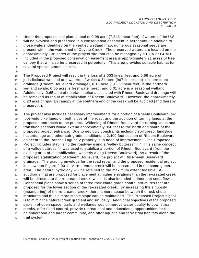
RANCHO LAGUNA 2 EIR 2.00 PROJECT LOCATION AND DESCRIPTION
p. 2.00 - 3
L:\Rancho Laguna 2 \ 2.00 Project Location and Description \ 7/6/06 \ 8:45 pm
1 2 3 4 5 6 7 8 9
10 11 12 13 14 15 16 17 18 19 20 21 22 23 24 25 26 27 28 29 30 31 32 33 34 35 36 37 38 39 40 41 42 43
Under the proposed site plan, a total of 0.98 acre (7,843 linear feet) of waters of the U.S. will be avoided and preserved in a conservation easement in perpetuity. In addition to those waters identified on the verified wetland map, numerous seasonal seeps are present within the watershed of Coyote Creek. The preserved waters are located on the approximately 136 acres of the project site that is to be managed by a HOA or GHAD. Included in the proposed conservation easement area is approximately 21 acres of tree canopy that will also be preserved in perpetuity. This area provides suitable habitat for several special-status species. The Proposed Project will result in the loss of 2,003 linear feet and 0.66 acre of jurisdictional wetland and waters, of which 0.34 acre (967 linear feet) is intermittent drainage (Rheem Boulevard drainage), 0.15 acre (1,036 linear feet) is the northern wetland swale; 0.05 acre is freshwater seep; and 0.01 acre is a seasonal wetland. Additionally, 0.65 acre of riparian habitat associated with Rheem Boulevard drainage will be removed as result of stabilization of Rheem Boulevard. However, the approximately 0.23 acre of riparian canopy at the southern end of the creek will be avoided (and thereby preserved). The project also includes necessary improvements for a portion of Rheem Boulevard, six foot-wide bike lanes on both sides of the road, and the addition of turning lanes at the proposed entrances to the project. Widening of Rheem Boulevard for turning lanes and transition sections would extend approximately 350 feet to the north and south of the proposed project entrance. Due to geologic constraints including soil creep, landslide hazards, age and other sub-grade conditions, a 2,400 foot section of Rheem Boulevard adjacent to the Rancho Laguna 2 property is in need of improvement. The Proposed Project includes stabilizing the roadway using a “valley buttress fill.” This same concept of a valley buttress fill was used to stabilize a portion of Rheem Boulevard (from the existing area of destabilization, westerly along Rheem Boulevard). As a result of the proposed stabilization of Rheem Boulevard, the project will fill Rheem Boulevard drainage. The grading envelope for the road repair and the proposed residential project is shown on Figure 2.00-4. A re-created creek will be constructed in the same general area. The natural hydrology will be retained to the maximum extent feasible. All subdrains that are proposed for placement at higher elevations than the re-created creek will be directed to the re-created creek, which is also intended to intercept seep flows. Conceptual plans show a series of three rock chute grade control structures that are proposed for the lower section of the re-created creek. By increasing the sinuosity (meandering) of the re-created creek, there is more space between the rock chute structures and thus a more stable slope can be maintained. The Proposed Project’s goal is to mimic the natural creek gradient and sinuosity. Additional objectives of the proposed system of open space, trails and wetlands would improve water quality to downstream creeks, offer flood control, provide recreational and educational opportunities for the neighborhood and larger community, and offer aquatic and terrestrial habitats along the trail system.

RANCHO LAGUNA 2 EIR 2.00 PROJECT LOCATION AND DESCRIPTION
p. 2.00 - 4
L:\Rancho Laguna 2 \ 2.00 Project Location and Description \ 7/6/06 \ 8:45 pm
1 2 3 4 5 6 7 8 9
10 11 12 13 14 15 16 17 18 19 20 21 22 23 24 25 26 27 28 29 30 31 32 33 34 35 36 37 38 39 40
Site Characteristics A minor ridge traverses the site in a north-south direction. The highest elevation is approximately 950 feet above mean sea level on the north side of the site. The lowest elevation is approximately 650 feet above mean sea level in the southeastern portion of the site. Prominent drainage courses on the east and west sides of the ridge drain to the south. Natural slope gradients range from relatively flat in valleys and on ridgelines, to as steep as 1.5:1 (horizontal:vertical) on the flanks of the ridges. Description of Existing Site Improvements Existing improvements on the site include high-voltage transmission lines on the northeastern portion, and an access road to an East Bay Municipal Water District (EBMUD) water tank that is located to the north of the site. Other existing improvements are limited to fences and ranch roads. A relatively large fill has been placed in the valley on the western side of the ridge, adjacent to Rheem Boulevard. The following is a list of easements recorded with Contra Costa County that currently affect the subject property:
CC 845/391: Power Lines (PG&E) - 80' wide
CC 4797/437: Water Pipelines (EBMUD) - 20' wide
CC 1381/72: Water Pipelines (EBMUD) - 10' wide
CC 4541/270: Sewer Pipes (Central Contra Costa Sanitary District) - 50' wide CC 4795/304: Roadway and Utilities (EBMUD) - 50' wide
CC 1171/265: Roadway and Utilities (EBMUD) - 50' wide
CC 1171/261: Potential Water Storage Site (EBMUD) - 16,200 s/f
General Plan/Zoning Designations The site is designated Open Space in the General Plan and zoned both Open Space - MOSO (OS-M) and Open Space - Planned Development (OS-PD).

RANCHO LAGUNA 2 EIR 2.00 PROJECT LOCATION AND DESCRIPTION
p. 2.00 - 5
L:\Rancho Laguna 2 \ 2.00 Project Location and Description \ 7/6/06 \ 8:45 pm
1 2 3 4 5 6 7 8 9
10 11 12 13 14 15 16 17 18 19 20 21 22 23 24 25 26 27 28 29 30 31 32 33 34 35 36 37 38 39 40 41 42 43 44 45
Public Services Public services and utilities would be provided by the agencies listed below. The arrangements for services are discussed in detail in Section 3.60, Public Services and Utilities.
● Schools: Moraga School District and Acalanes Unified High School ● Fire and Emergency Service: Moraga-Orinda Fire District (MOFD) ● Police Department: Town of Moraga Police Department (MPD) ● Water: East Bay Municipal Utility District (EBMUD) ● Wastewater: Central Contra Costa Sanitary District (CCCSD) ● Refuse: Allied Waste Industries and Pleasant Hill Bayshore Disposal ● Recycling: Valley Waste Management, Inc. ● Parks and Recreation: Town of Moraga and East Bay Regional Park District
(EBRPD) ● Gas and Electricity: Pacific Gas and Electric (PG&E)
Homeowner=s Association/Special Districts Both an HOA and/or a GHAD will be created to maintain the property. The HOA will be responsible for the maintenance of all Aprivate common@ improvements and for the management of the Conservation Easement. The Town will review and approve, as part of subsequent project approvals, the HOA=s Conditions, Covenants and Restrictions (CC&Rs) that will govern the HOA. The purpose of a GHAD is to act as an independent public entity overseeing geologic safety by means of prevention, mitigation, abatement, and control. The proposed Rancho Laguna 2 GHAD would be governed by a Plan of Control (POC). A POC is the guiding document for the operation of a GHAD prepared by a Certified Engineering Geologist. A POC is legally required for formation of a GHAD, and must be prepared by a Certified Engineering Geologist. It typically contains a monitoring schedule, prioritization of GHAD involvement, the scope of the GHAD’s responsibilities, a list of items which are not covered by the GHAD, etc. Funding for the Rancho Laguna 2 GHAD will be provided by supplemental property tax assessments, triggered by the sale of the individual lots. The Rancho Laguna 2 project could potentially enter into a larger existing GHAD, or form a GHAD with other projects in the vicinity.

RANCHO LAGUNA 2 EIR 2.00 PROJECT LOCATION AND DESCRIPTION
p. 2.00 - 6
L:\Rancho Laguna 2 \ 2.00 Project Location and Description \ 7/6/06 \ 8:45 pm
1 2 3 4 5 6 7 8 9
10 11 12 13 14 15 16 17 18 19 20 21 22 23 24 25 26 27 28 29 30 31 32 33 34 35 36 37 38 39 40 41 42 43 44 45 46
Proposed Architecture, Building Heights and Setbacks The project proposes two neighborhoods, each with distinctive characteristics. The Rheem Boulevard street neighborhood has a frontage street that enters/exits onto Rheem Boulevard, buffered by a heavily landscaped open space area and silhouetted by the hillside behind. This group of homes will have a Spanish style architecture, to maintain compatibility with the new ranchette homes across the street on Rheem Boulevard as well as to tie into the architecture of nearby St. Mary’s College. Homes will be either one- or two-story structures, using classic materials of stucco, sash windows, clay tile roofs and traditional Spanish wood trim details to complete the design concept. The homes on “C” Court overlook Palos Colorados and have views of Lafayette. The homes are separated by a minor ridgeline from the Rheem Boulevard site. These dwellings are designed to have a semi-rural feel featuring distinct styles of architecture (typical of the new homes in the Lamorinda community). As part of subsequent approvals, Architectural Guidelines for the project will be created subject to input from the Town decision-makers (Design Review Board [DRB], Planning Commission [PC] and Town Council). The purpose of these guidelines will be to establish standards and regulations specific to the Rancho Laguna 2 project. These guidelines will serve as the primary mechanism for regulating the development of future home sites. Implementation of the guidelines to be set forth will ensure that future development proceeds in a coordinated and consistent manner. Future review of site plans and other necessary discretionary approvals by the Town of Moraga will ensure adherence to these guidelines. On-Site Street System Design The Rancho Laguna 2 street system will consist of both on-site roads and off-site improvements to Rheem Boulevard. On-site roads are classified as Residential Streets with proposed 32 foot rights-of-way. The entry to the site is proposed to be a 45 foot right-of-way in order to accommodate a center median. On-site, there are approximately 2,000 lineal feet of residential streets, 210 feet of entry and the EVA. Rheem Boulevard includes almost 300 lineal feet of road reconstruction and related widening at the entries. In addition, Class 2 bike lanes will be added along the project frontage on both sides of Rheem Boulevard. On-Site Landscaping Plans A preliminary landscaping plan has been prepared that includes both native plants and other xeric species. The landscape plan proposes extensive landscaping on both sides of the re-created creek (between Rheem Boulevard and the creek as well as between the creek and “D” Drive). Landscaping is also proposed along the downhill (Units 15 - 35) side of “B” Court. Houses are to be set down (in a graded area) and landscaped to create a visual buffer (see Figure 2.00-5).

RANCHO LAGUNA 2 EIR 2.00 PROJECT LOCATION AND DESCRIPTION
p. 2.00 - 7
L:\Rancho Laguna 2 \ 2.00 Project Location and Description \ 7/6/06 \ 8:45 pm
1 2 3 4 5 6 7 8 9
10 11 12 13 14 15 16 17 18 19 20 21 22 23 24 25 26 27 28 29 30 31 32 33 34 35 36 37 38 39 40 41 42 43 44 45 46
Stormwater A Storm Water Management Plan for the project will be developed as project planning progresses in order to meet the project requirements for Regional Water Quality Control Board (RWQCB) permitting and Town of Moraga C.3 NPDES permit requirements. However, the concepts presented in this EIR can be used for planning purposes at conceptual plan review. Development of the stormwater controls after incorporating mitigation measures identified in this DEIR will reduce impacts to levels of less than significant. Should variations to these controls be developed, they will be subject to additional environmental review. The project will use structural controls such as detention basins or pipes that meter the storm water appropriately to a variety of pre-development flow rates (10 year and 100 year) before discharging the stormwater to a natural drainage system. Detention prevents the receiving creeks from being subjected to peak discharges higher than those historically carried by the creeks prior to construction. (A detailed discussion of the storm water controls is found in Section 3.30, Hydrology, Drainage and Water Quality.) A water quality/detention pond, bioswales and bioretention filters, are conceptually planned at the site to remove pollutants from storm water once they are mobilized from their source areas. Source controls that are likely to achieve these Best Management Practices (BMP) objectives include, but are not limited to, the following: ● Maximizing vegetated areas while minimizing impervious areas; ● Reducing irrigation practices; ● Reducing directly connected impervious areas; and, ● Educating the public on reducing herbicide, pesticide and fungicide use. The project proposes to extend existing sewer and water lines. All lots are proposed to be served from the sewer system either by a gravity service or an individual pump service. Gravity sewer mains are proposed to be installed in accordance with the standards established by the CCCSD. Water mains are proposed to be installed in accordance with standards established by the EBMUD. Proposed Public/Semi-Public, Recreational/Park and Open Space Amenities A staging area is proposed just to the south of the main access road (“A” Way). This staging area is designed to provide interpretive information. It is not intended to provide parking. On-site trails on both sides of Coyote Creek are proposed to connect the EBMUD Fay Hill Reservoir with the Palos Colorados trail system and to Rheem Boulevard. The connection of existing trail systems via the proposed open space trails and integration of the trails

RANCHO LAGUNA 2 EIR 2.00 PROJECT LOCATION AND DESCRIPTION
p. 2.00 - 8
L:\Rancho Laguna 2 \ 2.00 Project Location and Description \ 7/6/06 \ 8:45 pm
1 2 3 4 5 6 7 8 9
10 11 12 13 14 15 16 17 18 19 20 21 22 23 24 25 26 27 28 29 30 31 32 33 34 35 36 37 38 39 40 41 42 43 44
along Rheem Boulevard with the wetland areas is intended to provide both recreational and educational opportunities. Interpretive signage along the trails and at the staging area is proposed to help explain complex interrelationships between the systems. Connections to the existing trails are intended to link the neighborhood to the larger community. Plantings of native vegetation are proposed to create habitat for birds, wildlife and aquatic species. Project Phasing Build-Out All improvements related to the project would be constructed at one time, possibly during one construction season. Construction comprises two phases, the first of which includes rough grading, site preparation, recontouring for drainage and roadways, and the second phase includes final grading and home construction. Homes would be constructed over 1-2 years as the market dictates. 2.30 PROJECT SPONSORS David Downs for: Rancho Laguna LLC 7700 College Town Drive, Suite 109 Sacramento, CA 95826 (916) 379-0955 2.40 PROJECT OBJECTIVES The following are the Project Sponsors’ stated project objectives:
a. Provide the Town with the necessary improvements to stabilize a 2,400 foot section of Rheem Boulevard. Along with the stabilization of Rheem Boulevard, two six foot bike lanes will be provided along the Project’s frontage on Rheem Boulevard, providing a direct and safe route between St. Mary=s College and the Town Center.
b. Retain the natural topographic features and scenic qualities by
concentrating the project in areas of the site that are least sensitive in terms of environmental and visual resources, respecting site characteristics and constraints in the development of building envelopes.
c. Provide the Town with a range of housing types with lot sizes ranging from
15,043 - 32,714 square feet.

RANCHO LAGUNA 2 EIR 2.00 PROJECT LOCATION AND DESCRIPTION
p. 2.00 - 9
L:\Rancho Laguna 2 \ 2.00 Project Location and Description \ 7/6/06 \ 8:45 pm
1 2 3 4 5 6 7 8 9
10 11 12 13 14 15 16 17 18 19 20 21 22 23 24 25 26 27 28 29 30 31 32 33 34 35 36 37 38 39 40 41 42
d. Preserve views of the natural hillside landscape from valley areas. To minimize viewshed impacts, homes placed on the eastern slope of the project site shall be set down into a graded pad. Berming and landscaping is also proposed.
e. Enhance the existing trail system. The goal of the proposed trail system is
to provide a safe, continuous and connected system of trails through and around the project that tie into the surrounding residential neighborhoods, St. Mary=s College, and other existing trails. Provide a Astaging area@ for the trail system along Rheem Boulevard. The staging area is envisioned as a gateway to the trail system where information and/or maps can be displayed for public benefit (no parking is proposed).
f. Preserve the natural setting of the site by clustering development, imposing
conservation easements across larger lots, and avoiding areas of visual or natural significance. A total of 136 acres (or 75% of the site) is proposed to be preserved in its natural state.
g. Recreate the wetlands impacted by the necessary improvements
associated with the stabilization of Rheem Boulevard. The primary benefits of the recreated wetlands include:
● improve water quality to downstream creeks; ● mimic the creek’s natural gradient and sinuosity (see glossary); ● offer flood control; ● provide recreational and educational opportunities for the
neighborhood and larger community; and, ● offer aquatic and terrestrial habitats along the trail system.
2.50 RESPONSIBLE AND TRUSTEE AGENCIES AND AGENCIES WITH JURISDICTION BY LAW, PROJECT ENTITLEMENTS, DISCRETIONARY ACTIONS OR APPROVALS
Responsible Agencies: A Responsible Agency is a public agency other than the Lead Agency that has responsibility for carrying out or approving a project and complying with CEQA (Guidelines sections 15041[b]), 15042, 15096 and 15381). The following agencies are responsible agencies for the Rancho Laguna 2 project:

RANCHO LAGUNA 2 EIR 2.00 PROJECT LOCATION AND DESCRIPTION
p. 2.00 - 10
L:\Rancho Laguna 2 \ 2.00 Project Location and Description \ 7/6/06 \ 8:45 pm
1 2 3 4 5 6 7 8 9
10 11 12 13 14 15 16 17 18 19 20 21 22 23 24 25 26 27 28 29 30 31 32 33 34 35 36 37 38 39 40 41 42 43 44 45
● United States Fish and Wildlife Services (USFWS) (for rare and endangered species);
● U.S. Army Corps of Engineer (USACE) (for clean water permits and
wetlands); and, ● San Francisco Regional Water Quality Control Board (SFRWQCB) (for
water quality certification). Trustee Agencies: Trustee Agencies have jurisdiction by law over certain natural resources affected by a project that are held in trust for the people of California (Guidelines section 15386). The Department of Fish and Game is the only trustee agency for this project (for a streambed alteration permit, special status species, and certain study protocols). Agencies with Jurisdiction by Law: In addition to contacting all Responsible and Trustee Agencies, the Lead Agency, when preparing an EIR, must consult with, and seek comments from every public agency that has jurisdiction by law with respect to the project; each city or county that borders on a city or county within which the project is located; and federal, state, and local agencies that exercise authority over resources that may be affected by the project (Guideline section 15086). These agencies include:
● The City of Lafayette ● The City of Orinda ● Contra Costa County ● East Bay Regional Park District ● East Bay Municipal Utility District ● Central Contra Costa Sanitary District.
Approval Process The following approvals from the Town of Moraga will require review of, and approvals of the following:
● Conceptual Development Plan ● General Development Plan

RANCHO LAGUNA 2 EIR 2.00 PROJECT LOCATION AND DESCRIPTION
p. 2.00 - 11
L:\Rancho Laguna 2 \ 2.00 Project Location and Description \ 7/6/06 \ 8:45 pm
1 2 3 4 5 6 7 8 9
10 11 12 13 14 15 16 17 18 19
● Precise Development Plan ● Conditional Use Permits ● Tentative Subdivision Map ● Design Review ● Hillside Development Permit ● Grading Permits ● Final Subdivision Map ● Building Permits ● Encroachment Permit ● Planned Unit Development

3.00 ENVIRONMENTAL ANALYSIS

RANCHO LAGUNA 2 EIR 3.00 ENVIRONMENTAL ANALYSIS p. 3.00 - 1
L:\ Rancho Laguna 2 \ 3.00 Environmental Analysis \ 6/29/06 \ 12:30 pm
1 2 3 4 5 6 7 8 9
10 11 12
3.00 ENVIRONMENTAL ANALYSIS Preface This chapter describes the existing conditions/environmental setting before project implementation (as of the date of the NOP), provides the regulatory setting including relevant planning policies, identifies the thresholds of significance, and evaluates the potential impacts that would result from the Proposed Project. In addition, this chapter makes recommendations for mitigation of identified impacts of the Proposed Project that would eliminate or reduce potentially significant environmental impacts, identifies the level of significance of the mitigation, discusses responsibility and monitoring, and evaluates cumulative impacts.

RANCHO LAGUNA 2 EIR 3.10 LAND USE p. 3.10 - 1
L:\ Rancho Laguna 2 \ 3.10 Land Use \ 7/1/06 \ 4:00 pm
1 2 3 4
3.10 LAND USE A. ENVIRONMENTAL SETTING 1. Existing Conditions5
6 7 8 9
10 11 12 13 14 15 16 17 18 19 20 21 22 23 24 25 26 27 28 29 30 31 32 33 34 35 36 37 38 39 40 41 42 43 44 45
The Site and Surrounding Land Use The study area is located along the east side of Rheem Boulevard, between Moraga Road and St. Mary’s Road, Contra Costa County, as shown on the Las Trampas Ridge, California 7.5' USGS topographic quadrange (see Figure 2.00-1). It consists of approximately 180 acres of gentle to steeply sloping terrain. A portion of Coyote Creek flows south through the eastern portion of the study area, and Rheem Boulevard drainage, a seasonal stream, flows south in the western portion of the study area near Rheem Boulevard. Both are tributaries to Las Trampas Creek, a perennial stream. The project site and its surroundings include sources of fresh water and soils that support a variety of plants and provide habitat for numerous animals. The surrounding areas to the south and west are generally characterized by a mix of low-density residential development and open space. St. Mary’s College is located approximately 0.5 miles south of the site. The East Bay Regional Park District’s Lafayette-Moraga trail abuts the southeastern portion of the site. Adjacent to the northwest is the EBMUD’s Fay Hill Reservoir. Palos Colorados, a proposed 123 unit development, is located to the north and east of the subject site. Commercial land uses are located northwest of the site at the intersection of Rheem Boulevard and Moraga Road. Site Characteristics A minor ridge traverses the site in a north-south direction. The highest elevation is approximately 950 feet above mean sea level on the north side of the site. The lowest elevation on site is approximately 650 feet above mean sea level in the southeastern portion of the site. Prominent drainage courses on the east and west sides of the ridge drain to the south. Natural slope gradients range from relatively flat in valleys and on ridgelines, to as steep as 1.5:1 (horizontal:vertical) on the flanks of the ridges. The site is visible from the surrounding communities (see Section 3.35, Visual Quality). Existing Site Improvements Existing improvements on the site include high-voltage transmission lines on the northeastern portion of the site and an access road to an EBMUD water tank (Fay Hill Reservoir) that is located to the northwest of the site. EBMUD also holds several

RANCHO LAGUNA 2 EIR 3.10 LAND USE p. 3.10 - 2
L:\ Rancho Laguna 2 \ 3.10 Land Use \ 7/1/06 \ 4:00 pm
1 2 3 4 5 6 7 8 9
10 11 12 13 14 15 16 17 18 19 20 21 22 23 24 25 26 27 28 29 30 31 32 33 34 35 36 37 38 39 40 41 42 43 44 45
rights-of-way easements and a property on the project site’s eastern edge. Other existing improvements are limited to fences and ranch roads. A relatively large fill has been placed in the valley on the western side of the ridge, adjacent to Rheem Boulevard. Project Description (see Section 2.00 for a more comprehensive project description) The Rancho Laguna 2 project is a proposed residential community of 35 houses on 35 lots and related improvements, including the dedication of 136 acres of permanent open space for public use. Fourteen lots are proposed along Rheem Boulevard and 21 lots along the eastern facing slope of an uphill ridgeline. The Project will develop as a Planned Unit Development, consistent with the zoning of Open Space - Planned Development (OS-PD) as the subject proposes all development to occur on the OS-PD designated lands. No development is proposed within the MOSO-designated lands. The project includes two project entrances and an EVA, all accessible from Rheem Boulevard. The project also includes necessary improvements for the stabilization of a portion of Rheem Boulevard, six-foot-wide bike lanes on both sides of the road, and the addition of turning lanes near the proposed entrances to the project. Widening of Rheem Boulevard for turning lanes and transition sections would extend approximately 350 feet to the north and south of the proposed project entrances (see Figure 2.00-3). Project roadways are proposed without the typical curb, gutter, and sidewalk frontage improvements. Due to the need for grade separations between the roadways and lots (to help conceal the lots from surrounding view sheds) and to minimize the overall disturbed area for building envelopes, there is limited surface area remaining for traditional curb, gutter and sidewalks. A trail system will be developed on site utilizing the old cow paths or existing on site roadways. These trails are proposed to connect with the Lafayette-Moraga trail which runs near the southern property, as well as with the trails that connect with EBMUD’s Fay Hill Reservoir. Additional trails are proposed along Rheem Boulevard. Trails in the northeastern portion of the property are proposed to connect with the proposed Palos Colorados project’s trails. Due to geologic constraints including soil creep, landslide hazards, age and other sub-grade conditions, a 2,400 foot section of Rheem Boulevard adjacent to Rancho Laguna 2 is considered to be under distress, according to the Project Sponsors’ geotechnical evaluation (Appendix D) and as reviewed in Section 3.20, Geology and Soils. The evaluation outlines possible methods for stabilizing the roadway. As a result of the proposed stabilization of Rheem Boulevard, the project will fill or disturb approximately 0.55 acres of jurisdictional wetlands and waters and 0.65 acres of riparian canopy that lie adjacent to Rheem Boulevard on the site. As mitigation for the loss of the wetland/riparian area, the project proposes to re-create the creek, construct trails and revegetate the approximately four acres of the site. The objectives of the proposed system of open space, trails and wetlands would:

RANCHO LAGUNA 2 EIR 3.10 LAND USE p. 3.10 - 3
L:\ Rancho Laguna 2 \ 3.10 Land Use \ 7/1/06 \ 4:00 pm
1 2 3 4 5 6 7 8 9
10 11 12
● improve water quality to downstream creeks; ● mimic the creek’s natural gradient and sinuosity (see glossary); ● offer flood control; ● provide recreational and educational opportunities for the neighborhood
and larger community; and, ● offer aquatic and terrestrial habitats along the trail system.
2. Regulatory Environment13
14 15 16 17 18 19 20 21 22 23 24 25 26 27 28 29 30 31 32 33 34 35 36 37 38 39 40 41 42 43
General Plan and Zoning The General Plan land use map designates the 180.2 acre subject property as Open Space, with the eastern 91.2 acre portion designated Open Space - MOSO (OS-M) and the western 89 acre portion designated Open Space - Planned Development (OS-PD). A small area of OS-PD land abuts the northeastern corner near Palos Colorados. The eastern portion of the site is zoned OS-M and the western portion is zoned Non-MOSO Open Space Planned Development. The developed portion of the project is contained within the OS-PD designated lands. Guiding Principle 1: Preserve the Town’s natural setting and environmental
resources, including its undeveloped ridgelines and significant open space areas.
Guiding Principle 2: Protect and enhance the character and quality of residential
neighborhoods, maintaining a predominantly single family character in a semi-rural setting.
Guiding Principle 3: Ensure that the design and quality of new development
contributes to a positive community aesthetic and enhancement of the Town’s scenic corridors, in keeping with Moraga’s natural setting and high standards for good design.
Guiding Principle 9: Encourage a mix of housing types to help meet the needs of
different households and different levels of affordability. Goal LU1: A high quality residential environment consisting primarily of
detached single-family homes.

RANCHO LAGUNA 2 EIR 3.10 LAND USE p. 3.10 - 4
L:\ Rancho Laguna 2 \ 3.10 Land Use \ 7/1/06 \ 4:00 pm
1 2 3 4 5 6 7 8 9
10 11 12 13 14 15 16 17 18 19 20 21 22 23 24 25 26 27 28 29 30 31 32 33 34 35 36 37 38
Policy LU1.1: Neighborhood Preservation. Protect existing residential neighborhoods from potential adverse impacts of new residential development and additions to existing structures.
Policy LU1.2: Residential Densities. Restrict residential densities to the
maximum allowable indicated on the General Plan Diagram. The densities indicated are not guaranteed and are contingent upon a review of environmental constraints, the availability of public services and acceptable service levels, proper site planning and the provision of suitable open space and recreational areas consistent with the applicable goals and policies of the General Plan.
Policy LU1.4: Housing Types. Allow only conventional detached single-family
homes in those residential areas designated on the General Plan Diagram at three units per acre or less.
Policy LU1.5: Development Densities in Open Space Lands. Notwithstanding
any other provision of the General Plan, any development on lands depicted on the General Plan Diagram or by the Moraga Open Space Ordinance as “Public Open Space-Study” or “Private Open Space” (now designated as MOSO Open Space in the General Plan Diagram) shall be limited to a maximum density of one (1) dwelling unit per twenty (20), ten (10), or five (5) acres. Areas identified as “high risk” areas, but in no case shall density on such lands exceed one (1) dwelling unit per five (5) acres. Areas identified as “high risk” areas, as defined by the Moraga Open Space Ordinance, shall be limited to a maximum density of one (1) dwelling per twenty (20) acres.
Policy LU1.6: Minimum Lot Sizes and Percentage Mix for Single Family
Developments. Use the following table to establish minimum lot sizes for single family developments. The permitted mix of lot sizes may differ from the percentages indicated, provided the aggregate number of lots proposed does not exceed 100 percent of Theoretical Residential Holding Capacity, as initially calculated. Developments in areas designated Residential - 6 DUA should refer to Policy LU1.7.

RANCHO LAGUNA 2 EIR 3.10 LAND USE p. 3.10 - 5
L:\ Rancho Laguna 2 \ 3.10 Land Use \ 7/1/06 \ 4:00 pm
1 2 3 4 5 6 7 8 9
10 11 12 13 14 15 16 17 18 19 20 21 22 23 24 25 26 27 28 29 30 31 32 33 34 35 36 37 38 39 40 41 42 43 44
MOSO Open Space 40,000 s/f n/a Non-MOSO Open Space 40,000 s/f n/a 1 DUA 30,000 s/f 45% min 20,000 s/f 45% max 10,000 s/f 10% max 2 DUA 20,000 s/f 45% min 15,000 s/f 45% max 10,000 s/f 10% max 3 DUA 10,000 s/f n/a * DUA - Dwelling Units Per Acre
Policy LU1.8: Slope Restrictions. The soil characteristics in Moraga are prone
to landslide conditions which can cause damage to property, injury to persons, public cost and inconvenience; therefore, development shall be avoided on slopes of 20 percent or steeper, but may be permitted if supported by site-specific analysis. No new residential structures may be placed on after-graded average slopes of 25 percent or steeper within the development area, except that this provision shall not apply to new residential structures on existing lots that were either legally created after March 1, 1951 or specifically approved by the Town Council after April 15, 2002. All new non-MOSO lots shall contain an appropriate development area with an average after-graded slope of less than 25%. Grading on any non-MOSO land with an average predevelopment slope of 25% or more within the proposed development area shall be prohibited unless formally approved by the Town Council where it can be supported by site-specific analysis and shown that a minimum amount of grading is proposed in the spirit of and not incompatible with all other policies of the General Plan.
Under the terms of the Moraga Open Space Ordinance,
development is prohibited on slopes greater than 20 percent in areas designated MOSO Open Space. The Zoning Ordinance, Chapter 8.52 (Open Space District) of the Moraga Municipal Code, defines the methodology for MOSO Open Space designation.
Policy LU1.9: Cluster Housing to Protect Open Space. Provide for the
permanent preservation of open space by allowing clustered housing designs in areas designated MOSO Open Space or Non-MOSO Open Space or Residential on the General Plan Diagram. However, do not place cluster housing in locations that

RANCHO LAGUNA 2 EIR 3.10 LAND USE p. 3.10 - 6
L:\ Rancho Laguna 2 \ 3.10 Land Use \ 7/1/06 \ 4:00 pm
1 2 3 4 5 6 7 8 9
10 11 12 13 14 15 16 17 18 19 20 21 22 23 24 25 26 27 28 29 30 31 32 33 34 35 36 37 38 39 40 41 42 43 44 45
are visually prominent from the scenic corridor or where it would adversely impact existing residential areas.
Policy LU1.10: Planned District Zoning. Apply Planned District zoning for all new
residential development on parcels in excess of ten (10) acres (with the exception of MOSO Open Space areas) and on parcels designated as Residential - 6 DUA. The Planning Commission may, at its option, require any residential development to be processed by Planned District when issues relating to access, visual impact, geologic hazards, environmental sensitivity, community design and other related factors are deemed to be significant.
Goal LU5: Promotion and preservation of Moraga’s remaining agricultural
resources as an important part of the Town’s heritage and character.
Policy LU5.1: Agricultural Uses and Activities. Allow agricultural and
horticultural uses and activities on lands within the Town so long as they are low intensity and compatible with adjacent uses. Examples include small orchards and cattle grazing.
Goal OS2: Environmental Quality. Environmental quality in the future that is
as good or better than today. Moraga Open Space Ordinance (MOSO) MOSO (Measure A) was adopted by the voters of the Town of Moraga in 1986. MOSO re-defined hillside open space to include all land within public/private open space and created a new open space classification the Town termed OS-M. Development density upon such lands is dependent on interpretations made within the Town’s General Plan. The intent of MOSO is described in the Guidelines for Interpreting and Implementing the Moraga Open Space Initiative, as amended by Resolution 6-99. These guidelines state the following:
“By adopting the Ordinance, the people of Moraga have declared their intent "to protect the remaining open space resources within the Town in the interest of: (1) preserving the feel and character of the community; (2) ensuring the adequacy of recreational opportunities which are contingent on such open spaces; (3) ensuring the protection of local and regional wildlife resources which are dependent on the habitat provided by such open space; (4) ensuring that development does not occur in sensitive viewshed areas; (5) protecting the health and safety of the residents of the Town by restricting development on steep or unstable slopes; and,

RANCHO LAGUNA 2 EIR 3.10 LAND USE p. 3.10 - 7
L:\ Rancho Laguna 2 \ 3.10 Land Use \ 7/1/06 \ 4:00 pm
1 2 3 4 5 6 7 8 9
10 11 12 13 14 15 16 17 18 19 20 21 22 23 24 25 26 27 28 29 30 31 32 33 34 35 36 37 38 39 40 41 42
(6) ensuring that development within the Town is consistent with the capacity of local and regional streets and other public facilities and does not contribute to the degradation of local or regional air quality” (MOSO Section 2a).
The Moraga Open Space Ordinance identified the following limitations on new development in OS-M designated lands:
● No development on slopes with an average grade in excess of 20 percent. ● No development within 500 feet of a major ridge (identified as Indian Ridge,
Sanders Ranch, Mulholland Hill, and Campolindo Ridge). ● No development on a minor ridgeline (defined as the centerline or crest of
a ridge other than a major ridgeline, which rises above 800 feet mean sea level).
● No development on property situated on a minor ridgeline immediately
adjacent to open space land which meets the slope and elevation criteria of Section 3.d.(b) of the Open Space Ordinance.
The residential density in the MOSO Open Space District, as set forth at Section 8.52.140, is one dwelling unit per 20, 10 or 5 acres, but in no case less than one dwelling unit per five acres. As further provided in that section, which of those three densities will be applied to a particular MOSO property is dependent on several factors, including whether or not the property is classified as a high risk as based upon site constraints and defined by the applicable goals and policies of the Moraga General Plan and the requirements of MOSO. The density allowed in high risk areas is one dwelling unit per 20 acres and this density may not be increased. The MOSO Guidelines set forth specific standards for assessing final determination of high risk areas. Such determinations are to be made by utilizing the following criteria and standards:
a. whether the area has the potential to be adversely impacted by a landslide, unstable soil, soil with a history of slippage, or a slope subject to severe surface erosion or deterioration;
b. whether it serves as a natural drainage way or swale, with a drainage basin
of 50 acres or more or crossed by a perennial or ephemeral (intermittent) drainage channel;
c. within 50 feet of a known active or dormant fault trace;

RANCHO LAGUNA 2 EIR 3.10 LAND USE p. 3.10 - 8
L:\ Rancho Laguna 2 \ 3.10 Land Use \ 7/1/06 \ 4:00 pm
1 2 3 4 5 6 7 8 9
10 11 12 13 14 15 16 17 18 19 20 21
d. containing a regular or intermittent spring or adverse ground water conditions;
e. within 100 yards upstream or 500 yards downstream of a reservoir,
detention basin or pond of one acre or more in surface area; f. within an area subject to enhanced seismically induced ground shaking or
a seismically induced ground failure such as a landslide, lateral spread, rockfall, ground lurching, liquefaction, soil settlement, differential compaction and compression; and,
g. within an area subject to the effect of seismically induced flood and/or dam
or stock pond failure. An area which is classified as high risk through the application of the foregoing criteria may be changed from that classification, upon submittal by the Project Sponsor, if it is found and determined to the Town’s satisfaction that the characteristics making it high risk may be abated by appropriate remedial efforts which are consistent with CEQA, the Town’s environmental guidelines, and the Goals and Policies of the General Plan. Within a single parcel one area could be determined to be a high risk area and another may not. If a high risk area exists on a parcel, each cell within the parcel which is not designated high risk must be at least 10,000 square feet in area to be excluded from the high risk area classification.
22 23 24 25 26 27 28 29 30 31 32 33 34 35 36 37 38 39 40 41 42 43 44 45
Article 1. Non MOSO Open Space District (OS-PD) 8.52.010 Purpose The purpose of this district is to identify and regulate
when appropriate, lands that are in public ownership or are subject to an open space easement, development rights dedication or other enforceable restriction that regulates the use of the property from being utilized as other lands in private ownership. The district may also be used to identify and regulate residual parcels and those non-MOSO open space lands that have low development capability and are characterized by such factors as steep slopes, unstable soils, fault zones or high visibility. (Ord. 173 § 1 (part), 1998: prior code § 8-3801)
8.52.020 Centerline of Ridge Defined “Centerline” or “crest of a ridge” means the line running
along the highest portion of the ridge. (Ord. 173 § 1 (part), 1998; prior code § 8-3802)

RANCHO LAGUNA 2 EIR 3.10 LAND USE p. 3.10 - 9
L:\ Rancho Laguna 2 \ 3.10 Land Use \ 7/1/06 \ 4:00 pm
1 2 3 4 5 6 7 8 9
10 11 12 13 14 15 16 17 18 19 20 21 22 23 24 25 26 27 28 29 30 31 32 33 34 35 36 37 38 39 40 41 42 43 44 45
8.52.030 Permitted Uses Agriculture and buildings accessory thereto. (Ord. 173 § 1 (part), 1998: prior code § 8-3803)
8.52.040 Conditional Uses In this district, each of the following uses is permitted
on the issuance of a conditional use permit: A. Single-family residential dwelling; B. Public or private park or nonprofit recreational
facility, playground, trail and related facility; C. public or private school; D. Accessory uses and structures incidental to
conditional uses. (Ord. 173 § 1 (part), 1998: prior code § 8-3804)
8.52.050 Site Standards The precise site standards for the development of
property in this district shall be prescribed at the time the reviewing authority approves the issuance of a conditional use permit. These standards shall fix the density, lot area, frontage, front, side and rear setbacks, building height and site coverage requirements. The site standards shall be based upon site constraints. (Ord. § 1 (part), 1998: prior code § 8-3805)
8.52.060 Open Space Density The densities in this district shall be as determined
appropriate by the planning commission based upon site constraints of the property and in compliance with the applicable goals and policies of the general plan. (Ord. 173 § 1 (part), 1998: prior code § 8-3806)
Community Design Element Policy CD1.5: Ridgelines and Hillside Areas. Protect ridgelines from
development. In hillside areas, require new developments to conform to the site's natural setting, retaining the character of existing landforms preserving significant native vegetation and with respect to ridgelines, encourage location of building sites so that visual impacts are minimized. When grading land with an average slope of 20% or more, require ‘natural contour’ grading to minimize soil displacement and use of retainer walls. Design buildings and other improvements in accordance with the natural setting, maintaining a low profile and

RANCHO LAGUNA 2 EIR 3.10 LAND USE p. 3.10 - 10
L:\ Rancho Laguna 2 \ 3.10 Land Use \ 7/1/06 \ 4:00 pm
1 2 3 4 5 6 7 8 9
10 11 12 13 14 15 16 17 18 19
providing dense native landscaping to blend hillside structures with the natural setting.
Transportation Growth Management Plan Measure C was a local Control Costa County initiative passed in 1988 that added a one-half percent sales tax increase to fund a Transportation Improvement and Growth Management Program. It is also called the Growth Management Program. The overall goals of the program are to relieve congestion created by past development through road and transit improvements to be funded by the sales tax increase and to prevent future development from resulting in deterioration of services within Contra Costa County. Jurisdictions must be in compliance with the Growth Management Program or stand to lose their local street maintenance and improvement allocation from the Contra Costa Transportation Authority. The Town of Moraga Growth Management Element and its relationship to the Proposed Project are discussed in Section 3.40, Traffic, Transportation and Circulation. 3. Thresholds of Significance20
21 22 23 24 25 26 27 28 29 30 31 32 33 34 35 36 37 38 39 40 41 42 43 44
The project would have a significant effect on the environment if it would:
a. Physically divide an established community. b. Conflict with any applicable land use plan, policy, or regulation of an agency
with jurisdiction over the project (including, but not limited to the General Plan, Specific Plan, local coastal program, or zoning ordinance) adopted for the purpose of avoiding or mitigating an environmental effect.
c. Conflict with any applicable habitat conservation plan or natural community
conservation plan. d. Convert Prime Farmland, Unique Farmland, or Farmland Statewide
Importance (Farmland), as shown on the maps prepared pursuant to the Farmland Mapping and Monitoring Program of the California Resource Agency, to non-agricultural use.
e. Conflict with existing zoning for agricultural use, or a Williamson Act
contract. f. Involve other changes in the existing environment which, due to their
location or nature, could result in conversion of Farmland, to non-agricultural use.

RANCHO LAGUNA 2 EIR 3.10 LAND USE p. 3.10 - 11
L:\ Rancho Laguna 2 \ 3.10 Land Use \ 7/1/06 \ 4:00 pm
1 2
B. IMPACTS AND MITIGATION MEASURES 1. Basis for Impacts3
4 5 6 7 8 9
10 11 12 13 14 15 16
The project was evaluated against all applicable local and regional plans for consistency. The Town of Moraga has a three step development approval process consisting of:
a. A conceptual development plan approval and conditional use permit;
b. A general development plan approval; and, c. A precise development plan approval.
At this stage of environmental review, the Project Sponsors have provided a conceptual site plan and the supporting information to justify the requested density and conditional use permit. Assessment of impacts is therefore focused on the conceptual site plan. Subsequent environmental review will occur as the project is further defined in the 17 subsequent development approvals (general and precise development plans). 18
19 20
2. Analysis of Project Impacts21
22 23 24 25 26 27 28 29 30 31 32 33 34 35 36 37 38 39 40 41 42 43 44
Impact 3.10 #1. Division of Community: The Proposed Project is a residential project with a mix of lot sizes ranging from 15,043 to 32,714 square feet. The Proposed Project can be perceived as an extension of the existing or approved developments (Palos Colorados, Track 5968 and Rheem Glenn) to north, northwest and south. The Proposed Project will not physically divide an established community as it is a continuation of development in an urban setting surrounded by other housing projects. The Proposed Project will not affect an established, or proposed, habitat conservation plan (as there are no such plans established on, or near, the subject site). A USACE approved wetland mitigation plan, which calls for both on- and off-site mitigation, will be required (potential wetlands impacts are discussed in Section 3.55, Biological Resources). As this Proposed Project is comparable and therefore compatible with surrounding residential uses, these impacts are considered less than significant.
Mitigation Measure 3.10 #1: None Required. Impact 3.10 #2. Conversion of Agricultural Land: The project site is designated in the 2005 Contra Costa General Plan as part of the Moraga Sphere of Influence. The most recent revision to the County’s Urban Limit Line (ULL), adopted in 2002, includes this parcel within the Urban Limit Line. The County’s agricultural lands map shows the property as Important Farmland. The property is not in a Williamson Act contract, nor will development conflict with any existing lands zoned for agricultural use.

RANCHO LAGUNA 2 EIR 3.10 LAND USE p. 3.10 - 12
L:\ Rancho Laguna 2 \ 3.10 Land Use \ 7/1/06 \ 4:00 pm
1 2 3 4 5 6 7 8 9
10 11 12 13 14 15 16 17 18 19 20 21 22 23 24 25 26 27 28 29 30 31 32 33 34 35 36 37 38 39 40 41 42 43
Onsite soils are comprised of two soil types:
Millsholm loam (MeF), 30-50% slope, and Los Osos clay loam (LhF), 30-50% slope
These soils are identified as having low capability (for agriculture) units, and are primarily suited for dry land grain, range, watershed or wildlife habitat uses. Due to the steep slopes associated with most of the property, its agricultural viability is limited to the flatter slopes. The property subject to development is clustered on 44 of the 180 acres. Providing the mitigation measures identified in both the Hydrology, Drainage and Water Quality Resources, and Biological Resources sections of this EIR (Sections 3.30 and 3.55, respectively), are respected, continued agricultural use (grazing) of the open space portions of the property is feasible, thereby reducing impact on its long term agricultural viability. In support of Goal LU5 and Policy LU5.1, it is recommended that the property’s agricultural values be protected by grazing. Continued grazing will also assist with fire suppression. However, grazing can be (and has been) destructive to vegetation and drainages. Unless an open space management plan and fencing is implemented, this on-going impact will be exacerbated. This is a potentially significant impact.
Mitigation Measure 3.10 #2: The open space areas of the property shall be subject to an open space management plan that will ensure that the undeveloped portion of the property continue to be grazed as a means of fire protection and open space preservation subject to the implementation of Mitigation Measure 3.55 #33. Implementation of the mitigations recommended specifically for the Rancho Laguna 2 project will ensure that the potential conversion of agricultural land impacts are reduced to less than significant levels.
Significance After Mitigation: Less Than Significant. Responsibility and Monitoring: The Town of Moraga shall review and approve the Open Space Management Plan for the subdivision prior to any activity within the open space areas. Permit conditions prepared by the USACE, RWQCB, and CDFG, in consultation with the USFWS shall be conformed to. The Moraga Fire Department shall review the open space management plan for consistency with local fire control guidelines (see Mitigation Measure 3.61 #1). The Town of Moraga shall be copied all agency communications related to construction monitoring and compliance with permit conditions.

RANCHO LAGUNA 2 EIR 3.10 LAND USE p. 3.10 - 13
L:\ Rancho Laguna 2 \ 3.10 Land Use \ 7/1/06 \ 4:00 pm
1 2 3 4 5 6 7 8 9
10 11 12 13 14 15 16 17 18 19 20 21 22 23 24 25 26 27 28 29 30 31 32 33 34 35 36 37 38 39 40 41
Impact 3.10 #3. Neighborhood Compatibility: The proposed project is consistent with the Town of Moraga’s neighborhood compatibility goals and policies.1
Guiding Principles 1, 2, 3, and 9, Goals LU1, LU 1.1, LU1.2, LU1.4, LU1.10, LU5 and OS2, all provide guidance for development. Taken together these principles, goals and policies direct that any new development preserve, protect and enhance the quality of existing neighborhoods; that new homes be single family, primarily detached. The subject project proposes estate sized single family homes. The project is consistent with the Town’s request that there be no more than two two-story homes adjacent to one another. While the architecture of the homes will not be finalized until a later stage in the Town of Moraga’s three part development process, the design theme is comparable to nearby existing homes. Appendix 6 of the Project Sponsors’ Application available for review at the Town of Moraga offices identifies the various architectural styles proposed for the project site. The 14 homes along “D” Drive will use stucco, sash windows, clay roofs and sparse wood trim details. Homes along “B” Drive, “B” Court and “C” Drive all have distinct (custom) architecture. The Town’s Design Review Board will be responsible for architectural review and the residential structures will need to meet the Town’s design guidelines. The proposed lot sizes of 15,043 to 32,714 square feet are comparable to adjacent residential in Rheem Glen and across Rheem Boulevard, as well as with the proposed Palos Colorados project to the northeast, all of which have lots varying in size from approximately one quarter to larger than one acre. Although the subject project would result in the conversion of the site from undeveloped to residential uses, no significant land use conflicts would be expected to occur with neighboring residential communities. The closest of the proposed residential lots (Lots 14 and 19) would be located approximately 900 and 500 feet, respectively, away from the southwestern portion of the houses at the adjacent (to the south) Rheem Glen subdivision. Proposed Lots 1 and 2 are located 300 feet from the houses across Rheem Boulevard. However, as currently proposed, these lots would be buffered by extensive vegetation. Land use conflicts would be limited to increases in ambient noise associated with residential use of these parcels and changes in the local visual environment (see Section 3.35 for a discussion of proposed mitigations). Due to the large lot size of these proposed parcels, distances between existing and proposed residential uses would minimize land use disturbances. The project proposes a trail connection on the site to eventually tie into the connecting off-site trail that is located between the Rheem Glen subdivision and Rancho Laguna 2. That off-site trail connects to the Lafayette-Moraga Trail. Potential impacts related to land use compatibility are therefore considered less than significant.
1 A discussion of the consistency with all relevant Moraga General Plan goals and policies is found in
Appendix C.

RANCHO LAGUNA 2 EIR 3.10 LAND USE p. 3.10 - 14
L:\ Rancho Laguna 2 \ 3.10 Land Use \ 7/1/06 \ 4:00 pm
1 2 3 4 5 6 7 8 9
10 11 12 13 14 15 16 17 18 19 20 21 22 23 24 25 26 27 28 29 30 31 32 33 34 35 36 37 38 39 40 41 42 43 44 45
Mitigation Measure 3.10 #3: None Required. Impact 3.10 #4. Density: The proposed density is one unit less than the maximum allowable by the General Plan assuming that the Proposed Project is determined by the decision-making body to adequately mitigate for potential risks. Nine units are allowed at the lowest density of one unit per 20 acres (180 acre / 20). If the highest density (of one unit per five acres) is deemed appropriate by the Planning Commission, then 36 units are allowable (180 acres / 5). However, the higher density is predicated upon design which must address: ● environmental constraints, ● availability of public services, ● site planning issues, and ● provisions for open space and recreation areas. The Guidelines for determining consistency with MOSO are discussed under Impact 3.10 #5, below. This DEIR has identified methods (mitigation measures) by which the project can reduce potential environmental impacts related to high risk areas to less than significant as:
● there are available public services (or mitigations are available to provide
for these services without impacting current service levels); ● 76% of the site is to be left in open space; and,
● trails provided for public recreational use are provided. The Proposed Project layout has avoided most of the high risk areas/environmentally constrained areas. Mitigation measures have been identified that will allow for the reduction of these potential impacts to levels of less than significant. There are adequate public services to accommodate development as discussed in Section 3.60 of this EIR. The project does provide for open space (136± acres) as well as for trails and a staging area. There remains a few site planning issues that necessitate a redesign of the project. These include: Relocation of the Water Quality Basin: The water quality basin is proposed to
be located below Lot 25 on slopes that exceed 20%. Significant excavation would need to occur in order to construct the proposed basin.
Lot Numbers 13, 14 and 24 Slopes: Lot Numbers 13 and 14 are located at the
eastern end of “D” Drive have slopes exceeding 25% slope at their connection with

RANCHO LAGUNA 2 EIR 3.10 LAND USE p. 3.10 - 15
L:\ Rancho Laguna 2 \ 3.10 Land Use \ 7/1/06 \ 4:00 pm
1 2 3 4 5 6 7 8 9
10 11 12 13 14 15 16 17 18 19 20 21 22 23 24 25 26 27 28 29 30 31 32 33 34 35 36 37 38 39 40 41 42 43 44
“D” Drive. It is unlikely that either a driveway or a house pad could be developed on slopes consistent with OP-PD criteria as slopes exceed 25%. The same constraint is associated with Lot Number 24, located south of “C” Court. Development is inconsistent with criteria for development on non-MOSO lands.
These two constraining issues would lead to development impacts that are potentially significant.
Mitigation Measure 3.10 #4: The following recommendations to mitigate for inconsistencies with the Town’s policies and guidelines have been identified: ● relocated SW4B beneath the cul-de-sac at “C” Court or relocate it to Lot 25
(eliminating Lot #25); ● eliminate Lot Numbers 13, 14 and 24. Implementation of these mitigation measures would reduce impacts related to site constraints that affect allowable density to levels of less than significant. Significance After Mitigation: Less Than Significant. Responsibility and Monitoring: Prior to approval of the Precise Development Plan the project shall be redesigned to include the above mitigation measures.
Impact 3.10 #5. MOSO/Non-MOSO Land Use: In 1986, Measure A, the Moraga Open Space Initiative (MOSO) redefined hillside open space designated lands to include all lands designated private and public open space. The associated new open space designation is OS-M and OS-PD. All development on the subject property (as currently proposed) is located on lands designated OS-PD. Development density in OS-PD designated lands is one (1) dwelling unit per twenty (20), ten (10), or five (5) acres, depending upon the Town’s interpretation. The Guidelines for Interpreting and Implementing the Moraga Open Space Initiative (June, 1999) state the following in Section 2C:
“To protect the remaining open space resources, within the Town in the interest of: 1. preserving the feel and character of the community; 2. ensuring the adequacy of recreational opportunities which are contingent
on such open space;

RANCHO LAGUNA 2 EIR 3.10 LAND USE p. 3.10 - 16
L:\ Rancho Laguna 2 \ 3.10 Land Use \ 7/1/06 \ 4:00 pm
1 2 3 4 5 6 7 8 9
10 11 12 13 14 15 16 17 18 19 20 21 22 23 24 25 26 27 28 29 30 31 32 33 34 35 36 37 38 39 40 41 42 43 44 45
3. ensuring the protection of local and regional wildlife resources which are dependent on the habitat provided by such open space;
4. ensuring that development does not occur in sensitive viewshed areas; 5. protecting the health and safety of the residents of the Town by restricting
development on steep or unstable slopes; and, 6. ensuring that development with the Town is consistent with the capacity of
local and regional streets and other public facilities and does not contribute to the degradation of local or regional air quality.”
With respect to the Rancho Laguna 2 project, development is prohibited in the following circumstances for Open Space designated lands as noted in the discussion of non-MOSO lands, above. Design Review
Development on land located on a major or minor ridge is subject to design review control. A road may cross a ridge only if the Planning Commission finds that the crossing is necessary for orderly development and does not otherwise conflict with the Municipal Code. An area shall be classified as a high risk area depending upon both (1) its own site characteristics, and (2) its location in relation to other geological and topographical conditions. The standards for classification of a high risk area as they relate to a site’s characteristics include evidence or history or both of soil instability, steepness of slopes, difficulty of access, and adverse drainage conditions. Other standards to be included are whether the site is adversely affected by an off-site landslide and whether or not these characteristics can be adequately mitigated consistent with the California Environmental Quality Act (CEQA), the Towns’ Environmental Guidelines and the Goals and Policies of the General Plan. The Conditions that determine classification as a high risk area include, but are not limited to:
1. whether the area has the potential to be adversely impacted by a landslide,
unstable soil, soil with a history of slippage, or a slope subject to severe surface erosion or deterioration;
2. whether it serves as a natural drainage way or swale, with a drainage basin
of 50 acres or more or crossed by a perennial or ephemeral (intermittent) drainage channel;

RANCHO LAGUNA 2 EIR 3.10 LAND USE p. 3.10 - 17
L:\ Rancho Laguna 2 \ 3.10 Land Use \ 7/1/06 \ 4:00 pm
1 3. within 50 feet of a known active or dormant fault trace;

RANCHO LAGUNA 2 EIR 3.10 LAND USE p. 3.10 - 18
L:\ Rancho Laguna 2 \ 3.10 Land Use \ 7/1/06 \ 4:00 pm
1 2 3 4 5 6 7 8 9
10 11 12 13 14 15 16 17 18 19 20 21 22 23 24 25 26 27 28 29 30 31 32 33 34 35 36 37 38 39 40 41 42 43 44 45
4. containing a regular or intermittent spring or adverse ground water conditions;
5. within 100 yards upstream or 500 yards downstream of a reservoir,
detention basin or pond of one acre or more in surface area; 6. within an area subject to enhanced seismically induced ground shaking or
a seismically induced ground failure, such as landslide, lateral spread, rockfall, ground lurching, liquefaction, soil settlement, differential compaction and compression; and,
7. within an area subject to the effect of seismically induced flooding and/or
dam or stock pond failure.
An area which is classified as high risk through the application of the foregoing criteria may be changed from that classification, upon submittal by the Project Sponsor, if it is found and determined to the Town’s satisfaction that the characteristics making it high risk and may be abated by appropriate remedial efforts which are consistent with CEQA, the Town’s environmental guidelines, and the Goals and Policies of the General Plan. Within a single parcel one area could be determined to be a high risk area and another may not. If a high risk area exists on a parcel, each cell within the parcel which is not designated high risk must be at least 10,000 square feet in area to be excluded from the high risk area classification. “The Status Determination process described in the MOSO Guidelines requires that the Planning Commission make findings to support its decision to the applicable criteria. Numerous maps and analyses must be prepared to document (and enable review) as to the steepness of slopes, the areas of “high risk” due to soil or geologic conditions, and the appropriate density.”
The site and status determination information has been evaluated and it has been determined that risk can be reduced after implementation of the mitigation measures identified by environmental factor, in the text of this EIR. A brief assessment of the seven high risk factors is contained in Sections 3.20 (Geology and Soils) and 3.30 (Hydrology, Drainage and Water Quality). This is a less than significant impact.
Mitigation Measure #5: Implementation of the Mitigation Measures 3.20 #1 - 3.20 #10 and 3.30 #1 - 3.30 #3 all impacts relevant to geotechnical and hydrologic constraints will be mitigated.
Implementation of the mitigations recommended for the Rancho Laguna 2 project
will ensure that any impacts related to development MOSO lands will be reduced to less than significant.
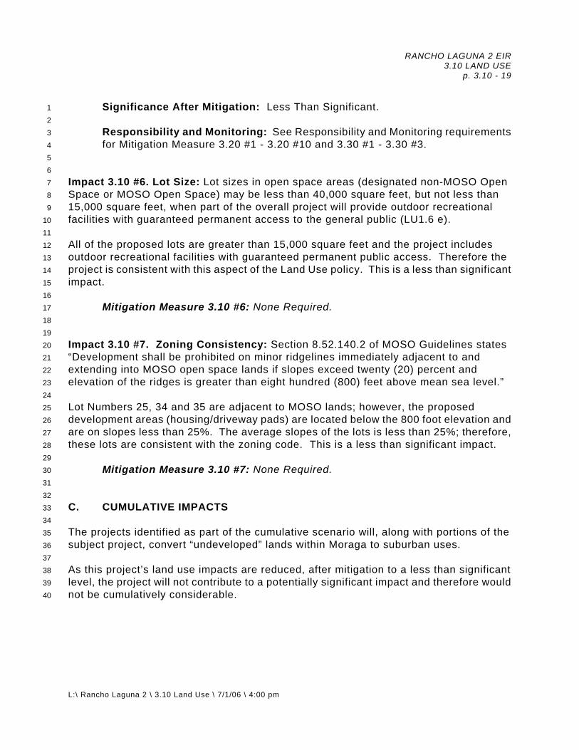
RANCHO LAGUNA 2 EIR 3.10 LAND USE p. 3.10 - 19
L:\ Rancho Laguna 2 \ 3.10 Land Use \ 7/1/06 \ 4:00 pm
1 2 3 4 5 6 7 8 9
10 11 12 13 14 15 16 17 18 19 20 21 22 23 24 25 26 27 28 29 30 31 32 33 34 35 36 37 38 39 40
Significance After Mitigation: Less Than Significant. Responsibility and Monitoring: See Responsibility and Monitoring requirements
for Mitigation Measure 3.20 #1 - 3.20 #10 and 3.30 #1 - 3.30 #3. Impact 3.10 #6. Lot Size: Lot sizes in open space areas (designated non-MOSO Open Space or MOSO Open Space) may be less than 40,000 square feet, but not less than 15,000 square feet, when part of the overall project will provide outdoor recreational facilities with guaranteed permanent access to the general public (LU1.6 e). All of the proposed lots are greater than 15,000 square feet and the project includes outdoor recreational facilities with guaranteed permanent public access. Therefore the project is consistent with this aspect of the Land Use policy. This is a less than significant impact.
Mitigation Measure 3.10 #6: None Required.
Impact 3.10 #7. Zoning Consistency: Section 8.52.140.2 of MOSO Guidelines states “Development shall be prohibited on minor ridgelines immediately adjacent to and extending into MOSO open space lands if slopes exceed twenty (20) percent and elevation of the ridges is greater than eight hundred (800) feet above mean sea level.” Lot Numbers 25, 34 and 35 are adjacent to MOSO lands; however, the proposed development areas (housing/driveway pads) are located below the 800 foot elevation and are on slopes less than 25%. The average slopes of the lots is less than 25%; therefore, these lots are consistent with the zoning code. This is a less than significant impact.
Mitigation Measure 3.10 #7: None Required.
C. CUMULATIVE IMPACTS
The projects identified as part of the cumulative scenario will, along with portions of the subject project, convert “undeveloped” lands within Moraga to suburban uses.
As this project’s land use impacts are reduced, after mitigation to a less than significant level, the project will not contribute to a potentially significant impact and therefore would not be cumulatively considerable.

RANCHO LAGUNA 2 EIR 3.15 JOBS, POPULATION AND HOUSING
p. 3.15 - 1
L:\ Rancho Laguna 2 \ 3.15 Jobs, Population and Housing \ 7/6/06 \ 9:15 pm
1 2 3 4
3.15 JOBS, POPULATION AND HOUSING A. ENVIRONMENTAL SETTING 1. Existing Conditions5
6 7 8 9
10 11 12 13 14 15 16 17 18 19 20 21 22 23 24 25
The project is located northeast of Rheem Boulevard, between St. Mary’s and Moraga Roads in the Town of Moraga, California. The site is surrounded by proposed very low residential development to the northeast and south, and by low density residential housing across Rheem Boulevard to the west. Regional Population Trends. The population of the nine-county San Francisco Bay Area was 6.8 million in 2000 as compared to 6.0 million in 1990, 5.2 million in 1980, and 4.6 million in 1970. The Association of Bay Area Governments (ABAG) estimates the region’s population will be 7.6 million in 2010, and will reach 8.0 million by 2020 (per ABAG’s Projections 2000). Research in 1977 projected that growth in the region would occur mostly outside the central cities. This expectation still holds, unless significant changes occur in the region’s land use and transportation patterns. The total population of Moraga on January 1, 2006 was 16,338. Since incorporation in 1974, Moraga has continued to develop primarily as a single family residential community. There are almost 5,800 housing units within the Town on almost 3,000 acres, and approximately 100 acres of community developed property. Population is projected to grow to 17,700 by 2020 (ABAG, Projections 1998). There are approximately 10 acres of vacant community designated property remaining according to the Town’s General Plan. As of January 1, 2006, the total household population was 14,707; there were 5,785 housing units and the average persons per household was 2.586 (California Department of Finance).
26 27 28 29 30 31 32 33 34 35 36 37 38 39 40 41 42 43 44 45
Housing/Land Supply A high demand for housing is expected to continue within the foreseeable future, given regional County and City growth projections (ABAG, Projections 2020). As stated in the Town of Moraga’s General Plan EIR:
“The Town of Moraga contains approximately 5,700 housing units. Housing in Moraga consists primarily of single-family homes, which comprise 84 percent of the housing stock. The Town’s housing stock has increased by about 30 percent since incorporation, a moderate rate of growth in comparison to the San Francisco Bay Area region. In the 1990s, only 91 new units of housing were built; most of these were single-family homes. In addition, 76 units of assisted care units were completed in 1999 for seniors. Most of Moraga’s housing was constructed after 1960 and is in good condition.”

RANCHO LAGUNA 2 EIR 3.15 JOBS, POPULATION AND HOUSING
p. 3.15 - 2
L:\ Rancho Laguna 2 \ 3.15 Jobs, Population and Housing \ 7/6/06 \ 9:15 pm
1 2 3 4 5 6 7 8 9
10 11 12 13 14 15 16 17 18 19 20 21 22
“The percentage of single-family homes is similar to that of the County, but much higher than Bay Area regional average of 53 percent.”
“Moraga is a high-cost housing area due to the desirability of its location, environment, and schools. Land values are substantially higher in Moraga than in many other Bay Area communities, and homebuilders tend to focus on the higher end of the housing market when constructing homes in the Town. The 1990 median housing price in Moraga was nearly double that of the County as a whole, and the median rent nearly 30 percent higher. For the first six months of 1999 the median sales price was $508,000. This median housing price is unaffordable for households earning median income.”
The Moraga 2000 General Plan Update identifies two specific plan areas (Rheem Park and Moraga Center) to provide over 200 additional multi-family dwelling units and a mix of residential and commercial uses and community facilities. The Specific Plan(s) for those two areas will focus, in particular, on those parcels that are undeveloped, under-utilized, or subject to potential redevelopment. The Specific Plans will define approximate locations and densities to achieve the Town’s fair share of regional housing need in keeping with the goals and policies of the General Plan Housing Element. The Rancho Laguna 2 project is proposing to provide market rate housing. 2. Regulatory Environment23
24 25 26 27 28 29 30 31 32 33 34 35 36 37 38 39 40 41 42 43 44 45
Town of Moraga’s Goals and Policies: Goal H1: Housing and Neighborhood Quality. Continued maintenance and
improvement of high-quality, safe and livable housing and residential neighborhoods.
Goal H2: Housing Mix and Affordability. A variety of housing types to help
meet the Town’s projected housing needs. Policy H2.1: Housing Variety. Ensure that new residential developments
provide the Town with a wide range of housing types to meet the various needs and income levels of people who live and work in Moraga.
Policy H2.6: Density Bonus. Provide a density bonus of 25 percent or
equivalent regulatory or financial incentive, consistent with State law requirements (California Government Code 65915), for residential projects that provide at least 10 percent of the dwelling units affordable to very low-income households, or at least 20 percent affordable to low-income households, or at least 50 percent suitable for senior citizens.

RANCHO LAGUNA 2 EIR 3.15 JOBS, POPULATION AND HOUSING
p. 3.15 - 3
L:\ Rancho Laguna 2 \ 3.15 Jobs, Population and Housing \ 7/6/06 \ 9:15 pm
1 2 3 4 5 6 7 8 9
10 11
Policy H2.10: Secondary Living Units. Allow secondary living units in single-family and multi-family areas, including MOSO and non-MOSO open space providing they comply with the Town’s Municipal Code and Design Guidelines. Further, detached second units within existing subdivisions may be allowed on lots that are sufficiently large for accommodation of such units taking into consideration impacts to the neighborhood and its residents including but not limited to visual impacts and privacy impacts and where they are otherwise compatible with the neighborhood.
3. Thresholds of Significance12
13 14 15 16 17 18 19 20 21 22 23 24 25 26 27 28 29
Per the CEQA Guidelines, a project would be considered to have a significant effect on the environment if it would: a. Induce substantial population growth in an area, either directly (for
example, by proposing new homes and businesses) or indirectly (for example, through extension of roads or other infrastructure).
b. Displace substantial numbers of existing housing, necessitating the
construction of replacement housing elsewhere. c. Displace substantial numbers of people, necessitating the construction of
replacement housing elsewhere. B. IMPACTS AND MITIGATION MEASURES 1. Basis for Impacts30
31 32 33 34 35 36
The Proposed Project will generate approximately 90 new residents, assuming a population per household factor of 2.586. Impacts would occur if the Proposed Project resulted in induced growth or if it displaced existing housing or population. 2. Analysis of Project Impacts37
38 39 40 41 42 43 44 45
Impact 3.15 #1. Growth Inducement: The project will provide housing, helping to meet the Town’s requirement to meet ABAG projections for housing. If approved as proposed, the Proposed Project will increase the housing supply by 35 units. These additional 35 homes will help the Town of Moraga achieve its regional housing needs as mandated by ABAG (e.g., market rate housing). Under the OS-PD zoning, a maximum density of nine units can be realized for the 180 acres (20 acre minimum zoning), unless it can be demonstrated that the conditions set forth under the MOSO

RANCHO LAGUNA 2 EIR 3.15 JOBS, POPULATION AND HOUSING
p. 3.15 - 4
L:\ Rancho Laguna 2 \ 3.15 Jobs, Population and Housing \ 7/6/06 \ 9:15 pm
1 2 3 4 5 6 7 8 9
10 11 12 13 14 15 16 17 18 19 20 21 22 23 24 25 26 27 28
Guidelines can be met (see Section 3.10 Land Use and Planning for a discussion of planning policy issues).
Mitigation Measure 3.15 #1: None Required.
Impact 3.15 #2. Displacement of Housing/Population: The Proposed Project will not displace any existing housing nor any existing population as the project site is vacant land.
Mitigation Measure 3.15 #2: None Required.
C. CUMULATIVE IMPACTS The overall increase in population growth is not in itself a significant impact. The Project is complying with the procedures set forth by Town policy in its request to increase units, from the minimum of nine allowable units to the maximum allowed under the open space zoning of 35 units. The population of Moraga was projected in the General Plan to grow over the next 20 year planning horizon. However, over the past year Moraga has experienced a reduction in population of 97 persons. The incremental difference in population associated with the project (between 35 versus the allowable 9 units) is a population of 68 persons, offsetting only a portion of the population lost in 2005. Limitation of the development to 35 units will reduce any cumulative, or growth inducing, aspects of the project to a level such that the project has no cumulatively considerable contribution to growth within the community.

RANCHO LAGUNA 2 EIR 3.20 GEOLOGY AND SOILS
p. 3.20 - 1
L:\ Rancho Laguna 2 \ 3.20 Geology and Soils \ 7/6/06 \ 9:15 pm
1 2 3 4 5 6 7 8 9
10 11 12 13 14 15 16 17 18 19 20 21 22 23
3.20 GEOLOGY AND SOILS Preface The materials used in the preparation of this section of this report include the Town of Moraga’s General Plan and 2000 Update EIR; the August 8, 2002 “Revised Preliminary Geotechnical Investigation, Rancho Laguna 2, Moraga, California,” prepared by ENGEO; the June 19, 2002 “Preliminary Geotechnical Evaluation, Rheem Boulevard Stabilization, Rancho Laguna Development, Moraga, California,” prepared by ENGEO; the December 9, 2005 “Supplemental Geotechnical Exploration, Rancho Laguna Development, Moraga, California,” prepared by ENGEO; the September 9, 2002 “Earthwork Calculations, Rancho Laguna, Moraga, California,” prepared by EarthCalc; the Town of Moraga Design Guidelines, Guidelines For Interpreting and Implementing The Moraga Open Space Initiative; and, available published geological references for this area. Several site visits were conducted during February, March and April, 2003, and November 2005. Stereographic aerial photographs of the site vicinity covering the period from 1954 to 2002 were also reviewed. A. ENVIRONMENTAL SETTING 1. Existing Conditions24
25 26 27 28 29 30 31 32 33 34 35 36 37 38 39 40 41
Geology The Town of Moraga lies within the California Coastal Range Geomorphic Province, which is characterized by a series of northwest trending mountain ranges and valleys. The subject property is underlain by the lower member of the Mullholland Formation of Pliocene and late Miocene Age (Graymer, 2000), consisting of friable to indurated sandstone, siltstone, mudstone and claystone. Outcrops of the sandstone and siltstone bedrock are present along the ridgeline that runs through the middle of the area planned for development and in an existing roadcut made for the EBMUD access road. Bedding at the site generally strikes northwest and is inclined strongly to the southwest with dips ranging from 30 to 60 degrees (Dibblee, 1980; Graymer, 2000; ENGEO, 2002). Structurally, the property is situated within the northeast limb of a northwest trending syncline, or concave fold, within the earth’s crust, whose axis lies about 3,500 feet to the southwest (Graymer, 2000).

RANCHO LAGUNA 2 EIR 3.20 GEOLOGY AND SOILS
p. 3.20 - 2
L:\ Rancho Laguna 2 \ 3.20 Geology and Soils \ 7/6/06 \ 9:15 pm
1 2 3 4 5 6 7 8 9
10 11 12 13 14 15 16 17 18 19 20 21 22 23 24 25 26 27 28 29 30 31 32 33 34 35 36 37 38 39 40 41 42 43
Surficial geologic units in the site vicinity include recent and dormant landslides on the hillsides, alluvial deposits in the valley drainages, such as along the east side of Rheem Boulevard, and colluvial deposits within the minor swales found on the hillsides. Artificial fills are located below the Rheem Boulevard alignment and in the north end of the valley along the east side of Rheem Boulevard. Figure 3.20-1 presents a map showing the geological conditions in the site vicinity. The site geology is presented on Figure 3.20-2 (Lots 1 - 14 Area) and Figure 3.20-2b, and includes Lot Numbers 15 - 35. Topography The subject property is bordered on the west by Rheem Boulevard, with the St. Mary’s Road alignment running east-west approximately 500 feet south of the property. The 180.2 acre parcel, of which 44 acres is proposed for development, includes moderately sloping hillside terrain on a north-south trending ridgeline, which ranges in elevation from 650 feet to 950 feet. The ridge slopes down toward the east to Coyote Creek, a minor drainage course, and toward the west to a major drainage course (Rancho Laguna Creek Valley) which parallels Rheem Boulevard and lies about 100 feet to the east. Low-lying areas in the southern portion of the site range in elevation from 500 to 600 feet. The slopes on both sides of the ridgeline are mantled by earth and slump flows and the Rancho Laguna Creek drainage crosses the toe of four closely spaced landslides that have originated off-site on the 150 foot high steeply inclined slope to the west. These landslides extend below Rheem Boulevard and daylight on the property in the vicinity of Rancho Laguna Creek. The landslides are discussed in the preliminary geotechnical evaluation report by ENGEO and were studied further as described in ENGEO’s December 2005 Supplemental Geotechnical Exploration, which included stability analyses of the four slides affecting Rheem Boulevard. The preliminary report concludes that the distress to Rheem Boulevard has resulted from gradual periodic movement of the deep seated landslides which toe out below the road bed. ENGEO’s supplemental report demonstrates that the slides will obtain a stable configuration with the reworking of the toe portion of the slide masses and construction of a valley buttress fill. This landslide stabilization measure would involve filling the valley to an elevation roughly equal to the elevation of the roadway in the area where the landslides toe out under Rheem Boulevard. The weight of the valley buttress fill placed at the toe of the landslide(s) provides additional gravity resisting forces to counter the driving forces of the landslide mass located below the roadway and upslope to the west. The buttress fill landslide

RANCHO LAGUNA 2 EIR 3.20 GEOLOGY AND SOILS
p. 3.20 - 3
L:\ Rancho Laguna 2 \ 3.20 Geology and Soils \ 7/6/06 \ 9:15 pm
1 2 3 4 5 6 7 8 9
10 11 12 13 14 15 16 17 18 19 20 21 22 23 24 25 26 27 28 29 30 31 32 33 34 35 36 37 38 39 40 41 42 43
stabilization method was previously shown to have effectively controlled the landslide movements of the north portion of Rheem Boulevard as described below. Stereographic aerial photographs of the site vicinity reviewed for this project suggest that the larger landslides mapped on the property generally existed prior to 1954. Recent slide activity at the site has consisted of enlargement of existing slumps and flows and a few isolated relatively shallow landslides, as subsequently discussed. A 400 foot section of Rheem Boulevard has been buttressed with artificial fill placed in the drainage course on the east side of Rheem Boulevard. This buttress, first observed on the 1974 aerial photos, appears to have been effective in controlling landslide movement based on the relatively intact condition of the pavement in this stretch of the road. However, the fill surface is about five feet lower in elevation than the roadbed and longitudinal cracking has developed in the shoulder and north lane due to soil creep; based on observation during a recent site visit the shoulder has continued to creep over the past two years. Vegetation at the site consists of trees and brush in the lower-lying valley areas and seasonal grasses on the slopes and ridgeline. Soils and Groundwater The USDA Soil Conservation Service (SCS) Soil Survey for Contra Costa County (1977) maps two soil types on the property: the Millshom loam (MeF) 30-50% slopes, and the Los Osos clay loam (LhF) 30-50% slopes. The Millshom loam (MeF) is formed from interbedded shale and fine-grained sandstone. Permeability on this soil type is moderate, runoff is rapid, and the hazard of erosion is high. These soils are rated Class VII e-1, with a Storie Index of 15 (grade 5). The Los Osos clay loam (LhF) is found on soft, fine-grained sandstone and shale. Permeability on this soil type is slow, runoff is medium to rapid and the hazard of erosion is moderate to high. These soils are rated Class VI e-1, with a Storie Index of 19 (grade 5). For a discussion of the agricultural capacity and status of these soils as prime agricultural soils, see Section 3.10, “Land Use.” The potential for erosion of the surface soils on the project site is moderate to high. Therefore, permanent slopes should be protected against erosion through the use of erosion resistant vegetation and jute netting. Slopes should be graded so that water is directed away from the slope face. As determined in the preliminary and supplemental soil investigations performed by ENGEO, the predominant subsurface soils on ridgelines and valley areas are medium stiff to very stiff, highly expansive silty clays and clayey silts overlying moderately strong sandstone, claystone and siltstone of the Mulholland Formation.

RANCHO LAGUNA 2 EIR 3.20 GEOLOGY AND SOILS
p. 3.20 - 4
L:\ Rancho Laguna 2 \ 3.20 Geology and Soils \ 7/6/06 \ 9:15 pm
1 2 3 4 5 6 7 8 9
10 11 12 13 14 15 16 17 18 19 20 21 22 23 24 25 26 27 28 29 30 31 32 33 34 35 36 37 38 39 40 41 42 43 44
Groundwater was encountered during the ENGEO soil investigations at depths ranging from two to 30.5 feet below existing grade. Shallow seasonal perched groundwater movement should be expected along the soil-bedrock interface in the direction normal to the ground contours. Seismicity, Ground Shaking and Liquefaction Potential The site is within a tectonically active area that is dominated by the San Andreas fault system. The San Andreas fault, the primary fault within this system, separates the northwest moving Pacific Plate (west of the fault) from the North American Plate which lies to the east. In Northern California, movement on the San Andreas fault system is distributed across a complex system of predominantly strike slip, right lateral, northwest trending faults which include the active San Andreas, Hayward, Calaveras, and Concord - Green Valley faults, among others. In the vicinity of the site, the San Andreas and Hayward faults are located approximately 22 miles and six miles to the southwest, respectively, with the Calaveras and Concord - Green Valley faults approximately four miles and eight miles to the northeast, respectively. One published report (Crane, 1988) maps a southwest dipping, thrust fault that runs parallel to the east side of Rheem Boulevard in the valley in which the drainage course is located. Another unnamed southwest dipping thrust fault is mapped by Crane approximately parallel to and one-half mile east of the thrust fault along Rheem Boulevard. The Calaveras and Hayward faults are the controlling seismic sources for strong ground shaking at the proposed project site. Using a maximum moment magnitude event of 6.8 and 7.1 for the Calaveras and Hayward faults, respectively, the predicted peak ground accelerations (Boore et al., 1997) are .27g and .28g, respectively, for the Rancho Laguna 2 site. No active faults are known to exist on or in close proximity to the site, and the site is not within an Alquist Priolo Earthquake Fault Zone of the State of California. Therefore, the potential for on-site surface fault rupture is considered to be very low. However, the property is likely to be subjected to strong ground shaking during the design life of the project from an earthquake originating on the San Andreas or other active fault in the North Bay/Northern California area. In addition, homes situated near the tops of ridgelines, such as those proposed for Lots 15 - 35 at Rancho Laguna 2, may experience amplified ground-motion. For example, the focusing of seismic energy along ridge lines was observed during the Loma Prieta earthquake (1989) in Los Altos Hills in Santa Clara County, where homes on narrow ridge lines sustained greater damage due to ground shaking than nearby homes on more level terrain. Therefore, the project should be designed and constructed in strict accordance with current standards for earthquake resistant construction.

RANCHO LAGUNA 2 EIR 3.20 GEOLOGY AND SOILS
p. 3.20 - 5
L:\ Rancho Laguna 2 \ 3.20 Geology and Soils \ 7/6/06 \ 9:15 pm
1 2 3 4 5 6 7 8 9
10 11 12 13 14 15 16 17 18 19 20 21 22 23 24 25 26 27 28 29 30 31 32 33 34 35 36 37 38 39 40 41 42
The investigation by ENGEO indicates that the site is generally underlain by stiff to very stiff silty clay and very dense sandstone to depths of up to 36 feet. Perched ground water was encountered within the depths explored over the bedrock surface. Since the soils were found to have a high relative density and a high percentage of clayey fines, the likelihood of soil liquefaction during ground shaking at the site is considered low. The weaker soils encountered in the Rancho Laguna Creek Valley, such as landslide material and old fill will be removed or reworked during the site grading, which will further reduce the liquefaction potential of these soils. USGS Open-File Report 03-214 predicts a 62 percent chance of a magnitude 6.7 or greater earthquake within the San Francisco Bay Area during the 30 year period ending in 2031. This study estimates a 27 percent probability of an earthquake of this magnitude on the Hayward fault and a 21 percent probability of such an earthquake on the San Andreas fault during the 30 year period. Figure 3.20-3 shows the site’s relationship to the regional faults in the San Francisco Bay Area. Discussion of Grading Plan/Geotechnical Report (Figure 2.00-5) The Preliminary Grading Plan prepared by Cooper, Thorne & Associates, June 2005, indicates that extensive cutting and filling will be performed on the property to create roads and level building pads for the 35 proposed lots. Cuts of up to 20 feet are shown on the ridge along the alignment of the planned new roads and pads. Fills up to approximately 35 feet are shown in the sloping valley areas along the east side of the ridge and in the Rancho Laguna Creek Valley along Rheem Boulevard. The Rancho Laguna Creek Valley will be filled in and a new drainage channel will be constructed. The grading for the new lots, as shown on the grading plans, will result in building pads that are wholly or predominantly in cut, deep fill and compound graded (both cut and fill) with roughly equal amounts of cut and fill proposed for the development. The grading plan indicates the site will be balanced with approximately 225,000 cubic yards of cut and fill. The major north-south trending slopes and secondary spur ridges that encompass the property are mantled by a series of predominantly shallow earthflows and slumps which have occurred within the near surface soils and weathered bedrock. These flow and slump features range from a few feet to as much as 10 to 15 feet in thickness. Several deep seated landslides are also present on the lower areas of the property east of Rheem Boulevard and along Coyote Creek. These landslides have an estimated thickness of 25 to 40 feet (ENGEO, 2002, 2005).

RANCHO LAGUNA 2 EIR 3.20 GEOLOGY AND SOILS
p. 3.20 - 6
L:\ Rancho Laguna 2 \ 3.20 Geology and Soils \ 7/6/06 \ 9:15 pm
1 2 3 4 5 6 7 8 9
10 11 12 13 14 15 16 17 18 19 20 21 22 23 24 25 26 27 28 29 30 31 32 33 34 35 36 37 38 39 40 41 42 43 44
The aerial photographs which were reviewed during the study indicate that the earth flows and slumps periodically reactivate during peak rainfall periods with the gradual accumulation of soil debris on the lower portion of the slopes. New erosion scars formed during wet years were observed on each pair of photos reviewed (1954, 1974, 1988 and 2002) and several small slips occurred during the last two winters. However, the majority of the landslide features shown on the Site Geology Map were present in some form in 1954. Published landslide mapping of this area (Majmundar, 1996) is presented on Figure 3.20-4, Local Landslide Map. The preliminary geotechnical report prepared by ENGEO in 2002 for the planned subdivision concludes that the primary geologic hazards on the property are landsliding and slope stability; and that other geotechnical concerns include expansive soils, groundwater and seismic hazards. The preliminary stabilization evaluation (2002) and supplemental geotechnical investigation reports (2005) for Rheem Boulevard, also prepared by ENGEO, concluded that landslides, soil creep and poor pavement subgrade conditions are the factors causing roadway distress, and that a valley buttress fill would mitigate the movements. The ENGEO reports describe three types of landslides on the property: slumps, earthflows, and deep seated slides. A total of 44 landslides have been mapped on the subject property by ENGEO; peer review verified the general location of the landslides as mapped. The conceptual landslide mitigation methods described in the ENGEO reports include providing setbacks from the toe of the slides using debris benches up to 50 feet wide, removal and replacement of slide material and buttressing. The December 2005 supplemental geotechnical investigation report describes four main landslides (A, B, C and E) that extend below Rheem Boulevard and onto the property in the Rancho Laguna Creek Valley. Lots 1 - 14 and the new entry road (“A” Way) are proposed within the toe portions of these landslides, which are to be mitigated by a combination of slope regrading below Rheem Boulevard and buttressing. The Slope Stability section of the ENGEO report recommends that cut slopes and fill slopes 10 feet or greater in height be no steeper than 3:1 (horizontal:vertical) and provided with benches, and that cut and fill slopes less than 10 feet high be no steeper than 2:1. However, the Preliminary Grading Plan, December 2005 by Cooper, Thorne & Associates, indicates that the fills below Lots 15 - 18 and Lots 24 and 25 are planned at a 2:1 gradient; drainage benches should be detailed on the plan. The Town of Moraga Design Guidelines, Section ll, Grading, Drainage and Erosion Control, specifies that cut and fill slopes be no steeper than 3:1, except where natural slopes are steeper, unless special mitigation measures are incorporated into the design. Development on slopes exceeding 2:1 requires a Design Exception. Additional slope stability analyses would be required to determine if the slopes shown on the preliminary grading plan meet the Town’s minimum factor of safety

RANCHO LAGUNA 2 EIR 3.20 GEOLOGY AND SOILS
p. 3.20 - 7
L:\ Rancho Laguna 2 \ 3.20 Geology and Soils \ 7/6/06 \ 9:15 pm
1 2 3 4 5 6 7 8 9
10 11 12 13 14 15 16 17 18 19 20 21 22 23 24 25 26 27 28 29 30 31 32 33 34 35 36 37 38 39 40
requirements. Special erosion control measures should also be specified for slopes that exceed the Town Guidelines. Alternatively, the grading plan should be revised to show conformance with the Town Guidelines. As recommended in ENGEO’s report, subdrains will likely be required at the toe of cutslopes, keyways and swales to intercept shallow groundwater seepage. The soils at the site are moderately to highly plastic and have a high expansion potential as discussed in the ENGEO report. Seasonal fluctuations of shallow perched groundwater can cause expansive soils to shrink and swell, causing damage to slabs-on-grade, pavements and shallow foundation systems. The construction methods that are recommended by ENGEO to minimize damage from expansive soil movements include overexcavating cut lots and cut/fill transition lots, moisture conditioning fills to over optimum moisture content and presoaking slab subgrades. ENGEO’s preliminary foundation design recommendations include using pier-and-grade-beam foundations or a structural mat (conventional or post-tensioned) to minimize the effects of soil expansion on the new homes. In addition, in areas where there is a significant differential fill thickness across individual Lots, ENGEO has proposed the subexcavation of the soil/bedrock materials and their replacement with engineered fill as a method to mitigate potential differential settlement. Rheem Boulevard Stabilization The section of Rheem Boulevard beginning from the point approximately 300 feet south of the proposed entrance to the Rancho Laguna 2 project and extending approximately 2,400 feet to the EBMUD water access road has experienced ongoing moderate to severe distress for over 30 years. The pavement distress has consisted of large cracks (up to one-inch wide) trending parallel to the roadway, vertical displacements creating a “roller coaster” effect and severe alligator cracking. ENGEO has mapped four landslides that extend under this section of Rheem Boulevard, which are likely the primary cause of the observed long term pavement distress. As earlier noted, the 400 foot section of roadway which was buttressed during the 1970s appears to have been stabilized against landslide movement but the outer fill portion is still experiencing creep movement. The stability of Rheem Boulevard can be improved through any of the following three remedial measures that reduce the potential for adverse impacts to the roadway from landsliding as well as soil/fill creep. Below-Grade Retaining Wall. A below-grade retaining wall could be constructed along the downslope (eastern) side of the roadway. The retaining structure would have a length of approximately 1,900 feet and would likely be constructed utilizing large-diameter, cantilevered and/or tied-back, cast-in-place concrete piers. The concrete
41 42 43 44

RANCHO LAGUNA 2 EIR 3.20 GEOLOGY AND SOILS
p. 3.20 - 8
L:\ Rancho Laguna 2 \ 3.20 Geology and Soils \ 7/6/06 \ 9:15 pm
1 2 3 4 5 6 7 8
piers should extend through the slide material and at least 10 to 20 feet into bedrock. The tie-back anchors associated with the pier system would need to extend back under the roadway achieving anchorage in firm competent bedrock behind the slide plane. The tieback anchor lengths would be approximately 40 to 60 feet. It is likely that construction easements on the western side of Rheem Boulevard would be needed for installation of tie-backs extending into those properties. The cost of this approach would be in the range of $3.5 million to $5 million. Keyway/Buttress. A keyway and buttress fill could be constructed along the downslope side of the roadway. The keyway could need to be approximately 30 to 35 feet deep in the landslide areas. To avoid triggering upslope movement and collapse of Rheem Boulevard, it would be necessary to excavate the keyway in short segments possibly no more than 50 feet long. This approach would involve very difficult grading operations and significant safety issues for roadway travelers and construction personnel that may require temporary closure of Rheem Boulevard. Following excavation of each segment of the keyway, subdrains would be constructed in the excavation and engineered fill would be placed in the keyway. In some portions of the keyway, the use of geogrid reinforced fill may be needed to provide additional support for the roadway. This approach would also be a very time consuming and costly construction operation with costs in the range of $2.5 to $3.5 million.
9 10 11 12 13 14 15 16 17 18 19 20 21
Valley/Buttress. A buttress fill could be placed in the valley on the eastern side of the roadway. The fill could be configured with ponds and/or swales as part of the possible wetlands mitigation measures. ENGEO estimated that a fill volume of approximately 175,000 cubic years would be needed. The fill could be placed without significant excavation of the underlying landslide materials provided that the land use is limited to open space. Using this approach, the likelihood of triggering upslope movement would be low and closure of Rheem Boulevard during remedial grading would not be needed. From a geotechnical engineering standpoint, the valley buttress approach is the most practical and cost effective alternative with costs in the range of $350,000 to $450,000.
22 23 24 25 26 27 28 29 30 31 32 33 34 35 36 37 38 39 40 41 42 43
The remedial measures selected by ENGEO in their 2005 supplemental geotechnical report to improve the condition of Rheem Boulevard consist of the buttress fill concept. Fill is placed in the valley east of the roadway in conjunction with removal and reworking of the slide materials downhill of the road. The landslides were analyzed with the buttress fill in-place and the factors of safety were found to be acceptable as discussed in the ENGEO report. The stabilizing fill should be brought up to the elevation of Rheem Boulevard over the length of the road to control development of longitudinal cracking resulting from soil creep. Remedial subgrade reworking and installation of a new structural pavement section would then be performed. Based on the observed roadway performance in the section which is currently buttressed, and the results of ENGEO’s slope stability analyses, the valley buttress fill would mitigate future road distress.
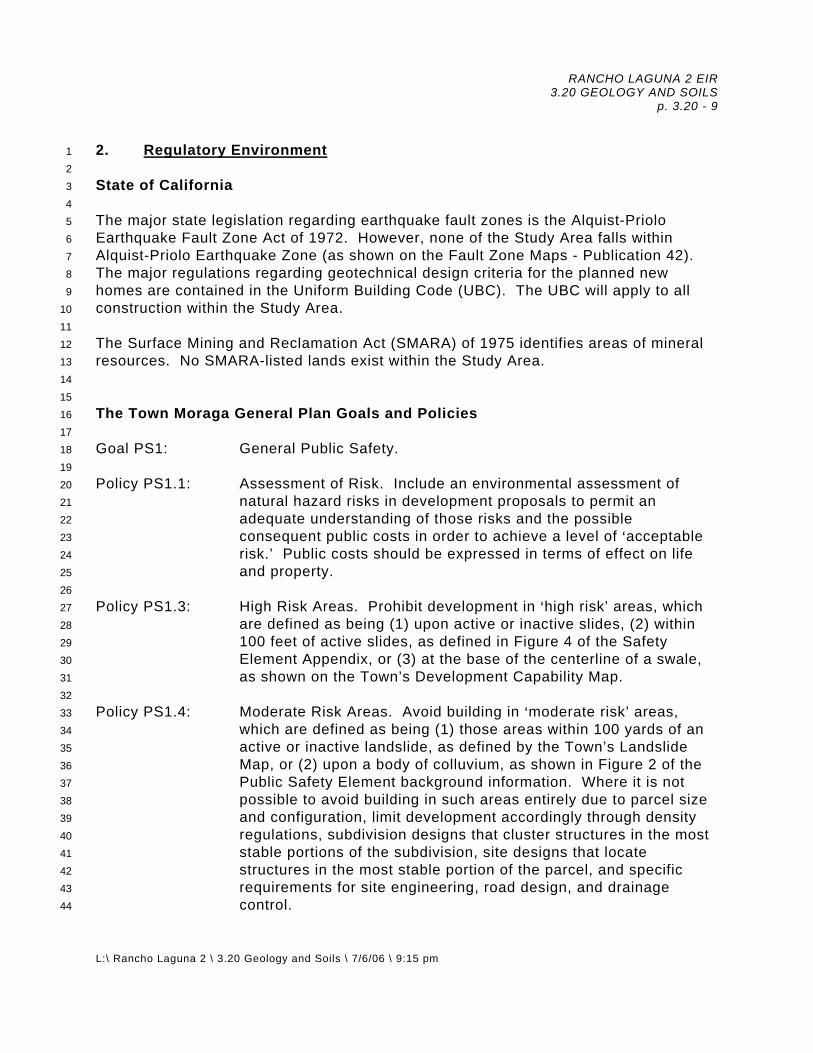
RANCHO LAGUNA 2 EIR 3.20 GEOLOGY AND SOILS
p. 3.20 - 9
L:\ Rancho Laguna 2 \ 3.20 Geology and Soils \ 7/6/06 \ 9:15 pm
2. Regulatory Environment1 2 3 4 5 6 7 8 9
10 11 12 13 14 15 16 17 18 19 20 21 22 23 24 25 26 27 28 29 30 31 32 33 34 35 36 37 38 39 40 41 42 43 44
State of California The major state legislation regarding earthquake fault zones is the Alquist-Priolo Earthquake Fault Zone Act of 1972. However, none of the Study Area falls within Alquist-Priolo Earthquake Zone (as shown on the Fault Zone Maps - Publication 42). The major regulations regarding geotechnical design criteria for the planned new homes are contained in the Uniform Building Code (UBC). The UBC will apply to all construction within the Study Area. The Surface Mining and Reclamation Act (SMARA) of 1975 identifies areas of mineral resources. No SMARA-listed lands exist within the Study Area. The Town Moraga General Plan Goals and Policies Goal PS1: General Public Safety. Policy PS1.1: Assessment of Risk. Include an environmental assessment of
natural hazard risks in development proposals to permit an adequate understanding of those risks and the possible consequent public costs in order to achieve a level of >acceptable risk.’ Public costs should be expressed in terms of effect on life and property.
Policy PS1.3: High Risk Areas. Prohibit development in >high risk’ areas, which
are defined as being (1) upon active or inactive slides, (2) within 100 feet of active slides, as defined in Figure 4 of the Safety Element Appendix, or (3) at the base of the centerline of a swale, as shown on the Town’s Development Capability Map.
Policy PS1.4: Moderate Risk Areas. Avoid building in >moderate risk’ areas,
which are defined as being (1) those areas within 100 yards of an active or inactive landslide, as defined by the Town’s Landslide Map, or (2) upon a body of colluvium, as shown in Figure 2 of the Public Safety Element background information. Where it is not possible to avoid building in such areas entirely due to parcel size and configuration, limit development accordingly through density regulations, subdivision designs that cluster structures in the most stable portions of the subdivision, site designs that locate structures in the most stable portion of the parcel, and specific requirements for site engineering, road design, and drainage control.

RANCHO LAGUNA 2 EIR 3.20 GEOLOGY AND SOILS
p. 3.20 - 10
L:\ Rancho Laguna 2 \ 3.20 Geology and Soils \ 7/6/06 \ 9:15 pm
1 2 3 4 5 6 7 8 9
10 11 12 13 14 15 16 17 18 19 20 21 22 23 24 25 26 27 28 29 30 31 32 33 34 35 36 37 38 39 40 41 42 43 44
Policy PS1.6: Public Safety Improvements. Give high priority to those public improvements that are related to public safety.
Goal PS4: Minimal risk to lives and property due to earthquakes and other
geologic hazards. Policy PS4.1: Development in Geologic Hazard Areas. Prohibit development in
geologically hazardous areas, such as slide areas or near known fault lines, until appropriate technical evaluation of qualified independent professional geologists, soils engineers and structural engineers is completed to the Town’s satisfaction. Allow development only where and to the extent that the geologic hazards have been eliminated, corrected or mitigated to acceptable levels.
Policy PS4.2: Development Review for Geologic Hazards. Require development
proposals to address geologic hazards, including, but not limited to landslide, surface instability, erosion, shrink-swell (expansiveness) and seismically active faults. Technical reports addressing the geologic hazards of the site shall be prepared by an independent licensed soil engineer, geologist and/or structural engineer, approved by the Town and at the expense of the developer. All technical reports shall be reviewed by the Town and found to be complete prior to approval of a development plan.
Policy PS4.3: Development Densities in Hazard Areas. Minimize the density of
new development in areas prone to seismic and other geologic hazards.
Policy PS4.5: Public Facilities and Utilities in Landslide Areas. Prohibit the
financing and construction of public facilities or utilities in potential landslide areas.
Policy PS4.6: Construction Standards. Ensure that all new construction and
applicable remodeling/reconstruction projects are built to established standards with respect to seismic and geologic safety.
Policy PS4.7: Construction Oversight. Adopt and follow procedures to ensure
that the recommendations of the project engineer and the design and mitigating measures incorporated in approved plans are followed through the construction phase.
Policy PS4.10: Grading. Grading for any purpose whatsoever may be permitted
only in accordance with an approved development plan that is

RANCHO LAGUNA 2 EIR 3.20 GEOLOGY AND SOILS
p. 3.20 - 11
L:\ Rancho Laguna 2 \ 3.20 Geology and Soils \ 7/6/06 \ 9:15 pm
1 2 3 4 5 6 7 8 9
10 11 12 13 14 15 16 17 18 19 20 21 22 23 24 25 26 27 28 29 30 31 32 33 34 35 36 37 38 39 40 41 42 43 44
found to be geologically safe and aesthetically consistent with the Town’s Design Guidelines. Land with a predevelopment average slope of 25% or greater within the development area shall not be graded except at the specific direction of the Town Council and only where it can be shown that a minimum amount of grading is proposed in the spirit of, and not incompatible with, the intention and purpose of all other policies of the General Plan. The Town shall develop an average slope limit beyond which grading shall be prohibited unless grading is required for landslide repair or slope stabilization.
Policy PS4.11: Retaining Walls. Discourage the use of retaining walls and other
man-made grading features to mitigate geologic hazards, permitting them only when:
● Required to decrease the possibility of personal injury or
property damage; ● Designed to blend with the natural terrain and avoid an
artificial or structural appearance; ● Appropriately screened by landscaping; ● Designed to avoid creating a tunnel effect along roadways
and to ensure unrestricted views for vehicular and pedestrian safety; and,
● Designed to ensure minimal public and/or private
maintenance costs. Policy PS4.12: Maintenance of Hillside Areas. Facilitate successful long-term
maintenance of hillside areas held as common open space. Policy CD1.5: Ridgelines and Hillside Areas. Protect ridgelines from
development. In hillside areas, require new developments to conform to the site's natural setting, retaining the character of existing landforms preserving significant native vegetation and with respect to ridgelines, encourage location of building sites so that visual impacts are minimized. When grading land with an average slope of 20% or more, require ‘natural contour’ grading to minimize soil displacement and use of retainer walls. Design buildings and other improvements in accordance with the natural setting, maintaining a low profile and providing dense native landscaping to blend hillside structures with the natural setting.

RANCHO LAGUNA 2 EIR 3.20 GEOLOGY AND SOILS
p. 3.20 - 12
L:\ Rancho Laguna 2 \ 3.20 Geology and Soils \ 7/6/06 \ 9:15 pm
1 2 3 4 5 6 7 8 9
10 11 12 13 14 15 16 17 18 19 20 21 22 23 24 25 26 27 28 29 30 31 32 33 34 35 36 37 38 39 40 41 42 43 44
Design Guidelines for Grading, Drainage and Erosion Control a. Preserve the natural topography of the land, especially at the horizon,
and not have “staircase” or “rice paddy” effects: 1. Round off, in a manner natural to the surrounding terrain, sharp
angles produced by earth moving, specifically at the top and toe of graded slopes.
2. All graded slopes shall be contour graded to achieve a natural
appearance. 3. Blend grading with the contours of contiguous properties and
create a smooth transition. 4. Minimize scars due to cuts, fills and drainage benches on natural
slopes. 5. Neither cuts nor fills shall result in slopes steeper than 3:1
(horizontal to vertical) except where natural slopes are greater. Where steeper slopes are unavoidable, special mitigation measures shall be incorporated into the design, since slopes steeper than 3:1 are difficult to maintain.
b. Preserve natural site amenities. 1. Development shall be planned in relation to natural features. 2. Natural features must be protected both during and after
construction of the project. 3. Retain trees and other native vegetation, consistent with the tree
preservation ordinance, to maintain current stability of steep hillsides, retain moisture, prevent erosion and enhance the natural scenic beauty.
4. Treat significant natural features, such as creeks, rock out-
croppings and prominent knolls, as assets. c. Consider appropriate remedial measures to deal with geologic hazards
and adverse soil conditions in site planning and design of structures. d. Place buildings on the site so as to permit ample room for usable yard
areas, adequate landscaping and drainage between and around buildings.
RANCHO LAGUNA 2 EIR 3.20 GEOLOGY AND SOILS
p. 3.20 - 13
L:\ Rancho Laguna 2 \ 3.20 Geology and Soils \ 7/6/06 \ 9:15 pm
1 2 3 4 5 6 7 8 9
10 11 12 13 14 15 16 17 18 19 20 21 22 23 24 25 26 27
e. Drainage should follow natural flow patterns, and where appropriate, plans should develop wide area flow patterns, rather than concentrating flow at one point.
f. Debris benches may be used on individual lots only where existing
landslides cannot be repaired. g. Downhill or uphill portions of any project shall provide landscaped
treatment to address potential erosion, to be in harmony with adjacent developments, and to provide a complementing view from distant horizons.
h. An exterior retaining wall shall be limited to five feet in height, unless it is
visible from off-site, in which case it shall be no higher than three feet. Materials used to construct a retaining wall shall be either concrete, suitably treated wood or masonry, and shall be properly designed, by a professional with an appropriate State license, to hold the required load. Other materials shall be used only when shown to have sufficient strength and longevity. The total height of a retaining wall and fencing on top of the wall shall not exceed eight feet. A guardrail or handrail (provided a solid fence does not support it) may be located on top of the retaining wall.
i. Surface and subsurface water behind all retaining walls shall be collected
and properly channeled to an approved drainage system.
3. Thresholds of Significance28
29 30 31 32 33 34 35 36 37 38 39 40 41 42 43
Significant effects could occur if development of the Proposed Project were to: a. Expose people or structures to potential substantial adverse effects,
including the risk of loss, injury, or death involving:
1. Rupture of a known earthquake fault, as delineated on the most recent Alquist-Priolo Earthquake Fault Zoning Map issued by the State Geologist for the area or based on other substantial evidence of a known fault? Refer to Division of Mines and Geology Special Publication 42.
2. Strong seismic ground shaking? 3. Seismic-related ground failure, including liquefaction?

RANCHO LAGUNA 2 EIR 3.20 GEOLOGY AND SOILS
p. 3.20 - 14
L:\ Rancho Laguna 2 \ 3.20 Geology and Soils \ 7/6/06 \ 9:15 pm
1 2 3 4 5 6 7 8 9
10 11 12 13 14 15 16 17 18
4. Landsliding? b. Result in substantial soil erosion or the loss of topsoil? c. Be located on a geologic unit or soil that is unstable, or that would
become unstable as a result of the project, and potentially result in on- or off-site landslide, lateral spreading, subsidence, liquefaction or collapse?
d. Be located on expansive soil, as defined in Table 18-1-B of the Uniform
Building Code (1994), creating substantial risks to life or property? e. Have soils incapable of adequately supporting the use of septic
tanks or alternative waste water disposal systems where sewers are not available for the disposal of waste water?
B. IMPACTS AND MITIGATION MEASURES 1. Basis for Impacts 19
20 21 22 23 24 25 26 27 28 29 30 31 32 33 34 35
The geotechnical characteristics of an area determine the potential for structural and safety hazards that can occur and thereby potentially affect urban development. The soil properties and the proximity to active earthquake faults and potential for slope instability are of concern in the project area. The primary geotechnical concerns for this project are: $ strong ground shaking; $ expansive soils; $ groundwater; and, $ landsliding and slope stability. 2. Analysis of Project Impacts and Mitigation Measures36
37 38 39 40 41 42 43 44
Impact 3.20 #1. Ground Shaking: Strong ground shaking associated with a major earthquake in the region is considered to be a significant impact on the planned development. Mitigation Measure 3.20 #1: The new buildings and other improvements will be
designed and built in accordance with the latest UBC, and other code requirements. Buildings designed and constructed in accordance with these

RANCHO LAGUNA 2 EIR 3.20 GEOLOGY AND SOILS
p. 3.20 - 15
L:\ Rancho Laguna 2 \ 3.20 Geology and Soils \ 7/6/06 \ 9:15 pm
1 2 3 4 5 6 7 8 9
10 11 12 13 14 15 16 17 18 19 20 21 22 23 24 25 26 27 28 29 30 31 32 33 34 35 36 37 38 39 40 41 42 43
requirements, and the recommendations of the geotechnical report, may experience some damage during a major seismic event but are unlikely to collapse or result in the loss of life.
Implementation of the mitigations recommended specifically for the Rancho
Laguna 2 project will ensure that the potential ground shaking impacts are reduced to less than significant levels.
Significance After Mitigation: Less Than Significant. Responsibility and Monitoring: Prior to issuance of any building permit Contra
Costa County Building Inspection Division shall review plans for compliance. Impact 3.20 #2. Liquefaction: Liquefaction is a phenomena in which saturated, loose, sandy and silty soils lose strength during seismic shaking. Liquefaction can result in significant lateral and vertical movement of structures founded on these soils. The preliminary investigations by ENGEO indicates that the site is generally underlain by stiff to very stiff silty clay and very dense sandstone, siltstone and claystone bedrock, as investigated to depths of up to 36 feet. Perched groundwater was encountered within the depths explored above the bedrock surface. Since the soils overlying bedrock were found to have a high relative density and contained a high percentage of clayey fines, the likelihood of soil liquefaction during ground shaking at the site is considered low. Because of the soil's inherent resistance to liquefaction, mitigation measures to prevent liquefaction at the site are not required. The weaker soils encountered in the Rancho Laguna Creek Valley, such as landslide material and old fill, will be removed or reworked during the site grading, which will eliminate the liquefaction potential of these soils. This is considered to be a less than significant impact.
Mitigation Measure 3.20 #2: None Required. Impact 3.20 #3. Expansive Soils: The near surface clay soils and bedrock have a moderate to high plasticity and a high expansion potential as discussed in the ENGEO report. Expansive soils can detrimentally affect building foundations, slabs, pavements, retaining walls and other site improvements. The impacts due to soil expansion are, therefore, potentially significant.
Mitigation Measure 3.20 #3: The ENGEO report provides recommended measures for mitigating the effects of expansive soils on the project improvements. These protective measures are to be implemented during the

RANCHO LAGUNA 2 EIR 3.20 GEOLOGY AND SOILS
p. 3.20 - 16
L:\ Rancho Laguna 2 \ 3.20 Geology and Soils \ 7/6/06 \ 9:15 pm
1 2 3 4 5 6 7 8 9
10 11 12 13 14 15 16 17 18 19 20 21 22 23 24 25 26 27 28 29 30 31 32 33 34 35 36 37 38 39 40 41 42 43
design and construction phase of the project and are to be documented by the project geotechnical engineer:
a. overexcavation of cut and fill lots; b. moisture conditioning of fills to over optimum; and, c. presoaking slab subgrade areas. The following additional measures can also be taken to minimize the effects of expansive soils:
d. providing a layer of non-expansive granular materials beneath slabs-on-
grade as a cushion against building slab movement; e. the use of aggregate base under exterior flatwork; and, f. control of irrigation adjacent to the new buildings.
Implementation of the mitigations recommended for the project will ensure that the issues with expansive soils are reduced to less than significant levels.
Significance After Mitigation: Less Than Significant.
Responsibility and Monitoring: Prior to approval of the individual lot foundation plans and subdivision improvement plans, the Contra Costa Building Inspection Division shall review plans for compliance.
Impact 3.20 #4. Groundwater: The subsurface conditions reported in the preliminary ENGEO study included relatively shallow groundwater at some locations. Shallow groundwater can cause foundation and pavement problems, and lead to instability of cut and fillslopes. The impacts due to shallow groundwater are, therefore, potentially significant. Mitigation Measure 3.20 #4: The ENGEO report provides recommended
measures for mitigating the effects of shallow groundwater on the project improvements. The following protective measures are to be implemented during the design and construction phase of the project and are to be documented by the project geotechnical engineer:
a. construction of subdrains in keyways, swales to be filled, overexcavation
areas and at the toe of cutslopes;

RANCHO LAGUNA 2 EIR 3.20 GEOLOGY AND SOILS
p. 3.20 - 17
L:\ Rancho Laguna 2 \ 3.20 Geology and Soils \ 7/6/06 \ 9:15 pm
1 2 3 4 5 6 7 8 9
10 11 12 13 14 15 16 17 18 19 20 21 22 23 24 25 26 27 28 29 30 31 32 33 34 35 36 37 38 39 40 41 42 43
b. construction of subdrains for reconstructed landslide areas and geogrid reinforced fillslopes; and,
c. presoaking slab subgrade area.
Implementation of the mitigations recommended specifically for the Rancho
Laguna 2 project will ensure that the potential impacts associated with groundwater are reduced to less than significant levels.
Significance After Mitigation: Less Than Significant.
Responsibility and Monitoring: Prior to approval of the subdivision grading and improvement plans, the Contra Costa Building Inspection Division shall review plans for compliance.
Impact 3.20 #5a. Landslides: A total of 44 landslides have been mapped on the subject property by ENGEO with an additional four landslides mapped on the west side of Rheem Valley which extend below Rheem Boulevard onto the property. A number of these slides are mapped in the area of the planned new lots. Therefore, the impacts due to existing landslides on the proposed development are potentially significant. Impact 3.20 #5b. Landslides (Rheem Boulevard): Of the three methods analyzed for stabilizing Rheem Boulevard, the valley buttress fill concept was selected. The below grade retaining wall was rejected due to cost and that it would not allow for a balance of cuts/fill on the site as houses would be located on the portions of the project site. The keyway buttress was also rejected due to (1) cost, (2) it would impact a sizeable portion of the wetlands and (3) that exportation of fill would be likely. The valley buttress fill concept was peer reviewed. The landslides were analyzed with the buttress fill in-place and the factors of safety were found to be acceptable as discussed in the ENGEO report. The stabilizing fill will need to control development of longitudinal cracking resulting from soil creep associated with the existing buttress fill. Remedial subgrade reworking and installation of a new structural pavement section would then be performed. Secondary visual and biological impacts related to this stabilization measure are discussed in impact/mitigation discussion 3.35 #3, 3.35 #4, 3.55 #3, 3.55 #4, 3.55 #5, 3.55 #9, 3.55 #17, 3.55 # 18, 3.55 #19, 3.55 #20, 3.55 #21, 3.55 #23, 3.55 #24, and 3.55 #26.
Mitigation Measure 3.20 #5: The ENGEO report recommends that landslide mitigation methods such as providing setbacks from the slides using debris benches up to 50 feet wide, removal and replacement of slide material and

RANCHO LAGUNA 2 EIR 3.20 GEOLOGY AND SOILS
p. 3.20 - 18
L:\ Rancho Laguna 2 \ 3.20 Geology and Soils \ 7/6/06 \ 9:15 pm
1 2 3 4 5 6 7 8 9
10 11 12 13 14 15 16 17 18 19 20 21 22 23 24 25 26 27 28 29 30 31 32 33 34 35 36 37 38 39 40 41 42 43 44
buttressing be used to mitigate the impact of existing landslides on the planned development. Implementation of the mitigations recommended for the Rancho Laguna 2 project will ensure that the impacts associated with landslides are reduced to less than significant levels.
Significance After Mitigation: Less Than Significant. Responsibility and Monitoring: Prior to approval of the individual lot foundation plans and subdivision improvement plans, the Contra Costa Building Inspection Division shall review plans for compliance.
Impact 3.20 #6. Soil Creep: Local areas of near surface clayey soils encountered at the site in the ENGEO study may be undergoing soil creep on the moderately inclined slopes found at the site. Creeping soils on slopes at the site present potentially significant impacts.
Mitigation Measure 3.20 #6: The ENGEO report recommends that within proposed fill areas, soils subject to creep are to be removed prior to fill placement. Alternately, improvements should be set back from potential creep zones, or below grade retaining walls and deepened foundations could be used to minimize potential creep impacts. These measures, or other appropriate measures as recommended by the geotechnical engineer and subject to the review and approval by the Town Engineer, shall be incorporated onto the foundation and site improvement plans and shall be verified and tested by the project geotechnical consultant. Implementation of the mitigations recommended specifically for the Rancho Laguna 2 project will ensure that the potential impacts associated with soil creep are reduced to less than significant levels.
Significance After Mitigation: Less Than Significant.
Responsibility and Monitoring: Prior to approval of the individual lot foundation plans and subdivision improvement plans, the Contra Costa County Building Inspection Division shall review plans for compliance.
Impact 3.20 #7. Erosion: The potential for erosion of the clayey surface soils on the project site is moderate to high. Erodible soils at the site present potentially significant impacts.

RANCHO LAGUNA 2 EIR 3.20 GEOLOGY AND SOILS
p. 3.20 - 19
L:\ Rancho Laguna 2 \ 3.20 Geology and Soils \ 7/6/06 \ 9:15 pm
1 2 3 4 5 6 7 8 9
10 11 12 13 14 15 16 17 18 19 20 21 22 23 24 25 26 27 28 29 30 31 32 33 34 35 36 37 38 39 40 41 42 43 44
Mitigation Measure 3.20 #7: The impacts from erosion can be mitigated by incorporating appropriate grading and drainage measures into the project design. The grading and drainage plan shall provide for positive drainage on building pads and removal of water from foundation areas into area drains and closed pipe systems connected to a suitable drainage facility. The pads should be drained individually so that flow does not move from lot to lot. Slopes should be graded so that water is directed away from the slope face. Permanent slopes should be protected against erosion through the use of erosion resistant vegetation and jute netting. Temporary erosion control measures such as positive gradients away from slopes, straw bales, silt fences and swales should be used during construction. The implementation of drainage control, and temporary and permanent erosion control measures will result in a less than significant hazard of erosion. Implementation of the mitigations recommended specifically for the Rancho Laguna 2 project will ensure that the erosion impacts are reduced to less than significant levels.
Significance After Mitigation: Less Than Significant. Responsibility and Monitoring: The final grading and drainage plans for the subdivision should be reviewed by the Contra Costa Building Inspection Division for compliance.
Impact 3.20 #8. Cuts and Fills: The preliminary grading plan for the project indicates finished slopes are to be 3:1 over most of the planned development, with 2:1 (horizontal:vertical) fillslopes shown for the area below Lots 15 - 18 and Lots 24 and 25. These slopes are steeper than that stated in the Town of Moraga’s Design Guidelines: “Neither cuts nor fills shall result in slopes steeper than 3:1 except where natural slopes are greater.” ENGEO recommends that cut slopes and fill slopes 10 feet or greater in height be no steeper than 3:1 (horizontal:vertical), and that cut and fill slopes less than 10 feet high be no steeper than 2:1. Special mitigation measures, supported by the findings of additional slope stability analyses, would be required to demonstrate that the slopes shown on the preliminary grading plan meet the Town’s minimum factor of safety requirements.
Mitigation Measure 3.20 #8: The project grading plans shall be reconfigured to have finished slopes no greater than 3:1, or additional slope analysis shall be prepared by the Project Sponsor demonstrating that steeper slopes are feasible. The following performance standards for increasing slope gradients shall be developed that identify techniques such as:

RANCHO LAGUNA 2 EIR 3.20 GEOLOGY AND SOILS
p. 3.20 - 20
L:\ Rancho Laguna 2 \ 3.20 Geology and Soils \ 7/6/06 \ 9:15 pm
1 2 3 4 5 6 7 8 9
10 11 12 13 14 15 16 17 18 19 20 21 22 23 24 25 26 27 28 29 30 31 32 33 34 35 36 37 38 39 40 41 42 43 44
● the use of geogrid reinforcement; ● utilization of only granular materials in engineered fills; and ● provisions for drainage benches on the fillslopes. As recommended in ENGEO’s report, subdrains will likely be required at the toe of cutslopes, keyways and swales to intercept shallow groundwater seepage. If 2:1 slopes were to be considered, ENGEO would show that slopes would be stable as discussed above. An exception to the Town’s Design Guidelines will be required. The mitigated design consistent with the mitigation measures that allow for screening of these fills and slopes, while not compromising the stability of the slopes, shall be developed and subject to additional environmental review. Implementation of the mitigations recommended specifically for the Rancho Laguna 2 project will ensure that the potential impacts associated with cuts and fills are reduced to less than significant levels.
Significance After Mitigation: Less Than Significant. Responsibility and Monitoring: The Town of Moraga will be responsible for allowing (or disallowing) the requested exceptions. Prior to approval of the subdivision grading plans, and ongoing during construction, the Contra Costa County Building Inspection Division shall ensure that all mitigation measures have been included on the plans.
Impact 3.20 #9. Building Pads: Fills up to 40 feet deep will be placed in several swales to create level building pads and some building pads will be founded in both cut and fill. The impacts associated with building pads resting on deep fill and compound (cut and fill) lot pads include differential settlement resulting from fill settlement caused by the weight of the fill, particularly in deep swales where the greatest settlement occurs in the center of the swale, and where foundation support crosses the “daylight line” from cut to fill. Additionally, wetting induced collapse resulting from drainage, runoff and direct infiltration of precipitation into the fill can cause engineered fill to settle following construction.
Mitigation Measure 3.20 #9: The ENGEO report recommends that deep fills be placed at a higher relative compaction and that the fill be moisture conditioned to above optimum moisture as determined from future design-level geotechnical testing and analysis. The placement of residence foundations on cut and fill building pads should utilize methods that will minimize differential settlements as determined by further study. Techniques that can be used to mitigate differential

RANCHO LAGUNA 2 EIR 3.20 GEOLOGY AND SOILS
p. 3.20 - 21
L:\ Rancho Laguna 2 \ 3.20 Geology and Soils \ 7/6/06 \ 9:15 pm
1 2 3 4 5 6 7 8 9
10 11 12 13 14 15 16 17 18 19 20 21 22 23 24 25 26 27 28 29 30 31 32 33 34 35 36 37 38 39 40 41 42 43
settlement on compound lots include such measures as overcutting and replacing the cut portion with an engineered fill cushion and the use of a rigid type foundation such as drilled pier and grade beam or structural slab. Implementation of the mitigations recommended for the Rancho Laguna 2 project will ensure that the impacts associated with building pads are reduced to less than significant levels.
Significance After Mitigation: Less Than Significant. Responsibility and Monitoring: Prior to approval of the individual lot foundation plans and subdivision improvement plans, the Contra Costa Building Inspection Division shall review plans for compliance.
Impact 3.20 #10. Foundations: Based on data collected during ENGEO’s preliminary investigation, it is their opinion that the site is suitable for the proposed residential construction from a geotechnical engineering standpoint. ENGEO recommends that a drilled pier and grade beam system, which obtains support in stiff native soils and bedrock below expansive upper soils, be used for support of the new structures. As an alternative, the report recommends a structural mat (conventional or post-tensioned) system.
Mitigation Measure 3.20 #10: The new residential construction and any other site improvements would need to:
a. Comply with the provisions of Title 24 of the California Administrative
Code, and the most recent edition of the Uniform Building Code, Seismic Zone 4 standards, or local seismic requirements, whichever is most stringent.
b. Meet all of the recommendations included in the August 8, 2002 ENGEO
preliminary soil investigation report including: 1. review of all plans and specifications including observation of
foundation excavations; and, 2. observation and testing of engineering fill, finish subgrade and
aggregate base.
Implementation of the mitigations recommended specifically for the Rancho Laguna 2 project will ensure that the potential impacts associated with foundations are reduced to less than significant levels.

RANCHO LAGUNA 2 EIR 3.20 GEOLOGY AND SOILS
p. 3.20 - 22
L:\ Rancho Laguna 2 \ 3.20 Geology and Soils \ 7/6/06 \ 9:15 pm
1 2 3 4 5 6 7 8 9
10 11 12 13 14 15 16 17 18 19 20 21
Significance After Mitigation: Less Than Significant. Responsibility and Monitoring: Prior to approval of the subdivision grading plans, and ongoing during construction, the Contra Costa County Building Inspection Division shall ensure that all mitigation measures have been included on the plans.
Impact 3.20 #11. Mineral Resources: No significant mineral resources are known to exist at the project site and no mining activities are known to have occurred in the past at this location.
Mitigation Measure 3.20 #11: None Required.
C. CUMULATIVE IMPACTS After mitigation, there are no significant cumulative impacts associated with geology and soils as (1) all impacts have been reduced to less than significant with mitigation and (2) the geology impacts are site-specific, and there are no other projects which increase the significance of these impacts.

RANCHO LAGUNA 2 EIR 3.25 HAZARDS AND HAZARDOUS MATERIALS
p. 3.25 - 1
L: \ Rancho Laguna 2 \ 3.25 Hazards and Hazardous Materials \ 7/1/06 \ 4:30 pm
1 2 3 4
3.25 HAZARDS AND HAZARDOUS MATERIALS A. ENVIRONMENTAL SETTING 1. Existing Conditions5
6 7 8 9
10 11 12 13 14
No environmental studies (Phase I) have been prepared for the site; however, the site has been utilized historically for grazing. It is unlikely that soils onsite, due to the steepness of the terrain, were subjected to fertilizers. No development has occurred on the site with the exception of the EBMUD access to (their) Fay Hill Reservoir, some ranch roads and cattle ponds. The area subject to development will be graded, the soil recompacted and used as fill onsite. 2. Regulatory Environment 15
16 17 18 19 20 21 22 23 24 25 26 27 28 29 30 31 32 33 34 35 36 37 38 39 40 41 42 43 44 45
The use, storage, generation and disposal of hazardous substances is regulated by a number of Federal, State and local agencies. The Department of Toxic Substances Control compiles a list of all hazardous waste facilities and lands designated as hazardous waste properties, along with other lists of hazardous waste sites per Section 65962.5 of the California Government Code. Resource Conservation and Recovery Act (RCRA). The RCRA Subtitle C addresses hazardous waste generation, handling, transportation, storage, treatment, and disposal. It includes requirements for a system that uses hazardous waste manifests to track the movement of waste from its site of generation to its ultimate disposition. California Code of Regulations. Most State and Federal regulations and requirements that apply to generators of hazardous waste are spelled out in the California Code of Regulations (CCR), Title 22, Division 4.5. Title 22 contains the detailed compliance requirements for hazardous waste generators, transporters, and treatment, storage, and disposal facilities. Because California is a fully authorized State according to RCRA, most RCRA regulations (those contained in 40 Code of Federal Regulations [CFR] 260 et seq.) have been duplicated and integrated into Title 22. However, because the Department of Toxic Substance Control (DTSC) regulates hazardous waste more stringently than the United States Environmental Protection Agency (U.S. EPA), the integration of California and Federal hazardous waste regulations that make up Title 22 do not contain as many exemptions or exclusions as does 40 CFR 260. The Contra Costa County Fire Protection District (CCCFPD) on behalf of the East Contra Costa County Fire Protection District will respond to hazardous substance releases, but only to evaluate conditions and determine if emergency services are needed. The local regulatory agency for hazardous materials is the Certified Uniform Program Agency (CUPA), which is part of the Contra Costa County Office of Health

RANCHO LAGUNA 2 EIR 3.25 HAZARDS AND HAZARDOUS MATERIALS
p. 3.25 - 2
L: \ Rancho Laguna 2 \ 3.25 Hazards and Hazardous Materials \ 7/1/06 \ 4:30 pm
1 2 3 4 5 6 7 8 9
10 11 12 13 14 15 16 17 18 19 20 21 22
Services. This agency, headquartered in Martinez, has authority over those areas of the County that are not under the jurisdiction of other CUPA offices. The CUPA personnel operate under California Environmental Protection Agency or Department of Toxic Substances Control Guidelines to enforce the California Code of Regulations. The Contra Costa Health Services Hazardous Materials Program serves area residents by responding to emergencies and monitoring hazardous materials. The Town of Moraga General Plan Goals and Policies Policy PS3.12: Hazardous Fire Areas. Apply special fire protection standards to
all new developments in hillside, open space, and wildland interface areas. Fire prevention measures such as removal of dry grass and brush, landscaping with fire and drought-resistant vegetation, provision of adequate water supplies and access for fire-fighting vehicles shall be required to reduce the risk of wildland fires. All new structures located in hazardous fire areas shall be constructed with fire resistant exterior materials consistent with applicable building codes and standards.
3. Thresholds of Significance 23
24 25 26 27 28 29 30 31 32 33 34 35 36 37 38 39 40 41 42 43 44
Appendix G of CEQA outlines the threshold of significance to be used to determine whether the project could be expected to have a significant impact on the environment:
a. Create a significant hazard to the public or the environment through the routine transport, use, or disposal of hazardous materials;
b. Create a significant hazard to the public or the environment through
reasonably foreseeable upset and accident conditions involving the release of hazardous materials into the environment;
c. Emit hazardous emissions or handle hazardous or acutely hazardous
materials, substances, or waste within one-quarter mile of an existing or proposed school;
d. Be located on a site which is included on a list of hazardous materials
sites compiled pursuant to Government Code 65962.5 and, as a result, would it create a significant hazard to the public or the environment;
e. For a project located within an airport land use plan or, where such a plan
has not been adopted, within two miles of a public airport or public use
RANCHO LAGUNA 2 EIR 3.25 HAZARDS AND HAZARDOUS MATERIALS
p. 3.25 - 3
L: \ Rancho Laguna 2 \ 3.25 Hazards and Hazardous Materials \ 7/1/06 \ 4:30 pm
1 2 3 4 5 6 7 8 9
10 11 12 13 14 15 16
airport, would the project result in a safety hazard for people residing or working in the project area;
f. For a project located within the vicinity of a private airstrip, would the project result in a safety hazard for people residing or working in the project area;
g. Impair implementation of or physically interfere with an adopted
emergency response plan or emergency evacuation plan; 1 h. Expose people or structures to a significant risk of loss, injury or death
involving wildland fires, including where wildlands are adjacent to urbanized areas or where residences are intermixed with wildlands.
B. IMPACTS AND MITIGATION MEASURES 1. Basis for Impacts 17
18 19 20 21 22
As this is a residential project, it is not anticipated to increase the potential for hazardous substances or household hazardous waste on or around the project site. 2. Analysis of Impacts23
24 25 26 27 28 29 30 31 32 33 34 35 36 37 38 39 40 41 42
Impact 3.25 #1. Hazardous Materials: No increase in hazards to the public or the environment due to reasonable foreseeable upset and accident conditions involving the release of hazardous materials to the environment is expected. The zoning code would prohibit uses that would be likely to use high concentrations, or store or dispose, of hazardous materials. The project proposes residential uses that do not involve the use and storage of hazardous materials of a quantity that could pose a significant risk. Therefore, this has been identified as a less than significant impact.
Mitigation Measure 3.25 #1: None Required. Impact 3.25 #2. Construction-Related Hazardous Materials: There is the potential for accidental release of oil, gasoline or diesel during construction. This is a potentially significant impact.
Mitigation Measure 3.25 #2: The Proposed Project shall comply with all Federal, State and local laws regarding use of hazardous materials at construction sites. The Proposed Project shall comply with the Town of Moraga
1 See Impacts and Mitigation Measure 3.61 #1.

RANCHO LAGUNA 2 EIR 3.25 HAZARDS AND HAZARDOUS MATERIALS
p. 3.25 - 4
L: \ Rancho Laguna 2 \ 3.25 Hazards and Hazardous Materials \ 7/1/06 \ 4:30 pm
1 2 3 4 5 6 7 8 9
10 11 12 13 14 15 16 17 18 19 20 21 22 23 24 25 26 27 28 29 30 31 32 33 34 35
code provisions relating to the methods for reducing the potential for fuel spills during construction. Compliance with Federal, State and local regulations shall ensure that the risk of potential spills during construction is reduced to a level of less than significant.
Significance After Mitigation: Less Than Significant.
Impact 3.25 #3. Proximity to Schools: The Proposed Project is not located within one-quarter mile of an existing or proposed school and therefore the risk is not considered a significant impact.
Mitigation Measure 3.25 #3: None Required. Impact 3.25 #4. Existing Hazardous Materials: The project site is not included on the list of hazardous materials sites compiled pursuant to Government Code 65962.5, and is therefore not considered a significant impact.
Mitigation Measure 3.25 #4: None Required.
Impact 3.25 #5. Proximity to Airports: The project site is not located within an airport land use plan or within two miles of a public airport or public use airport. The project site is not located within the vicinity of a private airstrip. Therefore, no safety hazards for people residing or working in the project area are anticipated and thus is considered a less than significant impact.
Mitigation Measure 3.25 #5: None Required.
C. CUMULATIVE IMPACTS There are no cumulative impacts associated with the storage or use of hazardous materials or exposure of population to negative situations.

RANCHO LAGUNA 2 EIR 3.30 HYDROLOGY, DRAINAGE AND WATER QUALITY
p. 3.30 - 1
L:\ Rancho Laguna 2 EIR \ 3.30 Hydrology, Drainage and Water Quality \ 7/1/06 \ 4:45 pm
1 2 3 4
3.30 HYDROLOGY, DRAINAGE AND WATER QUALITY A. ENVIRONMENTAL SETTING 1. Existing Conditions5
6 7 8 9
10 11 12 13 14 15 16 17 18 19 20 21 22 23 24 25 26 27 28 29 30 31 32 33 34 35 36 37 38 39 40 41 42 43 44
Watershed The Town of Moraga lies within both the watershed divide of the Las Trampas/Walnut Creek drainage to Suisun Bay, and the Moraga/San Leandro Creek drainage to South San Francisco Bay. The proposed Rancho Laguna 2 Development property lies primarily in the headwaters of Las Trampas Creek astride a northwest trending ridge that drains generally eastward to the Coyote and Rheem tributaries of the Las Trampas watershed. Only the westernmost corner of the property drains to Moraga Creek. Overland drainage slopes below the ridge crests are over steep, slowly permeable soils. Soil types along the ridge slopes include the Los Osos clay loam (LhF: 30-50% slopes, Hydrologic Group C) with moderate to high erosion hazard on bare soils. Along the ridge crest soils are Millshom loam (MeF: Hydrologic Group D). These soils are moderately permeable with rapid runoff and a high hazard of erosion. The well grazed grass lands produce rapid runoff to the established channels. All channels are significantly disturbed by cattle activity, particularly the downstream channels on the east end of the property, which are incised with cut banks and more susceptible to erosion. Numerous oak groves occupy the deep ravines above Las Trampas and Coyote Creeks. The mean annual precipitation (MAP) at the site is estimated at 28 inches by the Contra Costa County Flood Control District (CCCFCD), and is the basis of the depth-duration-frequency for rainfall-runoff estimates. Drainage and Flooding An existing paved road intercepts surface runoff from the head of the Rheem Boulevard drainage and releases it near the watershed divide on Rheem Boulevard. The road provides access to the EBMUD Fay Hill Reservoir located on the high point of the ridge adjacent to the northwest property line. A storm drain (12" corrugated metal pipe) from the subdivision west of Rheem Boulevard (Tract 5968) discharges into the Rheem Boulevard drainage below the buttress fill. Offsite, there are private road crossings and culverts in the Rheem Boulevard drainage adjacent to the Rheem Glen Subdivision and near its confluence with Las Trampas Creek as well as on the Coyote Creek tributaries.

RANCHO LAGUNA 2 EIR 3.30 HYDROLOGY, DRAINAGE AND WATER QUALITY
p. 3.30 - 2
L:\ Rancho Laguna 2 EIR \ 3.30 Hydrology, Drainage and Water Quality \ 7/1/06 \ 4:45 pm
1 2 3 4 5 6 7 8 9
10 11 12 13 14 15 16 17 18 19 20 21 22 23 24 25 26 27 28 29 30 31 32
Ground Water Seeps and springs located on the upper slopes lie along the eroded upturned edge of the steeply south dipping sandstone bedrock formation that support the main ridge and two spur ridges. These seeps and springs, located on both the Rheem and Coyote sides of the Ridge, may be dependent on bedrock recharge occurring along the length of the ridge crest. Small, undetected leakage from the EBMUD Fay Hill Reservoir located on the high point of the ridge crest to the west could account for nearly all current recharge. Ground water is recharged through permeable materials, and natural ground water recharge areas are an important natural resource for the replenishment and storage of water supply for wetland and riparian environments. Water Quality All channels are significantly disturbed by cattle activity, particularly the downstream channels on the southeast end of the property, which are incised with cut banks and more susceptible to erosion and sediment production. Wetland Water Supply Small seeps noted along the banks and benches of Rheem Boulevard drainage appear to support current wetland patches. A storm drain from the subdivision west of Rheem Boulevard (Tract 5968) appears to support the only observed tule wetland. Water supply sufficient to sustain the proposed additional wetlands is in question. The total drainage area on both sides of Rheem Boulevard through the wetlands to proposed “A” Way is approximately 69 acres. 2. Regulatory Environment33
34 35 36 37 38 39 40 41 42 43 44
Federal – National Pollution Discharge Elimination System (NPDES) Water runoff quality is regulated by the Federal National Pollution Discharge Elimination System (NPDES) Program (established by the Clean Water Act of 1972). The program objective is to control and reduce pollutants to water bodies from non-point discharges. The program is administered by the California Regional Water Quality Control Boards (RWQCB). The San Francisco Bay Regional Water Quality Control Board (SFRWQCB) issues NPDES point source permits for discharges from major industries and non-point source permits for discharges to water bodies in the San Francisco Bay region.

RANCHO LAGUNA 2 EIR 3.30 HYDROLOGY, DRAINAGE AND WATER QUALITY
p. 3.30 - 3
L:\ Rancho Laguna 2 EIR \ 3.30 Hydrology, Drainage and Water Quality \ 7/1/06 \ 4:45 pm
1 2 3 4 5 6 7 8 9
10 11 12 13 14 15 16 17 18 19 20 21 22 23 24 25 26 27 28 29 30 31 32 33 34 35 36 37 38 39 40 41 42 43 44 45 46 47
Additionally, improvement projects disturbing more than one acre of land during construction are required to file a Notice of Intent (NOI) to be covered under the State NPDES General Construction Permit for discharges of storm water associated with construction activity. A developer must propose control measures that are consistent with the State General Construction Permit. A Storm Water Pollution Prevention Plan (SWPPP) must be developed and implemented for each site covered by the General Permit. A SWPPP must include “Best Management Practices” (BMPs) designed to reduce potential impacts to surface water quality through the construction and life of the project. Federal 404 – United States Army Corps of Engineers Section 404 of the Clean Water Act of 1972 regulates activities that result in the discharge of dredged or fill material into waters of the United States, including wetlands. The United States Army Corps of Engineers has the principal authority to regulate discharges of dredged or fill material into waters of the United States. Waters of the United States may include:
● All waters which are currently used, or were used in the past, or may be susceptible to use in interstate of foreign commerce, including all waters which are subject to ebb and flow of tide;
● All interstate waters including interstate wetlands; ● All other waters such as intrastate lakes, rivers and streams (including
intermittent streams), mudflats, sandflats, wetlands, vernal pools, playa lakes, natural ponds, the use, degradation or destruction of which could affect interstate of foreign commerce; and,
● Tributaries of the above.
The USACE no longer takes jurisdiction over “isolated” wetlands and waters but does take jurisdiction over “adjacent” wetlands, which are hydrologically connected to navigable waters or tributaries of navigable water, even if such wetlands appear to otherwise be “isolated.” Additional regulations regarding USACE 404 permitting are discussed in Section 3.55, Biological Resources. State of California – Regional Water Quality Control Board – 401 Certification: Pursuant to Section 401 of the Clean Water Act and EPA 404(b)(1) guidelines, in order for a USACE federal permit applicant to conduct any activity which may result in discharge into navigable waters, they must provide a certification from the RWQCB that such discharge will comply with the state water quality standards. The RWQCB has a policy of no-net-loss of wetlands in effect and typically requires mitigation for all impact to wetlands before it will issue water quality certification.

RANCHO LAGUNA 2 EIR 3.30 HYDROLOGY, DRAINAGE AND WATER QUALITY
p. 3.30 - 4
L:\ Rancho Laguna 2 EIR \ 3.30 Hydrology, Drainage and Water Quality \ 7/1/06 \ 4:45 pm
1 2 3 4 5 6 7 8 9
10 11 12 13 14 15 16 17 18 19 20 21 22 23 24 25 26 27 28 29 30 31 32 33 34 35 36 37 38 39 40 41 42 43 44 45 46 47
Also, under the Porter-Cologne Water Quality Control Act (Cal. Water Code §§ 13000-14290), the RWQCB is authorized to regulate the discharge of waste that could affect the quality of the State’s waters including projects which do not require a federal permit through the USACE. In order to meet RWQCB 401 Certification standards, it is necessary to address all hydrologic issues related to a project including:
● Wetlands; ● Watershed hydrograph modification; ● Proposed creek or riverine related modifications; and, ● Long term post-construction water quality.
Additional regulations regarding 401 certification are discussed in Section 3.55, Biological Resources. State of California - California Department of Fish and Game The California Department of Fish and Game (CDFG) exercises jurisdiction over wetland and riparian resources associated with rivers, streams, and lakes under California Fish and Game Code Sections 1600 to 1607. The CDFG has the authority to regulate work that will: ● Divert, obstruct or change the natural flow of a river, stream or lake;
● Change the bed, channel, or bank of a river, stream or lake; or ● Use material from a stream bed.
California Department of Fish and Game asserts that its jurisdictional area along a river, stream or creek is usually bounded by the top-of-bank or the outermost edges of riparian vegetation. Typical activities regulated by the California Department of Fish and Game under Sections 1600-1607 authority include installing outfalls, stabilizing banks, creek restoration, and implementing flood control projects. Additional regulations are discussed in Section 3.55, Biological Resources. Contra Costa County The Contra Costa County Flood Control and Water Conservation District administers County Ordinance No. 90-74, which establishes the requirement to collect drainage fees from new development for the creation of new impervious surfaces in Drainage Area 104. The ordinance finds that new development, with the associated increase in impervious cover, can have adverse effects on regional drainage systems, requiring those systems to have upgrading and maintenance. The ordinance requires the

RANCHO LAGUNA 2 EIR 3.30 HYDROLOGY, DRAINAGE AND WATER QUALITY
p. 3.30 - 5
L:\ Rancho Laguna 2 EIR \ 3.30 Hydrology, Drainage and Water Quality \ 7/1/06 \ 4:45 pm
1 2 3 4 5 6 7 8 9
10 11
collection of fees based on $0.17 per square foot of new created impervious area to address these effects. Discussions with the Contra Costa County Flood Control District have indicated that the existing flood control facilities in Drainage Area 104 have not been designed to accommodate additional runoff from the proposed development. Contra Costa County also has authority to uphold its NPDES permit as discussed above under Federal Regulatory Environment. All post-construction BMPs required as part of the Federal NDPES program must adhere to Contra Costa County C.3 standards.
Provision C.3: This provision contains enhanced performance standards to address the post-construction and some construction phase impacts of new and redevelopment projects on stormwater quality. These impacts, described in more detail in the remainder of this section, include, but are not limited to, discharge of sediments and construction wastes during and after construction, which can bury aquatic habitat and degrade water quality, the post-construction discharge to the storm drain and waters of urban runoff pollutants such as oil, grease, heavy metals, pesticides, nutrients, and pathogens, and the post-construction modification of the runoff hydrograph from new development and redevelopment project sites, which, by increasing peak flows and the duration of peak flows, and decreasing base flows, can cause unnatural erosion and deposition of sediments in creeks and otherwise impact water quality and beneficial uses of waters. The Performance Standards in this Provision are intended to address impacts of these projects to downstream beneficial uses from urban runoff pollutants including those generated by changes in amount and timing of stormwater runoff, such as increases in peak runoff flow and duration that can cause increased erosion of stream banks and channels.
12 13 14 15 16 17 18 19 20 21 22 23 24 25 26 27 28 29 30 31 32 33 34 35 36 37 38 39 40 41 42 43 44
Town of Moraga General Plan Goals and Policies Policy OS3.6: Run-off From New Developments. Engineer future major
developments to reduce peak storm runoff and non-point source pollution to local creeks and streams, taking into consideration economically viable Best Management Practices (BMPs) in the design of the project as well as factors such as the physical constraints of the site, the potential impact on public health and safety and the practicability of possible mitigation measures.
Policy PS5: Flooding and Streambank Erosion Goal PS5: Minimal risk to lives and property due to flooding and streambank
erosion.

RANCHO LAGUNA 2 EIR 3.30 HYDROLOGY, DRAINAGE AND WATER QUALITY
p. 3.30 - 6
L:\ Rancho Laguna 2 EIR \ 3.30 Hydrology, Drainage and Water Quality \ 7/1/06 \ 4:45 pm
1 2 3 4 5 6 7 8 9
10 11 12 13 14 15 16 17 18 19 20 21 22 23 24 25 26 27 28 29 30
Policy PS5.1: Public Information on Flood Hazard Mitigation. Educate streamside property owners regarding potential flooding and streambank erosion hazards, their responsibilities for streambank maintenance and repair, and mitigation measures that may be used to address potential hazards.
Policy PS5.2: Development in Floodways. Restrict new development in floodways
in accordance with FEMA requirements. Policy PS5.3: New Structures in Flood Hazard Areas. Avoid placing new
structures within potentially hazardous areas along stream courses.
Policy PS5.4: Existing Structures in Flood Hazard Areas. Require the
rehabilitation or removal of structures that are subject to flooding or streambank erosion hazards.
Policy PS5.5: Streambank Erosion and Flooding Potential. Reduce the potential
for future streambank erosion and flooding by requiring appropriate mitigation measures.
Policy PS5.6: On-Site Storm Water Retention. Require on-site storm water
retention for new developments. Policy PS5.7: Flood Control. Utilize flood control measures where appropriate to
avoid damage to sensitive and critical slope areas, coordinating with the County Flood Control and Water Conservation District to evaluate watersheds and design flood control projects.
3. Thresholds of Significance31
32 33 34 35 36 37 38 39 40 41 42 43 44 45
According to the CEQA guidelines, Appendix G, the Proposed Project would result in significant adverse impacts if it would: a. Violate any water quality standards or waste discharge requirements. b. Substantially deplete groundwater supplies or interfere substantially with
groundwater recharge such that there would be a net deficit in aquifer volume or a lowering of the local groundwater table level (i.e., the production rate of pre-existing nearby wells would drop to a level which would not support existing land uses or planned uses for which permits have been granted).
c. Substantially alter the established drainage pattern of the site or area,

RANCHO LAGUNA 2 EIR 3.30 HYDROLOGY, DRAINAGE AND WATER QUALITY
p. 3.30 - 7
L:\ Rancho Laguna 2 EIR \ 3.30 Hydrology, Drainage and Water Quality \ 7/1/06 \ 4:45 pm
1 2 3 4 5 6 7 8 9
10 11 12 13 14 15 16 17 18 19 20 21 22 23 24 25 26 27 28 29 30 31 32
including through the alteration of the course of a stream or river, in a manner which would result in substantial erosion or siltation on- or off-site.
d. Substantially alter the existing drainage pattern of the site or area,
including through the alteration of the course of a stream or river, or substantially increase the rate or amount of surface runoff in a manner which would result in flooding on- or off-site.
e. Create or contribute runoff water which would exceed the capacity of
existing or planned storm water drainage systems or provide substantial additional sources of polluted runoff.
f. Otherwise substantially degrade water quality. g. Place housing within a 100-year flood hazard area as mapped on a
Federal Flood Hazard Boundary or Flood Insurance Rate Map or other flood hazard delineation map.
h. Place within a 100-year flood hazard area structures which would impede
or redirect flood flows. i. Expose people or structures to a significant risk of loss, injury or death
involving flooding, including flooding as a result of the failure of a levee or dam.
j. Expose people or structures to inundation by seiche, tsunami, or
mudflow. B. IMPACTS AND MITIGATION MEASURES 1. Basis for Impacts33
34 35 36 37 38 39 40
The development of the Project Site would result in increases to both the rate and volume of storm runoff into drainage facilities. Development would occur as both vacant and partially developed lands are covered by impervious surfaces, including roads and houses. The increased runoff could impact existing drains and reduce existing flood control capacity. Water quality could also deteriorate as a result of increased urbanization.

RANCHO LAGUNA 2 EIR 3.30 HYDROLOGY, DRAINAGE AND WATER QUALITY
p. 3.30 - 8
L:\ Rancho Laguna 2 EIR \ 3.30 Hydrology, Drainage and Water Quality \ 7/1/06 \ 4:45 pm
2. Analysis of Project Impacts1 2 3 4 5 6 7 8 9
10 11 12 13 14 15 16 17 18 19 20 21 22 23 24 25 26 27 28 29 30 31 32 33 34 35 36 37 38 39 40 41 42 43 44
Impact 3.30. #1 Storm Drainage: The runoff from the 35 proposed building pads will be collected to at least four separate drainage systems (Figure 3.30-1). Three enter the Rheem Boulevard drainage from the access roads “A” Way and “D” Drive; the fourth enters the steep northeast ravine of a Las Trampas Creek tributary. The existing Rheem Boulevard drainage adjacent to “D” Drive is to be re-created under criteria for a stable fluvial system. Creek flows must pass through a proposed bridges on “D” Drive, “A” Way and the existing private culvert in the Rheem Glen subdivision. Post development peak flow rates, if unmitigated, could increase more than 20 percent. Proposed Drainage Modifications The Project Sponsor is proposing the following drainage modifications/objectives to meet regulatory requirements: The Proposed Project will be designed with structural detention controls in order to mitigate any post-development downstream impacts from increases in water quality or significant runoff timing for the 2-year and 100-year peak flow events in accordance with Town of Moraga and Contra Costa County Flood Control Standards. The created channel for the Rancho Laguna 2 project will not result in significant erosion or siltation, and will not substantially increase the rate or amount of surface runoff which may result in flooding. Structures will not be placed within a 100-year flood hazard area such that they would impede or redirect storm runoff. Runoff from 2-year and 100-year peak flow events will be evaluated to confirm that facilities will not aggravate erosion. Based on the Project Sponsors’ Figure 3.30-2, Wetland Delineation, Figure 2.00-3, Conceptual Plan, 2.00-5, Preliminary Grading Plan, Figure 3.20-1, Proposed BMPs and Drainage System in: Conceptual Master Drainage Plan and Report, (Appendix G-4), the following proposed drainage modifications were identified: Development (Streets and Pads Drainage) Outfalls Concentrated street and lot runoff flows will replace the currently diffused overland flow potentially exacerbating the local erosion and gullying that is currently progressing along the north bank of Rheem Boulevard drainage west of the Rheem Glen Tract. a. Rheem Boulevard drainage adjacent to the existing land fill: Pads 1 - 8,
draining through a proposed Detention Facility and Water Quality/ Hydromodification BMP (D&BMP) Facilities at SW1A,B (Figure 3.30-1).

RANCHO LAGUNA 2 EIR 3.30 HYDROLOGY, DRAINAGE AND WATER QUALITY
p. 3.30 - 9
L:\ Rancho Laguna 2 EIR \ 3.30 Hydrology, Drainage and Water Quality \ 7/1/06 \ 4:45 pm
1 2 3 4 5 6 7 8 9
10 11 12 13 14 15 16 17 18 19 20 21 22 23 24 25 26 27 28 29 30 31 32 33 34 35 36 37 38 39 40 41
b. Relocated Rheem Boulevard drainage downstream of the existing land fill: Pads 9 - 14, draining through D&BMP at SW2A, B.
c. Rheem Boulevard drainage at the “A” Way culvert: the ridge crest “B”
Court Pads 15 - 20 and 32 - 35 draining through D&BMP at SW3A, “A” Way and SW3B, C.
d. Las Trampas Creek Tributary: the ridge crest “C” Court Pads 21 - 31
draining through D&BMP at SW4B, C into a tributary ravine at a point approximately 600 feet upstream of the main stem of Las Trampas Creek.
Rheem Boulevard Drainage: The Rheem Boulevard drainage is impacted by
proposed lot and street grading along “A” Way, “D” Drive and recreation of approximately 1,600 feet of channel. The design proposes that the existing dispersed inflow to the creek be:
a. Collected within the developed areas by street gutter and storm drain,
detained in D&BMP facilities of SW1, 2, 3 and released into the creek channel at three concentrated points. The rate of release is to be less than existing.
b. Collected from the natural slopes above “D” Drive (Sub-Watersheds SW1,
2) by a V-ditch and released to the creek through Detention Facility SW2A.
c. Collected from the natural slopes above “A” Way (Sub-Watersheds SW3)
by the “A” Way gutter and released to the creek through Detention Facility SW3B.
Las Trampas: The 5.2 acres “C” Court development (Sub-Watersheds SW4) located on the ridge crest will intercept a portion of the existing dispersed inflow to the 15.9 acre Las Trampas tributary drainage. Street and storm drain flows are proposed to be detained in D&BMP Facilities SW4B, C1 which are potentially capable of reducing common (less than 10-year recurrence) peak outflow to existing conditions.
The proposed grading of a portion of the “B” Court Pads 15 - 20 will direct less than two acres of drainage away from this small tributary basin into the 67 acre Rheem Boulevard drainage, thus providing a small reduction in the tributary total flow.
1 Note: Numbers in ENGEO report are inconsistent with mapping - this needs to be resolved by
ENGEO.

RANCHO LAGUNA 2 EIR 3.30 HYDROLOGY, DRAINAGE AND WATER QUALITY
p. 3.30 - 10
L:\ Rancho Laguna 2 EIR \ 3.30 Hydrology, Drainage and Water Quality \ 7/1/06 \ 4:45 pm
1 2 3 4 5 6 7 8 9
10 11 12 13 14 15 16 17 18 19 20 21 22 23 24 25 26 27 28 29 30 31 32 33 34 35 36 37 38 39 40 41 42 43 44
Coyote Creek: Proposed grading along the Coyote drainage divide for “B” Court Pads 32 - 35 should have no material effect on either Coyote or Rheem Boulevard drainage.
Runoff: Review of initial hydrologic analysis of the proposed development provided by ENGEO indicates the following potential significant impacts to drainage: a. Increase to initial peak runoff due to rapid collection and discharge from
impervious street and driveways; b. Increase in the volume of runoff due to the introduction of impervious
surfaces, including roofs, driveways and streets totaling approximately 17 acres;
c. Increases in storm runoff flow and volume in the Rheem Boulevard and
Las Trampas Tributary drainage; d. Potential local erosion and gullying due to concentrated street and lot
flows replacing current diffused overland flow; and, e. Increased velocities and water levels in Rheem Boulevard drainage at “A”
Way Entrance and adjacent to the Rheem Glen residences. The following mitigation measures are provided to reduce impacts.
Mitigation Measure 3.30 #1a: Estimated increases in peak flows due to development can be reduced to the existing peaks with properly designed settling/detention basins similar to the proposed “Conceptual Master Drainage Plan and Report, (ENGEO, 4/14/06), or the “Extended Detention Basins,” TC5, contained in the California Storm Water, Best Management Practice Municipal Handbook. Typical design will retain the runoff from common storms (1"± /12 hr) for a 40 hour settling time and detain the additional development runoff from the larger 2-year through 100-year average recurrence storms sufficiently to reduce the peak flows to less than existing conditions. Proposed sites for Rheem and Las Trampas Tributary watersheds settling/detention basins are shown as Detention Facility and Water Quality/ Hydromodification BMP (D&BMP) Facilities on Figure 3.30-1.
In order to determine whether or not there will a net increase to off site peak flows and volumes, an Expanded Master Drainage Plan (Drainage Plan) shall be prepared based upon the final development plan (which shall specifically identify all impervious surfaces, define the collection system, detention cells and outlets,

RANCHO LAGUNA 2 EIR 3.30 HYDROLOGY, DRAINAGE AND WATER QUALITY
p. 3.30 - 11
L:\ Rancho Laguna 2 EIR \ 3.30 Hydrology, Drainage and Water Quality \ 7/1/06 \ 4:45 pm
1 2 3 4 5 6 7 8 9
10 11 12 13 14 15 16 17 18 19 20 21 22 23 24 25 26 27 28 29 30 31 32 33 34 35 36 37 38 39 40 41 42 43 44
and details all BMP), the “Drainage Plan” shall comply with the following Performance Standards: a. provide parallel hydrologic and hydraulic analyses and calculations of
Existing pre-development and of Proposed post-development runoff flows and volumes from all tributary areas accounting for all changes in runoff characteristics and drainage area;
b. clearly identify differences between Existing and Proposed conditions by
providing at identical or equivalent geographic points in the watersheds directly comparable tables of runoff analysis, tabulation of characteristics, and drainage maps;
c. demonstrate that the required capacities detention and BMP facilities can
be constructed at the proposed sites without exceeding grading, landscape and other project criteria;
d. show that any uncontrolled overflow of the facilities due to blockage or
other malfunction will follow an identified flow path to the major channels and will result in no more than nuisance flooding;
e. demonstrate that individual lot grading will direct all drainage from the
building pads to the street. No overland drainage from the pads or street shall be discharged into the fills or natural slopes;
f. confirm capacity of the existing system and evaluate whether the
Proposed Project’s contribution exceeds the capacity of the existing (plus planned) drainage facilities, or contain those contributions in acceptable storm drains or non-erodible open channels;
g. confirm that any increase in the velocity and duration of erosive flows in
the natural and recreated drainage ways within the Project and downstream of Project facilities do not aggravate erosion from storm runoff of 2-, 10- and 100-year average recurrence (50% through 1% annual probability);
h. if the Proposed Project’s contribution to the existing peak flows and
volumes exceeds capacity of the existing (plus planned) facilities (both on and off site) the Drainage Plan shall identify required drainage enhancements and long term (in perpetuity) finding for these enhancements. These enhancements shall include:
1. either on-site detention facilities which can be demonstrated to
preclude any increase in the flows and volumes to pre-project

RANCHO LAGUNA 2 EIR 3.30 HYDROLOGY, DRAINAGE AND WATER QUALITY
p. 3.30 - 12
L:\ Rancho Laguna 2 EIR \ 3.30 Hydrology, Drainage and Water Quality \ 7/1/06 \ 4:45 pm
1 2 3 4 5 6 7 8 9
10 11 12 13 14 15 16 17 18 19 20 21 22 23 24 25 26 27 28 29 30 31 32 33 34 35 36 37 38 39 40 41 42 43 44
conditions and thereby preclude increased flooding and erosion risks; and/or,
2. reduce the size of the Proposed Project. Implementation of the mitigation measures recommended for the Rancho
Laguna 2 project will ensure that the potential storm drainage impacts are reduced to less than significant.
Significance After Mitigation: Less Than Significant. Responsibility and Monitoring: Prior to approval of the Precise Development Plan for the project, the Town of Moraga will verify compliance with CCCFCD and SFBRWQCB and review and approve the expanded Master Drainage Plan. During construction, the contractor shall be responsible for compliance with, or implementation of, all measures, providing the Town with monthly compliance reports. Mitigation Measure 3.30 #1b: The Project Sponsor shall construct needed drainage improvements both on-site and off-site. Responsibility and Monitoring: Prior to issuance of the first building permit for any home, the Town of Moraga shall ensure that both on-site and off-site drainage improvements are constructed.
Impact 3.30 #2. Groundwater Recharge: Groundwater recharge, which supports the flow at the springs and seeps within and downslope of the project site, is contributed to by rainfall infiltration into the exposed and near surface bedrock outcrops along the ridge crests. The proposed development will decrease recharge by capping these areas with roads, structures and fills. Conversely, the development may increase the recharge due to deep lawn irrigation. The grading, as proposed, will divert approximately six acres of existing drainage from the Coyote Creek watershed which may further impact Coyote Creek springs. Small, undetectable leakage from the EBMUD Fay Hill Reservoir located on the high point of the ridge crest to the west could account for nearly all current recharge.
Mitigation Measure 3.30 #2: As part of the Drainage Plan reviewed and approved by the Town of Moraga, the Project Sponsor shall demonstrate that the existing springs and seeps are not dependent on the recharge from the developed area. However, if found to be dependent, a supplemental water supply shall be provided, possibly necessitating further environmental analysis and review by the Town of Moraga.

RANCHO LAGUNA 2 EIR 3.30 HYDROLOGY, DRAINAGE AND WATER QUALITY
p. 3.30 - 13
L:\ Rancho Laguna 2 EIR \ 3.30 Hydrology, Drainage and Water Quality \ 7/1/06 \ 4:45 pm
1 2 3 4 5 6 7 8 9
10 11 12 13 14 15 16 17 18 19 20 21 22 23 24 25 26 27 28 29 30 31 32 33 34 35 36 37 38 39 40 41 42 43 44 45
Implementation of the mitigations recommended specifically for the Proposed Project will ensure that the potential impacts to ground water recharge are reduced to less than significant. Significance After Mitigation: Less Than Significant. Responsibility and Monitoring: Prior to issuance of any permit, the Town of Moraga, and the CCCFCD, shall review and approve the plans.
Impact 3.30 #3. Water Quality: Decreases in water quality are primarily attributable to: a. roadways; b. erosion (both short and long term); c. urban related pollutant contribution such as daily runoff and lawn
irrigation from excess lawn fertilization; d. increased population; and, e. grazing. Water quality impacts are both short-term, associated with project construction, and long-term, associated with daily runoff. Lawn irrigation may also introduce pollutants from excess lawn fertilization. On-site grading is a significant contributor to the existing erosion along the drainages and seeps. Mitigation Measure 3.30 #3: The Drainage Plan shall identify appropriate BMPs
for erosion and siltation control. A “Notice of Intent” shall be prepared which conforms to the SFBWQCB’s general permit for storm water discharge under the National Pollutant Discharge Elimination System, including Provision C3, and Storm Water Pollution Prevention Plan. The following performance standards shall be met:
a. During project construction, all exposed soil and other fill shall be
permanently stabilized at the earliest practicable date; b. All drainages shall be fenced to preclude grazing animals from entering
into the drainages and exacerbating erosion; c. Suitable storm drainage control system and permanent landscaping shall
be provided as part of the construction and ongoing operation of the project. If runoff is widely dispersed on the existing grasslands, potential

RANCHO LAGUNA 2 EIR 3.30 HYDROLOGY, DRAINAGE AND WATER QUALITY
p. 3.30 - 14
L:\ Rancho Laguna 2 EIR \ 3.30 Hydrology, Drainage and Water Quality \ 7/1/06 \ 4:45 pm
1 2 3 4 5 6 7 8 9
10 11 12 13 14 15 16 17 18 19 20 21 22 23 24 25 26 27 28 29 30 31 32 33 34 35 36 37 38 39 40 41 42 43 44 45
pollutants common to a development of this size may be absorbed before reaching an active stream;
d. The project shall include recharge-contaminant interceptors (grease
interceptors and storm drain filtration) as part of the SWPPP; e. The Drainage Plan shall be prepared by a registered Civil Engineer (or
other licensed professional acceptable to the Town) and reviewed and approved by the Town Engineer, and it shall include, as a minimum, the following provisions that must be adhered to post construction:
1. The Project Sponsor shall prepare a pavement cleaning and
maintenance program, which shall, at a minimum, consist of regular street cleaning and asphalt maintenance program for all on-site roads and parking areas.
2. The Project Sponsor shall prepare a three-part program designed
to limit direct disposal of contaminants into streets and storm drains that shall be monitored and maintained, in perpetuity by the HOA:
● labeling all catch basins - “No Dumping - Drains to Creek”; ● strictly limiting the use of non-biodegradable fertilizers or
pesticides; and, ● prohibiting the regular washing or maintenance of vehicles
in paved areas that drain directly into the storm drain system.
Implementation of the mitigations recommended specifically for the Proposed Project will ensure that the potential water quality impacts are reduced to less than significant levels. Significance After Mitigation: Less Than Significant.
Responsibility and Monitoring 3.30 #3: Prior to approval of any improvement plans the Town of Moraga, the CCCFCD, and the SFBWQCB shall review and approve plans.
Impact 3.30 #4. Floodplain: The site is neither within the 100-year floodplain, nor within the 500-year floodplain. Therefore, there are no impacts related to this issue. Mitigation Measure 3.30 #4: None Required.

RANCHO LAGUNA 2 EIR 3.30 HYDROLOGY, DRAINAGE AND WATER QUALITY
p. 3.30 - 15
L:\ Rancho Laguna 2 EIR \ 3.30 Hydrology, Drainage and Water Quality \ 7/1/06 \ 4:45 pm
1 2 3 4 5 6 7 8 9
10 11 12 13 14 15 16 17 18 19 20 21 22 23 24 25
Significance After Mitigation: Less Than Significant. Impact 3.30 #5. Flooding: The project will be required to retain runoff and release the flow such that they do not contribute to flooding down stream (see Mitigation Measure3.30 #1a, above). The risk of flooding and exposure to flooding related hazards is not considered to be a potential impact as the Proposed Project will not, after mitigation, exacerbate, peak flows. Mitigation Measure 3.30 #5: None Required. Significance After Mitigation: Less Than Significant. C. CUMULATIVE IMPACTS The Las Trampas Creek watershed downstream of the Proposed Project experiences occasional flooding. The Master Drainage Plan shall include measures that will preclude any adverse impacts to peak flows and ensure there is no project-related cumulative contribution to flooding. The project will not contribute to the degradation of water quality as it will mitigate for any project contribution through the implementation of BMPs (which will be included in the State required NPDES and SWPPP and in the Master Drainage Plan). All potential project-related hydrological impacts will be improved to better than existing conditions and are considered to have less than significant impacts and are therefore not considered to be cumulative.

RANCHO LAGUNA 2 EIR 3.35 VISUAL QUALITY, PARKS, RECREATION AND OPEN SPACE
p. 3.35 - 1
L:\ Rancho Laguna 2 EIR \ 3.35 Visual Quality, Parks, Recreation and Open Space \ 7/7/06 \ 10:30 am
1 2 3 4 5 6 7 8 9
10 11 12 13
3.35 VISUAL QUALITY, PARKS, RECREATION, & OPEN SPACE Preface This section provides a written evaluation of the project’s existing setting and visual changes expected to occur as a result of the construction of the Proposed Project. Photographs of the existing site and photomontages of the Proposed Project are included at the end of this section. An analysis of the Proposed Project’s effects on parks, recreation and open space is also included. A. ENVIRONMENTAL SETTING 1. Existing Conditions 14
15 16 17 18 19 20 21 22 23 24 25 26 27 28 29 30 31 32 33 34 35 36 37 38 39 40 41 42 43
Location The Proposed Project is a 180.2 acre site located just south of Highway 24 on Rheem Boulevard. The Moraga 2002 General Plan designates 91.21 acres of the site as Open Space under the Moraga Open Space Ordinance (OS-M) primarily on the northern and eastern portions of the site, and 89.02 acres as Open Space-Planned Development (OS-PD). Natural Features A prominent ridgeline runs roughly north/south through the Proposed Project site, dividing it into two drainage areas. Coyote Creek and its tributaries (all intermittent streams) drain most of the eastern half of the site while the western side drains to unnamed intermittent streams and wetland swales. The eastern side of the site is characterized by a series of seeps, springs and wetlands. Valley oaks are concentrated along Coyote Creek and its tributaries, and the remainder of the site is characterized by rolling grassy hills. The Proposed Project site is steep by sloping 83% of the total acreage has slopes of 20% or greater. The maximum elevation of the site is 945 feet above sea level and is located on the ridgetop in the northern portion of the site. The downstream reach of Coyote Creek in the southeast section of the site is the lowest point, at 495 feet above sea level. There are four wildflower fields on the site, each one directly south of a stand of valley oak. All four fields are located on the eastern slope of the ridge. The largest is approximately 2.5 acres in size.

RANCHO LAGUNA 2 EIR 3.35 VISUAL QUALITY, PARKS, RECREATION AND OPEN SPACE
p. 3.35 - 2
L:\ Rancho Laguna 2 EIR \ 3.35 Visual Quality, Parks, Recreation and Open Space \ 7/7/06 \ 10:30 am
1 2 3 4 5 6 7 8 9
10 11 12 13 14 15 16 17 18 19 20 21 22 23 24 25 26 27
Views From Public Roads Dense vegetation along St. Mary’s Road blocks immediate views into the site, but the ridgeline remains visible in the distance along short sections of the road where there are breaks in the vegetation. Along Rheem Boulevard, the eastern slope of the site is entirely hidden behind the ridgeline; only the grassy western slope is visible. Parcels on the west side of Rheem Boulevard, south of the development site, are already developed. The southern portion of the site (“Southern Plateau”) is visible from Bollinger Canyon Road. St. Mary’s Road, Rheem Boulevard and Bollinger Canyon Road have been designated as Scenic Corridors by the Town of Moraga. The following figures show the site from the eight viewsheds:
Figure 3.35-2 Bollinger Canyon Figure 3.35-4 Cattle Chute Road Figure 3.35-6 Fernwood Drive Figure 3.35-8 Joseph Drive Figure 3.35-10 Rheem Boulevard Figure 3.35-12 St. Mary’s Road Figure 3.35-14 Birchwood Figure 3.35-16 Rohrer Drive
Figure 3.35-1 is a key to these photomontage locations. Within Moraga, the site is also visible from Fernwood Road and Birchwood Drive to the immediate west of the site and from Joseph Drive to the southeast. Within the City of Lafayette, the site is highly visible from Cattle Chute Road and Rohrer Drive to the east. 2. Regulatory Environment 28
29 30 31 32 33 34 35 36 37 38 39 40 41 42 43 44
Town of Moraga Goals and Policies: Goal CD1: Protection and preservation of the natural scenic qualities that
make Moraga unique. Policy CD1.1: Location of New Development. To the extent possible, concentrate
new development in areas that are least sensitive in terms of environmental and visual resources, including:
● Areas of flat or gently sloping topography outside of flood
plain or natural drainage areas. ● The Moraga Center area and Rheem Park area. ● Infill parcels in areas of existing development.
RANCHO LAGUNA 2 EIR 3.35 VISUAL QUALITY, PARKS, RECREATION AND OPEN SPACE
p. 3.35 - 3
L:\ Rancho Laguna 2 EIR \ 3.35 Visual Quality, Parks, Recreation and Open Space \ 7/7/06 \ 10:30 am
1 2 3 4 5 6 7 8 9
10 11 12 13 14 15 16 17 18 19 20 21 22 23 24 25 26 27 28 29 30 31 32 33 34 35 36 37 38 39 40 41 42 43 44
Policy CD1.2: Site Planning, Building Design and Landscaping. Retain natural topographic features and scenic qualities through sensitive site planning, architectural design and landscaping. Design buildings and other improvements to retain a low visual profile and provide dense landscaping to blend structures with the natural setting.
Policy CD1.3: View Protection. Protect important elements of the natural setting
to maintain the Town's semi-rural character. Give particular attention to viewsheds along the Town's scenic corridors, protecting ridgelines, hillside areas, mature native tree groupings, and other significant natural features. Consideration should be given to views from within the Town and from adjacent jurisdictions. Likewise, the Town should work with adjacent jurisdictions to protect views from Moraga to adjacent areas.
Policy CD1.4: Canyon and Valley Areas. Protect the scenic and environmental
qualities of canyon and valley areas to retain the Town's semi-rural character. Preserve both close-up and distant views of the natural hillside landscape from valley areas, and preserve significant linear open spaces in major canyons and grassland valleys with floodplain zones as visual focus.
Policy CD1.5: Ridgelines and Hillside Areas. Protect ridgelines from
development. In hillside areas, require new developments to conform to the site's natural setting, retaining the character of existing landforms preserving significant native vegetation and with respect to ridgelines, encourage location of building sites so that visual impacts are minimized. When grading land with an average slope of 20% or more, require ‘natural contour’ grading to minimize soil displacement and use of retainer walls. Design buildings and other improvements in accordance with the natural setting, maintaining a low profile and providing dense native landscaping to blend hillside structures with the natural setting.
Policy CD1.6 Vegetation. Emphasize and complement existing mature tree
groupings by planting additional trees of similar species at Town entries, along major street corridors, in and around commercial centers, in areas of new development, and along drainage ways. Encourage the use of native, fire-resistive, and drought tolerant species.
Policy CD1.8 Utility Lines. Whenever and wherever possible, convert overhead
utility lines to underground and require underground utilities in areas of new development.

RANCHO LAGUNA 2 EIR 3.35 VISUAL QUALITY, PARKS, RECREATION AND OPEN SPACE
p. 3.35 - 4
L:\ Rancho Laguna 2 EIR \ 3.35 Visual Quality, Parks, Recreation and Open Space \ 7/7/06 \ 10:30 am
1 2 3 4 5 6 7 8 9
10 11 12 13 14 15 16 17 18 19 20 21 22 23 24 25 26 27 28 29 30 31 32 33 34 35 36 37 38 39 40 41 42 43 44
Goal CD3 Scenic roadways leading into and through the Town that strengthen community identity and reflect Moraga's semi-rural character.
Policy CD3.1 Designation of Scenic Corridors. Designate the following routes as
the Town's ‘Scenic Corridors’:
St. Mary's Road Canyon Road Moraga Way Moraga Road Rheem Boulevard Camino Pablo Bollinger Canyon Road
Goal OS1 Preservation of as much open space land as possible, including protection of all major and minor ridgelines and lands that help meet residents' recreational needs.
Policy OS1.1 Open Space Preservation. Preserve open space to the maximum
extent possible, using tools such as acquisition, lease, dedication, easements, donations, regulation or tax incentive programs.
Policy OS1.2 Major Ridgelines. Moraga's major ridgelines are highly visible
throughout the Town and are included within areas designated as MOSO Open Space on the General Plan Diagram.
Policy OS1.4 Private Ownership and Use of Open Space Areas. Areas
designated on the General Plan Diagram as MOSO Open Space or Non-MOSO Open Space may be retained in private ownership, may be used for such purposes as are found to be compatible with the corresponding open space designation and may, or may not, be accessible to the general public.
Policy OS1.5 Development on Slopes and Ridgelines in Open Space Lands. In
MOSO Open Space, development shall be prohibited on slopes with grades of twenty percent (20%) or greater and on the crests of minor ridgelines. The Town Council shall reduce the allowable densities on slopes of less than twenty percent (20%) through appropriate means such as requiring proportionally larger lot sizes or other appropriate siting limitations. For the purposes of this paragraph the term ‘minor ridgeline’ means any ridgeline, including lateral ridges, with an elevation greater than 800 feet above sea level, other than a major ridgeline.

RANCHO LAGUNA 2 EIR 3.35 VISUAL QUALITY, PARKS, RECREATION AND OPEN SPACE
p. 3.35 - 5
L:\ Rancho Laguna 2 EIR \ 3.35 Visual Quality, Parks, Recreation and Open Space \ 7/7/06 \ 10:30 am
1 2 3 4 5 6 7 8 9
10 11 12 13 14 15 16 17 18 19 20 21 22 23 24 25 26 27 28 29 30 31 32 33 34 35 36 37 38 39 40 41 42 43
Policy OS1.6 Transfer of Development Rights (TDRs). Encourage the transfer of development rights from Open Space lands to centrally located ‘receiving areas.’ In no event shall dwelling units be transferred to Open Space lands or to “High Risk” areas, as identified by the Town Council based on soil stability, slope considerations, accessibility and drainage conditions.
Policy OS1.8 Open Space Access and Recreational Use. Where appropriate and
consistent with other General Plan goals and policies, areas with an MOSO Open Space or Non-MOSO Open Space designation on the General Plan Diagram should be made available to the public for recreational use.
Goal FS3 Parks and recreational facilities that respond to community needs
and priorities and are consistent with Town resources. Policy FS3.2 Parks and Recreation Facilities in New Developments. Ensure that
adequate recreational facilities are provided in areas of new residential development as a condition of development approval. Recreational facilities may include, but need not be limited to, amenities such as playgrounds, drinking fountains, trails, restrooms, picnic tables, play fields, and natural areas.
Policy FS3.3 Park Dedication Requirements. Require residential and business
developments to make appropriate provisions for park land dedication, trails, trail easements, and/or in-lieu fees as part of the planning and development process. Land and/or facilities provided by the developer can be considered for credit toward the park dedication requirement.
Goal GM1 Maintenance of approved Performance Standards for Town
facilities, services and infrastructure. Policy GM1.5 Other Performance Standards. Establish the following performance
standards for other Town facilities, services and infrastructure. These standards pertain to the development review process and should not be construed as applying to existing developed lands. Proposed developments must include mitigation measures to assure that these standards are maintained. Modifications to these standards may be accomplished by a resolution of the Town Council.
Parks. Five acres of parkland per 1,000 residents.

RANCHO LAGUNA 2 EIR 3.35 VISUAL QUALITY, PARKS, RECREATION AND OPEN SPACE
p. 3.35 - 6
L:\ Rancho Laguna 2 EIR \ 3.35 Visual Quality, Parks, Recreation and Open Space \ 7/7/06 \ 10:30 am
1 2 3 4 5 6 7 8 9
10 11 12 13 14 15 16 17
Goal GP 5 Goal 5 of the Conservation Element from the 1990 Town of Moraga General Plan states, “To protect, preserve and maintain the natural resources and natural beauty of Moraga.” The three policies listed under Goal 5 are:
(1) Development of all kinds shall be designed to be as
compatible as possible with and to have a minimal adverse impact on the natural environment.
(2) Projects shall be designed to fit the natural topography. (3) Development on slopes shall blend with existing grades and
shall minimize cut and fill, except where necessary to restore previously cut slopes to a more natural topographic condition.
3. Thresholds of Significance18
19 20 21 22 23 24 25 26 27 28 29 30 31 32 33 34 35 36 37
Based on the CEQA Guidelines, a project is normally considered to have a significant effect on the environment if it would:
a. Have a substantial adverse effect on a scenic vista; b. Substantially damage scenic resources, including, but not limited to,
trees, rock outcroppings, and historic buildings within a state scenic highway;
c. Substantially degrade the existing visual character or quality of the site
and its surroundings; and, d. Create a new source of substantial light or glare which would adversely
affect day or nighttime views in the area. B. IMPACTS AND MITIGATION MEASURES 1. Basis for Impacts38
39 40 41 42 43 44 45
Evaluation of impacts upon visual and open space includes an analysis of:
● the sensitivity and character of the existing environment; ● the nature of the proposed development;

RANCHO LAGUNA 2 EIR 3.35 VISUAL QUALITY, PARKS, RECREATION AND OPEN SPACE
p. 3.35 - 7
L:\ Rancho Laguna 2 EIR \ 3.35 Visual Quality, Parks, Recreation and Open Space \ 7/7/06 \ 10:30 am
1 2 3 4 5 6 7 8 9
10 11
● the extent of the physical changes brought about by the project; ● the visibility of the changes; ● the effects of the changes on the viewing public; and, ● net loss or impact upon existing parks and open space. These changes are compared against local policies and objectives as well as local environmental conditions. 2. Analysis of Project Impacts and Mitigation Measures12
13 14 15 16 17 18 19 20 21 22 23 24 25 26 27 28 29 30 31 32 33 34 35 36 37 38 39 40 41
Impact 3.35 #1. Change in Community Character: Development of the project site will occur in phases with the first phase consisting of rough grading of the entire site, site preparation, re-contouring for drainage and roadways; and the second phase will consist of final grading and construction of 35 homes. Concerning the trees onsite, the grading plan indicates minimal disturbance or removal of the stands of native valley oaks on the hillsides and within the Coyote Creek corridor. (Potential impacts to trees are discussed in Section 3.55, Biological Resources.) Existing wildflower fields will not be impacted nor disturbed by site grading. A portion of the site will be irreversibly altered from its current undeveloped character to a rural-residential site with the majority of natural vegetation intact. The preliminary grading plan for the project indicates finished slopes of generally 3H:1V over most of the planned development with the exception of limited locations at the southern end of “C” and “B” Court where slopes are steeper at 2H:1V. The Town of Moraga’s Design Guidelines states: “Neither cut nor fills shall result in slopes steeper than 3.1.” Utilizing 2H:1V slopes exceeds the Town’s guidelines recommendation but given their limited application, and the fact that several of the hillsides on the property are 2H:1V (or steeper), their visual impact is limited. Furthermore, steeper slopes do minimize the overall area impacted by grading, though geologic stability may remain an issue needing to be addressed. Maps submitted pertaining to “Proposed BMPs and Drainage System” indicate drainage sub basins located in two locations along “D” Drive (SW1B and SW2B), one along Rheem Boulevard west of “A” Way ((SW3B) one along “B” Court at “A” Way (SW3A) and one at the eastern end of “C” Court (SW 4B). Significant grading will be needed to accommodate the basins, particularly SW3A and SW4B. These potential impacts are considered significant. 1 Mitigation Measure 3.35 #1: Grading shall comply with Mitigation Measure 3.20
#8.
1 NOTE: BMP identification numbers in text are exactly as the “proposed BMP” plan though plan numbering
appears in error.

RANCHO LAGUNA 2 EIR 3.35 VISUAL QUALITY, PARKS, RECREATION AND OPEN SPACE
p. 3.35 - 8
L:\ Rancho Laguna 2 EIR \ 3.35 Visual Quality, Parks, Recreation and Open Space \ 7/7/06 \ 10:30 am
1 2 3 4 5 6 7 8 9
10 11 12 13 14 15 16 17 18 19 20 21 22 23 24 25 26 27 28 29 30 31 32 33 34 35 36 37 38 39 40 41 42 43 44 45
Water quality BMP facilities SW 1B, SW2B and SW 3C shall be sensitively incorporated into the grading and landscape plan along Rheem Boulevard so as not to appear incongruous with the landscape design. Water quality BMP facilities SW 3A and SW 4B should, if possible be constructed beneath the cul-de-sacs at the eastern end of “B” Court and “C” Court in such a way that the tops of the facilities are open and accessible for maintenance and enough right-of-way is available for on-way vehicular movement around the facility. The open section of the facility shall be attractively landscaped with plant material appropriate for bio-remediation purposes. Alternatively SW 4B could be relocated to Lot 25.
Even with mitigation, these impacts remain significant and unavoidable. Significance After Mitigation: Significant and Unavoidable over the short term. Responsibility and Monitoring: Prior to issuance of any building permits, the
Town of Moraga shall review and approve the grading plans for the development.
Impact 3.35 #2. Ridgeline Development: Development of the Proposed Project would irreversibly alter the character of the project site with development along the ridgelines of the South Plateau impacting views from Moraga and Lafayette. Several Moraga General Plan policies (Policy CD1.1, CD1.3, CD1.4, and CD1.5) pertain to the importance of protecting views of ridgelines, though not outright prohibiting development. The Moraga Open Space Ordinance (MOSO) defines a “minor ridgeline” as “the centerline or crest of ridge other than a major ridgeline, which rises above 800 feet from mean sea level.” The ridgeline bisecting the site is considered a minor ridgeline and regardless of its location within or adjacent to MOSO designation, the ridge is the most prominent visual feature on the site. The development plan submitted illustrates no development on the ridgelines in the MOSO-designated portion of the site and no development on ridgelines above the 800 foot elevation line. Rather, development is sited below 800 feet in elevation, though remaining on the top of ridgelines on the South Plateau. Regardless of elevation, due to the potential high visibility of these lots, the impact is considered to be significant.
Mitigation Measure 3.35 #2: All of the project components shall incorporate street configuration sensitive to the natural topography. Landscape buffering and screening shall be with broadleaf deciduous and conifer trees and shrubs planted so as to replicate the natural vegetation groupings on site. Even with mitigation these impacts remain significant and unavoidable.

RANCHO LAGUNA 2 EIR 3.35 VISUAL QUALITY, PARKS, RECREATION AND OPEN SPACE
p. 3.35 - 9
L:\ Rancho Laguna 2 EIR \ 3.35 Visual Quality, Parks, Recreation and Open Space \ 7/7/06 \ 10:30 am
1 2 3 4 5 6 7 8 9
10 11 12 13 14 15 16 17 18 19 20 21 22 23 24 25 26 27 28 29 30 31 32 33 34 35 36 37 38 39 40 41 42 43 44
Significance After Mitigation: Significant and Unavoidable. Responsibility and Monitoring: Prior to final Design Review, the Town of Moraga shall approve the landscape plan and architectural design for the project.
Impact 3.35 #3. Site Characteristics: Development of the Proposed Project would irreversibly alter the character of the project site from the current semi-rural open space to a suburban setting and significantly impact the views to the site from within Moraga and Lafayette. The Moraga General Plan (Policy CD1.2) specifies site and building design that retains a low visual profile and dense landscaping to blend structures with the natural setting. The development plan submitted provides illustrations of architectural character and location of home sites. The architectural styles illustrate one and two story homes in the Mediterranean and Colonial styles. Square footages of the homes’ footprint are not provided, but the minimum building pad size appears to be approximately 8,200 square feet. The Preliminary Landscape Plan submitted illustrates an informal and "layered" tree planting pattern (a combination of deciduous, evergreen and broadleaf evergreen trees) on top of a 4H:1V berm along the southern edge of “B” Drive and “B” Court. Significant landscaping in naturalistic clusters occurs at the western end of “B” Court and “C” Court, and along “A” Way. Rheem Boulevard itself is situated on a portion of an active landslide that is currently destabilizing the integrity of the roadway. A landslide buttress has therefore been proposed within the existing Rheem Boulevard creek channel to buttress the toe of the landslide in order to prevent further movement of the roadway. The landslide buttress consists of engineered fill that will subsequently raise the existing creek channel up to 15 feet vertically from its existing alignment. The new creek illustrated in the Preliminary Landscape Plan (Figure 2.00-7) is associated with a dense planting of “riparian transition trees.” On the east side of the channel, “D” Drive and the 14 building pads along “D” Drive are also situated atop this buttress with a “debris bench” indicated in the rear of the majority of the building pads. The debris bench is essentially a retaining wall that appears, in some locations, to be in excess of 15 feet high. Due to the intensity of the change, the impact is considered to be significant and unavoidable.
Mitigation Measure 3.35 #3: Development shall comply with Mitigation Measures 3.35 #1 and #2. To ensure a project that is consistent with its surroundings and support the small town image, the Project Sponsor shall provide complete landscaping and building design that concentrates on the following distinct features: a. Landscaping shall utilize existing oak trees and supplement them with
medium-sized broadleaf deciduous street trees and shading canopy trees;

RANCHO LAGUNA 2 EIR 3.35 VISUAL QUALITY, PARKS, RECREATION AND OPEN SPACE
p. 3.35 - 10
L:\ Rancho Laguna 2 EIR \ 3.35 Visual Quality, Parks, Recreation and Open Space \ 7/7/06 \ 10:30 am
1 2 3 4 5 6 7 8 9
10 11 12 13 14 15 16 17 18 19 20 21 22 23
b. Building height shall be restricted to a maximum of 35 feet to the highest point of the roof for two-story homes and 18 feet for single story homes. Not more than two two-story homes shall be placed side by side; and,
c. Color selection for facades and roofs should be restricted to colors that blend with the landscape during the dry season (i.e., tans and light browns).
Even with mitigation these impacts remain significant and unavoidable. Significance After Mitigation: Significant and Unavoidable. Responsibility and Monitoring: Prior to final Design Review, the Town of Moraga shall approve the landscape plan and architectural design for the project.
Impact 3.35 #4. Scenic Corridors: General Plan Policy CD3.1 specifically addresses view impacts along scenic corridors and views both from within Moraga and from adjacent jurisdictions. Views from along Rheem Boulevard, St. Mary's Road, and Bollinger Canyon Road (designated scenic corridors in the Town of Moraga's General Plan), as well as from additional public streets in Moraga and Lafayette would be irreversibly changed as a result of the Proposed Project. Rheem Boulevard24
25 26 27 28 29 30 31 32 33 34 35 36 37 38 39 40 41 42 43 44
The foreground view from along Rheem Boulevard, a designated scenic corridor in the Town of Moraga General Plan, will be irreversibly changed as a result of the Proposed Project (Figure 3.35-11). The conceptual site plan submitted has fourteen homes fronting onto a local street (“D” Drive) situated approximately 100 to 150 feet from Rheem Boulevard and above the grade of Rheem Boulevard. The Preliminary Landscape Plan submitted illustrates the existing Rheem Boulevard creek channel and wetlands being filled and replaced with a landslide buttress (as discussed in Impact 3.35 #3). The resulting new creek channel is approximately 1.2 acres and includes significant deciduous and conifer tree planting in dense, naturalistic patterns. The Proposed BMPs and Drainage System plan illustrates two drainage sub-basins within this area as well, though no detail is given in their design or landscaping. The dense, naturalistic tree planting continues along “A” Way, and along the western side of “B” Drive and “B” Court where planting is atop a 4H:1V berm. The Grading Map submitted indicates that off-site grading occurs at the entry of “A” Way between the Rheem Boulevard right-of-way and the development's western boundary that is within MOSO land. This is a significant impact. St. Mary's Road45

RANCHO LAGUNA 2 EIR 3.35 VISUAL QUALITY, PARKS, RECREATION AND OPEN SPACE
p. 3.35 - 11
L:\ Rancho Laguna 2 EIR \ 3.35 Visual Quality, Parks, Recreation and Open Space \ 7/7/06 \ 10:30 am
1 2 3 4 5 6 7
Existing dense vegetation along St. Mary's Road effectively blocks views to the site with the exception of one location south of Cattle Chute Road in Lafayette. At this location the existing vegetation is low enough to allow views toward the minor ridgeline and, at a minimum, the roofs of the proposed development will be visible. (Figure 3.35-5). This is potentially a significant impact. Bollinger Canyon Road 8
9 10 11 12 13 14
Development on the South Plateau is partially visible in views north along Bollinger Canyon Road north of Joseph Drive (Figure 3.35-3). This is potentially a significant impact. Additional Public Roads in Moraga and Lafayette15
16 17 18 19 20 21 22 23 24
The site and its subsequent development is visually prominent in views from Birchwood Place (Figure 3.35-15), and Joseph Drive (Figure 3.35-9) in Moraga, and only partially visible from Fernwood Drive (Figure 3.35-7) in Moraga, and Cattle Chute Road (Figure 3.35-5) and Rohrer Drive (Figure 3.35-17) in Lafayette. This is potentially a significant impact.
Mitigation Measure 3.35 #4:
Rheem Boulevard 25 26 27 28 29 30 31 32 33 34 35 36 37 38 39
Proposed development shall comply with Mitigation Measures 3.35 #1, #2 and #3 and 3.55 #3b. In order to give the homes along “D” Drive a more integrated appearance with their surroundings, landscaping shall be added to the hillside behind the homes (above the debris bench) in natural-appearing vegetation groupings. These landscape groupings shall continue down the hillside to the new creek channel through landscape “easements” each with a minimum width of 25 feet. These easements shall be spaced so that no more than six building pads are constructed between any two easements. Achieving this will entail either narrowing the building pads, moving pads closer to each other (if grading allows), and/or eliminating one building pad from along “D” Drive.
St. Mary's Road40
41 42 43 44
Proposed development shall comply with Mitigation Measures 3.35 #1, #2 and #3. Bollinger Canyon Road45

RANCHO LAGUNA 2 EIR 3.35 VISUAL QUALITY, PARKS, RECREATION AND OPEN SPACE
p. 3.35 - 12
L:\ Rancho Laguna 2 EIR \ 3.35 Visual Quality, Parks, Recreation and Open Space \ 7/7/06 \ 10:30 am
1 2 3
Proposed development shall comply with Mitigation Measures 3.35 #1, #2 and #3.

RANCHO LAGUNA 2 EIR 3.35 VISUAL QUALITY, PARKS, RECREATION AND OPEN SPACE
p. 3.35 - 13
L:\ Rancho Laguna 2 EIR \ 3.35 Visual Quality, Parks, Recreation and Open Space \ 7/7/06 \ 10:30 am
Additional Public Roads in Moraga and Lafayette1 2 3 4 5 6 7 8 9
10 11 12 13 14 15 16 17 18 19 20 21 22 23 24 25 26 27 28 29 30 31 32 33 34 35 36 37 38 39 40 41 42 43 44
Proposed development shall comply with Mitigation Measure 3.35 #1, #2 and #3. Even with mitigation these impacts remain significant and unavoidable.
Significance After Mitigation: Significant and Unavoidable. Responsibility and Monitoring: Prior to final Design Review, the Town of Moraga shall approve the landscape plan for the project.
Impact 3.35 #5. Light and Glare: The project will introduce new sources of light and glare into the study area and increase ambient light in the site vicinity. Effects will be visible from Rheem Boulevard, St. Mary’s Road, Bollinger Canyon Road and several public streets and private residences in Moraga and Lafayette. This is a potentially significant impact.
Mitigation Measure 3.35 #5: Compliance with Mitigation Measure 3.35 #2 will effectively reduce the effect of light and glare. Additionally, compliance with Mitigation Measure 3.55 #4 will significantly reduce the effects of light and glare visible from the designated scenic corridors. To minimize the reflective light and glare, and ensure long-term maintenance, the Proposed Project shall: a. Use non-reflective material and finishes. b. The Project Sponsors shall ensure that all exterior lighting used for
pathways, internal streets and parking area lighting shall be reflected downward. If any monument signs are proposed, they shall be non-illuminated internally or externally.
c. Safety lighting shall incorporate low voltage lighting and/or treatments
designed to reduce the amount of spill over into surrounding areas. d. Provide for a Homeowners Association that will undertake the
responsibilities of the landscape lighting and distribution. Implementation of the mitigations recommended specifically for the Rancho Laguna 2 project will ensure that the potential impacts associated with increased light and glare are reduced to less than significant levels. Significance After Mitigation: Less Than Significant.

RANCHO LAGUNA 2 EIR 3.35 VISUAL QUALITY, PARKS, RECREATION AND OPEN SPACE
p. 3.35 - 14
L:\ Rancho Laguna 2 EIR \ 3.35 Visual Quality, Parks, Recreation and Open Space \ 7/7/06 \ 10:30 am
1 2 3 4 5 6 7 8 9
10 11 12 13 14 15 16 17 18 19 20 21 22 23 24 25 26 27 28 29 30 31 32 33 34 35 36 37 38 39 40 41 42 43
Responsibility and Monitoring: Prior to final Design Review, the Town of Moraga shall approve the landscape plan for the project.
Impact 3.35 #6. Recreation & Trails: The proposed development will increase demand for public open space and trails. Currently the Town of Moraga requires five acres of parkland for every 1,000 residents; or 0.54 acres for the 108 residents (Policy GM1.5). The development plan shows 35 dwelling units and a total of 158.5 acres, or 88% of the site set aside in perpetuity as public open space including the approximately 1.2 acre creek channel area along Rheem Boulevard. The development plan also illustrates a series of new open space trail connections. The northerly most proposed trail connection between the Lafayette-Moraga Trail and Palos Colorados crosses a patch of land designated OS-PD. The trail connection between “B” Court west (along Lot #35) and the connection to the Lafayette-Moraga Trail is very steep and could result in significant disturbance to Coyote Creek. These are potentially significant impacts. The impact is considered potentially significant.
Mitigation Measure 3.35 #6. The northerly trail connection shall be eliminated. The trail from “B” Court west shall also be eliminated. In lieu of these onsite trails the Project Sponsors shall, if possible, work with East Bay Regional Park District (EBRPD) to expand the parking facility located just south of the Rheem Boulevard/St. Mary’s Road intersection. If this is not possible the Project Sponsors shall contribute their fair share of funds toward the development of a community park/trail system. Implementation of the mitigations recommended specifically for the Rancho Laguna 2 project will ensure that the potential impacts to trails are reduced to less than significant levels.
Significance After Mitigation: Less Than Significant.
Responsibility and Monitoring: Prior to final Design Review, the Town of Moraga shall approve the landscape plan for the project.
Impact 3.35 #7. Wetlands Restoration: The development plan and conceptual landscape plan submitted include the construction of new creek channel (approximately 1.2 acres in size) along Rheem Boulevard. In addition to the creek and new tree planting, two drainage sub-basins are included in this area and illustrated in the Proposed BMPs and Drainage System plan but not the Preliminary Landscape Plan. Depending upon the design of the creek and drainage sub-basins, the development of the new creek channel might or might not have an adverse effect on the environment and therefore the impact is considered potentially significant.

RANCHO LAGUNA 2 EIR 3.35 VISUAL QUALITY, PARKS, RECREATION AND OPEN SPACE
p. 3.35 - 15
L:\ Rancho Laguna 2 EIR \ 3.35 Visual Quality, Parks, Recreation and Open Space \ 7/7/06 \ 10:30 am
1 2 3 4 5 6 7 8 9
10 11 12 13 14 15 16 17 18 19 20 21 22 23 24 25 26 27 28 29 30 31
Mitigation Measure 3.35 #7: Development shall comply with Mitigation Measure 3.35 #4 (Visual Quality, Parks, Recreation, & Open Space Visual), Mitigation Measure(s) 3.55 #3b, #4b, #5a, #5b and #5c (Biological Resources), and Mitigation Measure(s) 3.30 #1a, #2 and #3 (Hydrology, Drainage and Water Quality). Implementation of the mitigations recommended specifically for the Rancho Laguna 2 project will ensure that the potential impacts associated with wetlands restoration are reduced to less than significant levels. Significance After Mitigation: Less Than Significant.
Responsibility and Monitoring: Prior to final Design Review, the Town of Moraga shall approve the landscape plan for the project.
C. CUMULATIVE IMPACTS Several other projects that will alter the overall visual character are proposed in this area. These (larger) projects include Palos Colorados (123 units), Rheem Estates (20 units), and the proposed Bollinger-Bruzzone project (36 initial units with 126 ultimately proposed) on a 400-acre site in both Moraga and Lafayette. The Proposed Project will contribute to the urbanization of the area and incrementally reduce the amount of undeveloped in-fill lands. Visual impacts associated with development along Rheem Boulevard can be mitigated to levels of less than significant with landscaping, the implement of visual easements, setbacks, and limiting development to 2:1 slopes. Improvements to Rheem Boulevard are therefore not considered significant and unavoidable. Even with mitigation, the impacts related to urbanization and ridgelines are still considered cumulatively considerable and significant. Some of these cumulative impacts are related to development along hilltops and “ridgelines,” while some impacts are related to the development along Rheem Boulevard. However, the development along Rheem Boulevard does contribute to overall urbanization.

RANCHO LAGUNA 2 EIR 3.40 TRAFFIC, TRANSPORTATION AND CIRCULATION
p. 3.40 - 1
L:\ Rancho Laguna 2 \ 3.40 Traffic, Transportation and Circulation \ 7/6/06 \ 9:20 pm
1 2 3 4
3.40 TRAFFIC, TRANSPORTATION AND CIRCULATION A. ENVIRONMENTAL SETTING 1. Existing Conditions 5
6 7 8 9
10 11 12 13 14 15 16 17 18 19 20 21 22 23 24 25 26 27 28 29 30 31 32 33 34 35 36 37 38 39 40 41 42 43 44 45
Street Network Rheem Boulevard, a two-lane street that extends from St. Mary’s Road into the City of Orinda, would directly serve the project. Immediately adjacent to the project site, the Rheem Boulevard pavement is in poor condition due to landslides and sub-grade soil conditions. St. Mary’s Road is a two-lane street, which extends from Moraga Road in the Town of Moraga, to Moraga Road in the City of Lafayette. Moraga Road is a two- to four-lane street extending from central Moraga to downtown Lafayette. Study Intersections and Level of Service (LOS) Concept Study Intersections Intersection operation is usually considered a critical factor in determining the traffic handling capacity of a roadway system. Based on discussions with Town of Moraga staff, the following four intersections were chosen for analyses in terms of AM and PM peak commute hour operation: ● Moraga Road/Rheem Boulevard (traffic signal control) ● Moraga Road/Moraga Way (traffic signal control) ● Moraga Road/St. Mary’s Road (traffic signal control) ● St. Mary’s Road/Rheem Boulevard (Rheem Boulevard controlled by a stop
sign) As a part of this analysis, AM and PM peak period (7:00-9:00 AM and 4:00-6:00 PM) intersection counts were obtained for the study intersections. From the peak period intersection counts, AM and PM peak hour volumes were determined and are shown in Figure 3.40-1. At the signal-controlled intersections, Level of Service (LOS) reflects the overall operation of the intersection. The intersection’s volume/capacity ratio (v/c) is determined by the volume of conflicting traffic movements per hour and the capacity designed to accommodate them. This ratio, in turn, is rated from LOS “A” to “F”. The range describes

RANCHO LAGUNA 2 EIR 3.40 TRAFFIC, TRANSPORTATION AND CIRCULATION
p. 3.40 - 2
L:\ Rancho Laguna 2 \ 3.40 Traffic, Transportation and Circulation \ 7/6/06 \ 9:20 pm
1 2 3 4 5 6 7 8 9
10 11 12 13 14 15 16 17 18 19 20 21 22 23 24 25 26 27 28 29
increasing traffic demand, delays, and deterioration of services. A more thorough explanation of the v/c ratio is found in Appendix F. At the St. Mary’s Road/Rheem Boulevard intersection, the LOS reflects delays experienced by the minor street (Rheem Boulevard) approach. Thus, while the intersection’s overall LOS may be “A”, the minor street approach leg may experience greater delays (LOS “D”) for the outbound left-turn movement due to substantially higher through-traffic volumes on the major street (LOS definitions and calculations are included in Appendix F). The Town of Moraga has identified LOS standards for various types of intersections (Town of Moraga, Moraga 2002 General Plan, adopted June 4, 2002). For signal controlled intersections, the operation should not be below the LOS “D” range with a volume/capacity ration not exceeding 0.84. At an intersection where only the side street is controlled by a stop-sign, the overall LOS should not be below LOS “C” with a maximum overall delay of 20 seconds. In addition, the operation of the side street approach should not be below LOS “E” with a maximum side-street delay of 45 seconds. Traffic Flow Conditions Peak hour intersection LOS have been calculated, and as shown in Table 3.40-1, all but one of the intersections’ operations are at LOS “C” or better, indicating stable flows. At the intersection of St. Mary’s Road/Rheem Boulevard, the PM peak hour traffic flows are relatively heavy on St. Mary’s Road with few gaps for traffic entering from Rheem Boulevard. The delays for Rheem Boulevard left-turn movements are long, and as a result, the delay for Rheem Boulevard traffic is calculated at LOS “D”. It is also noted that PM peak hour volumes could warrant a left-turn lane on St. Mary’s Road.

RANCHO LAGUNA 2 EIR 3.40 TRAFFIC, TRANSPORTATION AND CIRCULATION
p. 3.40 - 3
L:\ Rancho Laguna 2 \ 3.40 Traffic, Transportation and Circulation \ 7/6/06 \ 9:20 pm
1 2 3 4
TABLE 3.40-1 EXISTING AND PROJECTED INTERSECTION OPERATION
Existing Traffic Baseline Traffic Base + Project Traffic
Intersection AM PM AM PM AM PM
Moraga Road/ Rheem Boulevard (1)
A 0.40
A 0.40
A 0.42
A 0.42
A 0.42
A 0.43
Moraga Road/ St. Mary’s Road (1)
A 0.51
A 0.51
A 0.52
A 0.52
A 0.52
A 0.52
Moraga Road/ Moraga Way (1)
A 0.48
A 0.54
A 0.49
A 0.55
A 0.49
A 0.55
St. Mary’s Road/ Rheem Boulevard (2)
D 27 sec
D 27 sec
D 27 sec
D 27 sec
D 28 sec
D 29 sec
5 6 7 8 9
10 11 12 13 14 15 16 17 18 19 20 21 22 23 24 25 26 27 28 29 30
(1) LOS and volume/capacity ratios refer to overall operation of these signal controlled intersections.
(2) LOS and seconds of delay refer to outbound left-turn operation Traffic Signal Warrants The St. Mary’s Road/Rheem Boulevard intersection has also been evaluated for peak hour traffic signal warrants. The peak hour warrants are established by Caltrans for installation of a signal (Caltrans, Traffic Manual, July, 1996). When an intersection’s peak hour volumes exceed the minimum thresholds, a traffic signal could be warranted. Currently, both the AM and PM peak hour volumes at St. Mary’s Road/Rheem Boulevard are well below the minimum thresholds for signal installation (warrant graphs are included in Appendix F). The most recent three year (2002-2004) accident history for the Rheem Boulevard/St. Mary’s Road intersection have been reviewed (2002 statistics are not yet available) (Town of Moraga, Statewide Integrated Traffic Records System [SWITRS], Town Accident Reports for 2002, 2003 and 2004.) This intersection has experienced a total of eight recorded accidents over this three year period. (It is recognized that some accidents may be unreported. However, the recorded accident statistics provide a consistent basis for comparing accident histories at intersections.) Of this accident total, three accidents were of the type that could be corrected by installation of a traffic signal. However, five accidents per year would be necessary to warrant a traffic signal. 31

RANCHO LAGUNA 2 EIR 3.40 TRAFFIC, TRANSPORTATION AND CIRCULATION
p. 3.40 - 4
L:\ Rancho Laguna 2 \ 3.40 Traffic, Transportation and Circulation \ 7/6/06 \ 9:20 pm
1 2 3 4 5 6 7 8 9
10 11 12 13 14 15 16 17 18 19 20 21 22 23 24 25
Vehicle Speeds and Traffic Conditions on Rheem Boulevard Vehicle speeds have been measured on Rheem Boulevard near the Proposed Project access points (radar surveys by George W. Nickelson, P.E., on March 19, 2003). Based on this data, the “critical speeds” (85% of all measured vehicle speeds are at or below the critical speed), are as follows: ● Rheem Boulevard near proposed north project access; 39 mph northbound,
35 mph southbound ● Rheem Boulevard near proposed south project access; 42 mph northbound,
44 mph southbound As these data suggest, speeds near the proposed north project access are near the 35 mph posted speed limit. These speeds reflect the fact that traffic flows slow somewhat due to the curve and crest of the hill on Rheem Boulevard. The speeds near the Proposed Project’s south access are substantially higher than the posted speed limit. The straight alignment and grade of Rheem Boulevard likely contribute to these higher speeds. The physical condition of Rheem Boulevard affects traffic flows. The uneven pavement and overall poor roadway condition probably results in reduced speeds along portions of Rheem Boulevard. However, the radar speed surveys indicate that vehicles are able to travel at higher speeds in the lower section of Rheem Boulevard near St. Mary’s Road. Approved Development 26
27 28 29 30 31 32 33 34 35 36 37 38 39 40 41 42 43
Approved Development Traffic and Planned Traffic Improvements The Contra Costa Transportation Authority (CCTA) provides technical procedures relative to traffic analyses (CCTA, Technical Procedures, September 17, 1997). These guidelines outline the appropriate sequence of analyses for proposed development projects. As per these guidelines, traffic analyses should consider existing traffic plus traffic generated by approved development. The effects of the Proposed Project can then be measured against this future baseline scenario. Two approved or proposed developments (within the project area) have been identified for the future baseline scenario: ● Palos Colorados; 123 single family homes ● One single family home on the west side of Rheem Boulevard (opposite the
Proposed Project)

RANCHO LAGUNA 2 EIR 3.40 TRAFFIC, TRANSPORTATION AND CIRCULATION
p. 3.40 - 5
L:\ Rancho Laguna 2 \ 3.40 Traffic, Transportation and Circulation \ 7/6/06 \ 9:20 pm
1 2 3 4 5 6 7 8 9
10 11 12 13 14
A 37,000 square foot education building has been approved for the St. Mary’s College campus. However, the building will accommodate existing students and staff – no traffic increases are expected. Traffic Flow Conditions With Approved Development The approved development trips have been distributed on these routes and through the study intersections on these routes. The study intersections’ LOS have been recalculated with the additional traffic generated by approved development. All of the intersections would remain at the same LOS as outlined with the existing conditions. The intersections’ volume/capacity (v/c) ratios would increase by a maximum of 0.02. 2. Regulatory Environment 15
16 17 18 19 20 21 22 23 24 25 26 27 28 29 30 31 32 33 34 35 36 37 38 39 40 41 42 43 44 45
Town of Moraga General Plan Goals & Policies Policy GM 1.4: Policy GM1.4. Traffic Service Standards. Establish the LOS
standard for all Moraga roads, urban and suburban, as a “high C” (0.75 to 0.79 volume to capacity ratio).
Policy GM1.7: Development Review and Approval. Approve development projects
only after making findings that one or more of the following conditions are met:
a. Standards for traffic level of service and facility/service
performance will be maintained following project occupancy;
b. Mitigation measures are available and will be required of the Project Sponsors in order to ensure maintenance of standards;
c. Capital projects planned by the Town or by a special district will
result in maintenance of standards. Policy GM1.9: Concurrency. Require that improvements to traffic service and/or
other Town facilities and services that are a condition of project approval be implemented and in place at the time of project completion and occupation.
Policy GM1.10: Findings of Consistency. The Contra Costa Transportation Authority
requires that projects estimated to generate over 100 peak-hour vehicle trips to conduct a traffic impact study. In addition, the Lamorinda Project Management Committee (LPMC) is required to review projects that are expected to add an additional 50 peak-hour

RANCHO LAGUNA 2 EIR 3.40 TRAFFIC, TRANSPORTATION AND CIRCULATION
p. 3.40 - 6
L:\ Rancho Laguna 2 \ 3.40 Traffic, Transportation and Circulation \ 7/6/06 \ 9:20 pm
1 2 3 4 5 6 7 8 9
10 11 12 13 14 15 16 17 18 19 20 21 22 23 24 25 26 27 28 29 30 31 32 33 34 35 36 37 38 39 40 41 42 43 44 45
trips. In such instances, the approval body must make Findings of Consistency with the adopted Level of Service standards and approved action plans in order to approve the project; unless mitigations are programmed to be completed within five years or Findings of Special Circumstances have been made.
Goal C1: Traffic Circulation and Safety. A circulation system that provides
reasonable and safe access to the Town, egress from the Town, and internal movement.
Policy C1.1: Roadway Engineering and Maintenance. Apply standard
engineering principles in the design, construction and maintenance of all roadways to make them safe for all users, including bicyclists, pedestrians and equestrians. In support of community design and environmental goals, consider allowing narrower street widths, consistent with Town standards, when it can be demonstrated that public safety concerns are adequately addressed.
Policy C1.2: Traffic Impact Costs. Require each new development to pay its fair
share of the costs of improvements for both the local and regional transportation system in accordance with policy GM1.6 and implementing program IP-C8.
Policy C1.3: Effective Mitigation Measures. Ensure that traffic mitigation
measures are specifically identified and reasonably demonstrated to be feasible and effective. Traffic mitigation measures may include a roadway or intersection improvement, public or private mass transportation improvement, or any other feasible solution that reduces trip volumes or enhances roadway capacity.
Goal C2: Regional Coordination. A regional circulation system that meets the
expectations and needs of Lamorinda residents. Policy C2.1: Regional Collaboration and Problem-solving. Work collaboratively
with the other Lamorinda jurisdictions and agencies to define and pursue a clear regional transportation agenda and to address traffic flow and safety issues, particularly on the three roadways leading from Moraga to State Route 24 (Moraga Way, Moraga Road, and St. Mary’s Road/Glenside Road/Reliez Station Road). Cooperate with Lafayette, Orinda and the County in planning and approving new development to ensure that cumulative development impacts do not lower the levels of service on these roadways below the adopted ‘Measure C’ standards. Use data from the Traffic Monitoring Program to monitor compliance with adopted standards and to determine remaining roadway capacity.

RANCHO LAGUNA 2 EIR 3.40 TRAFFIC, TRANSPORTATION AND CIRCULATION
p. 3.40 - 7
L:\ Rancho Laguna 2 \ 3.40 Traffic, Transportation and Circulation \ 7/6/06 \ 9:20 pm
1 2 3 4 5 6 7 8 9
10 11 12 13
Goal C4: Pedestrians, Bicycles and Transit. Encourage Moragans to walk, bike, take transit or rideshare as a means of reducing traffic trips, improving environmental quality, and maintaining a healthy lifestyle.
Policy C4.1: Pedestrian Circulation. Provide a safe, continuous and connected
system of pedestrian pathways through the Town, including sidewalks, paths, trails and appropriate crosswalks along all principal streets, to link residential neighborhoods, commercial areas, community facilities such as schools and parks, and other important destinations. Link this network as appropriate with the regional trails system.
3. Thresholds of Significance14
15 16 17 18 19 20 21 22 23 24 25 26 27 28 29 30 31 32 33 34 35 36 37 38 39 40 41 42 43 44
Significant effects could occur if the development of the Rancho Laguna 2 project were to: a. Cause an increase in traffic that is substantial in relation to the existing
traffic load and capacity of the street system (e.g., result in a substantial increase in either the number of vehicle trips, the volume to capacity ratio on roads, or congestion at intersections).
b. Exceed, either individually or cumulatively, a level of service standard
established by the local agency or Congestion Management Agency for designated roads or congestion at highways.
c. Result in a change in air traffic patterns, including either an increase in
traffic levels or a change in location that results in substantial safety risks. d. Substantially increase hazards due to a design feature (e.g., sharp curves
or dangerous intersections) or incompatible uses (e.g., farm equipment). e. Result in inadequate emergency access. f. Result in inadequate parking capacity. g. Conflict with adopted policies, plans, or programs supporting alternative
transportation (e.g., bus turnouts, bicycle racks). For this EIR, in addition to the CEQA criteria listed above, the significance criteria reflect the Moraga General Plan standards for intersection operation (Town of Moraga, Moraga 2002 General Plan EIR, Adopted June 4, 2002). These General Plan intersection standards are as follows:

RANCHO LAGUNA 2 EIR 3.40 TRAFFIC, TRANSPORTATION AND CIRCULATION
p. 3.40 - 8
L:\ Rancho Laguna 2 \ 3.40 Traffic, Transportation and Circulation \ 7/6/06 \ 9:20 pm
1 2 3 4 5 6 7 8 9
10 11 12 13 14 15 16 17
● overall operation of signal controlled intersections (in a suburban area) should not be worse than LOS “D” with a v/c ratio no higher than 0.84; and,
● for intersections where the side street is controlled by a stop sign, the side
street delay should be no worse than LOS “E”, or 45 seconds of delay. It is assumed that the Proposed Project would cause a significant impact if project trips caused any of the study intersections to exceed these thresholds. The project could also result in significant traffic impacts if the project access and/or internal circulation are not satisfactory. The access design is measured against accepted design standards regarding sight distance, turn lanes and traffic controls. Internal circulation design is measured in terms of Town of Moraga standards and standards established by the Moraga-Orinda Fire District. B. IMPACTS AND MITIGATION MEASURES 1. Basis for Impacts 18
19 20 21 22 23 24 25 26 27 28 29 30 31 32 33
Project Trip Generation and Distribution The proposed project’s trip generation has been based on “single family dwelling” trip rates compiled by the Institute of Transportation Engineers (ITE) (ITE, Trip Generation - 7th Edition, 2003). The ITE rates were increased by 20% to account for the project units having the potential for higher than average travel patterns. The project’s trip generation is outlined in Table 3.40-2 and shown on Figure 3.40-2. The project trips have been assigned through the study intersections as outlined in Table 3.40-2.
TABLE 3.40-2 PROJECT TRIP GENERATION
AM PEAK HOUR PROJECT TRIPS:
35 single family units @ 0.90/unit = 32 AM peak hour trips
(8 in/24 out)
PM PEAK HOUR PROJECT TRIPS:
35 single family units @ 1.21 units = 42 PM peak hour trips
(26 in/16 out) 34
35 36
Note: ITE, Trip Generation 7th Edition, 2003. The ITE rates have been increased by 20% to account for higher than average travel patterns.

RANCHO LAGUNA 2 EIR 3.40 TRAFFIC, TRANSPORTATION AND CIRCULATION
p. 3.40 - 9
L:\ Rancho Laguna 2 \ 3.40 Traffic, Transportation and Circulation \ 7/6/06 \ 9:20 pm
1 2 3 4 5
Distribution of the project trips has been based on a review of the existing traffic flow patterns at the study intersections and at the Rheem Boulevard/Fernwood Drive intersection. Based on these factors, the AM and PM peak project trips have been distributed as follows:
• To/From the North on St. Mary’s Road 31% AM 25% PM
• To/From the North on Moraga Road 28% AM 15% PM
• To/From the Rheem Center area via Moraga Road 10% AM 12% PM
• To/From the West on Rheem Boulevard 18% AM 27% PM
• To/From South on Moraga Road via St. Mary’s Road 13% AM 21% PM
100% 100%
6 7 8 9
10 11 12 13 14 15 16 17 18 19 20 21 22 23 24 25 26 27 28
Roadway Improvements Included as a Part of the Project The Proposed Project would include reconstructive improvements and access improvements on Rheem Boulevard. Due to underlying problems with soil stability, an approximately 2,400 foot section of Rheem Boulevard is in poor condition. This section of Rheem Boulevard begins about 1,700 feet north of St. Mary’s Road and continues nearly to the crest of the hill on Rheem Boulevard. The project would correct the underlying soils problem and reconstruct the roadway with two 12-foot travel lanes and two 6-foot bike lanes. It is noted that the new bike lanes would only extend along the project frontage. To the south, the roadway width could not accommodate the travel lanes, curb parking (allowed) and bike lanes. Between the project frontage and Moraga Road, the roadway is wider (about 40 feet) and curb parking is prohibited. In this section, it would be possible to restripe the roadway to accommodate relatively narrow (4-5 foot width) bike lanes. The discontinuous nature of the bike lanes would be problematic but would not be considered a project related impact. In addition to the overall reconstruction of Rheem Boulevard, the project would add left turn lanes on Rheem Boulevard at each of the project’s access points. Each left turn lane would have about 120 feet of left turn storage. These lanes would also have refuge areas for outbound left turns from the project access points.

RANCHO LAGUNA 2 EIR 3.40 TRAFFIC, TRANSPORTATION AND CIRCULATION
p. 3.40 - 10
L:\ Rancho Laguna 2 \ 3.40 Traffic, Transportation and Circulation \ 7/6/06 \ 9:20 pm
2. Analysis of Impacts and Mitigation Measures 1 2 3 4 5 6 7 8 9
10 11 12 13 14 15 16 17 18 19 20 21 22 23 24 25 26 27 28 29 30 31 32 33 34 35 36 37 38 39 40 41 42 43 44 45
Project Impacts at Study Intersections Impact 3.40 #1. Intersection Operation: The baseline plus project intersection conditions are outlined in Table 3.40-1. As indicated, all of the intersection LOS would be unchanged with project trips. The signal controlled intersections would experience a maximum increase of 0.01 in their v/c ratios. At St. Mary’s Road/Rheem Boulevard, the delays for outbound left-turns from Rheem Boulevard would increase by 1-2 seconds. This is considered a less than significant impact. Mitigation Measure 3.40 #1: None Required. Impact 3.40 #2. Traffic Control Needs and Vehicle Queues at St. Mary’s Road/ Rheem Boulevard: The peak hour volumes at the St. Mary’s Road/Rheem Boulevard intersection would remain well below the minimum thresholds at which a traffic signal could be warranted. The conditions at this intersection also do not warrant all-way stop sign controls. The volumes are below the minimum thresholds and the intersection has not had an accident level (at least five accidents per year) that would be corrected by the installation of all-way stop sign controls. The current striping on the Rheem Boulevard approach includes a left-turn lane and a limited (2-3 car length) right-turn lane. The predominant flow on this approach is left turns, and the left-turn queues can occasionally block access to the right-turn lane. However, this situation does not appear to significantly impact the intersection’s operation. It is also noted that sight distance to the north on St. Mary’s Road is somewhat limited by foliage and the hillside. As noted with existing conditions, PM peak hour conditions could warrant a left-turn lane on northbound St. Mary’s Road. The project would add 3-5% to existing left turn volumes, adding to the need for a left turn lane. This is considered a potentially significant impact.
Mitigation Measure 3.40 #2: The Project Sponsors shall contribute a proportional share toward the eventual construction of a northbound left turn lane from St. Mary’s Road to Rheem Boulevard. The project’s share of this left turn lane would be 3.6% (the average of the project’s AM and PM peak hour volume shares). Implementation: Payment of mitigation fees will reduce potential impacts related to the St. Mary’s / Rheem Boulevard intersection to a level of less than significant. Significance After Mitigation: Less Than Significant. Responsibility and Monitoring: Prior to approval of the Precise Development Plan, the Town of Moraga will ensure that the Project Sponsors have committed to their share of the left turn lane improvement.
RANCHO LAGUNA 2 EIR 3.40 TRAFFIC, TRANSPORTATION AND CIRCULATION
p. 3.40 - 11
L:\ Rancho Laguna 2 \ 3.40 Traffic, Transportation and Circulation \ 7/6/06 \ 9:20 pm
1 2 3 4 5 6 7 8 9
10 11 12 13 14 15 16 17 18 19 20 21 22 23 24 25 26 27 28 29 30 31 32 33 34 35 36 37 38 39 40 41 42 43 44
Impact 3.40 #3. Access Intersection Operations: The peak hour LOS of the Proposed Project access points have been calculated (LOS calculations in Appendix F). The delays for outbound vehicles are all calculated in the LOS B range, indicating minimal delays for outbound project traffic. This would be considered a less than significant impact.
Mitigation Measure 3.40 #3: None Required.
Impact 3.40 #4. Access Intersection Design: The project access intersections have been reviewed in terms of their proposed design. The peak hour volumes at the access intersections have been compared with design guidelines (Transportation Research Board [TRB], National Cooperative Highway Research Program Report 279 - Intersection Channelization Design Guide, November 1985). Although left-turn lanes would not be warranted, the project proposes to include new left-turn lanes at all three of the access points. No other turn lanes would be warranted at these access points. Another key factor related to access design is the available sight distance. Based on Caltrans design standards, the prevailing vehicle speeds on Rheem Boulevard (35-39 mph critical speed) near the proposed north access would require about 385 feet (north) and 430 feet (south) of “corner sight distance.” The Rheem Boulevard speeds near the proposed middle and south access points (42-44 mph critical speed) would require about 460 feet (south) and 485 feet (north) of “corner sight distance” (Caltrans Highway Design Manual). The Caltrans corner sight distance standards state that “a substantially clear line of sight should be maintained between the driver of a vehicle waiting at the cross road and the driver of an approaching vehicle in the right lane of the main highway.” Based on approximate field measurements and a review of the project plans, it is apparent that these corner sight distances could generally be provided. In the vicinity of the proposed middle and south accesses, there is substantial foliage along the project side of the roadway, and this foliage would need to be removed to provide the appropriate sight distance. At the proposed north access, visibility to the south is somewhat limited by the hill and foliage. However, it appears that minor grading and foliage trimming could provide the appropriate sight distance. To the north, sight distance is limited (by horizontal and vertical curves in Rheem Boulevard) to about 325 feet. It is not clear if this sight distance could be measurably increased. It is recommended that the corner sight distance be more precisely determined as a part of the final site design. This would be considered a potentially significant impact.
Mitigation Measure 3.40 #4: The Project Sponsors shall, as part of their Precise Development Plan, provide design details that demonstrate that appropriate sight distances are provided at the Proposed Project access points and removes vegetation that impedes sight distance.
Compliance with the mitigations recommended above will reduce impacts related
to intersection design to less than significant.

RANCHO LAGUNA 2 EIR 3.40 TRAFFIC, TRANSPORTATION AND CIRCULATION
p. 3.40 - 12
L:\ Rancho Laguna 2 \ 3.40 Traffic, Transportation and Circulation \ 7/6/06 \ 9:20 pm
1 2 3 4 5 6 7 8 9
10 11 12 13 14 15 16 17 18 19 20 21 22 23 24 25 26 27 28 29 30 31 32 33 34 35 36 37 38 39 40 41 42 43 44 45
Significance After Mitigation: Less Than Significant.
Responsibility and Monitoring: Prior to approval of any permit, the Town of Moraga will ensure that plans reflect required re-design. The HOA will be responsible for maintaining sight distance.
Impact 3.40 #5. Internal Circulation: The Town generally adheres to the Contra Costa County street standards that require a 32 foot width on “minor streets” (Contra Costa County, Contra Costa County Code; telephone discussion with Mr. Bob Dunn, Town Engineer, June 16, 2003). The Proposed Project’s internal streets would be 32 feet in width. The Contra Costa Fire District requires a minimum width of 20 feet for access roads with a 28 foot roadway allowing parking on one side and a 36 foot roadway allowing parking on both sides. These standards would suggest that the project’s internal streets could have parking on one side only. This would be considered a potentially significant impact.
Mitigation Measure 3.40 #5: A “Green Street” approach to street design shall be developed. The objective is to identify roads that are only as wide as necessary to provide access for emergency vehicles with clustered parking areas that have a pervious treatment (see Appendix B for Green Street for specific treatment options). Implementation of the mitigations noted will result in improvements to internal circulation such that they redeem impacts to less than significant levels. Responsibility and Monitoring: Prior to approval of the Precise Development Plan, the Town of Moraga will ensure that plans reflect required re-design.
Impact 3.40 #6: The project will not result in any affect on air traffic patterns, as it is not located near an airport. It will not result in inadequate access as two accesses are proposed. There will be no impact on parking capacity as there will be opportunity for on-street parking. There will be no conflict with plans and policies related to alternative transportation as bike lanes are proposed.
Mitigation Measure 3.40 #6: None Required. C. CUMULATIVE TRAFFIC IMPACTS Cumulative Traffic Flow Conditions Cumulative traffic flow conditions at the study intersections have been calculated in the Town of Moraga General Plan Update EIR. In that document, it was estimated that
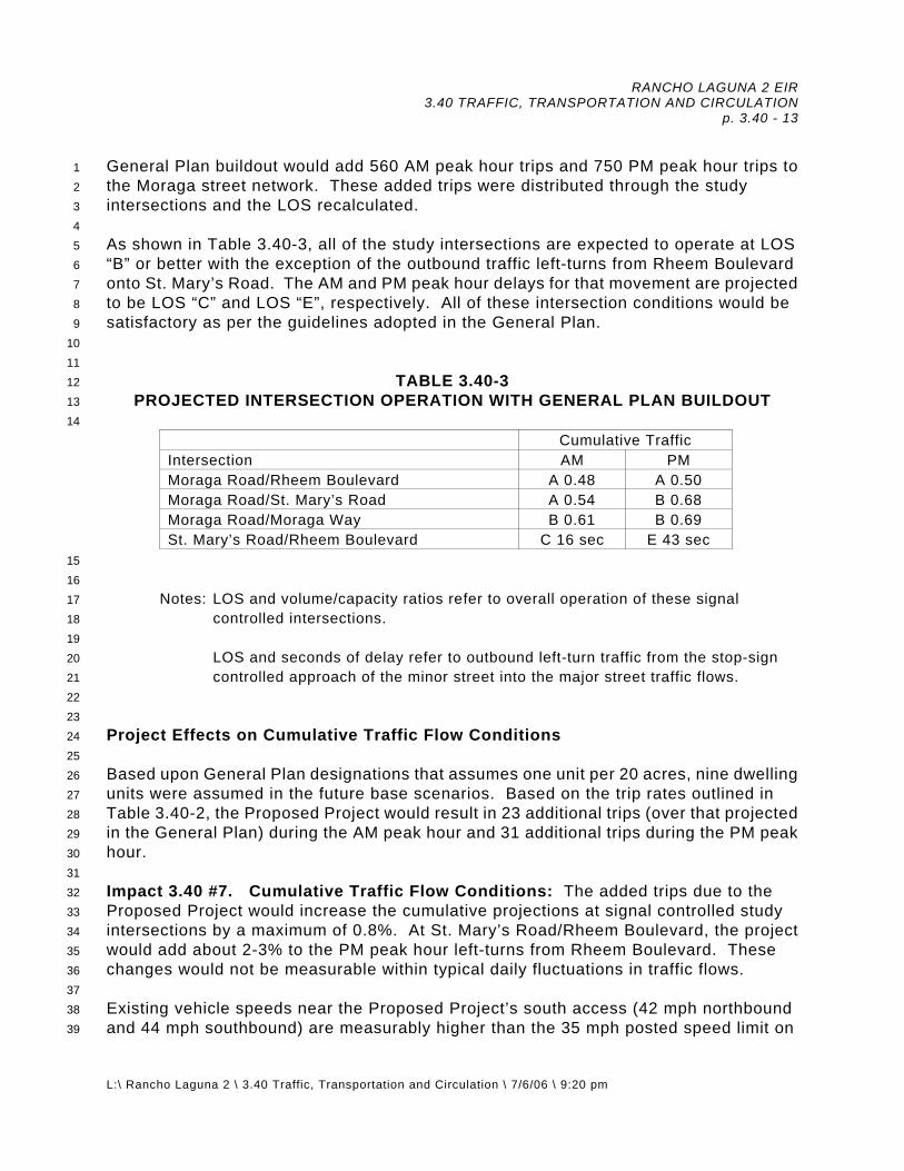
RANCHO LAGUNA 2 EIR 3.40 TRAFFIC, TRANSPORTATION AND CIRCULATION
p. 3.40 - 13
L:\ Rancho Laguna 2 \ 3.40 Traffic, Transportation and Circulation \ 7/6/06 \ 9:20 pm
1 2 3 4 5 6 7 8 9
10 11 12 13 14
General Plan buildout would add 560 AM peak hour trips and 750 PM peak hour trips to the Moraga street network. These added trips were distributed through the study intersections and the LOS recalculated. As shown in Table 3.40-3, all of the study intersections are expected to operate at LOS “B” or better with the exception of the outbound traffic left-turns from Rheem Boulevard onto St. Mary’s Road. The AM and PM peak hour delays for that movement are projected to be LOS “C” and LOS “E”, respectively. All of these intersection conditions would be satisfactory as per the guidelines adopted in the General Plan.
TABLE 3.40-3 PROJECTED INTERSECTION OPERATION WITH GENERAL PLAN BUILDOUT
Cumulative Traffic Intersection AM PM Moraga Road/Rheem Boulevard A 0.48 A 0.50 Moraga Road/St. Mary’s Road A 0.54 B 0.68 Moraga Road/Moraga Way B 0.61 B 0.69 St. Mary’s Road/Rheem Boulevard C 16 sec E 43 sec
15 16 17 18 19 20 21 22 23 24 25 26 27 28 29 30 31 32 33 34 35 36 37 38 39
Notes: LOS and volume/capacity ratios refer to overall operation of these signal
controlled intersections.
LOS and seconds of delay refer to outbound left-turn traffic from the stop-sign controlled approach of the minor street into the major street traffic flows.
Project Effects on Cumulative Traffic Flow Conditions Based upon General Plan designations that assumes one unit per 20 acres, nine dwelling units were assumed in the future base scenarios. Based on the trip rates outlined in Table 3.40-2, the Proposed Project would result in 23 additional trips (over that projected in the General Plan) during the AM peak hour and 31 additional trips during the PM peak hour. Impact 3.40 #7. Cumulative Traffic Flow Conditions: The added trips due to the Proposed Project would increase the cumulative projections at signal controlled study intersections by a maximum of 0.8%. At St. Mary’s Road/Rheem Boulevard, the project would add about 2-3% to the PM peak hour left-turns from Rheem Boulevard. These changes would not be measurable within typical daily fluctuations in traffic flows. Existing vehicle speeds near the Proposed Project’s south access (42 mph northbound and 44 mph southbound) are measurably higher than the 35 mph posted speed limit on

RANCHO LAGUNA 2 EIR 3.40 TRAFFIC, TRANSPORTATION AND CIRCULATION
p. 3.40 - 14
L:\ Rancho Laguna 2 \ 3.40 Traffic, Transportation and Circulation \ 7/6/06 \ 9:20 pm
1 2 3 4 5 6 7 8 9
10 11 12 13 14 15 16 17 18 19 20 21 22
Rheem Boulevard. The project would add vehicle trips to this section of Rheem Boulevard, increasing the potential for vehicular conflicts. The project design should incorporate a traffic calming measure to help reduce vehicle speeds on Rheem Boulevard. Although speed humps are most effective at reducing vehicle speeds, the grade of Rheem Boulevard and its function as a through route would preclude the use of these devices.
Mitigation Measure 3.40 #7: At the project’s south access, Rheem Boulevard could incorporate a “bulb out” curb. This bulb out would effectively narrow Rheem Boulevard to the width of the two travel lanes. Signs on either side of this section (“road narrows”) would alert motorists to this design. This traffic calming feature could reduce vehicle speeds by about 4%, or 2 mph, on the southerly section of Rheem Boulevard. (Institute of Transportation Engineers, Traffic Calming, State of the Practice, August 1999.)
Implementation of traffic calming measures will reduce impacts related to traffic
flow conditions along Rheem Boulevard to levels of less than significant.
Significance After Mitigation: Less Than Significant. Responsibility and Monitoring: Prior to approval of any permit, the Town of Moraga will ensure that plans reflect required re-design.

RANCHO LAGUNA 2 EIR 3.45 AIR QUALITY p. 3.45 - 1
L: \ Rancho Laguna 2 \ 3.45 Air Quality \ 7/6/06 \ 9:30 pm
1 2
3.45 AIR QUALITY 1. Environmental Setting 3
4 5 6 7 8 9
10 11 12 13 14 15 16 17 18 19 20 21 22 23 24 25 26 27 28 29 30 31 32 33 34 35 36 37 38 39 40 41 42 43 44 45 46
A. Existing Conditions Climate and Air Quality Conditions The Bay Area is characterized by its Mesothermal or Mediterranean type climate with warm dry summers and cool wet winters. Moraga’s climate is largely determined by its location in southwestern Diablo Valley. The mountains to the west partially block the flow of marine air from the west, giving the area a warmer, less cloudy climate in the summer and cooler temperatures in the winter, compared to areas to the west. As with most interior valleys, winds are generally light, with wind speeds averaging about five miles per hour annually. The area receives about 28-30 inches of rainfall per year, primary between September and April. There are two scenarios that produce elevated pollutant levels in the Moraga area: (1) during winter evenings when light winds combine with surfaced-based inversions and terrain to restrict air flow that cause pollutant levels to build up, and (2) in the summer months, ozone and ozone precursors are often transported into the area from the central Bay Area. Existing Air Quality Conditions Air quality is affected by the rate of pollutant emissions and by meteorological conditions such as wind speed, atmospheric stability, and mixing height, all of which affect the atmosphere’s ability to mix and disperse pollutants. Long-term variations in air quality typically result from changes in air pollutant emissions, while short-term variations result from changes in atmospheric conditions. Both the U.S. Environmental Protection Agency and the California Air Resources Board have established ambient air quality standards for common “criteria” pollutants. In general, the San Francisco Bay Area is considered one of the cleanest major metropolitan areas in the country, with respect to air quality. The air pollutants of greatest concern in Moraga are ground-level ozone (measured as one hour ozone) and very small particulate matter (10 microns or less in diameter), referred to as PM10 and measured over a 24 hour basis because the San Francisco Bay region as a whole does not comply with air quality standards for either pollutant. The San Francisco Bay region annually exceeds the California Ambient Air Quality Standard for 1-hour ozone and 24-hour PM10 levels. Throughout the Bay Area, the national 1-hour ozone standard was exceeded at one or more stations from 0 to eight days annually during recent years and the new 8-hour ozone

RANCHO LAGUNA 2 EIR 3.45 AIR QUALITY p. 3.45 - 2
L: \ Rancho Laguna 2 \ 3.45 Air Quality \ 7/6/06 \ 9:30 pm
1 2 3 4 5 6 7 8 9
10 11 12 13 14 15 16 17 18 19 20 21 22 23 24 25 26 27 28 29
standard was exceeded from 0 to 16 days annually. The number of days annually that the more stringent 1-hour state ozone standard was exceeded at one or more stations in the Bay Area ranged from eight to 34 days over the last five years. The National Ambient Air Quality Standards (NAAQS) for PM10 is not exceeded anywhere in the Bay Area, but the more stringent state standard is routinely exceeded in the Bay Area, as well as most other parts of the state. No other air quality standards are exceeded in the Bay Area. As a result, the San Francisco Bay region is considered nonattainment for PM10 at the state level. The San Francisco Bay region currently complies with state and federal standards for all other air pollutants (e.g., carbon monoxide, nitrogen dioxide, sulfur dioxide, and lead). The closest permanent Bay Area Air Quality Management District (BAAQMD) monitoring site is located in Concord. All federal standards except that for ozone were met at the Concord monitoring site during the 2005 reporting period. Violations of the more stringent state ozone standard were also recorded in each year, as were violations of the state standard for PM10. Sources of Air Pollution Sources of air pollution in and around Moraga are primarily vehicular traffic. The largest source of air pollution is emissions generated by traffic on Highway 24, one-half (air) miles to the east. The combustion of fuel for space and water heating is another source of air pollutant emissions. Wood burning and other outdoor burning is a major source of air pollutants (primarily particulates and carbon monoxide) during late fall and winter. There are no major industrial sources of air pollution. 2. Regulatory Environment30
31 32 33 34 35 36 37 38 39 40 41 42 43 44 45
The Federal and California Clean Air Acts have established ambient air quality standards for different pollutants. Federal Air Quality Regulations The Federal Clean Air Act governs air quality in the United States. In addition to being subject to federal requirements, air quality in California is also governed by more stringent regulations under the California Clean Air Act. At the Federal level, the United States Environmental Protection Agency (US EPA) administers the Clean Air Act (CAA). The California Clean Air Act is administered by the California Air Resources Board (CARB) at the State level and by the Air Quality Management Districts at the regional and local levels. The Bay Area Air Quality Management District (BAAQMD) regulates air quality at the regional level, which includes much of the nine-county Bay Area.

RANCHO LAGUNA 2 EIR 3.45 AIR QUALITY p. 3.45 - 3
L: \ Rancho Laguna 2 \ 3.45 Air Quality \ 7/6/06 \ 9:30 pm
1 2 3 4 5 6 7 8 9
10 11 12 13
14
15
16 17
United States Environmental Protection Agency. The USEPA is responsible for enforcing the Federal CAA. The USEPA is also responsible for establishing National Ambient Air Quality Standards (NAAQS). The NAAQS are required under the 1977 CAA and subsequent amendments. The USEPA regulates emission sources that are under the exclusive authority of the federal government, such as aircraft, ships, and certain types of locomotives. The agency has jurisdiction over emission sources outside state waters (e.g., beyond the outer continental shelf) and establishes various emission standards, including those for vehicles sold in states other than California. Automobiles sold in California must meet the stricter emission standards established by the CARB. National ambient air quality standards (NAAQS) were established by the federal Clean Air Act of 1970 (amended in 1977 and 1990) for six “criteria” pollutants. These criteria pollutants include carbon monoxide (CO), ozone (O3), nitrogen dioxide (NO2), particulate matter with a diameter less than 10 microns (PM10), sulfur dioxide (SO2), and lead (Pb). Recently, fine particulate matter or PM2.5 was added as a criteria pollutant. Air quality studies generally focus on five pollutants that are most commonly measured and regulated: CO, O3, NO2, SO2, and suspended particulate matter, i.e., PM10 and PM2.5.

RANCHO LAGUNA 2 EIR 3.45 AIR QUALITY p. 3.45 - 4
L: \ Rancho Laguna 2 \ 3.45 Air Quality \ 7/6/06 \ 9:30 pm
1 2 3
TABLE 3.45-1 MAJOR CRITERIA POLLUTANTS
Pollutants Characteristics
Health Effects
Major Sources
Ozone (O3)
A highly reactive photo-chemical pollutant created by the action of sunshine on ozone precursors (primarily reactive hydrocarbons and oxides of nitrogen). Often called photochemical smog.
Eye Irrigation Respiratory function impairment
The major sources of ozone precursors are combustion sources such as factories and automobiles, and evaporation of solvents and fuels.
Carbon Monoxide (CO)
Carbon monoxide is an odorless, colorless gas that is highly toxic. It is formed by the incomplete combustion of fuels.
Impairment of oxygen transport in the bloodstream. Aggravation of cardiovascular disease. Fatigue, headache, confusion, dizziness. Can be fatal in the case of high concentrations.
Automobile exhaust, combustion of fuels, combustion of wood in the woodstoves and fireplaces.
Nitrogen Dioxide (NO2)
Reddish-brown gas that discolors the air, formed during combustion.
Increased risk of acute and chronic respiratory disease.
Automobile and diesel truck exhaust, industrial processes, fossil-fueled power plants
Sulfur Dioxide (SO2)
Sulfur dioxide is a colorless gas with a pungent, irritating odor.
Increased risk of acute and chronic respiratory disease.
Diesel vehicle exhaust, oil-powered power plants, industrial processes.
Particulate Matter (PM10) (PM2.5)
Solid and liquid particles of dust, soot, aerosols and other matter which are small enough to remain suspended in the air for a long period of time.
Aggravation of chronic disease and heart/lung disease symptoms.
Combustion, automobiles, field burning, factories and unpaved roads. Also a result of photochemical process.
4 5 6 7 8 9
10 11 12 13 14 15
Source: Moraga 2000 General Plan Update EIR The six criteria pollutants are:
● Ozone: Ground-level ozone is the principal component of smog. It is not directly emitted into the atmosphere, but is formed by the photochemical reaction of reactive organic gases and nitrogen oxides (known as ozone precursors) in the presence of sunlight. Ozone levels are highest during late spring through early summer when precursor emissions are high and meteorological conditions are favorable for the complex photochemical

RANCHO LAGUNA 2 EIR 3.45 AIR QUALITY p. 3.45 - 5
L: \ Rancho Laguna 2 \ 3.45 Air Quality \ 7/6/06 \ 9:30 pm
1 2 3 4 5 6 7 8 9
10 11 12 13 14 15 16 17 18 19 20 21 22 23 24 25 26 27 28 29 30 31 32 33 34 35 36 37 38 39 40 41 42 43 44 45 46
reactions to occur. Approximately half of the reactive organic gas and nitrogen oxide emissions in the Bay Area are from motor vehicles. Adverse health effects of ground-level ozone include respiratory impairment and eye irritation. High ozone concentrations are also a potential problem to sensitive crops such as wine grapes.
● Carbon Monoxide: Carbon monoxide is a non-reactive pollutant that is
highly toxic, invisible, and odorless. It is formed by the incomplete combustion of fuels. The largest source of carbon monoxide emissions is motor vehicles. Wood stoves and fireplaces also contribute to high levels of carbon monoxide. Unlike ozone, carbon monoxide is directly emitted to the atmosphere. The highest carbon monoxide concentrations occur during the nighttime and early mornings in late fall and winter. Carbon monoxide levels are strongly influenced by meteorological factors such as wind speed and atmospheric stability. Adverse health effects of carbon monoxide include the impairment of oxygen transport in the bloodstream, increase of carboxyhemoglobin, aggravation of cardiovascular disease, impairment of central nervous system function, and fatigue, headache, confusion, and dizziness. Exposure to carbon monoxide can be fatal in the case of very high concentrations in enclosed places.
● Nitrogen Dioxide: Nitrogen dioxide is a reddish-brown gas that is a
by-product of combustion processes. Automobiles and industrial operations are the primary sources of nitrogen dioxides. Nitrogen dioxide contributes to ozone formation. Adverse health effects associated with exposure to high levels of nitrogen dioxide include the risk of acute and chronic respiratory illness.
● Sulfur Dioxide: Sulfur dioxide is a colorless gas with a strong odor and
potential to damage materials. It is produced by the combustion of sulfur containing fuels such as oil and coal. Refineries and chemical plants are the primary sources of sulfur dioxide emissions in the Bay Area. Sulfur dioxide concentrations in the North Bay Area are well below the ambient standards. Adverse health effects associated with exposure to high levels of sulfur dioxide include aggravation of chronic obstructive lung disease and increased risk of acute and chronic respiratory illness.
● Inhalable Particulates: Inhalable particulate or PM10 and PM2.5
(particulate matter 2.5 microns or less in diameter) refers to a wide variety of solid or liquid particles in the atmosphere. These include smoke, dust, aerosols, and metallic oxides. Some of these particulates are considered toxic. Although particulates are found naturally in the air, most particulate matter found in the Bay Area are emitted either directly or indirectly by motor vehicles, industry, construction, agricultural activities, and wind erosion of disturbed areas. Most PM2.5 is comprised of combustion products (e.g., soot). Small particulate matter may be inhaled, and possibly

RANCHO LAGUNA 2 EIR 3.45 AIR QUALITY p. 3.45 - 6
L: \ Rancho Laguna 2 \ 3.45 Air Quality \ 7/6/06 \ 9:30 pm
1 2 3 4 5 6 7 8 9
10 11 12 13 14 15 16 17 18 19 20 21 22 23 24 25 26 27 28 29 30 31 32 33 34 35 36
37 38 39 40 41 42 43 44 45 46 47
lodge in and/or irritate the lungs. Exposure to small particulate matter can also increase the risk of chronic respiratory illness with long-term exposure and altered lung function in children.
● Lead: Lead occurs in the atmosphere as particulate matter. It is primarily
emitted by gasoline-powered motor vehicles, although the use of lead in fuel has been virtually eliminated. As a result of lead being eliminated from fuels, levels in the Bay Area have dropped dramatically. Lead concentrations in the Bay Area are well below the ambient standards.
Toxic Air Contaminants (TAC) TACs are a broad class of compounds known to cause morbidity or mortality (usually because they cause cancer) and include, but are not limited to, the criteria air pollutants listed above. TACs are found in ambient air, especially in urban areas, and are caused by industry, agriculture, fuel combustion, and commercial operations (e.g., dry cleaners). TACs are typically found in low concentrations, even near their source (e.g., diesel particulate matter and benzene near a freeway). Because chronic exposure can result in adverse health effects, TACs are regulated at the regional, state, and federal level. Diesel exhaust is the predominant TAC in urban air and is estimated to represent about two-thirds of the cancer risk from TACs (based on the statewide average). Diesel exhaust is a complex mixture of gases, vapors and fine particles. This complexity makes the evaluation of health effects of diesel exhaust a complex scientific issue. Some of the chemicals in diesel exhaust, such as benzene and formaldehyde, have been previously identified as TACs by the ARB, and are listed as carcinogens either under the state's Proposition 65 or under the federal Hazardous Air Pollutants program. California has adopted a comprehensive diesel risk reduction program. The U.S. EPA has adopted low sulfur diesel fuel standards that will reduce diesel particulate matter substantially. These go into effect in June 2006. In cooler weather, smoke from residential wood combustion can be a source of TACs. Localized high TAC concentrations can result when cold stagnant air traps smoke near the ground and, with no wind, the pollution can persist for many hours. This occurs in sheltered valleys during the winter. Wood smoke also contains a significant amount of PM10 and PM2.5 . Wood smoke is an irritant and is implicated in worsening asthma and other chronic lung problems. Sensitive Receptors Sensitive receptors are people who are particularly susceptible to the adverse effects of air pollution. CARB has identified the following people who are most likely to be affected by air pollution: children under 14, the elderly over 65, athletes, and people with cardiovascular and chronic respiratory diseases. Locations that may contain a high concentration of these sensitive population groups include residential areas, hospitals, daycare facilities, elder care facilities, elementary schools, and parks. Both State and

RANCHO LAGUNA 2 EIR 3.45 AIR QUALITY p. 3.45 - 7
L: \ Rancho Laguna 2 \ 3.45 Air Quality \ 7/6/06 \ 9:30 pm
1 2 3 4 5 6 7 8 9
10 11 12 13 14 15 16 17 18 19 20 21 22 23 24 25 26 27 28 29 30 31 32 33 34 35
National ambient air quality standards were developed with the intent to protect sensitive receptors from the adverse impacts of air pollution. The San Francisco Bay Area Air Basin is a Federal non-attainment area for ozone. California Air Quality Regulations California established ambient air quality standards as early as 1969 through the Mulford-Carrol Act. Pollutants regulated under the California Clean Air Act are similar to those regulated under the Federal Clean Air Act. In many cases, California standards are more stringent than the national ambient air quality standards. California Air Resources Board. The CARB, part of the California Environmental Protection Agency, is responsible for meeting the state requirements of the Federal CAA, administering the California CAA, and establishing the California Ambient Air Quality Standards (CAAQS). The California CAA, as amended in 1992, requires all air districts in the State to endeavor to achieve and maintain the CAAQS. The CAAQS are more stringent than the corresponding federal standards and incorporate additional standards for sulfates, hydrogen sulfide, vinyl chloride and visibility reducing particles. The CARB regulates mobile air pollution sources, such as motor vehicles. The agency is responsible for setting emission standards for vehicles sold in California and for other emission sources, such as consumer products and certain off-road equipment. The CARB established passenger vehicle fuel specifications, which became effective on March 1996. The CARB oversees the functions of local air pollution control districts and air quality management districts, which in turn administer air quality activities at the regional and county level. The CARB also monitors ambient air quality throughout the State. California established ambient air quality standards as early as 1969 through the Mulford-Carrol Act. Pollutants regulated under the California Clean Air Act are similar to those regulated under the Federal Clean Air Act. In many cases, California standards are more stringent than the national ambient air quality standards. Federal and State air quality standards are shown in Table 3.45-1. Both the national and California ambient air quality standards have been adopted by the Bay Area Air Quality Management District (BAAQMD).

RANCHO LAGUNA 2 EIR 3.45 AIR QUALITY p. 3.45 - 8
L: \ Rancho Laguna 2 \ 3.45 Air Quality \ 7/6/06 \ 9:30 pm
1 2
3
4
TABLE 3.45-2 CALIFORNIA AND NATIONAL AMBIENT AIR QUALITY STANDARDS
National Standards (a)
Pollutant
Averaging Time
California Standards
Primary (b,c)
Secondary (b,d)
8-hour 0.07 ppm (154 µg/m3)
0.08 ppm (176µg/m3) —
Ozone 1-hour 0.09 ppm
(180 µg/m3) --(e) Same as primary
8-hour 9 ppm (10 mg/m3)
9 ppm (10 mg/m3) — Carbon
monoxide 1-hour 20 ppm (23 mg/m3)
35 ppm (40 mg/m3) —
Annual — 0.053 ppm (100 µg/m3) Same as primary
Nitrogen dioxide 1-hour 0.25 ppm
(470 µg/m3) — —
Annual — 0.03 ppm (80 µg/m3) —
24-hour 0.04 ppm (105 µg/m3)
0.14 ppm (365 µg/m3) —
3-hour — — 0.5 ppm (1,300 µg/m3)
Sulfur dioxide
1-hour 0.25 ppm (655 µg/m3) — —
Annual 20 µg/m3 50 µg/m3 Same as primary PM1024-hour 50 µg/m3 150 µg/m3 Same as primary Annual 12 µg/m3 15 µg/m3 PM2.5 24-hour — 65 µg/m3 Calendar quarter — 1.5 µg/m3 Same as primary
Lead 30-day average 1.5 µg/m3 — —
Notes: (a) Standards, other than for ozone and those based on annual averages, are not to be exceeded more than once a year. The ozone standard is attained when the expected number of days per calendar year with maximum hourly average concentrations above the standard is equal to or less than one. Concentrations are expressed first in units in which they were promulgated. Equivalent units given in parenthesis. Primary Standards: The levels of air quality necessary, with an adequate margin of safety to protect the public health. Each state must attain the primary standards no later than 3 years after that state’s implementation plan is approved by the EPA. Secondary Standards: The levels of air quality necessary to protect the public welfare from any known or anticipated adverse effects of a pollutant. The national 1-hour ozone standard was revoked by U.S. EPA on June 15, 2005. 5

RANCHO LAGUNA 2 EIR 3.45 AIR QUALITY p. 3.45 - 9
L: \ Rancho Laguna 2 \ 3.45 Air Quality \ 7/6/06 \ 9:30 pm
1 2 3 4 5 6 7 8 9
10 11 12 13 14 15 16 17 18 19 20 21 22 23 24 25 26 27 28 29 30 31 32 33 34 35 36 37 38 39 40 41 42 43 44 45
Regional Air Quality Regulations and Planning In 1955, the California Legislature created the Bay Area Air Quality Management District (BAAQMD). The agency is primarily responsible for assuring that the National and State ambient air quality standards are attained and maintained in the Bay Area. The BAAQMD is also responsible for adopting and enforcing rules and regulations concerning air pollutant sources, issuing permits for stationary sources of air pollutants, inspecting stationary sources of air pollutants, responding to citizen complaints, monitoring ambient air quality and meteorological conditions, awarding grants to reduce motor vehicle emissions, conducting public education campaigns, as well as many other activities. The BAAQMD does not have authority to regulate emissions from motor vehicles. The BAAQMD along with the other regional agencies (i.e., Association of Bay Area Governments and the Metropolitan Transportation Commission) has prepared an Ozone Attainment Plan to address the NAAQS for ozone. The 2001 Ozone Plan includes a strategy to attain the national ambient air quality standard for ozone. In 2004, U.S. EPA made a finding that the Bay Area has attained the national 1-hour ozone standard. However, in 2005, EPA revoked the 1-hour ozone standard, leaving the 8-hour standard as the prevailing national ozone standard. The region is presently considered non-attainment for this standard. In early 2006, the BAAQMD adopted the Bay Area 2005 Ozone Strategy. This plan replaces the 2000 Clean Air Plan. The plan was prepared to address the more stringent requirements of the California Clean Air Act with respect to ozone. This plan includes a comprehensive strategy to reduce emissions from stationary, area, and mobile sources. The plan objective is to indicate how the region would make progress toward attaining the stricter state air quality standards, as mandated by the California Clean Air Act. The plan is designed to achieve a region-wide reduction of ozone precursor pollutants through the expeditious implementation of all feasible measures. Air quality plans addressing the California Clean Air Act are developed about every three years. The plan proposes implementation of transportation control measures (TCMs) and programs such as Spare the Air. Spare the Air is a public outreach program designed to educate the public about air pollution in the Bay Area and promote individual behavior changes that improve air quality. Some of these measures or programs rely on local governments for implementation. The State CEQA Guidelines state that an EIR shall discuss “any inconsistencies between a proposed project and applicable general plans and regional plans. Such regional plans include, but are not limited to, the applicable Air Quality Management Plan (or State Implementation Plan) . . .” Town of Moraga General Plan Goals and Policies: Goal OS4: Preservation and maintenance of air quality.
RANCHO LAGUNA 2 EIR 3.45 AIR QUALITY p. 3.45 - 10
L: \ Rancho Laguna 2 \ 3.45 Air Quality \ 7/6/06 \ 9:30 pm
1 2 3 4 5 6 7 8 9
10 11 12 13 14 15 16 17 18 19 20 21 22 23 24 25 26 27 28 29 30 31
Policy OS4.1: Development Design. Conserve air quality and minimize direct and indirect emissions of air contaminants through the design and construction of new development. For example, direct emissions may be reduced through energy conserving construction that minimizes space heating, while indirect emissions may be reduced through uses and development patterns that reduce motor vehicle trips generated by the project.
Policy OS4.2: Development Approval and Mitigation. Prohibit development projects
which, separately or cumulatively with other projects, would cause air quality standards to be exceeded or would have significant adverse air quality effects through direct and/or indirect emissions. Such projects may only be approved if, after consulting with the Bay Area Air Quality Management District (BAAQMD), the Town Council explicitly finds that the project incorporates feasible mitigation measures or that there are overriding reasons for approving the project.
Policy OS4.3: Development Setbacks. Provide setbacks along high intensity use
roadways to reduce resident exposure to air pollutants. Policy OS4.4: Landscaping to Reduce Air Quality Impacts. Encourage the use of
vegetative buffers along roads to assist in pollutant dispersion. Policy OS4.5: Alternate Transportation Modes. Encourage transportation modes
that minimize motor vehicle use and the resulting contaminant emissions. Alternate modes to be encouraged include public transit, ride-sharing, combined motor vehicle trips to work and the use of bicycles and walking.
3. Thresholds of Significance32
33 34 35 36 37 38 39 40 41 42
According to Environmental Checklist Form contained in Appendix G of the CEQA Guidelines, a project would be considered to have a significant adverse air quality impact to the environment if the project would:
a. Conflict with or obstruct implementation of the applicable air quality plan. Conformity of the project to the current Bay Area Air Quality Plan and Town Policies are evaluated in this EIR.
b. Violate any air quality standard or contribute substantially to an existing or
projected air quality violation. A significant impact to local air quality is defined in this EIR as increased carbon monoxide concentrations at the closest sensitive receptors that cause a violation of the most stringent
43 44 45

RANCHO LAGUNA 2 EIR 3.45 AIR QUALITY p. 3.45 - 11
L: \ Rancho Laguna 2 \ 3.45 Air Quality \ 7/6/06 \ 9:30 pm
1 2 3 4 5 6 7
ambient standard for carbon monoxide (20 ppm for the one-hour averaging period, 9.0 ppm for the eight-hour averaging period).
c. Result in a cumulatively considerable net increase of any criteria pollutant
for which the project region is non-attainment under an applicable federal or state ambient air quality standard (including releasing emissions which exceed quantitative thresholds for ozone precursors). A significant impact on regional air quality is defined in this analysis as an increase in emissions of an ozone precursor or PM10 exceeding the BAAQMD recommended thresholds of significance. The latest guidelines issued by the BAAQMD for the evaluation of project air quality impacts consider emission increases to be significant if they exceed 80 pounds per day (or 15 tons/year) for ozone precursors or PM10. Any proposed project that would individually have a significant air quality impact would also be considered to have a significant cumulative air quality impact.
8 9
10 11 12 13 14 15 16 17 18 19 20 21 22 23
d. Expose sensitive receptors to substantial pollutant concentrations. e. Create objectionable odors affecting a substantial number of people.
B. IMPACTS AND MITIGATION MEASURES 1. Basis for Impacts 24
25 26 27 28 29 30 31 32 33 34 35 36 37 38 39 40
This EIR section briefly describes local and regional air quality impacts associated with the Rancho Laguna 2 project. The following measures are included in the design of the Proposed Project to reduce significant air pollutant emissions:
a. Convenient pedestrian pathways and connections (throughout the site); b. Convenient bicycle access and bicycle storage areas; c. Outdoor and recreation uses areas; d. Traffic calming at roadway crossings; and, e. Shade trees and landscaped areas.
2. Analysis of Project Impacts41
42 43 44 45 46
Impact 3.45 #1. Consistency with Clean Air Plan: A key element in air quality planning is to make reasonably accurate projections of future human activities that are related to air pollutant emissions. When the 2005 Ozone Strategy was developed for the Bay Area it utilized the most recent projections developed by the Association of Bay Area

RANCHO LAGUNA 2 EIR 3.45 AIR QUALITY p. 3.45 - 12
L: \ Rancho Laguna 2 \ 3.45 Air Quality \ 7/6/06 \ 9:30 pm
1 2 3 4 5 6 7 8 9
10 11 12 13 14 15 16 17 18 19 20 21 22 23 24 25 26 27 28 29 30 31 32 33 34 35 36 37 38 39 40 41 42 43 44 45
Governments (ABAG). These projections are based on the most recent projections using land use designators developed by Cities and Counties through the General Plan process. The Bay Area Clean Air Plan utilized ABAG’s household and employment projections from the Town’s General Plan designations (nine housing units). The difference between the 35 units (proposed) and the nine units assumed in the Clean Air Plan is considered well below the thresholds of significance by the BAAQMD (as the difference of 26 units would not be measurable). Additionally, since adoption of the General Plan, several projects have been developed at densities less than what is allowable under the General Plan projections. The project is, therefore, considered consistent with the BAAQMD plans as the resulting growth would be considered consistent with projections used to develop the most recent Clean Air Plan. That is, development of Rancho Laguna 2 project would not interfere with population projections used to develop the latest regional clean air planning projections. This would be a less than significant impact.
Mitigation Measure 3.45 #1: None Required. Impact 3.45 #2. Construction Activities: Dust generation from short-term construction activities associated with development of the project site would cause potential health and nuisance air quality impacts to adjacent land uses. Although temporary, this would be a potentially significant impact.
Mitigation Measure 3.45 #2: Incorporate measures to reduce dust and equipment exhaust emissions into construction plans.
a. Water all active construction areas at least twice daily and more often
during windy periods. Active areas adjacent to residences shall be kept damp at all times.
b. Cover all hauling trucks or maintain at least two feet of freeboard.
Dust-proof chutes shall be used, if appropriate, to load debris onto trucks during demolition.
c. To prevent blowing dust, pave, or apply water three times daily or as
necessary depending upon wind and temperature, or apply (non-toxic) soil stabilizers on all unpaved access roads, parking areas, and staging areas at construction sites. To ensure that these emissions are less-than-significant, visible dust clouds should be prevented from extending beyond construction sites.
d. Sweep daily (with vacuum sweepers) all paved access roads, parking
areas, and staging areas and sweep streets daily (with vacuum sweepers) if visible soil material is deposited onto the adjacent roads. If water sweepers are utilized, they shall meet the requirements of the SWPPP

RANCHO LAGUNA 2 EIR 3.45 AIR QUALITY p. 3.45 - 13
L: \ Rancho Laguna 2 \ 3.45 Air Quality \ 7/6/06 \ 9:30 pm
1 2
(such as filtering of runoff to prevent residual materials from entering the drainage system).

RANCHO LAGUNA 2 EIR 3.45 AIR QUALITY p. 3.45 - 14
L: \ Rancho Laguna 2 \ 3.45 Air Quality \ 7/6/06 \ 9:30 pm
1 2 3 4 5 6 7 8 9
10 11 12 13 14 15 16 17 18 19 20 21 22 23 24 25 26 27 28 29 30 31 32 33 34 35 36 37 38 39 40 41 42 43 44 45 46
e. Hydroseed or apply (non-toxic) soil stabilizers to inactive construction areas (previously graded areas that are inactive for 10 days or more).
f. Enclose, cover, water twice daily, or apply (non-toxic) soil binders to
exposed stockpiles. g. Provide signage to limit traffic speeds on any unpaved roads to 10 mph. h. Install sandbags or other erosion control measures to prevent silt runoff to
public roadways. i. Replant vegetation in disturbed areas as quickly as possible. j. Install wheel washers for all exiting trucks, or wash off the tires or tracks of
all trucks and equipment leaving the site. k. Install wind breaks at the westerly or windward side(s) of construction
areas. l. Suspend excavation and grading activity when winds exceed 25 mph and
cause visible dust clouds that extend beyond construction boundaries. An on-site wind gauge shall be installed that can be monitored by inspection personnel.
m. Properly maintain construction equipment and avoid unnecessary idling
near residences. n. Designate a disturbance coordinator that would respond to complaints
regarding construction-related air quality issues. The phone number for this disturbance coordinator shall be clearly posted at the construction sites.
Implementation of the above measures will reduce construction-related air quality
impacts to levels of less than significant.
Significance After Mitigation: Less Than Significant. Responsibility and Monitoring: During the grading and construction, the Project Sponsors’ Construction Manager, in consultation with the Town of Moraga, shall be responsible for construction related air quality mitigation monitoring and implementation. The construction manager shall be responsible for compliance with the SWPPP (see Mitigation Measure 3.30 #3) and provide a monthly compliance report.
Impact 3.45 #3: Consistency with Transportation Control Measures. The 2005 Ozone Strategy (i.e., BAAQMD’s most recent Clean Air Plan) includes 20 transportation

RANCHO LAGUNA 2 EIR 3.45 AIR QUALITY p. 3.45 - 15
L: \ Rancho Laguna 2 \ 3.45 Air Quality \ 7/6/06 \ 9:30 pm
1 2 3 4 5 6 7 8 9
10 11 12 13 14 15 16 17 18 19 20 21 22 23 24 25 26 27 28 29 30 31 32 33 34 35 36 37 38 39 40 41 42 43 44 45 46 47 48
control measures, which require participation at the local level and/or apply to residential projects. The latest set of adopted TCMs, where local governments are considered as implementing agencies, are listed by the BAAQMD in their CEQA Guidelines. Future development at the Rancho Laguna 2 site cannot individually implement the listed measures for each project; however, the Town’s General Plan policies should include all those measures that are consistent with the Town’s responsibility. The measures that require action by the Town (and future development projects to implement) are described below. ● TCM# 9. Improve Bicycle Access and Facilities The Town’s General Plan includes policies and implementation plans that
reasonably implement this TCM. The Rancho Laguna 2 project proposes opportunities for bicycle and pedestrian trips to replace trips normally made using motor vehicles. Goal C4 and Policy C4-1 of the General Plan sets forth the Town’s objective to facilitate bicycle and pedestrian use.
● TCM #12. Improve Arterial Traffic Management The Town’s General Plan includes policies and implementation plans that
reasonably implement this TCM. Policy CI.I and OS4.3 of the General Plan is aimed at improving traffic flow along arterials by limiting driveway access and providing appropriate acceleration/deceleration lanes at major drive entries and provision of reciprocal access between non-residential uses.
● TCM# 15. Local Clean Air Plans, Policies and Programs The Town’s General Plan does include policies that specifically focus on
subdivision, zoning and site design measures to reduce automobile trips. TCM #15 is implemented through the development of city-wide air quality programs and policies specifically oriented to reduce air quality emissions. General Plan Policy OS4.1 and Program IP-E-2, IP-K2 describes, in a broad sense, the policies that the Town would apply to developments. The BAAQMD encourages Cities and Counties to develop air quality elements of their General Plans to be consistent with this TCM. In general, this TCM would not be directly applicable to development at Rancho Laguna 2 as they are more effective for larger projects, mixed use or commercial projects.
● TCM# 17. Conduct Demonstration Projects This TCM is designed to improve air quality by conducting demonstration
projects to develop and/or encourage new strategies to reduce motor vehicle emissions such as public or private fleets of low-emission or zero emission vehicles. The Town’s General Plan includes policies and implementation plans that reasonably implement this TCM. Policy OS4.5 calls for minimization of motor vehicle use and encouragement of the use of alternative modes of transportation. The Town could apply public outreach projects to development of planning areas, such as Rancho Laguna 2. These could include recognition and promotion of the Spare the Air Days program operated by the BAAQMD. In general, this TCM would not be directly applicable to development at Rancho Laguna 2 as they are more effective for larger projects, mixed use or commercial projects.
RANCHO LAGUNA 2 EIR 3.45 AIR QUALITY p. 3.45 - 16
L: \ Rancho Laguna 2 \ 3.45 Air Quality \ 7/6/06 \ 9:30 pm
1 2 3 4 5 6 7 8 9
10 11 12 13 14 15 16 17 18 19 20 21 22 23 24 25 26 27 28 29 30 31 32 33 34 35 36 37 38 39 40 41 42 43 44 45 46 47
● TCM# 19. Pedestrian Travel The City’s General Plan includes policies and implementation plans that
reasonably implement this TCM. Policies supporting efforts to improve and encourage pedestrian use are similar to those described for TCM #9 (above). Additional implementation measures include the following General Plan action items:
P.E2: Pedestrian Environment to create interconnected sidewalk/pathway
linkages to adjacent neighborhoods, commercial centers and community facilities such as parks and schools; provide for pedestrian-oriented lighting; and, where feasible, encouraging landscape strips between the sidewalk and curb to buffer pedestrians from automobiles.
● CM# 20. Promote Traffic Calming Measures The General Plan includes specific traffic calming strategies or measures to
reduce the number and speed of motor vehicles and increase the attractiveness of transit bicycling and walking. Additionally, these measures are detailed in IP-G5, IP-G6 and IP-67.
IP-G5 Town Beautification Program Develop and implement a beautification program to enhance the
natural beauty and aesthetic qualities of the Town’s scenic corridors, commercial centers, community facilities, and residential neighborhoods.
IP-G6 Tree Planting Program Develop and implement a comprehensive tree-planting program. IP-G7 Air Quality Management Program Refer significant development proposals to the Bay Area Air Quality
Management District for review, and maintain consistency with the Bay Area Regional Air Quality Management Plan, as updated from time to time.
The Beautification Program is developing standards for trails, traffic safety
and air quality mitigation (in the form of additional tree plantings). Mitigation Measure 3.40#7 calls for traffic calming as part of the project
design. The Town has General Plan Policies that reasonably implement TCMs 9, 12, 15, 17, 19 and 20. Because the Town has policies and implementing measures that are reasonably consistent with the TCMs, the plan for Rancho Laguna 2 is consistent with the Bay Area Clean Air Plan. This is not a significant impact.
Mitigation Measure 3.45 #3a: None Required.

RANCHO LAGUNA 2 EIR 3.45 AIR QUALITY p. 3.45 - 17
L: \ Rancho Laguna 2 \ 3.45 Air Quality \ 7/6/06 \ 9:30 pm
1 2 3 4 5 6 7 8 9
10 11 12 13 14 15 16 17 18 19 20 21 22 23 24 25 26 27
Impact 3.45 #4: Buffers for Sources of Air Toxic Contaminants and Odors. Buffer zones to avoid odors and toxics impacts should be reflected in local plan policies, land use maps, and implementing ordinances. In April 2005, CARB released the final version of the Air Quality and Land Use Handbook, which is intended to encourage local land use agencies to consider the risks from air pollution prior to making decisions that approve the siting of new sensitive receptors near sources of air pollution. Unlike industrial or stationary sources of air pollution, siting of new sensitive receptors does not require air quality permits, but could create air quality problems. The primary purpose of the CARB document is to highlight the potential health impacts associated with proximity to common air pollution sources, so that those issues are considered in the planning process. CARB makes recommendations regarding the siting of new sensitive land uses near freeways, truck distribution centers, dry cleaners, gasoline dispensing stations, and other air pollution sources. CARB acknowledges that land use agencies have to balance other siting considerations such as housing and transportation needs, economic development priorities and other quality of life issues. The Town’s General Plan includes policies (OS4.3) to require that projects provide physical separations between sources emitting toxic air contaminants and sensitive receptors. There are no identified major sources of air toxic contaminants and odor emissions that affect the Rancho Laguna 2 project. Development of the Rancho Laguna 2 project is not expected to expose future sensitive receptors to existing sources of odors or air toxic contaminant emissions. Development does not appear to include substantial sources of air toxic contaminant emissions that could affect existing or future sensitive receptors. This would be a less than significant impact.
Mitigation Measure 3.45 #4: None Required. 3. Cumulative Impacts 28
29 30 31 32 33 34 35 36 37
Cumulative air quality impacts are evaluated based on (1) a quantification of the project-related air quality impacts and (2) the consistency of the project with local and regional air quality plans (e.g., the General Plan and the Bay Area Clean Air Plan). As this project would not reach a level of threshold for individual project impacts, is consistent with the Clean Air Plan, and as mitigations are available to reduce construction impacts (associated with air quality) and TCM’s are available to mitigate for ozone, the cumulative impacts of the project are determined not to have a cumulatively considerable impact to the environment.
RANCHO LAGUNA 2 EIR 3.50 NOISE
p. 3.50 - 1
L: \Rancho Laguna 2 \ 3.50 Noise \ 7/4/06 \ 11:30 am
1 2 3 4
3.50 NOISE A. ENVIRONMENTAL SETTING 1. Existing Conditions 5
6 7 8 9
10 11 12 13 14 15 16 17 18 19 20 21 22 23 24 25 26 27 28 29 30 31 32 33 34 35
The environmental noise analysis prepared for the subject project primarily assesses the effects of vehicular traffic noise from Rheem Boulevard adjacent to the proposed residential development. The project site is located on the east side of Rheem Boulevard and southwest side of St. Mary’s Road (Figure 2.00-2). Moraga is primarily a residential community with no industries or other stationary sources of noise. The primary commercial areas within the Town are clustered around the intersections of Rheem Boulevard/Moraga Road and Moraga Road/Moraga Way. Noise Measurement Units The decibel (dB) is the unit of measurement which indicates the relative amplitude of a sound. Zero decibels corresponds roughly to the threshold of hearing. Each 10 decibel increase corresponds approximately to doubling the perceived loudness of the sound. Technical terms are defined in Table 3.50-1. In this report all sound levels are measured using the A-weighting filter network and are reported as dBA. Representative outdoor and indoor noise levels in units of dBA are shown in Table 3.50-2. Since the sensitivity to noise increases during the evening and at night (because excessive noise interferes with the ability to sleep) 24-hour average noise level descriptors have been developed that incorporate noise penalties added to nighttime noise levels. The day/night average sound level, Ldn is a measure of the cumulative noise exposure with a 10 dB addition to noise levels at night (10:00 pm to 7:00 am). TABLE 3.50-1 DEFINITIONS OF ACOUSTICAL TERMS
TERM DEFINITIONS Decibel, dB
A unit describing the amplitude of sound, equal to 20 times the logarithm to the base 10 of the ratio of the pressure of the sound measured to the reference pressure, which is 20 micropascals (20 micronewtons per square meter).
Frequency, HZ
The number of complete pressure fluctuations per second above and below atmospheric pressure.
A-Weighted Sound Level, dB
The sound pressure level in decibels as

RANCHO LAGUNA 2 EIR 3.50 NOISE
p. 3.50 - 2
L: \Rancho Laguna 2 \ 3.50 Noise \ 7/4/06 \ 11:30 am
TERM DEFINITIONS
measured on a sound level meter using the A-weighting filter network. The A-weighting filter de-emphasizes the very low and very high frequency components of the sound in a manner similar to the frequency response of the human ear and correlates well with subjective reactions to noise. All sound levels in this report are A-weighted, unless reported otherwise.
L01, L10, L50, L90
The A-weighted noise levels that are exceeded 1%, 10%, 50%, and 90% of the time during the measurement period.
Equivalent Noise Level, Leq
The average A-weighted noise level during the measurement period.
Community Noise Equivalent Level, CNEL
The average A-weighted noise level during a 24-hour day, obtained after addition of 5 decibels in the evening from 7:00 pm to 10:00 pm and after addition of 10 decibels to sound levels measured in the night between 10:00 pm and 7:00 am.
Day/Night Noise Level, Ldn
The average A-weighted noise level during a 24-hour day, obtained after addition of 10 decibels to levels measured in the night between 10:00 pm and 7:00 am.
Lmax, Lmin
The maximum and minimum A-weighted noise level during the measurement period.
Ambient Noise Level
The composite of noise from all sources near and far. The normal or existing level of environmental noise at a given location.
Intrusive
That noise which intrudes over and above the existing ambient noise at a given location. The relative intrusiveness of a sound depends upon its amplitude, duration, frequency, and time of occurrence and tonal or informational content as well as the prevailing ambient noise level.
1 2 Source: Illingworth & Rodkin, Inc./Acoustical Engineers

RANCHO LAGUNA 2 EIR 3.50 NOISE
p. 3.50 - 3
L: \Rancho Laguna 2 \ 3.50 Noise \ 7/4/06 \ 11:30 am
1 2 3 4
TABLE 3.50-2 TYPICAL SOUND LEVELS MEASURED IN THE ENVIRONMENT AND INDUSTRY
At a Given Distance From Noise Source
A-Weighted
Sound Level in Decibels
Noise Environments
Subjective Impression
Civil Defense Siren (100') Jet Takeoff (200') Diesel Pile Driver (100') Freight Cars (50') Pneumatic Drill (50') Freeway (100') Vacuum Cleaner (10') Light Traffic (100') Large Transformer (200') Soft Whisper (5')
140
130
120
110
100
90
80
70
60
50
40
30
20
10
0
Rock Music Concert
Boiler Room Printing Press Plant
In Kitchen With Garbage
Disposal Running
Data Processing Center
Department Store
Private Business Office
Quiet Bedroom
Recording Studio
Pain Threshold
Very Loud
Moderately Loud
Quiet
Threshold of Hearing
5 6 7 8
Source: Illingworth & Rodkin, Inc./Acoustical Engineers 2. Regulatory Environment 9
10 11 12 13 14 15
Town of Moraga General Plan Goals and Policies Policy OS6.4: Noise Impacts of New Development. Ensure that new development
will not raise noise levels above acceptable levels on the Town's arterials and major local streets.
RANCHO LAGUNA 2 EIR 3.50 NOISE
p. 3.50 - 4
L: \Rancho Laguna 2 \ 3.50 Noise \ 7/4/06 \ 11:30 am
1 2 3 4 5 6
Policy OS6.5: Acoustical Data with Development Applications. Require the submittal of acoustical data, when and where appropriate, as part of the development application process so that the noise impacts of proposed uses can be properly evaluated and mitigated.
3. Threshold of Significance 7
8 9
10 11 12 13 14 15 16 17 18 19 20 21 22 23 24 25 26 27 28 29 30 31 32 33 34 35 36 37 38 39 40
The California Environmental Quality Act (CEQA) states that a project will normally have a significant effect on the noise environment if the project would result in: a. Exposure of persons to, or generation of, noise levels in excess of
standards established in the local general plan or noise ordinance, or applicable standards of other agencies;
b. Exposure of persons to, or generation of, excessive ground-borne
vibration or ground-borne noise levels; c. A substantial permanent increase in ambient noise levels in the project
vicinity above existing levels without the project; d. A substantial temporary or periodic increase in ambient noise levels in the
project vicinity above existing levels without the project; e. For a project located within an airport land use plan or where such a plan
has not been adopted within two miles of a public airport or public use airport, would the project expose people residing or working in the project area to excess noise levels;
f. For a project within a vicinity of a private airstrip, would the project
expose people residing or working in the project area to excessive noise levels.
Thus, the proposed project could result in potentially significant impacts related to noise materials if the project would exceed any of the thresholds of significance described above. B. IMPACTS AND MITIGATION MEASURES 1. Basis for Impacts 41
42 43 44
The potential noise issues associated with the project are:

RANCHO LAGUNA 2 EIR 3.50 NOISE
p. 3.50 - 5
L: \Rancho Laguna 2 \ 3.50 Noise \ 7/4/06 \ 11:30 am
1 2 3 4 5 6 7 8 9
10 11 12
13
a. The compatibility of the proposed housing with the noise environment at the site;
b. Short-term increases in noise resulting from construction activities; and, c. Long-term increases in noise levels.
The Town of Moraga has identified the following noise evaluation criteria: TABLE 3.50-3
EVALUATION CRITERIA WITH POINTS OF SIGNIFICANCE Evaluation Criteria
As Measured By
Point of Significance
Justification
4.G-1. Will operation of the Project expose the public to high noise levels?
Projected outdoor noise levels, Leq or Lp, at noise sensitive land uses.
Greater than Leq of 45 dBA between 5 pm and am Increase of 5 dB when ambient noise levels exceeds permissible noise levels above.
Bay Area Air Quality Management District CEQA Guidelines for Assessing impacts of Projects and Plans, 1996.
4.G-2. Will construction of the Project expose the public to high noise levels?
Project noise levels boundary between residential and other uses.
Greater than Leq of 60 dBA between 8 am and 5 pm, Monday through Friday
Town of Moraga Noise Regulation, Town Ordinance, Chapter 12-7.
14 15 16 17
Source: Table 4G-1, Moraga 2000 General Plan Update EIR 2. Analysis of Project Impacts 18
19 20 21 22 23 24 25 26 27
Impact 3.50 #1. Consistency with Plans: As this is a low density residential development, the Proposed Project would fall in the conditionally acceptable category with respect to the Town of Moraga noise and land use compatibility guidelines. The project will contribute around 5% to the peak hour traffic on Rheem Boulevard, resulting in a noise level increase of < 1 dBA. Noise level increases of less than 3 dBA are not discernable to the human ear. This is considered a less than significant impact.
Mitigation Measure 3.50 #1: None Required.

RANCHO LAGUNA 2 EIR 3.50 NOISE
p. 3.50 - 6
L: \Rancho Laguna 2 \ 3.50 Noise \ 7/4/06 \ 11:30 am
1 2 3 4 5 6 7 8 9
10 11 12 13 14 15 16 17 18 19 20 21 22 23 24 25 26 27 28 29 30 31 32 33 34 35 36 37 38 39 40 41 42 43 44 45
Impact 3.50 #2. Construction Activities: During construction, there would be a temporary short-term increase in noise levels outside of residences surrounding the site. These noise level increases would represent a short-term significant impact. Construction activities would include site clearing, grading, roadway paving, building construction and finishing work. During the most active construction periods, site clearing and grading, several pieces of construction equipment and haul trucks would be active. The type and quantity of construction equipment or the schedule for usage is not known at this time. Typical construction noise levels are shown in Tables 3.50-4 and 3.50-5. The noise resulting from construction activities would vary from hour to hour, daily, and by phase of construction. Typical noise levels from this activity would be about 85 to 88 dBA at 50 feet from the center of activity. Construction noise levels drop off at a rate of approximately 6 dBA for each doubling of distance. Noise levels are reduced further by noise barriers (such as terrain shielding) and ground absorption. With exception of the access road, the vast majority of the construction (site cleaning and re-grading) on the site would take place distant from existing receptors. Noise levels generated during grading and building erection phases could reach 75-80 dBA outside these homes for short periods of time. These noise levels would be high enough to interfere with indoor and outdoor activity. During the majority of the time, however, noise levels would be 10-15 decibels lower and would not significantly interfere with indoor or outdoor activity. Nonetheless, construction on the site would represent a significant short-term impact and the following mitigation measures are proposed.
Mitigation Measure 3.50 #2: The following construction mitigation shall be implemented:
a. Construction Scheduling: Limit noise-generating construction activities,
including truck traffic coming to and from the site for any purpose, to daytime, weekdays, and non-holiday hours (8:00 am to 5:00 pm). No engine idling between 8 am or after shall be allowed.
b. Construction Equipment Mufflers and Maintenance: Properly muffle and
maintain all construction equipment powered by internal combustion engines.
c. Equipment Location and Shielding: Locate all stationary noise-generating
construction equipment, such as air compressors, as far as practical from existing nearby residences and other noise-sensitive land uses. Acoustically shield such equipment with temporary solid barriers (e.g., plywood).

RANCHO LAGUNA 2 EIR 3.50 NOISE
p. 3.50 - 7
L: \Rancho Laguna 2 \ 3.50 Noise \ 7/4/06 \ 11:30 am
1 2 3 4 5 6 7 8 9
10 11 12 13 14 15 16 17 18 19 20 21 22 23 24 25 26 27 28 29 30 31
d. Quiet Equipment Selection: Select quiet construction equipment (e.g., equipment which includes noise control devices such as mufflers), particularly air compressors, whenever possible. Fit motorized equipment with proper mufflers in good working order.
e. Notification: Notify neighbors located adjacent to the construction site of
the construction schedule in writing. Notification shall be at least one week prior to commencement of construction.
f. Disturbance Coordinator: Designate a "noise disturbance coordinator"
(hired by the Town of Moraga and paid for by the Project Sponsor) who would be responsible for responding to any local complaints about construction noise. The disturbance coordinator would determine the cause of the noise complaint (e.g., starting too early, bad muffler, etc.) and would require that reasonable measures warranted to correct the problem be implemented. Conspicuously post a telephone number for the disturbance coordinator at the construction site and include it in the notice sent to neighbors regarding the construction schedule.
Implementation of the mitigations recommended for the Rancho Laguna 2 project will ensure that the noise related short-term construction impacts will be reduced to less than significant levels. Significance After Mitigation: Less Than Significant.
Responsibility and Monitoring: During grading and construction, the Project’s Construction Manager, in consultation with the Town of Moraga, shall be responsible for construction related noise mitigation monitoring and implementation. The construction manager shall provide a monthly compliance report.

RANCHO LAGUNA 2 EIR 3.50 NOISE
p. 3.50 - 8
L: \Rancho Laguna 2 \ 3.50 Noise \ 7/4/06 \ 11:30 am
1 2 3 4
TABLE 3.50-4 NOISE LEVELS BY CONSTRUCTION PHASES
Typical Ranges of Energy Equivalent Noise Levels at 50 Feet,
Leq in dBA, at Construction Sites
Domestic Housing
Office Building, Hotel, Hospital, School, Public
Works
Industrial
Parking Garage, Religious
Amusement & Recreations,
Store, Service Station
Public Works Roads &
Highways, Sewers, and
Trenches
I II I II I II
I II
Ground Clearing
83 83 84 84 84 83
84 84
Excavation
88 75 89 79 89 71
88 78
Foundations
81 81 78 78 77 77
88 88
Erection
81 65
87 75
84 72
79 78
Finishing
88 72
89 75
89 74
84 84
5 6 7
8
9 10 11
I - All pertinent equipment present at the site.
II - Minimum required equipment present at the site.
Source: USEPA, Legal Compilation on Noise, Vol. 1, p. 2-104 from Illingworth & Rodkin, Inc./Acoustical Engineers

RANCHO LAGUNA 2 EIR 3.50 NOISE
p. 3.50 - 9
L: \Rancho Laguna 2 \ 3.50 Noise \ 7/4/06 \ 11:30 am
1 2 3 4 5 6 7 8 9
10 11 12 13 14 15 16 17 18 19
Impact 3.50 #3. Proximity to Airports: The site is not located within two miles of any type of airport or airstrip and thus will not expose a new population to excessive noise levels. This is not an impact.
Mitigation Measure 3.50 #3: None Required. Impact 3.50 #4. Vibration: The site is not located within proximity of a use that generates ground vibration and thus will not expose a population to ground borne vibration or noise levels.
Mitigation Measure 3.50 #4: None Required. C. CUMULATIVE IMPACTS While all contributions to noise are cumulative, the mitigation measures (identified above) will preclude the exposure of additional populations to excessive noise levels; therefore these cumulative noise impacts would not be significant.
RANCHO LAGUNA 2 EIR 3.55 BIOLOGICAL RESOURCES p. 3.55 - 1
L:\ Rancho Laguna 2 \ 3.55 Biological Resources \ 7/7/06 \ 6:45 am
1 2 3 4 5 6 7 8 9
10 11 12 13 14 15 16 17 18 19 20
3.55 BIOLOGICAL RESOURCES Preface Identification of the biological resources occurring within the study area was based on the review and compilation of existing information and on fieldwork performed by the EIR team. Biological documentation prepared by the Project Sponsors and reviewed as part of this analysis includes reports prepared by the Project Sponsors’ biological analysts, the EIR consulting teams’ specialists, pertinent literature, and reports prepared for neighboring sites (see Section 6.30, References Cited). A complete listing of species found on site is contained in Appendix E. Under contract to the Town of Moraga, additional reconnaissance surveys and site surveys were performed by biologists Michael Wood, M.A., Susan E. Townsend, PhD, Mark Jennings, PhD, Randy Zebell, M.A., and Autumn Garrett, M.A., members of the EIR team. A. ENVIRONMENTAL SETTING 1. Existing Conditions 21
22 23 24 25 26 27 28 29 30 31 32 33 34 35 36 37 38 39 40 41 42 43
Natural Community Types and Associated Wildlife Six primary vegetation community types are present within the project area. In descending order of prevalence, these include non-native annual grassland, coast live oak woodland, Central Coast riparian scrub, Diablan sage scrub, northern coyote brush scrub, and wetlands (seasonal wetlands, vegetated and unvegetated intermittent drainages, isolated seeps, and non-native blackberry scrub). A summary of the acreages of all on-site vegetation communities is presented in Table 3.55-1. The complete Botanical Survey report is contained in Appendix E-6. Only common names of plants and animals are referred to in the text; for the scientific names of all common names, see Appendix E-2. Vegetation occurring within the study area is dominated by non-native annual grassland. Dense mature groves of coast live oak woodland occur primarily on east-facing slopes. Small, scattered patches of Diablan coastal scrub and northern coyote brush scrub are present on east- and west-facing slopes in the Coyote Creek corridor. A more or less contiguous band of willow-dominated Central Coast riparian scrub is present along a south-flowing unnamed tributary to Las Trampas Creek (hereafter referred to as the Rheem Boulevard drainage) and along Coyote Creek. Additional scattered, isolated patches of Central Coast riparian scrub are present along side drainages and springs.

RANCHO LAGUNA 2 EIR 3.55 BIOLOGICAL RESOURCES p. 3.55 - 2
L:\ Rancho Laguna 2 \ 3.55 Biological Resources \ 7/7/06 \ 6:45 am
1 2 3 4 5 6 7 8 9
10
Wetland vegetation associated with the Rheem Boulevard drainage consists primarily of herbaceous perennial and annual species characteristic of freshwater marshes. A single stand of non-native blackberry scrub associated with a spring is present at the upper reaches of the Rheem Boulevard drainage. Numerous seeps and springs are present throughout the site.
TABLE 3.55-1 SUMMARY OF ON-SITE VEGETATION COMMUNITIES
Habitat Type Acreage
USACE - Regulated Habitats Unvegetated Intermittent Drainage 0.80 Vegetated Intermittent Drainage 0.49 Seep 0.35 Seasonal Wetland 0.01
Freshwater Marsh 0.13
Total 1.78 CDFG/RWQCB - Regulated Habitats Central Coast Riparian Scrub 0.90 Non-Native Blackberry Scrub 0.10 Total 1.0 Other Habitats Non-Native Annual Grassland 154.07 Coast Live Oak Woodland 14.96 Diablan Sage Scrub/Northern Coyote Brush 7.45 Wildflower Field 1.26 Total 177.74
Total Project Acreage 180.52
11

RANCHO LAGUNA 2 EIR 3.55 BIOLOGICAL RESOURCES p. 3.55 - 3
L:\ Rancho Laguna 2 \ 3.55 Biological Resources \ 7/7/06 \ 6:45 am
Non-Native Annual Grassland 1 2 3 4 5 6 7 8 9
10 11 12 13 14 15 16 17 18 19 20 21 22 23 24 25 26 27 28 29 30 31 32 33 34 35 36 37 38 39 40 41 42 43
Non-native annual grassland is generally found in open areas in valleys and foothills throughout coastal and interior California (Holland 1986). It typically occurs on soils consisting of fine-textured loams or clays that are somewhat poorly drained. This vegetation type is dominated by non-native annual grasses and weedy annual and perennial forbs that have replaced native perennial grasslands and scrub as a result of human disturbance, particularly decades of livestock grazing. Scattered native wildflower grass species, representing remnants of the original vegetation, may also be common. Non-native grassland covers more than 90 percent of the study area, dominating virtually all of the slopes, hilltops and valleys. Common non-native plant species detected include wild oats, brome grasses, wild barley, Italian ryegrass, yellow star thistle, bull thistle, bur-clover, black mustard, filaree, fiddle dock, chickweed, common vetch, and cranesbill, among others. Extensive areas have been colonized by the invasive exotic species artichoke thistle. While the entire site is actively grazed, scattered native plant species are still present. Common native plant species detected include purple needlegrass, blue dicks, annual lupine, hill morning-glory, yarrow, California buttercup, California poppy, buttercup, dwarf checkerbloom, wavyleaf soap plant, common fiddleneck, Ithuriel's spear, narrowleaf mule ears, and California blue-eyed grass, among many others. In open areas at the interface between non-native annual grassland and coast live oak woodland are several patches dominated by native herbaceous wildflower species. Large, discernible patches were identified as wildflower fields. Common constituents of these areas are woodland-star, California saxifrage, rigid hedge nettle, Henderson's shootingstar, Pacific sanicle, and Chinese houses, among others. Non-native annual grassland, including wildflower fields, conforms to the California annual grassland series as described in Sawyer and Keeler-Wolf (1995) and would be classified as an upland, following Cowardin, et al. (1979). Common species of amphibians and reptiles expected to occur in grasslands on site include the California slender salamander, arboreal salamander, Pacific treefrog, California toad, Coast Range fence lizard, southern alligator lizard, Skilton’s skink, Pacific gophersnake, California kingsnake, racer, California red-sided gartersnake, and northern Pacific rattlesnake.
Non-native grasslands are used by many mammal species for foraging and breeding. Deer mouse, Botta’s pocket gopher, California vole, striped skunk, black-tailed hare, and California ground squirrel are commonly associated with this habitat type. American badgers, red fox, and coyote may occasionally inhabit grasslands here. Evidence of meadow voles and possibly bobcat were observed within the study area.

RANCHO LAGUNA 2 EIR 3.55 BIOLOGICAL RESOURCES p. 3.55 - 4
L:\ Rancho Laguna 2 \ 3.55 Biological Resources \ 7/7/06 \ 6:45 am
1 2 3 4 5 6
Common passerines (perching birds) and raptors (birds of prey) known to forage in grasslands include the white-tailed kite, American kestrel, red-tailed hawk, northern harrier, western meadowlark, American crow, and prairie falcon. Grasslands provide breeding habitat for burrowing owl, horned lark and western meadowlark. Coast Live Oak Woodland 7
8 9
10 11 12 13 14 15 16 17 18 19 20 21 22 23 24 25 26 27 28
29
30 31 32 33 34 35 36 37 38 39 40 41 42 43 44
Coast live oak woodland is typically found on north-facing slopes and shaded ravines in the southern and inland portions of the state, and on more exposed, mesic sites in the north. This community is dominated by coast live oak, which frequently occurs in pure, dense stands with a closed canopy. Coast live oak woodland is restricted primarily to the coast side of the state and is distributed from Sonoma County, California to Baja California, Mexico. It occurs throughout the outer South Coast ranges, and coastal slopes of the Transverse and Peninsular ranges, usually below 4,000 feet in elevation. Within the study area, coast live oak woodland occurs as a single large contiguous stand on the east-facing slopes and along the banks of Coyote Creek. In addition to coast live oak, other tree species commonly encountered on site include California buckeye, California bay, big-leaf maple, and madrone. Within this plant community, the shrub layer is typically poorly developed and the herbaceous layer is continuous. Characteristic shrub species that may be detected on site include snowberry, poison oak, blue elderberry, coyote bush, oceanspray, mugwort, toyon, wild rose, man root, and California honeysuckle. Characteristic herbaceous plants detected on site include such non-native species as bromes, wild oat, and goose grass as well as native species such as miner's lettuce, wood fern, bracken fern, Yerba Buena, fairy lantern, and California polypody, among others. On site, this vegetation type conforms to the coast live oak series as described by Sawyer and Keeler-Wolf (1995), and would be considered as an upland as classified in Cowardin, et al. (1979). Common species of amphibians and reptiles expected to occur in this vegetation community include the Coast Range newt, California slender salamander, arboreal salamander, Pacific treefrog, California toad, Coast Range fence lizard, southern alligator lizard, Skilton’s skink, Pacific gophersnake, California kingsnake, California red-sided gartersnake, and northern Pacific rattlesnake. Oak woodland provides nesting and cover habitat for a variety of birds. Raptors considered to have some potential to nest in these trees include red-tailed hawk, red-shouldered hawk, Cooper’s hawk, great horned owl, and American kestrel. Common passerines include western scrub-jay, Stellar’s jay, northern flicker, and chestnut-backed chickadee.

RANCHO LAGUNA 2 EIR 3.55 BIOLOGICAL RESOURCES p. 3.55 - 5
L:\ Rancho Laguna 2 \ 3.55 Biological Resources \ 7/7/06 \ 6:45 am
1 2 3 4 5 6 7 8 9
10 11 12 13 14 15
Oak woodland associated with creeks and streams consists of a mixture of native and non-natives including coast live oak, California bay, California buckeye, and willows, with an understory of native and nonnative species. The banks are eroded in some portions and are without vegetative cover. Healthy riparian areas are important for wildlife because they provide a rich variety of cover, as well as foraging and nesting habitat. Surface water is a source of drinking water for many species. The high relative humidity around aquatic vegetation and the presence of deciduous trees can support abundant insects and other invertebrates, providing an important source of food for many vertebrate species. Some of the species observed during site surveys in this habitat on site include southern alligator lizard, California quail, Bewick's wren, American robin, yellow-rumped warbler, mule deer, fox squirrel, western gray squirrel, western scrub-jay, northern flicker, black phoebe, and downy woodpecker.
Central Coast Riparian Scrub and Non-Native Blackberry Scrub 16
17 18 19 20 21 22 23 24 25 26 27 28 29 30 31 32 33 34 35
36
37 38 39
Central Coast riparian scrub typically consists of scrubby streamside, open to impenetrable thickets composed of any of several species of willows. This plant community occurs close to river channels and near the coast on fine-grained sand and gravel bars with a high water table. It is distributed along and at the mouths of most perennial and many intermittent streams of the South Coast Ranges, from the Bay Area to near Point Conception (Holland 1986). Central Coast riparian scrub is generally regarded as early seral, meaning that it typically precedes the development of other riparian woodland or forest communities in the absence of severe flooding. However, outside of riparian situations, that is, near groundwater seeps, willow-dominated scrub represents a relatively stable plant community and is not considered seral. Within the study area, Central Coast riparian scrub is restricted to side drainages on the north-facing slope, as well as along the banks of Coyote Creek and the Rheem Boulevard drainage. It is primarily restricted to seeps and springs at several locations. Characteristic native species occurring on site include arroyo willow, red willow, California blackberry, and poison oak, among others. Stands dominated by the non-native Himalayan blackberry are included in this vegetation community. On site, Central Coast riparian scrub conforms to the red willow and arroyo willow series as described in Sawyer and Keeler-Wolf (1995), and palustrine shrub-scrub wetland following Cowardin, et al. (1979).

RANCHO LAGUNA 2 EIR 3.55 BIOLOGICAL RESOURCES p. 3.55 - 6
L:\ Rancho Laguna 2 \ 3.55 Biological Resources \ 7/7/06 \ 6:45 am
1 2 3 4 5 6 7 8 9
10 11 12 13 14 15 16 17 18 19 20 21 22 23 24 25 26 27
Non-native blackberry scrub forms dense, impenetrable thickets dominated by the non-native Himalayan blackberry. It is frequently found on the banks of disturbed creeks and channel, irrigation ditches, and edged of fallow fields. Himalayan blackberry also forms dense stands in the beneath the sparse canopy of riparian forests and scrub in the Central Valley and Coast Ranges. Non-native blackberry scrub grows on heavy clay, loamy, and sandy soils, and can be found in seasonally wet to dry settings. Non-native blackberry scrub does not conform per se to any series described in Sawyer and Keeler-Wolf (1995). This habitat can be classified as upland or temporarily flooded scrub/shrub palustrine wetland, depending on level of inundation, following Cowardin, et al. (1979). Rocks, logs, and leaf litter provide suitable cover for the ensatina, California slender salamander and California newt. Pacific gophersnake and California red-sided gartersnake might forage here as they do in other habitats on site. The diversity and number of birds occurring here vary from season to season. Resident species include the western scrub-jay, Stellar’s jay, golden-crowned sparrow, white-crowned sparrow, and chestnut-backed chickadee. Potentially occurring winter migrants include yellow-rumped warbler and ruby-crowned kinglet. The low vegetation also provides habitat for small mammals such as the deer mouse and Audubon’s cottontail. Other mammals expected to occur here include raccoon, striped skunk, and Virginia opossum.
House sparrow, mourning dove, Hutton’s vireo, and American goldfinch were observed using blackberry scrub associated with a seep while on site. Riverine Seasonal Wetlands, Seasonal Wetlands and Seeps 28
29 30 31 32 33 34 35 36 37 38 39 40 41 42 43 44
Riverine seasonal wetlands typically occur in low-lying sites within or immediately adjacent to surface tributaries such as creeks and swales. These sites are seasonally flooded with fresh water but lacking significant surface current. They are found on nutrient-rich mineral soils that are saturated for only a portion of the year. This vegetation community is best developed where surface flow is slow or stagnant or where the water table is so close to the surface as to saturate the soil from below. Riverine seasonal wetlands are distributed along the coast and in coastal valleys near river mouths and around the margins of lakes, springs, and streams (Holland 1986). This vegetation community characteristically forms a dense to sparse cover of annual grasses, low perennial rushes and other emergent monocots. Within the study area, riverine seasonal wetlands (vegetated intermittent drainages) consist of herbaceous perennial and annual wetland species that dominate the swales associated with the Rheem Boulevard drainage. Characteristic vegetation includes broadleaf cattail, and rabbit’s-foot grass. Dominant freshwater marsh species include

RANCHO LAGUNA 2 EIR 3.55 BIOLOGICAL RESOURCES p. 3.55 - 7
L:\ Rancho Laguna 2 \ 3.55 Biological Resources \ 7/7/06 \ 6:45 am
1 2 3
4
5 6 7 8 9
10 11 12 13 14 15 16 17 18 19 20 21 22 23 24
brown-headed rush, pennyroyal, curly dock, wire rush, common large monkeyflower, toad rush, creeping spike-rush, narrowleaf cattail, spreading rush, common rush, and annual bluegrass. Riverine seasonal wetlands on site do not conform to any particular series, as classified by Sawyer and Keeler-Wolf (1995). This plant association is classified as riverine intermittent streambed vegetated, seasonally flooded, freshwater partially drained as described in Cowardin, et al. (1979). Common species of amphibians and reptiles expected to occur on site include the Coast Range newt, Pacific treefrog, California toad, western pond turtle, California red-sided gartersnake, and aquatic gartersnake. Other freshwater habitats present within the study area include isolated seeps, seasonal wetlands and stock ponds. Several of these features support vegetative habitats addressed above such as riparian scrub. Vertebrate species that may occur within the aquatic habitat are Pacific treefrog, California red-sided gartersnake, mallard, cinnamon teal, great blue heron, snowy egret, and black phoebe. Western pond turtle and California toad utilize this habitat. Aerial foraging species that hunt over marshy areas with open water include various bats and swallows. A common snipe was observed during site visits. Also detected during dip-net surveys of the stock pond were Pacific treefrog juveniles, adults, and larvae, backswimmer juveniles and adults, clam shrimp adult, and aquatic snail juveniles and adults. Diablan Sage Scrub 25
26 27 28 29 30 31 32 33 34 35 36 37 38 39 40 41 42 43
Diablan sage scrub consists of a dense to sparse cover of low shrubs up to three feet high. It is typically found on shallow, rocky soils on hot southern exposures. This vegetation community is distributed in a discontinuous strip in the Inner Coast Ranges from the Mt. Diablo region to southern Monterey County, outside the zone of coastal fog incursion, and at elevations up to 3,600 feet (Sawyer and Keeler-Wolf 1995). Within the study area, Diablan sage scrub consists of several isolated patches dominated by California sagebrush high on the east-facing slope overlooking Coyote Creek. Stands dominated by California sagebrush tend to be positioned about mid-slope on steep slopes where the sandstone bedrock is exposed and partially weathered. In addition to California sagebrush, characteristic species of Diablan sage scrub found on the project site include naked-stemmed buckwheat, summer lupine, coyote mint, California honeysuckle, and oso berry, among others. These stands have been severely degraded by livestock grazing and trampling and probably represent remnants of a plant community that was previously more widespread on the surrounding hills.

RANCHO LAGUNA 2 EIR 3.55 BIOLOGICAL RESOURCES p. 3.55 - 8
L:\ Rancho Laguna 2 \ 3.55 Biological Resources \ 7/7/06 \ 6:45 am
1 2 3 4 5 6 7 8 9
10 11 12 13 14 15 16 17 18 19 20 21 22 23 24 25 26 27 28 29 30 31
On site, this plant community intergrades with non-native grassland. Diablan sage scrub corresponds to the California sagebrush series as classified by Sawyer and Keeler-Wolf (1995), and would be classified as upland following Cowardin, et al. (1979). Wildlife that require some cover interspersed with open areas will prefer Diablan sage scrub. In addition, some of the species present (e.g., silvery bush lupine, California sagebrush, naked-stemmed buckwheat, and California honeysuckle) provide good forage for some butterflies and moths and birds (particularly Anna’s hummingbird). A variety of bat species could be attracted to the diverse insects these plants support. Wildlife expected in this type of habitat in this area would reflect those species from surrounding habitats. The western fence lizard and Pacific gopher snake are attracted to cover and prey (insects and small rodents) that tend to live in scrubby areas. Passerines such as white-crowned sparrow and loggerhead shrike often use scrub for nesting habitat. Brown towhee, western scrub-jay, black-tailed hare, and Audubon’s cottontail are expected to occur in this habitat. Small rodents could include California vole, deer mouse, western harvest mouse and pocket mouse. Terrestrial carnivores potentially occurring in this habitat include the bobcat and striped skunk. Terrestrial ungulates would include mule deer. Reptiles and amphibians that might occur in this habitat on site include California slender salamander, Pacific treefrog, Coast Range fence lizard, Skilton’s skink, Pacific gophersnake, California kingsnake, coast gartersnake, and northern Pacific rattlesnake. This habitat is not described in the Wildlife Habitat Relationships (“WHR”,) nor is there a corresponding habitat described in the WHR Crosswalk for Sawyer and Keeler-Wolf 1995 and Cowardin, et al. 1979. Coastal scrub (DeBecker 2005) corresponds most closely to the plant species elements but says little about wildlife associations. Two other vegetation types were used, Sagebrush (Neal 2005) and Low Sage (Verner 2005) for corresponding wildlife associations; however, many of the species listed do not occur in the Rancho Laguna 2 area. Northern Coyote Brush Scrub 32
33 34 35 36 37 38 39 40 41 42
Northern coyote brush scrub is generally considered a sub-type of various coastal and inland scrub habitats. In general, coyote brush can form dense stands following disturbance of somewhat mesic sites on heavy soils. These scrub types consist of shrubs to 8 feet tall with a well-developed herbaceous or low woody understory. Vegetative cover is mostly dense with scattered grassy openings. An increase in soil depth and moisture availability seems to favor dominance by coyote brush. This vegetation community is found in patches on coastal bluffs, slopes, and terraces within the fog incursion zone from southern Oregon to the Central Coast and South Coast of California.

RANCHO LAGUNA 2 EIR 3.55 BIOLOGICAL RESOURCES p. 3.55 - 9
L:\ Rancho Laguna 2 \ 3.55 Biological Resources \ 7/7/06 \ 6:45 am
1 2 3 4 5 6 7 8 9
10 11 12 13 14 15 16 17 18 19 20 21 22 23 24 25 26 27 28 29 30 31 32 33 34 35 36 37 38 39
Within the project boundaries, scattered patches of northern coyote brush scrub are present on both sides of the Coyote Creek channel. Stands dominated by coyote brush tend to be located lower on the slopes near the base, where soils consist of typical clay loam grassland soils. Stands are moderately dense and up to 8 feet tall and appear to have evolved as a result of landslides or surface creeping. These stands support a fairly diverse mix of native species characteristic of scrub and grassland sites. Characteristic species occurring within this plant community on site include poison oak, mugwort, oso berry, rigid hedge nettle, wavyleaf soap plant, California bee plant, narrowleaf mule ears, California sagebrush, and silver bush lupine, among others. On site, northern coyote brush scrub conforms to the coyote brush series as described in Sawyer and Keeler-Wolf (1995), and would be classified as an upland following Cowardin, et al. (1979). Wildlife species that require shrub cover will be attracted to northern coyote brush scrub. This habitat is attractive to some butterflies and some birds (particularly Anna’s hummingbird) due to the presence of nectar providing plants. In addition, insectivorous bats and birds will also likely forage in this type of habitat. Many of the species described in the Diablan sage scrub habitat will also utilize this habitat. These species include the western scrub jay, Audubon’s cottontail, loggerhead shrike, and deer mouse. In addition to most of the birds listed for Diablan sage scrub habitat, rufous-sided towhee, California quail, the golden-crowned sparrow, and Bewick’s wren would also be expected to use this habitat. Reptiles and amphibians that are expected to occur in this habitat are the same as described for Diablan sage scrub, above. This habitat is not described in the Wildlife Habitat Relationships (“WHR”) nor is there a corresponding habitat described in the WHR Crosswalk for Sawyer and Keeler-Wolf 1995 and Cowardin et al. 1979. Coastal Scrub (DeBecker 2005) corresponds most closely to the plant species elements but says little about wildlife associations. Two other vegetation types were used, Sagebrush (Neal 2005) and Low Sage (Verner 2005), for corresponding wildlife associations; however, many of the species listed do not occur in the Rancho Laguna 2 area. Special-Status Biological Resources Special-Status Natural Communities 40
41 42 43 44
Special-status natural communities are those that are considered rare in the region, support special-status plant or wildlife species, or receive regulatory protection (e.g., §404 and 401 of the Clean Water Act, the California Department of Fish and Game

RANCHO LAGUNA 2 EIR 3.55 BIOLOGICAL RESOURCES p. 3.55 - 10
L:\ Rancho Laguna 2 \ 3.55 Biological Resources \ 7/7/06 \ 6:45 am
1 2 3 4 5 6 7 8 9
10 11 12 13 14 15
[CDFG] §1600 et seq. of the CDFG Code, and/or the Porter-Cologne Act). In addition, the California Natural Diversity Data Base (CNDDB) has designated a number of communities as rare; these communities are given the highest inventory priority (Holland 1986, CDFG 2003) and impacts to these communities are routinely addressed in CEQA documents. Special-status natural communities present in the project site include adjacent and isolated seeps and seasonal wetlands, freshwater marsh, and Central Coast riparian scrub. In addition, unvegetated stream courses are also protected under state and federal statutes. Although non-native blackberry scrub on site is dominated by the non-native species Himalayan blackberry, stands associated with riparian habitat also receive regulatory scrutiny by the CDFG and/or the Regional Water Quality Control Board (RWQCB). A summary of regulated habitat types and acreages on site is provided in Table 3.55-1, above. Special-Status Species 16
17 18 19 20 21 22 23 24 25 26 27 28 29 30 31 32 33 34 35 36 37 38 39 40 41 42
Special-status species are plants and animals that are legally protected under the Federal Endangered Species Act (FESA), California Endangered Species Act (CESA), CEQA §15380, or other regulations, as well as other species that are considered rare enough by the scientific community and trustee agencies to warrant special consideration during California Environmental Quality Act (CEQA) review (i.e., Lake 2004). Special-status plant and animal species include those listed as endangered, threatened, or as candidates for listing by the United States Fish and Wildlife Service (USFWS 1999, 2005) and/or the CDFG (2005b,d). Specific protections against unlawful “take” of these species are provided under FESA, and CESA, respectively. The California Native Plant Society (CNPS) listing is used by the CDFG, and serves as a list of rare plants that may warrant listing under the CESA. Other special-status species include those that receive federal protection under the Bald Eagle Protection Act (BEPA) and the International Migratory Bird Treaty Act (MBTA). The generation of a list of potentially occurring special-status species for the study area was facilitated by reviewing information provided by the California Natural Diversity Database (CDFG 2002e), other environmental documents, and professional experience in the project region. In addition, species that are considered rare, declining or sensitive by regulating agencies and professional organizations were also considered (CDFG 2005a,c; National Audubon Society 2002; California Native Plant Society [CNPS] 2005). There are prohibitions of take of species listed under FESA and/or CESA and therefore potential impacts to these species during project implementation must be evaluated under CEQA guidelines.

RANCHO LAGUNA 2 EIR 3.55 BIOLOGICAL RESOURCES p. 3.55 - 11
L:\ Rancho Laguna 2 \ 3.55 Biological Resources \ 7/7/06 \ 6:45 am
1 2 3 4 5 6 7 8 9
10 11 12 13 14
A number of special-status plant and animal species are known to occur in central Contra Costa County. A summary of special-status plant species, their habitat affinities, and their potential to occur on site is given in Appendix E-4. A summary of special-status animal species, their habitat affinities and their potential to occur on site is given in Appendix E-5. Special-status species detected on site, species considered to have a moderate to high potential to occur on site, or those that are considered species of great regional importance, are described below. An explanation of special-status species codes is included in Appendix E-3. Federally or State Candidate, Threatened or Endangered Species Amphibians California Red-Legged Frog 15
16 17 18 19 20 21 22 23 24 25 26 27 28 29 30 31 32 33 34 35 36 37 38 39
The California red-legged frog (hereafter, CRLF) is federally listed as threatened under the ESA and is listed as a species of special concern by the CDFG (2005c). This subspecies is found primarily in slow moving streams and ponds at elevations west of the Sierra Nevada crest below 4,500 feet. Contra Costa and Alameda counties contain the majority of known CRLF localities within the San Francisco Bay Area. The nearest recorded populations of CRLF in Contra Costa County are located approximately one mile from the project site in ponds located in the upper watershed of Coyote Creek on the site of the proposed Palos Colorados development. Coyote Creek and its tributaries are intermittent (e.g., contains flowing or standing water for less than three months of the year), and thus provide only marginal habitat for this species. There is no suitable CRLF breeding habitat on site. However, CRLF breeding populations have been documented in ponds in the upper watershed of Coyote Creek and suitable habitat for CRLF occurs in nearby Las Trampas Creek. The project site is not located within designated CRLF critical habitat (70 FR 66905 67064, November 3, 2005). The potential for individuals to disperse along Coyote Creek is considered to be high because of the known presence of frog habitats within several areas surrounding the project site. The potential for dispersing individuals of CRLF along the Rheem Boulevard drainage is considered to be low because of the lack of vegetative cover and standing water for over nine months of the year (see Appendix E-7 for the Site Assessment for California Red-Legged Frog).

RANCHO LAGUNA 2 EIR 3.55 BIOLOGICAL RESOURCES p. 3.55 - 12
L:\ Rancho Laguna 2 \ 3.55 Biological Resources \ 7/7/06 \ 6:45 am
California Tiger Salamander 1 2 3 4 5 6 7 8 9
10 11 12 13 14 15 16 17 18 19 20 21 22 23 24 25 26 27 28 29 30 31 32 33 34 35 36 37 38 39
The California tiger salamander (hereafter CTS) is divided into three distinct population segments (DPS). Under an emergency listing, the Santa Barbara and Sonoma County DPS were initially listed as endangered under the ESA in 2000 and 2003, respectively. The Santa Barbara and Sonoma County DPS have since been down-listed from endangered to threatened. The remaining populations (collectively referred to as the “Central California DPS”) were listed as threatened under the ESA in 2004. The CTS is listed as a species of special concern by the CDFG (2005c). The USFWS has recently proposed critical habitat areas for CTS in parts of Alameda and Contra Costa counties (69 FR 48570 48649, August 10, 2004). However, the project site does not fall within the proposed critical habitat area. The CTS inhabits grassland and oak savanna habitats in the valleys and low hills of central and coastal California and breeds in ephemeral ponds. Habitat conversion and the introduction of exotic aquatic predators have eliminated the species from much of its former range (Shaffer, et al. 1993; Jennings and Hayes 1994; Fisher and Shaffer 1996). Adults spend most of their lives underground, typically in burrows of ground squirrels and other small mammals (Jennings and Hayes 1994). During winter rains between November and March, adults emerge from underground retreats to feed, court and breed (Loredo and Van Vuren 1996). Vernal pool and semi-permanent, quiet waters provide sites for egg-laying. After hatching in two to three weeks, the larvae continue to develop in the pools for three and a half to six months until they metamorphose in mass at about 5-6 in. (100-125 mm). Overwintering of larvae is rare, but has recently been documented to occur in permanent water bodies. Annual recruitment is variable and appears to be related to the timing and amount of rainfall (Loredo and Van Vuren 1996). Following transformation, juvenile salamanders seek refugia, typically in small mammal burrows, where they may remain until the next winter rains (Stebbins 1985; Jennings 1996). However, movements of juveniles are unpredictable and mass migrations have been observed in the summer months and during the first fall rains (Holland, et al. 1990). There are no records of CTS within five miles of the project site. The closest known population appears to have been northwest in the Pacheco area, approximately ten miles to the north. This population appears to have disappeared due to development (Jennings, personal observation). Reptiles Alameda Whipsnake 40
41 42 43 44
The Alameda whipsnake (AWS) is listed as a threatened species under both the FESA and CESA. Critical habitat for this species has been proposed (October 3, 2000, 65 FR 58933 58962) and the project site falls within Unit 2 of the designated critical

RANCHO LAGUNA 2 EIR 3.55 BIOLOGICAL RESOURCES p. 3.55 - 13
L:\ Rancho Laguna 2 \ 3.55 Biological Resources \ 7/7/06 \ 6:45 am
1 2 3 4 5 6 7 8 9
10 11 12 13 14 15 16 17 18 19 20 21 22 23 24 25 26 27 28 29 30 31 32 33 34 35 36 37 38 39 40 41 42 43 44
habitat. Like all species within the genus Masticophis, AWS is a fast moving, diurnal snake with large eyes (Stebbins 1985). It measures three to five feet in length, with a fairly wide head and a slender neck. Unlike the closely related California whipsnake, which ranges from northern California west of the Sierra-Nevada crest, to Central Baja California, this sub-species is restricted to Alameda and Contra Costa counties within the San Francisco Bay region (Jennings 1983). This regional distribution corresponds to the occurrence of coastal scrub and chaparral within the area (Stebbins 1985). This habitat association may also reflect this subspecies’ preference for friable, well-drained soils. Primary habitats for AWS include east, southeast, south, and southwest facing slopes supporting coastal scrub and chaparral, with rock outcrops within approximately 0.5 miles (Swaim 1994; Swaim, personal communication). Typical plant species within occupied habitats of scrub and chaparral communities include California sage, coyote brush, poison oak, and common large monkey-flower. Canopy cover within these habitats is typically open (<75% cover of total area) with little to no herbaceous understory (Swaim 1994). However, trapping efforts to determine distribution may have been biased to open areas due to the difficulty of setting traps in dense scrub (USFWS 2000a). Primary constituent elements, those habitat components that are essential for primary biological needs of the species, include scrub communities, and annual grasslands and oak woodlands that are contiguous with scrub habitats. Primary constituent elements may also include grasslands and various oak woodlands that are linked to scrub habitats by substantial rock outcrops or river corridors. The average home range size for male AWS is approximately 13.6 acres with spatial overlapping between males (Swaim 1994), and female AWS home range size is approximately 8.4 acres. Female home ranges were spatially overlapped with males’ home ranges. Movement distances were have been recorded from 0.5 to 1 mile (Swaim, personal communication). Overnight retreats and hibernacula include small mammal burrows created by deer mice and California voles (Swaim 1994). California ground squirrel burrows were rarely used. Other retreat areas include soil crevices, brush piles, woodpiles, and debris (e.g., corrugated metal roofing boards, metal boxes), although soil crevices and woodpiles were not used by telemetered snakes (Swaim personal communication; Swaim 1994). The main dietary item for this snake is the western fence lizard (Ellis 1987). Other prey items taken include other species of lizards, rodents, birds, and other snakes (CDFG 1980). Alameda whipsnakes have been reported as emerging in mid-April, with the males emerging from their hibernacula first (Ellis 1987). Hatchlings emerge in the first part of August through November (Swaim, personal communication). There are 13 records for AWS occurring within five miles of the project site (CNDDB 2005), and the project site is situated within Unit 2 of the proposed critical habitat area. The closest known records for AWS are within 3.2 miles of the site. Impacts to AWS

RANCHO LAGUNA 2 EIR 3.55 BIOLOGICAL RESOURCES p. 3.55 - 14
L:\ Rancho Laguna 2 \ 3.55 Biological Resources \ 7/7/06 \ 6:45 am
1 2 3 4 5 6 7 8 9
10 11 12 13 14
should be considered as an issue of concern on any property that has suitable habitat within the range of the subspecies. Potentially suitable AWS habitat on site is considered marginal due to the small size of the scrub and oak forest habitats present on site. The combined total of potential AWS habitat on site is significantly smaller than the home range of a single snake. Based on these findings, the potential for occurrence of AWS on site is low and the site is not considered likely to support a breeding population of AWS. (See Appendix E-8 for the Site Assessment for Alameda Whipsnake.) Other Special-Status Wildlife Plants Diablo Helianthella 15
16 17 18 19 20 21 22 23 24 25 26 27 28 29 30 31 32 33 34 35 36 37 38 39 40 41
Diablo helianthella (Helianthella castanea) has no official protected status under the FESA or CESA. However, it is considered a special plant by the CDFG (2005a), and is on the CNPS’ List 1-B:3-2-3, indicating that it is considered to be rare and endangered, its occurrence is limited to only a few highly restricted populations, and that it is endemic to California. It is therefore eligible for listing as endangered or threatened under the CESA. Diablo helianthella is also listed as an A-2 ranked species in Lake (2004), indicating that it occurs in 3-5 regions in the East Bay or is otherwise threatened locally. As such, impacts to Diablo helianthella would be considered significant under CEQA guidelines. Diablo helianthella is a perennial herb in the sunflower family (Asteraceae). It produces long, strap-shaped leaves ranging from three to eight inches long. Flower heads are solitary and borne on a stem 6 to 20 inches long. The individual flower heads are large, with 12 to 20 showy yellow ligules (petal-like structures) . Flowers appear from April to June. Diablo helianthella grows on slopes and hillsides in grassland, open woods, and chaparral, and is most frequently encountered at the interface between chaparral and adjacent plant communities. It is known from Alameda, Contra Costa, and San Mateo counties but is believed extirpated in San Francisco and Marin counties. Loss of historical populations is thought to be due to urbanization, grazing, and fire suppression. During botanical surveys in spring and summer of 1998, two small populations of Diablo helianthella (a total of six individual plants) were found at the higher elevations on the east-facing slope overlooking Coyote Creek. These populations are well outside of the limits of proposed grading.

RANCHO LAGUNA 2 EIR 3.55 BIOLOGICAL RESOURCES p. 3.55 - 15
L:\ Rancho Laguna 2 \ 3.55 Biological Resources \ 7/7/06 \ 6:45 am
Semaphore Grass 1 2 3 4 5 6 7 8 9
10 11 12 13 14 15 16 17 18 19 20 21 22 23 24 25 26 27 28
Semaphore grass (Pleuropogon californicus) has no official protected status under the FESA or CESA, it is not considered a special plant by the CDFG (2005a), or is it on the CNPS’ list of rare and endangered plants. However, it is listed as an A-2 ranked species in Lake (2004), indicating that it occurs in six regions in the East Bay. According to Lake (2004), semaphore grass is a unique species in the East Bay due to its restriction to few, small populations, threats to its habitat, and that fact that it occurs here at the southern limits of its geographic range. As such, semaphore grass meets the criteria for consideration as rare. Therefore, impacts to semaphore grass would be considered significant under CEQA guidelines. Semaphore grass is an annual or perennial herb in the grass family (Poaceae). It forms bunches with stems up to two feet tall. It occurs at low elevations in wet places in grasslands, seeps and openings in redwood and mixed evergreen forests. Its range extends from Stanislaus and Alameda counties in the south to Humboldt County in the north. Flowering occurs from March through May. A single population of semaphore grass is present in the vegetated intermittent drainage at the extreme western end of the Rheem Boulevard drainage. The population is located in wetland area “C” (Figure 3.55-1, as shown on the wetland impact figure). Semaphore grass seems to have responded to a reduction in grazing pressure over the past two years (C. Thayer, pers. comm.) Based on the proposed limits of grading, this population would be impacted. Invertebrates Bridges’ Shoulderband Snail 29
30 31 32 33 34 35 36 37 38 39 40 41 42 43 44
Bridges’ Coast Range shoulderband snail (Helminthoglypta nickliniana bridgesi, hereafter BCRSS) is one of more than 200 native taxa of land snails in California. This invertebrate was previously listed as a federal species of concern (FSC); this designation is no longer recognized by the USFWS. Although BCRSS is not listed as a species of special concern by the CDFG (2005c), it is included on their list of special animals, where it is considered rare under the CNDDB ranking codes. It is also considered “data deficient,” as little is known about its specific habitat requirements, taxonomic status, and historic range. While it is important under CEQA to identify potential impacts to such taxa, this subspecies does not receive legal protection either under state or federal law. Development of the site is not likely to represent a significant and adverse impact to the subspecies under CEQA guidelines. The geographic distribution of BCRSS is poorly understood, although it does appear to be restricted to Contra Costa County and northern Alameda County. It has been

RANCHO LAGUNA 2 EIR 3.55 BIOLOGICAL RESOURCES p. 3.55 - 16
L:\ Rancho Laguna 2 \ 3.55 Biological Resources \ 7/7/06 \ 6:45 am
1 2 3 4 5 6 7 8 9
10 11 12 13 14 15 16 17 18
recorded from many widespread occurrences including Thousand Oaks District of North Berkeley, Point Isabel, Tilden Park, San Pablo Creek watershed, Marsh Creek watershed and Las Trampas Creek watershed, and near the east end of the Caldecott Tunnel (Roth 1989, 1999). The BCRSS has been recorded from open hillsides, disused pastures, under tall grass and weeds, among rock piles, and in woody debris in riparian oak woodland (Roth 1989, 1999; Pilsbry 1939-1948). The BCRSS inhabits open hillsides and is typically found in non-native grasslands under debris, vegetation, and decomposing organic matter. Its geographic distribution includes Contra Costa and Alameda counties. Several individuals of BCRSS have been recorded in the Coyote Creek corridor on the Palos Colorados site, approximately 0.5 mile upstream from the project site (Roth 1989). Suitable habitat is available on the project site. The BCRSS is considered to have a high potential for occurrence within the project boundaries. Amphibians Foothill Yellow-Legged Frog 19
20 21 22 23 24 25 26 27 28 29 30 31 32 33 34 35 36 37 38 39 40 41 42 43
The foothill yellow-legged frog (hereafter FYLF) is listed as a species of special concern (CDFG 2005c). Historically, FYLF occurred in most Pacific drainages from Oregon south to the San Gabriel river system (Los Angeles County). It typically inhabits open rocky streams, preferring watercourses with cobble sized or larger rocks as a substrate (Jennings and Hayes 1994). Occupied drainages range from sea level to 6,700 feet (2,040 meters) (Stebbins 1985). Streams in woodland, chaparral or forest with little to no bank vegetation cover are also preferred. The FYLF prefers small to moderate sized streams with at least some cobble-sized substrate (Hayes and Jennings 1988). Breeding occurs from mid-March to May, depending on rain patterns and water temperatures, with tadpoles metamorphosing in June or July or as late as September (Jennings 1988). Egg masses are typically attached to rocks in backwater pools or on the downstream side of cobbles and boulders over which a gentle current of water flows (Jennings 1988). Larvae typically feed on algae, diatoms, among other things on the surfaces of rock substrates and in the water column (Jennings and Hayes 1994). Post metamorphic frogs prey on terrestrial and aquatic invertebrates as well as aquatic invertebrates. The range of FYLF has declined dramatically during the past 30 years and the species is now apparently extinct in much of the southern Sierra (south of Fresno County), and central and southern California (south of Monterey County) (Jennings and Hayes 1994). The reason for this species’ decline is thought to be due to a combination of factors including habitat destruction, introduced diseases, and the presence of introduced aquatic predators such as sunfish, western mosquitofish, crayfish, and

RANCHO LAGUNA 2 EIR 3.55 BIOLOGICAL RESOURCES p. 3.55 - 17
L:\ Rancho Laguna 2 \ 3.55 Biological Resources \ 7/7/06 \ 6:45 am
1 2 3 4 5 6 7 8 9
bullfrog. The FYLF is rare or absent in streams with introduced aquatic predators (Hayes and Jennings 1988). The FYLF is not expected to occur on site due to a lack of suitable habitat in Coyote Creek and the Rheem Boulevard drainage. Reptiles Western Pond Turtle 10
11 12 13 14 15 16 17 18 19 20 21 22 23 24 25 26 27 28 29 30 31 32 33 34 35 36 37 38 39 40 41 42 43 44
The western pond turtle (hereafter WPT) has been separated into a northwestern subspecies (Actinemmys marmorata marmorata) and a southwestern subspecies (A. m. pallida), both of which are listed as species of special concern (CDFG 2005c). The WPT originally inhabited many of the Pacific drainage basins in California, as well as a few desert drainages in southern California (Jennings and Hayes 1994). The WPT ranges from western Washington to northern Baja California, mostly west of the Sierra Nevada-Cascade crest (Stebbins 1985). It ranges in size to just over 8 inches (21cm) with a low carapace that is generally olive, brownish or blackish (Stebbins 1985; Jennings and Hayes 1994). It primarily inhabits permanent water sources including ponds, streams and rivers. It is often seen basking on logs, mud banks or mats of vegetation, although wild populations are wary and individuals often plunge for cover after detecting movement from a considerable distance (Holland 1992). The WPT can move overland in response to fluctuating water level, an apparent adaptation to the variable rainfall and unpredictable flows that occur in many coastal California drainage basins (Rathbun et al. 1992). In addition, it can over-winter on land or in water or remain active in the winter, depending on environmental conditions (Rathbun et al. 1993; Jennings and Hayes 1994). Females travel from aquatic sites into open, grassy areas to lay eggs in a shallow nest (Holland 1992; Rathbun et al. 1992). Nests have been reported from up to 1,300 feet (400 meters) or more away from water bodies (Jennings and Hayes 1994). It appears that most hatchlings over-winter in the nest (Holland 1992; Jennings and Hayes 1994), and placing nests away from watercourses makes young less susceptible to death by flood events that commonly occur during the winter weather year (Rathbun, et al. 1992). Additional explanations for placing nests away from watercourses include avoidance of predators such as raccoons, and for sex determination, which may be affected by temperature (Rathbun, et al. 1992). The WPT may live for 40 years or more in the wild (Jennings and Hayes 1994). Adults appear to be able to persist for many years in aquatic habitats such as sewage treatment ponds without any successful recruitment (successful establishment of breeding population), presumably due to introduced predators or unsuitable conditions
RANCHO LAGUNA 2 EIR 3.55 BIOLOGICAL RESOURCES p. 3.55 - 18
L:\ Rancho Laguna 2 \ 3.55 Biological Resources \ 7/7/06 \ 6:45 am
1 2 3 4 5 6 7 8 9
for egg deposition (Jennings and Hayes 1994). Current research suggests, however, that the taxon (species) may be represented by three distinct populations throughout its range in California, and may therefore require a taxonomic revision (Jennings and Hayes 1994). The WPT is considered to have a moderate potential for occurrence in Coyote Creek and the Rheem Boulevard drainage. However, breeding by WPT on site is considered very unlikely due to a lack of suitable resting site, deep pools, or breeding habitat. Burrowing Owl 10
11 12 13 14 15 16 17 18 19 20 21 22 23 24 25 26 27 28 29 30 31 32 33 34 35 36 37 38 39 40
The burrowing owl is listed in California as a species of special concern by the CDFG (2005c). They are further protected under Fish and Game Code Section 3503.5 that prohibits take, possession or destruction of raptors and their eggs and nests. Under federal regulation, breeding burrowing owls and their active nests are protected under the MBTA. Breeding birds and their active nests are protected under the MBTA. A petition for consideration for state listing under CESA was submitted in 2003, but was subsequently rejected by the CDFG. The burrowing owl is a ground-dwelling species that inhabits grassland and scrub communities predominately in the western United States, Mexico and Florida. It is a crepuscular species (active both at night and during the day), hunting a variety of small prey including insects, mammals, birds, and reptiles (Haug, et al. 1993). In the Bay Area, it typically occupies burrows excavated by other species such as California ground squirrel or American badger. It is also able to utilize man-made cover-sites such as culverts and artificial dens (California Burrowing Owl Consortium 1993, 1997; Trulio 1997). In open habitats, burrowing owl prefers areas where the grass height is relatively short, including non-native grasslands grazed by livestock (Plumpton and Lutz 1993), and it exhibits strong site-fidelity from year to year (Plumpton and Lutz 1993; Feeney 1997). It is capable of becoming tolerant of human activity and is regularly observed along roadsides (Thomsen 1971). Habitat conversion and secondary poisoning resulting from ground squirrel control efforts are thought to have caused declines throughout much of its range, particularly in eastern Contra Costa and Alameda Counties (Townsend and Lenihan, in press). Severe development pressures have resulted in loss of habitat in the coastal areas where burrowing owls were formerly abundant. The burrowing owl has not been recorded in the project vicinity. The potential for its occurrence on site is considered to be low at this time due to the steepness of the slopes on site and a lack of ground squirrel colonies.

RANCHO LAGUNA 2 EIR 3.55 BIOLOGICAL RESOURCES p. 3.55 - 19
L:\ Rancho Laguna 2 \ 3.55 Biological Resources \ 7/7/06 \ 6:45 am
California Horned Lark 1 2 3 4 5 6 7 8 9
10 11 12 13 14 15
The California horned lark is listed as a species of special concern (CDFG 2005c) and, under federal regulation, these breeding birds and their active nests are protected under the MBTA. It breeds in open grasslands throughout the Central Valley and adjacent foothills, and along the central and southern California coast. It is a ground nesting species that prefers shorter, less dense grasses, and areas with some bare ground. It feeds on insects and seeds. It forms flocks in the summer and winter months that are often observed foraging and roosting in cultivated fields and along dirt roads. The potential for occurrence of California horned lark is considered to be moderate due to the presence of suitable nesting and foraging habitat on site. Cooper’s Hawk 16
17 18 19 20 21 22 23 24 25 26 27 28 29 30 31
The Cooper’s hawk is listed as a species of special concern (CDFG 2005c). They are further protected under Fish and Game Code Section 3503.5 that prohibits take, possession or destruction of raptors and their eggs and nests. Under federal regulation, these breeding birds and their active nests are protected under the MBTA. It is a small raptor that breeds in oak woodlands and deciduous riparian forests. Nests are often constructed near water and are vigorously defended. The Cooper’s hawk forages in a variety of woodland and edge habitats. It is an agile flier and will pursue small birds and mammals through thickets and woodlands. During the winter, Cooper’s hawks utilize a wide variety of habitats for foraging. The Cooper’s hawk is considered to have a moderate potential for occurrence on site. Suitable nesting and foraging habitat are present. Ferruginous Hawk 32
33 34 35 36 37 38 39 40 41 42 43 44
The ferruginous hawk is listed as a species of special concern (CDFG 2005). They are further protected under Fish and Game Code Section 3503.5 that prohibits take, possession or destruction of raptors and their eggs and nests. Under federal regulation, these breeding birds and their active nests are protected under the MBTA; however, this hawk is not known to breed in California. It is a large raptor that inhabits open habitats in the Great Basin and northern Great Plains during the breeding season; it winters throughout arid and semi-arid areas of California. It prefers open grasslands for foraging, but also utilizes agricultural areas. The primary prey of the ferruginous hawk includes rabbits and ground squirrels, although birds and reptiles are also eaten (Bechard and Schmutz 1995). Individuals

RANCHO LAGUNA 2 EIR 3.55 BIOLOGICAL RESOURCES p. 3.55 - 20
L:\ Rancho Laguna 2 \ 3.55 Biological Resources \ 7/7/06 \ 6:45 am
1 2 3 4 5 6 7 8
often “perch” on the ground, using sit-and-wait tactics to capture prey. Ferruginous hawks is not thought to breed in California. Migrating birds arrive in California between September and October, and depart between February and April. The species typically congregates in grasslands and deserts where mammalian prey is abundant. The ferruginous hawk is not considered to have any potential to breed on site. Suitable foraging habitat for wintering individuals is present. Loggerhead Shrike 9
10 11 12 13 14 15 16 17 18 19 20 21 22 23 24 25 26 27 28
The loggerhead shrike is listed as a species of special concern (CDFG 2005c). Under federal regulation, these breeding birds and their active nests are protected under the MBTA. It is a wide-ranging species that occupies open habitats including grassland, scrub, and open woodland communities. The species typically nests in densely vegetated areas, isolated trees and shrubs, and occasionally man-made structures. The loggerhead shrikes feed on a variety of small prey including arthropods, mammals, amphibians, reptiles, and birds (Yosef 1996). Since it lacks talons, it often impales prey on thorns or barbed wire. In California, the species does not migrate and is resident year-round. Pairs maintain territories during the breeding season and individuals maintain territories during the winter (Yosef 1996). Declines in numbers have been noted across a broad geographical range in the United States. The loggerhead shrike is considered to have a moderate to high potential for occurrence on the project site due to the availability of abundant suitable nesting and foraging habitat. Northern Harrier 29
30 31 32 33 34 35 36 37 38 39 40 41 42 43
The northern harrier is listed as a species of special concern (CDFG 2005c). They are further protected under Fish and Game Code Section 3503.5 that prohibits take, possession or destruction of raptors and their eggs and nests. Under federal regulation, these breeding birds and their active nests are protected under the MBTA. It is commonly found in open grasslands, agricultural areas, and marshes. Nests are built on the ground in areas where tall grasses provide cover and protection. An opportunistic feeder, the harrier hunts for a variety of prey, including rodents, birds, frogs, reptiles and insects by flying low and slow in a traversing manner, utilizing both sight and sound to detect prey items. Loss of habitat due to the destruction of marshes, native grasslands, and moist meadows, as well as burning, spraying, and plowing in agricultural areas where nests are located, were thought to have resulted in a population decline (Remsen 1978).
RANCHO LAGUNA 2 EIR 3.55 BIOLOGICAL RESOURCES p. 3.55 - 21
L:\ Rancho Laguna 2 \ 3.55 Biological Resources \ 7/7/06 \ 6:45 am
1 2 3 4
The northern harrier is considered to have a low potential to nest on site, and a moderate to high potential to forage on site. White-Tailed Kite 5
6 7 8 9
10 11 12 13 14 15 16 17 18 19 20 21 22 23 24 25 26 27 28 29 30 31 32 33 34 35 36 37 38 39 40 41 42 43
The white-tailed kite is listed as a species of special concern (CDFG 2005c), and it is considered “Fully Protected” under the California Fish and Game Code (§3511). They are further protected under Fish and Game Code Section 3503.5 that prohibits take, possession or destruction of raptors and their eggs and nests. Under federal regulation, these breeding birds and their active nests are protected under the MBTA. It is a medium-sized raptor that is distributed across much of the western part of California. The species underwent a dramatic reduction in numbers due to habitat loss and hunting. Between the 1940s and early 1980s, the population recovered and its range expanded. Population declines were recently noted, possibly as a result of the conversion of agricultural lands to urban uses (Dunk 1995), but the species is thought to be on the increase again. The white-tailed kite occupies low-elevation grassland, agricultural, wetland, oak woodland, and savanna habitats. It nests in a wide variety of trees and shrubs, either isolated or in larger stands. Nearby open areas are required for foraging, including certain types of agricultural fields. Food habit studies have demonstrated that voles make up a large proportion of its diet, although other small mammals, birds, and insects are also preyed upon (Dunk 1995). The species hunts during the day primarily by hovering and searching for prey. White-tailed kites in California are generally resident, although they may occupy different areas during the non-breeding and breeding seasons. Typically, four eggs are laid in February and March, and chicks hatch after 30-32 days. Juveniles are dependent on parents for two to three months before they fledge. During the non-breeding season, the species roosts communally. The white-tailed kite is considered to have a moderate potential to nest and forage on site. Wildlife Movement Corridors The project site is currently bordered by undeveloped land or open space lands to the east, north, and south. Existing residential development is located to across Rheem Boulevard to the west and to the south of the project site. The Rheem Boulevard drainage channel originates on site and flows to the south, parallel to Rheem Boulevard; it empties into Las Trampas Creek approximately 1,000 feet south of the project boundary. Coyote Creek flows north to south across the eastern portion of the project site. Its channel originates on the adjacent Palos Colorados property to the

RANCHO LAGUNA 2 EIR 3.55 BIOLOGICAL RESOURCES p. 3.55 - 22
L:\ Rancho Laguna 2 \ 3.55 Biological Resources \ 7/7/06 \ 6:45 am
1 2 3 4 5 6 7 8 9
10 11 12 13 14 15 16 17 18 19 20 21 22 23 24 25 26 27 28 29 30 31 32 33
north and empties into Las Trampas Creek approximately 300 feet from the project boundaries. Ponds are located within a mile to the north and south of the project site. The Coyote Creek channel may represent a relatively important wildlife movement corridor between Las Trampas Ridge and undeveloped lands in Moraga and Lafayette. This potential for movement may be particularly important for the expected dispersal of California red-legged frog from the known breeding ponds on the Palos Colorados project site into Las Trampas Creek and Las Trampas Ridge. Common vertebrates also expected to utilize the Coyote Creek for movement include striped skunk, raccoon, red fox, coyote, mule deer, Virginia opossum, bobcat, among others. However, because north- and westward movement is inhibited by the extensive development of the Town of Lafayette, as well as Highway 24, the significance of the Coyote Creek channel for regional wildlife movement is diminished. The Rheem Boulevard drainage supports a relatively sparse riparian cover, degraded by livestock grazing. It runs through the backyards of single-family residences and along a fairly heavily traveled surface street (Rheem Boulevard). The drainage originates on site and terminates in open grassland with no vegetative cover to conceal wildlife movements. For these reasons, the Rheem Boulevard drainage channel is not considered to represent an important local or regional wildlife movement corridor. Implementation of the project development would not preclude the movement of wildlife between surrounding undeveloped lands, specifically by way of the Coyote Creek corridor. Because undeveloped lands on both sides of Coyote Creek would be preserved in open space, wildlife movement would not be impeded. The ridgeline itself is not considered to constitute a significant wildlife movement corridor and wildlife movement between Coyote Creek and the Rheem Boulevard drainage over the top of the ridge would be unlikely due to lack of cover and the steepness of the hillside slope. Development on the southern end of the ridgeline would still permit cross-ridge wildlife movement, if currently utilized, between the edge of the proposed development and Moraga Road. 2. Regulatory Environment34
35 36 37 38 39 40 41
Some of the resources within the project area are regulated under state and federal regulations and administered through their respective agencies and departments. Due to projected impacts, project implementation would require federal and state permits or agreements related to the presence of special-status biological resources present or potentially present on site. The following section reviews relevant authorities and regulations that pertain to resources found in the project area.

RANCHO LAGUNA 2 EIR 3.55 BIOLOGICAL RESOURCES p. 3.55 - 23
L:\ Rancho Laguna 2 \ 3.55 Biological Resources \ 7/7/06 \ 6:45 am
1 2
Federal Laws and Regulations Clean Water Act 3
4 5 6 7 8 9
10 11 12 13 14 15 16 17 18 19 20 21 22 23 24 25 26 27 28 29 30 31 32 33 34 35 36 37 38 39 40 41 42 43 44
Section 404 of the Clean Water Act (CWA) of 1972 regulates activities that result in the discharge of dredged or fill material into waters of the U.S., including wetlands. The U.S. Army Corps of Engineers (USACE) has the principal authority to regulate discharges of dredged or fill material into waters of the U.S., which essentially consist of all interstate waters including lakes, ponds, streams, and connected wetlands. Although isolated wetlands no longer fall under USACE jurisdiction, impacts to isolated wetlands continue to be regulated under State law (see below). Any discharge of dredged or fill material into waters of the U.S. must be approved by the USACE pursuant to Section 404 of the CWA. Generally, a standard Individual Permit from the USACE is required for any of the following discharges of fill: (1) any fill of any tidal waters or wetlands; (2) fill of more than one-half acre of non-tidal waters or wetlands (or one-third acre for certain transportation projects); and/or (3) more than 300 linear feet of fill into non-tidal waters or wetlands (or 200 linear feet for certain transportation projects). Individual permits require the submission of a comprehensive project application and compliance with the USACE’s formal review process. Individual Permit applications requires compliance with the National Environment Policy Act (NEPA) environmental review process and often require technically-defensible biological mitigation and monitoring plans, analyses of direct, indirect, and cumulative impacts, special-status species surveys, a documented history of project alternatives, and efforts to minimize impacts, a USACE-verified wetland delineation, and other project-specific materials. In contrast, projects that result in discharge of fill below the thresholds listed above may be authorized under one of the existing USACE Nationwide Permits (NWPs) if they meet all of the Nationwide Permit General Conditions. If the project falls under the NWP program and would result in greater than 0.10 acre of impacts, a pre-construction notification (PCN) must be submitted to the USACE prior to discharging fill; impacts to less than 0.10 acre qualify for a non-reporting NWP. The NWP General Conditions require that the project include provisions for the protection of federally- or state-listed Endangered or Threatened species, water quality management, and construction practices that do not disrupt movement of aquatic life, among other requirements. Activities authorized under NWPs are those considered to have minimal impacts to wetlands, waters, and special-status species. A formal wetland delineation has been prepared and verified by the USACE. An application for a Section 404 Individual Permit, including a Section 404(b)(1) Alternatives Analysis, has been prepared by the Project Sponsors’ biologist (Sycamore Associates LLC 2005a), and submitted to the USACE for review. The USACE has issued a Public Notice for this project (USACE 2005).

RANCHO LAGUNA 2 EIR 3.55 BIOLOGICAL RESOURCES p. 3.55 - 24
L:\ Rancho Laguna 2 \ 3.55 Biological Resources \ 7/7/06 \ 6:45 am
Endangered Species Act 1 2 3 4 5 6 7 8 9
10 11 12 13 14 15 16 17 18 19 20 21 22 23 24 25 26 27 28 29 30 31 32 33 34
The National Oceanographic and Atmospheric Administration Fisheries Division (NOAA Fisheries) and the U.S. Fish and Wildlife Service (USFWS) regulate compliance with the Endangered Species Act of 1973 (ESA), which provides for the protection of endangered and threatened animals and plants, and their habitats. Section 9 of the ESA prohibits the "take" of any fish or wildlife species listed under the ESA as endangered; take of species listed as threatened is also prohibited unless otherwise specifically authorized by regulation. Take, as defined by the ESA, means "to harass, harm, pursue, hunt, shoot, wound, kill, trap, capture, or collect, or to attempt to engage in any such conduct." Incidental Take Permits are required under the ESA for any activity that could result in take of a threatened or endangered species by any entity. Any federal agency proposing or authorizing an activity that could potentially jeopardize listed species or destroy or adversely modify designated critical habitat must initiate consultation with the USFWS or the National Oceanographic and Atmospheric Administration, Fisheries Division (NOAA-fisheries) pursuant to Section 7 of the ESA. Permits issued by federal agencies, such as a CWA Section 404 permit from the USACE, must be issued only if the proposed activity will not jeopardize the continued existence of a threatened or endangered species or a species proposed for such designation. When no other federal permit or action is required, consultation with the USFWS under Section 10, is the only alternative for obtaining an Incidental Take Permit. To receive an Incidental Take Permit under Section 10, the Project Sponsor is required to prepare a Habitat Conservation Plan (HCP), which must describe the impacts likely to result from the take and identify steps to monitor, minimize, and mitigate these impacts, among other requirements. The USACE has initiated consultation with the USFWS regarding the potential adverse effects to California red-legged frog and Alameda whipsnake, which could result from implementation of the Proposed Project. Migratory Bird Treaty Act 35
36 37 38 39 40 41 42 43 44
Migratory birds are protected under the Migratory Bird Treaty Act (MBTA, 16 U.S.C. §§ 703-712, July 3, 1918, as amended 1936, 1960, 1968, 1969, 1974, 1978, 1986 and 1989). Under the MBTA it is unlawful to pursue, hunt, take, capture or kill; attempt to take, capture or kill; possess, offer to or sell, barter, purchase, deliver or cause to be shipped, exported, imported, transported, carried or received any migratory bird, part, nest, egg or product, manufactured or not. Bird species covered under the MBTA are summarized in List of Migratory Birds (Title 50 of the Code of Federal Regulations, Section 10.13, available on line at

RANCHO LAGUNA 2 EIR 3.55 BIOLOGICAL RESOURCES p. 3.55 - 25
L:\ Rancho Laguna 2 \ 3.55 Biological Resources \ 7/7/06 \ 6:45 am
http://www.fws.gov/migratorybirds/intrnltr/mbta/mbtandx.html.) Certain other migratory birds receive protection under the Bald Eagle Protection Act, and sections 3503, 3503.5, and 3800 of the California Fish and Game Code.
1 2 3 4 5 6 7
State Regulations and Laws California Endangered Species Act 8
9 10 11 12 13 14 15 16 17 18 19 20 21 22 23 24 25 26 27
The California Endangered Species Act (CESA) states that all native species of fishes, amphibians, reptiles, birds, mammals, invertebrates, and plants, and their habitats, threatened with extinction and those experiencing a significant decline which, if not halted, would lead to a threatened or endangered designation, will be protected or preserved. The Department will work with all interested persons, agencies and organizations to protect and preserve such sensitive resources and their habitats. However, like with FESA, CESA also allows for take incidental to otherwise lawful development projects. The CESA emphasizes early consultation to avoid potential impacts to rare, endangered, and threatened species and to develop appropriate mitigation planning to offset project caused losses of listed species populations and their essential habitats. Through permits or memorandums of understanding, the Department also may authorize individuals, public agencies, universities, zoological gardens, and scientific or educational institutions, to import, export, take, or possess any endangered species, threatened species, or candidate species of plants and animals for scientific, educational, or management purposes. Streambed Alteration Agreement 28
29 30 31 32 33 34 35 36 37 38 39 40 41 42 43 44
The CDFG exercises jurisdiction over wetland and riparian resources associated with rivers, streams, and lakes under California Fish and Game Code Section 1602. The CDFG has the authority to regulate work that would substantially divert, obstruct, or change the natural flow of a river, stream, or lake; substantially change the bed, channel, or bank of a river, stream, or lake; or use material from a streambed. California Department of Fish and Game’s jurisdictional area along a river, stream or creek is usually bounded by the top-of-bank or the outermost edges of riparian vegetation. Typical activities regulated by the CDFG include installing outfalls, stabilizing banks, implementing flood control projects, construction of river and stream crossings, diverting water, damming streams, gravel mining, and logging operations. Prior to undertaking any activity that would directly or indirectly impact Coyote Creek, the Rheem Boulevard drainage, or associated riparian habitats, a Streambed Alteration Permit must be obtained from CDFG. An application for a Streambed Alteration Permit usually requires a complete project description, a biological assessment of the project

RANCHO LAGUNA 2 EIR 3.55 BIOLOGICAL RESOURCES p. 3.55 - 26
L:\ Rancho Laguna 2 \ 3.55 Biological Resources \ 7/7/06 \ 6:45 am
1 2 3 4 5 6 7 8 9
10 11 12 13 14 15 16 17 18 19 20 21
site, analyses of direct, indirect, and cumulative impacts, a technically-defensible biological mitigation and monitoring plan, a documented history of project alternatives, and efforts to avoid and minimize impacts, a relevant CEQA document, and a Notice of Determination that demonstrates the project has complied with CEQA. The CDFG has authority to reopen CEQA if impacts to resources over which it has jurisdiction have not been adequately addressed. For non-water-dependent projects located near creeks, as a condition of a Streambed Alteration Permit, the CDFG typically requires the establishment of a buffer zone adjacent to creeks, wetlands, and riparian habitat. Depending upon the specific project components, habitat conditions, site context or the presence of federally state-listed species, appropriate riparian buffer zones may vary from as little as 10 feet to as much as 300 feet. The CDFG also has jurisdiction over certain biological organisms. The CDFG has compiled a list of "Species of Special Concern" (CDFG 2005a, c), a designation given to wildlife species whose breeding populations are in decline, and for plant species whose habitats are seriously threatened. Many plant and animal species, as well as habitats, receive protection under the California Fish and Game Code. Porter-Cologne Water Quality Control Act 22
23 24 25 26 27 28 29 30 31 32 33 34 35 36 37 38 39 40 41 42 43 44
Pursuant to Section 401 of the Clean Water Act, an applicant for a federal permit to conduct any activity, which may result in discharge into navigable waters of the U.S., must provide a certification from the RWQCB that such discharge would comply with State water quality standards. The limits of jurisdiction of the RWQCB is broader than that of the USACE, and includes isolated wetlands and riparian areas that otherwise do not meet the three-parameter federal definition of a wetland. Under the Porter-Cologne Water Quality Control Act, the RWQCB is authorized to regulate the discharge of waste that could affect the quality of the State’s waters. “Waste” is broadly defined by the Porter-Cologne Act, and includes concentrations of silt or sediment, as well as extraction of sand, gravel or other minerals from a streambed. Therefore, even if a project does not require a permit from the USACE, it may require review and approval by the RWQCB. The focus of the RWQCB’s review is on protecting the “beneficial uses” associated with waters of the State, including agricultural and domestic water supplies, wildlife habitat, recreation, groundwater recharge, and municipal and domestic water supplies. In most cases, the RWQCB seeks to protect these beneficial uses by requiring the integration of water quality control measures into projects that could result in discharge into waters of the State. Proposed construction activities in the vicinity of the two drainages on the project site would be subject to review by the RWQCB.

RANCHO LAGUNA 2 EIR 3.55 BIOLOGICAL RESOURCES p. 3.55 - 27
L:\ Rancho Laguna 2 \ 3.55 Biological Resources \ 7/7/06 \ 6:45 am
1 2
Local Regulations and Ordinances Town of Moraga General Plan Goals and Policies 3
4 5 6 7 8 9
10 11 12 13 14 15 16 17 18 19 20 21 22 23 24 25 26 27 28 29 30 31 32 33 34 35 36 37 38 39 40 41 42 43
Policy OS1.8: Open Space Access and Recreational Use. Where appropriate and
consistent with other General Plan goals and policies, areas with a MOSO Open Space or Mon-MOSO Open Space designation on the General Plan Diagram should be made available to the public for recreational use.
Policy OS1.10: Open Space for Grazing. Allow use of open space land for farm
animals when such use does not have adverse impacts upon adjacent residential areas, wildlife, or the land itself.
Policy OS2.1: Protection of Wildlife Areas. Prohibit development in locations
where it would have a significantly adverse effect on wildlife areas. When development is permitted in the vicinity of wildlife areas, require implementation of appropriate mitigation measures to reduce any adverse impact upon the wildlife.
Policy OS2.2: Preservation of Riparian Environments. Preserve creeks, streams
and other waterways in their natural state whenever possible. Policy OS2.3: Natural carrying capacity. Require that land development be
consistent with the natural carrying capacity of creeks, streams, and other waterways to preserve their natural environment.
Policy OS2.5: Wildlife Corridors. To the extent possible, connect open space
areas so that wildlife can have free movement through the area, bypass urban areas and have proper access to adjacent regional parks and related open space systems.
Policy OS2.6: Reintroduction of Wildlife Species. Consider reintroduction into the
natural environment of those species that could survive, would not be detrimental to the urban development, and which could be economically accomplished.
Policy OS2.7: Reintroduction of Native Plant Species. Consider reintroduction
into the natural environment of plant species that are indigenous to the area and encourage programs to manage, reduce or eliminate the use and proliferation of non-native, invasive species. Encourage the use of native plant species in new landscaping plans.

RANCHO LAGUNA 2 EIR 3.55 BIOLOGICAL RESOURCES p. 3.55 - 28
L:\ Rancho Laguna 2 \ 3.55 Biological Resources \ 7/7/06 \ 6:45 am
1 2 3 4 5 6 7 8 9
10 11 12 13 14 15 16 17 18 19 20 21 22 23 24 25
Policy OS2.8: Tree Preservation. Preserve and protect trees wherever they are located in the community as they contribute to the beauty and environmental quality of the Town.
Policy OS2.9: Tree-Covered Areas. Preserve or substantially maintain in their
present form certain tree-covered areas, especially with respect to their value as wildlife habitats, even if development in those areas is permitted. Give preference to the retention of original growth over replanting. These areas include, but are not limited to:
● Mulholland Hill (both northeast and southwest slopes) ● Indian Ridge ● Bollinger Canyon ● Sanders Ranch properties ● St. Mary’s Road northeast of Bollinger Canyon Road ● The “Black Forest” area located northerly of the terminus of
Camino Ricardo ● Coyote Gulch west of St. Mary’s Road, to the north ● Wooded area to the east and south of St. Mary’s Gardens ● Wooded area behind Donald Rheem School ● Wooded area on the ridge south of Sanders Drive
B. IMPACTS AND MITIGATION MEASURES 1. Basis for Impacts26
27 28 29 30 31 32 33 34 35 36 37 38 39 40
Direct impacts are those primary effects that occur as a result of the project and at the same time and place. Indirect impacts are those secondary effects that are caused by the project but can occur later in time or some distance from the project. Short-term impacts are temporary in nature and usually associated with construction and long-term impacts are impacts that are of greater duration and can persist for the life of the project. Impacts were determined by considering what vegetation communities and wildlife habitats were to be disturbed permanently or temporarily. In addition, indirect impacts were also considered that were reasonably foreseeable as a result of the project. Temporary or short-term impacts were evaluated based on what type of and placement of construction due to project implementation. Long-term impacts were also considered; for example, permanent loss of habitat due to development. 2. Thresholds of Significance41
42 43 44
Significance criteria were derived from Section 15065 of the revised CEQA Guidelines. Impacts to biological resources would be considered significant if the project were to:

RANCHO LAGUNA 2 EIR 3.55 BIOLOGICAL RESOURCES p. 3.55 - 29
L:\ Rancho Laguna 2 \ 3.55 Biological Resources \ 7/7/06 \ 6:45 am
1 2 3 4 5 6 7 8 9
10 11 12 13 14 15 16 17 18 19 20 21 22 23 24 25 26 27 28 29 30 31 32 33 34 35 36 37 38 39 40 41 42 43
● substantially degrade the quality of the environment; ● substantially reduce the habitat of a fish or wildlife species; ● cause a fish or wildlife population to drop below self-sustaining levels; ● threaten to eliminate a plant or animal community; ● substantially reduce the number or restrict the range of an endangered,
rare or threatened species; ● achieve short-term environmental goals to the disadvantage of long-term
environmental goals; ● have environmental effects that are individually limited but cumulatively
considerable; or, ● conflict with the provisions of an adopted Habitat Conservation Plan,
Natural Community Conservation Plan, or other approved local, regional, or State habitat conservation plan.
In addition, for purposes of this analysis, a project would be determined to have significant adverse effects if it were to: ● have a substantial adverse effect, either directly or through habitat
modifications, on any special-status species identified as a candidate, sensitive, or special-status species in local or regional plans, policies or regulations, or by the CDFG or USFWS;
● have a substantial adverse effect on any riparian habitat or other
sensitive natural community identified in local or regional plans, policies, or regulations, or by the CDFG or USFWS;
● have a substantial adverse effect on federally protected wetlands as
defined by Section 404 of the Clean Water Act and the California Porter-Cologne Water Quality Control Act (including, but not limited to, marsh, vernal pool, coastal, etc.) through direct removal, filling, hydrological interruption, or other means;
● cause substantial interference with the movement of any native resident
or migratory fish or wildlife species or with established native resident or migratory wildlife corridors, or impeding the use of native wildlife nursery sites; or,

RANCHO LAGUNA 2 EIR 3.55 BIOLOGICAL RESOURCES p. 3.55 - 30
L:\ Rancho Laguna 2 \ 3.55 Biological Resources \ 7/7/06 \ 6:45 am
1 2 3 4 5 6 7 8 9
10 11 12 13 14 15 16 17 18
● conflict with any local policies or ordinances protecting biological resources, such as a tree preservation policy or ordinance.
Primary issues associated with biological resources on the project site include: ● direct, indirect, or cumulative impacts to wetlands and riparian habitats; ● direct, indirect, or cumulative impacts to state- or federally-listed rare,
threatened or endangered species; ● direct, indirect, or cumulative impacts to other special-status species; ● cumulative loss of wildlife habitat; ● loss of trees; and, ● long-term maintenance of the remaining biological resources. 2. Analysis of Project Impacts 19
20 21 22 23 24 25 26 27 28 29 30
The project boundaries encompass approximately 180 acres of undeveloped land. The proposed project includes the construction of 35 single-family residences and associated roadways on approximately 44 acres. Of the 44 acre development area, actual building pads, yards, and roads would cover approximately 18 acres; 26 acres will be placed in open space to be owned by the Homeowner’s Association (HOA). The remaining 136 acres (75 percent of the total area) will be placed in permanent open space and managed as natural habitat for the benefit of common and special-status plant and wildlife species. A summary of impacts to vegetation communities is provided in Table 3.55-2, below.

RANCHO LAGUNA 2 EIR 3.55 BIOLOGICAL RESOURCES p. 3.55 - 31
L:\ Rancho Laguna 2 \ 3.55 Biological Resources \ 7/7/06 \ 6:45 am
1 2 3
TABLE 3.55-2 SUMMARY OF HABITAT IMPACTS
Habitat Type
Total Area On Site
(Acres - lin. ft.)
Total Area Impacted (Acres - lin. ft.)
Percent Area
Impacted
Total Area Preserved
(Acres - lin. ft.)
USACE - Regulated Habitats
Unvegetated Intermittent Drainage
0.80 acres 7,639 lin. ft.
0.02 acres 410 lin. ft. 2.5% 0.78 acres
7,229 lin. ft.
Vegetated Intermittent Drainage
0.49 acres 1,726 lin. ft.
0.37 acres 1,377 lin. ft. 75.5% 0.12 acres
349 lin. ft.
Seasonal Wetland 0.01 acres n/a
0.01 acres n/a 100% 0.00
n/a
Seep 0.35 acres 349 lin. ft.
0.16 acres 0 lin. ft. 45.7% 0.19 acres
349 lin. ft.
Freshwater Marsh 0.13 acres 355 lin. ft.
0.10 acres 255 lin. ft. 76.9% 0.03 acres
100 lin. ft.
Total 1.78 acres 10,069 lin. ft.
0.66 acres 2,042 lin. ft. 37.1% 1.12
8,027 lin. ft.
Non-Corps Jurisdictional Wetlands
Central Coast Riparian Scrub 0.90 acres 0.65 acres 72.2% 0.25 acres
Non-Native Blackberry Scrub 0.10 acres 0 0.0% 0.10 acres
Total 1.0 acres 0.65 acres 65.0% 0.35 acres
Upland Habitats
Non-Native Annual Grassland 153.89 acres 27.89 acres 18.1% 126.0 acres
Coast Live Oak Woodland 14.96 acres 0 0% 14.96 acres
Diablan Sage Scrub/Northern Coyote Brush Scrub
7.45 acres 0.00 0.0% 7.45 acres
Wildflower Field 1.26 acres 0 0% 1.26 acres
Total 180.34 acres 29.2 acres 16.2 % 151.14 acres
4

RANCHO LAGUNA 2 EIR 3.55 BIOLOGICAL RESOURCES p. 3.55 - 32
L:\ Rancho Laguna 2 \ 3.55 Biological Resources \ 7/7/06 \ 6:45 am
1 2 3 4 5 6 7 8 9
10 11 12 13 14 15 16 17 18 19 20 21 22 23 24 25 26 27 28 29 30 31 32 33 34 35 36 37 38 39 40 41 42 43
Impact 3.55 #1. Loss of Annual Grasslands: Grading for lots, roadways, slope repair and habitat mitigation/restoration would result in the permanent loss of 27.89 acres of non-native grassland. Non-native grassland on site is dominated by non-native species, and is not protected, under any local, state or federal legislation or policies. Because 126 acres of annual grassland will be preserved on site, and similar habitat is present on surrounding lands, the loss of this habitat is not considered significant either in terms of the habitat itself or the values it provides to local wildlife. This is considered a less than significant impact.
Mitigation Measure 3.55 #1: None Required. Impact 3.55 #2. Loss of Coast Live Oak Woodland: Grading for lots, roadways, slope repair, and habitat mitigation/restoration would not result in the loss of coast live oak woodland. However, project implementation would result in the loss of a total of five individual trees, which are regulated pursuant to policies (see Impacts 3.55 #5 and #6, below and Table 3.55-3). This is considered a less than significant impact.
Mitigation Measure 3.55 #2. None Required. Impact 3.55 #3. Loss of USACE - Jurisdictional Wetlands: Grading for lots, roadways, slope repair and habitat mitigation/restoration would result in the loss of 0.66 acres (37.1 percent of the total site) of waters of the U.S. (including wetlands) falling under the jurisdiction of the USACE. Impacts to wetlands are regulated under the Clean Water Act (Sections 401 and 404) and Section 1600, et seq. of the State Fish and Game Code. Specifically, project implementation would result in direct impacts to seeps, seasonal wetlands, and vegetated and unvegetated intermittent drainages. A summary of all wetland impacts is provided in Table 3.55-2, above. Impacts to waters of the U.S. are restricted to lands adjacent to the Rheem Boulevard drainage. Impacts would result from the construction of the proposed “A” Way access road and from the placement of fill adjacent to Rheem Boulevard for slope stabilization purposes. This is considered a potentially significant impact.
Mitigation Measure 3.55 #3a: Impacts to waters of the U.S., including wetlands, are regulated by the USACE, CDFG, and RWQCB and would be subject to permit conditions imposed by these agencies. Prior to the placement of fill into waters of the U.S., the Project Sponsor is required to obtain permits under Section 404 and Section 401 of the Clean Water Act, as well as Section 1600 et seq. of the state Fish and Game Code. The mitigation measures imposed on the project are subject to regulatory review and approval. Prior to the issuance of grading permits by the Town of Moraga, approvals by the USACE, CDFG, RWQCB are required.

RANCHO LAGUNA 2 EIR 3.55 BIOLOGICAL RESOURCES p. 3.55 - 33
L:\ Rancho Laguna 2 \ 3.55 Biological Resources \ 7/7/06 \ 6:45 am
1 2 3 4 5 6 7 8 9
10 11 12 13 14 15 16 17 18 19 20 21 22 23 24 25 26 27 28 29 30 31 32 33 34 35 36 37 38 39 40 41 42
Mitigation Measure 3.55 #3b: The Project Sponsor has developed a revegetation and monitoring plan for the proposed re-creation of the Rheem Boulevard drainage. In addition to these efforts, a Wetland Mitigation and Monitoring Plan specifically outlining mitigation measures for unavoidable impacts to 0.66 acre of wetlands and 2,042 linear feet of channel shall be prepared and submitted for agency review. The Project Sponsor has indicated that wetland mitigation will be accommodated off site, as on-site mitigation options are limited. Off-site wetland mitigation is subject to the approval of the regulatory agencies, and project approval is subject to the issuance of the appropriate wetland permits. Detailed wetland protection, replacement, and restoration plans shall be prepared by a qualified wetland restorationist. The plans shall accurately identify the total wetlands and other jurisdictional areas affected by the project. The plans shall provide for re-establishment, enhancement, and/or replacement of wetland habitat and vegetation “in-kind” at a minimum replacement ratio of 2:1 (1.32 acres), subject to review and approval by the USACE, RWQCB, and CDFG. Created or enhanced wetlands shall be monitored for no less than five years following completion of plant installation or as otherwise specified in the permit conditions. Annual reports shall be submitted to the Town of Moraga, USACE, CDFG, and RWQCB. All wetland mitigation areas shall include an appropriate upland buffer, be placed in a permanent conservation easement or similar deed restriction, and shall be preserved in perpetuity. Prior to the issuance of grading permits by the Town of Moraga, the Project Sponsor shall provide evidence of the required approvals from the USACE, CDFG, and RWQCB. At a minimum, details of the plans should include the following:
a. the location(s) of mitigation areas, including the types and extent of each
habitat type to be created; b. mitigation for loss of existing wetlands shall be provided at a minimum
“in-kind” replacement ratio of 2:1, or as otherwise stipulated by the USACE, CDFG and RWQCB, and shall result in created or restored wetlands with an equal or higher habitat value;
c. a water budget (hydrological analysis) shall be prepared by the Project
Sponsor analyzing water demand for each mitigation habitat type to be created and the ability of the watershed to support the target wetland habitats;
d. the stated goal of the mitigation effort shall be to establish self-sustaining
native riparian vegetation that shall not require long-term irrigation or maintenance;

RANCHO LAGUNA 2 EIR 3.55 BIOLOGICAL RESOURCES p. 3.55 - 34
L:\ Rancho Laguna 2 \ 3.55 Biological Resources \ 7/7/06 \ 6:45 am
1 2 3 4 5 6 7 8 9
10 11 12 13 14 15 16 17 18 19 20 21 22 23 24 25 26 27 28 29 30 31 32 33 34 35 36 37 38 39 40 41 42 43 44
e. the mitigation site shall include the establishment of a vegetated upland buffer no less than 50 feet wide on all sides, where practicable;
f. a detailed mitigation and monitoring plan shall be prepared summarizing
the total area of habitat to be restored, grading details, analysis of site hydrology and its ability to support the proposed riparian vegetation, location and quantities of all indigenous plant materials to be installed, the location, application rate, and minimum germination rates of all native seed mixes to be used on all bare ground surfaces, monitoring procedures and schedules, identification of remedial measures, and performance criteria to be used by the agencies to assess success or failure of the mitigation effort; and,
g. mitigation areas shall be protected in perpetuity through the creation of a
conservation easement or other deed restrictions, or as otherwise stipulated by the regulatory agencies.
Implementation of the mitigations recommended specifically for the Rancho
Laguna 2 project will ensure that the potential loss of jurisdictional wetlands are reduced to less than significant levels.
Significance After Mitigation: Less Than Significant.
Responsibility and Monitoring: Prior to approval of the final grading plans for the subdivision, the Town of Moraga shall review the approved mitigation plans. Mitigation plantings shall be monitored for no less than five years following completion of plant installation and seeding. Annual reports shall be submitted to the Town of Moraga, USACE, CDFG and RWCB. Additionally, the Town of Moraga shall ensure that any on-site mitigation areas, along with the upland buffer, be placed in a permanent conservation easement, or similar deed restriction, and preserved in perpetuity.
Impact 3.55 #4. Non-Corps Jurisdictional Wetlands: The proposed development would result in impacts to a total of 0.65 acre of riparian habitats not otherwise qualifying as federally regulated wetlands; i.e., Central Coast riparian scrub. Impacts to isolated wetlands and other aquatic habitats not specifically regulated by the USACE may be regulated separately under the Clean Water Act (Section 401) and Section 1600, et seq. of the California Fish and Game Code. Pursuant to Section 401 of the Clean Water Act, a water quality certification or waiver must be issued by the RWQCB before the USACE could issue a Section 404 permit to fill any wetlands. The RWQCB routinely consults with the CDFG for technical assistance regarding an assessment of appropriate mitigation measures for unavoidable impacts to isolated wetlands and riparian habitats.

RANCHO LAGUNA 2 EIR 3.55 BIOLOGICAL RESOURCES p. 3.55 - 35
L:\ Rancho Laguna 2 \ 3.55 Biological Resources \ 7/7/06 \ 6:45 am
1 2 3 4 5 6 7 8 9
10 11 12 13 14 15 16 17 18 19 20 21 22 23 24 25 26 27 28 29 30 31 32 33 34 35 36 37 38 39 40 41 42 43 44
Although a formal wetland delineation has been performed and verified by the USACE, additional potential isolated wetlands and riparian habitats are present within the study area. A preliminary map of these habitats has been prepared and was considered in this impact assessment (Figure 3.55-1). Grading for lots, roadways, slope repair and habitat mitigation/restoration would result in the loss of 0.65 acres (72.2 percent of the total on site) of Central Coast riparian scrub habitat, which falls under the jurisdiction of the CDFG and/or RWQCB. No impacts to isolated seeps or non-native blackberry scrub would result from project implementation. Impacts to Central Coast riparian scrub are restricted to habitat adjacent to the Rheem Boulevard drainage. Impacts would result from the construction of the proposed “A” Way access road, and from the placement of fill adjacent to Rheem Boulevard for slope stabilization purposes. This is a potentially significant impact.
Mitigation Measure 3.55 #4a: Prior to site grading, the Project Sponsor shall obtain permits under Section 401 of the Clean Water Act and Section 1600, et seq. of the State Fish and Game Code. These permits, administered by the RWQCB and CDFG, respectively, would identify specific mitigation measures to be imposed on the project as permit conditions. Mitigation Measure 3.55 #4b: A Revegetation and Monitoring Plan for the proposed re-alignment of the Rheem Boulevard drainage has been prepared by the Project Sponsor (Sycamore Associates LLC 2005c). The Revegetation and Monitoring Plan provides detailed revegetation goals and objectives, conceptual design and typical planting seeding plans, schedule, site preparation, invasive species control, soil salvage, planting and seeding specifications, maintenance, monitoring methodologies, performance standards, reporting, contingency measures, and responsibilities and funding. The Revegetation and Monitoring Plan shall be submitted to the RWQCB, CDFG, and the Town of Moraga for review and approval. The plans provide for the re-creation and enhancement of approximately 1,500 linear feet of surface channel, which will be revegetated with native species. In addition, the implementation of this plan shall result in the establishment of at least 1.3 acres of Central Coast riparian scrub habitat. Mitigation plantings shall be monitored for no less than five years following completion of plant installation or as otherwise specified in the permit conditions. Annual reports shall be submitted to the Town of Moraga, USACE, CDFG, and RWQCB. Additionally, the Town of Moraga shall ensure that all mitigation areas, along with an appropriate upland buffer, be placed in a permanent conservation easement, or similar deed restriction, and preserved in perpetuity. Prior to the issuance of grading permits by the Town of Moraga, the Project Sponsor shall provide evidence of the required approvals from the CDFG and RWQCB.

RANCHO LAGUNA 2 EIR 3.55 BIOLOGICAL RESOURCES p. 3.55 - 36
L:\ Rancho Laguna 2 \ 3.55 Biological Resources \ 7/7/06 \ 6:45 am
1 2 3 4 5 6 7 8 9
10 11 12 13 14 15 16 17 18 19 20 21 22 23 24 25 26 27 28 29 30 31 32 33 34 35 36 37 38 39 40 41 42
The final mitigation measures imposed on the project are subject to Agency review and must meet the requirements of the USACE, CDFG and RWQCB. At a minimum, mitigation measures shall include the following:
a. the total area of willow canopy impacted shall be replaced at a minimum
ratio of at least two acres for each acre impacted, or a total of 1.3 acres of re-created Central Coast riparian scrub. Willow planting areas shall utilize a combination of pole cuttings collected from trees on site, in addition to 201 willow tree plantings (see Mitigation Measure 3.55 #5b, below);
b. a water budget (hydrological analysis) shall be prepared analyzing water
demand for each mitigation habitat type and the ability of the watershed to support the target habitats;
c. impacted non-wetland native tree species associated with riparian
corridors (e.g., coast live oak, valley oak, arroyo willow, California buckeye, black walnut) shall be replaced at a minimum of one 1½-gallon sized tree for every six inches of aggregate trunk diameter that is uprooted, using trees from East Bay stock (see Mitigation Measure 3.55 #5a, below);
d. the stated goal of the mitigation effort shall be to establish self-sustaining
native riparian vegetation that shall not require long-term irrigation or maintenance;
e. the mitigation site shall include an upland buffer of no less than 50 feet
on all sides; f. the mitigation effort shall conform to the Revegetation and Monitoring
Plan, prepared by Sycamore Associates LLC (2005c), or to the permit conditions, whichever is more rigorous; and,
g. Mitigation areas shall be protected in perpetuity through the creation of a
conservation easement or other deed restrictions, or as otherwise stipulated by the regulatory agencies.
Implementation of the mitigations recommended specifically for the Rancho
Laguna 2 project will ensure that the potential (non-USACE) jurisdictional wetlands are reduced to less than significant levels. Significance After Mitigation: Less Than Significant.

RANCHO LAGUNA 2 EIR 3.55 BIOLOGICAL RESOURCES p. 3.55 - 37
L:\ Rancho Laguna 2 \ 3.55 Biological Resources \ 7/7/06 \ 6:45 am
1 2 3 4 5 6 7 8 9
10 11 12 13 14 15 16 17 18 19 20 21 22 23 24 25 26 27 28 29 30 31 32 33 34 35 36 37 38 39 40 41 42 43 44
Responsibility and Monitoring: Preparation of a conceptual wetland plan for the subdivision would be completed prior to approval of any permit. Any replacement mitigation would be created simultaneous with, or prior to, incremental loss of wetlands on the site.
Mitigation plantings shall be monitored for no less than five years following completion of plant installation. Annual reports shall be submitted to the Town of Moraga, USACE, CDFG and RWQCB. All mitigation areas, along with the upland buffer, shall be placed in a conservation easement, or similar deed restriction, and preserved in perpetuity.
Impact 3.55 #5. Loss of Native Trees: The majority of impacts to mature native trees would occur along Rheem Boulevard. Impacts would result from the construction of the proposed “A” Way access road, and from the placement of fill adjacent to Rheem Boulevard for slope stabilization purposes. A total of 64 mature native trees (55 willows, nine upland trees) would be directly impacted by construction adjacent to Rheem Boulevard (see Table 3.55-3). A tree survey was been prepared for all trees with a diameter of six inches or greater adjacent to the Rheem Boulevard drainage (Foothill 2002a). The EIR team mapped and measured trees on the east side of the ridge adjacent to lots 15, 16, 17, 18, and 24. A summary of tree impacts and proposed mitigation is provided in Table 3.55-3. Impacts to mature willows are also addressed separately in Mitigation Measure 3.55 #4, above. This is considered a potentially significant impact. In addition to direct removal of native trees, direct impacts to trees result when grading or trenching occurs within the dripline (defined the area beneath the extent of a tree’s canopy). Grading can sever main support roots and injury to branches and the trunk can result from equipment operating too close to the tree. Direct impacts from surface disturbances within the dripline may cause the ultimate death of a tree by reducing root support or root surface area, and by making a tree susceptible to disease or insect attack through limb injury. Trees were considered to be directly impacted if proposed grading or filling would encroach with the dripline. This is a considered to be a potentially significant impact. Additional impacts to native trees could result from the installation of a sewer line that would extend from the end of “C” Court through the existing woodland to the Lafayette-Moraga Regional Trail. Details of this potential project component have not been completed and impacts have not been quantified. If installation of this sewer line would require excavation of an open ditch is very likely to result in direct removal of native trees, as well as indirect effects on the root systems of native trees. One alternative to the use of an open ditch might include boring a tunnel down the wooded slope, thus avoiding the need to remove trees and, at least potentially, avoiding impacts to native tree root systems. Another alternative includes the construction of a

RANCHO LAGUNA 2 EIR 3.55 BIOLOGICAL RESOURCES p. 3.55 - 38
L:\ Rancho Laguna 2 \ 3.55 Biological Resources \ 7/7/06 \ 6:45 am
1 2 3 4 5 6 7 8 9
10
lift station to pump wastewater upslope to the proposed gravity sewer line in “B” Drive, thus avoiding the need for tying the line into the main sewer line at the Lafayette-Moraga Regional Trail. This alternative mitigation measure is discussed in Mitigation Measure 3.65 #2a and #2b. Impacts to native trees would be considered potentially significant.
TABLE 3.55-3 MATURE NATIVE TREES TO BE REMOVED AND MITIGATION
Species
# of Trees
Directly Impacted
Total DBH
(inches) Mitigation
Rheem Boulevard Corridor
Arroyo Willow 55 1,204
Plant 201 - 1.5 gallon-sized arroyo willows along the re-aligned Rheem Blvd. drainage and sufficient pole cuttings planted on 3-5 foot centers to achieve no less than 1.3 acres of willow canopy cover at the end of five years.
Coast Live Oak 5 126 Plant 21 - 1.5 gallon-sized coast live oaks along the re-aligned Rheem Blvd. drainage.
Valley Oak 1 17
Plant 3 - 1.5 gallon-sized valley oaks along the re-aligned Rheem Blvd. drainage. Plant an additional 9 - 1.5 gallon valley oaks as a replacement for the impacted black walnut, below
California Buckeye 1 8 Plant 2 - 1.5 gallon-sized buckeyes along the re-aligned Rheem Blvd. drainage.
Black Walnut 1 52 (See valley oak, above.)
East Side of the Ridge
Valley Oak 1 44 Plant 7 -1.5 gallon-sized valley oaks on the east side of the ridge.
Total Trees to Be Removed 64 Plant a minimum of 234 -1.5 gallon-sized
trees (as summed from column above). 11
12 13 14 15 16
Mitigation Measure 3.55 #5a. Native Upland Trees: Potential direct impacts to a total of nine mature native trees (247 cumulative inches) including coast live oak, valley oak, California buckeye, and black walnut, could result from tree removal as well as grading or filling within the dripline. All direct impacts to
RANCHO LAGUNA 2 EIR 3.55 BIOLOGICAL RESOURCES p. 3.55 - 39
L:\ Rancho Laguna 2 \ 3.55 Biological Resources \ 7/7/06 \ 6:45 am
1 2 3 4 5 6 7 8 9
native trees shall be mitigated through planting of a minimum of 42 container-grown trees in the designated open space preserve in the re-aligned Rheem Boulevard drainage corridor or within the conservation easement. Direct impacts to native trees shall be mitigated by planting one 1½ gallon-sized tree or comparable for every six inches of aggregate trunk diameter that is impacted. Replacement trees shall be from local East Bay sources. As a measure of the successful implementation of this mitigation measure, the survivorship of container plantings shall be at least 60 percent by the third year and 75 percent by the fifth year. In addition, the health and vigor ratings for the tree plantings shall be an average of at least “2” (good) at the end of the five-year monitoring period, as described in the Revegetation Plan (Sycamore 2005c).
10 11 12 13 14 15 16 17 18 19 20 21 22
Mitigation Measure 3.55 #5b. Native Willows: Potential impacts to a total of 55 mature native arroyo willow (1,024 cumulative inches) shall be mitigated through planting of a minimum of 201 container-grown arroyo willows in the designated open space preserve in the re-aligned Rheem Boulevard drainage corridor. A combination of pole cuttings and container plantings shall be incorporated in the revegetation of the re-aligned Rheem Boulevard drainage corridor in order to provide at least 1.3 acres of new willow canopy (see Mitigation Measure 3.55 #4b). The survivorship of all willow container plantings shall be at least 60 percent by the third year and 75 percent by the fifth year. The health and vigor for the tree plantings shall be at least two (good) at the end of the five-year monitoring period, as described in the Revegetation Plan (Sycamore 2005c). Replacement trees shall be from local East Bay sources. Pole cuttings shall be collected from source trees on site and planting adjacent to existing or constructed water courses where the water table is no more than three feet below the soil surface. Willow pole cuttings shall be collected from dormant donor plants between November and the first of February. Cuttings shall be a minimum of three to five feet long, ¾ to two inches in diameter at the lower end, and consist of non-succulent stems. To distinguish the top from the bottom, the root end should be cut at an angle during collection, with the top end cut squarely. This will also facilitate inserting the cuttings into the ground. The cuttings shall be planted the same day they are collected, or, if necessary, stored for up to two nights. During interim storage, cuttings will be kept cool and moist, but not wet. Pole cuttings should be stuck into wet ground at least two feet deep.
23 24 25 26 27 28 29 30 31 32 33 34 35 36 37 38 39 40 41 42 43 44
Mitigation Measure 3.55 #5c: A Revegetation and Monitoring Plan for the proposed re-alignment of the Rheem Boulevard drainage has been prepared by the Project Sponsor (Sycamore Associates LLC 2005c; see Mitigation Measure 3.55 #4b, above). The plans shall provide for the planting and establishment of at least 243 1.5 gallon-sized native trees, as summarized in Table 3.55-3, above. The Revegetation and Monitoring Plan provides detailed revegetation

RANCHO LAGUNA 2 EIR 3.55 BIOLOGICAL RESOURCES p. 3.55 - 40
L:\ Rancho Laguna 2 \ 3.55 Biological Resources \ 7/7/06 \ 6:45 am
1 2 3 4 5 6 7 8 9
10 11 12 13 14
goals and objectives, conceptual design and typical planting seeding plans, schedule, site preparation, invasive species control, soil salvage, planting and seeding specifications, maintenance, monitoring methodologies, performance standards, reporting, contingency measures, and responsibilities and funding. The Revegetation and Monitoring Plan shall be submitted to the RWQCB, CDFG, and the Town of Moraga for review and approval. The plans provide for the re-creation and enhancement of approximately 1,500 linear feet of surface channel, which will be revegetated with native species. In addition, the implementation of this plan shall result in the establishment of at least 1.3 acres of Central Coast riparian scrub habitat. Mitigation plantings shall be monitored for no less than five years following completion of plant installation or as otherwise specified in the permit conditions. Annual reports shall be submitted to the Town of Moraga, USACE, CDFG, and RWQCB. The survivorship of container and willow plantings shall be at least 60 percent by the third year and 75 percent by the fifth year. The health and vigor for the tree plantings shall be 15 at least two (good) at the end of the five-year monitoring period, as described in the Revegetation Plan (Sycamore 2005c). Additionally, the Town of Moraga shall ensure that all mitigation areas, along with an appropriate upland buffer, be placed in a permanent conservation easement, or similar deed restriction, and preserved in perpetuity. Prior to the issuance of grading permits by the Town of Moraga, the Project Sponsor shall provide evidence of the required approvals from the CDFG and RWQCB.
16 17 18 19 20 21 22 23 24 25 26 27 28 29 30 31 32 33 34 35 36 37 38 39 40 41 42
The final mitigation measures imposed on the project are subject to agency review and must meet the requirements of the CDFG and RWQCB. Implementation of the above mitigation measures will reduce impacts related to native upland trees to levels of less than significant. Significance After Mitigation: Less Than Significant.
Responsibility and Monitoring: Prior to the approval of the Final Grading Plans for the subdivision, the Town of Moraga shall ensure that the plans include appropriate tree protection and replacement programs.
Impact 3.55 #6. Loss of Native Trees on the East Slope: Trees located within the areas of disturbance and along the immediate edge of the limits of grading on the east side of the ridge were mapped and measured by the EIR team. Grading would encroach within the dripline of one mature valley oak at Lot 15. Additional tree impacts could result from grading on the east side of the ridge at Lot Numbers 15-18, 24, 25, and 29. This is a potentially significant impact.

RANCHO LAGUNA 2 EIR 3.55 BIOLOGICAL RESOURCES p. 3.55 - 41
L:\ Rancho Laguna 2 \ 3.55 Biological Resources \ 7/7/06 \ 6:45 am
1 2 3 4 5 6 7 8 9
10 11 12 13 14 15 16 17 18 19 20 21 22 23 24 25 26 27 28 29 30 31 32 33 34 35 36 37 38 39 40 41 42 43 44 45
Mitigation Measure 3.55 #6a: Mitigation for grading within the dripline of a single mature valley oak at Lot 15 is included under Mitigation Measure 3.55 #5a, above. Mitigation Measure 3.55 #6b: A tree survey of all trees located within 50 feet of the limits of grading on the east side of the ridge shall be prepared by a qualified arborist. Trees shall be tallied as being directly impacted wherever grading overlaps with a tree’s dripline. Direct impacts to protected trees shall be mitigated as described in Mitigation Measure 3.55 #5a, above. Mitigation Measure 3.55 #6c: Prior to the issuance of a grading permit by the Town of Moraga, the Project Sponsor must develop a final plan to handle waste water for lots along “C” Court. If a sewer line extension between the lower end of “C” Court and the Lafayette-Moraga Regional Trail using open trench construction is proposed, a detailed tree survey must be completed within 50 feet of the centerline of the sewer alignment. The alignment itself should be sited to minimize the need to remove native trees, to the maximum extent feasible. If the sewer line extension to the Lafayette-Moraga Regional Trail can be implemented by boring, thus eliminating the need for open trench construction, a detailed tree survey must be completed within 50 feet of the edge of all construction areas, included but not limited to temporary staging and access areas, boring and receiving pits, or other areas of surface disturbance. Construction-related work areas should be sited to minimize tree removals, grading or stockpiling of soil within the root protection zone of native trees, to the maximum extent feasible. If wastewater is to be handled by use of a lift station, thereby eliminating entirely the need to connect with the sewer main at the Lafayette-Moraga Regional Trail, no additional tree surveys or mitigation measures are needed. Trees shall be tallied as being directly impacted wherever grading overlaps with a tree’s dripline. Direct impacts to protected native trees shall be mitigated as described in Mitigation Measure 3.55 #5a, above.
Implementation of the mitigations recommended specifically for the Rancho
Laguna 2 project will ensure that the potential loss of native trees on the east slopes are reduced to less than significant levels.
Significance After Mitigation: Less Than Significant. Responsibility and Monitoring: Prior to the approval of the Final Grading Plans for the subdivision, the Town of Moraga shall ensure that the plans include appropriate tree protection and replacement programs.
Impact 3.55 #7. Eviction of Wildlife: Project implementation would result in the permanent loss of approximately 28 acres of non-native annual grassland and smaller
RANCHO LAGUNA 2 EIR 3.55 BIOLOGICAL RESOURCES p. 3.55 - 42
L:\ Rancho Laguna 2 \ 3.55 Biological Resources \ 7/7/06 \ 6:45 am
1 2 3 4 5 6 7 8 9
10 11 12 13 14 15 16 17 18 19 20 21 22 23 24 25 26 27 28 29 30 31 32 33 34 35 36 37 38 39 40 41 42 43 44
portions of other habitats by the construction of roads and home lots. A total of 136 acres will be placed in permanent open space and managed as natural habitat for the benefit of common and special-status plant and wildlife species. Another 26 acres will be placed in open space to be owned by the Homeowner’s Association (HOA). Impacts resulting from construction of fencing, lighting, increased human activity and domestic animals could degrade the quality of the habitat for wildlife and potentially preclude wildlife activity from a portion of the project site. However, given the acreage that will be preserved on the project site, this is a less than significant impact.
Mitigation Measure 3.55 #7: None Required.
Impact 3.55 #8. California Red-Legged Frog Movement in Coyote Creek: Grading and fill activities could result in direct mortalities of CRLF unless protective measures are implemented and adequate mitigation is provided. As proposed, no grading or construction would occur within 300 feet of Coyote Creek, which is presumed to function as a dispersal corridor between breeding populations on the adjacent Palos Colorados site and Las Trampas Creek. Additionally, all grading and construction work would be conducted during the dry season (April through October) when CRLF would not be present in upland habitats. Dispersal of CRLF through the Coyote Creek corridor would not be impaired by the proposed project. This is considered a less than significant impact.
Mitigation Measure 3.55 #8: None Required. Impact 3.55 #9. California Red-Legged Frog: As proposed, the construction of the eastern access road from Rheem Boulevard, and filling to stabilize Rheem Boulevard would result in direct impacts to the Rheem Boulevard drainage. Specifically, the project would result in impacts to a total of 0.02 acre of unvegetated intermittent drainages, 0.37 acre of vegetated intermittent drainages, 0.01 acre of seasonal wetland, 0.16 acre of seep, 0.10 acre of freshwater marsh, and 0.65 acre of Central Coast riparian scrub. Although no suitable CRLF breeding habitat is present within the Rheem Boulevard drainage, and although it is unlikely to function as a dispersal corridor for CRLF between Las Trampas Creek and occupied habitats upstream, the tributary could provide seasonal habitat for CRLF. Work within the tributary could result in direct mortalities of CRLF present at the time of construction. This is considered to be a potentially significant impact.
Mitigation Measure 3.55 #9a: As part of the Clean Water Act permitting process, the USACE must assess the potential for a project to have an adverse effect on endangered species. A general condition of the authorization from the USACE to fill wetlands is that the proposed activities would not jeopardize any listed species. The USACE has been provided a copy of the CRLF Site

RANCHO LAGUNA 2 EIR 3.55 BIOLOGICAL RESOURCES p. 3.55 - 43
L:\ Rancho Laguna 2 \ 3.55 Biological Resources \ 7/7/06 \ 6:45 am
1 2 3 4 5 6 7 8 9
10 11 12 13 14 15 16 17 18 19 20 21 22 23 24 25 26 27 28 29 30 31 32 33 34 35 36 37 38 39 40 41 42 43
Assessment (Wood Biological Consulting and Rana Resources 2003a). The USACE has initiated consultation with the USFWS. Before work could proceed, a permit would be required from the USACE. The permit would include conditions of approval intended to ensure no “take” of CRLF would result. In addition to the mitigation measures outlined below, additional mitigation in the form of habitat preservation, creation and/or enhancement might be warranted, based on review by USFWS. Evidence that the Project Sponsors have complied with the requirements of these agencies shall be submitted to the Town of Moraga prior to issuance of any grading or building permits.
Mitigation Measure 3.55 #9b: A Special-Status Species Mitigation and Monitoring Plan has been prepared by the Project Sponsor (Sycamore Associates LLC 2005b) to offset impacts to potential CRLF dispersal habitat. The Plan shall be submitted to the USACE, RWQCB, CDFG, USFWS, and the Town of Moraga for review and approval. At a minimum, all measures outlined in the Plan, including implementation of the grazing management plan, and invasive species control, shall be implemented. Additional mitigation measures may be required by the regulatory agencies. The following measures shall be implemented:
1. a total of 136 acres of grassland, scrub and oak woodland shall be designated as a permanent conservation easement, and conveyed to a third-party entity approved by the Town of Moraga, USFWS and CDFG for preservation in perpetuity;
2. enhance suitable CRLF dispersal habitat in the Coyote Creek corridor by
implementation of the grazing management plan described in Sycamore (2005b);
3. the eastern edge of the Coyote Creek corridor shall be protected from
grazing by a permanent fence to exclude livestock from the channel banks;
4. existing springs within any areas proposed for grazing shall be fenced to
exclude livestock. If access to water is required, water may be piped from the springs to water troughs outside of the exclosure fencing.
5. adaptive management shall be utilized to identify and respond to
problems that arise and which threaten to degrade potential CRLF dispersal habitat;
6. signs shall be installed identifying the site as a sensitive habitat area;

RANCHO LAGUNA 2 EIR 3.55 BIOLOGICAL RESOURCES p. 3.55 - 44
L:\ Rancho Laguna 2 \ 3.55 Biological Resources \ 7/7/06 \ 6:45 am
1 2 3 4 5 6 7 8 9
10 11 12 13 14 15 16 17 18 19 20 21 22 23 24 25 26 27 28 29 30 31 32 33 34 35 36 37 38 39 40 41 42 43 44
7. habitats within the conservation easement shall be monitored in the spring and fall for no less than five years following installation of fencing;
8. an education brochure shall be produced for future homeowners
describing the purpose of the conservation easement and other mitigation measures, the species and habitats being protected, prohibited activities, and homeowner responsibilities;
9. monitoring of the average grass height shall be conducted one month
after “green-up” following the first inch of rain. Around mid-March, and monthly thereafter, average grass height shall be monitored to determine the residual dry matter level and timing of grazing cessation, adjusting grazing levels, or the need for supplemental feeding for no less than five years;
10. annual reports documenting observations made during monitoring visits
shall be submitted to the USACE, RWQCB, CDFG, and USFWS, by the end of each calendar year for no less than five years;
11. prior to the issuance of grading permits by the Town of Moraga, the
Project Sponsor shall provide evidence of the required approvals from all relevant regulatory agencies;
12. at the end of the five-year monitoring period, the Project Sponsor shall
coordinate with the Town of Moraga, USACE, USFWS, CDFG and RWQCB to determine if the success standards have been achieved. If the permit conditions have not been met, the agencies will identify the appropriate remedial measures. The Project Sponsor shall be responsible for completing all remedial measures and achieving sign-off from the agencies.
13. a long-term management plan shall be prepared and submitted to the
Town of Moraga for review and approval. The plan shall provide details of on-going monitoring and maintenance to be implemented in perpetuity.
14. to ensure the long-term management of the open space, the Project
Sponsor shall establish an endowment to provide for its maintenance and monitoring. The endowment shall include sufficient funding for the following functions: (a) the estimated cost of performing monitoring and annual reporting, (b) funding in perpetuity to perform weeding, trail maintenance, erosion control/repair, grazing management, and fence repair, and (c) funding in perpetuity for a designated preserve manager to periodically visit the site and report to the Town of Moraga. Funding sources might include seed money provided by the Project Sponsor,

RANCHO LAGUNA 2 EIR 3.55 BIOLOGICAL RESOURCES p. 3.55 - 45
L:\ Rancho Laguna 2 \ 3.55 Biological Resources \ 7/7/06 \ 6:45 am
1 2 3 4 5 6 7 8 9
10 11 12 13 14 15 16 17 18 19 20 21 22 23 24 25 26 27 28 29 30 31 32 33 34 35 36 37 38 39 40 41 42 43 44 45
annual contributions from the HOA, and income from grazing leases. No grading or building permits shall be issued by the Town until an endowment amount has been agreed upon and funded.
Mitigation Measure 3.55 #9c: Grading and filling of the Rheem Boulevard drainage could result in direct mortalities of CRLF present during construction. Construction within the tributary should be initiated after the peak season of CRLF dispersal (after May 1). Pre-construction surveys by a qualified wildlife biologist shall be conducted no more than 48 hours prior to clearing and grubbing the site (e.g., two night surveys immediately prior to construction), or as otherwise required by the USFWS. If CRLF are encountered, work must cease immediately and the USFWS must be contacted for further instructions. If no CRLF are encountered, the site may be considered ready for construction. Mitigation Measure 3.55 #9d: All grading in and around creeks and wetlands shall conform to permit conditions issued by USACE, CDFG, RWQCB, and USFWS, intended to preserve habitats, water quality, and avoid “take” of CRLF. Mitigation Measure 3.55 #9e: Sensitive areas adjacent to but outside of the construction footprint shall be designated as such on construction plans, and shall be protected by orange construction fencing. Mitigation Measure 3.55 #9f: Educational materials shall be prepared and provided to construction workers outlining measures to reduce or eliminate direct and indirect impacts to special-status species. Workers shall be required to sign a statement to the effect that they have received the educational materials regarding special-status species and that they understand that they will be responsible for impacts that occur as a result of worker negligence.
Implementation of the mitigations recommended specifically for the Rancho
Laguna 2 project will ensure that the potential impacts to the California red-legged frog are reduced to less than significant levels.
Significance After Mitigation: Less Than Significant.
Responsibility and Monitoring: Evidence that the Project Sponsor has complied with the requirements of these agencies shall be submitted to the Town of Moraga prior to issuance of any subdivision grading or individual house permits. A biological monitor shall be retained by the Town of Moraga and paid for by the Project Sponsor to perform the necessary construction monitoring and to perform the five-year mitigation monitoring. The role of the biological monitor shall be to ensure the preservation of sensitive habitats and that individual animals are not harassed or harmed. The monitor shall be approved by the USFWS for any required handling of CRLF. The results of the monitoring shall be submitted in reports to the Town of Moraga, the USFWS and the CDFG.

RANCHO LAGUNA 2 EIR 3.55 BIOLOGICAL RESOURCES p. 3.55 - 46
L:\ Rancho Laguna 2 \ 3.55 Biological Resources \ 7/7/06 \ 6:45 am
1 2 3 4 5 6 7 8 9
10 11 12 13 14 15 16 17 18 19 20 21 22 23 24 25 26 27 28 29 30 31 32 33 34 35 36 37 38 39 40 41 42 43
Impact 3.55 #10. Direct impacts to Alameda Whipsnake: The project site is located within an area proposed as Critical Habitat for AWS (Unit 2). Grading and construction activities would result in direct impacts to grasslands and other habitats potentially supporting dispersing or foraging individuals of AWS. Although habitats present on site are not considered optimal for AWS breeding, individuals could move onto the site from the adjacent Las Trampas Ridge Regional Open Space. Grading and construction on site could result in direct mortalities of AWS present at the time of construction. This is considered a potentially significant impact.
Mitigation Measure 3.55 #10a: As part of the Clean Water Act permitting process, the USACE must assess the potential for a project to have an adverse effect on endangered species. A general condition of the authorization from the USACE to fill wetlands is that the proposed activities would not jeopardize any listed species. The USACE shall be provided a copy of the AWS Site Assessment (Wood Biological Consulting and Rana Resources 2003b). The USACE has initiated consultation with the USFWS under Section 7 of the ESA. Before work could proceed, a permit is required from the USACE, and potentially the issuance of a Biological Opinion and/or incidental take permit by the USFWS. The permit and Biological Opinion will include conditions of approval intended to ensure no “take” of AWS would result. In addition to the mitigation measures outlined below, additional mitigation in the form of habitat preservation, creation and/or enhancement might be warranted, based on review by USFWS. Evidence that the Project Sponsors have complied with the requirements of these agencies shall be submitted to the Town of Moraga prior to issuance of any grading or building permits. Mitigation Measure 3.55 #10b: A Special-Status Species Mitigation and Monitoring Plan has been prepared by the Project Sponsor (Sycamore Associates LLC 2005b) to offset impacts to potential AWS dispersal habitat. The Plan shall be submitted to the USACE, RWQCB, CDFG, USFWS, and the Town of Moraga for review and approval. At a minimum, all measures outlined in the Plan, including implementation of the grazing management plan, and invasive species control, shall be implemented. Additional mitigation measures may be required by the regulatory agencies. The following measures shall be implemented:
1. a total of 136 acres of grassland, scrub and oak woodland shall be designated as a permanent conservation easement, and conveyed to a third-party entity approved by the USFWS and CDFG for preservation in perpetuity;
2. enhance suitable AWS dispersal habitat by implementation of the grazing
management plan described in Sycamore (2005b);

RANCHO LAGUNA 2 EIR 3.55 BIOLOGICAL RESOURCES p. 3.55 - 47
L:\ Rancho Laguna 2 \ 3.55 Biological Resources \ 7/7/06 \ 6:45 am
1 2 3 4 5 6 7 8 9
10 11 12 13 14 15 16 17 18 19 20 21 22 23 24 25 26 27 28 29 30 31 32 33 34 35 36 37 38 39 40 41 42 43
3. a minimum of eight rock piles covering 25 square feet and 3-4 feet in height shall be created using sandstone boulders salvaged on site during excavation;
4. bare soil areas associated with the boulder placement sites shall be
broadcast seeded using the native shrub and grassland mix described in Sycamore (2005b);
5. scrub habitat below the old ranch road shall be fenced with permanent
fencing to exclude grazing livestock; 6. existing springs within any areas proposed for grazing shall be fenced to
exclude livestock. If access to water is required, water may be piped from the springs to water troughs outside of the exclosure fencing;
7. adaptive management shall be utilized to identify and respond to
problems that arise and which threaten to degrade potential AWS dispersal habitat;
8. signs shall be installed identifying the site as a sensitive habitat area; 9. habitats within the conservation easement shall be monitored in the
spring and fall for no less than five years following installation of fencing and placement of boulder piles;
10. an education brochure shall be produced for future homeowners
describing the purpose of the conservation easement and other mitigation measures, the species and habitats being protected, prohibited activities, and homeowner responsibilities;
11. monitoring of the average grass height shall be conducted one month
after “green-up” following the first inch of rain. Around mid-March, and monthly thereafter, average grass height shall be monitored to determine the residual dry matter level and timing of grazing cessation, adjusting grazing levels, or the need for supplemental feeding for no less than five years;
12. annual reports shall be submitted to the USACE, RWQCB, CDFG, and
USFWS, by the end of each calendar year for no less than five years; 13. prior to the issuance of grading permits by the Town of Moraga, the
Project Sponsor shall provide evidence of the required approvals from all relevant regulatory agencies;

RANCHO LAGUNA 2 EIR 3.55 BIOLOGICAL RESOURCES p. 3.55 - 48
L:\ Rancho Laguna 2 \ 3.55 Biological Resources \ 7/7/06 \ 6:45 am
1 2 3 4 5 6 7 8 9
10 11 12 13 14 15 16 17 18 19 20 21 22 23 24 25 26 27 28 29 30 31 32 33 34 35 36 37 38 39 40 41 42
14. at the end of the five-year monitoring period, the Project Sponsor shall coordinate with the USACE, USFWS, CDFG and RWQCB to determine if the success standards have been achieved. If the permit conditions have not been met, the agencies will identify the appropriate remedial measures. The Project Sponsor shall be responsible for completing all remedial measures and achieving sign-off from the agencies;
15. a long-term management plan shall be prepared and submitted to the
Town of Moraga for review and approval. The plan shall provide details of on-going monitoring and maintenance to be implemented in perpetuity; and,
16. to ensure the long-term management of the open space, the Project
Sponsor shall establish an endowment to provide for its maintenance and monitoring. The endowment shall include sufficient funding for the following functions: (a) the estimated cost of performing monitoring and annual reporting, (b) funding in perpetuity to perform weeding, trail maintenance, erosion control/repair, grazing management, and fence repair, and (c) funding in perpetuity for a designated preserve manager to periodically visit the site and report to the Town of Moraga. Funding sources might include seed money provided by the Project Sponsor, annual contributions from the HOA, and income from grazing leases. No grading or building permits shall be issued by the Town until an endowment amount has been agreed upon and funded.
Mitigation Measure 3.55 #10c: Brush clearing and grading could result in
direct mortalities of AWS present during construction. Initial brush clearing and surface grading should be initiated after the peak season of AWS dispersal (after June 1). Pre-construction surveys by a qualified wildlife biologist shall be conducted no more than 24 hours prior to clearing and grubbing the site. If AWS should be encountered, the USFWS would be contacted for further instructions. If no AWS were encountered, the site could be considered ready for construction. A biologist shall be present to supervise brush removal until the site has been cleared of vegetation. The role of the biological monitor will be to ensure that no take of AWS occurs. The biological monitor shall also move other common wildlife species out of harm’s way during removal of surface vegetation. Monthly construction monitoring reports shall be prepared by the biological monitor and submitted to the Town, USFWS, and CDFG.
Mitigation Measure 3.55 #10d: All grading and construction activities shall conform to permit conditions issued by USACE, CDFG, RWQCB, and USFWS, intended to preserve habitats and avoid “take” of AWS.

RANCHO LAGUNA 2 EIR 3.55 BIOLOGICAL RESOURCES p. 3.55 - 49
L:\ Rancho Laguna 2 \ 3.55 Biological Resources \ 7/7/06 \ 6:45 am
1 2 3 4 5 6 7 8 9
10 11 12 13 14 15 16 17 18 19 20 21 22 23 24 25 26 27 28 29 30 31 32 33 34 35 36 37 38 39 40 41 42 43
Mitigation Measure 3.55 #10e: Sensitive areas adjacent to but outside of the construction footprint shall be designated as such on construction plans, and shall be protected from encroachment by construction workers and equipment by orange construction fencing. Mitigation Measure 3.55 #10f: Educational materials shall be prepared and provided to construction workers outlining measures to reduce or eliminate direct and indirect impacts to special-status species. Workers shall be required to sign a statement to the effect that they have received the educational materials regarding special-status species and that they understand that they shall be responsible for impacts that occur as a result of worker negligence. Implementation of the mitigations recommended specifically for the Rancho Laguna 2 project will ensure that the potential impacts to the Alameda Whipsnake are reduced to less than significant levels.
Significance After Mitigation: Less Than Significant.
Responsibility and Monitoring: Evidence that the Project Sponsor has complied with the requirements of these agencies shall be submitted to the Town of Moraga prior to issuance of any subdivision grading or individual house permits. A biological monitor shall be retained by the Town of Moraga and paid for by the Project Sponsor to perform the necessary construction monitoring and to perform the five-year mitigation monitoring. The role of the biological monitor shall be to ensure the preservation of sensitive habitats and that individual animals are not harassed or harmed. The monitor shall be approved by the USFWS for any required handling of AWS. The results of the monitoring shall be submitted in reports to the Town of Moraga, the USFWS, and the CDFG.
Impact 3.55 #11. Loss of Raptor and Other Migratory Bird Nesting Habitat and Bat Roosting Habitat: Project implementation would result in the permanent loss of suitable breeding and foraging habitats for a variety of migratory passerines, raptors, and bats. In general, grassland habitats provide suitable breeding opportunities for such species as California horned lark, northern harrier, short-eared owl, and although unlikely to occur on site, burrowing owl. Scrub habitat can support breeding for loggerhead shrike and a number of passerines. Mixed oak woodland and riparian habitat provides nesting habitat for a variety of raptors including Cooper’s hawk, long-eared owl, red-shouldered hawk, American kestrel, and great horned owl. White-tailed kites could be expected to nest in snags or areas where canopy is more open. Mixed oak woodland can provide roosting habitat for bats including the long-eared bat and long-legged bat and, to a lesser extent, Townsend’s big-eared bat, pallid bat and Yuma myotis bat. Due to an abundance of similar habitat included in the conservation

RANCHO LAGUNA 2 EIR 3.55 BIOLOGICAL RESOURCES p. 3.55 - 50
L:\ Rancho Laguna 2 \ 3.55 Biological Resources \ 7/7/06 \ 6:45 am
1 2 3 4 5 6 7 8 9
10 11 12 13 14 15 16 17 18 19 20 21 22 23 24 25 26 27 28 29 30 31 32 33 34 35 36 37 38 39 40 41 42 43 44
easement area and in the immediate project vicinity, these impacts are considered less than significant.
Mitigation Measure 3.55 #11: None Required. Impact 3.55 #12. Direct Impacts to Nesting Raptors and Other Nesting Migratory Birds, Occupied Nests, and Active Bat Roosts: Potential impacts include the destruction of occupied nests and roosts, direct mortalities of eggs and young, and causing breeding adults to abandon nests and roosts. This is a potentially significant impact.
Mitigation Measure 3.55 #12a: Active nesting sites of migratory birds including raptors are protected under the Migratory Bird Treaty Act and the California Fish and Game Code. In order to ensure that occupied nests of migratory birds are not impacted, land-clearing activities (grading, grubbing and clearing of vegetation, or the removal or trimming of trees) shall be performed between September 1 and January 30. Mitigation Measure 3.55 #12b: If land-clearing activities are scheduled to commence between February 1 and August 31, a pre-construction survey for nesting migratory birds shall be conducted prior to any destruction of suitable nesting habitat. Depending on time of year and results of the pre-construction surveys, construction activities may require commencement within one week of the survey or, at a maximum, within 30 days, as recommended by the wildlife biologist. The survey area shall include all large trees, grassland and scrub habitat within a 250-foot buffer zone of the limits of work. The purpose of pre-construction surveys is to determine if occupied nests are present within a reasonable area that would be subject to direct impacts or disruption during construction. Mitigation Measure 3.55 #12c: If occupied migratory bird nests are detected, grading and construction in the area may continue only after the nests are protected by an adequate setback (in general, 50 feet for passerines and 250 feet for raptors) approved by a qualified biologist in consultation with the CDFG, or after young birds have fledged. Nest sites may only be impacted after a qualified biologist has verified that migratory birds have either 1) not begun egg-laying and incubation, or 2) that the juveniles from those nests are foraging independently and capable of independent survival at an earlier date. Mitigation Measure 3.55 #12d: Prior to removing oak trees and large snags, pre-construction surveys should be conducted to check for the presence of bats. A pre-construction survey for bats shall be conducted no more than 30 days prior to the removal of any large tree. The survey shall be conducted by a

RANCHO LAGUNA 2 EIR 3.55 BIOLOGICAL RESOURCES p. 3.55 - 51
L:\ Rancho Laguna 2 \ 3.55 Biological Resources \ 7/7/06 \ 6:45 am
1 2 3 4 5 6 7 8 9
10 11 12 13 14 15 16 17 18 19 20 21 22 23 24 25 26 27 28 29 30 31 32 33 34 35 36 37 38 39 40 41 42 43 44
qualified wildlife biologist. If no evidence of bat roosting is identified during the pre-construction survey, then no impacts to bats would be expected to occur from tree removal. If evidence of bat roosting is identified, a focused survey by a qualified wildlife biologist shall be performed to determine the species present, number of individuals present, and their reproductive status. Appropriate mitigation measures shall be developed to protect roosting bats in consultation with the CDFG. Mitigation Measure 3.55 #12e: The presence of any maternity sites shall be reported to the California Natural Diversity Database (CNDDB). Implementation of the mitigations recommended specifically for the Rancho Laguna 2 project will ensure that the potential impacts to the loss of raptor and other migratory bird nesting habitat and bat roosting habitat are reduced to less than significant levels.
Significance After Mitigation: Less Than Significant.
Responsibility and Monitoring: Pre-construction surveys for raptors and other migratory birds shall be completed prior to issuance of a grading/demolition plan for the subdivision, generally within 30 days of anticipated construction. The Project Sponsor shall provide copies of preconstruction survey reports, along with any recommendations by the biologist, to the Town before the initiation of any grading. If nest or roost buffers are needed, the Project Sponsor shall designate those areas on grading plans, to be submitted to the Town prior to the initiation of grading.
Impact 3.55 #13. Direct Impacts on Sensitive Plant Communities: During grading and construction of the subdivision, inadvertent impacts to sensitive habitats such as oak woodland, riparian woodland, wetlands, seeps, springs, and scrub habitat could result. Inadvertent impacts include accidental grading or vehicle traffic outside the proposed limits of grading, stockpiling earth or construction materials, toxic spills, and fugitive dust. This is a potentially significant impact.
Mitigation Measure 3.55 #13a: All sensitive habitat areas to be avoided shall be clearly marked on project maps and provided to the contractor. These areas shall be designated as “no construction” or “limited construction” zones. These areas shall be flagged in the field, as approved by the project biologist, prior to the initiation of construction activities. In some cases, resources may need to be fenced or otherwise protected from direct or indirect impacts, as determined by the project biologist. Contractors shall be provided with copies of all state and federal permit conditions and shall be made aware of the consequences for non-compliance.

RANCHO LAGUNA 2 EIR 3.55 BIOLOGICAL RESOURCES p. 3.55 - 52
L:\ Rancho Laguna 2 \ 3.55 Biological Resources \ 7/7/06 \ 6:45 am
1 2 3 4 5 6 7 8 9
10 11 12 13 14 15 16 17 18 19 20 21 22 23 24 25 26 27 28 29 30 31 32 33 34 35 36 37 38 39 40 41 42 43 44
Mitigation Measure 3.55 #13b: Heavy equipment and construction activities shall be restricted to existing roadways and development areas, and vehicle access through creeks shall be prohibited, except where specifically authorized and permitted. Creeks, wetlands, woodland and scrub habitat not within the development envelope shall be designated as off-limits; their use for staging areas, equipment storage, and disposal or temporary placement of excess fill shall be prohibited. Mitigation Measure 3.55 #13c: Equipment maintenance and fueling areas shall not be located within 100 feet of any creek or wetland. All fuel and hydraulic fluid spills shall be contained within the maintenance area and managed appropriately. Equipment maintenance areas shall be indicated on grading plans. Mitigation Measure 3.55 #13d: Oak trees outside the impact area shall be protected with construction fencing where grading comes within 100 feet of the drip line. Mitigation Measure 3.55 #13e: The primary indirect effects of construction projects adjacent to streams or drainages involve 1) increased erosion due to the clearing of existing vegetation and the exposure of the bare soil surface and 2) degradation of offsite (e.g., downstream) riparian or wetland habitat by excessive sedimentation. The effects of erosion can be decreased by collecting surface water runoff in desilting ponds before releasing the water into natural drainages. Erosion and sedimentation impacts can be further minimized by employing standard erosion control procedures such the use of sandbags, silt fences, hay bales, diversion ditches, desilting ponds, and undertaking stream bank stabilization procedures. Best Management Practices (BMPs) shall be in place during construction. All bare slopes shall be seeded with an appropriate seed mix to be reviewed and approved by a qualified restoration biologist. Mitigation Measure 3.55 #13f: Although there is little information on the effects of dust on plant life, there is some indication that excessive dust can reduce the overall vigor of some plant species by reducing their ability to photosynthesize and by increasing their susceptibility to pests or disease. While any noticeable adverse impact from dust would likely require long-term exposure, preventive measures shall be included in the construction documents for the project. Fugitive dust emissions caused by prolonged grading activities shall be mitigated by employing standard air quality control procedures as noted in Air Quality (Mitigation Measure 3.45 #2).
Implementation of the mitigations recommended specifically for the Rancho Laguna 2 project will ensure that the potential loss on sensitive plant communities are reduced to less than significant levels.

RANCHO LAGUNA 2 EIR 3.55 BIOLOGICAL RESOURCES p. 3.55 - 53
L:\ Rancho Laguna 2 \ 3.55 Biological Resources \ 7/7/06 \ 6:45 am
1 2 3 4 5 6 7 8 9
10 11 12 13 14 15 16 17 18 19 20
Significance After Mitigation: Less Than Significant.
Responsibility and Monitoring: The Town of Moraga shall review and approve the subdivision Grading Plans and Landscape Plans prior to approval of any permit.
Impact 3.55 #14. Bridges’ Coast Range Shoulderband Snail: Project implementation would result in the loss of suitable habitat for the Bridges’ Coast Range shoulderband snail (BCRSS). Although the species is currently afforded no formal protection under state or federal legislation, impacts to it in the region are routinely evaluated and mitigation measures proposed. The majority of the oak woodland and grassland habitats within the project area would be preserved in a conservation easement, providing abundant suitable habitat for BCRSS. Due to the relatively wide distribution of BCRSS, development of this property would not jeopardize the continued existence of the subspecies. This is a less than significant impact. Mitigation Measure 3.55 #14a: None Required. Indirect Impacts 21
22 23 24 25 26 27 28 29 30 31 32 33 34 35 36 37 38 39 40 41 42 43 44
Impact 3.55 #15. Degradation of Wildlife Habitats and Decrease in the Carrying Capacity for Wildlife and Special-Status Species: Project implementation would result in increased human activity in and access to currently undeveloped wildlife habitats. These habitats include sensitive wetlands, regionally valuable oak woodlands, scrub, and wildflower fields, which could potentially support special-status wildlife species such as California red-legged frog, Alameda whipsnake, and migratory birds. Although the proposed project calls for the designation of 136 acres as permanently protected open space, without ecologically based management, the habitats could become degraded over time through benign neglect or abuse. Erosion, sedimentation of creeks, off-road vehicle activity, and invasive plant species could result in the permanent loss of the wildlife habitats that presently occupy the site. In addition, as homeowners move into the development, their personal interests and those of the HOA could change over time, and come into conflict with the stated goals of preserving these habitats for the benefit of wildlife, biological diversity, and, ultimately, the residents and citizens of the area. This is a potentially significant impact.
Mitigation Measure 3.55 #15a: A total of 136 acres of undeveloped land consisting of existing grasslands, oak woodland, intermittent channels, and seeps, would be designated as permanently preserved open space and placed into a conservation easement. A Special-status Species Mitigation and Monitoring Plan has been developed (Sycamore Associates LLC 2005b) to

RANCHO LAGUNA 2 EIR 3.55 BIOLOGICAL RESOURCES p. 3.55 - 54
L:\ Rancho Laguna 2 \ 3.55 Biological Resources \ 7/7/06 \ 6:45 am
1 2 3 4 5 6 7 8 9
10 11 12 13 14 15 16 17 18 19 20 21 22 23 24 25 26 27 28 29 30 31 32 33 34 35 36 37 38 39 40 41 42 43
provide guidance on managing and monitoring preserved aquatic and upland habitat for special-status and common wildlife species. Details of the plan and the required measures are outlined in Mitigation Measures 3.55 #9b and #10b, above. Mitigation Measure 3.55 #15b: The Project Sponsor shall retain the responsibility for these activities as the permittee until final sign off by the regulatory agencies and the Town of Moraga, presumably after five years. Mitigation Measure 3.55 #15c: Upon sign-off, an appropriate conservation-oriented third party entity (or the Town of Moraga) shall be designated as a preserve manager, subject to the approval of the Town of Moraga, USACE, CDFG, RWQCB, and USFWS. The preserve manager shall retain fee ownership interest in the 136 acre conservation easement, and shall assume the responsibility for providing the maintenance and management of the preserve after the five-year monitoring period. Mitigation Measure 3.55 #15d: To ensure the long-term management of the open space, the Project Sponsor shall establish an endowment to provide for its maintenance and monitoring. The endowment shall include sufficient funding for the following functions: (a) the estimated cost of performing monitoring and annual reporting, (b) funding in perpetuity to perform weeding, trail maintenance, erosion control/repair, and fence repair, and (c) funding in perpetuity for a designated preserve manager to periodically visit the site and report to the Town of Moraga.
Implementation of the mitigations recommended specifically for the Rancho Laguna 2 project will ensure that the potential degradation of wildlife habitats and decrease in the carrying capacity for wildlife and special-status species are reduced to less than significant levels. Significance After Mitigation: Less Than Significant.
Responsibility and Monitoring: Permit conditions prepared by the USACE, RWQCB, and CDFG, in consultation with the USFWS shall be conformed to. The Town of Moraga shall be provided copies of all agency communications related to construction monitoring and compliance with permit conditions.
Impact 3.55 #16. California Red-Legged Frog Habitat: Increased human habitation adjacent to occupied CRLF habitat could result in an increase in CRLF predators such as raccoons and skunks, which are attracted to dwellings by unsecured trash and outdoor pet food dishes. This is a potentially significant impact.

RANCHO LAGUNA 2 EIR 3.55 BIOLOGICAL RESOURCES p. 3.55 - 55
L:\ Rancho Laguna 2 \ 3.55 Biological Resources \ 7/7/06 \ 6:45 am
1 2 3 4 5 6 7 8 9
10 11 12 13 14 15 16 17 18 19 20 21 22 23 24 25 26 27 28 29 30 31 32 33 34 35 36 37 38 39 40 41 42 43 44
Mitigation Measure 3.55 #16a: Future residents shall be provided with guidelines for safely co-existing with wildlife. Leaving pet food out-of-doors shall be prohibited, unless in a fully fenced kennel. In addition, trash receptacles shall have tight-fitting lids to discourage wildlife from using as forage. Mitigation Measure 3.55 #16b: A Special-Status Species Mitigation and Monitoring Plan (Sycamore Associates LLC 2005b) has been developed to provide guidance on managing and monitoring preserved aquatic and upland habitat for special-status, including CRLF. Details of the plan and the required measures relative to CRLF are outlined in Mitigation Measures 3.55 #9b, above.
Significance After Mitigation: Less Than Significant.
Responsibility and Monitoring: The HOA shall assume responsibility for ensuring proper management of secured waste receptacles.
Impact 3.55 #17. Indirect Recreational Effects on California Red-Legged Frog: Recreational activities along the proposed re-aligned Rheem Boulevard drainage wetland area and trail system could contribute to the likelihood of an unauthorized “take” of CRLF individuals by residents and visitors. Harassment and predation by people and pets could become a serious problem, particularly where creeks and movement corridors border residential development and improved parks. The creation of ponds in the mitigation area could attract CRLF, placing them in danger of predation, especially if the ponds were to become colonized by bullfrogs or other predators such as bass or western mosquitofish. This is a potentially significant impact.
Mitigation Measure 3.55 #17a: The proposed revegetation of the re-aligned Rheem Boulevard drainage shall not include the construction of perennial ponds or any year-round water features to avoid attracting CRLF. Mitigation habitats shall be consistent with those present on site currently, specifically, woody riparian, seasonal wetlands, and annual grasslands. Such habitats would continue to provide the same functions as those lost to construction. Dispersing CRLF would not be inclined to remain on site, reducing the likelihood that individuals would be subject to predation. Mitigation Measure 3.55 #17b: A Special-Status Species Mitigation and Monitoring Plan (Sycamore Associates LLC 2005b) has been developed to provide guidance on managing and monitoring preserved aquatic and upland habitat for special-status, including CRLF. Details of the plan and the required measures relative to CRLF are outlined in Mitigation Measures 3.55 #9b, above.
Implementation of the mitigations recommended specifically for the Rancho Laguna 2 project will ensure that the potential impacts to the indirect

RANCHO LAGUNA 2 EIR 3.55 BIOLOGICAL RESOURCES p. 3.55 - 56
L:\ Rancho Laguna 2 \ 3.55 Biological Resources \ 7/7/06 \ 6:45 am
1 2 3 4 5 6 7 8 9
10 11 12 13 14 15 16 17 18 19 20 21 22 23 24 25 26 27 28 29 30 31 32 33 34 35 36 37 38 39 40 41 42 43 44 45
recreational effects on California Red-Legged Frog are reduced to less than significant levels.
Significance After Mitigation: Less Than Significant.
Responsibility and Monitoring: Preparation of a conceptual wetland plan for the subdivision will be completed prior to approval of any permit and must comply with all permit conditions. Any replacement mitigation would be created simultaneous with, or prior to, incremental loss of wetlands on the site. Mitigation plantings shall be monitored by a biological monitor retained by the Town of Moraga and paid for by the Project Sponsor for no less than five years following completion of plant installation. Annual reports shall be submitted to the Town of Moraga, USACE, CDFG and RWCB. All mitigation areas, along with the upland buffer, shall be placed in a conservation easement, or similar deed restriction, and preserved in perpetuity. Implementation of the mitigations recommended specifically for the Rancho Laguna 2 project will ensure that the potential impact of indirect recreational effects on California Red-Legged Frog are reduced to less than significant levels.
Impact 3.55 #18. Indirect Impacts on California Red-Legged Frog Habitat: Grading and the intensification of human activities could result in the degradation of water quality in the Rheem Boulevard drainage, thereby resulting in an indirect loss of CRLF habitat. While grading associated with the proposed re-aligned Rheem Boulevard drainage would ultimately serve to improve habitat, it could also contribute to short-term sedimentation and temporary loss of potential dispersal routes for CRLF. This is considered a potentially significant impact.
Mitigation Measure 3.55 #18a: Grading and filling of the Rheem Boulevard drainage could result in short-term sedimentation and temporary loss of potential dispersal routes for CRLF. Appropriate sedimentation controls must be designed, installed, and maintained during construction to prevent the accumulation of sediment in the tributary downstream of the construction site. Grading shall be performed outside of the peak season of CRLF dispersal to reduce the likelihood of individuals migrating into the construction area. The optimal season for grading corresponds with the driest months of the year, before the onset of fall or winter rains. Periodic monitoring shall be performed by a qualified wildlife biologist, as required in permit conditions. A silt fence and construction fence barrier shall be erected around the site to prevent construction workers from straying outside the construction site and preventing frogs from potentially accessing the site. The fence shall be monitored weekly by a qualified wildlife biologist to make sure it is properly maintained. Additional permit conditions could be imposed on the project.

RANCHO LAGUNA 2 EIR 3.55 BIOLOGICAL RESOURCES p. 3.55 - 57
L:\ Rancho Laguna 2 \ 3.55 Biological Resources \ 7/7/06 \ 6:45 am
1 2 3 4 5 6 7 8 9
10 11 12 13 14 15 16 17 18 19 20 21 22 23 24 25 26 27 28 29 30 31 32 33 34 35 36 37 38 39 40 41 42 43 44 45
Significance After Mitigation: Less Than Significant. Responsibility and Monitoring: Permit conditions prepared by the USACE, RWQCB, and CDFG, in consultation with the USFWS shall be conformed to. The Town of Moraga shall be provided copies of all agency communications related to construction monitoring and compliance with permit conditions.
Impact 3.55 #19. Indirect Effects on Alameda Whipsnake: Intensification of proposed residential use and human activity, and the associated degradation of upland habitats could cause indirect loss of AWS, occupied habitat, or suitable habitat unless protective measures are implemented and adequate mitigation is provided. Recreational uses along the proposed wetland area and trail system could contribute to the likelihood of an unauthorized “take” of AWS individuals by residents and visitors. Harassment and predation by children and pets could become a serious problem, particularly where the creeks and movement corridors border residential development and improved parks. The creation of ponds in the mitigation area could attract AWS, placing them in danger of harm by visitors or pets. This is a potentially significant impact.
Mitigation Measure 3.55 #19a: The proposed revegetation of the re-aligned Rheem Boulevard drainage shall not include the construction of perennial ponds or any year-round water features, which would attract tree frogs or other AWS prey species. Mitigation habitats shall be consistent with those present on site currently, specifically, woody riparian, seasonal wetlands, and annual grasslands. Such habitats would continue to provide the same functions as those lost to construction. Dispersing AWS individuals would not be inclined to remain, reducing the likelihood that individuals would be more subject to predation.
Implementation of the mitigations recommended specifically for the Rancho Laguna 2 project will ensure that the potential loss impact to Alameda Whipsnake are reduced to less than significant levels.
Significance After Mitigation: Less Than Significant.
Responsibility and Monitoring: The Town of Moraga shall review and approve the subdivision Grading Plans and Landscape Plans prior to approval of any permits.
Impact 3.55 #20. Recreational Impacts to Alameda Whipsnake: Recreational uses along the proposed wetland area and trail system could contribute to the likelihood of an unauthorized “take” of AWS individuals by residents and visitors. Harassment and

RANCHO LAGUNA 2 EIR 3.55 BIOLOGICAL RESOURCES p. 3.55 - 58
L:\ Rancho Laguna 2 \ 3.55 Biological Resources \ 7/7/06 \ 6:45 am
1 2 3 4 5 6 7 8 9
10 11 12 13 14 15 16 17 18 19 20 21 22 23 24 25 26 27 28 29 30 31 32 33 34 35 36 37 38 39 40 41 42 43 44
predation by children and pets could become a serious problem, particularly where the creeks and movement corridors border residential development and improved parks. The creation of ponds in the mitigation area could attract AWS, placing them in danger of harm by visitors or pets. This is considered a potentially significant impact.
Mitigation Measure 3.55 #20a: The proposed revegetation of the re-aligned Rheem Boulevard drainage shall not include the construction of perennial ponds or any year-round water features, which would attract tree frogs or other AWS prey species. Mitigation habitats shall be consistent with those present on site currently, specifically, woody riparian, seasonal wetlands, and annual grasslands. Such habitats would continue to provide the same functions as those lost to construction. Dispersing AWS individuals would not be inclined to remain, reducing the likelihood that individuals would be more subject to predation. Active recreational uses of the park/trail head area at Rheem Boulevard shall be prohibited to minimize the potential for harassment of wildlife. Creation of rock piles for AWS shall not be located near any high activity areas such as trail heads to lessen the chance of disturbance by humans. Mitigation Measure 3.55 #20b: An On-site Wetland and Special-Status Species Mitigation and Monitoring Plan has been developed (Sycamore Associates LLC 2005b), providing guidance on managing and monitoring preserved aquatic and upland habitat for special-status and common wildlife species (see Mitigation Measures 3.55 #9b and #10b). Implementation of the mitigations recommended specifically for the Rancho Laguna 2 project will ensure that the potential recreational impacts to the Alameda Whipsnake are reduced to less than significant levels.
Significance After Mitigation: Less Than Significant.
Responsibility and Monitoring: Permit conditions prepared by the USACE, RWQCB, and CDFG, in consultation with the USFWS shall be adhered to. The Town of Moraga shall be provided with copies of all agency communications related to construction monitoring and compliance with permit conditions.
Impact 3.55 #21. Recreational Impacts to Wildlife and Wildlife Habitat: It is the desire of the Town to provide a trail link between the Lafayette-Moraga Regional Trail through the Coyote Creek canyon and across the Palos Colorados project site to connect to Moraga Road. However, a trail system through this protected open space could increase the effects of increased human activity and access to sensitive habitats. Introduction of pets and off-trail travel by pedestrians, bicycles, and horses could result

RANCHO LAGUNA 2 EIR 3.55 BIOLOGICAL RESOURCES p. 3.55 - 59
L:\ Rancho Laguna 2 \ 3.55 Biological Resources \ 7/7/06 \ 6:45 am
1 2 3 4 5 6 7 8 9
10 11 12 13 14 15 16 17 18 19 20 21 22 23 24 25 26 27 28 29 30 31 32 33 34 35 36 37 38 39 40 41 42 43 44
in harassment and accidental mortalities of wildlife, as well as inhibition of wildlife activity and utilization of the preserved open space, in conflict with the stated goals of Town of Moraga General Plan. This is considered a potentially significant impact.
Mitigation Measure 3.55 #21a: An On-Site Wetland and Special-Status Species Mitigation and Monitoring Plan has been developed (Sycamore Associates LLC 2005b), providing guidance on managing and monitoring preserved aquatic and upland habitat for special-status and common wildlife species (see Mitigation Measures 3.55 #9b and #10b). Mitigation Measure 3.55 #21b: In order to minimize potential human impacts and preserve and enhance the existing habitats on site for wildlife, the proposed trail system shall be reoriented to consist of a single, unimproved dirt trail between (Lafayette-Moraga Regional Trail and Moraga Road) following the existing wagon trail west of Coyote Creek. Imported substrate, such as decomposed granite or wood chips, shall not be used. Trail width shall not exceed six feet. Proposed trail connections to the ridge and Rheem Boulevard Trail from Coyote Creek shall be eliminated. Encroachments (e.g., paths, view points) leading from the trail into the riparian corridor within Coyote Creek shall be avoided. Trailheads at both ends shall be marked and stipulate that pets must be leashed, that bicycles are prohibited, and that off-trail foot travel is prohibited. No trash cans shall be provide as they can become attractive nuisances for wildlife and require increased human activity in order to remove trash. Implementation of the mitigations recommended specifically for the Rancho Laguna 2 project will ensure that the potential recreational impacts to wildlife and wildlife habitat are reduced to less than significant levels.
Significance After Mitigation: Less Than Significant. Responsibility and Monitoring: The Town of Moraga shall review and approve the final trail plan prior to approval of any permits.
Impact 3.55 #22. Invasive Species: Grading and backfilling creates bare ground that can be colonized by invasive non-native plant species, potentially contributing to their spread. Invasive non-native species may compete with native species, particularly when the work area is at the interface with undeveloped hillsides and along riparian corridors. In addition, proposed landscaping of the development would likely include the use of both non-native and native species used in ornamental plantings, including a variety of trees, shrubs and groundcover. Non-native ornamentals can compete with native species in open space areas, particularly if highly invasive species are planted near the interface with undeveloped hillsides or along riparian corridors. Landscaping

RANCHO LAGUNA 2 EIR 3.55 BIOLOGICAL RESOURCES p. 3.55 - 60
L:\ Rancho Laguna 2 \ 3.55 Biological Resources \ 7/7/06 \ 6:45 am
1 2 3 4 5 6 7 8 9
associated with the project could result in the introduction of invasive non-native plants that could colonize wetlands and open space areas, displacing desired native species. This is a potentially significant impact.
Mitigation Measure 3.55 #22a: Invasive non-native plant species known to invade wetlands and natural areas, as described in Table 3.55-4, shall not be used in either the subdivision or individual lot landscaping. Under no circumstances shall the revegetation of graded or filled areas include any species appearing on the California Invasive Plant Council’s Invasive Plant Inventory (available at http://www.cal-ipc.org/pest_plant_list/). 10
11 12 13 14 15 16 17 18 19 20 21 22 23 24 25 26 27 28 29 30 31 32
Mitigation Measure 3.55 #22b: An On-Site Wetland and Special-Status Species Mitigation and Monitoring Plan has been developed (Sycamore Associates LLC 2005b), outlining measures to eradicate the existing infestation of artichoke thistle throughout the site, including the conservation easement. The plan also includes a grazing management plan intended to prevent over-grazing of the conservation easement lands, which would aid in the control of detrimental invasive species. The measures outlined in the plan shall be paid for and administered by the Project Sponsor. Proper implementation of these measures shall be documented by the site monitor and confirmed in reports submitted to the Town. As stated in Mitigation Measures 3.55 #9b and #10b, the Project Sponsor shall fund an endowment to ensure the long-term management and maintenance of the conservation easement. Mitigation Measure 3.55 #22c: All disturbed areas shall be visited by the restoration ecologist after one rainy season has passed since seeding. Site visits should be made during the spring, and each site shall be visited at least once. Sites shall be monitored for the revegetation. Sites that fail to show suitable vegetative cover shall be noted and mapped, and shall be re-seeded in the fall. The restoration ecologist shall make notes on the occurrence of particularly noxious non-native plant species, and make recommendations for their eradication.

RANCHO LAGUNA 2 EIR 3.55 BIOLOGICAL RESOURCES p. 3.55 - 61
L:\ Rancho Laguna 2 \ 3.55 Biological Resources \ 7/7/06 \ 6:45 am
1 2 3
TABLE 3.55-4 PROHIBITED LANDSCAPING SPECIES
Scientific Name Common Name Acacia (all species) Acacia Ailanthus altissima tree-of-heaven Ageratina adenophora eupatory Arundo donax giant reed Atriplex semibaccata Australian saltbush Bambusa (all running species) bamboo Cortaderia selloana, C. jubata pampas grass Cotoneaster pannosa cotoneaster Crataegus monogyna hawthorn Cytisus (all species) Scotch broom Delairea odorata Cape ivy Eucalyptus globules blue gum Festuca arundinacea tall fescue Genista monspessulanus French broom Hedera helix English ivy Hypericum perforatum St. John’s wort Leucanthemum vulgare ox-eye daisy Mesembryanthemum chilensis ice plant Muelenbeckia complexa mattress vine Nicotiana glauca tree tobacco Pennisetum setaceum fountain grass Phalaris aquatica Harding grass Pyracantha angustifolia pyracantha Ricinus communis castor bean Robinia pseudoacacia black locust Schinus molle Peruvian peppertree Sparteum junceum Spanish broom Tamarix (all species) tamarisk Ulex europaeus gorse Vinca major periwinkle
4 5 6 7 8 9
10 11 12 13
Implementation of the mitigations recommended specifically for the Rancho Laguna 2 project will ensure that the potential impacts related to invasive species are reduced to less than significant levels.
Significance After Mitigation: Less Than Significant.
Responsibility and Monitoring: Use of such species shall be expressly prohibited via a deed restriction and enforced by the HOA or GHAD.

RANCHO LAGUNA 2 EIR 3.55 BIOLOGICAL RESOURCES p. 3.55 - 62
L:\ Rancho Laguna 2 \ 3.55 Biological Resources \ 7/7/06 \ 6:45 am
1 2 3 4 5 6 7 8 9
10 11 12 13 14 15 16 17 18 19 20 21 22 23 24 25 26 27 28 29 30 31 32 33 34 35 36 37 38 39 40 41
Impact 3.55 #23. Habitat Loss and Fragmentation: Implementation of the proposed project would result in the permanent loss of 0.65 acres of riparian habitat and 27.89 acres of non-native annual grassland, as well as the potential degradation of habitat values of adjacent habitats by increased human activity including traffic, night lighting, noise, run-off containing noxious chemicals, increased risk of wildfires, and trampling. These plant communities provide suitable foraging, resting, and cover habitats and other benefits for a variety of native wildlife. The loss of and degradation to this habitat could potentially decrease local native biodiversity by decreasing the availability of these wildlife resources and could fragment existing communities. This is a potentially significant impact.
Mitigation Measure 3.55 #23a: The remaining natural habitat (approximately 80% of the project area) would be preserved in a conservation easement as publicly managed open space, as well as preserved open space managed by the HOA. Mitigation Measure 3.55 #23b: In order to prevent the incremental degradation of preserved habitats, the following measures shall be followed:
a. all areas not proposed for development shall be protected from construction disturbance and left in existing vegetation. Construction fencing shall be installed to delimit the areas subject to disturbance and to protect native vegetation outside the limits of grading;
b. soil and other debris shall not be stockpiled in areas designated as
preserved open space or for conservation; c. security night lighting shall be minimized by facing lights (street lamps,
parking lights, etc.) toward developed portions of the project and not toward native wildlife habitat or open space areas (construction hours shall be limited to 8AM to 5PM);
d. habitats within the conservation easement shall be managed according to
the On-Site Wetland and Special-Status Species Mitigation and Monitoring Plan (Sycamore Associates LLC 2005b), and summarized in Mitigation Measure 3.55 #9b and #10b.
e. human encroachment and predation by domestic pets shall be minimized
by the designation of trail access, informative signage regarding the sensitive nature of the native habitats and wildlife, homeowner education, and restrictions on pet access.

RANCHO LAGUNA 2 EIR 3.55 BIOLOGICAL RESOURCES p. 3.55 - 63
L:\ Rancho Laguna 2 \ 3.55 Biological Resources \ 7/7/06 \ 6:45 am
1 2 3 4 5 6 7 8 9
10 11 12 13 14 15 16 17 18 19 20 21 22 23 24 25 26 27 28 29 30 31 32 33 34 35 36 37 38 39 40 41 42 43
Implementation of the mitigations recommended specifically for the Rancho Laguna 2 project will ensure that the potential impacts related to habitat loss and fragmentation are reduced to less than significant levels.
Significance After Mitigation: Less Than Significant.
Responsibility and Monitoring: The Town of Moraga, in conjunction with the Fire Marshall, shall review and approve the grazing plan contained in the On-Site Wetland and Special-Status Species Mitigation and Monitoring Plan (Sycamore Associates LLC 2005b), prior to the issuance of any permits.
Impact 3.55 #24. Interruption to and Loss of Wildlife Movement Corridors: The staging area along Rheem Boulevard is relatively isolated and somewhat discontinuous from the rest of the open space. Terrestrial wildlife might have difficulty moving through this portion of the site. However, project implementation is not considered to result in the creation of any significant barriers to wildlife movement. The position of the residential development on the ridgeline might disrupt raptor and mammal foraging patterns in the immediate area. However, terrestrial and volant wildlife would be able to continue to utilize open space present surrounding the residential units. Project implementation is not considered likely to result in a significant restriction of movement of wildlife. Within the study area, Coyote Creek and the associated undeveloped open space could serve as a corridor for animal movement through the area. No construction in or near the Coyote Creek is proposed (with the exception of the sewer easement) and, therefore, no long-term or short-term disruption to wildlife movement is anticipated due to project implementation. The Rheem Boulevard drainage would be substantially altered to accommodate construction of an access road, and as a result of proposed filling to stabilize Rheem Boulevard. Approximately 2,042 linear feet of creek channel and 0.65 acre of associated riparian vegetation would be impacted. While the drainage and associated vegetation have value to wildlife, the tributary is not expected to currently function as an important wildlife connection between Las Trampas Creek and upland habitats on site or to the north. Nonetheless, the loss of mature woody riparian vegetation could disrupt wildlife movement out of the Las Trampas Creek corridor into the upper reaches of the tributary only. In addition, the proposed fill would result in a very steep gradient between the habitat restoration area and undisturbed riparian habitat downstream. The current proposal has not yet specified whether the “A” Way crossing of the Rheem Boulevard drainage would require construction of a buried culvert or a bridge structure. Installation of a buried culvert would represent an additional impediment to wildlife movement in the creek corridor. This is a potentially significant impact.

RANCHO LAGUNA 2 EIR 3.55 BIOLOGICAL RESOURCES p. 3.55 - 64
L:\ Rancho Laguna 2 \ 3.55 Biological Resources \ 7/7/06 \ 6:45 am
1 2 3 4 5 6 7 8 9
10 11 12 13 14 15 16 17 18 19 20 21 22 23 24 25 26 27 28 29 30 31 32 33 34 35 36 37 38 39 40 41 42
Mitigation Measure 3.55 #24a: Habitat lost to accommodate the proposed stabilization of Rheem Boulevard and to provide access to the proposed development would be mitigated by the recreation of similar habitats at the same location, as specified in the Revegetation Plan for re-aligned Rheem Boulevard drainage. The restored habitats would be contiguous with existing, undisturbed riparian habitat downstream of the proposed “A” Way crossing.
Mitigation Measure 3.55 #24b: Final grading plans showing the interface between the fill area and the existing channel grade downstream shall consider and remediate the potential for disruption of wildlife movement along the Rheem Boulevard drainage corridor. For example, construction of a span bridge over the creek would reduce the impediments to the movement of wildlife. The final design of the crossing at “A” Way shall conform to permit conditions, as specified by the CDFG and RWQCB. Implementation of the mitigations recommended specifically for the Rancho Laguna 2 project will ensure that the potential impacts related to interruption to and loss of wildlife movement corridors are reduced to less than significant levels. Significance After Mitigation: Less Than Significant.
Responsibility and Monitoring: The Town of Moraga shall ensure that CDFG and RWQCB requirements are included in grading plans.
Impact 3.55 #25. Indirect Impacts of Domestic Animals On Wildlife: Project implementation would result in an increase of domestic animals, which could result in impacts to special-status species and common wildlife species in preserved open space. Potential impacts to both special-status and common wildlife species from the anticipated increase of domestic animals include predation on wildlife, disturbance to wildlife, and disruption of wildlife breeding. This is a potentially significant impact.
Mitigation Measure 3.55 #25a: CC&Rs, enforced by the Homeowner’s Association, shall prohibit unleashed pets outside of the owner’s private property (e.g., within areas held in conservation easement or in open space). Signs shall be posted at the edges of open space areas identifying the areas as sensitive wildlife habitat and stating that leash laws are enforced by the Homeowner’s Association, Contra Costa Animal Control, and the Moraga Police Department.
Significance After Mitigation: Less Than Significant.

RANCHO LAGUNA 2 EIR 3.55 BIOLOGICAL RESOURCES p. 3.55 - 65
L:\ Rancho Laguna 2 \ 3.55 Biological Resources \ 7/7/06 \ 6:45 am
1 2 3 4 5 6 7 8 9
10 11 12 13 14 15 16 17 18 19 20 21 22 23 24 25 26
Responsibility and Monitoring: The HOA shall be responsible for maintaining signs.
Impact 3.55 #26. Grading Impacts: Grading of hillsides would result in the temporary loss of vegetative cover and could contribute to the degradation of upland habitats and downstream water quality. Grading of hillsides could lead to erosion, degrading water quality by the resulting in sedimentation of Coyote Creek and the Rheem Boulevard drainage. This is a potentially significant impact.
Mitigation Measure 3.55 #26a: Erosion and sedimentation impacts shall be minimized by employing standard erosion control procedures such the use of sandbags, silt fences, hay bales, diversion ditches, desilting ponds, and undertaking stream bank stabilization procedures. Best Management Practices shall be in place during construction. All bare slopes shall be seeded with an appropriate seed mix to be reviewed and approved by a qualified restoration biologist. Mitigation Measure 3.55 #26b: Upon completion of surface disturbances, bare ground shall be seeded with a mixture of native species indigenous to the geographic region including native perennial grasses to increase the diversity of the grassland cove prior to the onset of fall rains. Highly invasive annuals often included in commercial erosion control mixes shall not be used. The proposed erosion control seed mix shall be reviewed and approved by a qualified restoration ecologist. Under no circumstances shall the revegetation effort include any species appearing on the California Invasive Plant Council’s Invasive Plant Inventory (available at http://www.cal-ipc.org/pest_plant_list/). 27
28 29 30 31 32 33 34 35 36 37 38 39
Implementation of the mitigations recommended specifically for the Rancho Laguna 2 project will ensure that the potential grading impacts are reduced to less than significant levels.
Significance After Mitigation: Less Than Significant.
Responsibility and Monitoring: The Town of Moraga shall review and approve the subdivision Grading Plans and Landscape Plans prior to approval of any permit.
Construction and Operational Impacts 40 41 42 43 44 45
Constructional and operational impacts include direct, short-term impacts associated with the implementation of the proposed project as well as long-term effects associated with the actual occupation of the new home sites and the daily activities of residents and visitors.

RANCHO LAGUNA 2 EIR 3.55 BIOLOGICAL RESOURCES p. 3.55 - 66
L:\ Rancho Laguna 2 \ 3.55 Biological Resources \ 7/7/06 \ 6:45 am
1 2 3 4 5 6 7 8 9
10 11 12 13 14 15 16 17 18 19 20 21 22 23 24 25 26 27 28 29 30 31 32 33 34 35 36 37 38 39 40 41 42 43
Impact 3.55 #27. Construction Noise and Lighting Impacts: Project construction and operation could result in noise levels that could temporarily reduce wildlife use of adjacent natural habitats. Construction would be restricted to daylight hours; no artificial lighting and nighttime work is permitted. This impact is considered less than significant due to its temporary nature.
Mitigation Measure 3.55 #27: None Required.
Impact 3.55 #28. Increased Human Activity: The proposed project would result in the construction of 14 new single-family homes along the Rheem Boulevard drainage corridor and another 21 homes on the east side of the ridgeline. Occupation of these homes will result in an increase in noise generated by people, vehicles, and equipment associated with normal day-to-day life. This minor, yet a long-term source of increased noise levels is considered less than significant because wildlife will have unimpeded access through the Coyote Creek corridor and can reasonably be expected to habituate to regularly occurring disturbance. This is considered a less than significant impact.
Mitigation Measure 3.55 #28: None Required.
Impact 3.55 #29. Pollutants: The use of fertilizers, herbicides, pesticides and other chemicals as well as urban runoff from streets and driveways could pollute Coyote Creek, the Rheem Boulevard drainage, and Las Trampas Creek. Runoff from residences and paved surfaces could contaminate downstream aquatic habitats. Pollutant runoff lowers water quality, adversely affecting aquatic invertebrates, amphibians, other aquatic wildlife and foraging mammals and birds. This represents a potentially significant indirect effect of the proposed project. This is a potentially significant impact.
Mitigation Measure 3.55 #29: The Project Sponsor shall incorporate Best Management Practices (BMPs) into the project design to minimize incremental contamination of downstream aquatic habitats. Specific measures addressing erosion and sedimentation, non-point source pollution, and peak runoff volumes will be required under Contra Costa County’s C3 requirements and by the RWQCB as a condition of issuance of a water quality certification, pursuant to Section 401 of the Clean Water Act. (See 3.30, Hydrology and Drainage and Water Quality Mitigation Measure 3.30 #3.) Implementation of the mitigations recommended specifically for the Rancho Laguna 2 project will ensure that the potential pollutants impacts are reduced to less than significant levels.

RANCHO LAGUNA 2 EIR 3.55 BIOLOGICAL RESOURCES p. 3.55 - 67
L:\ Rancho Laguna 2 \ 3.55 Biological Resources \ 7/7/06 \ 6:45 am
1 2 3 4 5 6 7 8 9
10 11 12 13 14 15 16 17 18 19 20 21 22 23 24 25 26 27 28 29 30 31 32 33 34 35 36 37 38 39 40 41 42 43 44
Significance After Mitigation: Less Than Significant.
Responsibility and Monitoring: Prior to approval of any permit, the Town of Moraga and the RWQCB shall review and approve plans for incorporation of BMPs.
Impact 3.55 #30. Long-Term Adverse Effects on Native Oak Trees: Standard landscaping designs and irrigation practices can be detrimental to the health of mature oak trees. Native oaks, which are adapted to long, dry summers, can be adversely affected by summer time irrigation of lawns and ornamental landscaping. Landscaping design can result in mortalities of mature oak trees. This is a potentially significant impact.
Mitigation Measure 3.55 #30a: Mature native oaks shall be protected in the planning area, and disturbance within the tree drip line minimized, to the maximum extent feasible. Any incidental tree impacts shall be mitigated for as outlined above. Mature native oaks shall be protected from disturbance through restrictions on siting of structures and landscaping on each lot. Plans for house and landscape improvements shall be reviewed by a certified arborist to ensure that oaks are adequately protected and their long-term health not compromised. Implementation of the mitigations recommended specifically for the Rancho Laguna 2 project will ensure that the potential long-term adverse effects on native oak trees are reduced to less than significant levels. Significance After Mitigation: Less Than Significant.
Responsibility and Monitoring: The Town of Moraga shall review and approve both subdivision and individual lot grading and landscape plans.
Impact 3.55 #31. Impacts to Semaphore Grass: Proposed grading would impact a single population of Semaphore grass, a regionally significant species as identified in Lake (2004). In Contra Costa and Alameda counties, this species is at the southern limits of its geographic range. It has been recorded historically from 13 locations, but many of these records date from the late 1800s or early 1900s. Only a single record (dated from 1862) puts the species in the vicinity of the project site. The only recent sitings for the species are from Hercules and Point Pinol, Sunol, and the Livermore Valley (Springtown). The presence of this species at the project site represents a unique resources. This is a potentially significant impact.
Mitigation Measure 3.55 #31: The preferred mitigation measure is to avoid impacts to this population. However, it is not know to what degree grading in the
RANCHO LAGUNA 2 EIR 3.55 BIOLOGICAL RESOURCES p. 3.55 - 68
L:\ Rancho Laguna 2 \ 3.55 Biological Resources \ 7/7/06 \ 6:45 am
1 2 3 4
vicinity of the population would affect its long-term viability. Because grading at this location is part of a larger slope stabilization effort, merely avoiding direct impacts are not likely to ensure its survival. Nonetheless, the first goal should be avoidance. Therefore, the Project Sponsor shall investigate the feasibility of avoiding this population and maintaining the hydrologic conditions that are supporting this small wetland.
5 6 7 8 9
10 11 12 13 14 15 16 17 18 19 20 21 22 23 24 25 26 27 28 29 30 31 32 33 34 35 36 37 38 39 40 41 42
● the population size shall be estimated during the spring when plants are
in flower and readily identifiable; ● it shall be determined if plants on site are annuals or perennials; ● seeds shall be collected and stored for subsequent sowing the following
fall; ● if determined to be perennial, plants shall be salvaged and grown in
containers for subsequent transplantation during the following winter; ● seeds (and plants) shall be transferred to the existing wetland below lots
15-18, or another suitable on site location; and, ● specific methods for preparing the site, sowing, planting, and monitoring
shall be prepared and submitted to the CDFG for review and approval as part of the Streambed Alteration Agreement. The mitigation plan shall include success standards and remedial measures that must be performed in the event the success standards are not met.
Implementation of the mitigations recommended specifically for the Rancho Laguna 2 project will ensure that the potential impacts related to semaphore grass are reduced to less than significant levels.
Significance After Mitigation: Less Than Significant. Responsibility and Monitoring: Prior to approval of the final grading plans for the subdivision, the Town of Moraga shall review the approved mitigation plans. Mitigation plantings shall be monitored for no less than three years following completion of plant installation and seeding or as otherwise required by the CDFG. Annual reports shall be submitted to the Town of Moraga and CDFG, and USACE and RWCB if a condition of their permits. Additionally, the Town of Moraga shall ensure that any on-site mitigation areas, along with the upland buffer, be placed in a permanent conservation easement, or similar deed restriction, and preserved in perpetuity.

RANCHO LAGUNA 2 EIR 3.55 BIOLOGICAL RESOURCES p. 3.55 - 69
L:\ Rancho Laguna 2 \ 3.55 Biological Resources \ 7/7/06 \ 6:45 am
1 2 3 4 5 6 7 8 9
10 11 12 13 14 15 16 17 18 19 20 21 22 23 24 25 26 27 28 29 30 31 32 33 34 35 36 37 38 39 40 41 42 43 44
Impact 3.55 #32. Off-Road Vehicle Activity: Improved access to the hillsides of the planning area could result in off-road vehicle activity through undeveloped land and designated open space, particularly during the construction phase of specific developments. Off-road vehicle activity could degrade sensitive habitats, disturb wildlife, and contribute to erosion of hillside areas and sedimentation in creeks. This is a potentially significant impact.
Mitigation Measure 3.55 #32: Physical barriers shall be installed to prevent vehicles and motorcycles from traveling off designated roadways to minimize future disturbance to grassland cover and other vegetation in the surrounding undeveloped lands and open space. Implementation of the mitigations recommended specifically for the Rancho Laguna 2 project will ensure that the potential impacts from off-road vehicle activity are reduced to less than significant levels.
Significance After Mitigation: Less Than Significant.
Responsibility and Monitoring: The HOA shall be responsible for maintaining barriers, reporting violators, and repairing damage. Enforcement shall be by the local police department.
Impact 3.55 #33. Long-Term Degradation of Open Space and Conserved Habitats: With project implementation, surrounding open spaces would need to be managed to prevent wildfires. Open space management strictly for fire control is frequently contrary to the ecological requirements of the habitats being preserved. Unmanaged grazing can reduce the risk of fire but can also result in the degradation of upland and aquatic habitats, reduced wildlife habitat values, and reduced water quality.
Mitigation Measure 3.55 #33: To ensure that open space lands are managed in an ecologically appropriate manner, an On-site Wetland and Special-status Species Mitigation and Monitoring Plan has been developed (Sycamore Associates LLC 2005b). The plan includes a grazing management plan intended to prevent over-grazing of the conservation easement lands. The measures outlined in the plan shall be paid for and administered by the Project Sponsor. Proper implementation of these measures shall be documented by the site monitor and confirmed in reports submitted to the Town. As stated in Mitigation Measures 3.55 #9b and #10b, the Project Sponsor shall fund an endowment to ensure the long-term management and maintenance of the conservation easement. Implementation of the mitigations recommended specifically for the Rancho Laguna 2 project will ensure that the potential impacts to long-term degradation

RANCHO LAGUNA 2 EIR 3.55 BIOLOGICAL RESOURCES p. 3.55 - 70
L:\ Rancho Laguna 2 \ 3.55 Biological Resources \ 7/7/06 \ 6:45 am
1 2 3 4 5 6 7 8 9
10 11 12 13 14 15 16 17 18 19 20 21 22 23 24 25 26 27 28 29 30 31 32 33 34 35 36 37 38 39 40 41 42 43 44
of open space and conserved habitats are reduced to less than significant levels. Significance After Mitigation: Less Than Significant.
Responsibility and Monitoring: The Town of Moraga shall review and approve the Open Space Management Plan for the subdivision prior to any activity within the open space areas. Permit conditions prepared by the USACE, RWQCB, and CDFG, in consultation with the USFWS shall be conformed to. The Moraga Fire Department shall review the open space management plan for consistency with local fire control guidelines (see Mitigation Measure 3.61 #1). The Town of Moraga shall be copied all agency communications related to construction monitoring and compliance with permit conditions.
C. CUMULATIVE IMPACTS Cumulative impacts are defined under CEQA as “the change in the environment which results from the incremental impact of the project when added to other closely related past, present, and reasonably foreseeable probable future impacts. Cumulative impacts can result from individually minor but collectively significant projects taking place over a period of time.” Cumulative impacts are the sum of all impacts that occur throughout the project area or region, from this and other projects and include cumulative loss of foraging habitat, habitat fragmentation, and loss of movement corridors. An analysis of cumulative impacts was made by reviewing proposed and active substantial development projects in the region. The sphere of influence for impact evaluation includes the limits of the Town of Moraga, the City of Lafayette south of Highway 24, and the City of Walnut Creek south of Highway 24 and west of Highway 680. Proposed and approved projects in the vicinity of the Rancho Laguna 2 project site include the Palos Colorados residential subdivision, the Bollinger Valley Conceptual Development, and Rheem Estates residential subdivision. The Palos Colorado project is located immediately upstream along Coyote Gulch from the Rancho Laguna property boundaries. This project includes the development of 123 estate-sized residential lots on 74 acres of the 557-acre property (13.3 percent). Approximately 159 acres would be preserved as permanent open space areas and another 15.9 acres for associated public rights-of-way; the applicants have not yet indicated how the remaining 308 acres would be designated. The Palos Colorado open space would be contiguous with the proposed open space with the Rancho Laguna project. The applicants had previously proposed a 18-hole golf course, but have withdrawn this feature; elimination of the golf course will greatly reduce potential impacts on Coyote Gulch in terms of water quality

RANCHO LAGUNA 2 EIR 3.55 BIOLOGICAL RESOURCES p. 3.55 - 71
L:\ Rancho Laguna 2 \ 3.55 Biological Resources \ 7/7/06 \ 6:45 am
1 2 3 4 5 6 7 8 9
10 11 12 13 14 15 16 17 18 19 20 21 22 23 24 25 26 27 28 29 30 31 32 33 34 35 36 37 38 39 40 41 42 43 44
and habitat values. The Bollinger Valley proposal calls for the development of 126 homes to be built on 186 acres site (over a period of several years.) This site is situated in the Las Trampas Creek watershed, and is located approximately 2.5 miles to the southeast of the Rancho Laguna property. Of the 186 acre site, 94 acres (51 percent) would be preserved, consisting of oak woodland, riparian, grasslands and restored oak woodland habitats. The project would include a Creek Restoration and Enhancement Program and incorporate three water quality and detention basins, intended to preserve the water quality of Las Trampas Creek; which flows past the Rancho Laguna property. The Rheem Estates residential subdivision calls for the development of 20 single-family homes on 60 acres situated in the northeast corner of the intersection of Moraga Road and Rheem Boulevard. The application was originally submitted in 2002 and a revised proposal is pending. Development in Contra Costa County has resulted in the loss of both agricultural and grazing lands. Combined, the Rancho Laguna, Palos Colorados, and Bollinger Valley properties would result in the development of as much as 184 acres, or 20 percent of the total 923 acres they encompass. The Rancho Laguna project would result in the permanent conversion of 18 acres of open lands to building pads, yards and roads, or ten percent of the total project area, representing the lowest proportion of these three projects. Another 26 acres would be maintained as privately-managed open space but would be either converted to landscaping or otherwise altered or affected by the development. Approximately 136 acres would be preserved in a conservation easement. While the loss of as much as 44 acres of native and non-native habitats represents an incremental loss of grazing land and open space, it does not represent a significant adverse cumulative effect. The proposed Rancho Laguna 2 residential development project is not expected to result in a trend toward the conversion of other agricultural properties in the general vicinity. The preservation of as much as 136 acres of open space surrounding the proposed development would permanently remove that acreage from any and all potential future development as well as exert pressure on future development of the parcel to the northeast to preserve comparable open space habitats for wildlife usage. The existing Coyote Creek corridor, associated native riparian vegetation, and oak woodland would be included in the public managed open space. Impacted wetlands and riparian habitat associated with the Rheem Boulevard drainage would be restored with similar habitats. The mitigation habitats would also be included in the managed public open space. The preservation and enhancement of habitats in Coyote Gulch would be contiguous with the proposed Palos Colorados open space conservation.

RANCHO LAGUNA 2 EIR 3.55 BIOLOGICAL RESOURCES p. 3.55 - 72
L:\ Rancho Laguna 2 \ 3.55 Biological Resources \ 7/7/06 \ 6:45 am
1 2 3 4 5 6 7 8 9
10 11
Project implementation would also result in the loss of mature native oak trees and willows, as well as seasonal wetlands. Countywide, the reduction in nesting habitat provided by trees and the loss of wetlands represents a significant adverse effect on the environment. However, preservation of the riparian vegetation associated with Coyote Creek, combined with riparian plantings associated with the proposed re-alignment of the Rheem Boulevard drainage is expected to mitigate this potentially significant adverse cumulative effect to a less than significant level. The cumulative effect of impacts to seasonal wetlands would also be offset by implementation of agency-approved mitigation measures (see Mitigation Measure 3.55 #3 and #4). If properly implemented, mitigation would result in a net increase in wetlands and native woodland.

RANCHO LAGUNA 2 EIR 3.60 PUBLIC SERVICES AND UTILITIES
p. 3.60 - 1
L:\ Rancho Laguna 2 \ 3.60 Public Services and Utilities \ 7/4/06 \ 1:30 pm
1 2 3 4 5 6 7 8 9
10 11 12 13 14 15 16 17 18 19 20 21 22 23 24 25 26 27 28 29
3.60 PUBLIC SERVICES AND UTILITIES Preface This section contains information from the 2000 Moraga General Plan and from communications with representatives of the service providers. Public services and utilities would be provided by the agencies listed below: Fire and Emergency Service: Moraga-Orinda Fire District and Contra Costa Fire
Department Police Department: Town of Moraga Police Department Schools: Moraga School District and Acalanes Union High
School District Water: East Bay Municipal Utility District Wastewater: Central Contra Costa Sanitary District Solid Waste: Allied Waste Industries and the Keller Canyon Landfill Parks and Recreation: Town of Moraga and the East Bay Municipal Park
District Gas and Electricity: Pacific Gas and Electric Communications: SBC and AT&T

RANCH LAGUNA 2 EIR 3.61 FIRE PROTECTION p. 3.61 - 1
L: \ Rancho Laguna 2 \ 3.61 Fire \ 7/4/06 \ 1:30 pm
1 2 3 4
3.61 FIRE PROTECTION A. ENVIRONMENTAL SETTING 1. Existing Conditions5
6 7 8 9
10 11 12 13 14 15 16 17 18 19 20 21 22 23 24 25 26 27 28 29 30 31 32 33 34 35 36 37 38
Fire Protection services in the Moraga area are provided by the Moraga-Orinda Fire District (MOFD) and secondarily, the Contra Costa Fire Department. The three fire stations responsible for responding to calls within the project area include Station 41 and 42 of the Moraga-Orinda Fire District and Station 17 of the Contra Costa Fire Department. Moraga-Orinda Fire District Station 42 is located at 555 Moraga Road in Moraga. Response time from Station 42 to the project site is one to two minutes. On a 24-hour basis, the station is staffed with three people. Equipment at the station includes one 1,500-gallon-per-minute (gpm) engine, a 1,250 gpm water tender and a technical rescue unit. Moraga-Orinda Fire District Station 41 is located at 1280 Moraga Way. Response time from Station 41 to the project site is five to seven minutes. On a 24-hour basis, the station is staffed with five people. Equipment at the station includes one 1,500-gpm engine, one 1,500 gpm ladder truck, one wildland unit, and one paramedic transport ambulance. Contra Costa Fire Department Station 17 is located at 620 St. Mary’s Road in Lafayette. Response time from Station 17 to the project site is two to three minutes. On a 24-hour basis, the station is staffed with three people. Equipment at the station includes one 1,500 gpm engine and one wildland unit. In addition to the Contra Costa Fire Department, the MOFD has mutual-aid agreements with surrounding jurisdictions in the event these are needed. The California Department of Forestry has rated the fire hazard severity classification for the Proposed Project area as high hazard. The Insurance Services Office (ISO)1 has rated the project area as Three for fire prevention and suppression. A rating of Ten usually indicates that no fire protection is provided. The ISO rating system can be used by the District to determine acceptable staffing levels and for insurance companies to establish base rates.
1 The ISO sets standards for and rates fire protection based upon, among other criteria, the number of
paid versus volunteer personnel, the district’s equipment, water system, response times, and number of stations.
RANCH LAGUNA 2 EIR 3.61 FIRE PROTECTION p. 3.61 - 2
L: \ Rancho Laguna 2 \ 3.61 Fire \ 7/4/06 \ 1:30 pm
1 2 3 4 5 6 7 8 9
10
The MOFD has a fire flow assessment which provides funds for fire protection services and emergency medical services with a rate set annually by the MOFD Board of Directors based upon capital needs of the MOFD. The required fire flow for the project site is 2,250 gpm from three adjacent hydrants at 20 psi for a minimum duration of two hours. Individual fire flows for structures are based on structure size and construction type with a range of 1,000 to 2,000 gpm at 20 psi for two hours. 2. Regulatory Environment11
12 13 14 15 16 17 18 19 20 21 22 23 24 25 26 27 28 29 30 31 32 33 34 35 36 37 38 39 40 41 42
Town of Moraga General Plan Goals & Policies Goal PS3: A high level of fire and life safety. Policy PS3.5: Development Review for Emergency Response Needs. Evaluate
new development proposals to ascertain and mitigate problems associated with emergency response needs.
Policy PS3.8: Fire Safety Devices in Buildings. Require the installation of
appropriate fire safety devices in all structures at the time of original construction, additions, or remodeling, in accordance with adopted building codes and standards.
Policy PS3.11: Development Review by the Moraga-Orinda Fire District. Require
proposed construction projects that meet criteria established by the Moraga-Orinda Fire District (MOFD) to be reviewed by the MOFD at the beginning of the Town review process and before permits are issued. The MOFD shall submit conditions of approval for such projects to ensure that they meet adopted fire safety standards.
Policy PS3.12: Hazardous Fire Areas. Apply special fire protection standards to
all new developments in hillside, open space, and wildland-urban interface areas. Fire prevention measures such as removal of dry grass and brush, landscaping with fire and drought-resistant vegetation, provision of adequate water supplies and access for fire-fighting vehicles shall be required to reduce the risk of wildland fires. All new structures located in hazardous fire areas shall be constructed with fire resistant exterior materials consistent with applicable building codes and standards.
RANCH LAGUNA 2 EIR 3.61 FIRE PROTECTION p. 3.61 - 3
L: \ Rancho Laguna 2 \ 3.61 Fire \ 7/4/06 \ 1:30 pm
1 2 3 4 5 6 7 8 9
Policy PS3.14: Fire Retardant Roofing. Require fire retardant roofing of Class B or better in all new construction and when replacing roofs on existing structures.
Policy PS3.15: Fire Roads and Trails. Require adequate fire access to open
space areas in accordance with Moraga-Orinda Fire District standards.
3. Thresholds of Significance10
11 12 13 14 15 16 17 18 19 20 21 22 23 24 25 26 27 28 29 30 31 32 33 34 35 36
According to CEQA Guidelines (Appendix G), implementation of the Proposed Project would be considered to result in potentially significant impacts to public services and utilities if it would: a. Impair implementation of or physically interfere with an adopted
emergency response plan or emergency evacuation plan.
b. Expose people or structures to a significant risk of loss, injury, or death involving wildland fires, including where wildlands are adjacent to urbanized areas or where residences are intermixed with wildlands.
c. Result in substantial adverse physical impacts associated with the
provision of new or physically altered governmental facilities, need for new or physically altered governmental facilities, the construction of which could cause significant environmental impacts, in order to maintain acceptable service ratios, response times or other performance objectives for any of the public services:
(1) Fire protection d. Result in inadequate emergency access. B. IMPACTS AND MITIGATION MEASURES 1. Basis for Impacts37
38 39 40
The MOFD reviewed the project to establish whether this project would exceed, or significantly impact, their ability to provide services.

RANCH LAGUNA 2 EIR 3.61 FIRE PROTECTION p. 3.61 - 4
L: \ Rancho Laguna 2 \ 3.61 Fire \ 7/4/06 \ 1:30 pm
2. Analysis of Project Impacts1 2 3 4 5 6 7 8 9
10 11 12 13 14 15 16 17 18 19 20 21 22 23 24 25 26 27 28 29 30 31 32 33 34 35 36 37 38 39 40 41 42 43
Fire and Emergency Response Impact 3.61 #1. Wildland Fires: Much of the project site and the surrounding area include open and wooded grasslands. The location of residential units adjacent to undeveloped grasslands could increase the chance of wildland fires spreading to houses and house fires spreading into the wildland. The project proposes to provide two paved accesses and one emergency access that meet Fire Code standards (project plans show residential streets at 32’ wide). The hazard associated with a possible wildland fire adjacent to residential units would be considered a potentially significant project impact.
Mitigation Measure 3.61 #1: The following measures (identified by the MOFD) will reduce the risk of wildland fires:
a. Maximum grade for an emergency access road shall not exceed 20
percent. Emergency vehicle access (EVA) shall meet the requirements for fire department access as indicated in the Fire Code (minimum width of 20 feet with an all-weather road surface capable of supporting the imposed weight of fire department apparatus).
b. The MOFD shall reserve the right to review the development plan as it
relates to the existing fire trail system. Firefighting equipment access shall be provided to all areas of the project site in accordance with fire access standards of the MOFD and the adopted Uniform Fire Code.
c. All housing shall be constructed with fire retardant roofing and interior
sprinklers 2 and landscaping around homes be designed to minimize the interface between grassland areas and residences (e.g., fire resistant vegetation).
d. A fire protection plan shall be prepared which shall include a fire safety
component (to keep fire risk at reasonable levels in open space areas) subject to the approval of the MOFD. The plan shall identify vegetation mitigation and control, maintenance intervals and responsibility, restrictions on vehicle access, water supply and long-term risk management. Minimum standards for plan review are available from the Office of the Fire Marshal.
e. The MOFD shall review and approve (with respect to fire vehicle access)
the development plan relative to any roads less than 28 feet wide (in order that minimum street widths, on-street parking lanes and shoulders
2 Per MOFD Ordinance based on response distance.

RANCH LAGUNA 2 EIR 3.61 FIRE PROTECTION p. 3.61 - 5
L: \ Rancho Laguna 2 \ 3.61 Fire \ 7/4/06 \ 1:30 pm
1 2 3 4 5 6 7 8 9
10 11 12 13 14 15 16 17 18 19 20 21 22 23 24 25 26 27 28 29 30 31 32 33 34 35 36 37 38 39 40 41 42
accommodate the passage of emergency vehicles). Roadways less than 28 feet shall have restricted parking and shall be posted as required by the California Vehicle Code for a fire lane.
Implementation of the mitigation measures recommended specifically for the Rancho Laguna 2 project will ensure that the potential for wildland fires is reduced to less than significant levels.
Significance After Mitigation: Less Than Significant. Responsibility and Monitoring: Compliance shall be ensured through the review of the subdivision improvement plans and periodic site inspection for the subdivision and the individual lots by the MOFD. Maintenance of the Fire Protection Plan shall be the responsibility of the recognized homeowner’s association. An annual inspection report for compliance shall be submitted to the Office of the Fire Marshal for approval.
Impact 3.61 #2. Fire Protection: Construction of the Proposed Project would increase the demand for fire protection services. It is anticipated that the project will not interfere with the Town’s emergency evacuation plan as the Fire Department will review all development plans. While current facility personnel and equipment are adequate, the following measures, required by the Town, will ensure the impacts are less than significant.
Mitigation Measure 3.61 #2: The Project Sponsors shall provide a Fire Protection Plan that ensures that:
a. The Proposed Project is designed to be consistent with the Town’s emergency evacuation plan.
b. The water lines serving the Proposed Project shall provide continuous
water flow and adequate pressure for fire suppression.
c. All residences shall be no more than the distance required by the Uniform Fire Code from a fire hydrant.
d. Project design, including street alignment, shall be such that emergency
vehicles have full access to the site. e. Residential building height shall be limited to 35' and be equipped with
residential fire sprinklers.

RANCH LAGUNA 2 EIR 3.61 FIRE PROTECTION p. 3.61 - 6
L: \ Rancho Laguna 2 \ 3.61 Fire \ 7/4/06 \ 1:30 pm
1 2 3 4 5 6 7 8 9
10 11 12 13 14 15 16 17 18 19 20 21 22 23 24 25 26 27 28 29 30 31 32 33 34 35 36 37 38 39 40
f. Fire flow water pressures for the project shall be 1,000 gpm from one hydrant for residences up to 3,600 square feet, 1,750 gpm delivered from one hydrant for residences between 3,601 - 4,800 square feet, and 2,000 gpm delivered from two hydrants for residences between 4,801 and 6,200 square feet.
g. The project shall pay fire flow tax. The rate is based on fire protection
systems and square footage. Implementation of the mitigation measures recommended for the Rancho
Laguna 2 project will ensure that any impacts to fire protection will be reduced to less than significant levels.
Significance After Mitigation: Less Than Significant.
Responsibility and Monitoring: The Contra Costa County Building Inspection Division shall review and approve all individual lot building permits for compliance with the above conditions. The MOFD shall review all fire flow calculations, improvement plans, fire protection sprinkler plans and the Fire Protection Plan. EBMUD shall review and approve water distribution plans.
Impact 3.61 #3. Fire Flow: The project would result in an increased water demand for fire flow requirements necessitating the construction of new facilities, and/or the upgrading of existing facilities required to meet the fire flow requirement demands of the Proposed Project site. Distribution system improvements that would occur with development of the Proposed Project would be designed to accommodate the increased demand for water to meet the fire flow standards as noted in Mitigation 3.61 #2, above. This is a potentially significant impact.
Mitigation Measure 3.61 #3: The project shall comply with Mitigation Measure 3.62 #2, above.
Significance After Mitigation: Less Than Significant.
Responsibility and Monitoring: The Contra Costa County Building Inspection Division shall review and approve all individual lot building permits for compliance with the above conditions. The MOFD shall review all fire flow calculations, improvement plans, fire protection sprinkler plans and Fire Protection Plan.

RANCH LAGUNA 2 EIR 3.61 FIRE PROTECTION p. 3.61 - 7
L: \ Rancho Laguna 2 \ 3.61 Fire \ 7/4/06 \ 1:30 pm
1 2 3 4 5 6 7
C. CUMULATIVE IMPACTS The requirements for fire protection will add to the cumulative demand for protection; however, the project’s impacts can be mitigated to a level of less than significant, thereby not adding to the overall cumulative impact as the fire flow tax will result in the mainte nance of effective fire protection for the community.

RANCHO LAGUNA 2 EIR 3.62 LAW ENFORCEMENT
p. 3.62 - 1
L:\ Rancho Laguna 2 \ 3.62 Law Enforcement \ 7/74/06 \ 7:10 am
1 2 3 4
3.62 LAW ENFORCEMENT A. ENVIRONMENTAL SETTING 1. Existing Conditions 5
6 7 8 9
10 11 12 13 14 15 16 17 18 19 20 21 22 23 24 25 26 27 28 29 30 31 32 33
The Moraga Police Department provides police protective services within the Town limits. The Police Department is located on Rheem Boulevard, approximately one mile west of the project site. Response time to the project site ranges from two to three minutes from the Department for capital crimes, to up to ten minutes from the other side of town. The Police Department is currently staffed with 13 sworn (authorized) officers, including the Chief of Police. On a 24-hour basis, the department has a minimum staffing schedule of two officers. Staff scheduling occasionally allows for more than two officers on duty wit 10-11 officers normally available (based upon vacations, compensation time, etc). The department also has a reserve officer group which supplements the regular patrol force. The current ratio of sworn officers to population is approximately 0.7 officers per 1,000 residents. Moraga has a relatively low crime rate compared to other areas in Northern California; however, the department responds regularly to non-traditional service calls. Therefore, in spite of the low ratio of officers to residents, staffing is generally adequate to currently handle most calls for service. The police department has mutual aid agreements with all county law enforcement agencies. In addition, the department contracts for a radio dispatch channel with the Contra Costa County Sheriff’s Department, which expedites additional emergency response from neighboring departments. The California Highway Patrol (CHP) provides patrol of State Highways, in this case Highway 24, less than four miles north of the project site as well as enforcement of traffic related offenses in the County’s unincorporated area. 2. Regulatory Environment 34
35 36 37 38 39 40 41 42 43 44 45
Town of Moraga General Plan Goals and Policies: Policy GM1.5: Other Performance Standards. Establish the following
performance standards for other Town facilities, services and infrastructure. These standards pertain to the development review process and should not be construed as applying to existing developed lands. Proposed developments must include mitigation measures to assure that these standards or their equivalent are maintained. Modifications to these standards may be accomplished by a resolution of the Town Council.

RANCHO LAGUNA 2 EIR 3.62 LAW ENFORCEMENT
p. 3.62 - 2
L:\ Rancho Laguna 2 \ 3.62 Law Enforcement \ 7/74/06 \ 7:10 am
1 2 3 4 5
Police: Maintain a three-minute response time for all life-threatening calls and those involving criminal misconduct. Maintain a seven-minute response time for the majority of non-emergency calls.
3. Thresholds of Significance6
7 8 9
10 11 12 13 14 15 16 17 18 19 20 21 22 23
According to CEQA Guidelines (Appendix G), implementation of the Proposed Project would be considered to result in potentially significant impacts to public services and utilities if it would:
a. Result in substantial adverse physical impacts associated with the provision of new or physically altered governmental facilities, need for new or physically altered governmental facilities, the construction of which could cause significant environmental impacts, in order to maintain acceptable service ratios, response times or other performance objectives for any of the public services:
(1) Police Protection
B. IMPACTS AND MITIGATION MEASURES 1. Basis for Impacts 24
25 26 27 28 29
All services and utilities providers were contacted to establish whether this project would exceed, or significantly impact, their ability to provide services. 2. Analysis of Project Impacts 30
31 32 33 34 35 36 37 38 39 40 41 42
Impact 3.62 #1. Police Protection: The Proposed Project would result in increased demand for police protection services that are provided by the Moraga Police Department. Current staffing levels are recognized as being lower than the standards of one officer per 1,000/population. The addition of 35 new homes will increase calls, potentially impacting the Department’s ability to maintain response times. This is considered a potentially significant impact.
Mitigation Measure 3.62 #1: The Project Sponsor shall pay permit fees or other contributions to the General Fund to offset impacts from the Proposed Project. These fees would be utilized to improve police services and response times.1
1 The Town of Moraga is currently developing impact fees. This Proposed Project would fall under the umbrella of
the new ordinance.
RANCHO LAGUNA 2 EIR 3.62 LAW ENFORCEMENT
p. 3.62 - 3
L:\ Rancho Laguna 2 \ 3.62 Law Enforcement \ 7/74/06 \ 7:10 am
1 2 3 4 5 6 7 8 9
10 11 12 13 14 15 16 17 18
Implementation of the mitigations recommended specifically for the Rancho Laguna 2 project will ensure that the potential impacts to Police Services are reduced to less than significant levels.
Significance After Mitigation: Less Than Significant.
Responsibility and Monitoring: Prior to approval of the Precise Development Plan, the Town and the Project Sponsor shall determine the appropriate mitigation fees/contribution and prior to issuance of a grading permit the Town shall ensure that fees have been collected.
C. CUMULATIVE IMPACTS While adding to the demand for police protection, the Proposed Project will be subject to mitigation fees to reduce its impacts to less than significant levels. Therefore, it will not overburden the department’s ability to respond and not have a cumulatively considerable contribution to overall police protection.

RANCHO LAGUNA 2 EIR 3.63 SCHOOLS
p. 3.63 - 1
L: \ Rancho Laguna 2 \ 3.63 Schools \ 7/7/06 \ 7:15 am
1
2 3 4
3.63 SCHOOLS A. ENVIRONMENTAL SETTING 1. Existing Conditions 5
6 7 8 9
10 11 12
13 14 15
16
Both Moraga Unified School District and the Acalanes Union High School District serve the project site. Table 3.63-1 lists the enrollment and remaining capacity at the schools within each district that would serve the proposed project. Identified capacities are maximum estimates and would result in less than ideal conditions (e.g., use of laboratory rooms as classrooms, etc.). The school districts are described in more detail below.
TABLE 3.63-1
SCHOOL ENROLLMENTS AND CAPACITY
SCHOOL
ENROLLMENT AS OF
FALL 2005
PROJECTED CAPACITY
FALL 2005 ENROLLMENT (EXPECTED)
RESIDUAL CAPACITY
STUDENTS
GENERATED BY RANCHO LAGUNA
Donald L. Rheem Elementary School (K-5) (0.47 students/sfu)
353
410
370
40
16
Joaquin Moraga Intermediate School (6-8) (0.23 students/sfu)
676
750
677
73
8
Campolindo High School (9-12) (0.17 students/sfu)
1,339
1,500
1,300
200±
6
17 18 19 20 21 22 23 24 25 26 27 28 29 30 31 32 33 34 35
Sources: Moraga Unified School District (Richard Schaefer) Acalanes Union School District (Chris Learned)
sfu = single family unit The Donald L. Rheem Elementary School includes grades kindergarten through fifth, and is located at 90 Laird Drive, in Moraga. Rheem Elementary School currently has an enrollment of 353 students, and a maximum capacity of 410 students. The Joaquin Moraga Intermediate School includes grades sixth through eighth, and is located at 1010 Camino Pablo, in Moraga. Joaquin Moraga has a current enrollment of 676 students and a maximum capacity of 750 students. The Moraga School District adopted a strategic plan in the spring of 2005 that recommended class size reduction. The new class size goals are: Grades 4-5 26 students/classroom

RANCHO LAGUNA 2 EIR 3.63 SCHOOLS
p. 3.63 - 2
L: \ Rancho Laguna 2 \ 3.63 Schools \ 7/7/06 \ 7:15 am
1 2 3 4 5 6 7 8 9
10 11 12 13 14 15 16 17 18 19 20 21 22 23 24 25
Grades 6-8 26 students/class for core classes (math, science, language arts and social studies)
The class size reduction plan affects the projected capacity. The District is constructing new classrooms at Rheem Elementary. The Moraga School District currently collects $2.05 per square foot of new residential development. This fee is reviewed and updated annually. Currently, the school district is assessing renovation costs, which may alter the amount of the existing fee. Acalanes High School District The Campolindo High School (9-12), within the Acalanes High School District, would serve the project site. The school is located at 300 Moraga Road in Moraga. Campolindo has a current enrollment of 1,339 students and a capacity of 1,500 students. According to district projections during the next five years, Campolindo High School is expected to experience decreases in enrollment and will have a residual capacity for 200 students. The Acalanes School District does not collect school impact fees. 2. Regulatory Environment 26
27 28 29 30 31 32 33 34 35 36 37 38 39 40 41 42
Town of Moraga General Plan Goals and Policies: Goal FS2: Continued high quality schools. Policy FS2.2: Pace of Growth. Control the timing and location of new residential
development in a way that allows the Moraga School District and Acalanes Union High School District to plan and finance facility expansion in an orderly fashion.
Policy FS2.3: School Impact Fees. Cooperate with the school districts to assess
an impact fee on new subdivision developments to offset the costs of facility expansion and other school impacts resulting from those developments, in accordance with state law.
3. Thresholds of Significance43
44 45 46 47
According to CEQA Guidelines (Appendix G), implementation of the Proposed Project would be considered to result in potentially significant impacts to public services and utilities if it would:

RANCHO LAGUNA 2 EIR 3.63 SCHOOLS
p. 3.63 - 3
L: \ Rancho Laguna 2 \ 3.63 Schools \ 7/7/06 \ 7:15 am
1 2 3 4 5 6 7 8 9
10 11
12
a. Result in substantial adverse physical impacts associated with the provision of new or physically altered governmental facilities, need for new or physically altered governmental facilities, the construction of which could cause significant environmental impacts, in order to maintain acceptable service ratios, response times or other performance objectives for any of the public services.
(1) Schools B. IMPACTS AND MITIGATION MEASURES 1. Basis for Impacts 13
14 15 16 17 18
All services and utilities providers were contacted to establish whether this project would exceed, or significantly impact, their ability to provide services. 2. Analysis of Project Impacts19
20 21 22 23 24 25 26 27 28 29 30 31 32 33 34 35 36 37 38 39 40 41 42 43 44 45
Impact 3.63 #1. School Capacity: The Proposed Project would result in the generation of approximately 30 new students as shown on Table 3.63-1. As the three schools all have residual capacity and with this payment of school fees, this contribution does not represent a significant impact.
Mitigation Measure 3.63 #1: The Project Sponsors will be responsible for the payment of school impact fees at the time of building permit. Assuming an average sized home of 4,000 square feet, and based upon the current fee rate, the impact fees would be approximately $287,000. Significance After Mitigation: Less Than Significant.
Responsibility and Monitoring: Prior to issuance of each individual building permit, the county will collect school mitigation fees.
C. CUMULATIVE IMPACTS The project will add approximately 30 new students to the local schools assuming the student generation rates shown on Table 3.63-1. The schools have residual capacity to handle this project’s students; therefore, the cumulative contribution is not considered cumulatively considerable. Impacts to schools are considered fully mitigated under state law by the payment of the state mandated school impact fees (SB 50).

RANCHO LAGUNA 2 EIR 3.64 WATER SUPPLY p. 3.64 - 1
L:\ Rancho Laguna 2 \ 3.64 Water Supply \ 7/4/06 \ 3:15 pm
1 2 3 4
3.64 WATER SUPPLY A. ENVIRONMENTAL SETTING 1. Existing Conditions5
6 7 8 9
10 11 12 13 14 15 16 17 18 19 20 21 22 23 24 25 26 27 28 29 30 31 32 33 34 35 36 37 38 39 40 41 42 43 44
The East Bay Municipal Utility District (EBMUD) is the water service provider for approximately 1.3 million people within an approximately 331 square mile area of Alameda and Contra Costa Counties. Information on water supply was extracted from the Urban Water Management Plan 2005 (UWMP, 2005) prepared by EBMUD. The Town of Moraga and the subject site are within the EBMUD’s Ultimate Service Boundary (USB). EBMUD’s primary water source is the Mokelumne River in the Sierra Nevada. EBMUD diverts Mokelumne River water to the Pardee and Camanche Reservoirs. Untreated water from the Pardee Reservoir is conveyed to EBMUD’s service area and storage reservoirs via the Mokelumne and Lafayette Aqueducts to East Bay treatment plants and reservoirs. EBMUD has entitlements to withdraw up to 325 million gallons per day (mgd) from the Mokelumne River, although several factors limit the amount of water EBMUD can actually withdraw. These factors include upstream water use by prior water rights holders, downstream water use by riparian and senior appropriations to EBMUD rainfall variability runoff, mandated fishery releases, etc. Potential new uses of Mokelumne River water by other agencies could also affect future water supplies. EBMUD also has a contract with the Bureau of Reclamation that allows a diversion capacity of 185 mgd from the Sacramento River and 100 mgd of that capacity is allocated to EBMUD. The Freeport Regional Water Project Final EIR was issued on March 12, 2004. The Freeport Regional Water Project is scheduled to be on-line in 2009. Local Runoff EBMUD maintains five terminal reservoirs within its service area. Runoff in the local watersheds of these reservoirs yields up to approximately 15-25 mgd during normal hydrologic years. In dry years evaporation can exceed runoff, resulting in no net yield. The fact that the reservoirs are used to regulate water from the Mokelumne Aqueducts and provide emergency storage also limits the amount of local runoff that can be collected, by limiting available storage capacity. If all of the above sources were exploited, including construction of necessary conveyance and storage facilities, available supply could exceed 400 mgd. However, assuming a 50% curtailment of its Mokelumne River supply, EBMUD’s supply could approach 300 mgd. However, this available supply does not include senior water right

RANCHO LAGUNA 2 EIR 3.64 WATER SUPPLY p. 3.64 - 2
L:\ Rancho Laguna 2 \ 3.64 Water Supply \ 7/4/06 \ 3:15 pm
1 2 3 4 5 6 7 8 9
10 11 12 13 14 15 16
holders and releases due to regulatory requirements and demands of upstream water users. Water Demand Table 3.64-1 presents a summary of demand forecasts in comparison to the water supply currently available. According to the UWMP 2005, water demand within the USB was approximately 221 mgd in 1990, normalized to reflect non-drought conditions. By the year 2020, total projected demand is estimated at 277 mgd. However, once adjusted for conservation and the use of recycling, the key assumptions used to project future metered water use include historic consumption patterns for different customer categories, and data on population and housing projections for the USB from state, regional, and local planning agencies. These forecasts include existing, adopted and proposed water conservation and reclamation programs, expected reduction in demand (by 2020) drops to 228 mgd (UWMP 2005, pp. 4-6).

RANCHO LAGUNA 2 EIR 3.64 WATER SUPPLY p. 3.64 - 3
L:\ Rancho Laguna 2 \ 3.64 Water Supply \ 7/4/06 \ 3:15 pm
1 2
TABLE 3.64-1: EBMUD DEMAND AND SUPPLY PROJECTIONS 2005 2010 2015 2020 2025 2030 PROJECTED DEMAND (MGD) Customer Demand 1 241 258 267 277 279 281 Adjusted for Conservation 1 (13) (21) (27) (35) (35) (35) Adjusted for Recycled Water 2 (6) (12) (14) (14) (14) (14)
Planning Level of Demand 222 225 226 228 230 232 PROJECTED AVAILABLE SUPPLY & NEED FOR SUPPLEMENTAL SUPPLY (MGD) 3 Normal Water Year >222 >225 >226 >228 >230 >232 Supplemental Water Need 0 0 0 0 0 0
Single Dry Water Year (Multiple Dry Years - Year 1) Available Supply 211 213 215 217 219 220 Deficiency (Goal is 5% maximum4 ) 5% 5 5% 5% 5% 5% 5% Supplemental Supply Need 6 69 0 0 0 0 0
Multiple Dry Water Years - Year 2 Available Supply 167 168 170 171 173 174 Deficiency (Goal is 25% maximum 7 )
25% 25% 25% 25% 25% 25%
Supplemental Supply Need 6 40 0 0 0 0 0
Multiple Dry Water Years - Year 3 Available Supply 43 167 166 153 151 147 Deficiency (Goal is 25% Maximum 7
) 56% 26% 27% 33% 34% 37%
Supplemental Supply Need (To limit deficiency to 25% 6
15 1 4 18 22 27
Three-Year Drought Total Supplemental Supply Need (to Limit deficiency to 25% 6 )
124% 8
1
4
18
22
27 3
4 5 6 7 8 9
10 11 12 13 14 15 16 17 18 19 20 21
1 Projected Demand derived from the 2000 Demand Study, which projects water demand based on land use in EBMUD’s service area.
2 Conservation and recycled water program savings reported are based on the 1993 updated Water Supply Management Plan (WSMP). WSMP set a conservation program savings goal of 33 MGD and a recycled water program savings goal of 14 MGD for the year 2020. Since the adoption of the WSMP the conservation savings goal has increased to 35 MGD to offset demand from anticipated annexations to EBMUD’s service area. Conservation and recycled water savings goals are to be upheld through 2030. Reference Chapter 5 and Chapter 6 for details.
3 Projected supply data includes dry-year supply deliveries from the Freeport Regional Water Project (FRWP) beginning in 2010. Without the FRWP supply, 2020 deficiencies could be as high as 67% as discussed in the UWMP 2000.
4 Per 2003 FRWP EIR, rationing goal is set to 5% during the first year of a drought. 5 In 2005 and prior to the completion of the FRWP, EBMUD’s water supply system is inadequate to supply 95% of demand,
and may impose customer rationing up to 15% during the first year of a drought, resulting in a need for additional water. 6 The supplemental supply need is based on EBMUDSIM model results. It is the amount of water needed based upon
EBMUD’s demand Management Program, the provisions of the 1998 Joint Settlement Agreement and the offsetting of additional water supply system losses created by a supplemental supply. The actual need will be dependent on antecedent conditions and the severity of the actual drought. Supplemental supply stored during the initial years of the drought is later released, diminishing supplemental supply needs.
7 Assumed drought conditions, per Table 3-1 (Chapter 3).

RANCHO LAGUNA 2 EIR 3.64 WATER SUPPLY p. 3.64 - 4
L:\ Rancho Laguna 2 \ 3.64 Water Supply \ 7/4/06 \ 3:15 pm
1 2 3 4
8 Additional 15 MGD is needed in the third year if a supplemental supply is obtained in year 1 and year 2. If a supplemental supply is not available during years 1 and 2 of the drought, total system storage could be drawn down to meet 95% of demand in the first year and 75% in the second year, creating a greater storage deficit and a greater supplemental supply need in the third year.

RANCHO LAGUNA 2 EIR 3.64 WATER SUPPLY p. 3.64 - 5
L:\ Rancho Laguna 2 \ 3.64 Water Supply \ 7/4/06 \ 3:15 pm
1 2 3 4 5 6 7 8 9
10 11 12 13 14 15 16 17 18 19 20 21 22 23 24 25 26 27 28 29 30 31 32 33 34 35 36 37 38 39 40 41 42 43
Fifteen percent of total water supply needs will be met by customer rationing in 2030 during an average drought year. The expected rationing levels are based on an average rating of 5% during the first year and 25% rationing during the second and third years of the three-year drought as applied to the planning level of demand. The shortage of water during droughts will only increase in the future as the number of customers in the EBMUD service area increase, and senior water right holders on the lower Mokelumne River increase their diversions. Long-Term Water Supply Planning To assure adequate and secure long-term water supplies, EBMUD and several other wastewater utilities collect and treat wastewater in the EBMUD water service area. Currently three wastewater treatment facilities provide recycled water to EBMUD. Recycled water use reduces the demand for EBMUD’s potable water supplies. Since the early 1970s, EBMUD has been recycling water for landscape irrigation and for in-plant processes at its main wastewater treatment facility. EBMUD offers a number of incentives to encourage use of recycled water. Successful partnerships with the public, recycled water users, water and wastewater utilities, and state and federal agencies that provide funds to support resource conservation projects continue to help advance EBMUD’s waste recycling projects. Use of recycled water is expected to generate 14.5 mgd by 2020. It is uncertain whether recycled water is available to this site at the time of development. To ensure that vital water conservation objectives are met, EBMUD continually monitors water demand, new technology, and changing consumer preferences and works closely with other local, regional, state and national water utilities, organizations and researchers, to enhance the water conservation services offered to EBMUD customers. Conservation has become major part of EBMUD’s current and future programs to reduce demand and increase water supply reliability. EBMUD promotes demand-side conservation (demand reduction measures) by working with the water customers and supply-side conservation by detecting and repairing leaks and improving efficiency of the distribution system. Water savings from conservation programs, especially those that rely on customer behavioral changes, are assumed to diminish or “depreciate” over time. EBMUD recommendations may have only a temporary influence on customer behavior, and savings from hardware changes may degrade due to product wear. Incorporating depreciation into estimated water savings provides more realistic annual savings to better meet long-term conservation goals. EBMUD has incorporated this depreciation effect into EBMUD’s projected water conservation savings and will continue to uphold the Water Conservation Master Plan conservation goal of 35 mgd through 2030.

RANCHO LAGUNA 2 EIR 3.64 WATER SUPPLY p. 3.64 - 6
L:\ Rancho Laguna 2 \ 3.64 Water Supply \ 7/4/06 \ 3:15 pm
1 2 3 4 5 6 7 8 9
10 11 12 13 14 15 16 17 18 19 20 21 22 23 24 25 26 27
Distribution System Raw water is treated at the Orinda Filter Plant and conveyed to customers located in the Baseline, Fay Hill, Bryant and Carter pressure zones between the general elevations of 450 feet and 900 feet. A portion of the Town limits is also within the watershed that is tributary to EBMUD’s Upper San Leandro Reservoir. The existing EBMUD water supply treatment, storage, transmission, and distribution facilities for serving the Town of Moraga are generally adequate and have average system pressures that are greater than 80 pounds per square inch (psi). The acceptable range for system pressures in the EBMUD service area is 40 to 130 psi. In several areas (typically hillside areas), EBMUD records indicate that low system pressures have been observed. These areas include several addresses located on Birchwood Drive and Kings Crown Court. Other areas may also have low pressure, but are not listed in EBMUD records. In some areas, where low pressure problems are anticipated at the time of development, EBMUD provides water service subject to agreements which require that the property owner construct and operate a private hydropneumatic system to increase service pressures. A portion of the project is within the Fay Hill Pressure Zone (PZ) which has the ability to provide water service to lots up to 850'. Fay Hill Reservoir is located adjacent to the project site and is accessed via an easement over the project site. Additionally, at the south end of the property EBMUD has several easements and owns one one-half acre parcel. 1. Regulatory Environment28
29 30 31 32 33 34 35 36 37 38 39 40 41 42 43
Town of Moraga General Plan Goals and Policies related to Public Services and Utilities: Goal OS3: Protection of water resources through protection of underground
water aquifers and recharge areas; maintenance of watercourses in their natural condition; and efficient water use.
Policy OS3.7: Water Conservation Measures. Encourage water conservation in
new building construction and retrofits, through measures such as low-flow toilets and drought tolerant landscaping.
Policy OS3.8: Water Recycling. When and where feasible and appropriate,
encourage the use of recycled water for landscape irrigation purposes.

RANCHO LAGUNA 2 EIR 3.64 WATER SUPPLY p. 3.64 - 7
L:\ Rancho Laguna 2 \ 3.64 Water Supply \ 7/4/06 \ 3:15 pm
1 2 3 4 5 6 7 8 9
10 11 12 13 14 15 16 17 18 19 20
Policy GM1.5: Other Performance Standards. Establish the following performance standards for other Town facilities, services and infrastructure. These standards pertain to the development review process and should not be construed as applying to existing developed lands. Proposed developments must include mitigation measures to assure that these standards or their equivalent are maintained. Modifications to these standards may be accomplished by a resolution of the Town Council.
Water. The capacity to provide sufficient water to all residents and businesses in the Town as indicated by the East Bay Municipal Utility District.
Policy GM1.6: Development Impacts and Share of Costs. Require all new
development to contribute to or participate in the improvement of traffic service, parks, fire, policy, sanitary, water and flood control systems in proportion to the demand generated by project occupants and users.
2. Thresholds of Significance 21
22 23 24 25 26 27 28 29 30 31 32 33 34 35 36 37
According to CEQA Guidelines (Appendix G), implementation of the Proposed Project would be considered to result in potentially significant impacts to public services and utilities if it would:
a. Require or result in the construction of new water or wastewater treatment facilities or expansion of existing facilities, the construction of which could cause significant environmental effects.
b. Require or result in the construction of new storm water drainage facilities
or expansion of existing facilities, the construction of which could cause significant environmental effects.1
c. Are there sufficient water supplies available to serve the project from
existing entitlements and resources, or are new or expanded entitlements needed?
1 The items are addressed in Section 3.30, Hydrology, Drainage and Water Quality

RANCHO LAGUNA 2 EIR 3.64 WATER SUPPLY p. 3.64 - 8
L:\ Rancho Laguna 2 \ 3.64 Water Supply \ 7/4/06 \ 3:15 pm
1 2
B. IMPACTS AND MITIGATION MEASURES 1. Basis for Impacts3
4 5 6 7 8
EBMUD was contacted to establish whether this project would exceed, or significantly impact, their ability to provide services. 2. Analysis of Project Impacts 9
10 11 12 13 14 15 16 17 18 19 20 21
Impact 3.64 #1. Water Demand: The Rancho Laguna 2 project would increase demand for potable water by 64,705 gallons/day (gpd), during the summer months, as shown on Table 3.64-2. TABLE 3.64-2
PROJECTED WATER DEMAND IN GALLONS/DAY (GPD) UNLESS OTHERWISE NOTED
Land Use
Demand Criteria in gpd
Average Day Demand in gpd
Maximum Day Demand in gpd (1)
Peak-Hour Demand in gpd (2)
Average Annual
Demand in Acre Feet (6)
35 sfu (4)
563 gpd per
sfu
19,705
47,883
95,766
22.07
Landscaping
15 acres
3,000 gpd per
acre (5)
45,000
109,400
219,000
12.43
Total
64,705
157,283
314,766
34.50
(1) Based on a factor of 2.43 times the average day demand. (2) Based on a factor of 2.0 times the maximum day demand. (3) sfu = single family unit. (4) Based on average water consumption by customer category. (5) Assuming xeriscape landscaping and an evapotranspiration rate for the area of 3.4 acre feet
per year. (6) 1 acre foot = 325,851 gallons.
22

RANCHO LAGUNA 2 EIR 3.64 WATER SUPPLY p. 3.64 - 9
L:\ Rancho Laguna 2 \ 3.64 Water Supply \ 7/4/06 \ 3:15 pm
1 2 3 4 5 6 7 8 9
10 11 12 13 14 15 16 17 18 19 20 21 22 23 24 25 26 27 28 29 30 31 32 33 34 35 36 37 38 39 40
42 43 44 45 46
As previously stated, the EBMUD’s existing water supply currently falls short of drought planning targets. If a drought comparable to the 1976/77 drought occurred after project build-out and before a water supply project is operational, project demand could nominally, yet incrementally, increase the severity of supply shortages. During a drought, the homes within the project site would be subject to the same short-term water supply management measures as other residences in EBMUD’s service area. When EBMUD has imposed overall mandatory water rationing of 25 percent, single-family residences, as a category, have responded by reducing demand by 32 percent. Severe water shortages could affect consumers in several ways. The shortage could force the EBMUD to impose water rationing above 25 percent. EBMUD indicates that imposition of a 35 percent cut-back level in response to the 1976/77 drought and consequent cessation in landscape irrigation led to loss of lawns, shrubs and trees, which also affected customers’ property values. Other environmental effects associated with significant water shortages including reduction in the amount of water available for firefighting and other emergencies, and adverse effects on drinking water quality resulting from increased algae and turbidity as reservoir levels drop. The EBMUD could supplement the water supply during shortages with an alternate source. Recycled Water EBMUD’s Policy 73 requires “ . . . that customers . . . use non-potable water for non-domestic purposes when it is of adequate quality and quantity, available at reasonable cost, not detrimental to public health and not injurious to plant life, fish and wildlife” to offset demand on EBMUD’s limited potable water supply. Preliminary analyses indicated that EBMUD may be able to serve recycled water to the proposed Rancho Laguna 2 development project through a satellite treatment system (rather than previously thought through the Lamorinda Recycled Water Project). Installation of dual plumbing for use of recycled water within the subdivision for irrigation of parks, open spaces, greenbelts, and common landscaped areas within homeowners’ associations shall be developed consistent with the Town of Moraga’s Municipal Code. The ordinance regulating recycled water directs the Town to send projects to EBMUD for recommendations as to the appropriateness for use of recycled water. The Town then determines whether the use of recycled water will be required. Unless conservation measures are implemented, impacts to water supply could be potentially significant.
Mitigation Measure 3.64 #1a: The Project Sponsors must commit to the following conservation measures for the project:
a. Installation of water efficient irrigation systems for residential units that 41
include efficient sprinkler heads or drip irrigation.
b. Installation of ultra-low flow toilets, as required by state law. c. Installation of drought-tolerant landscaping.

RANCHO LAGUNA 2 EIR 3.64 WATER SUPPLY p. 3.64 - 10
L:\ Rancho Laguna 2 \ 3.64 Water Supply \ 7/4/06 \ 3:15 pm
1 2 3 4 5 6 7 8 9
10 11 12 13 14 15 16 17 18 19 20 21 22 23 24 25 26 27 28 29 30 31 32 33 34 35 36 37 38 39 40 41 42 43 44 45
d. The Town will refer the project to EBMUD and then determine whether to require dual piping and the use of recycled water for the project.
e. The Project Sponsor shall comply with the Assembly Bill 325, Model
Water Efficient Landscape Ordinance (Division 2, Title 23, California Code of Regulations, Chapter 2.7, Sections 490 through 495).
Mitigation Measure 3.64 #1b: The Project Sponsors shall commit to additional Demand Reduction Measures, commensurate with the amount of the project’s water demand. The Project Sponsors shall be subject to the Water Service Regulations and Schedule of Rates and Charges. Implementation of the mitigations recommended specifically for the Rancho Laguna 2 project will ensure that the potential impacts related to water supply are reduced to less than significant levels. Significance After Mitigation: Less Than Significant.
Responsibility and Monitoring: The Town of Moraga and EBMUD shall ensure, prior to approval of the Precise Development Plan, that the conservation measures and Demand Reduction Measures have been included in project design. The Contra Costa County Building Inspection Department shall monitor construction to ensure mitigation measures are implemented and fees have been collected.
Impact 3.64 #2. Pressure Zones: EBMUD’s Fay Hill Pressure Zone, with a service elevation range between 650 and 850 feet, will serve the proposed development, with site elevations ranging between approximately 700 and 790 feet. EBMUD owns and operates a distribution pipeline in Rheem Boulevard which provides continuous service to customers in the area. The integrity of this pipeline needs to be maintained at all times. Impacts to the pipeline are considered potentially significant.
Mitigation Measure 3.64 #2: Relocation of the existing pipeline in Rheem Boulevard, at the Project Sponsor’s expense, may be required if modifications are made to Rheem Boulevard as part of the proposed development. A water main extension, also at the Project Sponsor’s expense, will be required to serve the proposed development. Implementation of the mitigations recommended for the Rancho Laguna 2 project will ensure that the impacts related to water pressure are reduced to less than significant levels.
Significance After Mitigation: Less Than Significant.

RANCHO LAGUNA 2 EIR 3.64 WATER SUPPLY p. 3.64 - 11
L:\ Rancho Laguna 2 \ 3.64 Water Supply \ 7/4/06 \ 3:15 pm
1 2 3 4 5 6 7 8 9
10 11 12 13 14 15 16 17 18 19 20 21 22 23 24 25 26 27 28 29 30 31 32 33 34 35 36 37 38 39 40 41 42 43 44 45
Responsibility and Monitoring: The Town of Moraga, prior to issuance of a grading permit, shall ensure that the appropriate waterline extensions and relocations (if necessary) are properly designed. The Town of Moraga and EBMUD shall ensure, prior to approval of the Precise Development Plan, that the conservation measures and Demand Reduction Measures have been included in project design. The Contra Costa County Building Inspection Department shall monitor construction to ensure mitigation measures are implemented and fees have been collected.
Impact 3.64 #3a. Encroachment into EBMUD Properties: EBMUD owns a piece of property and has four right-of-ways (R/W) that traverse the proposed development: Property CVC 304, R/Ws 745, 1806, 1807, and 1978 (see Figure 3.64-1). R/W 745 is a 50 foot wide easement that provides access to EBMUD’s Property CC 30-4, a piece of land reserved for recycled water infrastructure. R/Ws 1806 and 1807 are 20 foot wide tunnel easements. R/W 1978 is a 50 foot wide easement that provides access to EBMUD’s Fay Hill Reservoir located adjacent to the proposed development at the northwestern end of the project site. Encroachment into EBMUD properties is considered a significant impact.
Mitigation Measure 3.64 #3a: Development shall avoid EBMUD right-of-way. Prior to approval of the Precise Development Plan, the Town shall review the agreements that the Project Sponsor has with EBMUD. If off-site lands are disturbed by development, the Town shall conduct additional environmental review and certify the environmental analysis of those properties. Implementation of the mitigations recommended specifically for the Rancho Laguna 2 project will ensure that the potential of encroachment by the Proposed Project on EBMUD lands is reduced to less than significant levels.
Impact 3.64 #3b. Fay Hill Access Road: The development proposed a realignment of the access road to Fay Hill Reservoir, Right-Of-Way 1978. Impacts to the access road to Fay Hill Reservoir are considered potentially significant impacts.
Mitigation Measure 3.64 #3b. Realignment of the Fay Hill Reservoir access road, at the Project Sponsors’ expense, shall be required as part of the proposed development as determined by the EBMUD. EBMUD requires that the Project Sponsors provide continuous and all weather access to the Fay Hill Reservoir during and after the road realignment construction.
a. No concrete pavements (or certain types of vegetation) is allowable within
its rights-of-way. A list of approved vegetation is available from EBMUD. b. No building or structure may be placed upon EBMUD’s right-of-way.

RANCHO LAGUNA 2 EIR 3.64 WATER SUPPLY p. 3.64 - 12
L:\ Rancho Laguna 2 \ 3.64 Water Supply \ 7/4/06 \ 3:15 pm
1 2 3 4 5 6 7 8 9
10 11 12 13 14 15 16 17 18 19 20 21 22 23 24 25 26 27 28 29 30 31 32 33 34 35 36 37 38 39 40 41 42 43 44 45
c. Changes in surface elevation (grade) greater than one foot require written consent from EBMUD.
d. Any proposed construction activity in EBMUD right-of-ways would be
subject to the terms and conditions determined by EBMUD including relocation of the right-of-ways, at the project sponsors’ expense.
Implementation of the mitigations recommended for the Rancho Laguna 2
project will ensure that the project does not encroach on EBMUD land without EBMUD agreement and that the Fay Hill access road is reconstructed, thereby reducing the potential impacts.
Significance After Mitigation: Less Than Significant.
Responsibility and Monitoring: Prior to approval of the Precise Development Plan, the Town shall ensure that EBMUD conditions have been satisfied.
Impact 3.64 #5. EBMUD Distribution System: EBMUD owns, operates and maintains pipelines in Rheem Boulevard. Potential improvements to Rheem Boulevard (including possible roadway stabilization, the development of bike lanes the addition of turning lanes near the proposed entrances) could impact the existing waterlines. These pipelines are extremely critical to EBMUD’s water supply and distribution system and are necessary to provide continuous service to EBMUD’s customers in the area. When modifications to the street occur, the pipelines may have to be relocated at the Project Sponsors’ expense. Impacts to EBMUD’s distribution system are considered potentially significant.
Mitigation Measure 3.64 #5: Measures to prevent any impacts to the existing pipeline, including those related to adequate pipeline cover and construction equipment wheel loads, shall be identified on the (offsite) Precise Development Plans if the Project Sponsors propose construction within the public street. Implementation of the mitigations recommended specifically for the Rancho Laguna 2 development will ensure that the potential impacts to existing EBMUD pipelines are reduced to less than significant levels.
Significance After Mitigation: Less Than Significant.
Responsibility and Monitoring: Prior to the approval of the Precise Development Plan, the Project Sponsors shall provide the Town of Moraga with verification that EBMUD has reviewed and approved the construction plans. The Town of Moraga and EBMUD shall ensure, prior to approval of the Precise Development Plan, that the conservation measures and Demand Reduction Measures have been included in project design. The Contra Costa County

RANCHO LAGUNA 2 EIR 3.64 WATER SUPPLY p. 3.64 - 13
L:\ Rancho Laguna 2 \ 3.64 Water Supply \ 7/4/06 \ 3:15 pm
1 2 3 4 5 6 7 8 9
10
Building Inspection Department shall monitor construction to ensure mitigation measures are implemented and fees have been collected.
C. CUMULATIVE IMPACTS The project will increase the demand for water supply; however, mitigation measures are provided which will minimize all of the project’s impacts such that they do not have a cumulatively considerable contribution. The project will not result in the construction of any facilities beyond its own needs.

RANCHO LAGUNA 2 EIR 3.65 WASTEWATER SERVICES
p. 3.65 - 1
L:\ Rancho Laguna 2 \ 3.65 Wastewater Services \ 7/4/06 \ 4:00 pm
1 2 3 4
3.65 WASTEWATER SERVICES A. ENVIRONMENTAL SETTING 1. Existing Conditions5
6 7 8 9
10 11 12 13 14 15 16 17 18 19 20 21 22 23 24 25 26 27 28 29 30 31 32
The Rancho Laguna 2 project site is within the boundaries of the Central Contra Costa Sanitary District (CCCSD) which is responsible for collection, treatment and disposal of wastewater generated in much of Central Contra Costa County. There are existing sewer mains within Rheem Boulevard and the Lafayette Moraga Trail. The sewer main in Rheem Boulevard is an 8 inch diameter main that services developments southwest of the site. The 8 inch diameter main is located about 850 feet north of Fernwood Drive. This line, as it travels to the east, increases to 10 inches in diameter and connects with a 27 inch diameter trunk line within the Lafayette Moraga Trail right-of-way. Central Contra Costa Sanitary District requires that all sewer connections drain by gravity flow. No community pumping systems are allowed; however, within a subdivision individual lots may be allowed to pump to an onsite sewer line. All sewer lines must be within public right-of-ways (e.g., public roads) or within an easement granted to CCCSD. Easements shall be 15 feet wide with a minimum of a 10 foot wide all weather access to surface facilities per CCCSD requirements. CCCSD encourages early consultation. Wastewater generated from the project area is treated at the CCCSD wastewater treatment plant in unincorporated Martinez. The District’s current permit, issued by the Regional Water Quality Control Board, allows a treated average dry weather flow discharge of 53.8 million gallons per day (mgd) based on an advanced secondary level of treatment. The actual average dry weather flow rate is 39.9 mgd in 2004. According to CCCSD, the wastewater treatment plant should have adequate capacity until approximately 2035. Changes in federal, state, or regional requirements could affect the availability of sewer connections (Leavitt 2005). 2. Regulatory Environment33
34 35 36 37 38 39 40 41 42 43
Town of Moraga General Plan Goals or Policies: GM1.5: Other Performance Standards. Establish the following performance
standards for other Town facilities, services and infrastructure. These standards pertain to the development review process and should not be construed as applying to existing developed lands. Proposed developments must include mitigation measures to assure that these standards or their equivalent are maintained. Modifications to these standards may be accomplished by a resolution of the Town Council.

RANCHO LAGUNA 2 EIR 3.65 WASTEWATER SERVICES
p. 3.65 - 2
L:\ Rancho Laguna 2 \ 3.65 Wastewater Services \ 7/4/06 \ 4:00 pm
1 2 3 4 5
Sanitary Facilities. The capacity to transport and treat residential and non-residential wastewater as indicated by the Central Contra Costa Sanitary District.
3. Thresholds of Significance 6 7 8 9
10 11 12 13 14 15 16 17 18 19 20 21 22 23 24 25 26
According to CEQA Guidelines (Appendix G), implementation of the proposed project would be considered to result in potentially significant impacts to public services and utilities if it would: ● Exceed wastewater treatment requirements of the applicable Regional
Water Quality Control Board. ● Require or result in the construction of new water or wastewater treatment
facilities or expansion of existing facilities, the construction of which could cause significant environmental effects.
● Result in a determination by the wastewater treatment provider which
serves or may serve the project that it has inadequate capacity to serve the project’s projected demand in addition to the provider’s existing commitments.
B. IMPACTS AND MITIGATION MEASURES 1. Basis for Impacts27
28 29 30 31 32
All services and utilities providers were contacted to establish whether this project would exceed, or significantly impact their ability to provide services. 2. Analysis of Project Impacts 33
34 35 36 37 38 39
Impact 3.65 #1. Wastewater Demand: The proposed project would increase the generation of wastewater from the project site. The Proposed Project is expected to generate approximately 7,875 gallons per day based on a flow rate of approximately 225 gallons per day per single family unit. Capacity exists to accommodate this project according to CCCSD (Leavitt, 2005). This would not be a significant impact.

RANCHO LAGUNA 2 EIR 3.65 WASTEWATER SERVICES
p. 3.65 - 3
L:\ Rancho Laguna 2 \ 3.65 Wastewater Services \ 7/4/06 \ 4:00 pm
1 2 3 4 5 6 7 8 9
10 11 12 13 14 15 16 17 18 19 20 21 22 23 24 25 26 27 28 29 30 31 32 33 34 35 36 37 38 39 40 41 42
Mitigation Measure 3.65 #1: None Required.
Impact 3.65 #2. Off-Site Sewer Line: The project proposes to service all lots within the subdivision by gravity flow. While most sewer lines would be located beneath streets, construction of a sewer line is proposed between the end of “C” Court and the existing manhole in the Lafayette-Moraga Trail right-of-way. This sewer line would cross over drainages to Coyote Creek (and possibly a cross over Coyote Creek). This is considered a potentially significant impact.
Mitigation Measure 3.65 #2a: The project shall be designed so that it allows wastewater to flow by gravity to the CCCSD system. The sewer line shall be located within public roads or a dedicated 15 foot wide easement, where appropriate. The easement shall have a minimum 10 foot wide all weather pavement at the manholes. To avoid disturbance to onsite drainages or Coyote Creek, CCCSD will allow the Project Sponsor to undertake directional drilling1 so that the sewer line undercross the drainages. The following conditions shall apply:
a. Construction shall be undertaken during the dry season; b. Undercrossing shall meet with USFW standards; c. Permits for riparian habitat disturbance shall be obtained from CDFG if
needed; and, d. Construction shall comply with CCCSD’s Hillside and Creek Area Sewer
Policy. Implementation of the mitigations recommended for the Rancho Laguna 2 project will ensure that the impacts associated with the construction of the wastewater transmission line will be reduced to less than significant. Mitigation Measure 3.65 #2b: If a gravity line is infeasible for Lots 22 - 30, a pumping system acceptable to CCCSD is an option, although not preferred. The lots will need to individually pump to the manhole (on “B” Drive) or possibly tie together in one sewer line managed by the HOA.
Significance After Mitigation: Less Than Significant.
Responsibility and Monitoring: Prior to approval of the Precise Development Plan, the Town of Moraga shall be provided with any necessary CCCSD, USFWS and CDFG agreements.
1 Directional drilling would allow for sewer lines to be installed below the surface and below the creek so that no
disturbance occurs to the surface except at the in-fall and outfall.

RANCHO LAGUNA 2 EIR 3.65 WASTEWATER SERVICES
p. 3.65 - 4
L:\ Rancho Laguna 2 \ 3.65 Wastewater Services \ 7/4/06 \ 4:00 pm
1 2 3 4 5 6 7 8 9
10 11 12 13 14 15 16 17 18 19 20 21 22 23 24 25 26 27 28 29 30 31 32 33 34 35 36 37 38 39
Impact 3.65 #3. Transmission Facilities: The existing project area main sewers are adequate for the additional wastewater that will be generated by the Proposed Project based upon current conditions. Some downstream District facilities do not have adequate flow carrying capacity under the District’s current design criteria for ultimate build out buildout conditions. Improvements to correct the deficiencies are in the District’s Capital Improvement Plan and are expected to be completed prior to buildout. Improvements to the District’s existing facilities that are required as a result of new development will be funded from applicable District fees and charges. This would be considered a less than significant impact.
Mitigation Measure 3.65 #3: The Project Sponsors will be required to pay fees and charges at the time of connection to the sewer system. The Project Sponsors shall secure a will serve letter that address transmission capacity. Implementation of the mitigation recommended for the Rancho Laguna 2 project will ensure that the adequate sewer transmission is available and potential impacts related to transmission are reduced to less than significant levels. Significance After Mitigation: Prior to approval of the Precise Development Plan, the Project Sponsor shall provide the Town with a will serve letter that assures that adequate transmission capacity is available.
Impact 3.65 #4. Treatment Plant Capacity: The Proposed Project would not substantially contribute to the use of the CCCSD’s wastewater treatment plant. This would be considered a less than significant impact.
Mitigation Measure 3.65 #4: None Required.
Significance After Mitigation: Less Than Significant. C. CUMULATIVE IMPACTS The project will increase the demand for wastewater; however, wastewater capacity is available and mitigation measures are provided which will minimize all of the project’s use of water and therefore its impacts to wastewater such that they do not have a cumulatively considerable contribution. The project will not result in the construction of any facilities beyond its own needs.

RANCHO LAGUNA 2 EIR 3.66 SOLID WASTE DISPOSAL
p. 3.66 - 1
L:\ Rancho Laguna 2 \ 3.66 Solid Waste Disposal \7/4/06 \ 4:20 pm
1 2 3 4
3.66 SOLID WASTE DISPOSAL A. ENVIRONMENTAL SETTING 1. Existing Conditions5
6 7 8 9
10 11 12 13 14 15 16 17 18 19 20 21
The Central Contra Costa Solid Waste Authority (CCCSWA) implements the waste management program encompassing solid waste, residential recycling services and commercial recycling. The CCCSWA has franchise agreements with Allied Waste Industries and Pleasant Hill Bayshore Disposal for the collection, transfer and disposal of residential and commercial solid waste, and with Valley Waste Management for the collection and marketing of residential recycling and green waste. The solid waste franchise serving Moraga is Allied Waste Industries. Solid waste is taken to the Contra Costa County Transfer and Recovery Station in Martinez which has a current permitted capacity that is in excess of the solid waste currently received. The facility has areas for expansion. Disposal of solid waste is then taken to the Keller Canyon Landfill which has in excess of 70 years capacity given the current rate of disposal. The landfill can accommodate the projected future growth in Moraga. 2. Regulatory Environment22
23 24 25 26 27 28 29 30 31 32 33 34 35 36 37
The California Integrated Waste Management Act of 1989 (AB 939) required a 50 percent reduction in the amount of solid waste going into landfills by the year 2000. By 1997, the Town of Moraga achieved the 50% diversion rate, the first city in Contra Costa County to achieve the state-mandated goal. The Contra Costa Solid Waste Authority filed an extension request with the California Integrated Waste Management Board outlining a plan for achieving 50 percent diversion. The plan includes recycling more construction and demolition debris, exploring the feasibility of collecting food waste with yard waste, commingling recyclables, and increasing school recycling diversion. Recently the Town of Moraga adopted a Construction and Demolition Debris Recycling Ordinance to ensure continued compliance with AB939. This project will be subject to the provisions of this ordinance. 3. Thresholds of Significance38
39 40 41 42
According to CEQA Guidelines (Appendix G), implementation of the Proposed Project would be considered to result in potentially significant impacts to public services and utilities if it would:

RANCHO LAGUNA 2 EIR 3.66 SOLID WASTE DISPOSAL
p. 3.66 - 2
L:\ Rancho Laguna 2 \ 3.66 Solid Waste Disposal \7/4/06 \ 4:20 pm
1 2 3 4 5 6 7 8 9
● Be served by a landfill with insufficient permitted capacity to accommodate the project’s solid waste disposal needs,
● Not comply with federal, state, and local statues and regulations related to solid
waste. C. IMPACTS AND MITIGATION MEASURES 1. Basis for Impacts10
11 12 13 14 15
All services and utilities providers were contacted to establish whether this project would exceed, or significantly impact, their ability to provide services. 2. Analysis of Project Impacts16
17 18 19 20 21 22 23 24 25 26 27 28 29 30 31 32 33 34 35 36 37 38 39 40 41 42 43
Impact 3.66 #1. Solid Waste Generation: The Proposed Project will generate solid waste. Development of the site for residential uses was anticipated when the capacity of the Keller Landfill was calculated. As the project will generate no more solid waste than that anticipated by the County in its General Plan, this is not expected to be a significant impact. Mitigation Measure 3.66 #1: None Required. Impact 3.66 #2: Solid waste generated by the project is not expected to inhibit or impact Moraga’s ability to maintain its 50 percent diversion rate. However, construction and demolition activities necessary for project development could generate significant levels of solid waste, vegetative waste, and construction debris if proper mitigation measures are not implemented.
Mitigation Measure 3.66 #2: The Project Sponsors shall be required to complete a construction debris recycling plan indicating they comply with the Town’s requirement for diversion of construction and demolition debris per the Town’s ordinance. Compliance with this will help maintain the Town’s 50 percent diversion. Implementation of the mitigations recommended for the Rancho Laguna 2 project will ensure that the impacts related to solid waste disposal are reduced to less than significant.
Significance After Mitigation: Less Than Significant.

RANCHO LAGUNA 2 EIR 3.66 SOLID WASTE DISPOSAL
p. 3.66 - 3
L:\ Rancho Laguna 2 \ 3.66 Solid Waste Disposal \7/4/06 \ 4:20 pm
1 2 3 4 5 6 7 8 9
10
Responsibility and Monitoring: The Town of Moraga shall review and approve a draft construction debris recycling plan prior to issuance of a grading permit.
C. CUMULATIVE IMPACTS The project will increase the demand for solid waste and disposal; however, solid waste capacity exists and mitigation measures (in the form of conservation measures) are provided which will minimize all of the project’s impacts such that they do not have a cumulatively considerable contribution.

RANCHO LAGUNA 2 EIR 3.67 CABLE/COMMUNICATIONS AND ENERGY p. 3.67 - 1
L:\ Rancho Laguna 2 \ 3.67 Cable, Communications and Energy \ 7/5/06 \ 4:30 pm
1 2 3 4
3.67 CABLE/COMMUNICATIONS AND ENERGY A. ENVIRONMENTAL SETTING 1. Existing Conditions5
6 7 8 9
10 11 12 13 14 15
The communications utility providers are AT&T (telephone) and Comcast (cable). Both utilities are fee for service providers and have facilities along Rheem Boulevard. Pacific Gas and Electric Company (PG&E) provides electrical power and natural gas supply to the Moraga area. PG&E has existing electric transmission facilities along Rheem Boulevard and on the project site. Electrical power conduits are typically placed underground with street improvements. 2. Regulatory Environment 16
17 18 19 20 21 22 23 24 25 26 27 28 29 30 31 32 33 34 35 36 37
Town of Moraga General Plan Goal and Policies: Policy OS5.1: Building Standards. Require that all new buildings and additions be
in compliance with the energy efficiency standards of the California Building Standards Code (Title 24, California Code of Regulations).
Policy OS5.2: Energy Conservation Measures. Encourage energy conservation in
new construction and through retrofitting of existing buildings, utilizing passive solar design, use of alternative energy systems, solar space and water heating, adequate insulation, and other measures where feasible and cost effective.
Policy OS5.3: Trip Reduction. Encourage energy conservation through measures
that reduce automobile trips, such as transit supportive development, provisions for pedestrian and bicycle circulation, and promotion of home-based office and telecommuting.
B. IMPACTS AND MITIGATION MEASURES 1. Basis for Impacts 38
39 40 41
Services and utilities providers were contacted to establish whether this project would exceed, or significantly impact, their ability to provide services.

RANCHO LAGUNA 2 EIR 3.67 CABLE/COMMUNICATIONS AND ENERGY p. 3.67 - 2
L:\ Rancho Laguna 2 \ 3.67 Cable, Communications and Energy \ 7/5/06 \ 4:30 pm
2. Analysis of Project Impacts and Mitigation Measures 1 2 3 4 5 6 7 8 9
10 11 12 13 14 15 16 17 18 19 20 21
Impact 3.67 #1. Communications: The project will increase demand for telephone and cable service, both of which are available along Rheem Boulevard.
Mitigation Measure 3.67 #1: None Required.
Impact 3.67 #2. Energy: The project will be conditioned to meet the most current Title 24 energy requirements which require the development to incorporate conservation features into residential orientation, siting and design and provide equipment which is energy efficient. All residential utility lines will be required to be undergrounded once brought onto the site.
Mitigation Measure 3.67 #2: None Required. C. CUMULATIVE IMPACTS Conditions of approval and compliance with Town policies will assure that the Proposed Project will not significantly contribute to the cumulative demand for energy.

RANCHO LAGUNA 2 EIR 3.70 CULTURAL RESOURCES
p. 3.70 - 1
L:\ Rancho Laguna 2 \ 3.70 Cultural Resources \ 7/4/06 \ 4:30 pm
1 2 3 4 5 6 7 8 9
10 11 12 13 14 15 16 17 18 19 20 21 22 23 24 25 26 27
3.70 CULTURAL RESOURCES Preface When a project might affect a cultural resource, an assessment is required to determine whether the affect may be one that is significant. It is important to determine the importance of the resources that could be affected. This is accomplished by an inventory of resources within a study area and by assessing the potential that cultural resources could be affected by development. This cultural resources survey was designed to satisfy environmental issues specified in CEQA and its guidelines (Title 14 CCR § 15064.5) by: (1) identifying all cultural resources within the project area; (2) offering a preliminary significance evaluation of the identified cultural resources; (3) assessing resource vulnerability to effects that could arise from project activities; and, (4) offering suggestions designed to protect resource integrity, as warranted. This study included archival research at the Northwest Information Center, Sonoma State University (NWIC File No. 02-538), examination of the library and files of Tom Origer & Associates, and field inspection of the study area (the study area includes the project site and its immediate surrounding area). The field survey found no cultural resources within the study area. Documentation pertaining to this study is on file at the offices of Tom Origer & Associates (File No. 03-06EIR). A. ENVIRONMENTAL SETTING 1. Existing Conditions 28
29 30 31 32 33 34 35 36 37 38 39 40 41 42
Archaeological evidence indicates that human occupation of California began at least 12,000 years ago (Fredrickson 1984:506). Early occupants appear to have had an economy based largely on hunting, with limited exchange, and social structures based on extended family units. Later, milling technology and an inferred acorn economy were introduced. This diversification of economy appears to be consistent with the shift to more sedentary population and its growth and expansion. Sociopolitical complexity and status distinctions based on wealth are also observable in the archaeological record, as evidenced by an increased range and distribution of trade goods (e.g., shell beads, obsidian tool stone), which are possible indicators of both status and increasingly complex exchange systems. At the time of European settlement, the study area was included in territory controlled by the Huchiun group of Ohlone Indians (Milliken 1995:243). The Huchiun spoke

RANCHO LAGUNA 2 EIR 3.70 CULTURAL RESOURCES
p. 3.70 - 2
L:\ Rancho Laguna 2 \ 3.70 Cultural Resources \ 7/4/06 \ 4:30 pm
1 2 3 4 5 6 7 8 9
10 11 12 13 14 15 16 17 18 19 20 21 22 23 24 25 26 27 28 29 30 31 32 33 34 35 36 37 38 39 40 41 42 43
Chochenyo, one of the eight Costanoan (Ohlone) languages, which are related to the Miwok languages (Kroeber 1925; Levy 1978). In general, the Ohlone, who are referred to in the ethnographic literature as the Costanoans, were hunter-gatherers who lived in rich environments with large carrying capacities that allowed for dense populations with complex social structures. They settled in large, permanent villages about which were distributed seasonal camps and task-specific sites. Primary village sites were occupied continually throughout the year, and other sites were visited in order to procure particular resources that were especially abundant or available only during certain seasons. Sites often were situated near freshwater sources and in ecosystems where plant life and animal life were diverse and abundant. Historically, the study area is situated within the 13,316 acre Rancho Laguna 2 de los Palos Colorados (GLO 1877). This rancho was first granted to Joaquín Moraga and Juan Bernal in 1835. Moraga was the grandson of Joseph Joaquín Moraga, founder and first comandante of the Presidio of San Francisco, and Bernal was the younger Moraga’s cousin (Hoover 1990:60). Native American Consultation Information regarding the presence of sacred sites or other cultural use sites was sought from the Native American Heritage Commission and local Native American organizations and individuals. Below is the list of groups and individuals that were contacted about the project area. Copies of correspondence are appended to the Cultural Resources report which is available for review at the Town of Moraga offices.
Native American Heritage Commission Andrew Galvan, The Ohlone Indian Tribe Thomas Soto, Ohlone/Costanoan Tribe Ramona Garibay, Ohlone/Costanoan Tribe
In summary, of the groups and individuals contacted two responded. They did not indicate the presence of sacred sites or traditional cultural properties within the study area. Archival Study Procedures Archival research included examination of the library and project files at Tom Origer & Associates. A review (File No. 02-538) was completed of the archaeological site base

RANCHO LAGUNA 2 EIR 3.70 CULTURAL RESOURCES
p. 3.70 - 3
L:\ Rancho Laguna 2 \ 3.70 Cultural Resources \ 7/4/06 \ 4:30 pm
1 2 3 4 5 6 7 8 9
10 11 12 13 14 15 16 17 18 19 20 21 22 23 24 25 26 27 28 29 30 31 32 33 34 35 36 37 38 39 40 41
maps and records, survey reports, and other materials on file at the Northwest Information Center (NWIC), Sonoma State University, Rohnert Park. Sources of information included, but were not limited to, the current listings of properties on the National Register of Historic Places, California Historical Landmarks, California Register of Historical Resources, and California Points of Historical Interest as listed in the Office of Historic Preservation’s Historic Property Directory (OHP 2002). The importance of a resource is measured in terms of criteria for inclusion on the California Register of Historical Resources (Public Resources Code §5024.1; Title 14 CCR, §4850.3) listed below. A resource may be important if it meets any one of the criteria below, or if it is already listed on the California Register of Historical Resources or a local register of historical resources. An important historical resource is one which: ● Is associated with events that have made a significant contribution to the
broad patterns of California’s history and cultural heritage. ● Is associated with the lives of persons important in our past. ● Embodies the distinctive characteristics of a type, period, region or method
of construction, or represents the work of an important creative individual, or possesses high artistic values.
● Has yielded, or may be likely to yield, information important in prehistory or
history. Additionally, the Office of Historic Preservation (OHP) advocates that all historical resources over 45 years old be recorded for inclusion in the OHP filing system (OHP 1995:2), although professional judgement is urged in determining whether a resource warrants documentation. Archival research included an examination of historical maps to gain insight into the nature and extent of historical development in the general vicinity, and especially within the study area. Maps ranged from hand-drawn maps of the 1800s (e.g., General Land Office) to topographic maps issued by the United States Geological Survey (USGS) and United States Army Corps of Engineers (USACE). In addition, ethnographic literature that describes appropriate Native American groups, county histories, and other primary and secondary sources were reviewed. Sources reviewed are listed in Section 6.20 of this report.

RANCHO LAGUNA 2 EIR 3.70 CULTURAL RESOURCES
p. 3.70 - 4
L:\ Rancho Laguna 2 \ 3.70 Cultural Resources \ 7/4/06 \ 4:30 pm
1 2 3 4 5 6 7 8 9
10 11 12 13 14 15 16 17 18 19 20 21 22 23 24 25 26 27 28 29 30 31 32 33 34 35 36 37 38 39 40 41 42 43
Archival Study Findings Archival research found that there are no recorded cultural resources and no ethnographic sites reported within the study area (Barrett 1908; Kroeber 1925, 1932; Levy 1978). Several cultural resources studies have been conducted within the vicinity of the study area (Desgrandchamp 1978, Chavez 1981, Self 1983, William Self Associates 1991), and one cultural resource study was completed within the current study area as part of a feasibility study for potential development (William Self Associates 1990). At that time, field survey was completed in areas of gentle terrain and it excluded slopes greater than 20%. None of these studies identified any cultural resources that extend into the current study area. Review of historical maps found no buildings or structures depicted within the study area (USGS 1913, 1914, 1939, 1959). Other old maps did not reveal any 19th century buildings or historical features within the current study area (General Land Office 1877). Field Survey Procedures Based on the results of prefield research it was anticipated that prehistoric period resources could be found within the study area, but historical resources were unlikely to be present. Because of field coverage limitations described in the William Self Associates (1990) report, the current field survey was focused on the examination of: ● slopes greater than 20%; ● rock outcrops where rock art and bedrock mortars could be present; and, ● a sample of areas with gentler terrain (e.g., ridge crests and creek side
terraces). The senior author, along with an associate, Nelson “Scotty” Thompson, completed a mixed strategy field survey of the study area on January 20, 2003. This consisted of an examination of hill slopes greater than 20% and rock out crops. Also, areas of gentle terrain (e.g., ridge crests and creek side terraces) were sampled. Surface visibility varied from poor to excellent. Hoes were used as necessary to clear small patches so that the soil surface could be inspected. Prehistoric archaeological site indicators expected to be found in the region include but are not limited to: obsidian and chert flakes and chipped stone tools; grinding and mashing implements such as slabs and handstones, and mortars and pestles; bedrock outcrops and boulders with mortar cups; and locally darkened midden soils containing some of the previously listed items plus fragments of bone, shellfish, and fire affected

RANCHO LAGUNA 2 EIR 3.70 CULTURAL RESOURCES
p. 3.70 - 5
L:\ Rancho Laguna 2 \ 3.70 Cultural Resources \ 7/4/06 \ 4:30 pm
1 2 3 4 5 6 7 8 9
10
stones. Historic period site indicators generally include: fragments of glass, ceramic, and metal objects; milled and split lumber; and structure and feature remains such as building foundations and discrete trash deposits (e.g., wells, privy pits, dumps). Field Survey Findings No prehistoric or historic-period cultural resources were discovered within the study area. 2. Regulatory Environment11
12 13 14 15 16 17 18
Town of Moraga General Plan Goals and Policies: Policy CD1: To the extent possible, concentrate new development in areas that are least
sensitive in terms of environmental and visual resources. 3. Thresholds of Significance19
20 21 22 23 24 25 26 27 28 29 30 31 32 33 34 35
According to CEQA Guidelines (Appendix G), implementation of the Proposed Project would be considered to result in potentially significant impacts to cultural resources if it would: ● Cause a substantial adverse change in the significance of a historical
resource as defined in §15064.5. ● Cause a substantial adverse change in the significance of an
archaeological resource pursuant to §15064.5. ● Directly or indirectly destroy a unique paleontological resource or site or
unique geologic feature. ● Disturb any human remains, including those interred outside of formal
cemeteries.

RANCHO LAGUNA 2 EIR 3.70 CULTURAL RESOURCES
p. 3.70 - 6
L:\ Rancho Laguna 2 \ 3.70 Cultural Resources \ 7/4/06 \ 4:30 pm
1 2
B. IMPACTS AND MITIGATION MEASURES 1. Basis for Impacts 3
4 5 6 7 8 9
Impacts would be considered significant if development were to affect old structures which could have historical value or if development was proposed in an area where archaeological resources could be discovered. 2. Analysis of Project Impacts and Mitigation Measures10
11 12 13 14 15 16 17 18 19 20 21 22 23 24 25 26 27 28 29 30 31 32 33 34 35 36 37 38 39 40 41 42 43
Impact 3.70 #1. Archaeological Resources: There is the possibility that buried archaeological deposits could be present and accidental discovery could occur, a potentially significant impact.
Mitigation Measure 3.70 #1: If archaeological remains are uncovered, work at the place of discovery should be halted immediately until a qualified archaeologist can evaluate the finds (§15064.5 [f]). Prehistoric archaeological site indicators include: obsidian and chert flakes and chipped stone tools; grinding and mashing implements (e.g., slabs and handstones, and mortars and pestles); bedrock outcrops and boulders with mortar cups; and locally darkened midden soils. Midden soils may contain a combination of any of the previously listed items with the possible addition of bone and shell remains, and fire affected stones. Historic period site indicators generally include: fragments of glass, ceramic, and metal objects; milled and split lumber; and structure and feature remains such as building foundations and discrete trash deposits (e.g., wells, privy pits, dumps).
All cultural materials recovered as part of the monitoring program shall be subject to scientific analysis, professional museum curation, and a report prepared according to current professional standards. Implementation of the mitigations recommended specifically for the Rancho Laguna 2 project will ensure that the potential impacts to archaeological resources are reduced to less than significant.
Significance After Mitigation: Less Than Significant.
Responsibility and Monitoring: The Project Sponsors’ construction manager shall be responsible for adherence to the above mitigations. The Town Engineer will require grading plans and construction contracts involving ground displacement to include a requirement that in the event remains are encountered, construction shall be temporarily halted and the Town Planning Department shall be notified immediately.

RANCHO LAGUNA 2 EIR 3.70 CULTURAL RESOURCES
p. 3.70 - 7
L:\ Rancho Laguna 2 \ 3.70 Cultural Resources \ 7/4/06 \ 4:30 pm
1 2 3 4 5 6 7 8 9
10 11 12 13 14 15 16 17 18 19 20 21 22 23 24 25 26 27 28 29 30 31 32 33 34 35 36 37 38 39 40 41 42 43
Impact 3.70 #2. Fossils: The possibility exists that fossils may be encountered during grading operations, a potentially significant impact.
Mitigation Measure 3.70 #2: If fossils are found during construction activities, grading in the vicinity shall be temporarily suspended while the fossils are evaluated for scientific significance and fossils recovery, if warranted. Implementation of the mitigations recommended for the Rancho Laguna 2 project will ensure that the potential impacts to fossils during construction will be reduced to less than significant levels.
Significance After Mitigation: Less Than Significant. Responsibility and Monitoring: The Town of Moraga will require grading plans and construction contracts involving ground displacement to include a requirement that in the event fossils are encountered, construction shall be temporarily halted, the Town of Moraga Planning Department shall be notified immediately, a qualified archaeologist shall evaluate the fossils, and steps needed to photo-document or to recover the fossils shall be taken.
Impact 3.70 #3. Human Remains: There is the possibility that buried human remains could be uncovered, a potentially significant impact.
Mitigation Measure 3.70 #3: If human remains are encountered, excavation or disturbance of the location must be halted in the vicinity of the find, and the county coroner contacted. If the coroner determines the remains are Native American, the coroner will contact the Native American Heritage Commission. The Native American Heritage Commission will identify the person or persons believed to be most likely descended from the deceased Native American. The most likely descendent makes recommendations regarding the treatment of the remains with appropriate dignity. Implementation of the mitigations recommended specifically for the Rancho Laguna 2 project will ensure that the potential impacts to human remains are reduced to less than significant levels.
Significance After Mitigation: Less Than Significant.
Responsibility and Monitoring: The Project Sponsors’ construction manager shall be responsible for adherence to the above mitigations. The Town of Moraga will require grading plans and construction contracts involving ground displacement to include a requirement that in the event remains are encountered,

RANCHO LAGUNA 2 EIR 3.70 CULTURAL RESOURCES
p. 3.70 - 8
L:\ Rancho Laguna 2 \ 3.70 Cultural Resources \ 7/4/06 \ 4:30 pm
1 2 3 4 5 6 7 8 9
construction shall be temporarily halted, the Town Planning Department shall be notified immediately.
C. CUMULATIVE IMPACTS The project will increase the potential for accidental discovery of remains; however, mitigation measures are provided which will minimize all of the project’s impacts such that they are not cumulatively considerable.

4.00 ALTERNATIVES

RANCHO LAGUNA 2 EIR 4.00 ALTERNATIVES
p. 4.00 - 1
L:\ Rancho Laguna 2 EIR \ 4.00 Alternatives \ 7/7/06 \ 7:15 am
1 2 3 4 5 6 7 8 9
10 11 12 13 14 15 16 17 18 19 20 21 22 23 24 25 26 27 28 29 30 31 32 33 34 35 36 37 38 39 40 41 42 43 44
4.00 ALTERNATIVES Preface CEQA requires that an EIR describe and analyze alternatives to the Proposed Project (CEQA §21002.1[a]). The CEQA Guidelines provide the following guidance with respect to the analysis of alternatives in an EIR:
“An EIR shall describe a range of reasonable alternatives to the project, or to the location of the project, which would feasibly attain most of the basic objectives of the project, but would avoid or substantially lessen any of the effects of the project and evaluate the comparative merits of the alternatives” (CEQA Guidelines 15126.6[a]).
The range of alternatives to be analyzed in an EIR is governed by a “rule of reason” such that only those alternatives necessary to permit a reasoned choice must be examined:
“The EIR need examine in detail only the [alternatives] that the lead agency determines could feasibly attain most of the basic objectives of the project” (CEQA Guidelines, § 15126.6,(f)[emphasis added]).
“Among the factors that may be taken into account when addressing the feasibility of alternatives are site suitability, economic viability, availability of infrastructure, general plan consistency, other plans or regulatory limitations, jurisdictional boundaries (projects with a regionally significant impact should consider the regional context) and whether the proponent can reasonably acquire, control or otherwise have access to the alternative site” (CEQA Guidelines §15126.6[f] [1]).
The Project Sponsors’ stated project objectives are:
a. Provide the Town with the necessary improvements to stabilize a 2,400 foot section of Rheem Boulevard. Along with the stabilization of Rheem Boulevard, two six foot bike lanes will be provided along the Project’s frontage on Rheem Boulevard, providing a direct and safe route between St. Mary’s College and the Rheem Center.
b. Retain the natural topographic features and scenic qualities by
concentrating the project in areas of the site that are least sensitive in terms of environmental and visual resources. The overall building envelope of the site was arrived through an evaluation of the site characteristics and constraints, as well as consultation with Town officials.

RANCHO LAGUNA 2 EIR 4.00 ALTERNATIVES
p. 4.00 - 2
L:\ Rancho Laguna 2 EIR \ 4.00 Alternatives \ 7/7/06 \ 7:15 am
1 2 3 4 5 6 7 8 9
10 11 12 13 14 15 16 17 18 19 20 21 22 23 24 25 26 27 28 29 30 31 32 33 34 35 36 37 38 39 40 41 42 43 44 45 46
c. Provide the Town with a range of housing types with lot sizes ranging from 15,043 - 32,714 square feet.
d. Preserve views of the natural hillside landscape from valley areas. To
minimize viewshed impacts, homes placed on the eastern slope of the project site shall be set down into a graded pad. Berming and landscaping is also proposed.
e. Enhance the existing trail system. The goal of the proposed trail system
is to provide a safe, continuous and connected system of trails through and around the project that tie into the surrounding residential neighborhoods, St. Mary’s College, and other existing trails. Provide a staging area for the trail system along Rheem Boulevard. The staging area is envisioned as a gateway to the trail system where information and/or maps can be displayed for public benefit (no parking is proposed).
f. Preserve the natural setting of the site by clustering development,
imposing conservation easements across larger lots, and avoiding areas of visual or natural significance. A total of 136 acres (or 75% of the site) is proposed to be preserved in its natural state.
g. Re-create the wetlands impacted by the necessary improvements
associated with the stabilization of Rheem Boulevard. The primary benefits of the re-created wetlands include:
● improved water quality of runoff downstream; ● improved flood control; ● enhanced recreation and educational opportunities for the
community; and, ● improved aquatic and terrestrial habitats along the trail system.
The CEQA Guidelines require consideration of a “No Project Alternative” in every EIR. In most project EIRs the No Project Alternative is assumed as one in which no development would occur on the project site. In this case, the No Project Alternative could be a continuation of existing agricultural uses (no development). The purpose of describing and analyzing a No Project Alternative is to allow decision-makers to compare the impacts of approving the Proposed Project with the baseline condition (the property remaining in its existing state). The 1998 CEQA revisions added another requirement to the No Project Alternative discussion which requires an analysis of what could reasonably be expected to occur in the foreseeable future based upon consistency with the current General Plan and

RANCHO LAGUNA 2 EIR 4.00 ALTERNATIVES
p. 4.00 - 3
L:\ Rancho Laguna 2 EIR \ 4.00 Alternatives \ 7/7/06 \ 7:15 am
1 2 3 4 5 6 7 8 9
10 11 12 13 14 15 16 17 18 19 20
21 22 23 24 25 26 27 28 29 30 31 32 33 34 35 36 37 38 39 40 41 42 43 44 45
zoning and given available infrastructure. In this case, the analysis of what could reasonably occur, based upon current the General Plan and zoning is included in the General Plan Medium Density Alternative (Section 4.30). The CEQA Guidelines require that the environmentally superior alternative be designated. If the alternative with the least environmental impact is the No Project Alternative, then the EIR must also designate which of the other alternatives causes the least environmental damage. In addition, CEQA Guidelines Section 15126.6(c) requires that an EIR identify any alternatives that were considered for analysis and subsequently rejected as infeasible, and discuss the reasons for their rejection. These rejected alternatives are discussed in Section 4.10 below. Prior to developing the Alternatives, a physical and environmental constraints analysis was performed for the site. Additionally, the Project Sponsors stated project objectives were also considered. The objectives are detailed above and in Section 2.40 of this EIR. 4.10 ALTERNATIVES ELIMINATED FROM FURTHER DISCUSSION There are an infinite number of feasible alternatives within the range of no development (no new units) and that of the Proposed Project (35 units on 35 lots). One could extrapolate what the impacts of each reduction in the number of units could be. Some environmental impacts are general to the project in that they are generated by the addition of a residential unit generally unrelated to the location of the unit on-site (such as traffic and air quality). Other impacts are specific to the location of the proposed residential unit (such as visual and biological resources). A progressive reduction in the number of units over that of the Proposed Project (in which the unit is reduced one residential unit at a time), would result in an incremental avoidance of 1/35th of the general impacts of the Proposed Project; and would result in avoidance of the site-specific impacts identified in this DEIR, resulting from construction in the area of the specific residential unit being eliminated. Each site-specific impact addressed in this DEIR could be avoided through elimination of the residential units at the affected area of the project site, and each general impact could be reduced incrementally through elimination of residential units. Such a review by this DEIR would thus yield an analysis of a voluminous number of project alternatives. And, a number of these alternatives would not meet most of the Project Sponsors’ stated objectives. Numerous on-site alternatives were developed by the Project Sponsors. These alternatives were evaluated in this DEIR and were not found to substantially avoid or lessen any potentially significant environmental effects over that of the Mitigated Plan or Rheem Boulevard Alternatives while still meeting most of the Project Sponsors’ stated objectives. These alternatives are presented in Table 4.00-1.

RANCHO LAGUNA 2 EIR 4.00 ALTERNATIVES
p. 4.00 - 4
L:\ Rancho Laguna 2 EIR \ 4.00 Alternatives \ 7/7/06 \ 7:15 am
1 2 3 4
TABLE 4.00-1 ONSITE ALTERNATIVES ELIMINATED FROM FURTHER EVALUATION
Characteristics Design Source Evaluation
1 A 35 unit project, 10 lots along a single loaded street, running parallel to, and 100 feet from Rheem Boulevard, which connects to both entries. Three lots are placed on a single loaded cul-de-sac, east of the ridgeline. The balance of the lots are clustered at the south end of the property.
The Planning Collaborative
Similar impacts to those associated with the Mitigated Plan. Alternative with one less unit. Visual impacts are less along ridgeline. There are impacts to wildflowers.
2 Five lots are placed on a single loaded cul-de-sac running parallel to, and 100 feet from Rheem Boulevard. Eight lots placed on the east side of the ridgeline, near the vicinity of Coyote Creek. Balance of lots are clustered at the south end of the property.
The Planning Collaborative
Similar to Mitigated Plan Alternative; however, this alternative has greater visual and biological impacts and still has gravity flow sewer issues.
3 All lots either clustered on the south end of the property, or along Coyote Creek.
The Planning Collaborative
Significant biological and visual impacts with no mitigation available to reduce impacts to less than significant levels.
4 All lots either clustered on the south end of the property, or along Coyote Creek.
The Planning Collaborative
Significant biological and visual impacts with no mitigation available to reduce impacts to less than significant levels.
5 All lots either clustered on the south end of the property, or along Coyote Creek. Plan also proposes a crossing of Coyote Creek, with two lots placed on the east side of the creek.
The Planning Collaborative
Significant biological and visual impacts with no mitigation available to reduce impacts to less than significant levels.
6 All lots placed in the southern portion of the property and the flatter areas in the middle of the property.
The Planning Collaborative
Significant biological and visual impacts with no mitigation available to reduce impacts to less than significant levels.

RANCHO LAGUNA 2 EIR 4.00 ALTERNATIVES
p. 4.00 - 5
L:\ Rancho Laguna 2 EIR \ 4.00 Alternatives \ 7/7/06 \ 7:15 am
Characteristics Design Source Evaluation
7 This plan shows 11 lots on the western facing slope of the ridgeline in the vicinity of the main access road. Plan shows lots in the vicinity of Coyote Creek. Plan also has a long stretch of road to access one lot placed on the eastern property boundary.
Wood Rogers Given that there are significantly more lots within the OS-M designated lands, there are significant impacts to biological resources and visual quality that are not able to be mitigated to less than significant levels.
8 Similar to previous except for the elimination of one lot on the eastern property boundary.
Wood Rogers Given that there are significantly more lots within the OS-M designated lands, there are significant impacts to biological resources and visual quality that are not able to be mitigated to less than significant levels.
9 This overlay sketch shows a possible road location for the placement of lots on the eastern side of the minor ridgeline.
Wood Rogers Eliminates lots within OS-M and transfers visual impacts to Rheem Boulevard viewshed.
10 This overlay sketch is similar to Number 9 above, but with a different road alignment and a single loaded cul-de-sac.
Wood Rogers Eliminates all but three lots within OS-M designated lands and transfers visual impacts to Rheem Boulevard viewshed.
11 This plan overlays two separate concepts: lots in Coyote Creek vs. lots being placed along east side of minor ridgeline.
Wood Rogers Eight lots with the OS-M designation. This alternative is highly visibly in all directions. There are impacts to biological resources that cannot be mitigated to less than significant levels.
12 This plan is similar to the current proposal. But this layout shows a rough sketch of an affordable housing component. There are shared driveways for five lots.
Wood Rogers Six lots are located within OS-M designated lands, highly visibility in all directions; impacts to biological resources cannot be mitigated to less than significant levels.
13 This plan is similar to the above proposal, except this plan has more lots on the western slope of the ridgeline, near the main entry vs. lots on the minor ridgeline.
Wood Rogers Six lots within OS-M designated land; highly visibility in all directions. Impacts to biological resources cannot be mitigated to less than significant levels.

RANCHO LAGUNA 2 EIR 4.00 ALTERNATIVES
p. 4.00 - 6
L:\ Rancho Laguna 2 EIR \ 4.00 Alternatives \ 7/7/06 \ 7:15 am
1 2 3 4 5 6 7 8 9
10 11 12 13 14 15 16 17 18 19 20 21 22 23 24 25 26 27 28 29 30 31 32 33 34 35 36 37 38 39 40 41 42 43 44 45
Based upon the above factors, the alternatives selected for further analysis are as follows: No Project Alternative (Section 4.20) General Plan Medium Density Alternative (Section 4.30) Alternatives Sites Alternative (Section 4.40) Mitigated Plan Alternative (Section 4.50) Rheem Boulevard Alternative (Section 4.60) 4.20 NO PROJECT ALTERNATIVE A. DESCRIPTION OF ALTERNATIVE Under this Alternative, the site would remain in its current, non-developed condition and would continue to be available for some development in the future. The No Project Alternative (no development) would not require any permits or approvals from the Town of Moraga or any other governmental agency. B. IMPACT ANALYSIS Land Use As the site is designated for both open space and open space-planned development, continued non-development of the site would be inconsistent with the Town of Moraga’s General Plan Goals and Policies. Under this alternative development pressures would likely occur at other locations within Moraga or in nearby jurisdictions. This alternative is superior to the Proposed Project. See Appendix C for a Summary of this Alternative’s consistency with the relevant Town of Moraga Goals and Policies. Population and Housing Under this Alternative, the site would remain in its undeveloped condition with the potential for development in the future. There would be no impact, positively or negatively, on the current supply of housing and no displacement of population or housing would occur. This alternative is superior to the Proposed Project.

RANCHO LAGUNA 2 EIR 4.00 ALTERNATIVES
p. 4.00 - 7
L:\ Rancho Laguna 2 EIR \ 4.00 Alternatives \ 7/7/06 \ 7:15 am
1 2 3 4 5 6 7 8 9
10 11 12 13 14 15 16 17 18 19 20 21 22 23 24 25 26 27 28 29 30 31 32 33 34 35 36 37 38 39
Geology and Soils Under this Alternative, the site would be undisturbed from its existing condition, therefore none of the impacts discussed in the project evaluation would occur. Because it would remain in an undeveloped condition, no new structures or people would be exposed to geologic hazards at this site. This alternative is superior to the Proposed Project. Hazards and Hazardous Materials As no new population is proposed there would be no additional risk of exposure to hazardous waste over that of the Proposed Project. This alternative is superior to the Proposed Project. Hydrology, Drainage and Water Quality Under this Alternative, the site would remain in its current undeveloped condition with no change in existing runoff rates. Because the site is somewhat disturbed by ongoing cattle grazing, there is ongoing erosion associated with episodes of heavy runoff, which contributes to downstream sedimentation and a degradation of water quality, a condition that will continue into the future. This alternative, due to the potential for continued water quality deterioration is considered inferior to hydrology resources. Visual Quality, Parks, Recreation and Open Space Under the Proposed Project the project site would remain in its current undeveloped condition as described in Section 3.35. This would result in no change in the visual setting and therefore have no impact on aesthetic character, no increased demand for parks and no impact on adjacent open space. This alternative is superior to the Proposed Project. Traffic, Transportation and Circulation Under this Alternative, the site would generate no new traffic and therefore no traffic or circulation impacts would occur. This alternative is superior to the Proposed Project.

RANCHO LAGUNA 2 EIR 4.00 ALTERNATIVES
p. 4.00 - 8
L:\ Rancho Laguna 2 EIR \ 4.00 Alternatives \ 7/7/06 \ 7:15 am
1 2 3 4 5 6 7 8 9
10 11 12 13 14 15 16 17 18 19 20 21 22 23 24 25 26 27 28 29 30 31 32 33 34 35 36 37 38 39 40 41 42 43 44
Meteorology and Air Quality Under this Alternative, no additional contributions to air quality degradation would occur since no additional development would occur. This alternative is superior to the Proposed Project. Noise Under the No Development Alternative, noise impacts would not change from existing conditions as development would not occur. This alternative is superior to the Proposed Project. Biological Resources Implementation of the No Project Alternative would be unlikely to result in impacts to biological resources on the project site. This alternative is superior to the Proposed Project. Public Services and Utilities As the site would remain in its existing condition, there would be no need for additional public services or utilities to be provided at the site. If no development (or improvement) were to occur at the project site, it is unlikely that there would be an increase in the demand for police or fire calls. This alternative is superior to the Proposed Project. Cultural Resources If the site would remain in its existing condition there would be no potential for the disturbance to any undiscovered archaeological resources. This alternative is superior to the Proposed Project. C. SUMMARY While this alternative would generate no new impacts, it does not meet any of the Project Sponsors’ objectives. The No Project Alternative would result in fewer cumulative impacts for the following environmental factors: land use, jobs, population and housing, geology and soils,

RANCHO LAGUNA 2 EIR 4.00 ALTERNATIVES
p. 4.00 - 9
L:\ Rancho Laguna 2 EIR \ 4.00 Alternatives \ 7/7/06 \ 7:15 am
1 2 3 4 5 6 7 8 9
10 11 12 13 14 15 16 17 18 19 20 21 22 23 24 25 26 27 28 29 30 31 32 33 34 35 36 37 38 39 40 41 42 43 44
hydrology and drainage, visual quality, parks, recreation and open space, traffic, air quality, noise, biological resources, public services and utilities, and cultural resources. If grazing were to continue as it currently does, the No Project Alternative would result in continued impacts to water quality. However, mitigation measures were identified for the Proposed Project that would reduce all potential impacts to levels of less than significant except in the area of visual quality. The No Project Alternative has been identified as superior to the Proposed Project. 4.30 GENERAL PLAN MINIMUM DENSITY ALTERNATIVE A. DESCRIPTION OF ALTERNATIVE Under this alternative, the property’s 180 acres would be developed at one (1) dwelling unit per twenty (20) acres, for a total of nine (9) lots. Under this alternative, most of the mitigations identified for the Proposed Project which could apply to any development related project, would be applied to the proposed nine unit development. This analysis assumes that development would be clustered on non-MOSO designated land, below the 800' contour and on slopes less than 20%. Two areas are likely for this clustering, either off “B” Drive in the vicinity of “C” Court, or along Rheem Boulevard. This alternative also assumes that the property will be developed as a planned unit development with lot sizes of 15,000 square feet or greater and that public access to open space would occur. Under this Alternative, both a GHAD and HOA are proposed to undertake long term maintenance of the open space, park, landscape, lighting, biotic, hydrologic and geologic mitigations. The only mitigation identified for the Proposed Project for which a nexus to the General Plan Minimum Density Alternative could not be identified was repair of Rheem Boulevard. It is unclear whether a nine unit project would not generate enough traffic to warrant the level of repair proposed for Rheem Boulevard. B. IMPACT ANALYSIS Land Use Development under this Alternative would be consistent with the Town of Moraga’s General Plan and zoning ordinance. The intensity of the uses would be less overall than for the Proposed Project; however, the lot sizes would likely be larger. It is assumed that the following benefits identified as part of the Proposed Project would hold for a nine unit development:

RANCHO LAGUNA 2 EIR 4.00 ALTERNATIVES
p. 4.00 - 10
L:\ Rancho Laguna 2 EIR \ 4.00 Alternatives \ 7/7/06 \ 7:15 am
1 2 3 4 5 6 7 8 9
10 11 12 13 14 15 16 17 18 19 20 21 22 23 24 25 26 27 28 29 30 31 32 33 34 35 36 37 38 39 40 41 42 43 44 45
● trails and open space will be dedicated for public use, ● there will be enhancement of biological species or habitats on site. See Appendix C for a Summary of this Alternative’s consistency with the relevant Town of Moraga Policies. This alternative is considered superior to the Proposed Project with respect to land uses. Population and Housing Under this Alternative the site would develop a project with fewer housing units, resulting in a correspondingly smaller contribution to the housing market. This project would neither displace housing or population and could (in the future) include some secondary (attached) units. This alternative is considered inferior to the Proposed Project with respect to population and housing. Geology and Soils Under the Town of Moraga General Plan Alternative the geotechnical impacts identified with the Proposed Project development scenario would be similar but not as intense, as the project would likely develop with less intense grading. However, lacking a specific design, it is speculative to assess these geotechnical impacts. The mitigation measures identified in this DEIR for the Proposed Project are available to reduce all of these potential impacts associated with geologic issues to a level of less than significant. The only exception is whether it is possible to balance cut and fill onsite. If cuts/fills are not balanced, additional analysis of the impacts associated with import/export of fill will be required, for this reason this alternative is considered comparable to that of the Proposed Project. Hazards and Hazardous Materials Under the General Plan Minimum Density Alternative no additional impacts would be likely, for this reason this alternative is considered comparable to that of the Proposed Project. Hydrology, Drainage and Water Quality Under this Alternative, drainage impacts could be similar, albeit less intense, to those described for the Proposed Project as the overall impervious surfaces are likely to be less (assuming a clustered project). Both water quality and hydrologic impacts could be reduced to a less than significant levels by implementing the mitigation measures

RANCHO LAGUNA 2 EIR 4.00 ALTERNATIVES
p. 4.00 - 11
L:\ Rancho Laguna 2 EIR \ 4.00 Alternatives \ 7/7/06 \ 7:15 am
1 2 3 4 5 6 7 8 9
10 11 12 13 14 15 16 17 18 19 20 21 22 23 24 25 26 27 28 29 30 31 32 33 34 35 36 37 38 39 40 41 42 43
identified for the Proposed Project. This alternative, due to the potential for continued water quality derogation, is considered inferior to hydrology resources. Visual Quality, Parks, Recreation and Open Space Under this Alternative the site would be altered by a smaller development foot print. As it is assumed to incorporate the visually-related mitigation measures identified for the Proposed Project (including avoidance of wildflowers, clustering of development, street configuration, screening, light and glare reduction, and provision for parkland, open space and/or trails), the General Plan Minimum Density Alternative could result in all potential impacts being reduced to less than significant. The proposed design, location and lot sizes would need to be evaluated to ensure viability/effectiveness of the mitigations (recommended for Proposed Project) for this alternative. Assuming implementation of the mitigations identified for the Proposed Project can be applied to this Alternative, then this General Plan Minimum Density Alternative is superior to the Proposed Project. Traffic, Transportation and Circulation Due to the density (as compared to the Proposed Project), traffic volumes would be 26% of that of the Proposed Project. It is likely that no mitigation measures would be necessary, including the repair of Rheem Boulevard. As Rheem Boulevard would not be repaired, this alternative is considered inferior to that of the Proposed Project. Meteorology and Air Quality As traffic volumes associated with this Alternative would be approximately 26% of that of the Proposed Project, the air quality impacts would be correspondingly lower. Mitigation measures identified for the Proposed Project would apply to this Alternative and serve to reduce impacts to less than significant levels. This alternative is considered to be superior to that of the Proposed Project. Noise Under this Alternative noise impacts would be nominal as nine homes would not result in any noticeable changes to the environment. Assuming the option of clustering along Rheem Boulevard is chosen, noise impact from Rheem Boulevard would need to be evaluated and mitigated (as for the Rheem Boulevard Alternative). This alternative is considered to be superior to that of the Proposed Project.

RANCHO LAGUNA 2 EIR 4.00 ALTERNATIVES
p. 4.00 - 12
L:\ Rancho Laguna 2 EIR \ 4.00 Alternatives \ 7/7/06 \ 7:15 am
1 2 3 4 5 6 7 8 9
10 11 12 13 14 15 16 17 18 19 20 21 22 23 24 25 26 27 28 29 30 31 32 33 34 35 36 37 38 39 40 41 42 43 44 45
Biological Resources The reduced density of residential development on the site would limit the potential adverse impacts of the project, retaining much of the existing grasslands, trees and creek. As mitigations recommended for the Proposed Project would need to be applied to this Alternative (in order to reduce impacts), the effect on biological resources could be reduced to less than significant. This alternative is considered to be superior to that of the Proposed Project. Public Services and Utilities Under this Alternative the demand for police, fire, public works, general governmental services, schools, and utilities (water, sewer and solid waste disposal) would be approximately 26% of that of the Proposed Project. There are mitigation measures related to fire safety, schools, water supply and conservation, wastewater and construction waste that would need to be implemented to reduce impacts to less than significant. This alternative is considered to be superior to that of the Proposed Project. Cultural Resources Under this Alternative development would have a somewhat lower level of risk than the Proposed Project, of disturbing a previously unearthed potential archaeological resource. Mitigation measures identified for the Proposed Project would offset this potential impact to less than significant. This alternative is considered to be superior to that of the Proposed Project. C. SUMMARY Assuming mitigations similar to those identified for the Proposed Project were applied to this General Plan Minimum Density Alternative, all cumulative impacts would be less than those associated with the Proposed Project. The only significant difference would be that Rheem Boulevard might not be repaired, a stated Town objective. This alternative is considered to be neither superior nor inferior to the Proposed Project. 4.40 ALTERNATIVE SITES ALTERNATIVE As noted in the CEQA Guidelines, “The key question and first step in analysis is whether any of the significant effects of the project would be avoided or substantially
RANCHO LAGUNA 2 EIR 4.00 ALTERNATIVES
p. 4.00 - 13
L:\ Rancho Laguna 2 EIR \ 4.00 Alternatives \ 7/7/06 \ 7:15 am
1 2 3 4 5 6 7 8 9
10 11 12 13 14 15 16 17 18 19 20 21 22 23 24 25 26 27 28 29 30 31 32 33 34 35 36 37 38 39 40 41 42 43 44 45
lessened by putting the project in another location” (CEQA Guidelines Section 15126.6[f] [2]). Only locations that would avoid or substantially lessen any of the significant effects of the project need be considered for inclusion in the EIR. The following screening criteria were applied, and only sites within the Town of Moraga were reviewed.
● sites under the control of the Project Sponsors; ● sites were of comparable or sufficient (60 acres) size; ● sites with appropriate General Plan designation and zoning; ● sites with fewer physical constraints; and, ● sites which could be developed with a project that meets most of the
Projects Sponsors’ stated objectives.
The Project Sponsors have no options, nor ownership, of other property within Moraga. In order to accomplish a development of 35 lots, ranging in size from 15,000 to 32,000 square feet, the alternative site would need to be approximately as large as the developed area of the Proposed Project, or approximately 50 acres in size. Zoning and General Plan designations for these alternative sites would need to be residential or open space planned development. The sites should have fewer environmental constraints. There are no undeveloped parcels of this size that are not already the subject of a development proposal (e.g., Bollinger Canyon or Rheem Estates). Other sites are available but are not under the Project Sponsors’ control. These include: ● the 100 acres of Indian Valley, designated 1.5 units per acre, both MOSO
and non-MOSO lands;
● Moraga Center, 70 acres designated at 3-6 units per acre;
● the property adjacent to Rancho Laguna 2, 84 acres designated MOSO and non-MOSO.
All of these sites are constrained by topography and MOSO restrictions. All of these sites have significant environmental issues relating to biological, geotechnical and topographic constraints. The analysis of potential off-site alternative locations for this project involved two distinct stages in the evaluation process. The first phase involved a search of available properties that could potentially accommodate the overall project purpose. Consideration criteria required the properties to be at least 50 acres in size and be
RANCHO LAGUNA 2 EIR 4.00 ALTERNATIVES
p. 4.00 - 14
L:\ Rancho Laguna 2 EIR \ 4.00 Alternatives \ 7/7/06 \ 7:15 am
1 2 3 4 5 6 7 8 9
10 11 12 13 14 15 16 17 18 19 20 21 22 23 24 25 26 27 28 29 30 31 32 33 34 35 36 37 38 39 40 41 42 43
located within the near vicinity of the Town of Moraga in western Contra Costa County to be considered. After analyzing the available properties that met, or closely met, the stated project objectives it became evident that only the Rancho Laguna 2 site could accommodate the project in or near the Town of Moraga (minimum acreage available within the reasonably foreseeable future, is under control of the Project Sponsor, meets the Town of Moraga’s stated policies with respect to development, preservation of open space and located within the designated Urban Limit Line). Selection of the Rancho Laguna 2 project site is the only practicable and feasible alternative that meets the stated project objective. Given that no alternative sites were found that meet the screening criteria, any further analysis would be speculative. 4.50 MITIGATED PLAN ALTERNATIVE (Figure 4.00-1) A. DESCRIPTION OF ALTERNATIVE This Alternative proposes up to 28 lots. Some of these lots could have attached housing. The accesses to the site are proposed to remain the same as for the Proposed Project. The massing of the development along Rheem Boulevard is reduced with a break between the clusters of housing through the use of landscape easements. While this alternative includes all of the mitigation measures identified for the Proposed Project, it incorporates the concepts behind those mitigations and develops a project that, by design, better blends into the natural landscape. Per Town Design Guidelines, finished slopes are no steeper than 3:1. Lots that are highly visible have also been removed. Specifically the following design changes have been incorporated into this alternative: ● Lots 13, 14, and 24 are eliminated (as their access to local streets is over
25% slope); ● The water quality basin (SW4) is relocated to lot 25 (and therefore Lot 25
is eliminated); ● Some lots could have attached single family duplex units as determined
by the Town (in order to meet affordability objectives); ● Landscape easements are introduced between homes along “D” Drive; ● Multi-use trails will be increased to accommodate bikes and pedestrians;

RANCHO LAGUNA 2 EIR 4.00 ALTERNATIVES
p. 4.00 - 15
L:\ Rancho Laguna 2 EIR \ 4.00 Alternatives \ 7/7/06 \ 7:15 am
1 2 3 4 5 6 7 8 9
10 11 12 13 14 15 16 17 18 19 20 21 22 23 24 25 26 27 28 29 30 31 32 33 34 35 36 37 38 39 40 41 42 43 44 45
● The trail adjacent to lot 35 connecting downhill to Rheem Boulevard drainage is eliminated;
● The trail connecting westerly of the existing cattle trail, at the northern
portion of the site, that travels through MOSO lands is also eliminated; ● The staging area along Rheem Boulevard is eliminated or clearly defined
as an orientation area; ● Lots along Rheem Boulevard are more widely spaced thereby achieving a
3:1 slope; ● Traffic calming measures are employed for the southerly access; and, ● Bike paths will be located on the project side of Rheem Boulevard and
shall meet the Town’s Class 1 bike trail standards. As compared to the Proposed Project, the Mitigated Plan Alternative development pattern would: ● reduce visibility of the development from some off-site locations; ● increase clustering of development; ● provide for on-site public recreation; ● provide for stabilization of Rheem Boulevard; ● reduce off-site impacts (related to gravity flow sewer, avoidance of
relocating EBMUD lands); and, ● reduce impacts on drainage and water quality. The Mitigated Plan Alternative was developed in direct response to: ● CEQA Guideline criteria; ● Most of the Project Sponsors’ stated objectives; ● A project that is consistent with as many as possible Town of Moraga’s
goals and policies; ● A project of the greatest density; and, ● A project that results in a reduction of potential impacts.

RANCHO LAGUNA 2 EIR 4.00 ALTERNATIVES
p. 4.00 - 16
L:\ Rancho Laguna 2 EIR \ 4.00 Alternatives \ 7/7/06 \ 7:15 am
1 2 3 4 5 6 7 8 9
10 11 12 13 14 15 16 17 18 19 20 21 22 23 24 25 26 27 28 29 30 31 32 33 34 35 36 37
The above criteria require a residential project that provides housing in the range of 31 - 35 units. 1 This alternative provides a design that depicts the greatest number of units in order to allow the decision makers the greatest flexibility in evaluating impacts (e.g., a discussion of the worst case scenario while still applying all mitigation measures). A 28 lot project is shown; however, the project could have additional duplex units. As explained in this DEIR, the elimination of lots or units would, in most cases, only avoid an impact that can be mitigated to a level of less than significant through other means. Accordingly, this DEIR has addressed the elimination of four lots (as a mitigation measure which when imposed will avoid impacts that generally cannot feasibly be mitigated by other means and when doing so does not interfere with most of the Project Sponsors’ stated objectives). This Mitigated Plan Alternative depicts an alternative project that incorporates all of the mitigation measures identified for the Project. It not only provides an alternate unit count, it also depicts how the unit-reduction mitigation measures proposed in this DEIR may feasibly be implemented. A conceptual layout of the Mitigated Plan Alternative is shown on Figure 4.00-1. In order for this Alternative to be consistent with the Town’s General Plan Housing Element, it is suggested at least a few of the housing units be affordable (e.g., through the incorporation of duplexes). This mix of units would achieve the Town’s goal to provide some affordably priced housing. Under this Alternative, both a GHAD and HOA are proposed to undertake long term maintenance of the open space, park, landscaping, lighting, biotic, hydrologic, and geologic mitigations. The Mitigated Plan Alternative also depicts a hypothetical land plan for the site that incorporates all other physical on-site mitigation measures identified in this DEIR. This includes every physical mitigation measure identified in the DEIR, including all of the mitigation measures proposed by this DEIR and the mitigation measures proposed by the Project Sponsors. This analysis is included to help determine the feasibility of the recommended physical, on-site mitigation measures, to allow a comparison of the resulting land plan with the identified potential impacts, and to assess whether the Mitigated Plan Alternative results in a plan that is superior to the Proposed Project (as was proposed by the Project Sponsors) while still meeting most project objectives.
1 At 10 units the project would be greater than the minimum allowed under the Moraga General Plan: 35 units is at the maximum density allowed under current zoning.

RANCHO LAGUNA 2 EIR 4.00 ALTERNATIVES
p. 4.00 - 17
L:\ Rancho Laguna 2 EIR \ 4.00 Alternatives \ 7/7/06 \ 7:15 am
1 2 3 4 5 6 7 8 9
10 11 12 13 14 15 16 17 18 19 20 21 22 23 24 25 26 27 28 29 30 31 32 33 34 35 36 37 38 39 40 41 42 43 44
B. IMPACT ANALYSIS Land Use Development under this Alternative would include up to 35 units on 31 lots, a comparable density to that of the Proposed Project. The Mitigated Plan Alternative is designed to be compatible with most of the Town’s General Plan policies. See Appendix C for a Summary of this Alternative’s consistency with the relevant Town of Moraga Policies. However, under this alternative impacts relating to development on slopes in excess of 25% would be eliminated. Therefore, this alternative is superior to the Proposed Project as far as land use is concerned. Population and Housing Under this Alternative, there could be fewer homes than the Proposed Project. Assuming a total of 31 lots are developed and four were affordable, a density bonus could be applied for. No displacement of housing or population would occur. This alternative is superior to the Proposed Project as it allows for an affordable housing component. Geology and Soils The area to be disturbed by grading under this Alternative is less than under the Proposed Project as Lots 13, 14, and 24 would not be developed and the water quality basin would be located on Lot 25. The mitigations identified for the Proposed Project would apply to this alternative and would serve to reduce levels to insignificant. This alternative is superior to the Proposed Project for geotechnical impacts. Hazards and Hazardous Materials Under the Mitigated Plan Alternative, the impacts, or lack thereof, would be comparable to that of the Proposed Project. Drainage and Water Quality The potential for impervious surface would be less than for the Proposed Project possibly allowing for the construction of a smaller detention basin. Impacts related to extensive grading to install the water quality basin are eliminated. The mitigations identified for the Proposed Project would apply to this alternative and would serve to

RANCHO LAGUNA 2 EIR 4.00 ALTERNATIVES
p. 4.00 - 18
L:\ Rancho Laguna 2 EIR \ 4.00 Alternatives \ 7/7/06 \ 7:15 am
1 2 3 4 5 6 7 8 9
10 11 12 13 14 15 16 17 18 19 20 21 22 23 24 25 26 27 28 29 30 31 32 33 34 35 36 37 38 39 40
reduce levels to insignificant. This alternative is superior to the Proposed Project for this environmental factor. Visual Quality, Recreation and Open Space The visual impacts associated with this Alterative would be less than for the Proposed Project. The site would be less visible from sites to the north and east. Landscape easement between homes along “D” Drive would allow for more integration of homesites into the existing landscape and more closely match the conditions along Rheem south of the site (Rheem Glenn). Mitigation measures identified for the Proposed Project, as described in Section 3.35, would reduce some impacts to a level of less than significant, with the exception of the visibility of the site and conversion of the project site to residential uses. This conversion would remain a significant, adverse, irreversible impact. However, this alternative is superior to the Proposed Project as far as visual quality and trail development issues are concerned. Traffic and Circulation Under this Alternative, traffic generation would be 80% to that generated by the Proposed Project. All mitigation measures identified for the Proposed Project would apply to this alternative and would reduce adverse impacts to less than significant. Traffic calming at this entrance would be implemented. This alternative is superior to that of the Proposed Project. Air Quality Under this Alternative, air pollutant emissions would be 80% of that generated by the Proposed Project. With implementation of the mitigation measures identified for the Proposed Project (Section 3.45), the impacts would be less than significant. Noise This Alternative would result in a slightly smaller impact on the noise environment and the development would expose a smaller population to existing noise sources. With the implementation of the mitigation measures identified in Section 3.50, impacts would be less than significant. This Alternative is therefore superior to the Proposed Project.

RANCHO LAGUNA 2 EIR 4.00 ALTERNATIVES
p. 4.00 - 19
L:\ Rancho Laguna 2 EIR \ 4.00 Alternatives \ 7/7/06 \ 7:15 am
1 2 3 4 5 6 7 8 9
10 11 12 13 14 15 16 17 18 19 20 21 22 23 24 25 26 27 28 29 30 31 32 33 34 35 36 37 38
Biological Resources Under the Mitigated Plan Alternative, the impacts on biological resources would be slightly less. With the implementation of the other mitigation measures identified in Section 3.55, the impacts of this Alternative would be reduced to less than significant. This alternative is considered slightly superior to that of the Proposed Project for biological resources. Public Services and Utilities Under this Alternative, there is less disturbance to EBMUD property. It appears waste water could be served (by gravity flow) for all the lots assuming that the tunneling or pumping options are utilized. Demand for public services and utilities would be 80% of that demanded or generated by the Proposed Project. Mitigation measures identified in Section 3.60 of this DEIR will reduce the impacts to all public services and utilities to levels of less than significant. This alternative is considered superior to the Proposed Project with respect to public services and utilities. Cultural Resources Earth-moving activities associated with this Alternative would be slightly less than the Proposed Project; however, they could disturb previously unidentified cultural resources. Mitigation measures proposed in Section 3.70 would reduce these impacts to less than significant making this alternative comparable to that of the Proposed Project. C. SUMMARY By design, the Mitigated Plan Alternative has fewer impacts than the Proposed Project for most environmental factors. Visual Quality impacts, irreversibly altering the characteristics of the site through ridgeline development as well as altering the site from rural to suburban and impacting views from offsite, would remain significant and unavoidable.

RANCHO LAGUNA 2 EIR 4.00 ALTERNATIVES
p. 4.00 - 20
L:\ Rancho Laguna 2 EIR \ 4.00 Alternatives \ 7/7/06 \ 7:15 am
1 2 3 4 5 6 7 8 9
10 11 12 13 14 15 16 17 18 19 20 21 22 23 24 25 26 27 28 29 30 31 32 33 34 35 36 37 38 39 40 41 42 43 44 45
4.60 RHEEM BOULEVARD ALTERNATIVE (Figures 4.00-2 and 4.00-3) A. DESCRIPTION OF ALTERNATIVE The 23 lot, 24 unit Rheem Boulevard Alternative was developed to test a project that approaches development of the site in an entirely different manner than that of the Proposed Project. The conceptual layout, as shown in Figure 4.00-2, shows 23 lots all on the slopes of the hills adjacent to the Rheem Boulevard. Two options to access are proposed. One layout shows the onsite road above the lots and the other layout shows how the onsite road could be aligned as a frontage road, similar to the frontage road (Figures 4.00-2a and 4.00-2b). Both layouts achieve the setbacks for drainage, preserve the existing right-of-way for the path or trail and accommodate the minimum 20 foot landscape (vegetative and possibly berming for noise attenuation) screening required by the Town’s Design Guidelines. This alternative has impacts to the wetlands along Rheem Boulevard, associated with the Rheem Boulevard stabilization program (similar to the Proposed Project). Lots are smaller than those in the Proposed Project, ranging from 15,000 to 20,000 square feet. This alternative assumes that public open space would be provided. Mitigations identified for the Proposed Project would be applied to this Alternative (geotechnical, hydrologic, biological, etc.) to the degree that these mitigations are required. Under this Alternative, both a GHAD and HOA are proposed to undertake long term maintenance of the open space, park, landscaping, lighting, and all biotic, hydrological and geologic mitigations. While respecting many of the constraints identified onsite, the layout avoids: ● development on EBMUD lands and easements; ● development of the minor ridgeline; ● MOSO designated lands; ● wildflower fields; and, ● all drainages to Coyote Creek. B. IMPACT ANALYSIS Land Use Development under this Alternative could be generally consistent with the Town of Moraga’s General Plan and zoning. The proposed residential layout would include

RANCHO LAGUNA 2 EIR 4.00 ALTERNATIVES
p. 4.00 - 21
L:\ Rancho Laguna 2 EIR \ 4.00 Alternatives \ 7/7/06 \ 7:15 am
1 2 3 4 5 6 7 8 9
10 11 12 13 14 15 16 17 18 19 20 21 22 23 24 25 26 27 28 29 30 31 32 33 34 35 36 37 38 39 40
uses similar to those proposed by the Proposed Project. Development is shown for 23 lots with Lot Number 1 being a double, or duplex, lot. All of the units are within non-MOSO lands, below 800' elevation and on slopes of less than 20%. The Rheem Boulevard Alternative extends the existing development along Rheem Boulevard by connecting Track 5968 (to the west and across Rheem Boulevard) with Rheem Glen Track 3788 (adjacent and to the east of the project site). This continuation of homes supports community compatibility. See Appendix C for a Summary of this Alternative’s consistency with the relevant Town of Moraga Policies. This alternative is superior to that of the Proposed Project. Population and Housing Under this Alternative the site would develop into a project that was approximately half as dense as the Proposed Project. No impacts to displacement to housing or population will occur under this alternative. Some affordable housing would be provided. This alternative is superior to that of the Proposed Project. Geology and Soils Under the Rheem Boulevard Alternative, the impacts identified with the Proposed Project development scenario would be limited to those discussed for the area near Rheem Boulevard (Impacts 3.20 #1 - 3.20 #10). The overall grading would be limited to less than 20 acres. It is likely that under this option balancing cut and fill, onsite, would not be possible and necessitate the importation of significant quantities of fill. The mitigation measures identified in this DEIR are available to reduce all of these potential impacts to a level of insignificance. If cuts and fills are not able to be balanced on-site, additional environmental analysis of the indirect impacts of import would be required by the Town. Due to a lack of geotechnical information on this alternative, it is considered inferior to that of the Proposed Project. Hazards and Hazardous Materials Under the Rheem Boulevard Alternative the impacts would be comparable to those identified for the Proposed Project development scenario (and no significant impacts were identified).

RANCHO LAGUNA 2 EIR 4.00 ALTERNATIVES
p. 4.00 - 22
L:\ Rancho Laguna 2 EIR \ 4.00 Alternatives \ 7/7/06 \ 7:15 am
1 2 3 4 5 6 7 8 9
10 11 12 13 14 15 16 17 18 19 20 21 22 23 24 25 26 27 28 29 30 31 32 33 34 35 36 37 38 39 40 41 42 43 44 45
Hydrology and Water Quality Under this Alternative, drainage impacts would be less than those described for the Proposed Project, as the amount of impervious surfaces would be less. However, depending upon the intensity of development, the runoff coefficient could be comparably increased (due to overall site compaction of soils associated with the development of buildings and roads in the area of Rheem Boulevard) and affect the Rheem Boulevard drainage. Both water quality and hydrologic impacts could be reduced to a less than significant level by implementing the mitigation measures identified for the Proposed Project in the areas of Rheem Boulevard for the Rheem Boulevard drainage. It is assumed that under this Alternative fencing of streams and seeps would still occur resulting in improved water quality (over existing conditions). Impacts to the Coyote Creek drainage would not occur within this Alternative. This Alternative would have a minor impact on drainage to the San Leandro drainage (Lot Number 1), which was not affected under the Proposed Project. A benefit of this Alternative over that of the Proposed Project is that no flows would be diverted from one drainage to the other. Therefore, his alternative is considered superior to that of the Proposed Project. Visual Quality, Parks, Recreation and Open Space Under this Alternative, only the area near Rheem Boulevard would be altered by development; resulting in a significant change of the visual context of the site from Rheem Boulevard. These lots would be highly visible from Rheem Boulevard and from the neighborhoods to the south and west until landscaping matures. It is assumed that a recreation area will be developed and that the remainder of the site will be set aside in permanent open space with public access. The visual impacts could be considerably more impacting than that of the Proposed Project along Rheem Boulevard as there would be no guarantee of a visual separation or consistency of appearance along Rheem Boulevard until vegetative screening matures (5 - 15 years). This is due in part to the layout of the parcels and the need for developments to meet required setbacks, coverage ratios, parking, etc. However, for those views from other scenic corridors there would be no impacts (as compared to the Proposed Project). Open space protection and management, preservation of biotic species, etc., would need to be applied (as mitigation) for this Alternative. This alternative is superior to that of the Proposed Project. Traffic, Transportation and Circulation Due to the reduced density as compared to the Proposed Project, traffic volumes would be significantly less (69% of the daily trips for the Proposed Project). This alternative’s

RANCHO LAGUNA 2 EIR 4.00 ALTERNATIVES
p. 4.00 - 23
L:\ Rancho Laguna 2 EIR \ 4.00 Alternatives \ 7/7/06 \ 7:15 am
1 2 3 4 5 6 7 8 9
10 11 12 13 14 15 16 17 18 19 20 21 22 23 24 25 26 27 28 29 30 31 32 33 34 35 36 37 38 39 40 41 42
trip generation is likely low enough that the left turn lane mitigation identified for the Proposed Project (on St. Mary’s Road) is no longer necessary, making this alternative superior to the Proposed Project. Meteorology and Air Quality As traffic volumes associated with this Alternative would be less, the air quality impacts would be commensurately less than that of the Proposed Project, making this alternative superior to the Proposed Project. Noise Under this Alternative, noise impacts to this project could be considerably higher and expose a larger population to noise levels along Rheem Boulevard. It is assumed that mitigation measures can be developed that would reduce most of those impacts to less than significant (e.g., a landscaped berm similar to that constructed for Sonsara Estates). However, because of the increased exposure to noise levels, this alternative is considered inferior to that of the Proposed Project. Biological Resources Development would occur within a 20 - 30 acre area. Mitigation measures recommended in Section 3.55 would be required to mitigate potential impacts to less than significant. The required wetland mitigation would need to occur within the Coyote Creek drainage or offsite (or in a combination of both on- and off-site). It is possible that overall mitigation of these wetlands (if the mitigation were off-site) could be less acceptable to reviewing agencies (RMQCB and ACOE) as compared to the proposed enhancement associated with the Proposed Project. This alternative is considered comparable to that of the Proposed Project. Public Services and Utilities Under this Alternative, the demand for police, fire, public works, general governmental services, schools, and utilities (water, sewer and solid waste disposal) would be tied to population and therefore be 69% of that of the Proposed Project. This alternative avoids development on EBMUD lands and easements and could be served by gravity flow sewer, as compared to the Proposed Project which proposes to pump sewage from 15 lots. This alternative is superior to that of the Proposed Project.

RANCHO LAGUNA 2 EIR 4.00 ALTERNATIVES
p. 4.00 - 24
L:\ Rancho Laguna 2 EIR \ 4.00 Alternatives \ 7/7/06 \ 7:15 am
1 2 3 4 5 6 7 8 9
10 11 12 13 14 15 16 17
Cultural Resources Under this, development would have a lower level of risk, as would the Proposed Project, of disturbing a buried archaeological resource. Mitigations identified for the Proposed Project would offset any impacts to less than significant. This alternative is superior to that of the Proposed Project. C. SUMMARY From a land use, population, hydrologic, visual, traffic, air quality, demand for public services and cultural resources prospective, this alternative is superior to the Proposed Project. It is comparable to the Proposed Project for an exposure to hazards and hazardous materials and biological resources impact basis. It is inferior from a noise exposure and geologic basis, the latter due to the unknown impacts associated with the need to import fill.

RANCHO LAGUNA 2 EIR 4.00 ALTERNATIVES
p. 4.00 - 25
L:\ Rancho Laguna 2 EIR \ 4.00 Alternatives \ 7/7/06 \ 7:15 am
1 2 3 4 5 6 7
4.70 COMPARATIVE ANALYSIS
TABLE 4.00-2 COMPARISON OF IMPACTS OF THE ALTERNATIVES
TO THE PROPOSED PROJECT
Environmental Issue No Project
General Plan Minimum Density Alternative
Alternative Sites
Mitigated Alternative
Rheem Boulevard Alternative
Land Use Superior Superior Inferior Superior Superior
Population/Housing Superior Inferior Inferior Superior Superior
Geologic/Soils Superior Comparable Inferior Superior Inferior
Hazards & Hazardous Materials
Superior Comparable Inferior Comparable Comparable
Hydrology, Drainage & Water Quality
Inferior Inferior Inferior Superior Superior
Visual Quality, Parks, Recreation and Open Space
Superior Superior Inferior Superior Superior
Traffic, Transportation & Circulation
Superior Inferior Inferior Superior Superior
Air Quality Superior Superior Inferior Superior Superior
Noise Superior Superior Inferior Superior Inferior
Biological Resources
Superior Superior Inferior Slightly Superior
Comparable
Public Services & Utilities
Superior Superior Inferior Superior Superior
Cultural Resources Superior Superior Inferior Comparable Superior
8
RANCHO LAGUNA 2 EIR 4.00 ALTERNATIVES
p. 4.00 - 26
L:\ Rancho Laguna 2 EIR \ 4.00 Alternatives \ 7/7/06 \ 7:15 am
1 2 3 4 5 6 7 8 9
10 11 12 13 14 15 16 17 18 19 20 21 22 23 24 25 26 27 28 29 30 31 32
Of the alternatives evaluated, the No Project Alternative (4.20) has the fewest environmental impacts, and the General Plan Minimum Density Alternative (4.30) is the next least environmentally damaging alternatives. However, since both the No Project #1 (no development) Alternative and the General Plan Minimum Density Alternative meet the “no project” criteria as defined by CEQA (CEQA Guidelines §15126.6 e), which states that if the “environmentally superior” alternative is the No Project Alternative, the EIR shall also identify an environmentally superior alternative among the other alternatives (CEQA Guidelines §15126.6 e (2). The Alternative Sites Alternative is the alternative with the most number of potential impacts, partially due to the speculation involved in assessing the alternate sites and since it does not meet any of the Project’s objectives. The Rheem Boulevard Alternative cannot be considered the environmentally superior Alternative as it would still impact a scenic corridor and because cuts and fills are not likely to be balanced on-site (and therefore would require importation of fill). The benefits of this alternative are that it continues an existing development pattern (extension of the Rheem Glen subdivision) and it impacts views to only one viewshed and these can be mitigated to less than significant through site design including landscaping and berming over the long term. These impacts will be significant, over the short term, however, until this landscaping matures (5 - 15 years). The Mitigated Plan Alternative was developed to identify one possible alternative layout with the greatest density (as allowed with a use permit and consistent with the General Plan). The Mitigated Plan Alternative (4.50) mitigates all impacts to a level less than significant except impacts 3.35 #1-4 (which irreversibly alters the characteristics of the site through grading (3.35 #1) ridgeline development (3.35 #2) as well as altering the site from rural to suburban (3.35 #3) and impacting views from offsite (3.35 #4). The Mitigated Alternative will result in a development with homes that are less visible than that of the Proposed Project. This alternative, while still having unavoidable impacts, has a lesser degrees of impact. The Mitigated Alternative is therefore identified as the environmentally superior alternative.

5.00 CEQA ISSUES

RANCHO LAGUNA 2 EIR 5.00 CEQA ISSUES
p. 5.00 - 1
L: \ Rancho Laguna 2 \ 5.00 CEQA Issues \ 7/5/06 \ 10:15 pm
1
2 3 4 5 6 7 8 9
10 11 12 13
14 15 16 17 18 19 20 21 22 23 24 25 26 27 28 29 30 31 32 33 34 35 36 37 38
39 40 41 42 43 44
5.00 CEQA ISSUES This chapter addresses many of the CEQA required sections including: ● Effects Not Found to be Significant; ● Significant Unavoidable Adverse Impacts; ● Growth Inducing Impacts; and, ● Cumulative Impacts 5.10 EFFECTS NOT FOUND TO BE SIGNIFICANT During preparation of the EIR only three potential impacts were found to be significant and unavoidable after mitigation although several impacts were identified that had significant effects some of which could be mitigated to less than significant with mitigations. Two potential effects were determined to have no impact: Airports. None of the Rancho Laguna 2 site is located within an airport land use
plan or is within two miles of a public airport or public use airport. Therefore, a future project at this site will not result in a safety hazard for people residing in the area.
Levee, Dam Failure, Seiches or Tsunamis. The Rancho Laguna 2 site is not
located within an identified dam failure inundation hazard area. The elevation of the area and distance from the San Francisco Bay preclude potential inundation by coastal hazards, such as tsunamis, extreme high tides or sea level rise and there are no levees within proximity of the site. There are no nearby larger water bodies that could generate seiches. The Fay Hill Reservoir is not likely to result in flooding of the Rancho Laguna 2 property as the natural flow of water, should the water tank fail, is away from the project site.
Minerals. The site is not listed in the State Division of Mines as a site containing
mineral resources. 5.20 SIGNIFICANT UNAVOIDABLE ADVERSE IMPACTS CEQA Guidelines define unavoidable adverse impacts as those impacts which cannot be reduced to a level of insignificance through the incorporation of mitigation measures. Throughout this EIR, mitigation measures have been identified which will reduce the Proposed Project’s impacts to less than significant, unless otherwise noted.

RANCHO LAGUNA 2 EIR 5.00 CEQA ISSUES
p. 5.00 - 2
L: \ Rancho Laguna 2 \ 5.00 CEQA Issues \ 7/5/06 \ 10:15 pm
1 2 3 4 5
The following discussion lists as unavoidable only those issues which cannot be reduced to less than significant through the implementation of mitigation measures and therefore will necessitate a project redesign. Visual Quality, Parks, Recreation, & Open Space 6
7 8 9
10 11 12 13 14 15 16 17 18 19 20 21 22 23 24 25 26 27 28 29 30 31
32 33 34 35 36 37 38 39 40 41 42 43
Impact 3.35 #1. Change in Community Character: Development of the project site will occur in phases with the first phase consisting of rough grading of the entire site, site preparation, re-contouring for drainage and roadways; and the second phase will consist of final grading and construction of 35 homes. Concerning the trees onsite, the grading plan indicates minimal disturbance or removal of the stands of native valley oaks on the hillsides and within the Coyote Creek corridor. (Potential impacts to trees are discussed in Section 3.55, Biological Resources.) Existing wildflower fields will not be impacted nor disturbed by site grading. A portion of the site will be irreversibly altered from its current undeveloped character to a rural-residential site with the majority of natural vegetation intact. The preliminary grading plan for the project indicates finished slopes of generally 3H:1V over most of the planned development with the exception of limited locations at the southern end of “C” and “B” Court where slopes are steeper at 2H:1V. The Town of Moraga’s Design Guidelines states: “Neither cut nor fills shall result in slopes steeper than 3.1.” Utilizing 2H:1V slopes exceeds the Town’s guidelines recommendation but given their limited application, and the fact that several of the hillsides on the property are 2H:1V (or steeper), their visual impact is limited. Furthermore, steeper slopes do minimize the overall area impacted by grading, though geologic stability may remain an issue needing to be addressed. Maps submitted pertaining to “Proposed BMPs and Drainage System” indicate drainage sub basins located in two locations along “D” Drive (SW1B and SW2B), one along Rheem Boulevard west of “A” Way ((SW3B) one along “B” Court at “A” Way (SW3A) and one at the eastern end of “C” Court (SW 4B). Significant grading will be needed to accommodate the basins, particularly SW3A and SW4B. These potential impacts are considered significant. 1 Impact 3.35 #2. Ridgeline Development: Development of the Proposed Project would irreversibly alter the character of the project site with development along the ridgelines of the South Plateau impacting views from Moraga and Lafayette. Several Moraga General Plan policies (Policy CD1.1, CD1.3, CD1.4, and CD1.5) pertain to the importance of protecting views of ridgelines, though not outright prohibiting development. The Moraga Open Space Ordinance (MOSO) defines a “minor ridgeline” as “the centerline or crest of ridge other than a major ridgeline, which rises above 800 feet from mean sea level.” The ridgeline bisecting the site is considered a minor ridgeline and regardless of its location within or adjacent to MOSO designation, the ridge is the most prominent visual feature on the site. The development plan submitted illustrates no development on the
1 NOTE: BMP identification numbers in text are exactly as the “proposed BMP” plan though plan numbering appears
in error.

RANCHO LAGUNA 2 EIR 5.00 CEQA ISSUES
p. 5.00 - 3
L: \ Rancho Laguna 2 \ 5.00 CEQA Issues \ 7/5/06 \ 10:15 pm
1 2 3 4 5 6 7 8 9
10 11 12 13 14 15 16 17 18 19 20 21 22 23 24 25 26 27 28 29 30 31 32 33 34 35 36 37 38 39 40 41
ridgelines in the MOSO-designated portion of the site and no development on ridgelines above the 800 foot elevation line. Rather, development is sited below 800 feet in elevation, though remaining on the top of ridgelines on the South Plateau. Regardless of elevation, due to the potential high visibility of these lots, the impact is considered to be significant. Impact 3.35 #3. Site Characteristics: Development of the Proposed Project would irreversibly alter the character of the project site from the current semi-rural open space to a suburban setting and significantly impact the views to the site from within Moraga and Lafayette. The Moraga General Plan (Policy CD1.2) specifies site and building design that retains a low visual profile and dense landscaping to blend structures with the natural setting. The development plan submitted provides illustrations of architectural character and location of home sites. The architectural styles illustrate one and two story homes in the Mediterranean and Colonial styles. Square footages of the homes’ footprint are not provided, but the minimum building pad size appears to be approximately 8,200 square feet. The Preliminary Landscape Plan submitted illustrates an informal and "layered" tree planting pattern (a combination of deciduous, evergreen and broadleaf evergreen trees) on top of a 4H:1V berm along the southern edge of “B” Drive and “B” Court. Significant landscaping in naturalistic clusters occurs at the western end of “B” Court and “C” Court, and along “A” Way. Rheem Boulevard itself is situated on a portion of an active landslide that is currently destabilizing the integrity of the roadway. A landslide buttress has therefore been proposed within the existing Rheem Boulevard creek channel to buttress the toe of the landslide in order to prevent further movement of the roadway. The landslide buttress consists of engineered fill that will subsequently raise the existing creek channel up to 15 feet vertically from its existing alignment. The new creek illustrated in the Preliminary Landscape Plan (Figure 2.00-7) is associated with a dense planting of “riparian transition trees.” On the east side of the channel, “D” Drive and the 14 building pads along “D” Drive are also situated atop this buttress with a “debris bench” indicated in the rear of the majority of the building pads. The debris bench is essentially a retaining wall that appears, in some locations, to be in excess of 15 feet high. Due to the intensity of the change, the impact is considered to be significant and unavoidable. Impact 3.35 #4. Scenic Corridors: General Plan Policy CD3.1 specifically addresses view impacts along scenic corridors and views both from within Moraga and from adjacent jurisdictions. Views from along Rheem Boulevard, St. Mary's Road, and Bollinger Canyon Road (designated scenic corridors in the Town of Moraga's General Plan), as well as from additional public streets in Moraga and Lafayette would be irreversibly changed as a result of the Proposed Project. Rheem Boulevard42
43 44 45
The foreground view from along Rheem Boulevard, a designated scenic corridor in the Town of Moraga General Plan, will be irreversibly changed as a result of the Proposed

RANCHO LAGUNA 2 EIR 5.00 CEQA ISSUES
p. 5.00 - 4
L: \ Rancho Laguna 2 \ 5.00 CEQA Issues \ 7/5/06 \ 10:15 pm
1 2 3 4 5 6 7 8 9
10 11 12 13 14 15 16 17
Project (Figure 3.35-11). The conceptual site plan submitted has fourteen homes fronting onto a local street (“D” Drive) situated approximately 100 to 150 feet from Rheem Boulevard and above the grade of Rheem Boulevard. The Preliminary Landscape Plan submitted illustrates the existing Rheem Boulevard creek channel and wetlands being filled and replaced with a landslide buttress (as discussed in Impact 3.35 #3). The resulting new creek channel is approximately 1.2 acres and includes significant deciduous and conifer tree planting in dense, naturalistic patterns. The Proposed BMPs and Drainage System plan illustrates two drainage sub-basins within this area as well, though no detail is given in their design or landscaping. The dense, naturalistic tree planting continues along “A” Way, and along the western side of “B” Drive and “B” Court where planting is atop a 4H:1V berm. The Grading Map submitted indicates that off-site grading occurs at the entry of “A” Way between the Rheem Boulevard right-of-way and the development's western boundary that is within MOSO land. This is a significant impact. St. Mary's Road18
19 20 21 22 23 24 25
Existing dense vegetation along St. Mary's Road effectively blocks views to the site with the exception of one location south of Cattle Chute Road in Lafayette. At this location the existing vegetation is low enough to allow views toward the minor ridgeline and, at a minimum, the roofs of the proposed development will be visible. (Figure 3.35-5). This is potentially a significant impact. Bollinger Canyon Road 26
27 28 29 30 31 32
Development on the South Plateau is partially visible in views north along Bollinger Canyon Road north of Joseph Drive (Figure 3.35-3). This is potentially a significant impact. Additional Public Roads in Moraga and Lafayette33
34 35 36 37 38 39 40 41
42 43 44 45
The site and its subsequent development is visually prominent in views from Birchwood Place (Figure 3.35-15), and Joseph Drive (Figure 3.35-9) in Moraga, and only partially visible from Fernwood Drive (Figure 3.35-7) in Moraga, and Cattle Chute Road (Figure 3.35-5) and Rohrer Drive (Figure 3.35-17) in Lafayette. This is potentially a significant impact. 5.30 GROWTH INDUCING IMPACTS OF THE PROPOSED ACTION CEQA considers a project to have a growth inducing effect if it directly or indirectly (1) fosters economic or population growth or the construction of additional housing; (2)

RANCHO LAGUNA 2 EIR 5.00 CEQA ISSUES
p. 5.00 - 5
L: \ Rancho Laguna 2 \ 5.00 CEQA Issues \ 7/5/06 \ 10:15 pm
1 2 3 4 5 6 7 8 9
10 11 12 13 14 15 16 17 18 19 20 21 22 23
24 25 26 27 28 29 30 31 32 33 34 35 36 37 38 39 40 41 42
removes obstacles to population growth or taxes community service facilities to the extent that the construction of new facilities would be necessary; or, (3) encourages or facilitates other activities that cause significant environmental effects (Guidelines sec. 15126.2[d]). Although the impacts of induced growth clearly must be discussed in an EIR, the Guidelines also indicate that growth should not be assumed to be either beneficial or detrimental (Guidelines sec. 15126.2[d]). Potential criteria which can induce growth (per CEQA) are:
● removal of obstacles to growth, which include the expansion of infrastructure capacity;
● the extension of urban services to previously unserved areas.
The Proposed Project will result in the extension of some public services and utilities (and the enhancement of some public services, road improvements and recreational trails) into an area that is not presently served (water, sewer). The Town of Moraga anticipated some level of growth associated with this site in the 2000 General Plan Update. The project will necessitate the extension of services onto the site (e.g., water, sewer, etc.). All service extensions will be designed to accommodate only the scope of this project. As such, development will not result in the removal any obstacles to growth which include the expansion of infrastructure or extension of services. 5.40 CUMULATIVE IMPACTS Cumulative impacts refer to “two or more individual effects which, when considered together, are considerable or which compound or increase other environmental impacts. The indirect effects may be changes resulting from a single project or a number of separate projects. The cumulative impact of several projects is the change in the environment which results from the incremental impact of the project when added to other closely related past, present, or reasonably foreseeable, probable future projects. Cumulative impacts can result from individually minor but collectively significant projects taking place over a period of time” (CEQA Guidelines Section 15355). Cumulative impacts of nearby projects, listed in Table 5.00-1, Approved and Proposed Projects, as well as development anticipated in the Moraga 2000 General Plan Update, were considered in this evaluation. The Rancho Laguna 2 project’s potential cumulative impacts, while incorporated in the analysis of individual environmental factors (Section 3.00 of the EIR), are summarized below. Many of the cumulative impacts were considered when this site was designated OS and OS-PD in the Moraga General Plan or can be reduced to a level of insignificance with implementation of the mitigation measures identified in this EIR.

RANCHO LAGUNA 2 EIR 5.00 CEQA ISSUES
p. 5.00 - 6
L: \ Rancho Laguna 2 \ 5.00 CEQA Issues \ 7/5/06 \ 10:15 pm
1
2
3
4
TABLE 5.00-1 APPROVED AND PROPOSED PROJECTS
Jurisdiction
Proposed or Approved Development
Notes
Status
Town of Moraga Palos Colorados Moraga Road
123 unit subdivision
Conceptual Development Plan Approved
Town of Moraga Rheem Estates Rheem Boulevard at Moraga Road
20 units on 60 acres Proposed
Town of Moraga House at 500 Rheem Boulevard
1 single family residence Approved and Under Construction
Town of Moraga Education Building St. Mary’s College
60,000 s/f Approved No increased traffic or staff increases
Town of Moraga Bollinger-Bruzzone 126 units proposed on approximately half of 400 acres in Moraga
Proposed; General Plan Amendment received
Lafayette Bollinger-Bruzzone 36 units proposed on approximately half of 400 acres in Lafayette
Proposed. Processing a Development Agreement
5 6 7 8 9
10 11 12
A cumulative impact should be distinguished from a growth-inducing impact which is characterized as a secondary or indirect project impact. The Lead Agency can determine that a project’s contribution or incremental effect to the cumulative impact is not significant, or has been fully mitigated and thus is not significant. Land Use13
14 15 16 17 18 19 20
The projects identified as part of the cumulative scenario will, along with portions of the Proposed Project, convert “undeveloped” lands within Moraga to suburban uses.
As Proposed Project’s land use impacts are reduced, after mitigation to a less than significant level, the project will not contribute to a potentially significant impact and therefore would not be cumulatively considerable.

RANCHO LAGUNA 2 EIR 5.00 CEQA ISSUES
p. 5.00 - 7
L: \ Rancho Laguna 2 \ 5.00 CEQA Issues \ 7/5/06 \ 10:15 pm
Jobs, Population and Housing1 2 3 4 5 6 7 8 9
10 11 12
The overall increase in population growth is not in itself a significant impact. The Project is complying with the procedures set forth by Town policy in its request to increase units, from the minimum of nine allowable units to the maximum allowed under the open space zoning of 35 units. Limitation of the development to 35 units will reduce any cumulative, or growth inducing, aspects of the project to a level such that the project has no cumulatively considerable contribution to growth within the community. Geology and Soils13
14 15 16 17 18 19 20
After mitigation, there are no significant cumulative impacts associated with geology and soils as (1) all impacts have been reduced to less than significant with mitigation and (2) the geology impacts are site-specific, and there are no other projects which increase the significance of these impacts. Hazards and Hazardous Materials21
22 23 24 25 26
There are no cumulative impacts associated with the storage or use of hazardous materials or exposure of population to negative situations. Hydrology, Drainage and Water Quality27
28 29 30 31 32 33 34 35 36 37 38
The Las Trampas Creek watershed downstream of The Proposed Project experiences occasional flooding. The Master Drainage Plan shall include measures that will preclude any adverse impacts to peak flows and ensure there is no project-related cumulative contribution to flooding. The project will not contribute to the degradation of water quality as it will mitigate for any project contribution through the implementation of BMPs (which will be included in the State required NPDES and SWPPP and in the Master Drainage Plan). All potential project-related hydrological impacts will be improved to better than less than significant and are therefore not considered to be cumulative. Visual Quality, Parks, Recreation and Open Space 39
40 41 42 43 44 45
Several other projects that will alter the overall visual character are proposed in this area. These (larger) projects include Palos Colorados (123 units), Rheem Estates (20 units), and the proposed Bollinger-Bruzzone project (36 initial units with 126 ultimately proposed) on a 400-acre site in both Moraga and Lafayette. The Proposed Project will contribute to the urbanization of the area and incrementally reduce the amount of

RANCHO LAGUNA 2 EIR 5.00 CEQA ISSUES
p. 5.00 - 8
L: \ Rancho Laguna 2 \ 5.00 CEQA Issues \ 7/5/06 \ 10:15 pm
1 2 3 4
undeveloped in-fill lands. Even with mitigation, these impacts are still considered cumulatively considerable and significant. Traffic, Transportation and Circulation5
6 7 8 9
10 11 12 13 14 15 16 17 18 19 20 21 22 23 24
Cumulative Traffic Flow Conditions Cumulative traffic flow conditions at the study intersections have been calculated in the Town of Moraga General Plan Update EIR. In that document, it was estimated that General Plan buildout would add 560 AM peak hour trips and 750 PM peak hour trips to the Moraga street network. These added trips were distributed through the study intersections and the LOS recalculated. As shown in Table 3.40 - 3, all of the study intersections are expected to operate at LOS “B” or better with the exception of the outbound traffic left-turns from Rheem Boulevard onto St. Mary’s Road. The AM and PM peak hour delays for that movement are projected to be LOS “C” and LOS “E”, respectively. All of these intersection conditions would be satisfactory as per the guidelines adopted in the General Plan.
TABLE 3.40 - 3 PROJECTED INTERSECTION OPERATION WITH GENERAL PLAN BUILDOUT
Cumulative Traffic Intersection AM PM Moraga Road/Rheem Boulevard A 0.48 A 0.50 Moraga Road/St. Mary’s Road A 0.54 B 0.68 Moraga Road/Moraga Way B 0.61 B 0.69 St. Mary’s Road/Rheem Boulevard C 16 sec E 43 sec
25 26 27 28 29 30 31 32 33 34 35 36 37 38 39
Notes: LOS and volume/capacity ratios refer to overall operation of these signal
controlled intersections.
LOS and seconds of delay refer to outbound left-turn traffic from the stop-sign controlled approach of the minor street into the major street traffic flows.
Project Effects on Cumulative Traffic Flow Conditions Based upon General Plan designations that assumes one unit per 20 acres, nine dwelling units were assumed in the future base scenarios. Based on the trip rates outlined in Table 3.40 - 2, the Proposed Project would result in 23 additional trips (over that projected in the General Plan) during the AM peak hour and 31 additional trips during the PM peak hour.

RANCHO LAGUNA 2 EIR 5.00 CEQA ISSUES
p. 5.00 - 9
L: \ Rancho Laguna 2 \ 5.00 CEQA Issues \ 7/5/06 \ 10:15 pm
Air Quality1 2 3 4 5 6 7 8 9
10 11
Cumulative air quality impacts are evaluated based on (1) a quantification of the project-related air quality impacts and (2) the consistency of the project with local and regional air quality plans (e.g., the General Plan and the 2000 Bay Area Clean Air Plan). As this project would not reach a level of threshold for individual project impacts, is consistent with the 2000 Clean Air Plan, and as mitigations are available to reduce construction impacts (associated with air quality) the cumulative impacts of the project are determined not to have a cumulatively considerable impact to the environment. Noise12
13 14 15 16 17 18
While all contributions to noise are cumulative, the mitigation measures (identified above) will preclude the exposure of additional populations to excessive noise levels; therefore these cumulative noise impacts would not be significant. Biological Resources 19
20 21 22 23 24 25 26 27 28 29 30 31 32 33 34 35 36 37 38 39 40 41 42 43 44 45
Cumulative impacts are defined under CEQA as “the change in the environment which results from the incremental impact of the project when added to other closely related past, present, and reasonably foreseeable probable future impacts. Cumulative impacts can result from individually minor but collectively significant projects taking place over a period of time.” Cumulative impacts are the sum of all impacts that occur throughout the project area or region, from this and other projects and include cumulative loss of foraging habitat, habitat fragmentation, and loss of movement corridors. An analysis of cumulative impacts was made by reviewing proposed and active substantial development projects in the region. The sphere of influence for impact evaluation includes the limits of the Town of Moraga, the City of Lafayette south of Highway 24, and the City of Walnut Creek south of Highway 24 and west of Highway 680. Proposed and approved projects in the vicinity of the Rancho Laguna 2 project site include the Palos Colorados residential subdivision, the Bollinger Valley Conceptual Development, and Rheem Estates residential subdivision. The Palos Colorado project is located immediately upstream along Coyote Gulch from the Rancho Laguna property boundaries. This project includes the development of 123 estate-sized residential lots on 74 acres of the 557-acre property (13.3 percent). Approximately 159 acres would be preserved as permanent open space areas and another 15.9 acres for associated public rights-of-way; the applicants have not yet indicated how the remaining 308 acres would be designated. The Palos Colorado open space would be contiguous with the proposed open space with the Rancho Laguna project. The applicants had previously proposed an 18-hole golf course, but have withdrawn this feature; elimination of the golf course will greatly reduce potential impacts on Coyote Gulch in terms of water quality and habitat

RANCHO LAGUNA 2 EIR 5.00 CEQA ISSUES
p. 5.00 - 10
L: \ Rancho Laguna 2 \ 5.00 CEQA Issues \ 7/5/06 \ 10:15 pm
1 2 3 4 5 6 7 8 9
10 11 12 13 14 15 16 17 18 19 20 21 22 23 24 25 26 27 28 29 30 31 32 33 34 35 36 37 38 39 40 41 42 43 44 45
values. The Bollinger Valley proposal calls for the development of 126 homes to be built on 186 acres site (over a period of several years.) This site is situated in the Las Trampas Creek watershed, and is located approximately 2.5 miles to the southeast of the Rancho Laguna property. Of the 186 acre site, 94 acres (51 percent) would be preserved, consisting of oak woodland, riparian, grasslands and restored oak woodland habitats. The project would include a Creek Restoration and Enhancement Program and incorporate three water quality and detention basins, intended to preserve the water quality of Las Trampas Creek; which flows past the Rancho Laguna property. The Rheem Estates residential subdivision calls for the development of 20 single-family homes on 60 acres situated in the northeast corner of the intersection of Moraga Road and Rheem Boulevard. The application was originally submitted in 2002 and a revised proposal is pending. Development in Contra Costa County has resulted in the loss of both agricultural and grazing lands. Combined, the Rancho Laguna, Palos Colorados, and Bollinger Valley properties would result in the development of as much as 184 acres, or 20 percent of the total 923 acres they encompass. The Rancho Laguna project would result in the permanent conversion of 18 acres of open lands to building pads, yards and roads, or ten percent of the total project area, representing the lowest proportion of these three projects. Another 26 acres would be maintained as privately-managed open space but would be either converted to landscaping or otherwise altered or affected by the development. Approximately 136 acres would be preserved in a conservation easement. While the loss of as much as 44 acres of native and non-native habitats represents an incremental loss of grazing land and open space, it does not represent a significant adverse cumulative effect. The proposed Rancho Laguna 2 residential development project is not expected to result in a trend toward the conversion of other agricultural properties in the general vicinity. The preservation of as much as 136 acres of open space surrounding the proposed development would permanently remove that acreage from any and all potential future development as well as exert pressure on future development of the parcel to the northeast to preserve comparable open space habitats for wildlife usage. The existing Coyote Creek corridor, associated native riparian vegetation, and oak woodland would be included in the public managed open space. Impacted wetlands and riparian habitat associated with the Rheem Boulevard drainage would be restored with similar habitats. The mitigation habitats would also be included in the managed public open space. The preservation and enhancement of habitats in Coyote Gulch would be contiguous with the proposed Palos Colorados open space conservation. Project implementation would also result in the loss of mature native oak trees and

RANCHO LAGUNA 2 EIR 5.00 CEQA ISSUES
p. 5.00 - 11
L: \ Rancho Laguna 2 \ 5.00 CEQA Issues \ 7/5/06 \ 10:15 pm
1 2 3 4 5 6 7 8 9
10 11 12 13
willows, as well as seasonal wetlands. Countywide, the reduction in nesting habitat provided by trees and the loss of wetlands represents a significant adverse effect on the environment. However, preservation of the riparian vegetation associated with Coyote Creek, combined with riparian plantings associated with the proposed re-alignment of the Rheem Boulevard drainage is expected to mitigate this potentially significant adverse cumulative effect to a less than significant level. The cumulative effect of impacts to seasonal wetlands would also be offset by implementation of agency-approved mitigation measures (see Mitigation Measure 3.55 #3 and #4). If properly implemented, mitigation would result in a net increase in wetlands and native woodland. PUBLIC SERVICES AND UTILITIES Fire Protection 14
15 16 17 18 19 20 21
The requirements for fire protection will add to the cumulative demand for protection; however, the project’s impacts can be mitigated to a level of less than significant, thereby not adding to the overall cumulative impact as the fire flow tax will result in the maintenance of effective fire protection for the community. Law Enforcement 22
23 24 25 26 27 28
While adding to the demand for policy protection, the project will provide mitigation such that it will not overburden the department’s ability to respond and therefore not have a cumulative impact. Schools29
30 31 32 33 34
The project will add approximately 30 new students to the local schools. With mitigation, these impacts will not be cumulatively considerable. Water Supply35
36 37 38 39 40 41 42
The project will increase the demand for water supply; however, mitigation measures are provided which will minimize all of the project’s impacts such that they do not have a cumulatively considerable contribution. The project will not result in the construction of any facilities beyond its own needs. Wastewater Services43
44

RANCHO LAGUNA 2 EIR 5.00 CEQA ISSUES
p. 5.00 - 12
L: \ Rancho Laguna 2 \ 5.00 CEQA Issues \ 7/5/06 \ 10:15 pm
1 2 3 4 5 6 7
The project will increase the demand for wastewater; however, wastewater capacity is available and mitigation measures are provided which will minimize all of the project’s use of water and therefore its impacts to wastewater such that they do not have a cumulatively considerable contribution. The project will not result in the construction of any facilities beyond its own needs. Solid Waste Disposal8
9 10 11 12 13 14 15
The project will increase the demand for solid waste disposal; however, solid waste capacity exists and mitigation measures (in the form of conservation measures) are provided which will minimize all of the project’s impacts such that they do not have a cumulatively considerable contribution. Cable/Communication/Energy16
17 18 19 20 21
Conditions of approval and compliance with Town policies will assure that the Proposed Project will not significantly contribute to the cumulative demand for energy. Cultural Resources22
23 24 25 26
The project will increase the potential for accidental discovery of remains; however, mitigation measures are provided which will minimize all of the project’s impacts such that they are not cumulatively considerable.

6.00 REPORT PREPARATION

RANCHO LAGUNA 2 EIR 6.00 REPORT PREPARATION
p. 6.00 - 1
L:\ Rancho Laguna 2 \ 6.00 Report Preparation \ 7/14/06 \ 10:30 am
6.00 REPORT PREPARATION 6.10 PERSONS AND ORGANIZATIONS CONTACTED DURING
PREPARATION OF THE REPORT Karen Allen Town of Moraga Parks and Recreation Don Carmickle Carmickle, Previsualists Inc. Richard Chamberlain Town of Moraga Planning Department Christine Dennler Town of Moraga Planning Department David Downs River West Investments Tanya Hoover Moraga-Orinda Fire District Brad Kearns Moraga Police Department Michelle Kenyon Town of Moraga Attorney Chris Learned Acalanes Unified School District Russell Leavitt Central Contra Costa Sanitary District Stefan Manolakas River West Investments Jill Mercurio Town of Moraga Engineer Keith Richter Contra Costa County Fire Department David Rehnstrom East Bay Municipal Utility District Mark Ruppenthal Town of Moraga Police Department Lori Salamack Town of Moraga Planning Director Richard Schafer Moraga School District David Storer Consulting Planner Ray Skinner ENGEO Philip Vince Moraga Town Manager Ken Whitney Foothill Associates Marrissa Wilson East Bay Municipal Utility District Mitch Wolfe Town of Moraga Consulting Geologist 6.20 PREPARERS AND CONTRIBUTORS TO THE REPORT This EIR was prepared by P.R.I.S.M. LLC dba Sponamore Associates under contract to the Town of Moraga. The individuals who contributed to the preparation of this EIR are listed below. MANAGEMENT TEAM Managing Partner Nadín Sponamore Executive Administrative Assistant Laurie Schaeffer Senior Research Assistant Debbie Levine Graphics Clark Wilson Jake Martini

RANCHO LAGUNA 2 EIR 6.00 REPORT PREPARATION
p. 6.00 - 2
L:\ Rancho Laguna 2 \ 6.00 Report Preparation \ 7/14/06 \ 10:30 am

RANCHO LAGUNA 2 EIR 6.00 REPORT PREPARATION
p. 6.00 - 3
L:\ Rancho Laguna 2 \ 6.00 Report Preparation \ 7/14/06 \ 10:30 am
TECHNICAL TEAM Traffic George Nickelson Nickelson Associates 1901 Olympic Boulevard, Suite 120 Walnut Creek, CA 94596 Drainage Doug Donmon Dimensions 4 Engineering 2952 Mendocino Avenue Santa Rosa, CA 95403 Dave Church Church Water Consultants 7609 Birch Bay Drive, #106 Blaine, WA 98230 Biotics Mike Wood Wood Biological Consulting 65 Alta Hill Way Walnut Creek, CA 94595 Geology Mike Cleary Grant Foster Cleary Consultants 900 N. San Antonio Road Los Altos, CA 94022 Site Design Phil Erickson Clark Wilson Community Design and Architecture 350 Frank Ogawa Plaza, 5th Floor Oakland, CA 94612-2012 Cultural Resources Tom Origer Tom Origer and Associates 3764 Santa Rosa Avenue Santa Rosa, CA 95407 Photomontage Matt Brockway Vallier Design Associates 210 Washington Avenue, Suite G Point Richmond, CA 94801

RANCHO LAGUNA 2 EIR 6.00 REPORT PREPARATION
p. 6.00 - 4
L:\ Rancho Laguna 2 \ 6.00 Report Preparation \ 7/14/06 \ 10:30 am
6.30 REFERENCES CITED Association of Bay Area Governments. Final Official Release 3/15/2001. Contra Costa
County. Online at: http://www.abag.ca.gov/cgi-bin/rhnd_allocation.pl . Contra Costa County 2030 Growth Concept. Contra Costa County
Jurisdiction Boundaries . On Shaky Ground: The San Francisco Bay Area. Publication No.
P95001EQK. April, 1995. . Projections 2005. pages 86-114. December, 2004 Association of Engineering Geologists, Landslides and Coastal Processes, San
Francisco Peninsula. Field Trip Guidebook, 29th Annual Meeting. 1986. . Engineering Geology Practice in Northern California, Special Publication
12. 2001. (2 Volumes). Bay Area Air Quality Management District. CEQA Guidelines. April 1996, revised
December 1999. . Bay Area 2000 Clear Air Plan and Triennial Assessment. Adopted by the
Board of Directors December, 20, 2000. . Bay Area 2005 Ozone Strategy. Vol 1. Final Adopted January, 2006. Blake, T. F., New Fault – Model Files for FRISKSP and EQFAULT. January, 1998. Brabb, Earl E., Sonneman, Howard S., and Switzer, John R., Preliminary Geologic Map
of the Mt. Diablo - Byron Area, Contra Costa, Alameda, and San Joaquin Counties, California: U.S. Geological Survey, BDC 28. 1971.
Brandman, Michael & Associates. Palos Colorados Project, Environmental Impact
Report and Second Modifications. June, 1994. Brode, J. M. Survey Protocol for California Tiger Salamander (Ambystoma
californiense). California Department of Fish and Game, Sacramento, California. Inland Fisheries - Informational Leaflet No. 44. September, 1997.
California Burrowing Owl Consortium (CBOC). Burrowing Owl Survey Protocol and Mitigation
Guidelines. Tech Rep. Burrowing Owl Consortium, Alviso, California. 1993. California Department of Finance. Table 2:E-5, City/County Population and Housing Estimates
(pages 1-20). July, 2005.

RANCHO LAGUNA 2 EIR 6.00 REPORT PREPARATION
p. 6.00 - 5
L:\ Rancho Laguna 2 \ 6.00 Report Preparation \ 7/14/06 \ 10:30 am
California Department of Fish and Game. List of California Terrestrial Natural Communities
Recognized by the California Natural Diversity Database. February, 2002. . Natural Diversity Database (CDFG). Special Vascular Plants, Bryophytes, and
Lichens List. Biannual publication, Mimeo. May, 2006. Available online at http://www.dfg.ca.gov/whdab/pdfs/SPPlants.pdf.
. Special Animals. California Natural Diversity Data Base. February, 2006.
Available online at http://www.dfg.ca.gov/whdab/pdfs/SPAnimals.pdf . State and Federally Listed Endangered and Threatened Animals of California.
Habitat Conservation Division, California Natural Diversity Data Base. April, 2006. Available online at http://www.dfg.ca.gov/whdab/pdfs/TEAnimals.pdf
. State and Federally Listed Endangered, Threatened, and Rare Plants of California.
Habitat Conservation Division, California Natural Diversity Data Base. May, 2006. Available online at http://www.dfg.ca.gov/whdab/pdfs/TEPlants.pdf.
California Department of Transportation (CalTrans). Highway Design Manual-Fifth
edition (pages 400-7 through 400-9). July, 2004. . Traffic Manual (p. 9-14). July, 1996. California Environmental Protection Agency California Air Resources Board. Air Quality
and Land Use Handbook: A Community Health Perspective. April, 2005. California Native Plant Society (CNPS). Inventory of Rare and Endangered Plants. Online
search of Las Trampas, Briones Valley, Oakland East, San Leandro, Dublin, Hayward, Diablo, Clayton, Walnut Creek 7.5-minute USGS Topographic Quadrangles. 2005. Available online at http://cnps.web.aplus.net/cgi-bin/inv/inventory.cgi
California Regional Water Quality Control Board San Francisco Bay Region. Contra Costa
Countywide NPDES Municipal Stormwater Permit Amendment. Order No. R2-2003-0022. Amending Order No. 99-058. NPDES Permit No. CAS0029912. Certified February, 2003.
Chavez, D. Cultural Resources Evaluation for Moraga Place -- 55 Unit Subdivision
EIR, Contra Costa County, California. Report S-2502 on file at the Northwest Information Center, Rohnert Park. 1981. This document contains protected materials that cannot be distributed to the public.

RANCHO LAGUNA 2 EIR 6.00 REPORT PREPARATION
p. 6.00 - 6
L:\ Rancho Laguna 2 \ 6.00 Report Preparation \ 7/14/06 \ 10:30 am
Contra Costa County, Preliminary Geologic Map of Contra Costa County, unpublished map at 1:62,500 scale available from Contra Costa County Public Works Department. 1976.
. Seismic Safety Element, Technical Background Report. Revisions,
August, 1975. . City and County Population and Housing Estimates As of January 1, 2005. Available online at: http://www.dof.ca.gov/HTML/DEMOGRAP/E-5a.xis (CA Dept
of Finance). Contra Costa County. Contra Costa County Code. undated Contra Costa Fire District. Design Guidelines for Fire Vehicle Access. December,
2002. Contra Costa Transportation Authority. Technical Procedures. September, 1997. Crane, R. Geologic Map of the Las Trampas Ridge Quadrangle. 1986. . Geologic Maps of the Diablo and Tassajara Quadrangles. 1995. Crane, R. and Lyon C. Geology of the Mount Diablo Region, Northern California.
Geological Society Field Trip Guidebook, Pacific Section AAPG Convention. 1995.
Davenport, C.W. Landslide hazards in Parts of the Diablo and Dublin Quadrangles,
Contra Costa County, California. CDMG Open File Report 86-7 SF. 1986.
De Becker, S. Coastal Scrub. California Wildlife Relationships System. CDFG. California Interagency Wildlife Task Group. 2005. Available on line at: http://www.dfg.ca.gov/whdab/cwhr/pdfs/CSC.pdf
DeSante, D. F. and Ruhlen E. D. A Census of Burrowing Owls in California, 1991-1993 (draft). The Institute for Bird Populations, Point Reyes Station, California. 1995.
Desgrandchamp, C. Archaeology Survey Report. Rescinded Route 04-CC-77. Excess
Parcels in Moraga, Contra Costa County, California. Report S-1316 on file at the Northwest Information Center, Rohnert Park. 1978. This document contains protected materials that cannot be distributed to the public.
Dibblee, T.W. Preliminary Geologic Map of the Las Trampas Ridge Quadrangle, Contra
Costa County, California, USGS OFR 80-536. 1980.

RANCHO LAGUNA 2 EIR 6.00 REPORT PREPARATION
p. 6.00 - 7
L:\ Rancho Laguna 2 \ 6.00 Report Preparation \ 7/14/06 \ 10:30 am
Dibble, Thomas W. Jr., Preliminary Geologic Map of the Diablo Quadrangle, Alameda and Contra Costa Counties, California. USGS Open File Report 80-546. 1980.
Dunk, J.R. White-tailed Kite (Elanus leucurus). A. Poole and F. Gill (eds). The Birds of
North America, No. 178. The Academy of Natural Sciences, Philadelphia, and The American Ornithologists’ Union, Washington, D. C. 1995.
EARTHCALC. Rancho Laguna, Moraga, California, Job No. M021030, unpublished
report. September, 2002. Ellis, S. Alameda Whipsnake: Five-year status report. California Department of Fish
and Game. 6pp. 1987. Environmental Laboratory. Corps of Engineers Wetlands Delineation Manual. Technical
Report Y-87-1, U.S. Army Engineer Waterways Experiment Station, Vicksburg, Miss. January, 1987.
Feeney, L.R. Burrowing Owl Site Tenacity Associated with Relocation Efforts. J.
Raptor Res. Report 9:132-137. 1997. Fisher, R. and Shaffer. The Decline of Amphibians in California’s Great Central Valley.
Cons. Biol. Vol. 10(5):1387-1397. 1996. Foothill Associates. Rancho Laguna Biological Assessment, Contra Costa County.
September, 2002. . Rancho Laguna Tree Survey. July, 2002. . Wetland Plants in Rancho Laguna. March, 2003. Graymer, R.W. Geologic Map and Map Database of the Oakland Metropolitan Area,
Alameda, Contra Costa, and San Francisco Counties, California, USGS MF-2342. 2000.
Graymer, R.W., Jones, D.L., and Brabb, E.E. Preliminary Geologic Map Emphasizing
Bedrock Formations in Contra Costa County, California: OFR 94-622. 1994. Hart, Earl W., Evidence for Recent Faulting, Calaveras and Pleasanton Faults, Diablo
and Dublin Quadrangles, California. California Division of Mines and Geology, Open-File Report 81-9 SF, scale 1:24,000. 1981.
Harvey, M.J, Altenbach J.S. and Best T.L. Bats of the United States. Arkansas Fish
and Game Commission. 1999.

RANCHO LAGUNA 2 EIR 6.00 REPORT PREPARATION
p. 6.00 - 8
L:\ Rancho Laguna 2 \ 6.00 Report Preparation \ 7/14/06 \ 10:30 am
Haug, E.A., Millsap B.A. and Martell M.S. Speotyto cunicularia (Burrowing Owl). In: The Birds of North America, No. 61. Academy of Natural Science Philadelphia; and Amer. Ornithol. Union, Washington, D.C. 1993.
Hayes, M. and Jennings, M. Habitat Correlates of Distribution of the California Red-
legged Frog and the Foothill Yellow-legged Frog: Implications for Management. In Sarzo, R., Severson, K. and Patton D. (technical coordinators). Proceedings of the Symposium on the Management of Amphibians, Reptiles and Small Mammals in California. U.S.D.A. Forest Service, Rocky Mountain Range and Experimental Station, Fort Collins, Colorado. General Technical Report (RM-166): 1-458. 1988.
Herd, D.G. Map of Quaternary Faulting Along the Northern Calaveras Fault Zone: U.S.
Geological Survey, Open-File Report 78-307, scale 1:24,000. 1978. Hickman, J.C. The Jepson Manual: Higher Plants of California, University of California
Press, Berkeley, California. 1993. Holland D.C., Hayes M.P. and McMillan E. Late Summer Movement and Mass Mortality
in the California Tiger Salamander (Ambystoma californiense). Southwestern Naturalist. 35:217-220. 1990.
Holland R. Preliminary Descriptions of the Terrestrial Natural Communities of
California. CDFG, The Resource Agency. 1986. Honeysett. Rare Plant Survey for Preston Ranch, Moraga, California. Received by
Town in 1992. Hoover, M., H. Rensch, E. Rensch, W. Abeloe, and D. Kyle. Historic Spots in
California. 4th ed., Stanford University Press, Stanford. 1990. Institute of Transportation Engineers (ITE). Trip Generation Manual. 7th Edition
(pages 270 & 271). 2003. . Traffic Calming – State of Practice (p. 104). August, 1999. Jameson E.W. Jr. and Peeters H.J. California Mammals. University of California
Press, Berkeley. 1988. Jennings, C.W. Fault Activity Map of California and Adjacent Areas with Locations and
Ages of Recent Volcanic Eruptions, California Division of Mines and Geology, Geologic Data Map No. 6. 1994.
Jennings, M.R. Reptilia: Squameta: Serpentes: Colubridae Masticophis Lateralis (pages 3431).
1983.

RANCHO LAGUNA 2 EIR 6.00 REPORT PREPARATION
p. 6.00 - 9
L:\ Rancho Laguna 2 \ 6.00 Report Preparation \ 7/14/06 \ 10:30 am
Jennings, M.R. and Hayes, M.P. Amphibian and Reptile Species of Special Concern in
California. Prepared for the Calif. Dept. of Fish and Game Inland Fisheries Div. Rancho Cordova, Calif. November, 1994. 255 pp. Available on line at http://www.dfg.ca.gov/hcpb/info/herp_ssc.pdf
Johnsgard, P.A. Hawks, Eagles, & Falcons of North America: Biology and Natural
History. Smithsonian Institution Press, Washington and London. 403 Project Sponsors. 1990.
Kroeber, A. Handbook of the Indians of California. Bureau of American Ethnology,
Bulletin 78, Smithsonian Institution, Washington, D.C. Kurta, A. and Teramino, J.A. Bat Community Structure in an Urban Park. 1991. LSA Associates. Revised Habitat Mitigation and Monitoring Plan, Palos Colorados
Residential/ Golf Course Project. 2000. Lawton, E.C., Review of Wetting Induced Collapse in Compacted Soil, Journal of
Geotechnical Engineering, Vol. 118, No. 9. September, 1992. Lynch, Kevin. Image of the City. MIT Press. 1960. Majmundar, H.H., Landslide Hazards in the Las Trampas Ridge Quadrangle and Parts
of the Diablo Quadrangle, Alameda and Contra Costa Counties, California, Landslide Hazard Identification Map No. 38, CDMG OFR 95-15. 1996.
McGinnis. The Status of the Alameda Whipsnake (Masticophis lateralis euryxanthus) on
the Preston Ranch, Moraga, California. 1988. . The Status of the Alameda Whipsnake (Masticophis lateralis euryxanthus)
on the Rheem Creek Project Site, Moraga, California. 1991. Meighan, C. Archaeology of the North Coast Ranges, California. Reports of the
University of California Archaeological Survey No. 30, Berkeley. 1955. Metro. Green Streets. Innovative Solutions for Stormwater and Stream Crossings.
2002. Milliken, R. A Time of Little Choice: the Disintegration of Tribal Culture in the San
Francisco Bay Area, 1769-1810. Ballena Press, Menlo Park. 1995. Moratto, M. California Archaeology. Academic Press, San Francisco. 1984.

RANCHO LAGUNA 2 EIR 6.00 REPORT PREPARATION
p. 6.00 - 10
L:\ Rancho Laguna 2 \ 6.00 Report Preparation \ 7/14/06 \ 10:30 am
Munz, P. and D. Keck, A California Flora and Supplement. University of California Press. 1973.
National Audubon Society. The Audubon Watch List. 2002. Available online at
http://audubon2.org/webapp/watchlist/viewWatchlist.jsp. Neal, Donald L. Sagebrush. California Wildlife Relationships System. CDFG. California
Interagency Wildlife Task Group. 2005. Available on line at: http://www.dfg.ca.gov/whdab/cwhr/pdfs/SGB.pdf
Nickelson, George W., P.E. Peak Hour Intersection Count Data for Rancho Laguna
Project, Moraga, California. June, 2003. . Radar Survey Data for Rancho Laguna Project, Moraga, California.
March, 2003. Nilsen, T. Preliminary Photo Interpretation of Landslide and Other Surficial Deposits of
the Las Trampas Ridge Quadrangle, Contra Costa County, CA, USGS 75-277-14. 1975.
. Influence of Rainfall and Ancient Landslide Deposits on Recent
Landslides (1950-71), Contra Costa County, California: U.S. Geological Survey, Bulletin 1388. 1975.
. Preliminary Photo Interpretation of Landslide and Other Surficial Deposits
of the Mt. Diablo Area, Contra Costa County, CA, USGS MF-310. 1971. Pampeyan, Earl H. Geology and Mineral Deposits of Mt. Diablo, Contra Costa County,
California. USGS SR 80. 1963. Parsons Harland Bartholomew Associates, Baird & Driskell Community Planning, Fehr
and Peers Associates, Inc. and Gast Hillmer. Final Environmental Impact Report, Moraga 2002 General Plan Update. State Clearinghouse Number 2000032129. February, 2001.
Peterson, R.T. Field Guide to Western Birds, Houghton Mifflin Company, Boston. 1961. Rathbun, G.B., Siepel, N. and Holland D.C. Nesting Behavior and Movements of
Western Pond Turtles (Clemmys marmorata). The Southwestern Naturalist 37(3):319-324. 1992.
Remsen, H.V. Bird Species of Special Concern in California: an Annotated List of Declining or
Vulnerable Bird Species. California Department of Fish and Game, The Resources

RANCHO LAGUNA 2 EIR 6.00 REPORT PREPARATION
p. 6.00 - 11
L:\ Rancho Laguna 2 \ 6.00 Report Preparation \ 7/14/06 \ 10:30 am
Agency. 1978. Rogers, J.D. Landslide Processes of the East Bay Hills, Field Trip Guidebook,
Association of Engineering Geologists, 29th Annual Meeting, San Francisco 5-10. 1986.
Roth, B. Elworthy Ranch Snail Survey Results / Helminthoglypta nickliniana bridgesi.
Unpublished technical report prepared for Entomological Consulting Services, Ltd., Pleasant Hill. 1999.
. Survey and Status Report on the Terresetrial Snail Helminthoglypta
nicklinians bridgessi on the Preston Ranch, Contra Costa County, California. 1989.
Sawyer, J.O. and T. Keeler-Wolf, A Manual of California Vegetation, California Native
Plant Society, Sacramento. 1995. Available online at: http://davisherb.ucdavis.edu/CNPSActiveServer/index.html.
Sawyer, T.L., Assessment of Contractional Deformation Rates of the Mt. Diablo Fold
and Thrust Belt Eastern San Francisco Bay Region, Northern California, U.S. Geological Survey National Hazards Reduction Program, Award 98-HQ-GR-1066. October 1998.
Self, W. An Archaeological Reconnaissance of the Bigbury Company Property in
Moraga and Lafayette, Contra Costa County, California. Report 6139 on file at the Northwest Information Center, Rohnert Park. 1983. This document contains protected materials that cannot be distributed to the public.
Self, William & Associates. Archaeological Survey Report Rheem Creek Project, Town
of Moraga, Contra Costa County, California. Report S-13417 on file at the Northwest Information Center, Rohnert Park. 1990. This document contains protected materials that cannot be distributed to the public.
. Addendum To: Archaeological Survey Report Rheem Creek Project, Town
of Moraga, Contra Costa County, California. Report 13418 on file at the Northwest Information Center, Rohnert Park. 1991. This document contains protected materials that cannot be distributed to the public.
Shaffer, H.B. and Stanley, S.E. Final Report: the California Tiger Salamander
(Ambystoma californiense). University of California, Davis. Final report prepared for California Department of Fish and Game, Inland Fisheries Division under Contracts (FG 9422 and FG 1383). 1991.
Stebbins, R.C., A Field Guide to Western Reptiles and Amphibians, 2nd Edition,
Houghton Mifflin Co., Boston. 1985.

RANCHO LAGUNA 2 EIR 6.00 REPORT PREPARATION
p. 6.00 - 12
L:\ Rancho Laguna 2 \ 6.00 Report Preparation \ 7/14/06 \ 10:30 am
Swaim, K. Aspects of the Ecology of the Alameda Whipsnake (Masticophis lateralis
euryxanthus). Thomsen, L. Behavior and Ecology of Burrowing Owls on the Oakland Municipal
Airport. The Condor. 73:177-192. 1971. Town of Moraga Design Guidelines. . Moraga 2002 General Plan. Adopted June 4, 2002. . Moraga 2002 General Plan Update Draft. August, 2002. . Statewide Integrated Traffic Records System (SWITRS), Town accident
reports for 2002, 2003 and 2004. Transportation Research Board (TRB). National Cooperative Highway Research
Program, Report 279 – Intersection Channelization Design Guide. November 1985. (2 pages).
Trulio, L. Burrowing Owl Demography and Habitat Use at Two Urban Sites in Santa
Clara County, California. J. Raptor Res. Report: 84-89. 1997. United States Census for California, 1990 and the United States Census for California,
2000. (Excerpts). United States Fish and Wildlife Service. Endangered and Threatened Wildlife and
Plants. 1998. U.S. Army Corps of Engineers (USACE). Public Notice, Number 26149S – Rancho Laguna.
San Francisco District. 2005. U.S. Department of Agriculture. Soil Survey of Contra Costa County: U.S. Department
of Agriculture, Soil Conservation Services. U.S. Fish and Wildlife Service, (USFWS). Cowardin, L.M., V. Carter, F.C. Golet, and
E.T. LaRoe. Classification of Wetlands and Deepwater Habitats of the United States. 1979.
. Determination of Endangered Status for the Santa Barbara County
Distinct Population Segment of the California Tiger Salamander; Final Rule. Federal Register Vol. 67, No. 221. October, 2000.

RANCHO LAGUNA 2 EIR 6.00 REPORT PREPARATION
p. 6.00 - 13
L:\ Rancho Laguna 2 \ 6.00 Report Preparation \ 7/14/06 \ 10:30 am
. Determination of Endangered Status for the Sonoma County Distinct Population Segment of the California Tiger Salamander; Final Rule. Federal Register Vol. 68, No. 53. March, 2003.
. Endangered and Threatened Wildlife and Plants; 12-Month Petition
Finding for the California Tiger Salamander. Federal Register, Vol 59, No. 74, pp. 18353-18355. 1994.
. National List of Plant Species That Occur in Wetlands: California (Region
0), Biological Report 88(26.10). 1988. U.S. Geological Survey, Earthquake Probabilities in the San Francisco Bay Region:
2000 to 2030 - A Summary of Findings. Open File Report 99-517. 1999. . Toward Assessing the Seismic Risks Associated with Blind Faults, San
Francisco Bay Region, California. Open File Report 96-267. 1996. Unruh, J.R., Characterization of Blind Seismic Sources in the Mt. Diablo-Livermore
Region, San Francisco Bay Area, California. U.S.G.S. NEHRP, Aware 99-HQ-GR-0069.
Unruh, J.R. and Sawyer, T.L., Paleoseismic Investigation of the Northern Greenville
Fault, Eastern San Francisco Bay Area, California, U.S. Geologic Survey National Earthquake Hazards Reduction Program, Award 1434-HQ-97-GR-03146. October 1998.
. Assessment of Blind Seismogenic Sources, Livermore Valley, Eastern
San Francisco Bay Region, U.S.G.S. NEHRP, Award Numbe4 1434-95-G-2611. 1997.
Verner, J. 2005. Low Sage. California Wildlife Relationships System. CDFG. California
Interagency Wildlife Task Group. http://www.dfg.ca.gov/whdab/cwhr/pdfs/LSG.pdf Wagstaff and Associates. Addendum to the Town-Certified Final Environmental Impact
Report for the Palos Colorados Project, Town of Moraga, California. May 2001. . Addendum to the Town Certified Final EIR. Palos Colorados, October
2003. Wood Biological Consulting and Rana Resources. Site Assessment for California Red-
Legged Frog at the Proposed Rancho Laguna Residential Development Site, Town of Moraga, Contra Costa County, California. 2003.

RANCHO LAGUNA 2 EIR 6.00 REPORT PREPARATION
p. 6.00 - 14
L:\ Rancho Laguna 2 \ 6.00 Report Preparation \ 7/14/06 \ 10:30 am
. Site Assessment for Alameda Whipsnake at the Proposed Rancho Laguna Residential Development Site, Town of Moraga, Contra Costa County, California. 2003.
. Botanical Survey of the Proposed Rancho Laguna Residential
Development site, Town of Moraga, Contra Costa County, California. 2003. . Focused Surveys for California Tiger Salamander at the Proposed Rancho
Laguna Residential Development Site, Town of Moraga, Contra Costa County, California. October, 2005.
Wood Rogers Engineering. Rancho Laguna Application for Status Determination and
Conditional Use Permit, Town of Moraga. September, 2002. Yosef, R. Loggerhead Shrike (Lanius ludovicianus). In: A. Poole and F. Gill (eds).
The Birds of North America, No. 178. The Academy of Natural Sciences, Philadelphia, and The American Ornithologists’ Union, Washington, D.C. 1996.
Aerial Photographs Photo Number
Flight Date
Scale
Type
Source
AV 127-03-08, 09
2/23/54
1:12,000
B/W
Pacific Aerial Surveys
AV 127-04-08, 09
2/23/54
1:12,000
B/W
Pacific Aerial Surveys
AV 253-26-29, 33, 34
5/16/57
1:12,000
B/W
Pacific Aerial Surveys
AV 253-27-34, 35, 36
5/16/57
1:12,000
B/W
Pacific Aerial Surveys
AV 1102-10, 11, 12
3/8/74
1:12,000
B/W
Pacific Aerial Surveys
AV 2862-11-13, 14, 15
4/20/86
1:12,000
B/W
Pacific Aerial Surveys
AV 2862-12-12, 13, 14, 15
4/20/86
1:12,000
B/W
Pacific Aerial Surveys
AV 3368-15-20, 21, 22
8/18/88
1:12,000
B/W
Pacific Aerial Surveys
CC AV 61-127-28,29,30
6/29/99
1:12,000
B/W
Pacific Aerial Surveys
CC AV 61-128-27, 28, 29
6/29/99
1:12,000
B/W
Pacific Aerial Surveys
AV 6540-16-23, 24
6/15/00
1:12,000
B/W
Pacific Aerial Surveys

RANCHO LAGUNA 2 EIR 6.00 REPORT PREPARATION
p. 6.00 - 15
L:\ Rancho Laguna 2 \ 6.00 Report Preparation \ 7/14/06 \ 10:30 am
CC AV 8202-16-18, 19, 20
6/26/02 1:12,000 B/W Pacific Aerial Surveys
Reports and Documents Submitted by Project Sponsors: EARTHCALC. Rancho Laguna, Moraga, California, Job No. M021030, unpublished
report. September 9, 2002. ENGEO, Inc., Revised Preliminary Geotechnical Investigation, Rancho Laguna,
Moraga, California, Project No. 2655.1.052.01. August 8, 2002. ENGEO, Inc., Preliminary Geotechnical Evaluation, Rheem Boulevard Stabilization,
Rancho Laguna, Moraga, California, Project No. 2655.053.01, unpublished report. June 19, 2002.
Foothill Associates, Wetland Plants in Rancho Laguna, Moraga City, March 26, 2003. Riverwest Investments. Application for Conceptual Development Plan and Conditional Use Permit. February 24, 2005. revised May 2005 Wood Rodgers Engineering, Preliminary Grading Plan, Rancho Laguna, Moraga,
California. September 9, 2002. Wood Rodgers Engineering, Rancho Laguna Application for Status Determination, Moraga City, September 8, 2002. 6.40 GLOSSARY The following are general definitions intended to provide the reader with a better understanding of how these terms are used within the context of an EIR. Aggregate Inert minerals or earth materials used as construction
materials or base. Alluvium Deposits of earth, sand, gravel and stones transported by
water (steam action or mud flows). Ambient Pertaining to the surrounding environment, particularly
existing levels of activity or pollutants.

RANCHO LAGUNA 2 EIR 6.00 REPORT PREPARATION
p. 6.00 - 16
L:\ Rancho Laguna 2 \ 6.00 Report Preparation \ 7/14/06 \ 10:30 am
Aquifer A geological formation that stores, transmits, and yields significant quantities of water into wells and springs.
Aspect The geographic orientation of a building or geographic
feature; often referred to in relation to solar orientation. Arterial A main thoroughfare; usually one or two lanes in each
direction, with wide shoulders and turning lanes. Bank Sloping ground bordering a stream channel which normally
confines the water flow. Buttresses A slope stabilization measure. The principle behind the use
of buttresses is to provide sufficient dead weight or restraint near the toe of the unstable mass to prevent slope movement. In other words, the buttress must be heavy enough to provide the additional component of resistance near the toe of the slope required for stability.
Colluvial Pertaining to colluvium, general term applied to non-
consolidated to poorly consolidated soil deposits mantling the swales and valleys found on the property. Thickness of colluvial soils on the Rancho Laguna property range from several feet up to 15 feet.
Cultural Resources Classified by the State Office of Historic Preservation (OHP)
as sites, buildings, structures, objects and districts, and each is described by OHP (1995) as follows:
Site A site is the location of a significant event, a prehistoric or
historic occupation or activity, or a building or structure, whether standing, ruined, or vanished, where the location itself possesses historic, cultural, or archaeological value regardless of the value of any existing structure.
Building A building, such as a house, barn, church, hotel, or similar
construction, is created principally to shelter any form of human activity. "Building" may also be used to refer to a historically and functionally related unit, such as a courthouse and jail, or a house and barn.
Structure The term "structure" is used to distinguish from buildings
those functional constructions made usually for purposes other than creating human shelter.

RANCHO LAGUNA 2 EIR 6.00 REPORT PREPARATION
p. 6.00 - 17
L:\ Rancho Laguna 2 \ 6.00 Report Preparation \ 7/14/06 \ 10:30 am
Object The term "object" is used to distinguish from buildings and structures those constructions that are primarily artistic in nature or are relatively small in scale and simply constructed. Although it may be, by nature or design, movable, an object is associated with a specific setting or environment.
District A district possesses a significant concentration, linkage, or
continuity of sites, buildings, structures, or objects united historically or aesthetically by plan or physical development.
Debris Bench A graded level bench or containment swale installed at the
toe of a landslide to protect infrastructure improvements such as homes and roads against the impact of landslide debris.
Decibel Unit on logarithmic scale used to measure relative intensity
of sounds. Deep-Seated Slide Landslides that have a basal slip plane that extends into
bedrock with most failures moving incrementally. They are typically vegetated with trees, brush and/or grass. Deep-seated landslides include translational/rotational bedrock slides and earthflows ranging up to 40 feet in thickness on the Rancho Laguna property.
Demographic Pertaining to statistical characteristics of human population. Earthflow A mass-movement process and landform characterized by
downslope sliding of clayey soil and weathered rock over a discrete basal shear surface within well defined lateral boundaries. Earthflows terminate in lobelike forms. They grade into mudflows through continuous range in morphology associated with increasing fluidity.
Ecosystem The combination of the biotic (or life form) community with
the physical environment around it. Edge (biotic) The interface between two vegetation types such as
grassland and woodland. The "edge" is especially valuable habitat for wildlife because it provides excellent cover, foraging and nesting areas.

RANCHO LAGUNA 2 EIR 6.00 REPORT PREPARATION
p. 6.00 - 18
L:\ Rancho Laguna 2 \ 6.00 Report Preparation \ 7/14/06 \ 10:30 am
Edge (visual) Linear visual elements that are not paths but provide breaks in continuity and can be very important in visually organizing the features of a city or regional landscape.
Endangered Pertaining to a plant or animal species designated as being
in danger of extinction throughout a significant portion of its range.
Exotic A non-native plant. In this case a plant which has been
imported to California. Expansive soil Clay soils which rapidly expand, when wet and contract
when dry for a prolonged period, forming cracks. Geogrid A polymer grid structure specifically fabricated for use as
soil reinforcement. Geologic formation Surface or sub-surface rock mass created in a different
manner or time than adjacent masses. Geomorphology Study of landforms on the earth's surface and the processes
that create them. Groundwater Water in a saturated aquifer. Groundshaking Accelerations The levels of a ground shaking discussed in the report are
based deterministic procedures using the distance of the site to the faults, the maximum predicted earthquake of each of the faults, and the acceleration relationships (perBoore et.al., 1997).
Gullying An erosive process where a trench is formed by
concentrated runoff. Gullies are often caused by interruptions in vegetative cover and usually proceed to cut uphill from the starting point.
Habitat Sites where plants and animals naturally or normally live
and grow. Impacts
Cumulative Impact Two or more effects that, when combined, are considerable or compound other environmental impacts.

RANCHO LAGUNA 2 EIR 6.00 REPORT PREPARATION
p. 6.00 - 19
L:\ Rancho Laguna 2 \ 6.00 Report Preparation \ 7/14/06 \ 10:30 am
Direct Impact An impact caused by the Proposed Project and occurring at the same time and place as the project.
Indirect Impact A secondary effect caused by the project that occurs later in
time or at some distance from the project.
Less-than-significant One considered to cause no substantial adverse Impact change in the environment.
Long-term Impact An extended duration impact.
Significant Impact An impact which will have a substantial adverse effect on
the environment.
Significant and Unavoidable Impact An impact which will cause a substantial adverse
effect on the environment and for which there are no feasible mitigation measures available to reduce to a less-than-significant level.
Insolation (Solar) Radiation (heat) from the sun falling on a unit area. Jute Netting Biodegradable erosion control fabric placed on slopes to
facilitate vegetative growth, reduce runoff velocity and retard erosion.
Lead Agency Public agency with primary responsibility for approving or
carrying out a project. Level of Service (LOS) Operation evaluation of roadway sectors which compares
traffic volumes to estimated carrying capacities expressed in letters A through E, signifying a range from free-flowing conditions to congested conditions.
Mesothermal A Mediterranean-type climate with warm dry summers, cool
wet winters. Primarily characterized by its moderate climate.
Microclimate Variation in regional climate, as associated with plant
community. Mitigation Pertaining to actions which avoid, reduce, minimize. rectify,
eliminate, or compensate for significant environmental impacts. (from CEQA)

RANCHO LAGUNA 2 EIR 6.00 REPORT PREPARATION
p. 6.00 - 20
L:\ Rancho Laguna 2 \ 6.00 Report Preparation \ 7/14/06 \ 10:30 am
Monitoring General: Inspecting, observing, surveying, and reporting on
aggregate operations and environmental conditions. From CEQA: Lead agency activities to ensure compliance with approved mitigation measures.
Monocot Plants belonging to the Class Monocotyledonae, such as
grasses, cattails and tules. Noxious plants Plants which are undesirable because they are irritating
(such as poison oak) or endanger the ecosystem (such as scotch broom).
Pathway A channel along which observers customarily move and from
which the environmental elements of a city or region are seen and defined. They might be highways, streets, rail lines, walkways, bike paths or other transportation corridors.
Perennation The survival of biennial or perennial plants from year to year
by vegetative means (e.g. underground storage roots in the case of biennials and herbacious plants), or by reducing their metabolic activity (as with deciduous trees).
Permeability The ability of rock, consolidated or unconsolidated, to
transmit water by means of interconnected pore spaces or open fractures.
Plant community An association of plants, identified by dominant species and
plant structure. Project Activity undertaken or approved by a public agency which
has a potential for resulting in physical change to the environment. (from CEQA)
Quaternary Recent and Pleistocene geologic time period. Recruitment The successful establishment of a breeding population. Rhizome A horizontial, underground stem. Runoff Rainfall that flows away in streams rather than soaking into
the ground, evaporating, or being taken up by plants. Sand Loose, granular aggregate smaller than gravel and larger
than silt.

RANCHO LAGUNA 2 EIR 6.00 REPORT PREPARATION
p. 6.00 - 21
L:\ Rancho Laguna 2 \ 6.00 Report Preparation \ 7/14/06 \ 10:30 am
Sandstone A cemented or otherwise compacted sedimentary rock,
composed predominantly of sand-sized quartz grains. Scenic Pertaining to picturesque landscapes, especially long or
wide views from public roads. Scoping Early consultation with affected agencies and other
interested parties to identify alternatives, impacts, and mitigation to be addressed in an EIR (from CEQA).
Seep A small spring; an area where surface soils are kept moist to
saturated by a truncated water table. Sinuocity Referring to a creek that has a meandering or serpentine
form. Slump The downward slipping of a mass of rock or unconsolidated
soil material, moving slowly as a unit over short distances, usually with backward rotation on a more or less horizontal axis parallel to the slope from which it originates.
Soil Creep The gradual, steady downhill movement of soil and loose
rock material on a slope. Creeping soils can cause settlement and cracking of road pavements, sidewalks and exterior flatwork; disruption of shallow underground utilities, and damage to residence foundations which are not designed to handle the effects of creeping soils. Foundation mitigation measures for creeping soils at sites where avoidance is not feasible include the installation of a well-reinforced drilled pier and grade beam system, deepened spread footings extending beneath the creep zone and structural mats capable of spanning local areas of non-support
Special Status Animals The CDFG maintains a list of ASpecial Status Animals@ and & Plants ASpecial Status Plants.@ Special animals and plants are
broadly defined as all taxa that are of concern to CDFG and are inventoried in the California Natural Diversity Data Base (CNDDB), regardless of their legal or protected status.
Specific Plan A planning document which sets forth policies and programs
which regulate development in a local area at a greater level of detail than the general plan.

RANCHO LAGUNA 2 EIR 6.00 REPORT PREPARATION
p. 6.00 - 22
L:\ Rancho Laguna 2 \ 6.00 Report Preparation \ 7/14/06 \ 10:30 am
Storie Index Expresses numerically the relative degree of suitability of soil for general intensive agriculture as it exists at the time of evaluation. The rating is based on soil characteristics only and is obtained by evaluating such factors as soil depth, surface layer texture, subsoil characteristics, drainage, salts, and alkali.
Substantial Evidence This term means enough relevant information and
reasonable inferences from this information that a fair argument can be made to support a conclusion, even though other conclusions might also be reached... Argument, speculation, unsubstantiated opinion or narrative evidence which is clearly erroneous or inaccurate... does not constitute substantial evidence. Substantial evidence shall include facts, reasonable assumptions predicated upon facts, and expert opinion supported by facts. [Section 15384]
Substrate The medium (i.e., earth, gravel, sand) in which plants are
rooted. Swale A shallow, broadly concave, non-channelized valley or slope
depression that transfers overland or subsurface flow into a drainage way. Characteristically filled with colluvial soils which increase in thickness toward the center.
Taxon A specific taxonomic unit, such as species or variety. Threatened A threatened species is one that is likely to become
endangered within the foreseeable future.
A category 1 candidate species is one for which the USFWS currently has enough information to support a proposal to list is formally as either an endangered or threatened species. A category 2 candidate species is one for which there is not enough data available to support a proposal to list it as threatened or endangered. A category C3a candidate is a species considered to be extinct; A category C3b candidate is a species considered to be taxonomically invalid; and a category C3c candidate is a species considered to be too widespread to be listed as threatened or endangered.
Viewshed The area visible from a defined observation point.

RANCHO LAGUNA 2 EIR 6.00 REPORT PREPARATION
p. 6.00 - 23
L:\ Rancho Laguna 2 \ 6.00 Report Preparation \ 7/14/06 \ 10:30 am
Waters and Wetlands Waters of the U.S. and their lateral limits are defined in 33 CFR Part 328.(a) and include streams that are tributaries to navigable waters and their adjacent wetlands. Wetlands that are not adjacent to waters of the U.S. are termed Aisolated wetlands.@
Zoning District A designated section of a City or County for which
prescribed land use requirements and building and development standards are uniform.
Zeriscape A landscape which contains plants and ground covers that
require very little irrigation (as compared to the more traditional landscapes which includes lawns and high water demand flowers).
6.50 ACRONYMS AND ABBREVIATIONS - BY PHRASE Alameda Whipsnake
AWS
Association of Bay Area Government
ABAG
Bald Eagle Protection Act
BEPA
Bay Area Air Quality Management District
BAAQMD
Best Management Practices
BMPs
Bridges= Coast Range Shoulderband Snail
BCRS
California Air Resources Board
CARB
California Ambient Air Quality Standards
CAAQS
California Department of Fish and Game
CDFG
California Environmental Quality Act
CEQA
California Highway Patrol
CHP
California Natural Diversity Data Base
CNDDB
California Native Plant Society
CNPS
California Red-Legged Frog
CRLF
California Tiger Salamander
CTS

RANCHO LAGUNA 2 EIR 6.00 REPORT PREPARATION
p. 6.00 - 24
L:\ Rancho Laguna 2 \ 6.00 Report Preparation \ 7/14/06 \ 10:30 am
Carbon Monoxide CO Central Contra Costa Sanitary District
CCCSD
Certified Uniform Program Agency
CUPA
Clean Air Plan
CAP
Conditions, Covenants and Restrictions
CC&Rs
Contra Costa County Flood Control District
CCCFCD
Contra Costa Transportation Authority
CCTA
Cropley Clay
CkB
Cubic Feet Per Second
Cfs
Decibel
dB
East Bay Municipal Utility District
EMBUD
Environmental Impact Report
EIR
Environmental Protection Agency
EPA
Federal Energy Regulatory Commission
FERC
Final EIR
FEIR
Foothill Yellow-Legged Frog
FYLF
Gallons Per Day
GPD
Gallons Per Minute
GPM
Geologic Hazard Abatement Districts
GHADs
Homeowners Association
HOA
Inhalable Particulate Matter
PM10
Institute of Transportation Engineers
ITE
Insurance Services Office
ISO
Lamorinda Project Management Committee
LPMC
Lead
Pb
Level of Service
LOS

RANCHO LAGUNA 2 EIR 6.00 REPORT PREPARATION
p. 6.00 - 25
L:\ Rancho Laguna 2 \ 6.00 Report Preparation \ 7/14/06 \ 10:30 am
Los Osos Clay Loam
LhF
Mean Annual Precipitation
MAP
Migratory Bird Treaty Act
MBTA
Million Gallons per Day
MGD
Millshom Loam
MeF
Mitigation Monitoring and Reporting Program
MMRP
Moraga Open Space Ordinance
MOSO
Moraga-Orinda Fire District
MOFD
National Ambient Air Quality Standards
NAAQS
National Pollutant Discharge Elimination System
NPDES
Nitrogen Dioxide
NO2
Northwest Information Center
NWIC
Notice of Intent
NOI
Notice of Preparation
NOP
Open Space
OS
Open Space - MOSO
OS-M
Open Space - Planned Development
OS-PD
Ozone
O3
Pacific Gas and Electric Company
PG&E
Pounds Per Square Inch
Psi
Pressure Zone
PZ
Regional Water Quality Control Board
RWQCB
San Francisco Bay Regional Water Quality Control Board
SFBRWQCB
Soil Conservation Service
SCS
State Water Resources Control Board
SWRCB

RANCHO LAGUNA 2 EIR 6.00 REPORT PREPARATION
p. 6.00 - 26
L:\ Rancho Laguna 2 \ 6.00 Report Preparation \ 7/14/06 \ 10:30 am
Storm Water Pollution Prevention Plan SWPPP Sulfur Dioxide
SO2
Surface Mining and Reclamation Act
SMARA
Transfer of Development Rights
TDRs
Ultimate Service Boundary
USB
Uniform Building Code
UBC
United States Army Corps of Engineers
USACE
United States Fish and Wildlife Service
USFWS
United States Geological Survey
USGS
Urban Limit Line
ULL
Urban Water Management Plan
UWMP
Volume-Capacity Ratio
V/C
Western Pond Turtle
WPT
6.50 ACRONYMS AND ABBREVIATIONS - BY ABBREVIATIONS ABAG
Association of Bay Area Government
AWS
Alameda Whipsnake
BAAQMD
Bay Area Air Quality Management District
BCRS
Bridges= Coast Range Shoulderband Snail
BEPA
Bald Eagle Protection Act
BMPs
Best Management Practices
CAAQS
California Ambient Air Quality Standards
CAP
Clean Air Plan
CARB
California Air Resources Board
CCCFCD
Contra Costa County Flood Control District

RANCHO LAGUNA 2 EIR 6.00 REPORT PREPARATION
p. 6.00 - 27
L:\ Rancho Laguna 2 \ 6.00 Report Preparation \ 7/14/06 \ 10:30 am
CCCSD Central Contra Costa Sanitary District CC&Rs
Conditions, Covenants and Restrictions
CCTA
Contra Costa Transportation Authority
CDFG
California Department of Fish and Game
CEQA
California Environmental Quality Act
cfs
Cubic Feet Per Second
CHP
California Highway Patrol
CkB
Cropley Clay
CNDDB
California Natural Diversity Data Base
CNPS
California Native Plant Society
CO
Carbon Monoxide
CRLF
California Red-Legged Frog
CTS
California Tiger Salamander
CUPA
Certified Uniform Program Agency
dB
Decibel
EIR
Environmental Impact Report
EMBUD
East Bay Municipal Utility District
EPA
Environmental Protection Agency
FEIR
Final EIR
FERC
Federal Energy Regulatory Commission
FYLF
Foothill Yellow-Legged Frog
GHADs
Geologic Hazard Abatement Districts
GPD
Gallons Per Day
GPM
Gallons Per Minute
HOA
Homeowners Association
ISO
Insurance Services Office

RANCHO LAGUNA 2 EIR 6.00 REPORT PREPARATION
p. 6.00 - 28
L:\ Rancho Laguna 2 \ 6.00 Report Preparation \ 7/14/06 \ 10:30 am
ITE
Institute of Transportation Engineers
LhF
Los Osos Clay Loam
LOS
Level of Service
LPMC
Lamorinda Project Management Committee
MAP
Mean Annual Precipitation
MBTA
Migratory Bird Treaty Act
MeF
Millshom Loam
MGD
Million Gallons per Day
MMRP
Mitigation Monitoring and Reporting Program
MOFD
Moraga-Orinda Fire District
MOSO
Moraga Open Space Ordinance
NAAQS
National Ambient Air Quality Standards
NO2
Nitrogen Dioxide
NOI
Notice of Intent
NOP
Notice of Preparation
NWIC
Northwest Information Center
O3
Ozone
OS
Open Space
OS-M
Open Space - MOSO
OS-PD
Open Space - Planned Development
Pb
Lead
PG&E
Pacific Gas and Electric Company
PM10
Inhalable Particulate Matter
Psi
Pounds Per Square Inch
PZ
Pressure Zone

RANCHO LAGUNA 2 EIR 6.00 REPORT PREPARATION
p. 6.00 - 29
L:\ Rancho Laguna 2 \ 6.00 Report Preparation \ 7/14/06 \ 10:30 am
RWQCB Regional Water Quality Control Board SCS
Soil Conservation Service
SFBRWQCB
San Francisco Bay Regional Water Quality Control Board
SMARA
Surface Mining and Reclamation Act
SO2
Sulfur Dioxide
SWPPP
Storm Water Pollution Prevention Plan
SWRCB
State Water Resources Control Board
TDRs
Transfer of Development Rights
USB
Ultimate Service Boundary
UBC
Uniform Building Code
USACE
United States Army Corps of Engineers
USFWS
United States Fish and Wildlife Service
ULL
Urban Limit Line
USGS
United States Geological Survey
UWMP
Urban Water Management Plan
V/C
Volume-Capacity Ratio
WPT Western Pond Turtle