Overview of Indian Satellite Navigation Programme
N. Neelakantan Director
Satellite Communication and Navigation Programme
Indian Space research Organization
India

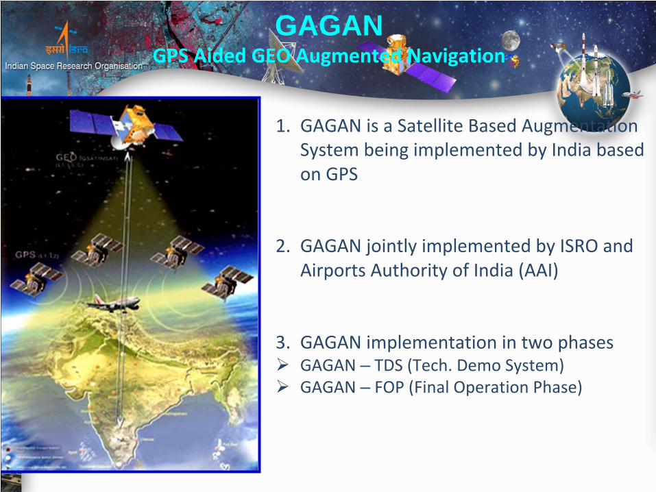
GAGAN (GPS Aided Geo Augmented Navigation)
1.
GAGAN is a Satellite Based Augmentation System being implemented by India based on GPS
2.
GAGAN jointly implemented by ISRO and Airports Authority of India (AAI)
3.
GAGAN implementation in two phasesGAGAN – TDS (Tech. Demo System)GAGAN – FOP (Final Operation Phase)
GAGAN GPS Aided GEO Augmented Navigation

OBJECTIVE
To provide Satellite-based Navigation services with accuracy and integrity required for civilian and aviation applications over Indian Air Space.
Better Air Traffic Management over Indian Airspace.
GAGAN

GPS Augmentation systems
EGNOSWAAS MSAS
GAGAN
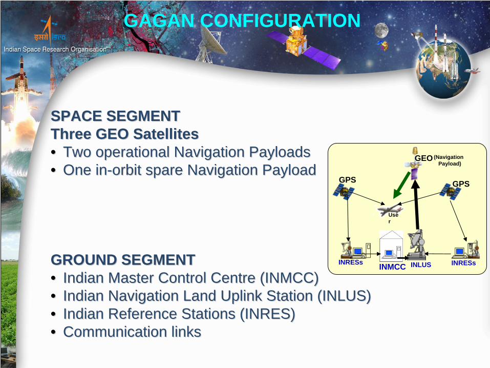
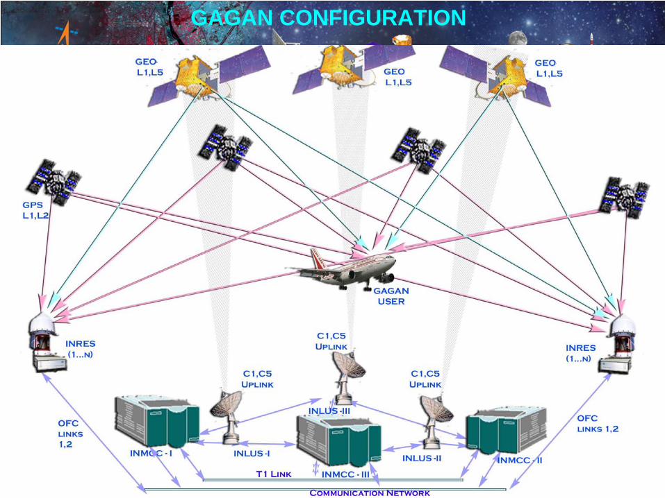
SPACE SEGMENTSPACE SEGMENTThree GEO SatellitesThree GEO Satellites•• Two operational Navigation Payloads Two operational Navigation Payloads •• One inOne in--orbit spare Navigation Payloadorbit spare Navigation Payload
GROUND SEGMENTGROUND SEGMENT•• Indian Master Control Centre (INMCC) Indian Master Control Centre (INMCC) •• Indian Navigation Land Uplink Station (INLUS)Indian Navigation Land Uplink Station (INLUS)•• Indian Reference Stations (INRES)Indian Reference Stations (INRES)•• Communication linksCommunication links
GAGAN CONFIGURATION
INRESs INMCC
GPS GPS
INRESs
GEO
INLUS
Use r
(NavigationPayload)

GAGAN NAVIGATION SIGNALS
7
GAGAN Space Segment uses SBAS PRN codes 127 and 128 to transmit corrections and integrity parameters to SBAS receiver.
Signals Received by GAGAN Receiver
Signals Frequency Band
1 MHz BPSK L1 (1575.42 MHz)
10 MHz BPSK * L5 (1176.45 MHz)
* When GPS L5Civil is available

GAGAN PAYLOAD CHARACTERISTICS
RHCPRHCPTransmit polarisation6.
50 Kg Total Payload weight10.
40W40WRF Power rating9.
15.8 dB15.8 dBAntenna Gain8.
Helix HelixType of Antenna7.
C‐bandC‐bandFeeder Link frequency 5.
GlobalGlobalFootprint4.
240WPower D C11.
24 MHz20 MHzBandwidth3.
‐2 dB/deg.K‐2 dB/deg.KReceive G/T2.
29.2 dBW30.2 dBWTransmit EIRP (EOC)1.
L5 Freq. (1176.45
MHz)L1 Freq.
(1575.42 MHz)
System characteristicsSl.
No.
GAGAN CONFIGURATION
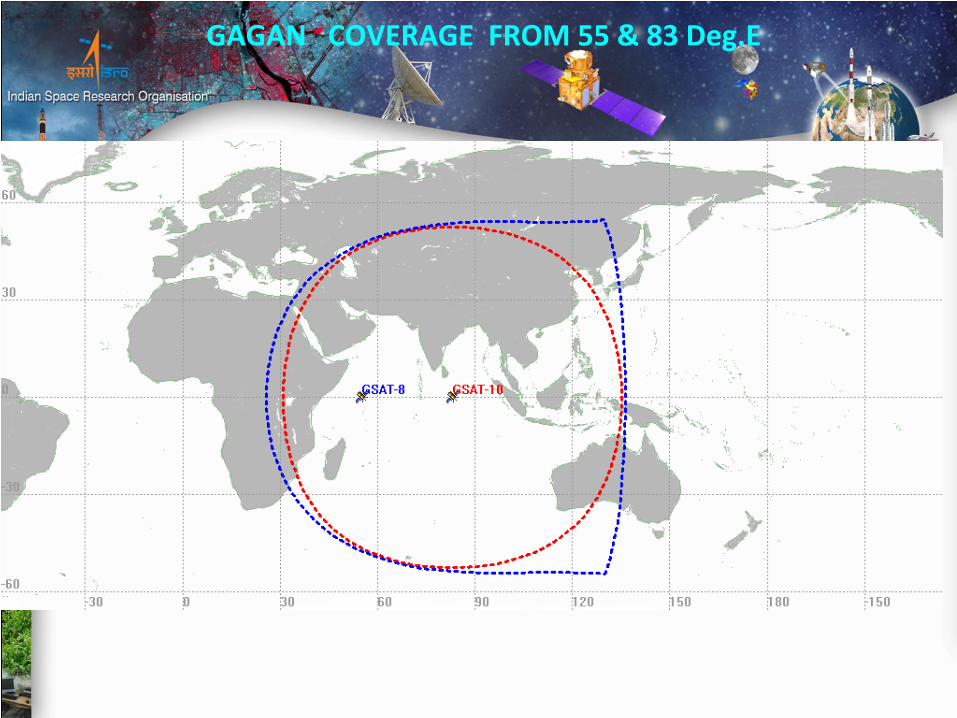
GAGAN
COVERAGE FROM 55 & 83 Deg.E

High position accuracies with integrity (APV-1.5 or better) over Indian geographical area.These position accuracies to be simultaneously made available to all airports and air fields in Indian FIR, enabling satellite based landing of aircraft fitted with SBAS receivers.
GAGAN INTENDED SERVICES
IRNSS(Indian Regional Navigation Satellite System)
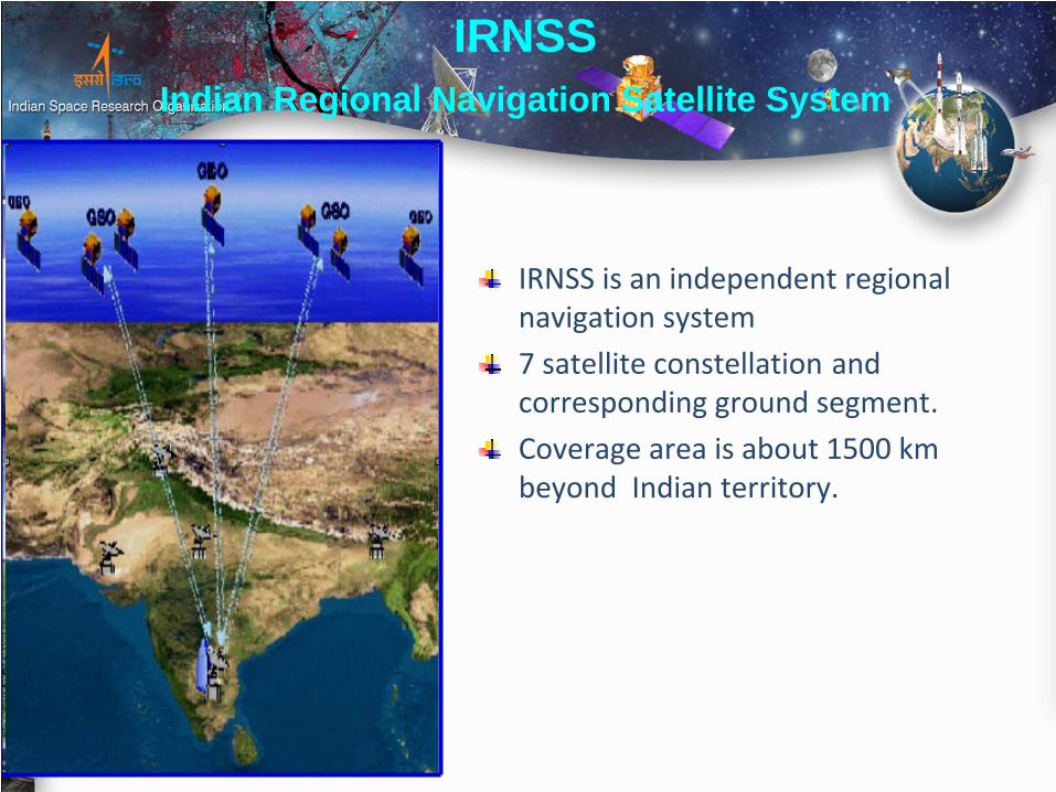
IRNSS is an independent regional navigation system
7 satellite constellation
and corresponding ground segment.
Coverage area is about 1500 km beyond Indian territory.
IRNSSIndian Regional Navigation Satellite System
IRNSSIndian Regional Navigation Satellite System
OBJECTIVES
Reliable Position, Navigation and Timing services over India and its immediate neighborhood.
To provide fairly good accuracy to the user.
The constellation is seen by user all the time.
Integrity and ionospheric correction messages to user.
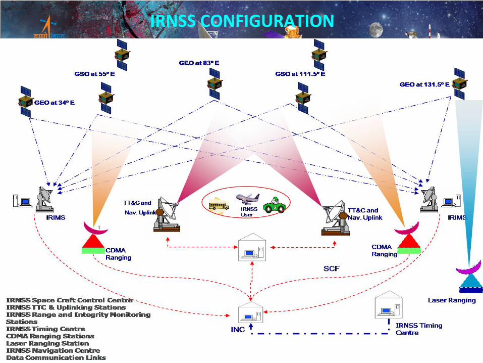
IRNSS CONFIGURATION
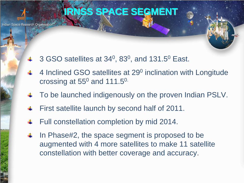
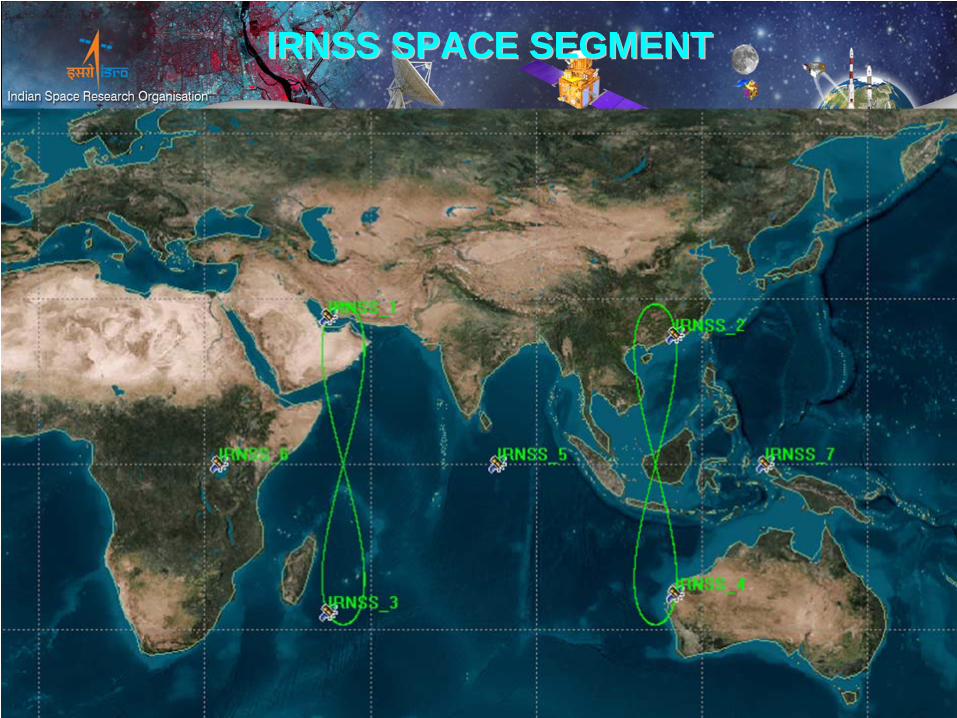
3 GSO satellites at 340, 830, and 131.50 East.
4 Inclined GSO satellites at 290 inclination with Longitude crossing at 550 and 111.50.
To be launched indigenously on the proven Indian PSLV.
First satellite launch by second half of 2011.
Full constellation completion by mid 2014.
In Phase#2, the space segment is proposed to be augmented with 4 more satellites to make 11 satellite constellation with better coverage and accuracy.
IRNSS SPACE SEGMENTIRNSS SPACE SEGMENT
IRNSS SPACE SEGMENTIRNSS SPACE SEGMENT
18
IRNWT
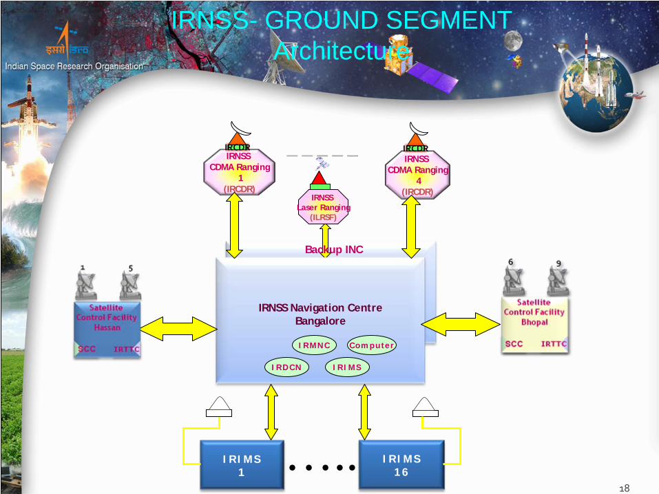
IRNSS- GROUND SEGMENT Architecture
IRIMS1
IRIMS16…..
IRNSS Laser Ranging
(ILRSF)
IRNSS Navigation CentreBangalore
IRNSS CDMA Ranging
4 (IRCDR)
IRCDRIRNSS
CDMA Ranging1
(IRCDR)
IRCDR
Backup INC
IRMNC Computer
IRDCN IRIMS

IRNSS Navigation Control Facility ( IRNCF )IRNSS Navigation Centre ( INC ) - 2 NosIRNSS Network Time ( IRNWT ) - 2 NosIRNSS CDMA Ranging Stations ( IRCDR ) - 4 NosIRNSS Laser Ranging Service ( ILRS )IRNSS Range and Integrity Monitoring Stations - 16 NosIRNSS Data Communication Network (IRDCN)
IRNSS Satellite Control Facility ( IRSCF )IRNSS TTC & Land Uplink Stations (INLUS) - 9 NosIRNSS Satellite Control Centre ( IRSCC ) - 2 Nos
IRNSS- GROUND SEGMENT Architecture
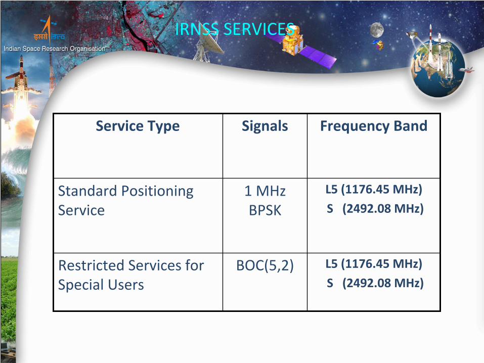
IRNSS SERVICES
Service Type Signals Frequency Band
Standard Positioning Service1 MHz
BPSKL5 (1176.45 MHz)
S (2492.08 MHz)
Restricted Services for Special Users
BOC(5,2) L5 (1176.45 MHz)
S (2492.08 MHz)

IRNSS NAVIGATION SIGNALS
SPS RS
L5 (1176.45 MHz ) BPSK BOC (5,2)
S band (2492.028 MHz) BPSK BOC(5,2)
CDMA Ranging Frequencies
•Uplink
: 6712 .0MHz (B.W 24MHz)•Downlink
: 3412 .0 MHz (B.W 24MHz)
21
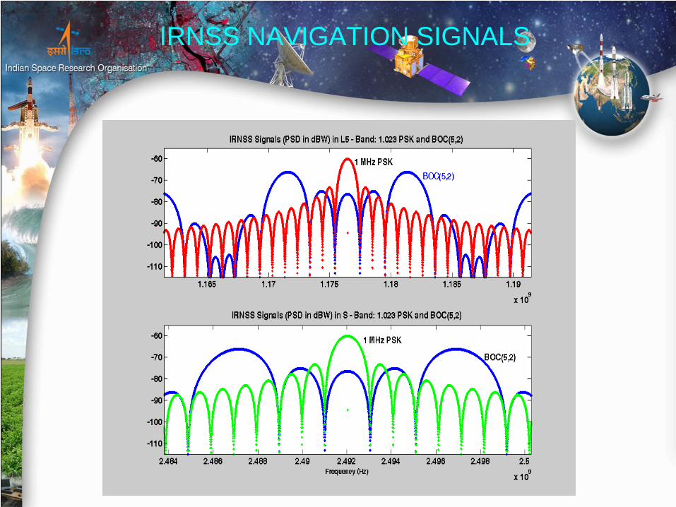
IRNSS NAVIGATION SIGNALS

THANK YOUTHANK YOU
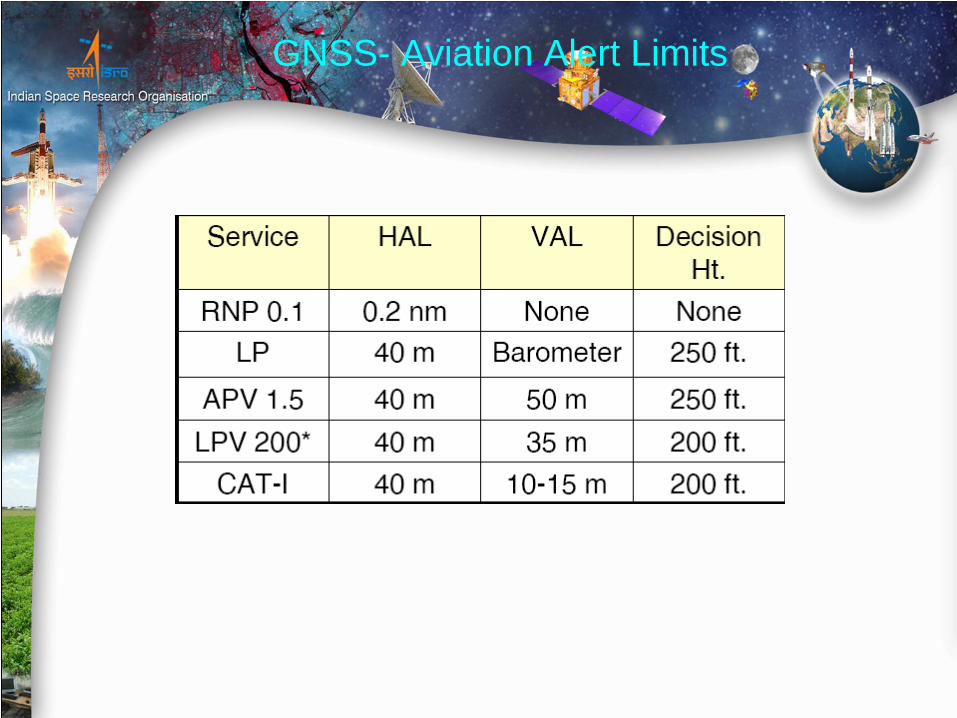
GNSS- Aviation Alert Limits

Accuracy Integrity Time-to-Alert Continuity Availability
En route
Terminal
Initial & Int
Approach, NPA, Departure
APV-I
APV-II
CAT I
1-10-7
per hr
1-10-7
per hr
1-10-7
per hr
1-2x10⁻⁷
per approach
1-2x10⁻⁷
per approach
1-2x10⁻⁷
per approach
5 min
15 sec
10 sec
10 sec
6 sec
6 sec
0.99 to 0.99999
0.999 to 0.99999
0.99 to 0.99999
0.99 to 0.99999
0.99 to 0.99999
0.99 to 0.99999
1-10-4/hr to1-10-8/hr
1-10-4/hr to1-10-8/hr
1-10-4/hr to1-10-8/hr
1-8x10⁻⁶/hr in any 15 sec
1-8x10⁻⁶/hr in any 15 sec
1-8x10⁻⁶/hr in any 15 sec
3.7 km (H)
0.74 km (H)
220 m (H)
220 m (H)20 m (V)
16 m (H)8 m (V)
16 m (H)6-4 m (V)
GNSS- Aviation Operational Performance Requirements

IRNSS NAVIGATION FRAME STRUCTURE


