
Earls Court ProjectRoyal Borough of Kensington & ChelseaApplication 1
Prepared for EC Properties Ltdby WSP & Halcrow
June 2011
Properties
Transport Assessment

2 Earls Court Project Application 1 | Royal Borough of Kensington & Chelsea | Transport Assessment | June 2011 Properties

3Earls Court Project Application 1 | Royal Borough of Kensington & Chelsea | Transport Assessment | June 2011Properties
Application Document
Cover Letter
Planning Application Forms (including notices and certificates)
Planning Application Fee
Development Specification
Parameter Plans
Access Plans
Community Engagement Report
Design and Access Statement
Design Guidelines
Planning Statement
Environmental Statement
• Non-Technical Summary
• Volume 1: Main Technical Chapters
• Volume 2: Townscape and Visual Impact Assessment (incorporating PPS5 Heritage Assessment)
• Volume 3: Technical Appendices
Transport Assessment
Retail and Leisure Assessment
Office Assessment
Housing Statement
Sustainability Strategy
Energy Strategy
Waste Strategy
Utilities and Services Infrastructure Strategy
Cultural Strategy
Estate Management Strategy

4 Earls Court Project Application 1 | Royal Borough of Kensington & Chelsea | Transport Assessment | June 2011 Properties

5Earls Court Project Application 1 | Royal Borough of Kensington & Chelsea | Transport Assessment | June 2011Properties
Executive Summary 7
Introduction 11
Relevant Policy and Guidance 21
Baseline Conditions – Land Uses & Local Area 27
Baseline Conditions – Local Highway Network 29
Baseline Conditions – Public Transport 35
Baseline Conditions - Walking & Cycling 41
Trip Generation 47
Demolition & Construction 51
Impacts - Road Network 55
Impacts – Parking 61
Impacts - Public Transport 63
Impacts – Walking and Cycling 69
Mitigation 73
Conclusions 77
Contents

6 Earls Court Project Application 1 | Royal Borough of Kensington & Chelsea | Transport Assessment | June 2011 Properties

7Earls Court Project Application 1 | Royal Borough of Kensington & Chelsea | Transport Assessment | June 2011Properties
Executive Summary This report is submitted in relation to the development proposals for the Earls Court Site. It forms part of a suite of documents that support two planning applications for the Earls Court Site. Planning Application 1 relates only to land within RBKC. Planning Application 2 relates to land within LBHF, plus a small area of land within RBKC, and is the subject of a separate Transport Assessment. This report is the Transport Assessment for Application 1, and it includes a comprehensive set of cumulative development scenarios as follows
• the RBKC Only Development Option (“the Development”, Application 1 only) and all committed developments plus background growth in 2021
• the RBKC Only Development Option and all committed developments plus background growth in combination with the Seagrave Road proposals in 2021
• the Site Wide Development Option (comprising Planning Applications 1 + 2) and all committed developments plus background growth in 2031
• the Site Wide Development Option and all committed developments plus background growth in combination with the Seagrave Road proposals in 2031.
This Executive Summary focuses on the Development, with the cumulative implications of the Site Wide Development Option and the Seagrave Road proposals being addressed briefly under a separate heading at the end of this Executive Summary.
The Proposals
The Development has been guided by a sustainable transport strategy, which is to be realised through a combination of design and management measures.
The site is currently impermeable and the Development addresses this by creating a permeable network of pedestrian and cyclist routes between Warwick Road and Old Brompton Road, and by facilitating a connection across the West London Line should Application 2 be implemented. This will improve connectivity and travel choices for the surrounding communities as well as for the new development
The Development would provide a highly walkable environment, integrated with existing and improved walking and cycling routes to provide attractive and easy connections to and from the area.
The Development would be an exemplar project to establish a cycling culture. It would encourage cycling by having a high standard of on-site cyclist facilities. In addition, provision is being made for two Barclays Cycle Hire stations to be established within the Development.
The Development would include residential car parking in accordance with London Plan standards so that off-site parking pressures would not be generated on the surrounding roads. Meanwhile, non-residential parking would be constrained as part of the strategy to reduce the amount of cars being attracted into the Development.
The on-site parking provision would meet the requirements of Blue Badge holders and provide for a Car Club to be established so that all occupiers had access to the shared use of pay-as-you-go vehicles. Provision is also made for electric vehicle charging at 20% of non-residential spaces and up to 40% of all residential parking spaces, with rapid charge points among the on-street parking spaces for the benefit of short stay visitors.
A management strategy has been developed to encourage the efficient and sustainable movement of goods and deliveries. This would reduce the transport impacts associated with servicing so that goods and services can be delivered, and waste removed, in a safe, efficient and environmentally-friendly way
The proposed accesses involve the modification and improvement of the existing accesses from Warwick Road and Old Brompton Road by modifying existing crossovers and reducing their width so that pedestrians benefit from an improved layout along the site frontages. The access layouts and proposed highway alterations have been the subject of Stage 1 Road Safety Audits. The Safety Audit recommendations have been reviewed, and they can all be addressed as the access designs progress towards more detailed layouts
The internal road layout has been designed in line with Manual for Streets principles, along with TfL and RBKC guidance documents. The Design Guidelines for the Development include details such that pedestrians and cyclists are prioritised with permeable movement throughout the site encouraged by shared surface spaces with at-grade pedestrian crossings and routes.
Overall, it is concluded that the Development proposals encourage sustainable travel patterns from the outset, and would be reinforced through the Framework Travel Plan measures.
8 Earls Court Project Application 1 | Royal Borough of Kensington & Chelsea | Transport Assessment | June 2011 Properties
Detailed mode-by-mode assessments have been carried out for all transport options and are summarised below for the highway network, underground rail, overground rail, buses, walking and cycling.
Highway Network
The proposed accesses have been modelled using PICADY (the standard software package for priority junctions) and the Warwick Road / Old Brompton Road and the A4 / Warwick Road junctions have been modelled using LINSIG (the standard software package for signalised junctions).
The PICADY results indicate that the Warwick Road and West Brompton accesses would operate well within capacity, with a maximum queue of only two cars waiting to join Warwick Road and no queues forecast at the West Brompton access.
The LINSIG results show that the A4 / Warwick Road and the Warwick Road / Old Brompton Road junctions would also have capacity to accommodate the Development.
London Underground
The site has good access to Earls Court and West Brompton stations, which provide a total of 78 and 24 services per hour respectively.
The Piccadilly and District Lines are to be upgraded in line with the Mayor’s Transport Strategy commitment to deliver passenger capacity increases of up to 19% on the District Line and 30% on the Piccadilly Line.
Analyses using TfL’s Railplan model show that travel demand from the Development would result in a negligible change on the underground network in the 2021 assessment year.
At Earls Court station, the gatelines at both ticket halls would run with sufficient capacity with the Development in 2021, so no ticket hall alterations would be required. Planning Application 1 includes re-commissioning the pedestrian tunnel entrance, accessed from the basement of the Earls Court Exhibition Centre. This would be of significant benefit to the station by reducing the number of passengers using the eastbound District Line platforms as a route to the Piccadilly Line platforms.
West Brompton station would be able to accommodate the Development in 2021 without mitigation.
Overground Rail
The Development would improve the pedestrian crossing to West Brompton station, where London Overground and Southern Trains run approximately 10 two-way mainline trains per hour in the peak. The West London Line upgrade is being implemented and increases peak capacity by 97% northbound and 65% southbound.
The Railplan analyses show that overground rail trips due to the Development would result in a negligible change from the 2021 Base (ie the situation in 2021 with no development).
Buses
The Railplan results for buses show that the 2021 Development demand levels would be comparable to, or below, the existing passenger numbers. In every case, the peak period passenger numbers would be well within the overall seating capacities. It is clear from these results that the Development impact is minor.
Bus stop audits on all bus routes within walking distance of the site have found a range of existing deficiencies and a financial contribution is therefore proposed for the improvement of three stops on Old Brompton Road, three on Warwick Road and three on Earls Court Road.
Walking
A quality audit of the pedestrian environment in the vicinity of the site found a lack of signage and information provision, together with some sub-standard surfacing and a lack of dropped kerbs and other facilities. The clear widths of existing footways were found to be compromised by street furniture on Warwick Road around Earls Court station and on Lillie Bridge.

9Earls Court Project Application 1 | Royal Borough of Kensington & Chelsea | Transport Assessment | June 2011Properties
Footway capacities were assessed and improvements are proposed on Warwick Road, Old Brompton Road and Lillie Road. Detailed pedestrian crossing assessments of the Development demands were carried out at the Warwick Road and Old Brompton Road crossings, finding that the existing 10m width of the Warwick Road crossing would be satisfactory and that the West Brompton crossing should be widened from 3m to 7m.
The Development includes mitigation in the form of a new pedestrian and cyclist crossing and associated pedestrian and cyclist improvements on Warwick Road, and a widened crossing plus widened footways on Old Brompton Road. These works are within the planning application boundary and it is proposed that they would be implemented as part of the Development proposals.
Other potential mitigation would be the subject of financial contributions for• off-site pedestrian improvements, as part of a comprehensive
public realm strategy for the surrounding area;• a wayfinding strategy for the local area in accordance with
Legible London guidelines; and• the installation of tactile and audible information for sensory
impaired users at the Old Brompton Road / Warwick Road and A4 / Warwick Road junctions.
Cycling
At present, there are limited routes and cycle parking facilities in the surrounding area.
The Development is forecast to contribute to the Mayor’s target for cycling to reach a 5% share of all journeys by 2026 and it would encourage cycling by having a high standard of on-site cyclist facilities. In addition, provision is being made for two Barclays Cycle Hire stations to be established within the Development.
This would be further supported by potential financial contributions towards off-site cyclist improvements for existing routes and new routes around the site.
Policy Compliance
The Development proposals have been assessed relative to transport and development policies at National, London and Borough levels
In terms of strategic policies• the Development proposals have been shown to promote
sustainable transport choices and this is reflected in the low car driver mode shares of only 4-9% depending on the scenario being considered and the time of day
• the land use mix and the Development’s location in a high PTAL area reduce the need to travel, especially by car
• the Development proposals include an extensive range of measures which have been designed-in or are the subject of proposed commitments through the Framework Travel Plan to encourage sustainable travel.
• Turning to more detailed local policy requirements:• the Development proposals improve the walking environment
by creating an attractive and permeable link through the site; by improving crossing points; widening footways; and proposing contributions for improving the wider public realm and introducing a wayfinding strategy
• cycling is encouraged by the high standard of on-site cyclist facilities and the provision being made for Barclays Cycle Hire stations within the Development, plus potential financial contributions towards off-site cyclist improvements around the site.
• the Development proposals accord with bus policies by assessing the quality of the surrounding bus network, and nearby bus stops and making provision for potential financial contributions towards bus stop improvements
• the parking proposals comply with published car parking standards and provide for Blue Badge holders, electric vehicle charging and a Car Club
• The Development proposals provide for all servicing, deliveries and refuse collection to take place away from the public highway, and to be controlled through a Delivery and Servicing Plan. The Plan sets out a management strategy so that goods and services can be delivered, and waste removed, in a safe, efficient and environmentally-friendly way
• the Development proposals comply with the 12 transport Key Principles of the Earls Court and West Kensington Opportunity Area draft Joint Supplementary Planning Document.

10 Earls Court Project Application 1 | Royal Borough of Kensington & Chelsea | Transport Assessment | June 2011 Properties
Cumulative Development ImplicationsThe highway accesses have been modelled for the Site Wide Development Option plus the Seagrave Road proposals and found to operate well within capacity, with a maximum queue of only two cars waiting to join Warwick Road and no queues forecast at the West Brompton access. The implications of these cumulative development scenarios on the highway network have also been tested by VISSIM modelling, finding that the cumulative development traffic can be accommodated.
The cumulative impact assessment for the underground network in the 2031 assessment year (when the Site Wide Development Option is assumed to be completed) shows results similar to the existing situation, with background growth plus the cumulative development demand being matched by the committed increases in capacity.
The cumulative impact at Earls Court station in 2031 would be accommodated without alterations to the ticket hall, due to the re-opened pedestrian tunnel providing additional entry/exit capacity and providing a more direct route onto the Piccadilly Line platforms.
At West Brompton station, the cumulative impact in 2031 would require an additional ticket gate to bring journey times for exiting passengers back in line with the 2031 Base situation (ie the situation with no development).
For the cumulative impact scenarios in 2031 the West London Line passenger densities with would still be significantly less than the existing situation, because of increases in capacity.
The Railplan results for buses show that the 2031 cumulative demand levels would be comparable to, or below, the existing passenger numbers. In every case, the peak period passenger numbers would be well within the overall seating capacities. It is clear from these results that the Development impact is minor.
Footway capacities were assessed for the cumulative development scenarios, finding that the existing 10m width of the Warwick Road crossing would be satisfactory and that the widened West Brompton crossing would also accommodate the cumulative development demand.
The increased cycling demand due to the cumulative development proposals in 2031 can be accommodated satisfactorily.

11Earls Court Project Application 1 | Royal Borough of Kensington & Chelsea | Transport Assessment | June 2011Properties
1.1 Background
1.1.1 EC Properties Limited is submitting planning applications for the redevelopment of the Earls Court Site. This is part of the Earls Court and West Kensington Opportunity Area (ECWKOA), and includes land in the London Borough of Hammersmith and Fulham (LBHF) and the Royal Borough of Kensington and Chelsea (RBKC).
1.1.2 The Earls Court Site is approximately 32 hectares (ha) in size and comprises four main landholdings:• Earls Court Exhibition Centres One and Two - on land within
RBKC and LBHF respectively;• The West Kensington and Gibbs Green Housing Estates - on
land mostly owned by LBHF;• The Lillie Bridge Depot - owned by Transport for London; and• The railway lines which pass through the main site and associated
rail sidings – owned by Network Rail.
1.1.3 LBHF, RBKC and the Greater London Authority (GLA) have produced a draft Supplementary Planning Document framework dated March 2011 to guide potential redevelopment in the ECWKOA.
1.1.4 This report is submitted in relation to the development proposals for the Earls Court Site. It forms part of a suite of documents that support two planning applications for the Earls Court Site (referred to as Planning Application 1 and Planning Application 2). Planning Application 1 relates only to land within RBKC. Planning Application 2 almost entirely relates to land within LBHF, but also includes a small area of land within RBKC. These planning applications are described fully in the Development Specification (Appendix A).
1 Introduction
File
: Q
:\W
SP_U
K\W
SP_D
\Cha
ncer
y_La
ne\1
114\
Earls
Cou
rt 1
11XX
XXX\
Anal
ysis
\Arc
GIS
\Map
Doc
umen
ts\P
B1\A
pplic
atio
n 1\
tRAN
SPO
RT.m
xdD
raw
n By
: uk
djm
007
Dat
e M
odifi
ed:
06/0
5/20
11
0 100 200 300 400MetersContains Ordnance Survey data © Crown
copyright and database right 2011.
TITLE: FIGURE No:
APPLICATION SITE BOUNDARIES
Key
Application 1
Application 2
Application 3
Opportunity Area
1.1
Figure 1.1 shows the relevant site boundaries.

12 Earls Court Project Application 1 | Royal Borough of Kensington & Chelsea | Transport Assessment | June 2011 Properties
1.1.5 It is the Applicant’s intention at this time to fully implement both planning applications for the Earls Court Site. However, it wishes to retain the potential for Planning Application 1 to be implemented in its own right as a self-standing development.
1.1.6 Therefore, this document considers two development options:• RBKC Only Development Option (“the Development”) - This
option relates to the scheme proposals within RBKC. It comprises the implementation of Planning Application 1; and
• Site Wide Development Option - This option relates to the whole of the Earls Court Site. It results from the combination of Planning Applications 1 and 2.
1.1.7 This document does not consider the implementation of Planning Application 2 as a self-standing development. This is not considered a feasible or realistic option due to the nature of the development proposals and the anticipated development phasing. This is explained further in the Development Specification.
1.1.8 A separate planning application will be submitted for the Seagrave Road Site (which is located to the south of the Earls Court Site, south of Lillie Road). Together the three planning applications propose the redevelopment of the Earls Court & West Kensington Opportunity Area (ECWKOA) as designated in the Draft Replacement London Plan.
1.1.9 Each application is accompanied by a separate Transport Assessment (TA).
1.1.10 This Application 1 TA will assess the RBKC Only Development Option on a standalone basis, plus cumulative assessments including the Site Wide Development Option (Planning Applications 1 and 2) and the Seagrave Road proposals.
1.1.11 The Application 2 TA will assess the Site Wide Development Option, plus cumulative assessments including the Seagrave Road proposals.
1.2 Transport Strategy and Vision
1.2.1 The overall aim, as originally set out in the sustainability protocol, is to make the ECWKOA an ‘open’ and highly accessible place where people move around freely and efficiently. Its scale, diversity and quality will enable it to be a self-contained highly walkable neighbourhood where daily needs are easily met via a short walk on a safe and attractive street.
1.2.2 Walking will be the key means of circulation for daily needs but the ECWKOA will also become a compelling focal point in the Mayor’s ‘cycling revolution’ in which the conviviality and efficiency of movement of, for example, Copenhagen’s streets is combined with London’s premium creativity and energy. The wealth of underground stations situated nearby and the availability of regular clean-fuel buses will mean that the mode of choice for journeys should naturally evolve away from the car. This in turn will free up road space for the comparatively free flow of cars for essential uses or for longer journeys. Priority will be given to electric or other clean cars and the street and parking infrastructure will pioneer efficient electrical charging.
1.2.3 This ambition will be achieved through a sustainable transport strategy, to be realised through a combination of design and management measures which will include the following elements of the Sustainability Protocol.
Modal shift ambition
1.2.4 The ambition, supported by design, delivery and ongoing management, will be for the ECWKOA residents to evolve a mode share whereby, by 2030, 90% of journeys under 2km and 40% of journeys of between 2 and 5km (compared with under 10% in Greater London today) are on foot or by bike.
Deliveries
• Identify opportunities for reducing the number of heavy vehicle movements into and around the ECWKOA during construction and use.

13Earls Court Project Application 1 | Royal Borough of Kensington & Chelsea | Transport Assessment | June 2011Properties
• Propose and comply with a Delivery and Servicing Plan. This would set out a management strategy to encourage the efficient and sustainable movement of goods and deliveries and to reduce transport impacts associated with servicing.
• Car parking standards
• Adopt parking standards for residents and workplaces that balance sustainability objectives with market demand, with a target overall residential parking ratio of around 0.6 spaces per dwelling and restrained commercial parking.
Hierarchy of transport strategies
• Develop a hierarchy of transport strategies and street typologies to ensure the needs of pedestrians, cyclists and public transport users have priority over the needs of private motor vehicles.
• Consider the need for improvements to the transport network in neighbouring boroughs and beyond, and the need to establish and promote car club and car share schemes. All streets will be designed to reduce vehicle speeds to reasonable levels.
Pedestrian and cycle network
• Provide a comprehensive pedestrian and cycle network with high quality cycle lanes and pavements to create a wide choice of routes within the Development and integrate with existing walking and cycling routes (including connections to the proposed cycle superhighway), providing attractive and easy connections to and from the area.
Priorities for off-site improvements
1.2.5 Use the comprehensive audit of pedestrian and cycle infrastructure, facilities and routes to establish priorities for improvements on and near the ECWKOA including:
• necessary improvements to the current pedestrian and cycle network, such as widening of cycle lanes, resurfacing, addressing fragmentation and enforcement;
• priority improvements to junctions that act as actual or perceived barriers to walking and cycling;
• opportunities to improve permeability for pedestrians and cyclists through ‘filtered permeability’, such as by creating cycle contra flows on one way streets and opening up cul-de-sacs to create cycle and pedestrian through routes; and
• opportunities to improve pedestrian and cycle access to public transport.
Cycle parking provision
• Ensure there is high quality, secure and weather protected cycle parking provision for residents (in line with the requirements of the Code for Sustainable Homes) and workplace employees/users, generous public cycle parking provision throughout the ECWKOA, and encourage provision for shower and changing facilities in all workplaces.
• Explore opportunities for the site to be served by an expansion of the Barclays Cycle Hire scheme and provide cycle hubs at key destinations, combining secure cycle parking, cycle hire and cycle repair facilities.
Electric and plug in hybrid cars
• The use of electric and plug in hybrid cars and vans will be actively encouraged through the provision of charging points and incentives such as reduced parking rates for low carbon vehicles. The car club will include electric vehicles.
• The opportunity to provide electric charging points for car parking spaces will be looked into with the aim of meeting the TfL target of at least 1 in 5 of all parking spaces having an electrical charging point. This ratio will be reviewed at the start of each phase to ensure it is ahead of market demand.
Smart Choices programme
1.2.6 Develop a ‘Smart Choices’ programme to influence future travel patterns for local, regional and national journeys, with regular monitoring and additional support, such as personalised travel planning, cycle safety lessons and walking buses/cycling clubs encouraged where possible.

14 Earls Court Project Application 1 | Royal Borough of Kensington & Chelsea | Transport Assessment | June 2011 Properties
1.3 Proposed Development
1.3.1 The Development contains the following:
Table 1.1: RBKC Only Development Option
Land Use Use Class Maximum FloorpsaceGIA (sqm) GEA (sqm)
Residential C3 139,198 143,503Office B1 15,295 15,850Retail A1-5 3,570 3,700
Hotel / Serviced Apartments
C1 10,145 10,513
Leisure D2 1,930 2,000Community / Culture D1 531 550
170,669 176,116
1.3.2 Application 1 seeks permission for up to 1,016 units depending on the precise mix of unit sizes. The breakdown of the residential space by unit sizes is:
Table 1.2: RBKC Only Development Option Residential Breakdown
Unit Type Proportion Range1 person apt 2% - 5%
1 bed 20% - 35%2 bed 30% - 40%3 bed 20% - 25%
4 bed + 5% - 20%
Applications 1 and 2 Combined – the Site Wide Development Option
1.3.3 Applications 1 and 2 are assessed in combination through the cumulative appraisal of the Site Wide Development Option which is summarised below in Table 1.3.
Table 1.3: Site Wide Development Option Quantum
Land Use Use Class Maximum FloorspaceGIA (sqm) GEA (sqm)
Residential C3 734,724 757,447Office B1 116,394 120,615Retail A1-5 28,399 29,429
Hotel / Serviced Apartments
C1 18,357 19,023
Leisure D2 13,615 14,109Medical C2 11,278 11,687
Education / Community / Culture
D1 17,583 18,221
940,350 970,532
1.3.4 The Site Wide Development Option could accommodate up to 6,775 units depending on the precise mix of unit sizes.
The Seagrave Road Proposals
1.3.5 The development proposals for Seagrave Road comprise 808 units and some 1,200sqm of gymnasium and café uses.
1.4 Rbkc Only Development Option
Access
1.4.1 The Application 1 site is currently impermeable as the Earls Court Exhibition Centre is gated and does not allow for general public access between Warwick Road and Old Brompton Road. The detailed access and outline layout proposals address this by creating a permeable network of pedestrian and cyclist routes between Warwick Road and Old Brompton Road, and by facilitating a potential connection across the West London Line. This will improve connectivity and travel choices for the surrounding communities as well as for the Development.

15Earls Court Project Application 1 | Royal Borough of Kensington & Chelsea | Transport Assessment | June 2011Properties
1.4.2 The detailed access proposals for the RBKC Only Development Option involve the modification and improvement of the existing accesses from Warwick Road and Old Brompton Road. The access layouts are contained in Appendix B and access has been the subject of Stage 1 Road Safety Audits, which are attached as Appendix C.
1.4.3 The Safety Audit recommendations have been reviewed, and they can all be addressed as the access designs progress towards more detailed layouts.
1.4.4 The Warwick Road access is located opposite Earls Court underground station. A new Toucan crossing is proposed so that pedestrians and cyclists have a safe and attractive access across Warwick Road. The road level across the crossing is proposed to be subtly raised to match the adjacent footways and to make the crossing as seamless as possible for pedestrians and cyclists between the site and Earls Court station. Vehicular access would be separated from the pedestrian and cyclist movements via a left-in turn into the new Empress Crescent south of the crossing and egress via a left-out turn from the proposed Warwick Crescent north of the crossing. The vehicular access and egress will be priority junctions, and their safe interaction with pedestrian and cyclist movements plus the Warwick Road traffic has been a key design consideration. They both involve modifying existing crossovers and reducing their width so that pedestrians on the west side of Warwick Road benefit from an improved layout. Appendix B shows that the crossover widths would be reduced from the existing situation, so there would be more pedestrian space along the site frontage.
1.4.5 The West Brompton access, opposite West Brompton station, comprises a modified entrance from Old Brompton Road into the new Empress Crescent via Counters Place, a new public square which marks the beginning of the Lost River Park. The access will be an all movement priority junction and pedestrian access to West Brompton station will also be improved significantly by upgrading the existing signalised crossing to a wider Toucan crossing with widened footways. As with the Warwick Road access, the road level could be subtly raised to bring the crossing surface up to the adjacent footway levels to further improve pedestrian and cyclist connectivity. The access involves modifying the existing western crossover and removing the eastern crossover so that pedestrians on the north side of the road benefit from an improved layout, with more pedestrian space.
1.4.6 Cluny Mews would provide a connection onto Warwick Road from the northern development plot “WK04”, which would contain some 40 residential units and 8,370sqm of office space. It is proposed that the existing access layout would be unaltered, as its geometry is satisfactory for the current low level of pedestrian, cyclist and vehicle movements, and its use by traffic would not be intensified.
1.4.7 The internal road layout (Figure 1.2) has been designed in line with Manual for Streets principles, along with TfL’s Streetscape Guidance 2009 and RBKC’s Transport SPD. The layout and scheme principles see pedestrians and cyclists prioritised with permeable movement throughout the site encouraged by shared surface spaces with at-grade pedestrian crossings and routes. It is expected that the predominant desire for movement would be to Earls Court and West Brompton stations and the street configuration responds to these desire lines.
NE04
Figure 1.2 The internal road layout
16 Earls Court Project Application 1 | Royal Borough of Kensington & Chelsea | Transport Assessment | June 2011 Properties
1.4.8 The Development is designed to feel like an attractive part of London, and therefore the design and public realm strategy have the objective that pedestrians would be encouraged to walk into and through the site via the proposed pedestrian crossings around the periphery of the site and enhanced footways.
1.4.9 Cycling is likely to be a popular mode of transport both within and through the Masterplan area. This creates a need for high-quality cyclist facilities, including secure cycle parking, carriageways of sufficient width to comfortably accommodate cyclists, and showering / changing facilities throughout the proposed land uses.
1.4.10 The access layouts have all been checked to ensure that large delivery, emergency and refuse vehicles can be accommodated. The check has used standard “TRACK” software to simulate the swept paths of vehicle movements, and the TRACK plots are included in Appendix B.
Parking, Taxis & Car Club Provision
1.4.11 The overall residential parking provision is based on a ratio of 0.6 space per dwelling, which is the level of car ownership anticipated by the Applicant. This equates to 609 residential car parking spaces.
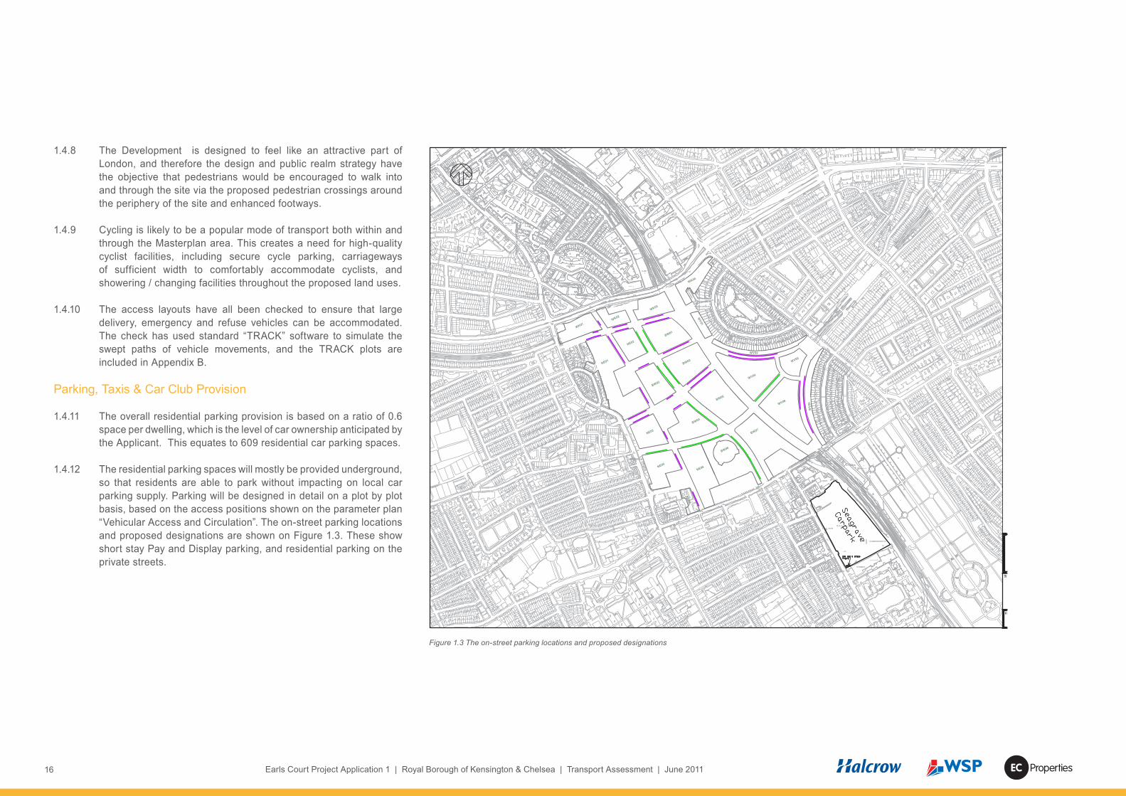
1.4.12 The residential parking spaces will mostly be provided underground, so that residents are able to park without impacting on local car parking supply. Parking will be designed in detail on a plot by plot basis, based on the access positions shown on the parameter plan “Vehicular Access and Circulation”. The on-street parking locations and proposed designations are shown on Figure 1.3. These show short stay Pay and Display parking, and residential parking on the private streets.
NE03
BW03
BW06
BW07
NE06
WK02
NE04
NE01
NE02
BW01
BW04
NE05
BW05
WV04
WV02
WV03
WV0
5WV06
WK01
WK03
WK04
WV01
BW02
Figure 1.3 The on-street parking locations and proposed designations
17Earls Court Project Application 1 | Royal Borough of Kensington & Chelsea | Transport Assessment | June 2011Properties
1.4.13 The travel demand assessment includes forecasts of taxi demand, and the requirement for on-site taxi facilities will be discussed with TfL. If required, some of the on-street parking areas could be converted to taxi ranks.
1.4.14 Blue badge parking will be provided at a ratio of 10% of the overall number of spaces, unless agreed otherwise with TfL and RBKC. Additional on-street blue badge parking will be provided for commercial, leisure and retail uses.
1.4.15 Commercial parking is proposed at the following ratios:
• B1/ Office: 1 space per 1000 m² • Hotel / Serviced Apartments: 1 space per 40 rooms/units• Leisure: Disabled only with on-street visitor• Culture: Disabled only with on-street visitor• Retail: Disabled with on-street visitor.
1.4.16 21 dedicated non-residential on-plot parking spaces are proposed and there would be 18 on-street pay and display or Blue Badge spaces on adopted streets within the development.
1.4.17 Discussions with Streetcar, a Car Club operator which is active in RBKC, indicate a likely demand for three on-street spaces to be provided within the site. There is scope to vary this according to future Car Club demand levels. Streetcar already has 99 vehicles and over 5,800 members in RBKC, and has aspirations to introduce electric vehicles to its fleet of pay-as-you-go vehicles. It already works in partnership with RBKC to provide on-street Car Clubs to its members.
1.4.18 In line with the Draft Replacement London Plan standards, 20% of parking spaces will be provided with active electric charging. A further 20% will have “passive” provision to allow for further expansion as electric vehicles become more prevalent. The adoption of these standards for the RBKC Only Development Option equates to 122 residential spaces having electric charging facilities with another 122 being passively prepared for adoption of the technology when demand is sufficient. In addition, 20% of the on-street spaces will be equipped for electric vehicle charging.
Motor Cycle and Cycle Parking
1.4.19 On-plot motorcycle parking will be provided at a ratio of one space per 20 dwellings, totalling some 50 spaces. Some of the on-street parking areas shown on Figure 1.3 could be reserved for motorcycle use.
1.4.20 The London Plan residential cycle parking standard is one space per 1 or 2 bed unit and two spaces per 3 or more bed unit. This equates to a total of 1,311 on-plot spaces. Visitor cycle parking is proposed at a level of 0.1 spaces per dwelling equating to 102 visitor spaces to be provided on-street across the site. Non-residential cycle parking would be provided in accordance with London Plan cycle parking standards in a mixture of on-plot and on-street locations.
Servicing, Waste and Deliveries
1.4.21 The principles of provision for deliveries are that :• residential and hotel deliveries will take place from basement
areas or from on-street bays• basement servicing access for vans will use the car park ramps,
subject to headroom restrictions, with larger vehicles accessing the basements from the Northern Access Road
• the townhouses will be serviced from their street frontages • retail and community / culture uses will be serviced from
dedicated on-street loading bays, given their small-scale • commercial and larger leisure units will have dedicated off-street
servicing bays, located at grade or in basements and will be finalised in the detail design of each plot
• the energy centre will be accessed at basement level from the Northern Access Road
• the estate roads will be actively managed by on-site estate management staff to prevent these streets from being used by vehicles unconnected with the Development.
1.4.22 Communal refuse rooms would be provided in individual buildings at ground or basement levels, and standard waste and recycling bins would be provided.
1.4.23 Commercial waste is subject to the “Duty of Care” and “Controlled Waste” as set out in the 1990 Environmental Protection Act – Waste Management, The Duty of Care Code of Practice. The overall

18 Earls Court Project Application 1 | Royal Borough of Kensington & Chelsea | Transport Assessment | June 2011 Properties
waste strategy will aim to coordinate the individual commercial waste collection arrangements while taking account of specialised requirements such as clinical waste and cooking oil.
1.4.24 The internal access roads leading to the servicing areas have been designed to accommodate the largest vehicle types that can reasonably be expected to service each occupier within the site. These vehicles are as follows: • 16.5 Artic HGV (Width 2.5; Length 16.5m; Height 4.0m)• 11m Rigid HGV (Width 2.5m; Length 11m; Height: 3.7m);• Large Refuse Vehicle (Width 2.5m; Length 9.9m; Height: 3.7m);• Fire Pump Appliance (Width 2.3m; Length 8.5m; Height: 3.7m); and• Transit Van (Width 2.2m; Length 5.5m; Height: 2.4m).
1.4.25 The proposed management of servicing, refuse collection and deliveries is set out in the Framework Delivery and Servicing Plan (Appendix S).
1.5 Context Of Technical Assessment
1.5.1 This Transport Assessment has been undertaken following the substantial technical work undertaken as part of the Earls Court Transport Study (ECTS).
1.5.2 The ECTS was undertaken in four stages and in accordance with an agreed TfL methodology. The primary objective of the ECTS was to understand the transport capacity of the ECWKOA with regard to all modes by testing a range of development scenarios.
1.5.3 The ECTS considered the implications of development in the Earls Court West Kensington Opportunity Area (ECWKOA) through a series of reporting stages:• Stage 1 – Inception Report• Stage 2a – Development and Transport Scenarios Definition• Stage 2b – Review of Existing Models and Analysis• Stage 3 – Forecasting and Analysis • Stage 4 – Local Capacity Study
1.5.4 The Stage 4 report was produced in parallel with the development of the ECWKOA Supplementary Planning Document (SPD) and informed the draft SPD in terms of identifying transport issues, their
implications for different scales of development and their potential mitigation. The Stage 4 report focussed on more local and detailed transport considerations, whereas the Stage 3 report considered impacts at a strategic level.
1.5.5 The ECTS has been audited, on behalf of TfL, by MVA Consultancy. The study concluded that a level of travel demand associated with ECWKOA development of some 8,300 residential units and some 24,000 jobs could be accommodated on the transport networks subject to appropriate and agreed levels of mitigation.
1.6 Consultation
1.6.1 The emerging development proposals have been the subject of consultation with TfL and both Boroughs, largely through the Earls Court Transport Study Steering Group plus other consultations and briefings arranged by TfL Land Use Planning and Surface Transport.
1.6.2 A TA Scoping Study dated 25th February 2011 was provided to TfL, LBHF and RBKC. The Scoping Study was prepared in accordance with the TfL guidelines set out in TfL’s ‘Transport Assessment Best Practice’ (April 2010) guidance document and formed the basis for discussion at pre-application meetings held with TfL, LBHF and RBKC. A consultation response was received from TfL on 26 April 2011. Copies of the Scoping Study and its response are provided as Appendix D.
1.6.3 Consultation has continued with these bodies throughout the pre-application process. All comments received from LBHF, RBKC and TfL, as part of the consultation have been taken into account in producing this TA. This consultation and previous consultation undertaken for the ECTS has informed both the Masterplan proposals and the content of this Transport Assessment.
1.6.4 In addition to statutory consultation, pre-planning public consultation on the masterplan proposals was held at the Earls Court exhibition centre during March 2011, together with other consultation exercises as summarised in the Statement of Community Engagement.
19Earls Court Project Application 1 | Royal Borough of Kensington & Chelsea | Transport Assessment | June 2011Properties
1.7 Cumulative Assessments And Forecast Growth
1.7.1 The cumulative development scenarios include the Site Wide Development Option plus the Seagrave Road proposals .In common with the EIA, consideration has been given to other schemes located within 1 km. These schemes comprise consented schemes and schemes under construction. In addition, and for increased robustness those schemes resolved to be approved have been considered. In order to be considered as being significant, the schemes identified either comprise over 50 residential units or provide over 10,000sqm of floorspace. The schemes include: • G-Gate, Olympia, Corner of Lyons Walk and Hammersmith Road
-2008/00547/FUL. Call-in decision – Approved – 3 December 2009.
• 72 Farm Lane, London, SW6 1QA – 2008/01550/FUL. Granted - 18 February 2010.
• Ibis Hotel, 47 Lillie Road, SW6 – 2007/00608/OUT. Granted – 10 June 2009.
• The Commonwealth Institute, 224-238 Kensington High Street PP/09/00839; CC/09/00841; LB/09/00840. Resolution to Grant – 17 October 2009.
• 245 Warwick Road (TA Centre) – PP/08/00218. Resolution to Grant – 30 April 2008.
• 181-183 Warwick Road – PP/06/02568. Resolution to Grant – 26 August 2008.
• Odeon Cinema, Kensington High Street – PP/07/01071. Resolution to Grant – 19 November 2008.
• Telephone Exchange, 213-215 Warwick Road – PP/08/01214. Resolution to Grant – 11 December 2008.
• Charles House, 375 Kensington High Street and The Radnor Arms, 247 Warwick Road, London, W14 8QH – PP/08/01178. Resolution to Grant - 30/04/2010.
• Olympia Exhibition Centre, Hammersmith Road, W14 8UX – 2010/02180/FUL and 2010/02181/LBC. Resolution to grant – 13/10/2010.
1.7.2 This TA aims to ensure that these schemes are taken into account without double-counting their traffic into the forecasts of background traffic growth. Each Transport Assessment for the above developments has been reviewed against TfL’s London
Transportation Study (LTS) growth forecasts, confirming that the additional travel demand associated with all of the above schemes are already counted into the background growth forecasts for the 2021 and 2031 Future Base scenarios. The detail of this review is set out in Appendix E.
1.7.3 In addition to these specific schemes, the TA takes account of travel demand generated by the Tesco site proposals at 100 West Cromwell Road and other developments further afield. This has been achieved by using LTS forecasts, with LTS Version 6.2.2 being provided by TfL for use as part of this planning application. Discussions with TfL have confirmed that further cumulative assessments are being progressed by their consultants to clarify any strategic implications of the “Western Arc” developments.
1.8 Assessment Scenarios
1.8.1 Where the impact of the RBKC Only Development Option is considered, it is undertaken in the context of the following scenarios:
• Scenario 1 - The RBKC Only Development Option proposals at completion. This considers the Development in combination with the 2021 Future Base
• Scenario 2 - The RBKC Only Development Option and the Seagrave Road proposals (2021)
• Scenario 3 - The Site Wide Development Option at completion, and in combination with the 2031 Future Base. There is also a requirement to assess the intermediate scenario for the Site Wide Development Option in 2021, prior to the A4 junction being open to traffic
• Scenario 4 – The Site Wide Development Option and the Seagrave Road proposals (2031), in combination with the 2031 Future Base

20 Earls Court Project Application 1 | Royal Borough of Kensington & Chelsea | Transport Assessment | June 2011 Properties

21Earls Court Project Application 1 | Royal Borough of Kensington & Chelsea | Transport Assessment | June 2011Properties
2 Relevant Policy and Guidance
2.1 Introduction
2.1.1 Section 3 of TfL’s “Transport Assessment Best Practice Guidance” says that a key consideration is to assess the conformity of development proposals with policy. A review of transport-related national, regional and local policy is therefore provided below.
2.1.2 The extent to which the development proposals accord with these policies is detailed in section 14 “Conclusions”.
2.2 National Policies
2.2.1 The high-level principles of national transport policy for development proposals are set out in PPG13 “Transport”; PPS3 “Housing”; PPS4 “Planning for Sustainable Economic Growth”; and PPG12 “Local Spatial Planning”.
2.2.2 As an overview, these documents stress the importance of promoting sustainable transport choices and reducing the need to travel, especially by car. They aim to improve the integration of land use planning and transport in order to achieve more sustainable patterns of development.
2.2.3 The key recurring themes include the importance of complimentary land uses being accessible by public transport, walking and cycling, and for car parking levels to promote sustainable transport policies.
2.3 London Policies
2.3.1 The Mayor’s transport and development policies are set out in the London Plan and related documents, which reflect the overall national policies and add London-specific details.
The London Plan, 2008
• The transport and development aspects of the overall strategy are summarised in Policy 2A.1 as being to ensure that development occurs in areas which are accessible by public transport, walking and cycling, while taking account of transport infrastructure capacity.
• The most relevant policies in terms of this Transport Assessment are summarised below.
Policy 3C.1 Integrating transport and development
2.3.2 The Mayor will work with TfL, the government, boroughs and other partners to ensure the integration of transport and development by:
• encouraging patterns and forms of development that reduce the need to travel, especially by car.
• seeking to improve public transport, walking and cycling capacity and accessibility where it is needed, for areas of greatest demand and areas designated for development and regeneration, including….Opportunity Areas.
• in general, supporting high trip generating development only at locations with both high levels of public transport accessibility and capacity, sufficient to meet the transport requirements of the development. Parking provision should reflect levels of public transport accessibility.
• encouraging integration of the major transport infrastructure plans with improvements to the public realm, particularly in key areas around major rail and underground stations and interchanges, using land assembly powers where necessary.
Policy 3C.2 Matching development to transport capacity
2.3.3 The Mayor will and boroughs should consider proposals for development in terms of existing transport capacity, both at a corridor and local level. Where existing transport capacity is not sufficient to allow for travel generated by proposed developments, and no firm plans exist for a sufficient increase in capacity to cater for this, boroughs should ensure that development proposals are appropriately phased until it is known these requirements can be met.
2.3.4 Boroughs should take a strategic lead in exploiting opportunities for development in areas where appropriate transport accessibility and capacity exists or is being introduced. The cumulative impacts of development on transport requirements should be taken into account. Boroughs should also facilitate opportunities to integrate major transport proposals with development in a way that supports the London Plan’s priorities.
2.3.5 Developments with significant transport implications should include a Transport Assessment and Travel Plan as part of planning applications.

22 Earls Court Project Application 1 | Royal Borough of Kensington & Chelsea | Transport Assessment | June 2011 Properties
Policy 3C.3 Sustainable transport in London
2.3.6 The Mayor will and strategic partners should support :• measures that encourage shifts to more sustainable modes and
appropriate demand management• measures that promote greater use of low carbon technologies
so that CO2 and other contributors to global warming are reduced
• Opportunity Areas …. should be supported by improved public transport
• access improvements to and within town centres and their residential hinterlands by public transport – including by improved bus services, walking and cycling – and between town centres by improved bus services, more frequent rail services and, where appropriate, new tram and bus transit schemes
• improved sustainable transport between suburban centres, particularly by enhanced bus services, walking and cycling and by greater integration between bus, rail and Underground service
• improved provision for bus services, cycling and pedestrian facilities and local means of transport to improve accessibility to jobs and services for the residents of deprived areas.
Policy 3C.20 Improving conditions for buses
2.3.7 The Mayor will work with TfL and boroughs to implement London-wide improvements to the quality of bus services for all. DPD policies should actively promote and give priority to the continued development of the London bus network, including:
• ensuring good bus access to and within town centres, major developments and residential areas
• ensuring that walking routes to bus stops from homes and workplaces are direct, secure, pleasant and safe
• ensuring that bus layover and turning areas, driver facilities, bus stations and garages are available where needed.
Policy 3C.21 Improving conditions for walking
2.3.8 DPD Policies should:• Ensure that safe, convenient, accessible and direct pedestrian
access is provided from new developments to public transport
nodes and key land uses, taking account of the need to connect people to jobs, to town centres and schools and based on the TfL guidance Improving Walkability.
• Plan for suitable crossing facilities around and near new developments, including features to enable disabled people to access them.
• Ensure that the pedestrian environment is accessible to disabled people.
• Take account of measures set out in the TfL walking plan for London.
• Improve the safety and convenience of pedestrian routes to school.
Policy 3C.22 Improving conditions for cycling
2.3.9 DPD Policies should:• identify and implement high quality, direct, cycling routes, where
possible segregated from motorised traffic, giving access to public transport nodes, town centres and key land uses
• Encourage provision of sufficient, secure cycle parking facilities within developments, taking account of TfL’s Cycle Parking Standards
• Encourage and improve safety for cycling.
Policy 3C.23 Parking Strategy
2.3.10 The Mayor, in conjunction with Boroughs, will seek to ensure that on-site car parking at new developments is the minimum necessary and that there is no over- provision that could undermine the use of more sustainable non-car modes. The only exception to this approach will be to ensure that developments are accessible for disabled people DPD policies and transport local implementation plans should:• Adopt on- and off-street parking policies that encourage access
by sustainable means of transport, assist in limiting the use of the car and contribute to minimising road traffic.
• Adopt the maximum parking standards set out in the annex on parking standards (Annex 4) where appropriate, taking account of local circumstances and allowing for reduced car parking provision in areas of good transport accessibility.
• Reduce the amount of existing, private, non-residential parking, as opportunities arise.

23Earls Court Project Application 1 | Royal Borough of Kensington & Chelsea | Transport Assessment | June 2011Properties
• Recognise the needs of disabled people and provide adequate parking for them.
• Take account of the needs of business for delivery and servicing movements.
• Encourage good standards of car parking design.
Policy 3C.25 Freight strategy
2.3.11 The Mayor will promote the sustainable development of the full range of road, rail and water-borne freight facilities in London DPD policies should:
• seek to locate developments that generate high levels of freight movement close to major transport routes and to minimise night disturbance
• ensure developments include appropriate servicing facilities, off-road wherever practicable, and include appropriate freight loading and parking facilities
• ensure collection and delivery can take place off the main bus and tram routes.
The draft replacement london plan (october 2009)
2.3.12 The draft Replacement London Plan was issued as a public consultation draft in October 2009 and the Panel Report on its Examination was published on 03 May 2011. Although it remains in draft the Replacement London Plan has been included in this policy section as it gives a useful insight into the proposed future direction of the London Plan transport and development policies.
2.3.13 The draft replacement plan entails little change to the overall thrust of transport and development policy, and paragraph 6.1 explains that the transport policies are primarily intended to support delivery of the Mayor’s sixth objective - that London should be a city where it is easy, safe and convenient for everyone to access jobs, opportunities and facilities with an efficient and effective transport system which actively encourages more walking and cycling and makes better use of the Thames.
2.3.14 Draft Policy 6.1 encourages closer integration of transport and development by:• Encouraging patterns of development that reduce the need to
travel, especially by car• Improving the capacity and accessibility of public transport,
walking and cycling, particularly in areas of greatest demand • Supporting development that generates high levels of trips only
at locations with high levels of public transport accessibility• Improving interchange between different forms of transport,
particularly around major rail and Underground stations• Facilitating the efficient distribution of freight whilst minimising
its impacts on the transport network• Supporting measures that encourage shifts to more sustainable
modes and appropriate demand management• Promoting greater use of low carbon technology so that CO2
and other contributors to global warming are reduced• Promoting walking by ensuring an improved urban realm
2.3.15 Draft Policy 6.3 seeks the assessment of development impacts on transport capacity, through Transport Assessments and their associated Travel Plans, Construction Logistics Plans and Delivery & Servicing Plans.
2.3.16 Draft Policy 6.4 proposes that the Mayor will work with strategic partners to support sustainable development and public transport improvements. DPDs should identify development opportunities related to locations which will benefit from increased public transport accessibility.
2.3.17 Draft Policy 6.7 proposes that the Mayor will work with TfL and boroughs to implement London-wide improvements to the quality of bus, bus transit and tram services. DPDs should promote improvements to these networks, including priority on existing or proposed routes; direct, secure, accessible and pleasant walking routes to stops; implementing TfL’s Accessible Bus Stop Design Guidance; and ensuring that bus standing, garaging and driver facilities are provided where needed.
2.3.18 Draft Policy 6.9 sets out the intention to bring about a significant increase in cycling, so that it accounts for at least 5 per cent of modal share by 2026. Developments are expected to provide cycle parking and facilities, and to facilitate the Cycle Super Highways and central London cycle hire scheme.

24 Earls Court Project Application 1 | Royal Borough of Kensington & Chelsea | Transport Assessment | June 2011 Properties
2.3.19 Draft Policy 6.10 aims for a significant increase in walking. Pedestrian environments in and around new developments should emphasize the quality of pedestrian and street space. DPDs should identify, promote and complete strategic and borough walking routes, and implement convenient direct routes to town centres, transport nodes and other key uses. They should also promote the ‘Legible London’ initiative to improve pedestrian way-finding and provide for audits of existing pedestrian infrastructure. The draft policy also seeks to encourage a higher quality pedestrian and street environment, including the use of shared space principles, simplified streetscape, decluttering, and access for all.
2.3.20 Draft Policy 6.13 says that The Mayor wishes to see an appropriate balance being struck between promoting new development and preventing excessive car parking provision that can undermine cycling, walking and public transport use by applying maximum car parking standards while making provision for disabled people, electric car charging and minimum cycle parking standards.
2.3.21 Draft Policy 6.14 seeks to improve freight distribution, with developments that generate high numbers of freight movements being located close to major transport routes, and promoting the Freight Operators Recognition Scheme, Construction Logistics Plans and Delivery & Servicing Plans.
2.4 Borough Policies
RBKC LDF
2.4.1 The Core Strategy was adopted on 08 December 2010.
2.4.2 Policy CO3 sets out the strategic objective for better travel choices – where walking, cycling and public transport are safe, easy, attractive and inclusive for all and preferred by residents and visitors over private car ownership and use.
2.4.3 Policy CT1 aims to ensure that there are better alternatives to car use by making it easier and more attractive to walk, cycle and use public transport and by managing traffic congestion and the supply of car parking. To deliver this the Council proposes a range of measures, including• high trip generating development to be located where public
transport accessibility has a PTAL score of 4 or above and there is sufficient public transport capacity
• require that development will not result in any material increase in traffic congestion or on-street parking pressure
• require that all new additional residential development be permit-free• require that parking in non-residential development is for
essential need only• require improvements to the walking and cycling environment,
including pedestrian and cycle links through new developments• require new development to incorporate measures to improve
road safety, and in particular the safety of pedestrians, cyclists and motorcyclists
• ensure that new developments provide or contribute toward improvements to public transport services, and access to them, giving priority to north-south bus links and areas that currently have lower levels of accessibility
• require new developments to contribute toward step-free access and ensure it is delivered at underground and rail stations where there is a re-development opportunity
• require that where a development creates new on-street parking it is managed so that parking demand is controlled and the need for off-street parking is minimised
• work with TfL to improve the streets within the Earl’s Court one-way system by:i. investigating the return of the streets to two-way operation,
and by implementing the recommended improvements, should TfL and the Council deem them feasible
ii. by securing improvements to the pedestrian environment iii. requiring developments to contribute to objectives i and ii.
2.4.4 Policy CR4 aims to improve streetscape through a series of proposals, which include :• require all work affecting the public highway, to be carried out in
accordance with the Council’s adopted Streetscape Guidance;

25Earls Court Project Application 1 | Royal Borough of Kensington & Chelsea | Transport Assessment | June 2011Properties
• require all redundant or non-essential street furniture to be removed, except historic street furniture, where it does not adversely impact on the safe functioning of the street;
• require that where there is an exceptional need for new street furniture that it is of high quality design and construction, and placed with great care, so as to relate well to the character and function of the street.
RBKC Transport SPD
2.4.5 The Transportation Supplementary Planning Document (SPD) dated December 2008 sets out the Council’s standards for parking, servicing and highway improvements in developments. The SPD provides detailed guidance on the implementation of policy.
Earls Court and West Kensington Opportunity Area Draft Joint SPD
2.4.6 The first draft ECWKOA SPD was published in March 2011. The draft SPD provides supplementary detail to policies contained within LBHF’s submission Core Strategy (January 2011) and RBKC’s adopted Core Strategy (December 2010). It also provides supplementary detail to the London Plan and draft Replacement London Plan (December 2010).
2.4.7 There are 12 transport Key Principles that are set out in the initial consultation draft:• TRN1: North-south and east-west pedestrian movement must
be improved through the Opportunity Area• TRN2: The quality of the pedestrian environment on the streets
surrounding the Opportunity Area must be improved• TRN3: The streets within the Opportunity Area must provide
safe and direct north-south and east-west cycle connections and improved onward connections into the surrounding streets must be delivered.
• TRN4: The level of cycle parking must be increased, particularly at key public transport interchanges and the TfL Cycle Hire Scheme must be extended into the Opportunity Area
• TRN5: All streets within the Opportunity Area must be cycle and pedestrian friendly.
• TRN6: New development must provide wider, clearer and higher quality footways on the existing street network.
• TRN7: Development will need to deliver improvements to all three stations to accommodate any increase in passenger numbers
• TRN8: Development in the Opportunity Area must not result in unacceptable levels of overcrowding or delay on the LUL or National Rail network.
• TRN9: Development in the Opportunity Area must not result in excessive crowding on, or reduce the reliability of, bus services.
• TRN10: Most journeys generated by the development of the Opportunity Area will have to be made on foot, by bicycle or on public transport.
• TRN11: Any development proposals should provide sufficient mitigation such that there are no significant negative impacts on the surrounding road network
• TRN12: Travel demand measures, including reduced car parking levels, should be used to ensure car use is as low as possible

26 Earls Court Project Application 1 | Royal Borough of Kensington & Chelsea | Transport Assessment | June 2011 Properties

27Earls Court Project Application 1 | Royal Borough of Kensington & Chelsea | Transport Assessment | June 2011Properties
3 Baseline Conditions – Land Uses & Local Area
3.1 Existing Land Use & Context
3.1.1 The site and is mostly occupied by the Earls Court Exhibition Centre. The Earls Court 1 and 2 buildings reach 91m from the base of the deck on which they sit and are surrounded by their loading/unloading areas. Beneath the two exhibition centres run a number of train lines, including the District Line branches, the Piccadilly Line, the West London Line and the London Underground depot and associated tracks. The site also includes land between Philbeach Gardens and the railway which has planning consent for the Earls Court Exhibition Centre Northern Access Road. A further area to the north-west of Philbeach Gardens is occupied by the Clear Channel International Ltd headquarters office and is accessed from Cluny Mews.
3.1.2 The surrounding area contains a wide range of complimentary land uses which support the principle of residential development on the application site.
3.2 Existing Car Parking
3.2.1 WSP carried out a parking capacity survey (including Seagrave Road car park) in January 2009, finding that the Earls Court Exhibition Centre has operational car parking spaces in its Red and Blue Car Parks, and off-site at the Seagrave Road Car Park.
3.2.2 The Red Car Park has 400 spaces and the Blue Car Park has 185 spaces. Adding the 24 parking spaces surveyed on the Lillie Road forecourt and east of Empress Place gives a sub-total of 609 parking spaces within the Earls Court Exhibition Centre, being used by exhibition vehicles, staff and visitors to exhibitions.
3.2.3 The Seagrave Road Car Park site is currently a surface level car park with 1,070 parking spaces, which have been used for:
• A car rental business;• Public visitors to exhibitions, both in cars and in coaches, either
on a pre-booked or a turn-up and park basis; and• Marshalling traffic for exhibitors’ goods vehicles associated with
the build-up and the break-down of events at the Earls Court Exhibition Centre.
3.2.4 The overall total number of parking spaces associated with the Earls Court Exhibition Centre business is therefore 1,679.
3.2.5 The other ECWKOA uses have the following parking numbers:
• West Kensington and Gibbs Green Estates - 615 spaces• Lillie Road depot - 120 spaces• Ashfield House and Rootstein Mannequins - 32 spaces• Kensington Hall Gardens - 26 spaces• Empress State Building. - 190 spaces.
3.2.6 In total there are 2,597 parking spaces currently available within the ECWKOA red line.
3.3 Events At Earls Court
3.3.1 Earls Court exhibition centre (EC1 and EC2) receives over 600,000 visitors per year. The diverse range of events varies in scale from several hours to several weeks in duration. Most of the events are exhibitions and trade fairs which open during the daytime. These are complemented by special evening events, such as pop concerts, awards ceremonies and corporate staff parties.
3.3.2 The baseline traffic surveys (described further in section 4) were all undertaken during non-event periods and so the TA baseline will reflect average non-event days at Earls Court Exhibition Centre.

28 Earls Court Project Application 1 | Royal Borough of Kensington & Chelsea | Transport Assessment | June 2011 Properties
29Earls Court Project Application 1 | Royal Borough of Kensington & Chelsea | Transport Assessment | June 2011Properties
4 Baseline Conditions – Local Highway Network
4.1 Existing Highway network
4.1.1 As shown by Figure 1.1, the site is bounded by the West London Line, the A4 West Cromwell Road, Warwick Road, Cluny Mews, Philbeach Gardens, Eardley Crescent and Lillie Road.
4.1.2 The A4 West Cromwell Road, Warwick Road and Earls Court Road form part of the Transport for London Road Network (TLRN), where Transport for London is the Highway Authority. RBKC is the Highway Authority for the other roads. Warwick Road and Earls Court Road are one-way northbound and southbound respectively, and form the Earls Court One Way System (ECOWS) which is part of the strategic north-south corridor between the A40 Westway and Chelsea Embankment.
4.1.3 Baseline conditions on the existing highway network are summarised below in terms of traffic flows, accident records, on-street parking designations and on-street parking demand. Other important aspects of the highway network such as pedestrian, cyclist and public transport facilities are described in sections 5 and 6.
4.2 BAseline Traffic Flows
4.2.1 Existing Baseline two way traffic flow information for the AM (0800 – 0900) and PM (1700 – 1800) weekday peak hours is presented on Figures 4.1 and 4.2 respectively. These are based on survey data collected as part of the Earls Court Transport Study. These weekday peak hours have been found to represent the most critical conditions on the road network, including both existing traffic and the future traffic generation of the proposals (as described in section 7). For completeness Saturday and Sunday peak traffic flows were also assessed, but were found to be lower than the weekday AM and PM peaks. The assessment is therefore based on the weekday AM and PM peaks.
4.2.2 These Figures show that the dominant movement through the area is east-west through traffic, following in magnitude by the north-south through traffic. The detail of the individual junction turning movement surveys also shows there is a substantial west–south through movement from the A4, turning right onto Earls Court Road and then continuing south on Redcliffe Gardens.
The reverse movement from Finborough Road north to Warwick Road and then turning left onto the A4 westbound is also apparent as a dominant movement (approximately half of the Warwick Road traffic approaching the A4 subsequently turns left onto the A4).
4.2.3 These Existing Baseline traffic flows pre-date the Congestion Charge Western Extension Zone (WEZ) removal in December 2010. However, as noted by section 1.7, the assessment years are 2021 and 2031. Baseline flows for these years have been derived from updated forecasts using London Transportation Studies (LTS, a London–wide strategic model used to forecast background growth in travel), CLoHAM (TfL’s Central London Highway Assignment Model used to assign traffic onto the highway network) and VISSIM (a detailed highway network modelling tool endorsed by TfL) models, following the ECTS study methods. A detailed description of the methods used to derive baseline traffic flows from these models is set out in Appendix F. The baseline forecasts for this TA have been based on updated LTS data which TfL advises to be the best available information for this purpose. The forecasts include for removal of the Congestion Charge Western Extension Zone (WEZ).
4.3 Existing Access Arrangements And Movements
4.3.1 The Earls Court Site has three access gates for the Exhibition Centres (Warwick Road gate, Old Brompton Road Gate and Lillie Road Gate) which provide access onto Warwick Road, Old Brompton Road and Lillie Road respectively. In addition, the consented Northern Access Road proposals mean that the site has a potential access onto Warwick Road via the Tesco site and Fenelon Place, as shown on Figure 8.1.
4.3.2 Gate counts into and out of Earls Court 1 and 2 were undertaken by camera surveys over the period 18-30 January 2008 at each of the three access gates to the Earls Court Exhibition Centre (Lillie Road Gate, Brompton Gate, and the Warwick Road Forecourt). These counts reflect the existing use of the site during different events.

30 Earls Court Project Application 1 | Royal Borough of Kensington & Chelsea | Transport Assessment | June 2011 Properties
North End Road Total Vehicles (LGVS and HGVs)Earls Court Road
Total HGVs
84 22 4 9 94 13111 2255 244 56 316 629 134
9 300 23 115 146118 290 54 751
Talgarth Road West Cromwell Road 91 2007 West Cromwell Road Cromwell Rd
264 15 1342 852069 94 814 910 93 1315 63 63 16
215 207 56 3 37 82 1411 32 West Kensington
North End Road
45495 15
Beaumont Crescent
4369 5 646
30 2497 21
Mund Street
10 1157 8 26 131 2
3 404 11 83 3692 51
Star Road 1 4
Earl's Court Earl's Court
53 181 47 15 16622 32 415 17 3 174
Soutbound OnlyWarwick Road
Thaxton Road
7 1254 17 26 Earls Court Rd36 1 Empress Place
4 28 3 3 1 2 5 34 140 232 46 61 304 124 6 14 2 2 4 12 Northbound Only 21 355 234 1106 179
30 286 3 4 21 175 6 332 30 1 11 26 500 4 8 17 371
Lillie Rd Lillie Rd 40 440 3 27 28 632 Old Brompton Rd Old Brompton Rd
42 4 30 6 3 24 11 147 15 227 24159 17 302 25 278 19 375 28 300 19 46 9 Soutbound Only38 6 22 2 130 74 57 1287 57
46 262 95 5 2 5 104 63 32 14 West Brompton
Redcliffe Gardens
10 Finborough Road54
48 17
Figure 4.1
EXISTING TRAFFIC DATA - AM PEAK - (08:00-09:00)
RBKC Development Site
Earls Court RoadNorth End Road Total Vehicles (LGVS and HGVs)
Soutbound OnlyTotal HGVs
1 71 16 1 15 54 455 2000 264 59 3 382 740 1813 256 81 55 1096
8 353 51 771Talgarth Road West Cromwell Road 44 1737 West Cromwell Road Cromwell Rd
292 6 1670 682492 85 954 823 100 1636 48 86 11
118 164 65 2 34 44 92 17
West KensingtonNorth End Road
34531 10
Beaumont Crescent
10364 4 626
30 2497 21
Mund Street
16324 9 1223
1 2517 56 453
1 37Star Road 10 43
Earl's Court Earl's Court
49 318 30 7 17061 22 452 21 132
Soutbound OnlyWarwick Road
Thaxton Road
14358 12 17 1 Earls Court Rd26 2 Empress Place
21 3 2 9 18 75 111 43 73 371 80 6 14 5 1 9 13 Northbound Only 10 209 200 ### 150
14 223 4 10 127 4 566 45 3 19 21 216 5 10 262
Lillie Rd Lillie Rd 25 369 20 26 284 Old Brompton Rd Old Brompton Rd
56 1 29 4 1 8 1 150 7 250 15255 20 348 22 331 22 411 26 373 23 46 2 Soutbound Only52 3 17 1 67 54 9 55 1461 39
71 228 74 5 8 68 21 22 3 West Brompton
Redcliffe Gardens
Finborough Road254
48 2
Figure 4.2
EXISTING TRAFFIC DATA - PM PEAK - (17:00-18:00)
RBKC Development Site
Figure 4.1 Figure 4.2

31Earls Court Project Application 1 | Royal Borough of Kensington & Chelsea | Transport Assessment | June 2011Properties
4.3.3 The surveys recorded the following scenarios:• the “ATE” exhibition build-up, open and break-down periods;• the “Broadcast” exhibition build-up and open periods; and• the “Destinations” exhibition build-up period; and • Non-event periods.
The existing traffic surveyed at the Warwick Road and West Brompton forecourts have been extracted from Figures 4.1 and 4.2 and are set out below in Table 4.1.
Table 4.1: Existing Site Traffic (Non Event Day) Veh/Hr
Gate AM Peak PM PeakIN OUT 2-way IN OUT 2-way
Warwick Road Gate 15 4 19 7 43 50Brompton Gate 32 16 48 13 22 35Total 47 20 67 20 65 85
4.4 Accident Analysis
4.4.1 The most recent Personal Injury Accident (PIA) records for the area surrounding the site have been obtained from TfL’s Accident Analysis Unit. An analysis of the PIA data has been undertaken to ascertain if there are any safety issues or accident black spot areas on the local highway network. The full data is contained within Appendix G whilst a summary of accidents within the study area is displayed in Figure 4.3.
4.4.2 The following sub-sections review the existing accident records around each of the proposed access locations. The accidents within 50m of each access and their reference numbers are shown on Figure 4.4.
warwick road access
4.4.3 A total of four slight injury accidents (reference numbers 42, 72, 181, 196 in Appendix G) were recorded over the past three years in the vicinity of the proposed Warwick Road access.
4.4.4 Inspection of the accident records shows that two of these accidents were the result of vehicles travelling too close behind motorcyclists,
Figure 4.3

32 Earls Court Project Application 1 | Royal Borough of Kensington & Chelsea | Transport Assessment | June 2011 Properties
Figure 4.4

33Earls Court Project Application 1 | Royal Borough of Kensington & Chelsea | Transport Assessment | June 2011Properties
resulting in a collision from the rear. Another accident involved a cyclist being struck by an overtaking bus or coach. The other accident (number 196) occurred onboard a bus, when a passenger lost their footing on the stairs.
West Brompton access
4.4.5 A total of nine accidents (reference numbers 97, 112, 156, 162, 178, 197, 199, 200, 222 in Appendix G) were recorded over the past three years in the vicinity of the West Brompton access.
4.4.6 Four of the accidents (numbers 97, 178, 199, 222) occurred at the junction of Old Brompton Road and Eardley Crescent, although a detailed review of the accident descriptions does not suggest a particular deficiency with the highway layout. Four of the accidents involved cyclists, but no particular pattern is apparent from the accident descriptions.
4.5 On-Street Parking
4.5.1 Daytime car parking availability in the area surrounding the site has been established through surveys undertaken on the 12th October 2010. Two events were taking place at Earls Court exhibition centre that day – The Restaurant Show and The Halal Capital Markets Conference 2010. It was apparent there was little or no off-site parking impact from those events. The surveys were undertaken by the Vincent Knight independent survey company using a standard methodology for data collection.
4.5.2 The purpose of the surveys was to determine on-street parking capacity for resident permit holders and for non-residents during controlled parking hours. The full parking survey data is contained in Appendix H.
4.5.3 Parking controls in RBKC allocate bays to specific users which are categorised as follows:
• Resident Bays• Pay and Display (P & D) Bays• Car Club Bays
• Diplomatic Bays• Disabled Bays
4.5.4 It should be noted that RBKC does not utilise a parking zoning system and therefore residents are permitted to park in resident bays anywhere within RBKC.
4.5.5 The surveys undertaken established the following parking availability and usage in RBKC for all categories of parking.
Table 4.2: RBKC Parking Survey Summary
Parking Type Number of Available Bays
Number of Parked Cars
Parking Stress Free Spaces
Residents 9786 7690 78.6% 2096P & D 1438 843 58.6% 595Car Club 52 34 65.4% 18Diplomatic 65 8 12.3% 57Disabled 38 20 52.6% 18Total 11379 8595 75.5% 2784
4.5.6 From the above table, it is possible to see that Residents parking and P & D parking are the biggest contributors to the overall parking stock in the RBKC part of the study area. It is apparent that Resident and P & D parking has some available spare capacity with residents parking operating at 78.6% and P & D parking operating at 58.6%.

34 Earls Court Project Application 1 | Royal Borough of Kensington & Chelsea | Transport Assessment | June 2011 Properties

35Earls Court Project Application 1 | Royal Borough of Kensington & Chelsea | Transport Assessment | June 2011Properties
5 Baseline Conditions – Public Transport
5.1 Access to the Transport System
5.1.1 The Public Transport Accessibility Level (PTAL) methodology has been adopted by the Boroughs, GLA and TfL as a means of quantifying and comparing accessibility to public transport.
5.1.2 The existing Public Transport Accessibility Level (PTAL) of the site has been assessed from TfL mapping, which shows most of the site having a PTAL of 6a (“excellent”), with a small area close to the West London Line corridor having a PTAL of 5 (“very good”).
5.2 Bus Services
Bus Network Accessibility
5.2.1 The existing bus services around the study area are shown in Figure 5.1.
5.2.2 The bus stops located within 400 metres walking distance from the Development accesses are served by the following bus routes.
Table 5.1: Existing Bus Services (Application 1)
Service Route Description FrequencyOne Way Buses/hr
74 Putney Bridge Road to Baker Street Station 8190 Danebury Avenue / Minstead Gardens to
Empress State Building7
328 Golders Green Station to Limerston Street 9430 Danebury Avenue / Minstead Gardens to South
Kensington Station6
C1 Victoria Station to White City Bus Station 6C3 Falcon Road / Grant Road to Warwick Road
Tesco7
Total (One Way) 53

36 Earls Court Project Application 1 | Royal Borough of Kensington & Chelsea | Transport Assessment | June 2011 Properties
5.2.3 The bus routes available from the site provide high frequency services with onward connection to Central and West London destinations plus other public transport interchanges.
5.2.4 The bus priority network around the study area is relatively sparse, with only limited sections of bus lane on North End Road. The lack of bus priority means that services are vulnerable to delays caused by traffic congestion.
5.2.5 A review of passenger numbers on the local bus network has been assessed through the use of the Railplan model. A summary of bus passenger numbers against available seating capacity along the key corridors in the study area are provided below in Tables 5.2 and 5.3, indicating that bus passenger numbers are higher in the PM peak period than the AM peak period.
Table 5.2 AM Peak Period Bus Utilisation (0700-1000)
Link Direction Seating Capacity Observed Base % Of Capacity Used
Lillie Road EB 5850 847 14%Lillie Road WB 3351 461 14%Warwick Road NB 3786 1602 42%Earls Court Road SB 3786 1230 32%
Table 5.3 PM Peak Period Bus Utilisation (1600-1900)
Link Direction Seating Capacity Observed Base Capacity UsedLillie Road EB 5811 447 8%Lillie Road WB 3312 922 28%Warwick Road NB 3285 1670 51%Earls Court Road SB 3285 1625 49%
5.2.6 Tables 5.2 and 5.3 indicate that current bus passenger demand can be comfortably accommodated on the services currently being provided. It is acknowledged that this assessment is an aggregate of all services along each corridor and specific bus routes may have a greater level of utilisation than reported above.
5.3 Bus Stop Review
5.3.1 As part of the ECTS Pedestrian Environment Review System (PERS) assessment, an audit of bus stop facilities was undertaken. This found that none of the bus stops have Real Time Passenger Information (RTPI), nor raised kerbs to assist wheelchair users or prams with level access arrangements. However most of the stops have other facilities, as summarised by Table 5.4.
Table 5.4 Existing Bus Stop Facilities
Street StopLetter
Shelter RTPI Lighting Timetable for all routes
Local Area Information
Seating
Warwick Road E x
West Cromwell Road
D x
Earls Court Road
K x x x x x
Earls Court Road
A x
Earls Court Road
L x
Finborough Road
N x
Warwick Road B x
Old Brompton Road
M x
Old Brompton Road
O x
Old Brompton Road
P x
Lillie Road BA x x x x
Lillie Road BB x
Warwick Road C x
Bus Stops K and BA lack the most facilities. Bus Stop K, on Earls Court Road near Nevern Place, lacks a shelter, information and lighting for waiting passengers. The lack of a shelter is due to the 2m footway which becomes congested at peak periods. Even without a shelter being available, the bus

37Earls Court Project Application 1 | Royal Borough of Kensington & Chelsea | Transport Assessment | June 2011Properties
stop flag and groups of waiting passengers reduce the available footway space for passing pedestrians. 5.3.2 Bus Stop BA, eastbound on Lillie Road west of Seagrave Road, also
lacks a shelter and detailed public transport / local information due to the 1.8m footway width. The adjacent street lighting column and the bus stop flag are not aligned and obstruct the footway space available to passing pedestrians.
5.4 Rail Services
5.4.1 London Overground and Southern Trains run services via West Brompton from Kensington Olympia, Clapham Junction, East Croydon, Watford Junction, Willesden Junction and Stratford. These services provide approximately 10 two-way mainline trains per hour (six London Overground and four Southern) in the AM peak hour.
5.4.2 The London Overground is a suburban network of rail services in London managed by TfL since November 2007. By 2011 London Overground will go through 20 of London’s 33 boroughs resulting in 30% of all Londoners being less than a 15 minute walk from their local stations.
5.4.3 The London Overground connects to the extended East London
line running from Dalston Junction to West Croydon, Crystal Palace and New Cross.
5.5 Underground Services
5.5.1 Earls Court Station provides access to the District and Piccadilly Lines. The peak hour frequencies by line and direction are summarised in Table 5.5 below.
Table 5.5 Earls Court Station Peak Hour Frequencies
LUL Destination Frequency (trains per hour)District Line – Ealing Broadway 8District Line – Kensington Olympia 3District Line – Richmond 6District Line – Wimbledon 13District Line – Edgware Road 6District Line - Upminster 14Piccadilly Line – Heathrow Terminal 5 6Piccadilly Line – Uxbridge 4Piccadilly Line - Cockfosters 18Total 78
5.5.2 Earls Court station provides a total of 78 services per hour across the District and Piccadilly Lines which provide access across London including Richmond, Westminster Heathrow, Ealing Broadway and Uxbridge.
5.5.3 West Brompton station provides access to the District Line, Wimbledon Branch. The peak hour frequencies by line and direction are summarised in Table 5.6 below.
Table 5.6 West Brompton Station Peak Hour Frequencies
LUL Destination Frequency (trains per hour)District Line – Wimbledon 13District Line – Edgware Road 6District Line - Upminster 5Total 24
Figure 4.4
Figure 4.4
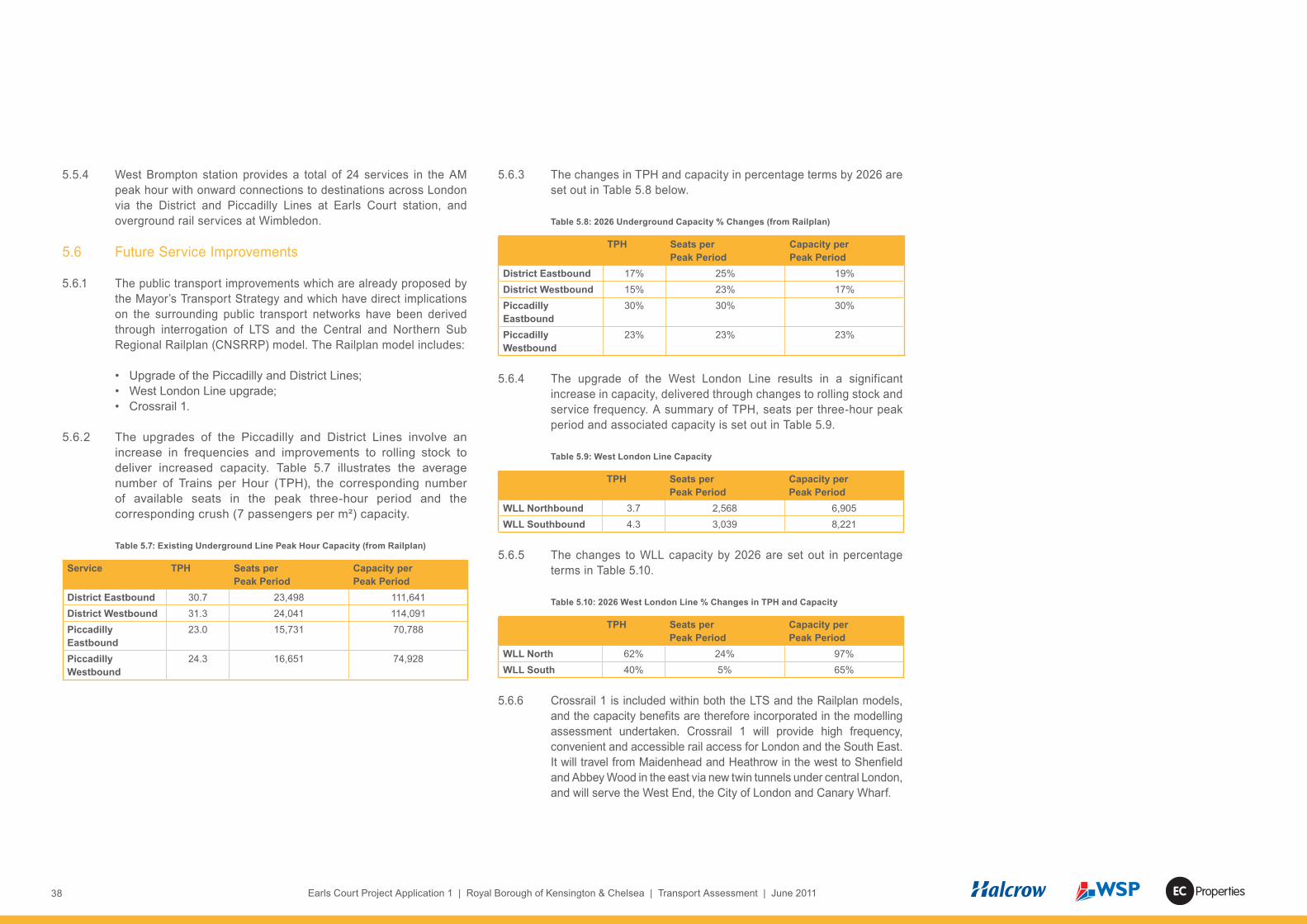
38 Earls Court Project Application 1 | Royal Borough of Kensington & Chelsea | Transport Assessment | June 2011 Properties
5.5.4 West Brompton station provides a total of 24 services in the AM peak hour with onward connections to destinations across London via the District and Piccadilly Lines at Earls Court station, and overground rail services at Wimbledon.
5.6 Future Service Improvements
5.6.1 The public transport improvements which are already proposed by the Mayor’s Transport Strategy and which have direct implications on the surrounding public transport networks have been derived through interrogation of LTS and the Central and Northern Sub Regional Railplan (CNSRRP) model. The Railplan model includes:
• Upgrade of the Piccadilly and District Lines;• West London Line upgrade; • Crossrail 1.
5.6.2 The upgrades of the Piccadilly and District Lines involve an increase in frequencies and improvements to rolling stock to deliver increased capacity. Table 5.7 illustrates the average number of Trains per Hour (TPH), the corresponding number of available seats in the peak three-hour period and the corresponding crush (7 passengers per m²) capacity.
Table 5.7: Existing Underground Line Peak Hour Capacity (from Railplan)
Service TPH Seats per Peak Period
Capacity per Peak Period
District Eastbound 30.7 23,498 111,641District Westbound 31.3 24,041 114,091Piccadilly Eastbound
23.0 15,731 70,788
Piccadilly Westbound
24.3 16,651 74,928
5.6.3 The changes in TPH and capacity in percentage terms by 2026 are set out in Table 5.8 below.
Table 5.8: 2026 Underground Capacity % Changes (from Railplan)
TPH Seats per Peak Period
Capacity per Peak Period
District Eastbound 17% 25% 19%District Westbound 15% 23% 17%Piccadilly Eastbound
30% 30% 30%
Piccadilly Westbound
23% 23% 23%
5.6.4 The upgrade of the West London Line results in a significant increase in capacity, delivered through changes to rolling stock and service frequency. A summary of TPH, seats per three-hour peak period and associated capacity is set out in Table 5.9.
Table 5.9: West London Line Capacity
TPH Seats per Peak Period
Capacity per Peak Period
WLL Northbound 3.7 2,568 6,905WLL Southbound 4.3 3,039 8,221
5.6.5 The changes to WLL capacity by 2026 are set out in percentage terms in Table 5.10.
Table 5.10: 2026 West London Line % Changes in TPH and Capacity
TPH Seats per Peak Period
Capacity per Peak Period
WLL North 62% 24% 97%WLL South 40% 5% 65%
5.6.6 Crossrail 1 is included within both the LTS and the Railplan models, and the capacity benefits are therefore incorporated in the modelling assessment undertaken. Crossrail 1 will provide high frequency, convenient and accessible rail access for London and the South East. It will travel from Maidenhead and Heathrow in the west to Shenfield and Abbey Wood in the east via new twin tunnels under central London, and will serve the West End, the City of London and Canary Wharf.

39Earls Court Project Application 1 | Royal Borough of Kensington & Chelsea | Transport Assessment | June 2011Properties
5.6.7 Its rolling stock will have capacity to carry more than 1500 passengers in each train during peak periods, and will reduce crowding on London’s transport network. Although Crossrail 1 will not pass through the immediate study area, its delivery will result in relief to, and increased available capacity on, nearby sections of the public transport networks such as the Piccadilly Line.
5.7 Rail Network Flows
5.7.1 Passenger flows are based on 2007 observed data from TfL for the underground network, and 2010 data for the overground rail network. Appendix I provides directional flows for each tube line and station entrance in detail for the AM and PM peaks.
5.7.2 The underground line flows show that the AM peak is the critical period, where the Fulham Broadway to Earls Court section of the District Line has a standing density above four passengers / sqm. All other sections of the underground network have lower passenger densities.
5.7.3 The West London Line flows peak between Kensington Olympia and Imperial Wharf stations in the southbound direction during the PM peak. Standing densities exceed four passengers / sqm between Kensington Olympia and Imperial Wharf stations northbound in the AM peak and southbound in the PM peak.
5.8 Rail Stations
5.8.1 The Application 1 site provides convenient access to Earls Court and West Brompton stations for underground services and West Brompton station for London Overground and Southern train services. Earls Court station has a disused pedestrian access via a tunnel from the Earls Court Exhibition Centre, which passes underneath Warwick Road.
5.8.2 The existing inbound and outbound passenger movements at each
station show the AM peak to be marginally busier than the PM peak, with Earls Court station having just over four times as many movements as West Brompton station, and just under four times as many movements as West Kensington station.
5.8.3 These base year flows have been used to assess each station’s operation during peak periods, as reported further in section 11.
5.9 Interchange Space Review
5.9.1 TfL’s “Interchange Best Practice Guidelines 2009” considers purpose-built “interchange facilities”, and “interchange zones” where interchange takes place in locations where few formal facilities exist. It describes interchange zones as often being gateways which provide an interface between public transport services and the surrounding area. The guidance sets out a Design and Evaluation Framework, based on the four themes of Efficiency, Usability, Understanding and Quality. Each theme has four principles, as follows :• Efficiency - Operations, Movement within an interchange facility,
Movement through the wider interchange zone, Sustainability• Usability - Accessibility, Safety and accident prevention,
Personal security, Protected environment• Understanding - Legibility, Permeability, Wayfinding, Service
information• Quality - Perception, Quality of built design, Urban realm, Sense
of place
5.9.2 Earls Court and West Brompton stations are interchange zones, and have been considered against the themes and principles set out in the TfL guidance as summarised below.
Earls Court Station
5.9.3 There are deficiencies in terms of “Movement through the wider

40 Earls Court Project Application 1 | Royal Borough of Kensington & Chelsea | Transport Assessment | June 2011 Properties
interchange zone”. On-site observations indicate that footways are congested at peak times due to the levels of pedestrian flow, and exacerbated by the guardrails and their ad hoc cycle parking. Street furniture for lighting, pedestrian signals and general signage also reduces the available width for pedestrians. This is no formal cycle parking at this location nor any dedicated taxi pick up or drop off facilities.
5.9.4 The interchange zone is also lacking in terms of “Legibility” and “Wayfinding”. The nearby street furniture could be rationalised and the directional signage for pedestrians could be improved.
West Brompton Station
5.9.5 The space in front of West Brompton station provides direct interchange opportunities for taxis and pick-up / drop-off, although there are other deficiencies in terms of “Movement through the wider interchange zone”. Guard railing constrains the adjacent footways and the pedestrian movements to the Lillie Bridge signalised crossing.
5.9.6 There are four Sheffield cycle stands directly outside of the station with a further three adjacent to the Lillie Bridge pedestrian crossing whereas the document “Cycle Parking Standards TfL Proposed Guidance” suggests that one cycle parking space per 200 entrants would be required.
5.9.7 The interchange zone is also lacking in terms of “Legibility” and “Wayfinding” as there is currently a lack of signage at West Brompton station to help passengers continue their journeys by foot.
5.9.8 The “Urban realm” immediately outside the station lacks quality frontage, with large advertising boards on both sides of carriageway.

41Earls Court Project Application 1 | Royal Borough of Kensington & Chelsea | Transport Assessment | June 2011Properties
6.1 Pedestrian Network
6.1.1 This section considers the existing pedestrian and cyclist networks, based on a number of site audits, which have been supplemented through detailed desktop analyses.
6.1.2 The study has included an overview of pedestrian and cyclist permeability; pedestrian and cyclist movement surveys; an audit of footway widths and cyclist facilities; and a Pedestrian Environment Review System (PERS) assessment using the standard TfL method to audit the quality of the pedestrian environment and public realm.
6.1.3 The pedestrian network and highway crossing points are shown on Figure 6.1. The pedestrian network largely follows the road network and, with the exception of routes across green spaces such as Brompton Cemetery, there are few dedicated pedestrian-only links in the surrounding area.
6.1.4 The site is currently impermeable as the Earls Court Exhibition Centre is gated and does not allow for general public access between Warwick Road and Old Brompton Road. East-west and north-south movements are affected by the West London Line and the District Line branches. Together these form a barrier to pedestrian and cycle permeability and to wider connections in the area. The West London Line is bridged by Lillie Road and the A4 but with no additional crossings in the 700m distance between these two bridges. As a result, the community around and west of North End Road is cut-off from the site and experiences severance due to the lack of pedestrian and cycle permeability to Earls Court station and town centre. Similarly, the District Line is bridged by Warwick Road and North End Road, but with no intermediate crossing in between, which causes severance between the Seagrave Road area and West Kensington north of the A4.
6.1.5 North of the site the principal barrier is the A4, which has a poor quality environment due to its traffic volumes, speed and width of carriageway. This section of the A4 provides crossing points only at the junctions with North End Road and Warwick Road which are 570 metres apart, although it is acknowledged that the current lack of accessible land uses on either side of the A4 currently means there is limited existing demand to cross the road between the North End Road and Warwick Road junctions.
6 Baseline Conditions – Walking & Cycling
Figure 6.1 The pedestrian network and highway crossing points
42 Earls Court Project Application 1 | Royal Borough of Kensington & Chelsea | Transport Assessment | June 2011 Properties
6.1.6 Warwick Road also forms a barrier to pedestrian and cyclist crossing movements due to the volume and speed of traffic, and its three-lane carriageway width. There are however four crossing points along the length of Warwick Road that in part reduce the barrier effect of the road and allow access from the site to Earls Court Station and Earls Court Road further east.
6.1.7 These movement barriers result in longer pedestrian and cyclist journeys, with local services and centres being severed from some of their surrounding communities.
6.2 Cycle Network
6.2.1 The existing London Cycle Network (LCN) around the site is also shown on Figure 6.1.
6.2.2 The LCN has a limited coverage around the site and there is limited direct east-west and north-south connectivity. A number of existing routes become fragmented in the immediate vicinity of the site or terminate at or close to the A4. A sign-posted route along Lillie Road and Old Brompton Road connects parts of Fulham to the west with South Kensington in the east. This is supported by advisory cycle lane carriageway markings along Lillie Road and Old Brompton Road before then continuing eastbound along Kempsford Gardens. There is no further on-carriageway cycle provision in the area.
6.2.3 The provision of the Mayor’s Cycle Superhighways will help to alleviate this lack of connectivity. Superhighway 9 (CS9) is proposed to run along Kensington High Street north of the Earls Court Site.
6.2.4 Cycle parking in the area is limited to small clusters, at the locations indicated on Figure 6.1. There are 3 to 4 stands in locations along Earls Court Road, at the junctions of Penywern Road and Old Brompton Road/ Redcliffe Gardens. A similar level is provided along Warwick Road, with Sheffield stands provided at both junctions with Nevern Square. Ad-hoc cycle parking also takes place along sections of pedestrian guard railing on Warwick Road, and in a number of other locations with street furniture.
6.2.5 The Application 1 site is on the western fringe of the Barclays Cycle Hire scheme, with an existing docking station located on Warwick Road
6.3 Existing Pedestrian and Cyclist Activity
6.3.1 WSP have obtained a number of pedestrian and cyclist counts. From this data it has been possible to identify where high pedestrian activity exists in the area, as shown in Figures 6.2 and 6.3. The highest levels of pedestrian movement occur around the Earls Court station access on Warwick Road. The next busiest areas are along Lillie Road and Old Brompton Road around West Brompton station. The AM peak flows are higher than the PM flows.
6.3.2 Existing cycle movements have been established from a number of fully classified traffic surveys, as summarised by Figures 6.4 and 6.5. This analysis indicates that Lillie Road and Old Brompton Road have the highest levels of cyclist activity, being more than double the flows on the next-busiest routes – North End Road and Warwick Road. The AM peak flows are higher than the PM flows.
6.3.3 Generally cycling levels in the area are relatively low. The lack of supporting infrastructure in terms of cycle parking and on-street infrastructure, and dominance of vehicular traffic on key links may contribute to this low base.
6.4 PERS Audit
6.4.1 A Pedestrian Environment Review System (PERS) assessment has been undertaken to assess the level of service and quality across the existing pedestrian network and public realm. The PERS Audit results are set out in Appendix J.
6.4.2 PERS is used to review the following aspects of the pedestrian environment: • Links – Any footway, footpath or highway. • Crossings – Any designated or undesignated crossing where a
pedestrian route intersects with a highway. • Routes – A way that links a trip origin and a trip destination, such
as home to work. Routes are made up of any number of links and crossings.
• Public Transport Waiting Areas (PTWAs) – Any designated area where people are required to wait in order to use public transport, such as bus and train stops.

43Earls Court Project Application 1 | Royal Borough of Kensington & Chelsea | Transport Assessment | June 2011Properties
• Interchange Spaces – The areas around and between public transport stops or termini. They allow travellers to change between transport modes. PERS is used to assess the external public interchange space only, not the interior.
• Public Spaces – These vary in size from small plazas to parks, used as part of a pedestrian’s route.
6.4.3 The audit was carried out in accordance with TfL’s ‘Pedestrian Environment Review System, Review Handbook Version 2, May 2006’ and the review forms provided in the PERS Handbook were used to assess each item.
6.4.4 The items which were reviewed included 21 links, 68 crossings, 12 public transport waiting areas (PTWA’s), six interchange spaces, two public spaces and five routes to key services and facilities. These are all itemised on Table 2.1 of Appendix J and the results are summarised below.
Links
6.4.5 All links were assessed as “positive overall” providing good quality surfacing and generally well maintained with dropped kerbs in appropriate locations. However, the audit results show a lack of signage and information provision along all the links. Improved pedestrian signage and ‘wayfinding’ would assist pedestrians.
6.4.6 Specific shortcomings around the Application 1 site, as identified by the audit are summarised below.
6.5 Earls Court Road
6.5.1 In some locations and despite the adequate overall footway widths, the usable footway width is restricted as a result of street furniture, “clutter”, and private premises signage.
Earls Court Station
6.5.2 A lack of provision of dropped kerbs, cracked or damaged footways
Figure 6.4
Figure 6.3

44 Earls Court Project Application 1 | Royal Borough of Kensington & Chelsea | Transport Assessment | June 2011 Properties
and poor surfacing reinstatements were observed in places along the footways.
6.5.3 Generally the footways have an acceptable width for the current level of pedestrians, but there are some pinch points as in the “Footway Widths” sub-section below.
A4 West Cromwell Road
6.5.4 The A4 West Cromwell Road is a heavily trafficked dual carriageway. The section east of Warwick Road has a more pleasant pedestrian environment with footways exceeding 2m in width and residential frontages along the link.
6.5.5 The section west of Warwick Road is dominated by high volumes of traffic and parapet walls / guard railing which limits pedestrian crossing opportunities and detract from the pedestrian environment.
Footway Widths
6.5.6 TfL’s PERS audit guidelines note that 2m is regarded as the desirable minimum footway width and this standard is sourced from the IHT Guidelines for Providing for Journeys on Foot (2000). Further and more recent guidance in TfL’s 2009 Streetscape Guidance report gives advice and information regarding footway width, layouts and the positioning of street furniture. Streetscape Guidance 2009 was originally put together for the Transport for London Road Network (TLRN), but its principles reflect good design practice for other London streets. While the footways generally meet the 2m minimum width, there are several sections which fall short of the Streetscape Guidance. These are highlighted on Figure 6.1.
6.5.7 The clear width of footways on Warwick Road is compromised by street furniture including guardrailing and signposts around Earls Court station.
6.5.8 The existing footway on the north side of Lillie Bridge is slightly
Figure 6.3

45Earls Court Project Application 1 | Royal Borough of Kensington & Chelsea | Transport Assessment | June 2011Properties
below standard at 1.9m wide, but the clear width is further reduced to only 1.3m due to the pedestrian guardrail and signal pole for the pedestrian crossing.
Crossings
6.5.9 All crossings were classed as ‘positive’ overall, meaning that the individual components each had a score between 0 and 3. However, even ‘positive’ crossings could still be improved to a higher standard so as to improve the pedestrian environment and public realm.
6.5.10 Generally, the arrangement of crossings on the strategic road corridors is to support the movement of vehicular traffic rather than to provide a high quality pedestrian environment. An example of this is the Warwick Road junction with the A4 where a dedicated left turn slip is provided from Warwick Road into the A4. This arrangement provides additional highway capacity but requires pedestrians to cross in two stages and wait on a pedestrian refuge island.
6.5.11 There are a number of crossings on the A4 West Cromwell Road where guardrailing constrains the movement of pedestrians. These are labelled C40 and C53 on the A4/ Warwick Road junction plus C52 and C56 at the A4 / North End Road junction.
6.5.12 The pedestrian crossing across Old Brompton Road / Lillie Road (C60) close to West Brompton Station lacks pedestrian storage capacity on the northern footway.
6.5.13 While the existing pedestrian crossings are adequate, these cause delay to pedestrians due to their crossing movements being staggered over two or three stages, with pedestrians having to wait on pedestrian refuge islands.
6.5.14 During the audit it was also noted that the surfacing of the crossing across the A4 West Cromwell Road to the west of its junction with Warwick Road is suffering from cracks and poor reinstatements in places which could represent potential trip hazards to pedestrians.
6.5.15 Provision for sensory and mobility impaired users is lacking at key strategic locations, and the deficiencies are summarised for each parameter in Table 6.1.
Table 6.1 Provision for sensory and mobility impaired users
Street Request Box
Tactile Info Audible Info
Rotating Cones
Redcliffe Gardens – north of Fulham Road
x x
Earls Court Road – north of Earls Court Road / Bramham Gardens / Earls Court Square junction
x x
Fulham Road – east of Finborough Road
x x
Old Brompton Road / Warwick Road
x x x
Lillie Road (Lillie Road Bridge)
x x
Warwick Road x
6.6 Pedestrian and Cyclist Accidents
6.6.1 Figure 6.2 shows the distribution of pedestrian accidents around the site.
6.6.2 There is a noticeable difference when comparing the numbers of accidents on Warwick Road with those on Earls Court Road, despite the similar traffic flows on each road. When reviewing the differences between the Warwick Road and Earls Court Road pedestrian accidents, it was noted that over half of the accidents along Earls Court Road involved pedestrians crossing the road away from any pedestrian crossing facilities. This may be related to the lengths of active retail frontages which result in a greater number of pedestrian crossing movements over an extended length of road.

46 Earls Court Project Application 1 | Royal Borough of Kensington & Chelsea | Transport Assessment | June 2011 Properties
6.6.3 12 pedestrian accidents have occurred along the relevant sections of Old Brompton Road and Warwick Road in the past three years. Eight of them (66%) occurred on or in the vicinity of designated crossing points.
6.6.4 Figure 6.7 shows the distribution of cyclist accidents around the site.
6.6.5 12 accidents involving cyclists have occurred along the relevant
Figure 6.7
sections of Old Brompton Road and Warwick Road in the past three years. More cyclist accidents have occurred on Old Brompton Road than Warwick Road, reflecting its higher usage by cyclists. It is therefore important that any highway improvements along Old Brompton Road should aim to improve cyclist safety.

47Earls Court Project Application 1 | Royal Borough of Kensington & Chelsea | Transport Assessment | June 2011Properties
7.1 Introduction
7.1.1 In order to assess the Development proposals, a trip generation methodology has been formulated and agreed with TfL, and is set out in Appendix K. Using this methodology a spreadsheet based trip generation model has been constructed and the forecast number of trips by mode has been calculated.
7.1.2 The spreadsheet model, which is also included in Appendix K has been used to forecast the likely number of trips that will be generated by each of the planning applications and takes account of the existing land uses. Given the scale of the development proposals and the variety of land uses proposed, where appropriate, methodologies have also been developed to account for internal trip making and linked trips.
7.1.3 This section of the report therefore provides a summary of trips generated by the RBKC Only Development Option. It should be noted that the network peak hours have been identified as 0800-0900 and 1700-1800, whereas the generated trip peak hours have been identified as 0800-0900 and 1730-1830. For the PM peak, adding the peak generated trips onto the network peak provides a robust assessment.
7.2 Development Trip Forecasts
7.2.1 The Development proposals for the RBKC Only Development Option are: • 1,016 Residential units • 1,057 jobs or 15,850m² of B1 floorspace• 210 hotel rooms / serviced apartments• 2,000m² of leisure uses• 550 m² of Community / Culture uses• 3,700 m² of retail uses
7.2.2 The application of the person trip rates contained in Appendix K have been agreed with TfL for all land uses shown above, and provides the gross number of person trips associated with the proposed development, as summarised by Table 7.1. It should be noted that the calculation at this stage takes no account of existing trips, internal or linked trips and any adjustments that are also set out in Appendix K.
Table 7.1: Person Trips by Land Use
Land Use AM Peak (0800-0900) PM Peak (1730-1830)In Out 2-way In Out 2-way
Residential 122 496 618 332 176 508Office 424 29 453 35 388 423Hotel / Serviced Apartments 40 84 123 87 65 152Leisure 16 8 24 45 36 81Community / Culture 16 8 0 0 0 0Retail 40 22 62 73 101 174Total 641 639 1280 573 766 1339
7.3 Existing trips
7.3.1 The existing non-event use of the Earls Court Exhibition Centre is included within all baseline surveys. Therefore, to ensure that these trips are not double-counted as part of the forecast demand, the net change needs to be derived.
7.3.2 For ease of calculation, transparency and consistency with the approach used by LTS within the ECTS, the net change in employment numbers has been applied when assessing the incremental travel demand. This uses the same method to calculate existing trips as has been used to calculate the new person trips, as summarised by Table 7.2.
7.3.3 The existing on site trip generating land uses are• 120 Jobs (Earls Court 1 and 2)• 100 Jobs (Clear Channel office, Cluny Mews)
Table 7.2: Calculated Existing All Land Use Person Trips –Earls Court 1 and 2
Land Use AM Peak PM PeakIN OUT 2-way IN OUT 2-way
Employment 48 3 51 4 44 47 48 3 51 4 44 47
7 Trip Generation

48 Earls Court Project Application 1 | Royal Borough of Kensington & Chelsea | Transport Assessment | June 2011 Properties
7.3.4 A number of Earls Court Exhibition Centre gate traffic surveys have previously been undertaken on non-event days and the traffic generation has been adjusted using these surveys to derive the net change in traffic flows.
7.3.5 The existing traffic surveyed at the Warwick Road and West Brompton forecourts are set out below in Table 7.3.
Table 7.3: Warwick and Brompton Gate Surveys (Non Event Day) PCUS
Gate AM Peak PM PeakIN OUT 2-way IN OUT 2-way
Warwick Road Gate 18 5 23 7 53 60Brompton Gate 47 23 69 17 31 48Total 64 28 92 24 84 108
7.4 Net Person Trips
7.4.1 The differences between the trips generated by the existing land uses and the generated trips are the net trips that will be new to the area. The net person trips by land uses are summarised in Table 7.4 below.
Table 7.4: Net Person Trips
Land Use AM Peak (0800-0900) PM Peak (1730-1830)IN OUT Total IN OUT Total
Residential 122 496 618 332 176 508Office 376 26 401 31 344 375Hotel 40 84 164 87 65 152Leisure 16 8 24 45 36 81Culture 0 0 0 0 0 0Retail 40 22 62 73 101 174Total 593 636 1229 569 722 1291
7.5 Mode Share
7.5.1 All person trips have been disaggregated by journey purpose and have then been further disaggregated by their main mode (the mode of travel used for the majority of that trip). The details of these calculations are contained in Appendix K.
7.5.2 As the initial or final journey stage public transport trips will involve walking between the site and the relevant bus stop or rail station, Main Mode and Final Mode (the mode used for the last leg of the trip) trips are assessed as part of the subsequent technical assessments.
7.5.3 The Development proposals only provide limited commuter parking and therefore the car driver mode share for the Business from Home journey purpose has been partly re-proportioned to other modes to ensure parking accumulation does not exceed supply. All other car driver mode shares are unadjusted due to the availability of visitor or short stay parking in the development and or wider area.

49Earls Court Project Application 1 | Royal Borough of Kensington & Chelsea | Transport Assessment | June 2011Properties
7.6 Net Additional Trips by Mode
7.6.1 The application of the mode share data provides the following net total trips shown in Table 7.5 by Main Mode which will be used for development impact testing (with the exception of pedestrian assessments, where the Final Mode demand is used).
Table 7.5: Forecast Trips by Main Mode
Mode AM Peak PM Peak
In Out In OutUnderground 223 261 484 200 251 451Train 10 8 18 0 29 29Bus, minibus or coach 89 30 119 36 90 126Taxi or minicab 16 13 29 16 22 39Driving a car or van -12 55 43 74 4 78Passenger in car or van 24 42 66 38 35 73Motorcycle 7 7 14 6 8 14Bicycle 17 30 46 12 15 27On Foot 149 155 305 132 192 324Other 6 3 9 2 5 8Total 485 511 1132 516 623 1139
7.6.2 Car Driver trips represent only some 4-7% of the total travel demand.
7.7 Servicing
7.7.1 Additional to the travel demand generated by new residents and workers within the development, account needs to be taken of the servicing trips that are likely to occur during the AM and PM peak hours.
7.7.2 The methodology used to calculate these trips is included in Appendix K and the summary trips relating to LGV and HGV vehicle types are shown in Table 7.6.
Table 7.6: Peak Hour Servicing trips
Mode AM Peak PM Peak
In Out In OutLGV 6 5 11 1 1 2HGV 13 7 20 2 1 3Total 19 12 33 3 2 5
7.7.3 These trips are included in the highway impact modelling to ensure that the full operational demands of the Development proposals are assessed.

50 Earls Court Project Application 1 | Royal Borough of Kensington & Chelsea | Transport Assessment | June 2011 Properties

51Earls Court Project Application 1 | Royal Borough of Kensington & Chelsea | Transport Assessment | June 2011Properties
8.1 Introduction
8.1.1 A detailed analysis of the demolition and construction phases was undertaken by Mace and Sir Robert McAlpine as part of the Environmental Statement construction chapter to provide a basis for assessing the potential impact on the highway network. The analysis includes the demolition and construction programme, predicted construction traffic flows, vehicle routing and access gate locations.
8.1.2 At an early stage in the construction planning process, analyses were undertaken to investigate the feasibility of using rail and water routes during the demolition and construction phases, in line with the London Freight Plan’s aims of reducing dependence on heavy road vehicles. These reports are attached as Appendix L, and their findings are summarised in the following sub-sections. An initial desktop study by Mace of water options established at an early stage that these would not have potential. Meanwhile, the rail options looked to have more potential and so they were studied in further technical detail by Halcrow.
8.2 Potential Use Of Rail
8.2.1 The use of rail to remove waste from the area has been examined by Halcrow, who considered a number of sites around the ECWKOA. However, none of these sites are considered viable / suitable.
8.2.2 The most promising site for development was London Underground’s (LU) Lillie Bridge depot. LU is not currently planning to vacate this site, and a significant amount of space is required by them for the continuing stabling of trains throughout the construction programme. The remaining area is too small for the development of a freight facility.
8.2.3 If LU did vacate the site there would still be a number of constraints to its use as a rail freight terminal:• access would be required via the West London Line (WLL) and
LU’s Kensington Olympia branch, requiring new infrastructure;• day to day operation of the site would be complex due to the
interaction of trains from the WLL with LU’s signalling systems;• the actual operational life of the siding would be short in relation to
the construction phasing of the development; and• construction will require cooperation with and legal agreements
between Network Rail, LU and the developer.
8.2.4 At best this option would save between two and four lorry movements per hour for four years.
8.2.5 Most of the demolition waste will require movement from the site in years 1 and 2 of the construction programme. With the construction of a rail freight facility taking at least two years, a siding would not be available until year 3 of the construction programme.
8.2.6 A second site near West Brompton station was also considered under the RBKC Only Development Option.
8.2.7 This site would be uneconomic to develop as alterations would be needed to Lillie Bridge and the concrete flooring under EC2 to enable a new freight siding at this location. The nature reserve at West Brompton station would also be removed to accommodate a new rail siding.
8.2.8 In year 3 the use of this site would save up to three lorry movements per hour but thereafter one per hour would be a typical saving. Due to the low number of lorry movements saved, this site was not investigated further.
8.2.9 Other off-site locations were considered but dismissed as these would not see a reduction in lorry movements and would result in double-handling.
8.3 Potential Use Of Water
8.3.1 A further possibility for complementary removal of waste and delivery of construction material is water, via the existing Blue Ribbon network of inland waterways and canals.
8 Demolition & Construction

52 Earls Court Project Application 1 | Royal Borough of Kensington & Chelsea | Transport Assessment | June 2011 Properties
8.3.2 Mace noted that the movement of materials by water could be a cost effective solution only for certain commodities such as aggregates, waste and recyclables, depending on:• the supply chain characteristics of the commodity; • the location of commodity sources and destinations;• infrastructure at transfer points;• the economic viability of moving by water to other modes; and • barge technology, dwell times and availability of transfer equipment.
8.3.3 Mace found that, whilst it could be a cost effective solution for future waste management by the waste authorities, the Blue Ribbon network is too far from the site (1.7 miles by road to the south and 3.7 miles by road to the north) for use during the construction phase. This meant that road transport would still be required. As a large part of road haulage costs are in the loading and unloading times, such double handling of materials is inefficient in terms of both time and energy. There are insufficient local docking points at the closest parts of the Blue Ribbon network and upgrading could be required at these docking points. In addition, water transport has tidal limitations, especially around the River Thames area with its large tidal range of 7 metres. Mace’s overall conclusion was that using the Blue Ribbon Network during the construction period did not make sense environmentally, commercially, and logistically.
8.4 Demolition & Construction Phasing
8.4.1 The demolition and construction activities for the RBKC Only Development Option have been planned for implementation during a 10 year deconstruction/demolition and construction programme, anticipated to commence sometime after the 2012 London Olympic Games.
8.5 Site traffic Access & Egress
8.5.1 The initial activities will include establishing secure access points with wheel cleaning facilities and access controls. Discussions will be held with RBKC, LBHF and TfL to agree approach routes to the site and the access locations. Following these discussions, detailed logistics plans will be developed as part of the Construction Environmental Management Plan. Meanwhile, the principles of construction access and management are set out in the Framework Construction Logistics Plan (Appendix M).
8.5.2 The options to access the demolition site include use of a new road in the areas of the site associated with the consented Northern Access Road. This new road would connect the existing Earls Court Exhibition Centre podium with Fenelon Place via the existing Tesco basement coach park (Gate 1 on Figure 8.1). Other entrances can be provided at West Brompton (Gate 2), Warwick Road (Gate 3) and Cluny Mews (Gate 4).
8.5.3 Initial analysis of the local routes for construction & demolition traffic shows that the A4 and the A40 to the north of the site would be the most suitable routes for the vast majority of vehicle movements. The approach to and egress from Gate 1 would be via the A4 and Fenelon Place and the existing Tesco basement coach park. This would provide a direct access from the north, avoiding the Earls Court One Way System and residential areas around the perimeter of the site.
8.5.4 Gate locations G1, G2, G3 and G4 will be maintained throughout the construction programme. To further minimise the likelihood of congestion, strict monitoring and control of vehicles entering, egressing and travelling across the site will be maintained. Delivery schedules will be produced to regulate deliveries and eliminate bottlenecks. A holding area close to the Heathrow/A4 corridor will be used to control the number of construction vehicles coming into the Earls Court area.
8.6 Road Vehicle Movements
8.6.1 The number of construction vehicles accessing the site during the programme has been calculated by Mace, based on the expected volumes of material to be removed during demolition and delivered during construction. It is forecast that vehicle movements would peak at 10 vehicle movements per hour (i.e. five in and five out : a delivery every 12 minutes) in Years 2 and 3.
8.6.2 It is anticipated that there will be 3 to 4 vehicular access gates in operation at this time. On this basis, the frequency will reduce to a delivery every 30 minutes per access gate.

53Earls Court Project Application 1 | Royal Borough of Kensington & Chelsea | Transport Assessment | June 2011Properties
8.6.3 In making these forecasts, Mace has given consideration to reducing the number of vehicle movements by:
• the possible reuse of circa 33% of the crushed concrete produced during deconstruction of EC1 and EC2;
• reuse of excavated material for filling (based on its suitability);• potential provision of an on-site soil hospital to remediate soil
on site (the current extent of contamination and remediation required is unknown at this point);
• potential provision of a mortar batching facility on site;• the use of reusable hoardings where they can be used in non-
aesthetic locations; and• the potential for the use of prefabrication techniques and modern
methods of construction where practical and viable to do so without compromising quality.
8.6.4 It is proposed that a construction stage Travel Plan will be devised. There will be a general policy of not providing any car parking on site and the site labour force will be encouraged to use public transport. Provision will be made for essential parking only and cycling will be encouraged with secure bicycle storage and shower facilities made available on site.
Figure 8.1

54 Earls Court Project Application 1 | Royal Borough of Kensington & Chelsea | Transport Assessment | June 2011 Properties

55Earls Court Project Application 1 | Royal Borough of Kensington & Chelsea | Transport Assessment | June 2011Properties
9.1 Traffic Flows
9.1.1 The number of vehicle movements generated by the RBKC Only Development Option was forecast in section 7 and is summarised below.
Table 9.1 Forecast Vehicular Trips
Mode AM Peak PM Peak
In Out 2 Way In Out 2 WayTaxi or Minicab 17 13 30 16 24 40Driving a car or van 52 83 135 98 88 186Servicing 16 10 26 3 3 6Total 85 106 191 117 115 232
9.1.2 These vehicle movements result from the completed development and are the “gross” traffic generation of the proposals, whereas the impact of the development needs to be assessed as a net change from the “no development” situation. The net change is calculated by taking account of traffic generated by the existing land uses, as shown in Table 9.2.
Table 9.2 Net Traffic Generation
Mode AM Peak PM Peak
In Out 2 Way In Out 2 WayTraffic Generation 85 106 191 117 115 232Existing Traffic 65 27 92 24 86 110Net Traffic 20 79 99 93 29 122
9.2 Assessment Method
9.2.1 The highway assessment method has been agreed with TfL and its full detail is contained in Appendix M.
9.2.2 As a simplified summary, the analysis of the existing situation has been based on surveyed traffic flows and the analysis of the 2021 scenarios is based on forecast traffic flows which were derived from the process described below.
9.2.3 Background traffic growth from the existing situation until 2021 has been established using TfL’s strategic LTS model version 6.2.2. The highway growth forecasts were then extracted and input into to TfL’s highway assignment model CLoHAM to establish the baseline traffic patterns in the 2021 Base case (with no development on the Earls Court Site) .
9.2.4 The net development traffic for 2021 was added to the 2021 Base model, and assigned onto the highway network using CLoHAM. The outputs were then used for a more detailed analysis using the VISSIM model which had been audited by TfL’s consultants during the Earls Court Transport Study.
9.3 Junction Analyses
9.3.1 The proposed accesses were modelled using PICADY (the standard software package for priority junctions) and the Warwick Road / Old Brompton Road and the A4 / Warwick Road junctions were modelled using LINSIG (the standard software package for signalised junctions).
9.3.2 The results of the Development tests are summarised in the following tables with full LINSIG and PICADY results in Appendix J.
9.3.3 When assessing the Site Wide Development Option, the Warwick Road / West Cromwell Road and Old Brompton Road / Finborough Road signalised junctions are analysed as part of the VISSIM network in the Appendix K cumulative impact assessment. For completeness, the site access PICADY analyses have been run using the turning movements from the VISSIM assessment of the 2031 Site Wide Development Option. The traffic flows for these analyses involve increased turning movements at each access, since they would serve also the Application 2 land uses, plus increased flows on Warwick Road and Lillie Road / Old Brompton Road. The AM and PM peak hour movements for the Site Wide Development Option are shown on Figure 9.2.
9.3.4 It should be noted that the Seagrave Road proposals would result in a small decrease in traffic entering and leaving the Seagrave Road car park site. Therefore, no separate cumulative assessment with the Seagrave Road proposals is presented, and the simplifying
9 Impacts – Road Network

56 Earls Court Project Application 1 | Royal Borough of Kensington & Chelsea | Transport Assessment | June 2011 Properties
assumption has been made that the Seagrave Road proposals result in zero net change in traffic flows.
9.4 Warwick Road Access
9.4.1 The access onto Warwick Road has only been modelled as a left-out as that is the only opposed movement given the one-way nature of Warwick Road. The signalised pedestrian crossing has been incorporated into the assessment and coded with on-site recorded signal data. The results of the PICADY analyses for this junction are shown in Table 9.3 and 9.4 for the AM and PM peaks respectively.
Table 9.3 Warwick Road Egress AM Peak
Approach The Development Site Wide Development OptionRatio of Flow to
CapacityMax Queue
Length (Vehs) Ratio of Flow to
CapacityMax Queue
Length (Vehs) W a r w i c k R o a d Northbound
0.626 2 0.678 2
Egress onto W a r w i c k Road
0.121 0 0.050 0
Table 9.4 Warwick Road Egress PM Peak
Approach The Development Site Wide Development OptionRatio of Flow to
CapacityMax Queue
Length (Vehs)Ratio of Flow to
CapacityMax Queue
Length (Vehs)W a r w i c k R o a d Northbound
0.605 2 0.608 2
Egress onto W a r w i c k Road
0.110 0 0.102 0
9.4.2 The results indicate that this junction will operate within capacity with a maximum queue of 2 cars being forecast during the AM peak period. This queue is located on the left and ahead movement on Warwick Road and is caused by the controlled crossing facility to the south of the access.
9.5 West Brompton Access
9.5.1 The proposed priority junction onto Old Brompton Road has also been assessed using PICADY. This junction provides for all movements, so the outbound and right turn inbound movements have to give way to other traffic and are considered for queuing and delay analysis.
9.5.2 The results of the PICADY analysis for this junction using the future traffic flows are shown in Table 9.4 and 9.5 for the AM and PM peak periods respectively.
Table 9.4 West Brompton Access AM Peak
Approach The Development Site Wide Development Option
Ratio of Flow to Capacity
Max Queue Length (Vehs)
Ratio of Flow to Capacity
Max Queue Length (Vehs)
Right turn In
0.00 0 0.00 0
Site Egress 0.176 0 0.084 0
Table 9.5 West Brompton Access PM Peak
Approach The Development Site Wide Development OptionRatio of Flow to
CapacityMax Queue
Length (Vehs) Ratio of Flow to
CapacityMax Queue
Length (Vehs) Right turn In
0.00 0 0.00 0
Site Egress 0.119 0 0.221 0
9.5.3 The results indicate that this junction will operate within capacity with no queues during either peak period.

57Earls Court Project Application 1 | Royal Borough of Kensington & Chelsea | Transport Assessment | June 2011Properties
Finborough Road/ Old Brompton Road
9.5.4 The Finborough Road and Old Brompton Road junction is a four arm signalised junction incorporating pedestrian facilities on each arm. Finborough Road is one-way northbound and forms part of the Earls Court One Way System.
9.5.5 The junction has been assessed using LINSIG software and its performance is set out in Tables 9.6 and 9.7 for the AM and PM peaks respectively.
Table 9.6 Finborough Road/ Old Brompton Road AM Peak
Link Number and Description
Existing Base Future Base The Development
DOS MMQ DOS MMQ DOS MMQ1 / 1 Finborough
Road – Left / Ahead
61.1 10.2 63.0 10.8 63.4 11.0
1 / 2 Finborough Road – Ahead
56.9 9.9 58.7 10.5 59.1 10.6
1 / 3 Finborough Road – Ahead Right
56.9 9.9 58.7 10.5 59.1 10.6
2 / 1 Old Brompton Road Eastbound - Ahead
39.5 8.2 43.3 8.8 43.3 8.8
2 / 2 Old Brompton Road Eastbound - Left
21.8 2.2 17.3 1.7 17.4 1.7
3 / 1 Old Brompton Road Westbound - Ahead / Right
60.8 10.1 62.8 10.4 63.4 10.5
Practical Reserve Capacity (%)
47.3 42.9 41.9
Total Delay over all Links (PCU/hr)
17.35 18.24 18.43
“DOS” = Degree of Saturation, a percentage of the available capacity which is taken up to accommodate the traffic flow“MMQ” is the average maximum queue, measured in standard car lengths.
9.5.6 Table 9.6 indicates that despite the addition of background growth up to 2021, the junction continues to operate within capacity during the AM peak period. However, some queuing is observed on Finborough Road (on all movements) and Old Brompton Road (ahead/right movement).
Table 9.7 Finborough Road/ Old Brompton Road PM Peak
Link Number and Description
Existing Base Future Base The Development
DOS MMQ DOS MMQ DOS MMQ1 / 1 Finborough Road
– Left / Ahead65.5 11.3 67.3 11.4 64.7 11.2
1 / 2 Finborough Road – Ahead
61.0 10.9 62.7 10.9 60.3 10.7
1 / 3 Finborough Road – Ahead Right
61.0 10.9 62.7 10.9 60.3 10.7

58 Earls Court Project Application 1 | Royal Borough of Kensington & Chelsea | Transport Assessment | June 2011 Properties
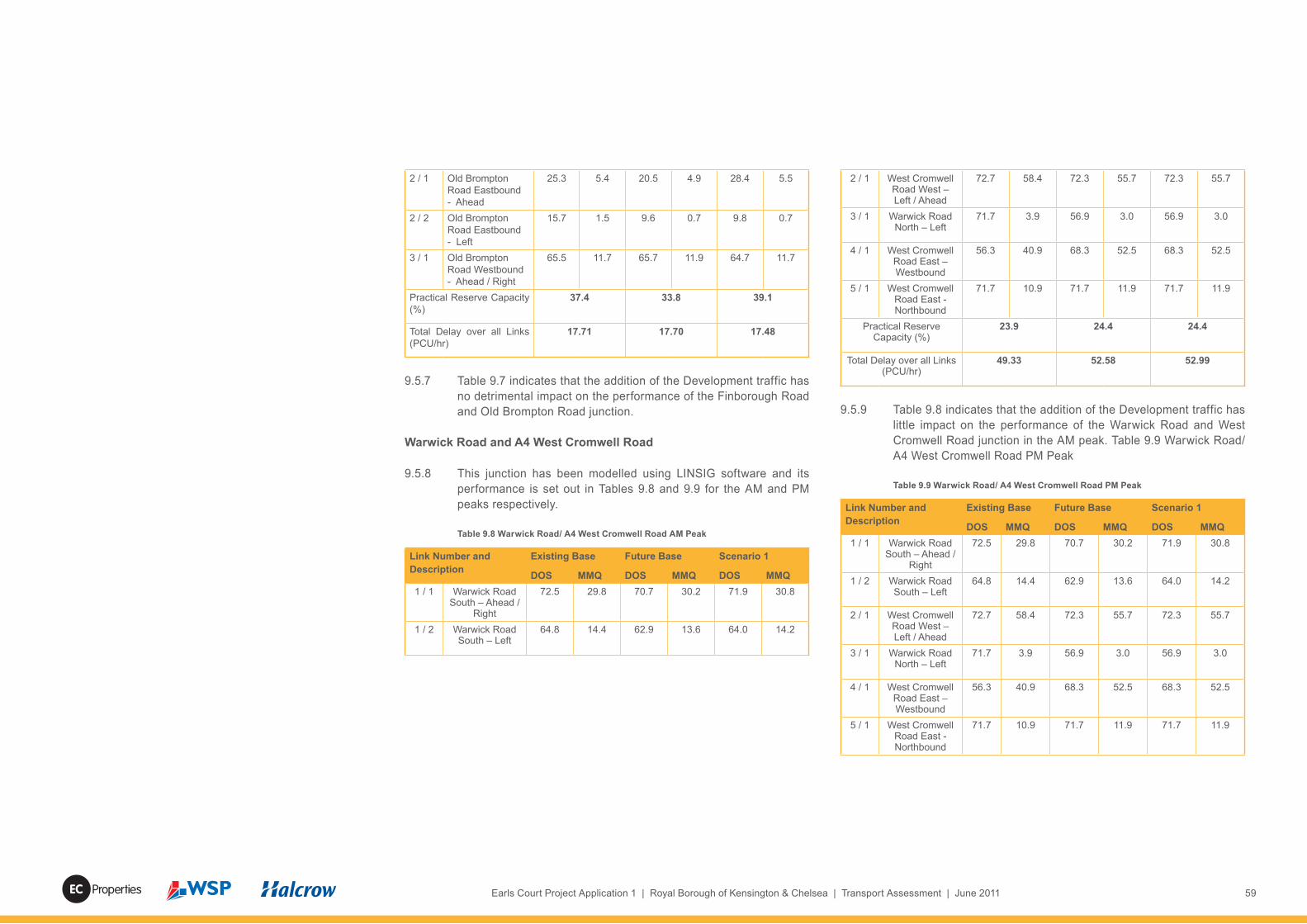
59Earls Court Project Application 1 | Royal Borough of Kensington & Chelsea | Transport Assessment | June 2011Properties
2 / 1 Old Brompton Road Eastbound - Ahead
25.3 5.4 20.5 4.9 28.4 5.5
2 / 2 Old Brompton Road Eastbound - Left
15.7 1.5 9.6 0.7 9.8 0.7
3 / 1 Old Brompton Road Westbound - Ahead / Right
65.5 11.7 65.7 11.9 64.7 11.7
Practical Reserve Capacity (%)
37.4 33.8 39.1
Total Delay over all Links (PCU/hr)
17.71 17.70 17.48
9.5.7 Table 9.7 indicates that the addition of the Development traffic has no detrimental impact on the performance of the Finborough Road and Old Brompton Road junction.
Warwick Road and A4 West Cromwell Road
9.5.8 This junction has been modelled using LINSIG software and its performance is set out in Tables 9.8 and 9.9 for the AM and PM peaks respectively.
Table 9.8 Warwick Road/ A4 West Cromwell Road AM Peak
Link Number and Description
Existing Base Future Base Scenario 1
DOS MMQ DOS MMQ DOS MMQ1 / 1 Warwick Road
South – Ahead / Right
72.5 29.8 70.7 30.2 71.9 30.8
1 / 2 Warwick Road South – Left
64.8 14.4 62.9 13.6 64.0 14.2
2 / 1 West Cromwell Road West – Left / Ahead
72.7 58.4 72.3 55.7 72.3 55.7
3 / 1 Warwick Road North – Left
71.7 3.9 56.9 3.0 56.9 3.0
4 / 1 West Cromwell Road East – Westbound
56.3 40.9 68.3 52.5 68.3 52.5
5 / 1 West Cromwell Road East - Northbound
71.7 10.9 71.7 11.9 71.7 11.9
Practical Reserve Capacity (%)
23.9 24.4 24.4
Total Delay over all Links (PCU/hr)
49.33 52.58 52.99
9.5.9 Table 9.8 indicates that the addition of the Development traffic has little impact on the performance of the Warwick Road and West Cromwell Road junction in the AM peak. Table 9.9 Warwick Road/ A4 West Cromwell Road PM Peak
Table 9.9 Warwick Road/ A4 West Cromwell Road PM Peak
Link Number and Description
Existing Base Future Base Scenario 1
DOS MMQ DOS MMQ DOS MMQ1 / 1 Warwick Road
South – Ahead / Right
72.5 29.8 70.7 30.2 71.9 30.8
1 / 2 Warwick Road South – Left
64.8 14.4 62.9 13.6 64.0 14.2
2 / 1 West Cromwell Road West – Left / Ahead
72.7 58.4 72.3 55.7 72.3 55.7
3 / 1 Warwick Road North – Left
71.7 3.9 56.9 3.0 56.9 3.0
4 / 1 West Cromwell Road East – Westbound
56.3 40.9 68.3 52.5 68.3 52.5
5 / 1 West Cromwell Road East - Northbound
71.7 10.9 71.7 11.9 71.7 11.9

60 Earls Court Project Application 1 | Royal Borough of Kensington & Chelsea | Transport Assessment | June 2011 Properties

61Earls Court Project Application 1 | Royal Borough of Kensington & Chelsea | Transport Assessment | June 2011Properties
10.1 Residential Parking
10.1.1 The modelling undertaken to date has utilised a residential parking ratio of 0.6 spaces per unit. This provision is based on the anticipated level of car ownership in the RBKC Only Development Option, so there should be no overspill residential parking on surrounding streets outside the Development site.
10.1.2 This situation will be re-enforced through the anticipated planning controls prohibiting future residents of the development from obtaining on-street residential parking permits.
10.1.3 The residential parking spaces will mostly be provided underground, so that residents are able to park without impacting on local car parking supply. Parking will be designed in detail on a plot by plot basis, based on the access positions shown on the parameter plan “Vehicular Access and Circulation”. The on-street parking locations and proposed designations are shown on Figure 1.3. This shows 84 residential parking spaces on the private streets.
10.1.4 Discussions with Streetcar, a Car Club operator which is active in RBKC, indicate a likely demand for three on-street spaces to be provided within the site. There is scope to vary this according to future Car Club demand levels.
10.1.5 In line with the Draft London Plan standards, 20% of parking spaces will be provided with active electric charging. A further 20% will have “passive” provision to allow for further expansion as electric vehicles become more prevalent. The adoption of these standards for the RBKC Only Development Option equates to 122 residential spaces having electric charging facilities with another 122 being passively prepared for adoption of the technology when demand is sufficient. In addition, 20% of the on-street spaces will be equipped for electric vehicle charging.
10.2 Commercial Parking
10.2.1 It is considered that the limited commercial car parking provided within the Development will serve as an effective measure to restrain commuter car trips. Excluding Blue Badge and on-street visitor parking, a total of 21 dedicated non-residential on-plot parking spaces will be provided across the site.
10.2.2 It is proposed to provide 18 on-street pay and display or Blue Badge spaces on adopted streets within the development.
10.3 Motor Cycle and Cycle Parking
10.3.1 On-plo t motorcycle parking will be provided at ratios of one space per 20 dwellings. Some of the on-street parking areas could be reserved for motorcycle use.
10.3.2 The London Plan residential cycle parking standard is one space per 1 or 2 bed unit and two spaces per 3 or more bed unit. This equates to a total of 1,311 on-plot spaces. Visitor cycle parking is proposed at a level of 0.1 spaces per dwelling equating to 102 visitor spaces to be provided on-street across the site. Non-residential cycle parking would be provided in accordance with London Plan cycle parking standards in a mixture of on-plot and on-street locations.
10.3.3 Parking Management Proposals
10.4 On-street parking will need to be controlled to ensure it is not mis-used. In particular measures will need to be taken, given the proximity to tube stations, to ensure that the Development is not used for commuter parking. This will necessitate the use of parking controls such as permits and pay and display parking, or similar.
10.4.1 It is proposed that an active and effective parking management strategy would be evolved to ensure demand does not exceed supply. Prospective residents and commercial occupiers would be made clear from the outset that there were constraints on parking and that an associated parking strategy would be in operation.
10.4.2 In terms of achieving the objectives of the parking strategy and ensuring dedicated residential spaces parking spaces are retained for, and only used by authorised users, the following mechanisms for the parking strategy are proposed:• pay and display spaces will be provided on street along the High Street• residential spaces to be located in private basements and in
designated on-street locations• Blue Badge parking will be provided at a ratio of 10% of the
overall number of spaces • electric vehicle charging will be available at 20% of the overall
number of spaces• on–site enforcement will be carried out by the Estate
Management Team.
10 Impacts – Parking

62 Earls Court Project Application 1 | Royal Borough of Kensington & Chelsea | Transport Assessment | June 2011 Properties

63Earls Court Project Application 1 | Royal Borough of Kensington & Chelsea | Transport Assessment | June 2011Properties
11 Impacts - Public Transport
11.1 Introduction
11.1.1 Table 7.5 summarises the net trip generation by bus, overground and underground rail. These demand forecasts were then run through the Railplan model to assign them onto the bus, underground, and overground rail networks. This method has been discussed and agreed with TfL through the pre-application process.
11.2 Forecast Changes In Bus Passenger Demand
11.2.1 It was agreed at the Scoping Study stage that the Transport Assessment would present the forecast changes in bus passenger numbers for each direction on each bus corridor, and their implications would be assessed by TfL Buses.
11.2.2 The following demand forecasts are for the bus corridors which will be subject to additional passenger demand in the 2021 Base scenario; the RBKC Only Development Option (Scenario 1); the RBKC Only Development Option and the Seagrave Road development (Scenario 2); the Site Wide Development Option (Scenario 3); and the Site Wide Development Option with the Seagrave Road development (Scenario 4).
11.2.3 The assessment considers changes against the Existing Base and the 2021 Base.
Table 11.1 AM Peak Period Bus Passengers (0700-1000)
Link Existing Base
2021 Base
Scenario 1
Scenario 2
Scenario 3
Scenario 4
Seats
Lillie Road EB
847 623 623 635 731 732 5850
Lillie Road WB
461 327 330 337 437 447 3351
Warwick Road
1602 1476 1494 1495 1601 1609 3786
Earls Court Road
1230 1122 1123 1123 1139 1141 3786
A4 East of Warwick
Road
762 697 701 712 771 779 1545
11.2.4 The results show that overall bus demand is forecast to fall between the Existing Base and the 2021 Base. This is due to TfL’s District Line, Piccadilly Line and West London Line service frequency improvements, which are forecast by Railplan to attract existing bus passengers onto the improved rail services. The reductions range between some 30% on Lillie Road to around 10% on the other corridors.
11.2.5 The addition of Scenarios 1 and 2 results in little change to the forecast bus passenger numbers.
11.2.6 The cumulative Scenarios 3 and 4 forecasts are higher due to their increased amount of development and further background growth to the 2031 assessment year. The overall 2031 demand levels are comparable to, or below, existing passenger numbers, and all well within the overall seating capacities in each case.
11.2.7 The impacts on the PM peak local bus network are set out in Table 11.2 As with the AM peak period, there is a drop in passenger numbers when compared to the Existing Base. Again, the addition of Scenarios 1 to 4 sees passenger numbers increase to levels which are comparable to, or below, existing passenger numbers and all well within the overall seating capacities in each case.
Table 11.2 PM Peak Period Bus Passengers (1600-1900)
Link Existing Base
2021 Base
Scenario 1
Scenario 2
Scenario 3
Scenario 4
Seats
Lillie Road EB
447 398 398 403 526 535 5811
Lillie Road WB
922 785 798 799 983 984 3312
Warwick Road
1670 1320 1332 1332 1369 1372 3285
Earls Court Road
1625 1422 1425 1396 1489 1472 3285
A4 East of Warwick
Road
452 428 428 433 462 463 1509

64 Earls Court Project Application 1 | Royal Borough of Kensington & Chelsea | Transport Assessment | June 2011 Properties
11.2.8 The implications of these changes in passenger numbers are to be assessed by TfL Buses, but these Railplan results suggest that the Development impact is minor.
11.2.9 It should be noted that the Railplan model split the total public transport trip generation from each development onto the bus, underground, and overground rail networks such that the bus demand was lower than the bus demand derived by section 7 of this report. The underground and overground rail demands are therefore higher, ensuring a robust assessment of those modes.
11.3 Impacts - Underground Line Capacity
11.3.1 Baseline conditions on the underground network have been described in Section 5.7. The Appendix I Railplan results provide details of the forecast levels of background growth in the 2021 Base scenario; the RBKC Only Development Option (Scenario 1); the RBKC Only Development Option and the Seagrave Road development (Scenario 2); the Site Wide Development Option (Scenario 3); and the Site Wide Development Option with the Seagrave Road development (Scenario 4).
11.3.2 The AM results illustrate that forecast growth without any development on the Earls Court Site between the Existing Base and the 2021 Base would not change the number of station-to-station links with more than four standing passengers / sqm. There would be minor increases of 0.2-0.3 passengers / sqm on some links (which equates to an average of between five and seven additional passengers per carriage).
11.3.3 Table 11.3 summarises the percentages of the network within different passenger standing density ranges during the AM peak hour.
Table 11.3 Underground Network Assessment – AM Peak Hour (0800-0900)
Existing 2021 Base
Scenario 1
Scenario 2
Scenario 3
Scenario 4
Some seats available
48.3% 46.6% 46.4% 46.6% 44.1% 44.1%
Some standing (0-1 /sqm)
13.9% 17.2% 17.2% 17.0% 15.2% 15.2%
Busy (1-2 / sqm)
13.7% 14.4% 14.4% 14.4% 13.7% 13.7%
Crowded (2-3 / / sqm)
10.8% 10.0% 10.0% 10.0% 11.8% 11.8%
Very Crowded (3-4 / sqm)
7.9% 7.8% 8.0% 8.0% 8.7% 8.7%
Maximal (4+ / sqm)
5.3% 4.1% 4.1% 4.1% 6.5% 6.5%
11.3.4 Overall the balance of links at different crowding levels in 2021 would be less than the existing situation despite a background growth in passenger numbers of 21%. This is due to the increases in capacity provided by the District and Piccadilly Line upgrades. The most crowded part of the 2021 Base local network is the District Line between Fulham Broadway and Earls Court, where standing densities of 4.5 passengers / sqm are forecast during the peak hour. These densities are generally tolerable for short durations.
11.3.5 The Scenario 1 and 2 standing densities are identical due to the relatively small additional demand from the Seagrave Road development. The RBKC Only Development Option (Scenario 1) would result in a negligible change compared to the 2021 Base.
11.3.6 The Scenario 3 and 4 results show overall crowding levels in 2031 similar to the existing situation despite a background growth in passenger numbers of 26%. This is again due to the increases in capacity provided by the District and Piccadilly Line upgrades. The most crowded part of the 2031 Base local network is the District Line between Fulham Broadway and Earls Court, where standing densities of 4.7 passengers / sqm are forecast during the peak hour. These densities are generally tolerable for short durations.
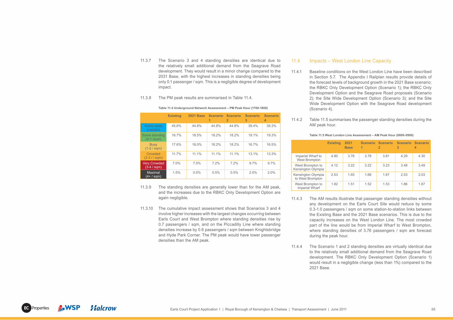
65Earls Court Project Application 1 | Royal Borough of Kensington & Chelsea | Transport Assessment | June 2011Properties
11.3.7 The Scenario 3 and 4 standing densities are identical due to the relatively small additional demand from the Seagrave Road development. They would result in a minor change compared to the 2031 Base, with the highest increases in standing densities being only 0.1 passenger / sqm. This is a negligible degree of development impact.
11.3.8 The PM peak results are summarised in Table 11.4.
Table 11.4 Underground Network Assessment – PM Peak Hour (1700-1800)
Existing 2021 Base Scenario 1
Scenario 2
Scenario 3
Scenario 4
Some seats available
45.6% 44.8% 44.8% 44.8% 39.4% 39.3%
Some standing (0-1 /sqm)
16.7% 18.5% 18.2% 18.2% 19.1% 19.3%
Busy (1-2 / sqm)
17.6% 18.0% 18.2% 18.2% 16.7% 16.5%
Crowded(2-3 / / sqm)
11.7% 11.1% 11.1% 11.1% 13.1% 13.3%
Very Crowded(3-4 / sqm)
7.0% 7.0% 7.2% 7.2% 9.7% 9.7%
Maximal(4+ / sqm)
1.5% 0.5% 0.5% 0.5% 2.0% 2.0%
11.3.9 The standing densities are generally lower than for the AM peak, and the increases due to the RBKC Only Development Option are again negligible.
11.3.10 The cumulative impact assessment shows that Scenarios 3 and 4 involve higher increases with the largest changes occurring between Earls Court and West Brompton where standing densities rise by 0.7 passengers / sqm, and on the Piccadilly Line where standing densities increase by 0.6 passengers / sqm between Knightsbridge and Hyde Park Corner. The PM peak would have lower passenger densities than the AM peak.
11.4 Impacts – West London Line Capacity
11.4.1 Baseline conditions on the West London Line have been described in Section 5.7. The Appendix I Railplan results provide details of the forecast levels of background growth in the 2021 Base scenario; the RBKC Only Development Option (Scenario 1); the RBKC Only Development Option and the Seagrave Road proposals (Scenario 2); the Site Wide Development Option (Scenario 3); and the Site Wide Development Option with the Seagrave Road development (Scenario 4).
11.4.2 Table 11.5 summarises the passenger standing densities during the AM peak hour.
Table 11.5 West London Line Assessment – AM Peak Hour (0800-0900)
Existing 2021 Base
Scenario 1
Scenario 2
Scenario 3
Scenario 4
Imperial Wharf to West Brompton
4.80 3.76 3.78 3.81 4.29 4.30
West Brompton to Kensington Olympia
4.12 3.22 3.22 3.23 3.48 3.49
Kensington Olympia to West Brompton
2.53 1.65 1.66 1.67 2.03 2.03
West Brompton to Imperial Wharf
1.82 1.51 1.52 1.53 1.86 1.87
11.4.3 The AM results illustrate that passenger standing densities without any development on the Earls Court Site would reduce by some 0.3-1.0 passengers / sqm on some station-to-station links between the Existing Base and the 2021 Base scenarios. This is due to the capacity increases on the West London Line. The most crowded part of the line would be from Imperial Wharf to West Brompton, where standing densities of 3.76 passengers / sqm are forecast during the peak hour.
11.4.4 The Scenario 1 and 2 standing densities are virtually identical due to the relatively small additional demand from the Seagrave Road development. The RBKC Only Development Option (Scenario 1) would result in a negligible change (less than 1%) compared to the 2021 Base.

66 Earls Court Project Application 1 | Royal Borough of Kensington & Chelsea | Transport Assessment | June 2011 Properties
11.4.5 The PM peak results are summarised in Table 11.6.
Table 11.6 West London Line Assessment – PM Peak Hour (1700-1800)
Existing 2021 Base
Scenario 1
Scenario 2
Scenario 3
Scenario 4
Imperial Wharf to West Brompton
3.30 1.64 1.65 1.65 2.13 2.13
West Brompton to Kensington Olympia
4.03 1.99 2.00 2.00 2.49 2.49
Kensington Olympia to West Brompton
5.34 3.81 3.80 3.84 4.14 4.17
West Brompton to Imperial Wharf
6.15 4.31 4.32 4.32 4.80 4.80
11.4.6 Comparing Tables 11.5 and 11.6, the PM standing densities are all higher than for the AM peak. The increases due to The RBKC Only Development Option are negligible.
11.4.7 For the cumulative impact Scenarios 3 and 4 in 2031 the future standing densities with development are all significantly less than the Existing Base due to the increased line capacity.
11.5 Impacts - Rail Stations
11.5.1 Background growth in passenger demand and the additional trips due to development scenarios will result in increased station entry and exit flows. These are presented below for each station in each peak period.
Table 11.7 Station Flows – AM Peak Period (0700-1000)
Existing 2021 Base
Scenario 1
Scenario 2
Scenario 3
Scenario 4
Underground PassengersEarls Court Entries 8,880 10,535 11,010 11,099 12,329 12,409Earls Court Exits 6,641 7,474 7,873 7,862 8,849 8,866Earls Court Totals 15,521 18,009 18,883 18,961 21,178 21,275
West Brompton Entries
767 1,001 1,001 1,139 1,515 1,648
West Brompton Exits 1,634 2,036 2,050 2,081 2,979 2,995West Brompton
Totals2,401 3,037 3,051 3,220 4,494 4,644
West London Line PassengersWest Brompton
Entries295 659 673 695 851 874
West Brompton Exits 723 1,090 1,109 1,130 1,481 1,488West Brompton
Totals1,018 1,749 1,781 1,826 2,332 2,362
11.8 Station Flows – PM Peak Period (1600-1900)
Existing 2021 Base
Scenario 1
Scenario 2
Scenario 3
Scenario 4
Underground PassengersEarls Court Entries 8,032 9,394 9,858 9,890 11,396 11,421Earls Court Exits 7,178 8,842 9,213 9,242 10,801 10,828Earls Court Totals 15,210 18,236 19,071 19,132 22,198 22,249
West Brompton Entries
1,082 1,607 1,605 1,648 2,644 2,663
West Brompton Exits 1,037 1,379 1,375 1,471 1,903 2,019West Brompton
Totals2,119 2,987 2,979 3,119 4,547 4,682
West London Line PassengersWest Brompton
Entries686 1,551 1,580 1,574 2,028 2,043
West Brompton Exits 297 1,029 1,027 1,092 1,240 1,288West Brompton Totals
983 2,580 2,607 2,666 3,268 3,331

67Earls Court Project Application 1 | Royal Borough of Kensington & Chelsea | Transport Assessment | June 2011Properties
11.5.2 At Earls Court station, the AM peak growth (without Development) between 2007 and 2021 is 16%. The RBKC Only Development Option would add an additional 5%. The PM peak growth between 2007 and 2021 is higher at 20%, and the RBKC Only Development Option would again add an additional 5%. The 2031 flows for the Site Wide Development Option show an additional 12% AM growth and 16% PM growth. In both peaks, the Seagrave Road development adds only a small increase (between Scenarios 1 and 2, and Scenarios 3 and 4).
11.5.3 At West Brompton station, the underground AM peak growth between 2007 and 2021 is 27%. RBKC Only Development Option would add an additional 6%. The PM peak growth between 2007 and 2021 is higher at 41%, and the RBKC Only Development Option would add a smaller increase of 4%. The 2031 flows for the Site Wide Development Option show an additional 47% AM growth and 53% PM growth. In both peaks, the Seagrave Road development adds only a small increase (between Scenarios 1 and 2, and Scenarios 3 and 4).
11.5.4 The West London Line entry and exit flows at West Brompton station show AM peak growth of some 70% between 2007 and 2021 and some 160% in the PM peak. The RBKC Only Development Option would then add just under 2% to the AM peak and 1% to the PM peak. The 2031 flows for the Site Wide Development Option show an additional 31% AM growth and 25% PM growth. The Seagrave Road development would add between 1- 2% more demand to each peak.
11.5.5 The most onerous cumulative assessment flows in 2031 have been analysed (using LEGION dynamic station capacity models approved by TfL) to establish the level of mitigation required for that case. A RBKC Only Development Option plus Seagrave Road development was then assessed for 2021 using “static” spreadsheet-based models (Appendix N). The 2021 assessment was used to establish whether the 2031 level of mitigation would need to be implemented for Scenarios 1 and 2 by 2021.
Earls Court – Scenarios 1 and 2 in 2021
11.5.6 The “static” spreadsheet-based assessment by Halcrow in Appendix P has been used to check on gateline capacity requirements with Scenarios 1 and 2, finding that the existing gateline configuration would still operate satisfactorily with those developments in 2021.
11.5.7 Planning Application 1 (the RBKC Only Development Option) proposes the re-commissioning of the pedestrian tunnel between Earls Court Exhibition Centre basement and the station. Although the static analyses suggest that the tunnel re-commissioning would not be required by 2021, it is part of the Development and would improve conditions at Earls Court station.
Earls Court – 2031 Cumulative Scenarios
11.5.8 The existing AM peak model shows queue levels which are at their highest at the tops of the stairs that lead down from the eastbound District Line platform to the mezzanine level. The 2031 Base and Scenarios 3 and 4 each show an increase from the existing pedestrian densities and queuing. These increases are focused on the western end of District Line platforms 1 and 2, and at the top of the Piccadilly Line escalator at the mezzanine level. Scenarios 3 and 4 do not generate any new areas of passenger congestion and queuing.
11.5.9 Overall, the PM peak shows less congestion. The model shows minimal queuing in the 2031 Base and Scenarios 3 and 4, with the exceptions of queuing for the lift up direction from the Piccadilly Line, which is considered acceptable.
11.5.10 In terms of mitigation proposals at Earls Court, the gatelines at both ticket halls will run with sufficient capacity. No ticket hall alterations will be required. The key constraint at this station is the interchange capacity between the Piccadilly Line and eastbound District Line platforms. The Applicant proposes the re-commissioning of the pedestrian tunnel entrance, accessed from the basement of the Earls Court Exhibition Centre. This proposal has been tested in LEGION (Appendix O) and shown to have a beneficial impact on

68 Earls Court Project Application 1 | Royal Borough of Kensington & Chelsea | Transport Assessment | June 2011 Properties
passenger densities by reducing the number of passengers using the eastbound District Line platforms as a route to the Piccadilly Line Platforms. Around half of the future entry and exit flows could use the tunnel in preference to the Warwick Road gateline.
11.5.11 The overall effect of the Development on Earls Court station would therefore be beneficial.
West Brompton – Scenarios 1 and 2 in 2021
11.5.12 The “static” spreadsheet-based assessment by Halcrow in Appendix P has been used to check on gateline capacity requirements with Scenarios 1 and 2, finding that the existing gateline configuration would still operate satisfactorily with the RBKC Only Development Option and the Seagrave Road proposals in 2021. The required number of gates does not increase between the 2007 assessment and 2021 Scenario assessments.
West Brompton– 2031 Cumulative Scenarios
11.5.13 In terms of passenger densities and queues within the station, the impact of Scenarios 3 and 4 is less than the impact of background growth between 2009 and 2031.
11.5.14 In the AM peak the highest passenger densities within the station are at the gateline and on the West London Line platforms. In these areas there would be no material increase in densities under Scenarios 3 and 4. However, queuing around the gateline would spread further and passenger densities on the West London Line northbound platform would increase slightly. Although densities at the base of the staircases would be high, each platform would be clear of alighting passengers prior to the next train arrival. Average journey times during the peak hour from platforms to the station exit would remain under two minutes in all scenarios. There would be no significant increase on the District Line platforms as a result of the increased demand.
11.5.15 During the PM peak the predominant flow would be entries as opposed to exiting passengers, and passenger densities on the unpaid side of the gateline would remain low. This is because the entries arrive in a less peaked profile. On the paid side of the
gateline, passenger densities would increase due to increased number of passengers exiting in Scenario 3 and 4 but would still be less than those in the AM peak. During the PM peak the impact of Scenario 3 and 4 on these platforms is shown to be minimal. However, there would be high passenger densities on the West London Line platforms as passengers wait to board. These higher densities also reflect the large amount of conflicting movements from passengers interchanging with the District Line as well as those exiting the station.
11.5.16 In terms of mitigating the net cumulative development impact at West Brompton, an additional ticket gate is proposed. The analysis with this mitigation shows relief in the AM peak with regards to queuing around the immediate gateline area. In the PM peak there is a consequent reduction in passenger densities at the gateline. The journey time analysis suggests that the relief brings journey times for exiting passengers broadly back in line with the 2031 Base situation. Average journey times from platforms to station exits remain below two minutes. In addition, the Applicant is helping TfL identify possible mitigation for background growth between 2009 and 2031, possibly including increased staircase widths and ticket hall reconfigurations.

69Earls Court Project Application 1 | Royal Borough of Kensington & Chelsea | Transport Assessment | June 2011Properties
12.1 Forecast Demand - Walking
12.1.1 The trip generation model forecasts the following changes in walking demand as a result of the RBKC Only Development Scenario. These numbers relate to walking as a main mode.
Table 12.1: Net Additional Main Mode Walk Trips
IN OUT 2-way
AM Peak Hour 141 154 296
PM Peak Hour 117 171 287
12.1.2 In addition to the demand generated by walking as a main mode, there will also be walking trips to and from stations and bus stops. The additional public transport trips generated are shown in Table 12.2.
Table 12.2: Net Additional Final Mode Walk Trips
IN OUT 2-way
AM Peak Hour 465 464 930
PM Peak Hour 357 511 868
12.1.3 These additional trips have been assessed for impacts on footway and crossing capacities.
12.2 Distributon Of Increased Pedestrian Demand
12.2.1 For assessment purposes, it has been assumed that pedestrian flows are distributed between the adjacent corridors of Lillie Road, Old Brompton Road and Warwick Road in accordance with current base flows. This assessment has been undertaken for the AM peak which is a worst case for both background flows and the RBKC Only Development Option demand.
12.2.2 The additional overground and underground rail trips are forecast to access West Brompton and Earls Court stations respectively and this demand is additional to the footways on the routes to each station. The station demand forecasts have been provided by Railplan before manual assignment to footways, using the
Appendix Q pedestrian model. The model has assigned trips to the most convenient routes to each station. To ensure robustness assignment has routed all Earls Court station passengers onto the Warwick Road surface level pedestrian crossing rather than splitting them between the crossing and the tunnel beneath Warwick Road.
12.2.3 The additional bus demand has been assigned to the pedestrian footways to allow access to the bus stops closest to each of the separate sites. Again the bus assignment by direction has been undertaken using Railplan before manual assignment to bus stops and associated footways.
12.2.4 Based on the method set out above, a summary of the distribution of all walk trips is shown in Figure 12.1.
12.2.5 In addition to the Figure 12.1 demand, there is also a forecast increase in base flows due to background growth and this has been calculated through the use of TfL’s LTS model where existing flows have been factored using TfL’s LTS growth factor for pedestrian movements. This additional increase relates to other committed or approved schemes in the area and potential modal shift to walking and cycling.
12.3 Footway Capacities
12.3.1 TfL’s Pedestrian Comfort Guidance for London (2010) has been used to assess implications on footway capacity. The guide allows for development proposals to be assessed and any potential problems identified at an early stage and mitigation developed if required.
12.3.2 The guide states that ‘the aim of a pedestrian comfort assessment is to understand the pedestrian experience as people walk along the street’. Therefore a number of different locations along a street are considered to establish the level of comfort, and how this may be impacted by footway constraints.
12.3.3 The guide allows for a Pedestrian Comfort Level (PCL) to be calculated for each location, which ensures that a review of the whole site as well as individual problem areas can be undertaken. The PCLs are defined as :
12 Impacts – Walking and Cycling

70 Earls Court Project Application 1 | Royal Borough of Kensington & Chelsea | Transport Assessment | June 2011 Properties
Table 12.3: PCL Definitions (ppmm = Pedestrians Per Metre Per Minute)
PCL A A+ <3ppmm
<3% Restricted MovementA 3 to 5 ppmm
13% Restricted MovementA- 6 to 8 ppmm
22% Restricted MovementPCL B
B+ 9 to 11ppmm31% Restricted Movement
B 12 to 14ppmm41%Restricted Movement
B- 15 to 17 ppmm50% Restricted Movement
PCL B+ is the recommended level of comfort for all area types. This level provides enough space for normal walking speed and some choice in routes taken. At PCL B and B- normal walking speed is still possible but conflicts are becoming more frequent and, in
retail areas, people start to consider avoiding that area.PCL C
C+ 18 to 20 ppmm59% Restricted Movement
C 21 to 23 pmm69% Restricted Movement
C- 24 to 26 ppmm78% Restricted Movement
The pedestrian environment is becoming increasingly uncomfortable, with the majority of people experiencing conflict or closeness with other pedestrians and bi-directional
movement becoming difficult.PCL D
27 to 35 ppmm100% Restricted Movement
At PCL D walking speeds are restricted and reduced and there are difficulties in bypassing slower pedestrians or moving in reverse flows.
PCL E>35ppmm
100% Restricted MovementAt PCL E people have very little personal space and speed and movement is very
restricted. Extreme difficulties are experienced if moving in reverse flows.
12.3.4 The guide requires a number of locations to be considered and these areas are classified as follows:• A location with the typical footway width for the site and no street
furniture • Locations where full footway width changes, and there is no
street furniture • Locations which include the typical street furniture • Locations where there are bus stops, cafes, market stalls or
other locations where there are high levels of people waiting.• Locations where the street furniture is not aligned parallel to the
building edge or kerb edge or there are more than two pieces within a length of three metres.
12.3.5 Applying this approach to the assessment has seen the following locations being identified for assessment: • Warwick Road North of crossing (western side); Bus Stop C• Warwick Road North of crossing (eastern side); Cycle Stands• Warwick Road South of crossing (western side); Signpost• Warwick Road South of crossing (eastern side); Cycle Stands• Old Brompton Road (southern side); Bus Stop O• Old Brompton Road (northern side); Bus Stop P• Old Brompton Road (southern side); Lamppost• Lillie Road west of crossing (northern side)• Lillie Road west of crossing (southern side)• North End Road (eastern side) opposite West Kensington Station
12.3.6 All of the above footway points are shown on Figure 12.2 and have been assessed, as summarised in Table 12.4. The full calculations are contained in Appendix P.
Table 12.4 PCL Assessment
Location Existing Base
2021 Base
Scenario 1
Width Required
Warwick Road North of crossing (western side); Bus Stop C
E E E 1.90
Warwick Road North of crossing (eastern side); Cycle Stands
E E E 1.70
Warwick Road South of crossing (western side); Signpost
A A A- -
Warwick Road South of crossing (eastern side); Cycle Stands
A A A -
Old Brompton Road (southern side); Bus Stop O)
E E E 1.90
Old Brompton Road (southern side); Lamppost
A+ A+ A+ -
Old Brompton Road (northern side); Bus Stop P
E E E 1.90
Lillie Road west of crossing (northern side)
E E E 1.90
Lillie Road west of crossing (southern side)
E E E 1.70
North End Road (eastern side) opposite West Kensington Station
E E E 1.90

71Earls Court Project Application 1 | Royal Borough of Kensington & Chelsea | Transport Assessment | June 2011Properties
12.3.7 Table 12.4 indicates that only three of the pinch points surveyed provide sufficient footway dimensions to achieve the minimum B+ rating. The other locations required widening to achieve the widths shown in Table 12.4, either by moving street furniture to increase the clear widths or by widening the footways. It should be noted that the North End Road pinch point would require further widening up to 3.16m for the Site Wide Development Option plus Seagrave Road development scenario, whereas the other pinch points would not require further widening.
12.4 Crossing Capacities
12.4.1 The forecast pedestrian crossing demands from the RBKC Only Development Scenario have been assessed for the Warwick Road pedestrian crossing to Earls Court station and the Old Brompton Road crossing to West Brompton station. Figure 12.1 shows these to be the most significant pedestrian desire lines.
12.4.2 According to Local Transport Note 2/95 “The Design of Pedestrian Crossings”, the minimum width (between the two rows of studs) for a Zebra, Pelican or Puffin pedestrian crossing should be 2.4 metres. If the crossing is of the Toucan type, or is used by a substantial number of cyclists on foot, the minimum width should ideally be 4 metres.
12.4.3 Where pedestrian flows over 600 per hour are encountered wider crossings should be used, up to have a maximum width of 10 metres for Pelican crossings. The Traffic Signs Manual (TSM) Chapter 5 recommends an additional width of 0.5m above the 2.4m minimum for each 125 pedestrians / hour above 600.
12.4.4 Tables 12.5 and 12.6 summarise the pedestrian crossing flows and the required crossing widths under each scenario.
Table 12.5 Warwick Road Crossing – TSM Assessment
Existing Base 2021 Base Scenario 1 Scenario 3Two-Way Flow (ped/hr) 542 582 1136 2136Width Required 2.4 2.4 4.9 8.5
Table 12.6 West Brompton Crossing – TSM Assessment
Existing Base 2021 Base Scenario 1 Scenario 3Two-Way Flow (ped/hr) 550 591 647 1786Width Required 2.4 2.4 2.9 7.1
12.4.5 The results suggest that the Old Brompton Road crossing would require widening to 7.1m from its current 3.0m width but that the Warwick Road crossing would not require widening above its existing 10m width (which is the limit of current standards for crossing widths).
12.4.6 As a further check, TfL’s Pedestrian Comfort Guidance for London (2010) has also been used. This guide can be used to calculate a Pedestrian Comfort Level (PCL) for each crossing, using a number of geometric and temporal inputs for pedestrian crossing widths.
Table 12.7 Warwick Road Crossing - PCL Assessment
Existing Base 2021 Base Scenario 1 Scenario 3Crossing A A A B+
12.4.7 The above assessment indicates that the crossing width would be satisfactory for the RBKC Only Development Option and the Site Wide Development Option. The Seagrave Road development has no impact on the Warwick Road crossing and a minimal impact on the West Brompton crossing, so the Scenario 2 and 4 results are the same as the Scenario 1 and 3 results respectively.
Table 12.8 West Brompton Crossing - PCL Assessment
Existing Base 2021 Base Scenario 1 Scenario 3Crossing A- A- A- C+

72 Earls Court Project Application 1 | Royal Borough of Kensington & Chelsea | Transport Assessment | June 2011 Properties
12.4.8 The above assessment indicates that the West Brompton crossing is more constrained and less able to accommodate increased demand than the Warwick Road crossing, due to its existing 3m width. PCL analysis indicates that this crossing provides a C+ PCL rating with Scenario 3 and would need to be increased to 5.2m in order to achieve the target B+ PCL rating.
12.4.9 It is proposed to increase the crossing width to 7.0m.
12.5 Forecast Demand - Cycling
12.5.1 The addition of RBKC Only Development Option demand will see cycle flows increase, as summarised by Table 12.9.
Table 12.9 Additional Cycle Trips
IN OUT 2-wayAM Peak Hour 17 30 46PM Peak Hour 12 15 27
12.5.2 The Replacement London Plan Draft Policy 6.9 sets out the intention to bring about a significant increase in cycling, so that it accounts for at least 5 per cent of modal share by 2026. The above forecasts equate to some 2-4% and a 5% modal share would involve some 60 additional cycling trips per hour.
12.5.3 There is no standard capacity assessment method for cycling and meanwhile a range of TfL and Borough initiatives are being progressed in order to encourage a significant increase. The Cycle Superhighways and other improvements to the cycle network will involve a change to the routing and distribution of future cycle trips, so a quantitative analysis of cycling impact is impractical.
The Development will incorporate extensive cycling facilities and it is proposed that financial contributions will be made towards cycling initiatives, as summarised in the “Mitigation” section.

73Earls Court Project Application 1 | Royal Borough of Kensington & Chelsea | Transport Assessment | June 2011Properties
13 Mitigation 13.1 Walking and Cycling
13.1.1 The RBKC Only Development Scenario has been shown to generate pedestrian demand on the Warwick Road crossing to Earls Court station and on the Old Brompton Road crossing to West Brompton station. It would also result in increased footway flows on Warwick Road and along Old Brompton Road / Lillie Road. The impacts of additional pedestrian demand on the Warwick Road / Old Brompton Road, Warwick Road / A4 and Lillie Road / North End Road junctions would all be minor. Similarly there would be little change in pedestrian flows along Earls Court Road and the A4.
13.1.2 Application 1 includes mitigation in the form of a new Toucan crossing and associated pedestrian and cyclist improvements on Warwick Road, and a new Toucan crossing plus widened footways on Old Brompton Road. These works are within the planning application boundary and it is proposed that they would be implemented as part of the consented proposals.
13.1.3 In terms of proposed mitigation which would be the subject of potential financial contributions rather than being implemented as part of a planning consent, the following elements have been identified :• a financial contribution towards off-site pedestrian improvements,
as part of a comprehensive public realm strategy for the surrounding area. This is envisaged to include improvements along Lillie Road, Old Brompton Road, Earls Court Road and Warwick Road by providing dropped kerbs and facilities to aid sensory and mobility impaired users, and the removal or rationalisation of unnecessary street furniture
• a financial contribution towards a wayfinding strategy for the local area, in accordance with Legible London guidelines
• a financial contribution towards off-site cyclist improvements. This is envisaged to include improvements to existing routes and the delivery of new routes at locations around the Application 1 site, such as Old Brompton Road, Trebovir Road and Penywern Road
• a financial contribution for the installation of two Barclays Cycle Hire stations within the Development
• a financial contribution for the installation of tactile and audible information for sensory impaired users at the Old Brompton Road / Warwick Road and A4 / Warwick Road junctions.
13.2 Public Transport
13.2.1 The RBKC Only Development Scenario has been shown to generate public transport demand on the bus network and on the underground and overground rail networks. It has been shown that the District, Circle, Piccadilly and West London Line services would all have sufficient capacity to carry the passenger demand. However, the nearby bus facilities require some improvement and there are opportunities to improve the interchange and public realm quality at the rail stations.
13.2.2 Application 1 provides a net benefit by proposing to re-open the entrance to Earls Court station which passes below Warwick Road in a tunnel from an entrance within the application site.
13.2.3 In terms of proposed mitigation which would be the subject of financial contributions rather than being implemented as part of a planning consent, the following potential elements have been identified :• interchange zone improvements at Earls Court and West
Brompton stations, to address the deficiencies identified in section 5.9. The detail of these improvements would need to be agreed with TfL and should be in accordance with the public realm strategies for each of the areas being considered
• A financial contribution for the improvement of three bus stops on Old Brompton Road, three on Warwick Road and three on Earls Court Road.
13.3 Highway Network
13.3.1 The junction capacity analyses in section 9 show that the proposed accesses would operate well within capacity during the peak periods and there would be negligible impact on the surrounding highway network due to the Application 1 proposals.
13.3.2 The Warwick Road / Old Brompton Road junction and the A4 / Warwick road junction have both been assessed in terms of highway capacity, finding that the RBKC Only Development Option would have minimal additional impact in the 2021 assessment year.

74 Earls Court Project Application 1 | Royal Borough of Kensington & Chelsea | Transport Assessment | June 2011 Properties
13.3.3 As part of this assessment, the 2021 traffic signal timings for the Base and the development options have been adjusted in order to improve the coordination and performance of the local highway network. This is consistent with the Mayor’s objective to smooth traffic flows (draft Replacement London Plan Policy 6.11). This optimisation of signal timings can be undertaken through Tfl’s SCOOT system, subject to agreement with TfL.
13.3.4 It is therefore concluded that measures to increase highway capacity are not required to mitigate the Application 1 impacts.
13.4 Framework Travel Plan
13.4.1 It was agreed with TfL during scoping discussions that a single Framework Travel Plan should be submitted with the planning applications. This has been prepared in draft using TfL’s guidance document “Travel Planning for New Development in London”, February 2011 and is in Appendix R.
13.4.2 The proposals which would be applicable to the RBKC Only Development Option are listed below, and divided into “Hard” and “Soft” measures. The Hard measures are those which have been designed into the proposals and involve the provision of built facilities, whereas the Soft measures are management proposals to support a Smarter Choices programme.
‘hard’ measures - SUSTAINABility through Design
13.4.3 In order to encourage sustainable travel patterns from the outset, a number of design principles have been incorporated into the development and these are set out below, avoiding duplication with the items specified earlier in this section. • Direct connections to existing cycle routes at the site perimeter• Provide space for Barclays Cycle Hire stations• Create two-way streets to encourage cycling• Provide a range of complementary land uses and facilities on
the site• Facilitate on-site changing, storage and showering for all
employment land uses to encourage cycling• Minimise commercial parking supply • Incorporate good quality public realm design for all areas
‘Soft’ Measures• Provide financial incentives for cycling through bike loans and
cycle vouchers• Consider car parking charges as part of a car park management
strategy• Provide on-site management to operate concierge facilities and
delivery management strategy• Extend / adapt the existing Controlled Parking Zone• Establish a Streetcar car club• Develop a Low Emission Vehicle Strategy• Produce a Travel Pack to ensure all prospective occupiers are
fully aware of their sustainable transport choices• Appoint a Travel Plan Coordinator (TPC)• Provide a personalised journey planning service to promote
sustainable transport choices to all occupiers.
13.5 Framework Delivery and Servicing Plan
13.5.1 It was agreed with TfL during scoping discussions that a single Framework Delivery and Servicing Plan should be submitted with the planning applications. This has been prepared in draft and is in Appendix N.
13.5.2 The Plan sets out a management strategy to encourage the efficient and sustainable movement of goods and deliveries and to reduce transport impacts associated with servicing. It has the following objectives:
• Demonstrate that goods and services can be delivered, and waste removed, in a safe, efficient and environmentally-friendly way;
• Identify deliveries that could be reduced, re-timed or even consolidated, particularly during busy periods;
• Improve the reliability of deliveries to the site; • Reduce the operating costs of building occupants and freight
companies; and • Reduce the impact of freight activity on local residents and the
environment.13.5.3 The proposals include the following draft measures and the
subsequent detailed proposals will be developed once the end users and onsite strategy elements and contracts are agreed :
75Earls Court Project Application 1 | Royal Borough of Kensington & Chelsea | Transport Assessment | June 2011Properties
• Servicing Restrictions • Security Measures • Secure Delivery Drop-off Facilities • Accommodating Special Deliveries • Freight Operator Recognition Scheme • Consolidation of Suppliers • Delivery Restrictions and Enforcement • Promotion of Freight Information Portal• Communication of Delivery Procedures • Workplace Servicing Booking / Management Strategy • Out of Hours Deliveries • Staff Training Requirements and Responsibilities • Waste Reduction, Storage and Removal Measures • Refuse Collection Procedures • Delivery and Collection Frequencies • Encouraging Deliveries by Sustainable Modes
13.6 Framework Construction Logistics Plan
13.6.1 It was agreed with TfL during scoping discussions that a single Framework Construction Logistics Plan should be submitted with the planning applications. This is in Appendix R.
13.6.2 The Plan sets out a management strategy to better manage all types of freight vehicle movement to and from the Earls Court construction sites. It has the following objectives: • Demonstrate that construction materials can be delivered, and
waste removed, in as safe, efficient and environmentally-friendly way as practicable;
• Identify deliveries that could be reduced, re-timed or even consolidated, particularly during peak periods;
• Help cut congestion on local roads;• Improve the reliability of deliveries to the site; and• Reduce freight operators’ fuel consumption.
13.6.3 The CLP objectives will be achieved through a set of proposed delivery and servicing management measures and initiatives to ensure that construction and servicing of the Earls Court Site can be carried out efficiently, minimising negative impacts upon the local highway network, residents and commercial occupiers within and surrounding the site, and the environment.
13.6.4 The proposed measures include:
• Parking – on-site parking for construction workers will be restricted as there will be a general policy of not providing any car parking on the site.
• Deliveries – all on-site construction deliveries will be pre-arranged and pre-booked as part of the efficient operation of construction work.
• Design - providing secure drop off facilities to reduce the number of failed trips and encourage out-of-hours deliveries;
• Procurement Strategy – contracting operators registered with a best practice scheme such as FORS;
• Operational Efficiency – agreeing core hours of construction;• Waste Management - reducing the amount of waste generated
and exported from the site and all principal and trade contractors will be required to produce a construction Site Waste Management Plan (SWMP) on a phase by phase basis;
• Traffic Management - the proposed construction vehicle access routes will be agreed with TfL, RBKC and LBHF; the routing will avoid using minor roads as far as possible and will specifically avoid residential roads adjoining the sites to ensure that delivery vehicles have minimal impact on surrounding roads;
• Pedestrian Routing – pedestrians will be kept separate from the deconstruction, demolition and construction activities at all times through rerouting pedestrian thoroughfares or providing temporary footpaths where required to be agreed with TfL, RBKC and LBHF;
• Construction Sustainability - phase specific CEMPs will be developed for the construction phases and will include a strategy for minimising carbon emissions; and
• Monitoring and Review – a programme of monitoring and review of construction activity to the site will be the responsibility of the principal contractor for each development of the full ECWKOA, and available to TfL, RBKC and LBHF upon request.

76 Earls Court Project Application 1 | Royal Borough of Kensington & Chelsea | Transport Assessment | June 2011 Properties

77Earls Court Project Application 1 | Royal Borough of Kensington & Chelsea | Transport Assessment | June 2011Properties
14.6.1 The On-Site Proposals
14.6.2 The proposals for the RBKC Only Development Option have been guided by a sustainable transport strategy, which is to be realised through a combination of design and management measures.
14.6.3 The site is currently impermeable as the Earls Court exhibition centre is gated and does not allow for general public access between Warwick Road and Old Brompton Road. The proposals address this by creating a permeable network of pedestrian and cyclist routes between Warwick Road and Old Brompton Road, and by facilitating a potential connection across the West London Line. This will improve connectivity and travel choices for the surrounding communities as well as for the new Development. The Development would provide a highly walkable environment, to be integrated with existing and improved walking and cycling routes to provide attractive and easy connections to and from the area.
14.6.4 It would encourage cycling by having a high standard of on-site cyclist facilities including convenient and secure cycle parking for all occupiers and visitors, plus showering, changing and storage areas for cycling gear in the workplaces. In addition, provision is being made for Barclays Cycle Hire stations to be established within the Development. It is concluded that this Development would be an exemplar project to establish a cycling culture.
14.6.5 The Development would include residential car parking in accordance with London Plan standards to match the anticipated level of car ownership, so that off-site parking pressures would not be generated on the surrounding Royal Borough of Kensington and Chelsea roads. Meanwhile, non-residential parking would be constrained as part of the strategy to reduce the amount of cars being attracted into the Development.
14.6.6 The on-site parking provision would meet the requirements of Blue Badge holders and provide for a Car Club to be established so that all occupiers had access to the shared use of pay-as-you-go vehicles. The viability of this Car Club has been confirmed by a Streetcar viability report. Streetcar already has 99 vehicles and over 5,800 members in RBKC, and has aspirations to introduce electric vehicles to its vehicle fleet.
14.6.7 Provision is also made for electric vehicle charging, with 20% of non-residential spaces and up to 40% of all residential parking spaces being able to facilitate electric vehicle charging. In addition, rapid charge points are proposed among the on-street parking spaces for the benefit of short stay visitors.
14.6.8 A management strategy has been developed to encourage the efficient and sustainable movement of goods and deliveries. This would reduce the transport impacts associated with servicing so that goods and services can be delivered, and waste removed, in as safe, efficient and environmentally-friendly way as practicable.
14.6.9 The proposed accesses involve the modification and improvement of the existing accesses from Warwick Road and Old Brompton Road. These provide safe and attractive access for pedestrians and cyclists. It is proposed that the adjacent road levels would be subtly raised to match the adjacent footways and to make the crossings as seamless as possible. The access proposals both involve modifying existing crossovers and reducing their width so that pedestrians benefit from an improved layout and more pedestrian space along the site frontage. The capacities of these access points have been assessed in relation to the forecast traffic flows from the RBKC Only Development Option, and for the Site Wide Development Option plus the Seagrave Road development. These, plus the surrounding road network, would accommodate the traffic demand satisfactorily.
14.6.10 The internal road layout has been designed in line with Manual for Streets principles, along with TfL’s Streetscape Guidance 2009 and RBKC’s Transport SPD. The Design Guidelines for the Development include details such that pedestrians and cyclists prioritised with permeable movement throughout the site encouraged by shared surface spaces with at-grade pedestrian crossings and routes. It is expected that the predominant desire for movement would be to Earls Court and West Brompton stations and the street configuration responds to these desire lines.
14.6.11 The access layouts and proposed highway alterations have been the subject of Stage 1 Road Safety Audits. The Safety Audit recommendations have been reviewed, and they can all be addressed as the access designs progress towards more detailed layouts.
14 Conclusions

78 Earls Court Project Application 1 | Royal Borough of Kensington & Chelsea | Transport Assessment | June 2011 Properties
14.6.12 Overall, it is concluded that the on-site proposals encourage sustainable travel patterns from the outset, and these would be reinforced through the Framework Travel Plan measures to encourage sustainable transport, and provide a basis for monitoring the actual movement patterns which result from the RBKC Only Development Option.
14.1 Road Network
14.1.1 The proposed accesses have been modelled using PICADY (the standard software package for priority junctions) and the Warwick Road / Old Brompton Road and the A4 / Warwick Road junctions have been modelled using LINSIG (the standard software package for signalised junctions).
14.1.2 The PICADY results indicate that the Warwick Road and West Brompton accesses will operate well within capacity with the Development and its cumulative scenarios, with a maximum queue of only two cars waiting to join Warwick Road and no queues forecast at the West Brompton access.
14.1.3 The LINSIG results show that the A4 / Warwick Road and the Warwick Road / Old Brompton Road junctions would also have capacity to accommodate the Development.
14.2 London Underground
14.2.1 The Development has good access to Earls Court and West Brompton stations. Earls Court provides a total of 78 services per hour across the District and Piccadilly Lines which provide access across London including Richmond, Westminster Heathrow, Ealing Broadway and Uxbridge. West Brompton station provides a total of 24 services in the peak hour with onward connections to destinations across London via the District and Piccadilly Lines at Earls Court station, and overground rail services at Wimbledon.
14.2.2 The Piccadilly and District Lines are to be upgraded in line with the Mayor’s Transport Strategy and this will involve increased train frequencies and improvements to rolling stock to deliver passenger capacity increases of up to 19% on the District Line and 30% on the Piccadilly Line.
14.2.3 The implications of these improvements, future background growth in passenger numbers, and the implications of the Development plus the cumulative impact scenarios have all been studied using TfL’s Railplan model. The key performance indicator for assessing the capacity of underground trains is the density of standing passengers on each section of line between stations.
14.2.4 In the existing situation the AM peak is the busiest period, when the Fulham Broadway to Earls Court section of the District Line has a standing density above 4 passengers / sqm.
14.2.5 In terms of background growth until 2021 without the Development, the Railplan model shows there would be minor increases of 0.2-0.3 passengers / sqm on some links, including Fulham Broadway to Earls Court, which equates to an average of five to seven additional passengers per carriage. Overall the passenger densities in 2021 would be less than the existing situation despite background growth of 21%. This is due to the increases in capacity provided by the District and Piccadilly Line upgrades.
14.2.6 Adding the Development demand on top of the 2021 background growth would result in a negligible increase on the Piccadilly and District Lines.
14.2.7 In addition to analysing the underground line capacities using Railplan, the assessment has considered the impact of passenger growth on Earls Court and West Brompton stations.
14.2.8 At Earls Court station, the AM peak background growth between 2007 and 2021 is 16%. The Development would add an additional 5%. The PM peak growth between 2007 and 2021 is higher at 20%, and the Development would again add an additional 5%.
14.2.9 At West Brompton station, the overall increases in underground plus West London Line passenger entry and exit flows are much higher due in particular to forecast background growth on the West London Line. The back ground growth by 2021 is forecast to be 40% AM and 79% PM. The Development would add around 1% to both peaks, and the Seagrave Road proposals would add roughly 4% more demand.
79Earls Court Project Application 1 | Royal Borough of Kensington & Chelsea | Transport Assessment | June 2011Properties
14.2.10 These passenger flow changes have all been analysed using station capacity models approved by TfL.
14.2.11 At Earls Court station, the Development would not generate create any new areas of passenger congestion and queuing. The key existing constraint at this station is the interchange capacity between the Piccadilly Line and eastbound District Line platforms. Application 1 proposes the re-commissioning of the pedestrian tunnel from the basement of the Earls Court Exhibition Centre. This proposal would have a beneficial impact on passenger densities by reducing the number of passengers using the eastbound District Line platforms as a route to the Piccadilly Line platforms.
14.2.12 At West Brompton station, the impact of the Development would be minimal in terms of passenger densities and queues within the station, and would not require mitigation.
14.3 Overground Rail
14.3.1 The Development has good access to West London Line services at West Brompton station, where London Overground and Southern Trains run approximately 10 two-way mainline trains per hour (six London Overground and four Southern) in the peak.
14.3.2 The West London Line upgrade is being implemented and results in peak capacity increases of 97% northbound and 65% southbound, delivered through changes to rolling stock and service frequency.
14.3.3 The Railplan AM results illustrate that passenger standing densities without any development on the Earls Court Site between the Existing Base and the 2021 Base would reduce by some 0.3-1.0 passengers / sqm on some station-to-station links despite background growth of between 68% and 97%.
14.3.4 Adding the Development demand on top of the 2021 background growth would result in a negligible change compared to the 2021 Base.
14.4 Buses
14.4.1 As agreed with TfL at the Scoping Study stage, the Transport Assessment has presented forecast changes in bus passenger numbers for each direction on each bus corridor.
14.4.2 The results show that overall bus demand is forecast to fall between the Existing Base and the 2021 Base due to TfL’s District Line, Piccadilly Line and West London Line service frequency improvements.
14.4.3 The Development results in little change to the forecast bus passenger numbers. The implications of these changes in passenger numbers are to be assessed by TfL Buses, taking account of peaks in demand above the average peak period conditions which can occur due to service disruption and other operational factors. However, it is clear from these results that the development impact is minor.
14.4.4 This Transport Assessment has included audits of bus stops on all bus routes within walking distance of the site, and this has found a range of existing deficiencies which require some improvement. A financial contribution is therefore proposed for the improvement of three bus stops on Old Brompton Road, three on Warwick Road and three on Earls Court Road.
14.5 Walking
14.5.1 The site is currently impermeable as the Earls Court Exhibition Centre is gated and does not allow for general public access between Warwick Road and Old Brompton Road. The proposals address this by creating a permeable network of pedestrian and cyclist routes between Warwick Road and Old Brompton Road, and by facilitating a subsequent connection across the West London Line. This will improve connectivity and travel choices for the surrounding communities as well as for the new Development. The Development would provide a highly walkable environment, to be integrated with existing and improved walking and cycling routes to provide attractive and easy connections to and from the area.

80 Earls Court Project Application 1 | Royal Borough of Kensington & Chelsea | Transport Assessment | June 2011 Properties
14.5.2 Surveys of the existing situation confirm that the highest levels of pedestrian movement occur around the Earls Court station accesses on Earls Court Road and Warwick Road. The next busiest areas are along the A4, North End Road, and around West Brompton station.
14.5.3 An audit of the pedestrian environment quality using TfL software showed a lack of signage and information provision along all the links, together with some sub-standard surfacing and lack of dropped kerb and other facilities. The clear widths of existing footways were found to be compromised on Warwick Road around Earls Court station by street furniture including guardrailing and signposts, and on Lillie Bridge due to pedestrian guardrails and signal poles.
14.5.4 The number of future pedestrian movements due to background growth and due to each development scenario were calculated and assigned to the pedestrian network. This included for all the pedestrians who would be walking to the surrounding stations and bus stops to access public transport services. TfL’s Pedestrian Comfort Guidance for London (2010) was then used to assess implications on footway capacity. The guide allows for development proposals to be assessed and any potential problems identified at an early stage and mitigation developed if required.
14.5.5 Footway capacities were assessed for each development scenario and improvements are proposed on Warwick Road, Old Brompton Road and Lillie Road.
14.5.6 Detailed pedestrian crossing capacity assessments were carried out at the Warwick Road and Old Brompton Road crossings, finding that the existing 10m width of the Warwick Road crossing would be satisfactory and that the West Brompton crossing should be widened to 7m.
14.5.7 The Development includes mitigation in the form of a new Toucan or pedestrian crossing and associated pedestrian and cyclist improvements on Warwick Road and a new Toucan or pedestrian crossing plus widened footways on Old Brompton Road. These works are within the planning application boundary and it is proposed that they would be implemented as part of the consented proposals.
14.5.8 In terms of proposed mitigation which would be the subject of potential financial contributions rather than being implemented as part of a planning consent, and these would be directed towards off-site pedestrian improvements, as part of a comprehensive public realm strategy for the surrounding area; a wayfinding strategy for the local area in accordance with Legible London guidelines; and the installation of tactile and audible information for sensory impaired users at the Old Brompton Road / Warwick Road and A4 / Warwick Road junctions
14.5.9 Cycling
14.5.10 At present, the London Cycle Network has limited coverage in the surrounding area. The sign-posted route along Lillie Road and Old Brompton Road has advisory cycle lane carriageway markings and there is no further formal on-carriageway cycle provision in the area. The provision of the Mayor’s Cycle Superhighways will help to alleviate this lack of connectivity. Superhighway 9 (proposed to run along Kensington High Street north of the site.
14.5.11 Cycle parking in the area is limited to small clusters along Earls Court Road, at the junctions of Penywern Road and Old Brompton Road/ Redcliffe Gardens. A similar level is provided along Warwick Road, with Sheffield stands provided at both junctions with Nevern Square. Ad-hoc cycle parking also takes place along sections of pedestrian guard railing on Warwick Road, and in a number of other locations with street furniture. The Application 1 site is on the western fringe of the Barclays Cycle Hire scheme, with an existing docking station located on Warwick Road.
14.5.12 The Development is forecast to contribute to the Mayor’s target for cycling to reach a 5% share of all journeys by 2026 and this would involve some 60 additional cycling trips per hour.
14.5.13 A range of TfL and Borough initiatives are being progressed in order to encourage a significant increase. The Cycle Superhighways and other improvements to the cycle network will involve a change to the routing and distribution of future cycle trips.
14.5.14 The Development would encourage cycling by having a high standard of on-site cyclist facilities including convenient and
81Earls Court Project Application 1 | Royal Borough of Kensington & Chelsea | Transport Assessment | June 2011Properties
secure cycle parking for all occupiers and visitors, plus showering, changing and storage areas for cycling gear in the workplaces. In addition, provision is being made for Barclays Cycle Hire stations to be established within the Development. It is concluded that this Development would be an exemplar project to establish a cycling culture.
14.5.15 This would be further supported by potential financial contributions towards off-site cyclist improvements. This is envisaged to include improvements to existing routes and the delivery of new routes at locations around the site, such as Old Brompton Road, Trebovir Road and Penywern Road.
14.5.16 Policy Compliance
14.5.17 The degree of policy compliance has been assessed relative to the transport and development policies summarised in section 2 at National, London and Borough levels.
14.5.18 In terms of strategic policies, the Development proposals have been shown to promote sustainable transport choices and this is reflected in the low car driver mode shares of only 4-7% as forecast by section 7.6 (PPG13 “Transport”; PPS3 “Housing”; PPS4 “Planning for Sustainable Economic Growth”; PPG12 “Local Spatial Planning; London Plan Policy 3C.1 and Replacement London Plan Draft Policy 6.1).
14.5.19 The land use mix and the Development’s location among a range of complementary land uses reduce the need to travel, especially by car (PPG13 “Transport”; PPS3 “Housing”; PPS4 “Planning for Sustainable Economic Growth”; PPG12 “Local Spatial Planning; London Plan Policy 3C.3 and Replacement London Plan Draft Policy 6.1).
14.5.20 The Development integrates transport and development by providing homes, employment and complementary land uses at a location which is well-served by buses, underground and overground rail services, and where further improvements are planned (PPG13 “Transport”; PPS3 “Housing”; PPS4 “Planning for Sustainable Economic Growth”; PPG12 “Local Spatial Planning; London Plan Policy 3C.1 and Replacement London Plan Draft Policies 6.1 and 6.4).
14.5.21 The Development proposals have been developed with the Earls Court and West Kensington Opportunity Area draft Supplementary Planning Document in mind, as informed by the Earls Court Transport Study (ECTS). The ECTS approach has been to match development to transport capacity and this has been followed-through in this Transport Assessment whereby the capacity of all transport modes has been considered and proposed for enhancement where required. In this respect the proposals therefore comply with London Plan Policies 3C.1, 3C.2 and 3C.3; with Replacement London Plan Draft Policies 6.1, 6.3 and 6.4; and with RBKC Core Strategy Policy CT1.
14.5.22 The proposals include an extensive range of measures which have been designed-in or are the subject of proposed commitments through the Framework Travel Plan to encourage sustainable travel. They also include access commitments between the site and the surrounding area, including Earls Court town centre, thereby conforming to London Plan Policy 3C.3 and RBKC Core Strategy Policy CO3.
14.5.23 Turning to more detailed policy requirements, the Development proposals accord with London Plan Policy 3C.20; Replacement London Plan Draft Policy 6.7; and RBKC Core Strategy Policy CT1 by assessing the quality of the surrounding bus network, auditing the nearby bus stops and then making provisions for potential financial contributions to implement TfL’s Accessible Bus Stop Design Guidance.
14.5.24 The Development proposals improve the walking environment by creating an attractive and permeable link between Warwick Road at Earls Court station and Old Brompton Road at West Brompton station; by improving crossing points; widening footways; and proposing contributions for improving the wider public realm and introducing a wayfinding strategy. These proposals ensure compliance with the requirements of London Plan Policy 3C.21; Replacement London Plan Draft Policy 6.9; and RBKC Core Strategy Policy CT1.
14.5.25 The Development encourages cycling by the high standard of on-site cyclist facilities including convenient and secure cycle parking for all occupiers and visitors, plus showering, changing and storage areas. In addition, provision is being made for Barclays Cycle Hire

82 Earls Court Project Application 1 | Royal Borough of Kensington & Chelsea | Transport Assessment | June 2011 Properties
stations to be established within the Development and for financial contributions towards off-site cyclist improvements to existing routes and the delivery of new routes around the site. Together, these proposals ensure compliance with the requirements of London Plan Policy 3C.22; Replacement London Plan Draft Policy 6.10; and RBKC Core Strategy Policies CT1 and CR4.
14.5.26 The parking proposals involve a balance between providing for the anticipated level of residential car ownership to avoid off-site parking impacts while still encouraging the use of sustainable transport. Non-residential parking is constrained as part of the strategy to reduce the amount of cars being attracted into the development. All of the parking proposals comply with published car parking standards and provide for Blue Badge holders, electric vehicle charging and a Car Club. The proposals therefore comply with the requirements of London Plan Policy 3C.23; Replacement London Plan Draft Policy 6.13; and RBKC Core Strategy Policy CT1.
14.5.27 The proposals provide for all servicing, deliveries and refuse collection to take place away from the public highway, and to be controlled through a Delivery and Servicing Plan in line with TfL requirements. The Plan sets out a management strategy so that goods and services can be delivered, and waste removed, in a safe, efficient and environmentally-friendly way. These proposals accord with the requirements of London Plan Policy 3C.25, and the Replacement London Plan Draft Policy 6.14.
14.5.28 To conclude this section on policy compliance, the 12 transport Key Principles from the Earls Court and West Kensington Opportunity Area draft Supplementary Planning Document have been reviewed. While these relate to the whole Opportunity Area (comprising the Site Wide Development Option plus the Seagrave Road development), the underlying principles can all be applied to the RBKC Only Development Option. The proposals comply with these Key Principles by:• improving pedestrian movements (TRN1)• improving the quality of the pedestrian environment on the
surrounding streets (TRN2)• providing for safe and direct cycle connections and improved
onward connections into the surrounding streets (TRN3)• increasing the level of cycle parking and extending the TfL Cycle
Hire Scheme into the site (TRN4)
• designing all on-site streets to be cycle and pedestrian friendly (TRN5)
• providing wider, clearer and higher quality footways on the existing street network (TRN6)
• providing contributions to improve the stations to accommodate any increase in passenger numbers (TRN7)
• avoiding unacceptable levels of overcrowding or delay on the LUL or National Rail network (TRN8)
• avoiding excessive crowding on, or reducing the reliability of, bus services (TRN9)
• ensuring that most journeys generated by the Development will be made on foot, by bicycle or on public transport (TRN10)
• avoiding significant negative impacts on the surrounding road network (TRN11)
• promoting travel demand measures including reduced car parking levels to ensure car use is as low as possible (TRN12)
14.6 Cumulative Development Implications
14.6.1 The highway accesses have been modelled for the Site Wide Development Option plus the Seagrave Road proposals and found to operate well within capacity, with a maximum queue of only two cars waiting to join Warwick Road and no queues forecast at the West Brompton access. The implications of these cumulative development scenarios on the highway network have also been tested by VISSIM modelling, finding that the cumulative development traffic can be accommodated.
14.6.2 Turning to the cumulative impact assessment of the underground network, this shows that overall crowding levels in 2031 would be similar to the existing situation despite a background growth in passenger numbers of 26%. This is due to the increases in capacity provided by the District and Piccadilly Line upgrades. The most crowded part of the 2031 Base local network is the District Line between Fulham Broadway and Earls Court in the AM peak, where standing densities of 4.7 passengers / sqm are forecast during the peak hour. However, the Site Wide Development Option plus the Seagrave Road proposals would result in minor change, with the highest increases in standing densities being only 0.1 passenger / sqm. Greater changes would occur in the PM peak between Earls Court and West Brompton, and on the Piccadilly Line between

83Earls Court Project Application 1 | Royal Borough of Kensington & Chelsea | Transport Assessment | June 2011Properties
Knightsbridge and Hyde Park Corner where standing densities increase by 0.6-0.7 passengers / sqm. The PM peak would have lower passenger densities than the AM peak.
14.6.3 Considering the cumulative impacts at Earls Court station, these show further increases above the Development demands of 12% AM and 15% PM by 2031 due to further background growth and the additional travel demand from the Site Wide Development Option. The Seagrave Road proposals add only a small increase in both peaks. The cumulative impact at Earls Court station in 2031 would be accommodated without alterations to the ticket hall, due to the re-opened pedestrian tunnel providing additional entry/exit capacity and providing a more direct route onto the Piccadilly Line platforms.
14.6.4 At West Brompton station, the cumulative impact shows further increases above the Development demands of 35% by 2031 in both peaks due to further background growth and the additional travel demand from the Site Wide Development Option and the Seagrave Road proposals. The cumulative impact of these developments in 2031 would be minimal in terms of additional passenger densities and queues within the station when compared to the 2031 Base. In both peak periods the increase in passenger densities can mostly be attributed to the forecast background growth between 2009 and 2031 without the cumulative development. In terms of mitigation for the net impact of the cumulative developments above the 2031 Base, an additional ticket gate is proposed. The analysis with this mitigation brings journey times for exiting passengers broadly back in line with the 2031 Base situation.
14.6.5 For the cumulative impact scenarios in 2031, the West London Line passenger densities with would still be significantly less than the existing situation because of increases in line capacity. The the increased West London Line passenger entry and exit flows at West Brompton station have all been included in the station capacity analyses.
14.6.6 Turning to the cumulative impact assessment on the bus network in 2031, the overall cumulative demand levels would be comparable to, or below, the existing passenger numbers. In every case, the peak period passenger numbers would be well within the overall seating capacities. The implications of
these changes in passenger numbers are to be assessed by TfL Buses, taking account of peaks in demand above the average peak period conditions which can occur due to service disruption and other operational factors. However, it is clear from these results that the cumulative development impact is minor.
14.6.7 Footway capacities were assessed for the cumulative development scenarios, finding that the existing 10m width of the Warwick Road crossing would be satisfactory and that the widened West Brompton crossing would also accommodate the cumulative development demand.
14.6.8 The increased cycling demand due to the cumulative development proposals in 2031 can be accommodated satisfactorily

84 Earls Court Project Application 1 | Royal Borough of Kensington & Chelsea | Transport Assessment | June 2011 Properties


