
Captain J. Ashley Roach, JAGC, USN (ret.)Centre for International Law
National University of SingaporeThursday, 20 January 2011

OUTLINE Terminology Arctic Geography Arctic Maritime Zones Arctic Maritime Boundaries Arctic Extended Continental Shelf Routes used for International Navigation IMO Arctic Work Program Arctic Marine Shipping Assessment Arctic Search and Rescue Negotiations Unilateral Regulation in Arctic
2


Terminology Arctic North of the Arctic Circle 66°33’39”N North of 60°N Where permafrost begins
Arctic land territory Arctic submerged lands Arctic Ocean
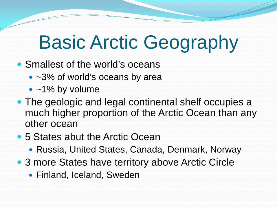
Basic Arctic Geography Smallest of the world’s oceans
~3% of world’s oceans by area ~1% by volume
The geologic and legal continental shelf occupies a much higher proportion of the Arctic Ocean than any other ocean
5 States abut the Arctic Ocean Russia, United States, Canada, Denmark, Norway
3 more States have territory above Arctic Circle Finland, Iceland, Sweden

Maritime Zones Arctic is just like any other ocean
Internal waters, territorial sea, EEZ, high seas Continental shelf, deep sea bed (“The Area”)
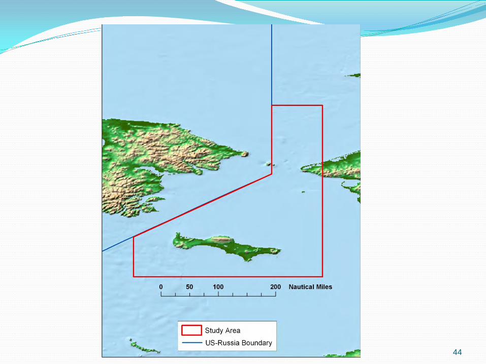
Five States border the Arctic Ocean Russia (Siberia), USA (Alaska), Canada (NW
Territories), Denmark (Greenland), Norway (Svalbard) Each is in the process of defining the outer limit of its
continental shelf (ECS) Norway has received CLCS approval

Legal Boundaries of the Oceans and Airspace

Maritime Boundaries Arctic States have agreed on many but not all
maritime boundaries 5 maritime boundary situations exist in Arctic Ocean
where adjacent or opposite States have overlapping maritime claims:
Russia-US Denmark-NorwayCanada-US Norway-RussiaCanada-Denmark


Agreement on Maritime BoundariesCanada –Denmark (Greenland)
continental shelf, 1973 treatyDenmark (Greenland) –Norway (Svalbard and Faroe Islands)
Continental shelf and EEZ, 1979 and 2006 treatiesEEZ, 1979 treatyEEZ, 1993 ICJ decision
Norway –RussiaTerritorial sea, 1957 and 2007 treatiesEEZ and continental shelf, 2010 treaty
U.S. –Russia Territorial sea, EEZ, continental shelf, 1990 treaty
Areas of Unresolved Maritime BoundariesCanada –Denmark (Greenland)
Sovereignty over Hans IslandEEZ (south of Alert), EEZ and continental shelf (north of Alert)
Canada –U.S.Territorial Sea, EEZ, and ECS in Beaufort Sea/Arctic Ocean
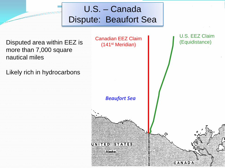
Canadian EEZ Claim(141st Meridian)
U.S. EEZ Claim(Equidistance)
Beaufort Sea
Disputed area within EEZ is more than 7,000 square nautical miles
Likely rich in hydrocarbons
U.S. – Canada Dispute: Beaufort Sea

U.S. Purchase of Alaska, 1867
“…from this point the line of demarcation shall follow the summit of the mountains situated parallel to the Coast, as far as the point of intersection with the 141st degree of West longitude (i.e., Meridian); and, finally, from the said point of intersection, the same meridian line of 141 Degrees shall form in its prolongation as far as the frozen ocean, the limit between the Russian and British Possessions on the Continent of Northwest America.”
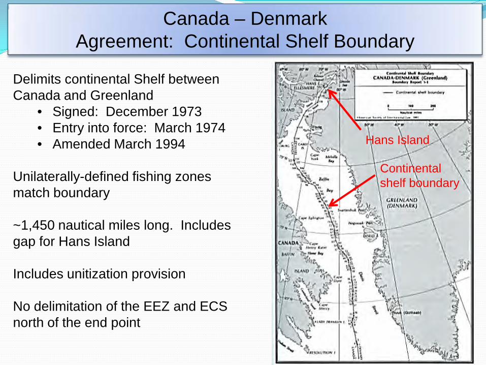
Canada – DenmarkAgreement: Continental Shelf Boundary
Delimits continental Shelf between Canada and Greenland
• Signed: December 1973• Entry into force: March 1974• Amended March 1994
Unilaterally-defined fishing zones match boundary
~1,450 nautical miles long. Includes gap for Hans Island
Includes unitization provision
No delimitation of the EEZ and ECSnorth of the end point
Hans Island
Continental shelf boundary

DenmarkAugust 13, 2002
CanadaJuly 13, 2005
Canada – Denmark Dispute: Sovereignty of Hans Island

Delimitation of the EEZ and continental shelf between Greenland and Svalbard • Signed: February 2006 • Entry into force: June 2006
Denmark – NorwayAgreement: Maritime Boundary in Greenland Sea

Norway – Russia Dispute: EEZ
Norway claims an equidistance line
Russia claims a sector line
Several disputed polygons created by the two competing claims
16
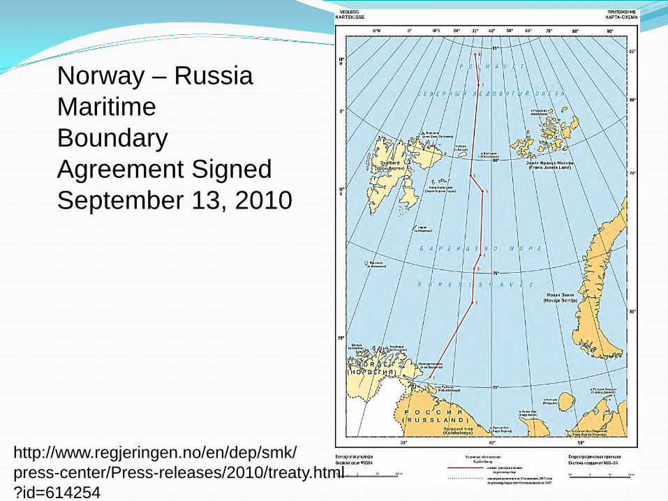
http://www.regjeringen.no/en/dep/smk/press-center/Press-releases/2010/treaty.html?id=614254
Norway – Russia MaritimeBoundary Agreement SignedSeptember 13, 2010

Agreement between US & USSR•Signed: June 1990•U.S. ratified: Sept 1991•Provisionally applied: June 1990
Longest maritime boundary in the world
First boundary to include the extended continental shelf
”…the maritime boundary extends north…into the Arctic Ocean as far as permitted under international law”
U.S. – RussiaAgreement: Territorial Sea, EEZ, and Continental Shelf

Extended Continental Shelves in Arctic
Canada Submission planned for 2013
Denmark Submission planned for 2012
Norway Submission approved 2009
Russia 2001 submission under revision
United States Data being collected

Canadian ECS

http://www.un.org/depts/los/clcs_new/submissions_files/nor06/nor_rec_summ.pdf (p.17)

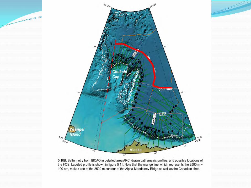
Chukchi Plateau• U.S. Statement, April 3, 1980, UNCLOS III Plenary• Features such as the Chukchi plateau and its
component elevations, situated north of Alaska, are covered by exemption in article 76(6), second sentence, of LOS Convention (i.e., not a ridge), and thus not subject to the 350-mile limitation set forth in article 76(6), first sentence
• Repeated in Commentary to 1994 Transmittal Package to U.S. Senate
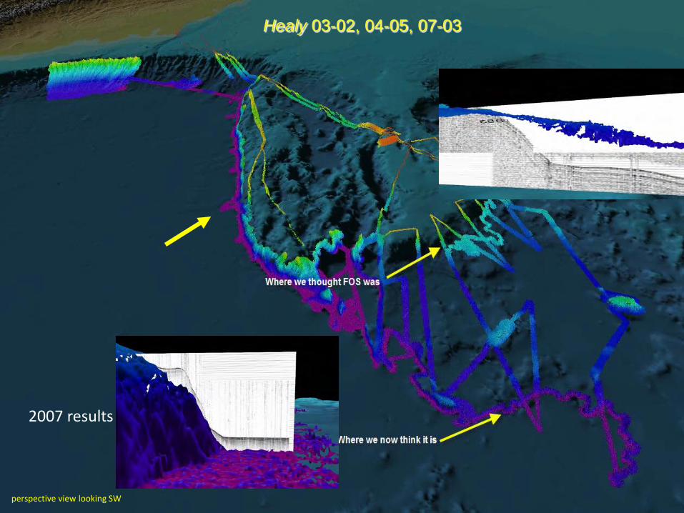
perspective view looking SW
2007 results
Healy 03-02, 04-05, 07-03

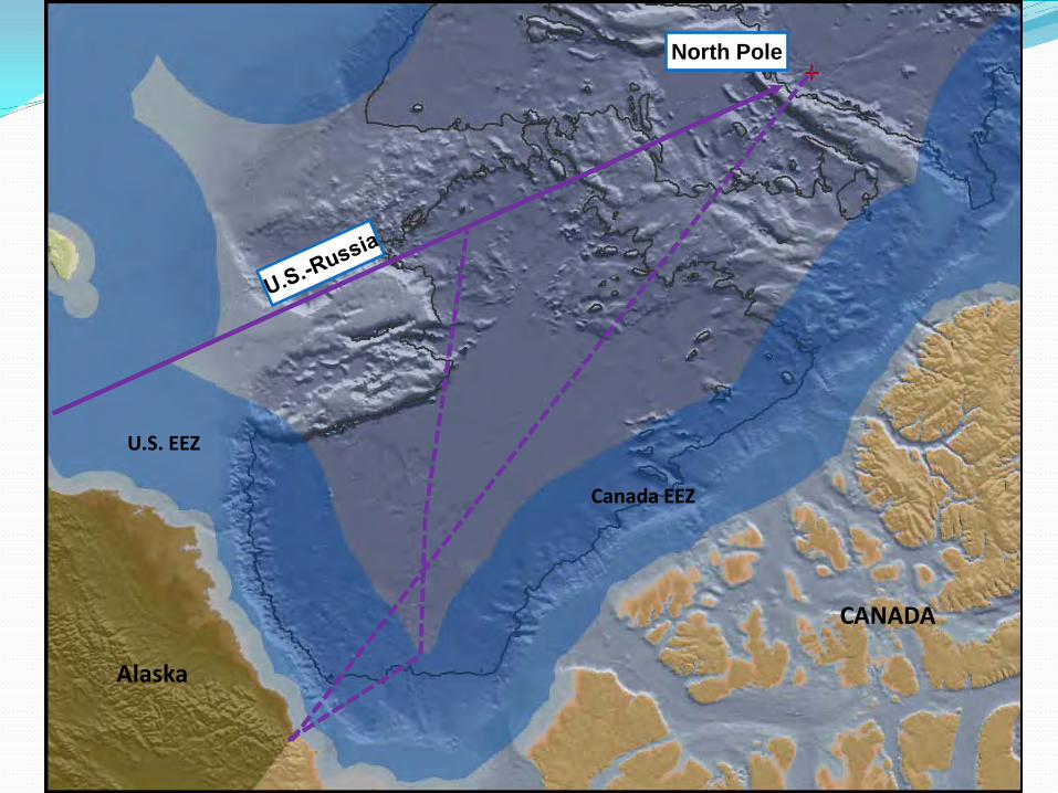
North Pole
CANADA
Alaska
U.S. EEZ
Canada EEZ


Some Arctic Routes used for International Navigation Bering Strait Northwest Passage Northeast Passage Arctic Ocean (“over the top”)


Applicable Law Law of the Sea Convention IMO treaties: SOLAS, MARPOL, COLREGS,
London Convention, SAR Convention, OPPRC Soft law: IMO guidelines Arctic Council guidelines on Arctic oil and gas
(2009)

IMO Guidelines Guidelines for Ships Operating in Polar Waters, 2009 Enhanced Contingency Planning Guidance for
Passenger Ships Operating in Areas Remote from SAR Facilities (2006)
Guidelines for Voyage Planning for Passenger Ships Operating in Remote Areas (2007)
Guide for Cold Water Survival (2006)

IMO Arctic Work Program Make revised Polar Code mandatory (DE, target
completion date 2012) Strengthen MARPOL Shipboard Oil Pollution
Emergency Plan regulation Establish Maritime Safety Information broadcast
system for Arctic Establish training and certification standards and
crew qualifications for ships operating in Arctic

Possibilities at IMO Specially designated Arctic marine areas MARPOL Special Areas Particularly Sensitive Sea Areas
Emission Control Areas Ballast water management Arctic Marine Traffic System Routeing, reporting and VTS systems AIS, LRIT
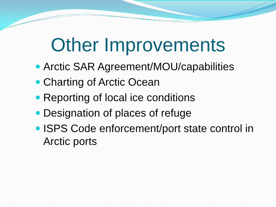
Other Improvements Arctic SAR Agreement/MOU/capabilities Charting of Arctic Ocean Reporting of local ice conditions Designation of places of refuge ISPS Code enforcement/port state control in
Arctic ports

Arctic Marine Shipping Assessment (AMSA)
Approved by Arctic Council Ministers meeting in Tromsø April 2009
Many recommendations in three themes Enhancing Arctic Marine Safety Protecting Arctic People and the Arctic Environment Building Arctic Marine Infrastructure
Our Focus on Safety of Navigation AMSA document online at
http://pame.is/amsa/amsa-2009-report35

36

Source: http://www.marinelog.com/DOCS/PRINTMMV/MMVjularc1.html, adapted from the report of the Arctic Marine Transport Workshop held September 28-30, 2004
General Portrayal of the Major Arctic Marine Routes
37
Trans-Arctic Shipping Trans-Arctic shipping is happening During summer of 2010 there were at least 24
transits of the Arctic Ocean Five via Northern Sea Route 18 via the Northwest Passage One circumpolar
More transits are expected in 2011 135 documented full transits of Northwest Passage
1903-2009
38

ARCTIC SEA ROUTES Northwest Passage and Northern Sea Route
Source: http://maps.grida.no/go/graphic/arctic-sea-routes-northern-sea-route-and-northwest-passage
39

Source: http://maps.grida.no/go/graphic/northern-sea-route-and-the-northwest-passage-compared-with-currently-used-shipping-routes
NORTHWEST PASSAGE AND NORTHERN SEA ROUTEcompared with currently used shipping routes
40

Bering Strait 51 nm wide, divided into two straits
East of Little Diomede Island (US) West of Big Diomede Island (Russian) Each about 22.5 nm wide Diomedes are about 2.4 nm apart
No routeing measures in place Some AtoN 2 year PARS underway by USCG
41

42

NOAA Nautical Chart of Bering Strait
Source: Wikipedia, Bering Strait
43
44

SOLAS Regulation V/10(5) Where two or more Governments have a common
interest in a particular area, they should formulate joint proposals for the delineation and use of a routeing system therein on the basis of an agreement between them. Upon receipt of such proposal and before proceeding with consideration of it for adoption, the Organization shall ensure details of the proposal are disseminated to the Governments which have a common interest in the area, including countries in the vicinity of the proposed ships’ routeing system.
45

Polar Code International Code for Safety of Navigation in Polar
Waters Being drafted by IMO DE Sub-Committee and
Correspondence Group (Norway lead) Completion date 2012 To be mandatory, through amendment to SOLAS Common provisions plus tailored separate provisions
for Arctic and Antarctic waters To replace Guidelines for Ships Operating in Polar
Waters, 2009
46

Geographic Area for Polar Code
Source: Guidelines for Ships Operating in Polar Waters, IMO Resolution A.1024(26), Dec. 2, 2009, p. 9, fig. 1
47
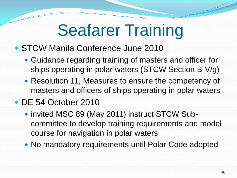
Seafarer Training STCW Manila Conference June 2010
Guidance regarding training of masters and officer for ships operating in polar waters (STCW Section B-V/g)
Resolution 11, Measures to ensure the competency of masters and officers of ships operating in polar waters
DE 54 October 2010 invited MSC 89 (May 2011) instruct STCW Sub-
committee to develop training requirements and model course for navigation in polar waters
No mandatory requirements until Polar Code adopted
48
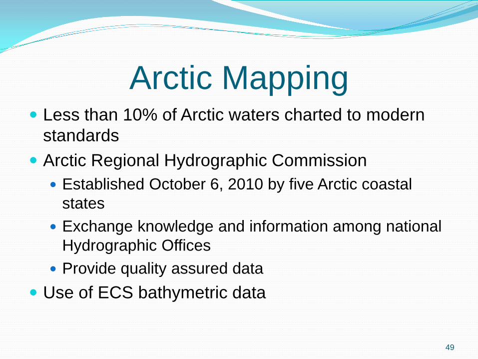
Arctic Mapping Less than 10% of Arctic waters charted to modern
standards Arctic Regional Hydrographic Commission
Established October 6, 2010 by five Arctic coastal states
Exchange knowledge and information among national Hydrographic Offices
Provide quality assured data Use of ECS bathymetric data
49

New Warning Areas for Arctic Five new Arctic NAVAREAs/METAREAs established
for Arctic waters International SafetyNET Service
Broadcast navigational warnings and meteorological warnings and forecasts
Initial operating capability began July 1, 2010 Full operational capability June 1, 2011
Part of IMO/IHO World-Wide Navigational Warning Service (WWNWS)
50

NAVAREAS For Radio Navigational Warnings
Source: Revised Joint IMO/IHO/WMO Maritime Safety Information Manual, IMO MSC.1/Circ 1310 ANNEX page 9, June 8, 200951

52Source: US Department of State OES/OPA

Arctic MSI Services Revised International SafetyNET Manual
IMO MSC.1/Circ. 1364, May 24, 2010
Revised Joint IMO/IHO/WMO Manual on Maritime Safety Information (MSI) IMO MSC.1/Circ. 1310, June 8, 2010
53

Arctic Search and Rescue Arctic Council April 2009 ministerial mandate to
negotiate an Arctic SAR agreement Last negotiating round held mid-December 2010 To be adopted at next Arctic Council ministerial
meeting in Nuuk, Greenland May 12, 2011
54
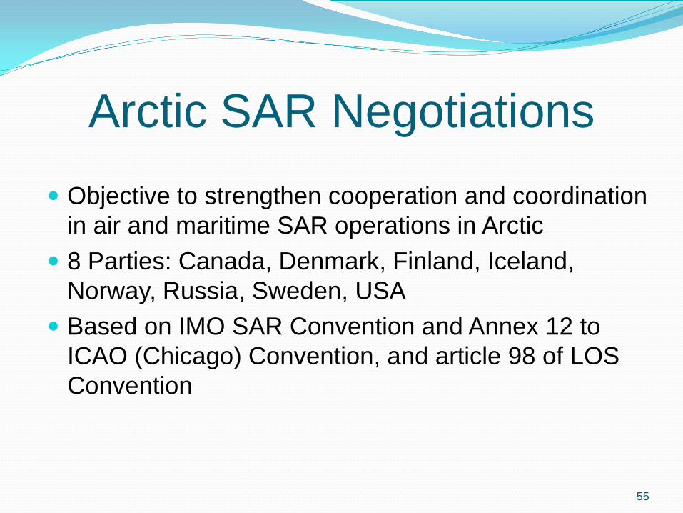
Arctic SAR Negotiations Objective to strengthen cooperation and coordination
in air and maritime SAR operations in Arctic 8 Parties: Canada, Denmark, Finland, Iceland,
Norway, Russia, Sweden, USA Based on IMO SAR Convention and Annex 12 to
ICAO (Chicago) Convention, and article 98 of LOS Convention
55

Draft Lines of Delimitation of SRRs
56
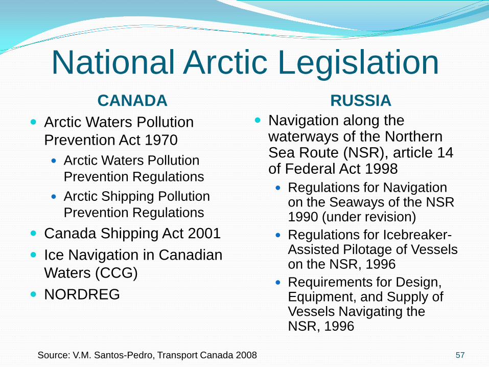
National Arctic LegislationCANADA
Arctic Waters Pollution Prevention Act 1970 Arctic Waters Pollution
Prevention Regulations Arctic Shipping Pollution
Prevention Regulations Canada Shipping Act 2001 Ice Navigation in Canadian
Waters (CCG) NORDREG
RUSSIA Navigation along the
waterways of the Northern Sea Route (NSR), article 14 of Federal Act 1998 Regulations for Navigation
on the Seaways of the NSR1990 (under revision)
Regulations for Icebreaker-Assisted Pilotage of Vessels on the NSR, 1996
Requirements for Design, Equipment, and Supply of Vessels Navigating the NSR, 1996
57Source: V.M. Santos-Pedro, Transport Canada 2008
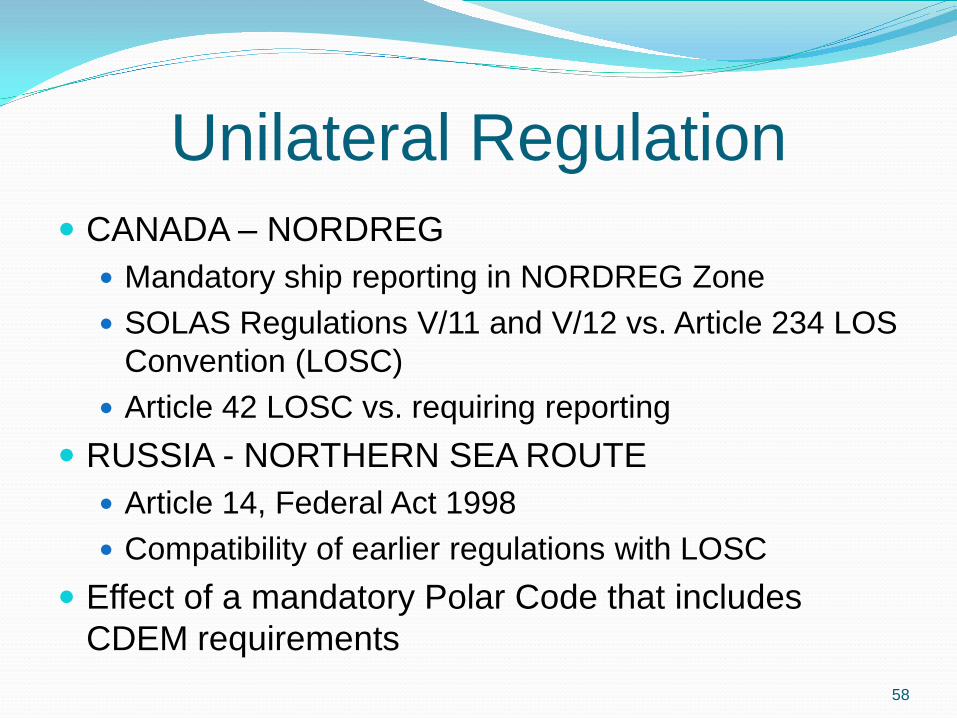
Unilateral Regulation CANADA – NORDREG
Mandatory ship reporting in NORDREG Zone SOLAS Regulations V/11 and V/12 vs. Article 234 LOS
Convention (LOSC) Article 42 LOSC vs. requiring reporting
RUSSIA - NORTHERN SEA ROUTE Article 14, Federal Act 1998 Compatibility of earlier regulations with LOSC
Effect of a mandatory Polar Code that includes CDEM requirements
58

Maximum Arctic Sea Ice March 30, 2010
Source: http://www.nasa.gov/topics/earth/features/ice-max-2010.html
59

Source: http://earthobservatory.nasa.gov/IOTD/view.php?id=46282
Minimum Arctic Sea Ice for 2010: September 19
60

Further Reading (1) Ilulissat Declaration, May 28, 2008,
http://www.oceanlw.org/downloads/arctic/Ilulisat_Declaration.pdf
Tromsø Declaration, 29 April 2009, http://arctic-council.org/filearchive/Tromsoe%20Declaration-1..pdf

Further Reading (2) Changes in the Arctic Environment and the Law of
the Sea, Seward Alaska 20-23 May 2009. COLP Conference PowerPoints online at http://www.virginia.edu/colp/annual-conference.html
Arctic Marine Shipping Assessment, 2009, http://arctic-council.org/filearchive/amsa2009report.pdf
Arctic Offshore Oil and Gas Guidelines 2009, http://arctic-council.org/filearchive/Arctic%20Offhsore%20Oil%20and%20Gas%20Guidelines%202009.pdf


LOSC and NORDREG 1970 Canadian Arctic Waters Pollution Prevention
Act 1978 article 234 accepted in UNCLOS III Also article 21.2 on CDEM in TS and article 8.2 on
SBL converting TS to IW 1994 LOSC entered into force (for Canada in 2003) 1996 SOLAS regulation V/8-1 on MSR in force for
Canada and others 2002 renumbered V-11 when revised chapter V
entered into force for Canada and others 2003 LOS Convention EIF for Canada 2014 Polar Code expected to become mandatory
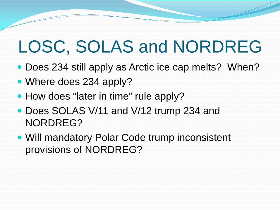
LOSC, SOLAS and NORDREG Does 234 still apply as Arctic ice cap melts? When? Where does 234 apply? How does “later in time” rule apply? Does SOLAS V/11 and V/12 trump 234 and
NORDREG? Will mandatory Polar Code trump inconsistent
provisions of NORDREG?

Article 234 LOSC Section 8, Ice-covered areas, of Part XIII on Protection
and Preservation of the Marine Environment: Coastal States have the right to adopt and enforce non-
discriminatory laws and regulations for the prevention, reduction and control of marine pollution from vessels in ice-covered areas within the limits of the exclusive economic zone, where particularly severe climatic conditions and the presence of ice covering such areas for most of the year create obstructions or exceptional hazards to navigation, and pollution of the marine environment could cause major harm to or irreversible disturbance of the ecological balance.
Such laws and regulations shall have due regard to navigation and the protection and preservation of the marine environment based on the best available scientific evidence.

67
Source: Transport Canada Press Release No. H078/10 Backgrounder, June 22, 2010

SOLAS V/11 Ship reporting systems
.1 Ship reporting systems contribute to safety of life at sea, safety and efficiency of navigation and/or protection of the marine Environment. A ship reporting system, when adopted and implemented in accordance with the guidelines and criteria developed by the Organization pursuant to this regulation, shall be used by all ships, or certain categories of ships or ships carrying certain cargoes in accordance with the provisions of each system so adopted.

SOLAS V/11.2.2 The Organization is recognized as the only international body for developing guidelines, criteria and regulations on an international level for ship reporting systems. Contracting Government shall refer proposals for the adoption of ship reporting systems to the Organization. The Organization will collate and disseminate to Contracting Governments all relevant information with regard to any adopted ship reporting system.

SOLAS V/11.8-.9.8 All adopted ship reporting systems and actions taken to enforce compliance with those systems shall be consistent with international law, including the relevant provisions of the United Nations Convention on the Law of the Sea.
.9 Nothing in this regulation or its associated guidelines and criteria shall prejudice the rights and duties of Governments under international law or the legal regimes of straits used for international navigation and archipelagic sea lanes.
SOLAS V/12Vessel traffic services
.1 Vessel traffic services (VTS) contribute to safety of life at sea, safety and efficiency of navigation and protection of the marine environment, adjacent shore areas, work sites and offshore installations from possible adverse effects of maritime traffic.
.3 Contracting Governments planning and implementing VTS shall, wherever possible, follow the guidelines developed by the Organization*. The use of VTS may only be made mandatory in sea areas within the territorial seas of a coastal State.
* Refer to the Guidelines on Vessel Traffic Services adopted by the Organization by resolution A.857(20).

SOLAS V/12.5.5 Nothing in this regulation or the guidelines adopted by the Organization shall prejudice the rights and duties of Governments under international law or the legal regimes of straits used for international navigation and archipelagic sea lanes.

LOSC Article 21 - CDEM Laws and regulations of the coastal State relating to
innocent passage may be adopted regarding 1.(f) the preservation of the environment 2. Such laws and regulations shall not apply to the
design, construction, manning or equipment of foreign ships unless they are giving effect to generally accepted international rules or standards
Polar Code will contain generally accepted international rules and standards


