
This article was downloaded by: [McGill University Library]On: 01 October 2013, At: 00:21Publisher: Taylor & FrancisInforma Ltd Registered in England and Wales Registered Number: 1072954 Registeredoffice: Mortimer House, 37-41 Mortimer Street, London W1T 3JH, UK
International Journal of Mining,Reclamation and EnvironmentPublication details, including instructions for authors andsubscription information:http://www.tandfonline.com/loi/nsme20
A study of land reclamation andecological restoration in a resource-exhausted city – a case study of Huaibeiin ChinaWu Xiao a , Zhenqi Hu a , Jing Li a , Heyu Zhang a & Jialiang Hu aa Institute of Land Reclamation and Ecological Restoration, ChinaUniversity of Mining & Technology (Beijing), Beijing, 100083,ChinaPublished online: 20 Sep 2011.
To cite this article: Wu Xiao , Zhenqi Hu , Jing Li , Heyu Zhang & Jialiang Hu (2011) A study ofland reclamation and ecological restoration in a resource-exhausted city – a case study of Huaibeiin China, International Journal of Mining, Reclamation and Environment, 25:4, 332-341, DOI:10.1080/17480930.2011.608888
To link to this article: http://dx.doi.org/10.1080/17480930.2011.608888
PLEASE SCROLL DOWN FOR ARTICLE
Taylor & Francis makes every effort to ensure the accuracy of all the information (the“Content”) contained in the publications on our platform. However, Taylor & Francis,our agents, and our licensors make no representations or warranties whatsoever as tothe accuracy, completeness, or suitability for any purpose of the Content. Any opinionsand views expressed in this publication are the opinions and views of the authors,and are not the views of or endorsed by Taylor & Francis. The accuracy of the Contentshould not be relied upon and should be independently verified with primary sourcesof information. Taylor and Francis shall not be liable for any losses, actions, claims,proceedings, demands, costs, expenses, damages, and other liabilities whatsoever orhowsoever caused arising directly or indirectly in connection with, in relation to or arisingout of the use of the Content.
This article may be used for research, teaching, and private study purposes. Anysubstantial or systematic reproduction, redistribution, reselling, loan, sub-licensing,systematic supply, or distribution in any form to anyone is expressly forbidden. Terms &

Conditions of access and use can be found at http://www.tandfonline.com/page/terms-and-conditions
Dow
nloa
ded
by [
McG
ill U
nive
rsity
Lib
rary
] at
00:
21 0
1 O
ctob
er 2
013
A study of land reclamation and ecological restoration in a resource-
exhausted city – a case study of Huaibei in China
Wu Xiao, Zhenqi Hu*, Jing Li, Heyu Zhang and Jialiang Hu
Institute of Land Reclamation and Ecological Restoration, China University of Mining &Technology (Beijing), Beijing 100083, China
(Received 1 March 2011; final version received 10 August 2011)
Eco-city construction is a powerful method which can advance a city fromtraditional industrial civilisation to ecological civilisation. The city of Huaibei,with 50 years of coal mining history, has been listed as a national resource-exhausted city. The city’s sustainable development and ecological restorationwork face severe challenges. This study presents a time-space evolution analysis ofmining subsidence to show the evolution and the distribution of the subsidencearea in Huaibei. Intensive use was made of land evaluation to formulate land usemeasures. According to this analysis, and based on the popular eco-reconstruc-tion movement, suggestions for land reclamation and eco-reconstruction areproposed for the city of Huaibei. The paper aims to make strategicrecommendations to help Huaibei city transform from a resource-exhaustedcity to an eco-city.
Keywords: resource-exhausted city; ecological restoration; Huaibei city
1. Introduction
Resource-based cities are developed or constructed around resource development.Following the depletion of resources and transformation of the economic system,resource-based cities gradually have to face multiple pressures, e.g. large population,shortage of resources and a damaged environment. According to statistics, Chinahas 118 resource-based cities, more than 30 of which are facing resource depletionproblems. Out of about 8000 mines in existence more than 400 are now in depletion,2/3 of which have entered ‘old age’ so their depletion process is accelerating.Resource-exhausting mines in China are facing the challenge of ecologicalrestoration. The key problem of resource-exhausting mines is the serious damagethey create to the environment: air pollution, acidification of water bodies, decline ofsoil quality, loss of biodiversity, destruction of natural landscapes, etc. The pollutionfrom closed mines and geological disasters in the mining legacy will continue tomake a serious impact on the surrounding environment. Accordingly, ecologicalrestoration and environmental improvement of resource-exhausting mines havebecome important factors for achieving a smooth economic transition; manyscholars have made studies of the transformation of resource-exhausted cities [1–3].
*Corresponding author. Email: [email protected]
International Journal of Mining, Reclamation and Environment
Vol. 25, No. 4, December 2011, 332–341
ISSN 1748-0930 print/ISSN 1748-0949 online
� 2011 Taylor & Francis
http://dx.doi.org/10.1080/17480930.2011.608888
http://www.tandfonline.com
Dow
nloa
ded
by [
McG
ill U
nive
rsity
Lib
rary
] at
00:
21 0
1 O
ctob
er 2
013
The 10th five-year programme of China for national economic and socialdevelopment highlighted ‘active and steady closure of resource-exhausting mines,promoting ongoing industry, and replacement industries in cities and large minesbased on exploitation of resources according to local conditions, and studying newmodels for mining exploitation’. Meanwhile, resource-exhausting cities continue toattract major central government investment during the 11th five-year plan.Meanwhile, coal mining subsidence control and eco-environmental protection andrestoration will be priority areas for public funding [4]. In addition, promotion ofbrown field reclamation will be an important measure for achieving landconservation [5].
Huaibei City, which is listed as one of the second batch of national resource-exhausting pilot cities, has more than 50 years of coal mining history. Since 1958, whenthe first mine was opened, the city has produced 66108 t coal, which has made animportant contribution to the economic and social development of China. However,because of the numerous thick coal seams and the long wall caving mining method, alarge area of ground subsidence was caused. By 2018, the subsidence area will be up toabout 20,000 hm2. Huaibei City put forward a development strategy to create an ‘eco-city’ in 2008. The strategy indicates how to produce good ecological, social and economicbenefits by maximising the re-development and utilisation of the subsidence area. Thestrategy takes into account the local natural conditions and resources and aims to fulfilthe needs of sustainable development of the mine as an imminent, urgent problem.
2. Eco-reconstruction of resource-exhausting cities in China
2.1. Rural eco-agriculture
China’s resource-exhausting cities are located in a range of geographical sites.Therefore, there are different eco-types, e.g. mountain, plain farming and grasslandeco-patterns, different ecological zones with different conditions leading to differentecological modes. For example, the pattern for plain farming and pastoral areas isfruit–vegetables–peas–poultry–insects–grass, or milk cows–forest–grass–insects–ed-ible fungi–biogas, etc. The basic model of eco-agriculture is ‘integration, coordina-tion, circulation (benign), and regeneration’ [6].
2.2. Wetland parks and suburban parks
Comprehensive treatment of large mining-damaged areas outside the city couldprovide a broad ecological hinterland for the city and change ‘black gold’ into a‘green lung’. Water systems in mining areas connect with the winding river and therippling blue water surface. The water system, the green belt and other ecologicallands are turned into urban country parkland, wetlands or mine parks, and form apart of the urban development space [6,7]. The landscape can be divided intodifferent levels with different significance, to form a mixed, organic landscape axis.
2.3. Mine parks
Twenty-eight national mine park units, e.g. Huang Song-yu in Beijing, which passedthrough the National Mine Park Mine Leading Group Qualifications in early 2006,indicate that Chinese mine park development has entered a substantive stage ofoperation. The mine parks mostly display the process of mine development, coal
International Journal of Mining, Reclamation and Environment 333
Dow
nloa
ded
by [
McG
ill U
nive
rsity
Lib
rary
] at
00:
21 0
1 O
ctob
er 2
013
geology, exploration, the research history and the geology history of the miningregion, the history of formation and evolution of the coal, and the central position ofcoal development in the national economy. The coal mine exhibition hall, withpictures, texts, models, video and multimedia forms of information, introducesvisitors to the impact of mineral development on the local ecological environmentand the results of environmental recovery and management [8].
3. Time-space evolution analysis of mining subsidence in Huaibei
3.1. Subsidence status of the city of Huaibei
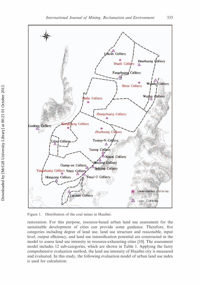
There are seven state-owned mines and more than 10 local small mines in the city ofHuaibei. According to the local Land Board 2008 Reserves Report, the grossproduction of the local coal mines was about 1,321,700 t, accounting for 12.03% ofthe city’s production. After 40 years of coal mining, there was 63.05 km2 of collapsearea at the end of 2001. Then, with the development of coal mining, the extent of thesubsidence area increased year by year. At the end of 2008, the internal collapse areaamounted to 79.20 km2, including a perennial water area of 19.42 km2. Yangzhuangcoal mine collapsed to a depth of as much as 15.0 m in the deepest part, forming adeep subsidence area. The distribution of mines is shown in Figure 1.
3.2. Subsidence area in sub-scenario simulation time
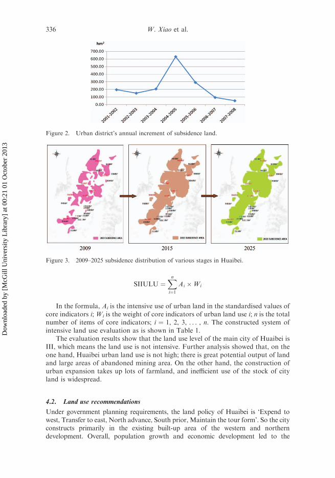
Within the city, Huaibei’s coal subsidence rate is about 0.216 hm2/10,000 tons. Since2001, the annual increase in subsidence has amounted to about 133–200 hm2. At theend of 2004, due to the impact of soaring international oil prices and rapid economicgrowth in China, coal production in Huaibei reached its highest record, which led toa maximum annual land subsidence increase: 630.21 hm2 lands subsided in 2004.From that time on, coal mining conditions showed signs of depletion, coalproduction declined, and the annual subsidence rate consistent with the coalproduction, inclined to merely 50.46 hm2 in 2008. The 2001–2008 annualincremental change of subsidence in Huaibei city is shown in Figure 2.
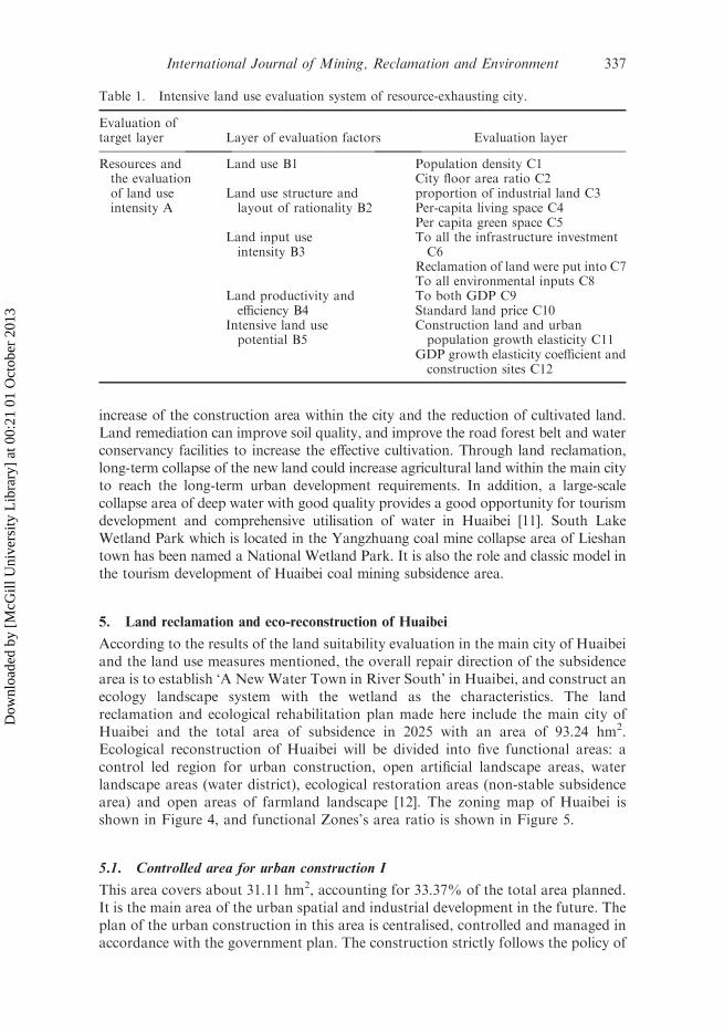
After nearly 50 years of mining, the state of mining in each block in Huaibei hasgradually become overripe. According to information provided by the Bureau ofMines, one of the seven state-owned mines, Xiangcheng mine, was closed because ofresource depletion. Five out of the six remaining mines will reach the end of theirlives in 2015. With coal mining, the northern and central subsidence will graduallyexpand in the current basis area. As of 2025, the subsidence area in Huaibei willreach 122.42 km2, of which 83.74 km2 will be within the city area and 38.68 km2
outside it. The collapse between 2009 and 2015 and the space-time evolution inHuaibei are shown in Figure 3.
4. Intensive use of land evaluation and land use measures for Huaibei
4.1. Intensive use of land
The development of a city does not depend only on its own resources. Otherimportant factors are the development of urban functions and layout planning, inorder to avoid inadequate urban functions, urban area expansion and a land usestructure of disordered chaos [9]. Attention must also be given to exploitation ofmineral resources in resource-exhausting cities after land reclamation and ecological
334 W. Xiao et al.
Dow
nloa
ded
by [
McG
ill U
nive
rsity
Lib
rary
] at
00:
21 0
1 O
ctob
er 2
013
restoration. For this purpose, resource-based urban land use assessment for thesustainable development of cities can provide some guidance. Therefore, fivecategories including degree of land use, land use structure and reasonable, inputlevel, output efficiency, and land use intensification potential are constructed in themodel to assess land use intensity in resource-exhausting cities [10]. The assessmentmodel includes 12 sub-categories, which are shown in Table 1. Applying the fuzzycomprehensive evaluation method, the land use intensity of Huaibei city is measuredand evaluated. In this study, the following evaluation model of urban land use indexis used for calculation:
Figure 1. Distribution of the coal mines in Huaibei.
International Journal of Mining, Reclamation and Environment 335
Dow
nloa
ded
by [
McG
ill U
nive
rsity
Lib
rary
] at
00:
21 0
1 O
ctob
er 2
013
SIIULU ¼Xn
i¼1Ai �Wi
In the formula, Ai is the intensive use of urban land in the standardised values ofcore indicators i; Wi is the weight of core indicators of urban land use i; n is the totalnumber of items of core indicators; i ¼ 1, 2, 3, . . . , n. The constructed system ofintensive land use evaluation as is shown in Table 1.
The evaluation results show that the land use level of the main city of Huaibei isIII, which means the land use is not intensive. Further analysis showed that, on theone hand, Huaibei urban land use is not high; there is great potential output of landand large areas of abandoned mining area. On the other hand, the construction ofurban expansion takes up lots of farmland, and inefficient use of the stock of cityland is widespread.
4.2. Land use recommendations
Under government planning requirements, the land policy of Huaibei is ‘Expend towest, Transfer to east, North advance, South prior, Maintain the tour form’. So the cityconstructs primarily in the existing built-up area of the western and northerndevelopment. Overall, population growth and economic development led to the
Figure 2. Urban district’s annual increment of subsidence land.
Figure 3. 2009–2025 subsidence distribution of various stages in Huaibei.
336 W. Xiao et al.
Dow
nloa
ded
by [
McG
ill U
nive
rsity
Lib
rary
] at
00:
21 0
1 O
ctob
er 2
013
increase of the construction area within the city and the reduction of cultivated land.Land remediation can improve soil quality, and improve the road forest belt and waterconservancy facilities to increase the effective cultivation. Through land reclamation,long-term collapse of the new land could increase agricultural land within the main cityto reach the long-term urban development requirements. In addition, a large-scalecollapse area of deep water with good quality provides a good opportunity for tourismdevelopment and comprehensive utilisation of water in Huaibei [11]. South LakeWetland Park which is located in the Yangzhuang coal mine collapse area of Lieshantown has been named a National Wetland Park. It is also the role and classic model inthe tourism development of Huaibei coal mining subsidence area.
5. Land reclamation and eco-reconstruction of Huaibei
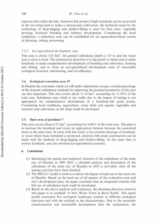
According to the results of the land suitability evaluation in the main city of Huaibeiand the land use measures mentioned, the overall repair direction of the subsidencearea is to establish ‘A New Water Town in River South’ in Huaibei, and construct anecology landscape system with the wetland as the characteristics. The landreclamation and ecological rehabilitation plan made here include the main city ofHuaibei and the total area of subsidence in 2025 with an area of 93.24 hm2.Ecological reconstruction of Huaibei will be divided into five functional areas: acontrol led region for urban construction, open artificial landscape areas, waterlandscape areas (water district), ecological restoration areas (non-stable subsidencearea) and open areas of farmland landscape [12]. The zoning map of Huaibei isshown in Figure 4, and functional Zones’s area ratio is shown in Figure 5.
5.1. Controlled area for urban construction I
This area covers about 31.11 hm2, accounting for 33.37% of the total area planned.It is the main area of the urban spatial and industrial development in the future. Theplan of the urban construction in this area is centralised, controlled and managed inaccordance with the government plan. The construction strictly follows the policy of
Table 1. Intensive land use evaluation system of resource-exhausting city.
Evaluation oftarget layer Layer of evaluation factors Evaluation layer
Resources andthe evaluationof land useintensity A
Land use B1 Population density C1City floor area ratio C2
Land use structure andlayout of rationality B2
proportion of industrial land C3Per-capita living space C4Per capita green space C5
Land input useintensity B3
To all the infrastructure investmentC6
Reclamation of land were put into C7To all environmental inputs C8
Land productivity andefficiency B4
To both GDP C9Standard land price C10
Intensive land usepotential B5
Construction land and urbanpopulation growth elasticity C11
GDP growth elasticity coefficient andconstruction sites C12
International Journal of Mining, Reclamation and Environment 337
Dow
nloa
ded
by [
McG
ill U
nive
rsity
Lib
rary
] at
00:
21 0
1 O
ctob
er 2
013

‘reasonable utilisation and land conservation’, with integrated social, environmentaland economic benefits.
5.2. Open artificial landscape area II
This area covers about 4.87 hm2, accounting for 5.22% of the total area planned,including two parts of the eco-industrial park and the mining cultural industry park.
The mining cultural industry park contains three parts: an artificial landscapepark, a mining heritage Tourism Park and the entertainment district [13,14]. Theecological industry chain is based on the abundant local coal resources, relying onHuaibei Mining Group, using the coal, fly ash, waste water and mining subsidence asthe basis, taking the utilisation of the coal mining subsidence area which has beenreclaimed as the core. Then an interrelated chain of industrial systems can be set up
Figure 4. Zoning map of main city in Huaibei.
338 W. Xiao et al.
Dow
nloa
ded
by [
McG
ill U
nive
rsity
Lib
rary
] at
00:
21 0
1 O
ctob
er 2
013
with the following parts: coal production, power system, coal chemical system, minewater treatment system, waste treatment and utilisation system.
5.3. Open water landscape area III
It is estimated that by 2025 the water area of the subsidence in the main city ofHuaibei will be about 24.63 km2, except for small fish ponds, as shown in Figure 4.Water is an important resource for tourism development, which is generally lackingin the urban part of northern China. The large area of good quality water caused bythe subsidence in Huaibei is very rare in a northern city. It is a good place for theconstruction of recreational facilities, wetland parks and leisure tourism. This areacovers about 39.91 hm2, accounting for 42.80% of the total planning area.
5.3.1. Wetland
The functions of the wetland park to be expanded are mainly ecotourism and wetlandprotection. On the basis of the original South Lake and East Lake, the wetland parkcan make a further expansion of the wetland landscape pattern with an area of 29.88hm2, imitating the natural communities according to the wetland characteristics ofHuai River, setting up the ecological environment of an original wetland andenriching biological diversity. A series of projects in the wetland park to formfunctions including education, science, humanities, and ecological restoration,including the following projects: building various kinds of biological observationplatform, opening bird sanctuary free from human interference, building reed jungle,water shallow, water park and other attractions.
5.3.2. Utilisation of the water area
There is a large lake, and also a certain amount of unused beach in this area,covering 6.20 hm2. A variety of methods (fencing, netting, caging) can be used to
Figure 5. Functional Zones’ area ratio.
International Journal of Mining, Reclamation and Environment 339
Dow
nloa
ded
by [
McG
ill U
nive
rsity
Lib
rary
] at
00:
21 0
1 O
ctob
er 2
013
separate fish within the lake. Intensive fish ponds of high standards can be excavatedin the low-lying land to make a stereoscopic cultivation: the farmland made by thetechnology of deep-digging and shallow-filling is used for fruit trees, vegetablegrowing, livestock breeding and industry development. Considering the localconditions, a utilisation zone can be established for an aquaculture-based systemof planting, raising, processing.
5.3.3. Eco-agricultural development zone
This area is about 3.83 hm2, the general subsidence depth is 115 m and the waterarea is close to land. The reclamation direction is to dig ponds to breed and to makefarmland, to make comprehensive development of breeding and cultivation, farmingand fishing, and to form an eco-agricultural development zone of reasonableecological structure, functioning, and eco-efficiency.
5.4. Ecological restoration area IV
In Huaibei the coal mines which are still under exploitation occupy a certain percentageof the dynamic subsidence; methods for improving the potential productive of this partare also important. This area covers about 11.14 hm2, accounting for 11.95% of thetotal area. Subsidence area which is not stable due to the impact of mining is notappropriate for comprehensive development of a farmland–fish pond system.Considering local conditions, aquaculture, water birds and aquatic vegetables andseasonal crop cultivation on the slope could be developed.
5.5. Open area of farmland V
This area covers about 6.21 hm2, accounting for 6.66% of the total area. The plan isto increase the farmland and create an appropriate balance between the associateditems at the same time. In areas with less water, a less extreme shortage of farmland,or areas where basic farmland is protected, intensive fish pond construction can bemade with the methods of deep-digging and shallow-filling. At the same time torestore farmland, and also develop eco-agricultural economy.
6. Conclusions
(1) Simulating the spatial and temporal variation of the subsidence of the maincity of Huaibei in 2001–2025, a detailed analysis and description of thesubsidence of the main city of Huaibei in 2025 is provided, after all themining activities have been finished.
(2) The SIIULU model is used to evaluate the degree of land use in the main cityof Huaibei. Based on the land use of all aspects of the evaluation area andcity’s development plan, the paper concludes that an integrated tourism withfull use of subsidence land could be developed.
(3) Based on the above analysis and evaluation, the planning direction raised inthis paper is to establish ‘A New Water Town in River South’. The repairmodel constructs five ecological landscape systems of different ecologicalfunctions and with the wetland as the characteristics. Due to the economictransformation and sustainable development after the reclamation, the
340 W. Xiao et al.
Dow
nloa
ded
by [
McG
ill U
nive
rsity
Lib
rary
] at
00:
21 0
1 O
ctob
er 2
013
relations of local industry and agriculture, urban and rural areas will begradually improved. Meanwhile, two virtuous circles between coal resourcedevelopment and land reclamation utilisation will be achieved.
Acknowledgements
The research was supported by nonprofit industry research and special funds provided by theMinistry of Land and Resources in China, approval no. 200911015-03. We offer special thanksto Ru-Song Wang, a researcher at the Ecological Environment Research Center of the ChineseAcademy of Sciences for the valuable assistance provided, and to Dan Hu, a researcher at theState Key Laboratory of Urban and Regional Ecology. We have also been helped by FangWang, from the China Institute of Water Resources and Hydropower Research, and RobertEdson Swain from Williams Huiming Architects. We also thank the Huaibei government forproviding the research funding and other assistance.
References
[1] Z. Hu, Review and prospect of land reclamation and ecological restoration in China, Sci.Technol. Rev. 27 (2009), pp. 38–41.
[2] Z. Hu and Y. Luo, Suggestions on environmental quality and food safety in overlappedareas of crop and mineral production, Sci. Technol. Rev. 24 (2006), pp. 93–94.
[3] Wu Xiao, Heyu Zhang, and Jiajia, Function Restoration of 3D Ecosystem on MiningBrownfield in Jingxi of China, Paper presented in the Proceedings of the 3rd InternationalConference on Environmental Technology and Knowledge Transfer, Hefei, China, May13–14, 2010.
[4] Wu Xiao, Zhenqi Hu, Xianlei Xu, and Yanhua Fu, Cost definite method of landreclamation in coal mining area, J. China Coal Soc. 35 (2010), pp. 175–179.
[5] Zhenqi Hu, Zhao Yan-ling, and Gao Yong-guang, Impact of coal resource development oneco-environment and its restoration in West China, Trans. Nonferrous Metals Soc. China.15 (2005), Special 1, pp. 168–171.
[6] Meichen Fu, Hui, and Zeng Hongjie Zhang, Land reclamation and ecological reconstruc-tion in resource-exhausted mining areas, Sci. Technol. Rev. 27 (2009), pp. 38–43.
[7] Data analyst of ‘Information for Deciders Magazine’, Information for Deciders Magazine,2005, pp. 30–31.
[8] Yan Bao, Zhenqi Hu, Jianfeng Wang, and Xia Zhao, Risk Assessment of Reusing MineLand after Mine Closure, Fourteenth, Paper presented at International Symposium onMine Planning and Equipment Selection. Alberta, Canada, 2005, pp. 101–107.
[9] Juan Fu, The Studies on the Ecological Protection Planning of Urban Wetland Park – ACase Study for the ShangHu National Urban Wetland Park. Huazhong AgriculturalUniversity, Wu Han, 2007.
[10] Kuitao Zhao, Ke Hu, Xiaoqin Jia, et al., Research on evaluation index system of landintensive utilization in resource-based cities. China Mining Mag. 18 (2009), pp. 38–41.
[11] Liliang Ren and Longeang Shu, Balancing Water for Humans and Nature: The NewApproach in Eco-hydrology, Water Power Press, Beijing, 2006.
[12] Shuyun Zhao, Surface subsidence caused by coal mining in Huaibei: Ecologicalrehabilitation of various modes, China Coal. 34 (2008), pp. 11–13.
[13] Heyu Zhang, Yanlin Zhao, and Wu Xiao, Eco-art park – A new mode of the restorationof abandoned mining zone in China and its case study, Metal mine. 12 (2007), pp. 122–125.
[14] WuXiao,Yanling Zhao, andHesyuZhang,SWOTanalysis and the solution of Recreationalreclamation on Mining Brownfield in Jingxi, China Coal, 11 (2009), pp. 25–28.
International Journal of Mining, Reclamation and Environment 341
Dow
nloa
ded
by [
McG
ill U
nive
rsity
Lib
rary
] at
00:
21 0
1 O
ctob
er 2
013


