domestic waterfront structures ... - marine.nsw.gov.au
TRANSCRIPT

www.marine.nsw.gov.au
Initiative 2Online Forum - June 2021
Domestic Waterfront Structures Strategies andEstuary Bank Management Strategies
Photos: DPI Fisheries, Hydrosphere, HLLS, NCLLS, EES, Clarence Valley Council

Domestic Waterfront Structures Strategies
www.marine.nsw.gov.au
ObjectivesStreamline and integrate assessment processes of new domestic waterfront structures to reduce the cumulative threats and risks to the marine estate associated with such types of development. MethodMap the estuary foreshore, indicating if sites are suitable or not for the development of domestic waterfront structures, informed by NSW Government policy and legislation requirements.

www.marine.nsw.gov.au
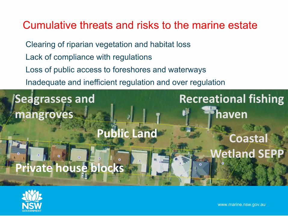
Cumulative threats and risks to the marine estate
www.marine.nsw.gov.au
Clearing of riparian vegetation and habitat lossLack of compliance with regulationsLoss of public access to foreshores and waterwaysInadequate and inefficient regulation and over regulation
Recreational fishing haven
Coastal Wetland SEPP
Public Land
Seagrasses and mangroves
Private house blocks

www.marine.nsw.gov.au
Decision modelAssess each lot on the waterfront against NSW Government legislation and policy administered by DPIE Crown Lands, DPI Fisheries and Transport for NSWCategorise each lot as either not suitable, potentially suitable or suitable for Land Owner’s Consent

www.marine.nsw.gov.au
Estuary wide map

www.marine.nsw.gov.au
Streamlining the Land Owner’s Consent process
www.marine.nsw.gov.au

Estuary bank management strategies
www.marine.nsw.gov.au
ObjectiveReduce the cumulative impacts of erosion, and ad-hoc management of erosion with integrated foreshore assessment and development management. MethodCreate maps to show bank condition, overlayed with recommended best practice treatment. Maps are informed by a Decision Support Tool (DST).

Estuary bank management strategies
www.marine.nsw.gov.au
The ‘patchy’ problemOften ad-hoc, ‘patchy’ distribution of types of works Ineffective, not fish friendly, not best practice Inefficient, double handling, costly assessmentsOngoing cumulative threats and risks to the marine estate

Estuary Bank Management
Strategies
www.marine.nsw.gov.au
An integrated solution Standard assessment methodology Best practice erosion managementDecision Support Tool (DST)Map outcomes to illustrate erosion risk overlayed with best practice at estuary-wide scale Maps form the backbone of the strategies, making it quicker to assess and make integrated, informed decisions about erosion management.
Standard assessment
method
Decision Support Tool
(DST)
Estuary-wide maps
Field testing
Approval requirements
Best practice erosion control

www.marine.nsw.gov.au
Decision Support Tool (DST)

www.marine.nsw.gov.au
Estuary wide map

www.marine.nsw.gov.au
What’s next – testing the DSTThe DST was developed in Tweed and Brunswick River estuaries, NSW north coast.Extensive ‘peer review’But, how does it perform in other types of estuaries with different morphological characteristics?Where are the suitable downstream boundaries for operation of the DST?
Brunswick River estuary
Tweed River estuary

www.marine.nsw.gov.au
Wallaga LakeICOLL
Manning River flood effected
March 2021
Shoalhaven/Crookhaven Berry’s Canal
Hawkesbury, Pittwaterdrowned river valleyflood effected March 2021

www.marine.nsw.gov.au
What’s next – testing the DSTTesting June – Dec 2021Soil Conservation Service and consultants.60+ test sites. LGAs: Tweed, Byron, Ballina, Coffs Harbour, Nambucca, Kempsey, Mid Coast, Port Stephens, Central Coast, Pittwater, Hornsby, Hawkesbury, Hills, Shoalhaven, Eurobodalla, Bega ValleyRefinement Feb 2022

www.marine.nsw.gov.au
Roll-out of strategies Tested and refined DST Tweed River, Brunswick River, Richmond River, Nambucca River, Shoalhaven/Crookhaven River and possibly two more south coast estuariesCompleted assessments July 2022, strategy prep Dec 2022The tested and refined DST will be available

Emma WilkieManager Marine Estate Foreshore Management
0428 764 310
www.marine.nsw.gov.au
Where to find out more
www.marine.nsw.gov.au