document resume - eric · document resume. sf 010 51p. chapman, prank l. the s9a and its...
TRANSCRIPT

ED 046 735
AUTUORmTTLPTNSTTTUTIONsPO9S AGE"CY
7M7 DA77NOmPAVAILAPLY PFOM
DOCUMENT RESUME
SF 010 51P
Chapman, Prank L.The S9a and Its Poundaries.Carteret County Public Schools, Beaufort, N.C.Pureau of Plementary and Sc,condary PRucation(DT4.711/09, Washington, D.C.[701
,r).
Regional Marine Science Project, Carteret CountyPublic Schools, Peaufort, N.C. 2PP16 (Erne)
FDPS PRICE FDPS Price MP-$0.65 PC Not 7Available from FDPS.DESCRIPTORS Curriculum Guides, Parth Science, *Pcology,
*Elementary School Science, environmental Fducation,*Tnstructional Materials, Natural Resources,*Oceanology, *Textbooks
IDENTIFIFRS ESFA. Title III
ABSTRACTThis publication is designed for use as part of a
curriculum series developed by the Regional Marine Science Project.As an informative text for a three-week unit in marine science forgrade eight, it presents a study of coastal processes andoceanography. An ecological approach to nature is emphasized,stressing the ties between culture, economy, and resource use. mOPICSare divided into three units: Physical Oceanology covers tides: mheSea at Its Boundary discusses waves, beaches, and man's control ofthe beach environment; and Beyond the Land describes the off-coastnrofile, elements in the water, winds, currents, and sea testingequipment. Each unit includes a vocabulary, fill-in questions,discussion topics, and activities to complete. Numerous diagramsillustrate topics discussed. This work was oreoared under an FSFATitle III contract. (BL)

THE SEA
`4\ AND ITS
sOuNDARIESU S DEPARTMENT OF HEALTH. EDUCATION
& WELFAREOFFICE OF EDUCATION
THIS DOCUMENT HAS PEEN REPRODUCEDEXACTLY AS RECEIVED FROM THE PERSON DRORGANIZATION ORIGINATING IT POINTS OFVIEW OR OPINIONS STATED DO NOT h:CESSARILY REPRESENT OFFICIAL OIF ICE OF IOUCA 'ION POSIT,ON OR POLICY
FRANK L. CHAPM
CARTERET REGIONALMARINE SCIENCE PROJECT
1

1"
THE SEA
AND ITS
sOuNDAR1ES
This publication is designed for use as part of acurriculum series developed by the Regional MarineScience Project of the Carteret County PublicSchools, financed primarily by ESEA TITLE III. Theseries will include three-week teaching units inmarine science for grades 4-10 and two full-yearhigh school courses in advanced biology.
All materials take an ecological approach tonature, stressing the ties between culture, economyand resource use. Field work is an integral part.ofthe curriculum.
Publications are distributed at cost to interestedschool systems. Most are designed for wide spreaduse on the central eastern seaboard. Address in-quiri2s to:
Will HonProject director,and series editor.
2
by FRANK L. CHAPMANillustrated by WILL HON

PHYSICAL OCEANOLOGY
Leonard Engel was right when he said that our planet has the wrong name. Since there isthree times as much water as land on the surface of our planet, why not call it "Ocean"instead of "Earth." It seems strange that in spite of all this water, man has only recently begunthe systematic study of the oceans. Scientists call this study OCEANOLOGY. Oceanology isthe study of all things aoout the ocean. Oceanology includes geology, chemistry, physics,biology and other sciences.
Most oceanologists recognize four major bodies of water which they call oceans. ThePacific is the largest, the Atlantic second in size, the Indian third, and the Arctic the smallest.Some oceanologists recognize a fifth ocean, the Antarctic, but this depends on their definitionof an ocean, Most oceanologists agree that an ocean shou.d be bounded by continents, distinctive bottom features, or other physical factors. Although these oceans have differentnames, we should keep in mind that they are interconnected an water can pass from oneinto the other.
Scientists once thought that all ocean floors were smooth plains with no hills or mountainson the bottom. However, modern methods of depth finding show that the ocean floor is veryrough. There are hills, mountains, and valleys much like those found on the land. In manycases, these ocean mountains are much larger than those on land.
Man has always been familiar with the ways the ocean can change a coastline. Often, hehas attempted to keep these changes from taking place. His attempts usually fail and moredamage results.
These are just a few of the problems the modern oceanologist must deal with. In order forus to study the ocean and some of its effects, let's start at the edge of the land where theocean is more familiar to us.
TIDES
One of the things an "inlander" would see on a visit to the coast is the rhythmic variation inthe depth of the water at different times of the day. Coastal people would recognize thisvariation as the result of the TIDE.
The importance of tides 'o people living on the coast is great. Those who make a living fromthe sea are influenced in their fishing and shipping by the deep or shallow water resultingfrom the tides. Other coastal dwellers must keep a wary eye on storms. Storm winds can raisethe le, al of the tide to great heights. Finally, and certainly not least, many marine animals andplants (including commercially .mportant species) are influenced by the tides.
Man has been observing the results of the tide since he took to the sea. Yet, it is only re-cently that he has been able to explain the tides. Ancient mariners thought the tide wascaused by the breathing of the earth monster. Later in history, when man began recording theevents around him, he found the tides to be closely related to the movements of the moon.
He found that every twenty-lour hours and ,about fifty minutes a complete tidal cycle oftwo highs (floods) and two lows (ebbs) are completed. Modern science has confirmed thatlunar cycles, along with solar and other cycles. do influence the tides.
3

Although the sun is much larger than the moon, the moon's pull is greater. This is becausethe moon is so much closer to the earth than the sur,. Other celestial bodies also exert agravitational pull on the waters of the earth, but not very much.
How do the oceans on earth react to the pull of the moon and the sun? the gravitJlionalpull of the moon causes a bulge of water toward itself and on the opposite side the earth.It is as if the water directly under the moon were being pulled away from the earth, whilethe earth was being pulled away from the water on the other side. Actually it is more compli-cated and involves mathematical calculations of the moon's gravity and r ,-)mrifugal forces onearth.
The moon's gravity causes two bulges of water on theearth's surface. One toward the moon and, one on the oppo-site side of the earth.
Since the moon travels around the earth once every month, we should have one low andone high tide each month. However, the earth rotates once every twenty-four hours. Thisresults in the daily high and low tides. But, if the earth rotates every twenty-four hours,why does the tide average twenty-four hours and fifty minutes? This is because the moon isrevolving around the earth in the same direction that the earth is rotating. It takes an averageof fifty more minutes for a spot on the earth to pass under the moon each day because themoon progresses in its revolution.
4
If the moon remained in the same position with the earthat all times, North Carolina Auld pass under the moonevery 24 hours. But, the moon revolves around the earth inthe same direction that the earth rotates. While North Caro-lina makes a complete circle in 24 hours, the moon hastraveled about 54,636 miles ahead. In order for NorthCarolina to pass directly under the moon again, it musttravel for about another 50 minutes. Thus, the tides areabout 50 minutes later each day.

The sun presents sr ofluence on the waters of the earth. The smaller sun bulges areusually out of phase v.ith the moon bulges and do not overlap them. HowevF:r, two times amonth the bulges are it phase and this produces SPRING TIDES. Spring tides occur at thetime of the "new moon" (sun and moon lined up on the same side of the earth) anc the "fullmoon' (sun and moon on opposite sides of the earth).
Spring tides represent the highest and lowest of the tides. New moons produce higt,orwater than full moons. Why? Because the sun and moon are pulling in the same direction.
When the moon, sun, and earth line up at full and newmoon, the tides are highest and lowest. The I des at thattime are called spring tides.
Another and almost opposite effect is achieved when the moon is at first and last quarter.This produces the least high and low tides, which are called the NEAP TIDES. In this phasethe moon, earth, and sun form a 90 degree angle and the bulges are out of phase.
Neap tides occur when the moon, earth, and sun form a90° angle with each other. The tides do not change asmuch from low to high at this time.
D
5

The change from spring tide to near tide is gradual, following the progressive movementof the moon around the earth.
Besides spring and neap tides, the- Jre other reasons why the tides are not equally highor low. The moon and sun are rot always di-ectly over the equator, but vary i,orth or south.The moon vai-;es as much as 28 degrees north or ocuth eac:-) month. However, two times in the30 day period ;nor will be directly ovei the equator.
-----
;-----
"7" 1:4.
The Moon changes positions in relation to the earth eachmonth. Since the tidal bulges follow the gravity of themoon. They will also change with the moon.
Likewise, the sun is over the Tropic of Cancer (231/2 degrees north) and the Tropic of Capri-corn (231/2 degrees south) once each year and over the equator two times a year. As the sunand moon vary from northern to southern hemispheres and back again, the tidal bulgesfollow their moYement.
The orLit of the moon around the earth is not round. Rather, it is eliptical with a distantpoint (apogee) and a near point (perigee). The same is true for the orbit of the earth aroundthe sun. Since gravity exerts the strongest influence on objects when they are nearest, perigeetides will be greater.
6
0 APOGEE 0
Perigee tides will be more extreme than apogee tides be-cause the moon is Closer at perigee.

Winds also produce variation in the tides. If a strong wind is blowing with a flooding tide,the water may be several feet higher than predicted. Likewise, if a wind is blowing in theopposite direction to the ebbing tide, the water may remain higher than at normal ebb tide.This caused by friction of the air against the water. Witness the extreme tides of hurricanes.when water is actually blown in or out according to the d:rection of the wind.
The topography of the bottom of a body of water exerts a tremendous influence on theresults of the tide. The Bay of Fundy, wish fifty feet of variation at its head, is an excellentexample. Fundy is deep and wide at its mouth and gradually gets shallow and narrow towardthe head. At low water the upper reaches of the Bay are dry. As the tide changes, large volumesof water entering the deep mouth find only limited space to fill as it proceeds toward the headof the Bay. Consequently the large volume of water is pushed upward by the rising bottom.At high tide (flood) the water level reaches as much as fifty feet and the tidal currents run asfast as eight knots. This makes it very dangerous for fishermen caught in the basin onchanging tides.
In contrast to the Bay of Fundy are the tides at Halifax, Nova Scotia. Halifax is located onAtlantic and the water is rather deep near shore. Tides here range at the most only sevenfeet. Also associated with bottom topography and floodhg tides, are TIDAL BORES. A tidalbore is a wave of water created by the flooding tide as it moves up a coastal river. They arecaused by an incoming tide.
NEW
BRUNS W LCK
rMap of New Brunswick and Nova Scotia showing the Bayof Fundy as it narrows and shallows at the Arias Basinand Petitcodiac River.
7
7

As the tide moves in the river, it is held back by friction with the bottom and the waterflowing out of the river. When it reaches a certain height the force of the water overcomesthe force against it. The tide then moves up the river as a translation wave, that transportswater from one place to another. The tidal bore cf the Petitcodiac River (off the Bay of Fundy)ranges as high as five feet. The exact height depends on the phase of the moon. The bore ofthe Tsientang River of Cnina is sa'd to reach a height of twenty-five feet and all shipping iscontrolled by the bore.
.011.
Lagram of tidal bore moving up a river. Note that waterremains high after the bore front passes.
The coast of North Carolina experiences two flood and two ebb tides each 24 hours and50 minutes. This is called a SEMI-DUIRNAL TIDE. Another cycle found in the United Stateson areas of the Gulf of Mexico Coast is the DIURNAL TIDE. The diurnal tide consists of onehigh and one low each 24 hours and fifty minutes.
The tides of the Society Islands in the Pacific show an unusual situation. The tide is highat approximately 12 o'clock noon and 12 o'clock midnight every day. Their tides are evidentlyresponding to the sun's, pull. How can we explain this solar-produced tide, when we knowthat the moor, exerts much more influence on the earth's waters than does the sun?
Two theories have been formulated to account for unusual solutions such as this. ThePROGRESSIVE WAVE THEORY holds that tides are the results of waves, like ripples in a pond.
The progressive wave theory holds that tides representwaves like ripples on a pond, that progress from south tonorth.
8

On the Atlantic Coast of the United States these waves appear to move from south to north,with high tides generally progressing later to the north. In the Society Islands, two such wavesmoving from different directions would have to meet at the island two times per day to resultin the tidal cycles present there. There are some errors in this theory and scientists now thinkthat the stationery or standing wave theory may be the most important.
The STANDING WAVE THEORY is based on the fact that every body of water oscillatesnaturally. If water in a dishpan is made to slosh back and forth (oscillate), we will see thatit almost goes over one side, while it is almost gone from the other side. This continues backand forth. The water will shift back and forth very rapidly in our dishpan but more slowly ina large container. While the water is sloshing back and forth, we can see a spot in the middle ofthe dishpan where there is no up or down movement of the water. this point is ..ailed theNODE. Our dishpan was a "basin" for the water, and The ocean has many such basins formedby the topography of the bottom. Each of these has its own PERIOD OF OSCILLATION (timeto complete a cycle from one side to the other and back again). Little force is needed to keepthis oscillation in motion, and the force of the moon and sun is sufficient for natural basinson earth.
The standing wave theory states that natural basins ofwater slosh back and forth. At the center of this sloshthere will be no movement of water (node), but at bothends the tides will rise up and down.
The Society Islands may be located in the node of a mooninfluenced oscillating basin.At least, tides in areas around the Society Islands fluctuate with movements of the moon.Since the moon would cause little movement at the Society Islands (node) the sun would befree to influence tides here. Indeed, this seems to be the case.
Like most natural phenomena now studied, tides are complicated. They are the results ofmany combined factors and not alike in any two places. One tidal theory may explain the tidesat one place, but not another. So we must use both theories to explain tides all over theworid.
As tides are regular in their movements, they can be predicted far in advance. The Coastand Geodetic Survey of the United States Department of Commerce has published daily tidetables for the Atlantic Coast since 1867. These can be purchased from the United StatesGovernment Printing Office in Washington, D. C., and in local nautical shops.
It would be impossible for the tide tables to cover every spot along the Atlant'r- Coast.However, they do cover the most important areas for shipping. If you desire to know the tides
9
9

for an area between two reported spots, you would have to estimate according to the distancebetween the two reported spots. This is called INTERPOLATION. For instance, if hightideoccurs at 0200 hours at spot A and 0400 hours at spot C, Spot B, half-way between spot Aand C, would have high tide at 0300 hours.
Some areas are covered by a full report. Hampton Roads, Virginia, is one of these. Otherareas can be calculated by adding or subtracting a particular time factor from one of the com-plete charts. For instance, Cape Lookout and Shell Point on Harkers Island are calculatedfrjm Hamptor Roads, Virginia. In order to determine the time of high water at Cape Lookoutyou must subtract two hours and eight minutes from the Hampton Roads 4.ide table. Forlow water we must subtract two hours and eighteen minutes from the Hampton Rr ads tidetable (see sample chart).
HAMPTON ROADS (SEWELLS PT.), VA., 1968TIMES AND HEIGHTS OF HIGH AND LOW WATERS
OCTOBER
Day Time Ht. Day Time Ht.H.M. Ft. H.M. Ft.
16 0406 2.1 20 0112 0.0W 1006 0.7 SM 0730 3.1
1630 2.5 1348 0.02254 0.5 1954 2.8
17 21 0154 0.1TH 0506 2.3 M 0818 3.3
1106 0.5 1436 0.21725 2.6 2.92348 0.4
22 0242 -0.218 0554 2.6 TU 0900 3.4F 1206 0.3 1524 -0.2
1818 2.7 2124 2.8
19 0030 0.2 23 0324 -0.3SA 0642 2.8 W 0948 3.5
1300 0.1 1612 -0.21906 2.8 2.-12 2.7
No. Place Position DifferencesLat. Long. High
WaterLow
WaterHigh
Wat alLow
WaterNorth Carolina's o' h.m. h.m. feet feet
Outer Coast N.On Hampton Roads,
Time meridian, 75° W.2461 Cape Lookout 34 37 76 32 -2 08 -2 18 l! +1 2 0.02463 Shell Point,
Harkers Island 34 41 76 32 +0 08 +0 40 1 -1 2 0.02465 Beaufort 34 43 76 40 -1 00 -0 51 1 -0.0 0.0
10
11
Included with the time of high and low water is the expected height of the tides. It mustbe remembered that the tides are influenced by many factors and these predictions are forideal conditions. Referring to charts, find the time and heights of high and low tides at CapeLookout on 23 October 1968. By using the chart we can calculate that high tide will occur at0740 and 2004. Tides are read from the twenty-four hour clock, which starts at midnightand t-yLps counting hours until the next midnight, twenty-four hours later. This reduces thechance of the A.M. and P.M. error. We must also keep in mind that the tide prediction chartis set up for standard time. This means we must correct for daylight savings time from 1 Aprilto the last Sunday in October.
0948 Hampton Roads high 2212 Hampton Roads high-0208 Cape Lookout correction -0208 Cape Lookout correction
0740 Hours 2004 Hours
Calculate for the low tides on 23 October 1968 in the same manner. Be careful to note thatthe correction factor for high and low is different. Low tides occur at 0106 hours and 1354hours.
To find the expected height of high water at Cape Lookout from the chart, we must add1.2 feet to the Hampton Roads high water readings (2.3 feet + 1.2 = 3.5 feet above averagesea level). The chart also says that low water at the Cape will be the same as at HamptonRoads.
VOCABULARY
Diurnal Tides: A tidal cycle of one high and one low tide about every 24 hours and 50 minutes.
Ebb Tide: A tide that is falling, receding, going out.Flood Tide: A tide that is rising, coming in.Neap Tides: Tides that have the least variation of water level between high and low. Neap
tiee occurs when the sun, earth and moon form a right (90 degree) angle with eachother.
Node: A point in the middle of an osciliating basin that remains stationary.Progressive Wave Theory: A theory which states that tides, are the result of large water waves
moving past an area.
Semidiurnal Tides: A tidal cycle of two high and two low tides about every 24 hours and 50minutes.
Spring Tide: Tides that have the greatest variation of water level. Spring tries occur when thesun, moon, and earth form a straight line.
Standing Wave Theory: A tly.,.ory which states that tides result from oscillation (sloshing)of water back and forth in a matural basin.
Tidal Bore: A translation wave that travels up a river as the result of a flooding tide.Tidal Currents: Movements of water from one place to another in response to the tides.
11
11

QUESTIONS
Fill in the blanks with the correct answer.
1. On the North Carolina coast there are two high and two low tides each 24 hours and 50
minutes. We call this kind tide a tide.
2. Neap tides occur when the sun, earth, and moon form a degree
angle with each other.
3. During a tide a coastal area will experience its highest and
lowest tides. This occurs when the sun, earth and moon form a straight line with each
other.
4. If the tide is high at Beaufort, North Carolina at 1200 hours, the next high tide will
occur at about hours.
5. Two theories that represent an attempt to explain the tides of the world are the
and wave theories.
6. The of the Petitcodiac River is a
translation wave that passes up the raver at high tide.
Discuss the following questions.1. Explain why the tides at Beaufort, North Carolina, differ in, height from one t'me to
another.2. Explain why scientists think the high tides at the Society Islands in the Pacific occur
at 12 noon and 12 midnight. Explain how both tide theories can account for this.3. Explain why the tidal cycle is 24 hours and 50 minutes, when the earth makes a com-
plete rotation in only 24 hours.4. Design a device for measuring the tides. Explain how it will operate.
ACTIVITIES
All of the problems in this exercise refer to the tide prediction chart in your book. You willalso need a ruler and a pencil to answer the questions below.1. At what time did low tide occur at Hampton R,gads, Virginia, on 18 October 1968?2. When did high tide occur at Hampton Roads on 22 October 1968?3. What were the times and heights of the high tides on 20 October 1968 at Beaufort, North
Carolina? What day of the week is this?4. What were the times of the two flood tides at Cape Lookout on 16 October 1968? What
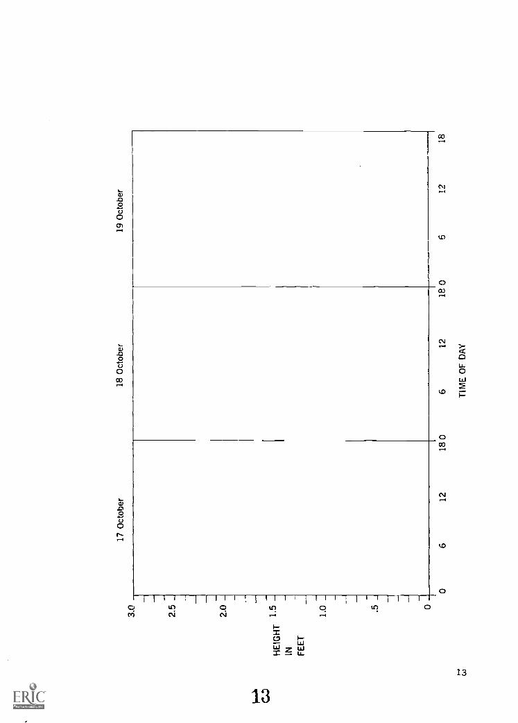
were the heights of the tiths?5. What is the latitude and longriL:de of Beaufort, North Carolina?6. Construct a graph like the one on the following page. Draw a continuous tide curve for
Shell Point, Harkers Island, North Carolina, for 17, 18, and 19 October 1968 on thegraph you construct.
12
12
3017
Oct
ober
18 O
ctob
er19
Oct
ober
2.5
_
2.0
_H
EIG
HT
1.5
IN_
FE
ET
.5_
0
06
1218
06
1218
0
tA;
TIM
E O
F D
AY
A12
18

ACTIVITIES
The progressive wave theory states that the tides are the result of waves, like ripples ona pond, moving from one area to another. High tides are the crests (high pact) of the wavea-d low tides are the troughs (low parts).
The standing wave theory states that tides are the result of water oscillating in a naturalbasin. High tides are where the water is highest and low tide is where the water is lowest.The water will oscillate back eventually and the situation will be reversed.
Materials: Water, dishpans of various sizes, watch or clock with a second hand, pencil,and paper.
Object: To observe on a small scale how the standing and progressive wave theoriesmay operate to produce the tides.
Methods: STANDING WAVE THEORYFill your different sizes of pans about half fullof water and allow them to settle. Start the water oscillating by lifting oneside of a pan and setting it down. Count the number of seconds for thewater to make one complete oscillation (the water to go from high to lowand back to high again). Do this for each of the different size pans. The timefor one complete oscillation is called the period of oscillation. Make a chartand repeat the operation two or three times.
Questions:1. What size pan has the fastest period of oscillation?2. In the center of the pan is a spot where the water does not move up or down. What is
this spot called?3. You started the water oscillating by lifting the pan. What force is responsible for the
oscillation of ocean basins?
Methods: PROGRESSIVE WAVE THEORYUse the large pan of water. Allow the waterto settle down. Slap the water sharply with the end of your pencil. Observe theripples (waves) produced.
Questions:1. Whai force could produce progressive waves in the ocean?2. How do these differ from standing waves?3. Can standing waves and progressive waves occur at the same time? See if you can create
both kinds in your large pan.
14
THE SEA AT ITS BOUNDARYWAVES
If you have ever been surfing, you know that there is more to it than just sanding on aboard. In fact, the first thing a beginner must learn is how to get out through the surf. Thenext thing he must learn is to judge when the next wave will get to him so that he can catcha ride. With a ,ittle practice at this, he will see that the waves seem to follow each other in apattern. In fact, they seem to break at about the same spot each time. Each one breaking atthis spot will seem to be about the same size. Only after acquiring this bit of knowledge isthe surfer ready to concentrate on riding the board.
Most of us may never go surfing, but waves are still important to us. Not only can wavescause serious damage, but they can benefit us when we harness their energy. Let's begin astudy of waves by looking at their anatomy.
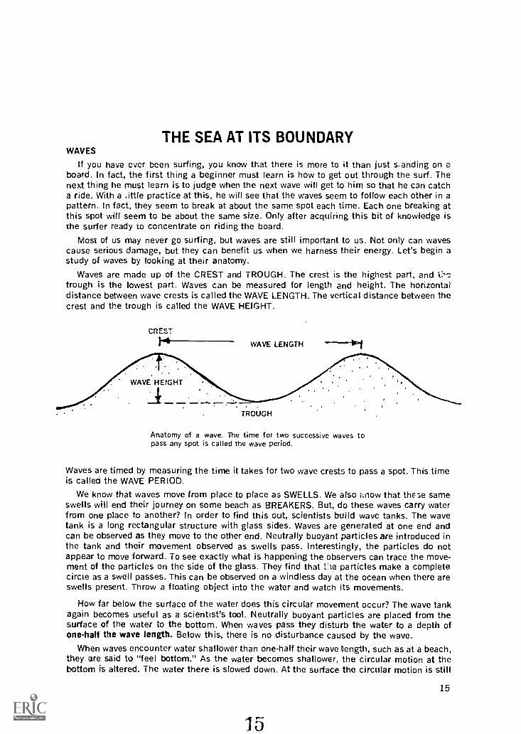
Waves are made up of the CREST and TROUGH. The crest is the highest part, andtrough is the lowest part. Waves can be measured for length and height. The horizontaldistance between wave crests is called the WAVE LENGTH. The vertical distance between thecrest and the trough is called the WAVE HEIGHT.
CREST
WAVE LENGTH -111
WAVE HEIGHT
TROUGH
Anatomy of a wave. The time for two successive waves topass any spot is called the wave period.
Waves are timed by measuring the time it takes for two wave crests to pass a spot. This timeis called the WAVE PERIOD.
We know that waves move from place to place as SWELLS. We also i:now that the sameswells will end their journey on some beach as BREAKERS. But, do these waves carry waterfrom one place to another? In order to find this out, scientists build wave tanks. The wavetank is a long rectangular structure with glass sides. Waves are generated at one end andcan be observed as they move to the other end. Neutrally buoyant particles are introduced inthe tank and their movement observed as swells pass. Interestingly, the particles do notappear to move forward. To see exactly what is happening the observers can trace the move-ment of the particles on the side of the glass. They find that the particles make a completecircle as a swell passes. This can be observed on a windless day at the ocean when there areswells present. Throw a floating object into the water and watch its movements.
Now far below the surface of the water does this circular movement occur? The wave tankagain becomes useful as a scientist's tool. Neutrally buoyant particles are placed from thesurface of the water to the bottom. When waves pass they disturb the water to a depth ofone-half the wave length. Below this, there is no disturbance caused by the wave.
When waves encounter water shallower than one-half their wave [length, such as at a beach,they are said to "feel bottom." As the water becomes shallower, the circular motion at thebottom is altered. The water there is slowed down. At the surface the circular motion is still
15

Motion of a particle of water in a wave. Notice the pathforms a circle. there is slight movement forward, but notvery noticeable. When many waves pass however, a largemass of water is moved very slowly. We call this massmovement.
moving very rapidly. In fact, ii moves so much faster than the bottom of the wave that thetop will spill over in front. Then the wave is known as a BREAKER. Breakers do carry wateralong with them. Waves that transport water are called TRANSLATION WAVES. If the wavebreaks very quickly, the crest will be thrown into tie trough in front. This leaves, for a shorttime, a tunnel of water (surfers call this the Banzai Tunnel) and the wave is known as aPLUNGING WAVE. If the process is slow, the crest simply tumbles down the front of the waveinto the trough. This kind of breaker is known as a SPILLING WAVE. Surfers prefer spillingwaves because they last much longer than plunging waves.
PLUNGING
-- .
Two types of breakers.
SPILLING
Now we know a little about waves, but what generates them and where do they come from?The waves we commonly see at the seashore are WIND WAVES. These are generated by thefriction of wind blowing across water. Usually, wind waves are rather small, but storms canproduce large waves. The size of wind waves are dependent on three factors, the fetch(distance over which the wind blows), the strength of the wind, and the length of time thewind blows. If all three factors are large, the waves will be large.
16

TIME
STRENGTH
The size of wind waves is dependent on 3 factors, thelength of time the wind blows, the strength of the wind, ant'the distance over which the wind blows (fetch).
Large storm waves can cause great damage. In fact, they are resporsible for new inlets inmany spots along the outer banks of North Carolina. We must remember that even normalwaves can erode vast areas of shoreline. The white Cliffs of Dover, E igland, are an excellentexample of how the constant action of normal waves can cut back the land.
The most spectacular kind of wave is the SEISMIC WAVE. These are commonly called"tidal waves," but that name is unfortunate. Seismic waves are the results cf movements ofthe sea bottom or undersea landslides. In fact the word "seism" means earthquake in Greek.Since seismic waves have nothing what-so-ever to do with the tries, scienti; ts have namedseismic waves, TSUNAMI (pronounced su-nah "-nee). Tsunami is the Japanese word for seis-mic waves.
Although tsunamis are large at the coast, a ship at sea would hardly notice one passing.This is because their crests and troughs are so far apart. In shallower water the situation iscompletely different. The waves may become breakers as much as 100 feet high. On April1, 1946, at Scotch Gap, Alaska, a tsunami completely demolished a radio tower that wasplaced on a rock 103 feet above the sea.
On the same day Dr. Francis P. Shepard witnessed Iiic results of that disturbance in Hawaii.The wave took many lives and wrecked much property. Today there is a tidal wave warningsystem around the Pacific Ocean. When a seismograph station detects an earthquake, awarning is sent to all areas that could be hit by a tsunami.
WAVES AND BEACHES
If you live inland, you probably think the ocean beach is a never-changing spread of sand.But, this is far from what a beach is really like. The beach bordering an ocean !s constantlychanging. This is due to the force of the wind and waves. As we have already said, the energyof the wind is picked up by the waves far at sea. When these waves travel to a teach all thisenergy is reeased on the beach. The larger the wave, the more energy it releases.
Although waves appear to hit the beach straight on, they seldom hit exactly parallel.Instead, they come from an angle. When a wave comes to a beach at an angle, the part closestto the beach feels bottom first. This part is then slowed down by friction with the bottom.
17
17

This allows the rest of the wave to "catch up". From the air, the wave woul( -,:ppear to bebent sr that it would be parallel to the beach. This bending is referred to as I- -FRACTION.Refraction takes most of the angle with the shoreline out of a wave. But, the's is usuallya slight angle remaining.
Waves approaching a beach at an angle will be refracted.As they approach the beach, the part of the wave nearshore will feel bottom and slow down. The other part willcontinue to move as fast as always and will seem to catchup with the other part.
Since breakers are translation waves that water, many breakers hitting the beachat the same angle can transport large amounts of water along the beach. This movement ofwater along the beach is called the LONGSHORE CURRENT. The longshore current is onlyfound in the breaker zone.
Waves hitting the shore at a slight angle cause a watercurrent in the surf zone (translation wave zone) in thedirection of Cle wave.
The longshore current is responsible for many of the natural alterations taking place onbeaches. It can and does move tons of sand from one spot on the beach to another. For in-stance, next time you go to the beach notice the sand kicked up by incoming breakers. This
18
18

sand kicked up from the bottom is moved along by the longshore current. The movement ofsand along a beach is called the LITTORAL DRIFT or LONGSHORE TRANSPORT. The effectsof the littoral drift can be seen an the ends of islands or peninsulas where the longshorecurrent is operating. There, the waves no longer hit against the shoreline and the . ongshorecurrent loses its energy. Sand is no longer carried along, but settles to the bottom. The resultsare long extensions of sand on the ends of these islands or peninsulas. We call these SPITS.
e,...2, Oft
4612
ii#1,0110.Is oh10,1'',lb '.41
Island with a sand spit deposited on the end by the lit-toral drift.
Another common movement of sand at the beach is a movement offshore and onshore.The results of this movement are long mounds of sand parallel to the beach called SANDBARS. Sand bars are usually present offshore after a week or two of high breakers. Whenthe waves are small for long periods, the sand bar is pushed toward shore and spread out bythe waves.
Associated with sand bars are RIP CURRENTS. Breaking :saves carry large amounts cfwater over the sand bar. The force of many waves breaking over the bar keeps water trappedbetween the bar and the beach. If the bar is broken anywhere along its length, water willgo back to the ocean through the hole. This water comes from both directions inside the barand a current going straight away from the beach results. This is the rip current.
Rip currents are responsible for carrying many bathers "over their head" at fine beach.Rips are strong and should be avoided. However, when necessary, surfers and lifeguardscan use rips to get through the surf rapidly. Coming back through a rip is very difficult andshould be attempted only if you are an excellent swimmer. If you are ever caught in a rip,swim parallel to shore. When you get out of the current, swim to shore. With just a little prac-tice you can learn to spot rip currents. They usually hold back waves and are sometimesdiscolored by sand and other debris picked up from the bottom.
MAN'S CONTROL OF THE BEACH ENVIRONMENT
Years ago ocean engineers thought barriers were the best way to keep a beach from washingaway. Lately, they have found that stabilizing a beach in one spot can cause trouble some-where else along the beach. For instance, if we stopped the lottoral drift at the middle pointon one of North Carolina's outer banks, the down current section of the beach would soon
19
19

. '
I
---'. !,; ,;';' .:" $ " ;.$'.1,1i,;()..
- -- - *:.,. .114. .
-^--...11.1 'ir4... ."
I.
:1 ,
1-1" :^1.1"#' .
Water getting trapped between a sand bar and the beachcan escape through a hole in the bar. This may producea strong current finning away from the beach. This currentis called a rip current.
be deprived of its normal flow of sand. Eventually that section of the beach would erode away.The upcurrent section of the beach would erode away. The upcurrent section of the beachwould become much wider because the barrier stops the sand here.
Many materials have been tried as barriers, but large rocks are the cheapest and easiestto obtain. These rocks are used to form JETTIES, GROINS, AND BREAKWATERS. Jetties are:structures that extend into the ocean at the entrance of rivers or bays. They restrict the flowof water out of the river to a narrow channel. This tends to prevent SHOALS (sand moundslin rivers or lagoons) from accumulating at the river mouth.
Groins are similar to jetties but are usually placed perpendicular to the shore. They aregrouped in a series, at critical points, to catch or hold sand.
20
System of groins and jetties. The. groins are perpendicularto the beach and used for catching and holding sand fromthe littoral drift. The jetties are found on each side of themouth of the inlet or river. Its purpose is to keep sandfrom "shoaling up" in the entrance.
20

Breakwaters are used outside of a beach to break up the waves hitting shore. This createsa calm area for small boats to anchor. Although this sounds like a good idea, it does havesome serious consequences. If the waves no longer strike the shore, the er-ergy creating thelongshore current is gone. When the longshore current encounters the calm water of thebreakwater, the sand it carries is deposited. The water in the breakwater will then becomeincreasingly more shallow. The beach on the down current side will contw.ue to be erodedand will not receive sand from above. The beach there will become very narrow.
Breakwaters are built to slow down waves. This can makean excellent spot to anchor boats next to shore. Sincethey slow the waves down, sand is deposited behind them,ruining the beach.
In areas where shoals build up in a shipping lane, man has found a method to removethem. This is done by a boat, called a dredge, that is specially designed for the purpose.There are several kinds of dredges. One kind takes material off the bottom and transports itto spoils areas through long pipes. Another type dredge, called a hcpper dredge, picks upthe material and stores it in its hold until it can be carried offshore and dumped in theocean.
Parallel dunes built by snow fence and grass. The snowfence, being nearly buried, will not stop much more sand.The vegetation has grown with its dune and will continueto build up. Notice also the stabilizing framework createdby the root systems.
21
21
Above the water line on the beach, sand is moved by the wind. When the wind hits vegeta-tion or some other barrier it slows oown. The sand being carried by the wind then falls tothe ground. If this continues for long periods, SAND DUNES are formed. Sand dunes aremounds of sand that pile up on the upper beach. They are very important in keeping stormwaves from destroying the land behind them. Since the land along our coasts is valuable,man is now trying to preserve it by building sand dunes.
There are several methods man uses to build dunes. One method is to pile sand up witha machine. This is not the best way because the wind will soon blow it away. The t est methodsare the use of snow fences and beach grasses. With these methods, the wind actually buildsthe sand dune. The vegetation and sand fences will hold the dune in place.
Recent investigation has pointed out that vegetation is the ideal method to bui d dunes. Infact, until man came along this was the only way for dunes to become stable. Can you thinkof a reason why plants are the best dune builders? How about the holding power of the roots?
VOCABULARY
Bar: P. mound of sand found offshore and parallel with the beach.
Beach: An area bord,lring an ocean that is affected by the waves.bi.,.ker: A wave in which the crest has fallen off.Breakwater: A wave barrier placed offshore and parallel to the shoreline.
Crest: The uppermost part of a wave.Groin: Barriers placed perpendicular to a shoreline.
Jetty: A barrier extending into the ocean at the mouth of a river or bay.Littoral Dirft: The movement of sand along a beach because of the longshore curNnt.Longshore Current: Current of water that moves along a beach caused by waves breaking
at an angle with shoreline.Neutrally Buoyant Particle: A particle that neither floats or sinks because it has the same
density as water.
Plunging Wave: A breaker in which the crest is thrown off into the trough ahead.Rip Current: Water currents formed when water moves to sea through a break in an offshore
bar.
Shoal: Shallow area caused by the deposition of sand or mud.
Spilling Wave: A breaker in which the crest slides down itself into the trough ahead.Swell: A stable wave that does not carry water from one spot to another. The water particles
in this wave move in a circle.Trough: The low area of a wave between two crests.Tsunami: A seismic wave that may reach great heights.
Wave Height: The vertical distance between a wave trough and a wave crest.
22
22

Wave Length: The horizontal distance between two crests.Wave Period: the time that elapses between the passing of two wave crests.
QUESTIONS
Fill in the blanks with the correct answer.
1. The size of wind waves is dependent on
and
2. is the .Mpanese word for waves produced by seismic activity
on the bottom of the ocean.
3. The time it takes for iwo wave crests to pass a spot is called the wave
4. Breakers carry water from one place to another and are called
waves by scientists.
5. Currents of water moving away from shore through a hole in the offshore bar are called
currents.
6. The current is a current of water caused by breakers striking
the beach at an angle.
7. The mass movement of sand along a coast because of the Iongshore current is called
the
DISCUSSION
1. Discuss why the littoral drift is important to the seaports of North Carolina.2. Describe a method of measuring the height of waves. Make it your own invention or
one you know about.3. How are sand dunes formed and why are beach grasses important?
23
23

ACTIVITIES
Wind waves are produced by the friction of wind 'Diming aaoss the water. Wind producedwaves are the normal waves seen at the coast. Another type wave, seldom seen, is the seismicwave or tsunami. Tsunamis are produced by a disturbance on the bottom of the ocean.Materials: shallow elongated pan, small fan (optional), sand, pencil, and paper.Object: to create and observe, on a small scale, wind produced waves and seismic
produced waves.Methods: Wind WavesFill the pan with water about three-fourths full. Allow the water
to settle. Use the fan or blow across the water in the pan. Observe the rr.,-sults.Seismic WavesFill the pan about three-fourths full. Allow the water tosettle down. Lift the edge of the pan slightly then allow it to fall .)ack tothe desk. Observe the results.
QUESTIONS:1. What happened to our artificially produced waves when they got to the end of our pan?
How does this differ from ocean waves striking a beach?2. What differences do you notice about the size and number of waves produced by wind
and seismic activities?3. Waves will reflect if their energy is not expended. See if you can make the waves you pro-
duce expend their energy by placing sand shaped like a beach at one end of your pan.What happens to your waves now?
24
24

BEYOND THE LANDNow that we have studied some of the processes at work along the edge of the sea, let's
go beyond the shoreline. There are some important features in the oceans that should befamiliar to us.
The relatively shallow area surrounding a continent is called the CONTINENTAL SHELF.The continental shelf extends from the beach to a point where a relatively steep-sloped drop-off to the deep ocean floor occurs. This slope is called the CONTINENTAL SLOPE.
Continental shelves are very important to fishermen. Since they border continents, mineralswashed from land mixes with the water over the shelf. Marine plants, mostly phytoplanktcn(phyto-plant, plankton-floating), are able to use these minerals to grow. The plants are theneaten by fishes and other important marine organisms.
The width of continental shelves differ from place to plcce. For instance, the continentalshelf on the Atlantic Coast of North America is only about one mile wide at West Palm Beach,Florida. But at Beaufort, North Carolina, it is about forty five miles wide. The shelves may bemade of many different types of material. They may be rocky, sandy, muddy or a combinationof all three. They may also have depressions or hills on them. In fact, some h.11s stick outof the water as islands.
As we said, on the far edge of the continental shelf is the continental slope. The continentalslope drops down to the deep ocean floor. For many years, scientists thought the deep oceanfloor was a smooth featureless plam. With improved methods of sounding (testing the depth),they found that it is not a smooth plain. In fact, they found some of the most spectacularmountains and valleys anywhere on earth. The MID-ATLANTIC RIDGE is one of the mountainranges found there. It extends north-south through the middle of the Atlantic Ocean and isconnected to other ranges in other oceans. On each side of the Mid-Atlantic Ridge are DEEPSEA BASINS. These are simply deep depressions on the oceans floor. Also found on the deerocean floor are isolated mountains called SEAMOUNTS. Some of these seamounts are flattopped and are called GUYOTS (pronounced je yoos).
No one is sure how seamounts originated. Some oceanologis,.i think they may be oldvolcanoes. But even if they are old volcanoes, how did some of tho seamounts (guyots) getflat tops? They believe that millions of years ago, during the ice ages, these seamounts wereabove sea level. Above the water, they were eroded by wind and waves. When the many tonsof ice over the continents melted, the level of the sea became much higher. This submergedthe eroded tops of the seamounts. The hypothesis does not completely explain guyots, but itis a step in attempting to understand how they became flat-topped.
The deepest areas in the ocean are the deep sea trenches. The deepest trench known isthe Mariana trench found in the Pacific Ocean. It has been measured at 35,700 feet, almost7 miles deep. Trenches seem to be caused by volcano activity, but this has not been proven.
SEA LEVEL
CONTINENTAL SHELF GUYOTCONTINENTAL SEAMOUNT
SLOPE
DEEP-SEA FLOOR
DEEP-SEA TRENCH
Profile of the Ocean Bottom.
25
25

In all our studies so far, we have failed to consider the water in the sea. After all, this iswhat we think of when we think of the sea. Water is called the universal solvent by chemists,because it can dissolve so many substances. This is why sea water tastes salty to us. Scientistsbelieve that millions of years ago, ocean water was not salty. With the erosion of land, mineralswere dissolved by the streams, carried to the sea and concentrated by evaporation. Overmillions of years, this gave the ocean its present salinity this term refers to minerals dissolvedin sea water). However, it should be remembered that most of the sea water is still water.Less than 4% is dissolved rnjnerals and solids.
The most common elements (but not all of them) found dissolved in sea water are chlorine,sodium, magnesium, potassium, calcium, iron, and carbon. Two of the most common sub-stances, chlorine and sodium, can combine to form common table salt, NaCI. During theCivil War sea water was boiled in large pots. When the water was completely evaporated,crystals of salt were left behind in the bottom of the pot.
These salt works were an early attempt at mining the sea. Today bromine is taken fromsea water in large amounts. The cost is very high for removing most minerals from the sea.In fact, it costs more to mine most minerals from the sea than a company could make byselling them.
The ability of water to hold heat is very important to coastal dwellers. Land areas of theearth lose and gain heat very rapidly. The oceans are much slower. During the winter, coastalareas usually remain warmer than the inland areas. Often water at different depths will havedifferent temperatures. Sometimes a very distinct line of difference can be found betweenthe different temperatures. This line is called a THERMOCLINE.
The waters of the ocean are always in motion. Trade winds and the spinning of the eartha:e responsible for most of this movement. The most spectacular of the movements are calledOCEAN CURRENTS. Ocean currents are caused by winds and the earths rotation. If we tooka pan of water and suddenly moved it forward, we could see how the water would spill overthe back of the pan. This is very similar to the way the water behaves in relation to thespinning of the earth. If there were no land masses to stop the water, there would .be a con-tinuous currem from east to west ir, the sea. But, land masses prevent the ocean watersfrom doing this. Instead, currents turn away when they encounter a land mass.
26
ROTATION WIND
Ocean currents are the results of two main factors. Theearths rotation and the trade winds. The trade winds terdto push water along with them. The earths rotation nasa different effect. The water tends to remain in place asthe earth turns. Just as if the water was a separate shelland did not turn. This is seen by us as a current that isturned as it encounters land.
26
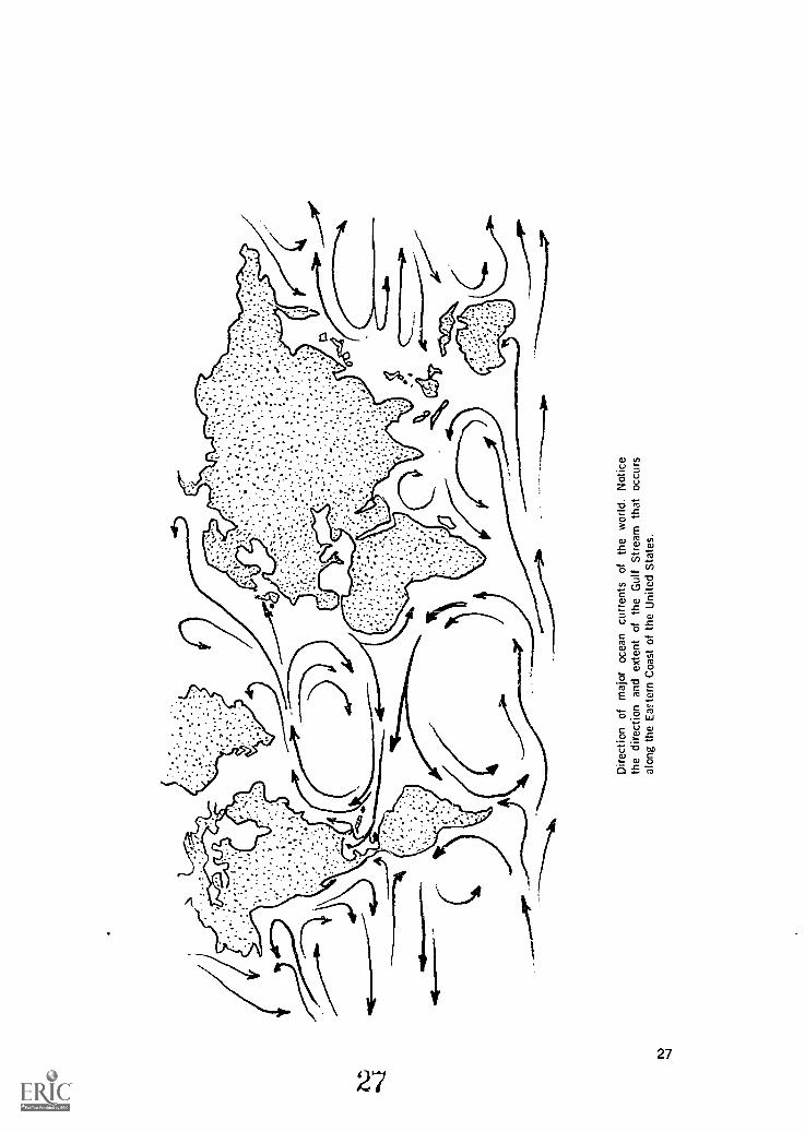
Dire
ctio
n of
maj
or o
cean
cur
rent
s of
the
wor
ld. N
otic
eth
e di
rect
ion
and
exte
nt o
f the
Gul
f Str
eam
that
occ
urs
alon
g th
e E
aste
rn C
oast
of t
he U
nite
d S
tate
s.

Ocean currents occur over ail oceans, but the most studied of the ocean currents is theGulf Stream. The Gulf Stream carries warm water from the Caribbean Sea to the east coastof the United States and the northwest coast of Europe. The warm waters of the Gulf Streammeeting the cold waters of the Labrador Current causes great fog clouds on the grand fishingbanks of Newfoundland.
Another important current in the ocean is the UPWELLING CURRENT. This current israther slow, but carries cold bottom water to the surface. This water may carry minerals fromdecayed animals that have sunk to the bottom. Phytoplankton can then use the mineralsto grow.
Oceanologists use many methods to study the ocean. One of his most important tools isthe research vessel. These are specially designed ships that carry equipment for all phasesof ocean study. This equipment must be designed to reach the great depths necessary tostudy the oceans properties. The pressure and temperatures are extreme at great depths.
Bottom studies are done by using coring devices. These are dropped from the ship and areattached by a cable. They are streamlined and very heavy. The speed and weight of the in-strument help push a long pipe into the bottom material. The whole instrument is then broughtto the surface and the material caught in the pipe is studied. By getting the material thisway, the oceanologist can get a cross section of the sediments on the bottom. Another methodof obtaining bottom materials is with the clam-jawed grabber. When this instrument touchesthe bottom, it closes, much like a clam, and a piece of the bottom is scooped up.
Salinity am' temperature of deep water is tested by using the nansen bottle. These bottlesare lowered to the desired depth on a cable, closed up, the temperature recorded, and thewater is brought to the surface for study. Thermometers, pressure gauges, current meters, andcameras are also lowered into the ocean on cables.
BottomCorer
Clam-jawedGrabber
NansenBottle
The fathometer is used to determine the depth of the ocean floor. This electronic instru-ment works by bouncing a sound wave, from the ship, off the bottom of the ocean. The longer
28
28

it takes the wave to reach the ship after bouncing from the bottom, the deeper is the water.Fishermen can use this device for finding fish. Sound waves pounce off the fish just as theydo off the bottom. Fishermen then know where to drop their nets to catch a schlol of fish.
Oceanologists can also observe the bottom directly. If he only wants to go to 150 feet,he can safely use scuba gear (Self-Contained, Underwater Breathing Apparatus). For deeperobservation, the research submarines can dive to about 3,000 feet. The bathyscaph (fromGreek meaning "deep boat") is designed for much deeper diving. The deepest dive was inthe Challenger Deep, 35,700 feet. This was done by Jacques Piccard in his bathyscaph"Trieste." Piccard was able to prove that life exists at this great depth when he saw a fishswim by his window.
Bathyscaphe "Trieste", one of the first free "diving boats"
VOCABULARY
Continental Shelf: The area surrounding a continent, out to the steep-sloped drop-off to thedeep ocean basin.
Continental Slope: The steep slope that marks the end of the continental shelf.Deep Sea Basin: Flat bottom depression that forms the deep ocean floor.Deep Sea Trenches: Trenches in the ocean floor believed to be caused by volcanic activity.
They are the deepest spots in the ocean.Guyots: Flat-topped sea mounts.
Mid-Atlantic Ridge: Ridge of mountains in the Atlantic Ocean.Ocean Currents: Water moving from one place to another in the open ocean due to winds and
the earth rotation.Phytopldnkton: Floating plants in the sea, mostly microscopic.
29
29

Salinity: Amount of dissolved minerals in the sea.Sea Mounts: Isolated mountains that are believed to be volcanos.Thermocline: An area in the ocean where the temperature rapidly changes.Updwelling Current: A current that moves from the bottom to the top of the oceans waters.
QUESTIONS
Fill in the blanks with the correct answer.
1. Water is called the solvent because it dissolves so many
substances.
2. The warm ocean current found off the coast of North Carolina is called the
Stream.
3. The bathyscaph "Trieste" made its deepest dive to 35,700 feet in the
Trench.
4. Microscopic floating plants in the sea are called
5. Isolated flat-topped mountains in the sea are :ailed
6. The ridge is a mountain range in the Atlantic Ocean.
7. The corer is a device used to sample the oceans bottom.
8. The minerals dissolved in ocean water is called its
9. The oceans water is percent pure water.
10. The term Scuba stands for
DISCUSSION
1. Why are the continental shelf areas of importance to the fisherman?2. Explain the hypothesis of why sea mounts have pointed tops and guyots have flat tops.3. Write down a complete method of studying the continental shelf on the North Carolina
coast. Include research ships and the instruments you would use.
30
Sea watera residue of
Materials:Methods:
Questions:
ACTIVITIES
contains about four percent dissolved salts. If sea water is allowed to evaporate,salt will remain behind when the water is gone.
large beaker, sea water, bunsen burner, pencil and paper.Place the sea water in the beaker. Evaporate the water out of the beaker byboiling it over the bunsen burner. Record the end results.
1. What is the most abundant substance left behind?2. How else may the salts be recovered besides boiling?3. How did the great Salt Flats at Utah get there?
31