dn 20-26 dredging notice u.s. army corps of engineers …

5
DN 20-26 DREDGING NOTICE U.S. ARMY CORPS OF ENGINEERS ST. PAUL DISTRICT NOTICE DATE: July 2 nd , 2020 DREDGING CATEGORY: Imminent MEETING DATE: If requested MEETING TIME: BOAT REQUIREMENT: MEETING LOCATION: DREDGE CUT NAME: Cannon River RIVER MILE: 792.7 – 793.7 HISTORIC DATA Frequency: 34 % Avg. Quantity/Job: 32,575 yd 3 Date Last Dredged: September 5 th , 2019 Avg. Quantity/Year: 11,075 yd 3 SURVEY DATA Date Surveyed: July 1 st , 2020 Water Surface Elevation: 670.9 Low Control Pool Elevation: 666.6 Net Difference: +4.3 5-Day River Forecast: Slight rise DREDGING DATA Recommended Channel Width: 300 feet Recommended Dredging Depth: 12’ Estimated Quantity: 48,165 yd 3 plus 2,382 yd 3 for placement site access Type of Dredge: Contract Mechanical Proposed Dredging Date: July 2 nd , 2020 Estimated Duration: 24 dredging days Justification for Dredging: The navigation channel is reduced 80’ between the 9.0’ contours and closed between the 10.5’ contours. MATERIAL PLACEMENT DATA Proposed Placement Site: Red Wing Commercial Harbor Location: 4-791.6-RMP Site Characteristics: This is a historically used upland placement site owned by the City of Red Wing. If you have any questions concerning this project, or if you would like to request an on-site meeting, please call me at 651-290-5155. Dan Cottrell Dredging Manager

Upload: others

Post on 28-Feb-2022

3 views

Category:

Documents


0 download

TRANSCRIPT

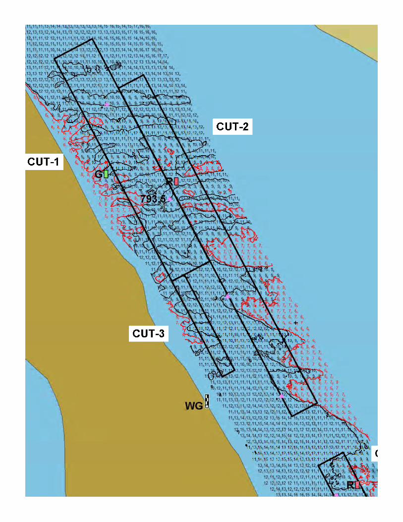
DN 20-26 DREDGING NOTICE U.S. ARMY CORPS OF ENGINEERS ST. PAUL DISTRICT NOTICE DATE: July 2nd, 2020 DREDGING CATEGORY: Imminent MEETING DATE: If requested MEETING TIME: BOAT REQUIREMENT: MEETING LOCATION: DREDGE CUT NAME: Cannon River RIVER MILE: 792.7 – 793.7 HISTORIC DATA

Frequency: 34 % Avg. Quantity/Job: 32,575 yd3 Date Last Dredged: September 5th, 2019 Avg. Quantity/Year: 11,075 yd3

SURVEY DATA Date Surveyed: July 1st, 2020 Water Surface Elevation: 670.9 Low Control Pool Elevation: 666.6 Net Difference: +4.3 5-Day River Forecast: Slight rise

DREDGING DATA Recommended Channel Width: 300 feet Recommended Dredging Depth: 12’ Estimated Quantity: 48,165 yd3 plus 2,382 yd3 for placement site access Type of Dredge: Contract Mechanical Proposed Dredging Date: July 2nd, 2020 Estimated Duration: 24 dredging days Justification for Dredging: The navigation channel is reduced 80’ between the 9.0’ contours and closed between the 10.5’ contours.

MATERIAL PLACEMENT DATA Proposed Placement Site: Red Wing Commercial Harbor Location: 4-791.6-RMP Site Characteristics: This is a historically used upland placement site owned by the City of Red Wing.

If you have any questions concerning this project, or if you would like to request an on-site meeting, please call me at 651-290-5155.

Dan Cottrell Dredging Manager

b6codjc4
Text Box
Pool 4, Cannon River River Mile: 792.7 - 793.7 Surveyed: July 1st, 2020 Scale: 1" = 200'
b6codjc4
Text Box
Pool 4, Red Wing Comm Harbor Plcmt Access River Mile: 791.5 Surveyed: July 1st, 2020 Scale: 1" = 200'