distribution of classified soils in south-west western
TRANSCRIPT

Distribution of classified soils in south-west Western Australia
Resource management technical report 401


Distribution of classified soils in south-west Western Australia
Resource management technical report 401
Dennis van Gool, Angela Stuart-Street and Peter Tille

© State of Western Australia 2018
July 2018
ISSN 1039-7205
Cover: Soil profiles
Unless otherwise indicated, ‘Distribution of classified soils in south-west Western Australia’ by Department of Primary Industries and Regional Development is licensed under a Creative Commons Attribution 3.0 Australian Licence. This report is available at dpird.wa.gov.au.
The Creative Commons licence does not apply to the State Crest or logos of organisations.
Recommended reference
van Gool, D, Stuart-Street, A & Tille, P 2018, ‘Distribution of classified soils in south-west Western Australia’, Resource management technical report 401, Department of Primary Industries and Regional Development, Perth.
Disclaimer
The Chief Executive Officer of the Department of Primary Industries and Regional Development, and the State of Western Australia accept no liability whatsoever by reason of negligence or otherwise arising from the use or release of this information or any part of it.
Copies of this document are available in alternative formats upon request.
Department of Primary Industries and Regional Development 3 Baron-Hay Court, South Perth WA 6151 Telephone: +61 (0)8 9368 3333 Email: [email protected] Website: dpird.wa.gov.au
iii
Contents Acknowledgements ............................................................................................. iv
Summary ............................................................................................................... v
Introduction ........................................................................................................... 1
Soil classifications used in Western Australia ................................................ 1 Ag Soils in the south-west .............................................................................. 2
1 Alkaline shallow duplexes ........................................................................... 4
2 Calcareous sands ........................................................................................ 8
3 Calcareous loamy earths ........................................................................... 11
4 Clays and shallow loamy duplexes .......................................................... 14
5 Coloured sands .......................................................................................... 19
6 Deep sandy duplexes ................................................................................ 23
7 Deep loamy duplexes and earths ............................................................. 27
8 Ironstone gravelly soils ............................................................................. 31
9 Non-saline seasonally wet soils ............................................................... 35
10 Pale sands .................................................................................................. 38
11 Saline wet soils .......................................................................................... 42
12 Sandy earths ............................................................................................... 45
13 Self-mulching clays ................................................................................... 49
14 Shallow loams over rock ........................................................................... 52
15 Shallow sands over rock ........................................................................... 56
16 Shallow sandy duplexes ............................................................................ 60
17 Stony soils .................................................................................................. 64
18 Other non-arable land ................................................................................ 68
18.1 Rock outcrop........................................................................................ 68 18.2 Non-cropping soils: wet or saline ......................................................... 70 18.3 Remaining non-cropping soils (excludes rock outcrop and wet or
saline land) .......................................................................................... 72 Appendix A The area and proportion of Australian Soil Classification
Soil Orders and Suborders within Ag Soils ............................................. 74
Appendix B The Australian Soil Classification and Western Australian Soil Groups ................................................................................................. 75
References .......................................................................................................... 88

iv
Acknowledgements We would like to acknowledge the efforts of the many land resource and soil surveyors, past and present, who have contributed to the soil knowledge in Western Australia.
This work is possible because federal and state funding over many years has enabled the compilation of state and national databases of our valuable soil resources. Presently the ‘baton’ is held by staff in the Department of Primary Industries and Regional Development, who are the current custodians of the state’s soil databases.
Thanks also to David Bicknell and Pauline Gazey who identified the need for this publication.
v
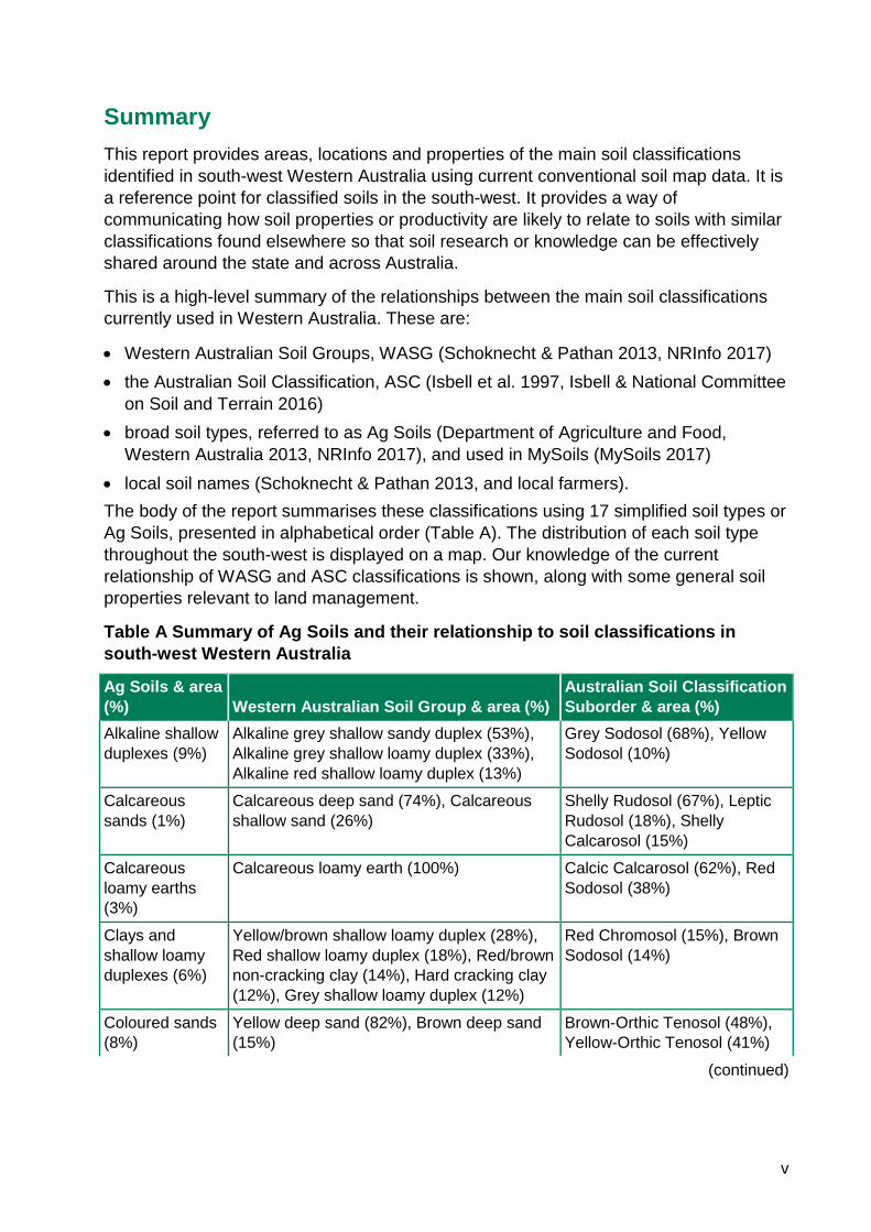
Summary This report provides areas, locations and properties of the main soil classifications identified in south-west Western Australia using current conventional soil map data. It is a reference point for classified soils in the south-west. It provides a way of communicating how soil properties or productivity are likely to relate to soils with similar classifications found elsewhere so that soil research or knowledge can be effectively shared around the state and across Australia.
This is a high-level summary of the relationships between the main soil classifications currently used in Western Australia. These are:
• Western Australian Soil Groups, WASG (Schoknecht & Pathan 2013, NRInfo 2017) • the Australian Soil Classification, ASC (Isbell et al. 1997, Isbell & National Committee
on Soil and Terrain 2016) • broad soil types, referred to as Ag Soils (Department of Agriculture and Food,
Western Australia 2013, NRInfo 2017), and used in MySoils (MySoils 2017) • local soil names (Schoknecht & Pathan 2013, and local farmers). The body of the report summarises these classifications using 17 simplified soil types or Ag Soils, presented in alphabetical order (Table A). The distribution of each soil type throughout the south-west is displayed on a map. Our knowledge of the current relationship of WASG and ASC classifications is shown, along with some general soil properties relevant to land management.
Table A Summary of Ag Soils and their relationship to soil classifications in south-west Western Australia
Ag Soils & area (%) Western Australian Soil Group & area (%)
Australian Soil Classification Suborder & area (%)
Alkaline shallow duplexes (9%)
Alkaline grey shallow sandy duplex (53%), Alkaline grey shallow loamy duplex (33%), Alkaline red shallow loamy duplex (13%)
Grey Sodosol (68%), Yellow Sodosol (10%)
Calcareous sands (1%)
Calcareous deep sand (74%), Calcareous shallow sand (26%)
Shelly Rudosol (67%), Leptic Rudosol (18%), Shelly Calcarosol (15%)
Calcareous loamy earths (3%)
Calcareous loamy earth (100%) Calcic Calcarosol (62%), Red Sodosol (38%)
Clays and shallow loamy duplexes (6%)
Yellow/brown shallow loamy duplex (28%), Red shallow loamy duplex (18%), Red/brown non-cracking clay (14%), Hard cracking clay (12%), Grey shallow loamy duplex (12%)
Red Chromosol (15%), Brown Sodosol (14%)
Coloured sands (8%)
Yellow deep sand (82%), Brown deep sand (15%)
Brown-Orthic Tenosol (48%), Yellow-Orthic Tenosol (41%)
(continued)

vi
Table A continued
Ag Soils & area (%) Western Australian Soil Group & area (%)
Australian Soil Classification Suborder & area (%)
Deep sandy duplexes (12%)
Grey deep sandy duplex (56%), Yellow/brown deep sandy duplex (20%), Alkaline grey deep sandy duplex (12%)
Grey Sodosol (35%), Yellow Sodosol (20%), Yellow Chromosol (18%), Grey Chromosol (11%)
Deep loamy duplexes and earths (7%)
Brown loamy earth (28%), Red loamy earth (25%), Brown deep loamy duplex (16%), Red deep loamy duplex (11%)
Red Kandosol (21%), Brown Dermosol (21%), Brown Kandosol (11%)
Ironstone gravelly soils (13%)
Duplex sandy gravel, (40%), Loamy gravel (39%), Deep sandy gravel (20%)
Brown Kandosol (23%), Sesqui-nodular Tenosol (20%), Yellow Chromosol (19%), Grey Chromosol (18%),
Non-saline seasonally wet soils (2%)
Semi-wet soil (100%) Redoxic Hydrosol (71%), Oxyaquic Hydrosol (20%),
Pale sands (8%) Pale deep sand (79%), Gravelly pale deep sand (21%)
Bleached-Orthic Tenosol (31%), Grey-Orthic Tenosol (24%), Sesqui-nodular Tenosol (19%), Arenic Rudosol (16%),
Saline wet soils (3%)
Saline wet soil (100%) Salic Hydrosol (100%)
Sandy earths (7%)
Yellow sandy earth (40%), Red sandy earth (26%), Brown sandy earth (14%), Acid yellow sandy earth (11%)
Yellow Kandosol (46%), Red Kandosol (25%), Brown Kandosol (12%),
Self-mulching clays (<1%)
Self-mulching cracking clay (100%) Grey Vertosol (70%), Brown Vertosol (20%), Red Vertosol (10%)
Shallow loams over rock (2%)
Red-brown hardpan shallow loam (54%), red shallow loam (41%)
Red Kandosol (86%),
Shallow sands over rock (2%)
Yellow/brown shallow sand (50%), Pale shallow sand (29%), Red shallow sand (20%)
Leptic Tenosol (43%), Bleached-Leptic Tenosol (18%), Leptic Rudosol (11%),
Shallow sandy duplexes (6%)
Grey shallow sandy duplex (50%), Yellow/brown shallow sandy duplex (34%), Red shallow sandy duplex (14%)
Grey Sodosol (21%), Yellow Chromosol (20%), Yellow Sodosol (16%), Brown Chromosol (15%), Grey Chromosol (10%),
Stony soils (4%) Shallow gravel (76), Stony soil (23%) Sesqui-nodular Tenosol (56%), Brown Kandosol (15%), Clastic Rudosol (14%),
Note: Only the WASG and ASC components that occupy more than 10% of the broad soil type are listed.

Soil classes in south-west Western Australia
1
Introduction This report provides soil areas, locations and properties of the main soil classifications identified in south-west Western Australia using current conventional soil map data.
Computing power and the data and models available have dramatically increased our ability to model, predict and interpret soils. However, as more data is collected and methods evolve, soil reporting is to some degree a moving target, which can be confusing to users who do not have time to understand all the detailed assumptions behind the predictions. This report can be used as a reference point for classified soils in the south-west of Western Australia.
Soils are complicated. For estimating soil characteristics like plant root growth, or to calculate plant available soil water, it is important to know what is going on, sometimes up to several metres, below the surface. Soil classifications attempt to categorise soils into groups with similar properties. Soil classifications need to be formalised with clear rules covering many properties. Formal soil classifications allow us to group soils so that we can transfer knowledge and information relevant to agriculture and the environment on similar soils that occur in different locations. It also allows us to correlate different formal soil classifications.
Soil classifications used in Western Australia
This document is a high-level summary that uses the relationship between the main soil classifications in Western Australia. These are:
1. Western Australian Soil Groups, WASG (Schoknecht & Pathan 2013, NRInfo 2017) The WASG are used throughout Western Australia and underpin the statewide soil-landscape and land capability mapping (NRInfo 2017).
2. The Australian Soil Classification, ASC (Isbell et al. 1997, Isbell & National Committee on Soil and Terrain et al. 2016)
The ASC is required to relate soil information about research, yields or management in Western Australia to soil information in other parts of Australia or in other parts of the world. For example, is the soil on my farm similar enough that I can use the management practice developed in New South Wales? 3. Broad soil types, referred to as Ag Soils (DAFWA 2013, NRInfo 2017), and as used
in Mysoils (Mysoils 2017) Ag Soils, the broad soil types used in this report, are only suitable as a basic communication tool because the diverse range of properties associated with any soil cannot be summarised briefly. 4. Local soil names (Schoknecht & Pathan 2013, and local farmers) Local soil names are included in Schoknecht and Pathan (2013). They are an informal classification and you cannot be certain what the soils actually are. Often local soil names are based only on the soil that is visible on the surface.
An example is ‘sandplain soils’. More than 70% of soils in south-west Western Australia have sandy surfaces, many of which are referred to as ‘sandplain’ because they look
Soil classes in south-west Western Australia
2
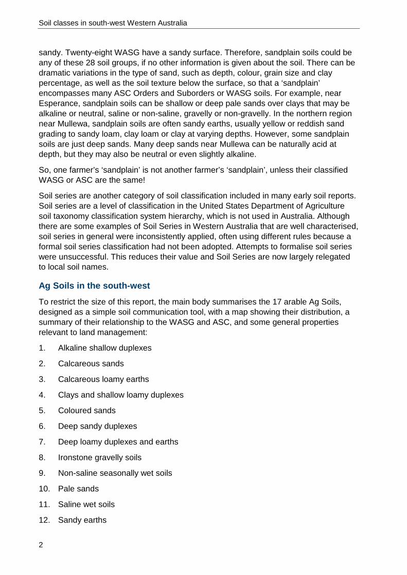
sandy. Twenty-eight WASG have a sandy surface. Therefore, sandplain soils could be any of these 28 soil groups, if no other information is given about the soil. There can be dramatic variations in the type of sand, such as depth, colour, grain size and clay percentage, as well as the soil texture below the surface, so that a ‘sandplain’ encompasses many ASC Orders and Suborders or WASG soils. For example, near Esperance, sandplain soils can be shallow or deep pale sands over clays that may be alkaline or neutral, saline or non-saline, gravelly or non-gravelly. In the northern region near Mullewa, sandplain soils are often sandy earths, usually yellow or reddish sand grading to sandy loam, clay loam or clay at varying depths. However, some sandplain soils are just deep sands. Many deep sands near Mullewa can be naturally acid at depth, but they may also be neutral or even slightly alkaline.
So, one farmer’s ‘sandplain’ is not another farmer’s ‘sandplain’, unless their classified WASG or ASC are the same!
Soil series are another category of soil classification included in many early soil reports. Soil series are a level of classification in the United States Department of Agriculture soil taxonomy classification system hierarchy, which is not used in Australia. Although there are some examples of Soil Series in Western Australia that are well characterised, soil series in general were inconsistently applied, often using different rules because a formal soil series classification had not been adopted. Attempts to formalise soil series were unsuccessful. This reduces their value and Soil Series are now largely relegated to local soil names.
Ag Soils in the south-west
To restrict the size of this report, the main body summarises the 17 arable Ag Soils, designed as a simple soil communication tool, with a map showing their distribution, a summary of their relationship to the WASG and ASC, and some general properties relevant to land management:
1. Alkaline shallow duplexes
2. Calcareous sands
3. Calcareous loamy earths
4. Clays and shallow loamy duplexes
5. Coloured sands
6. Deep sandy duplexes
7. Deep loamy duplexes and earths
8. Ironstone gravelly soils
9. Non-saline seasonally wet soils
10. Pale sands
11. Saline wet soils
12. Sandy earths

Soil classes in south-west Western Australia
3
13. Self-mulching clays
14. Shallow loams over rock
15. Shallow sands over rock
16. Shallow sandy duplexes
17. Stony soils
Appendix A shows the area of the ASC Soil Order and Suborder compared to broad Ag Soils and has distribution maps of the main ASC Soil Orders and Suborders in south-west Western Australia.
Appendix B shows how the ASC Soil Order and Suborder relate to the WASG and qualifiers. Qualifiers subdivide the WASG into categories that affect land management. Note: this lookup table is a first approximation; as more soil data is collected and analysed, soil data and soil correlations will change.
Distribution maps of individual WASG are in Schoknecht and Pathan (2013).

Soil classes in south-west Western Australia
4
1 Alkaline shallow duplexes Sand or loam topsoil over alkaline clay subsoil at less than 30cm.
Figure 1.1 Alkaline shallow duplexes occur on about 2 234 800ha or 9% of the south-west

Soil classes in south-west Western Australia
5
Identifying properties:
• sandy or loamy surface texture • abrupt change to clayey subsoil at less than 30cm • topsoil is grey, yellow or red • alkaline pH subsoil • subsoil often calcareous • subsoil commonly has poor rooting conditions and slow water permeability.
Alkaline red shallow loamy duplex, Dalwallinu
Alkaline grey shallow sandy duplex, Midlands
Alkaline grey shallow loamy duplex, Salmon Gums
Figure 1.2 Images for common Alkaline shallow duplexes

Soil classes in south-west Western Australia
6
Table 1.1 Western Australian Soil Groups and Australian Soil Classification for Alkaline shallow duplexes
WASG name & code Description
Some common names
Estimated area (ha)
Estimated area (%)
Estimated area of ASC Suborder (%)
Alkaline grey shallow sandy duplex (402)
Grey sandy over alkaline sandy clay loam to clay at <30cm
Mallee soil, Scaddan sand, Moort soil
1 201 400 53 Grey Sodosol (41%) Yellow Sodosol (10%) Yellow Chromosol (1%) Grey Chromosol (1%)
Alkaline grey shallow loamy duplex (502)
Grey loam over alkaline clay at <60cm
Moort soil, Grey clay
739 500 33 Grey Sodosol (27%) Grey Chromosol (6%)
Alkaline red shallow loamy duplex (503)
Red loam over alkaline clay at <30cm
Salmon gum soil, York gum soil, Red-brown earth
293 900 13 Red Sodosol (9%) Red Chromosol (4%)
Total 2 234 800 100 100
Summary of the estimated area of ASC Suborders for Alkaline shallow duplexes
• Grey Sodosol (68%) • Yellow Sodosol (10%) • Red Sodosol (9%) • Grey Chromosol (7%) • Red Chromosol (4%) • Yellow Chromosol (1%)

Soil classes in south-west Western Australia
7
Table 1.2 Main soil issues for Alkaline shallow duplexes
Issue* Description
Acidity and aluminium toxicity
Moderately acid sandy to neutral topsoils are common.
Alkalinity Usually moderately alkaline subsoils, with a few strongly alkaline.
Boron toxicity Boron toxicity is likely in these soils especially if they are derived from marine sediments in the south-east.
Erodibility Soils with loose sandy surfaces are highly prone to wind erosion on exposed flats and rises. Slaking topsoils and dispersive subsoils can lead to water erosion on long slopes.
Fertility These soils typically have moderate natural fertility.
Hardpan and gravel Hardpans are rare. Small amounts of ironstone are common in the profiles.
Hardsetting topsoil Hardsetting surfaces are common for the loamy duplexes. Sandy duplexes are often firm.
Perched watertables Perched watertables are common but vary seasonally.
Salinity Slight soil salinity is common, with a few soils ranging to high levels of salinity.
Soil depth These soils are usually deep, but moderately shallow crop rooting is common on poor clays (sodic, alkaline or saline). Some structured clays can have deep rooting conditions.
Soil structure Surface soils are loose (sands) or earthy (loams). Poorly structured subsurface clays can be brought to the surface during cultivation in profiles with thin topsoil.
Water repellence The sandy surfaced topsoils are often water repellent.
Water storage Often have very low soil water storage. Profiles with better structured subsoils can have up to moderate storage.
Workability These soils usually have good workability though sodic subsoil may cause some problems where the topsoil is thin. Many of the loamy duplex soils cannot be worked when they are too wet, or are very hard when dry.
* For more information about issues, see van Gool et al. (2005) and Moore (1998).

Soil classes in south-west Western Australia
8
2 Calcareous sands Sand which is calcareous (alkaline) throughout, sometimes over limestone or calcrete.
Figure 2.1 Calcareous sands occur on about 344 400ha or 1% of the south-west

Soil classes in south-west Western Australia
9
Identifying properties:
• sandy throughout • white, grey or yellow • usually calcareous throughout, though the top 30cm may be non-calcareous on older
dunes • alkaline pH throughout • very deep on dunes • includes shallow (or deep) sands over limestone or calcareous hardpan.
Calcareous deep sand, West Coast Calcareous shallow sand, Bookara Figure 2.2 Images for common Calcareous sands
Table 2.1 Western Australian Soil Groups and Australian Soil Classification for Calcareous sands
WASG name & code Description
Some common names
Estimated area (ha)
Estimated area (%)
Estimated area of ASC Suborder (%)
Calcareous deep sand (442)
Calcareous sand >80cm deep
Beach dune sand, calcareous sand, coastal sand
255 200 74 Shelly Rudosol (59%) Shelly Calcarosol (15%)
Calcareous shallow sand (421)
Calcareous sand over rock, hardpan or other cemented layer at <80cm
89 200 26 Leptic Rudosol (18%) Shelly Rudosol (8%)
Total 344 400 100 100

Soil classes in south-west Western Australia
10
Summary of the estimated area of ASC Suborders for Calcareous sands
• Shelly Rudosol (67%) • Leptic Rudosol (18%) • Shelly Calcarosol (15%)
Table 2.2 Main soil issues for Calcareous sands
Issue* Description
Acidity and aluminium toxicity
Generally nil. Only older dunes with non-calcareous surface soils (to 30cm) may acidify. These soils have very low pH buffering and pH levels will fluctuate rapidly with addition of fertiliser or lime.
Alkalinity Alkaline throughout.
Boron toxicity Nil
Erodibility The loose sandy topsoils are extremely prone to wind erosion, especially in exposed windy positions on coastal fore-dunes.
Fertility These soils typically have very low natural fertility.
Hardpan and gravel Hardpans are rare. Limestone is common in the subsoils.
Hardsetting topsoil Not hardsetting.
Perched watertables Rarely occur.
Salinity Soil salinity can occur due to proximity to the beach, or as a result of coastal salt spray.
Soil depth Variable
Soil structure The soils are loose single grain sands.
Water repellence The sandy topsoils are moderately to highly water repellent.
Water storage The often coarse sandy textures result in low to extremely low water storage.
Workability These soils are easy to work, except where limestone occurs close to the surface.
* For more information about issues, see van Gool et al. (2005) and Moore (1998).

Soil classes in south-west Western Australia
11
3 Calcareous loamy earths Loamy topsoil with loamy or clayey subsoil and profile is predominantly calcareous.
Figure 3.1 Calcareous loamy earths occur on about 880 000ha or 3% of the south-west

Soil classes in south-west Western Australia
12
Identifying properties:
• loamy throughout, or loamy topsoil grading to clay subsoil • calcareous throughout or calcareous below 30cm • may have limestone or calcrete at depth • calcium carbonate segregations often present • usually red or brown topsoil but may be grey • hardsetting or fluffy surface • sometimes saline.
Calcareous loamy earth, near Moora Calcareous loamy earth, near Moora
Calcareous loamy earth, Mount Beaumont Calcareous loamy earth, Bodallin
Figure 3.2 Images for common Calcareous loamy earths

Soil classes in south-west Western Australia
13
Table 3.1 Western Australian Soil Groups and Australian Soil Classification for Calcareous loamy earths
WASG name & code Description
Some common names
Estimated area (ha)
Estimated area (%)
Estimated area of ASC Suborder (%)
Calcareous loamy earth (542)
Calcareous loam, may grade to calcareous clay
Morrel soil, Salmon gum-gimlet, Lake bank soil, Merredin sandy loam, Calcrete soil, Kopi soil
880 042 100 Calcic Calcarosol (62%) Red Sodosol (38%)
Summary of the estimated area of ASC Suborders for Calcareous loamy earths
• Calcic Calcarosol (62%) • Red Sodosol (38%)
Table 3.2 Main soil issues for Calcareous loamy earths
Issue* Description Acidity and aluminium toxicity
Nil
Alkalinity Subsoils are moderately to strongly alkaline. Boron toxicity Boron toxicity can occur on alkaline soils, particularly on soils derived from
marine sediments on the south coast. Erodibility With firm surfaces these soils are not highly prone to wind erosion. Loose
surfaces will have some erosion risk. Water erosion risk is often low, but it can range from very low to extreme. For example, water erosion risk can occur on long slopes or on soils associated with the drainage network on valley floors.
Fertility These soils typically have moderate to high natural fertility. Hardpan and gravel
Hardpans are rare, but these soils can be susceptible to subsoil compaction.
Hardsetting topsoil
Surfaces are variable. May be hardsetting, but often firm. Could also have loose fluffy surfaces.
Perched watertables
These soils are often moderately well drained but higher watertables may occur low in the landscape.
Salinity Surface salinity is often slight but high salinity is common in the subsoil. Soil depth These soils usually have moderate rooting depth due to poor conditions in
underlying subsoils. Soil structure Surface layers can be earthy or loose with many deeper subsoils being
massive and poorly structured. Water repellence Usually not water repellent. Water storage Low to moderate soil water storage. Workability These soils often have fair to good workability. Problems may be
encountered when soils are saturated.
* For more information about issues, see van Gool et al. (2005) and Moore (1998).

Soil classes in south-west Western Australia
14
4 Clays and shallow loamy duplexes These are soils with:
• loamy surface textures and an abrupt increase in texture to clay subsoils at less than 30cm (Shallow loamy duplexes)
• clay textures on the surface and throughout the entire profile (clays).
Figure 4.1 Clays and shallow loamy duplexes occur on about 1 523 000ha or 6% of the south-west

Soil classes in south-west Western Australia
15
Identifying properties:
• loamy or clayey surface and clayey subsoils • for soils with a loamy surface, an abrupt increase in texture to clay at less than 30cm • variable colour • can be moderately well drained, though profile permeability is typically slow • neutral or slightly acid pH at surface, (rarely acidic) • neutral to alkaline at depth (rarely acidic).
Alkaline grey shallow loamy duplex, Katanning
Yellow/brown shallow loamy duplex, Donnybrook
Red/brown non-cracking clay, Jurien east
Red shallow loamy duplex, Three Springs
Red shallow loamy duplex, Chittering
Red shallow loamy duplex, Chittering
Figure 4.2 Images for common Clay and shallow loamy duplexes

Soil classes in south-west Western Australia
16
Table 4.1 Western Australian Soil Groups and Australian Soil Classification for Clays and shallow loamy duplexes WASG name & code Description
Some common names
Estimated area (ha)
Estimated area (%)
Estimated area of ASC Suborder (%)
Yellow/ brown shallow loamy duplex (506)
Yellow/brown loam over clay at <30cm
Mallee duplex 448 000 28 Yellow Sodosol (9%) Brown Sodosol (9%) Brown Chromosol (5%) Yellow Chromosol (5%)
Red shallow loamy duplex (507)
Red loam over non-calcareous clay at <30cm
Jam soil, York gum soil, Chapman Valley loam, Avon valley loam, Red soil
275 000 18 Red Chromosol (15%) Red Sodosol (3%)
Red/brown non-cracking clay (622)
Red or brown non-cracking clay, usually with a moderately to strongly developed structure
Dolerite dyke soil, York gum/Jam country
198 000 14 Red Dermosol (8%) Brown Dermosol (3%) Red Ferrosol (3%)
Hard cracking clay (601)
Cracking clay without a self-mulching surface
Cracking clay, Crabhole depression soil
190 000 12 Grey Vertosol (5%) Brown Vertosol (5%) Red Vertosol (2%)
Grey shallow loamy duplex (504)
Grey to brown loam over non-alkaline clay at <30cm
Grey clay, Moort loam/clay
187 000 12 Grey Sodosol (5%) Brown Sodosol (5%) Grey Chromosol (1%) Brown Chromosol (1%)
Grey non-cracking clay (621)
Grey non-cracking clay
Moort soil, Crabhole mound soil, Grey clay
114 000 8 Grey Dermosol (6%) Brown Dermosol (1%) Yellow Dermosol (1%)
Acid shallow duplex (501)
Loam or sand over strongly acid clay at <30cm
Pink clay, Mallet soil, Grey mallee clay
91 000 6 Brown Kurosol (1%) Grey Kurosol (2%) Red Kurosol (1%) Yellow Kurosol (1%)
Loamy duplexes supergroup (500)
Soils with a loamy surface and a texture contrast at 3 to 80cm
19 000 1 Chromosol (<1%) Sodosol (1%)
Total 1 523 000 100 100

Soil classes in south-west Western Australia
17
Summary of the estimated area of ASC Suborders for Clays and shallow loamy duplexes
• Red Chromosol (15%) • Brown Sodosol (14%) • Yellow Sodosol (9%) • Red Dermosol (8%) • Brown Chromosol (6%) • Grey Dermosol (6%) • Grey Sodosol (5%) • Grey Vertosol (5%) • Yellow Chromosol (5%) • Brown Vertosol (5%) • Brown Dermosol (4%) • Red Ferrosol (3%) • Red Sodosol (3%) • Grey Kurosol (2%) • Red Vertosol (2%) • Brown Kurosol (2%) • Yellow Kurosol (1%) • Yellow Dermosol (1%) • Red Kurosol (1%) • Grey Chromosol (1%)

Soil classes in south-west Western Australia
18
Table 4.2 Main soil issues for Clays and shallow loamy duplexes
Issue* Description
Acidity and aluminium toxicity
A small proportion have low levels of acidity near the surface or shallow subsurface and aluminium toxicity is usually not a problem.
Alkalinity Moderately alkaline subsoils are common.
Boron toxicity Boron toxicity is likely on alkaline soils, particularly on soils derived from marine sediments on the south coast.
Erodibility Due to hardsetting surfaces these soils are not highly prone to wind erosion. Slaking topsoils and dispersive subsoils can lead to water erosion on long slopes.
Fertility These soils typically have moderate or high natural fertility.
Hardsetting topsoil Hardsetting surfaces are common.
Hardpan and gravel Hardpans are rare. Small amounts of ironstone are common in the profiles.
Perched watertables Temporary waterlogging may develop in low lying landscape positions and on flats after heavy rains due to slow profile permeability.
Salinity Most soils have nil to slight surface salinity, a few soils (10%) range to high levels of salinity. High subsoil salinity is a little more common (30%)
Crop rooting depth Moderately shallow crop rooting is common on poor clays (sodic, saline or alkaline). Some structured clays can have deep rooting conditions.
Soil structure Shallow loamy duplex soils often have poorly structured sodic subsoils. Many clays have a reasonably structured surface layer, commonly over poorly structured or shrink swell subsoils. Some moderate or well-structured clay subsoils do occur.
Soil water storage Often very low (<50mm/m) but highly variable.
Water repellence Duplexes with sandy loam surfaces are commonly water repellent, most clays and duplexes without sandy surfaces are not water repellent.
Water storage Often have very low soil water storage, but it can range all the way to high soil water storage for well-structured clays.
Workability These soils often have good or fair workability, but poor workability is also common. Many soils cannot be worked when they are too wet, or could be very hard when too dry.
* For more information about issues, see van Gool et al. (2005) and Moore (1998).

Soil classes in south-west Western Australia
19
5 Coloured sands Yellow, brown and red deep sands.
Figure 5.1 Coloured sands occur on about 2 156 000ha or 8% of the south-west

Soil classes in south-west Western Australia
20
Identifying properties:
• loose sandy surface, sometimes loamy sand due to small amounts of organic matter • red, yellow or brown colour; may be grey at surface • little or no soil structure; loose single grains, fine or medium grained with very small
amounts of clay • well drained, generally rapid profile permeability • neutral or acid pH • some gravels in profile, especially in yellow deep sands.
Yellow deep sand, Eradu sandplain Red deep sand, Murchison
Brown deep sand, Kukerin Yellow deep sand (bog iron
at >4m deep), Chittering Figure 5.2 Images for common Coloured sands

Soil classes in south-west Western Australia
21
Table 5.1 Western Australian Soil Groups and Australian Soil Classification for Coloured sands
WASG name & code Description
Some common names
Estimated area (ha)
Estimated area (%)
Estimated area of ASC Suborder (%)
Yellow deep sand (446)
Yellow sands more the 80cm deep
Yellow sand, Pear and pine sand, sandplain, Spearwood sand, Eradu sandplain, Sands on limestone, Karrakatta sand, Siliceous sand
1 778 000 82 Yellow-Orthic Tenosol (41%) Brown-Orthic Tenosol (33%) Arenic Rudosol (8%)
Brown deep sand (441)
Brown sands more than 80cm deep
Brown sand, Alluvial sand, Alluvial brown sand
323 000 15 Brown-Orthic Tenosol (15%)
Red deep sand (445)
Red sands more than 80cm deep
Red sand, Pindan sand, Wandarrie sand
55 100 2 Red-Orthic Tenosol (1%) Arenic Rudosol (1%)
Total 2 156 000 100 100
Summary of the estimated area of ASC Suborders for Coloured sands
• Brown-Orthic Tenosol (48%) • Yellow-Orthic Tenosol (41%) • Arenic Rudosol (9%) • Red-Orthic Tenosol (1%)

Soil classes in south-west Western Australia
22
Table 5.2 Main soil issues for Coloured sands
Issue* Description
Acidity and aluminium toxicity
Some of these soils are highly acidic in the subsurface horizons. The highly acidic versions frequently have toxic levels of subsoil acidity requiring amelioration with lime. Most of these sands have a high risk of subsurface acidification or are presently acid at depth.
Alkalinity These soils are rarely alkaline. Yellow and red sands on the coastal dunes are associated with limestone, but these are not major cropping soils. (Calcareous sands are grouped with pale sands.)
Boron toxicity Nil
Erodibility The sandy topsoils are prone to wind erosion, especially in exposed windy positions such as crests nearer the coast. Water repellent topsoils may also erode in heavy rain, especially during summer thunderstorms when the protective surface cover of vegetation is often at its lowest.
Fertility These soils typically have low natural fertility.
Hardpan and gravel Hardpans are rare. Subsurface compaction pans (traffic pans) can develop under machinery necessitating occasional deep ripping. Small amounts of ironstone are common throughout the profiles but do not normally impact on production.
Hardsetting topsoil The sandy topsoils are not usually hardsetting.
Perched watertables Perched watertables can occur at low positions in the landscape.
Salinity Soil salinity is uncommon.
Soil depth These soils are usually deep with few physical rooting restrictions.
Soil structure These soils are usually loose with little soil structure.
Water repellence The sandy topsoils are prone to water repellence.
Water storage The sandy textures result in generally low to moderately low soil water storage. Soil with fine sand fractions have higher water storage compared to sands with coarse sand fractions. Combined with good crop rooting conditions better sands can be very productive.
Workability These soils are easy to work.
* For more information about issues, see van Gool et al. (2005) and Moore (1998).

Soil classes in south-west Western Australia
23
6 Deep sandy duplexes Sandy topsoil over heavy textured subsoil at 30–80cm.
Figure 6.1 Deep sandy duplexes occur on about 3 164 000ha or 12% of the south-west

Soil classes in south-west Western Australia
24
Identifying properties:
• sand to loamy sand surface texture • abrupt increase to sandy clay loam, clay or reticulite subsoil at 30–80cm • profile typically has a permeability contrast, rapid in topsoil, slow in subsoil • topsoil and subsoils often slightly to moderately acid • subsoils can be alkaline • subsoil clay often has poor rooting condition.
Grey deep sandy duplex, Geraldton Red deep sandy duplex, Greenough
Yellow/brown deep sandy duplex, Donnybrook
Reticulite deep sandy duplex, Corrigin
Alkaline grey deep sandy duplex, Grainbelt
Figure 6.2 Images for common Deep sandy duplexes

Soil classes in south-west Western Australia
25
Table 6.1 Western Australian Soil Groups and Australian Soil Classification for Deep sandy duplexes
WASG name & code Description
Some common names
Estimated area (ha)
Estimated area (%)
Estimated area of ASC Suborder (%)
Grey deep sandy duplex (403)
Grey sand over sandy clay loam to clay at 30–80cm
Esperance sandplain, Fleming sand, Sheoak soil, sand over clay
1 773 000 56 Grey Sodosol (26%) Yellow Sodosol (17%) Grey Chromosol (8%) Yellow Chromosol (5%)
Yellow/brown deep sandy duplex (407)
Yellow or brown sand over sandy clay loam to clay at 30–80cm
Mallee soil broombush soil
660 000 20 Yellow Chromosol (11%) Brown Chromosol (7%) Yellow Sodosol (1%) Brown Sodosol (1%)
Alkaline grey deep sandy duplex (401)
Grey sand over alkaline sandy clay loam to clay at 30–80cm
Mallee soil, Scaddan sand
390 000 12 Grey Sodosol (9%) Yellow Sodosol (2%) Grey Chromosol (1%) Yellow Chromosol (0%)
Reticulite deep sandy duplex (409)
Grey to yellow or brown sandy surface over reticulite (mottled loamy sand to sandy clay loam) subsoil at 30–80cm
Sandy gravel, Blue mallee soil
160 000 6 Yellow Chromosol (2%) Brown Chromosol (2%) Grey Chromosol (2%)
Red deep sandy duplex (405)
Red sand over sandy clay loam to clay at 30–80cm
Red soil 155 000 5 Red Chromosol (3%) Red Sodosol (2%)
Sandy duplexes supergroup (400)
Soils with a sandy surface and a texture or permeability contrast at 30–80cm
26 000 1 Sodosol (1%) Chromosol (0%)
Total 3 164 000 100 100

Soil classes in south-west Western Australia
26
Summary of the estimated area of ASC Suborders for Deep sandy duplexes
• Grey Sodosol (35%) • Yellow Sodosol (20%) • Yellow Chromosol (18%) • Grey Chromosol (11%) • Brown Chromosol (9%) • Red Chromosol (3%) • Red Sodosol (2%) • Brown Sodosol (1%)
Table 6.2 Main soil issues for Deep sandy duplexes
Issue* Description
Acidity and aluminium toxicity
Acidity and aluminium toxicity occur on these soils. Acid sandy topsoils are common.
Alkalinity Rare: mainly in Alkaline grey deep sandy duplexes.
Boron toxicity Unlikely
Erodibility These soils are very highly prone to wind erosion on exposed flats and rises. Water erosion can be a problem on slopes receiving run-off.
Fertility These soils typically have low or moderate natural fertility.
Hardsetting topsoil Surfaces are usually loose or soft.
Hardpan and gravel Hardpans are rare, but these soils are moderately susceptible to subsoil compaction (traffic pans) which could reduce rooting depth and require occasional deep ripping. Small amounts of ironstone gravels are common in the profiles.
Perched watertables These soils are often moderately well or well drained but perched watertables, which may not reach the soil surface, are common. These vary seasonally and can lead to root pruning.
Salinity Surface soil salinity is uncommon.
Soil depth These soils commonly have moderately deep topsoils soils over clay. The clay subsoils can provide rooting restrictions at 30–80cm.
Soil structure Surface soils are loose fine sands, sands or loamy sands. Clay subsoils are often poorly structured.
Water repellence Highly to moderately water repellent.
Water storage Very low to moderately low soil water storage.
Workability These soils usually have good workability.
* For more information about issues, see van Gool et al. (2005) and Moore (1998).

Soil classes in south-west Western Australia
27
7 Deep loamy duplexes and earths Soils with loamy surface textures which:
• remain loamy throughout or only have a gradual increase in texture with depth (loamy earths)
• or have an abrupt increase in texture at 30–80cm (loamy duplexes).
Figure 7.1 Deep loamy duplexes and earths occur on about 1 725 000ha or 7% of the south-west

Soil classes in south-west Western Australia
28
Identifying properties:
• loamy topsoil at least 30cm deep • loamy or clayey subsoil • red, brown or yellow colours are most common; may be grey at surface • usually well drained • neutral to moderately acid pH at surface • usually slightly acid to neutral at depth.
Brown loamy earth, Narrogin Friable red/brown loamy earth,
Karri forests, Denmark Yellow loamy earth, northern Grainbelt
Brown deep loamy duplex, Dalwallinu
Red loamy earth, Greenough River
Red deep loamy duplex, Narrogin River
Figure 7.2 Images for common deep loamy duplexes and earths

Soil classes in south-west Western Australia
29
Table 7.1 Western Australian Soil Groups and Australian Soil Classification for Deep loamy duplexes and earths
WASG name & code Description
Some common names
Estimated area (ha)
Estimated area (%)
Estimated area of ASC Suborder (%)
Brown loamy earth (541)
Brown loam (may grade to clay at depth)
Alluvial brown loam, Yate loam
475 623 28 Brown Dermosol (18%) Brown Kandosol (10%)
Red loamy earth (544)
Red loam (may grade to clay at depth)
Mulga loam, Yate loam
439 436 25 Red Kandosol (20%) Red Dermosol (4%) Red Ferrosol (1%)
Brown deep loamy duplex (505)
Brown loam over clay at 30–80cm
Deep yate loam 279 566 16 Brown Chromosol (9%) Yellow Chromosol (6%) Brown Sodosol (1%) Yellow Sodosol (<1%)
Red deep loamy duplex (506)
Red loam over clay at 30–80cm
Deep yate loam, York gum soil
181 057 11 Red Chromosol (8%) Red Sodosol (3%)
Yellow loamy earth (545)
Yellow loam (may grade to clay at depth)
Yellow earth 146 748 9 Yellow Kandosol (7%) Yellow Dermosol (2%)
Friable red/brown loamy earth (543)
Red/brown loam, may grade to clay, very friable and porous
Karri loam, Marybrook soil
147 539 8 Brown Dermosol (3%) Red Dermosol (3%) Red Kandosol (1%) Brown Kandosol (1%) Red Ferrosol (<1%)
Loamy earths supergroup (540)
Soils with a loamy surface and either loamy throughout or grading to clay by 80cm
54 592 4 Dermosol (3%) Kandosol (1%)
Total 1 725 000 100 100

Soil classes in south-west Western Australia
30
Summary of the estimated area of ASC Suborders for Deep loamy duplexes and earths
• Red Kandosol (21%) • Dermosol (3%)
• Brown Dermosol (21%) • Red Sodosol (3%)
• Brown Kandosol (11%) • Yellow Dermosol (2%)
• Brown Chromosol (9%) • Kandosol (1%)
• Red Chromosol (8%) • Brown Sodosol (1%)
• Yellow Kandosol (7%) • Red Ferrosol (<1%)
• Red Dermosol (7%) • Yellow Sodosol (<1%)
• Yellow Chromosol (6%)
Table 7.2 Main soil issues for Deep loamy duplexes and earths
Issue* Description Acidity and aluminium toxicity
These soils are rarely strongly acidic and aluminium toxicity is usually not a problem.
Alkalinity Alkaline subsoils are a minor occurrence in deep loamy duplex soils. Boron toxicity Boron toxicity is unlikely in these soils. Erodibility Due to firm surfaces these soils are not highly prone to wind erosion unless
dry soil is broken up through cultivation. These soils are moderately water erodible, which could cause problems on long slopes.
Fertility These soils typically have high or very high natural fertility. Hardpan and gravel
Hardpans are rare, though the loamy textures make these soils highly susceptible to subsurface compaction. Small amounts of ironstone or rock fragments are often found throughout the profile.
Hardsetting topsoil
Soil surface is usually firm. Hardsetting may occur on soils with poor or saline subsoil.
Perched watertables
These soils are usually well drained though perched watertables may occur on valley floors and other low lying positions.
Salinity Soil salinity is uncommon. Soil depth These soils are usually deep. Soil structure Often loose or earthy but loamy soils friable surfaces and moderate soil
structure also occur. Soils can be susceptible to surface structure decline with repeated cultivation.
Water repellence Usually not a significant problem. Water storage The loamy textures result in mostly moderate soil water storage. Friable
loamy earths and duplexes with earth or well-structured subsoils have high soil water storage. Poorly structured subsoils reduce water storage to moderately low.
Workability These soils are typically easy to work.
* For more information about issues, see van Gool et al. (2005) and Moore (1998).

Soil classes in south-west Western Australia
31
8 Ironstone gravelly soils Soils with prominent ironstone gravels that are greater than 80cm deep.
Figure 8.1 Ironstone gravelly soils occur on about 3 352 000ha or 13% of the south-west

Soil classes in south-west Western Australia
32
Identifying properties:
• ironstone gravels are a prominent feature of the profile • layer with greater than 20% gravel and greater than 20cm thick begins within the top
15cm of the profile • yellow, brown, grey and red colours in top 30cm • neutral to acid pH
• native vegetation, especially proteaceous species, appears to have a role in the formation of these soils.
Deep sandy gravel, Boyup Brook Duplex sandy gravel, West Midlands
Loamy gravel, Bridgetown
Figure 8.2 Images for common Ironstone gravelly soils

Soil classes in south-west Western Australia
33
Table 8.1 Western Australian Soil Groups and Australian Soil Classification for Ironstone gravelly soils
WASG name & code Description
Some common names
Estimated area (ha)
Estimated area (%)
Estimated area of ASC Suborder (%)
Duplex sandy gravel (302)
Ironstone gravel soil, with a predominantly sandy matrix, over a permeability contrast layer at 30–80cm. The permeability contrast layer may be either a texture contrast or reticulate (mottled sandy loam to sandy clay loam)
Buckshot gravel, Coarse gravel, Jarrah gravel, Sandy gravel, Gairdner gravelly duplex, Forest grove gravel
1 385 429 40 Yellow Chromosol (18%) Grey Chromosol (18%) Yellow Sodosol (2%) Grey Sodosol (2%) Yellow Kurosol (0%)
Loamy gravel (303)
Ironstone gravel soil, with predominantly loamy matrix, often grading to clay at >30cm
Loamy gravel, Forest grove gravel, Forest hill gravel, Pea gravel, Fine loamy type gravel, Jarrah gravel
1 291 955 39 Brown Kandosol (23%) Brown Sodosol (9%) Brown Kurosol (3%) Yellow Kandosol (2%) Brown Chromosol (1%) Yellow Chromosol (1%)
Deep sandy gravel (301)
Ironstone gravel soil, with a predominantly sandy matrix, usually over clay, cemented gravels (ferricrete) or reticulate at >80cm
Buckshot gravel, Forest gravel
674 660 20 Sesqui-nodular Tenosol (20%)
Total 3 352 000 100 100

Soil classes in south-west Western Australia
34
Summary of the estimated area of ASC Suborders for Ironstone gravelly soils
• Brown Kandosol (23%) • Yellow Sodosol (2%) • Sesqui-nodular Tenosol (20%) • Grey Sodosol (2%) • Yellow Chromosol (19%) • Yellow Kandosol (2%) • Grey Chromosol (18%) • Brown Chromosol (1%) • Brown Sodosol (9%) • Yellow Kurosol (<1%) • Brown Kurosol (3%)
Table 8.2 Main soil issues for Ironstone gravelly soils
Issue* Description Acidity and aluminium toxicity
Surface soils are often moderately acid, ranging to very strongly acid. Subsoils normally have slight acidity, but are in danger of acidifying in the future if lime is not applied.
Alkalinity These soils are not alkaline. Boron toxicity Nil Erodibility The sandy topsoils can be prone to wind erosion, but the presence of
gravel on the surface often reduced the risk. These soils are often associated with sloping land and there is some risk of water erosion risks.
Fertility These soils typically have moderate natural fertility. Hardpan and gravel Very high quantities of ironstone gravels can restrict rooting and soil
water storage in some soils. In soils formed under wandoo forest the top of the clayey subsoil can be hard and (almost indurated), forming a partial barrier to roots and water.
Hardsetting topsoil Generally not hardsetting, some Loamy gravels can set hard. Perched watertables Perched watertables can occur in duplex profiles in flat areas. Salinity Soil salinity is uncommon. Soil depth These soils are greater than 80cm deep. (Shallow gravels with cemented
gravel pans are grouped with Stony soils.) Soil structure The soils are usually loose or earthy with little topsoil structure. Subsoil
structure is variable. Water repellence The sandy topsoils are prone to water repellence. This is less of a
problem with loamy topsoils. Water storage The sandy textures in the topsoils and high gravel content result in low to
moderately low estimated water storage in most gravels (ranging to extremely low for some Deep sandy gravels). However, our understanding of gravel–water–root interactions are poor and crop performance often seems to indicate better water storage than estimated.
Workability These soils are easy to work, though the high gravel content can cause problems in harvesting crops such as field peas.
* For more information about issues, see van Gool et al. (2005) and Moore (1998).

Soil classes in south-west Western Australia
35
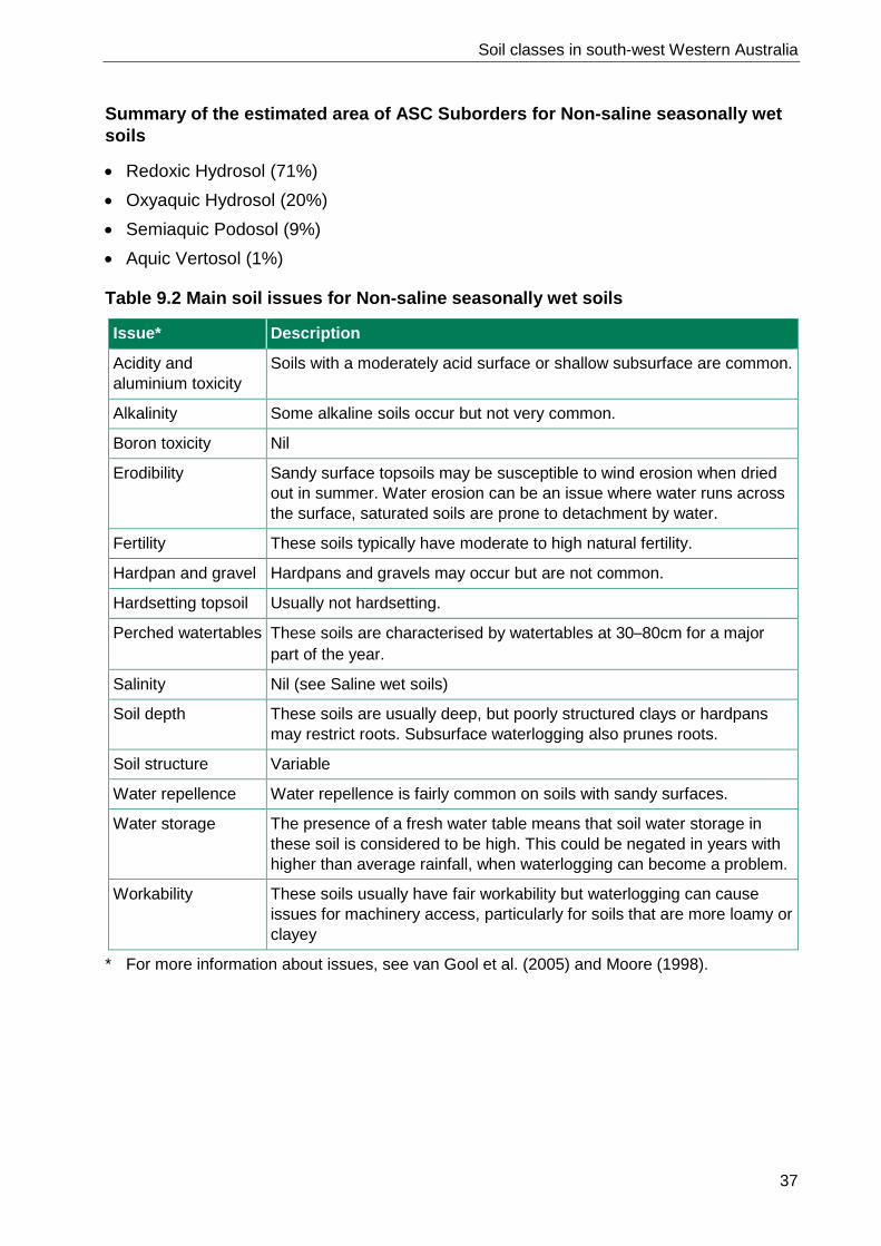
9 Non-saline seasonally wet soils Non-saline soils that are waterlogged at a depth of 30cm for a major part of the year.
Figure 9.1 Non-saline seasonally wet soils occur on about 575 000ha or 2% of the south-west

Soil classes in south-west Western Australia
36
Identifying properties:
• lower part of profile (30–80cm) saturated for the major part of the year • does not include soils that have a temporary perched watertable over a dry clay
subsoil • often have dark grey, brown or black topsoil • sands, loams and clays • acid to neutral pH • variable subsoil, may contain bog iron; a texture contrast horizon (often clay) may
occur below 80cm • common in plains with elevated fresh watertables.
Semi-wet soil (Deep sandy duplex), South Coast
Semi-wet soil (Loamy duplex), Darling range
Figure 9.2 Images for common Non-saline seasonally wet soils
Table 9.1 Western Australian Soil Groups and Australian Soil Classification for Non-saline seasonally wet soils
WASG name & code Description
Some common names
Estimated area (ha)
Estimated area (%)
Estimated area of ASC Suborder (%)
Semi-wet soil (103)
Non-saline soils waterlogged to 30–80cm for a major part of the year
Mungite soil, Coolup sand, Boyanup loam
575 000 100 Redoxic Hydrosol (71%) Oxyaquic Hydrosol (20%) Semiaquic Podosol (9%) Aquic Vertosol (1%)
Soil classes in south-west Western Australia
37
Summary of the estimated area of ASC Suborders for Non-saline seasonally wet soils
• Redoxic Hydrosol (71%) • Oxyaquic Hydrosol (20%) • Semiaquic Podosol (9%) • Aquic Vertosol (1%)
Table 9.2 Main soil issues for Non-saline seasonally wet soils
Issue* Description
Acidity and aluminium toxicity
Soils with a moderately acid surface or shallow subsurface are common.
Alkalinity Some alkaline soils occur but not very common.
Boron toxicity Nil
Erodibility Sandy surface topsoils may be susceptible to wind erosion when dried out in summer. Water erosion can be an issue where water runs across the surface, saturated soils are prone to detachment by water.
Fertility These soils typically have moderate to high natural fertility.
Hardpan and gravel Hardpans and gravels may occur but are not common.
Hardsetting topsoil Usually not hardsetting.
Perched watertables These soils are characterised by watertables at 30–80cm for a major part of the year.
Salinity Nil (see Saline wet soils)
Soil depth These soils are usually deep, but poorly structured clays or hardpans may restrict roots. Subsurface waterlogging also prunes roots.
Soil structure Variable
Water repellence Water repellence is fairly common on soils with sandy surfaces.
Water storage The presence of a fresh water table means that soil water storage in these soil is considered to be high. This could be negated in years with higher than average rainfall, when waterlogging can become a problem.
Workability These soils usually have fair workability but waterlogging can cause issues for machinery access, particularly for soils that are more loamy or clayey
* For more information about issues, see van Gool et al. (2005) and Moore (1998).

Soil classes in south-west Western Australia
38
10 Pale sands Pale coloured sands extending to depths of 80cm or more.
Figure 10.1 Pale sands occur on about 2 020 000ha or 8% of the south-west

Soil classes in south-west Western Australia
39
Identifying properties:
• sandy textures throughout the top 80cm • topsoil soil is pale coloured, usually white, light yellow/brown or grey (can be dark
grey on surface) • subsoil is often similar colour to topsoil but can also be yellow or brown • ironstone gravel sometimes common in the subsoil • loose sandy surface • profile often very deep.
Pale deep sand, Jerramungup Gravelly pale deep sand, Geraldton
Figure 10.2 Images for common Pale sands

Soil classes in south-west Western Australia
40
Table 10.1 Western Australian Soil Groups and Australian Soil Classification for Pale sands
WASG name & code Description
Some common names
Estimated area (ha)
Estimated area (%)
Estimated area of ASC Suborder (%)
Pale deep sand (444)
Sand >80cm deep with white, grey or pale yellow topsoil
Spillway sand, Gutless sand, Silver loam, Tincurrin/ Harrismith sand, Christmas tree and Banksia sand, Deep mallee sand, Mungie sand, Siliceous sand
1 582 858 79 Bleached-Orthic Tenosol (31%) Grey-Orthic Tenosol (24%) Arenic Rudosol (16%) Aeric Podosol (8%)
Gravelly pale deep sand (443)
Sand >15cm (and pale to at least 30cm) over gravelly sand >80cm deep. Gravels are a dominant feature of the profile
Gravelly sand, White sandy gravels
426 120 21 Sesqui-nodular Tenosol (19%) Bleached-Leptic Tenosol (2%) Aeric Podosol (0%)
Deep sands supergroup (440)
Sands greater than 80cm deep
10 744 0 Tenosol (<1%) Rudosol (<1%) Podosol (<1%)
Total 2 020 000 100 100
Summary of the estimated area of ASC Suborders for Pale sands
• Bleached-Orthic Tenosol (31%) • Grey-Orthic Tenosol (24%) • Sesqui-nodular Tenosol (19%) • Arenic Rudosol (16%) • Aeric Podosol (8%) • Bleached-Leptic Tenosol (2%)

Soil classes in south-west Western Australia
41
Table 10.2 Main soil issues for Pale sands
Issue* Description
Acidity and aluminium toxicity
A fair proportion of these soils are acidic at the surface and shallow subsurface horizons. These soils have very low pH buffering and pH levels will fluctuate rapidly with addition of fertiliser or lime.
Alkalinity Nil
Boron toxicity Nil
Erodibility The loose sandy topsoils are very prone to wind erosion, especially in exposed windy positions such as crests. Water repellent topsoils may also erode in heavy rain, especially during summer thunderstorms when the protective surface cover of vegetation is often at its lowest.
Fertility These soils typically have low to very low natural fertility.
Hardpan and gravel Hardpans are rare. Ironstone gravel is common in the subsoils of Gravelly pale deep sands but this often appears to improve productivity.
Hardsetting topsoil Not hardsetting.
Perched watertables Perched watertables can occur on these soils when they occur low in the landscape, such as a coastal plains or valley floors. This has led to the term ‘effective duplex’ to be applied to some of these soils where a clay horizon is present below 80cm.
Salinity Soil salinity is uncommon.
Soil depth These soils are usually deep.
Soil structure The soils are loose single grain sands.
Water repellence The sandy topsoils are often highly water repellent.
Water storage The sandy textures result in low to extremely low water storage.
Workability These soils are easy to work.
* For more information about issues, see van Gool et al. (2005) and Moore (1998).

Soil classes in south-west Western Australia
42
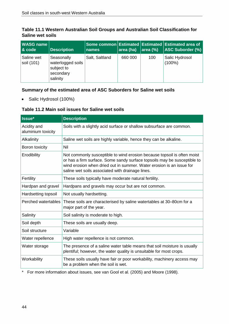
11 Saline wet soils Seasonally waterlogged soils subject to secondary salinity.
Figure 11.1 Saline wet soils occur on about 660 000ha or 3% of the south-west

Soil classes in south-west Western Australia
43
Identifying properties:
• seasonally wet to within 80cm for a major part of the year • affected by moderate to extreme secondary salinity • texture highly variable; includes sands, loams and clays • topsoils are often dark coloured as a result of organic matter.
Saline wet soil, Pingrup Saline wet soil, North Stirlings
Figure 11.2 Images for common Saline wet soils
Soil classes in south-west Western Australia
44
Table 11.1 Western Australian Soil Groups and Australian Soil Classification for Saline wet soils
WASG name & code Description
Some common names
Estimated area (ha)
Estimated area (%)
Estimated area of ASC Suborder (%)
Saline wet soil (101)
Seasonally waterlogged soils subject to secondary salinity
Salt, Saltland 660 000 100 Salic Hydrosol (100%)
Summary of the estimated area of ASC Suborders for Saline wet soils
• Salic Hydrosol (100%)
Table 11.2 Main soil issues for Saline wet soils
Issue* Description
Acidity and aluminium toxicity
Soils with a slightly acid surface or shallow subsurface are common.
Alkalinity Saline wet soils are highly variable, hence they can be alkaline.
Boron toxicity Nil
Erodibility Not commonly susceptible to wind erosion because topsoil is often moist or has a firm surface. Some sandy surface topsoils may be susceptible to wind erosion when dried out in summer. Water erosion is an issue for saline wet soils associated with drainage lines.
Fertility These soils typically have moderate natural fertility.
Hardpan and gravel Hardpans and gravels may occur but are not common.
Hardsetting topsoil Not usually hardsetting.
Perched watertables These soils are characterised by saline watertables at 30–80cm for a major part of the year.
Salinity Soil salinity is moderate to high.
Soil depth These soils are usually deep.
Soil structure Variable
Water repellence High water repellence is not common.
Water storage The presence of a saline water table means that soil moisture is usually plentiful; however, the water quality is unsuitable for most crops.
Workability These soils usually have fair or poor workability, machinery access may be a problem when the soil is wet.
* For more information about issues, see van Gool et al. (2005) and Moore (1998).

Soil classes in south-west Western Australia
45
12 Sandy earths Yellow, brown and red sands grading to loams.
Figure 12.1 Sandy earths occur on about 1 705 000ha or 7% of the south-west

Soil classes in south-west Western Australia
46
Identifying properties:
• sandy surface • sand grading to loam by 80cm • red, yellow or brown colour; may be grey at surface • well drained • neutral or acid pH • some gravels in profile is common.
Red sandy earth, Greenough River Brown sandy earth, Jerramungup
Yellow sandy earth, Bencubbin Pale sandy earth, Busselton
Figure 12.2 Images for common Sandy earths

Soil classes in south-west Western Australia
47
Table 12.1 Western Australian Soil Groups and Australian Soil Classification for Sandy earths
WASG name & code Description
Some common names
Estimated area (ha)
Estimated area (%)
Estimated area of ASC Suborder (%)
Yellow sandy earth (464)
Yellow sand grading to loam by 80cm
Tammar soil, Good sandplain soil
680 245 40 Yellow Kandosol (36%) Yellow Dermosol (4%)
Red sandy earth (463)
Red sand grading to loam by 80cm
Red soil, Pindan sand,
436 323 26 Red Kandosol (25%) Red Dermosol (1%) Red Ferrosol (<1%)
Brown sandy earth (462)
Brown sand grading to loam by 80cm
Alluvial brown sand/soil
246 163 14 Brown Kandosol (12%) Brown Dermosol (2%) Brown-Orthic Tenosol (0%)
Acid yellow sandy earth (461)
Strongly acid yellow sands grading to loam by 80cm
Wodjil sand/soil 183 873 11 Yellow Kandosol (10%) Yellow Dermosol (1%)
Pale sandy earth (465)
Pale sand grading to loam by 80cm
Busselton sand 127 088 7 Grey Kandosol (6%) Grey-Orthic Tenosol (1%)
Sandy earths supergroup (460)
Soils with a sandy surface and grading to loam by 80cm. May be clayey at depth
30 996 2 Kandosol (2%)
Total 1 705 000 100 100
Summary of the estimated area of ASC Suborders for Sandy earths
• Yellow Kandosol (46%) • Brown Dermosol (2%) • Red Kandosol (25%) • Red Dermosol (1%) • Brown Kandosol (12%) • Grey-Orthic Tenosol (1%) • Grey Kandosol (6%) • Brown Orthic Tenosol (<1%) • Yellow Dermosol (5%) • Red Ferrosol (<1%) • Kandosol (2%)

Soil classes in south-west Western Australia
48
Table 12.2 Main soil issues for Sandy earths
Issue* Description
Acidity and aluminium toxicity
These soils are commonly moderately to strongly acid, in the topsoil, increasing to very strongly acid with depth in some profiles. The highly acidic versions frequently have toxic levels of subsoil acidity requiring amelioration with lime.
Alkalinity These soils are rarely alkaline.
Boron toxicity Nil
Erodibility The sandy topsoils are can be susceptible to wind erosion, especially in exposed windy positions. Water erosion is not a common issue on these soils.
Fertility These soils typically have moderate natural fertility.
Hardpan and gravel Hardpans are rare. Subsurface compaction pans (traffic pans) can develop under machinery necessitating occasional deep ripping. Small amounts of ironstone are common throughout the profiles but do not normally impact on production.
Hardsetting topsoil The sandy topsoils are not usually hardsetting. They are usually soft and sometimes loose, but may be firm for some soils.
Perched watertables Perched watertables are uncommon in these soils, though they may occur low in the landscape.
Salinity There is a minor occurrence of sandy earths with slightly saline subsoil.
Soil depth These soils are usually deep with few physical rooting restrictions. Acidic subsoils can restrict rooting depth.
Soil structure The soils are usually loose or earthy with little soil structure. Some loamy earths have poorly structured soils deeper in the profile (e.g. >60cm).
Water repellence The sandy topsoils are commonly to water repellent.
Water storage Most commonly moderately low water storage; but ranges from moderate to low.
Workability These soils are easy to work.
* For more information about issues, see van Gool et al. (2005) and Moore (1998).

Soil classes in south-west Western Australia
49
13 Self-mulching clays Soils that have a cracking clay topsoil with a self-mulching surface.
Figure 13.1 Self-mulching clays soils occur on about 68 500ha or less than 1% of the south-west

Soil classes in south-west Western Australia
50
Identifying properties:
• self-mulching surface: forms a loose granular mulch of fine aggregates at the soil surface after wetting and drying
• often dark grey, but also light grey, yellow, brown and red within the top 30cm • deep cracks when dry, which is occasionally obscured by the self-mulching surface • clay textures throughout the profile.
Self-mulching cracking clay, Irwin Self-mulching cracking clay,
East Kimberley
Figure 13.2 Images for common Self-mulching clays
Table 13.1 Western Australian Soil Groups and Australian Soil Classification for Self-mulching clays
WASG name & code Description
Some common names
Estimated area (ha)
Estimated area (%)
Estimated area of ASC Suborder (%)
Self-mulching cracking clay (602)
Cracking clay with a self-mulching surface
Black soil, crabhole mound clay, Dolerite dyke soil, Cracking clay
68 500 100 Grey Vertosol (70%) Brown Vertosol (20%) Red Vertosol (10%)

Soil classes in south-west Western Australia
51
Summary of the estimated area of ASC Suborders for Self-mulching clays
• Grey Vertosol (70%) • Brown Vertosol (20%) • Red Vertosol (10%)
Table 13.2 Main soil issues for Self-mulching clays
Issue* Description
Acidity and aluminium toxicity
Nil
Alkalinity Moderately alkaline subsoils may occur.
Boron toxicity Nil
Crop rooting depth These soils are usually deep, but rooting conditions in deeper subsoils are variable.
Erodibility Generally not erodible.
Fertility These soils typically have moderate or high natural fertility.
Hardpan and gravel Hardpans do not occur, small amounts of ironstone may occur in the profiles.
Hardsetting topsoil Nil
Perched watertables Temporary waterlogging may develop in low-lying landscape positions and on flats after heavy rains as a result of slow profile permeability.
Salinity Most soils have nil to slight surface salinity, though higher levels may occur deeper in the profile.
Soil structure Well-structured surface horizons with variable moderate or poorly structured subsoils.
Soil water storage Generally moderate, but some variants are high.
Water repellence Nil
Workability These soils often have fair workability, but poor workability is also common. Many soils cannot be worked when they are too wet.
* For more information about issues, see van Gool et al. (2005) and Moore (1998).

Soil classes in south-west Western Australia
52
14 Shallow loams over rock Red or calcareous loam over rock or hardpan at greater than 80cm.
Figure 14.1 Shallow loams over rock occur on about 458 000ha or 2% of the south-west

Soil classes in south-west Western Australia
53
Identifying properties:
• loam, sometimes grading to clay over rock or hardpan at less than 80cm • topsoil is often red, although browns and greys are common for Calcareous shallow
loam • rock fragments sometimes common and surface mantle of stones may be present • carbonate nodules in Calcareous shallow loams.
Calcareous shallow loam, Kambalda Red-brown hardpan shallow loam, Mullewa
Red-brown hardpan shallow loam, Murchison
Red shallow loam, Ajana
Figure 14.2 Images for common Shallow loams over rock

Soil classes in south-west Western Australia
54
Table 14.1 Western Australian Soil Groups and Australian Soil Classification for Shallow loams over rock
WASG name & code Description
Some common names
Estimated area (ha)
Estimated area (%)
Estimated area of ASC Suborder (%)
Red-brown hardpan shallow loam (523)
Red loam over red-brown hardpan at <50cm
Murchison cement loam, Red-brown hardpan soil
241 195 53 Red Kandosol (53%)
Red shallow loam (522)
Red loam less than 80cm deep over rock or hardpan (not red-brown)
Jam soil, York gum soil
189 836 41 Red Kandosol (33%) Red Dermosol (6%) Red Ferrosol (2%)
Shallow loams supergroup (520)
Loam <80cm deep, over rock, hardpan or other cemented layer
25 847 5 Kandosol (3%) Dermosol (2%)
Calcareous shallow loam (521)
Calcareous loam over rock or hardpan at <80cm
Salmon gum gimlet soil, Fluffy gimlet soil, Crabhole soil, Beete loam, Kopi-fluff
1 455 <1 Calcic Calcarosol (<1%)
Total 458 000 100 100
Summary of the estimated area of ASC Suborders for Shallow loams over rock
• Red Kandosol (86%) • Red Dermosol (6%) • Kandosol (3%) • Dermosol (2%) • Red Ferrosol (2%) • Calcic Calcarosol (<1%)

Soil classes in south-west Western Australia
55
Table 14.2 Main soil issues for Shallow loams over rock
Issue* Description
Acidity and aluminium toxicity
Most soils are slightly acidic in the topsoil and shallow subsurface, becoming neutral at depth.
Alkalinity These soils are rarely alkaline, except for Calcareous shallow loams, a minor soil of the grainbelt.
Boron toxicity Boron toxicity is unlikely, except in Calcareous shallow loams.
Erodibility Low susceptibility to wind erosion. Water erosion can be a problem on sloping land or drainage lines.
Fertility These soils typically have moderate natural fertility.
Hardpan and gravel Hardpans reduce water storage and production.
Hardsetting topsoil Red-brown hardpan shallow loams are hardsetting, the other soils are typically firm.
Perched watertables Perched watertables can occur mainly on Red-brown hardpan shallow loams on valley floors.
Salinity Soil salinity is uncommon, except on Red-brown hardpan shallow loams found on some valley floors.
Soil depth These soils typically have moderately shallow to moderate rooting depth (30–80cm deep).
Soil structure These soils are usually earthy or have moderate soil structure.
Water repellence Not water repellent.
Water storage Shallower soil depths restrict these loamy soils to low or moderately low soil water storage.
Workability These soils are generally easy to work, except for some very shallow soils (<30cm over rock or hardpan) and those with stones.
* For more information about issues, see van Gool et al. (2005) and Moore (1998).
Soil classes in south-west Western Australia
56
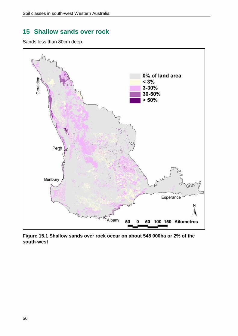
15 Shallow sands over rock Sands less than 80cm deep.
Figure 15.1 Shallow sands over rock occur on about 548 000ha or 2% of the south-west

Soil classes in south-west Western Australia
57
Identifying properties:
• sandy surface and subsurface textures • underlain by rock, hardpan or other cemented layer at less than 80cm • grey, yellow, brown or red colour • sand can be siliceous or calcareous.
Pale shallow sand, Wongan Hills Red shallow sand, Mullewa
Yellow/brown shallow sand, West Gingin
Pale shallow sand, Unicup
Figure 15.2 Images for common Shallow sands over rock

Soil classes in south-west Western Australia
58
Table 15.1 Western Australian Soil Groups and Australian Soil Classification for Shallow sands over rock
WASG name & code Description
Some common names
Estimated area (ha)
Estimated area (%)
Estimated area of ASC Suborder (%)
Yellow/brown shallow sand (424)
Yellow or brown sand over rock, hardpan or other cemented layer at <80cm
Karrakatta sand (shallow phase), Spearwood sand (shallow phase)
268 926 50 Leptic Tenosol (31%) Yellow-Orthic Tenosol (9%) Brown-Orthic Tenosol (9%) Leptic Rudosol (1%)
Pale shallow sand (422)
White, grey or pale yellow sand over rock, hardpan or other cemented layer at <80cm
Gutless/gritty sand, Gritty sheoak sand
155 974 29 Bleached-Leptic Tenosol (18%) Leptic Rudosol (6%) Bleached-Orthic Tenosol (5%) Aeric Podosol (0%)
Red shallow sand (423)
Red sand over rock, hardpan or other cemented layer at <80cm
Wyarri sand 109 196 20 Leptic Tenosol (12%) Leptic Rudosol (4%) Red-Orthic Tenosol (4%)
Shallow sands supergroup (420)
Sands less than or equal to 80cm over rock, hardpan or other cemented layer
13 719 2 Tenosol (1%) Rudosol (1%)
Total 548 000 100 100

Soil classes in south-west Western Australia
59
Summary of the estimated area of ASC Suborders for Shallow sands over rock
• Leptic Tenosol (43%) • Bleached-Leptic Tenosol (18%) • Leptic Rudosol (11%) • Yellow-Orthic Tenosol (9%) • Brown-Orthic Tenosol (9%) • Bleached-Orthic Tenosol (5%) • Red-Orthic Tenosol (4%) • Tenosol (1%) • Rudosol (1%) • Aeric Podosol (<1%)
Table 15.2 Main soil issues for Shallow sands over rock
Issue* Description
Acidity and aluminium toxicity
Slight to moderately acid sandy topsoils, can become neutral at depth.
Alkalinity Usually only occurs in Calcareous shallow sands, which are rarely used for cropping.
Boron toxicity Unlikely
Erodibility Highly prone to wind erosion on exposed flats and rises. These soils often have low susceptibility to water erosion, but can range to very highly susceptible on sloping land.
Fertility These soils typically have low to very low natural fertility.
Hardpan and gravel Rock or hardpan occurs at <80cm.
Hardsetting topsoil Nil
Perched watertables Perched watertables are not common except in low lying landscape positions.
Salinity Soil salinity is rare.
Soil depth Moderate rooting depth is the most common, where the rock occurs at 50–80cm.
Soil structure Surface and subsurface soils typically are loose sands.
Water repellence The sandy surfaced soils are usually moderately to highly water repellent.
Water storage Soil water storage is extremely or very low.
Workability These soils usually have fair workability, but shallower soils are poor or very poor.
* For more information about issues, see van Gool et al. (2005) and Moore (1998).

Soil classes in south-west Western Australia
60
16 Shallow sandy duplexes Sand topsoil over clayey subsoil at less than 30cm.
Figure 16.1 Shallow sandy duplexes occur on about 1 486 000ha or 6% of the south-west

Soil classes in south-west Western Australia
61
Identifying properties:
• sandy surface texture • abrupt change to sandy clay loam or clay subsoil at less than 30cm • red, yellow, brown or grey colour; grey surface sands are common • commonly moderately acid surface pH • commonly neutral clay subsoil • some gravels in profile, especially above clay layer • subsoil commonly has poor rooting conditions and slow water permeability.
Grey shallow sandy duplex, Swan Coastal Plain
Red shallow sandy duplex, Mullewa
Yellow/brown shallow sandy duplex, South Coast
Figure16.2 Images for common Shallow sandy duplexes

Soil classes in south-west Western Australia
62
Table 16.1 Western Australian Soil Groups and Australian Soil Classification for Shallow sandy duplexes
WASG name & code Description
Some common names
Estimated area (ha)
Estimated area (%)
Estimated area of ASC Suborder (%)
Grey shallow sandy duplex (404)
Grey sand over non-alkaline sandy clay loam to clay at <30cm
Duplex soil, White gum soil, Spongolite soil, Grey clay (where clay is near to surface)
751 392 50 Grey Sodosol (21%) Yellow Sodosol (14%) Grey Chromosol (10%) Yellow Chromosol (5%)
Yellow/brown shallow sandy duplex (408)
Yellow or brown sand over sandy clay loam to clay at <30cm
Mallee duplex, Moort soil
526 691 34 Brown Chromosol (15%) Yellow Chromosol (15%) Brown Sodosol (2%) Yellow Sodosol (2%)
Red shallow sandy duplex (406)
Red sand over sandy clay loam to clay at less than 30cm
Mallet soil, York gum soil, Red loam, Rocky outcrop country
208 343 14 Red Sodosol (8%) Red Chromosol (6%)
Total 1 486 000 100 100
Summary of the estimated area of ASC Suborders for Shallow sandy duplexes
• Grey Sodosol (21%) • Yellow Chromosol (20%) • Yellow Sodosol (16%) • Brown Chromosol (15%) • Grey Chromosol (10%) • Red Sodosol (8%) • Red Chromosol (6%) • Brown Sodosol (2%)

Soil classes in south-west Western Australia
63
Table 16.2 Main soil issues for Shallow sandy duplexes
Issue* Description
Acidity and aluminium toxicity
Moderately acid sandy topsoils are common.
Alkalinity Rare. Alkaline shallow duplexes comprise a separate category.
Boron toxicity Unlikely. See Alkaline shallow duplexes.
Erodibility Soils with loose sandy surfaces are highly prone to wind erosion on exposed flats and rises. Slaking topsoils and dispersive subsoils can lead to water erosion on long slopes.
Fertility These soils typically have moderate natural fertility.
Hardpan and gravel Hardpans are rare. Variable amounts of ironstone are common in the profiles.
Hardsetting topsoil Can range from loose to firm to hardsetting surfaces. Hardsetting is common on shallow soils over poor clay, presumably because cultivation reaches the subsoil, effectively converting these to loamy duplex soils.
Perched watertables Perched watertables are common on flatter land, but vary seasonally.
Salinity Nil to slight surface salinity is common, but a few soils range to high. Higher salinity may occur in the underlying clay.
Soil depth These soils are usually deep, but moderately shallow crop rooting is common on poor clays (sodic or saline). Some structured clays can have deep rooting conditions.
Soil structure Surface soils are typically loose sands. Poorly structured subsurface clays can be brought to the surface during cultivation in profile with thin topsoil.
Water repellence The sandy surfaced topsoils may be moderately to highly water repellent.
Water storage Shallow sandy surface over generally poorly structured, often sodic, clay means very low water storage is common. Where subsoils are better soils can range to moderate soil water storage.
Workability These soils usually have good workability though sodic subsoil may cause some problems where the topsoil is thin.
* For more information about issues, see van Gool et al. (2005) and Moore (1998).

Soil classes in south-west Western Australia
64
17 Stony soils Soils which are either stony or rocky throughout, or gravelly with a cemented layer above 80cm.
Figure 17.1 Stony soils occur on about 1 109 000ha or 4% of the south-west

Soil classes in south-west Western Australia
65
Identifying properties:
• rocks, stones and gravels are dominant throughout the profile • includes ironstone gravelly soils with cemented gravel (ferricrete) at less than 80cm • usually associated with rock outcrops.
Shallow gravel, Midlands area Shallow gravel, Narrogin Shallow gravel, Katanning
Stony soil, Binnu Stony soil, Bindoon Stony soil, Stirling Range
Figure 17.2 Images for common Stony soils

Soil classes in south-west Western Australia
66
Table 17.1 Western Australian Soil Groups and Australian Soil Classification for Stony soils
WASG name & code Description
Some common names
Estimated area (ha)
Estimated area (%)
Estimated area of ASC Suborder (%)
Shallow gravel (304)
Ironstone gravel soil over cemented gravels (ferricrete), rock or other hard or permanently cemented layers at ≤80cm
Buckshot gravel, Ironstone cap, Shallow gravel
846 293 76 Sesqui-nodular Tenosol (56%) Brown Kandosol (15%) Brown Chromosol (5%)
Stony soil (203)
Soils which are coarse gravelly, stony or rocky throughout
Rocky/rubble soil
251 030 23 Clastic Rudosol (14%) Leptic Rudosol (9%)
Calcareous stony soil (202)
Soils which are stony or rocky and calcareous throughout
Rocky lime soil, Rocky kopi
11 558 <1 Calcic Calcarosol (<1%) Lithocalcic Calcarosol (<1%) Leptic Rudosol (<1%)
Total 1 109 000 100 100
Summary of the estimated area of ASC Suborders for Stony soils
• Sesqui-nodular Tenosol (56%) • Brown Kandosol (15%) • Clastic Rudosol (14%) • Leptic Rudosol (9%) • Brown Chromosol (5%) • Calcic Calcarosol (<1%) • Lithocalcic Calcarosol (<1%)

Soil classes in south-west Western Australia
67
Table 17.2 Main soil issues for Stony soils
Issue* Description
Acidity and aluminium toxicity
These soils may be moderately acidic in the topsoil and slightly acidic in the shallow subsoil.
Alkalinity These soils are rarely alkaline. The exception, Calcareous stony soil, is a minor soil type of the grainbelt.
Boron toxicity Nil, except Calcareous stony soils.
Erodibility Loose topsoils in exposed positions can be susceptibility to wind erosion though surface rocks reduce wind strength. Water erosion can be a problem on sloping land. This can be exacerbated by rapid run-off from rock outcrops.
Fertility These soils typically have very low to moderate natural fertility.
Hardpan and gravel Gravels and stones make this soil poorly suited to cultivation.
Hardsetting topsoil Some with sandy loam surfaces are hardsetting.
Perched watertables Perched watertables are rare.
Salinity Soil salinity is rare.
Soil depth These have highly variable soil depth.
Soil structure Soil structure is variable.
Water repellence Sandy surfaced stony soils are moderately water repellent.
Water storage Stones, gravels and rock restrict soil water storage. Degree of restriction depends on proportion of stones, soil depth and texture of the matrix. Ranges from extremely low in shallow sandy gravels to moderate for deeper loamy soils.
Workability Often poor, but it depends on the size and quantity of the stones as well as the distribution of rock outcrops.
* For more information about issues, see van Gool et al. (2005) and Moore (1998).

Soil classes in south-west Western Australia
68
18 Other non-arable land
18.1 Rock outcrop
Areas of bare rock; excludes surface mantle (loose stones on the surface).
Figure 18.1 Rock outcrop occurs on about 420 000ha or 2% of the south-west

Soil classes in south-west Western Australia
69
Rock outcrop, Dandaragan Rock outcrop, Kojonup area
Figure 18.2 Images for common Rock outcrop

Soil classes in south-west Western Australia
70
18.2 Non-cropping soils: wet or saline
This Ag Soil includes soils that are wet for a large portion of each year, plus salt scalds and salt lakes with predominantly bare ground and some halophytes (plants adapted to saline soil). It does not include cropping soils with variable seasonal waterlogging or salinity, or soils with saline subsoils.
Figure 18.3 Non-cropping wet or saline soils occur on about 763 000ha or 3% of the south-west

Soil classes in south-west Western Australia
71
Bare ground and halophytes, Canna Salt lake soil, Grainbelt
Figure 18.4 Images for common Non-cropping soils: wet or saline

Soil classes in south-west Western Australia
72
18.3 Remaining non-cropping soils (excludes rock outcrop and wet or saline land)
This Ag Soil includes disturbed land, such as mine sites and areas of permanent water.
Figure 18.5 Remaining non-cropping soils occur on about 177 000ha or 1% of the south-west

Soil classes in south-west Western Australia
73
Gravel quarry, Corrigin Permanent wetland lake, Unicup
Figure 18.6 Images for disturbed land and permanent water

Soil classes in south-west Western Australia
74
Appendix A The area and proportion of Australian Soil Classification Soil Orders and Suborders within Ag Soils

Table A1: The area of Australian Soil Classification Soil Orders and their proportions within Ag Soils in south-west Western Australia, in descending order of extent
Tota
l are
a (ha
)
Tota
l are
a (%
)
Irons
tone
gra
velly
soils
(%
)
Deep
sand
y dup
lexes
(%)
Alka
line s
hallo
w du
plex
es
(%)
Colo
ured
sand
s (%
)
Pale
sand
s (%
)
Deep
loam
y dup
lexes
&
earth
s (%
)
Sand
y ear
ths (
%)
Clay
s & sh
allow
loam
y du
plex
es (%
)
Shall
ow sa
ndy d
uplex
es (%
)
Ston
y soi
ls (%
)
Calca
reou
s loa
my e
arth
s (%
)
Non-
crop
ping
soils
: wet
or
salin
e (%
)
Salin
e wet
soils
(%)
Non-
salin
e sea
sona
lly w
et
soils
(%)
Shall
ow sa
nds o
ver r
ock
(%)
Shall
ow lo
ams o
ver r
ock
(%)
Rock
out
crop
(%)
Calca
reou
s san
ds (%
)
Non-
crop
ping
soils
(%)
Self-
mul
chin
g cla
ys (%
)
Total area (ha) 25 289 399 3 351 639 3 155 655 2 202 086 2 155 675 2 013 741 1 724 411 1 704 879 1 520 344 1 481 068 1 105 810 870 582 753 816 659 477 574 998 547 850 457 976 419 053 344 439 177 396 68 503 Total area (%) 13 12 9 9 8 7 7 6 6 4 3 3 3 2 2 2 2 1 1 0 Sodosol 5 865 390 23 13 59 88 0 0 4 0 33 48 0 38 0 0 0 0 0 0 0 0 0 Tenosol 5 292 422 21 20 0 0 90 76 0 2 0 0 56 0 0 0 0 88 0 0 0 0 0 Chromosol 4 463 442 18 38 41 12 0 0 22 0 28 52 5 0 0 0 0 0 0 0 0 0 0 Kandosol 3 629 234 14 25 0 0 0 0 39 90 0 0 15 0 0 0 0 0 89 0 0 0 0 Hydrosol 1 860 522 7 0 0 0 0 0 0 0 0 0 0 0 90 100 91 0 0 0 0 0 0 Rudosol 1 554 175 6 0 0 0 10 16 0 0 0 0 23 0 0 0 0 12 0 100 85 0 0 Dermosol 1 002 536 4 0 0 0 0 0 32 8 18 0 0 0 0 0 0 0 8 0 0 0 0 Calcarosol 601 134 2 0 0 0 0 0 0 0 0 0 1 62 0 0 0 0 0 0 15 0 0 Vertosol 261 591 1 0 0 0 0 0 0 0 13 0 0 0 0 0 1 0 0 0 0 0 100 Podosol 249 622 1 0 0 0 0 8 0 0 0 0 0 0 5 0 9 0 0 0 0 0 0 Kurosol 212 807 1 4 0 0 0 0 0 0 6 0 0 0 0 0 0 0 0 0 0 0 0 Not applicablea 161 428 1 0 0 0 0 0 0 0 0 0 0 0 0 0 0 0 0 0 0 91 0 Ferrosol 81 360 0 0 0 0 0 0 2 0 3 0 0 0 0 0 0 0 2 0 0 0 0 Organosol 37 767 0 0 0 0 0 0 0 0 0 0 0 0 5 0 0 0 0 0 0 0 0 Anthroposol 15 968 0 0 0 0 0 0 0 0 0 0 0 0 0 0 0 0 0 0 0 9 0 ASC Order in Ag Soil (%) 100 100 100 100 100 100 100 100 100 100 100 100 100 100 100 100 100 100 100 100 100 a Not applicable refers to areas such as undifferentiated soils, disturbed soils, rock outcrops and water. Notes: 1. Shaded cells show where ASC soil orders are more than 50% of an Ag Soil.2. Areas are calculated using the estimated correlation of soils in Table B1.

Table A2 Distribution maps of Australian Soil Classification Soil Orders in south-west Western Australia, based on data in Table B1 in Appendix B
Anthroposol Calcarosol Chromosol
Dermosol Ferrosol Hydrosol (continued)

Table A2 continued
Kandosol Kurosol Not applicable (e.g. undifferentiated soils, water)
Organosol Podosol Rudosol (continued)

Table A2 continued
Sodosol Tenosol Vertosol

Table A3 The area of Australian Soil Classification Soil Suborders and their proportions within Ag Soils in south-west Western Australia, in descending order of extent
ASC
Subo
rder
area
(h
a)
ASC
Subo
rder
area
(%
)
Irons
tone
gra
velly
so
ils (%
)
Deep
sand
y dup
lexes
(%
)
Alka
line s
hallo
w du
plex
es (%
)
Colo
ured
sand
s (%
)
Pale
sand
s (%
)
Deep
loam
y dup
lexes
&
earth
s (%
)
Sand
y ear
ths (
%)
Clay
s & sh
allow
loam
y du
plex
es (%
)
Shall
ow sa
ndy
dupl
exes
(%)
Ston
y soi
ls (%
)
Calca
reou
s loa
my
earth
s (%
)
Non-
crop
ping
soils
: we
t or s
aline
(%)
Salin
e wet
soils
(%)
Non-
salin
e sea
sona
lly
wet s
oils
(%)
Shall
ow sa
nds o
ver
rock
(%)
Shall
ow lo
ams o
ver
rock
(%)
Rock
out
crop
(%)
Calca
reou
s san
ds (%
)
Non-
crop
ping
soil (
%)
Self-
mul
chin
g cla
ys
(%)
Total area (ha) 25 289 399
3 351 639 3 155 655 2 202 086 2 155 675 2 013 741 1 724 411 1 704 879 1 520 344 1 481 068 1 105 810 870 582 753 816 659 477 574 998 547 850 457 976 419 053 344 439 177 396 68 503 Total area (%)
13 12 9 9 8 7 7 6 6 4 3 3 3 2 2 2 2 1 1 0
Grey Sodosolb 3 059 209 12 2 35 68 0 0 0 0 5 21 0 0 0 0 0 0 0 0 0 0 0 Yellow Chromosolb 1 732 109 7 19 19 1 0 0 6 0 5 21 0 0 0 0 0 0 0 0 0 0 0 Sesqui-nodular Tenosolb 1 674 522 7 20 0 0 0 19 0 0 0 0 56 0 0 0 0 0 0 0 0 0 0 Yellow Sodosolb 1 344 460 5 2 21 10 0 0 0 0 9 17 0 0 0 0 0 0 0 0 0 0 0 Brown Kandosolb 1 311 350 5 23 0 0 0 0 11 12 0 0 15 0 0 0 0 0 0 0 0 0 0 Grey Chromosolb 1 264 475 5 18 10 7 0 0 0 0 1 10 0 0 0 0 0 0 0 0 0 0 0 Red Kandosolb 1 178 260 5 0 0 0 0 0 21 25 0 0 0 0 0 0 0 0 86 0 0 0 0 Brown-Orthic Tenosolb 1 080 450 4 0 0 0 48 0 0 0 0 0 0 0 0 0 0 9 0 0 0 0 0 Yellow Kandosolb 981 243 4 2 0 0 0 0 7 46 0 0 0 0 0 0 0 0 0 0 0 0 0 Yellow-Orthic Tenosolb 935 510 4 0 0 0 41 0 0 0 0 0 0 0 0 0 0 9 0 0 0 0 0 Brown Chromosolb 825 561 3 1 9 0 0 0 9 0 7 15 5 0 0 0 0 0 0 0 0 0 0 Red Sodosolb 815 416 3 0 2 10 0 0 3 0 3 8 0 38 0 0 0 0 0 0 0 0 0 Salic Hydrosolb 659 477 3 0 0 0 0 0 0 0 0 0 0 0 0 100 0 0 0 0 0 0 0 Leptic Rudosolb 642 930 3 0 0 0 0 0 0 0 0 0 9 0 0 0 0 11 0 100 18 0 0 Bleached Orthic Tenosolb 630 751 2 0 0 0 0 31 0 0 0 0 0 0 0 0 0 0 0 0 0 0 0 Redoxic Hydrosolb 630 586 2 0 0 0 0 0 0 0 0 0 0 0 30 0 71 0 0 0 0 0 0 Red Chromosolb 629 793 2 0 3 4 0 0 8 0 15 6 0 0 0 0 0 0 0 0 0 0 0 Brown Sodosolb 613 398 2 9 1 0 0 0 1 0 14 2 0 0 0 0 0 0 0 0 0 0 0 Calcic Calcarosolb 545 315 2 0 0 0 0 0 0 0 0 0 0 62 0 0 0 0 0 0 0 0 0 Arenic Rudosolb 520 712 2 0 0 0 10 16 0 0 0 0 0 0 0 0 0 0 0 0 0 0 0 Grey-Orthic Tenosol 498 485 2 0 0 0 0 23 0 1 0 0 0 0 0 0 0 0 0 0 0 0 0 Brown Dermosol 455 799 2 0 0 0 0 0 21 2 3 0 0 0 0 0 0 0 0 0 0 0 0 Hypersalic Hydrosol 366 268 1 0 0 0 0 0 0 0 0 0 0 0 49 0 0 0 0 0 0 0 0 Red Dermosol 277 008 1 0 0 0 0 0 7 1 8 0 0 0 0 0 0 0 6 0 0 0 0 Leptic Tenosol 235 919 1 0 0 0 0 0 0 0 0 0 0 0 0 0 0 43 0 0 0 0 0 Shelly Rudosol 230 966 1 0 0 0 0 0 0 0 0 0 0 0 0 0 0 0 0 0 67 0 0 Oxyaquic Hydrosol 199 031 1 0 0 0 0 0 0 0 0 0 0 0 11 0 20 0 0 0 0 0 0 Aeric Podosol 161 550 1 0 0 0 0 8 0 0 0 0 0 0 0 0 0 0 0 0 0 0 0 Not applicablea 161 428 1 0 0 0 0 0 0 0 0 0 0 0 0 0 0 0 0 0 0 91 0 Clastic Rudosol 150 558 1 0 0 0 0 0 0 0 0 0 14 0 0 0 0 0 0 0 0 0 0 Bleached-Leptic Tenosol 141 703 1 0 0 0 0 2 0 0 0 0 0 0 0 0 0 18 0 0 0 0 0 Brown Kurosol 138 677 1 3 0 0 0 0 0 0 2 0 0 0 0 0 0 0 0 0 0 0 0 Yellow Dermosol 124 113 0 0 0 0 0 0 2 5 1 0 0 0 0 0 0 0 0 0 0 0 0
(continued)

Table A3 continued
ASC
Subo
rder
area
(h
a)
ASC
Subo
rder
area
(%
)
Irons
tone
gra
velly
so
ils (%
)
Deep
sand
y dup
lexes
(%
)
Alka
line s
hallo
w du
plex
es (%
)
Colo
ured
sand
s (%
)
Pale
sand
s (%
)
Deep
loam
y dup
lexes
&
earth
s (%
)
Sand
y ear
ths (
%)
Clay
s & sh
allow
loam
y du
plex
es (%
)
Shall
ow sa
ndy
dupl
exes
(%)
Ston
y soi
ls (%
)
Calca
reou
s loa
my
earth
s (%
)
Non-
crop
ping
soils
: we
t or s
aline
(%)
Salin
e wet
soils
(%)
Non-
salin
e sea
sona
lly
wet s
oils
(%)
Shall
ow sa
nds o
ver
rock
(%)
Shall
ow lo
ams o
ver
rock
(%)
Rock
out
crop
(%)
Calca
reou
s san
ds (%
)
Non-
crop
ping
soil (
%)
Self-
mul
chin
g cla
ys
(%)
Grey Vertosol 123 985 0 0 0 0 0 0 0 0 5 0 0 0 0 0 0 0 0 0 0 0 70 Grey Kandosol 101 688 0 0 0 0 0 0 0 6 0 0 0 0 0 0 0 0 0 0 0 0 0 Grey Dermosol 90 983 0 0 0 0 0 0 0 0 6 0 0 0 0 0 0 0 0 0 0 0 0 Brown Vertosol 89 733 0 0 0 0 0 0 0 0 5 0 0 0 0 0 0 0 0 0 0 0 20 Red Ferrosol 81 360 0 0 0 0 0 0 2 0 3 0 0 0 0 0 0 0 2 0 0 0 0 Kandosol 56 693 0 0 0 0 0 0 1 2 0 0 0 0 0 0 0 0 3 0 0 0 0 Dermosol 54 633 0 0 0 0 0 0 3 0 0 0 0 0 0 0 0 0 2 0 0 0 0 Semiaquic Podosol 51 321 0 0 0 0 0 0 0 0 0 0 0 0 0 0 9 0 0 0 0 0 0 Shelly Calcarosol 51 054 0 0 0 0 0 0 0 0 0 0 0 0 0 0 0 0 0 0 15 0 0 Red-Orthic Tenosol 47 769 0 0 0 0 1 0 0 0 0 0 0 0 0 0 0 4 0 0 0 0 0 Red Vertosol 44 867 0 0 0 0 0 0 0 0 3 0 0 0 0 0 0 0 0 0 0 0 10 Sapric Organosol 37 767 0 0 0 0 0 0 0 0 0 0 0 0 5 0 0 0 0 0 0 0 0 Grey Kurosol 36 548 0 0 0 0 0 0 0 0 2 0 0 0 0 0 0 0 0 0 0 0 0 Aquic Podosol 35 676 0 0 0 0 0 0 0 0 0 0 0 0 5 0 0 0 0 0 0 0 0 Sodosol 32 907 0 0 1 0 0 0 0 0 1 0 0 0 0 0 0 0 0 0 0 0 0 Yellow Kurosol 28 446 0 0 0 0 0 0 0 0 1 0 0 0 0 0 0 0 0 0 0 0 0 Bleached-Orthic Tenosol 27 446 0 0 0 0 0 0 0 0 0 0 0 0 0 0 0 5 0 0 0 0 0 Spolic Anthroposol 15 968 0 0 0 0 0 0 0 0 0 0 0 0 0 0 0 0 0 0 0 9 0 Tenosol 14 380 0 0 0 0 0 0 0 0 0 0 0 0 0 0 0 1 0 0 0 0 0 Chromosol 11 505 0 0 0 0 0 0 0 0 0 0 0 0 0 0 0 0 0 0 0 0 0 Red Kurosol 9 137 0 0 0 0 0 0 0 0 1 0 0 0 0 0 0 0 0 0 0 0 0 Rudosol 9 008 0 0 0 0 0 0 0 0 0 0 0 0 0 0 0 1 0 0 0 0 0 Brown-Orthic Tenosol 5 488 0 0 0 0 0 0 0 0 0 0 0 0 0 0 0 0 0 0 0 0 0 Lithocalcic Calcarosol 4 765 0 0 0 0 0 0 0 0 0 0 0 0 0 0 0 0 0 0 0 0 0 Aquic Vertosol 3 006 0 0 0 0 0 0 0 0 0 0 0 0 0 0 1 0 0 0 0 0 0 Intertidal Hydrosol 2 064 0 0 0 0 0 0 0 0 0 0 0 0 0 0 0 0 0 0 0 0 0 Supratidal Hydrosol 2 064 0 0 0 0 0 0 0 0 0 0 0 0 0 0 0 0 0 0 0 0 0 Podosol 1 074 0 0 0 0 0 0 0 0 0 0 0 0 0 0 0 0 0 0 0 0 0 Extratidal Hydrosol 1 032 0 0 0 0 0 0 0 0 0 0 0 0 0 0 0 0 0 0 0 0 0 Suborder in Ag Soil (%) 100 100 100 100 100 100 100 100 100 100 100 100 100 100 100 100 100 100 100 100 100 a Not applicable refers to areas such as undifferentiated soils, disturbed soils, rock outcrops and water. b These 20 suborders each cover more than 500 000ha and account for 83% or 21 076 000ha of the land area. Their distribution maps are in Table A4, Notes: 1. Shaded cells show where ASC soil orders are more than 50% of an Ag Soil.2. Areas are calculated using the estimated correlation of soils in Table B1.

Table A4 Distribution maps of the dominant 20 Australian Soil Classification Suborders that occur in south-west Western Australia, based on data in Table B1 in Appendix B
Arenic Rudosol Bleached Orthic-Tenosol Brown Chromosol
Brown Kandosol Brown Orthic-Tenosol Brown Sodosol (continued)

Table A4 continued
Calcic Calcarosol Grey Chromosol Grey Sodosol
Leptic Rudosol Red Chromosol Red Kandosol
(continued)

Table A4 continued
Redoxic Hydrosol Red Sodosol Salic Hydrosol
Sesqui-nodular Tenosol Yellow Chromosol Yellow Kandosol (continued)

Table A4 continued
Yellow-Orthic Tenosol Yellow Sodosol

Soil classes in south-west Western Australia
75
Appendix B The Australian Soil Classification and Western Australian Soil Groups Table B1 Percentage allocation of Australian Soil Classification Soil Orders and Suborders to Western Australian Soil Groups and soil group qualifiers (decodes in Tables B2, B3 and B4)
WAS
G co
de
Quali
fier (
Q)
code
Or
der c
ode
Subo
rder
code
% o
f WAS
G Q
100 TYP HY 100 100 UDF HY 100 101 CLY HY 32 100 101 DSA HY 32 100 101 DSD HY 32 100 101 DSK HY 32 100 101 GRV HY 32 100 101 LCA HY 32 100 101 LDP HY 32 100 101 LMY HY 32 100 101 RST HY 32 100 101 SEA HY 32 100 101 SHL HY 32 100 101 SHS HY 32 100 101 SSD HY 32 100 101 TYP HY 32 100 101 UDF HY 32 100 101 VSH HY 32 100 102 DNR HY 23 100 102 TYP HY 23 100 102 UDF HY 23 100 103 CLY HY 29 20 103 CLY HY 31 70 103 CLY VE 02 10 103 DSA HY 29 20 103 DSA HY 31 50 103 DSA PO 35 30 103 DSD HY 29 20 103 DSD HY 31 80 103 DSK HY 29 20 103 DSK HY 31 80 103 GRV HY 29 20 103 GRV HY 31 80
WAS
G co
de
Quali
fier (
Q)
code
Or
der c
ode
Subo
rder
code
% o
f WAS
G Q
103 LCA HY 29 20 103 LCA HY 31 80 103 LDP HY 29 20 103 LDP HY 31 80 103 LMY HY 29 20 103 LMY HY 31 80 103 RST HY 29 20 103 RST HY 31 80 103 SEA HY 29 20 103 SEA HY 31 80 103 SHL HY 29 20 103 SHL HY 31 80 103 SHS HY 29 20 103 SHS HY 31 80 103 SSD HY 29 20 103 SSD HY 31 80 103 TYP HY 29 20 103 TYP HY 31 80 103 UDF HY 29 20 103 UDF HY 31 80 103 VSH HY 29 20 103 VSH HY 31 80 104 DNR HY 15 20 104 DNR HY 24 40 104 DNR HY 40 40 104 TYP HY 15 20 104 TYP HY 24 40 104 TYP HY 40 40 104 UDF HY 15 20 104 UDF HY 24 40 104 UDF HY 40 40 105 CLY HY 29 20 105 CLY HY 31 80
WAS
G co
de
Quali
fier (
Q)
code
Or
der c
ode
Subo
rder
code
% o
f WAS
G Q
105 DSA HY 29 20 105 DSA HY 31 40 105 DSA PO 02 40 105 DSD HY 29 20 105 DSD HY 31 80 105 DSK HY 29 20 105 DSK HY 31 80 105 GRV HY 29 20 105 GRV HY 31 80 105 LCA HY 29 20 105 LCA HY 31 80 105 LDP HY 29 20 105 LDP HY 31 80 105 LMY HY 29 20 105 LMY HY 31 80 105 PEA HY 29 30 105 PEA HY 31 20 105 PEA OR 33 50 105 RST HY 29 20 105 RST HY 31 80 105 SEA HY 29 20 105 SEA HY 31 80 105 SHL HY 29 20 105 SHL HY 31 80 105 SHS HY 29 20 105 SHS HY 31 80 105 SSD HY 29 20 105 SSD HY 31 80 105 TYP HY 29 20 105 TYP HY 31 80 105 UDF HY 29 20 105 UDF HY 31 80 105 VSH HY 29 20
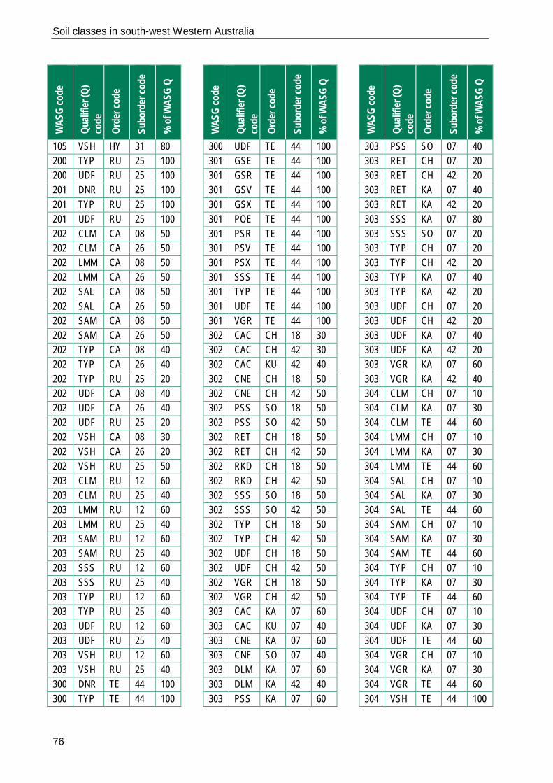
Soil classes in south-west Western Australia
76
WAS
G co
de
Quali
fier (
Q)
code
Or
der c
ode
Subo
rder
code
% o
f WAS
G Q
105 VSH HY 31 80 200 TYP RU 25 100 200 UDF RU 25 100 201 DNR RU 25 100 201 TYP RU 25 100 201 UDF RU 25 100 202 CLM CA 08 50 202 CLM CA 26 50 202 LMM CA 08 50 202 LMM CA 26 50 202 SAL CA 08 50 202 SAL CA 26 50 202 SAM CA 08 50 202 SAM CA 26 50 202 TYP CA 08 40 202 TYP CA 26 40 202 TYP RU 25 20 202 UDF CA 08 40 202 UDF CA 26 40 202 UDF RU 25 20 202 VSH CA 08 30 202 VSH CA 26 20 202 VSH RU 25 50 203 CLM RU 12 60 203 CLM RU 25 40 203 LMM RU 12 60 203 LMM RU 25 40 203 SAM RU 12 60 203 SAM RU 25 40 203 SSS RU 12 60 203 SSS RU 25 40 203 TYP RU 12 60 203 TYP RU 25 40 203 UDF RU 12 60 203 UDF RU 25 40 203 VSH RU 12 60 203 VSH RU 25 40 300 DNR TE 44 100 300 TYP TE 44 100
WAS
G co
de
Quali
fier (
Q)
code
Or
der c
ode
Subo
rder
code
% o
f WAS
G Q
300 UDF TE 44 100 301 GSE TE 44 100 301 GSR TE 44 100 301 GSV TE 44 100 301 GSX TE 44 100 301 POE TE 44 100 301 PSR TE 44 100 301 PSV TE 44 100 301 PSX TE 44 100 301 SSS TE 44 100 301 TYP TE 44 100 301 UDF TE 44 100 301 VGR TE 44 100 302 CAC CH 18 30 302 CAC CH 42 30 302 CAC KU 42 40 302 CNE CH 18 50 302 CNE CH 42 50 302 PSS SO 18 50 302 PSS SO 42 50 302 RET CH 18 50 302 RET CH 42 50 302 RKD CH 18 50 302 RKD CH 42 50 302 SSS SO 18 50 302 SSS SO 42 50 302 TYP CH 18 50 302 TYP CH 42 50 302 UDF CH 18 50 302 UDF CH 42 50 302 VGR CH 18 50 302 VGR CH 42 50 303 CAC KA 07 60 303 CAC KU 07 40 303 CNE KA 07 60 303 CNE SO 07 40 303 DLM KA 07 60 303 DLM KA 42 40 303 PSS KA 07 60
WAS
G co
de
Quali
fier (
Q)
code
Or
der c
ode
Subo
rder
code
% o
f WAS
G Q
303 PSS SO 07 40 303 RET CH 07 20 303 RET CH 42 20 303 RET KA 07 40 303 RET KA 42 20 303 SSS KA 07 80 303 SSS SO 07 20 303 TYP CH 07 20 303 TYP CH 42 20 303 TYP KA 07 40 303 TYP KA 42 20 303 UDF CH 07 20 303 UDF CH 42 20 303 UDF KA 07 40 303 UDF KA 42 20 303 VGR KA 07 60 303 VGR KA 42 40 304 CLM CH 07 10 304 CLM KA 07 30 304 CLM TE 44 60 304 LMM CH 07 10 304 LMM KA 07 30 304 LMM TE 44 60 304 SAL CH 07 10 304 SAL KA 07 30 304 SAL TE 44 60 304 SAM CH 07 10 304 SAM KA 07 30 304 SAM TE 44 60 304 TYP CH 07 10 304 TYP KA 07 30 304 TYP TE 44 60 304 UDF CH 07 10 304 UDF KA 07 30 304 UDF TE 44 60 304 VGR CH 07 10 304 VGR KA 07 30 304 VGR TE 44 60 304 VSH TE 44 100

Soil classes in south-west Western Australia
77
WAS
G co
de
Quali
fier (
Q)
code
Or
der c
ode
Subo
rder
code
% o
f WAS
G Q
400 PSS CH 20 400 PSS SO 80 400 RKM CH 20 400 RKM SO 80 400 SSS CH 10 400 SSS SO 90 400 TYP CH 50 400 TYP SO 50 400 UDF CH 50 400 UDF SO 50 400 WSS CH 100 401 GSP SO 18 80 401 GSP SO 42 20 401 GWK CH 18 80 401 GWK CH 42 20 401 PPS SO 18 80 401 PPS SO 42 20 401 PWK CH 18 80 401 PWK CH 42 20 401 RKM CH 18 10 401 RKM CH 42 10 401 RKM SO 18 60 401 RKM SO 42 20 401 SSS SO 18 80 401 SSS SO 42 20 401 TYP CH 18 10 401 TYP CH 42 10 401 TYP SO 18 60 401 TYP SO 42 20 401 UDF CH 18 10 401 UDF CH 42 10 401 UDF SO 18 60 401 UDF SO 42 20 402 ALK CH 18 60 402 ALK CH 42 40 402 PSS SO 18 80 402 PSS SO 42 20 402 RKM CH 18 10 402 RKM CH 42 10
WAS
G co
de
Quali
fier (
Q)
code
Or
der c
ode
Subo
rder
code
% o
f WAS
G Q
402 RKM SO 18 60 402 RKM SO 42 20 402 SSS SO 18 80 402 SSS SO 42 20 402 TYP CH 18 10 402 TYP CH 42 10 402 TYP SO 18 60 402 TYP SO 42 20 402 UDF CH 18 10 402 UDF CH 42 10 402 UDF SO 18 60 402 UDF SO 42 20 403 GSA CH 18 60 403 GSA CH 42 40 403 GSN CH 18 60 403 GSN CH 42 40 403 GSP SO 18 60 403 GSP SO 42 40 403 PPS SO 18 60 403 PPS SO 42 40 403 PWA CH 18 60 403 PWA CH 42 40 403 PWN CH 18 60 403 PWN CH 42 40 403 RKM CH 18 60 403 RKM CH 42 20 403 RKM SO 18 10 403 RKM SO 42 10 403 SSS SO 18 80 403 SSS SO 42 20 403 TYP CH 18 60 403 TYP CH 42 20 403 TYP SO 18 10 403 TYP SO 42 10 403 UDF CH 18 60 403 UDF CH 42 20 403 UDF SO 18 10 403 UDF SO 42 10 404 ACD CH 18 60
WAS
G co
de
Quali
fier (
Q)
code
Or
der c
ode
Subo
rder
code
% o
f WAS
G Q
404 ACD CH 42 40 404 NEU CH 18 60 404 NEU CH 42 40 404 PSS SO 18 60 404 PSS SO 42 40 404 RKM CH 18 60 404 RKM CH 42 20 404 RKM SO 18 10 404 RKM SO 42 10 404 SSS SO 18 60 404 SSS SO 42 40 404 TYP CH 18 60 404 TYP CH 42 20 404 TYP SO 18 10 404 TYP SO 42 10 404 UDF CH 18 60 404 UDF CH 42 20 404 UDF SO 18 10 404 UDF SO 42 10 405 ACD CH 30 80 405 ACD KU 30 20 405 ALK CH 30 100 405 NEU CH 30 100 405 PSS SO 30 100 405 RKM CH 30 60 405 RKM SO 30 40 405 SSS SO 30 100 405 TYP CH 30 60 405 TYP SO 30 40 405 UDF CH 30 60 405 UDF SO 30 40 406 ALK CH 30 100 406 NEU CH 30 60 406 NEU SO 30 40 406 PSS SO 30 100 406 RKM CH 30 60 406 RKM SO 30 40 406 SSS SO 30 100 406 TYP CH 30 60

Soil classes in south-west Western Australia
78
WAS
G co
de
Quali
fier (
Q)
code
Or
der c
ode
Subo
rder
code
% o
f WAS
G Q
406 TYP SO 30 40 406 UDF CH 30 60 406 UDF SO 30 40 407 ACD CH 07 50 407 ACD CH 42 50 407 ALK CH 07 50 407 ALK CH 42 50 407 NEU CH 07 50 407 NEU CH 42 50 407 PSS CH 07 20 407 PSS CH 42 60 407 PSS SO 07 10 407 PSS SO 42 10 407 RKM CH 07 20 407 RKM CH 42 60 407 RKM SO 07 10 407 RKM SO 42 10 407 SSS SO 07 40 407 SSS SO 42 60 407 TYP CH 07 20 407 TYP CH 42 60 407 TYP SO 07 10 407 TYP SO 42 10 407 UDF CH 07 20 407 UDF CH 42 60 407 UDF SO 07 10 407 UDF SO 42 10 408 ALK CH 07 50 408 ALK CH 42 50 408 NEU CH 07 50 408 NEU CH 42 50 408 PSS CH 07 40 408 PSS CH 42 40 408 PSS SO 07 10 408 PSS SO 42 10 408 RKM CH 07 40 408 RKM CH 42 40 408 RKM SO 07 10 408 RKM SO 42 10
WAS
G co
de
Quali
fier (
Q)
code
Or
der c
ode
Subo
rder
code
% o
f WAS
G Q
408 SSS SO 07 50 408 SSS SO 42 50 408 TYP CH 07 40 408 TYP CH 42 40 408 TYP SO 07 10 408 TYP SO 42 10 408 UDF CH 07 40 408 UDF CH 42 40 408 UDF SO 07 10 408 UDF SO 42 10 409 GRG CH 07 30 409 GRG CH 18 30 409 GRG CH 42 40 409 GRP CH 07 30 409 GRP CH 18 30 409 GRP CH 42 40 409 PSS CH 07 30 409 PSS CH 18 30 409 PSS CH 42 40 409 RKM CH 07 30 409 RKM CH 18 30 409 RKM CH 42 40 409 SSS CH 07 30 409 SSS CH 18 30 409 SSS CH 42 40 409 TYP CH 07 30 409 TYP CH 18 30 409 TYP CH 42 40 409 UDF CH 07 30 409 UDF CH 18 30 409 UDF CH 42 40 409 WSS CH 07 30 409 WSS CH 18 30 409 WSS CH 42 40 420 RKM RU 50 420 RKM TE 50 420 TYP RU 50 420 TYP TE 50 420 UDF RU 50
WAS
G co
de
Quali
fier (
Q)
code
Or
der c
ode
Subo
rder
code
% o
f WAS
G Q
420 UDF TE 50 420 VSH RU 50 420 VSH TE 50 421 GSR RU 25 70 421 GSR RU 36 30 421 GVR RU 25 70 421 GVR RU 36 30 421 PSR RU 25 70 421 PSR RU 36 30 421 PVR RU 25 70 421 PVR RU 36 30 421 SAL RU 25 70 421 SAL RU 36 30 421 TYP RU 25 70 421 TYP RU 36 30 421 UDF RU 25 70 421 UDF RU 36 30 422 GRI RU 25 20 422 GRI TE 05 60 422 GRI TE 06 20 422 GSR RU 25 20 422 GSR TE 05 60 422 GSR TE 06 20 422 PSR RU 25 20 422 PSR TE 05 60 422 PSR TE 06 20 422 SAC PO 01 20 422 SAC TE 05 60 422 SAC TE 06 20 422 SAL RU 25 20 422 SAL TE 05 60 422 SAL TE 06 20 422 TYP RU 25 20 422 TYP TE 05 60 422 TYP TE 06 20 422 UDF RU 25 20 422 UDF TE 05 60 422 UDF TE 06 20 422 VSH RU 25 20

Soil classes in south-west Western Australia
79
WAS
G co
de
Quali
fier (
Q)
code
Or
der c
ode
Subo
rder
code
% o
f WAS
G Q
422 VSH TE 05 80 423 GSR RU 25 20 423 GSR TE 25 60 423 GSR TE 46 20 423 PSR RU 25 20 423 PSR TE 25 60 423 PSR TE 46 20 423 SAC TE 25 60 423 SAC TE 46 40 423 SAL RU 25 20 423 SAL TE 25 60 423 SAL TE 46 20 423 TYP RU 25 20 423 TYP TE 25 60 423 TYP TE 46 20 423 UDF RU 25 20 423 UDF TE 25 60 423 UDF TE 46 20 423 VSH RU 25 20 423 VSH TE 25 80 424 GSR TE 25 60 424 GSR TE 47 20 424 GSR TE 48 20 424 PSR TE 25 60 424 PSR TE 47 20 424 PSR TE 48 20 424 SAC TE 25 60 424 SAC TE 47 20 424 SAC TE 48 20 424 SAL TE 25 60 424 SAL TE 47 20 424 SAL TE 48 20 424 TYP TE 25 60 424 TYP TE 47 20 424 TYP TE 48 20 424 UDF TE 25 60 424 UDF TE 47 20 424 UDF TE 48 20 424 VSH RU 25 20
WAS
G co
de
Quali
fier (
Q)
code
Or
der c
ode
Subo
rder
code
% o
f WAS
G Q
424 VSH TE 25 80 440 EDX PO 10 440 EDX RU 20 440 EDX TE 70 440 RKM RU 100 440 TYP PO 10 440 TYP RU 20 440 TYP TE 70 440 UDF PO 10 440 UDF RU 20 440 UDF TE 70 440 VDE PO 10 440 VDE RU 20 440 VDE TE 70 441 FSE TE 47 100 441 FSR TE 47 100 441 FSV TE 47 100 441 GSE TE 47 100 441 GSR TE 47 100 441 GSV TE 47 100 441 PSE TE 47 100 441 PSR TE 47 100 441 PSV TE 47 100 441 SAC TE 47 100 441 TYP TE 47 100 441 UDF TE 47 100 442 GSR CA 36 20 442 GSR RU 36 80 442 GSV CA 36 20 442 GSV RU 36 80 442 PSR CA 36 20 442 PSR RU 36 80 442 PSV CA 36 20 442 PSV RU 36 80 442 SAL CA 36 20 442 SAL RU 36 80 442 TYP CA 36 20 442 TYP RU 36 80 442 UDF CA 36 20
WAS
G co
de
Quali
fier (
Q)
code
Or
der c
ode
Subo
rder
code
% o
f WAS
G Q
442 UDF RU 36 80 443 GSE PO 01 20 443 GSE TE 44 80 443 GSR TE 05 20 443 GSR TE 44 80 443 GSV TE 44 100 443 GTR TE 05 20 443 GTR TE 44 80 443 PSE TE 44 100 443 PSR TE 05 20 443 PSR TE 44 80 443 PSV TE 44 100 443 SAC TE 44 100 443 TYP TE 44 80 443 TYP TE 49 20 443 UDF TE 44 100 444 GSE PO 01 10 444 GSE RU 03 20 444 GSE TE 40 444 GSE TE 49 30 444 GSR PO 01 10 444 GSR RU 03 20 444 GSR TE 40 444 GSR TE 49 30 444 GSV PO 01 10 444 GSV RU 03 20 444 GSV TE 40 444 GSV TE 49 30 444 GTR PO 01 10 444 GTR RU 03 20 444 GTR TE 40 444 GTR TE 49 30 444 PSE PO 01 10 444 PSE RU 03 20 444 PSE TE 40 444 PSE TE 49 30 444 PSR PO 01 10 444 PSR RU 03 20 444 PSR TE 40

Soil classes in south-west Western Australia
80
WAS
G co
de
Quali
fier (
Q)
code
Or
der c
ode
Subo
rder
code
% o
f WAS
G Q
444 PSR TE 49 30 444 PSV PO 01 10 444 PSV RU 03 20 444 PSV TE 40 444 PSV TE 49 30 444 SAC PO 01 10 444 SAC RU 03 20 444 SAC TE 40 444 SAC TE 49 30 444 TYP PO 01 10 444 TYP RU 03 20 444 TYP TE 40 444 TYP TE 49 30 444 UDF PO 01 10 444 UDF RU 03 20 444 UDF TE 40 444 UDF TE 49 30 445 FSE RU 03 50 445 FSE TE 46 50 445 FSR RU 03 50 445 FSR TE 46 50 445 FSV RU 03 50 445 FSV TE 46 50 445 GSE RU 03 50 445 GSE TE 46 50 445 GSR RU 03 50 445 GSR TE 46 50 445 GSV RU 03 50 445 GSV TE 46 50 445 PSE RU 03 50 445 PSE TE 46 50 445 PSR RU 03 50 445 PSR TE 46 50 445 PSV RU 03 50 445 PSV TE 46 50 445 SAC RU 03 50 445 SAC TE 46 50 445 TYP RU 03 50 445 TYP TE 46 50
WAS
G co
de
Quali
fier (
Q)
code
Or
der c
ode
Subo
rder
code
% o
f WAS
G Q
445 UDF RU 03 50 445 UDF TE 46 50 446 FSE RU 03 10 446 FSE TE 47 40 446 FSE TE 48 50 446 FSR RU 03 10 446 FSR TE 47 40 446 FSR TE 48 50 446 FSV RU 03 10 446 FSV TE 47 40 446 FSV TE 48 50 446 GSE RU 03 10 446 GSE TE 47 40 446 GSE TE 48 50 446 GSR RU 03 10 446 GSR TE 47 40 446 GSR TE 48 50 446 GSV RU 03 10 446 GSV TE 47 40 446 GSV TE 48 50 446 PSE RU 03 10 446 PSE TE 47 40 446 PSE TE 48 50 446 PSR RU 03 10 446 PSR TE 47 40 446 PSR TE 48 50 446 PSV RU 03 10 446 PSV TE 47 40 446 PSV TE 48 50 446 SAC RU 03 10 446 SAC TE 47 40 446 SAC TE 48 50 446 TYP RU 03 10 446 TYP TE 47 40 446 TYP TE 48 50 446 UDF RU 03 10 446 UDF TE 47 40 446 UDF TE 48 50 460 PSS KA 100
WAS
G co
de
Quali
fier (
Q)
code
Or
der c
ode
Subo
rder
code
% o
f WAS
G Q
460 RKM KA 100 460 SSS KA 100 460 TYP DE 10 460 TYP KA 80 460 TYP TE 10 460 UDF DE 10 460 UDF KA 80 460 UDF TE 10 460 WSS KA 100 461 ACD DE 42 40 461 ACD KA 42 60 461 PSS KA 42 100 461 RKM KA 42 100 461 SSS KA 42 100 461 TYP KA 42 100 461 UDF KA 42 100 462 ACD DE 07 20 462 ACD KA 07 80 462 ALK DE 07 20 462 ALK KA 07 80 462 NEU DE 07 20 462 NEU KA 07 80 462 PSS KA 07 80 462 PSS TE 47 20 462 RKM KA 07 80 462 RKM TE 47 20 462 SSS KA 07 100 462 TYP DE 07 10 462 TYP KA 07 80 462 TYP TE 47 10 462 UDF DE 07 10 462 UDF KA 07 80 462 UDF TE 47 10 463 ACD DE 30 8 463 ACD FE 30 2 463 ACD KA 30 90 463 ALK DE 30 8 463 ALK FE 30 2 463 ALK KA 30 90

Soil classes in south-west Western Australia
81
WAS
G co
de
Quali
fier (
Q)
code
Or
der c
ode
Subo
rder
code
% o
f WAS
G Q
463 NEU DE 30 8 463 NEU FE 30 2 463 NEU KA 30 90 463 PSS KA 30 100 463 RKM KA 30 100 463 SSS KA 30 100 463 TYP KA 30 100 463 UDF KA 30 100 464 ACD DE 42 10 464 ACD KA 42 90 464 ALK DE 42 10 464 ALK KA 42 90 464 NEU DE 42 10 464 NEU KA 42 90 464 PSS KA 42 100 464 RKM KA 42 100 464 SSS KA 42 100 464 TYP KA 42 100 464 UDF KA 42 100 465 ACD KA 18 80 465 ACD TE 49 20 465 ALK KA 18 80 465 ALK TE 49 20 465 NEU KA 18 80 465 NEU TE 49 20 465 PSS KA 18 80 465 PSS TE 49 20 465 RKM KA 18 80 465 RKM TE 49 20 465 SSS KA 18 80 465 SSS TE 49 20 465 TYP KA 18 100 465 UDF KA 18 100 500 PSS CH 20 500 PSS SO 80 500 RKM KU 07 30 500 RKM KU 18 40 500 RKM KU 30 30 500 SSS CH 40
WAS
G co
de
Quali
fier (
Q)
code
Or
der c
ode
Subo
rder
code
% o
f WAS
G Q
500 SSS SO 60 500 TYP CH 50 500 TYP SO 50 500 UDF CH 50 500 UDF SO 50 500 WSS CH 80 500 WSS SO 20 501 ACD KU 07 30 501 ACD KU 18 40 501 ACD KU 30 10 501 ACD KU 42 20 501 PSS KU 07 30 501 PSS KU 18 40 501 PSS KU 30 10 501 PSS KU 42 20 501 RKM KU 07 30 501 RKM KU 18 40 501 RKM KU 30 10 501 RKM KU 42 20 501 SSS KU 07 30 501 SSS KU 18 40 501 SSS KU 30 10 501 SSS KU 42 20 501 TYP KU 07 30 501 TYP KU 18 40 501 TYP KU 30 10 501 TYP KU 42 20 501 UDF KU 07 30 501 UDF KU 18 40 501 UDF KU 30 10 501 UDF KU 42 20 502 ALK CH 18 100 502 PSS SO 18 100 502 RKM CH 18 40 502 RKM SO 18 60 502 SSS SO 18 100 502 TYP CH 18 20 502 TYP SO 18 80 502 UDF CH 18 20
WAS
G co
de
Quali
fier (
Q)
code
Or
der c
ode
Subo
rder
code
% o
f WAS
G Q
502 UDF SO 18 80 503 ALK CH 30 100 503 PSS SO 30 100 503 RKM CH 30 40 503 RKM SO 30 60 503 SSS SO 30 100 503 TYP CH 30 40 503 TYP SO 30 60 503 UDF CH 30 40 503 UDF SO 30 60 504 NEU CH 07 50 504 NEU CH 18 50 504 PSS SO 07 50 504 PSS SO 18 50 504 RKM CH 07 30 504 RKM CH 18 30 504 RKM SO 07 20 504 RKM SO 18 20 504 SSS SO 07 50 504 SSS SO 18 50 504 TYP CH 07 30 504 TYP CH 18 30 504 TYP SO 07 20 504 TYP SO 18 20 504 UDF CH 07 30 504 UDF CH 18 30 504 UDF SO 07 20 504 UDF SO 18 20 505 ACD CH 07 60 505 ACD CH 42 40 505 ALK CH 07 60 505 ALK CH 42 40 505 NEU CH 07 60 505 NEU CH 42 40 505 PSS SO 07 80 505 PSS SO 42 20 505 RKM CH 07 60 505 RKM CH 42 40 505 SSS SO 07 80

Soil classes in south-west Western Australia
82
WAS
G co
de
Quali
fier (
Q)
code
Or
der c
ode
Subo
rder
code
% o
f WAS
G Q
505 SSS SO 42 20 505 TYP CH 07 60 505 TYP SO 07 40 505 UDF CH 07 60 505 UDF SO 07 40 506 ACD CH 30 100 506 ALK CH 30 80 506 ALK SO 30 20 506 NEU CH 30 100 506 PSS CH 30 20 506 PSS SO 30 80 506 RKM CH 30 80 506 RKM SO 30 20 506 SSS CH 30 20 506 SSS SO 30 80 506 TYP CH 30 60 506 TYP SO 30 40 506 UDF CH 30 60 506 UDF SO 30 40 507 ALK CH 30 100 507 NEU CH 30 100 507 PSS CH 30 20 507 PSS SO 30 80 507 RKM CH 30 80 507 RKM SO 30 20 507 SSS CH 30 20 507 SSS SO 30 80 507 TYP CH 30 60 507 TYP SO 30 40 507 UDF CH 30 60 507 UDF SO 30 40 508 ACD CH 07 50 508 ACD CH 42 50 508 ALK CH 07 50 508 ALK CH 42 50 508 NEU CH 07 50 508 NEU CH 42 50 508 PSS SO 07 50 508 PSS SO 42 50
WAS
G co
de
Quali
fier (
Q)
code
Or
der c
ode
Subo
rder
code
% o
f WAS
G Q
508 RKM CH 07 30 508 RKM CH 42 30 508 RKM SO 07 20 508 RKM SO 42 20 508 SSS SO 07 50 508 SSS SO 42 50 508 TYP CH 07 30 508 TYP CH 42 30 508 TYP SO 07 20 508 TYP SO 42 20 508 UDF CH 07 30 508 UDF CH 42 30 508 UDF SO 07 20 508 UDF SO 42 20 520 LMR DE 40 520 LMR KA 60 520 SAL DE 40 520 SAL KA 60 520 TYP DE 40 520 TYP KA 60 520 UDF DE 40 520 UDF KA 60 520 VSH DE 40 520 VSH KA 60 521 NSA CA 08 100 521 SAL CA 08 100 521 TYP CA 08 100 521 UDF CA 08 100 522 LMR DE 30 15 522 LMR FE 30 5 522 LMR KA 30 80 522 SAL DE 30 15 522 SAL FE 30 5 522 SAL KA 30 80 522 TYP DE 30 15 522 TYP FE 30 5 522 TYP KA 30 80 522 UDF DE 30 15 522 UDF FE 30 5
WAS
G co
de
Quali
fier (
Q)
code
Or
der c
ode
Subo
rder
code
% o
f WAS
G Q
522 UDF KA 30 80 522 VSH DE 30 15 522 VSH FE 30 5 522 VSH KA 30 80 523 LMR KA 30 100 523 LVR KA 30 100 523 SSS KA 30 100 523 TYP KA 30 100 523 UDF KA 30 100 540 PSS DE 10 540 PSS KA 90 540 SSS DE 60 540 SSS KA 40 540 TYP DE 60 540 TYP KA 40 540 UDF DE 60 540 UDF KA 40 540 WSS DE 90 540 WSS KA 10 541 ACD DE 07 80 541 ACD KA 07 20 541 ALK DE 07 80 541 ALK KA 07 20 541 NEU DE 07 80 541 NEU KA 07 20 541 PSS DE 07 20 541 PSS KA 07 80 541 RKM DE 07 50 541 RKM KA 07 50 541 SSS DE 07 60 541 SSS KA 07 40 541 TYP DE 07 40 541 TYP KA 07 60 541 UDF DE 07 40 541 UDF KA 07 60 542 ALK CA 08 100 542 PSS CA 08 100 542 RKM CA 08 100 542 SSS CA 08 40

Soil classes in south-west Western Australia
83
WAS
G co
de
Quali
fier (
Q)
code
Or
der c
ode
Subo
rder
code
% o
f WAS
G Q
542 SSS SO 30 60 542 TYP CA 08 90 542 TYP SO 30 10 542 UDF CA 08 90 542 UDF SO 30 10 543 ACD DE 07 40 543 ACD DE 30 35 543 ACD FE 30 5 543 ACD KA 07 10 543 ACD KA 30 10 543 ALK DE 07 40 543 ALK DE 30 35 543 ALK FE 30 5 543 ALK KA 07 10 543 ALK KA 30 10 543 NEU DE 07 40 543 NEU DE 30 35 543 NEU FE 30 5 543 NEU KA 07 10 543 NEU KA 30 10 543 PSS DE 07 40 543 PSS DE 30 35 543 PSS FE 30 5 543 PSS KA 07 10 543 PSS KA 30 10 543 SSS DE 07 40 543 SSS DE 30 35 543 SSS FE 30 5 543 SSS KA 07 10 543 SSS KA 30 10 543 TYP DE 07 40 543 TYP DE 30 35 543 TYP FE 30 5 543 TYP KA 07 10 543 TYP KA 30 10 543 UDF DE 07 40 543 UDF DE 30 35 543 UDF FE 30 5 543 UDF KA 07 10
WAS
G co
de
Quali
fier (
Q)
code
Or
der c
ode
Subo
rder
code
% o
f WAS
G Q
543 UDF KA 30 10 544 ACD DE 30 15 544 ACD FE 30 5 544 ACD KA 30 80 544 ALK DE 30 15 544 ALK FE 30 5 544 ALK KA 30 80 544 NEU DE 30 15 544 NEU FE 30 5 544 NEU KA 30 80 544 PSS DE 30 15 544 PSS FE 30 5 544 PSS KA 30 80 544 RKM DE 30 15 544 RKM FE 30 5 544 RKM KA 30 80 544 SSS DE 30 15 544 SSS FE 30 5 544 SSS KA 30 80 544 TYP DE 30 15 544 TYP FE 30 5 544 TYP KA 30 80 544 UDF DE 30 15 544 UDF FE 30 5 544 UDF KA 30 80 545 ACD DE 42 20 545 ACD KA 42 80 545 ALK DE 42 20 545 ALK KA 42 80 545 NEU DE 42 20 545 NEU KA 42 80 545 PSS DE 42 20 545 PSS KA 42 80 545 RKM DE 42 20 545 RKM KA 42 80 545 SSS DE 42 20 545 SSS KA 42 80 545 TYP DE 42 20 545 TYP KA 42 80
WAS
G co
de
Quali
fier (
Q)
code
Or
der c
ode
Subo
rder
code
% o
f WAS
G Q
545 UDF DE 42 20 545 UDF KA 42 80 600 DNR VE 100 600 TYP VE 100 600 UDF VE 100 601 CAC VE 07 40 601 CAC VE 18 40 601 CAC VE 30 20 601 CLK VE 07 40 601 CLK VE 18 40 601 CLK VE 30 20 601 CNE VE 07 40 601 CNE VE 18 40 601 CNE VE 30 20 601 SAL VE 07 40 601 SAL VE 18 40 601 SAL VE 30 20 601 TYP VE 07 40 601 TYP VE 18 40 601 TYP VE 30 20 601 UDF VE 07 40 601 UDF VE 18 40 601 UDF VE 30 20 602 CAC VE 07 20 602 CAC VE 18 70 602 CAC VE 30 10 602 CLK VE 07 20 602 CLK VE 18 70 602 CLK VE 30 10 602 CNE VE 07 20 602 CNE VE 18 70 602 CNE VE 30 10 602 SAL VE 07 20 602 SAL VE 18 70 602 SAL VE 30 10 602 TYP VE 07 20 602 TYP VE 18 70 602 TYP VE 30 10 602 UDF VE 07 20

Soil classes in south-west Western Australia
84
WAS
G co
de
Quali
fier (
Q)
code
Or
der c
ode
Subo
rder
code
% o
f WAS
G Q
602 UDF VE 18 70 602 UDF VE 30 10 620 TYP DE 100 620 UDF DE 100 621 CAC DE 07 10 621 CAC DE 18 80 621 CAC DE 42 10 621 CLK DE 07 10 621 CLK DE 18 80 621 CLK DE 42 10 621 CNE DE 07 10 621 CNE DE 18 80 621 CNE DE 42 10 621 SAL DE 07 10 621 SAL DE 18 80 621 SAL DE 42 10 621 TYP DE 07 10 621 TYP DE 18 80 621 TYP DE 42 10 621 UDF DE 07 10 621 UDF DE 18 80 621 UDF DE 42 10 622 CAC DE 07 20 622 CAC DE 30 60 622 CAC FE 30 20 622 CLK DE 07 20 622 CLK DE 30 60 622 CLK FE 30 20 622 CNE DE 07 20 622 CNE DE 30 60 622 CNE FE 30 20 622 SAL DE 07 20 622 SAL DE 30 60 622 SAL FE 30 20 622 TYP DE 07 20 622 TYP DE 30 60 622 TYP FE 30 20 622 UDF DE 07 20 622 UDF DE 30 60
WAS
G co
de
Quali
fier (
Q)
code
Or
der c
ode
Subo
rder
code
% o
f WAS
G Q
622 UDF FE 30 20 700 TYP 100 700 UDF 100 701 DNR AN 37 100 701 TYP AN 37 100 701 UDF AN 37 100 702 DNR 100 702 TYP 100 702 UDF 100 703 DNR 100 703 TYP 100 703 UDF 100 704 DNR 100 704 TYP 100 704 UDF 100
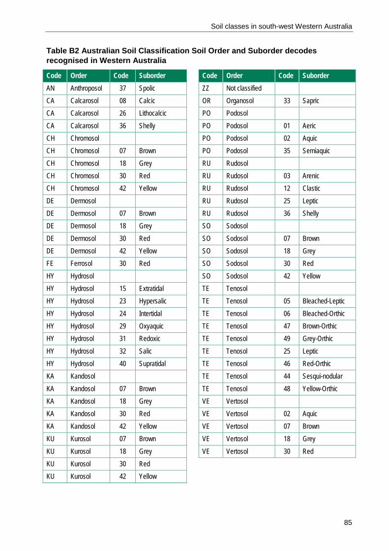
Soil classes in south-west Western Australia
85
Table B2 Australian Soil Classification Soil Order and Suborder decodes recognised in Western Australia
Code Order Code Suborder Code Order Code Suborder AN Anthroposol 37 Spolic ZZ Not classified
CA Calcarosol 08 Calcic OR Organosol 33 Sapric CA Calcarosol 26 Lithocalcic PO Podosol CA Calcarosol 36 Shelly PO Podosol 01 Aeric CH Chromosol
PO Podosol 02 Aquic
CH Chromosol 07 Brown PO Podosol 35 Semiaquic CH Chromosol 18 Grey RU Rudosol
CH Chromosol 30 Red RU Rudosol 03 Arenic CH Chromosol 42 Yellow RU Rudosol 12 Clastic DE Dermosol
RU Rudosol 25 Leptic
DE Dermosol 07 Brown RU Rudosol 36 Shelly DE Dermosol 18 Grey SO Sodosol
DE Dermosol 30 Red SO Sodosol 07 Brown DE Dermosol 42 Yellow SO Sodosol 18 Grey FE Ferrosol 30 Red SO Sodosol 30 Red HY Hydrosol
SO Sodosol 42 Yellow
HY Hydrosol 15 Extratidal TE Tenosol HY Hydrosol 23 Hypersalic TE Tenosol 05 Bleached-Leptic
HY Hydrosol 24 Intertidal TE Tenosol 06 Bleached-Orthic HY Hydrosol 29 Oxyaquic TE Tenosol 47 Brown-Orthic HY Hydrosol 31 Redoxic TE Tenosol 49 Grey-Orthic HY Hydrosol 32 Salic TE Tenosol 25 Leptic HY Hydrosol 40 Supratidal TE Tenosol 46 Red-Orthic KA Kandosol
TE Tenosol 44 Sesqui-nodular
KA Kandosol 07 Brown TE Tenosol 48 Yellow-Orthic KA Kandosol 18 Grey VE Vertosol
KA Kandosol 30 Red VE Vertosol 02 Aquic KA Kandosol 42 Yellow VE Vertosol 07 Brown KU Kurosol 07 Brown VE Vertosol 18 Grey KU Kurosol 18 Grey VE Vertosol 30 Red KU Kurosol 30 Red KU Kurosol 42 Yellow

Soil classes in south-west Western Australia
86
Table B3 Western Australian Soil Group decodes
WASG code WASG decode WASG code WASG decode 100 Wet or waterlogged soils supergroup 460 Sandy earths supergroup 101 Saline wet soil 461 Acid yellow sandy earth 102 Salt lake soil 462 Brown sandy earth 103 Semi-wet soil 463 Red sandy earth 104 Tidal soil 464 Yellow sandy earth 105 Wet soil 465 Pale sandy earth 200 Rocky or stony soils supergroup 500 Loamy duplexes supergroup 201 Bare rock 501 Acid shallow duplex 202 Calcareous stony soil 502 Alkaline grey shallow loamy duplex 203 Stony soil 503 Alkaline red shallow loamy duplex 300 Ironstone gravelly soils supergroup 504 Grey shallow loamy duplex 301 Deep sandy gravel 505 Brown deep loamy duplex 302 Duplex sandy gravel 506 Red deep loamy duplex 303 Loamy gravel 507 Red shallow loamy duplex 304 Shallow gravel 508 Yellow/brown shallow loamy duplex 400 Sandy duplexes supergroup 520 Shallow loams supergroup 401 Alkaline grey deep sandy duplex 521 Calcareous shallow loam 402 Alkaline grey shallow sandy duplex 522 Red shallow loam 403 Grey deep sandy duplex 523 Red-brown hardpan shallow loam 404 Grey shallow sandy duplex 540 Loamy earths supergroup 405 Red deep sandy duplex 541 Brown loamy earth 406 Red shallow sandy duplex 542 Calcareous loamy earth 407 Yellow/brown deep sandy duplex 543 Friable red/brown loamy earth 408 Yellow/brown shallow sandy duplex 544 Red loamy earth 409 Reticulite deep sandy duplex 545 Yellow loamy earth 420 Shallow sands supergroup 600 Cracking clays supergroup 421 Calcareous shallow sand 601 Hard cracking clay 422 Pale shallow sand 602 Self-mulching cracking clay 423 Red shallow sand 620 Non-cracking clays supergroup 424 Yellow/brown shallow sand 621 Grey non-cracking clay 440 Deep sands supergroup 622 Red/brown non-cracking clay 441 Brown deep sand 700 Miscellaneous soils supergroup 442 Calcareous deep sand 701 Disturbed land 443 Gravelly pale deep sand 702 Water 444 Pale deep sand 703 No suitable group 445 Red deep sand 704 Undifferentiated soils 446 Yellow deep sand

Soil classes in south-west Western Australia
87
Table B4 Simplified Western Australian Soil Group qualifier decodes Qualifier code Qualifier decode
Qualifier code Qualifier decode
ACD good acid subsoil LMY loam topsoil ALK good alkaline subsoil LVR loam, very shallow rock substrate CAC acid subsoil NEU good neutral subsoil CLK alkaline subsoil NSA non-saline CLM clayey matrix PEA peaty CLY clay topsoil POE poor sand, effective duplex CNE neutral subsoil PPS poor sand, poor subsoil DLM no clay loam in top 80cm PSE poor sand, effective duplex DNR differentiation not required PSR poor sand, deep rock substrate DSA deep sand PSS poor subsoil DSD deep sandy duplex PSV poor sand, very deep DSK calcareous or alkaline sands PSX poor sand, permeable substrate EDX effective duplex PVR poor sand, very shallow rock substrate FSE fair sand, effective duplex PWA poor sand, good acid subsoil FSR fair sand, rock substrate PWK poor sand, good alkaline subsoil FSV fair sand, very deep PWN poor sand, good neutral subsoil GRG gravelly subsurface, good subsoil RET reticulite GRI coarse gritty sand RKD deep rock substrate GRP gravelly subsurface, poor subsoil RKM rock substrate GRV gravelly subsoil RST rocky or stony GSA good sand topsoil, good acid subsoil SAC acid sand GSE good sand, effective duplex SAL saline GSN good sand topsoil, good neutral subsoil SAM sandy matrix GSP good sand topsoil, poor subsoil SEA sandy earth GSR good sand, deep rock substrate SHL shallow loam GSV good sand, very deep SHS shallow sand GSX good sand, permeable substrate SSD shallow sandy duplex GTR gritty sand, rock substrate SSS saline subsoil GVR good sand, very shallow rock substrate TYP not assigned GWK good sand, good alkaline subsoil UDF undifferentiated LCA loamy-calcareous VDE very deep LDP loamy duplex VGR very gravelly LMM loamy matrix VSH very shallow rock substrate LMR loam, rock substrate WSS good subsoil LMY loam topsoil Note: Within a specific WASG the detailed description of a simplified qualifier code can vary slightly. For example,
the rock substrate (RKM) qualifier for most soils is solid rock, hardpan or cemented layer at 30–80cm. However, for RKM within the deep sands supergroup, the rock occurs deeper, because deep sands must be at least 80cm deep. Here, RKM is defined as the cemented layer or solid rock at 80–150cm.

Soil classes in south-west Western Australia
88
References Department of Agriculture and Food, Western Australia 2013, Report card on sustainable natural resource use in agriculture: Status and trend in the agricultural areas of the south-west of Western Australia, Department of Agriculture and Food, Western Australia, Perth.
Isbell, RF, McDonald, WS & Ashton, LJ 1997, Concepts and rationale of the Australian soil classification, CSIRO publishing, Collingwood, Victoria.
Isbell, RF & National Committee on Soil and Terrain 2016, The Australian soil classification, 2nd edn, CSIRO publishing, Collingwood, Victoria.
Moore, G 1998, Soilguide: a handbook for understanding and managing agricultural soils, Bulletin 4343, Agriculture Western Australia, Perth.
MySoil 2017, Department of Agriculture and Food, Western Australia, February 2017, https://www.agric.wa.gov.au/mysoil.
NRInfo 2017, Department of Agriculture and Food, Western Australia, Perth, February 2017, http://maps.agric.wa.gov.au/nrm-info/.
Schoknecht, NR & Pathan, S 2013, ‘Soil Groups of Western Australia: A simple guide to the main soils of Western Australia’, 4th edn, Resource management technical report 380, Department of Agriculture and Food, Western Australia, Perth.
van Gool, D, Tille, P & Moore, G 2005, Land evaluation standards for land resource mapping, 3rd edn, Resource management technical report 298, Department of Agriculture and Food, Perth.