distribution list caledonia go station transit project
TRANSCRIPT

Caledonia GO Station Transit Project Assessment Process Natural Heritage Assessment Report
Metrolinx
R.J. Burnside & Associates Limited6990 Creditview Road, Unit 2 Mississauga ON L5N 8R9 CANADA
February 2016300034767.0000
Metrolinx i
Caledonia GO Station Transit Project Assessment Process Natural Heritage Assessment ReportFebruary 2016
R.J. Burnside & Associates Limited 300034767.0000034767_Caledonia GO Natural Heritage Assessment Report.docx
Distribution List
No. of Hard
CopiesPDF Email Organization Name
0 Yes Yes Metrolinx
Record of Revisions
Revision Date Description0 February 9, 2015 Draft Submission to Metrolinx1 June 30, 2015 Second Draft Submission to Metrolinx2 August 17, 2015 Final Draft Submission to Metrolinx3 September 4, 2015 Final Draft Submission to Metrolinx with Draft EPR
Submission4 October 2, 2015 Final Draft Submission to Metrolinx with 2nd Draft EPR
Submission5 February 16, 2016 Final Submission to Metrolinx for Review7 February 22, 2016 Final EPR
R.J. Burnside & Associates Limited
Report Prepared By:
Kevin Butt, B.Sc. (Env). Eco. Rest. Cert.Certified Arborist & Terrestrial EcologistKB:mp
Report Reviewed By:
Jennifer Vandermeer, P.Eng.Environmental Assessment Lead
Nicholle Smith B.A., EMPDSenior Terrestrial Ecologist
Philip Rowe, C.E.T.Vice President, Environmental Planning and Assessment

Metrolinx ii
Caledonia GO Station Transit Project Assessment Process Natural Heritage Assessment ReportFebruary 2016
R.J. Burnside & Associates Limited 300034767.0000034767_Caledonia GO Natural Heritage Assessment Report.docx
Table of Contents
1.0 Introduction .........................................................................................................12.0 Study Area ...........................................................................................................13.0 Planning Context .................................................................................................1
3.1 Provincial Policy Statement .........................................................................13.2 City of Toronto Official Plan .........................................................................2
4.0 Study Methodology .............................................................................................34.1 Background Information Review ..................................................................34.2 Field Investigations ......................................................................................4
4.2.1 Surface Water and Fish Habitat .......................................................44.2.2 Vegetation ........................................................................................44.2.3 Wildlife..............................................................................................4
5.0 Existing Conditions.............................................................................................55.1 Context.........................................................................................................55.2 Landforms, Soils and Geology.....................................................................55.3 Surfacewater and Groundwater ...................................................................55.4 Fish and Fish Habitat ...................................................................................65.5 Natural Heritage Areas ................................................................................65.6 Vegetation....................................................................................................7
5.6.1 Vegetation Communities within the Rail Corridor.............................75.6.2 Vegetation on Lands Adjacent to the Rail Corridor ..........................8
5.7 Wildlife .........................................................................................................85.7.1 General Wildlife Habitat....................................................................85.7.2 Avifauna ...........................................................................................95.7.3 Mammals..........................................................................................95.7.4 Amphibians and Reptiles................................................................10
6.0 Species at Risk ..................................................................................................106.1 Vegetation..................................................................................................116.2 Terrestrial and Aquatic Wildlife ..................................................................156.3 Significant Wildlife Habitat .........................................................................21
7.0 Description of Development.............................................................................218.0 Impacts and Mitigation Measures ....................................................................219.0 Recommendations ............................................................................................2710.0 Conclusion.........................................................................................................2711.0 References .........................................................................................................28
TablesTable 6.1: NHIC Designated Flora Records...................................................................12Table 6.2: NHIC and OBBA Designated Fauna Records...............................................17Table 8.1: Environmental Impact, Mitigation Measures and Monitoring Activities .........23
Metrolinx iii
Caledonia GO Station Transit Project Assessment Process Natural Heritage Assessment ReportFebruary 2016
R.J. Burnside & Associates Limited 300034767.0000034767_Caledonia GO Natural Heritage Assessment Report.docx
FiguresFigure 1: Study Area and Existing Natural Environment Features
AppendicesAppendix A Ecological Land Classification (ELC) Field Data SheetsAppendix B Photographic RecordAppendix C Ontario Breeding Bird Atlas (OBBA) Records, 2001-2005Appendix D Natural Heritage Information Centre (NHIC) Records

Metrolinx 1
Caledonia GO Station Transit Project Assessment Process Natural Heritage Assessment ReportFebruary 2016
R.J. Burnside & Associates Limited 300034767.0000034767_Caledonia GO Natural Heritage Assessment Report.docx
1.0 Introduction
Metrolinx, an agency of the Province of Ontario, has retained R.J. Burnside & Associates Limited (Burnside) to complete an Environmental Assessment (EA) and Preliminary Design Update to support the development of the future Caledonia GO Station. This new station will be located near the intersection of Eglinton Avenue West and Caledonia Road, where the Eglinton Crosstown Light Rail Transit line intersects with the GO Transit Barrie Rail Corridor (northwest quadrant of Eglinton Avenue West and Croham Road). The preparation of this Natural Heritage Assessment Report is included as acomponent of the EA, to assess the existing natural environment conditions onsite and on adjacent lands, as prescribed by the Transit Project Assessment Process (TPAP), as outlined in Ontario Regulation 231/08, Transit Project and Metrolinx Undertakings(Government of Ontario).
2.0 Study Area
The site of the future Caledonia GO Station is located in the City of Toronto, in an area comprised of mixed of residential, commercial and industrial land uses. The Study Area for the natural heritage review is bound by Castlefield Avenue to the north, Croham Road/Gilbert Avenue to the east, Keith Avenue to the south and Blackthorn Avenue / Carnarvon Street / Strathnairn Avenue to the west. The boundaries of the Study Area, as illustrated on Figure 1 (provided before appendices), include lands adjacent to the development area (Project Area).
3.0 Planning Context
The Province of Ontario, Metrolinx and City of Toronto have policy and plans relating to transit which are relevant to the development of the future Caledonia GO Station and the TPAP process. A more detailed discussion of the Planning context is provided in separate cover within the Socio-Economic and Land Use Environment Report.
Specifically, the Provincial Policy Statement and the City of Toronto Official Plan have policies that are relevant to the natural heritage features of the Study Area. These policies are summarized in the following sections.
3.1 Provincial Policy Statement
The Provincial Policy Statement (PPS) (Ministry of Municipal Affairs and Housing, 2014)provides general policies on land use patterns, transportation priorities, resources, and public health and safety that guide development across Ontario. The PPS also provides enhanced protection for the environment. Section 1.6.7 and 1.6.8 of the PPS provide policies for Transportation Systems and Corridors. Section 1.6.7.2 states that “Efficient
Metrolinx 2
Caledonia GO Station Transit Project Assessment Process Natural Heritage Assessment ReportFebruary 2016
R.J. Burnside & Associates Limited 300034767.0000034767_Caledonia GO Natural Heritage Assessment Report.docx
use shall be made of existing and planned [transportation] infrastructure.” Thedevelopment of the future Caledonia GO Station is one of the improvements proposed to optimize use of this existing rail corridor.
The Natural Heritage Reference Manual (2nd Edition, 2010) provides guidance for implementing the natural heritage policies of the PPS for the protection of natural heritage features and areas and natural heritage systems in Ontario (e.g., significant wildlife habitat, significant wetlands, woodlands, valleylands, etc.).
3.2 City of Toronto Official Plan
The City of Toronto’s Official Plan (2010 Consolidation) is supportive of public transit and specifically references GO Transit in Chapter 2, Section 2.2.1, Policy 8 stating that “priority will be given to improving transit (TTC and GO) access to the downtown…”. Chapter 3, Section 3.4, Policy 21 notes the requirement for noise and vibration studies associated with development in the vicinity of rail lines to identify impacts and requires mitigation measures to be implemented.
The City of Toronto Official Plan (OP) Map 9 designates the rail corridor north of Eglinton Avenue West and north of the Study Area as part of the Natural Heritage System (City of Toronto Online Mapping). The York Beltline Trail adjacent to the northeast portion of the Site is also included in the Natural Heritage System as illustrated on Figure 1. The City’s OP Policies 10 and 12 of Section 3.4 (Natural Environment) states the protection of components of the Natural Heritage System:
10. Development is generally not permitted in the natural heritage system illustrated on Map 9. Where underlying land use designation provides for development in or near the natural heritage system, development will:
a) Recognize natural heritage values and potential impacts of the natural ecosystem as much as is reasonable in the context of other objectives for the areas; and
b) Minimize adverse impacts and when possible, restore and enhance the natural heritage system.
12. All proposed development in or near the natural heritage system will be evaluated to assess the development’s impacts on the natural heritage system and identify measures to mitigate negative impact on and/or improve the nature heritage system, taking into account the consequences for:
a) terrestrial natural habitat features and functions including wetlands and wildlife habitat;

Metrolinx 3
Caledonia GO Station Transit Project Assessment Process Natural Heritage Assessment ReportFebruary 2016
R.J. Burnside & Associates Limited 300034767.0000034767_Caledonia GO Natural Heritage Assessment Report.docx
b) known watercourses and hydrologic functions and features;
c) significant physical features and land forms;
d) riparian zones or buffer areas and functions;
e) vegetation communities and species of concern; and
f) significant aquatic features and functions.
To assist this evaluation, an impact study may be required in accordance with guidelines established for this purpose.
This report is intended to identify and address impacts to natural heritage features within the Study Area based on the level of detail available to date.
4.0 Study Methodology
4.1 Background Information Review
At the outset of the project, the Study Area was identified extending north and south of the approximate limits of work for the future Caledonia GO Station, as well as to the west and east limits of the GO Transit Barrie Rail Corridor, thereby guiding the review of features and constraints. Available background information was compiled and reviewed within this general area to provide preliminary input into the impacts of the futureCaledonia GO Station on the natural environment.
Information from the following sources was reviewed:
Air photo mapping from Google Earth Pro (2009);Ministry of Natural Resources and Forestry (MNRF) Natural Heritage Information Centre (NHIC) database and Ontario Breeding Bird Atlas (2001-2005) for significant species and designated natural features within, adjacent to or in the vicinity of the general study area;MNRF Land Information Ontario (LIO) database;Review of the City of Toronto Official Plan (2010) mapping for presence of Environmentally Significant Areas and City of Toronto Natural Heritage System; and,Review of the Toronto and Region Conservation Authority (TRCA) regulated areas.
A Tree Inventory Plan Report has been prepared under separate cover. This report provides mapping and an assessment of the conditions of trees located within the Study Area.
Metrolinx 4
Caledonia GO Station Transit Project Assessment Process Natural Heritage Assessment ReportFebruary 2016
R.J. Burnside & Associates Limited 300034767.0000034767_Caledonia GO Natural Heritage Assessment Report.docx
4.2 Field Investigations
Field investigations by qualified Burnside staff were conducted on October 1, 2014 to gather terrestrial information about vegetation and wildlife conditions within the Study Area and adjacent lands that may be impacted by the future Caledonia GO Station.Biologists completed the primary assessment by reviewing both sides of the corridor from the rail right-of-way (ROW) on foot. The east side was investigated by walking southward along the meadow and the west side was reviewed by walking northward, under the supervision of a flagging assistant. The site was also investigated from the Eglinton Avenue West bridge, the York Beltline Trail and area roads.
Inventory or analysis procedures are outlined in more detail in the following sections where relevant.
4.2.1 Surface Water and Fish Habitat
Burnside staff visually inspected the Study Area on October 1, 2014 to determine presence of any surface water conveyance or a discharge that would indicated subsurface conveyance and the potential for fish habitat.
4.2.2 Vegetation
The Ecological Land Classification (ELC) communities were delineated and determinedbased on the ELC for Southern Ontario (Lee et. al, 1998) and observations during the field investigation, respectively. The assessment was completed within an area that encompassed the entire width (east to west) of the rail ROW and extended north toCastlefiled Avenue and 100 m south of Eglinton Avenue West (field data sheets included in Appendix A).
The purpose of the assessment was to characterize the vegetation communities present within the Study Area, identify seasonally evident plant species and identify whether any habitat for Species at Risk (SAR) are supported. The methodology for this component of the field data collection includes wandering transects through vegetated areas of the Study Area, focusing on species composition and distribution in order to delineate and classify distinct vegetation communities based on dominant species and soil moisture. These vegetation communities are mapped and presented on Figure 1 (provided before appendices). Existing conditions and potential for SAR are further detailed in Section 5.6 and 6.1, respectively.
4.2.3 Wildlife
The review of background information (OBBA 2001-2005 and NHIC records) was carried out prior to the site investigation to review the general vicinity for potential Species atRisk (SAR) presence. The results of the review are listed in Table 6.2. Since this

Metrolinx 5
Caledonia GO Station Transit Project Assessment Process Natural Heritage Assessment ReportFebruary 2016
R.J. Burnside & Associates Limited 300034767.0000034767_Caledonia GO Natural Heritage Assessment Report.docx
project commenced outside of the standard breeding bird survey window for Southern Ontario (May 24 to July 10), breeding bird surveys were not completed during the October 2014 field investigations. Appropriate timing windows are determined by Bird Studies Canada, an agency of Canadian Wildlife Service, whereby OBBA describessurvey methodology based on timing windows. Further discussion regarding breeding bird surveys is provided in Sections 5.7.2 and 9.0. Incidental observations of all wildlife (SAR or otherwise) and habitat usage (such as tracks, scats, trails, dens, vocalizations or other wildlife signs) were recorded while onsite on October 1, 2014 during daytime hours from 9 a.m. until 2 p.m. Observations are included in Appendix A. Information onexisting conditions and potential SAR habitat is further detailed in Section 5.7 and 6.2,respectively.
5.0 Existing Conditions
5.1 Context
The Study Area is located in the City of Toronto, in an area comprised of mixedresidential, commercial and industrial land uses. More information on the land uses within and adjacent to the Study Area is provided under separate cover in the Socio-Economic and Land Use Environment Report.
5.2 Landforms, Soils and Geology
Topography is generally flat throughout the Study Area. North of Eglinton Avenue West bridge, the lands adjacent to the tracks within the rail corridor slope upward to meet the adjacent private lands. The slopes leading upward from the tracks south of the Eglinton Avenue West bridge are not as steep as those immediately north of the bridge.
The soil is characterized as Clayey Silt Till (Halton) according to historic soils mapping of the area (MNR, 1980). This soil type is the most common within Toronto and the surrounding area. Significant disturbance has occurred within the Study Area over time,including the import of fill materials, which likely resulted from development of the rail corridor and adjacent lands.
5.3 Surfacewater and Groundwater
The GO Transit Barrie Rail Corridor does not traverse any waterbodies or tributarieswithin the Study Area. City of Toronto mapping identifies a TRCA regulated area beginning approximately 40 m to the west of the railway corridor (see Figure 1) and extending westward away from the Study Area. Staff inspected the documented location of this feature on Carnarvon Street and Woodborough Avenue on October 1, 2014 and found no evidence of surface water conveyance or a discharge that would indicate subsurface conveyance. No evidence of the portion of the documented TRCA regulated
Metrolinx 6
Caledonia GO Station Transit Project Assessment Process Natural Heritage Assessment ReportFebruary 2016
R.J. Burnside & Associates Limited 300034767.0000034767_Caledonia GO Natural Heritage Assessment Report.docx
area was located within 250 m of the Study Area. This feature is suspected to havebeen removed, paved over, or relocated.
A visual search was conducted during field investigations on October 1, 2014 for culverts and other surface or buried discharges that convey water onto, or away from the rail corridor, from or to adjacent properties within the Study Area. The most up-to-date GOTransit - Culvert Inventory List was also cross-referenced. No culverts were noted to be located within the Study Area. No discharges and no markers indicating presence the presence of discharges were found during the field investigations. No wetlands were documented within the Study Area. Wetland plants found within the Study Area are limited to isolated impounded portions of the swales adjacent to the rail tracks (see Section 5.6).
5.4 Fish and Fish Habitat
A review of MNRF’s NHIC records indicate two historical records for Redside Dace (Clinostomus elongatus) within the vicinity of the Study Area (recorded dates: 1926 and 1936). Habitat for this species may have been present in the past; however, no onsite fish habitat is presently supported due to lack of waterbodies, wetlands or watercourses within the Study Area. Therefore, these historical records are anticipated to be associated with the Black Creek, located west of the site, beyond the Study Area limits.
5.5 Natural Heritage Areas
Publicly available Geographic information system (GIS) based mapping from the MNRF Natural Areas Mapping tool (MNRF, 2015) and City of Toronto website (City of Toronto, 2015) were reviewed for the presence of natural heritage areas within the vicinity of the Study Area.
For the purposes of this document, ‘designated natural areas’ include areas identified for protection by the MNRF, TRCA, and City of Toronto. These include: evaluated wetlands (both Locally Significant Wetlands [LSW] and Provincially Significant Wetlands [PSW]), Environmentally Sensitive Areas, Significant Wildlife Habitat (SWH), Provincial Parks, Conservation Reserves and Areas of Natural and Scientific Interest (ANSI). None of these listed features are present within the Study Area or on immediately adjacent lands.
The City of Toronto Official Plan identifies the vegetation on either side of the GO Transit Barrie Rail Corridor and the York Beltline Trail as components of the City’s ‘Natural Heritage System’. In addition, the lands within the TRCA regulated limits discussed in Section 5.3 are also subject to the City of Toronto’s ‘Ravine and Natural FeatureProtection By-law’ (see Figure 1). This by-law is discussed further in the Tree Inventory Report. By-law Lands included in the Natural Heritage System are located within the

Metrolinx 7
Caledonia GO Station Transit Project Assessment Process Natural Heritage Assessment ReportFebruary 2016
R.J. Burnside & Associates Limited 300034767.0000034767_Caledonia GO Natural Heritage Assessment Report.docx
study area. These lands are not expected to be adversely affected as part of the proposed works.
5.6 Vegetation
5.6.1 Vegetation Communities within the Rail Corridor
The ELC community that characterizes the Study Area within the rail corridor is a Dry-Moist Old Field Meadow (CUM 1-1) and Cultural Thicket (CUT 1) Complex (see Figure 1). The following section describes the vegetation observed which led to this conclusion. Photos illustrating representative vegetation of the site are included in Appendix B.
Complex: Dry-Moist Old Field Meadow Type (CUM 1-1) and Cultural Thicket (CUT 1)
Canopy layer and vegetation relative abundance varied throughout the communityexamined, though vegetation composition was consistent throughout the Study Area.The vegetation within the Study Area is a complex, with varying abundance of either Cultural communities with Dry-Moist Old Field Meadow, or Cultural Thicket, depending on the extent of shrub/tree canopy cover. These cultural communities result from, or are maintained by cultural or anthropogenic-based disturbances. These types of communities often contain a large proportion of non-native plant species and site conditions and substrate can vary.
The meadow component of the community that flanks the east and west sides of thetracks is highly disturbed and regularly maintained lands and is approximately 5 m wide on each side. The community is represented by a dense (>60% overall coverage) groundlayer and sparse (<25% overall coverage) understory. The groundlayer is dominated by early successional and / or introduced species grasses such as SmoothBrome (Bromus inermis) and, Timothy (Phleum pratense) and forbs such as Common Milkweed (Asclepias syriaca) and Garlic Mustard (Alliaria petioliata). The understory layer is dominated by Manitoba Maple (Acer negundo), Virginia Creeper (Parthenocissus inserta), Riverbank Grape (Vitis riparia), and Canada Goldenrod (Solidago canadensis).
The thicket component of the community, situated along the east and west property limits, slopes upward from the meadow to the adjacent properties. The woody vegetation within the subcanopy and understory layers is growing as hedgerows and is comprised mainly of trees under 20 m in height, which would be classified as immature(most trees are also less than 30 cm DBH). Manitoba Maple is the dominant species in these layers with lesser associates of Staghorn Sumac (Rhus typhina), Siberian Elm(Ulmus pumila), Black Locust (Robinia pseudoacacia), White Mulberry (Morus alba), and Norway Maple (Acer platanoides). The groundlayer contains the same species as the meadow component, but has sparse coverage.
Metrolinx 8
Caledonia GO Station Transit Project Assessment Process Natural Heritage Assessment ReportFebruary 2016
R.J. Burnside & Associates Limited 300034767.0000034767_Caledonia GO Natural Heritage Assessment Report.docx
5.6.2 Vegetation on Lands Adjacent to the Rail Corridor
Residential and Commercial Properties
Adjacent residential and commercial properties contain ornamental trees that range from mature to immature and are comprised of a variety of species. The Ravine and Natural Feature Protection By-Law feature mentioned earlier is found west of the Project Area. No other natural heritage features (i.e., woodlands, wetlands) were identified on these properties based on City of Toronto Official Plan mapping, field assessment and air photo interpretation. Details of trees that will be impacted by the proposed development or immediately adjacent to the development are provided in the Tree Inventory Plan.
York-Beltline Trail
The York Beltline Trail is a multi-use path owned and maintained by the City of Toronto that extends in an easterly direction beyond the Study Area limits. The south limit of the path is located where Bowie Avenue terminates at the GO Transit Barrie Rail Corridor property limit. Immature dense thicket dominated by Manitoba Maple line the east and west sides of the path as it extends northeast. Ornamental plantings of immature trees including Serviceberries (Amelanchier sp.) and Norway Maples (Acer platanoides) are found in the grassed verge at the south trailhead (at Bowie Avenue). The vegetation on either side of the York Beltline Trail within the Study Area is designated as ‘Natural Heritage System’ in the City of Toronto Official Plan.
Eglinton-Gilbert Parkette
The Eglinton-Gilbert Parkette located at the northwest corner of Eglinton Avenue West and Gilbert Avenue was also reviewed. The parkette contains ornamental Green Ash(Fraxinus pennsylvanica) and Thornless Honey Locust (Gleditsia triacanthos var. inermis) within a manicured turf area.
5.7 Wildlife
5.7.1 General Wildlife Habitat
The Study Area is located within a heavily urbanized environment comprised ofresidential, commercial and industrial properties. The GO Transit Barrie Rail Corridor further fragments the landscape but also provides a potential linear corridor for wildlife movement for small and medium-sized animals that are tolerant of urbanized environments (e.g., Raccoon, Gray Squirrel and Coyote). Contribution to high quality wildlife habitat is anticipated to be limited within the Study Area due to these constraints.

Metrolinx 9
Caledonia GO Station Transit Project Assessment Process Natural Heritage Assessment ReportFebruary 2016
R.J. Burnside & Associates Limited 300034767.0000034767_Caledonia GO Natural Heritage Assessment Report.docx
5.7.2 Avifauna
The Ontario Breeding Bird Atlas (OBBA) online database indicates that 161 species of breeding birds have been recorded in the vicinity of the Study Area between 2001 to 2005 (Cadman et. al, 2007). Data for this source is compiled via partnership between Environmental Canada, MNRF, Ontario Nature, Bird Studies Canada, and Ontario Field Ornithologists. The Study Area falls within OBBA square 17PJ23 (see Appendix C for data records). These records are obtained online through the Ontario Breeding Birds Atlas website.
Burnside staff observed three species of birds within the Study Area during the field investigation on October 1, 2014. The Ontario Breeding Bird Atlas Guide for Participants (March 2001) was used for guidance in determination of the breeding bird survey field methodology and recommends surveys be completed between May 24 and July 10. As stated in Section 4.0, this project commenced outside of the standard breeding birdsurvey window for Southern Ontario; therefore, these surveys were not completed during the October 2014 field investigations. As an alternative, incidental observations were documented.
Two resident species, American Crow (Corvus brachyrhynchos) and American Robin (Turdus migratorius) were noted during incidental observations. In addition, Ring-billed Gull (Larus delawarensis) and/or Herring Gull (Larus smithsonianus) were observed flying overhead, but are considered flyover observations only, given the absence of suitable breeding habitat within the Study Area.
A variety of other common bird species typical of urban environments are anticipated to be present within the Study Area given the generally contiguous nature of the habitat mosaic and known tolerance of these species to anthropogenic habitats. These species may include: House Sparrow (Passer domesticus), Song Sparrow (Melospiza melodia), Mourning Dove (Zenaida macroura), American Goldfinch (Carduelis tristis), and Northern Cardinal (Cardinalis cardinalis).
None of these bird species are designated as SAR; however, they are common and expected in this type of urban environment.
5.7.3 Mammals
Burnside staff recorded incidental observations or evidence of mammals during the field investigation on October 1, 2014 for the Gray Squirrel (Sciurus carolinensis) and Vole species (Microtus sp.). According to the Atlas of the Mammals of Ontario (Dobbyn, 1994), additional mammals that are common in Ontario and expected based on habitat present within the Study Area, were not directly observed by Burnside staff. Theseinclude: Striped Skunk (Mephitis mephitis), Raccoon (Procyon lotor), Eastern Chipmunk (Tamias minimus), Eastern Cottontail (Sylvilagus floridanus), and Coyote (Canis latrans).
Metrolinx 10
Caledonia GO Station Transit Project Assessment Process Natural Heritage Assessment ReportFebruary 2016
R.J. Burnside & Associates Limited 300034767.0000034767_Caledonia GO Natural Heritage Assessment Report.docx
Some of these animals are nocturnal, and others tend to be secretive and are therefore difficult to observe.
None of these species are designated as SAR.
Potential locations for hibernation areas and maternity roosts for bats, including cavities in trees, were not found within the existing rail corridor.
5.7.4 Amphibians and Reptiles
No incidental observations of amphibians or reptiles (collectively termed ‘herpetofauna’) were observed during the October 2014 field investigation. The absence of woodlands, wetlands or watercourses within the Study Area and general vicinity in this urbanized setting reduces the suitability of the area to support all but a few species.
Certain common species of herpetofauna that may be found in disturbed urban environments may be present within the Study Area based on a review of the Ontario Reptile and Amphibian Atlas (accessed online on August 28, 2014), the existing habitat present within the Study Area and common species within this EcoRegion. These mayinclude: American Toad (Anaxyrus americanus), Eastern Gartersnake (Thamnophis sirtalis sirtalis), and Northern Brownsnake (Storeria dekayi).
None of these species are designated as SAR.
6.0 Species at Risk
For the purposes of this report, the term ’Species at Risk’’ (SAR) refers to federally designated SAR under the Species at Risk Act (SARA Schedule 1), and species designated as provincially Threatened or Endangered that afford protection under the Ontario Endangered Species Act, 2007 (ESA, 2007).
Generally, other species of conservation concern include species listed as Special Concern provincially under the ESA, 2007; species that are listed as rare or historical in Ontario based on NHIC records (S1-S3 ranks), or species that are regionally or locally rare, but do not receive official designation. Recorded occurrences in the NHIC database greater than 40 years old are still tracked by the MNRF, but given the high level of development and disturbance within the Study Area over time, it is unlikely that conditions are still supportive of species that were present 40 years ago. It is possiblethat the Study Area is supportive of habitats for species listed in historic records, yetthere are no recently recorded observations. These historically recorded species are provided in this report with analysis of the probability for the presence of a species and/or its supporting habitat.
The Study Area is found within (1 km x 1 km) NHIC squares 17PJ2338 and17PJ2339.

Metrolinx 11
Caledonia GO Station Transit Project Assessment Process Natural Heritage Assessment ReportFebruary 2016
R.J. Burnside & Associates Limited 300034767.0000034767_Caledonia GO Natural Heritage Assessment Report.docx
6.1 Vegetation
A search of the NHIC database confirmed that several SAR and species of conservation concern have been documented in the general vicinity of the Study Area. During the field investigation, priority was placed on identifying and locating any flora SAR or species of conservation concern that were known to either occur, or have the potential to occur in the Study Area.
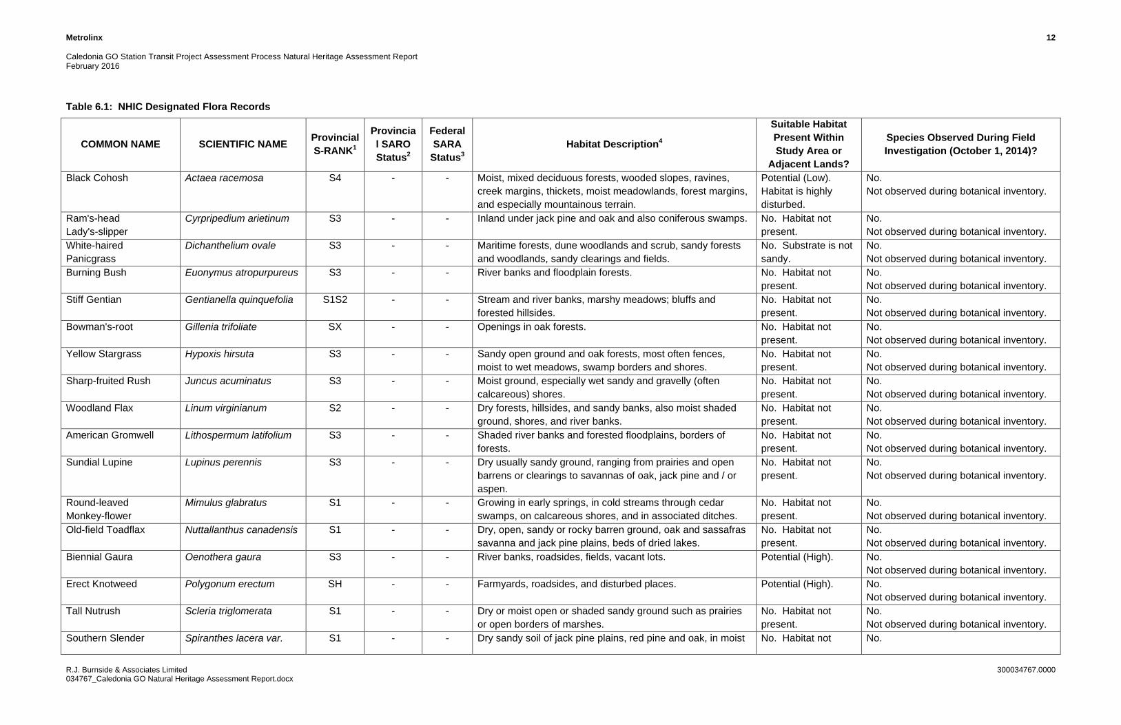
A total of 17 vascular plant records listed as species of conservation concern (ranked by MNRF as S1-S31) were listed within the vicinity of the Study Area (see Appendix D). These species and their habitat requirements are listed in Table 6.1.
Biennial Gaura and Erect Knotweed
As illustrated in Table 6.1, there is high potential for habitat within the Study Area to support two of the species included in the background records screening list including Biennial Gaura (Gaura biennis) and Erect Knotweed (Polygonum erectum). However, neither of the species noted above were observed during the field investigation. These species are not protected under the ESA, 2007.
White Wood Aster and Red Mulberry
In addition to the species listed above, provincially designated SAR recorded by NHIC within the vicinity of the Study Area include White Wood Aster (Eurybia divaricate) and Red Mulberry (Morus rubra). Table 6.1 illustrates that these species require specific habitat conditions, mainly in undisturbed forests. The heavily disturbed, urban environment within the Study Area is not supportive of these habitat requirements. The records for these two species date back to 1927 and 1941, respectively, and areclassified as historic, further decreasing the likelihood of finding these species within the Study Area.
1 S1 Critically Imperiled - Critically imperiled in the nation or state/province because of extreme rarity (often 5 or fewer occurrences) or because of some factor(s) such as very steep declines making it especially vulnerable to extirpation from the state/province.S2 Imperiled - Imperiled in the nation or state/province because of rarity due to very restricted range, very few populations (often 20 or fewer), steep declines, or other factors making it very vulnerable to extirpation from the nation or state/province.S3 Vulnerable - Vulnerable in the nation or state/province due to a restricted range, relatively few populations (often 80 or fewer), recent and widespread declines, or other factors making it vulnerable to extirpation.
Metrolinx 12 Caledonia GO Station Transit Project Assessment Process Natural Heritage Assessment Report February 2016
R.J. Burnside & Associates Limited 300034767.0000 034767_Caledonia GO Natural Heritage Assessment Report.docx
Table 6.1: NHIC Designated Flora Records
COMMON NAME SCIENTIFIC NAME Provincial S-RANK1
Provincial SARO Status2
Federal SARA
Status3 Habitat Description4
Suitable Habitat Present Within Study Area or
Adjacent Lands?
Species Observed During Field Investigation (October 1, 2014)?
Black Cohosh Actaea racemosa S4 - - Moist, mixed deciduous forests, wooded slopes, ravines, creek margins, thickets, moist meadowlands, forest margins, and especially mountainous terrain.
Potential (Low). Habitat is highly disturbed.
No. Not observed during botanical inventory.
Ram's-head Lady's-slipper
Cyrpripedium arietinum S3 - - Inland under jack pine and oak and also coniferous swamps. No. Habitat not present.
No. Not observed during botanical inventory.
White-haired Panicgrass
Dichanthelium ovale S3 - - Maritime forests, dune woodlands and scrub, sandy forests and woodlands, sandy clearings and fields.
No. Substrate is not sandy.
No. Not observed during botanical inventory.
Burning Bush Euonymus atropurpureus S3 - - River banks and floodplain forests. No. Habitat not present.
No. Not observed during botanical inventory.
Stiff Gentian Gentianella quinquefolia S1S2 - - Stream and river banks, marshy meadows; bluffs and forested hillsides.
No. Habitat not present.
No. Not observed during botanical inventory.
Bowman's-root Gillenia trifoliate SX - - Openings in oak forests. No. Habitat not present.
No. Not observed during botanical inventory.
Yellow Stargrass Hypoxis hirsuta S3 - - Sandy open ground and oak forests, most often fences, moist to wet meadows, swamp borders and shores.
No. Habitat not present.
No. Not observed during botanical inventory.
Sharp-fruited Rush Juncus acuminatus S3 - - Moist ground, especially wet sandy and gravelly (often calcareous) shores.
No. Habitat not present.
No. Not observed during botanical inventory.
Woodland Flax Linum virginianum S2 - - Dry forests, hillsides, and sandy banks, also moist shaded ground, shores, and river banks.
No. Habitat not present.
No. Not observed during botanical inventory.
American Gromwell Lithospermum latifolium S3 - - Shaded river banks and forested floodplains, borders of forests.
No. Habitat not present.
No. Not observed during botanical inventory.
Sundial Lupine Lupinus perennis S3 - - Dry usually sandy ground, ranging from prairies and open barrens or clearings to savannas of oak, jack pine and / or aspen.
No. Habitat not present.
No. Not observed during botanical inventory.
Round-leaved Monkey-flower
Mimulus glabratus S1 - - Growing in early springs, in cold streams through cedar swamps, on calcareous shores, and in associated ditches.
No. Habitat not present.
No. Not observed during botanical inventory.
Old-field Toadflax Nuttallanthus canadensis S1 - - Dry, open, sandy or rocky barren ground, oak and sassafras savanna and jack pine plains, beds of dried lakes.
No. Habitat not present.
No. Not observed during botanical inventory.
Biennial Gaura Oenothera gaura S3 - - River banks, roadsides, fields, vacant lots. Potential (High). No. Not observed during botanical inventory.
Erect Knotweed Polygonum erectum SH - - Farmyards, roadsides, and disturbed places. Potential (High). No. Not observed during botanical inventory.
Tall Nutrush Scleria triglomerata S1 - - Dry or moist open or shaded sandy ground such as prairies or open borders of marshes.
No. Habitat not present.
No. Not observed during botanical inventory.
Southern Slender Spiranthes lacera var. S1 - - Dry sandy soil of jack pine plains, red pine and oak, in moist No. Habitat not No.

Metrolinx 13 Caledonia GO Station Transit Project Assessment Process Natural Heritage Assessment Report February 2016
R.J. Burnside & Associates Limited 300034767.0000 034767_Caledonia GO Natural Heritage Assessment Report.docx
COMMON NAME SCIENTIFIC NAME Provincial S-RANK1
Provincial SARO Status2
Federal SARA
Status3 Habitat Description4
Suitable Habitat Present Within Study Area or
Adjacent Lands?
Species Observed During Field Investigation (October 1, 2014)?
Ladies'-tresses gracilis aspen forests and conifer thickets along shores and dunes. Rarely in moist soils.
present. Not observed during botanical inventory.
White Wood Aster Eurybia divaricata S2 THR THR Typically grows in open, dry deciduous forests dominated by Sugar maple and American beech trees. Often found mixed in with other asters. Does best in well-drained soils and may prefer low level of disturbance, as it has been found to grow along trails. Does well in partial to full shade. Restricted to a relatively small area in Niagara region and a few areas in southwestern Quebec.
Potential (Low). No. Not observed during botanical inventory. NHIC records within study area dated 1927-07-24
Red Mulberry Morus rubra S2 END END In Ontario, Red mulberry grows in moist, forested habitats and on both sandy and limestone-based loamy soils. It is often found in areas where the forest canopy is quite open and allows lots of sunlight to reach the forest floor, but it will tolerate some shade. Red mulberry occurs in eastern North American forests. In Canada, it is only found in the Carolinian Zone (the small area of Ontario southwest of Toronto to Sarnia down to the shores of Lake Erie) near rivers, the shores of Lake Erie, and the slopes of the Niagara Escarpment (MOECC, 2015).
No. Habitat Not Present.
No. Not observed during botanical inventory. NHIC records within study area dated 1941-06-27
1S-Ranks (provincial) Provincial (or Subnational) ranks are used by the Natural Heritage Information Centre (NHIC) to set protection priorities for rare species and natural communities. These ranks are not legal designations. Provincial ranks are assigned in a manner similar to that described for global ranks, but consider only those factors within the political boundaries of Ontario (Please refer to: http://explorer.natureserve.org/nsranks.htm) SX — Presumed Extirpated - Species or community is believed to be extirpated from the province. Not located despite intensive searches of historical sites and other appropriate habitat, and virtually no likelihood that it will be rediscovered. SH — Possibly Extirpated (Historical) - Species or community occurred historically in the province, and there is some possibility that it may be rediscovered. Its presence may not have been verified in the past 20–40 years. A species or community could become SH without such a 20-40 year delay if the only known occurrences in a province were destroyed or if it had been extensively and unsuccessfully looked for. The SH rank is reserved for species or communities for which some effort has been made to relocate occurrences, rather than simply using this status for all elements not known from verified extant occurrences. S1 — Critically Imperiled - Critically imperiled in the province or state because of extreme rarity (often 5 or fewer occurrences) or because of some factor(s) such as very steep declines making it especially vulnerable to extirpation from the province. S2 — Imperiled - Imperiled in the province because of rarity due to very restricted range, very few populations (often 20 or fewer), steep declines, or other factors making it very vulnerable to extirpation from the province. S3 — Vulnerable - Vulnerable in the province due to a restricted range, relatively few populations (often 80 or fewer), recent and widespread declines, or other factors making it vulnerable to extirpation. S4 — Apparently Secure - Uncommon but not rare; some cause for long-term concern due to declines or other factors. S5 — Secure - Common, widespread, and abundant in the province. SNR — Unranked - Province conservation status not yet assessed. SU — Unrankable - Currently unrankable due to lack of information or due to substantially conflicting information about status or trends. SNA — Not Applicable - A conservation status rank is not applicable because the species is not a suitable target for conservation activities. S#S# — Range Rank - A numeric range rank (e.g., S2S3) is used to indicate any range of uncertainty about the status of the species or community. Ranges cannot skip more than one rank (e.g., SU is used rather than S1S4). S#? – Inexact or Uncertain - Denotes inexact or uncertain numeric rank. Breeding Status Qualifiers B – Breeding Conservation status refers to the breeding population of the species in the nation or state/province. N – Nonbreeding Conservation status refers to the non-breeding population of the species in the province. M – Migrant species occurring regularly on migration at particular staging areas or concentration spots where the species might warrant conservation attention. Conservation status refers to the aggregating transient population of the species in the province.

Metrolinx 14 Caledonia GO Station Transit Project Assessment Process Natural Heritage Assessment Report February 2016
R.J. Burnside & Associates Limited 300034767.0000 034767_Caledonia GO Natural Heritage Assessment Report.docx
2SARO Endangered Species Act, 2007 (provincial status from http://www.ontario.ca/environment-and-energy/how-species-risk-are-listed#section-3) The provincial review process is implemented by the MNR's Committee on the Status of Species at Risk in Ontario (COSSARO). Extinct - A species that no longer exists anywhere. Extirpated (EXT) - Lives somewhere in the world, and at one time lived in the wild in Ontario, but no longer lives in the wild in Ontario. Endangered (END) - Lives in the wild in Ontario but is facing imminent extinction or extirpation. Threatened (THR) - Lives in the wild in Ontario, is not endangered, but is likely to become endangered if steps are not taken to address factors threatening it. Special concern (SC) - Lives in the wild in Ontario, is not endangered or threatened, but may become threatened or endangered due to a combination of biological characteristics and identified threats. Not at Risk (NAR) - A species that has been evaluated and found to be not at risk. Data Deficient (DD) - A species for which there is insufficient information for a provincial status recommendation. 3SARA (Federal Species at Risk Act) Status and Schedule (includes COSEWIC Status) The Act establishes Schedule 1, as the official list of wildlife species at risk. It classifies those species as being either Extirpated, Endangered, Threatened, or Special Concern. Once listed, the measures to protect and recover a listed wildlife species are implemented. Extinct - A wildlife species that no longer exists. Extirpated (EXT) - A wildlife species that no longer exists in the wild in Canada, but exists elsewhere. Endangered (END) - A wildlife species facing imminent extirpation or extinction. Threatened (THR) - A wildlife species that is likely to become an endangered if nothing is done to reverse the factors leading to its extirpation or extinction. Special Concern (SC) - A wildlife species that may become threatened or endangered because of a combination of biological characteristics and identified threats. Data Deficient (DD) - A category that applies when the available information is insufficient (a) to resolve a wildlife species' eligibility for assessment or (b) to permit an assessment of the wildlife species' risk of extinction. Not At Risk (NAR) - A wildlife species that has been evaluated and found to be not at risk of extinction given the current circumstances. 4Source: Ontario Ministry of Natural Resources. 2000. Significant Wildlife Habitat Technical Guide & Appendices.

Metrolinx 15
Caledonia GO Station Transit Project Assessment Process Natural Heritage Assessment ReportFebruary 2016
R.J. Burnside & Associates Limited 300034767.0000034767_Caledonia GO Natural Heritage Assessment Report.docx
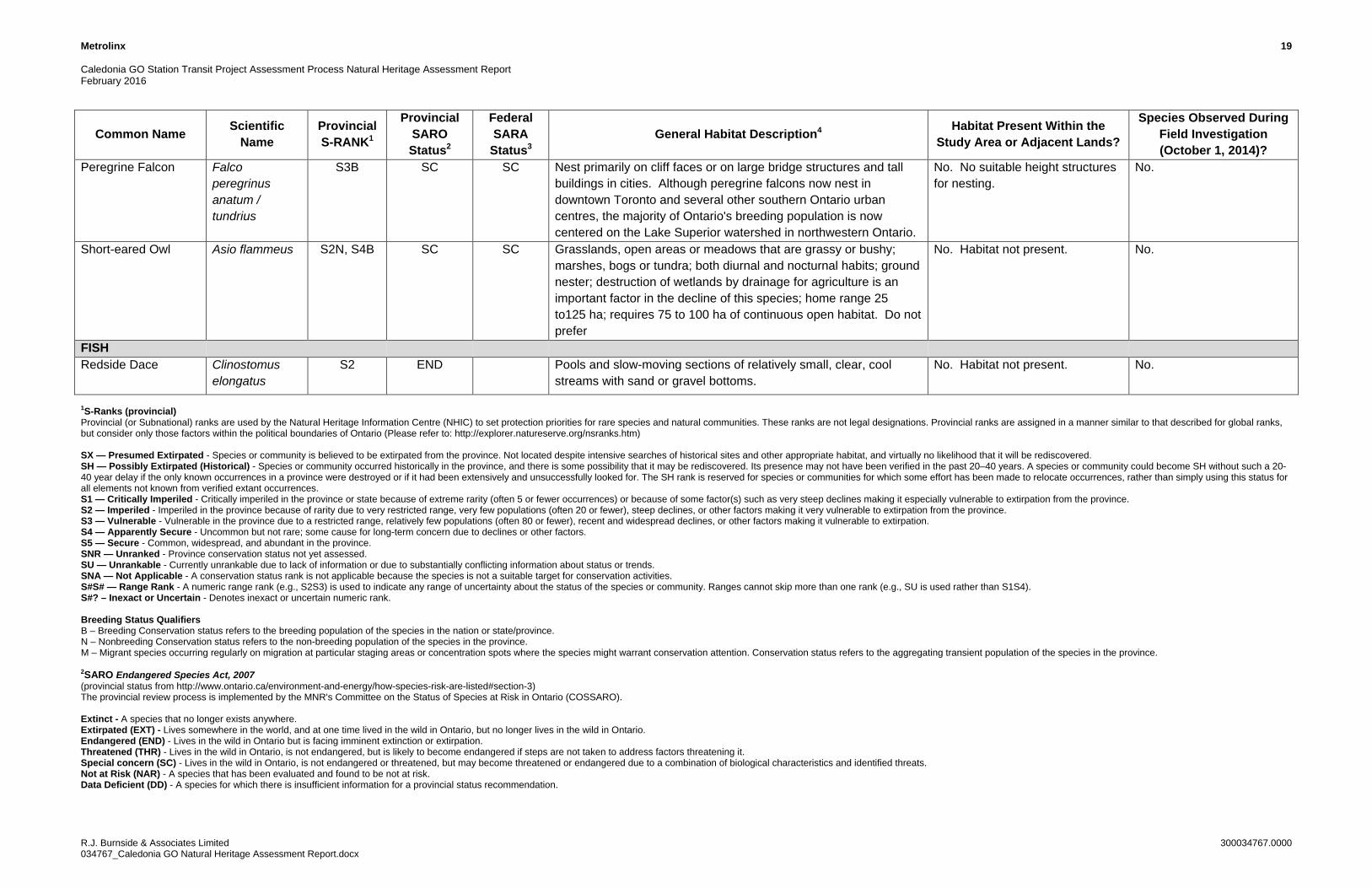
6.2 Terrestrial and Aquatic Wildlife
A review of background information (OBBA 2001-2005 and NHIC records) resulted in a total of 16 fauna SAR or species of conservation concern that have been recorded within the general vicinity of the Study Area (see Table 6.2). In addition, eight NHIC ‘restricted’ species records indicated information that is not available to the public. A complete list of records for OBBA square 17PJ23 is included in Appendix C. A complete list of NHIC records for squares17PJ2338 and 17PJ2339 is included in Appendix D.
None of the species listed in Table 6.2 were observed during the field investigation on October 1, 2014. As noted in Table 6.2, habitat potential for the majority of these species is not present in the Study Area or adjacent lands, with the exception of Chimney Swift (Chaetura pelagica) and Common Nighthawk (Chordeiles minor). Both of these species are known to breed in urban environments. The majority of species listed in Table 6.2 either inhabit waterbodies or terrestrial habitats close to waterbodies, or require habitat not present in the Study Area or adjacent lands such as forest environments with either moderate to dense canopy cover, or expansive tracts of undisturbed land. Vegetation composition within the Study Area is indicative of high levels of anthropogenic disturbance, and lacks a dense canopy cover.
Chimney Swift
Potential habitat for Chimney Swift may be present within the general vicinity of the Study Area.Chimney Swift can be found nesting and roosting in buildings with open chimney structures (i.e., not capped or sealed). The only structure to be removed in order to develop the future Caledonia GO Station is the commercial building located at 2-4 Croham Road, which has achimney structure. Prior to removal, confirmation will be required to determine whether the chimney structure is being used by Chimney Swift. If the chimney structure is not sealed or capped, surveys may need to be completed during the appropriate timing window(s) as per Bird Studies Canada (May 2015). Please refer to Section 9.0 for further recommendations.
Common Nighthawk
Common Nighthawk may nest in urban areas on flat gravel roofs of buildings, on railways and footpaths (Cadman et. al, 2007). Given its significant decline throughout its range in recent years and the daily noise disturbances within the Study Area from the active rail corridor, suitable breeding habitat for this species is not present within the Study Area limits; however, very limited potential breeding habitat may be present on adjacent lands in the general vicinity of the Study Area
Metrolinx 16
Caledonia GO Station Transit Project Assessment Process Natural Heritage Assessment ReportFebruary 2016
R.J. Burnside & Associates Limited 300034767.0000034767_Caledonia GO Natural Heritage Assessment Report.docx
Redside Dace
NHIC records indicate two historical records for Redside Dace (Clinostomus elongatus) within the vicinity of the Study Area. No fish habitat is supported within the Study Area as there are no watercourses present. These records are assumed to associate with another waterbody located west of the site, anticipated to be associated with Black Creek, which is located in the same NHIC squares beyond the Study Area limits.

Metrolinx 17 Caledonia GO Station Transit Project Assessment Process Natural Heritage Assessment Report February 2016
R.J. Burnside & Associates Limited 300034767.0000 034767_Caledonia GO Natural Heritage Assessment Report.docx
Table 6.2: NHIC and OBBA Designated Fauna Records
Common Name Scientific Name
Provincial S-RANK1
Provincial SARO Status2
Federal SARA
Status3 General Habitat Description4 Habitat Present Within the
Study Area or Adjacent Lands?
Species Observed During Field Investigation (October 1, 2014)?
REPTILES Blanding's Turtle (Great Lakes/St. Lawrence Population)
Emydoidea blandingii
S3 THR THR Shallow water marshes, bogs, ponds or swamps, or coves in larger lakes with soft muddy bottoms and aquatic vegetation; basks on logs, stumps, or banks; surrounding natural habitat is important in summer as they frequently move from aquatic habitat to terrestrial habitats; hibernates in bogs.
No. Habitat not present. No.
Stinkpot (Common/ Eastern Musk Turtle)
Sternotherus odoratus
S3 SC THR Prefers permanent waters such as clear lakes or ponds with marl, sand, or gravel bottoms and a moderate growth of aquatic plants. Aquatic species, except when laying eggs; shallow slow moving water of lakes, streams, marshes and ponds; hibernate in underwater mud, in banks or in muskrat lodges; eggs are laid in debris or under stumps or fallen logs at waters’ edge.
No. Habitat not present. No.
Spiny Softshell Apalone spinifera
S3 THR THR Inhabit a very limited range in southwestern Ontario in the Lake St. Clair, Lake Erie and western Lake Ontario watersheds. Mostly found in the Thames and Sydenham rivers and at two sites in Lake Erie. Prefers rivers and lakes, but may also be found seasonally in lake marsh areas, streams and oxbows. Prefers areas with mudflats, sandbars, soft substrate, aquatic vegetation, and areas to bask.
No. Habitat not present. No.
Queen Snake Regina septemvittata
S2 END END Aquatic species seldom found more than a few metres from the water. Prefers rivers, streams and lakes with clear water, rocky or gravel bottoms, lots of places to hide, and an abundance of crayfish. Queensnakes primary food source is crayfish. Hibernation sites (called hibernacula) include abutments of old bridges and crevices in bedrock. Found in Middlesex, Brant, Huron and Essex counties, and on the Bruce Peninsula. Fewer than 25 sites where it is known to occur in these areas (SAR website: https://www.ontario.ca/environment-and-energy/queensnake. Date accessed October 26, 2014).
No. Habitat not present. No.
Eastern Ribbonsnake Thamnophis sauritus
S3 SC SC Semi-aquatic. It is most frequently found along the edges of shallow ponds, streams, marshes, swamps, or bogs bordered by dense vegetation that provides cover. Abundant exposure to sunlight is also required, and adjacent upland areas may be used for nesting.
No. Habitat not present. No.

Metrolinx 18 Caledonia GO Station Transit Project Assessment Process Natural Heritage Assessment Report February 2016
R.J. Burnside & Associates Limited 300034767.0000 034767_Caledonia GO Natural Heritage Assessment Report.docx
Common Name Scientific Name
Provincial S-RANK1
Provincial SARO Status2
Federal SARA
Status3 General Habitat Description4 Habitat Present Within the
Study Area or Adjacent Lands?
Species Observed During Field Investigation (October 1, 2014)?
Canada Warbler Cardellina canadensis
S4B SC THR An interior forest species; dense, mixed coniferous, deciduous forests with closed canopy, wet bottomlands of cedar or alder; shrubby undergrowth in cool moist mature woodlands; riparian habitat; usually requires at least 30 ha.
No. Habitat not present. No.
Chimney Swift Chaetura pelagica
S4B THR THR Commonly found in urban areas near buildings; nests in hollow trees, crevices of rock cliffs, chimneys; highly gregarious; feeds over open water.
Potential (Low). Confirmation required to determine whether the chimney structure present on the building located at 2-4 Croham Drive is being used by Chimney Swift prior to building removal.
No.
Common Nighthawk Chordeiles minor
S4B SC THR Open ground; clearings in dense forests; ploughed fields; gravel beaches or barren areas with rocky soils; open woodlands; flat gravel roofs.
Low Potential on adjacent lands; no potential within Study Area limits.
No.
Golden-winged Warbler
Vermivora chrysoptera
S4B SC THR Early successional habitat; shrubby, grassy abandoned fields with small deciduous trees bordered by low woodland and wooded swamps; alder bogs; deciduous, damp woods; shrubbery clearing in deciduous woods with saplings and grasses; brier-woodland edges; requires >10 ha of habitat.
No. Habitat not present based on size requirements.
No.
Least Bittern Ixobrychus exilis
S4B THR THR Deep marshes, swamps, bogs; marshy borders of lakes, ponds, streams, ditches; dense emergent vegetation of cattail, bulrush, sedge; nests in cattails; intolerant of loss of habitat and human disturbance.
No. Habitat not present. No.
Red-headed Woodpecker
Melanerpes erythrocephalus
S4B SC THR Open, deciduous forest with little understory; fields or pasture lands with scattered large trees; wooded swamps; orchards, small woodlots or forest edges; groves of dead or dying trees; feeds on insects and stores nuts or acorns for winter; loss of habitat is limiting factor; requires cavity trees with at least 40 cm dbh; require about 4 ha for a territory.
No. No suitable cavity nesting trees.
No.
Acadian Flycatcher Empidonax virescens
S2S3 END END Mature, shady, deciduous forests; heavily wooded ravines; creek bottoms or river swamps; needs at least 30 ha of forest; main threats include forest loss and logging in southern Ontario, residential and agricultural development in or near woodlots limiting good quality habitat.
No. Habitat not present. No.
Cerulean Warbler Setophaga cerulea
S3B THR SC Mature deciduous woodland of Great Lakes- St. Lawrence and Carolinian forests, sometimes coniferous; swamps or bottomlands with large trees; area sensitive species needing extensive areas of forest (>100 ha).
No. Habitat not present. No.
Metrolinx 19 Caledonia GO Station Transit Project Assessment Process Natural Heritage Assessment Report February 2016
R.J. Burnside & Associates Limited 300034767.0000 034767_Caledonia GO Natural Heritage Assessment Report.docx
Common Name Scientific Name
Provincial S-RANK1
Provincial SARO Status2
Federal SARA
Status3 General Habitat Description4 Habitat Present Within the
Study Area or Adjacent Lands?
Species Observed During Field Investigation (October 1, 2014)?
Peregrine Falcon Falco peregrinus anatum / tundrius
S3B SC SC Nest primarily on cliff faces or on large bridge structures and tall buildings in cities. Although peregrine falcons now nest in downtown Toronto and several other southern Ontario urban centres, the majority of Ontario's breeding population is now centered on the Lake Superior watershed in northwestern Ontario.
No. No suitable height structures for nesting.
No.
Short-eared Owl Asio flammeus S2N, S4B SC SC Grasslands, open areas or meadows that are grassy or bushy; marshes, bogs or tundra; both diurnal and nocturnal habits; ground nester; destruction of wetlands by drainage for agriculture is an important factor in the decline of this species; home range 25 to125 ha; requires 75 to 100 ha of continuous open habitat. Do not prefer
No. Habitat not present. No.
FISH Redside Dace Clinostomus
elongatus S2 END Pools and slow-moving sections of relatively small, clear, cool
streams with sand or gravel bottoms. No. Habitat not present. No.
1S-Ranks (provincial) Provincial (or Subnational) ranks are used by the Natural Heritage Information Centre (NHIC) to set protection priorities for rare species and natural communities. These ranks are not legal designations. Provincial ranks are assigned in a manner similar to that described for global ranks, but consider only those factors within the political boundaries of Ontario (Please refer to: http://explorer.natureserve.org/nsranks.htm) SX — Presumed Extirpated - Species or community is believed to be extirpated from the province. Not located despite intensive searches of historical sites and other appropriate habitat, and virtually no likelihood that it will be rediscovered. SH — Possibly Extirpated (Historical) - Species or community occurred historically in the province, and there is some possibility that it may be rediscovered. Its presence may not have been verified in the past 20–40 years. A species or community could become SH without such a 20-40 year delay if the only known occurrences in a province were destroyed or if it had been extensively and unsuccessfully looked for. The SH rank is reserved for species or communities for which some effort has been made to relocate occurrences, rather than simply using this status for all elements not known from verified extant occurrences. S1 — Critically Imperiled - Critically imperiled in the province or state because of extreme rarity (often 5 or fewer occurrences) or because of some factor(s) such as very steep declines making it especially vulnerable to extirpation from the province. S2 — Imperiled - Imperiled in the province because of rarity due to very restricted range, very few populations (often 20 or fewer), steep declines, or other factors making it very vulnerable to extirpation from the province. S3 — Vulnerable - Vulnerable in the province due to a restricted range, relatively few populations (often 80 or fewer), recent and widespread declines, or other factors making it vulnerable to extirpation. S4 — Apparently Secure - Uncommon but not rare; some cause for long-term concern due to declines or other factors. S5 — Secure - Common, widespread, and abundant in the province. SNR — Unranked - Province conservation status not yet assessed. SU — Unrankable - Currently unrankable due to lack of information or due to substantially conflicting information about status or trends. SNA — Not Applicable - A conservation status rank is not applicable because the species is not a suitable target for conservation activities. S#S# — Range Rank - A numeric range rank (e.g., S2S3) is used to indicate any range of uncertainty about the status of the species or community. Ranges cannot skip more than one rank (e.g., SU is used rather than S1S4). S#? – Inexact or Uncertain - Denotes inexact or uncertain numeric rank. Breeding Status Qualifiers B – Breeding Conservation status refers to the breeding population of the species in the nation or state/province. N – Nonbreeding Conservation status refers to the non-breeding population of the species in the province. M – Migrant species occurring regularly on migration at particular staging areas or concentration spots where the species might warrant conservation attention. Conservation status refers to the aggregating transient population of the species in the province. 2SARO Endangered Species Act, 2007 (provincial status from http://www.ontario.ca/environment-and-energy/how-species-risk-are-listed#section-3) The provincial review process is implemented by the MNR's Committee on the Status of Species at Risk in Ontario (COSSARO). Extinct - A species that no longer exists anywhere. Extirpated (EXT) - Lives somewhere in the world, and at one time lived in the wild in Ontario, but no longer lives in the wild in Ontario. Endangered (END) - Lives in the wild in Ontario but is facing imminent extinction or extirpation. Threatened (THR) - Lives in the wild in Ontario, is not endangered, but is likely to become endangered if steps are not taken to address factors threatening it. Special concern (SC) - Lives in the wild in Ontario, is not endangered or threatened, but may become threatened or endangered due to a combination of biological characteristics and identified threats. Not at Risk (NAR) - A species that has been evaluated and found to be not at risk. Data Deficient (DD) - A species for which there is insufficient information for a provincial status recommendation.

Metrolinx 20 Caledonia GO Station Transit Project Assessment Process Natural Heritage Assessment Report February 2016
R.J. Burnside & Associates Limited 300034767.0000 034767_Caledonia GO Natural Heritage Assessment Report.docx
3SARA (Federal Species at Risk Act) Status and Schedule (includes COSEWIC Status) The Act establishes Schedule 1, as the official list of wildlife species at risk. It classifies those species as being either Extirpated, Endangered, Threatened, or Special Concern. Once listed, the measures to protect and recover a listed wildlife species are implemented. Extinct - A wildlife species that no longer exists. Extirpated (EXT) - A wildlife species that no longer exists in the wild in Canada, but exists elsewhere. Endangered (END) - A wildlife species facing imminent extirpation or extinction. Threatened (THR) - A wildlife species that is likely to become an endangered if nothing is done to reverse the factors leading to its extirpation or extinction. Special Concern (SC) - A wildlife species that may become threatened or endangered because of a combination of biological characteristics and identified threats. Data Deficient (DD) - A category that applies when the available information is insufficient (a) to resolve a wildlife species' eligibility for assessment or (b) to permit an assessment of the wildlife species' risk of extinction. Not At Risk (NAR) - A wildlife species that has been evaluated and found to be not at risk of extinction given the current circumstances. 4Source: Ontario Ministry of Natural Resources. 2000. Significant Wildlife Habitat Technical Guide & Appendices.

Metrolinx 21
Caledonia GO Station Transit Project Assessment Process Natural Heritage Assessment ReportFebruary 2016
R.J. Burnside & Associates Limited 300034767.0000034767_Caledonia GO Natural Heritage Assessment Report.docx
6.3 Significant Wildlife Habitat
As noted in Section 5.5, Significant Wildlife Habitat (SWH) areas have not beenidentified in the Study Area, based on a query of the NHIC database. The various habitats identified during the field investigations were assessed in relation to the general criteria outlined in MNR’s (2000) Significant Wildlife Habitat Technical Guide to provide an indication of potential significance. SWH is broadly categorized as:
Seasonal concentration areas (e.g., conifer forests for deer wintering);Rare vegetation communities or specialized habitats for wildlife;Habitats of species of conservation concern, excluding the habitats of endangered and threatened species; and,Animal movement corridors.
Given the highly urbanized, anthropogenic environment, none of these significant features are anticipated to be present within the Study Area or adjacent lands.
7.0 Description of Development
The proposed development of the new Caledonia GO Station consists of:
Station Building;Kiss and Ride;Platforms;Second set of tracks; and,Pedestrian tunnel under the tracks that runs between the south limit of Carnarvan Street and the west terminus of Bowie Avenue.
The new station, fronting Eglinton Avenue West, is being designed in conjunction with the Caledonia Light Rail Transit (LRT) Station for the Eglinton Crosstown LRT, which will be located underground, below the Barrie rail corridor track level. Access to the underground Caledonia LRT Station will be available from the west side of the rail corridor and via a pedestrian bridge, which will span the Barrie rail corridor from the Caledonia GO Station building.
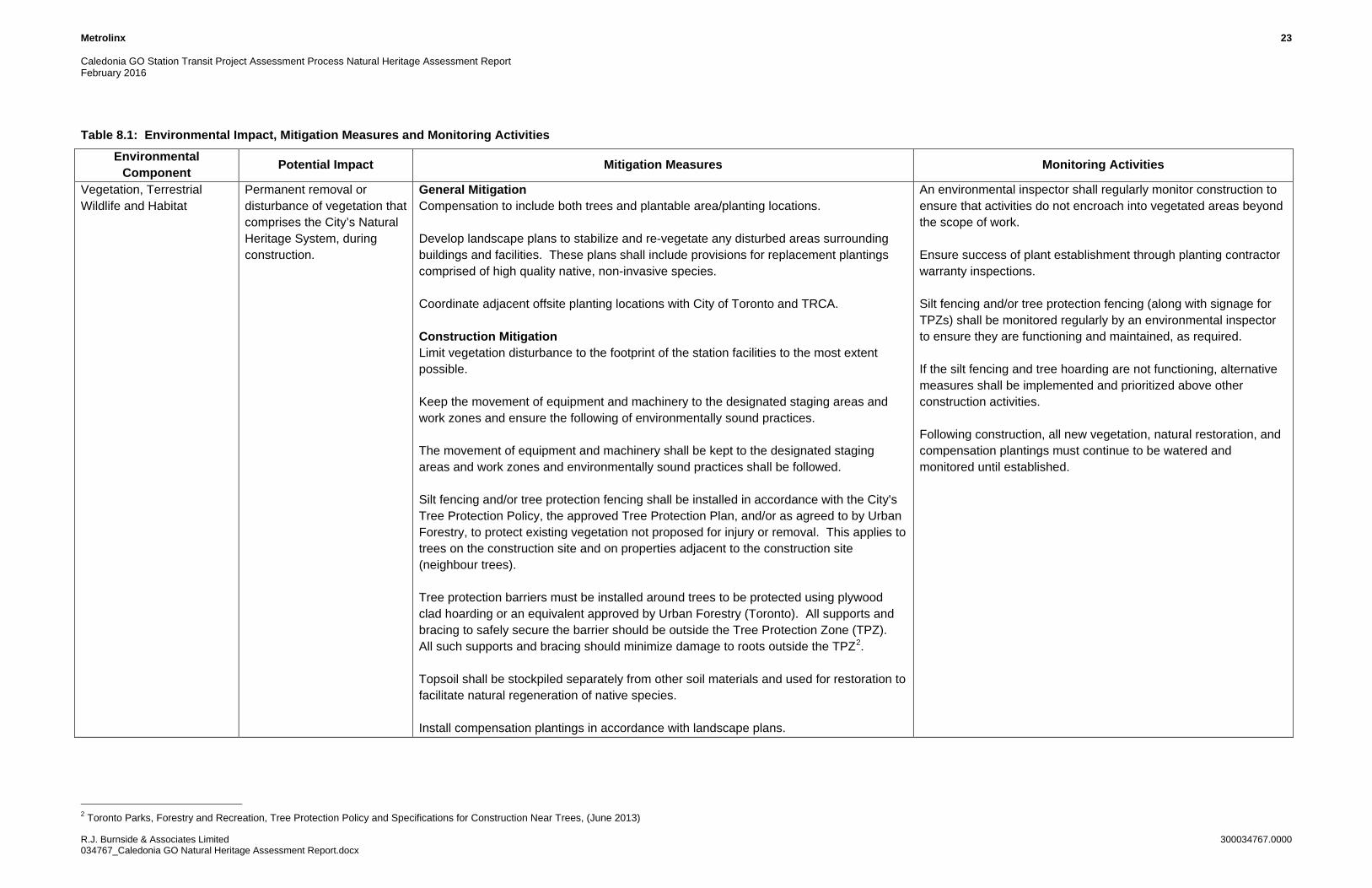
8.0 Impacts and Mitigation Measures
The anticipated impacts of the Caledonia GO Station development have been summarized in Table 8.1. Mitigation measures, which are needed prior to project implementation to reduce the potential impacts and monitoring activities, which are needed to ensure the mitigation measures are working effectively, are also provided in Table 8.1. Additional measures have also been identified in Section 9.0.
Metrolinx 22
Caledonia GO Station Transit Project Assessment Process Natural Heritage Assessment ReportFebruary 2016
R.J. Burnside & Associates Limited 300034767.0000034767_Caledonia GO Natural Heritage Assessment Report.docx
It is estimated that approximately 0.78 ha of treed lands will be cleared to accommodate construction. The final impact of removal of vegetation required to accommodate construction will be better understood when detailed grading is available. Opportunities for vegetation preservation should be investigated in conjunction with development of the grading plan during the 50% detailed design phase of the project. Opportunities for the reduction of woody vegetation loss should also be investigated during detailed design. Potential solutions may include retaining walls, naturalized berms, and geotechnical materials. Improvements to species diversity to support improvements to aesthetics, habitat for beneficial wildlife (e.g., pollinators) and screening can be accomplished through the development of the Landscape Plan during the detailed design phase of the project. Native species of trees, shrubs, wildflowers and grasses should be considered in landscaping and mitigation plantings.
Metrolinx 23 Caledonia GO Station Transit Project Assessment Process Natural Heritage Assessment Report February 2016
R.J. Burnside & Associates Limited 300034767.0000 034767_Caledonia GO Natural Heritage Assessment Report.docx
Table 8.1: Environmental Impact, Mitigation Measures and Monitoring Activities
Environmental Component Potential Impact Mitigation Measures Monitoring Activities
Vegetation, Terrestrial Wildlife and Habitat
Permanent removal or disturbance of vegetation that comprises the City’s Natural Heritage System, during construction.
General Mitigation Compensation to include both trees and plantable area/planting locations. Develop landscape plans to stabilize and re-vegetate any disturbed areas surrounding buildings and facilities. These plans shall include provisions for replacement plantings comprised of high quality native, non-invasive species. Coordinate adjacent offsite planting locations with City of Toronto and TRCA. Construction Mitigation Limit vegetation disturbance to the footprint of the station facilities to the most extent possible. Keep the movement of equipment and machinery to the designated staging areas and work zones and ensure the following of environmentally sound practices. The movement of equipment and machinery shall be kept to the designated staging areas and work zones and environmentally sound practices shall be followed. Silt fencing and/or tree protection fencing shall be installed in accordance with the City's Tree Protection Policy, the approved Tree Protection Plan, and/or as agreed to by Urban Forestry, to protect existing vegetation not proposed for injury or removal. This applies to trees on the construction site and on properties adjacent to the construction site (neighbour trees). Tree protection barriers must be installed around trees to be protected using plywood clad hoarding or an equivalent approved by Urban Forestry (Toronto). All supports and bracing to safely secure the barrier should be outside the Tree Protection Zone (TPZ). All such supports and bracing should minimize damage to roots outside the TPZ2. Topsoil shall be stockpiled separately from other soil materials and used for restoration to facilitate natural regeneration of native species. Install compensation plantings in accordance with landscape plans.
An environmental inspector shall regularly monitor construction to ensure that activities do not encroach into vegetated areas beyond the scope of work. Ensure success of plant establishment through planting contractor warranty inspections. Silt fencing and/or tree protection fencing (along with signage for TPZs) shall be monitored regularly by an environmental inspector to ensure they are functioning and maintained, as required. If the silt fencing and tree hoarding are not functioning, alternative measures shall be implemented and prioritized above other construction activities. Following construction, all new vegetation, natural restoration, and compensation plantings must continue to be watered and monitored until established.
2 Toronto Parks, Forestry and Recreation, Tree Protection Policy and Specifications for Construction Near Trees, (June 2013)

Metrolinx 24 Caledonia GO Station Transit Project Assessment Process Natural Heritage Assessment Report February 2016
R.J. Burnside & Associates Limited 300034767.0000 034767_Caledonia GO Natural Heritage Assessment Report.docx
Environmental Component Potential Impact Mitigation Measures Monitoring Activities
Loss of plantable area for compensation plantings.
General Mitigation Identify locations of offsite planting within adjacent public property (i.e., parklands) to receive plantings, in coordination with TRCA and City staff. Construction Mitigation Plant installation to be coordinated with construction work.
Ensure success of plant establishment through planting contractor warranty inspections. Following construction, all new vegetation, natural restoration, and compensation plantings must continue to be watered and monitored until established.
Potential for the encroachment by contractors and equipment into protected vegetation zones on adjacent lands (parklands).
Construction Mitigation Install sturdy vegetation protection measures (e.g., paige wire fencing) with signage.
Qualified personnel are required to inspect and repair protection measures as needed.
Potential for disturbance to breeding bird or migratory bird and their habitat by the construction of the Caledonia GO Station (prohibitions under the Migratory Birds Convention Act, 1994).
General Mitigation Ensure that timing constraints are applied to avoid vegetation clearing (including grubbing) and/or structure works (construction, maintenance) during the core breeding bird period. Note: Environment Canada broadly defines the core breeding bird period for open habitat (in which vegetation clearing should be avoided) in nesting Zone C (Ontario) as typically April 26 to July 31; however, this period can extend earlier and later for some species. This window stipulates when clearing should be avoided to prevent impacts to open habitat. This window is separate from timing windows for completion of breeding bird surveys, generally from May 24-July 10 (as stipulated by Bird Studies Canada (Cadman, M.D., et al., 2007). Active nests (nests with eggs or young birds) of protected migratory birds, including SAR protected under the ESA, 2007, cannot be destroyed. Construction Mitigation If a nesting migratory bird (or SAR protected under ESA, 2007) is identified within or adjacent to the construction site and the construction activities are such that continuing construction in that area would result in a contravention of the MBCA or ESA, 2007, all activities will stop and the Contract Administrator (with assistance from a Qualified Avian Biologist) will discuss mitigation measures with the Metrolinx - Environment Program and Assessment department. MNRF and Environment Canada should be contacted to discuss mitigation options. The Contractor Administrator will instruct the Contractor on how to proceed based on the mitigation measures established through discussions with Metrolinx, MNRF and/or Environment Canada.
Breeding bird surveys are not required. Given the small footprint of the Study Area, nest surveys may be carried out by skilled and experienced observers using appropriate methodology (as per Environment Canada guidelines) immediately prior to vegetation removal (i.e., 1-2 days).

Metrolinx 25 Caledonia GO Station Transit Project Assessment Process Natural Heritage Assessment Report February 2016
R.J. Burnside & Associates Limited 300034767.0000 034767_Caledonia GO Natural Heritage Assessment Report.docx
Environmental Component Potential Impact Mitigation Measures Monitoring Activities
Potential for removal of Chimney Swift (Chaetura pelagica) habitat in the chimney on the structure at 2-4 Croham Road (to be confirmed by future targeted surveys, if necessary).
General Mitigation Prior to removal of the structure, confirmation is required to determine if the chimney structure is being used by Chimney Swift. If the chimney structure is not sealed or capped, surveys may need to be completed during the appropriate timing windows (as per Bird Studies Canada survey protocols) and in consultation with the local MNRF District Office SAR Biologist. In the event that SAR are found within the study limits, an MNRF SAR Biologist will be contacted for advice as these animals are protected under ESA, 2007.
If the chimney structure at 2-4 Croham Road is determined not to be sealed or capped, monitor the structure during the appropriate timing windows (as per Bird Studies Canada survey protocols and consultation with MNRF) to determine if Chimney Swift are present.
Displacement and disturbance of wildlife and wildlife habitat (i.e., tree canopy) during the construction phase (i.e., vegetation removals, noise).
General Mitigation Develop a Landscape Plan to stabilize and re-vegetate any disturbed areas surrounding buildings and facilities. The Landscape Plan shall include provisions for replacement plantings comprised of high quality native, non-invasive species. Install compensation plantings in offsite lands in coordination with City of Toronto and TRCA. Construction Mitigation Some wildlife may be displaced during construction activities and after construction of the GO Station. Some wildlife habitat may be removed as a result of the proposed activities. It is expected that wildlife inhabiting the Study Area are species which are tolerant of disturbance and are resilient to changes in urban environments. It is expected that these species which have adapted to existing disturbances will return upon completion of the construction activities and will utilize habitat that will be present. In the event that an animal encountered during construction does not move from the construction zone, the Contractor will notify the Contract Administrator. If the construction activities are such that continuing construction in the area would result in harm to wildlife, construction activities in that location will temporarily stop and MNRF will be contacted for direction. In the event that SAR are found within the study limits, an MNRF SAR Biologist will be contacted for advice as these animals are protected under ESA, 2007.
Monitor that any animals encountered are reported to the Contract Administrator and that no harm comes to animals during construction.
Surface Water, Soils, and Vegetation
Potential for the erosion of soils and impacts to surface water and offsite lands during the construction period.
General Mitigation An Erosion and Sediment Control (ESC) Plan will be developed in consultation with Toronto and Region Conservation Authority (TRCA). Implementation of the ESC measures will conform to recognized standard specifications such as Ontario Provincial Standards Specification (OPSS) and the requirements of the TRCA. The ESC Plan will also take into account the Greater Golden Horseshoe Area Conservation Authorities (GGHACA) Erosion and Sediment Control Guidelines for Urban Construction.
Qualified personnel are required to inspect and repair ESC measures as needed.

Metrolinx 26 Caledonia GO Station Transit Project Assessment Process Natural Heritage Assessment Report February 2016
R.J. Burnside & Associates Limited 300034767.0000 034767_Caledonia GO Natural Heritage Assessment Report.docx
Environmental Component Potential Impact Mitigation Measures Monitoring Activities
Construction Mitigation Implement and maintain ESC Plan during construction phase.
Soil Handling Potential for delays to project schedule and impacts to project cost due to the removal or relocation of contaminated soils from the Project Area.
Construction Mitigation A Soil Management Plan (SMP) shall be prepared by a Qualified Professional for managing soil materials onsite (includes excavation, location of stockpiles, reuse, and offsite disposal). Option to reuse soil onsite or at other Metrolinx owned sites shall be the explored first. Metrolinx should be notified well in advance of soil materials being arranged for transport on/offsite.
Monitor the movement of soils to ensure the SMP is followed.
Material handling Potential contamination of soils resulting from a spill or release of fuels and toxic substances during construction.
General Mitigation An emergency response and communications plan will be developed during detailed design to ensure proper mitigation and notification procedures are in place regarding soil quality during project operation. Construction Mitigation Refueling of equipment and fuel storage shall be conducted in designated areas with spill protection.
Monitor for leaks and spills
Material handling Potential impacts to groundwater from construction activities including dewatering activity and potential contamination from leaks, spills.
General Mitigation Investigate potential for localized groundwater impacts and retain services for a detailed hydrogeological study, if recommended following geotechnical investigations. Consult TRCA if hydrogeological studies are undertaken. Coordinate any dewatering requirements with the other project works that may be ongoing in the Project Area, including Barrie Rail Corridor Expansion Project and Eglinton Crosstown LRT. Determine dewatering requirements as applicable for the construction works including building/ bridge foundations and track lowering and consult with the TRCA on dewatering for construction work. Construction Mitigation Contractor and Construction Administrator to implement dewatering in accordance with the TRCA approved plans.
Monitor for leaks and spills
Dewatering Potential for dewatering activities required for construction of the new GO Station to affect the Eglinton Avenue West Bridge structure and substructure.
General Mitigation In conjunction with the Geotechnical Investigation, a dewatering plan will be prepared, if required, for the construction of the new GO Station works. This dewatering plan will be cognizant of any dewatering activities that are ongoing for the ECLRT or Barrie Expansion project. Consultation will be sought from the TRCA.
The bridge will be monitored during construction of the new GO Station works by way of pre-condition and post-condition monitoring.

Metrolinx 27
Caledonia GO Station Transit Project Assessment Process Natural Heritage Assessment ReportFebruary 2016
R.J. Burnside & Associates Limited 300034767.0000034767_Caledonia GO Natural Heritage Assessment Report.docx
9.0 Recommendations
In addition to the general mitigation measures noted in Table 8.1, the following specific activities are recommended to be undertaken during the 50% detailed design phase or prior to construction of the project.
Based on a review of NHIC and OBBA Designated Fauna Records (see Table 6.2), the only avian SAR that has the potential to be present within the Study Area limits is Chimney Swift. On this basis, a general breeding bird survey is not recommended.
Confirmation is required to determine whether the chimney structure present on the building located at 2-4 Croham Drive (proposed for removal) is being used by Chimney Swift. If the chimney structure is not sealed or capped, a species- specific survey may need to be completed during the appropriate timing window(s) as per Bird Studies Canada (May 2015)3 or MNRF-approved survey protocols to assess species presence and apply appropriate agency-approved mitigation measures (if required).
Opportunities for vegetation preservation should be investigated in conjunction with the development of the grading plan.
Opportunities for the reduction of woody vegetation loss should also be investigated during detailed design.
10.0 Conclusion
Impacts to the natural environment features and functions are not anticipated to be significant based on the existing site use and urban context. Impacts as a result of construction activities will be reduced through the implementation of the mitigation and monitoring measures provided in this report.
3 SwiftWatch Protocol defines the following three monitoring periods to determine the presence of Chimney Swift. If Chimney Swift is observed using a chimney structure during any or all of these periods, the chimney will be considered habitat for a provincially Threatened species.
1. Spring (Migratory) Roosting Period: approximately end of May – June 2;2. Nesting Period (when adults are feeding young): approximately July 7 - July 23;3. Fall (Migratory) Roosting Period: approximately 2nd to 3rd week in August to first week of September.
Metrolinx 28
Caledonia GO Station Transit Project Assessment Process Natural Heritage Assessment ReportFebruary 2016
R.J. Burnside & Associates Limited 300034767.0000034767_Caledonia GO Natural Heritage Assessment Report.docx
11.0 References
ARUP and NORR Limited Architects. September 2013. Caledonia GO Station Reference Concept Design.
Bird Studies Canada. May 2015. Ontario SwiftWatch Protocol and Data Forms for Volunteers (Updated May 2015). Accessed online at: http://www.birdscanada.org/volunteer/ai/resources/Ontario_Swiftwatch_Protocol.pdf
Cadman, M.D. et al. 2007. Atlas of the Breeding Birds of Ontario, 2001-2005. Bird Studies Canada, Environment Canada, Ontario Field Ornithologists, Ontario Ministry of Natural Resources, and Ontario Nature, Toronto, xxii + 706 pp.
City of Toronto Online Mapping. http://map.toronto.ca/maps/map.jsp?app=TorontoMaps_v2. Accessed October 23, 2014.
City of Toronto. Official Plan (2010 Consolidation).
Dobbyn, J.S. 1994. Atlas of the Mammals of Ontario. Federation of Ontario Naturalists. Don Mills, Ontario.
Lee, H.T., W.D. Bakowsky, J. Riley, J. Bowles, M. Puddister, P. Uhlig and S. McMurray. 1998. Ecological Land Classification for Southern Ontario: First Approximation and Its Application. Ontario Ministry of Natural Resources, Southcentral Science Section, Science Development and Transfer Branch. SCSS Field Guide FG-02.
Ministry of the Environment and Climate Change Website, Red Mulberry (Species at Risk) page. 2014.
Accessed online at: http://www.ontario.ca/environment-and-energy/red-mulberry-0
Migratory Birds Convention Act (MBCA). 1994. Accessed online at: http://laws-lois.justice.gc.ca/eng/acts/M-7.01/
Ministry of Municipal Affairs & Housing (MMAH). 2014. Provincial Policy Statement.
Natural Heritage Information Centre Database accessed via ArcGIS 10.2.2
Nature Serve Explorer website, Dichanthelium ovale Habitat Comments. 2009. Accessed January 29, 2015 at: http://explorer.natureserve.org/servlet/NatureServe.
Nature Serve Explorer website, Juncus acuminatus Habitat Comments. 2009. Accessed January 29, 2015 at: http://explorer.natureserve.org/servlet/NatureServe.

Metrolinx 29
Caledonia GO Station Transit Project Assessment Process Natural Heritage Assessment ReportFebruary 2016
R.J. Burnside & Associates Limited 300034767.0000034767_Caledonia GO Natural Heritage Assessment Report.docx
Nature Serve Explorer website, Linum virginianum) Habitat Comments. 2009. Accessed January 29, 2015 at: http://explorer.natureserve.org/servlet/NatureServe
Nature Serve Explorer website, Scleria triglomerata Habitat Comments. 2009. Accessed January 29, 2015 at: http://explorer.natureserve.org/servlet/NatureServe.
Ontario Breeding Bird Atlas (2001-2005). Accessed online at: http://www.birdsontario.org/atlas/index.jsp
Ontario Ministry of Natural Resources (MNR). 1980. Quaternary Geology, Toronto and Surrounding Area, Southern Ontario. Ontario Geological Survey. Preliminary Map P. 2204. Geological Series.
Ontario Ministry of Natural Resources (MNR). 2000. Significant Wildlife Habitat Technical Guide. Fish and Wildlife Branch, Wildlife Section. Science Development and Transfer Branch, Southcentral Sciences Section.
Ontario Ministry of Natural Resources and Forestry (2015). Make a Map: Natural Heritage Areas. Accessed online at: http://www.giscoeapp.lrc.gov.on.ca/web/MNR/NHLUPS/NaturalHeritage/Viewer/Viewer.html
Ontario Reptile and Amphibian Atlas (Ontario Nature). Accessed August 28, 2014: http://www.ontarionature.org/protect/species/reptiles_and_amphibians/index.php
Species at Risk in Ontario (SARO) Website: http://www.ontario.ca/environment-and-energy/species-risk-ontario-list. (Date Accessed October 20, 2014)
Species at Risk Ontario (SARO) Website: https://www.ontario.ca/environment-and-energy/queensnake. (Date Accessed October 26, 2014)
The Ontario Breeding Bird Atlas Guide for Participants (March 2001)
Figures
Figures


Appendix A
Ecological Land Classification (ELC) Field Data Sheets
Appendix A
N
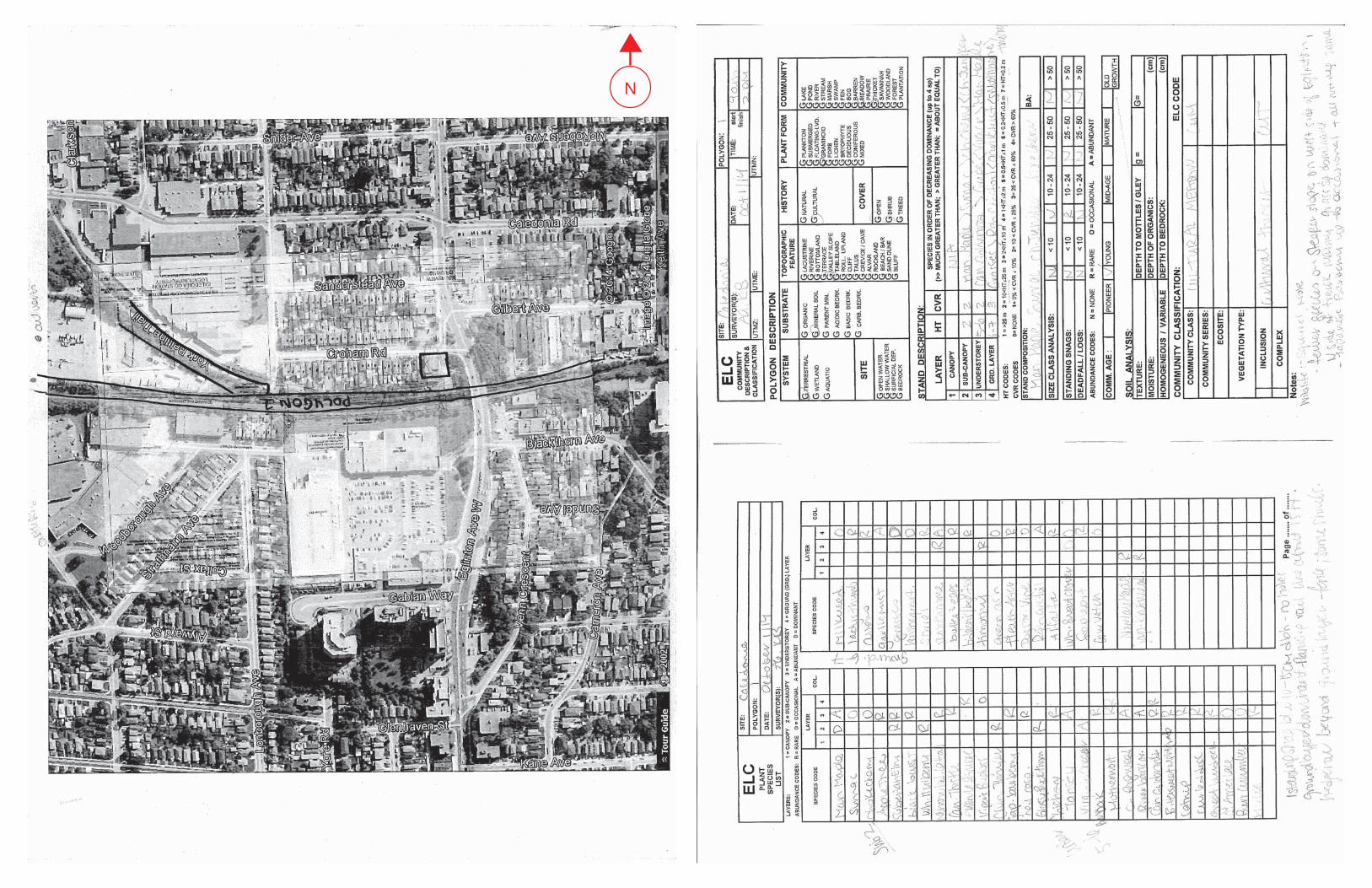
N

Appendix B
Photographic Record
Appendix B
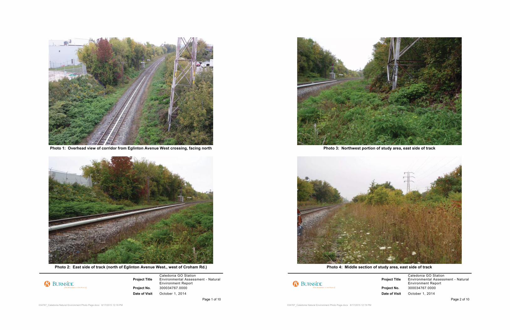


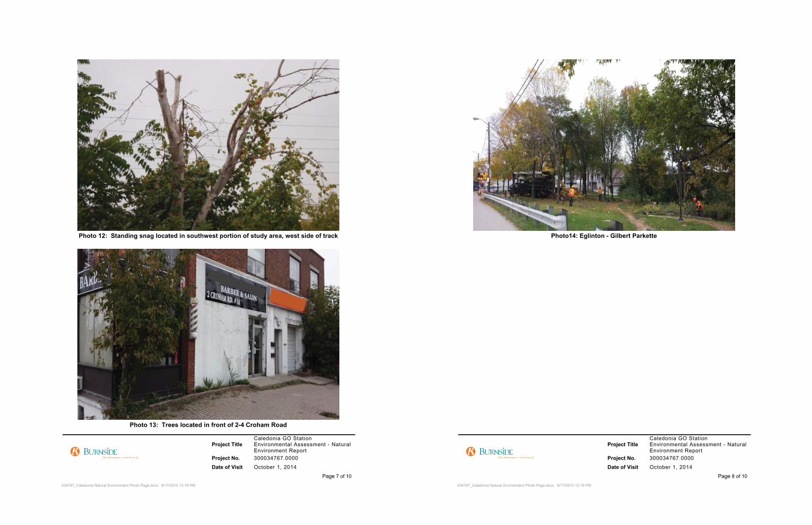


Appendix C
Ontario Breeding Bird Atlas (OBBA) Records,2001-2005
Appendix C

DDDDDDDDDDDDDDDDDDDDDDDDDDDDDDDDDDDDDDDDDDDDRDRDDRDRDRDRDRDDRDRDRDRDRDRDRDDRDRDDDRDDDDDDDDDDDDDDDDDDRDDDRDRDDDDDDRRDRDRRDRRRDRDRRRDRDRDDDDDDDDDDDRRRRDDDRDDDDDDDDDDDDDDDDDDDDDDDDRRRRRRRRRRRRRRRRRRRRRRRRRRRRRRRRRDRDRDRDRDRDRDRRDRRRDRRRRRRARRARRARARARARARARARARRARRRRRRRRRRRRRRRRRRARRARRRRRRRRRRARARRRRRRDRARRRRRRARARARARARARARARARARARARARARARARARARARARARARARARARARARARARARARARARARARARARARARARARARARARARARARARARARARARARARARRARRRARARARAARARRARRARAAAAAAAARAAAAAAAFARARARAAAFARARARARARAFAFAFAAFAFAFAFAFAAFAFAFAFAFAFAFAFAFAFAFAFAFAFAFAFAFAFAFAFAFAFAFAFAFAFAFRARARARAAFAFRARAAAAAAAAAAAAAARAFRARARARARARARARAAAAARARARARARARAARARARARARARAAAAAAAAAAAAAARARARAAAAAAAAAAAAAAAAAAAAAAAAAAAAAAAAARARARAFAAAFAFAAFAFAFAFFAFFFAFAFAFAFFAFAFAFFFAFAFAFAFFFAFAFAFAFFAFAFAFAFFAFAFFAFAFAFAFAAAAFAAAAFFFFAAAAAAAAFAAFAAAAFAFAFFAAFFFAFAFAAFAAAAAFAFAAFAFAFAFAFAFAFAFAFAFAFAFAFAFAFAFAFAFFFFFFFFFFAFAFAFAAFAFAFAFAFAFAFFFAFT
AFFTFTAFTAFAFAFFFFTAFTFAFFTFTFTTFTFTTFTTTTTTTTTFTFTFTFTTTTFTFTFTTFTFTTFTFAFTAFTFFTFTTTFTFTTFTFTFTFFTFFTFTFTFTFTFTFTTTTTTTTTTFTFTFTFTAFTAFTAFAFAFFTTTFTTTFTFTFTFTAFTFTAFTAFTAFTTTTTTTTTTTTTTTTTTTTTTTTTTTTTTTTTT
DDAARARARARAFT
DRAFDRAFT
DDRRRFT
DDDDDDDDDD
TR
TTT
DRDRDRDRDRDRDDDDDDDFTFTFTFTFTFT
RAAAARARAAAAAFDDDDDDD


Appendix D
Natural Heritage Information Centre (NHIC)Records
Appendix D

NHIC MASTER SPECIES LIST FOR CALEDONIA SRANK COSSARO F&WCA F&WCA COSARA COSEWIC
SARA
Schedule
Wildlife Survey Conducted by: R.J. Burnside & Associates PROVINCIAL PROVINCIAL PROVINCIAL PROVINCIAL FEDERAL FEDERAL FEDERAL
COMMON NAME
ALTERNATIVE
COMMON NAME SCIENTIFIC NAME
ALTERNATIVE
SCIENTIFIC
NAME LOCATION SRANK
Endangered
Species Act
Fish &
Wildlife
Conservation
Act
F&WCA
Schedule COSEWIC
SARA
Schedule Habitat Descriptions
Unicorn Clubtail Arigomphus villosipes S2S3
FISH
Redside Dace
Clinostomus elongatus
S2 END END 3
Pools and slow-moving sections of relatively small, clear,
cool streams with sand or gravel bottoms. Tracked
From NHIC records but not SARA or OESA
ranked

NHIC Data: Squares 17PJ2338 and 17PJ2339
Scientific Name Common Name S Rank COSEWIC MNR Status FREQUENCY NHIC SQUARE
Actaea racemosa Black Cohosh S2 2 17PJ2338, 17PJ2339
Apalone spinifera Spiny Softshell S3 THR THR 2 17PJ2338, 17PJ2339
Arigomphus villosipes Unicorn Clubtail S2S3 2 17PJ2338, 17PJ2339
Clinostomus elongatus Redside Dace S2 END END 2 17PJ2338
Cypripedium arietinum Ram's-head Lady's-slipper S3 2 17PJ2338, 17PJ2339
Dichanthelium praecocius White-haired Panicgrass S3 2 17PJ2338, 17PJ2339
Emydoidea blandingii Blanding's Turtle S3 THR THR 3 17PJ2338, 17PJ2339
Euonymus atropurpureus Burning Bush S3 2 17PJ2338, 17PJ2339
Eurybia divaricata White Wood Aster S2 THR THR 2 17PJ2338, 17PJ2339
Gentianella quinquefolia Stiff Gentian S2 4 17PJ2338, 17PJ2339
Gillenia trifoliata Bowman's-root SX 2 17PJ2338, 17PJ2339
Hypoxis hirsuta Yellow Stargrass S3 2 17PJ2338, 17PJ2339
Juncus acuminatus Sharp-fruited Rush S3 2 17PJ2338, 17PJ2339
Linum virginianum Woodland Flax S2 2 17PJ2338, 17PJ2339
Lithospermum latifolium American Gromwell S3 2 17PJ2338, 17PJ2339
Lupinus perennis Sundial Lupine S3 2 17PJ2338, 17PJ2339
Mimulus glabratus Round-leaved Monkey-flower S1 2 17PJ2338, 17PJ2339
Morus rubra Red Mulberry S2 END END 2 17PJ2338, 17PJ2339
Nuttallanthus canadensis Old-fieldToadflax S1 2 17PJ2338, 17PJ2339
Oenothera gaura Biennial Gaura S3 2 17PJ2338, 17PJ2339
Polygonum erectum Erect Knotweed SH 2 17PJ2338, 17PJ2339
Polystoechotes punctatus Giant Lacewing SH 2 17PJ2338, 17PJ2339
Regina septemvittata Queensnake S2 END END 2 17PJ2338, 17PJ2339
RESTRICTED RESTRICTED 8
Scleria triglomerata Tall Nutrush S1 2 17PJ2338, 17PJ2339
Spiranthes lacera var. gracilis Southern Slender Ladies'-tresses S1 2 17PJ2338, 17PJ2339
Sternotherus odoratus Eastern Musk Turtle S3 SC THR 2 17PJ2338, 17PJ2339
Thamnophis sauritus Eastern Ribbonsnake S3 SC SC 2 17PJ2338, 17PJ2339