durham-orange light rail transit...
TRANSCRIPT
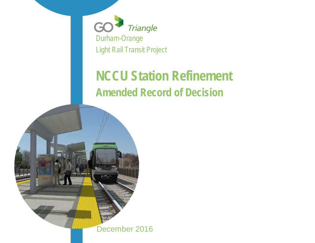
Durham-OrangeLight Rail Transit Project
NCCU Station RefinementAmended Record of Decision
December 2016
D-O LRT Project-NCCU Station RefinementAmended Record of Decision
Amended ROD-i
Table of Contents1 Amended Record of Decision
1.1 Decision .......................................................................... 21.2 Background .................................................................... 21.3 Basis for Decision ........................................................... 31.4 Measures to Minimize Harm .......................................... 31.5 Monitoring and Enforcement ........................................531.6 Public Outreach and Opportunities to Comment .........551.7 Determinations and Findings Regarding Other Laws ..551.8 Conclusion ....................................................................59
Appendices
A Responses to Agency CommentsB Responses to Substantive Public CommentsC Agency Letters ReceivedD Copy of All Public CommentsE Section 106 Coordination Materials
List of TablesTable Amended ROD-1: Commitments or Mitigation Measures .. 4Table Amended ROD-2: Anticipated Permits and Approvals ..... 54
D-O LRT Project-NCCU Station RefinementAmended Record of Decision
Amended ROD-ii
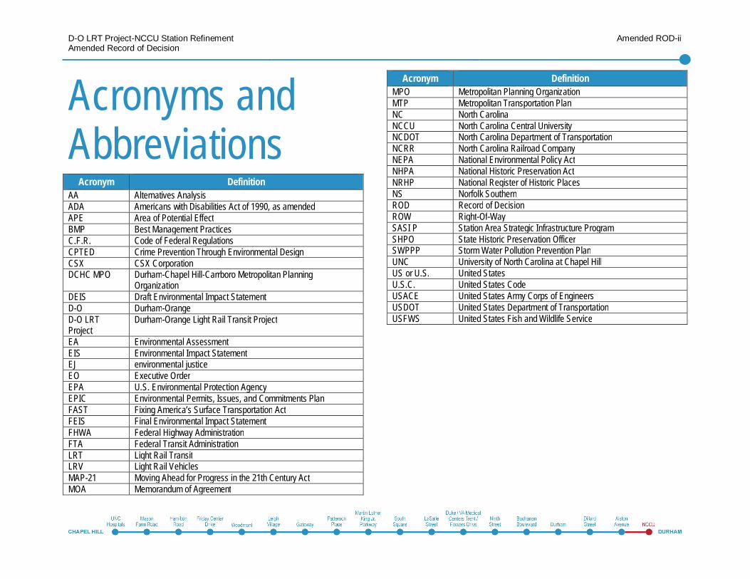
Acronyms andAbbreviations
Acronym DefinitionAA Alternatives AnalysisADA Americans with Disabilities Act of 1990, as amendedAPE Area of Potential EffectBMP Best Management PracticesC.F.R. Code of Federal RegulationsCPTED Crime Prevention Through Environmental DesignCSX CSX CorporationDCHC MPO Durham-Chapel Hill-Carrboro Metropolitan Planning
OrganizationDEIS Draft Environmental Impact StatementD-O Durham-OrangeD-O LRTProject
Durham-Orange Light Rail Transit Project
EA Environmental AssessmentEIS Environmental Impact StatementEJ environmental justiceEO Executive OrderEPA U.S. Environmental Protection AgencyEPIC Environmental Permits, Issues, and Commitments PlanFAST Fixing America’s Surface Transportation ActFEIS Final Environmental Impact StatementFHWA Federal Highway AdministrationFTA Federal Transit AdministrationLRT Light Rail TransitLRV Light Rail VehiclesMAP-21 Moving Ahead for Progress in the 21th Century ActMOA Memorandum of Agreement
Acronym DefinitionMPO Metropolitan Planning OrganizationMTP Metropolitan Transportation PlanNC North CarolinaNCCU North Carolina Central UniversityNCDOT North Carolina Department of TransportationNCRR North Carolina Railroad CompanyNEPA National Environmental Policy ActNHPA National Historic Preservation ActNRHP National Register of Historic PlacesNS Norfolk SouthernROD Record of DecisionROW Right-Of-WaySASI P Station Area Strategic Infrastructure ProgramSHPO State Historic Preservation OfficerSWPPP Storm Water Pollution Prevention PlanUNC University of North Carolina at Chapel HillUS or U.S. United StatesU.S.C. United States CodeUSACE United States Army Corps of EngineersUSDOT United States Department of TransportationUSFWS United States Fish and Wildlife Service
1 Amended Recordof Decision
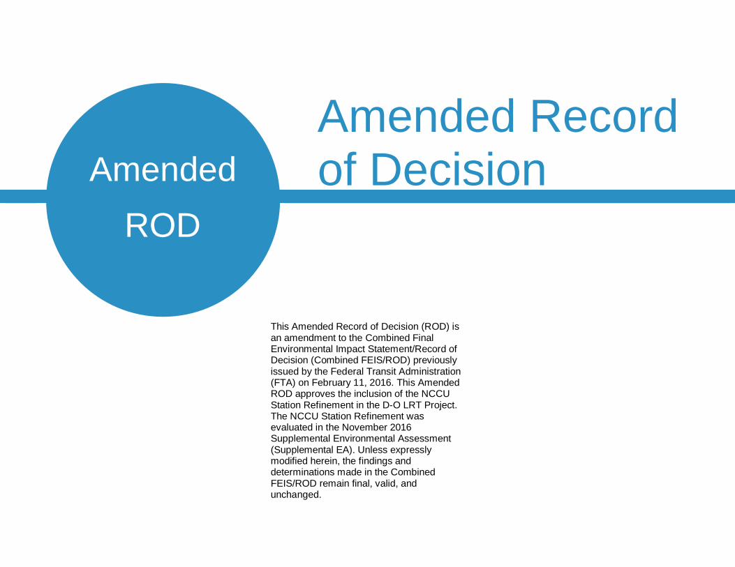
This Amended Record of Decision (ROD) isan amendment to the Combined FinalEnvironmental Impact Statement/Record ofDecision (Combined FEIS/ROD) previouslyissued by the Federal Transit Administration(FTA) on February 11, 2016. This AmendedROD approves the inclusion of the NCCUStation Refinement in the D-O LRT Project.The NCCU Station Refinement wasevaluated in the November 2016Supplemental Environmental Assessment(Supplemental EA). Unless expresslymodified herein, the findings anddeterminations made in the CombinedFEIS/ROD remain final, valid, andunchanged.
AmendedROD
D-O LRT Project-NCCU Station RefinementAmended Record of Decision
Amended ROD-2
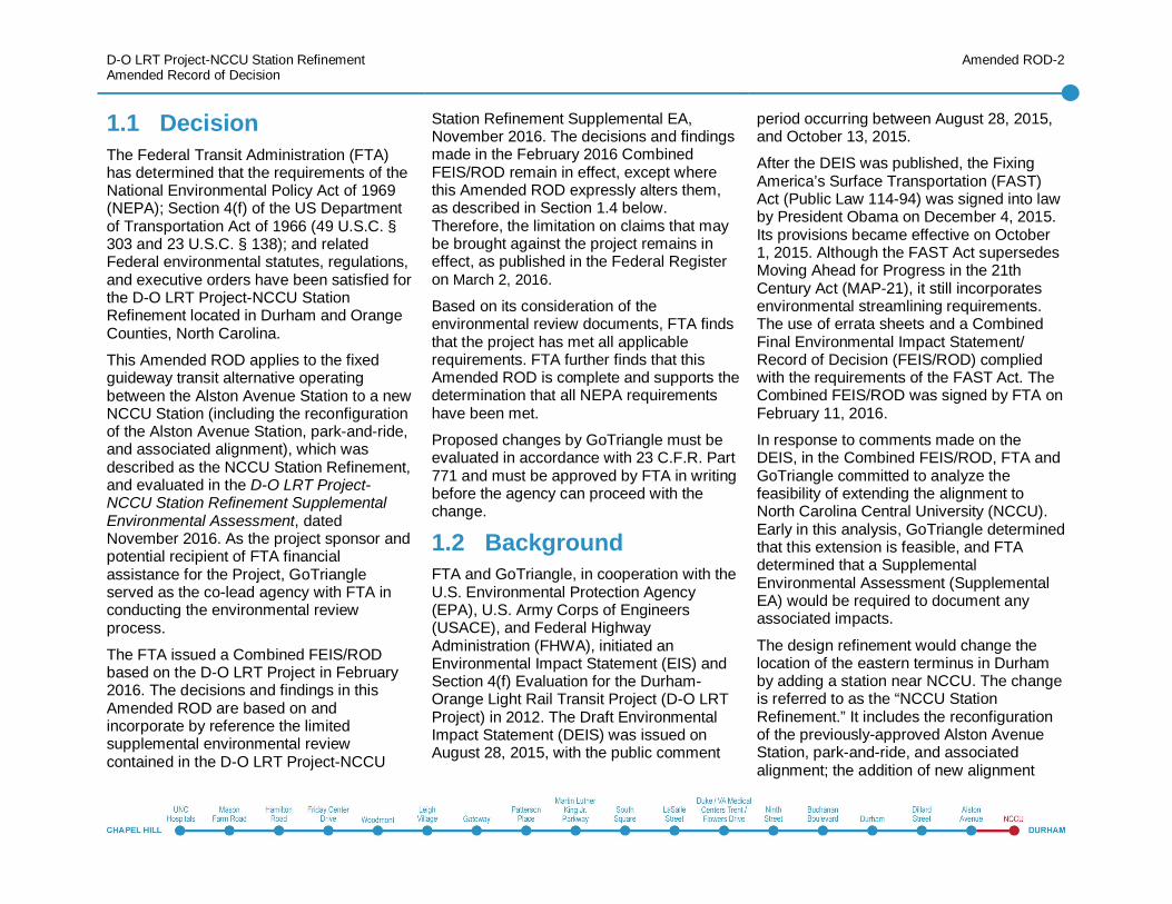
1.1 DecisionThe Federal Transit Administration (FTA)has determined that the requirements of theNational Environmental Policy Act of 1969(NEPA); Section 4(f) of the US Departmentof Transportation Act of 1966 (49 U.S.C. §303 and 23 U.S.C. § 138); and relatedFederal environmental statutes, regulations,and executive orders have been satisfied forthe D-O LRT Project-NCCU StationRefinement located in Durham and OrangeCounties, North Carolina.
This Amended ROD applies to the fixedguideway transit alternative operatingbetween the Alston Avenue Station to a newNCCU Station (including the reconfigurationof the Alston Avenue Station, park-and-ride,and associated alignment), which wasdescribed as the NCCU Station Refinement,and evaluated in the D-O LRT Project-NCCU Station Refinement SupplementalEnvironmental Assessment, datedNovember 2016. As the project sponsor andpotential recipient of FTA financialassistance for the Project, GoTriangleserved as the co-lead agency with FTA inconducting the environmental reviewprocess.
The FTA issued a Combined FEIS/RODbased on the D-O LRT Project in February2016. The decisions and findings in thisAmended ROD are based on andincorporate by reference the limitedsupplemental environmental reviewcontained in the D-O LRT Project-NCCU
Station Refinement Supplemental EA,November 2016. The decisions and findingsmade in the February 2016 CombinedFEIS/ROD remain in effect, except wherethis Amended ROD expressly alters them,as described in Section 1.4 below.Therefore, the limitation on claims that maybe brought against the project remains ineffect, as published in the Federal Registeron March 2, 2016.
Based on its consideration of theenvironmental review documents, FTA findsthat the project has met all applicablerequirements. FTA further finds that thisAmended ROD is complete and supports thedetermination that all NEPA requirementshave been met.
Proposed changes by GoTriangle must beevaluated in accordance with 23 C.F.R. Part771 and must be approved by FTA in writingbefore the agency can proceed with thechange.
1.2 BackgroundFTA and GoTriangle, in cooperation with theU.S. Environmental Protection Agency(EPA), U.S. Army Corps of Engineers(USACE), and Federal HighwayAdministration (FHWA), initiated anEnvironmental Impact Statement (EIS) andSection 4(f) Evaluation for the Durham-Orange Light Rail Transit Project (D-O LRTProject) in 2012. The Draft EnvironmentalImpact Statement (DEIS) was issued onAugust 28, 2015, with the public comment
period occurring between August 28, 2015,and October 13, 2015.
After the DEIS was published, the FixingAmerica’s Surface Transportation (FAST)Act (Public Law 114-94) was signed into lawby President Obama on December 4, 2015.Its provisions became effective on October1, 2015. Although the FAST Act supersedesMoving Ahead for Progress in the 21thCentury Act (MAP-21), it still incorporatesenvironmental streamlining requirements.The use of errata sheets and a CombinedFinal Environmental Impact Statement/Record of Decision (FEIS/ROD) compliedwith the requirements of the FAST Act. TheCombined FEIS/ROD was signed by FTA onFebruary 11, 2016.
In response to comments made on theDEIS, in the Combined FEIS/ROD, FTA andGoTriangle committed to analyze thefeasibility of extending the alignment toNorth Carolina Central University (NCCU).Early in this analysis, GoTriangle determinedthat this extension is feasible, and FTAdetermined that a SupplementalEnvironmental Assessment (SupplementalEA) would be required to document anyassociated impacts.
The design refinement would change thelocation of the eastern terminus in Durhamby adding a station near NCCU. The changeis referred to as the “NCCU StationRefinement.” It includes the reconfigurationof the previously-approved Alston AvenueStation, park-and-ride, and associatedalignment; the addition of new alignment
D-O LRT Project-NCCU Station RefinementAmended Record of Decision
Amended ROD-3
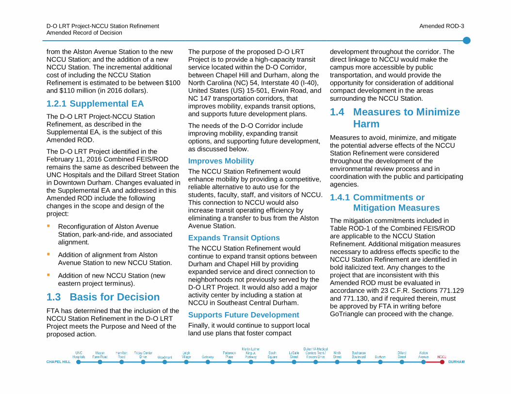
from the Alston Avenue Station to the newNCCU Station; and the addition of a newNCCU Station. The incremental additionalcost of including the NCCU StationRefinement is estimated to be between $100and $110 million (in 2016 dollars).
1.2.1 Supplemental EAThe D-O LRT Project-NCCU StationRefinement, as described in theSupplemental EA, is the subject of thisAmended ROD.
The D-O LRT Project identified in theFebruary 11, 2016 Combined FEIS/RODremains the same as described between theUNC Hospitals and the Dillard Street Stationin Downtown Durham. Changes evaluated inthe Supplemental EA and addressed in thisAmended ROD include the followingchanges in the scope and design of theproject:
Reconfiguration of Alston AvenueStation, park-and-ride, and associatedalignment.
Addition of alignment from AlstonAvenue Station to new NCCU Station.
Addition of new NCCU Station (neweastern project terminus).
1.3 Basis for DecisionFTA has determined that the inclusion of theNCCU Station Refinement in the D-O LRTProject meets the Purpose and Need of theproposed action.
The purpose of the proposed D-O LRTProject is to provide a high-capacity transitservice located within the D-O Corridor,between Chapel Hill and Durham, along theNorth Carolina (NC) 54, Interstate 40 (I-40),United States (US) 15-501, Erwin Road, andNC 147 transportation corridors, thatimproves mobility, expands transit options,and supports future development plans.
The needs of the D-O Corridor includeimproving mobility, expanding transitoptions, and supporting future development,as discussed below.
Improves MobilityThe NCCU Station Refinement wouldenhance mobility by providing a competitive,reliable alternative to auto use for thestudents, faculty, staff, and visitors of NCCU.This connection to NCCU would alsoincrease transit operating efficiency byeliminating a transfer to bus from the AlstonAvenue Station.
Expands Transit OptionsThe NCCU Station Refinement wouldcontinue to expand transit options betweenDurham and Chapel Hill by providingexpanded service and direct connection toneighborhoods not previously served by theD-O LRT Project. It would also add a majoractivity center by including a station atNCCU in Southeast Central Durham.
Supports Future DevelopmentFinally, it would continue to support localland use plans that foster compact
development throughout the corridor. Thedirect linkage to NCCU would make thecampus more accessible by publictransportation, and would provide theopportunity for consideration of additionalcompact development in the areassurrounding the NCCU Station.
1.4 Measures to MinimizeHarm
Measures to avoid, minimize, and mitigatethe potential adverse effects of the NCCUStation Refinement were consideredthroughout the development of theenvironmental review process and incoordination with the public and participatingagencies.
1.4.1 Commitments orMitigation Measures
The mitigation commitments included inTable ROD-1 of the Combined FEIS/RODare applicable to the NCCU StationRefinement. Additional mitigation measuresnecessary to address effects specific to theNCCU Station Refinement are identified inbold italicized text. Any changes to theproject that are inconsistent with thisAmended ROD must be evaluated inaccordance with 23 C.F.R. Sections 771.129and 771.130, and if required therein, mustbe approved by FTA in writing beforeGoTriangle can proceed with the change.
D-O LRT Project-NCCU Station RefinementAmended Record of Decision
Amended ROD-4
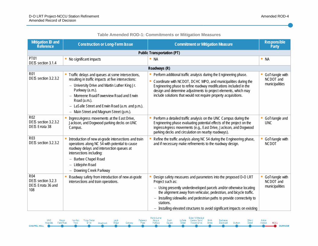
Table Amended ROD-1: Commitments or Mitigation MeasuresMitigation ID and
Reference Construction or Long-Term Issue Commitment or Mitigation Measure ResponsibleParty
Public Transportation (PT)PT01DEIS section 3.1.4
No significant impacts NA NA
Roadways (R)R01DEIS section 3.2.3.2
Traffic delays and queues at some intersections,resulting in traffic impacts at five intersections:
University Drive and Martin Luther King Jr.Parkway (a.m.).Morreene Road/Towerview Road and ErwinRoad (a.m.).LaSalle Street and Erwin Road (a.m. and p.m.).Main Street and Magnum Street (p.m.).
Perform additional traffic analysis during the Engineering phase.Coordinate with NCDOT, DCHC MPO, and municipalities during theEngineering phase to refine roadway modifications included in thedesign and determine adjustments to project elements, which mayinclude solutions that would not require property acquisitions.
GoTriangle withNCDOT andmunicipalities
R02DEIS section 3.2.3.2DEIS Errata 38
Ingress/egress movements at the East Drive,Jackson, and Dogwood parking decks on UNCCampus.
Perform a detailed traffic analysis on the UNC Campus during theEngineering phase evaluating potential effects of the project on theingress/egress movements (e.g., East Drive, Jackson, and Dogwoodparking decks and circulation on nearby roadways).
GoTriangle andUNC
R03DEIS section 3.2.3.2
Introduction of new at-grade intersections and trainoperations along NC 54 with potential to causeroadway delays and intersection queues atintersections including:
Barbee Chapel RoadLittlejohn RoadDowning Creek Parkway
Refine the traffic analysis along NC 54 during the Engineering phase,and if necessary make refinements to the roadway design.
GoTriangle withNCDOT
R04DEIS section 3.2.3DEIS Errata 36 and108
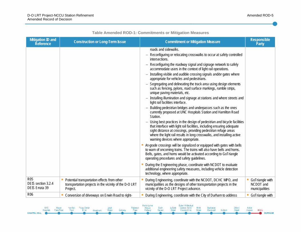
Roadway safety from introduction of new at-gradeintersections and train operations.
Design safety measures and parameters into the proposed D-O LRTProject such as:
Using presently underdeveloped parcels and/or otherwise locatingthe alignment away from vehicular, pedestrian, and bicycle traffic.Installing sidewalks and pedestrian paths to provide connectivity tostations.Installing elevated structures to avoid significant impacts on existing
GoTriangle withNCDOT andmunicipalities
D-O LRT Project-NCCU Station RefinementAmended Record of Decision
Amended ROD-5
Table Amended ROD-1: Commitments or Mitigation MeasuresMitigation ID and
Reference Construction or Long-Term Issue Commitment or Mitigation Measure ResponsibleParty
roads and sidewalks.Reconfiguring or relocating crosswalks to occur at safely controlledintersections.Reconfiguring the roadway signal and signage network to safelyaccommodate users in the context of light rail operations.Installing visible and audible crossing signals and/or gates whereappropriate for vehicles and pedestrians.Segregating and delineating the track area using design elementssuch as fencing, pylons, road surface markings, rumble strips,unique paving materials, etc.Installing illumination and signage at stations and where streets andlight rail facilities interface.Building pedestrian bridges and underpasses such as the onescurrently proposed at UNC Hospitals Station and Hamilton RoadStation.Using best practices in the design of pedestrian and bicycle facilitiesthat interface with light rail facilities, including ensuring adequatesight distance at crossings, providing pedestrian refuge areaswhere the light rail results in long crosswalks, and installing activewarning devices where appropriate.
At-grade crossings will be signalized or equipped with gates with bellsto warn of oncoming trains. The trains will also have bells and horns.Bells, gates, and horns would be activated according to GoTriangleoperating procedures and safety guidelines.During the Engineering phase, coordinate with NCDOT to evaluateadditional engineering safety measures, including vehicle detectiontechnology, where appropriate.
R05DEIS section 3.2.4DEIS Errata 39
Potential transportation effects from othertransportation projects in the vicinity of the D-O LRTProject.
During Engineering, coordinate with the NCDOT, DCHC MPO, andmunicipalities as the designs of other transportation projects in thevicinity of the D-O LRT Project advance.
GoTriangle withNCDOT andmunicipalities
R06 Conversion of driveways on Erwin Road to right- During Engineering, coordinate with the City of Durham to address GoTriangle with
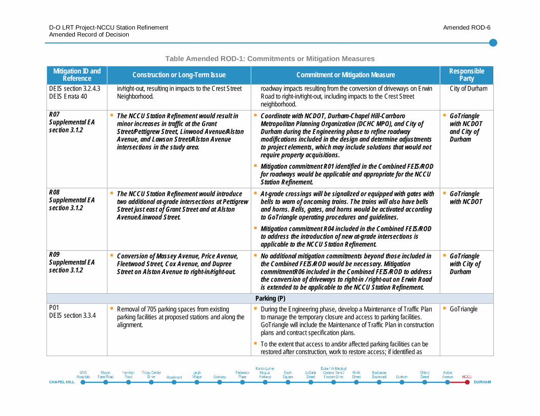
D-O LRT Project-NCCU Station RefinementAmended Record of Decision
Amended ROD-6
Table Amended ROD-1: Commitments or Mitigation MeasuresMitigation ID and
Reference Construction or Long-Term Issue Commitment or Mitigation Measure ResponsibleParty
DEIS section 3.2.4.3DEIS Errata 40
in/right-out, resulting in impacts to the Crest StreetNeighborhood.
roadway impacts resulting from the conversion of driveways on ErwinRoad to right-in/right-out, including impacts to the Crest Streetneighborhood.
City of Durham
R07Supplemental EAsection 3.1.2
The NCCU Station Refinement would result inminor increases in traffic at the GrantStreet/Pettigrew Street, Linwood Avenue/AlstonAvenue, and Lawson Street/Alston Avenueintersections in the study area.
Coordinate with NCDOT, Durham-Chapel Hill-CarrboroMetropolitan Planning Organization (DCHC MPO), and City ofDurham during the Engineering phase to refine roadwaymodifications included in the design and determine adjustmentsto project elements, which may include solutions that would notrequire property acquisitions.Mitigation commitment R01 identified in the Combined FEIS/RODfor roadways would be applicable and appropriate for the NCCUStation Refinement.
GoTrianglewith NCDOTand City ofDurham
R08Supplemental EAsection 3.1.2
The NCCU Station Refinement would introducetwo additional at-grade intersections at PettigrewStreet just east of Grant Street and at AlstonAvenue/Linwood Street.
At-grade crossings will be signalized or equipped with gates withbells to warn of oncoming trains. The trains will also have bellsand horns. Bells, gates, and horns would be activated accordingto GoTriangle operating procedures and guidelines.Mitigation commitment R04 included in the Combined FEIS/RODto address the introduction of new at-grade intersections isapplicable to the NCCU Station Refinement.
GoTrianglewith NCDOT
R09Supplemental EAsection 3.1.2
Conversion of Massey Avenue, Price Avenue,Fleetwood Street, Cox Avenue, and DupreeStreet on Alston Avenue to right-in/right-out.
No additional mitigation commitments beyond those included inthe Combined FEIS/ROD would be necessary. MitigationcommitmentR06 included in the Combined FEIS/ROD to addressthe conversion of driveways to right-in / right-out on Erwin Roadis extended to be applicable to the NCCU Station Refinement.
GoTrianglewith City ofDurham
Parking (P)P01DEIS section 3.3.4
Removal of 705 parking spaces from existingparking facilities at proposed stations and along thealignment.
During the Engineering phase, develop a Maintenance of Traffic Planto manage the temporary closure and access to parking facilities.GoTriangle will include the Maintenance of Traffic Plan in constructionplans and contract specification plans.To the extent that access to and/or affected parking facilities can berestored after construction, work to restore access; if identified as
GoTriangle
D-O LRT Project-NCCU Station RefinementAmended Record of Decision
Amended ROD-7
Table Amended ROD-1: Commitments or Mitigation MeasuresMitigation ID and
Reference Construction or Long-Term Issue Commitment or Mitigation Measure ResponsibleParty
necessary, replacement parking will be provided to the extentpracticable.Where parking facilities cannot be restored or replacement parking isnot feasible, during real estate acquisition, work with the affectedentities pursuant to the Uniform Relocation Assistance and RealProperty Acquisition Policies Act.
P02DEIS section 3.3.4
Spillover parking onto nearby streets (either adjacentto park-and-ride facilities or adjacent to walk-upstations, where no parking is provided).
Once the D-O LRT Project is in operation, monitor station areas andinvestigate any complaints of spillover parking. Work with themunicipalities to develop appropriate parking enforcement if spilloverparking becomes a concern.
GoTriangle withmunicipalities
P03Supplemental EAsection 3.1.3
The NCCU Station Refinement would result in theremoval of 16 on-street and 10 off-street spaces(with 8 of the off-street spaces being replacedafter mitigation).
No additional mitigation commitments beyond P01 included inthe Combined FEIS/ROD would be necessary.
GoTriangle
P04Supplemental EAsection 3.1.3
Spillover parking onto nearby streets (eitheradjacent to park-and-ride facilities or adjacent towalk-up stations, where no parking is provided).
No additional mitigation commitments beyond those included inthe Combined FEIS/ROD would be necessary. Mitigationcommitment P02 included in the Combined FEIS/ROD to addressspillover parking concerns is applicable to the NCCU StationRefinement.
GoTrianglewith City ofDurham
Freight and Passenger Railroads (FPR)FPR01DEIS section 3.4.4.1DEIS Errata 45
Planned NCRR project to grade-separate theexisting NCRR Corridor at Blackwell and Mangumstreets through downtown Durham.
During Engineering and Construction, coordinate with NCRR andNCDOT Rail Division on the use of the NCRR right-of-way and plannedNCRR projects.
GoTriangle withNCRR andNCDOT RailDivision
Airports (A)A01DEIS section 3.5.5
Portions of the project corridor located within 5 mileprotection zone; as a result, indirect impacts couldoccur such as wildlife attractants from wet pondtreatment sites.
During Engineering, coordinate with the FAA to comply with FAAAdvisory Circular 150/5200-33B Section 2-3(B) when it is necessary tolocate stormwater best management practices (BMPs) such as bioretention along the alignment within 5 miles of Womble Field andHorace Williams Airport (i.e., the 5 mile protection zones).Include measures identified during Engineering regarding the design of
GoTriangle withFAA

D-O LRT Project-NCCU Station RefinementAmended Record of Decision
Amended ROD-8
Table Amended ROD-1: Commitments or Mitigation MeasuresMitigation ID and
Reference Construction or Long-Term Issue Commitment or Mitigation Measure ResponsibleParty
BMPs located within 5-mile protection zones in construction plans andcontract specifications.
Pedestrian and Bicycle Facilities (PBF)PBF01DEIS section 3.6.4
Where design requirements necessitate the additionof pedestrian and/or bicycle facilities, but constraintsexist (either due to the existing built environment,roadways, and/or topographical constraints) somepedestrian and/or bicycle infrastructure would not beaccommodated.
During Engineering, coordinate with NCDOT and the municipalities torefine the project design to ensure that light rail station design includesimprovements to bicycle and pedestrian facilities. The design shallensure that:
Sidewalks and crosswalks at the stations are enhanced.Pedestrian crossings of light rail tracks are designed in accordancewith ADA requirements and standards to ensure access andmobility for all users.Bicycle and pedestrian infrastructure within station areas aredesigned according to BMPs for pedestrian and bicycle safety.Pedestrians are discouraged from crossing the tracks outside of thedesignated track crossings (e.g., fencing, signage, and/orpedestrian corals); and include measures to enhance the safety forpedestrians at permitted crossing locations (e.g., pedestrian signalsand/or well-marked crosswalks).
During Engineering, work with members of the public, the City ofDurham, Town of Chapel Hill, NCDOT, the Durham Bicycle andPedestrian Advisory Commission, the Town of Chapel Hill ConnectivityBoard, and representatives from the Alston Avenue neighborhood toidentify ways to improve bicycle and pedestrian connections tostations.
GoTriangle withNCDOT andmunicipalities
PBF02DEIS section 3.6.4
Need to maintain or provide new pedestrian andbicycle infrastructure as required by the developmentor design guidelines of the municipalities and/orNCDOT.
Coordinate with the City of Durham’s Station Area StrategicInfrastructure Program (SASI P) to incorporate pedestrian and bicycleimprovements into the design of the D-O LRT Project.
GoTriangle withNCDOT andmunicipalities
PBF03DEIS section 3.6.4DEIS Errata 37
Impacts to 80 existing pedestrian and/or bicyclefacilities.
During Engineering, if the project design cannot avoid impacts toexisting and/or planned pedestrian and/or bicycle facilities, coordinatewith NCDOT and/or municipalities to discuss potential Project designrefinements for facility reconstruction, and applicability of the design
GoTriangle withNCDOT,municipalities,
D-O LRT Project-NCCU Station RefinementAmended Record of Decision
Amended ROD-9
Table Amended ROD-1: Commitments or Mitigation MeasuresMitigation ID and
Reference Construction or Long-Term Issue Commitment or Mitigation Measure ResponsibleParty
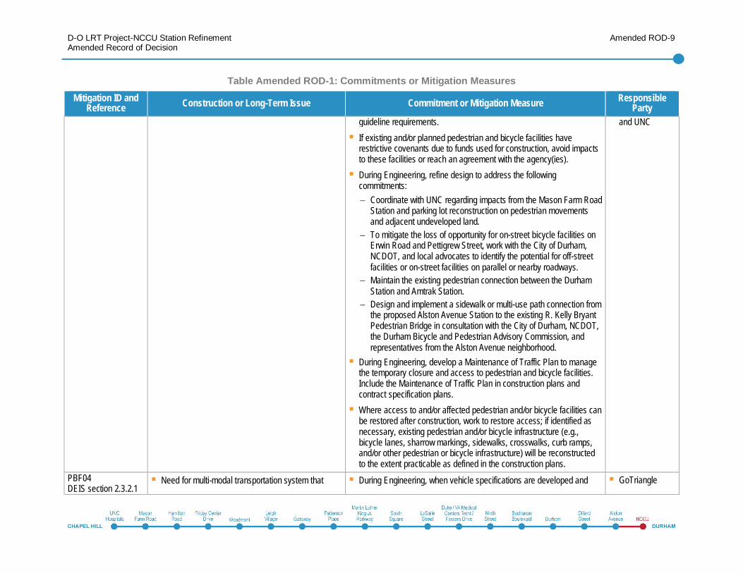
guideline requirements.If existing and/or planned pedestrian and bicycle facilities haverestrictive covenants due to funds used for construction, avoid impactsto these facilities or reach an agreement with the agency(ies).During Engineering, refine design to address the followingcommitments:
Coordinate with UNC regarding impacts from the Mason Farm RoadStation and parking lot reconstruction on pedestrian movementsand adjacent undeveloped land.To mitigate the loss of opportunity for on-street bicycle facilities onErwin Road and Pettigrew Street, work with the City of Durham,NCDOT, and local advocates to identify the potential for off-streetfacilities or on-street facilities on parallel or nearby roadways.Maintain the existing pedestrian connection between the DurhamStation and Amtrak Station.Design and implement a sidewalk or multi-use path connection fromthe proposed Alston Avenue Station to the existing R. Kelly BryantPedestrian Bridge in consultation with the City of Durham, NCDOT,the Durham Bicycle and Pedestrian Advisory Commission, andrepresentatives from the Alston Avenue neighborhood.
During Engineering, develop a Maintenance of Traffic Plan to managethe temporary closure and access to pedestrian and bicycle facilities.Include the Maintenance of Traffic Plan in construction plans andcontract specification plans.Where access to and/or affected pedestrian and/or bicycle facilities canbe restored after construction, work to restore access; if identified asnecessary, existing pedestrian and/or bicycle infrastructure (e.g.,bicycle lanes, sharrow markings, sidewalks, crosswalks, curb ramps,and/or other pedestrian or bicycle infrastructure) will be reconstructedto the extent practicable as defined in the construction plans.
and UNC
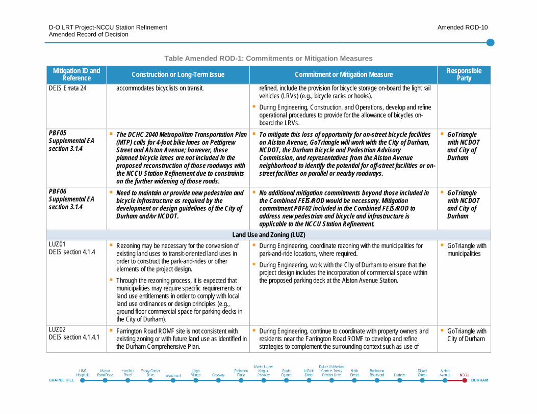
PBF04DEIS section 2.3.2.1
Need for multi-modal transportation system that During Engineering, when vehicle specifications are developed and GoTriangle
D-O LRT Project-NCCU Station RefinementAmended Record of Decision
Amended ROD-10
Table Amended ROD-1: Commitments or Mitigation MeasuresMitigation ID and
Reference Construction or Long-Term Issue Commitment or Mitigation Measure ResponsibleParty
DEIS Errata 24 accommodates bicyclists on transit. refined, include the provision for bicycle storage on-board the light railvehicles (LRVs) (e.g., bicycle racks or hooks).During Engineering, Construction, and Operations, develop and refineoperational procedures to provide for the allowance of bicycles on-board the LRVs.
PBF05Supplemental EAsection 3.1.4
The DCHC 2040 Metropolitan Transportation Plan(MTP) calls for 4-foot bike lanes on PettigrewStreet and Alston Avenue; however, theseplanned bicycle lanes are not included in theproposed reconstruction of those roadways withthe NCCU Station Refinement due to constraintson the further widening of those roads.
To mitigate this loss of opportunity for on-street bicycle facilitieson Alston Avenue, GoTriangle will work with the City of Durham,NCDOT, the Durham Bicycle and Pedestrian AdvisoryCommission, and representatives from the Alston Avenueneighborhood to identify the potential for off-street facilities or on-street facilities on parallel or nearby roadways.
GoTrianglewith NCDOTand City ofDurham
PBF06Supplemental EAsection 3.1.4
Need to maintain or provide new pedestrian andbicycle infrastructure as required by thedevelopment or design guidelines of the City ofDurham and/or NCDOT.
No additional mitigation commitments beyond those included inthe Combined FEIS/ROD would be necessary. Mitigationcommitment PBF02 included in the Combined FEIS/ROD toaddress new pedestrian and bicycle and infrastructure isapplicable to the NCCU Station Refinement.
GoTrianglewith NCDOTand City ofDurham
Land Use and Zoning (LUZ)LUZ01DEIS section 4.1.4
Rezoning may be necessary for the conversion ofexisting land uses to transit-oriented land uses inorder to construct the park-and-rides or otherelements of the project design.Through the rezoning process, it is expected thatmunicipalities may require specific requirements orland use entitlements in order to comply with localland use ordinances or design principles (e.g.,ground floor commercial space for parking decks inthe City of Durham).
During Engineering, coordinate rezoning with the municipalities forpark-and-ride locations, where required.During Engineering, work with the City of Durham to ensure that theproject design includes the incorporation of commercial space withinthe proposed parking deck at the Alston Avenue Station.
GoTriangle withmunicipalities
LUZ02DEIS section 4.1.4.1
Farrington Road ROMF site is not consistent withexisting zoning or with future land use as identified inthe Durham Comprehensive Plan.
During Engineering, continue to coordinate with property owners andresidents near the Farrington Road ROMF to develop and refinestrategies to complement the surrounding context such as use of
GoTriangle withCity of Durham
D-O LRT Project-NCCU Station RefinementAmended Record of Decision
Amended ROD-11
Table Amended ROD-1: Commitments or Mitigation MeasuresMitigation ID and
Reference Construction or Long-Term Issue Commitment or Mitigation Measure ResponsibleParty
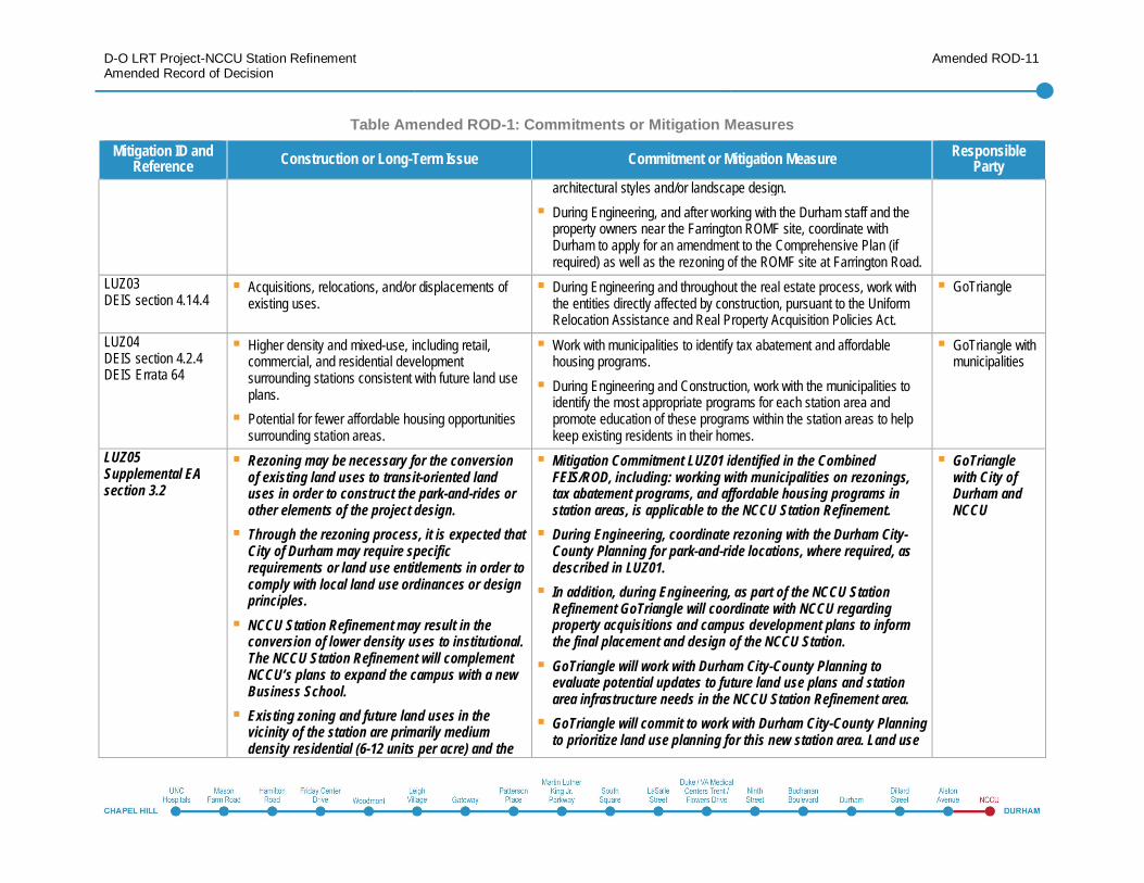
architectural styles and/or landscape design.During Engineering, and after working with the Durham staff and theproperty owners near the Farrington ROMF site, coordinate withDurham to apply for an amendment to the Comprehensive Plan (ifrequired) as well as the rezoning of the ROMF site at Farrington Road.
LUZ03DEIS section 4.14.4
Acquisitions, relocations, and/or displacements ofexisting uses.
During Engineering and throughout the real estate process, work withthe entities directly affected by construction, pursuant to the UniformRelocation Assistance and Real Property Acquisition Policies Act.
GoTriangle
LUZ04DEIS section 4.2.4DEIS Errata 64
Higher density and mixed-use, including retail,commercial, and residential developmentsurrounding stations consistent with future land useplans.Potential for fewer affordable housing opportunitiessurrounding station areas.
Work with municipalities to identify tax abatement and affordablehousing programs.During Engineering and Construction, work with the municipalities toidentify the most appropriate programs for each station area andpromote education of these programs within the station areas to helpkeep existing residents in their homes.
GoTriangle withmunicipalities
LUZ05Supplemental EAsection 3.2
Rezoning may be necessary for the conversionof existing land uses to transit-oriented landuses in order to construct the park-and-rides orother elements of the project design.Through the rezoning process, it is expected thatCity of Durham may require specificrequirements or land use entitlements in order tocomply with local land use ordinances or designprinciples.NCCU Station Refinement may result in theconversion of lower density uses to institutional.The NCCU Station Refinement will complementNCCU’s plans to expand the campus with a newBusiness School.Existing zoning and future land uses in thevicinity of the station are primarily mediumdensity residential (6-12 units per acre) and the
Mitigation Commitment LUZ01 identified in the CombinedFEIS/ROD, including: working with municipalities on rezonings,tax abatement programs, and affordable housing programs instation areas, is applicable to the NCCU Station Refinement.During Engineering, coordinate rezoning with the Durham City-County Planning for park-and-ride locations, where required, asdescribed in LUZ01.In addition, during Engineering, as part of the NCCU StationRefinement GoTriangle will coordinate with NCCU regardingproperty acquisitions and campus development plans to informthe final placement and design of the NCCU Station.GoTriangle will work with Durham City-County Planning toevaluate potential updates to future land use plans and stationarea infrastructure needs in the NCCU Station Refinement area.GoTriangle will commit to work with Durham City-County Planningto prioritize land use planning for this new station area. Land use
GoTrianglewith City ofDurham andNCCU
D-O LRT Project-NCCU Station RefinementAmended Record of Decision
Amended ROD-12
Table Amended ROD-1: Commitments or Mitigation MeasuresMitigation ID and
Reference Construction or Long-Term Issue Commitment or Mitigation Measure ResponsibleParty
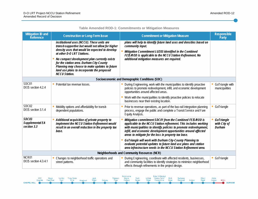
institutional uses (NCCU). These units aretransit-supportive but would not allow for higherdensity uses that would be expected to developat other D-O LRT Stations.No compact development plan currently existsfor the station area. Durham City-CountyPlanning may choose to make updates to futureland use plans to incorporate the proposedNCCU Station.
plans will help to identify future land uses and densities based oncommunity input.Mitigation Commitment LUZ03 identified in the CombinedFEIS/ROD is applicable to the NCCU Station Refinement. Noadditional mitigation measures are required.
Socioeconomic and Demographic Conditions (SDC)SDC01DEIS section 4.2.4
Potential tax revenue losses. During Engineering, work with the municipalities to identify proactivepolicies to promote redevelopment, infill, and economic developmentopportunities around affected areas.Work with the municipalities to identify proactive policies to relocatebusinesses near their existing location.
GoTriangle withmunicipalities
SDC02DEIS section 3.1.4
Mobility options and affordability for transit-dependent populations.
Prior to revenue operations, as part of the bus-rail integration planningprocess, engage the public and complete a Transit Service and FareEquity Analysis.
GoTriangle
SDC03Supplemental EAsection 3.3
Additional acquisition of private property toimplement the NCCU Station Refinement wouldresult in an overall reduction in the property taxbase.
Mitigation commitment SDC01 from the Combined FEIS/ROD isapplicable to the NCCU Station refinement. This includes workingwith municipalities to identify policies to promote redevelopment,infill, and economic development opportunities around affectedareas to mitigate for the loss in property tax base.GoTriangle will work with Durham City-County Planning toevaluate potential updates to future land use plans and stationarea infrastructure needs in the NCCU Station Refinement area.
GoTrianglewith City ofDurham
Neighborhoods and Community Resources (NCR)NCR01DEIS section 4.3.4.1
Changes to neighborhood traffic operations andstreet patterns.
During Engineering, coordinate with affected residents, businesses,and community facilities to identify strategies to minimize neighborhoodeffects through refinements in the project design.
GoTriangle
D-O LRT Project-NCCU Station RefinementAmended Record of Decision
Amended ROD-13
Table Amended ROD-1: Commitments or Mitigation MeasuresMitigation ID and
Reference Construction or Long-Term Issue Commitment or Mitigation Measure ResponsibleParty
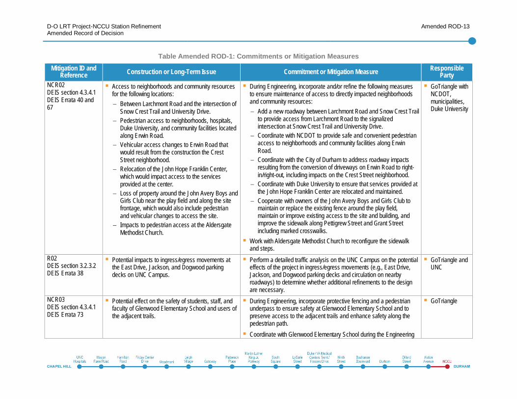
NCR02DEIS section 4.3.4.1DEIS Errata 40 and67
Access to neighborhoods and community resourcesfor the following locations:
Between Larchmont Road and the intersection ofSnow Crest Trail and University Drive.Pedestrian access to neighborhoods, hospitals,Duke University, and community facilities locatedalong Erwin Road.Vehicular access changes to Erwin Road thatwould result from the construction the CrestStreet neighborhood.Relocation of the John Hope Franklin Center,which would impact access to the servicesprovided at the center.Loss of property around the John Avery Boys andGirls Club near the play field and along the sitefrontage, which would also include pedestrianand vehicular changes to access the site.Impacts to pedestrian access at the AldersgateMethodist Church.
During Engineering, incorporate and/or refine the following measuresto ensure maintenance of access to directly impacted neighborhoodsand community resources:
Add a new roadway between Larchmont Road and Snow Crest Trailto provide access from Larchmont Road to the signalizedintersection at Snow Crest Trail and University Drive.Coordinate with NCDOT to provide safe and convenient pedestrianaccess to neighborhoods and community facilities along ErwinRoad.Coordinate with the City of Durham to address roadway impactsresulting from the conversion of driveways on Erwin Road to right-in/right-out, including impacts on the Crest Street neighborhood.Coordinate with Duke University to ensure that services provided atthe John Hope Franklin Center are relocated and maintained.Cooperate with owners of the John Avery Boys and Girls Club tomaintain or replace the existing fence around the play field,maintain or improve existing access to the site and building, andimprove the sidewalk along Pettigrew Street and Grant Streetincluding marked crosswalks.
Work with Aldersgate Methodist Church to reconfigure the sidewalkand steps.
GoTriangle withNCDOT,municipalities,Duke University
R02DEIS section 3.2.3.2DEIS Errata 38
Potential impacts to ingress/egress movements atthe East Drive, Jackson, and Dogwood parkingdecks on UNC Campus.
Perform a detailed traffic analysis on the UNC Campus on the potentialeffects of the project in ingress/egress movements (e.g., East Drive,Jackson, and Dogwood parking decks and circulation on nearbyroadways) to determine whether additional refinements to the designare necessary.
GoTriangle andUNC
NCR03DEIS section 4.3.4.1DEIS Errata 73
Potential effect on the safety of students, staff, andfaculty of Glenwood Elementary School and users ofthe adjacent trails.
During Engineering, incorporate protective fencing and a pedestrianunderpass to ensure safety at Glenwood Elementary School and topreserve access to the adjacent trails and enhance safety along thepedestrian path.Coordinate with Glenwood Elementary School during the Engineering
GoTriangle
D-O LRT Project-NCCU Station RefinementAmended Record of Decision
Amended ROD-14
Table Amended ROD-1: Commitments or Mitigation MeasuresMitigation ID and
Reference Construction or Long-Term Issue Commitment or Mitigation Measure ResponsibleParty
phase to review the designs.R04DEIS section 3.2.3DEIS Errata 36 and108
Operational effects of the introduction of new at-grade intersections and train operations on thesafety, roadway delays, and intersection queuesalong NC 54.
Refine the traffic analysis along NC 54 during the Engineering phase,and if necessary make refinements to the roadway design.At-grade crossings will be signalized or equipped with gates with bellsto warn of oncoming trains. The trains will also have bells and horns.Bells, gates, and horns would be activated according to GoTriangleoperating procedures and safety guidelines.During the Engineering phase, coordinate with NCDOT to evaluateadditional engineering safety measures, including vehicle detectiontechnology, where appropriate.
GoTriangle withNCDOT
LUZ02DEIS section 4.1.4.1
Neighborhood concerns regarding visual, noise,safety, and access effects on residential propertieslocated near the ROMF site.
During Engineering, coordinate with property owners and residentsnear the Farrington Road ROMF to develop and refine strategies tocomplement the surrounding context such as use of architectural stylesand/or landscape design.During Engineering, and after working with the Durham staff and theproperty owners near the Farrington ROMF, coordinate with Durham toapply for an amendment to the Comprehensive Plan as well as therezoning of the ROMF site at Farrington Road. The public will have theopportunity to comment on the design through a public hearing as partof the city and/or county approval process.
GoTriangle withCity of Durham
LUZ03DEIS section 4.14.4
As a result of the construction of the ROMF,displacements of residents would occur.
During Engineering, ensure that any displaced residents would berelocated in accordance with Uniform Relocation Assistance and RealProperty Acquisition Policies Act of 1970 (49 C.F.R. Part 24).
GoTriangle
NCR04DEIS section 4.3.4.1
Acquisition of a portion of the parcel that containsthe Patterson’s Mill Country Store (which isconsidered to be a community resource) would benecessary, but the store could remain.
Develop landscaping, vegetative screening, and modified access to thestore.
GoTriangle
NCR05DEIS section 4.16.3.3
Temporary impacts to school bus routes andvehicular travel patterns during construction of theproject.
Coordinate with Chapel Hill-Carrboro City Schools and Durham PublicSchools to identify detours for impacted school bus routes.During the Engineering phase, develop a Maintenance of Traffic Plan
GoTriangle
D-O LRT Project-NCCU Station RefinementAmended Record of Decision
Amended ROD-15
Table Amended ROD-1: Commitments or Mitigation MeasuresMitigation ID and
Reference Construction or Long-Term Issue Commitment or Mitigation Measure ResponsibleParty
to manage the temporary closure and access to parking facilities.GoTriangle will include the Maintenance of Traffic Plan in constructionplans and contract specification plans.
NCR06Supplemental EAsection 3.4
The NCCU Station Refinement would affectaccess and mobility due to the conversion ofnumerous intersections along Alston Avenue toright-in and right-out access only; however, theexisting grid street network provides convenientaccess to the affected neighborhoods to allowaccess to left turns on Alston Avenue fromLinwood Avenue or Lawson Street.
Impacts to neighborhoods and community resources for theNCCU Station Refinement would generally be the same as thosedescribed in the Combined FEIS/ROD for the D-O LRT Project, butwould extend these impacts to a new area.Mitigation commitment NCR02 in the Combined FEIS/ROD isextended to be applicable to the NCCU Station Refinement. Noadditional mitigation measures are required.
GoTriangle andCity of Durham
Visual and Aesthetic Conditions (VAC)VAC01DEIS section 4.4.4.1DEIS Errata 75, 76,and 77
Introduction of new visual elements to the viewshed.These new elements could negatively affect visuallysensitive resources by altering the view to and/orfrom the resource, or by adding an element thatwould be out of scale or character with the existingvisual context.
During Engineering, coordinate with the Town of Chapel Hill and theCity of Durham as well as with affected residents, businesses,neighborhoods, and community facilities to identify strategies to furtherminimize the visual effects of the project.For locations where visual impacts cannot be avoided, incorporate thefollowing measures in the project design:
The use of interdisciplinary design teams to create aestheticguidelines and standards.The interdisciplinary design teams will use input from thecoordination with municipalities, residents, businesses,neighborhoods, and community facilities to inform the strategies forminimizing visual effects in the project design.Integrate facilities with area redevelopment plans.Work with the municipalities and NCDOT to identify landscapeplanting and appropriate vegetation in and adjoining the projectright-of-way.Replant remainder parcels when portions of a parcel will remainafter the construction.Use source-shielding in exterior lighting at ROMFs, stations, and
GoTriangle,NCDOT, andmunicipalities
D-O LRT Project-NCCU Station RefinementAmended Record of Decision
Amended ROD-16
Table Amended ROD-1: Commitments or Mitigation MeasuresMitigation ID and
Reference Construction or Long-Term Issue Commitment or Mitigation Measure ResponsibleParty
auxiliary facilities to reduce light pollution from new light sources.Identify and integrate Art-in-Transit opportunities in the design (e.g.,unique artistic design in the etching, color, or materials ofwindscreens, canopies, and seating at transit stations, landscapeplanting along the project right-of-way, and/or incorporation of color,murals, form design in the project’s walls, bridges, and/or murals attransit stations).
Incorporate landscaping and aesthetic treatments to the design ofelevated or aerial structure in close proximity to residences.
VAC02DEIS section 4.4.4.1DEIS Errata 78 and79
Site-specific visual impacts include:UNC Finley Golf Course (Landscape Unit #2) –changes in the viewshed and the introduction ofnew visual elements that would result from theproject (station, lighting, OCS poles, track, etc.).East 54/Hamilton Road Station (Landscape Unit#2) – changes in the viewshed and theintroduction of new visual elements that wouldresult from the project (station, lighting, OCSpoles, track, etc.).Patterson’s Mill Country Store and Walter CurtisHudson Farm (Landscape Unit #4) –changes inthe viewshed and introduction of new visualelements that would be located adjacent to thecommunity resource and historic property,respectively (Section 106 and Section 4(f)Resources).Duke West Campus (Landscape Unit #6) –introduction of aerial structure adjacent to the AlBuehler Trail.Duke University Golf Course (Landscape Unit #7and #8) – introduction of new visual elementsadjacent to the Duke University Golf Course and
Implement the following mitigation measures for site-specific visualimpacts:
UNC Finley Golf Course – reconstruct the affected hole and providelandscaping and a protective screen, which is based on a plandeveloped by the golf course designer, as described in chapter 6,Draft Section 4(f) Evaluation.East 54/Hamilton Road Station – incorporate additional landscapingalong Prestwick Road.Patterson’s Mill Country Store and Walter Curtis Hudson Farm –provide a landscape visual buffer for the Walter Curtis Hudson Farmincluding additional landscaping.Duke West Campus – coordinate with Duke University and NCDOTto determine appropriate mitigation measures for the Al BuehlerTrail and aesthetic treatments to the elevated structure.Duke University Golf Course - coordinate with Duke University toprovide landscaping and vegetative screening for the golf course.
Farrington Road ROMF – coordinate with the surrounding landownersand the City of Durham during Engineering to identify potentialtreatments including landscaping, architectural treatments, visualbarriers, and building height maximum.
GoTriangle withCity of Durham,Duke University,NCDOT, andSHPO
D-O LRT Project-NCCU Station RefinementAmended Record of Decision
Amended ROD-17
Table Amended ROD-1: Commitments or Mitigation MeasuresMitigation ID and
Reference Construction or Long-Term Issue Commitment or Mitigation Measure ResponsibleParty
would require the removal of some existinglandscaping and vegetative screening.The ROMF would include built facilities(maintenance buildings, office spaces, andshops) and infrastructure (parking and pavedareas, tracks, switches, OCS lines and poles,TPSS, and signals). The site topography wouldchange due to grading, and would includechanges in structural features, such as theremoval of existing structures and theconstruction of new buildings; changes invegetation, such as the removal of vegetationand planting of new vegetation; and the additionof lighting.
VAC03Supplemental EAsection 3.5
For the NCCU Station Refinement, visual impactsin Landscape Unit #10 would be moderate. Thisis a change from the visual impacts identified inthe Combined FEIS/ROD for Landscape Unit #10for the D-O LRT Project, which were expected tobe low-moderate. This change is due to theaddition of a multi-story parking structure on theproperty adjacent to the Durham Water Towerand Valve House, a National Register resource.Visual impacts for the NCCU Station Refinementfor Landscape Unit #11 would be moderate. Novisual impacts to this area were anticipated withthe D-O LRT Project, as the project did notextend into this area.
The NCCU Station Refinement would result in moderate visualimpacts in Landscape Units #10 and #11. Mitigation commitmentVAC01 from the Combined FEIS/ROD is extended to the NCCUStation Refinement.As potential impacts of the NCCU Station Refinement on visualresources are similar in type and magnitude to those disclosed inthe Combined FEIS/ROD, no additional mitigation measures arerequired.
GoTriangle,NCDOT, andCity of Durham
Historic and Archaeological Resources (CHAR)CHAR01DEIS section 4.5.3.1
Architectural Historic ResourcesIndirect impacts to 13 of 25 architectural historicproperties within the area of potential effect:
Dr. Robert Jack Shankle House
Architectural Historic ResourcesProvide a landscape visual buffer for the following historic resourcesdue to their non-urban settings: the Rocky Ridge Farm Historic District,the Highland Woods Historic District, the Walter Curtis Hudson Farm,
GoTriangle withSHPO
D-O LRT Project-NCCU Station RefinementAmended Record of Decision
Amended ROD-18
Table Amended ROD-1: Commitments or Mitigation MeasuresMitigation ID and
Reference Construction or Long-Term Issue Commitment or Mitigation Measure ResponsibleParty
H.G. Baity HouseBowers-Nelson HouseDubose Tenant Farm ComplexMeadowmontWest Durham Historic DistrictPowe HouseTrinity Historic DistrictWatts and Yuille Tobacco WarehousesBright Leaf Historic DistrictDowntown Durham Historic DistrictDurham Water TowerEast Durham Historic District
and the Ruth-Sizemore Store (Table 4.5-1). This visual buffer wouldprovide a blooming of at least two seasons of each year. GoTrianglewill consult with property owners, historic district representatives, andthe SHPO on the appearance of this buffer.
CHAR02DEIS section 4.5.4.2
Archaeological ResourcesImpacts to archaeological resources will not be morefully understood until Engineering. Therefore,GoTriangle has entered into a Memorandum ofAgreement (MOA) with FTA and SHPO.The Archaeological Background Informationidentified areas where further archaeological surveys(Phase 1 and II) will be conducted during futureengineering and prior to construction.
Archaeological ResourcesConduct Phase I archaeological surveys for the following locations ofthe proposed D-O LRT Project (Table 4.5-2):
North of Mason Farm Road between UNC and Fordham Boulevard.Between George King Road and Interstate-40 (I-40).Farrington Road ROMF site.West of I-40 at the US 15-501 Interchange (Exit 270) (GatewayStation).Between US 15-501 and the NC 751 – Erwin Road intersection.
GoTriangle may conduct Phase II archaeological testing projects at thefollowing locations dependent on the nature and extent of potentialground-disturbing activities:
Archaeological site 31DH655PS-1PS-3
FTA, GoTriangle, and SHPO entered into a MOA for the proposed D-OLRT Project to establish the procedures by which FTA, GoTriangle,and SHPO will work together to ensure the effective protection ofhistoric and/or archaeological resources during the implementation andconstruction of the proposed D-O LRT Project. FTA, GoTriangle, and
GoTriangle withSHPO
D-O LRT Project-NCCU Station RefinementAmended Record of Decision
Amended ROD-19
Table Amended ROD-1: Commitments or Mitigation MeasuresMitigation ID and
Reference Construction or Long-Term Issue Commitment or Mitigation Measure ResponsibleParty
SHPO agree that the D-O LRT Project shall be implemented inaccordance with the stipulations outlined in the MOA
The MOA and Final EIS/ROD identify measures required to mitigateimpacts to archaeological historic properties if any are identifiedduring archaeological Phase I or Phase II studies.
In the event of an inadvertent discovery of archaeological materials,cease construction within a 50 foot buffer around the material. Theconstruction manager will immediately contact the SHPO, FTA, andGoTriangle. The SHPO and FTA will consult to determine appropriateactions to identify archaeological materials and mitigate adverseeffects.
CHAR03Supplemental EAsection 3.6
Architectural Historic ResourcesThe NCCU Station Refinement would add aneight-story parking structure on the GoTriangle-owned property immediately west of the DurhamWater Tower’s eligible boundary. FTA and SHPOdetermined no adverse effect on the DurhamWater Tower and Valve House (DH-3508) basedon design features incorporated into the parkingstructure.FTA and SHPO determined no adverse effect onthe Russell Memorial CME Church.The NCCU Station Refinement would have noadverse effect on any historic properties withinthe Area of Potential Effects (APE).
Architectural Historic ResourcesDesign parking structure such that no structures on the east sideof the garage will rise above the 60-foot level of the garage; no celltowers or related antenna will be erected on the garage.The Memorandum of Agreement (MOA) developed for the D-O LRTProject (described in CHAR02) addresses the procedures bywhich FTA, GoTriangle, and SHPO will work together to ensurethe effective protection of historic and/or archaeologicalresources during the implementation and construction of theproposed D-O LRT Project. Provisions in the MOA regarding theinadvertent discovery of archaeological materials is applicable tothe NCCU Station Refinement.FTA and GoTriangle received concurrence that there will be noadverse effect on any historic property within the APE.
GoTrianglewith SHPO
Parklands and Recreational Areas (PRA) (Refer to Section 4(f) entries for additional information)PRA01DEIS section 4.6.4DEIS Errata 84, 85,and 86
Impacts to three existing public parks (UNC OpenSpace, UNC Finley Golf Course, and USACELands), one private park (Duke University), and one
During Engineering and Construction, continue to coordinate withagencies with jurisdiction (i.e., UNC, North Carolina Botanical Gardens,Town of Chapel Hill, USACE, NCWRC, Duke Forest, and City-County
GoTriangle withUNC, NorthCarolina
D-O LRT Project-NCCU Station RefinementAmended Record of Decision
Amended ROD-20
Table Amended ROD-1: Commitments or Mitigation MeasuresMitigation ID and
Reference Construction or Long-Term Issue Commitment or Mitigation Measure ResponsibleParty
planned public park (UNC Central Park South), witha total impact to 13.3 acres of parklands.Crossing of three proposed trails (East 54/BotanicalGardens, Little Creek Connector Trail, and the NewHope Creek Trail).
of Durham) to minimize potential impacts to parklands and recreationalresources.Provide financial compensation for purchase and development ofreplacement park property of at least equivalent value with the propertyacquired, or, where appropriate, enhancement of the existing facility tocompensate for impacts in coordination with the respective agencieswith jurisdiction. This mitigation will be provided for UNC Open Space,the planned UNC Central Park South, Coker Pinetum, MeadowmontPark, and Duke University properties that will be impacted by theNEPA Preferred Alternative.During Engineering, as the result of ongoing stakeholder coordination,incorporate the following site-specific commitments into the projectdesign:
UNC Finley Golf Course – One golf hole (#17) will be redesignedbased on the plan developed by the golf course designer and golfcourse cart paths will be realigned. GoTriangle will reconstruct theaffected hole and provide landscaping. GoTriangle will continue tocoordinate with UNC, and the golf course will remain open duringconstruction.UNC Cross Country Trails – Install a pedestrian underpass andrealign the trails to maintain connectivity in a manner consistent withexisting conditions. GoTriangle will continue to coordinate with UNCduring Engineering to minimize impacts to these trails and willcoordinate closings of the trails with UNC during Construction.Jordan Game Lands (USACE Property) –GoTriangle commits to thefollowing:
Replace reservoir water-storage volume lost due to fill belowelevation 245 feet msl by excavation of an equal amount of newstorage volume at the same elevation as the lost storagevolume.Compensate the NCWRC for loss of marketable timber. Timbervalue will be determined by a registered government foresterand payment for timber will be collected at the time the
BotanicalGardens, Townof Chapel Hill,USACE,NCWRC, DukeForest, andCity-County ofDurham
D-O LRT Project-NCCU Station RefinementAmended Record of Decision
Amended ROD-21
Table Amended ROD-1: Commitments or Mitigation MeasuresMitigation ID and
Reference Construction or Long-Term Issue Commitment or Mitigation Measure ResponsibleParty
easement is issued.Relocate the access road to the existing impoundment parkingarea, place gravel on the parking lot, provide and install a newgate and informational signs.Construct a gravel access road (16 feet wide) from the existingparking area to a second parking area along the NEPAPreferred Alternative for the impoundment, and provide andinstall a new gate and informational signs.Construct a public access parking area on the south side of NC54, and provide and install a double gate and informationalsigns.Replace the existing Waterfowl Impoundment sign and install anew Game Lands access directional sign for new area along NC54.
Coordinate with USACE to locate fencing as appropriate.Natural Resources (NR)
NR01DEIS section 4.7.4DEIS Errata 90
Impacts to approximately 316 acres of habitat.Crossing of the USACE property and the NCWRCJordan Game Lands, potentially impacting habitatand wildlife movement.Potential impacts to the Little Creek Bottomlandsand Slopes, a Significant Natural Heritage Area.
As a result of ongoing coordination with the agencies with jurisdiction,GoTriangle commits to the following:
Revegetate bare soils after construction to minimize erosion. Disturbedland would be re-vegetated with a native seed mix or landscaping inthe urban environment. During Engineering, GoTriangle will includethese provisions in the construction plans and contract specifications.Minimize adverse effects to aquatic wildlife by bridging wetland andstream areas, and employing sediment and erosion control BMPs.Efforts to avoid, minimize, or mitigate impacts to wildlife and theirhabitats will continue during final design and construction. Mitigationmeasures, such as nesting surveys if required, will be developed inconsultation with NCWRC and the NCDA. During Engineering,GoTriangle will work with NCWRC and NCDA to determine if nestingsurveys are required prior to construction.During Engineering and Construction, periodically review the countyspecies list to ensure the status of the northern long-eared bat. If the
GoTriangle withUSACE,USFWS,NCWRC, andNCDA
D-O LRT Project-NCCU Station RefinementAmended Record of Decision
Amended ROD-22
Table Amended ROD-1: Commitments or Mitigation MeasuresMitigation ID and
Reference Construction or Long-Term Issue Commitment or Mitigation Measure ResponsibleParty
bat is listed in the county and tree removal has not yet been completedfor the project, then GoTriangle will consult with USFWS at that time.Conduct surveys if it becomes evident that bald eagles are utilizing theproject area. During Engineering, GoTriangle will include thesespecifications in the design and construction plans.While impacts to migratory birds are not anticipated, GoTrianglecommits to the following: Between October 1 and February 15, thecontractor would remove all old migratory bird nests from anystructures that would be affected by the proposed project, andcomplete any necessary construction on existing bridges and/orvegetation clearing. In addition, the contractor would be prepared toprevent migratory birds from building nests between February 15 andOctober 1, per the Environmental Permits, Issues, and CommitmentsPlan (EPIC). In the event that migratory birds are encountered on-siteduring project construction, adverse impacts on protected birds, activenests, eggs, and/or young would be avoided. However, if constructionis to take place during nesting season for migratory birds, GoTrianglewill conduct a nesting survey prior to construction. During Engineering,GoTriangle will include these provisions in the construction plans andcontract specifications.
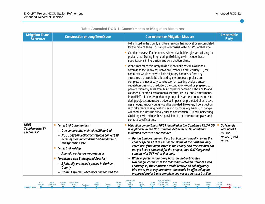
NR02Supplemental EAsection 3.7
Terrestrial CommunitiesOne community: maintained/disturbedNCCU Station Refinement would convert 18acres of maintained disturbed habitat to atransportation use
Terrestrial WildlifeAnimal species are opportunistic
Threatened and Endangered Species3 federally protected species in DurhamCountyOf the 3 species, Michaux’s Sumac and the
Mitigation commitment NR01 identified in the Combined FEIS/RODis applicable to the NCCU Station Refinement. No additionalmitigation measures are required.
During Engineering and Construction, periodically review thecounty species list to ensure the status of the northern long-eared bat. If the bat is listed in the county and tree removal hasnot yet been completed for the project, then GoTriangle willconsult with USFWS at that time.While impacts to migratory birds are not anticipated,GoTriangle commits to the following: Between October 1 andFebruary 15, the contractor would remove all old migratorybird nests from any structures that would be affected by theproposed project, and complete any necessary construction
GoTrianglewith USACE,USFWS,NCWRC, andNCDA
D-O LRT Project-NCCU Station RefinementAmended Record of Decision
Amended ROD-23
Table Amended ROD-1: Commitments or Mitigation MeasuresMitigation ID and
Reference Construction or Long-Term Issue Commitment or Mitigation Measure ResponsibleParty
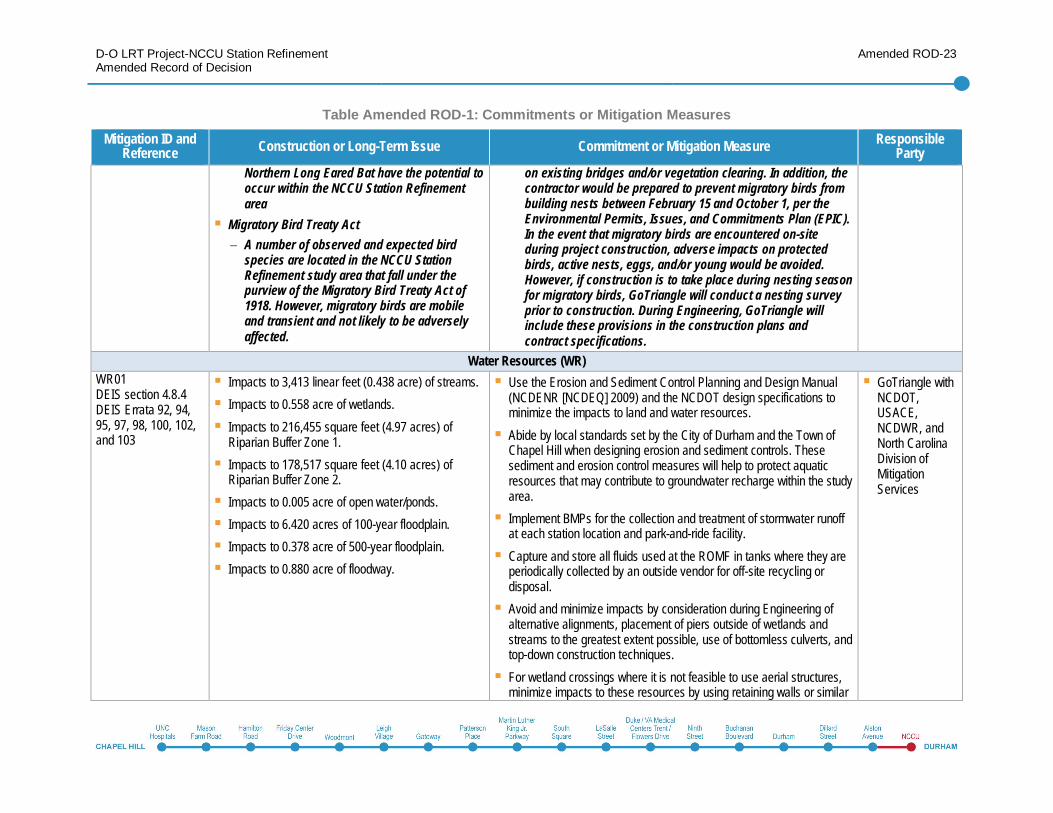
Northern Long Eared Bat have the potential tooccur within the NCCU Station Refinementarea
Migratory Bird Treaty ActA number of observed and expected birdspecies are located in the NCCU StationRefinement study area that fall under thepurview of the Migratory Bird Treaty Act of1918. However, migratory birds are mobileand transient and not likely to be adverselyaffected.
on existing bridges and/or vegetation clearing. In addition, thecontractor would be prepared to prevent migratory birds frombuilding nests between February 15 and October 1, per theEnvironmental Permits, Issues, and Commitments Plan (EPIC).In the event that migratory birds are encountered on-siteduring project construction, adverse impacts on protectedbirds, active nests, eggs, and/or young would be avoided.However, if construction is to take place during nesting seasonfor migratory birds, GoTriangle will conduct a nesting surveyprior to construction. During Engineering, GoTriangle willinclude these provisions in the construction plans andcontract specifications.
Water Resources (WR)WR01DEIS section 4.8.4DEIS Errata 92, 94,95, 97, 98, 100, 102,and 103
Impacts to 3,413 linear feet (0.438 acre) of streams.Impacts to 0.558 acre of wetlands.Impacts to 216,455 square feet (4.97 acres) ofRiparian Buffer Zone 1.Impacts to 178,517 square feet (4.10 acres) ofRiparian Buffer Zone 2.Impacts to 0.005 acre of open water/ponds.Impacts to 6.420 acres of 100-year floodplain.Impacts to 0.378 acre of 500-year floodplain.Impacts to 0.880 acre of floodway.
Use the Erosion and Sediment Control Planning and Design Manual(NCDENR [NCDEQ] 2009) and the NCDOT design specifications tominimize the impacts to land and water resources.Abide by local standards set by the City of Durham and the Town ofChapel Hill when designing erosion and sediment controls. Thesesediment and erosion control measures will help to protect aquaticresources that may contribute to groundwater recharge within the studyarea.Implement BMPs for the collection and treatment of stormwater runoffat each station location and park-and-ride facility.Capture and store all fluids used at the ROMF in tanks where they areperiodically collected by an outside vendor for off-site recycling ordisposal.Avoid and minimize impacts by consideration during Engineering ofalternative alignments, placement of piers outside of wetlands andstreams to the greatest extent possible, use of bottomless culverts, andtop-down construction techniques.For wetland crossings where it is not feasible to use aerial structures,minimize impacts to these resources by using retaining walls or similar
GoTriangle withNCDOT,USACE,NCDWR, andNorth CarolinaDivision ofMitigationServices
D-O LRT Project-NCCU Station RefinementAmended Record of Decision
Amended ROD-24
Table Amended ROD-1: Commitments or Mitigation MeasuresMitigation ID and
Reference Construction or Long-Term Issue Commitment or Mitigation Measure ResponsibleParty
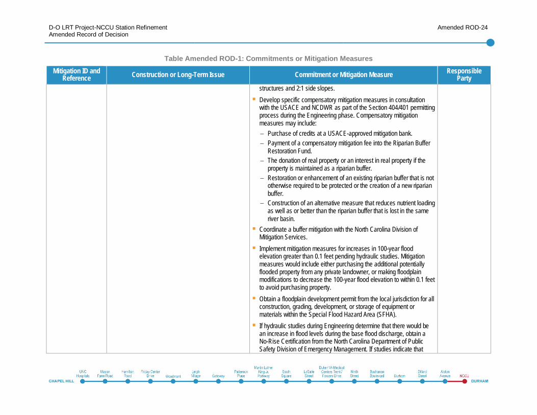
structures and 2:1 side slopes.Develop specific compensatory mitigation measures in consultationwith the USACE and NCDWR as part of the Section 404/401 permittingprocess during the Engineering phase. Compensatory mitigationmeasures may include:
Purchase of credits at a USACE-approved mitigation bank.Payment of a compensatory mitigation fee into the Riparian BufferRestoration Fund.The donation of real property or an interest in real property if theproperty is maintained as a riparian buffer.Restoration or enhancement of an existing riparian buffer that is nototherwise required to be protected or the creation of a new riparianbuffer.Construction of an alternative measure that reduces nutrient loadingas well as or better than the riparian buffer that is lost in the sameriver basin.
Coordinate a buffer mitigation with the North Carolina Division ofMitigation Services.Implement mitigation measures for increases in 100-year floodelevation greater than 0.1 feet pending hydraulic studies. Mitigationmeasures would include either purchasing the additional potentiallyflooded property from any private landowner, or making floodplainmodifications to decrease the 100-year flood elevation to within 0.1 feetto avoid purchasing property.Obtain a floodplain development permit from the local jurisdiction for allconstruction, grading, development, or storage of equipment ormaterials within the Special Flood Hazard Area (SFHA).If hydraulic studies during Engineering determine that there would bean increase in flood levels during the base flood discharge, obtain aNo-Rise Certification from the North Carolina Department of PublicSafety Division of Emergency Management. If studies indicate that
D-O LRT Project-NCCU Station RefinementAmended Record of Decision
Amended ROD-25
Table Amended ROD-1: Commitments or Mitigation MeasuresMitigation ID and
Reference Construction or Long-Term Issue Commitment or Mitigation Measure ResponsibleParty
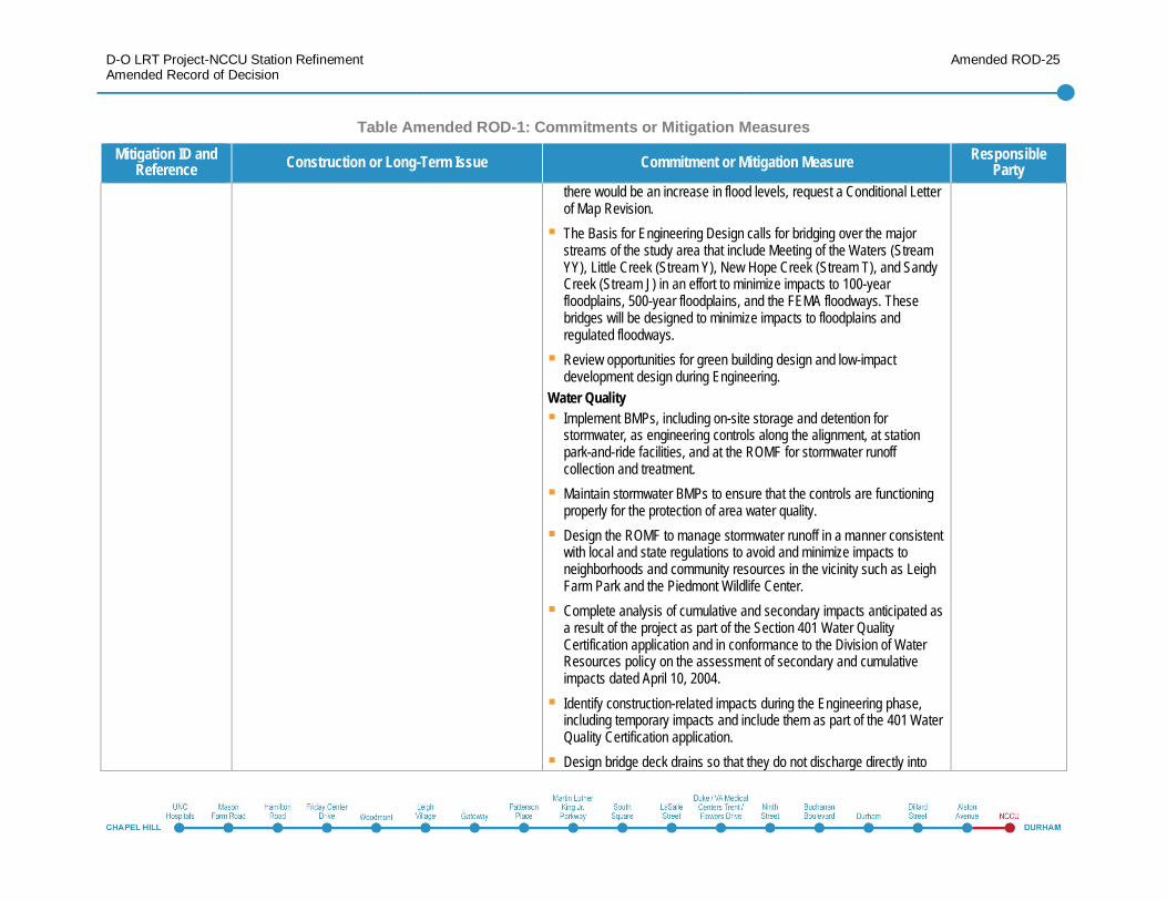
there would be an increase in flood levels, request a Conditional Letterof Map Revision.The Basis for Engineering Design calls for bridging over the majorstreams of the study area that include Meeting of the Waters (StreamYY), Little Creek (Stream Y), New Hope Creek (Stream T), and SandyCreek (Stream J) in an effort to minimize impacts to 100-yearfloodplains, 500-year floodplains, and the FEMA floodways. Thesebridges will be designed to minimize impacts to floodplains andregulated floodways.Review opportunities for green building design and low-impactdevelopment design during Engineering.
Water QualityImplement BMPs, including on-site storage and detention forstormwater, as engineering controls along the alignment, at stationpark-and-ride facilities, and at the ROMF for stormwater runoffcollection and treatment.Maintain stormwater BMPs to ensure that the controls are functioningproperly for the protection of area water quality.Design the ROMF to manage stormwater runoff in a manner consistentwith local and state regulations to avoid and minimize impacts toneighborhoods and community resources in the vicinity such as LeighFarm Park and the Piedmont Wildlife Center.Complete analysis of cumulative and secondary impacts anticipated asa result of the project as part of the Section 401 Water QualityCertification application and in conformance to the Division of WaterResources policy on the assessment of secondary and cumulativeimpacts dated April 10, 2004.Identify construction-related impacts during the Engineering phase,including temporary impacts and include them as part of the 401 WaterQuality Certification application.Design bridge deck drains so that they do not discharge directly into
D-O LRT Project-NCCU Station RefinementAmended Record of Decision
Amended ROD-26
Table Amended ROD-1: Commitments or Mitigation MeasuresMitigation ID and
Reference Construction or Long-Term Issue Commitment or Mitigation Measure ResponsibleParty
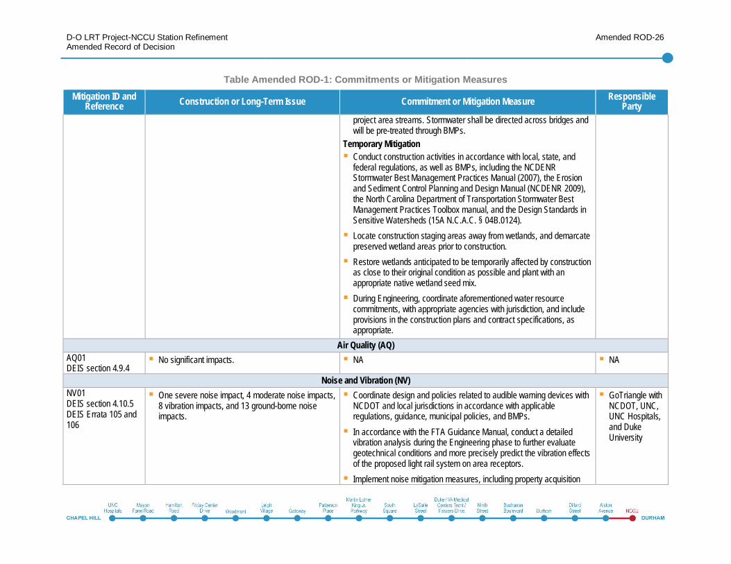
project area streams. Stormwater shall be directed across bridges andwill be pre-treated through BMPs.
Temporary MitigationConduct construction activities in accordance with local, state, andfederal regulations, as well as BMPs, including the NCDENRStormwater Best Management Practices Manual (2007), the Erosionand Sediment Control Planning and Design Manual (NCDENR 2009),the North Carolina Department of Transportation Stormwater BestManagement Practices Toolbox manual, and the Design Standards inSensitive Watersheds (15A N.C.A.C. § 04B.0124).Locate construction staging areas away from wetlands, and demarcatepreserved wetland areas prior to construction.Restore wetlands anticipated to be temporarily affected by constructionas close to their original condition as possible and plant with anappropriate native wetland seed mix.During Engineering, coordinate aforementioned water resourcecommitments, with appropriate agencies with jurisdiction, and includeprovisions in the construction plans and contract specifications, asappropriate.
Air Quality (AQ)AQ01DEIS section 4.9.4
No significant impacts. NA NA
Noise and Vibration (NV)NV01DEIS section 4.10.5DEIS Errata 105 and106
One severe noise impact, 4 moderate noise impacts,8 vibration impacts, and 13 ground-borne noiseimpacts.
Coordinate design and policies related to audible warning devices withNCDOT and local jurisdictions in accordance with applicableregulations, guidance, municipal policies, and BMPs.In accordance with the FTA Guidance Manual, conduct a detailedvibration analysis during the Engineering phase to further evaluategeotechnical conditions and more precisely predict the vibration effectsof the proposed light rail system on area receptors.Implement noise mitigation measures, including property acquisition
GoTriangle withNCDOT, UNC,UNC Hospitals,and DukeUniversity
D-O LRT Project-NCCU Station RefinementAmended Record of Decision
Amended ROD-27
Table Amended ROD-1: Commitments or Mitigation MeasuresMitigation ID and
Reference Construction or Long-Term Issue Commitment or Mitigation Measure ResponsibleParty
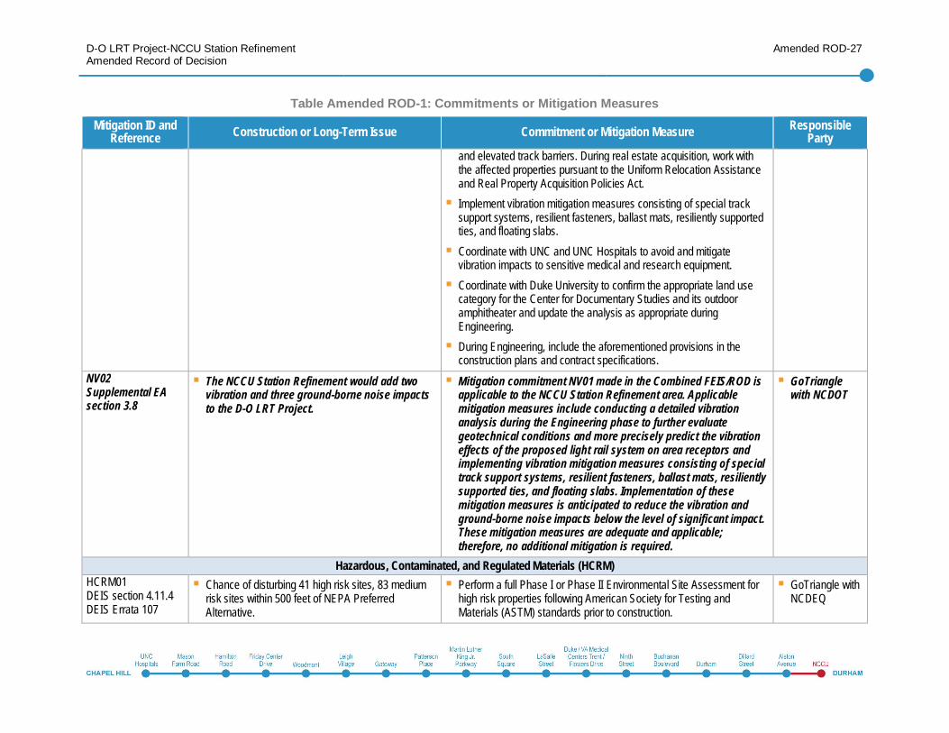
and elevated track barriers. During real estate acquisition, work withthe affected properties pursuant to the Uniform Relocation Assistanceand Real Property Acquisition Policies Act.Implement vibration mitigation measures consisting of special tracksupport systems, resilient fasteners, ballast mats, resiliently supportedties, and floating slabs.Coordinate with UNC and UNC Hospitals to avoid and mitigatevibration impacts to sensitive medical and research equipment.Coordinate with Duke University to confirm the appropriate land usecategory for the Center for Documentary Studies and its outdooramphitheater and update the analysis as appropriate duringEngineering.During Engineering, include the aforementioned provisions in theconstruction plans and contract specifications.
NV02Supplemental EAsection 3.8
The NCCU Station Refinement would add twovibration and three ground-borne noise impactsto the D-O LRT Project.
Mitigation commitment NV01 made in the Combined FEIS/ROD isapplicable to the NCCU Station Refinement area. Applicablemitigation measures include conducting a detailed vibrationanalysis during the Engineering phase to further evaluategeotechnical conditions and more precisely predict the vibrationeffects of the proposed light rail system on area receptors andimplementing vibration mitigation measures consisting of specialtrack support systems, resilient fasteners, ballast mats, resilientlysupported ties, and floating slabs. Implementation of thesemitigation measures is anticipated to reduce the vibration andground-borne noise impacts below the level of significant impact.These mitigation measures are adequate and applicable;therefore, no additional mitigation is required.
GoTrianglewith NCDOT
Hazardous, Contaminated, and Regulated Materials (HCRM)HCRM01DEIS section 4.11.4DEIS Errata 107
Chance of disturbing 41 high risk sites, 83 mediumrisk sites within 500 feet of NEPA PreferredAlternative.
Perform a full Phase I or Phase II Environmental Site Assessment forhigh risk properties following American Society for Testing andMaterials (ASTM) standards prior to construction.
GoTriangle withNCDEQ
D-O LRT Project-NCCU Station RefinementAmended Record of Decision
Amended ROD-28
Table Amended ROD-1: Commitments or Mitigation MeasuresMitigation ID and
Reference Construction or Long-Term Issue Commitment or Mitigation Measure ResponsibleParty
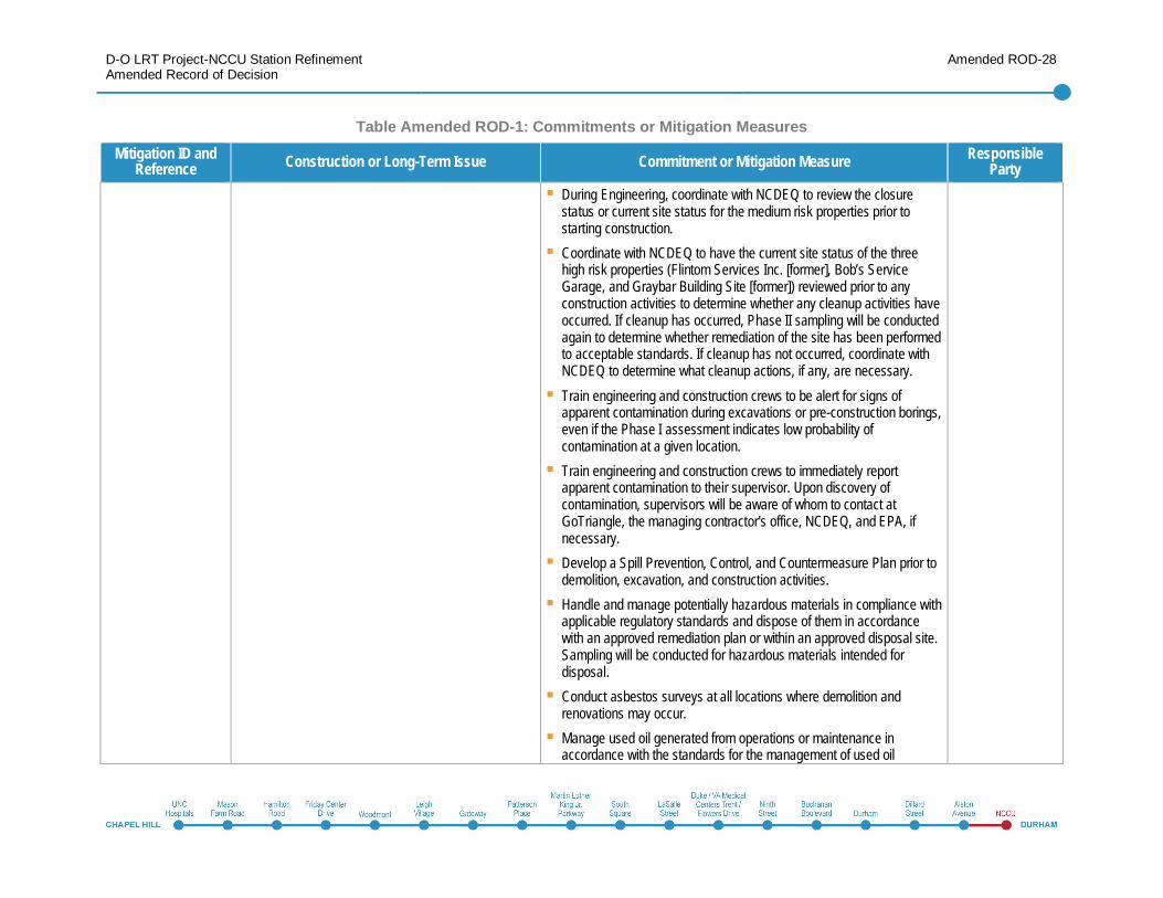
During Engineering, coordinate with NCDEQ to review the closurestatus or current site status for the medium risk properties prior tostarting construction.Coordinate with NCDEQ to have the current site status of the threehigh risk properties (Flintom Services Inc. [former], Bob’s ServiceGarage, and Graybar Building Site [former]) reviewed prior to anyconstruction activities to determine whether any cleanup activities haveoccurred. If cleanup has occurred, Phase II sampling will be conductedagain to determine whether remediation of the site has been performedto acceptable standards. If cleanup has not occurred, coordinate withNCDEQ to determine what cleanup actions, if any, are necessary.Train engineering and construction crews to be alert for signs ofapparent contamination during excavations or pre-construction borings,even if the Phase I assessment indicates low probability ofcontamination at a given location.Train engineering and construction crews to immediately reportapparent contamination to their supervisor. Upon discovery ofcontamination, supervisors will be aware of whom to contact atGoTriangle, the managing contractor's office, NCDEQ, and EPA, ifnecessary.Develop a Spill Prevention, Control, and Countermeasure Plan prior todemolition, excavation, and construction activities.Handle and manage potentially hazardous materials in compliance withapplicable regulatory standards and dispose of them in accordancewith an approved remediation plan or within an approved disposal site.Sampling will be conducted for hazardous materials intended fordisposal.Conduct asbestos surveys at all locations where demolition andrenovations may occur.Manage used oil generated from operations or maintenance inaccordance with the standards for the management of used oil
D-O LRT Project-NCCU Station RefinementAmended Record of Decision
Amended ROD-29
Table Amended ROD-1: Commitments or Mitigation MeasuresMitigation ID and
Reference Construction or Long-Term Issue Commitment or Mitigation Measure ResponsibleParty
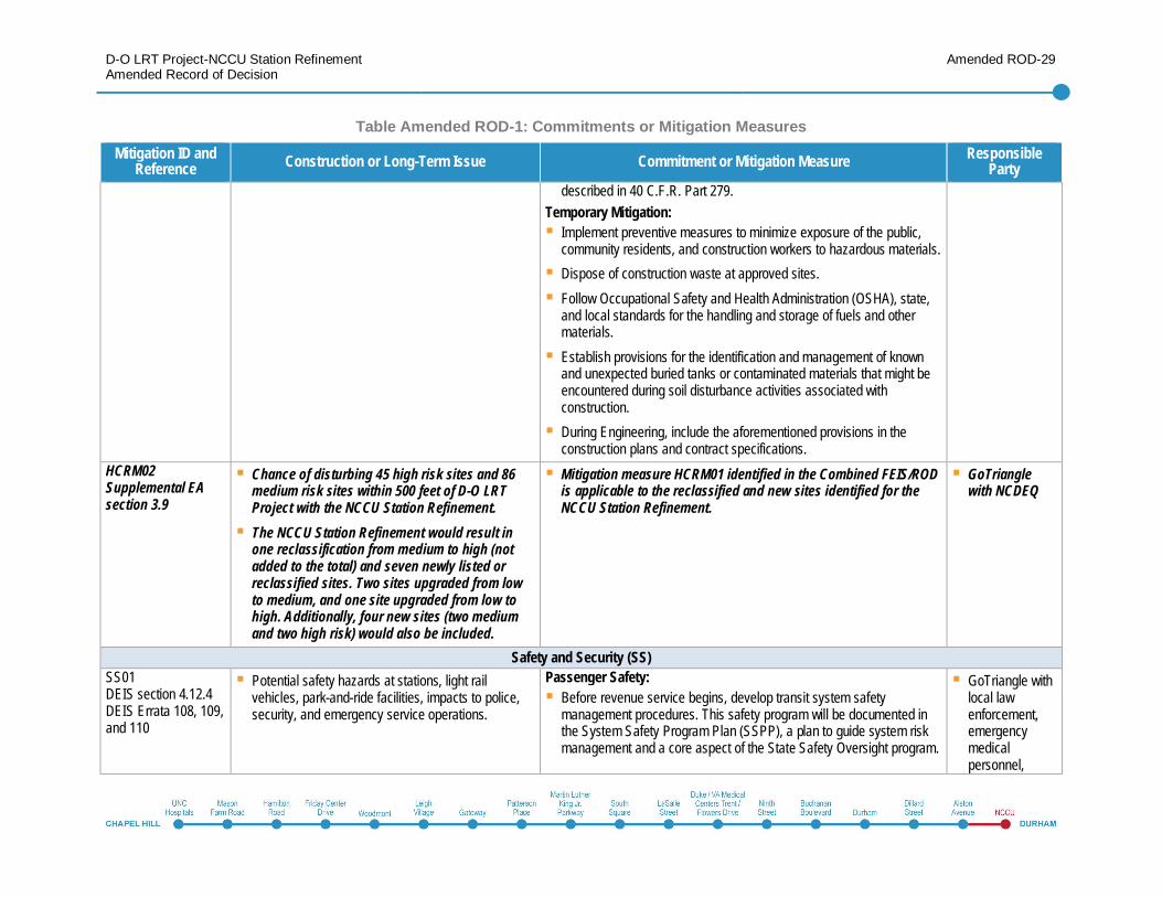
described in 40 C.F.R. Part 279.Temporary Mitigation:
Implement preventive measures to minimize exposure of the public,community residents, and construction workers to hazardous materials.Dispose of construction waste at approved sites.Follow Occupational Safety and Health Administration (OSHA), state,and local standards for the handling and storage of fuels and othermaterials.Establish provisions for the identification and management of knownand unexpected buried tanks or contaminated materials that might beencountered during soil disturbance activities associated withconstruction.During Engineering, include the aforementioned provisions in theconstruction plans and contract specifications.
HCRM02Supplemental EAsection 3.9
Chance of disturbing 45 high risk sites and 86medium risk sites within 500 feet of D-O LRTProject with the NCCU Station Refinement.The NCCU Station Refinement would result inone reclassification from medium to high (notadded to the total) and seven newly listed orreclassified sites. Two sites upgraded from lowto medium, and one site upgraded from low tohigh. Additionally, four new sites (two mediumand two high risk) would also be included.
Mitigation measure HCRM01 identified in the Combined FEIS/RODis applicable to the reclassified and new sites identified for theNCCU Station Refinement.
GoTrianglewith NCDEQ
Safety and Security (SS)SS01DEIS section 4.12.4DEIS Errata 108, 109,and 110
Potential safety hazards at stations, light railvehicles, park-and-ride facilities, impacts to police,security, and emergency service operations.
Passenger Safety:Before revenue service begins, develop transit system safetymanagement procedures. This safety program will be documented inthe System Safety Program Plan (SSPP), a plan to guide system riskmanagement and a core aspect of the State Safety Oversight program.
GoTriangle withlocal lawenforcement,emergencymedicalpersonnel,
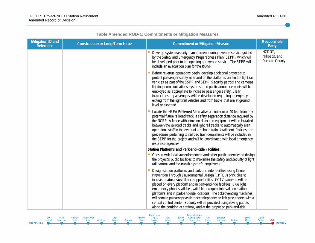
D-O LRT Project-NCCU Station RefinementAmended Record of Decision
Amended ROD-30
Table Amended ROD-1: Commitments or Mitigation MeasuresMitigation ID and
Reference Construction or Long-Term Issue Commitment or Mitigation Measure ResponsibleParty
Develop system security management during revenue service guidedby the Safety and Emergency Preparedness Plan (SEPP), which willbe developed prior to the opening of revenue service. The SEPP willinclude an evacuation plan for the ROMF.Before revenue operations begin, develop additional protocols toprotect passenger safety near and on the platforms and in the light railvehicles as part of the SSPP and SEPP. Security patrols and cameras,lighting, communications systems, and public announcements will beemployed as appropriate to increase passenger safety. Clearinstructions to passengers will be developed regarding emergencyexiting from the light rail vehicles and from tracks that are at groundlevel or elevated.Locate the NEPA Preferred Alternative a minimum of 40 feet from anypotential future railroad track, a safety separation distance required bythe NCRR. A fence with intrusion detection equipment will be installedbetween the railroad tracks and light rail tracks to automatically alertoperations staff in the event of a railroad train derailment. Policies andprocedures pertaining to railroad train derailments will be included inthe SEPP for the project and will be coordinated with local emergencyresponse agencies.
Station Platforms and Park-and-Ride Facilities:Consult with local law enforcement and other public agencies to designthe project’s public facilities to maximize the safety and security of lightrail patrons and the transit system’s employees.Design station platforms and park-and-ride facilities using CrimePrevention Through Environmental Design (CPTED) principles toincrease natural surveillance opportunities. CCTV cameras will beplaced on every platform and in park-and-ride facilities. Blue lightemergency phones will be available at regular intervals on stationplatforms and in park-and-ride locations. The ticket vending machineswill contain passenger assistance telephones to link passengers with acentral control center. Security will be provided using roving patrolsalong the corridor, at stations, and at the proposed park-and-ride
NCDOT,railroads, andDurham County
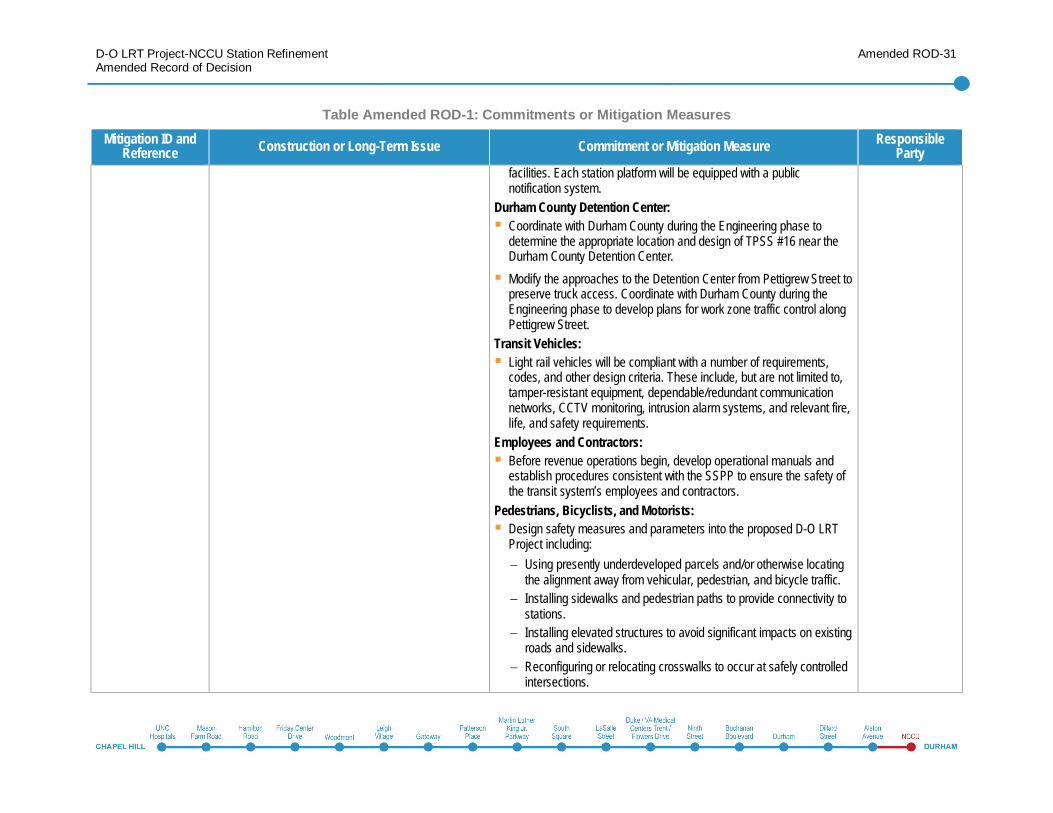
D-O LRT Project-NCCU Station RefinementAmended Record of Decision
Amended ROD-31
Table Amended ROD-1: Commitments or Mitigation MeasuresMitigation ID and
Reference Construction or Long-Term Issue Commitment or Mitigation Measure ResponsibleParty
facilities. Each station platform will be equipped with a publicnotification system.
Durham County Detention Center:Coordinate with Durham County during the Engineering phase todetermine the appropriate location and design of TPSS #16 near theDurham County Detention Center.Modify the approaches to the Detention Center from Pettigrew Street topreserve truck access. Coordinate with Durham County during theEngineering phase to develop plans for work zone traffic control alongPettigrew Street.
Transit Vehicles:Light rail vehicles will be compliant with a number of requirements,codes, and other design criteria. These include, but are not limited to,tamper-resistant equipment, dependable/redundant communicationnetworks, CCTV monitoring, intrusion alarm systems, and relevant fire,life, and safety requirements.
Employees and Contractors:Before revenue operations begin, develop operational manuals andestablish procedures consistent with the SSPP to ensure the safety ofthe transit system’s employees and contractors.
Pedestrians, Bicyclists, and Motorists:Design safety measures and parameters into the proposed D-O LRTProject including:
Using presently underdeveloped parcels and/or otherwise locatingthe alignment away from vehicular, pedestrian, and bicycle traffic.Installing sidewalks and pedestrian paths to provide connectivity tostations.Installing elevated structures to avoid significant impacts on existingroads and sidewalks.Reconfiguring or relocating crosswalks to occur at safely controlledintersections.
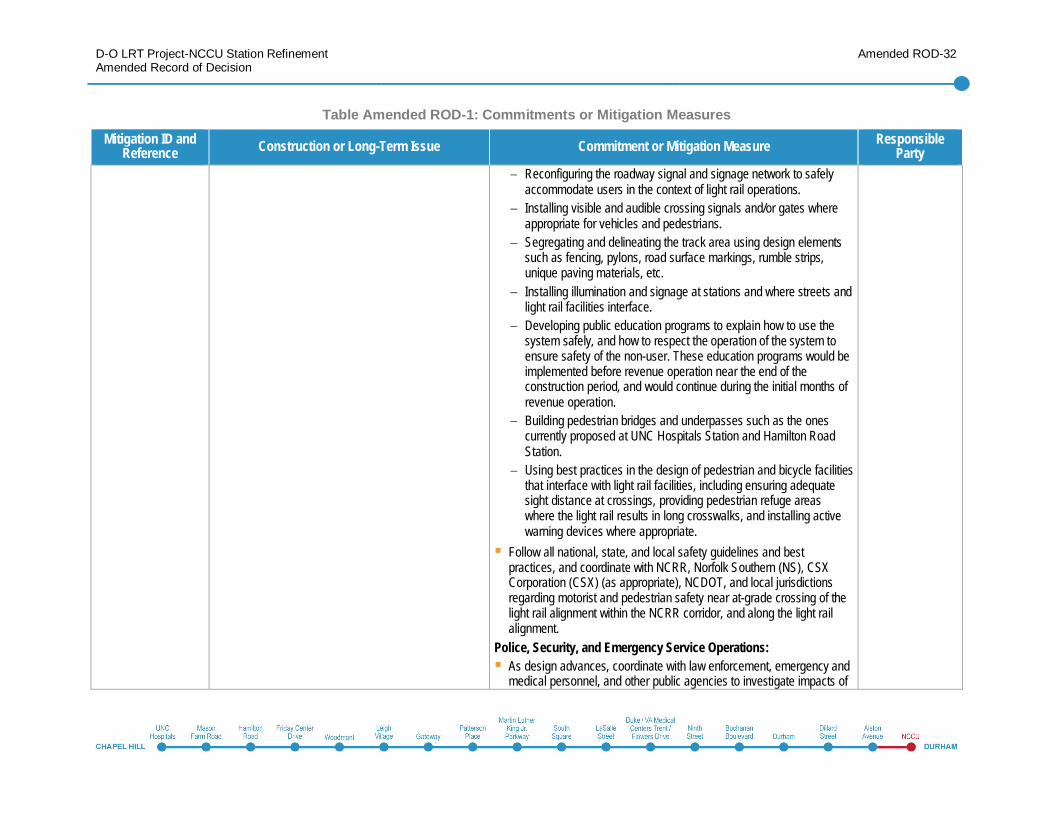
D-O LRT Project-NCCU Station RefinementAmended Record of Decision
Amended ROD-32
Table Amended ROD-1: Commitments or Mitigation MeasuresMitigation ID and
Reference Construction or Long-Term Issue Commitment or Mitigation Measure ResponsibleParty
Reconfiguring the roadway signal and signage network to safelyaccommodate users in the context of light rail operations.Installing visible and audible crossing signals and/or gates whereappropriate for vehicles and pedestrians.Segregating and delineating the track area using design elementssuch as fencing, pylons, road surface markings, rumble strips,unique paving materials, etc.Installing illumination and signage at stations and where streets andlight rail facilities interface.Developing public education programs to explain how to use thesystem safely, and how to respect the operation of the system toensure safety of the non-user. These education programs would beimplemented before revenue operation near the end of theconstruction period, and would continue during the initial months ofrevenue operation.Building pedestrian bridges and underpasses such as the onescurrently proposed at UNC Hospitals Station and Hamilton RoadStation.Using best practices in the design of pedestrian and bicycle facilitiesthat interface with light rail facilities, including ensuring adequatesight distance at crossings, providing pedestrian refuge areaswhere the light rail results in long crosswalks, and installing activewarning devices where appropriate.
Follow all national, state, and local safety guidelines and bestpractices, and coordinate with NCRR, Norfolk Southern (NS), CSXCorporation (CSX) (as appropriate), NCDOT, and local jurisdictionsregarding motorist and pedestrian safety near at-grade crossing of thelight rail alignment within the NCRR corridor, and along the light railalignment.
Police, Security, and Emergency Service Operations:As design advances, coordinate with law enforcement, emergency andmedical personnel, and other public agencies to investigate impacts of
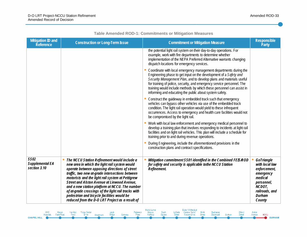
D-O LRT Project-NCCU Station RefinementAmended Record of Decision
Amended ROD-33
Table Amended ROD-1: Commitments or Mitigation MeasuresMitigation ID and
Reference Construction or Long-Term Issue Commitment or Mitigation Measure ResponsibleParty
the potential light rail system on their day-to-day operations. Forexample, work with fire departments to determine whetherimplementation of the NEPA Preferred Alternative warrants changingdispatch locations for emergency services.Coordinate with local emergency management departments during theEngineering phase to get input on the development of a Safety andSecurity Management Plan, and to develop plans and materials usefulfor training of police, security, and emergency service personnel. Thetraining would include methods by which these personnel can assist ininforming and educating the public about system safety.Construct the guideway in embedded track such that emergencyvehicles can bypass other vehicles via use of the embedded trackcondition. The light rail operation would yield to these infrequentoccurrences. Access to emergency and health care facilities would notbe compromised by the light rail.Work with local law enforcement and emergency medical personnel todevelop a training plan that involves responding to incidents at light railfacilities and on light rail vehicles. This plan will include a schedule fortraining prior to and during revenue operations.During Engineering, include the aforementioned provisions in theconstruction plans and contract specifications.
SS02Supplemental EAsection 3.10
The NCCU Station Refinement would include anew area in which the light rail system wouldoperate between opposing directions of streettraffic, two new at-grade intersections betweenmotorists and the light rail system at PettigrewStreet and Alston Avenue at Linwood Avenue,and a new station platform at NCCU. The numberof at-grade crossings of the light rail tracks withpedestrian and bicycle facilities would bereduced from the D-O LRT Project as a result of
Mitigation commitment SS01 identified in the Combined FEIS/RODfor safety and security is applicable tothe NCCU StationRefinement.
GoTrianglewith local lawenforcement,emergencymedicalpersonnel,NCDOT,railroads, andDurhamCounty
D-O LRT Project-NCCU Station RefinementAmended Record of Decision
Amended ROD-34
Table Amended ROD-1: Commitments or Mitigation MeasuresMitigation ID and
Reference Construction or Long-Term Issue Commitment or Mitigation Measure ResponsibleParty
the reorientation of the Alston Avenue Station;however, the NCCU Station would be located inthe median of Alston Avenue, which wouldintroduce a conflict for pedestrians andbicyclists crossing vehicular traffic to access thestation.
Energy (E)E01DEIS section 4.13.4
No significant impacts. NA NA
Acquisitions, Relocations, and Displacements (ARD)ARD01DEIS section 4.14.4DEIS Errata 112
Acquisitions, relocations, and displacements include92 potential full acquisitions, 138 potential partialacquisitions, and 65 displacements.
Conduct the acquisition and relocation process in accordance with theUniform Relocation Assistance and Real Property Acquisition PoliciesAct of 1970, as amended.For property owners and tenants whose primary language is notEnglish, conduct the property acquisition and relocation discussions inalternate languages.If exercising eminent domain is necessary, follow the procedures setforth under North Carolina law, including NC Eminent Domain(N.C.G.S. §§ 40-A-1 – 40A-85) and NC Relocation Assistance Act(N.C.G.S. § 133-5 – 133-22).Pursuant to 23 C.F.R. Part 810 Subpart C, request authorization fromthe Federal Highway Administration (after an assessment by NCDOT)to use federally-owned rights-of-way in conjunction with the proposedD-O LRT Project.Conduct any relocation of a displaced use in accordance with theUniform Relocation Assistance and Real Property Acquisition PoliciesAct of 1970. Provide ample notice to those being relocated to allow forany planning contingencies that may arise.In accordance with Title VI of the Civil Rights Act of 1964, providerelocation advisory assistance to all eligible persons withoutdiscrimination.
GoTriangle withUNC and DukeUniversity
D-O LRT Project-NCCU Station RefinementAmended Record of Decision
Amended ROD-35
Table Amended ROD-1: Commitments or Mitigation MeasuresMitigation ID and
Reference Construction or Long-Term Issue Commitment or Mitigation Measure ResponsibleParty
Provide relocation planning and services to businesses includingreview of site requirements, current lease terms, and other contractualobligations; outside specialists to assist in planning and moving;identification and resolution of personal property/real property issues;an estimate of time required for the business to vacate the site; anestimate of the anticipated difficulty in locating replacement property;and an identification of any advance relocation payments required forthe move.During Engineering, coordinate with UNC and Duke University todetermine whether an acquisition or easement is appropriate.
ARD02Supplemental EAsection 3.12
The NCCU Station Refinement would result in 34new full acquisitions (including one that waspreviously a partial), 5 new partial acquisitions,and 23 additional displacements.
Mitigation commitment ARD01 identified in the CombinedFEIS/ROD is applicable to the NCCU Station Refinement:
Conduct the acquisition and relocation process in accordancewith the Uniform Relocation Assistance and Real PropertyAcquisition Policies Act of 1970, as amended.
In addition, GoTriangle will coordinate with NCCU regardingproperty acquisitions and campus development plans to informthe final placement and design of the NCCU Station.
GoTriangle
Utility Impacts (UI)UI01DEIS section 4.15.4
Potential impacts to 85 miles of utility lines.Potential impacts to the cell tower on the FarringtonRoad ROMF site.
Survey existing utilities during the Engineering phase and seek to avoidor limit impacts to existing utilities.All protection in place, relocation, replacement, or abandonment will beconducted in consultation with the utility owner.Where relocation will be required, make efforts to consolidate existingutilities.Minimize utility service outages and schedule them with the utilityowner and the customer such that they would present the leastinconvenience.Incorporate special measures to ensure continuous service to lifesafety functions such as hospitals, fire protection, emergency
GoTriangle
D-O LRT Project-NCCU Station RefinementAmended Record of Decision
Amended ROD-36
Table Amended ROD-1: Commitments or Mitigation MeasuresMitigation ID and
Reference Construction or Long-Term Issue Commitment or Mitigation Measure ResponsibleParty
response, detention centers, and other facilities providing criticalsupport such as private medical offices/care facilities or universitylaboratories.Notify residences and businesses of utility work.During Engineering and construction, coordinate with the utility ownersto monitor relocation activities and execute any necessary relocationagreements.Coordinate with the utility owner and property owners to determine thefeasibility of accommodating the cell tower and access for the utilityowner for operations and maintenance into the Farrington Road ROMFsite design.
UI02Supplemental EAsection 3.13
Up to two miles of utility impacts could resultfrom the NCCU Station Refinement.
Mitigation commitment UI01 identified in the Combined FEIS/RODis applicable to the NCCU Station Refinement, and no additionalmitigation is proposed for the NCCU Station Refinement.As noted in the Combined FEIS/ROD, GoTriangle will surveyexisting utilities during the Engineering phase to avoid or limitimpacts, minimize utility outages during construction, and notifyresidences, universities, and businesses of utility work.
GoTriangle
Construction (C)C01DEIS section 4.16.3DEIS Errata 115, 116,117, 120, and 121
Temporary impacts to:Transportation, traffic, and parkingAccess for residents and businessesNeighborhood and community resourcesVisual and aestheticsHistoric and archaeological resourcesNatural resourcesWater resourcesAir quality
Develop a project construction, education, and outreach plan duringthe Engineering phase. This plan will identify how to educate the publicand stakeholders about ongoing and upcoming construction andconstruction impacts (e.g., detours, service interruptions). It will includeboth broad-based approaches to educate the public (e.g., media, website, newsletters, public meetings) and targeted outreach to those whomay be more directly affected by construction activities (e.g., directmail, small group meetings, in-person communication).Minimize construction impacts through selection and implementation ofBMPs.
GoTriangle withNCDOT,railroads, andmunicipalities
D-O LRT Project-NCCU Station RefinementAmended Record of Decision
Amended ROD-37
Table Amended ROD-1: Commitments or Mitigation MeasuresMitigation ID and
Reference Construction or Long-Term Issue Commitment or Mitigation Measure ResponsibleParty
Noise and vibrationHazardous, contaminated, and regulatedmaterialsSafety and securityEnergy useUtilities
Comply with all municipal and state regulations and policies regardingdevelopment for the construction and development of the D-O LRTProject. Coordinate with municipalities on the design of the projectduring Engineering.
Transportation, Traffic, and Parking:Maintain pedestrian and vehicular access to businesses, universities,medical facilities, and residences with a priority placed on emergencyfacilities.Prepare work zone traffic control plans during the Engineering andConstruction phases. Coordinate these plans with the City of Durham,Town of Chapel Hill, NCRR, universities, emergency services, and theNCDOT. The plans will identify requirements for maintaining access tobusinesses, university, medical, and emergency facilities. They willinclude advanced warning for lane closures.Construct the structures employing methods that minimize the impactto the roadway user. Lane closures on the major arterials must beapproved by the NCDOT and coordinated with the Highway Patrol andlocal police authority.Restrict lane closures to night and weekend lane closures to minimizetraffic inconvenience. Traffic detours will be restricted to minimum timedurations via the contract and work zone traffic control plans.Include appropriate access provisions in the Work Zone Traffic ControlPlans, and BMPs to manage debris for potential disruptions to bicycleand pedestrian facilities during construction.Minimize closing adjacent crosswalks at the same time to allow forcontinued pedestrian movement across streets. Provide sidewalks andcrosswalks to meet minimum standards for accessibility and free ofslipping and tripping hazards.Provide special facilities (such as handrails, fences, barriers, ramps,and walkways) to maintain bicyclist and pedestrian safety in the eventof temporary closures or impacts to sidewalks.
D-O LRT Project-NCCU Station RefinementAmended Record of Decision
Amended ROD-38
Table Amended ROD-1: Commitments or Mitigation MeasuresMitigation ID and
Reference Construction or Long-Term Issue Commitment or Mitigation Measure ResponsibleParty
During the Engineering phase, develop a plan to manage the closure ofpedestrian crossings and other restrictions on non-motorizedtransportation facilities and crossings throughout the constructionprocess.Temporary off-site detours of traffic and/or phased construction wouldbe necessary when the Farrington Road bridge is lengthened toaccommodate the light rail line. Traffic on I-40 would be maintainedduring the construction period. Short periods of lane closure may benecessary to construct the pier adjacent to I-40 traffic and to erect thegirders.Reduce construction-related transportation impacts by schedulingconstruction activities during off-peak hours; coordinating freight andpassenger rail schedules and construction activities with NCRR,Norfolk Southern, and Amtrak; coordinating with appropriate trafficcontrol authorities to maintain reasonable and safe traffic operations ataffected roadway crossings; and coordinating with hospitals,universities, and businesses in order to make reasonable efforts tomitigate concerns regarding reduction of parking through education ofpatrons and employees about parking alternatives, such as carpooling,park and rides, and transit options.
Access for Residents and Business:Avoid and/or minimize adverse impacts to residents and businessesduring project construction by maintaining traffic, parking, and accessduring construction, modifying business signage to maintain businessvisibility, using marketing campaigns to advise patrons of requiredconstruction in areas with multiple businesses, installing temporarydirectional signage, and providing advance communication ofconstruction activities.Include temporary arrangements for safe pedestrian access in theconstruction documents. Site-specific business and accessmanagement plans will also be developed by the contractor.
D-O LRT Project-NCCU Station RefinementAmended Record of Decision
Amended ROD-39
Table Amended ROD-1: Commitments or Mitigation MeasuresMitigation ID and
Reference Construction or Long-Term Issue Commitment or Mitigation Measure ResponsibleParty
Neighborhood and Community Resources:Inform local property owners of roadway disruptions and otherconstruction-related activities and consequences through constructioneducation and outreach plans.Coordinate with emergency response personnel to maintain continuousaccess for emergency vehicles throughout the duration of construction.Prior to construction, coordinate with Chapel Hill-Carrboro City Schoolsand Durham Public Schools to identify potential impacts on school busroutes and appropriate temporary detour routes during construction.
Visual and Aesthetic Considerations:Stabilize embankments and plant vegetation in construction areas asquickly as possible so that sediment and erosion control devices canbe removed.Locate staging areas in the least visibly sensitive project areas.Whenever possible, these facilities will be located out of view ofresidences, businesses, or any potential viewer.Implement height limits for staged materials and excavated soil so thatthey are less visibleDirect lighting toward the interior of the construction areas or provideshielding to minimize light pollution into adjacent properties.Screen construction activities whenever possible.Clear dirt and debris from areas adjacent to the construction sites in atimely manner.Keep construction sites well organized and clear of trash and debris.
Historic and Archaeological Resources:Address mitigation measures and construction control throughconsultation with the North Carolina State Historic Preservation Officeas part of the process for compliance with Section 106 of the NationalHistoric Preservation Act of 1966.
D-O LRT Project-NCCU Station RefinementAmended Record of Decision
Amended ROD-40
Table Amended ROD-1: Commitments or Mitigation MeasuresMitigation ID and
Reference Construction or Long-Term Issue Commitment or Mitigation Measure ResponsibleParty
Develop an Archaeological Recovery Plan during Engineering.Avoidance and minimization measures are outlined in the MOA.Coordinate these measures pursuant to the MOA through ongoingconsultation with the North Carolina State Historic Preservation Officeand FTA.
Natural Resources:BMPs will be followed by the contractor during construction. BMPscould include the demarcation of the construction limits and stagingareas prior to the initiation of construction to limit the disturbances tohabitat and wildlife. Create a plan to minimize impacts and losses ofvegetation.
Water Resources:Implement appropriate BMPs during construction, such as installingfabric barriers at storm drain inlets.Locate the placement of the piers outside of wetlands and streams andemploy top-down construction of the aerial structures to minimizedisturbance to the wetland soils.Require contractors to have spill prevention, containment, andcollection plans in place to address the risk of contamination fromconstruction equipment.Develop a Stormwater Pollution Prevention Plan (SWPPP) during theEngineering phase of the project. The SWPPP will include provisions tocontrol erosion and reduce sedimentation and other pollutantsassociated with construction activities.
Air Quality:Minimize dust generated during construction through standard dustcontrol measures such as applying water to exposed soils and limitingthe extent and duration of exposed soil conditions.Employ the following measures to mitigate fugitive dust kicked up intothe air from earthmoving and other ground disturbance and emissionsfrom construction equipment:
D-O LRT Project-NCCU Station RefinementAmended Record of Decision
Amended ROD-41
Table Amended ROD-1: Commitments or Mitigation MeasuresMitigation ID and
Reference Construction or Long-Term Issue Commitment or Mitigation Measure ResponsibleParty
Shutting off construction equipment not in direct use.Watering areas of exposed soil.Covering open body trucks transporting materials to and fromconstruction sites.Rerouting truck traffic away from schools and residentialcommunities when possible.Repaving and/or replanting exposed areas as soon as possiblefollowing construction.Securing tarps, plastic, or other material over debris piles.Prohibiting delivery trucks or other equipment from idling duringperiods of extended unloading or inactivity.
Noise and Vibration:During Engineering, complete a detailed construction noiseassessment that will provide property specific details to developmitigation plans to keep the noise levels at or below acceptable levelsduring construction.Construction equipment will be required to be properly muffled andmaintained.Limit certain construction activities to weekday daytime hours (typicallyfrom 7 a.m. to 6 p.m.) and consider prohibition of nighttime constructionnear residential neighborhoods.Monitor noise on a regular basis during construction near potentiallyaffected sensitive receptors.Conduct vibration and noise monitoring during construction dependingon the sensitivity of the surrounding resources.Limited duration of pile driving operations resulting in short term levelsof annoyance. Monitor vibration levels at sensitive building structuresduring construction.In the event monitoring results in impacts beyond acceptable levels,implement additional site-specific mitigation.
D-O LRT Project-NCCU Station RefinementAmended Record of Decision
Amended ROD-42
Table Amended ROD-1: Commitments or Mitigation MeasuresMitigation ID and
Reference Construction or Long-Term Issue Commitment or Mitigation Measure ResponsibleParty
Where construction of deep foundations for elevated structures isrequired near sensitive receptors, employ drilled shaft footings toreduce noise and vibration.Implement other noise mitigation during construction:
Noise barriers.Minimizing the distance of truck routing and routing trucks awayfrom residential streets.Relocating noise-generating equipment as far away from thesensitive noise areas as possible.Drilled pile instead of impact pile driving.Specifying quieted equipment in construction specifications.Alternative demolition or pavement breaking techniques.
Hazardous, Contaminated, and Regulated Materials:Minimize construction-related impacts related to hazardous materials:
Comply with applicable federal and state regulations.Follow OSHA, state, and local standards in handling and storage offuels and other materials.Dispose of hazardous materials according to applicable federal,state, and local guidelines.Clean construction vehicles to prevent off-site contamination.Dispose of construction waste at approved sites.
During Construction, minimize the generation of waste, to recyclematerials for which viable markets exist, and to use recycled productsand materials where suitable. Any waste generated duringConstruction that cannot be beneficially reused or recycled will bedisposed of at a solid waste management facility approved to managethe respective waste type.Develop a Spill Prevention, Control, and Countermeasure Plan prior todemolition, excavation, or construction activities.
D-O LRT Project-NCCU Station RefinementAmended Record of Decision
Amended ROD-43
Table Amended ROD-1: Commitments or Mitigation MeasuresMitigation ID and
Reference Construction or Long-Term Issue Commitment or Mitigation Measure ResponsibleParty
Conduct sampling of hazardous materials intended for disposal.Assess potential exposure levels through the use of monitoringequipment.Develop decontamination procedures.Perform a full Phase I and/or Phase II Environmental Site Assessmentfor high risk properties following ASTM standards prior to construction.Review the closure status or current site status of medium riskproperties with NCDEQ before starting construction.Manage any hazardous waste generated from the demolition,construction, maintenance, operation, and/or remediation (e.g.,excavated soil) from the D-O LRT Project in accordance with the NorthCarolina Hazardous Waste Rules. Notify the NCDEQ HazardousWaste Section on the quantity of hazardous waste generated in orderto make a determination whether the D-O LRT Project qualifies as asmall or large quantity generator.
Safety and Security:Provide construction barriers and fencing to secure construction sitesand staging areas, and evaluate the need for additional securitymeasures such as guards, if needed.Address the safety of the public, particularly the passage ofpedestrians, bicyclists, and other spectators near open excavationsand other construction activity through the creation, proper timing, andplacement of protective safety programs, public information efforts, andselected protective measures.
Energy Use:Minimize energy consumption during construction by limiting the idlingof construction equipment and employee vehicles as well as locatingstaging areas and material processing facilities as close as practical towork sites.
D-O LRT Project-NCCU Station RefinementAmended Record of Decision
Amended ROD-44
Table Amended ROD-1: Commitments or Mitigation MeasuresMitigation ID and
Reference Construction or Long-Term Issue Commitment or Mitigation Measure ResponsibleParty
Utilities:Avoid and minimize utility disruptions by coordinating utilityconstruction with other construction activities and limiting constructionaround existing utility lines such as excavations, removal of fill, andgrading.Prior to construction, contact area utility companies and utility agenciesand request them to provide line location measures and approval of theproposed alteration of utility lines.Coordinate with businesses such as restaurants, grocery stores, andfood preparation/manufacturing facilities in order to protect foodpreparation and storage.During construction, should utilities be identified that were not identifiedprior to construction, contact appropriate utility companies andagencies to identify the line(s). The newly identified line(s) will not bedisrupted until businesses and residences are notified and the utilityowner/operator has approved the proposed alteration.During Engineering, include the aforementioned provisions in theconstruction plans and contract specifications. During Construction,GoTriangle will monitor contractor compliance.
C02Supplemental EAsection 3.14
Construction of the NCCU Station Refinementhas the potential to cause vibration impacts atthe historic water tower and valve house locatedon Pettigrew Street east of the Alston AvenueStation parking garage.
Monitoring of vibration impacts during construction will beconducted on the historic water tower and valve house located onPettigrew Street east of the Alston Avenue Station parking garage.Construction techniques would be required so as not to causedetrimental vibration to these facilities.Mitigation commitment C01 identified in the Combined FEIS/RODis applicable to the NCCU Station Refinement.
GoTrianglewith City ofDurham
Indirect and Cumulative EffectsICE01Supplemental EAsection 3.15
The NCCU Station Refinement may contribute toindirect impacts to land use due to new growththat could occur that may not be consistent withthe current adopted Durham Comprehensive
The NCCU Station Refinement would result in similar levels ofindirect impacts on land use compared to the D-O LRT Project.The NCCU Station Refinement would result in similar levels of
GoTriangle
D-O LRT Project-NCCU Station RefinementAmended Record of Decision
Amended ROD-45
Table Amended ROD-1: Commitments or Mitigation MeasuresMitigation ID and
Reference Construction or Long-Term Issue Commitment or Mitigation Measure ResponsibleParty
Plan. The current adopted plan calls for medium-density residential uses in this area.The NCCU Station Refinement may contribute tocumulative impacts on parking, pedestrian andbicycle conditions, and land use. However, thesecumulative impacts are anticipated to result inpositive effects on these resources, resultingfrom improved regional connectivity, and moreefficient land use patterns. These effects areconsistent with potential cumulative effectsidentified for the D-O LRT Project as documentedin the Combined FEIS/ROD.
cumulative impacts on parking, pedestrian and bicycle conditions,and land use, compared to the D-O LRT Project.GoTriangle will commit to work with Durham City-County Planningto prioritize land use planning for this new station area. Land useplans will help to identify future land uses and densities based oncommunity input.
Environmental Justice (EJ)EJ01DEIS section 5.5DEIS Errata 123
There will be no disproportionate impacts to EJpopulations. Effects on specific resources within EJareas include the following:
Visual impacts near the Oak Creek VillageApartments on Garrett Road.One moderate noise impact in downtownDurham.Commercial, institutional, and residentialdisplacements along the entire D-O Corridor,most of which would occur in the US 15-501 andeast Durham evaluation areas.Acquisitions in the east Durham community couldbe perceived as an adverse effect sincehistorically, transportation projects haveadversely affected community cohesion, access,land use planning, and development in thisevaluation area.Indirect effects associated with gentrification,resulting in reduction in affordable housing
Some of the specific impacts of the NEPA Preferred Alternative mayadversely affect EJ populations. Therefore, where possible, thealignment options have been refined through the NEPA process tominimize impacts to both the human and natural environments.Continue to provide outreach to EJ communities to implement theproposed mitigation strategies effectively.Continue coordination with EJ populations and assess design andaesthetic treatments during further design development to addressvisual impacts throughout the corridor.Provide design treatments to reduce visual impacts at affectedlocations, where possible, including those in EJ areas.Reduce operational vibration by evaluating and implementing specificmaterials and construction methods in the construction of the light railline.Conduct the acquisition and relocation process in accordance with theUniform Relocation Assistance and Real Property Acquisition PoliciesAct of 1970, as amended.Continue working with EJ communities to address ways that their
GoTriangle andmunicipalities
D-O LRT Project-NCCU Station RefinementAmended Record of Decision
Amended ROD-46
Table Amended ROD-1: Commitments or Mitigation MeasuresMitigation ID and
Reference Construction or Long-Term Issue Commitment or Mitigation Measure ResponsibleParty
opportunities. concerns could be mitigated further.Work with the City of Durham to provide opportunities for localbusinesses to benefit from commercial space within the parking deck atthe proposed Alston Avenue Station.Work directly with the Town of Chapel Hill and Durham City/CountyPlanning staff to encourage, support, and facilitate the developmentand implementation of affordable housing policies for the D-O Corridor.Continue to participate in the Coalition for Affordable Housing andTransit, a citizens group led by the Durham People’s Alliance that isfocused on working with local governments to develop policies toprotect existing affordable housing and promote creation of newaffordable housing in proposed D-O LRT Project station areas.
EJ02Supplemental EAsection 5.4
There will be no disproportionately high andadverse impacts to EJ populations. Effects onspecific resources within EJ areas include thefollowing:
Parking Facilities: Loss of 16 on-streetparking spaces; reconfiguration andrelocation of Alston Avenue parking garagewith 1,200 additional spaces.Pedestrian and Bicycle Facilities: Loss ofopportunity for on-street bicycle facilities onAlston Avenue.Access and Mobility: Generally animprovement to access and mobility for EJcommunities around the NCCU Station area;five roadway intersections would beconverted to right-in right-out access only.Access changes and visual impacts for theRussell Memorial Christian MethodistEpiscopal Church and Child DevelopmentCenter (daycare).
Some of the specific impacts of the D-O LRT Project mayadversely affect EJ populations. Therefore, where possible, thealignment options have been refined through the NEPA process tominimize impacts to both the human and natural environments.Continue to provide outreach to EJ communities to implement themitigation strategies effectively.Continue coordination with EJ populations and assess design andaesthetic treatments during further design development toaddress visual impacts throughout the corridor.Provide design treatments to reduce visual impacts at affectedlocations, where possible, including those in EJ areas.Reduce operational vibration by evaluating and implementingspecific materials and construction methods in the constructionof the light rail line.Conduct the acquisition and relocation process in accordancewith the Uniform Relocation Assistance and Real PropertyAcquisition Policies Act of 1970, as amended.Continue working with EJ communities to address ways that their
GoTriangle andCity of Durham
D-O LRT Project-NCCU Station RefinementAmended Record of Decision
Amended ROD-47
Table Amended ROD-1: Commitments or Mitigation MeasuresMitigation ID and
Reference Construction or Long-Term Issue Commitment or Mitigation Measure ResponsibleParty
Land Use: Land uses around NCCU stationcould promote higher density residential notcurrently indicated in Durham’s future landuse plans.Community Cohesion: Improved connectivitybetween neighborhoods located north andsouth of NC 147 that were separated by theconstruction of the highway.Employment: Minor increase of 15 full timeequivalent jobs in the region.Community Facilities: Improved access tocommunity facilities; impacts to John AveryBoys and Girls Club.Visual and Aesthetic: Change from low-moderate to moderate visual impacts inLandscape Unit #10 from introduction ofmulti-story parking garage east of AlstonAvenue; new moderate visual impacts inLandscape Unit #11.Vibration: Three ground-borne noise and twovibration impacts.Safety and Security: At-grade crossings ofLRT; LRT between opposing lanes of traffic.Acquisitions and Displacements: Residentialand commercial acquisitions anddisplacements in the Alston Avenue Stationarea and along Alston Avenue (Fullacquisitions: +14 residential; +5 commercial;Partial: +2 residential /-1 residential; +1community facilities; Displacements: +18residential, +5 commercial, no additionalcommunity resources).Indirect and Cumulative: Indirect and
concerns could be mitigated further.Work directly with Durham City/County Planning staff toencourage, support, and facilitate the development andimplementation of affordable housing policies for the NCCUStation Refinement.Continue to participate in the Coalition for Affordable Housing andTransit, a citizens group led by the Durham People’s Alliance thatis focused on working with local governments to develop policiesto protect existing affordable housing and promote creation ofnew affordable housing in NCCU Station Refinement stationareas.Mitigation Commitment EJ01 included in the Combined FEIS/RODis applicable to the NCCU Station Refinement and would addressvisual and aesthetic impacts identified.Mitigation Commitment EJ 01 included in the Combined FEIS/RODis applicable to additional impacts from the NCCU StationRefinement to access and mobility, community facilities, noiseand vibration, and acquisitions and displacements.Mitigation Commitment PBF05 identified for the loss ofopportunity for bicycle facilities along Alston Avenue would beaddressed through coordination between GoTriangle, the City ofDurham, NCDOT, and local advocates to identify the potential foroff-street facilities or on-street facilities on parallel or nearbyroadways.Additional mitigation measures to address impacts to land useand indirect and cumulative impacts of the NCCU StationRefinement are as follows:During Engineering, GoTriangle will coordinate with NCCUregarding property acquisitions and campus development plansto inform the final placement and design of the NCCU Station.GoTriangle will also coordinate with the City of Durham to
D-O LRT Project-NCCU Station RefinementAmended Record of Decision
Amended ROD-48
Table Amended ROD-1: Commitments or Mitigation MeasuresMitigation ID and
Reference Construction or Long-Term Issue Commitment or Mitigation Measure ResponsibleParty
cumulative impacts to land use in theSoutheast Central Durham neighborhood,including indirect effects associated withpotential gentrification and reduction inaffordable housing opportunities.
evaluate potential updates to their future land use plan and stationarea infrastructure needs in the NCCU Station Refinement area.During Engineering, work with the City of Durham to ensure thatthe project design includes the incorporation of commercial spacewithin the proposed parking deck at the Alston Avenue Station.
Section 4(f) Property – Jordan Game LandsPRA01DEIS section 4.6.4DEIS Errata 84, 85,and 86
Permanent easement of approximately 3.6 acres inthe area of the Jordan Game Lands. This iscomprised of approximately 1.7 acres of permanenteasement within an existing transportation easementheld by NCDOT for the occupancy of NC 54;approximately 1.7 acres of permanent easementwithin the George King Road right-of-way, andapproximately 0.2 acre of land in the Jordan GameLands at the western edge of George King Road andnorthern edge of NC 54.The latter 0.2 acre is not within an existing easementor right-of-way and would constitute a Section 4(f)use of the property.Approximately 1.4 acres of land would be needed fora temporary construction easement.
Section 4(f) Determination: de minimis impact.
After considering previous measures to minimize harm, FTA hasdetermined that the impacts to this resource are de minimis and requireno mitigation. That is, the impacts will not adversely affect the activities,features, or attributes that qualify the property for protection underSection 4(f).GoTriangle will provide the following commitments regarding theJordan Game Lands:
Replace reservoir water storage volume lost due to fill belowelevation 245 feet msl by excavation of an equal amount of newstorage volume at the same elevation as the lost storage volume.Compensate NCWRC for loss of marketable timber. Timber valuewould be determined by a registered government forester andpayment for timber would be collected at the time the permanenteasement is issued.Coordinate with USACE and NCWRC regarding location of fencingon government property necessary for safety and security of the D-O LRT Project.Complete the following to the satisfaction of NCWRC:
Relocate the access road to the existing impoundment parkingarea #1, place gravel on the parking lot, provide and install anew gate and informational signs.Construct a gravel access road (16 feet wide) from parking area#1 to parking area #2 along the alignment. Improve parking area#2 by installing gravel; provide and install a new gate andinformational signs.Construct a public access parking area #3 on the south side of
GoTriangle withUSACE andNCWRC
D-O LRT Project-NCCU Station RefinementAmended Record of Decision
Amended ROD-49
Table Amended ROD-1: Commitments or Mitigation MeasuresMitigation ID and
Reference Construction or Long-Term Issue Commitment or Mitigation Measure ResponsibleParty
NC 54, provide and install a double gate and informationalsigns.Replace the existing Waterfowl Impoundment sign and install anew Game Lands access directional sign for the new parkingarea #3, along NC 54.
Restore the area used for the temporary construction easement ofthe aerial structure along NC 54 to the condition it was in beforeconstruction or utilized by the USACE for its identified purposes aspart of the mitigation for the D-O LRT Project.
Sign an agreement with USACE, consistent with the measures statedabove prior to issuance of the easements (permanent and temporary)required for the D-O LRT Project.
Section 4(f) Property – Central Park SouthPRA01DEIS section 4.6.4DEIS Errata 84, 85,and 86
Would require acquisition of approximately 0.9 acreof permanent easement of the 13.7 acres of UNClands designated for the future development ofCentral Park South.GoTriangle will ensure that construction would notpreclude future development of Central Park South.
Section 4(f) Determination: de minimis impact.
After considering previous measures to minimize harm, FTA hasdetermined that the impacts to this resource are de minimis and requireno mitigation. That is, the impacts will not adversely affect the activities,features, or attributes that qualify the property for protection underSection 4(f).
NA
Section 4(f) Property – Coker PinetumPRA01DEIS section 4.6.4DEIS Errata 84, 85,and 86
Would require a permanent easement ofapproximately 0.1 acre of land from the CokerPinetum and a temporary construction easement ofapproximately 0.01 acre.
Section 4(f) Determination: de minimis impact.
After considering previous measures to minimize harm, FTA hasdetermined that the impacts to this resource are de minimis and requireno mitigation. That is, the impacts will not adversely affect the activities,features, or attributes that qualify the property for protection underSection 4(f).
NA
Section 4(f) Property – Disc Golf Course and Athletic FieldsPRA01DEIS section 4.6.4DEIS Errata 84, 85,and 86
Section 4(f) Determination: The proximity impacts fromconstruction and operation of the NEPA PreferredAlternative would not substantially impair the protectedactivities, features, or attributes that qualify the property
Coordinate with UNC on the schedule of construction activities near thedisc golf course and athletic fields.
GoTriangle withUNC
D-O LRT Project-NCCU Station RefinementAmended Record of Decision
Amended ROD-50
Table Amended ROD-1: Commitments or Mitigation MeasuresMitigation ID and
Reference Construction or Long-Term Issue Commitment or Mitigation Measure ResponsibleParty
for protection under Section 4(f).Section 4(f) Property– UNC Finley Golf Course and Athletic Fields
PRA01DEIS section 4.6.4DEIS Errata 84, 85,and 86
Would require approximately 2.6 acres of permanenteasement from the UNC Finley Golf Course andAthletic Fields.Would also require a 0.3 acre temporaryconstruction easement.Construction of the alignment would require cartpaths and tee boxes to be re-located and vegetationto be cleared.Visual changes, such as clearing vegetation, wouldresult in adverse impacts to the recreationalfeatures.
Section 4(f) Determination: de minimis impact.
After considering previous measures to minimize harm, FTA hasdetermined that the impacts to this resource are de minimis and requireno mitigation. That is, the impacts will not adversely affect the activities,features, or attributes that qualify the property for protection underSection 4(f).GoTriangle will provide the following commitments regarding the UNCFinley Golf Course and Athletic Fields:
Place landscaping and tree buffers along the alignment to increaseprivacy and minimize noise impacts to users of this Section 4(f)property in accordance with the UNC Finley Golf Course DesignConcept Plan and Construction Cost Estimates, by Fazio GolfCourse Designers, Inc., last updated in April 2014 (Fazio 2014).Coordinate with UNC to minimize disruption to the golf course usersand staff.Restore the area used for the temporary construction easement tothe condition it was in before construction or better.
Work with UNC to minimize construction-related effects and maintainaccess to the public properties during construction.
GoTriangle withUNC
Section 4(f) Property – UNC Open SpacePRA01DEIS section 4.6.4DEIS Errata 84, 85,and 86
Approximately 0.8 acre of the 120 acre UNC OpenSpace property would be acquired for a permanenteasement.Approximately 1.0 acre would be acquired as atemporary construction easement.
Section 4(f) Determination: de minimis impact.
After considering previous measures to minimize harm, FTA hasdetermined that the impacts to this resource are de minimis and requireno mitigation. That is, the impacts will not adversely affect the activities,features, or attributes that qualify the property for protection underSection 4(f).GoTriangle will provide the following commitments regarding the UNCOpen Space:
Notify UNC at least 48 hours in advance as to when the paths willbe temporarily closed and coordinate closely with UNC tocommunicate the closure to users to minimize impacts to the
GoTriangle withUNC
D-O LRT Project-NCCU Station RefinementAmended Record of Decision
Amended ROD-51
Table Amended ROD-1: Commitments or Mitigation MeasuresMitigation ID and
Reference Construction or Long-Term Issue Commitment or Mitigation Measure ResponsibleParty
public’s recreational use of the property during construction.Restore the area being used for the temporary constructioneasement to the condition it was in before construction or better.
Relocate a UNC Athletics cross country trail and direct users to a shortsegment of the golf course cart path to avoid crossing the proposedalignment at-grade.
Section 4(f) Property – Glenwood Elementary SchoolNCR03DEIS section 4.3.4.1DEIS Errata 73
Would require a permanent easement ofapproximately 0.1 acre of undeveloped land in thesoutheast corner of the school’s property.Temporary easement of 0.1 acre would be requiredfor construction of the light rail alignment.Would not directly impact the area of the schoolproperty developed or used for recreationalpurposes, as the proposed alignment is over 150feet away in a wooded area not used by students forrecreation.
Section 4(f) Determination: The proximity impacts fromconstruction and operation would not substantiallyimpair the protected activities, features, or attributesthat qualify the property for protection under Section4(f).
No substantial impacts to the activities, features, or attributes thatqualify the property for protection under Section 4(f), and as such, nomitigation measures are warranted.
NA
Section 4(f) Property – New Hope Creek TrailPRA01DEIS section 4.6.4DEIS Errata 84, 85,and 86
Would cross the proposed New Hope Creek Trail inthe vicinity of US 15-501 on an elevated platformand require less than 0.1 acre of land for permanenteasement.While the guideway would be a new visual elementin the vicinity of the planned trail, the overall changein visual character of the area would be moderate,given the existing highway structure that would be
After considering previous measures to minimize harm, FTA hasdetermined that the impacts to this resource are de minimis and requireno mitigation. That is, the impacts will not adversely affect the activities,features, or attributes that qualify the property for protection underSection 4(f).
NA
D-O LRT Project-NCCU Station RefinementAmended Record of Decision
Amended ROD-52
Table Amended ROD-1: Commitments or Mitigation MeasuresMitigation ID and
Reference Construction or Long-Term Issue Commitment or Mitigation Measure ResponsibleParty
viewed from the trail.Section 4(f) Determination: de minimis impact.
Section 4(f) Property – Venable Tobacco Company WarehouseCHAR01DEIS section 4.5.3.1
A portion of the NEPA Preferred Alternative wouldbe constructed at-grade approximately 25 feet northof the Venable Tobacco Company Warehouse withinthe current alignment of East Pettigrew Street, in anurban setting.The NEPA Preferred Alternative has been designedto avoid taking any property located within thewarehouse’s National Register boundaries.Therefore, no use under Section 4(f) would occur.Construction of the NEPA Preferred Alternativewould require a temporary construction easement ofapproximately 0.03 acre from thenortheast/northwest corner of the parcel’s NationalRegister boundaries.Temporary easement would have no effect on thefeatures or attributes that qualify the property forprotection under Section 4(f).The area to be used for the temporary constructioneasement would be restored to the condition it wasin before construction or better.
Section 4(f) Determination: de minimis impact.
After considering previous measures to minimize harm, FTA hasdetermined that the impacts to this resource are de minimis and requireno mitigation. That is, the impacts will not adversely affect the activities,features, or attributes that qualify the property for protection underSection 4(f). No adverse effects on the NRHP-listed property underSection 106, and as such, no mitigation measures are warranted.GoTriangle will restore the area to be used for the temporaryconstruction easement to the condition it was in before construction orbetter.
NA
D-O LRT Project-NCCU Station RefinementAmended Record of Decision
Amended ROD-53
1.5 Monitoring andEnforcement
FTA and GoTriangle are ultimatelyresponsible for monitoring and enforcingmitigation measures. GoTriangle, as well asits contractors, will be responsible forcompliance assurance of all relatedcommitments and regulatory permitconditions made or obtained for the D-OLRT Project, including the NCCU StationRefinement. A list of permits specific to theNCCU Station Refinement that areanticipated to be required for theconstruction are identified in TableAmended ROD-2.
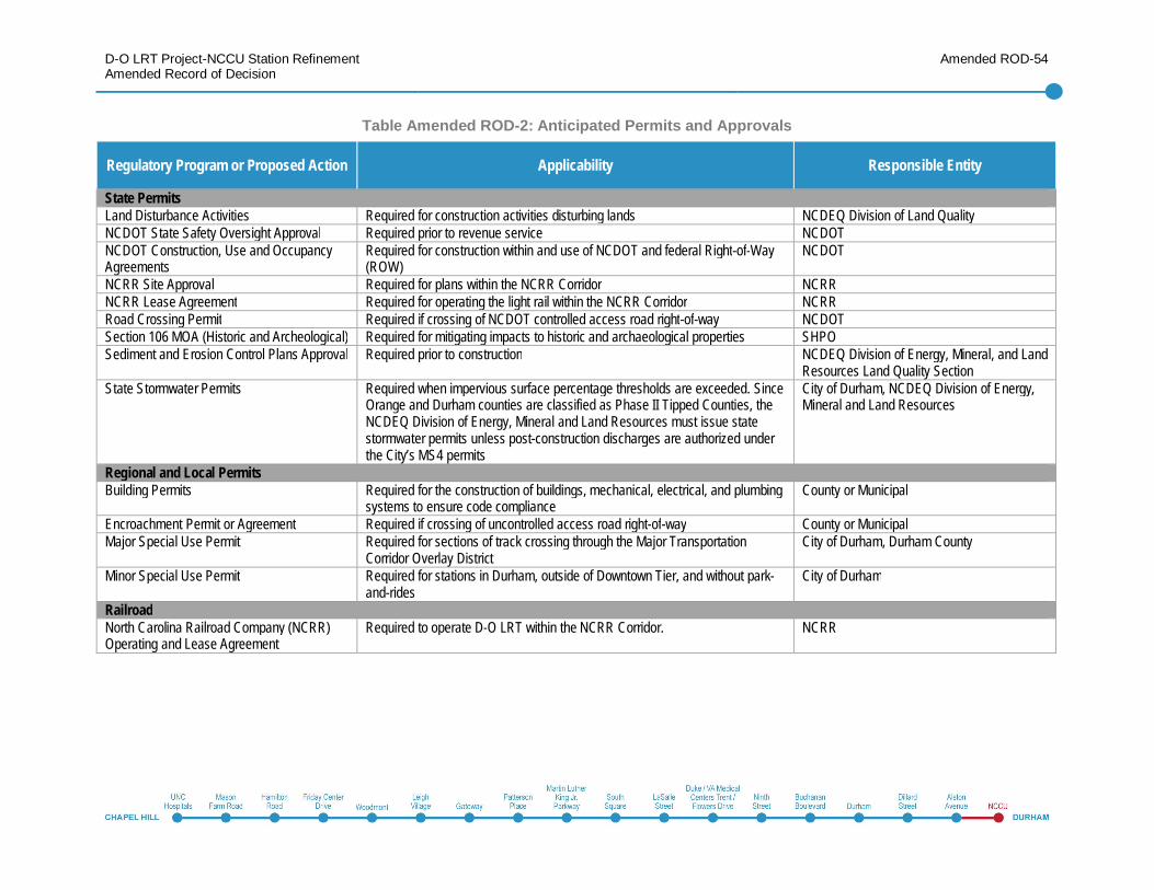
D-O LRT Project-NCCU Station RefinementAmended Record of Decision
Amended ROD-54
Table Amended ROD-2: Anticipated Permits and Approvals
Regulatory Program or Proposed Action Applicability Responsible Entity
State PermitsLand Disturbance Activities Required for construction activities disturbing lands NCDEQ Division of Land QualityNCDOT State Safety Oversight Approval Required prior to revenue service NCDOTNCDOT Construction, Use and OccupancyAgreements
Required for construction within and use of NCDOT and federal Right-of-Way(ROW)
NCDOT
NCRR Site Approval Required for plans within the NCRR Corridor NCRRNCRR Lease Agreement Required for operating the light rail within the NCRR Corridor NCRRRoad Crossing Permit Required if crossing of NCDOT controlled access road right-of-way NCDOTSection 106 MOA (Historic and Archeological) Required for mitigating impacts to historic and archaeological properties SHPOSediment and Erosion Control Plans Approval Required prior to construction NCDEQ Division of Energy, Mineral, and Land
Resources Land Quality SectionState Stormwater Permits Required when impervious surface percentage thresholds are exceeded. Since
Orange and Durham counties are classified as Phase II Tipped Counties, theNCDEQ Division of Energy, Mineral and Land Resources must issue statestormwater permits unless post-construction discharges are authorized underthe City’s MS4 permits
City of Durham, NCDEQ Division of Energy,Mineral and Land Resources
Regional and Local PermitsBuilding Permits Required for the construction of buildings, mechanical, electrical, and plumbing
systems to ensure code complianceCounty or Municipal
Encroachment Permit or Agreement Required if crossing of uncontrolled access road right-of-way County or MunicipalMajor Special Use Permit Required for sections of track crossing through the Major Transportation
Corridor Overlay DistrictCity of Durham, Durham County
Minor Special Use Permit Required for stations in Durham, outside of Downtown Tier, and without park-and-rides
City of Durham
RailroadNorth Carolina Railroad Company (NCRR)Operating and Lease Agreement
Required to operate D-O LRT within the NCRR Corridor. NCRR
D-O LRT Project-NCCU Station RefinementAmended Record of Decision
Amended ROD-55
1.6 Public Outreach andOpportunities toComment
For GoTriangle, education, inclusion,transparency, accountability andresponsiveness have been key principles ofthe planning process for transit service in theD-O Corridor from before the AA wascompleted in 2012 through the ongoingNEPA and project development process.
The public has been engaged through:
Public meetings and community groupmeetings
Project newsletters and emaildistribution lists
Project website
Interaction with community organizations
Informational materials at all publicmeetings, including presentation materials,handouts, and comment sheets, have beenavailable in Spanish as well as English, anda Spanish-speaking staff member has beenpresent at all meetings.
In September 2016 GoTriangle beganengaging property owners and tenantswithin the study area for the NCCU StationRefinement. Four community meetings wereheld in September (on the 23rd and 24th) andOctober (on the 6th and the 7th) 2016 toprovide an opportunity to learn about the
NCCU Station Refinement, with meetingnotices being mailed to all property ownersand tenants. The Supplemental EA wasreleased for a 30-day Public Commentperiod on November 7, 2016. The commentperiod ran until December 7, 2016. Twopublic meetings were held during thecomment period on November 12 and 17,2016. These meetings targeted potentiallyinterested and affected parties of the NCCUStation Refinement. Property owners andtenants within a quarter-mile area aroundthe Alston Avenue Station area, thealignment along Alston Avenue to NCCU,and the NCCU station area were contactedvia letter. Interested parties were notified viatwo public legal notices; one on November 7in the Durham Herald Sun and one onNovember 9 in the News and Observer, aswell as with a press release reminder onNovember 15.
1.7 Determinations andFindings RegardingOther Laws
1.7.1 Section 106 of theNational HistoricPreservation Act
Any federal agency whose project, funding,or permit may affect a historic property, boththose listed or eligible for inclusion inthe NRHP, must consider the effects onhistoric properties and "seek ways to avoid,
minimize or mitigate" any adverse effects onhistoric properties.
Architectural Historic ResourcesApplicable laws addressing historicproperties include Section 106 of theNational Historic Preservation Act (NHPA)(54 United States Code [U.S.C.] § 306108and implemented in 36 C.F.R. Part 800) andSection 110 of the NHPA (54 U.S.C. §§306101-306114). Both laws require federalagencies to consider the potential effects ofa proposed federally funded project, alsoreferred to as an undertaking, on historicproperties.
The Durham Water Tower and Valve House(DH-3508), previously identified in studiesfor the D-O LRT Project as eligible for theNRHP, falls within the Area of PotentialEffect (APE) and was considered during thehistoric resources survey for the NCCUStation Refinement. The Durham WaterTower and Valve House, located at 1318East Pettigrew Street, was erected in 1939.It was determined eligible for NRHP listing in2015 by FTA under Criterion A for itsassociation with the local activities of theFederal Emergency Administration of PublicWorks, which funded it, and Criterion C asan excellent and unusually large example ofa 1930s-era water tower. The NRHP-eligibleboundaries include the fenced 0.4-acre areaencompassing the Water Tower and ValveHouse, which retains its integrity.
The NCCU Station Refinement would addan eight-story parking structure on the
D-O LRT Project-NCCU Station RefinementAmended Record of Decision
Amended ROD-56
GoTriangle-owned property immediatelywest of the Durham Water Tower’s NRHP-eligible boundary. The structure would riseno more than 60 feet above PettigrewStreet.
The tower and the NCCU StationRefinement are within an urban settingcharacterized by industrial andtransportation-related buildings and smallsingle-family residences. At 156 feet tall, thewater tower would remain the dominantvisual feature of the surrounding area.
The design of the parking deck will includeno stairwells, elevator towers, or otherstructures that rise above the 60-foot heightof the garage parapet on the eastern half ofthe structure. This would minimize visualeffects on the Water Tower. Therefore, FTAhas made a determination, in consultationwith the State Historic Preservation Officer(SHPO) that the parking structure wouldresult in no adverse effect on the DurhamWater Tower and Valve House.
The Russell Memorial CME Church islocated at 703 South Alston Avenue inDurham. The church was built around 1952and is located on the eastern side of AlstonAvenue within the APE that was consideredin studies supporting the Supplemental EAfor the NCCU Station Refinement. Thechurch is essentially a straightforward,cross-gabled building of brick construction.Its solid appearance, numerous roundedarches, relatively tall front and verticalprojection are believed to embody the
distinctive characteristics of theRomanesque Revival style. The EligibilityReport prepared in support of theSupplemental EA recommended that thechurch was not eligible for the NRHP.
Based on comments from and coordinationwith the SHPO on the Section 106 EligibilityReport, the Russell Memorial CME Churchhas been identified as eligible for listing onthe NRHP. Russell Memorial is believed tobe NRHP-eligible under Criterion C as asignificant and largely intact example of anAfrican-American, Romanesque Revival-style church in Durham. The recommendedNRHP-eligible boundaries of RussellMemorial CME Church are those of its twolots. They include the church and the formerparsonage, which is recommended as acontributing building. The boundaries ofthese lots, as currently shown on tax maps,extend on the west to a retaining wall andsteps in front of the church, but not to thesidewalk and South Alston Avenue and itsright-of-way. On the east they also extend toa retaining wall and not beyond to thesidewalk or to Ridgeway Avenue and itsright-of-way.
The transportation improvements associatedwith the NCCU Station Refinement wouldinclude continued provision for automobile,bicycle, and pedestrian traffic in front of thechurch and would introduce light rail to theenvironment. This transportation focus infront of the church is consistent with the
historic transportation uses provided in frontof the church in the past.
The NCCU Station Refinement would maketransportation improvements in front of thechurch, but the construction limits of theproposed improvements would not extendinto the NRHP-eligible boundary of thechurch property. For this reason, the projectwould have no adverse effect on the RussellMemorial CME Church.
The NCCU Station Refinement would haveno adverse effect on any historic propertieswithin the APE.
Archaeological ResourcesArchaeological site location information isconfidential information under North CarolinaGeneral Statute 70-18 and not intended forpublic display or public viewing.
Given the urbanized landscape, previouslydisturbed nature of the APE, and age of thehistoric occupation in the area, it isanticipated that no significant archaeologicalresources are present and impacts toarchaeological resources from the NCCUStation Refinement would be non-existent orminimal.
FTA has made a determination inconsultation with the SHPO that noadditional Phase I survey is necessary withinthe NCCU Station Refinement area.
FTA, GoTriangle, and SHPO entered into aMemorandum of Agreement (MOA) for theD-O LRT Project to establish the procedures
D-O LRT Project-NCCU Station RefinementAmended Record of Decision
Amended ROD-57
by which FTA, GoTriangle, and SHPO willwork together to ensure the effectiveprotection of historic and/or archaeologicalresources during the implementation andconstruction of the D-O LRT Project. FTA,GoTriangle, and SHPO agree that the D-OLRT Project shall be implemented inaccordance with the stipulations outlined inthe MOA. The stipulations outlined in theMOA are applicable to the D-O LRT Project,including the NCCU Station Refinement.
1.7.2 Section 4(f)Section 4(f) of the U.S. Department ofTransportation Act of 1966, 49 U.S.C. § 303and 23 U.S.C. § 138, is a federal law thatprotects publicly owned parks, recreationareas, wildlife and/or waterfowl refuges, andsignificant historic sites, whether publicly orprivately owned. Section 4(f) requirementsapply to all transportation projects thatrequire funding or other approvals by theU.S. Department of Transportation(USDOT). As a USDOT agency, FTA mustcomply with Section 4(f). FTA’s Section 4(f)implementing regulations are at 23 C.F.R.Part 774.
FTA cannot approve a transportation projectthat uses a Section 4(f) property, as definedin 23 C.F.R. § 774.17, unless FTAdetermines that:
There is no feasible and prudentavoidance alternative, as defined in 23C.F.R. § 774.17, to the use of land fromthe Section 4(f) property, and the action
includes all possible planning, as definedin 23 C.F.R. § 774.14, to minimize harmto the property resulting from such use(23 C.F.R. § 774.3(a)) or
The use of the Section 4(f) property,including any measure(s) to minimizeharm (such as any avoidance,minimization, mitigation, orenhancement measures) committed toby the applicant will have a de minimisuse, as defined in 23 C.F.R. § 774.17,on the property (23 C.F.R. § 774.3(b)).
Section 4(f) applies to the use of protectedproperty for transportation purposes. Usecan occur as a result of direct impact fromconstruction or impacts from adjacency thatresult in a constructive use. Section 4(f) hasno further applicability where there is no useof property.
As described in the Section 4(f) Evaluationin chapter 4 of the Supplemental EA, there isan existing bicycle and pedestrian path thatconnects with the R. Kelly Bryant Jr.Pedestrian Bridge located on the east sideof Alston Avenue, south of the plannedparking garage property owned byGoTriangle. There are no other publicly-owned park, recreation, or wildlife orwaterfowl refuges within 250 feet of theNCCU Station Refinement that meet thecriteria for protection as a Section 4(f)property.
No temporary or permanent easements orproperty acquisition would be required from
this property and therefore, there would beno direct use of the property. All constructionwould be confined to the GoTriangle-ownedproposed parking garage property. Accesswould be maintained and the userexperience would not be substantiallyimpaired by noise, visual, or other effects.Since there are no proximity effects, noconstructive use of the resource wouldoccur.
There are two Section 4(f) historic propertiesin the Area of Potential Effects of the NCCUStation Refinement: the Durham WaterTower and Valve House, and the RussellMemorial CME Church.
The Durham Water Tower and Valve House,located at 1318 East Pettigrew Street wasdetermined eligible for National Register ofHistoric Places (NRHP) listing in 2015 byFTA under Criterion A and Criterion C, whichqualifies it for protection under Section 4(f).
The NCCU Station Refinement would notrequire the acquisition of property or anyeasements within the NRHP-eligibleboundary of the water tower. FTA, inconjunction with SHPO determined that theNCCU Station Refinement would notsubstantially impact the eligibility criteria forlisting the Durham Water Tower and ValveHouse on the NRHP that qualify the propertyfor Section 4(f) protection. Therefore, theNCCU Station Refinement does not create ause of the Durham Water Tower and ValveHouse.
D-O LRT Project-NCCU Station RefinementAmended Record of Decision
Amended ROD-58
The Russell Memorial CME Church, locatedat 703 South Alston Avenue was determinedeligible for National Register of HistoricPlaces (NRHP) listing under Criterion C asdescribed in section 1.6.1, which qualifies itfor protection under Section 4(f).
The NCCU Station Refinement would notrequire the acquisition of property or anypermanent or temporary easements withinthe NRHP-eligible boundary of the RussellMemorial CME Church. FTA, in conjunctionwith SHPO determined that the NCCUStation Refinement would not substantiallyimpact the eligibility criteria for listing theRussell Memorial CME Church on the NRHPthat qualify the property for Section 4(f)protection. Therefore, the NCCU StationRefinement does not create a use of theRussell Memorial CME Church.
As described above, the NCCU StationRefinement will not require any temporary orpermanent land from any of the propertiesthat qualify as Section 4(f) properties.Consequently, the NCCU StationRefinement would not result in a use of anySection 4(f) property.
The NCCU Station Refinement would notrequire temporary or permanent easementsor property acquisition from any propertiesand therefore, there would be no direct use.Further, no constructive use of resourceswould occur for the NCCU StationRefinement.
1.7.3 Environmental JusticeThe environmental documentation for theD-O LRT Project-NCCU Station Refinementwas prepared in accordance with ExecutiveOrder (EO) 12898; DOT Order 5610.2(a);and FTA Circular 4703.1 and Title VI of theCivil Rights Act of 1964, 42 U.S.C. § 2000d(Title VI). The general methodology foraddressing EO 12898 involves:
Identifying the environmental justice (EJ)populations within the study area
Providing information on the efforts thatGoTriangle made to involve minority andlow-income populations in the study area
Assessing whether the projectalternatives would result indisproportionately high and adverseeffects on EJ populations, taking intoconsideration minimization, mitigation,and enhancement measures and projectbenefits, as appropriate
Chapter 5 of the Supplemental EA notes theevaluation areas, study area, and countiesand indicates percentages of minority andlow-income populations. Of the 84 blockgroups in the study area, 37 (44 percent)have higher concentrations of EJpopulations than the county averages.
Outreach to EJ PopulationsGoTriangle has conducted a robust publicoutreach program with an emphasis oninteraction and communication with EJ
populations as a key element of the D-OLRT Project and NCCU Station Refinement.The engagement of local residents, businessowners, and other stakeholders began withscoping (2012) and is on-going. Theoutreach program was conducted inaccordance with the D-O LRT Project PublicInvolvement Plan, EO 12898, and guidingprinciples contained in FTA Circular 4703.1.
Outreach efforts were described in detail inchapter 6 of the Supplemental EA.
Assessment of DisproportionatelyHigh and Adverse EffectsIn East Durham, where the NCCU StationRefinement would be constructed, 93percent of the population is minority and 64percent is living below the poverty level (low-income defined as being at or below 150percent of the poverty line). It is to beexpected that effects of the project would beexperienced by EJ populations. The adverseeffects of the project would be distributedproportionately between EJ and non-EJareas, when looking at the NCCU StationRefinement with the entire project. Theproposed D-O LRT Project and the NCCUStation Refinement would provide anadditional and affordable option for travel inthe D-O Corridor. Light rail service to theNCCU campus would provide greateraccess to a major educational institution andother destinations within the corridor.Increased travel reliability and time-savingare further benefits of the project. The mainbenefits of the D-O LRT Project and the
D-O LRT Project-NCCU Station RefinementAmended Record of Decision
Amended ROD-59
NCCU Station Refinement include thefollowing:
Employment opportunities due toconstruction and the potentialredevelopment/developmentopportunities in the areas surroundingstations, which would result in positiveeconomic gains in the form of increasedwages and spending
Competitive advantages for existing andfuture businesses located along thecorridor due to the additionaltransportation capacity and accessibilityfor customers
Improved pedestrian and bicycleenhancements, connections, and access
Faster transit service
More reliable, more frequent, and highercapacity service for transit riders
Improved mobility through the projectvicinity
Improved connections to existing transitas well as to employment, education,shopping, medical services, recreation,and cultural opportunities
Opportunities for improved overall healthof the users of the D-O LRT Project andthe NCCU Station Refinement byincreasing opportunities to walk and biketo stations and surrounding areas alongthe corridor
While these benefits are distributed, theywould be experienced to a higher degree byminority and low-income populations withinthe D-O Corridor and the NCCU StationRefinement area due to a higher reliance ontransit.
While EJ populations would experiencesome direct effects related to the project, theEJ populations in the NCCU StationRefinement area would also benefit from theproject.
Taking all factors into account, the projectwould not have “disproportionately high andadverse effects” on EJ populations.Mitigation measures identified wouldaddress impacts from light rail operationsand construction activities that may affect EJpopulations. Nonetheless, GoTrianglerecognizes that some of the specific impactsof the NCCU Station Refinement mayadversely affect EJ populations, particularlywith regards to potential displacements.GoTriangle is committed to working with allaffected residents to ensure that they arecompensated in accordance with provisionsof the Uniform Relocation Assistance andReal Property Acquisition Policies Act.GoTriangle will continue to provide outreachto EJ communities to implement themitigation strategies effectively.
1.8 ConclusionThe environmental record for this decisionincludes the following documents:
D-O LRT Project DEIS
D-O LRT Project CombinedFEIS/Section 4(f) Determination/ROD
D-O LRT Project-NCCU StationRefinement Supplemental EA
All technical reports, white papers, TitleVI analysis, and supportingdocumentation incorporated byreference into the DEIS, CombinedFEIS/ROD, and Supplemental EA
These documents, incorporated herein byreference, constitute the statements requiredby NEPA and Title 23 of the United StatesCode on:
The environmental impacts of the project
The adverse environmental effects thatcannot be avoided should the project beimplemented
Alternatives to the proposed project
Irreversible and irretrievable impacts onthe environment that may be involvedwith the project should it be implemented
Having carefully considered theenvironmental record noted above, themitigation measures as required herein, thewritten and oral comments offered byagencies and the public on this record andthe written responses to the comments, FTAmakes a Finding of No Significant Impactwith respect to inclusion of the NCCUStation Refinement in the D-O LRT Project
D-O LRT Project-NCCU Station RefinementAmended Record of Decision
Amended ROD-60
and finds that a supplemental environmentalimpact statement is not necessary.
FTA finds that all practicable measures tominimize environmental harm have beenincorporated into the design of the NCCUStation Refinement and will ensure that thecommitments outlined herein will beimplemented as part of final design,construction contract, and post-constructionmonitoring. FTA also determines that thisdecision is in the best overall public interest.