disaster management policy in japan - ijbg than 20% of earthquake with m6 or greater in the world...
TRANSCRIPT

Disaster Management Policy in Japan
Sep. 17, 2009Cabinet Office of Japan

Typhoon Ise-Wan(5,098)
Great Hanshin-Awaji Earthquake(6,437)
The number of Death and Missing Persons in Natural Disasters
Mikawa Earthquake(2,306)、Typhoon Makurazaki(3,756)
Fukui Earthquake(3,769)
Torrential Rains(1,124)
Typhoon Toyamaru(1,761)
year
People
19451947 1949 1951 1953 1955 1957 1959 1961 1963 1965 1967 1969 1971 1973 1975 1977 1979 1981 1983 1985 1987
19891991 1993 1995 1997 1999 2001 2003 2005
2007

More than 20% of Earthquake with M6 or greater in the world occurred around Japan last 30 years.
World Geographical Distribution of Hypocenters and Plates

Large-scale Earthquake predicted in the future
Distribution of active faults in Japan
The Headquarters for Earthquake research Promotion of Government evaluated main faults. They have made result of evaluation of activity about 104 faults public.
There are Approx. 2,000 discovered active faults
Tokai Earthquake
Nankai Trough
Japa
n Tr
ench
Chisim
a Trench
The Earthquake with a possibility of being predicted just before it occurs
Wide area Earthquake disaster on Western Japan
There is a high possibility of Great earthquake occurringThe Earthquake with a possibility of being predicted just before it occurs
It is anticipated that wide area earthquake will occur in the first half of this century.
8 types of Earthquakes like The Miyagi- ken-oki Earthquake with a imminent possibility to occur
Tonankai and NankaiEarthquake
A Giant Tsunami over 20m
Trench-type Earthquake in the Vicinity of the Japan and ChisimaTrenches
Chubu area and Kinki area inland Earthquake
It is an earthquake which is anticipated that it devastate capital function.An M7 scale earthquake with an imminent possibility
Tokyo inland Earthquake
It is anticipated that a earthquake devastate old wooden urban district and cultural heritage.
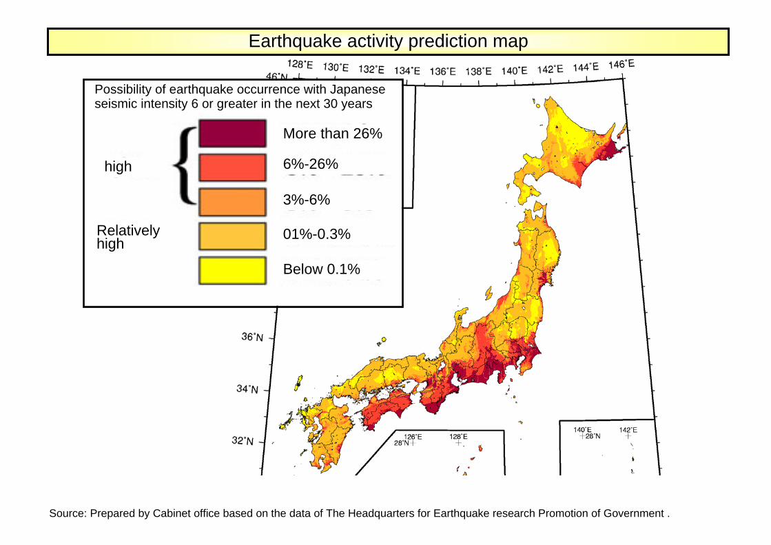
Earthquake activity prediction map
Possibility of earthquake occurrence with Japanese seismic intensity 6 or greater in the next 30 years
high
Relatively high
More than 26%
6%-26%
3%-6%
01%-0.3%
Below 0.1%
Source: Prepared by Cabinet office based on the data of The Headquarters for Earthquake research Promotion of Government .
(Maginified image of the capital area)
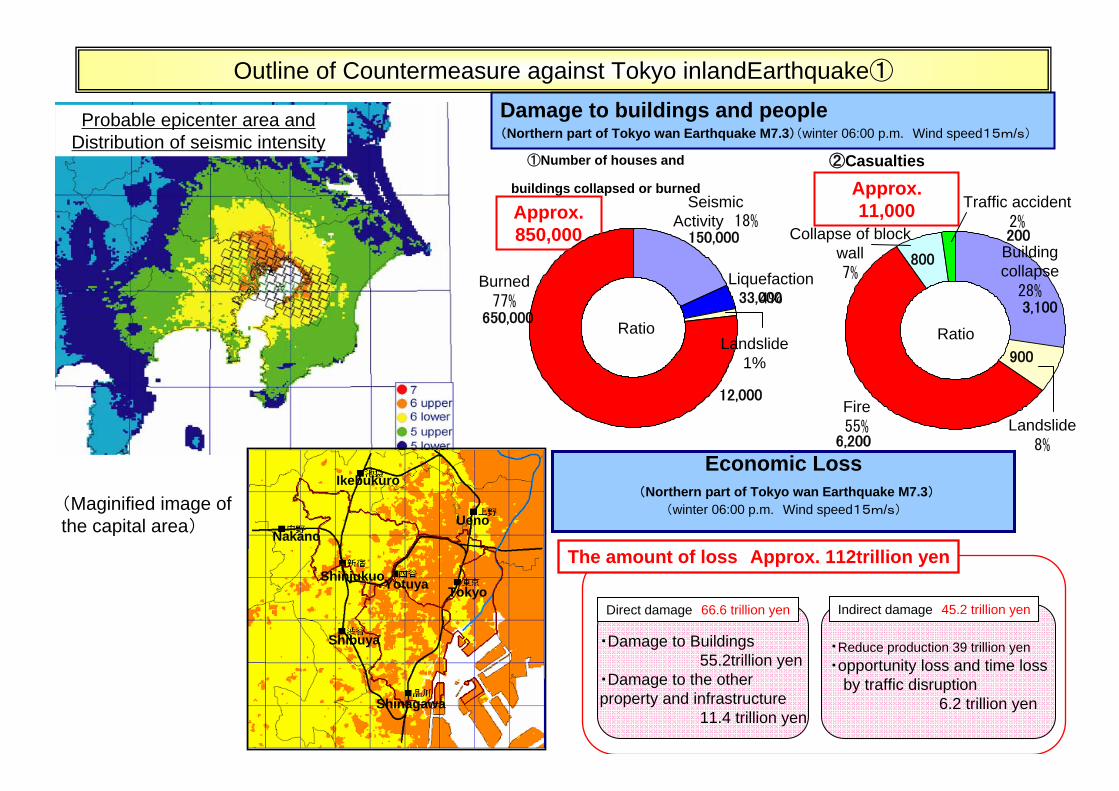
Seismic Activity 18%
Burned77%
Ratio
150,000
650,000
Building collapse
28%
Landslide8%
Fire55%
3,100
900
6,200
Ratio
Collapse of block wall7%
800
Traffic accident2%200
①Number of houses and
buildings collapsed or burned
②Casualties
Damage to buildings and people(Northern part of Tokyo wan Earthquake M7.3)(winter 06:00 p.m. Wind speed15m/s)
33,000Liquefaction
4%
12,000
Landslide 1%
Economic Loss(Northern part of Tokyo wan Earthquake M7.3)
(winter 06:00 p.m. Wind speed15m/s)
Approx. 850,000
Approx. 11,000
Probable epicenter area and Distribution of seismic intensity
Outline of Countermeasure against Tokyo inlandEarthquake①
・Reduce production 39 trillion yen・opportunity loss and time loss
by traffic disruption6.2 trillion yen
・Damage to Buildings55.2trillion yen
・Damage to the other property and infrastructure
11.4 trillion yen
Direct damage 66.6 trillion yen Indirect damage 45.2 trillion yen
The amount of loss Approx. 112trillion yenNakano
Yotuya
Shibuya
Shinjukuo
Ikebukuro
Ueno
Tokyo
Shinagawa

Secure the continuity of the capital functions
Countermeasure to reduce massive damage~Forming City ~
Countermeasure and goals keeping 3days after disasiter occurrence in mind
Planned and prompt precausion
Countermeasure against the foreseeable massive number of evacuees and people stranded without a means of returning home
Enforcement of disaster reduction by region and company
Establishment of wide-area disaster reduction system
Measure of recovery and rehabilitation
Policy Framework for Tokyo Inland Earthquake
Specified roles of each ministry
Development Development of citizen of citizen
movementmovement(Public-help efforts, self-help efforts and mutual-help efforts)
All the society work on
Activity system of Government
Activity for securing the continuity of the capital central functions
Main emergency response activities
Guidelines for Tokyo Inland Earthquake Emergency Response Activity
Establishment of Emergency disaster management headquarter and Emergency on-site disaster management headquarter
Keeping functions of the capital central agency
Seach, rescue, medical operation, fire fighting and emergency transportation
Tokyo Inland Earthquake Disaster strategy
To halve the death toll and to reduce economicloss by 40% in 10 years. (~2016)
Casualties Approx. 11,000 → 5,600
Economic loss Approx. 112trillion yen → 70trillion yen
Earthquake-proofing of houses and buildings :Quake-proof ratio 75%→90%
Improve densely populated urban area:Fire-proofing ratio over 40%
Improve initial fire extinguish ratio:community ratio with voluntary disaster management organization 72.5%→96%
Fix household furniture:Fixation ratio Approx. 30%→60%
Measures for steep terrain of landslide risk area:No. of house safe from landslides in steep terrain increase by approx. 30%
Recovery cost reduction measures:
Business continuity of companies:Ratio of companies with business continuity plansLarge company : mostly all Medium-sized company over 50%
Measures for restoring transportation networks quickly:
・Quake-proof houses and buildings ratio 75%→90%・Anti-seismic reinforcement of direct control road facilities: mostly completed・improve quake-proof quays: Approx. 55%→70%
・ Quake-proof ratio 75%→90%・ Anti-seismic reinforcement of emergency transportation road facilities:
mostly completed ・ improve quake-proof quays: Approx. 55%→70%
Outline of Countermeasure against Tokyo inlandEarthquake ②
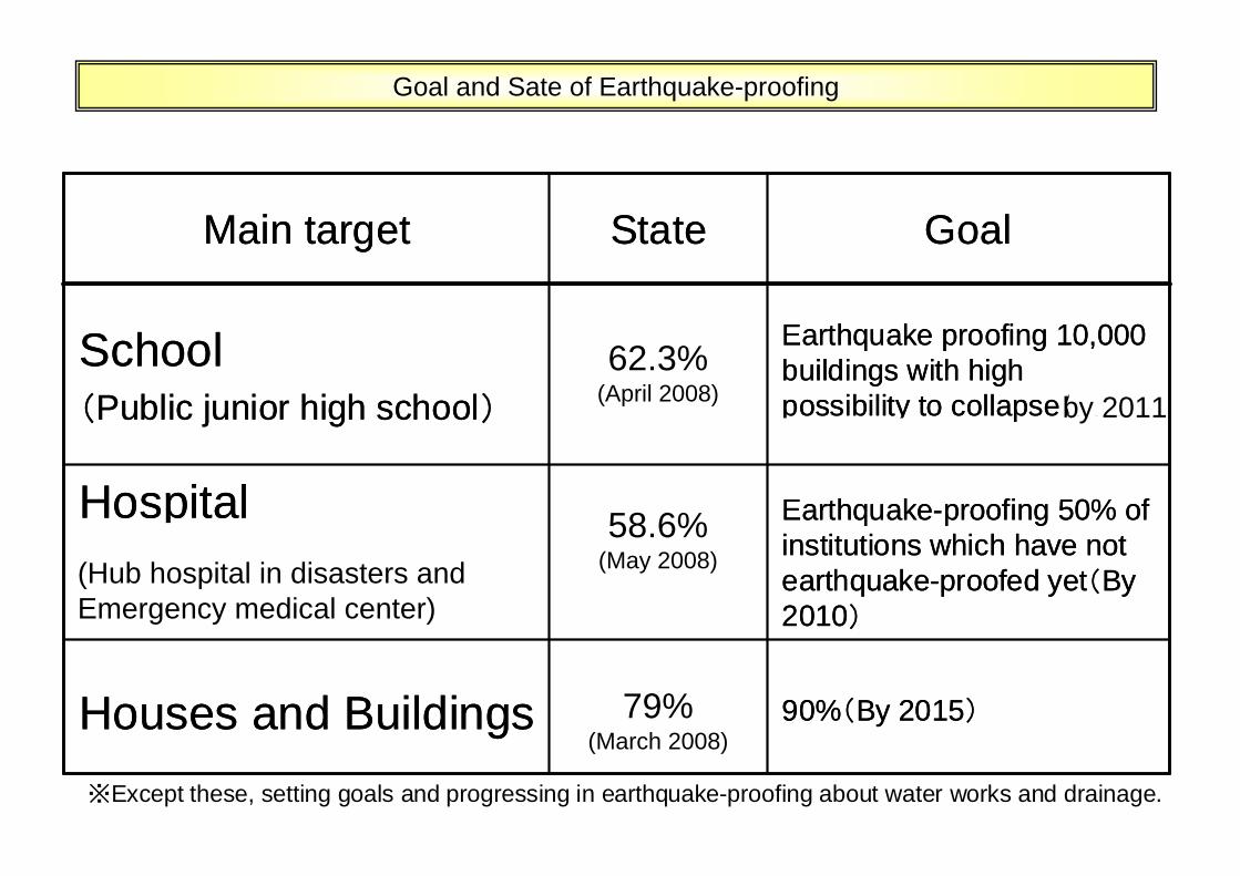
Goal and Sate of Earthquake-proofing
※Except these, setting goals and progressing in earthquake-proofing about water works and drainage.
Main target State Goal
School(Public junior high school)
58.6%(April 2007)
Earthquake proofing 10,000 buildings with high possibility to collapse(In the next 5 years)
Hospital(Stronghold hospital in disasters and emergency medical center)
43%(2005)
Earthquake-proofing 50% of institutions which have not earthquake-proofed yet(By 2010)
Houses and Buildings 75%(2003)
90%(By 2015)
62.3% (April 2008) by 2011
58.6% (May 2008)
79% (March 2008)
(Hub hospital in disasters and Emergency medical center)
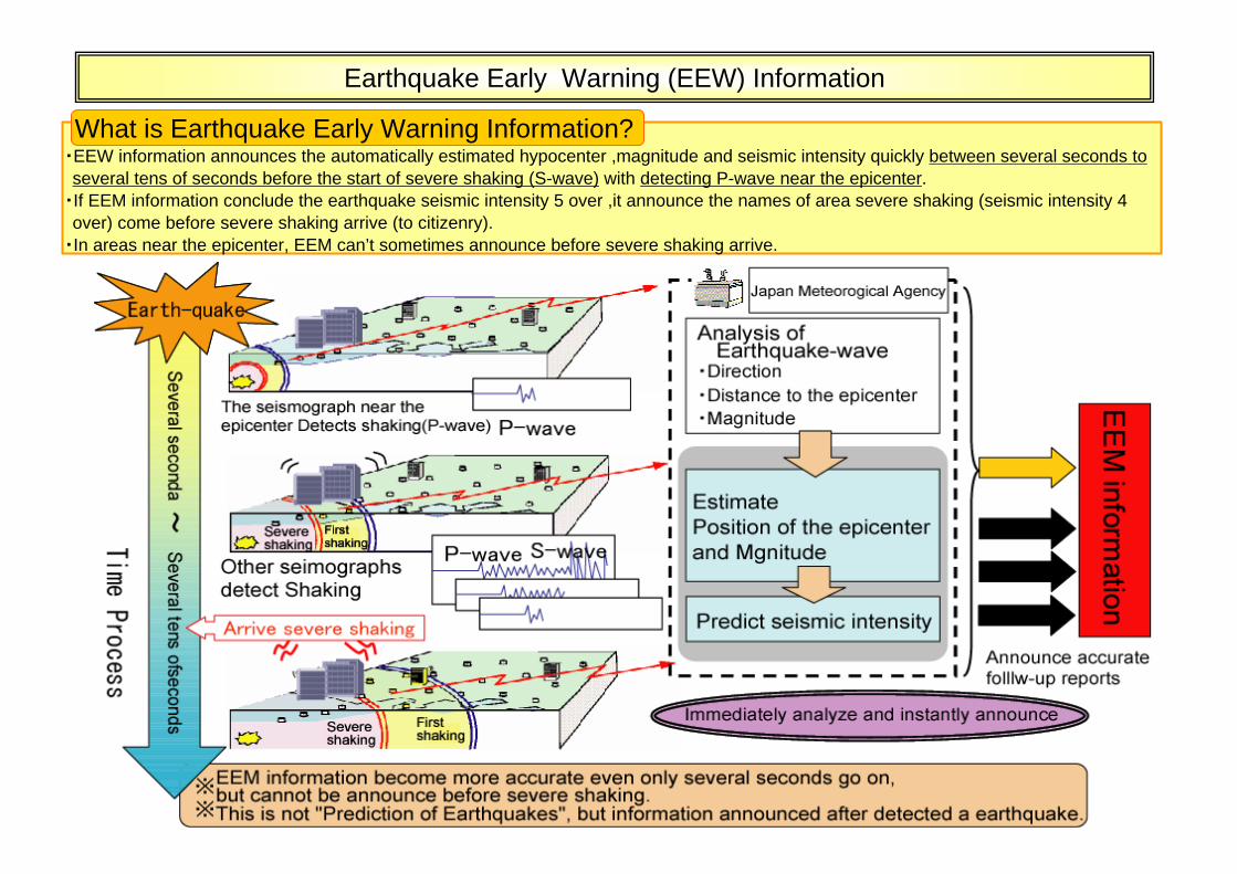
・EEW information announces the automatically estimated hypocenter ,magnitude and seismic intensity quickly between several seconds to several tens of seconds before the start of severe shaking (S-wave) with detecting P-wave near the epicenter.
・If EEM information conclude the earthquake seismic intensity 5 over ,it announce the names of area severe shaking (seismic intensity 4 over) come before severe shaking arrive (to citizenry).
・In areas near the epicenter, EEM can’t sometimes announce before severe shaking arrive.
What is Earthquake Early Warning Information?
Earthquake Early Warning (EEW) Information
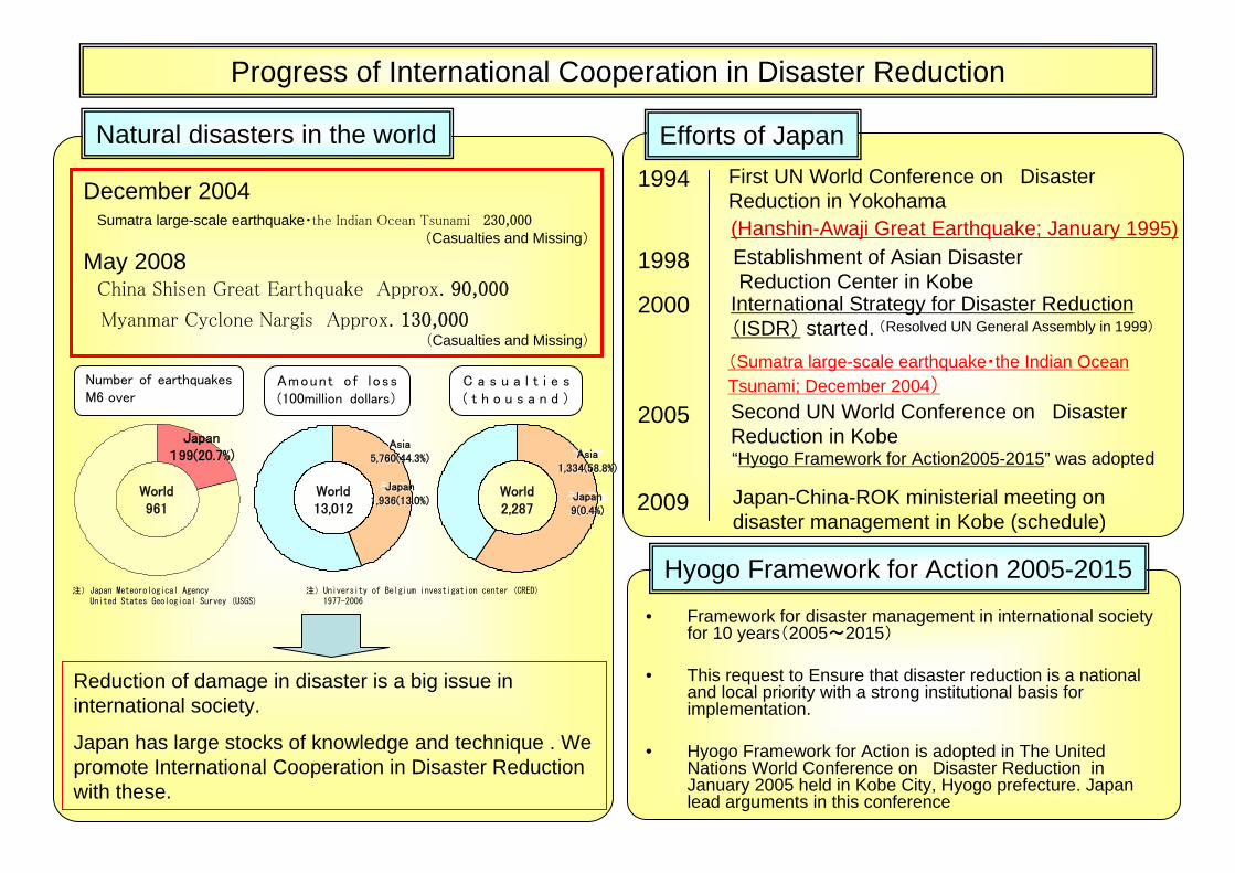
Progress of International Cooperation in Disaster Reduction
2000
1994
1998
International Strategy for Disaster Reduction(ISDR) started. (Resolved UN General Assembly in 1999)
First UN World Conference on Disaster Reduction in Yokohama
Establishment of Asian DisasterReduction Center in Kobe
(Hanshin-Awaji Great Earthquake; January 1995)
2005 Second UN World Conference on Disaster Reduction in Kobe
(Sumatra large-scale earthquake・the Indian Ocean Tsunami; December 2004)
“Hyogo Framework for Action2005-2015” was adopted
Efforts of JapanNatural disasters in the world
Amount of loss(100million dollars)
C a s u a l t i e s( t h o u s a n d )
Hyogo Framework for Action 2005-2015
World2,287
アジア1,334(58.8%)
うち日本9(0.4%)
アジア5,760(44.3%)
うち日本1,936(13.0%)
World13,012
World961
Japan199(20.7%)
注)Japan Meteorological Agency 注)University of Belgium investigation center (CRED)United States Geological Survey (USGS) 1977-2006
Number of earthquakes M6 over
• Framework for disaster management in international society for 10 years(2005~2015)
• This request to Ensure that disaster reduction is a national and local priority with a strong institutional basis for implementation.
• Hyogo Framework for Action is adopted in The United Nations World Conference on Disaster Reduction in January 2005 held in Kobe City, Hyogo prefecture. Japan lead arguments in this conference
Asia1,334(58.8%)
Japan9(0.4%)
Asia5,760(44.3%)
Japan1,936(13.0%)
December 2004Sumatra large-scale earthquake・the Indian Ocean Tsunami 230,000
(Casualties and Missing)
May 2008China Shisen Great Earthquake Approx. 90,000
Myanmar Cyclone Nargis Approx. 130,000(Casualties and Missing)
Reduction of damage in disaster is a big issue in international society.
Japan has large stocks of knowledge and technique . We promote International Cooperation in Disaster Reduction with these.
2009 Japan-China-ROK ministerial meeting on disaster management in Kobe (schedule)
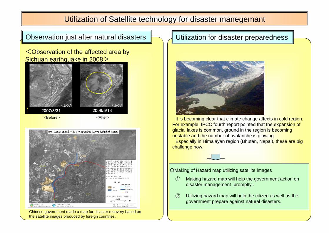
Utilization of Satellite technology for disaster manegemant
Utilization for disaster preparednessObservation just after natural disasters
<Observation of the affected area by Sichuan earthquake in 2008>
Chinese government made a map for disaster recovery based on the satellite images produced by foreign countries.
<Before> <After> It is becoming clear that climate change affects in cold region.For example, IPCC fourth report pointed that the expansion of glacial lakes is common, ground in the region is becoming unstable and the number of avalanche is glowing.
Especially in Himalayan region (Bhutan, Nepal), these are big challenge now.
○Making of Hazard map utilizing satellite images
① Making hazard map will help the government action on disaster management promptly .
② Utilizing hazard map will help the citizen as well as the government prepare against natural disasters.

La ringrazio per la Sua cortese attenzione!
ご清聴ありがとうございました。