digital parcel data in texas - amazon web services · digital parcel data in texas - study - report...
TRANSCRIPT
Digital Parcel Data in Texas - Study - Report Supplement Page 1 of 23
Empowering People with Spatial Solutions
Digital Parcel Data in Texas
State of Texas - GIS Solutions Group
Report Supplement
April 19, 2017

Digital Parcel Data in Texas - Study - Report Supplement Page 2 of 23
Empowering People with Spatial Solutions
1 Survey of Data Providers 3
2 Survey of State Agencies 8
3 State Program Component Details 13
3.1 North Carolina 13
3.2 Massachusetts 14
3.3 Montana 15
3.4 Virginia 17
3.5 Arkansas 18
3.6 Tennessee 19
3.7 Vermont 21
Digital Parcel Data in Texas - Study - Report Supplement Page 3 of 23
Empowering People with Spatial Solutions
1 Survey of Data Providers
A survey was conducted during November of 2016 to gather information about the status, availability
and benefits of statewide digital parcel data in Texas. The following is a summary list of the questions
that were asked, followed by pie charts or bar charts showing the distribution of responses for the 174
participants in the survey.
1. Does your district have digital (GIS) parcel data?
2. Please select the primary resource or tool used by your appraisal district to share parcel or
appraisal data with the public.
3. How is your digital (GIS) parcel data maintained?
4. What percentage of the appraisal district's digital (GIS) parcel data is maintained by or
purchased from a 3rd party company/vendor?Is there a flat rate fee for both government
agencies and private companies/vendors?
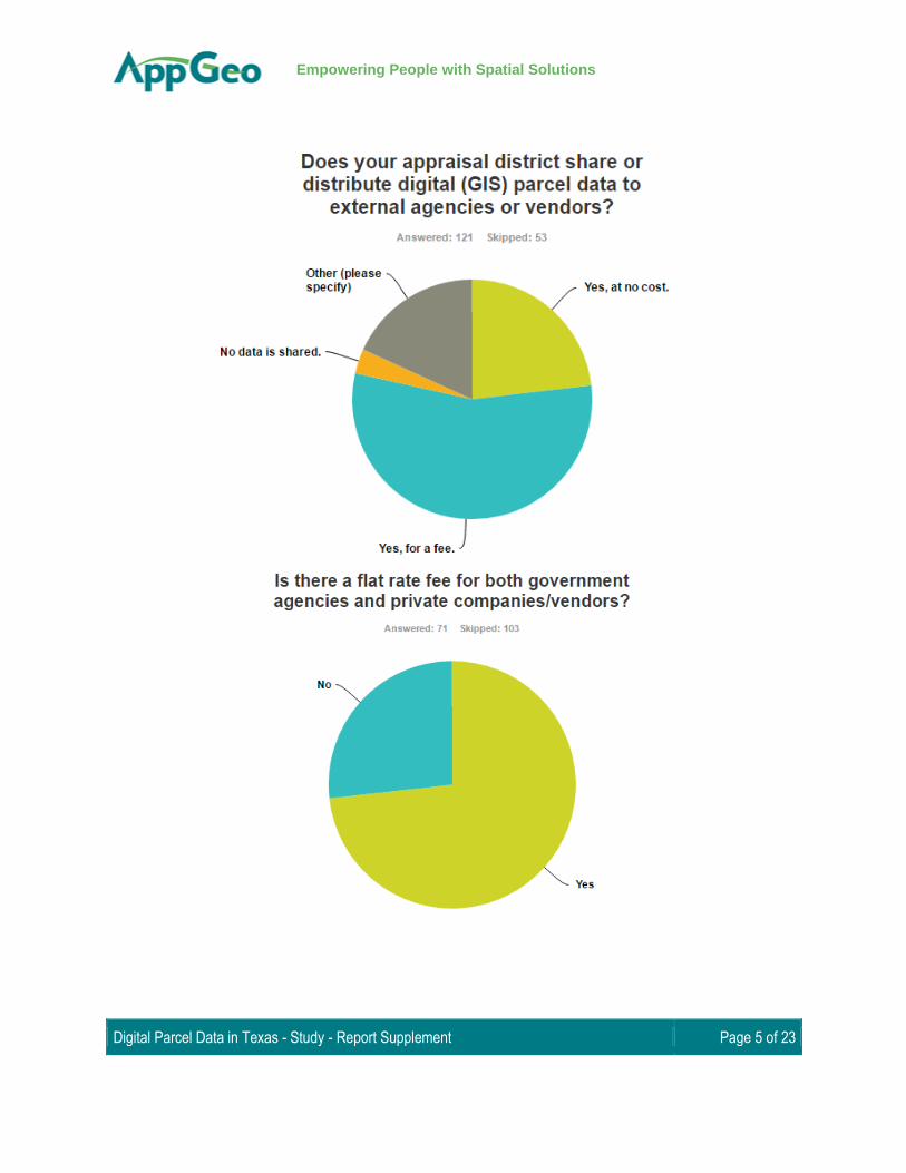
5. Does your appraisal district share or distribute digital (GIS) parcel data to external agencies or
vendors?
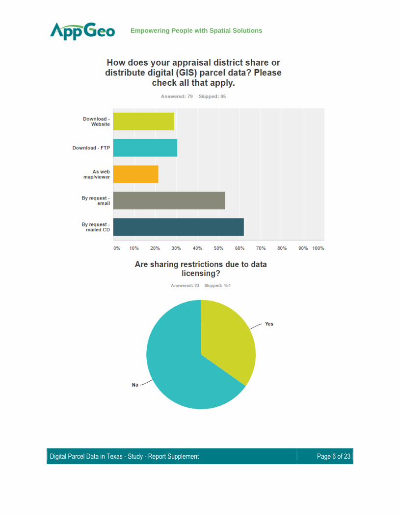
6. How does your appraisal district share or distribute digital (GIS) parcel data? Please check all
that apply.
7. Are sharing restrictions due to data licensing?
8. Would a unified statewide digital parcel data set benefit your county appraisal district in terms
of planning and distribution of information for emergency management? (e.g., times of flooding,
hurricane events, or fire)
9. If the state developed a statewide digital (GIS) parcel data set, could your district supply data to
help build and maintain it?

Digital Parcel Data in Texas - Study - Report Supplement Page 4 of 23
Empowering People with Spatial Solutions
Digital Parcel Data in Texas - Study - Report Supplement Page 5 of 23
Empowering People with Spatial Solutions
Digital Parcel Data in Texas - Study - Report Supplement Page 6 of 23
Empowering People with Spatial Solutions

Digital Parcel Data in Texas - Study - Report Supplement Page 7 of 23
Empowering People with Spatial Solutions
Digital Parcel Data in Texas - Study - Report Supplement Page 8 of 23
Empowering People with Spatial Solutions
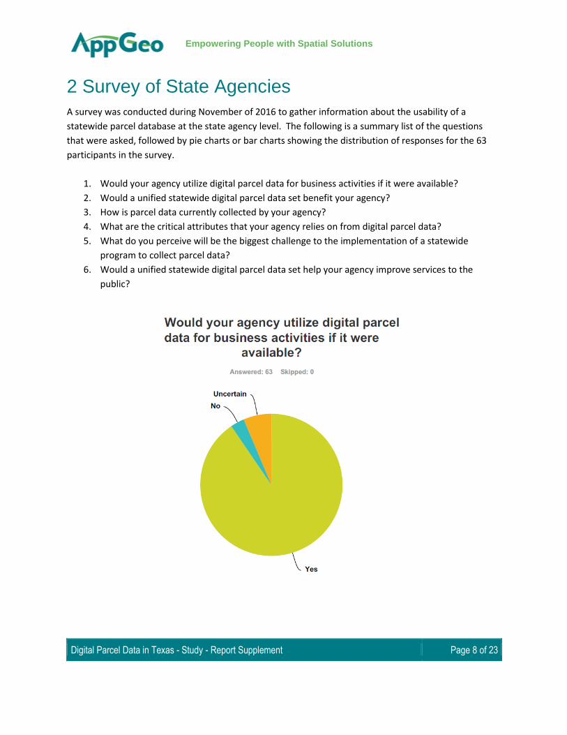
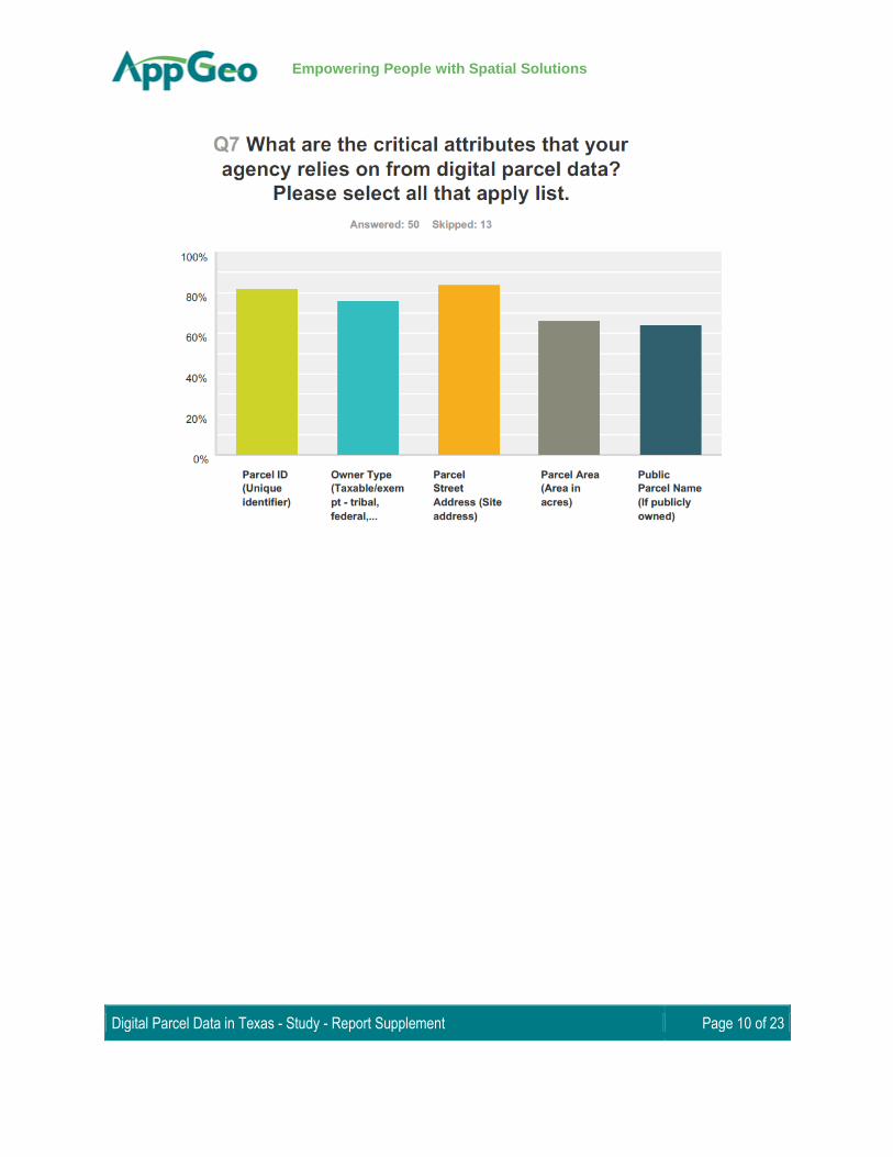
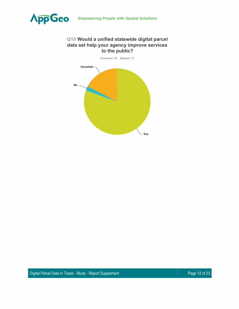
2 Survey of State Agencies
A survey was conducted during November of 2016 to gather information about the usability of a
statewide parcel database at the state agency level. The following is a summary list of the questions
that were asked, followed by pie charts or bar charts showing the distribution of responses for the 63
participants in the survey.
1. Would your agency utilize digital parcel data for business activities if it were available?
2. Would a unified statewide digital parcel data set benefit your agency?
3. How is parcel data currently collected by your agency?
4. What are the critical attributes that your agency relies on from digital parcel data?
5. What do you perceive will be the biggest challenge to the implementation of a statewide
program to collect parcel data?
6. Would a unified statewide digital parcel data set help your agency improve services to the
public?

Digital Parcel Data in Texas - Study - Report Supplement Page 9 of 23
Empowering People with Spatial Solutions
Digital Parcel Data in Texas - Study - Report Supplement Page 10 of 23
Empowering People with Spatial Solutions

Digital Parcel Data in Texas - Study - Report Supplement Page 11 of 23
Empowering People with Spatial Solutions
Digital Parcel Data in Texas - Study - Report Supplement Page 12 of 23
Empowering People with Spatial Solutions

Digital Parcel Data in Texas - Study - Report Supplement Page 13 of 23
Empowering People with Spatial Solutions
3 State Program Component Details
3.1 North Carolina
Business Drivers - A key motivation in North Carolina was to be able to enable multi-county and even
statewide display, mapping, and analysis of parcel data, that supported quick, reliable answers to
questions from the General Assembly and other officials about statewide property information. The
approach taken enabled the state to solve the problem of inefficient and duplicative parcel data
collection and processing by state agencies in support of transportation, agriculture, commerce,
emergency management, and environmental quality.
Coordinating Office - The project was an initiative of the NC Geographic Information Coordinating
Council, led by the Statewide Mapping Advisory Committee and its Working Group for Seamless Parcels.
Funding Mechanism - Funding for the development of the translator tool was provided through the US
EPA Grant 83431001. NC Department of Transportation was willing to contribute $40,000 in cost share
to be able to stop collecting and integrating parcel data on its own, as one of at least five departments
that are doing likewise.
Standards - The standards put in place by North Carolina conform to national standards and includes
metadata. A county data provider does need need extensive technical experience to load data into the
transformer as the field mapping is done visually by matching the source fields to the target standards
and does not require programming. The county data providers incur no expense as the cloud based
system does not require the installation of software and there is no need for them to alter or change
their existing schema and local standard.
The system stores the translation models for reuse, incorporates producer supplied look up tables, and generates a preview prior to running the entire data set. Metadata is also generated for each update. County data managers obtain State-managed credentials (NCID) for authentication and permission to edit translation models if needed and generate an updated transformation of source data.
Success Factors - A major success factor for North Carolina was that all 100 counties had existing digital
parcel data. Approximately one third of the counties were charging for their data, but through the
comprehensive outreach the state was able to secure buy-in statewide. Once buy-in and funding were
secured, the development of the online parcel translator provided a intuitive, streamlined and
repeatable process for the data providers to follow, which mitigated the burden placed on the counties
to supply their data in a standardized format.

Digital Parcel Data in Texas - Study - Report Supplement Page 14 of 23
Empowering People with Spatial Solutions
Challenges - The biggest hurdle faced by North Carolina was the lack of attribute standardization across
the 100 local jurisdictions and the 15 disparate CAMA systems in use across the state. The widely varying
attribute data presented a major integration challenge for the state, as aggregation without
standardization would not have been widely useful. Invoking the state adopted parcel standard and
equipping the local producers with a standardization tool that could be “trained” to generate a
standardized dataset made the difference. This web based NC Parcel Transformer had to perform
complicated processing and yet be easily understood and intuitive so that, logging in twice a year, users
could easily and quickly perform their standardization functions.
3.2 Massachusetts
Business Drivers - Rather than build a one-off parcel dataset, the State’s Office of Geographic
Information (MassGIS) undertook the implementation of a statewide parcel standard which would be
robust enough to support the high data quality demands of the NextGen 911 program, and would
perpetuate statewide parcel mapping at this same level of data quality.
Funding Mechanism - Funding for the L3 standard came from the Next Generation 911 Emergency Call
System, a program of the State of Massachusetts’ Executive Office of Public Safety and Security.
Data Standards - The Massachusetts parcel standard involves the reconciliation of a core set of parcel
attributes that are used in the various municipal assessment databases. Attribute standardization
required the cooperation of the major CAMA vendors within the state to build repeatable extracts, or
reports, which are specifically formulated for the L3 Standard. The Standard also introduced a unique
parcel identifier which is used to link parcels and CAMA records. The upkeep of the standard depends
heavily on the cooperation of the CAMA vendors to dedicate a field within their databases to house this
new identifier.
Rigid requirements are imposed on the parcel geometry, and these are what make the Massachusetts
standard one of the more demanding. They include adherence to a common spatial reference system,
reconciliation to a common basemap, a spatial accuracy threshold, ‘clean’ topology requirements, and
seamless edge matching across town boundaries.
Success Factors - A signature aspect of the implementation of the MassGIS L3 Standard is the
exceptional level of outreach that was required to get the dataset built, and the continued level of
outreach that is needed to keep it maintained. The state contracted for the development of the initial

Digital Parcel Data in Texas - Study - Report Supplement Page 15 of 23
Empowering People with Spatial Solutions
dataset, but its ongoing maintenance relies on the voluntary cooperation of the 351 towns. For a town,
adopting the standard can require modifying workflows and incurring some costs, so the role of
MassGIS, as the data steward, is to continually encourage buy-in and cooperation, even among
somewhat parochial towns.
Challenges - A particular challenge in Massachusetts, as in other New England states, is that property
assessment is done at the municipal level. Since town governments often have deep histories in New
England, there exist many quirks in both attitudes and methodologies. There also exists a very broad
spectrum between highly populated urban municipalities such as Boston, and rural communities with
less than a hundred residents. This translates into an equally large spread in the degree to which
Massachusetts towns have adopted digital mapping technology. There was virtually no digital parcel
data in existence for a number of them.
3.3 Montana
Business Drivers - Beginning as far back at the 1980’s, Montana’s GIS professionals realized that almost all government data has a geographic basis, 80 percent of which originates at the state and local level. In 1995, six counties formed the "Montana Local Government Coalition" in collaboration with private companies. The coalition turned to Montana Department of Revenue for central management of the parcel program. (Reference: Montana Business Impact).
Funding Mechanism - The state leveraged a combination of public and private funding in the initial
stages of program implementation through a partnership with two private companies, who each
contributed $5k per year for 4 years. The state ultimately realized additional sustained funding
legislated through the Montana Land Information Act (MLIA), which enacted a one dollar document
transaction on common documents at the county clerk and recorder offices to provide additional
revenue at the county and state level.
Standards - Montana’s approach to statewide parcel standardization is influenced by the fact that
most of the state’s rural land is in aliquot parts, while the smaller urban pockets are subdivided. The
state has combined two distinctly different approaches that are needed to bring both the aliquot
land and the subdivided parcels together into a state standard.
The parcel boundaries for most of the state, the portion of land that is aliquot parts, are automatically
generated by combining two sources – the land description which is maintained in the ORION CAMA
database, and the US Bureau of Land Management’s Public Land Survey System (PLSS) data which is in
digital form for most of Montana. The Montana Automated Parcel Program (MAPP) was built to
Digital Parcel Data in Texas - Study - Report Supplement Page 16 of 23
Empowering People with Spatial Solutions
mathematically combine these two sources of information and automatically derive the parcel
boundaries from them. Data updates are extracted from the ORION database on a monthly basis.
The remaining areas of the state, typically the more urban pockets, are the subdivided “holes” which are
not filled in by the MAPP methodology. These had to be developed with more labor-intensive efforts,
including field research at the county level, and the automation of paper sources. For most of the 56
counties, maintenance of these subdivided parcels is done on an ongoing basis, at the state level. There
are 7 or 8 counties which do their own maintenance and submit regular updates to the state database.
Standardized attributes include: an identified owner, location and boundary, description, and property rights associated with a parcel of land. (Ref: MT business impact)
Success Factors - A unique advantage in Montana is that property appraisal is centralized, while in
most states it is handled at either the county or municipal level. The State of Montana’s ORION
database is the single repository for appraisal data statewide. This greatly simplified the task of
standardizing the parcel data’s tabular attribution.
The state leveraged public-private partnerships to allocate funding and demonstrate value of the
statewide parcel data to a variety of data consumers. Ultimately, financial benefits to the private
sector, state agencies, and private citizens far exceed the cost of the investment. At a minimum, the
cadastral infrastructure has returned $46,000,000 in value over the last 10 years, with the real
benefit total being probably far greater. (Source: MT business Impact)
Challenges - Initially, challenges to the state included the intensive data development process to
cover “data holes” across rural parts of the state and to convert the county data into digital format.
The data development process took five years but resulted in a spatially reconciled dataset
comprised of rural aliquot parcels developed by state staff and non-aliquot parcels developed by
contractors in the private sector.
Digital Parcel Data in Texas - Study - Report Supplement Page 17 of 23
Empowering People with Spatial Solutions
3.4 Virginia
Business Drivers - The key business driver for Virginia is the statewide cadastral map coverage as a base
map resource for the state.
Coordinating Office - The coordinating office for the collection efforts is Virginia Geographic Information
Network (VGIN).
Funding Mechanism - A small percentage of State 911 money goes to the local data authors, but mostly,
the locals fund parcel compilation and maintenance themselves. However, VGIN is 100 percent funded
by State 911, and they coordinate the statewide assembly.
Standards - Virginia has conducted a comprehensive parcel inventory across the state. Currently there
are no spatial or attribute standards in place. Therefore, the parcel geometry is not reconciled between
jurisdictions and the attributes are stripped to the minimum except for the FIPS Code and local unique
identifier. The aggregated data available is made publicly available as web services and as downloads by
jurisdiction in its original format.
Success Factors - The State of Virginia harvests and aggregates locally maintained and produced parcel
data on a quarterly calendar basis. The state then publishes the data and makes it publicly available
through the state’s ArcGIS Online site as image and feature based web services as well as a statewide
feature geodatabase download. This process, while lacking standardization allows the state to publish
the data while incurring minimal maintenance cost.
Challenges - A challenge for Virginia is to find the will and the justification to add parcels to this level of
statewide data maturity. With the current state level emphasis on NG9-1-1 needs, parcel development
to a Level 5 Stewardship - Reconciled will not occur until the need is clearly communicated from the
local or legislative level.
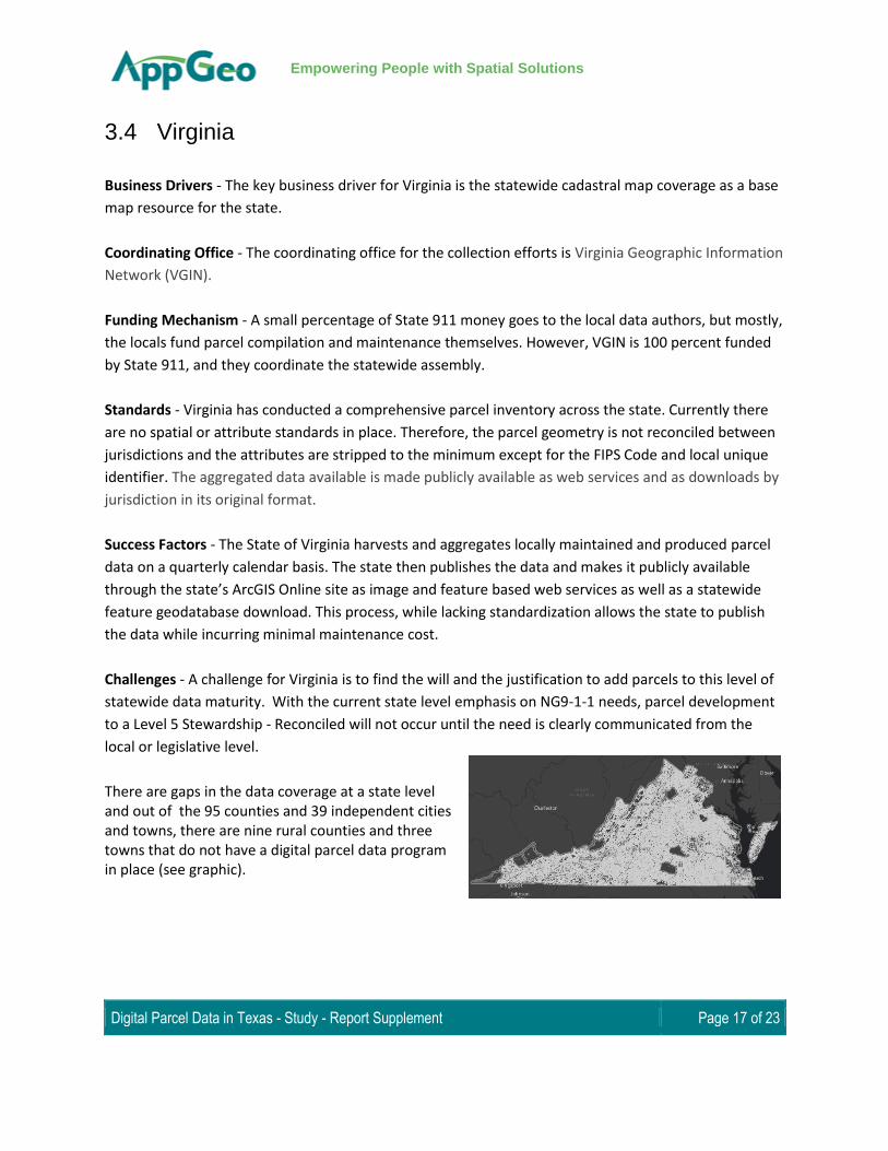
There are gaps in the data coverage at a state level and out of the 95 counties and 39 independent cities and towns, there are nine rural counties and three towns that do not have a digital parcel data program in place (see graphic).
Digital Parcel Data in Texas - Study - Report Supplement Page 18 of 23
Empowering People with Spatial Solutions
3.5 Arkansas
Business Drivers - The awareness of the value of land records for state offices and counties in terms of
economic opportunity, government efficiency and public safety and services were key use cases put
forth by the state to provide context for the value of the program.
Parcel data in Arkansas had been historically maintained with paper maps, the integration of which into
modern analysis and technologies was estimated to be costing the state, counties and businesses many
millions of dollars and creating widespread
redundancies. The state realized that without a
coordinated effort to create the statewide
basemap between the counties and the state
data consumers, duplication of effort and
redundancy would continue to exist across the
state. 1 pg11, 16-18
Coordinating Office - The County Assessor's
Mapping Program (CAMP), a collaboration
between the Arkansas Assessment Coordination
Department (AACD), the Arkansas GIS Office,
and participating counties is the current
cadastral data program, collecting and
standardizing county parcel data for the state.
Funding Mechanism - Funding for the GIS basemap program came through Arkansas Assessment
Coordinating Office (AACD), the office of oversight for county assessment created in 1997. Their
awareness of the value and use of GIS data to the agency and local governments came about because of
the Arkansas Geographic Information Offices (AGIO) outreach effort. Arkansas used the state budget to
create a grant program to finish county parcels. Counties were asked to “match” funding (approximately
$30,000 per county) provided by the State and develop their parcel data according to recommended
guidelines and standards. Funding for the AACD and GIS program is subsidized by the “Arkansas Real
Property Reappraisal Fund”2
1 State of Arkansas, State Mapping and Land Records Modernization Advisory Board, Mapping and Land Records Modernization - Strategies for Arkansas: A Report to Governor Jim Guy Tucker, (Report, 1994.) 2 Minnesota Geospatial Information Office. “Business Plan for Statewide Parcel Data Integration”, September 2012.
Digital Parcel Data in Texas - Study - Report Supplement Page 19 of 23
Empowering People with Spatial Solutions
Standards - County data providers submit their data to the state office through portals. Most of the data
is standardized to a core set of attributes and requires minimal processing by the state. While most
counties adhere to the recommended standards there is not a strict requirement for them to use it.
Overall, the outreach and training program implemented by the AACD and the AGIO office set the
standards in place from the beginning of the program reducing processing efforts for the state.
Success Factors - Arkansas realized great success with a tight budget through their phased approach to
the program. The communication, tools and training efforts empowered the counties and provided
incentive to participate. Each phase of the program allowed the state to operate within its budget and
to slowly become one of the most mature parcel programs in the country.
Arkansas’ grassroots approach to their parcel data collection efforts began by having the counties create
simple parcel point data, linked to CAMA databases through the unique parcel ID number. Arkansas GIS
Office implemented education programs to train and support the county appraisal offices in developing
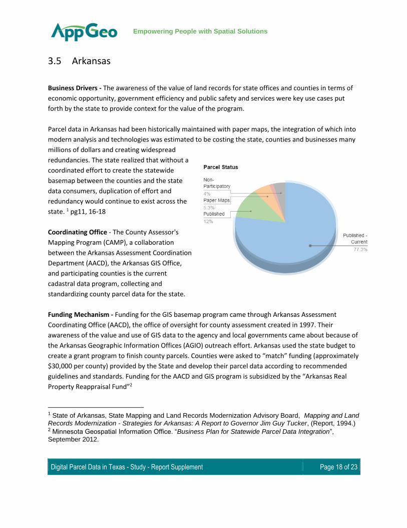
their parcel data as polygons, so that they have now collected and published parcel boundaries for 67
out of the 75 counties. Out of the 67 published counties 58 are current. The remaining 8 countries are
working on their parcel data, have data in the form of paper, or in the case of 4 counties in the state are
choosing not to participate.
Additionally, numerous counties have replaced traditional editing methods in ArcDesktop with simple,
user friendly web based applications that allow for easy polygon creation and attribution without
extensive knowledge of the ESRI platform.
Challenges - Communication, outreach and support for 75 counties is no small task. The effort requires
committed and capable state staff willing to travel, communicate and provide training and support
resources to numerous county appraisal offices with lower levels of GIS technical expertise
3.6 Tennessee
Business Drivers - The state had an awareness that nearly all decisions State and local governments
make are influenced by spatial components. It was determined that the creation of a common digital
basemap consisting of digital orthoimagery and parcel data would support multiple stakeholder
agencies to seamlessly share data across state.
Increased demand of the following were major drivers for the implementation of the basemap:
Digital Parcel Data in Texas - Study - Report Supplement Page 20 of 23
Empowering People with Spatial Solutions
● GIS services
● Data sharing and exchange
● Spatially enabled business applications
The state’s justification for the creation of a digital basemap included the following use cases:
● Land use characteristics
● Location of emergency services
● Valuation of property considering socioeconomic conditions in the surrounding community
● Site Selection for Transportation projects
● Emergency Response3
Coordinating Office - The Office of Local Government, a division of the comptroller of the Treasury
manages the inflow of data from the local county offices. The data is served publicly through the
Tennessee Property Viewer, a web application maintained by the Tennessee Department of Finance and
Administration.
Funding Mechanism - Tennessee was in a unique position in 1996 to begin a basemap program as there
were existing resources available through the office of the Comptroller of the treasury. Ultimately, a
cost share between State, County, Municipal, and Federal governments, the private sector, and public
and private utilities was determined to be the most likely scenario to succeed in successfully completing
the creation of the statewide digital base map. The state sought to seek county funding equal to 25
percent of the cost for that county, with the remainder of funding needs comprised of funding from
state, federal and private funds.
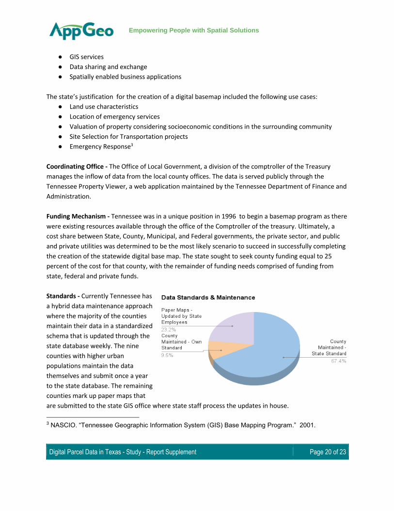
Standards - Currently Tennessee has
a hybrid data maintenance approach
where the majority of the counties
maintain their data in a standardized
schema that is updated through the
state database weekly. The nine
counties with higher urban
populations maintain the data
themselves and submit once a year
to the state database. The remaining
counties mark up paper maps that
are submitted to the state GIS office where state staff process the updates in house.
3 NASCIO. “Tennessee Geographic Information System (GIS) Base Mapping Program.” 2001.
Digital Parcel Data in Texas - Study - Report Supplement Page 21 of 23
Empowering People with Spatial Solutions
Success Factors - Tennessee had manually mapped all of their parcels in 1963 to a common coordinate
system. This provided a common base from which to develop the digital parcels.
State and local governments in Tennessee had a history of embracing the concept of collaboration on
state issues and pooling resources to accomplish more with limited resources, so data sharing and
coordination between the state and local governments was a natural response to the need for the
statewide basemap. 4
The state found that the training and resources they provided created incentive for the counties to
participate, as the counties realized additional benefits from the added technology resources provided
through the training program.
Challenges - Prior to the implementation of the basemap program, very little digital data existed; the
sparse data that did exist was being used by state and federal agencies, but due to inconsistencies and
accuracy issues did not meet the needs of the local governments. Additionally, existing data was not
standardized to meet the needs of multiple users. The key challenge was the coordination and
development of data between the state and the county governments.
3.7 Vermont
Business Drivers - The key business drivers for Vermont have been the certification of land ownership
and the determination of ROW holdings for the Vermont Agency of Transportation.
Coordinating Office - The project was initiated through the Vermont Center for Geographic Information
(VCGI) and the Vermont Agency of Transportation (VTRANS).
Funding Mechanism - Vermont was able to establish additional funding through the Agency of
Transportation using funds made available through the ROW Modernization Program set forth by the
Federal Highways Administration.
Standards - Vermont has defined a state standard for parcel attribution, but does not, at the time, plan
to implement spatial quality requirements or standards. Vermont’s goal is to meet the attribute
standards through a three year implementation project.
4 NASCIO. “Tennessee Geographic Information System (GIS) Base Mapping Program.” 2001.

Digital Parcel Data in Texas - Study - Report Supplement Page 22 of 23
Empowering People with Spatial Solutions
Success Factors - The state has adopted a rigorous planning process to develop a sustainable program
that will provide value to the state and ensure their investment.
Challenges - As in Massachusetts, property assessment is done at the municipal level, and many
Vermont towns are small, rural, and lacking exposure to digital parcel technology. The state has recently
strengthened its parcel data standards and is in the process of contracting with vendors to update and
upgrade parcel data for every town. The challenge will be to leverage this one-time upgrade into a
sustainable cycle of database maintenance. One advantage for Vermont is that all towns use a single
statewide CAMA database. Additionally, as in many states, jurisdictional boundary disputes exist and
require collaboration between local entities.
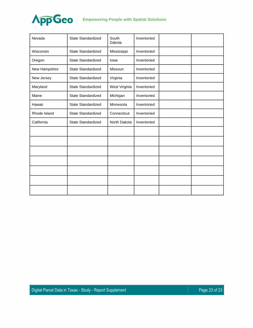
4 National IAAO Parcel Stewardship
State Level of stewardship
Montana Reconciled Nebraska Assembled Pennsylvania Undefined
Massachusetts Reconciled Kentucky Assembled Illinois Undefined
District of Columbia Reconciled Georgia Assembled American Samoa
Undefined
Arkansas Local Standardized Colorado Assembled Oklahoma Undefined
North Carolina Local Standardized Vermont Assembled Louisiana Undefined
Florida Local Standardized South Carolina
Assembled Texas Undefined
Washington State Standardized Arizona Assembled Guam Undefined
New Mexico State Standardized Ohio Assembled
Utah State Standardized Alabama Assembled
Tennessee State Standardized Idaho Assembled
Wyoming State Standardized Kansas Assembled
Indiana State Standardized Delaware Assembled
Alaska State Standardized New York Assembled
Digital Parcel Data in Texas - Study - Report Supplement Page 23 of 23
Empowering People with Spatial Solutions
Nevada State Standardized South Dakota
Inventoried
Wisconsin State Standardized Mississippi Inventoried
Oregon State Standardized Iowa Inventoried
New Hampshire State Standardized Missouri Inventoried
New Jersey State Standardized Virginia Inventoried
Maryland State Standardized West Virginia Inventoried
Maine State Standardized Michigan Inventoried
Hawaii State Standardized Minnesota Inventoried
Rhode Island State Standardized Connecticut Inventoried
California State Standardized North Dakota Inventoried