development site selection process
TRANSCRIPT
DEVELOPMENT SITESELECTION PROCESS
July 2021
EVIDENCE BASE DOCUMENTDRAFT LOCAL PLAN 2020-2037
(Regulation 19)
DEVELOPMENT SITE SELECTION PROCESS (2021)
1. Introduction
2. The 2020 SHELAA and Regulation 18 Consultation
3. The Compilation of the Long List and the Revised 2021 Site Selection Process
4. Site Screening Process a) Validation b) Ownership Issues c) Absolute Constraints
5. General Site Assessment Process
a) Conformity with Strategic Policies b) Strategic Green Belt Conformity c) Site Specific Issues That Cannot Be Mitigated
6. Summary at the End of the Site Screening and General Site Assessment Processes
7. Green Belt Sites Subject to the Green Belt Exceptional Circumstances Test
8. The Final List
9. Establishing a Density Formula
10. Non-Residential and Mixed Use Sites
11. Trajectory
12. Re-Examination to Meet Housing Need
13. Conclusions

1. Introduction 1.1. This paper presents the methodology by which the allocated sites in the 2021 Draft
Mole Valley Local Plan were chosen. It explains how:
The long list was compiled;
The long list was sifted; and,
The Green Belt sites were analysed with regard to exceptional circumstances.
1.2. The paper produces a final list of allocated development sites to go into the 2021 Draft Mole Valley Local Plan, produces a density matrix to provide a guide to the housing capacity of each site and produces a trajectory for the local plan.
2. The 2020 SHELAA and Regulation 18 Consultation
2.1. In January 2020, the Council produced a Strategic Housing and Economic Land Availability Assessment (SHELAA). The SHELAA included commentary justifying the choice of draft site allocations which went on to be contained within the Regulation 18 consultation document.
2.2. The draft site allocations were consulted upon between 3 February and 23 March
2020. The Council received over 4,000 responses and a recurring theme was that the site allocation selection process was not transparent enough. Consequently, responding to these representations, the Council has re-visited its site selection process. This document describes the outcome of the revised process and follows the methodology flowchart set out in Paragraph: 005, Reference ID: 3-005-20190722, Revision date: 22 07 2019 of the national Planning Practice Guidance.
3. The Compilation of the Long List for the Revised 2021 Site Selection Process
3.1. For the 2021 Site Selection Process, the Council used the long list from the 2020 SHELAA but updated it to include recent planning applications and the further sites that were promoted and/or identified in the Regulation 18 consultation. The long list totalled 290 sites.
3.2. National Planning Practice Guidance advises that a long list of potential sites and
locations should be identified from a variety of sources, listed in Paragraph: 011 Reference ID: 3-011-20190722. These sources are set out in Table 1 below and how the Council has utilised them both for the 2020 SHELAA and subsequently for the 2021 Site Selection Process. A 2021 SHELAA Addendum has been prepared which provides site plans to identify sites which were not referenced in the 2020 SHELAA.

Table 1: Sources for Potential Sites and the Mole Valley Approach
PPG Sources Mole Valley Sources
Existing housing and economic development allocations and site development briefs not yet with planning permission
Yes. Uncompleted development sites from the 2000 Local Plan, 2012 Dorking Area Action Plan and the Capel Neighbourhood Plan
Planning Permissions for housing and economic development that are unimplemented or under construction
Yes. Planning permissions were included for the 2020 SHELAA (see Appendix 1 and 2) and updated and included for the 2021 Site Selection. The site selection process is closely aligned with the Five Year Housing Land Supply
Planning applications that have been refused or withdrawn
Yes. Depending on the reasons for refusal or withdrawal, appropriate sites were included in the 2020 SHELAA and the 2021 Site Selection
Land in the local authority’s ownership
Yes. The Asset Management sections of Mole Valley District Council and Surrey County Council were both contacted for surplus land. Both sections also responded to the Regulation 18 consultation.
Surplus and likely to become surplus public sector land
Yes. Public sector bodies were contacted as part of the 2016 Brownfield Call for Sites and 2018 Greenfield Call for Sites and the 2020 Regulation 18 consultation.
Sites with permission in principle, and identified brownfield land
Yes. Sites identified from the 2016 Brownfield Call for Sites and Brownfield Land Register were included.
Vacant and derelict land and buildings (including empty homes, redundant and disused agricultural buildings, potential permitted development changes, eg offices to residential)
Yes. Local knowledge and call for sites generated potential sites and all office to residential prior approvals were assessed in Table 3 of the SHELAA and updated for the 2021 Site Selection Process.
Additional opportunities for unestablished uses (eg making productive use of under-utilised facilities such as garage blocks)
Yes. Underused industrial land was investigated.
Business requirements and aspirations
Yes. Local businesses were contacted and information was passed to the planning policy section from the economic development section
Sites in rural locations Yes. Sites were generated from the 2018 Greenfield Call for Sites and from presentations to Parish Councils

PPG Sources Mole Valley Sources
Large scale redevelopment and redesign of existing residential or economic areas
No. There are no major regeneration areas within Mole Valley. However, specific sites included in MVDC’s Transform Leatherhead masterplan were included.
Sites in adjoining villages and rural exceptions sites
Yes. Sites were generated from the 2018 Greenfield Call for Sites and from presentations to Parish Councils
Potential urban extensions and new free-standing settlements
Yes. Significant urban extensions and the potential for a free-standing settlement was considered both pre- and post- the Regulation 18 consultation
4. Site Screening Process
4.1. The Site Screening Process involved three stages. First, the validation of information regarding the sites, then a review of any ownership constraints affecting deliverability and thirdly an assessment of sites suitability against identified absolute constraints.
Validation
4.2. Inevitably, considering the numerous sources of the sites, a certain amount of validation was required to ensure that information about the sites was valid and up-to-date. In terms of validation, the following criteria were followed:
Table 2: Validation of Sites during the Site Screening Process
Reason for Site Elimination No of Sites Eliminated
Site which is a duplicate of another 5 sites eliminated
Sites absorbed into adjacent sites to make logical unit 7 sites eliminated
Site divided to create two logical units 2 sites eliminated
Sites below 0.1ha in size 5 sites eliminated
Sites withdrawn by landowner so no longer deliverable 2 sites eliminated
Sites with planning permission but recently completed 5 sites included in the housing trajectory but not allocated
Sites with planning permission and under construction 5 sites included in the housing trajectory but not allocated
Sites with extant planning permission not yet implemented/part implemented
10 sites included in trajectory, with fast track development sites to support delivery; not subject to further assessment
Total 41 sites

Ownership Issues 4.3. Some sites, which had been free of ownership issues for the 2020 SHELAA, had
subsequently become unavailable and so these were also eliminated. There were also a small number of sites which had been suggested by third parties in consultation responses, but where investigations identified no evidence that the sites was reasonably likely to be available during the Local Plan period. A few sites were identified where delivery would depend on availability of other land owned by a third party, and where known constraints made this highly unlikely to be achievable.
4.4. The question on ownership issues and information on the question are set out below:
Table 3: Ownership Issue Question at the Site Screening Stage
No Question Sites Eliminated
2 Are there factors which make the site undeliverable?
12 sites eliminated across the district
Total 12 sites
Absolute Constraints
4.5. The remaining sites were evaluated against absolute constraints, in other words factors that were considered to make the site undevelopable. These were based on the conclusions of the Constraints Analysis prepared in 2017 and updated 2020, but adapted to take account of issues raised in 2020 consultation responses. For example, exclusion of existing mineral and waste sites was added as an absolute constraint in response to representations from Surrey County Council as the minerals and waste planning authority. However, the approach to sites in the AONB and AGLV was adapted to allow for a more fine-grained approach and this constraint is now considered at a later stage in the process.
4.6. Although the Constraints Analysis excluded land within Flood Zone 3b (the Functional Floodplain) from consideration, no sites which reached this stage were entirely within the functional floodplain. Sites can include small areas within Flood Zone 3b but be otherwise “flood safe” for housing by means of a sequential approach to steer development towards parts of the site at low risk of flooding. Therefore Flood Zone 3b was not treated as an absolute constraint eliminating any whole sites at this point. The approach to applying the sequential and exceptions test are outlined further in paragraph 5.13 below.
4.7. The absolute constraints were created to be questions, where any “yes” answer
meant it was necessary for the site to be eliminated. The questions and information on the questions are set out below:
Table 4: Absolute Constraint Questions
No Question Sites Eliminated
3 Is the site within an SSSI or SAC? No sites were eliminated against this constraint
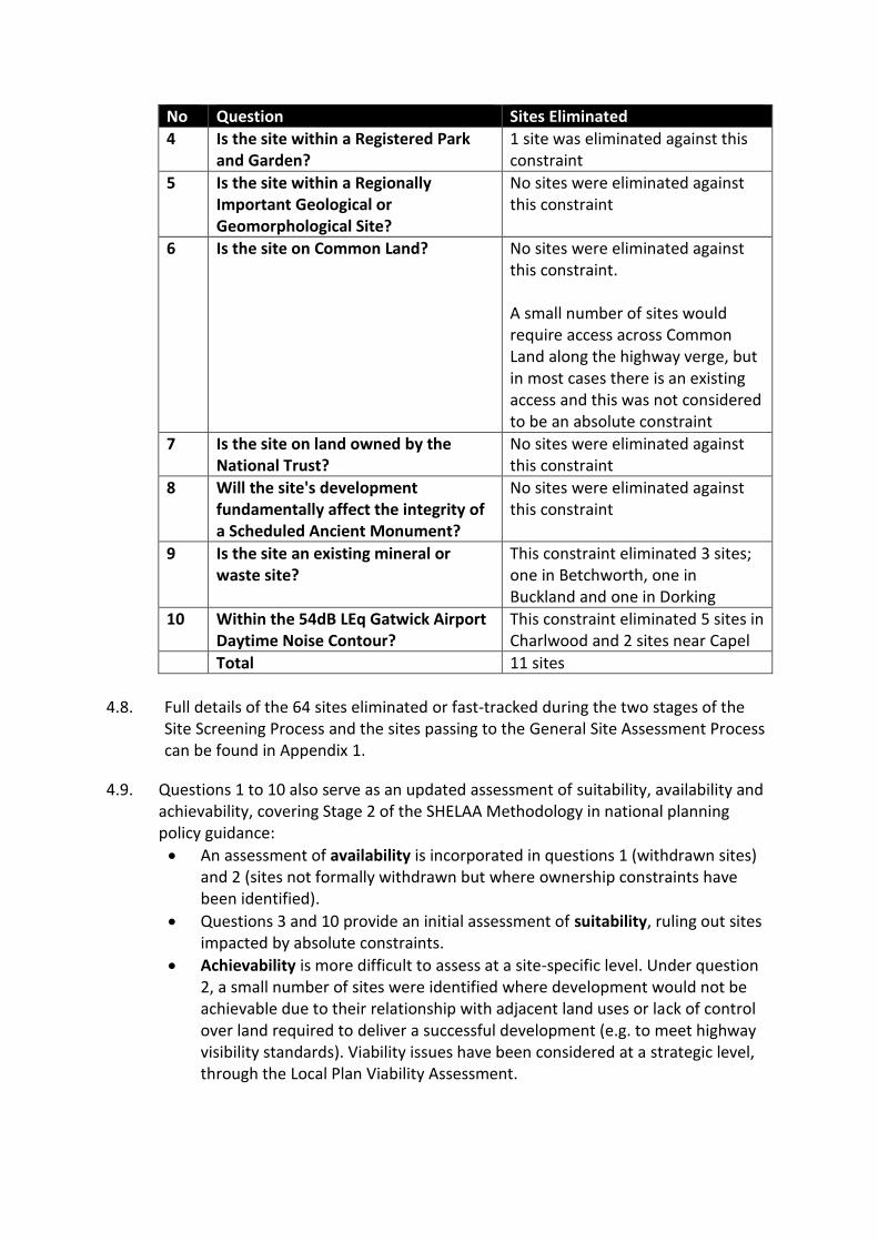
No Question Sites Eliminated
4 Is the site within a Registered Park and Garden?
1 site was eliminated against this constraint
5 Is the site within a Regionally Important Geological or Geomorphological Site?
No sites were eliminated against this constraint
6 Is the site on Common Land? No sites were eliminated against this constraint. A small number of sites would require access across Common Land along the highway verge, but in most cases there is an existing access and this was not considered to be an absolute constraint
7 Is the site on land owned by the National Trust?
No sites were eliminated against this constraint
8 Will the site's development fundamentally affect the integrity of a Scheduled Ancient Monument?
No sites were eliminated against this constraint
9 Is the site an existing mineral or waste site?
This constraint eliminated 3 sites; one in Betchworth, one in Buckland and one in Dorking
10 Within the 54dB LEq Gatwick Airport Daytime Noise Contour?
This constraint eliminated 5 sites in Charlwood and 2 sites near Capel
Total 11 sites
4.8. Full details of the 64 sites eliminated or fast-tracked during the two stages of the
Site Screening Process and the sites passing to the General Site Assessment Process can be found in Appendix 1.
4.9. Questions 1 to 10 also serve as an updated assessment of suitability, availability and achievability, covering Stage 2 of the SHELAA Methodology in national planning policy guidance:
An assessment of availability is incorporated in questions 1 (withdrawn sites) and 2 (sites not formally withdrawn but where ownership constraints have been identified).
Questions 3 and 10 provide an initial assessment of suitability, ruling out sites impacted by absolute constraints.
Achievability is more difficult to assess at a site-specific level. Under question 2, a small number of sites were identified where development would not be achievable due to their relationship with adjacent land uses or lack of control over land required to deliver a successful development (e.g. to meet highway visibility standards). Viability issues have been considered at a strategic level, through the Local Plan Viability Assessment.

5. General Site Assessment Process 5.1. For the remaining 226 sites, the General Site Assessment Process involved three
stages: An assessment of whether the site was in conformity with strategic policies,
which had previously agreed upon following earlier consultations;
An assessment of the site against strategic Green Belt objectives; and
An assessment of whether there were any site specific constraints that were unable to be mitigated
Conformity with the Strategic Policies
5.2. To make sure that the sites contributed to the consulted upon and agreed strategic policies, six questions were devised to ensure this conformity. The first three questions related to the strategic spatial policy direction of the plan but the other three questions focussed on protecting specific land uses.
5.3. The first strategic spatial policy questions related to whether the site was adjacent
to a settlement boundary. It was considered that a site would be more sustainable if it was located adjacent to an existing settlement. The reasoning is twofold: it ensures access to the settlement’s shops and services for residents of the new properties and it protects the countryside from encroachment. The approach also supports the Council’s preferred options for strategic-scale development, being urban extensions or expansion of one or more rural villages.
5.4. An exception was made for a small number of existing gypsy and traveller sites
which had been promoted as having potential for delivery of additional pitches but are not adjacent to a settlement boundary. This recognises that there are specific sustainability benefits to enabling sites suitable for extended gypsy and traveller families, in terms of reducing social exclusion and providing a settled base from which to access health and education services. Therefore excluding these existing sites simply on grounds of proximity to a settlement would not support the aims of sustainable development.
5.5. The next two questions both relate to the strategic approach to modest expansion
of rural villages, drawing on the approach set out in the Settlement Boundaries Topic Paper.
5.6. First, sites in or around Tier 5 villages were excluded from further consideration.
These are the settlements which the Settlement Hierarchy identifies as having the fewest services to support new housing development.
5.7. Sites in or around Tier 4 villages were subject to a Modest Additions to Rural Villages test. In line with the approach in the Settlement Boundaries Topic Paper, the site selection process considered village sites against (i) whether they were sites for infill within a village (since Tier 4 settlements would remain in the Green Belt); (ii) whether they were modest in size and (iii) whether they would require a boundary change to a village in the Area of Outstanding Natural Beauty (AONB). Major expansion of Tier 4 villages was also excluded, as this would not be strategy-compliant, for reasons outlined in the Settlement Boundaries Topic Paper.
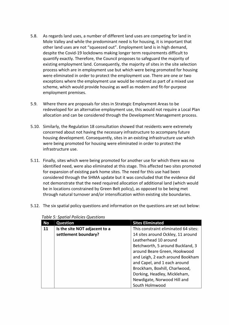
5.8. As regards land uses, a number of different land uses are competing for land in
Mole Valley and while the predominant need is for housing, it is important that other land uses are not “squeezed out”. Employment land is in high demand, despite the Covid-19 lockdowns making longer term requirements difficult to quantify exactly. Therefore, the Council proposes to safeguard the majority of existing employment land. Consequently, the majority of sites in the site selection process which are in employment use but which were being promoted for housing were eliminated in order to protect the employment use. There are one or two exceptions where the employment use would be retained as part of a mixed use scheme, which would provide housing as well as modern and fit-for-purpose employment premises.
5.9. Where there are proposals for sites in Strategic Employment Areas to be
redeveloped for an alternative employment use, this would not require a Local Plan allocation and can be considered through the Development Management process.
5.10. Similarly, the Regulation 18 consultation showed that residents were extremely
concerned about not having the necessary infrastructure to accompany future housing development. Consequently, sites in an existing infrastructure use which were being promoted for housing were eliminated in order to protect the infrastructure use.
5.11. Finally, sites which were being promoted for another use for which there was no
identified need, were also eliminated at this stage. This affected two sites promoted for expansion of existing park home sites. The need for this use had been considered through the SHMA update but it was concluded that the evidence did not demonstrate that the need required allocation of additional land (which would be in locations constrained by Green Belt policy), as opposed to be being met through natural turnover and/or intensification within existing site boundaries.
5.12. The six spatial policy questions and information on the questions are set out below:
Table 5: Spatial Policies Questions
No Question Sites Eliminated
11 Is the site NOT adjacent to a settlement boundary?
This constraint eliminated 64 sites: 14 sites around Ockley, 11 around Leatherhead 10 around Betchworth, 5 around Buckland, 3 around Beare Green, Hookwood and Leigh, 2 each around Bookham and Capel, and 1 each around Brockham, Boxhill, Charlwood, Dorking, Headley, Mickleham, Newdigate, Norwood Hill and South Holmwood

No Question Sites Eliminated
12 Is the site within a Tier 5 settlement? (A Tier 5 settlement being a settlement with the fewest retail, community and educational facilities)
This constraint eliminated 5 sites: 2 in Forest Green and 1 each in Headley, Okewoodhill and Wotton
13 Does the site FAIL the Modest Additions to Rural Villages test? In other words, (i) the site is not infill; (ii) the site is not modest; (iii) the village is within the AONB and the site is not within the existing village boundary
This test eliminated 19 sites. 8 sites were considered to fail parts (i) and (jj) being neither infill development nor of a modest scale (2 in Leigh, Buckland and Newdigate, 1 each in Woodlands Road, Bookham, and Ockley). 4 sites were considered to fail part (i) only, being not classed as infill (3 in Buckland and 1 in Woodlands Road, Bookham). The remaining 7 sites lay outside village boundaries in the AONB and therefore failed part (jjj) (3 in Mickleham, 2 in Westhumble and 1 each in Abinger Hammer, Boxhill and Buckland)
14 Would the site result in a loss of employment land or is promoted for employment uses only?
This constraint eliminates 8 sites: 3 sites in Dorking, 3 sites in Leatherhead and 2 in Hookwood.
15 Would the site result in the loss of social or physical infrastructure?
This constraint eliminated 3 sites: 1 each in Leatherhead, Newdigate and Ockley. However, as a result of the site submission, the site in Leatherhead was identified as having potential for expansion of infrastructure (commuter parking adjacent to Leatherhead Railway Station), so remained in consideration for that potential use, as opposed to redevelopment for housing.
16 Is the site for a use for which there is no identified need?
This site eliminated 2 sites, in Box Hill and near Beare Green, both promoted for park homes.
Total 101

Strategic Green Belt Conformity 5.13. The approach to assessing sites in the Green Belt is set out in more detail in the
Exceptional Circumstances Topic Paper. The paper describes a two part process to consider whether there are exceptional circumstances to justify a change to the Green Belt boundary in a specific location.
5.14. Question 17 corresponds with Part 1 of the exceptional circumstances process. The
question utilised the Council’s 2020 Green Belt Review and, in particular, the maps between Pages 13 and 143. The maps on these pages score broad areas of the Mole Valley Green Belt for how effective they are at achieving the four of the purposes of the Green Belt: 1. to check the unrestricted sprawl of large built-up areas; 2. to prevent neighbouring towns merging into one another; 3. to assist in safeguarding the countryside from encroachment; 4. to preserve the setting and special character of historic towns;
The scoring is minimal/moderate/significant.
5.15. Any site within a broad area with a significant score for purposes relating to sprawl, merging or encroachment was eliminated. The reason for focussing on these three purposes is explained in the Green Belt Exceptional Circumstances Topic Paper. The question and information on the question are set out below:
Table 6: Strategic Green Belt Conformity Question
No Question Sites Eliminated
17 Is the site within a broad area where development would have a significant impact on the Green Belt purposes of preventing sprawl, preventing merging or safeguarding the countryside from encroachment?
This constraint eliminated 31 sites: 8 sites each in Ashtead and Leatherhead, 5 sites in Bookham, 4 sites in Brockham, 2 sites each in Beare Green and Dorking and 1 site each in Fetcham and Westcott
Total 31
Site Specific Issues That Cannot Be Mitigated
5.16. Many site constraints are not showstoppers and can be mitigated, for example:
A small area of protected habitat can be preserved on part of a site and potentially enhanced as part of proposals for biodiversity net gain;
The setting of a Listed Building can be conserved or enhanced through an appropriate design approach;
Development can be made “flood safe” through a sequential approach to locating development on the parts of site with lower flood risk, as well as through appropriate sustainable drainage solutions and mitigation measures such as raised floor levels; and,
Contaminated land should be seen as an opportunity not a constraint where it can be remediated satisfactorily.
5.17. Nevertheless, there are some circumstances where it is very difficult to mitigate the
impact of development and so what are nominally non-absolute constraints become

absolute constraints. Three features have been identified that are important to ensuring sustainable development in Mole Valley and where it would be difficult to mitigate the impact of development, thereby effectively becoming absolute constraints:
Landscape Quality. Nearly half the district is covered by the Surrey Hills Area of Outstanding Natural Beauty (AONB) or Area of Great Landscape Value (AGLV). This high quality landscape is very sensitive to development and the NPPF requires that great weight is given to conserving and enhancing landscape and scenic beauty. The NPPF states that the scale and extent of development should be limited and major development avoided other than in exceptional circumstances. Therefore sites within the AONB or AGLV were eliminated unless they involved (i) modest intensification of an existing, developed use (ii) provision of community infrastructure (where it was considered that community benefits versus landscape harm could best be assessed through the exceptional circumstances process or (iii) modest infill sites within villages, which had already passed the tests in Question 13.
Priority Habitats and Ancient Woodland. Priority Habitat and Ancient Woodland on a small part of a site may not prevent development. However, where the percentage of cover increases this will become an absolute constraint. Therefore, sites with 80%+ coverage of Priority Habitat and/or Additional Habitat identified on the Priority Habitat Inventory and Ancient Woodland were eliminated.
Conservation Areas. While development can sometimes enhance the character of Conservation Area, in some cases, the features of a Conservation Area mean that any development harms the character. This is the case with a number of the Conservation Areas in Mole Valley’s villages where the space between the built form is the principal heritage characteristic so any infilling harms the character. This means that any infilling in these villages is an effective absolute constraint.
5.18. Given how difficult it is to mitigate a development’s effects on these designated
areas, the following questions were devised, which are set out in the table below with further information:
Table 7: Site Specific Issues Where It is Not Possible to Mitigate Effectively
No Question Sites Eliminated
18 Is the site within AONB/ AGLV (and not (i) existing site with potential for modest intensification of existing use, (ii) a site for community infrastructure or (iii) site within a village boundary which passes the Modest Additions to Rural Villages test.
This constraint eliminated 4 sites: all in Dorking
19 Is the site covered by 80%+ Priority Habitat, Additional
This constraint eliminated 14 sites: 3
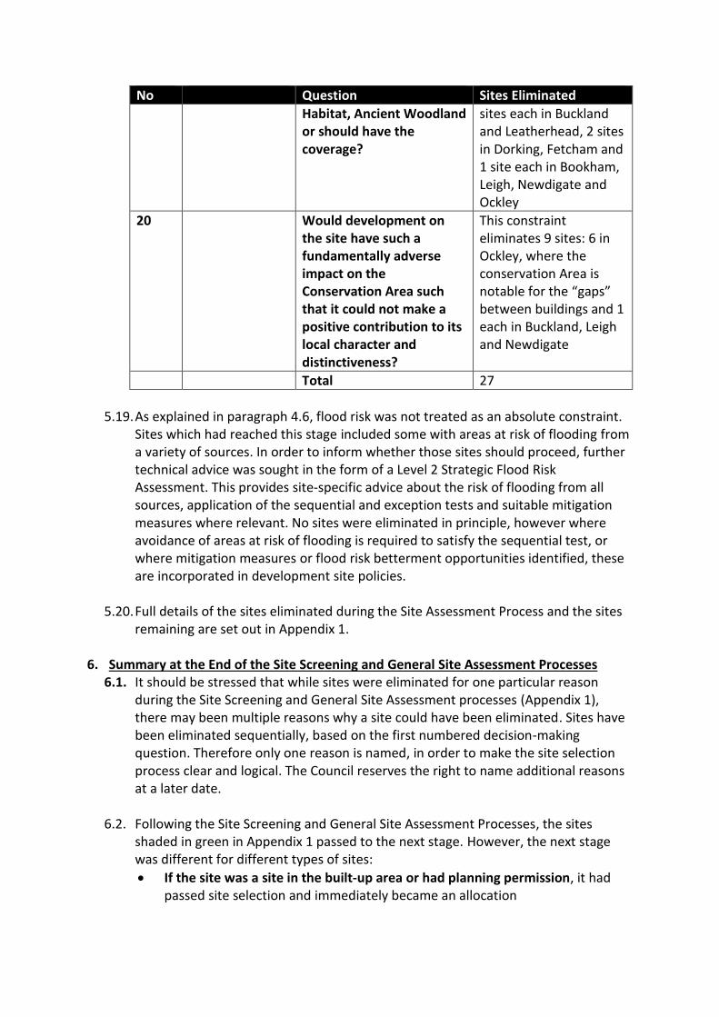
No Question Sites Eliminated
Habitat, Ancient Woodland or should have the coverage?
sites each in Buckland and Leatherhead, 2 sites in Dorking, Fetcham and 1 site each in Bookham, Leigh, Newdigate and Ockley
20 Would development on the site have such a fundamentally adverse impact on the Conservation Area such that it could not make a positive contribution to its local character and distinctiveness?
This constraint eliminates 9 sites: 6 in Ockley, where the conservation Area is notable for the “gaps” between buildings and 1 each in Buckland, Leigh and Newdigate
Total 27
5.19. As explained in paragraph 4.6, flood risk was not treated as an absolute constraint.
Sites which had reached this stage included some with areas at risk of flooding from a variety of sources. In order to inform whether those sites should proceed, further technical advice was sought in the form of a Level 2 Strategic Flood Risk Assessment. This provides site-specific advice about the risk of flooding from all sources, application of the sequential and exception tests and suitable mitigation measures where relevant. No sites were eliminated in principle, however where avoidance of areas at risk of flooding is required to satisfy the sequential test, or where mitigation measures or flood risk betterment opportunities identified, these are incorporated in development site policies.
5.20. Full details of the sites eliminated during the Site Assessment Process and the sites
remaining are set out in Appendix 1. 6. Summary at the End of the Site Screening and General Site Assessment Processes
6.1. It should be stressed that while sites were eliminated for one particular reason during the Site Screening and General Site Assessment processes (Appendix 1), there may been multiple reasons why a site could have been eliminated. Sites have been eliminated sequentially, based on the first numbered decision-making question. Therefore only one reason is named, in order to make the site selection process clear and logical. The Council reserves the right to name additional reasons at a later date.
6.2. Following the Site Screening and General Site Assessment Processes, the sites
shaded in green in Appendix 1 passed to the next stage. However, the next stage was different for different types of sites:
If the site was a site in the built-up area or had planning permission, it had passed site selection and immediately became an allocation

Sites in Tier 4 villages within the Green Belt which had been demonstrated to comply with the MARV strategy (see Question 13) were also considered to have passed site selection and became allocations.
Sites within the Green Belt and located on the edge of a Tier 1, 2 or 3 settlement, were subject to the Council’s “exceptional circumstances” test, since allocations in these locations would require insetting land from the Green Belt.
7. Green Belt Sites Subject to the Green Belt Exceptional Circumstances Test
7.1. Sites subject to the Green Belt Exceptional Circumstances Test faced 13 additional questions to ascertain whether, on balance, there were sufficient exceptional circumstances that would outweigh the harm to the Green Belt and justify Green Belt release. These 13 questions are set out in Table 8 and further detail is contained in the Exceptional Circumstances Topic Paper. Part 1 (Questions a, b and c) corresponds with the strategic Green Belt assessment (Question 17 above). Questions d to m complete part 2 of the assessment.
Table 8: Questions to Assess Harm to the Green Belt
No Question
Nationally Derived Considerations
a Is the site Strategy Compliant? Is the site within a proposed settlement boundary?
b Does the site selection methodology recommend consideration for Exceptional Circumstances?
c What is the nature and extent of the harm to the Green Belt in this location if the site is developed? (One of the matters set out in Calverton Parish Council v Greater Nottingham Councils [2015] EWHC 10784 regarding issues to be considered when assessing exceptional circumstances)
d What is the impact on the setting of any historic town or heritage asset (in respect of purpose 4 of Green Belts)?
e To what extent can the consequent impacts on the purposes of the Green Belt be ameliorated or reduced to the lowest reasonably practicable extent? (One of the matters set out in Calverton Parish Council v Greater Nottingham Councils [2015] EWHC 10784 regarding issues to be considered when assessing exceptional circumstances)
f Does the ecology evidence consider the site is ecologically suitable?
g Does the landscape evidence consider the site has capacity to accommodate development in the landscape?
Locally Derived Considerations
h Does the site currently contribute to provision of public open space, recreation or sports provision? Can such provision be retained or re-provided elsewhere?
i Does the Sustainability Appraisal consider that the site is a sustainable location?
j Is the site sequentially preferred? Would development of the site increase flood risk or impact on water quality?
k Does the site provide a community benefit in terms of infrastructure?
l Does the site provide an opportunity for reducing the impacts of climate change through decentralised heat and power, carbon offsetting or zero carbon homes, or improvements to biodiversity and green infrastructure?
m Can any lost public access to countryside be replaced or is access increased?
7.2. The fate of the sites that took the Exceptional Circumstances test are set out in
Appendix 2. Full details of the reasoning followed for each site is provided in the Exceptional Circumstances Topic Paper.
7.3. Of the 33 Green Belt sites reaching this stage, 20 were considered to exhibit
exceptional circumstances for a change to the Green Belt boundary. The remaining 13 sites did not exhibit exceptional circumstances. These are in addition to the 31 sites which had already been eliminated under Part 1 of the process (see Question 17). Therefore in total 44 sites were eliminated through the exceptional circumstances process and will remain in the Green Belt.
8. The Final List 8.1. The 65 sites shaded in white or green in Appendix 2 are the final list of selected
sites. Of these, 63 have been included as allocated development sites in the draft Local Plan. The remaining two sites do not require an allocation due to their small scale and location within an existing settlement boundary, as detailed in Appendix 4.
9. Establishing a Density Formula
9.1. The 2019 National Planning Policy Framework stresses that new development should use land efficiently, taking into account:
The identified need for different types of housing and other forms of development, and the availability of land suitable for accommodating it;
Local market conditions and viability
The availability and capacity of infrastructure and services
The desirability of maintaining an area’s character and setting
The importance of securing well-designed, attractive and healthy places.
9.2. Expanding on this strategic steer, the NPPF adds: “Plans should contain policies to optimise the use of land in their area and meet as much of the identified need for housing as possible. This will be tested robustly at examination, and should include the use of minimum density standards for city and town centres and other locations that are well served by public transport. These standards should seek a significant uplift in the average density of residential development within these areas, unless it can be shown that there are strong reasons why this would be inappropriate. The use of minimum density standards should also be considered for other parts of the plan area. It may be appropriate to set out a range of densities that reflect the accessibility and potential of different areas, rather than one broad density range.”
9.3. There will always be a degree of tension between using land efficiently and the
desirability of maintaining the area’s character and setting. This tension is particularly heightened in Mole Valley as the following local factors are present:

Many of the allocated sites are Green Belt sites and so, having relinquished
these areas of Green Belt, there should be an imperative to use them as
efficiently as possible; However,
Approximately 40% of the district is designated as Area of Outstanding Natural Beauty or Area of Great Landscape Value and harm can easily be caused to views within, out of or towards these high quality landscapes by high density development;
Developments near to the M25 are liable to noise pollution, requiring mitigation measures that will influence the density and the built form design;
Both the District’s towns are covered by Conservation Areas: Dorking to a great extent and Leatherhead to a lesser extent;
Many of the allocated sites are edge of settlement sites and any development may be relatively poorly connected to facilities and services as a result of deficiencies in public transport and the road network or have other infrastructure limitations; and,
Many of the edge of settlement allocated sites will be adjacent to low density development, as low as 6 dwellings per hectare (dph), and so higher density new development could be incongruous with the existing built form.
9.4. Taking all these factors into account, it seems prudent to base a density formula for
the allocated development sites in many parts of the District on the prevailing density and built form.
9.5. Nine land and setting typologies and have been identified which resulted in the
following indicative densities, set out in Table 9. These indicative densities have also been informed by measurements of existing densities in and on the edge of the built up area, see Table 10.
Table 9: Land and Setting Typologies and Indicative Densities
Land Typology
Setting Typology
Factors Considered in Establishing the Indicative Density
Density (dph)
1 Brownfield Inner Built Up/ Existing Fully Developed
● Sites include offices, car parks and infrastructure and will be mixed use developments. ● These sites and land uses are so diverse that it is not possible to devise one indicative density figure. ● Therefore, each site will be treated on a case-by-case basis.
-
2 Brownfield Built Up* ● Densities within the built-up area vary greatly, as a result of the dwelling type. ● However, these are the most sustainable locations in the District and brownfield land should be reused efficiently. ● Consequently, an indicative density figure of 50dph, which is greater than a lot of the
50

Land Typology
Setting Typology
Factors Considered in Establishing the Indicative Density
Density (dph)
existing semi-detached, terraced housing (see Table 11)
3 Greenfield Built Up* ● Compared to brownfield/built up sites, greenfield sites have considerably more constraints, such as existing trees and hedges and a lack of existing infrastructure, for example roads. ● There are few recent examples of development on this type of land and setting typology. ● Consequently, 30dph is an appropriate indicative density figure
30
4 Brownfieldand Greenfield
Garden Land ● Highly irregular site shapes, often with trees that need to be preserved, often surrounded by very low density development. ● Therefore, these sites do not easily to conform to one typology Consequently, these sites should be treated on a case-by-case basis
-
5 Brownfield Built Up Edge* ● There are relatively few sites of this typology but, where they exist (often as office sites to be redeveloped as mixed use sites), they have the potential to deliver a large number of units. ● The re-provision of office accommodation would set a precedent for a relatively dense built form ● Consequently, 40dph is an appropriate indicative density figure and is higher than many areas adjacent to the allocated development sites (see Table 11)
40
6 Greenfield Built Up Edge* Less than 3ha
● These sites may require a road network and some small scale infrastructure. ● Therefore, the indicative density figure should be less than the indicative density figure for brownfield/built up edge ● Consequently, 30dph per hectare is an appropriate indicative density figure and is greater than many areas adjacent to the allocated development sites (see Table 11)
30
7 Greenfield Built Up Edge* More than 3ha
● These sites may require infrastructure and are liable to hit thresholds for additional infrastructure, such as play space
20

Land Typology
Setting Typology
Factors Considered in Establishing the Indicative Density
Density (dph)
● Therefore, the indicative density figure should be less than the small sites ● Consequently, 20dph per hectare is an appropriate indicative density figure and is comparable to many areas adjacent to the allocated development sites (see Table 11)
8 Brownfield In Green Belt ● There is only one site that falls within this typology ● It is appropriate to treat it the same as a brownfield site on the edge of the built up area ● Consequently, 40dph is an appropriate indicative density figure
40
9 Brownfield and Greenfield
Villages ● The District’s villages are characterised by limited services, a limited public transport offer and an existing character of low density development ● Therefore, they are not appropriate for high density developments ● Consequently, 20dph is an appropriate density figure
20
“Built up” refers to the development around the site rather than the planning designation terminology of opposite to open land
Table 10: Suburban Density Examples
Location Principal Road within Area Properties (no)
Area (ha)
Density (dph)
Ashtead Quarry Gardens – Ermyn Way – Stag Leys 508 29 17.5
Bookham Little Bookham Street 175 8.4 21
Bookham Burnhams Road 110 14 8
Dorking (west side) Sondes Place Drive 36 3.6 10
Dorking (west side) Glebe Road 79 4 18
Dorking (west side) Longfield Road 74 4.3 17
Dorking (west side) West Bank 86 3.6 24
Dorking (west side) Nower Road 133 6 22
Dorking (east side) Lincoln Road 139 1.76 79
Dorking (east side) Croft Avenue/Mowbray Gardens 42 3.1 13.5
Dorking (east side) Chichester Road & Close/Calvert Gardens 41 6.9 5.9
Hookwood East side of Reigate Road 92 7.3 12.5
Hookwood West side of Reigate Road 185 5 37
Leatherhead Farthings 96 2.9 34
Leatherhead Randalls Road 31 1.5 21
Leatherhead Tudor Walk/Parr Close/Boleyn Walk 153 3.5 44
Leatherhead Highbury Drive 127 1 127

9.6. These typologies and indicative densities are a guide to calculate the capacity of allocated development sites. The resultant capacities for each allocation are only estimates and do not dictate how many dwellings will developed on a site. They should be treated as indicative densities but there may be instances where more dwellings may be accommodated and there may be a site-specific reason why the indicative density figure may not be reached.
9.7. Appendix 3 shows each development site, its site area, an estimated developable area (where this differs significantly from the total area), its land and setting typology, its indicative density per hectare and indicative capacity.
10. Non-Residential or Mixed Use Sites
10.1. Up until now, the site selection process has predominantly focussed on purely residential or residential-led allocations. At this point, it is appropriate to introduce or re-introduce non-residential allocated development sites. Some sites promoted for non-residential uses were identified in the original long list (see Appendix 1) and have been re-introduced while others are added here as a result of needs assessments for physical and social infrastructure.
10.2. Appendix 4 sets out the strategic residential sites, mixed use sites and non-
residential sites identified and whether they are required to be made allocations and/or whether they are required to be in the trajectory. The criteria used to determine this is set out in Table 11:
Table 11: Criteria for Inclusion as an Allocation or in the Trajectory
Criterion Allocate In Trajectory
Residential site, more than 10 units Yes Yes
Mixed-use, site more than 10 units Yes Yes
Residential site, fewer than 10 units that could have been developed on existing policy
No No (to avoid double-
counting small site allowance)
Residential site, fewer than 10 units but could not have been developed on existing policy
Yes Yes
Site for new or redeveloped infrastructure Yes No (no housing units)
Non-residential site, with significant redevelopment
Yes No (no housing units)
Sites not proposed for housing, infrastructure or redevelopment
No No
11. Trajectory
11.1. Having established the allocations, the appropriate density calculation and whether a site should be allocated and/or be in the trajectory, the Council can now produce a housing trajectory (see Appendix 5). The trajectory sets out the relevant

allocations, their area and capacity. The delivery date of a site is predicted with guidance from landowners and developers where available.
11.2. The trajectory runs for 17 years. The 17 years includes the two years for plan
preparation and the 15 years of the plan period, as required by paragraph 22 of the NPPF. The sites correspond to the Council’s Five Year Housing Land Supply and the trajectory takes account of sites of 10+ dwellings and small sites with planning permission as identified in the 2021-2026 Five Year Housing Land Supply statement.
11.3. The trajectory shows a shortfall against Local Housing Need of 1,748 housing units
over the 17 years of the plan period. But, crucially, over the first eight years of the plan period, the plan meets the objectively assessed need. Therefore, the plan is meeting the immediate housing crisis and with five-year plan reviews, as required by Paragraph 33 of the NPPF, there is scope for the objectively assessed need to be met over the plan period.

12. Re-Examination to Meet Local Housing Need
12.1. The flowchart in Paragraph: 005 Reference ID: 3-005-20190722 of the Planning Practice Guidance states that if, at the end of a land availability assessment, there is a shortfall against the objectively assessed need, Councils should re-examine and re-evaluate their site assessment process. Table 12 shows the elements of the Site Assessment, how stringent they are in “knocking out” potential sites, whether they can be re-evaluated and, where necessary, what would happen if the element was amended.

Table 12: Re-evaluation of the Site Assessment Elements
Site Assessment Element
Can the element be re-evaluated? What would happen if element was amended
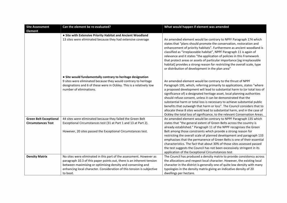
Spatial Policy ● Not adjacent to the settlement boundary 64 sites were eliminated because they were not adjacent to the settlement boundary. The spatial policy has been consulted upon twice and both consultations have shown support for new development adjacent to settlement boundaries. ● Within a Tier 5 Settlement 5 sites were eliminated because they were within a Tier 5 settlement. This is a relatively low number of eliminations. ● The MARV Test 19 sites were eliminated because they failed at least one of the three elements of the MARV Test ● Result in the Loss of Employment Land or Infrastructure or Allocate a Site for a Use where There is No Identified Need 13 sites were eliminated because they would result in a loss of employment land, a loss of infrastructure or allocate for a use where there was no identified need
An amended element would be contrary to NPPF Paragraph 16 which states that plan should “be shaped by early, proportionate and effective engagement between planmakers and communities, local organisations, businesses, infrastructure providers and operators and statutory consultees”. An amended element would be contrary to NPFF Paragraph 72, which states that “strategic policy-making authorities should identify suitable locations for such [housing] development where this can help to meet identified needs in a sustainable way”. An Amended MARV test would be contrary to NPPF Paragraph 145 which permits only “limited in filling in villages” and NPPF Paragraph 11 which grants the strongest protection to Areas of Outstanding Natural Beauty An amended element would be contrary to NPPF Paragraph 117 which states that “planning policies and decisions should promote an effective use of land in meeting the need for homes and other uses.”
Strategic Green Belt 31 sites were eliminated because they contributed to the purposes of the Green Belt strategically
An amended element would be contrary to NPPF Paragraph 134 which sets out the five purposes of the Green Belt.
Non-mitigatable Site Specific Issues
● Site within AONB or AGLV 5 sites were eliminated because they would harm landscape of the AONB or AGLV
An amended element would be contrary to NPPF Paragraph 11 which states that “the application of policies in this Framework that protect areas or assets of particular importance [eg Areas of Outstanding Natural Beauty] provides a strong reason for restricting the overall scale, type or distribution of development in the plan area
Site Assessment Element
Can the element be re-evaluated? What would happen if element was amended
● Site with Extensive Priority Habitat and Ancient Woodland 13 sites were eliminated because they had extensive coverage ● Site would fundamentally contrary to heritage designation 9 sites were eliminated because they would contrary to heritage designations and 6 of these were in Ockley. This is a relatively low number of eliminations.
An amended element would be contrary to NPFF Paragraph 174 which states that “plans should promote the conservation, restoration and enhancement of priority habitats”. Furthermore as ancient woodland is classified as “irreplaceable habitat”, NPPF Paragraph 11 is again of relevance and it states “the application of policies in this Framework that protect areas or assets of particular importance [eg irreplaceable habitat] provides a strong reason for restricting the overall scale, type or distribution of development in the plan area” An amended element would be contrary to the thrust of NPPF Paragraph 195, which, referring primarily to applications, states “where a proposed development will lead to substantial harm to (or total loss of significance of) a designated heritage asset, local planning authorities should refuse consent, unless it can be demonstrated that the substantial harm or total loss is necessary to achieve substantial public benefits that outweigh that harm or loss”. The Council considers that to allocate these 8 sites would lead to substantial harm, and in the case of Ockley the total loss of significance, to the relevant Conservation Areas.
Green Belt Exceptional Circumstances Test
44 sites were eliminated because they failed the Green Belt Exceptional Circumstances test (31 at Part 1 and 13 at Part 2). However, 20 sites passed the Exceptional Circumstances test.
An amended element would be contrary to NPPF Paragraph 135 which states that “the general extent of Green Belts across the country is already established.” Paragraph 11 of the NPPF recognises the Green Belt among those constraints which provide a strong reason for restricting the overall scale of planned development and paragraph 133 emphasises that the permanence of Green Belts is one of their essential characteristics. The fact that about 30% of those sites assessed passed the test suggests the Council has not been excessively stringent in its application of the Exceptional Circumstances test
Density Matrix No sites were eliminated in this part of the assessment. However as paragraph 10.3 of this paper points out, there is an inherent tension between maximising or optimising density and conserving and enhancing local character. Consideration of this tension is subjective to boot.
The Council has produced a density matrix to provide consistency across the allocations and respect local character. However, the existing local character in the district is generally one of quite low density with many typologies in the density matrix giving an indicative density of 20 dwellings per hectare.

Site Assessment Element
Can the element be re-evaluated? What would happen if element was amended
The Council has sought to increase densities for new development above the prevailing existing character in the most sustainable locations, such as the inner built-up area, the built up areas and those undeveloped areas on the edge of the built up areas. However, these are not excessive increases and, indeed, the capacities for large greenfield sites and village sites are assessed at densities of only 20 dwellings per hectare. The 2006 Planning Policy Statement set a national minimum indicative density figure of 30 dwellings per hectare. Therefore, to discover the effect of this minimum density figure, the council has applied 30 dwellings per hectare as the minimum to the allocations and so dealing with the problem of particularly low greenfield and village densities. The result of applying the minimum density floor was that the number of housing units increased by 921 units – still not enough to meet the original shortfall against objectively assessed need. The Council considers that the harm to local character by this density increase outweighs the benefit of increased housing units which still does not meet the objectively assessed need shortfall and, therefore, proposes no change to the existing density matrix.

13. Conclusions 13.1. The Council has undertaken a thorough examination of sites based on robust
evidence to deliver an appropriate strategy for allocated development sites. It follows the national methodology and strives to meet the objectively assessed need for the authority area whilst having regard to the full range of policies contained within the NPPF, for example with regard to AONB and Green Belt. The nature of the District, with its considerable and extensive environmental constraints, significantly reduces the options for meeting development needs. The Council has, however, considered reasonable alternatives at every step of the site selection process.
13.2. Over the first eight years of the plan period, the plan meets the objectively assessed
need. Therefore, the plan is meeting the immediate housing crisis and with five-year plan reviews, as required by Paragraph 33 of the NPPF, there is scope for the objectively assessed need to be met over the plan period.
13.3. The sites selected for allocations are deliverable over the plan period and enable
the delivery of sustainable development in accordance with policies in the NPPF. Therefore, this site selection process and the sites allocated meet all aspects of the Tests of Soundness set out in Paragraph 35 of the NPPF.