3.0 site selection process - province of manitoba...de salaberry east station 3-1 environmental...
TRANSCRIPT

De Salaberry East Station 3-1
Environmental Assessment Report
3.0 Site selection process
This chapter outlines the site selection process used to determine the location of the proposed 230-66 kV station. The objectives of the site selection process were to:
• reduce potential effects to the biophysical environment; • reduce potential effects to the socioeconomic environment; • reduce potential effects on traditional use of the area; • consider transmission planning (e.g. minimize distance to the proposed St. Vital to
Letellier 230 kV line); • consider distribution planning (proximity to the load centre; the need for up to six 66 kV
lines leaving the station); and • consider station construction, operation and maintenance (ease of construction, access,
and maintenance).
3.1 Site selection approach and summary The site selection process was initiated by undertaking a desktop analysis of available information and the identification of proposed sites based on the above considerations.
Following the desktop analysis, Manitoba Hydro conducted a field reconnaissance survey on November 17, 2015. Members of the environmental assessment and project management teams surveyed the area and possible station sites.
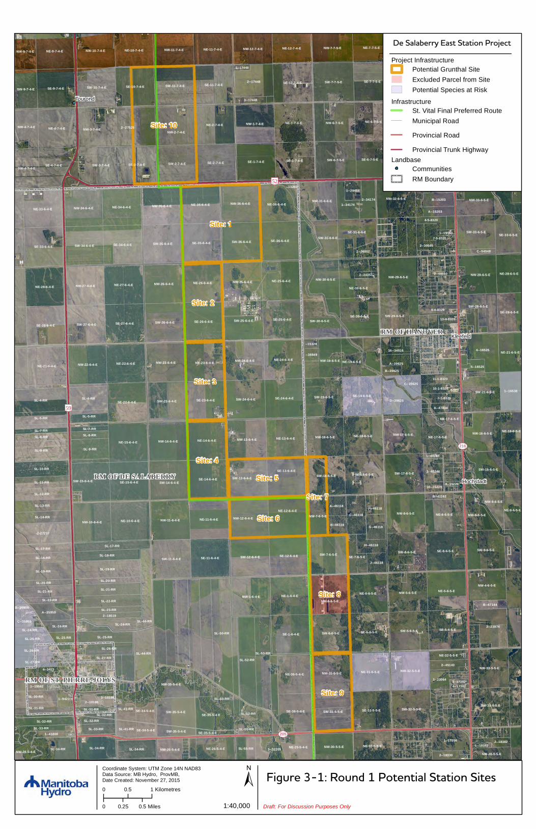
Ten possible site locations were developed based on the preliminary desktop analysis and field reconnaissance surveys (Figure 3-1). The possible site locations were discussed during three Site Selection Workshops.
A modified Delphi approach was used to select a preferred site. The modified Delphi approach is a widely used and accepted approach for gathering data from respondents within their area of expertise. “The technique is designed as a group communication process which aims to achieve a convergence of opinion on a specific real-world issue” (Hsu et. al 2007). The technique develops consensus using multiple iterations of data and discussion from a group to facilitate decisions.

De Salaberry East Station 3-2
Environmental Assessment Report
3.1.1 Initial site selection workshop
Manitoba Hydro held the first Site Selection Workshop on November 30, 2015, to discuss the ten proposed site locations and site selection criteria. Representatives from transmission line design, distribution planning, station design, property, public engagement, Indigenous engagement, biophysical and socioeconomic specialists, and project management were present. The objectives of the workshop were to identify site preferences and opportunities from each representative as well as eliminate site locations that presented constraints to the Project. Two rounds of site selection and discussions occurred during the initial workshop.
During the first round, each representative was asked to identify their top five sites using a 1-5 ranking. Furthermore, each representative was asked to identify their least preferred site. The workshop group agreed to remove Sites 2, 3, 5, 7, 8 and 9 because they were not preferred by any representative. Some of the concerns/challenges with the sites included:
• property acquisition challenges; • distance to load centre; • distance to proposed St. Vital to Letellier line; and • presence of existing infrastructure.
The workshop group agreed that sites 1, 4, 6 and 10 would be feasible options and these sites were further reviewed in the second round of the workshop.
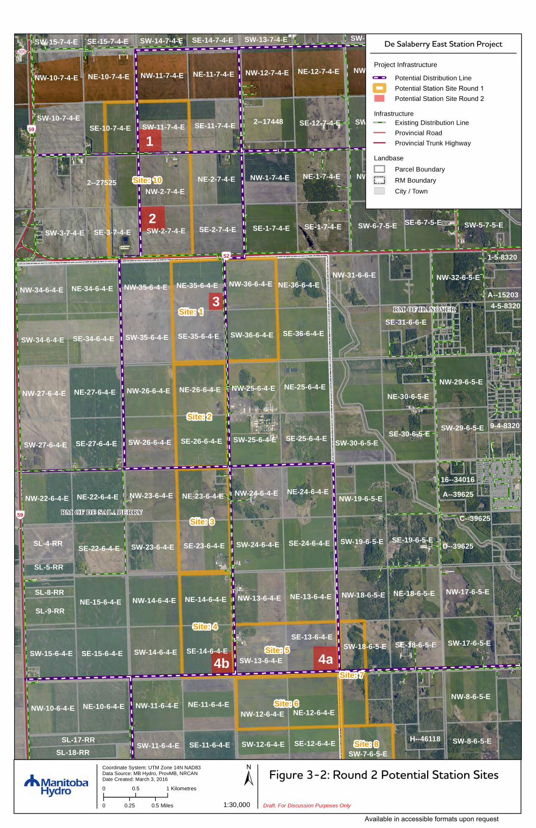
During the second round, the remaining sites were discussed by the representatives in greater detail. The sites were renumbered 1 through 4b (Figure 3-2) for simplicity. Once discussions were complete, the following sites remained:
• site 1 – Southwest corner of SW-11-7-4-E (formerly Site 10); • site 2 – Northwest corner of SW-2-7-4-E (formerly Site 10); • site 3 – South half of NE-35-6-4-E and all of SE-35-6-4-E (formerly Site 1); • site 4a – Southeast corner of SE-13-6-4-E (formerly Site 5); and • site 4b – Southeast corner of SE-14-6-4-E (new site).
Site 4b was added after the first round due to the benefits of the site from a distribution planning perspective.
The following general characteristics were noted for the remaining five proposed site locations:

De Salaberry East Station 3-3
Environmental Assessment Report
• biophysical environment; o minimal wildlife concerns because areas are primarily cultivated land;
• socio-economic environment; o little existing infrastructure generally; o areas with fewer potential landowner concerns;
• traditional use; o areas are primarily used for agriculture therefore there is limited potential for
traditional use; • transmission planning;
o minimized distance to the proposed St. Vital to Letellier line; o minimal transmission planning concerns;
• distribution planning; o closer proximity to the load centre; o shorter length of the 66 kV lines for sites 1, 2 and 3;
• station construction, operation and maintenance; o minimal construction, maintenance and access concerns.
The remaining sites were further reviewed and evaluated during the second Site Selection Workshop.
3.1.2 Second site selection workshop
Manitoba Hydro held the second Site Selection Workshop on March 8, 2016, to discuss the five remaining proposed site locations. The objective of the workshop was to share more in-depth information about each site and reach consensus among the representatives on a preferred site.
The workshop began with a high-level review of the opportunities and constraints identified for each site during the first Site Selection Workshop. Each site was then examined in greater detail with representatives providing detailed comments on their perspective during a round table discussion.
Some of the key points raised for each site during the round table discussion included:
• biophysical environment; o all sites are on cultivated land therefore there are limited wildlife concerns.
• socioeconomic environment; o there are no identified heritage sites on any of the remaining sites.
De Salaberry East Station 3-4
Environmental Assessment Report
o Site 1 no residential development present; and Challenges related to constructability due to congestion of existing and planned
infrastructure. o Site 2 could interact with agricultural activities (aerial application, biosecurity, manure
spreading, etc.); major agricultural operation and residential development on adjacent quarter
section; and require larger area for acquisition and easement due to disruption to agricultural
operations. o Site 3 no development on the quarter section (i.e., active or proposed); no residential development on the quarter section; Constructability challenges relating to existing and planned infrastructure; and reduced visual impacts to surrounding landowners because nearby homes are
treed. o Site 4a no development on the quarter section (i.e., active or proposed); no existing infrastructure on the quarter section; and a new access road would provide improved access to nearby residents and may
be perceived as beneficial – currently there is only access from PR 215. o Site 4b existing infrastructure on adjacent quarter section; possible manure spreading issue; potential stray voltage concerns with proximity to livestock operations; and a new access road would provide improved access to nearby residents and may
be perceived as beneficial – currently there is only access from PR 215. • traditional use
o all sites are on cultivated land, and no indication of traditional use on these specific sites has been identified.
• transmission planning o Site 1 congestion with other transmission lines in the immediate vicinity creates design

De Salaberry East Station 3-5
Environmental Assessment Report
challenges; and short distance to proposed St. Vital to Letellier line.
o Site 2 congestion with other transmission lines in the immediate vicinity creates design
challenges; and short distance to proposed St. Vital to Letellier line.
o Site 3 congestion with other transmission lines in the immediate vicinity creates design
challenges; and longest distance from the proposed St. Vital to Letellier line.
o Site 4a short distance to proposed St. Vital to Letellier line.
o Site 4b short distance to proposed St. Vital to Letellier line.
• distribution planning o Site 1 closest to load centre and most cost effective from a distribution perspective
due to line length. o Site 2 located near load centre, slightly further than Site 1.
o Site 3 located near load centre, further than Sites 1 and 2.
o Site 4a furthest distance to load center creates high distribution costs.
o Site 4b furthest distance to the load center creates high distribution costs.
• station construction, operation and maintenance o Site 1 congestion of transmission lines and distribution lines around the proposed
station (i.e., construction challenges); highly visible site that would lessen potential security issues; site allows for future development if necessary; and good access.
o Site 2

De Salaberry East Station 3-6
Environmental Assessment Report
congestion of transmission lines and distribution lines around the proposed station (i.e., construction challenges); and
good access. o Site 3 congestion of transmission lines and distribution lines around the proposed
station (i.e., construction challenges); and good access
o Site 4a the site would require the construction of a lengthy access road from PTH 59
and may be cost prohibitive. o Site 4b a new road would need to be constructed, but much shorter than Site 4a.
Following the review of each site, a facilitated discussion occurred to start the process of characterizing the sites. The representatives quickly reached consensus to eliminate Site 2 and Site 4a because neither site was desirable from any perspective. It was agreed that Site 2 would be eliminated due to the potential for a larger area required for acquisition (increased cost) and easement due to agricultural impacts. Site 4a was also eliminated because of the high cost associated with the construction of a new access road to PTH 59. Through further discussion, the representatives agreed to eliminate Site 4b because of concerns regarding access to the site, the distance to the load center and associated future 66kV transmission line costs.
With only Site 1 and Site 3 remaining, site-specific details were discussed. Site 1 is closest to the load centre, therefore the least expensive, requiring the fewest kilometers of distribution (66kV) lines; however, there were significant concerns about the constructability due to existing and planned infrastructure on the site as well as configuration of the infrastructure. Site 3 had no accessibility issues given the proximity to the highway and poses limited security concerns due to its visibility from the highway. There were fewer constructability concerns for site 3.
Site 3 was selected as the preferred site because it presented potentially reduced effects to both the biophysical and socio-economic environment, the lowest concern from a constructability perspective, there were no access issues to the site from a construction perspective, presented a low security risk and allowed easy maintenance access because of

De Salaberry East Station 3-7
Environmental Assessment Report
its proximity to PTH 52, had few homes in proximity to the site and concentrated the infrastructure in one location.
At the conclusion of the meeting, it was decided by the group that each representative conduct further investigation of the two remaining sites including orientation of the station and that a follow-up meeting be held to confirm that site three was the preferred site location.
3.1.3 Third site selection workshop
On April, 7th, 2016, the group re-convened for the final workshop to finalize its selection of the preferred station location. A facilitated discussion of the two remaining sites (site one and site three) occurred to determine if site three remained the preferred station location upon detailed investigation by each representative. Further investigation into the two remaining sites did not alter the decision to proceed with site three as the preferred station location. The following are some of the key reasons for the decision:
• site one had considerable construction challenges due to existing and planned infrastructure on the property;
• site three is further away from residences; • from an electrical perspective site three was a more favourable option given the
infrastructure to be installed on the site for other projects; • concentration of infrastructure (aesthetic concerns) in one location is often preferred
from the public rather than using multiple locations making site three a preferred location; and
• the location of site three is adjacent to PTH 52 and is a better option from a security and maintenance perspective.
Site: 10
Site: 1
Site: 8
Site: 4
Site: 5
Site: 6
Site: 3
Site: 2
Site: 9
Site: 7
RM OF HANOVER
RM OF DE SALABERRY
RM OF ST. PIERRE-JOLYS
Tourond
Kleefeld
Hochstadt
SL-50-RR
2--27525
SL-52-RR
SL-4-RR
SL-53-RR
SE-8-7-5-E
SE-5-6-5-E
SE-8-6-5-E
SE-1-6-4-E SE-6-6-5-E
SW-7-7-5-E
NE-5-7-5-ENE-1-7-4-E
NE-6-6-5-E NE-5-6-5-E
NE-2-7-4-E
NE-1-6-4-E
SE-7-7-5-E
SE-3-7-4-E
SE-9-7-4-E
2--23974
2--17448
NE-6-7-5-E
SE-2-7-4-E
NE-4-7-4-E
SE-1-7-4-E
-2-27237
SE-1-7-4-E
SW-5-6-5-E
SW-8-6-5-E
SW-6-7-5-E
NW-1-7-4-E
NW-8-6-5-E
NW-2-7-4-E
SW-6-6-5-E
SW-8-7-5-E
SW-7-6-5-E
NW-6-6-5-E
NW-6-7-5-E
NW-1-6-4-E
SW-2-7-4-E
NW-5-6-5-E
SW-9-6-5-E
SE-11-6-4-E
SE-11-7-4-E
SE-6-7-5-E
SE-15-6-4-E
SE-12-7-4-E
SE-22-6-4-E
SE-26-6-4-E
SE-34-6-4-E
SE-27-6-4-E
SE-12-6-4-E
SE-13-6-4-E
SE-14-6-4-E
SE-24-6-4-E
NE-11-6-4-E
SE-18-6-5-E
SE-35-6-4-E
SE-19-6-5-E
SE-25-6-4-E
SE-10-7-4-E
SE-36-6-4-E
SE-23-6-4-E
NE-15-6-4-E
SE-31-5-5-E
NE-27-6-4-E
SE-33-6-4-E
NE-14-6-4-E
NE-26-6-4-E
NE-12-6-4-E
NE-13-6-4-E
NE-22-6-4-ENE-24-6-4-E
NE-18-6-5-E
NE-25-6-4-E
NE-9-7-4-E
NE-28-6-4-E
SE-28-6-4-E
NE-31-5-5-E
NE-10-6-4-E
SL-9-RR
SW-9-7-5-E
NE-21-6-4-E
SW-11-6-4-E
SW-11-7-4-E
NE-35-6-4-E
NE-8-6-5-E
SW-3-7-4-E
NW-11-6-4-E
SW-23-6-4-E
SW-14-6-4-E
SW-12-6-4-E
SW-13-6-4-E
SW-26-6-4-E
SW-24-6-4-E
SW-25-6-4-E
SW-35-6-4-E SW-36-6-4-E
SW-17-6-5-E
NW-4-7-5-E
4--16525
SW-32-5-5-E
NW-14-6-4-E
NW-12-6-4-E
NW-13-6-4-E
NW-23-6-4-E NW-24-6-4-E
NW-26-6-4-E
SW-10-7-4-E
NW-25-6-4-E
NW-17-6-5-E
NW-29-6-5-E
NW-32-5-5-E
SE-30-6-5-E
NE-34-6-4-E
SL-19-RR
NW-31-5-5-E
SW-34-6-4-E
SW-27-6-4-E
NW-32-6-5-E
SW-18-6-5-E
SW-31-5-5-E
NW-36-6-4-ENE-33-6-4-E
NW-27-6-4-E
SW-19-6-5-E
NW-22-6-4-E
NW-10-6-4-E
NW-18-6-5-E
NE-23-6-4-E
NW-35-6-4-E
NW-5-7-5-E
NW-28-6-5-E
SW-4-7-5-E
NE-10-7-4-E
NE-36-5-4-E
SW-15-6-4-E
SW-5-7-5-ESE-4-7-4-E
NW-34-6-4-E
NE-30-6-5-E
NW-16-6-5-E
SW-33-5-5-E
NW-33-5-5-E
SW-29-6-5-E
SW-21-6-5-E
NW-31-6-6-E
NE-11-7-4-ENW-10-7-4-E NW-7-7-5-E
D--39625
SL-19-RR
NE-36-6-4-E
SL-4-RR
NW-11-7-4-E
SW-33-6-5-E
NE-7-7-5-E
NW-4-6-5-E
SE-36-5-4-E
1--16538
NE-12-7-4-ENW-12-7-4-E
SL-44-RR
SW-30-6-5-E
SL-34-RR NE-30-5-5-E
SL-9-RR
SW-16-6-5-E
NW-19-6-5-E
1--17356SL-34-RR
SW-35-5-4-E
SL-10-RR
SE-35-5-4-E
NE-17-6-5-E
NW-33-6-5-E
SW-4-7-4-E
C--46118
SL-44-RR
SE-5-7-5-E
SE-31-6-6-E
NW-30-5-5-E
NE-28-6-5-ENW-30-6-5-E
SL-22-RR
SL-21-RR
NW-3-7-4-E
SL-5-RR
SE-28-6-5-ESW-28-6-5-E
SW-9-7-4-E
SE-33-6-5-E
NE-26-5-4-E
NE-21-6-5-E
SL-34-RR
NW-9-6-5-E
NW-9-7-4-E
NW-35-5-4-E
SL-18-RR
NW-4-7-4-E
SW-31-6-6-E
2--341741--34174
SL-14-RR
SL-21-RR
SL-13-RR
SL-11-RR
SL-17-RR
SL-12-RR
NE-16-6-5-E
SL-25-RR
NE-25-5-4-E
NW-7-6-5-E
NE-19-6-5-E
NE-9-6-5-E
A--39625
SL-31-RR
SL-26-RR
SL-18-RR
SL-5-RR
B--15203
G--46118
A--35959
SE-7-6-5-E
SL-30-RR
H--46118SL-17-RR
3--40246
SL-32-RR
C--39625
1--23064
SL-8-RR
SL-55-RR
SL-27-RR
SL-41-RR
SL-25-RR
J--46118
7-5-8320
SL-24-RR
NW-9-6-5-E
SL-26-RR
2--45143
B--46118
9-4-8320
2--18519
NW-26-5-4-E
A--15203
A--46118
2--30585
1-5-8320
SL-33-RR
SL-20-RR
SL-23-RR
NW-28-5-5-E
11-1-8320
7-1-8320
SE-34-5-4-E
10-1-8320
SL-50-RR
16--34016
1--29454
SL-33-RR
3--32205
SL-24-RRC--35959
SL-20-RR
SL-8-RR
4--3423
SL-52-RR
SE-5-7-5-E
1--9423
SL-41-RR
2--18382
4-5-8320
2--18330
B--47144
F--46118
NE-32-5-5-E
--13260
SL-7-RR
SW-35-5-4-E
NE-17-6-5-E
SL-22-RR
5--16525
NW-28-5-4-E
1--19562
SL-25-RR
1--36802
C--15203
SL-32-RR
--38849
3--17448
1--41808SE-34-5-4-E
2--10186
SL-55-RR
3--10186
SL-7-RR
A--47834
B--39625
B--41162
SL-31-RR
SL-24-RR
13-4-8320
2--24353
10--15229
--15328
SL-32-RR
SE-35-5-4-E
SL-27-RR
B--35959
C--54548
1--19463
1--40246
1--18382
4--173823--17382
1--17448
2--48550
8--15229
[\59
[\52
UV216
UV205
UV216
Figure 3-1: Round 1 Potential Station SitesCoordinate System: UTM Zone 14N NAD83Data Source: MB Hydro, ProvMB,Date Created: November 27, 2015
0 0.25 0.5 Miles
0 0.5 1 Kilometres±
1:40,000 Draft: For Discussion Purposes Only
InfrastructureSt. Vital Final Preferred RouteMunicipal Road
Provincial Road
Provincial Trunk Highway
Project InfrastructurePotential Grunthal SiteExcluded Parcel from SitePotential Species at Risk
LandbaseCommunitiesRM Boundary
De Salaberry East Station Project
4a
2
1
3
4b
Site: 10
Site: 1
Site: 4
Site: 5
Site: 6
Site: 3
Site: 2
Site: 8
Site: 7
RM OF HANOVER
RM OF DE SALABERRY
ÃÆ
52
ÃÆ
59
ÃÆ
59
2--27525
SW-7-7-5-E
NE-1-7-4-ENE-2-7-4-E
NW-7-7-5-E
SE-7-7-5-E
SE-3-7-4-E
2--17448
NE-7-7-5-E
NE-6-7-5-E
SE-2-7-4-E SE-1-7-4-E SE-1-7-4-E SW-6-7-5-E
NW-1-7-4-E
NW-8-6-5-E
NW-2-7-4-E
SW-8-7-5-E
NW-8-7-5-E
NW-6-7-5-E
SW-2-7-4-E
SE-11-7-4-E
SE-6-7-5-E
SE-15-6-4-E
SE-12-7-4-E
SE-22-6-4-E
SE-26-6-4-E
SE-34-6-4-E
SE-27-6-4-E
SE-13-6-4-ESE-14-6-4-E
SE-24-6-4-E
NE-11-6-4-E
SE-18-6-5-E
NE-11-7-4-E
SE-35-6-4-E
SE-19-6-5-E
SE-25-6-4-E
SE-10-7-4-E
SE-36-6-4-E
SE-23-6-4-E
NE-15-6-4-E
NE-27-6-4-E
NE-12-7-4-E
NE-14-6-4-E
NE-26-6-4-E
NE-12-6-4-E
NE-13-6-4-E
NE-10-7-4-E
NE-22-6-4-E NE-24-6-4-E
NE-18-6-5-E
NE-25-6-4-E
NE-10-6-4-E
SW-11-7-4-E
NE-35-6-4-E
SW-3-7-4-E
NW-11-6-4-E
SW-23-6-4-E
SW-14-6-4-ESW-13-6-4-E
SW-26-6-4-E
SW-24-6-4-E
SW-25-6-4-E
SW-35-6-4-E
NW-11-7-4-E
SW-36-6-4-E
SW-17-6-5-E
NW-14-6-4-E
NW-12-7-4-E
NW-12-6-4-E
NW-13-6-4-E
NW-23-6-4-E NW-24-6-4-E
NW-26-6-4-E
SW-10-7-4-E
NW-25-6-4-E
NW-17-6-5-E
NW-29-6-5-E
SE-30-6-5-E
NE-34-6-4-E
SW-34-6-4-E
SW-27-6-4-E
NW-32-6-5-E
SW-18-6-5-E
NW-36-6-4-E
NW-27-6-4-E
SW-19-6-5-E
NW-10-7-4-E
NW-22-6-4-E
NW-10-6-4-E
NW-18-6-5-E
NE-23-6-4-E
NW-35-6-4-E
NW-5-7-5-E
SW-15-6-4-E
SW-5-7-5-E
NW-34-6-4-E
NE-30-6-5-E
SW-29-6-5-E
NW-31-6-6-E
D--39625
NE-36-6-4-E
SL-4-RR
SW-8-6-5-E
SW-30-6-5-E
SL-9-RR
NW-19-6-5-E
SW-7-6-5-E
SE-31-6-6-E
SE-12-6-4-ESE-11-6-4-E SW-12-6-4-ESL-18-RR SW-11-6-4-ESL-17-RR
A--39625
SL-5-RR
H--46118
C--39625
16--34016
SW-15-7-4-E SE-15-7-4-E
SL-8-RR
SW-14-7-4-E SE-14-7-4-E
1-5-8320
A--15203
9-4-8320
4-5-8320
SW-13-7-4-E SW-18-7-5-E
UV216
UV305
Figure 3-2: Round 2 Potential Station SitesCoordinate System: UTM Zone 14N NAD83Data Source: MB Hydro, ProvMB, NRCANDate Created: March 3, 2016
0 0.25 0.5 Miles
0 0.5 1 Kilometres±
1:30,000 Draft: For Discussion Purposes Only
De Salaberry East Station Project
Landbase
Parcel BoundaryRM BoundaryCity / Town
InfrastructureExisting Distribution LineProvincial RoadProvincial Trunk Highway
Project Infrastructure
Potential Distribution LinePotential Station Site Round 1Potential Station Site Round 2
Available in accessible formats upon request