developing a wetland condition monitoring … a wetland condition monitoring network for nj:...
TRANSCRIPT

Developing a Wetland Condition Monitoring Network for NJ:
Application of New Assessment Methods
EPA R2 WPDG Grant – NJDEPMay 19, 2010
NJ Water Monitoring Council Meeting

National Aquatic Resource Survey (NARS) Field & Report Schedule
RESOURCE FIELD REPORT• Lakes FY07 FY09• Rivers FY08 FY10• Streams FY09 FY11• Coastal FY10 FY12• Wetlands FY11 FY13

EPA’s “Three-Tier Framework” for Wetland Monitoring and Assessment
Tier I: Landscape (Broad Landscape-Scale RAM)Tier II: Site (Field RAM)Tier III: Intensive Biological & Physical-Chemical
Survey– Vegetation– Soils– Hydrology– WQ– Stressors– National Vegetation Classification (NVC)
Tier IV: Intensive +– Fixed Monitoring Stations (e.g. SET)

Rare Wetland Research & Monitoring (Tier 3) in NJ 1997-2009
Calcareous Sinkhole Ponds of the Kittatinny Valley
Pine Barren Riverside Savannas
Non-tidal Floodplain Forest Communities
Coastal Plain Intermittent Pond Communities
Sea-level Fen, Tidal Freshwater and Brackish Marsh Communities
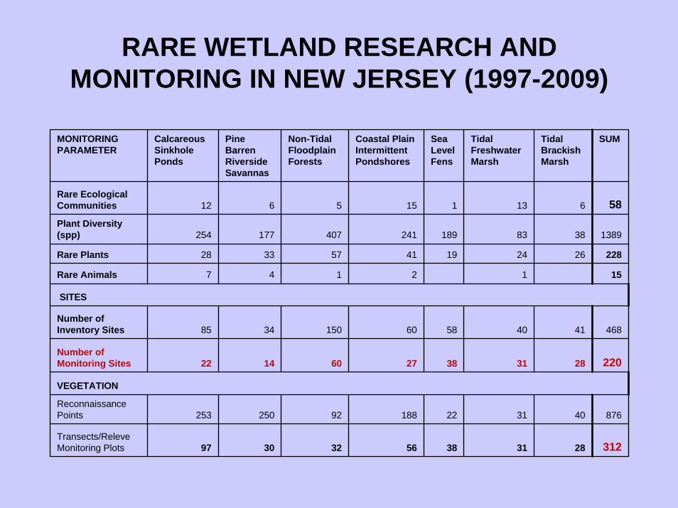
RARE WETLAND RESEARCH AND MONITORING IN NEW JERSEY (1997-2009)
MONITORING PARAMETER
Calcareous Sinkhole Ponds
Pine Barren Riverside Savannas
Non-Tidal Floodplain Forests
Coastal Plain Intermittent Pondshores
Sea Level Fens
Tidal Freshwater Marsh
Tidal Brackish Marsh
SUM
Rare Ecological Communities 12 6 5 15 1 13 6 58Plant Diversity (spp) 254 177 407 241 189 83 38 1389
Rare Plants 28 33 57 41 19 24 26 228
Rare Animals 7 4 1 2 1 15
SITES
Number of Inventory Sites 85 34 150 60 58 40 41 468
Number of Monitoring Sites 22 14 60 27 38 31 28 220
VEGETATION
Reconnaissance Points 253 250 92 188 22 31 40 876
Transects/ReleveMonitoring Plots 97 30 32 56 38 31 28 312

What can we say?
• NJ supports and extraordinarily high diversity of wetland types, many of which are globally rare
• Missing data on wetland condition for common wetland types
• Previous rare wetland sites were not randomly selected – difficult to establish disturbance gradient (except for floodplain forests)
• No way to report on the overall condition of wetlands statewide, by region, or by watershed

Developing a Wetland Condition Monitoring Network for New Jersey: Application of New
Assessment MethodsEPA-R2-WPDG (2009-2013)
1. Establish statewide network of wetland condition assessment monitoring sites at Level 2 and 3 intensification applying NatureServe’s Ecological Integrity Assessment and EPA NWCA protocols.
2. Map and classify the springs of New Jersey and establish long-term monitoring at characteristic springs statewide.
3. Augment the existing Floristic Quality Assessment Index with bryophytes and rare plants and use to evaluate and track vegetation at mitigation sites.
4. Outreach to federal, state, local, private and watershed conservation groups.

TASK 1. Establish statewide network of wetland condition assessment monitoring sites.
• Level 2 Wetland Condition Assessment Intensification Study Statewide Probabilistic Survey– 300 palustrine & estuarine wetland sites using LULC2007
data stratified by HUC, Phys Prov, Cowardin, HGM• Level 3 Wetland Condition Assessment Intensification
Study– 60 wetland monitoring sites using Ecological Integrity
Assessment in conjunction with EPA NWCA sampling methods and protocols» Establish long-term hydrological monitoring» Freshwater Algae Study» Sediment Carbon Sequestration Study» Riparian Overbank Flow Study
– 6 wetland experimental & monitoring sites established to inform water allocation permitting decisions

Geographic Framework (TBD):– HUC8 (12)* or HUC11 Watershed (152) * NJWMC recommendation 5/19/10– Physiographic Provinces (5-6)– Omernik Ecoregions EPA (5-17)– Watershed Management Areas (20)– Climate Regions (5)
Cowardin Wetland Class 6 (7)– Estuarine Intertidal Forested/Scrub-Shrub– Estuarine Intertidal Emergent– Palustrine Forested– Palustrine Scrub-Shrub– Palustrine Emergent– Palustrine Aquatic Bed– Palustrine Farmed (in NWCA but not to be included in NJWCA)
NWI 2010 HGM Class (7) - Ralph Tiner, USFWS– Riverine, Depressional, Slope, Mineral Soil Flats, Organic Soil Flats, Estuarine
Fringe, Lacustrine Fringe
Framework to be determined by 2013 NARS Wetlands REPORT FORMAT300 RAM Level 2 sampling sites = 12HUC x 6NWI = 72 x 4-5 reps = 288-360 sites
Probabilistic Stratified Random Sampling Framework (Tier 2)


EIA & NWCA Level 1 & 2 Assessment MetricsRank Factor Major Ecological Attribute Indicator
Landscape Structure Landscape Connectivity
Buffer Index
Surrounding Land Use Index
Landscape Stressors Landscape Stressors Checklist
SIZE Size Patch Size Condition
Patch Size
Vegetation Vegetation Structure
Organic Matter Accumulation
Vegetation Composition
Relative Total Cover of Native Plant Species (FQAI)
Vegetation Stressors Vegetation Stressors Checklist
Soils (including physico-chemical) Physical Patch Types
Water Quality
Soil Surface Condition
Soil Stressors Soils Stressors Checklist
Hydrology Water Source
Hydroperiod
Hydrologic Connectivity (HGM)
Hydrology Stressors Hydrology Stressors Checklist
CONDITION
LANDSCAPECONTEXT

TASK 1. Establish statewide network of wetland condition assessment monitoring sites.
• Level 2 Wetland Condition Assessment Intensification Study Statewide Probabilistic Survey– 300 palustrine & estuarine wetland sites using LULC2007
data stratified by Phys Prov, Cowardin, HGM, NVC classes• Level 3 Wetland Condition Assessment Intensification
Study– 60 wetland monitoring sites using Ecological Integrity
Assessment in conjunction with EPA NWCA sampling methods and protocols» Establish long-term hydrological monitoring» Freshwater Algae Study» Sediment Carbon Sequestration Study» Riparian Overbank Flow Study
– 6 wetland experimental & monitoring sites established to inform water allocation permitting decisions
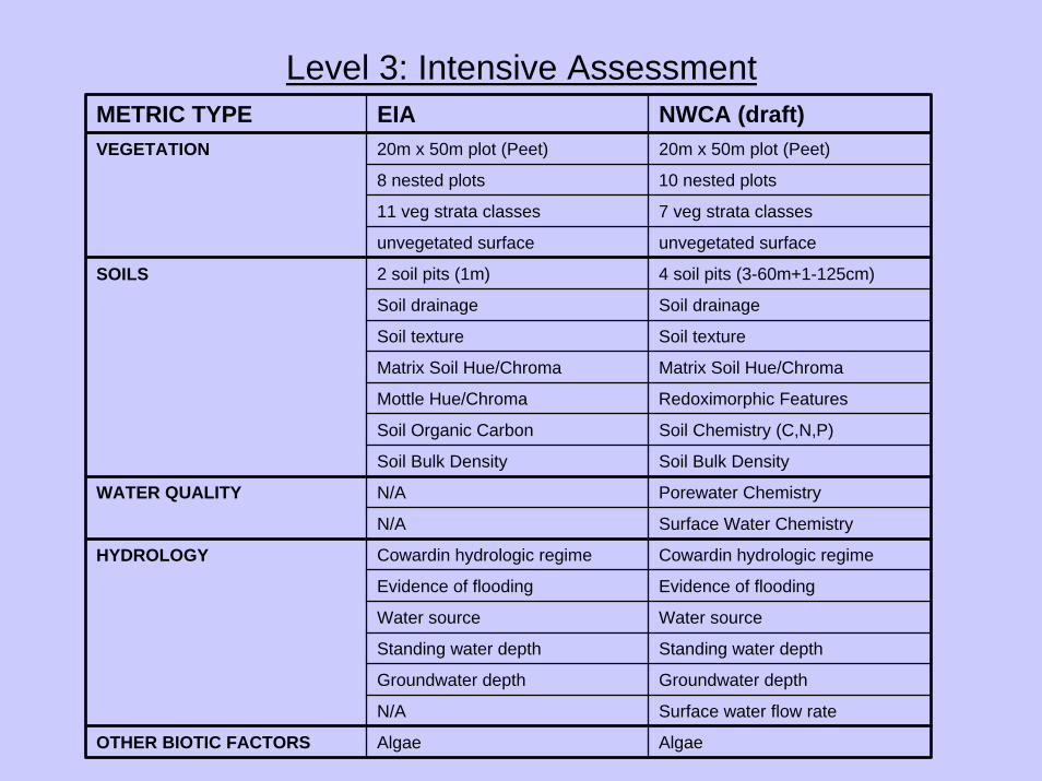
Level 3: Intensive AssessmentMETRIC TYPE EIA NWCA (draft)VEGETATION 20m x 50m plot (Peet) 20m x 50m plot (Peet)
8 nested plots 10 nested plots
11 veg strata classes 7 veg strata classes
unvegetated surface unvegetated surface
SOILS 2 soil pits (1m) 4 soil pits (3-60m+1-125cm)
Soil drainage Soil drainage
Soil texture Soil texture
Matrix Soil Hue/Chroma Matrix Soil Hue/Chroma
Mottle Hue/Chroma Redoximorphic Features
Soil Organic Carbon Soil Chemistry (C,N,P)
Soil Bulk Density Soil Bulk Density
WATER QUALITY N/A Porewater Chemistry
N/A Surface Water Chemistry
HYDROLOGY Cowardin hydrologic regime Cowardin hydrologic regime
Evidence of flooding Evidence of flooding
Water source Water source
Standing water depth Standing water depth
Groundwater depth Groundwater depth
N/A Surface water flow rate
OTHER BIOTIC FACTORS Algae Algae

National Wetland Condition Assessment 2011


Collaboration ~ Monitoring• Mid-Atlantic Coastal Wetland Assessment
workgroup (MACWA)– Barnegat Bay & Delaware Bay Tidal Marsh Research
• Barnegat Bay National Estuarine Program• Partnership for the Delaware Estuary• USFWS Forsythe Refuge• Academy of Natural Sciences• Rutgers University• DEP – CZM, DSRT, WMS, NJGS• NJWMC

Developing a Wetland Condition Monitoring Network for New Jersey: Application of New
Assessment MethodsEPA-R2-WPDG (2009-2013)
1. Establish statewide network of wetland condition assessment monitoring sites at Level 2 and 3 intensification applying NatureServe’s Ecological Integrity Assessment and EPA NWCA protocols.
2. Map and classify the springs of New Jersey and establish long-term monitoring at characteristic springs statewide.
3. Augment the existing Floristic Quality Assessment Index with bryophytes and rare plants and use to evaluate and track vegetation at mitigation sites.
4. Outreach to federal, state, local, private and watershed conservation groups.

Task 3. Floristic Quality Assessment Index for Bryophytes and Rare Flora
• Develop FQA Coefficients of Conservatism for bryophytes (mosses, liverworts) and rare plants of New Jersey.
• Use FQAI as a vegetation condition metric in Level 3 Wetland Condition Assessments
• Use FQAI as a metric to evaluate and track wetland mitigation site vegetation data (restoration and enhancement sites)

Developing a Wetland Condition Monitoring Network for New Jersey: Application of New
Assessment MethodsEPA-R2-WPDG (2009-2013)
1. Establish statewide network of wetland condition assessment monitoring sites at Level 2 and 3 intensification applying NatureServe’s Ecological Integrity Assessment and EPA NWCA protocols.
2. Map and classify the springs of New Jersey and establish long-term monitoring at characteristic springs statewide.
3. Augment the existing Floristic Quality Assessment Index with bryophytes and rare plants and use to evaluate and track vegetation at mitigation sites.
4. Outreach to federal, state, local, private and watershed conservation groups.
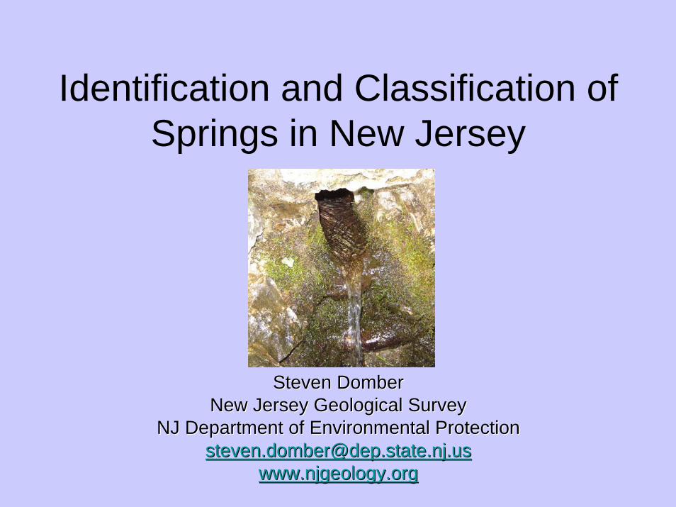
Identification and Classification of Springs in New Jersey
Steven DomberSteven DomberNew Jersey Geological SurveyNew Jersey Geological Survey
NJ Department of Environmental ProtectionNJ Department of Environmental [email protected]@dep.state.nj.us
www.njgeology.orgwww.njgeology.org

What is a spring?• Areas of focused ground-water discharge
– Perennial or ephemeral– Large or small volumes – Can be located on slopes, in wetlands and riparian
areas, or under water– Can be specific point locations or distributed across a
specific area (e.g. headwater wetlands/seeps) – Water temperatures and flow variability vary
depending on length of flow path– Related spring terms include: mineral, soda, thermal,
karst, boiling, sulfur, etc
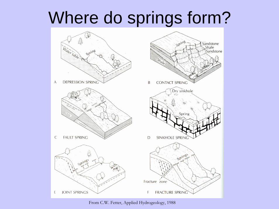
Where do springs form?
From C.W. Fetter, Applied Hydrogeology, 1988

Why study springs in NJ?
• Hydro-ecological importance– Can provide relatively constant volume and
temperature of water to nearby surface waters or wetlands
– Thermal and ecological refuges – Unique flora and fauna; other studies have suggested
they are significant sources of biological diversity– Smaller seasonal springs can provide breading areas
(e.g. vernal pools)– Can be the primary source of water high up in the
watershed

• Socio-cultural importance– Native American and European settlement often
associated with springs (drinking water, game animals and refrigeration)
– Township of Boiling Springs – now East Rutherford– Laurel Springs Borough in Camden County– Historic markers– Schooley’s Mountain Resort (late 1800s)
Why study springs in NJ? con’t

• Regulatory Requirements– Drinking water:
• Public Water: Washington Twp, Mine Hill Boro• Spring water bottling: Spring Meadow Farm,
Mountain Wood Spring Water Company, Crystal Valley Spring, numerous historic bottlers
– Water Allocation Permit requirements• Hydrologic impacts
– Watershed Management– Land Use Regulation (wetland permitting)
Why study springs in NJ? con’t

• Springs have hydro-ecologic, socio-cultural, water supply importance.
• However, unlike lakes and wetlands comprehensive assessments of springs have not typically been conducted. This is true in NJ and elsewhere.
• Bits and pieces on the identification of and classification systems and assessments have been developed but they are far from comprehensive…
What does this tell us?

Meinzer’s 1927 Spring Discharge Classification System
Still commonly used today, but only considers flow…
Magnitude Avg. Annual FlowFirst Order >100 cfs
Second Order 10 to 100 cfsThird Order 1 to 10 cfs
Fourth Order 100 gpm to 1 cfsFifth Order 10 to 100 gpmSix Order 1 to 10 gpm
Seventh Order 1 pint to 1 gpmEighth Order <1 pint pmZero Order no longer flowing
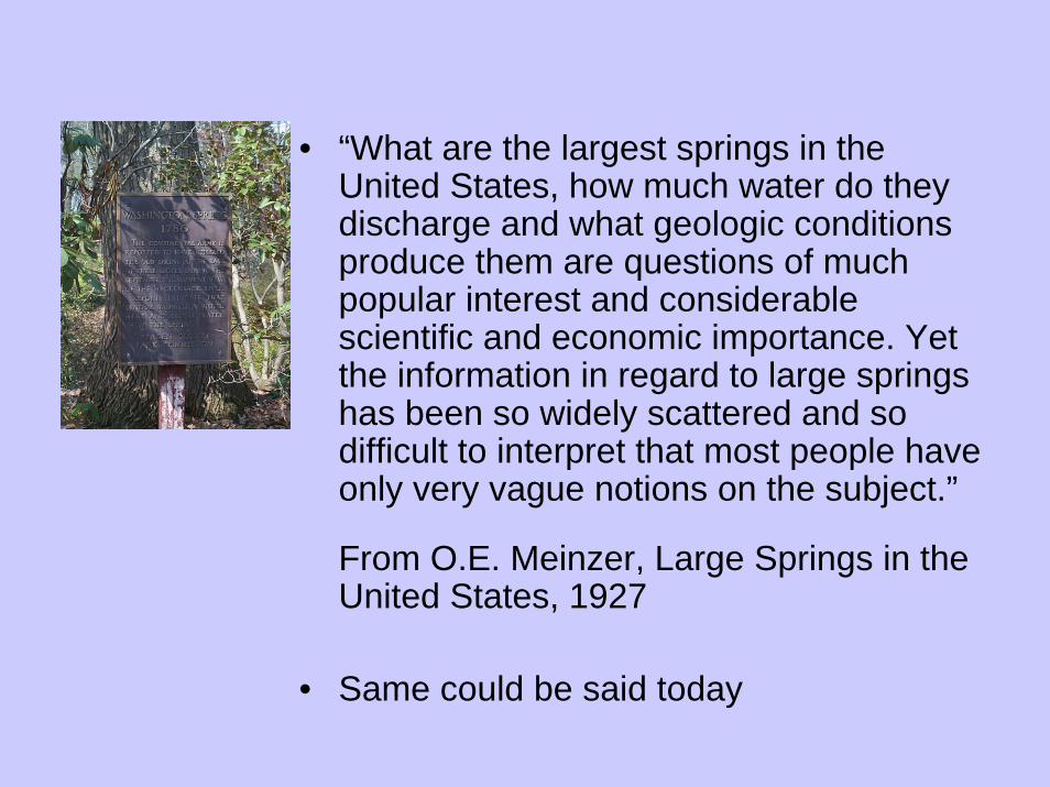
• “What are the largest springs in the United States, how much water do they discharge and what geologic conditions produce them are questions of much popular interest and considerable scientific and economic importance. Yet the information in regard to large springs has been so widely scattered and so difficult to interpret that most people have only very vague notions on the subject.”
From O.E. Meinzer, Large Springs in the United States, 1927
• Same could be said today

Springs Identified to date

Proposed Approach• Phase 1: Statewide Spring Survey
– Identify locations of major springs in NJ• Review/consolidate existing resources• As discovered during other field work
– Develop a statewide GIS database locating and characterizing springs using a consistent methodology
• GPS locations• Pictures• Approximate flow rates• Where readily available
– Hydrogeologic setting– Water chemistry field parameters
• Phase II: more detailed research– Using data collected in Phase 1:
• Identify regions/geologic settings where springs are prevalent
• Or vice versa, locations where springs have been located but are not common (and therefore potentially unique/significant)
– Identify subset of springs for more detailed analysis and monitoring
– Characterize geologic, hydrologic, and ecologic settings – Monitor water quality, quantity, and temperature over
time

• Phase II con’t: – Using survey and detailed data collected
develop a spring classification system for NJ• Possibly base NJ’s classification system on one
developed by Springer, et al.– Relational database design using relevant physical,
chemical, biological, and socio-cultural variables – Includes geomorphic considerations, flow forcing
mechanisms, flow characteristics, water quality, habitat characteristics, springs biota, and land management
– Identify vulnerable springs and headwater seepage wetlands
– Develop database and field worksheets to manage future data collection

Developing a Wetland Condition Monitoring Network for New Jersey: Application of New
Assessment MethodsEPA-R2-WPDG (2009-2013)
1. Establish statewide network of wetland condition assessment monitoring sites at Level 2 and 3 intensification applying NatureServe’s Ecological Integrity Assessment and EPA NWCA protocols.
2. Map and classify the springs of New Jersey and establish long-term monitoring at characteristic springs statewide.
3. Augment the existing Floristic Quality Assessment Index with bryophytes and rare plants and use to evaluate and track vegetation at mitigation sites.
4. Outreach to federal, state, local, private and watershed conservation groups.

Task 4. Outreach• Post final wetland condition assessment and spring
mapping products on DEP website(s).• Provide Floristic Quality Assessment Index (FQAI)
bryophyte and rare plant information to Bowman’s Hill Wildflower Preserve for posting on their FQAI/Plant Stewardship Index (PSI) website.
• Provide summary information on condition of palustrine and estuarine wetlands and headwater springs of NJ for land use planning, protection and restoration of vulnerable wetland and aquatic resources to federal, state, local, private and watershed conservation groups.
• Provide site information and monitoring data to the NJDEP Water Monitoring Council, Volunteer Monitoring Program and Watershed Watch Network.

NJDEP Contact Information
Kathleen Strakosch WalzNJDEP – Natural & Historic Resources
Division of Parks & ForestryOffice of Natural Lands Management
Natural Heritage Program22 S. Clinton Ave, 4th Floor
PO Box 404Trenton, NJ 08625-0404
Steven DomberNJDEP – Land Use Management
New Jersey Geological SurveyBureau of Water Resources
29 Arctic ParkwayPO Box 427
West Trenton, NJ 08625-0427908-984-6587