developing a system to track wetland changes over time ... · developing a system to track wetland...
TRANSCRIPT

Updating and Tracking Wetlands
Developing a System to Track Wetland
Changes Over Time Using ArcSDE

Updating and Tracking Wetlands
Why is DU Interested in Updating
and Tracking Wetlands?
Habitat Modeling
Restoration Planning
580529

Updating and Tracking Wetlands
Wetland Functional Assessment
Paw Paw Watershed, Michigan (MI DEQ)

Updating and Tracking Wetlands
What Do We Want to Know?
Current Inventory of Wetlands
Track Wetland Changes Over Time
Agriculture Development
Inventory of Converted/Modified Wetlands
Type of Conversion
Recreation

Updating and Tracking Wetlands
How do you accomplish it?
How do you keep
track of this
wetland if you
delete it from the
current inventory?
Updating and Tracking Wetlands
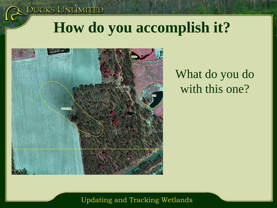
How do you accomplish it?
What do you do
with this one?
Updating and Tracking Wetlands
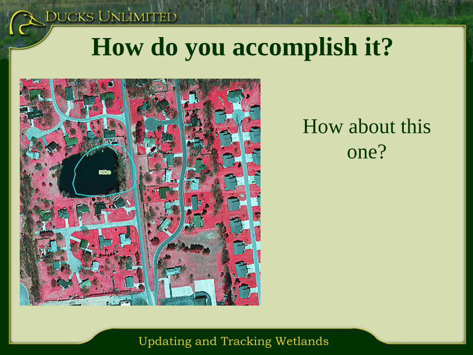
How do you accomplish it?
How about this
one?

Updating and Tracking Wetlands
Spatially Combine Two Dates
1978 NWI 1998 NWI Combined 78-98

Updating and Tracking Wetlands
Advantages:
Straight forward methodology
Separate layers for each date
Disadvantages:
Attributes get “messy” in the combined layer
More difficult to calculate and identify changes
Will get confusing when adding more then two dates
Multiple data layers to manage
Spatially Combine Two Dates
Updating and Tracking Wetlands
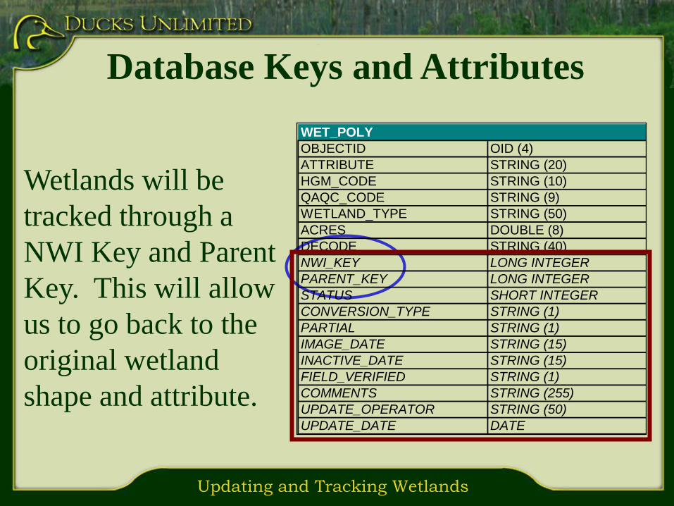
Database Keys and Attributes
Wetlands will be
tracked through a
NWI Key and Parent
Key. This will allow
us to go back to the
original wetland
shape and attribute.
WET_POLY
OBJECTID OID (4)
ATTRIBUTE STRING (20)
HGM_CODE STRING (10)
QAQC_CODE STRING (9)
WETLAND_TYPE STRING (50)
ACRES DOUBLE (8)
DECODE STRING (40)
NWI_KEY LONG INTEGER
PARENT_KEY LONG INTEGER
STATUS SHORT INTEGER
CONVERSION_TYPE STRING (1)
PARTIAL STRING (1)
IMAGE_DATE STRING (15)
INACTIVE_DATE STRING (15)
FIELD_VERIFIED STRING (1)
COMMENTS STRING (255)
UPDATE_OPERATOR STRING (50)
UPDATE_DATE DATE

Updating and Tracking Wetlands
Status will allow us
to determine if the
wetland is “active”
(currently exists) or
“inactive” (been
converted).
Database Keys and Attributes
WET_POLY
OBJECTID OID (4)
ATTRIBUTE STRING (20)
HGM_CODE STRING (10)
QAQC_CODE STRING (9)
WETLAND_TYPE STRING (50)
ACRES DOUBLE (8)
DECODE STRING (40)
NWI_KEY LONG INTEGER
PARENT_KEY LONG INTEGER
STATUS SHORT INTEGER
CONVERSION_TYPE STRING (1)
PARTIAL STRING (1)
IMAGE_DATE STRING (15)
INACTIVE_DATE STRING (15)
FIELD_VERIFIED STRING (1)
COMMENTS STRING (255)
UPDATE_OPERATOR STRING (50)
UPDATE_DATE DATE

Updating and Tracking Wetlands
NWI Key/Parent Key Example
Time 3Time 2Time 1
WET_POLY
OBJECTID
ATTRIBUTE PUB
NWI_KEY 101
PARENT_KEY
STATUS A
DRAINAGE_TYPE
PARTIAL
IMAGE_DATE 1978
FIELD_VERIFIED
COMMENTS
UPDATE_OPERATOR
UPDATE_DATE
WET_POLY
OBJECTID
ATTRIBUTE PUB
NWI_KEY 103
PARENT_KEY 102
STATUS A
DRAINAGE_TYPE D
PARTIAL Y
IMAGE_DATE 2005
FIELD_VERIFIED Y
COMMENTS
UPDATE_OPERATOR RDM
UPDATE_DATE 2007
WET_POLY
OBJECTID
ATTRIBUTE PEM
NWI_KEY 104
PARENT_KEY 102
STATUS A
DRAINAGE_TYPE
PARTIAL Y
IMAGE_DATE 2005
FIELD_VERIFIED N
COMMENTS
UPDATE_OPERATOR RDM
UPDATE_DATE 2007
Status becomes
inactive (I) if there
is a change in future
updates
A new polygon is created
that can be linked back
to original data through
the Parent_Key
If a polygon needs to be
split, both of the new polygons
can be linked back to the original
data through the Parent_Key
WET_POLY
OBJECTID
ATTRIBUTE PEM
NWI_KEY 102
PARENT_KEY 101
STATUS A
DRAINAGE_TYPE
PARTIAL
IMAGE_DATE 1998
FIELD_VERIFIED
COMMENTS
UPDATE_OPERATOR RDM
UPDATE_DATE 2005
NWI Key = 101 NWI Key = 102
Parent Key = 101
Open
WaterEmergent
Emergent
Converted
NWI Key = 103
Parent Key = 102
NWI Key = 102
Parent Key = 101
Status = inactive
Conversion = A
Partial = Yes

Updating and Tracking Wetlands
Advantages:
Can handle multiple updates and updates for small areas
Only one layer to manage
Easy to select historic and current wetlands
Easy to track individual wetlands
Disadvantages:
More complex methodology
Potential for more data entry errors
Database Keys and Attributes

Updating and Tracking Wetlands
Update Imagery
Spring CIR/Summer Natural Color
Michigan 1998 CIR – 2005 NC
Ohio 06/07 CIR – 2004 NC
Indiana 2005 CIR – 2003 NC
Illinois 2005 BW/NC - 2004 CIR
Wisconsin ?? – 2005 NC

Updating and Tracking Wetlands
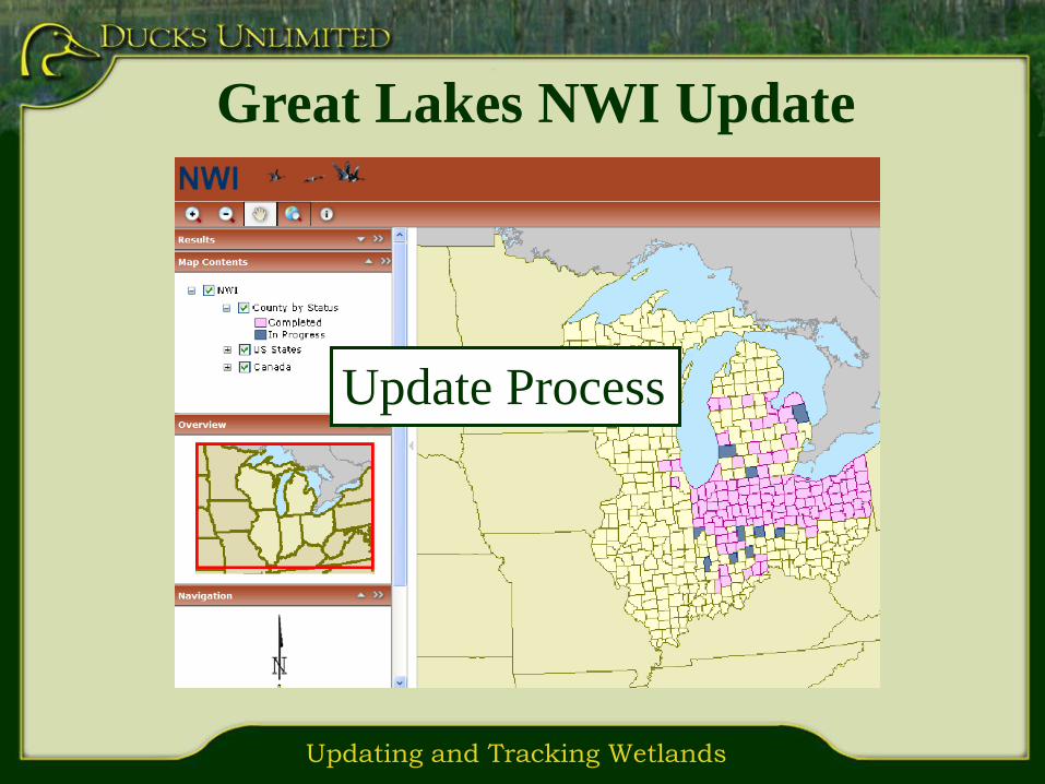
Great Lakes NWI Update
NWI TOOLBOX

Updating and Tracking Wetlands
Object Inspector
Customized
attribute
table for
editing NWI
attributes
(Update operator
and date are
automatically
generated)

Updating and Tracking Wetlands
Object Inspector
Global
variables
can be set
for the
editing
session
Updating and Tracking Wetlands
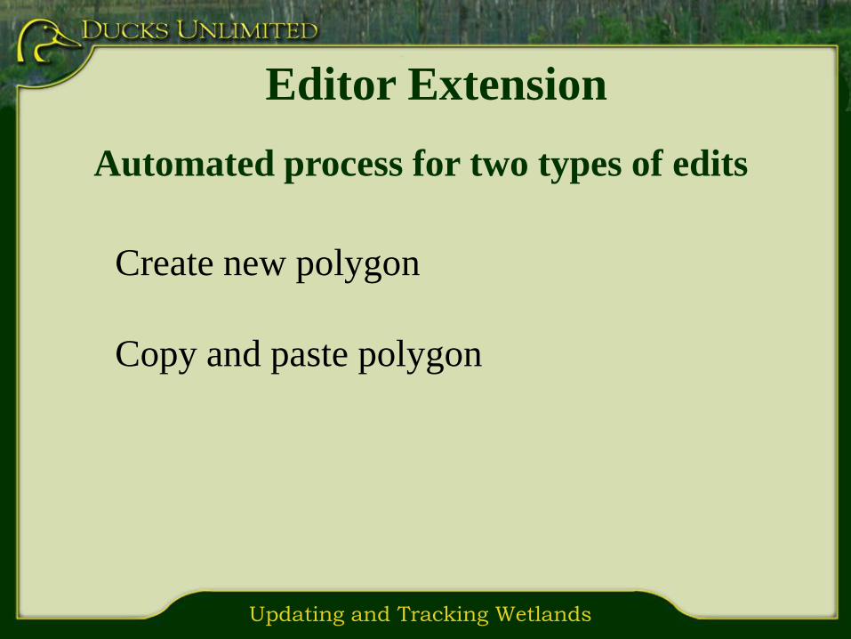
Editor Extension
Automated process for two types of edits
Create new polygon
Copy and paste polygon

Updating and Tracking Wetlands
Create New Polygon
Automatically
populates the
NWI Key,
Status, and
Image Date
Updating and Tracking Wetlands
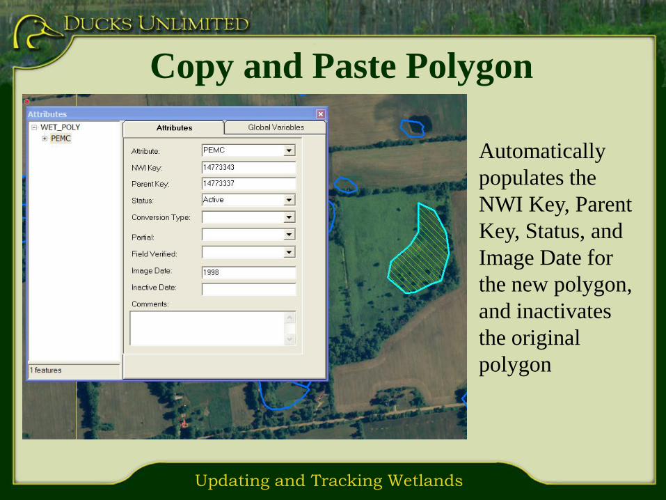
Copy and Paste Polygon
Automatically
populates the
NWI Key, Parent
Key, Status, and
Image Date for
the new polygon,
and inactivates
the original
polygon
Updating and Tracking Wetlands
Great Lakes NWI Update
Update Process

Updating and Tracking Wetlands
County
Editor
County
Editor
County
Editor
County
Editor
County
Editor
Database
sent to DU
County checked
out for editing
Version run through
quality assurance
Database returned
to USFWS
Editable
Version of
database
DU NWI Master
Geodatabase
(DU MGD)
USFWS NWI Master
Geodatabase
(USGS MGD)
QA/QC
Editors
update
NWI
Corrections
made
Editable
Version of
database
Field
Sites
Selected
Field
Verification
Assess
And
Update
Final
QA/QC
Update
Process
Verification
process
County
Editor
County
Editor
County
Editor
County
Editor
County
Editor
County
Editor
County
Editor
County
Editor
County
Editor
County
Editor
Database
sent to DU
County checked
out for editing
Version run through
quality assurance
Database returned
to USFWS
Editable
Version of
database
DU NWI Master
Geodatabase
(DU MGD)
DU NWI Master
Geodatabase
(DU MGD)
USFWS NWI Master
Geodatabase
(USGS MGD)
USFWS NWI Master
Geodatabase
(USGS MGD)
QA/QC
Editors
update
NWI
Corrections
made
Editable
Version of
database
Field
Sites
Selected
Field
Verification
Assess
And
Update
Final
QA/QC
Final
QA/QC
Update
Process
Verification
process

Updating and Tracking Wetlands
Check Out Process
Change NWI
status layer
from Null to In
Progress

Updating and Tracking Wetlands
County
Editor
County
Editor
County
Editor
County
Editor
County
Editor
Database
sent to DU
County checked
out for editing
Version run through
quality assurance
Database returned
to USFWS
Editable
Version of
database
DU NWI Master
Geodatabase
(DU MGD)
USFWS NWI Master
Geodatabase
(USGS MGD)
QA/QC
Editors
update
NWI
Corrections
made
Editable
Version of
database
Field
Sites
Selected
Field
Verification
Assess
And
Update
Final
QA/QC
Update
Process
Verification
process
County
Editor
County
Editor
County
Editor
County
Editor
County
Editor
County
Editor
County
Editor
County
Editor
County
Editor
County
Editor
Database
sent to DU
County checked
out for editing
Version run through
quality assurance
Database returned
to USFWS
Editable
Version of
database
DU NWI Master
Geodatabase
(DU MGD)
DU NWI Master
Geodatabase
(DU MGD)
USFWS NWI Master
Geodatabase
(USGS MGD)
USFWS NWI Master
Geodatabase
(USGS MGD)
QA/QC
Editors
update
NWI
Corrections
made
Editable
Version of
database
Field
Sites
Selected
Field
Verification
Assess
And
Update
Final
QA/QC
Final
QA/QC
Update
Process
Verification
process

Updating and Tracking Wetlands
The QA/QC Process
Different photo
interpreter reviews
and verifies 10% of
the County

Updating and Tracking Wetlands
The QA/QC Process

Updating and Tracking Wetlands
Analyst Reviews County and
Runs FWS QA/QC Tool
The NWI
Verification tool

Updating and Tracking Wetlands
Post Draft data on Web Site

Updating and Tracking Wetlands
County
Editor
County
Editor
County
Editor
County
Editor
County
Editor
Database
sent to DU
County checked
out for editing
Version run through
quality assurance
Database returned
to USFWS
Editable
Version of
database
DU NWI Master
Geodatabase
(DU MGD)
USFWS NWI Master
Geodatabase
(USGS MGD)
QA/QC
Editors
update
NWI
Corrections
made
Editable
Version of
database
Field
Sites
Selected
Field
Verification
Assess
And
Update
Final
QA/QC
Update
Process
Verification
process
County
Editor
County
Editor
County
Editor
County
Editor
County
Editor
County
Editor
County
Editor
County
Editor
County
Editor
County
Editor
Database
sent to DU
County checked
out for editing
Version run through
quality assurance
Database returned
to USFWS
Editable
Version of
database
DU NWI Master
Geodatabase
(DU MGD)
DU NWI Master
Geodatabase
(DU MGD)
USFWS NWI Master
Geodatabase
(USGS MGD)
USFWS NWI Master
Geodatabase
(USGS MGD)
QA/QC
Editors
update
NWI
Corrections
made
Editable
Version of
database
Field
Sites
Selected
Field
Verification
Assess
And
Update
Final
QA/QC
Final
QA/QC
Update
Process
Verification
process
Field Verification Methods

Updating and Tracking Wetlands
What do we want to Verify?
Accuracy of the NWI wetland class
Accuracy of identifying wetland status (converted or new to NWI)
Verify ambiguous wetlands from photo interpretation process

Updating and Tracking Wetlands
Run Field Selection Process Script
Buffers roads by 90 meters
Determines number of wetlands to select
Randomly selects wetlands
Adds field verified wetlands from PI process
Create personal Geodatabase of selections
Updating and Tracking Wetlands
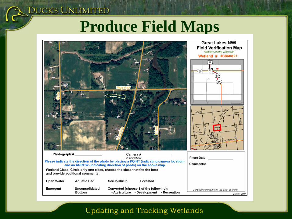
Produce Field Maps

Updating and Tracking Wetlands
Add Field Data to Geodatabase
Add Photo Point
And Photo
Updating and Tracking Wetlands
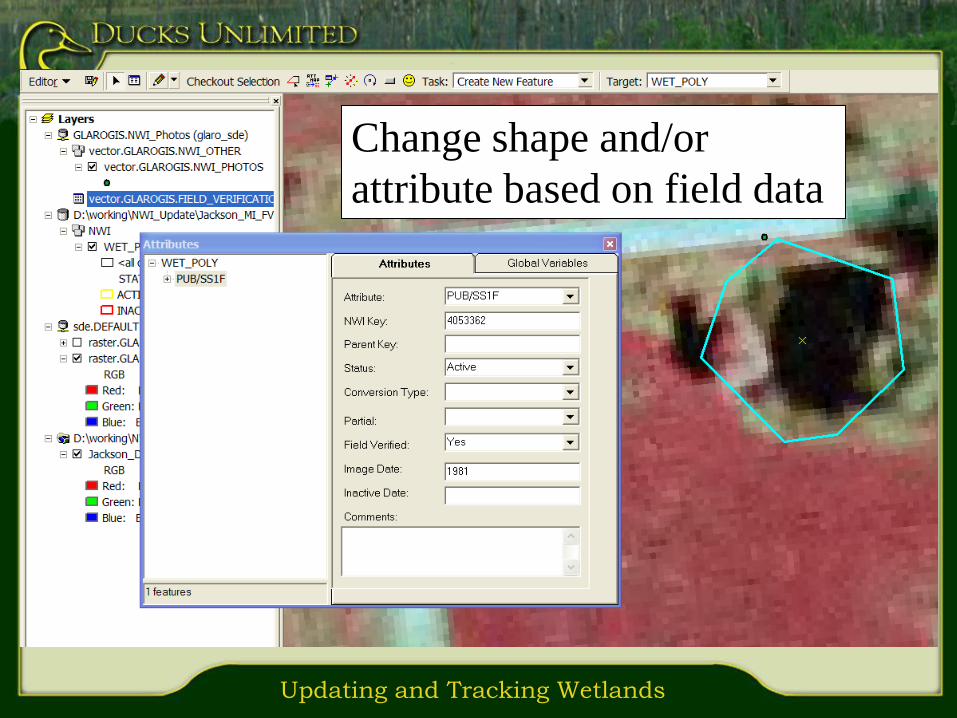
Update NWI Layer and Assessment
TableChange shape and/or
attribute based on field data

Updating and Tracking Wetlands
County
Editor
County
Editor
County
Editor
County
Editor
County
Editor
Database
sent to DU
County checked
out for editing
Version run through
quality assurance
Database returned
to USFWS
Editable
Version of
database
DU NWI Master
Geodatabase
(DU MGD)
USFWS NWI Master
Geodatabase
(USGS MGD)
QA/QC
Editors
update
NWI
Corrections
made
Editable
Version of
database
Field
Sites
Selected
Field
Verification
Assess
And
Update
Final
QA/QC
Update
Process
Verification
process
County
Editor
County
Editor
County
Editor
County
Editor
County
Editor
County
Editor
County
Editor
County
Editor
County
Editor
County
Editor
Database
sent to DU
County checked
out for editing
Version run through
quality assurance
Database returned
to USFWS
Editable
Version of
database
DU NWI Master
Geodatabase
(DU MGD)
DU NWI Master
Geodatabase
(DU MGD)
USFWS NWI Master
Geodatabase
(USGS MGD)
USFWS NWI Master
Geodatabase
(USGS MGD)
QA/QC
Editors
update
NWI
Corrections
made
Editable
Version of
database
Field
Sites
Selected
Field
Verification
Assess
And
Update
Final
QA/QC
Final
QA/QC
Update
Process
Verification
process

Updating and Tracking Wetlands
Original NWI
wetlands that
still exist
Converted
Wetlands
Additional
or Modified
Wetlands
Blue and yellow
wetlands are all
current wetland
(2005)

Updating and Tracking Wetlands
Cooperators
· U.S. Environmental Protection Agency – Great Lakes National Program Office
· Michigan Department of Environmental Quality
· Michigan Department of Environmental Quality – Coastal Zone Management Program
· USFWS: Great Lakes Coastal Program
· USFWS: Upper Mississippi River – Great Lakes Joint Venture
· USFWS: Great Lakes Fish and Wildlife Restoration Act
MICHIGAN
INDIANA
· U.S. Environmental Protection Agency – Great Lakes National Program Office
· Indiana Department of Environmental Management
·

Updating and Tracking Wetlands
Cooperators
Ohio
· U.S. Environmental Protection Agency – Great Lakes National Program Office
· Ohio Department of Natural Resources: Division of Wildlife
· Ohio Department of Natural Resources: Information Technology
· Ohio Department of Natural Resources: Office of Coastal Management
· Ohio Environmental Protection Agency
· Ohio Department of Transportation
· Lake Erie Commission
· U.S. Department of Agriculture – Ohio Natural Resource Conservation Service
· U.S. Fish and Wildlife Service – Great Lakes Coastal Program
· U.S. Fish and Wildlife Service – Region 3 Ecological Services
· Cleveland Museum of Natural History
· Cleveland Metroparks
· The Nature Conservancy
·
Updating and Tracking Wetlands
Cooperators
Illinois
· U.S. Environmental Protection Agency – Great Lakes National Program Office
· Illinois Department of Natural Resources (State Wildlife Grant)
· Illinois Environmental Protection Agency
· Illinois Natural History Survey
· Illinois State Geological Survey
· Illinois Department of Transportation

Updating and Tracking Wetlands
Why is this Important?
More than
18,000 pairs of breeding mallardswere lost since the 1970’s.

Updating and Tracking Wetlands
National
Conservation
Easement
Database
www.conservationeasement.us

Updating and Tracking Wetlands
Questions?
http://glaro.ducks.org/nwi