detection of the 2010 chile earthquake tsunami from … international workshop on remote sensing for...
TRANSCRIPT

8th International Workshop on Remote Sensing for Disaster ManagementTokyo, 30 September, 2010
Session: 2010 Chile earthquake
Detection of the 2010 Chile earthquake tsunami Detection of the 2010 Chile earthquake tsunami from satellite altimetry
Yutaka HAYASHI1 Norihisa USUI2 Masafumi KAMACHI2 Yutaka HAYASHI1, Norihisa USUI2, Masafumi KAMACHI2, 1 Seismology and Volcanology Research Dep., Meteorological Research Institute,
Japan Meteorological Agency (MRI, JMA)2 Oceanographic Research Dep., MRI, JMA
andShunichi KOSHIMURA3Shunichi KOSHIMURA
3 Graduate School of Engineering, Tohoku Univ.
1 /20

Motivation: Is it possible to monitor/findMotivation: Is it possible to monitor/find tsunami from the space?
Before EarthquakeBefore Earthquake
Earthquake, Propagating TsunamiEarthquake, Propagating Tsunami
2 /20
Contents
1. Introduction, BackgroundsA) Satellite altimetryB) 2004 Indian Ocean tsunami detected by altimetry
2. 2010 Chile earthquake tsunami2. 2010 Chile earthquake tsunami
3 Advanced method to extract tsunami signals from3. Advanced method to extract tsunami signals from satellite altimetry dataA) Methods: Multi-satellite time-spatial interpolationB) Results: 2004 Indian Ocean tsunami profiles along 5 satellite tracks
3 /20

Introduction, Backgrounds
1. Introduction, BackgroundsA) Satellite altimetryB) 2004 Indian Ocean tsunami detected by altimetry
2. 2010 Chile earthquake tsunami2. 2010 Chile earthquake tsunami
3 Advanced method to extract tsunami signals from3. Advanced method to extract tsunami signals from satellite altimetry dataA) Methods: Multi-satellite time-spatial interpolationB) Results: 2004 Indian Ocean tsunami profiles along 5 satellite tracks
4 /20

An altimeter measures sea surface height along satellite tracks
AltimeterMicrowave sensor (C- and K-band)Microwave sensor (C and K band)
Accuracy of observationJason-1, 2 <4.2cm
TOPEX/Poseidon 4.2cm (RMS), ...
Sampling approx every 5-10kmSampling approx. every 5-10km
MissionsOcean monitoring, etc.g,
cycle (day)operation data processingsatellite cycle (day)operation data processingsatellite
List of altimeter-equipped satellites
TOPEX/Poseidon9.9156CNES, NASA
Jason-1
cycle (day)operation, data processingsatellite
TOPEX/Poseidon9.9156CNES, NASA
Jason-1
cycle (day)operation, data processingsatellite
~2006
35.0000ESA, CNESENVISAT17.0506NOAAGFO35.0000ESA, CNESENVISAT17.0506NOAAGFOJason-2 2008~
5 /20

Operating agencies routinely process data to reduce noisesreduce noises
Raw data involve noises caused byyOcean tidesAir pressureOffsets of each satellite reduced by routine processingOffsets of each satelliteGeoid locality, etc.
by operating agencies
(freely distributed products)
SLA ( l l l )
(freely distributed products)Real-time (Jason-2)* 3~6 hours
Near Real-time 1~2 daysSLA (sea level anomaly)
Nonseismic effectsSea currentsTemperature oceanographers
Delayed time 3~6 months
TemperatureWinds … etc.
g pinterest
* Limited to real-time routine use6 /20

Right use of altimetry data- Example: Monitoring El Nino -
Map of monthly mean sea level anomalyMap of monthly mean sea level anomaly
cm
(From website of Japan Meteorological Agency)
cm
7 /20
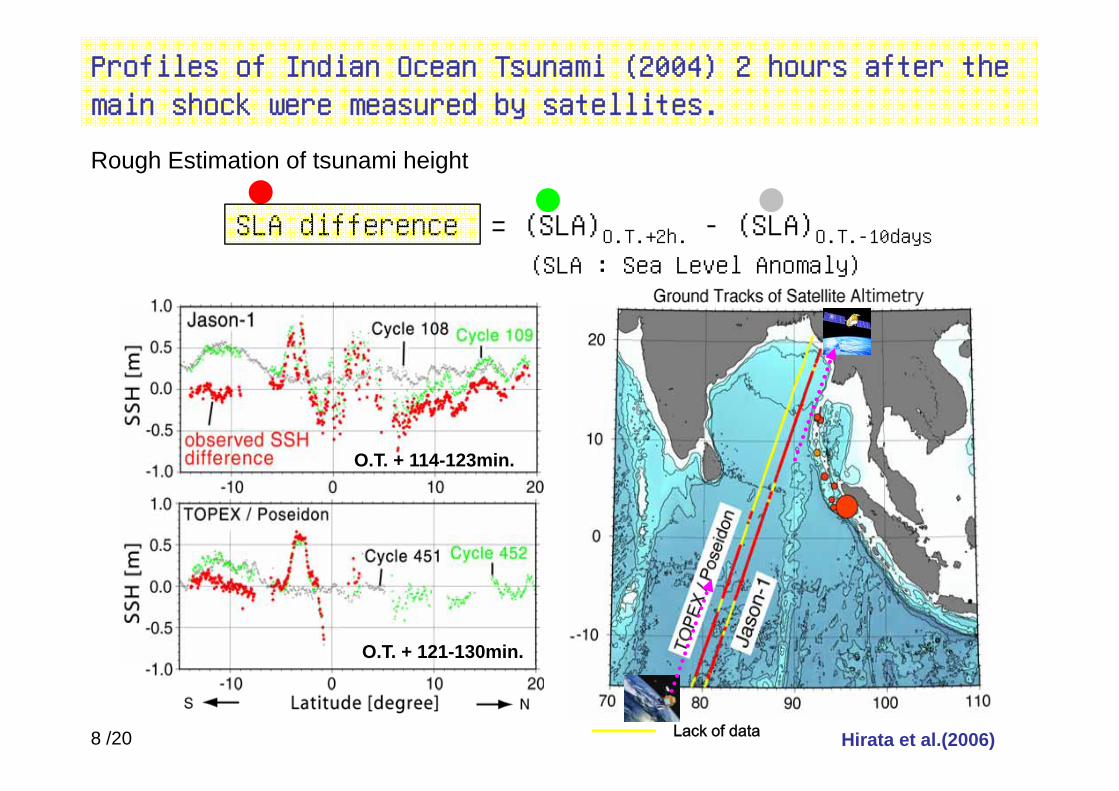
Profiles of Indian Ocean Tsunami (2004) 2 hours after the main shock were measured by satellites.
SLA diff (SLA) (SLA)
Rough Estimation of tsunami height
SLA difference = (SLA)O.T.+2h. - (SLA)O.T.-10days(SLA : Sea Level Anomaly)
O.T. + 114-123min.
O.T. + 121-130min.
Hirata et al.(2006)Lack of data8 /20

Observation data from satellite altimetry were used for analysis of tsunami mechanism
Important information. Why?Ri h i h i f i h hRich in the information near the trenchLess affected by nonlinear effects
Application (example)Slip distributions by linear inversion of tsunamiSlip distributions by linear inversion of tsunami waveforms
Tsunami source generated slowly (<1km/sec) ? (by Hirata et. al, 2006)
Hirata et. al (2006, EPS)9 /20
2010 Chile earthquake tsunami
1. Introduction, BackgroundsA) Satellite altimetryB) 2004 Indian Ocean tsunami detected by altimetry
2. 2010 Chile earthquake tsunami2. 2010 Chile earthquake tsunami
3 Advanced method to extract tsunami signals from3. Advanced method to extract tsunami signals from satellite altimetry dataA) Methods: Multi-satellite time-spatial interpolationB) Results: 2004 Indian Ocean tsunami profiles along 5 satellite tracks
10 /20
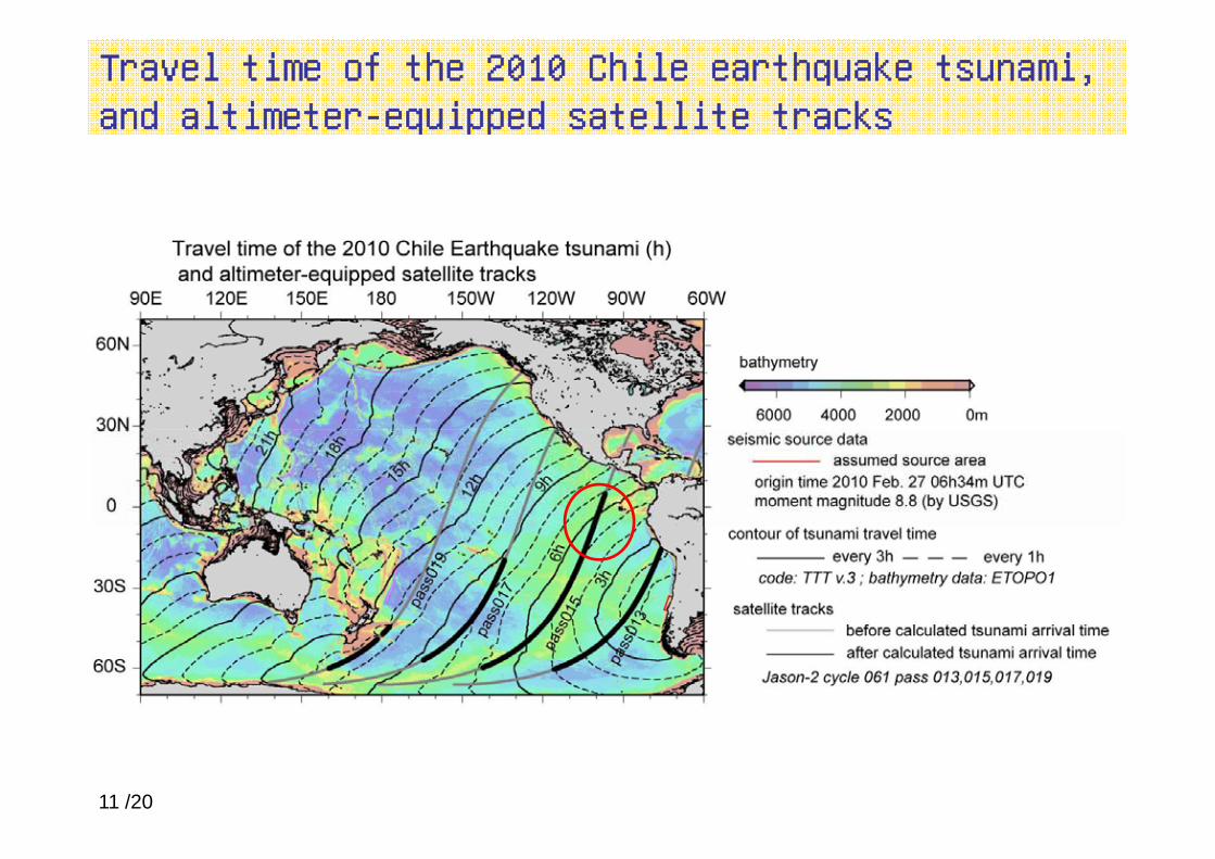
Travel time of the 2010 Chile earthquake tsunami, and altimeter-equipped satellite tracks
11 /20
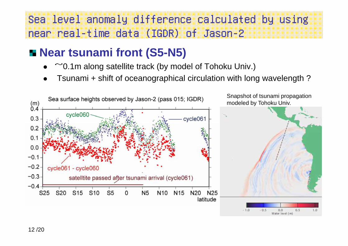
Sea level anomaly difference calculated by using near real-time data (IGDR) of Jason-2
Near tsunami front (S5-N5) ~0 1m along satellite track (by model of Tohoku Univ )0.1m along satellite track (by model of Tohoku Univ.)Tsunami + shift of oceanographical circulation with long wavelength ?
Snapshot of tsunami propagationSnapshot of tsunami propagation modeled by Tohoku Univ.
12 /20
Advanced method to extract tsunami signals from satellite altimetry data
1. Introduction, BackgroundsA) Satellite altimetryB) 2004 Indian Ocean tsunami detected by altimetry
2. 2010 Chile earthquake tsunami2. 2010 Chile earthquake tsunami
3 Advanced method to extract tsunami signals from3. Advanced method to extract tsunami signals from satellite altimetry data (Hayashi, 2008, JGR) A) Methods: Multi-satellite time-spatial interpolationB) Results: 2004 Indian Ocean tsunami profiles along 5 satellite tracks
13 /20
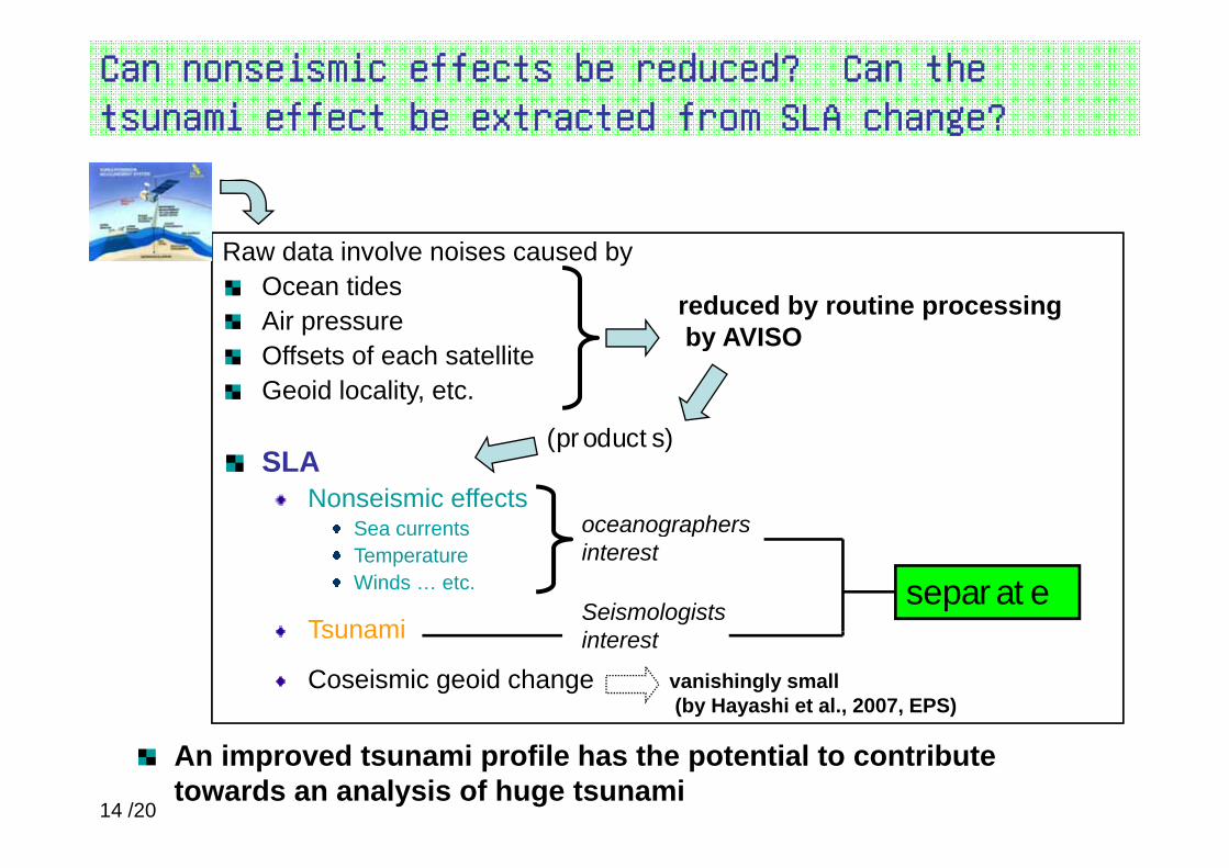
Can nonseismic effects be reduced? Can the tsunami effect be extracted from SLA change?
Raw data involve noises caused byOcean tidesAir pressure reduced by routine processing
by AVISOOffsets of each satelliteGeoid locality, etc.
by AVISO
(products)SLA
Nonseismic effectsSea currents
(products)
oceanographers Sea currentsTemperatureWinds … etc.
Tsunamiseparate
Seismologists i
g pinterest
Tsunami
Coseismic geoid changeinterest
vanishingly small(by Hayashi et al., 2007, EPS)
An improved tsunami profile has the potential to contribute towards an analysis of huge tsunami
14 /20

To estimate "SLA under the assumption that no tsunami occurred" by multi-satellite time-spatial interpolation
DataAltimetry data from four satellitesSampled data near from reference pointspData not affected by tsunami
are usedR=45×3km- 10×3day < T< +10×3dayare used - 10×3day < T< +10×3day
Typical scale of meso-l dd i hi iscale eddy in this region45km, 10days (Stammer,1997)
All tracks from four altimeter equipped satellites15 /20

Scale parameters R=45km,T=10days are used
Reference heights along ENVISAT track 352Time-spatial interpolation
R=45km, T=5,10,20,30days
T=10days R=15 45 90 180km
Difference of two cycles
T=10days, R=15,45,90,180km
Relation between scale parameters and RMSEsHayashi (2008, JGR)
Typical scale of mesoscale eddy in this region
45km, 10days (Stammer,1997)

Results (products of tsunami profiles after processing) - Example: Jason-1 track 129p g) p 1 129
cycle#109Time-spatial interpolationSimpler wave form
Smaller heightsPeak 0.7 m -> 0.6 m
cycle#109SSHref
interpolation
Peak 0.7 m 0.6 mDefined at more sampling points SSHc#109 – SSHref
cycle#108
O.T. + 114-123min.
Difference of two cycles
cycle#1092004 Indian Ocean Tsunami
SSH – SSH O T + 121 130minSSHc#109 – SSHc#108
Hayashi (2008, JGR)
O.T. + 121-130min.
16 /20

Jason-1, TOPEX/Poseidon, ENVISAT, and GFO successfully detected the Indian Ocean tsunamiy
2004 Indian Ocean Tsunami
121-130min
from mainshockfrom mainshock
201-190min
441-431min 524-544mindetected wave frontHayashi (2008, JGR)17 /20

Comparison of two methods2004 Indian Ocean Tsunami
Difference of two cycles
Multi-satellite time-spatial interpolation
Tracks include tsunami signals 2 (TOPEX/Poseidon 5 (T/P J1 ENVISATTracks include tsunami signals 2 (TOPEX/Poseidon, Jason-1)
5 (T/P, J1, ENVISAT, GFO×2)
Number of valid sampling J-1 356/
412points T/P 88 285Accuracy of data more than 7-10 cm
(RMSE)4-5cm
Necessary period to makereference sea level
2~3 days 5~10 month
Time-spatial interpolation method :Advantage e g ±30days
Time-spatial interpolationg
• accurate• potential of small tsunami detection
Disadvantage
futurepast
1 cycle
e.g. ±30days
DifferenceDifference
• too late to useObservation date used to define reference height, and date of tsunami
1 cycle
18 /20

Summary
The multi-satellite time-spatial interpolation method effectively reducedThe multi satellite time spatial interpolation method effectively reduced the oceanographical backgrounds in the SLA data of 2004 Indian Ocean tsunami.
2010 Chile earthquake tsunami is a bit small to be discussed by “rapid and less-accurate method” (difference of two cycles).By our current best method “slow and accurate” ( lti t llit ti ti lBy our current best method “slow and accurate” (multi-satellite time-spatial
interpolation), it takes many months to extract signals from altimetry data.
More advanced “rapid and accurate” method is necessaryfor the purpose of monitoring tsunamifor the purpose of monitoring tsunami.
19 /20

Thanks for your Attention
20 /20