detection of kuril subduction-zone earthquakes from remote ... · hokkaido and northern honshu....
TRANSCRIPT

369
ANNALS OF GEOPHYSICS, VOL. 47, N. 2/3, April/June 2004
Key words historical earthquakes – seismic inten-sity – seismicity – Kuril subduction zone
1. Introduction
Japan is one of the most seismically-activeregions in the world, surrounded by four tec-tonic plates: the Pacific, Philippine Sea, Eurasiaand North America plates (fig. 1). The last two,on which most Japanese islands are situated,are also known as the Amurian and Okhotskplates, respectively (Seno et al., 1996; Heki etal., 1999). Most of great (M~8) earthquakesaround Japan occur in subduction zones, in-
cluding the Kuril trench where the Pacific platesubducts beneath Hokkaido, and the Nankaitrough where the Philippine Sea plate subductsbeneath southwest Japan.
Japanese historical records documentearthquakes as far back as the 7th century(Usami, 2002). Until around A.D. 1600, mosthistorical records were kept in western Japan,particularly around Kyoto where the emper-or’s capital was located between the 8th and19th centuries. Hence many earthquakes werereported in Kyoto and its vicinity. On the ba-sis of such historical documents, recurrenceof great earthquakes along the Nankai troughwith approximately 100 year intervals hasbeen inferred from historical documents(Imamura, 1928; Ando, 1975). In A.D. 1603,the Shugun established a centralized govern-ment in Edo (present Tokyo; fig. 1), and eachlocal government started keeping officialrecords. Both the quantity and quality of his-
Detection of Kuril subduction-zoneearthquakes from remote historic recordsin Honshu, Japan, between 1656 and 1867
Kenji SatakeActive Fault Research Center, Geological Survey of Japan, National Institute of Advanced Industrial
Science and Technology, Tsukuba, Japan
AbstractEarthquakes before A.D. 1800 along the Southern Kuril trench, although before the start of written history onnearby islands, probably account for some of the earthquakes noted by local records in Honshu, hundreds ofkilometers to the southwest. Earthquake historians have identified about 4800 felt earthquakes in Edo (presentTokyo) and about 3000 felt reports in selected local government records in Tohoku, northern Honshu, for theyears A.D. 1656-1867. On the average, 19 earthquakes per year were felt in Edo. Of the Tohoku records, 361 (anaverage nearly 2 per year) were felt at multiple Tohoku locations; 95 of these (0.4 per year) were also felt in Edo.Since 1926, Tokyo has had a yearly average of 15 felt earthquakes with seismic intensity 2 or more on the JapanMeteorological Agency scale (corresponding to III or more on Modified Mercalli scale). For Tohoku the aver-age annual frequency is about 4. Among them, an average of 0.6 events per year also reached intensity 2 inTokyo. About one quarter of these events occurred in the southern Kuril trench. If the seismicity is temporallyconstant, about 80 of the earthquakes recorded in 1656-1867 probably had a Kuril origin.
Mailing address: Dr. Kenji Satake, Active Fault Re-search Center, GSJ/AIST, National Institute of AdvancedIndustrial Science and Technology, Site C7 1-1-1 Higashi,Tsukuba 305-8567, Japan; e-mail: [email protected]

370
Kenji Satake
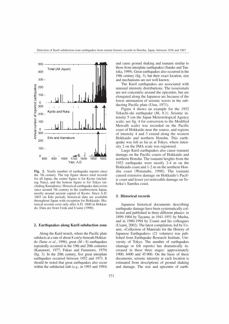
torical records dramatically increased in theEdo period (A.D. 1603-1867), and earth-quakes were documented throughout Japanexcept for Hokkaido (fig. 2).
The oldest documented earthquakes alongthe Southern Kuril trench occurred in the 19thcentury. Great earthquakes along the southernKuril trench cause damage from ground shak-ing and tsunamis on nearby Hokkaido. Mostof Hokkaido had long been occupied by nativepeople (Ainu) and very few written records ex-isted until the 19th century. The oldest recordin the Eastern Hokkaido is «Nikkan-ki», theofficial record of a temple in Akkeshi. It start-ed in A.D. 1804, and reports about 70 earth-quakes between 1816 and 1861. The earth-quake record, however, is not uniform: 32
Fig. 1. Plate tectonic configuration around the Japanese Islands. The Pacific plate subducts beneath northern Hon-shu, the largest island, and Hokkaido, the northernmost island, at the Japan and Kuril trenches, respectively. ThePhilippine Sea plate subducts beneath southwestern Japan at the Nankai trough.
events were recorded between 1816 and 1821,followed by ten years with no reported earth-quakes.
In this paper I attempt to detect the Kurilearthquakes from remote historical data. Be-cause of the short written history of Hokkaido,it seems difficult to infer the pre-19th centuryseismicity along the Kuril trench. However,great earthquakes along the southern Kuriltrench are felt in Tohoku (northern Honshu)and Tokyo, and relatively uniform historicalrecords exist in these regions. The seismic in-tensity distribution is examined from the Edo-period and modern data. Then an attempt ismade to detect the Kuril earthquakes hidden inthe historical earthquake records in Tohokuand Edo.
371
Detection of Kuril subduction-zone earthquakes from remote historic records in Honshu, Japan, between 1656 and 1867
2. Earthquakes along Kuril subduction zone
Along the Kuril trench, where the Pacific platesubducts at a rate of about 8 cm/yr beneath Hokkai-do (Seno et al., 1996), great (M ~ 8) earthquakesrepeatedly occurred in the 19th and 20th centuries(Kanamori, 1977; Fukao and Furumoro, 1979)(fig. 3). In the 20th century, five great interplateearthquakes occurred between 1952 and 1973. Itshould be noted that great earthquakes also occurwithin the subducted slab (e.g., in 1993 and 1994)
Fig. 2. Yearly number of earthquake reports sincethe 7th century. The top figure shows total recordsfor all Japan, the center figure is for Kyoto (includ-ing Nara), and the bottom figure is for Tokyo (in-cluding Kamakura). Historical earthquake data existssince around 7th century in the southwestern Japan,mostly around ancient capital of Kyoto. Since A.D.1603 (in Edo period), historical data are availablethroughout Japan with exception for Hokkaido. His-torical records exist only after A.D. 1800 in Hokkai-do. Data are from Ueda and Usami (1990).
and cause ground shaking and tsunami similar tothose from interplate earthquakes (Satake and Tan-ioka, 1999). Great earthquakes also occurred in the19th century (fig. 3), but their exact location, sizeand mechanisms are not well known.
The Kuril earthquakes are associated withunusual intensity distributions. The isoseismalsare not concentric around the epicentre, but areelongated along the Japanese arc because of thelower attenuation of seismic waves in the sub-ducting Pacific plate (Utsu, 1971).
Figure 4 shows an example for the 1952Tokachi-oki earthquake (Mw 8.1). Seismic in-tensity 5 (on the Japan Meteorological Agencyscale; see fig. 4 for conversion to the ModifiedMercalli scale) was recorded on the Pacificcoast of Hokkaido near the source, and regionsof intensity 4 and 3 extend along the westernHokkaido and northern Honshu. This earth-quake was felt as far as at Tokyo, where inten-sity 2 on the JMA scale was registered.
Large Kuril earthquakes also cause tsunamidamage on the Pacific coasts of Hokkaido andnorthern Honshu. The tsunami heights from the1952 earthquake were mostly 2-4 m on theHokkaido coast and 1-2 m on the northern Hon-shu coast (Watanabe, 1998). The tsunamicaused extensive damage on Hokkaido’s Pacif-ic coast and lesser yet noticeable damage on To-hoku’s Sanriku coast.
3. Historical records
Japanese historical documents describingearthquake damage have been systematically col-lected and published in three different phases: in1899-1904 by Tayama, in 1941-1951 by Musha,and in 1980-1994 by Usami and his colleagues(Usami, 2002). The latest compilation, led by Us-ami, «Collection of Materials for the History ofJapanese Earthquakes» (21 volumes) was pub-lished from Earthquake Research Institute, Uni-versity of Tokyo. The number of earthquakes(damage or felt reports) has dramatically in-creased in these three stages: approximately1900, 8400 and 45 000. On the basis of thesedocuments, seismic intensity at each location isestimated from descriptions of ground shakingand damage. The size and epicentre of earth-

372
Kenji Satake
Fig. 3. Source regions of great interplate earthquakes along the southern Kuril trench. The 1968 and 1856 earth-quakes occurred around the corner of Kuril and Japan trenches. Magnitudes are Mw (moment magnitude) for the20th century events and Mt (tsunami magnitude; Abe, 1999) for the 18-19th century events except for the 1893event for which M was estimated by Utsu (1999).
Mw
Mw
Mw
Mw
Mw
M
Fig. 4. Seismic intensity distribution (on the Japan Meteorological Agency scale) of the 1952 Tokachi-oki earth-quake. Conversion table for the JMA and Modified Mercalli scales is also shown.
Mw
373
Detection of Kuril subduction-zone earthquakes from remote historic records in Honshu, Japan, between 1656 and 1867
quakes are further estimated from the seismic in-tensity distribution, by comparing modern earth-quake data and using empirical relations. As a re-sult, several tables of damaging earthquakes inJapan have been published (Usami, 2002).
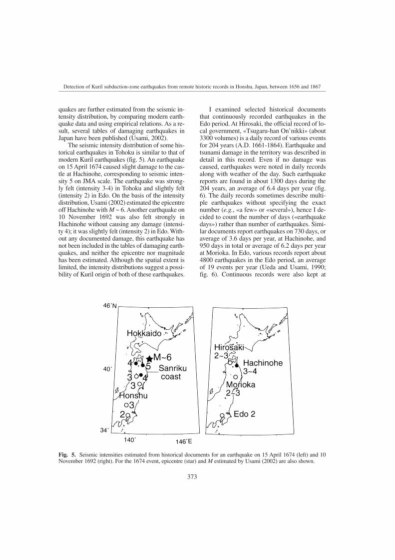
The seismic intensity distribution of some his-torical earthquakes in Tohoku is similar to that ofmodern Kuril earthquakes (fig. 5). An earthquakeon 15 April 1674 caused slight damage to the cas-tle at Hachinohe, corresponding to seismic inten-sity 5 on JMA scale. The earthquake was strong-ly felt (intensity 3-4) in Tohoku and slightly felt(intensity 2) in Edo. On the basis of the intensitydistribution, Usami (2002) estimated the epicentreoff Hachinohe with M ~ 6. Another earthquake on10 November 1692 was also felt strongly inHachinohe without causing any damage (intensi-ty 4); it was slightly felt (intensity 2) in Edo. With-out any documented damage, this earthquake hasnot been included in the tables of damaging earth-quakes, and neither the epicentre nor magnitudehas been estimated. Although the spatial extent islimited, the intensity distributions suggest a possi-bility of Kuril origin of both of these earthquakes.
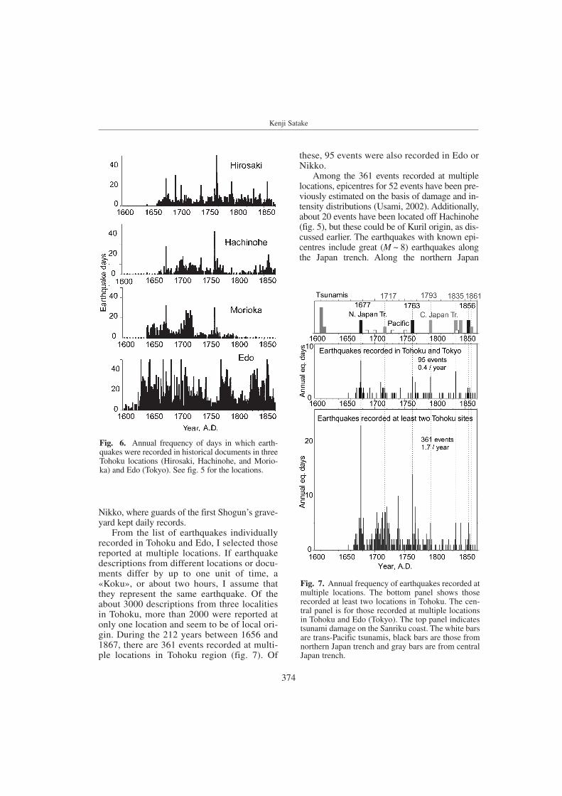
I examined selected historical documentsthat continuously recorded earthquakes in theEdo period. At Hirosaki, the official record of lo-cal government, «Tsugaru-han On’nikki» (about3300 volumes) is a daily record of various eventsfor 204 years (A.D. 1661-1864). Earthquake andtsunami damage in the territory was described indetail in this record. Even if no damage wascaused, earthquakes were noted in daily recordsalong with weather of the day. Such earthquakereports are found in about 1300 days during the204 years, an average of 6.4 days per year (fig.6). The daily records sometimes describe multi-ple earthquakes without specifying the exactnumber (e.g., «a few» or «several»), hence I de-cided to count the number of days («earthquakedays») rather than number of earthquakes. Simi-lar documents report earthquakes on 730 days, oraverage of 3.6 days per year, at Hachinohe, and950 days in total or average of 6.2 days per yearat Morioka. In Edo, various records report about4800 earthquakes in the Edo period, an averageof 19 events per year (Ueda and Usami, 1990;fig. 6). Continuous records were also kept at
Fig. 5. Seismic intensities estimated from historical documents for an earthquake on 15 April 1674 (left) and 10November 1692 (right). For the 1674 event, epicentre (star) and M estimated by Usami (2002) are also shown.
374
Kenji Satake
these, 95 events were also recorded in Edo orNikko.
Among the 361 events recorded at multiplelocations, epicentres for 52 events have been pre-viously estimated on the basis of damage and in-tensity distributions (Usami, 2002). Additionally,about 20 events have been located off Hachinohe(fig. 5), but these could be of Kuril origin, as dis-cussed earlier. The earthquakes with known epi-centres include great (M ~ 8) earthquakes alongthe Japan trench. Along the northern Japan
Fig. 6. Annual frequency of days in which earth-quakes were recorded in historical documents in threeTohoku locations (Hirosaki, Hachinohe, and Morio-ka) and Edo (Tokyo). See fig. 5 for the locations.
Fig. 7. Annual frequency of earthquakes recorded atmultiple locations. The bottom panel shows thoserecorded at least two locations in Tohoku. The cen-tral panel is for those recorded at multiple locationsin Tohoku and Edo (Tokyo). The top panel indicatestsunami damage on the Sanriku coast. The white barsare trans-Pacific tsunamis, black bars are those fromnorthern Japan trench and gray bars are from centralJapan trench.
Nikko, where guards of the first Shogun’s grave-yard kept daily records.
From the list of earthquakes individuallyrecorded in Tohoku and Edo, I selected thosereported at multiple locations. If earthquakedescriptions from different locations or docu-ments differ by up to one unit of time, a«Koku», or about two hours, I assume thatthey represent the same earthquake. Of theabout 3000 descriptions from three localitiesin Tohoku, more than 2000 were reported atonly one location and seem to be of local ori-gin. During the 212 years between 1656 and1867, there are 361 events recorded at multi-ple locations in Tohoku region (fig. 7). Of

375
Detection of Kuril subduction-zone earthquakes from remote historic records in Honshu, Japan, between 1656 and 1867
trench, at the source area of the 1968 event (fig.3), great (M ~ 8) earthquakes and their after-shocks occurred in 1677, 1763, and 1856. To thesouth along the central Japan trench, the Miyagi-oki earthquakes occurred in 1717, 1793, 1835and 1861 in the Edo period, followed by 1897,1936 and 1978 events (Utsu, 1999).
During the Edo period 16 tsunamis wererecorded on Sanriku, the Pacific coast of north-ern Honshu, but the origin of these tsunami areall known (Watanabe, 1998). Among these, fivetsunamis (1687, 1700, 1730, 1751 and 1837)were trans-Pacific tsunamis from North orSouth America, supported by historical or pale-oseismological evidence. Four were from greatearthquakes in the northern Japan trench (in-cluding one from the 1763 aftershock) and oth-er four were from the central Japan trench. The1611 tsunami has been considered to be from atsunami earthquake (Watanabe, 1998). A tsuna-mi in 1616, though included in Watanabe(1998), has been questioned of its existence(Yoshinobu Tsuji, manuscript in revision). Thelast one, in 1843, is considered to be from thepenultimate event of the 1952 Tokachi-oki earth-quake along the southern Kuril trench (fig. 2).Unknown Kuril earthquakes in the Edo period, ifany, apparently did not generate damagingtsunamis along the Sanriku coast, because suchtsunami damage would have been documented.
4. Modern seismic intensity observations
The Japan Meteorological Agency startedsystematic seismic intensity observations in 1926at weather stations distributed throughout Japan. Iused the JMA seismic intensity database (Ishiga-ki and Takagi, 2000) for the 76 years 1926-2001,and compared the modern and historical felt re-ports. Because there was no weather station in Hi-rosaki, I used nearby Aomori data. At Aomori,Morioka and Tokyo, the seismic intensity datahave been available since 1926, but the Hachino-he data have been available only since 1936.
The JMA seismic intensity observations de-tect more earthquakes than the historical reports.The average annual frequency of earthquakeswith intensity 1 or more on JMA scale is 18 atAomori, 48 at Hachinohe, 37 at Morioka, and 40at Tokyo (table I; fig. 8). If the threshold is raisedto seismic intensity 2 (corresponding to III onModified Mercalli scale), then the average annu-al frequency becomes 7 at Aomori, 18 at Hachi-nohe, 13 at Morioka, and 15 at Tokyo. Thesenumbers are comparable to annual earthquakedays in the historical documents: 6.4, 3.6, 6.2and 19, respectively, at these locations. It indi-cates that historical data are complete for modernseismic intensity 2 or higher, if the seismicity isassumed to be temporally constant. At Hachino-he and Morioka, the modern records show high-
Table I. Felt earthquakes of historical and modern JMA data.
Historical data JMA seismic intensity observation
Annual frequency Period 1 or
higher2 or
higher3 or
higherPeriod
Hirosaki 6.4 1661-1864 17.5 7.2 1.9 Aomori: 1926-2001
Hachinohe 3.6 1665-1869 48.2 17.6 4.1 1936-2001
Morioka 6.2 1664-1796 37 13.1 3.4 1926-2001
Tokyo (Edo) 19 1601-1872 39.9 14.9 4.1 1926-2002
Tohoku 1.7 Two or more 9.8 3.6 0.9 Aomori, Hachinohe, Morioka
Tohokuand Tokyo
0.4 1.4 0.6 0.1 Above three and Tokyo

376
Kenji Satake
Fig. 8. Annual frequency of felt earthquakes reported by Japan Meteorological Agency (1926-2001). Shadingindicates different intensity values on the JMA seismic intensity scale.
Fig. 9. Epicentre distribution of earthquakes reported at three stations in Tohoku (open circles) and those reportedat Tohoku and Tokyo stations (solid circles). The symbol size is proportional to earthquake magnitude. Trianglesindicate the station locations. Nearly a quarter of these events occurred along the Kuril trench, in the region sur-round by dashed lines.
377
Detection of Kuril subduction-zone earthquakes from remote historic records in Honshu, Japan, between 1656 and 1867
er numbers; hence the historical data may becomplete for intensity 3 or higher, for which theaverage annual frequency is 4 at both locations.However, considering the slight difference incounting methods (events in modern data where-as earthquake days that possibly contain multipleevents in historical data) and the incompletenessof historical data, I conclude that historical datadetect earthquakes with seismic intensity of 2 orhigher on the JMA scale.
Earthquakes recorded at multiple JMA sta-tions yield similar conclusions. During the 66years between 1936 and 2001, the number of feltearthquakes at the three Tohoku stations (Ao-mori, Hachinohe and Morioka) is 276 if thethreshold is intensity 2, and 68 for the thresholdintensity of 3. The average annual frequencies are4 and 1, respectively, comparable to that fromhistorical data: 1.7. The number of events record-ed at Tohoku stations and Tokyo is 46 and 11 forintensity thresholds of 2 and 3, respectively. Theannual frequencies are 0.6 and 0.1 events, againcomparable to that of historical data, 0.4.
Epicentres of earthquakes felt in Tohoku andTokyo are distributed around northeast Japan (fig.9). Many earthquakes are located on the Pacificcoast of Hokkaido and Honshu, but inland earth-quakes, earthquakes along the eastern margin ofJapan Sea, and deep events beneath the Russiancoast are also included. Among them, 59 events(21%) of those felt (with intensity scale 2 or larg-er) only in Tohoku, and 11 events (24%) of thosefelt in both Tohoku and Tokyo occurred along thesouthern Kuril trench.
5. Edo-period Kuril seismicity
A comparison of historical and modernearthquakes suggests historical data detect earth-quakes with seismic intensity of 2 or more on theJMA scale. Under an assumption that the histor-ical data are complete for this threshold, and fur-ther that the seismicity rate has not changedsince the 17th century, the number of Kuril earth-quakes can be estimated for historical data set.Of the 361 earthquakes recorded at multiple To-hoku locations between A.D. 1656 and 1867,about 76 events (21%) are estimated to be ofKuril origin. Of the 95 events recorded at multi-
ple Tohoku locations and Edo, about 23 events(24%) are also estimated to be of Kuril origin.
Are the above assumptions, data complete-ness and temporally constant seismicity,valid? Regarding the second assumption,earthquakes often occur as clusters and theseismicity rate may change with time. In thisstudy no declustering, including aftershocks,was made for either historical on modernrecords. Intraplate seismicity rate in Tohoku isreported to change with association of largerinterplate earthquakes (Shimazaki, 1978). Be-cause the time period is very long (> 200 yearsfor the Edo records and 75 years for moderndata), effects of clustering and temporalchange may not be significant.
The present study cannot identify individualKuril earthquakes, but the candidates are listed.Further investigation of historical documentscould focus on these dates and might revealmore detailed information on individual earth-quakes. Historical documents are still beingfound from local archives. While it is unlikelythat continuous documents as used here arenewly found, historical records for shorter peri-od of time are likely to be found. The candidatetables will be therefore useful to examine suchrecords.
Acknowledgements
The Japanese version of this paper with atable of the 361 events was published in Histor-ical Earthquakes (Rekishi Jishin). The full textcan be downloaded at http://staff.aist.go.jp/kenji.satake/Rekishijisin/05-Satake.pdf. Kazue Ueda provided me with her database for the in-dex to the collections and a summary of feltearthquakes (fig. 2). Akimichi Takagi providedme with his software to analyze the JMA seis-mic intensity database. Yuichi Nishimura care-fully reviewed the Japanese version of this pa-per. I thank two reviewers whose comments im-proved the presentations of the paper. I alsothank Virginia García Acosta, Roger Musson,and Max Stucchi for their efforts to organize theworkshop «Investigating the records of pastearthquakes» and offering me an opportunity toparticipate.
378
Kenji Satake
REFERENCES
ABE, K. (1999): Quantification of historical tsunamis by theMt scale, Zisin, J. Seismol. Soc. Jpn, 52, 369-377 (inJapanese with English abstract).
ANDO, M. (1975): Source mechanisms and tectonic signifi-cance of historical earthquakes along the Nankai troughJapan, Tectonophysics, 27, 119-140.
FUKAO,Y., and M. FURUMORO (1979): Stress drops, wave spec-tra and recurrence intervals of great earthquakes - impli-cations of the Etorofu earthqaukes of 1958 November 6,Geophys. J. R. Astr. Soc., 57, 23-40.
HEKI, K., S. MIYAZAKI, H. TAKAHASHI, M. KASAHARA, F. KI-MATA, S. MIURA, N.F. VASILENKO, A. VASHCHENKO and K.-D. AN (1999): The Amurian Plate motion and currentplate kinematics in Eastern Asia, J. Geophys. Res., 104,29147-29155.
IMAMURA, A. (1928): On the seismic activity of central Japan,Jpn. J. Astron. Geophys., 6, 119-137.
ISHIGAKI, Y., and A. TAKAGI (2000): JMA seismic intensity da-ta base and several operational utility examples, Quart. J.Seismol. (Kenshin Jiho), 63, 75-92 (in Japanese).
KANAMORI, H. (1977): Seismic and aseismic slip along sub-duction zones and their tectonic implications, in IslandArcs, Deep Sea Trenches and Back-Arc Basins, editedby M. TALWANI and W.C. PITMAN, III (American Geo-
physical Union, Washington D.C.), 163-174.SATAKE, K., and Y. TANIOKA (1999): Sources of tsunami and
tsunamigenic earthquakes in subduction zones, Pure Ap-pl. Geophys., 154, 467-483.
SENO, T., T. SAKURAI, and S. STEIN (1996): Can the Okhotskplate be discriminated from the North American plate?, J.Geophys. Res., 101, 11305-11315.
SHIMAZAKI, K. (1978): Correlation between interplate seismic-ity and interplate earthquakes in Tohoku, (NortheastJapan), Bull. Seismol. Soc. Am., 68, 181-192.
UEDA, K., and T. USAMI (1990): Number of earthquakes inHistorical Records, Hist. Earthquakes (Rekishi Jishin), 6,181-187 (in Japanese).
USAMI, T. (2002): Historical earthquakes in Japan, in Interna-tional Handbook of Earthquake and Engineering Seis-mology, Part A, edited by W.H.K. LEE, H. KANAMORI, P.C.JENNINGS, and C. KISSLINGER (IASPEI, Academic Press,San Diego, U.S.A.), 799-802.
UTSU, T. (1971): Seismological evidence for anomalous struc-ture of island arcs with special reference to the Japaneseregion, Rev. Geophys. Space Phys., 9, 839-890.
UTSU, T. (1999): Seismicity Studies: a Comprehensive Review(University of Tokyo Press, Tokyo), pp. 876 (in Japanese).
WATANABE, H. (1998): Comprehensive List of Tsunamis to Hitthe Japanese Islands (University of Tokyo Press, Tokyo),pp. 238 (in Japanese).