department of the army us army installation … · dear mr. burchette: ... (ncp) [40 code of...
TRANSCRIPT

Environmental Division Mr. John Burchette NPL/BRAC/Federal Facilities Branch U.S. Environmental Protection Agency 1650 Arch Street Philadelphia, PA 19103-2029 Dear Mr. Burchette: Enclosed please find the March 2014 Draft Final Proposed Plan (Plan) for the Manor View Dump Site at Fort George G. Meade for your review and comment. The Plan has been revised based on comments received from the United States Environmental Protection Agency (USEPA) on August 20, 2013, and August 26, 2013, and the Maryland Department of the Environment (MDE) on July 26, 2013. This document also reflects revisions from the Remedial Investigation Addendum (human health risk assessment) which is currently being finalized. Copies of the Plan have also been furnished to Mick Butler (Fort George G. Meade), Fran Coulters (U.S. Army Environmental Command), Elisabeth Green (MDE), Dan LaHart (Anne Arundel County Schools), and the Fort George G. Meade Restoration Advisory Board. While the Federal Facility Agreement allows for a 30 day review period, the Army requests expedited review and approval by March 19, 2014 in advance of the public comment period scheduled to begin March 20, 2014. Written comments should be addressed to Fort. George. G. Meade, Attention: IMNE-MEA-PWE (Paul Fluck), 4215 Roberts Ave., Room 320, Fort Meade, Maryland 20755-7068 or [email protected]. If you have any questions, please feel free to contact Ms. Denise Tegtmeyer at (301) 677-9559 or me at (301) 677-9365.
Sincerely,
Paul V. Fluck, PG, REP
Program Manager, Installation Restoration Program Directorate of Public Works-Environmental Division
Enclosure
DEPARTMENT OF THE ARMY US ARMY INSTALLATION MANAGEMENT COMMAND HEADQUARTERS, UNITED STATES ARMY GARRISON
4551 LLEWELLYN AVENUE, SUITE 5000 FORT GEORGE G. MEADE, MARYLAND 20755-5000
March 11, 2014
REPLY TO ATTENTION OF:
DRAFT FINAL Proposed Plan Manor View Dump Site (FGGM 93), Fort George G. Meade, Maryland March 2014
Imagine the result

Draft Final 1 Proposed Plan March 2014 Manor View Dump Site (FGGM 93) Fort George G. Meade, Maryland
INTRODUCTION AND PURPOSE This Proposed Plan (PP) provides information necessary to facilitate public involvement in selecting the appropriate response action for the Manor View Dump Site, also designated as FGGM 93 at Fort George G. Meade (FGGM) (Figure 1), Maryland. The preferred Remedial Action (RA) described in this PP is Maintenance of Existing Soil Cover, Land Use Controls (LUCs), and Long Term Monitoring (LTM). FGGM 93 (herein referred to as “the Site”) is located near the intersection of MacArthur Road and 2nd Corps Boulevard in the northern portion of FGGM. A site location map is provided as Figure 2. Throughout this document, figure and table references are bolded. In addition, bolded terms are defined in the Glossary Section.
The environmental cleanup activities at FGGM are conducted pursuant to the Comprehensive Environmental Response, Compensation, and Liability Act, as amended (CERCLA), and the National Oil and Hazardous Substances Pollution Contingency Plan (NCP) [40 Code of Federal Regulations (CFR) 300], as required by the United States Army’s (Army’s) Defense Environmental Restoration Program (DERP). FGGM was placed on the National Priorities List (NPL) on July 28, 1998. The Army coordinates cleanup activities with the United States Environmental Protection Agency (USEPA) Region III, and, as appropriate, the other signatories of the FGGM Federal Facility Agreement, including the Architect of the Capitol and the Department of Interior. The Army also solicits input from the Maryland Department of the Environment (MDE).
This PP summarizes information presented in the Remedial Investigation (RI) Report (URS, 2008), the Final RI Report Final Addendum (ARCADIS U.S., Inc. [ARCADIS], 2014a) and the Final Feasibility Study (FS), Revision 1 (ARCADIS, 2014b) developed pursuant to 40 CFR 300.430(a)(2) as well as other reports that are available for review as part of the Administrative Record file for the Site (compiled and maintained in accordance with 40 CFR 300.800(a)). This PP highlights the preferred alternative to address environmental impacts posed by groundwater and buried waste at the Site and outlines all alternatives evaluated during the FS.
The Army and USEPA will finalize and present the selected RA for the Site in a Record of Decision (ROD). The final selection will not take place until after the public comment period. All significant comments will be considered and responded to in the
Responsiveness Summary section of the ROD. The public is encouraged to comment on the preferred RA presented in this PP as well as the other RAs considered. Information about how to submit comments may be found in the “Community Participation” section of this Plan.
The Army and USEPA jointly issue this PP, with support from the MDE, in order to fulfill the public participation requirements under Section 117(a) of CERCLA, and the NCP Section 300.430(f)(2). The Army, USEPA, and MDE encourage the public to review all of the documents relevant to activities conducted at the Site in order to assist in the selection of an appropriate alternative for the Site. Pertinent information regarding the public meeting and comment period is provided below.
IMPORTANT DATES AND LOCATIONS Public Meeting: March 27, 2014 at 7:00 PM The Army will hold a public meeting to explain the PP and all Response Actions presented in the FS. Oral and written comments will also be accepted at the meeting. The meeting will be held at the McGill Training Center, Classroom 6, 8452 Zimborski Avenue, Fort Meade, Maryland 20755. Public Comment Period: March 20, 2014 – April 19, 2014 The Army will accept written comments on the PP during the public comment period. The Administrative Record, containing information used in selecting the preferred Response Action, is available for public review at the following location:
Anne Arundel County Public Library West County Area Branch
1325 Annapolis Rd. Odenton, Maryland 21113
An additional copy of the Administrative Record is maintained at the following location:
Fort Meade Environmental Division Office 4215 Roberts Avenue, Suite 320
Fort Meade, Maryland 20755
Remedial Alternatives Alternative 1: No Further Action
Alternative 2: Maintenance of Existing Soil Cover, Land Use Controls (LUCs), and Long Term Monitoring (LTM)
Alternative 3: Installation of a Low Permeability Cap, LUCs, and LTM
Relevant documents used in the preparation of this PP are listed in the “References” section found at the end of this document.
DRAFT FINAL PROPOSED PLAN FOR THE MANOR VIEW DUMP SITE (FGGM 93) FORT GEORGE G. MEADE, MARYLAND
March 2014

Draft Final 2 Proposed Plan March 2014 Manor View Dump Site (FGGM 93) Fort George G. Meade, Maryland
Based on comments from the USEPA and the MDE on historical site documents, including the RI Report (URS, 2008), and on changed site conditions, a Revised Human Health Risk Assessment (HHRA) and an Ecological Pathway Evaluation were conducted. These were done to evaluate various exposure pathways and quantify risks based upon the existing site conditions following a Non-Time-Critical Removal Action (NTCRA) completed February 2012 through July 2012. In order to finalize the RI Report, an RI Report Addendum including a revised HHRA was prepared and finalized in March 2014 concurrent with the FS.
Based on the Final HHRA (ARCADIS, 2014a), unacceptable risk was identified for the following exposure pathways: future student and teacher (eastern portion of the Site only), future construction worker, future hypothetical resident (western portion of the Site only), future adjacent off-Site resident (western portion of the Site only). Therefore, a RA must be selected to control and mitigate the exposure pathways.
SITE BACKGROUND
FGGM is located midway between the cities of Baltimore, Maryland and Washington, D.C. in Anne Arundel County, Maryland, as shown on Figure 1. FGGM became an Army installation in 1917 and encompassed 9,349 acres. During World War I, over 100,000 soldiers passed through FGGM. The 79th, 92nd, and 11th Infantry Divisions trained at the installation and an Ordnance Supply School was established in 1918. When the war ended, FGGM served as a demobilization center for returning troops. FGGM became a permanent Army installation after World War I.
By 1940, there were 251 permanent and 218 temporary buildings and over 2,100 enlisted soldiers on post. By December 1941, the total land acquired by FGGM had grown to approximately 13,800 acres. After World War II, the National Security Agency relocated to FGGM and Tipton Airfield was constructed in 1960. In 1988, FGGM was realigned under the first round of the Base Realignment and Closure (BRAC) program. The BRAC program authorized 9,000 acres to be divested from FGGM. The Army retained 900 acres of the BRAC parcel that includes Tipton Airfield, which was transferred to Anne Arundel County in 1999. As a result of the 1988 BRAC realignment, the installation includes 5,145 acres. The current installation boundaries encompass the area previously referred to as the cantonment area, which is used for administrative, recreational, and housing facilities. FGGM contains approximately 65.5 miles of paved roads, 3.3 miles of secondary roads, and about 1,300 buildings. The USEPA placed FGGM on the NPL on July 22, 1998 after an evaluation of contamination due to past storage and disposal of hazardous substances.
Manor View Dump Site (FGGM 93) History
FGGM 93 was discovered in 2003 during site preparation and utility work associated with the
construction of the Potomac Place residential development (located in the south and west portions of the Site). Waste materials were recovered and determined to originate from the 1940s. Further analysis indicated that the buried waste extended beyond the planned limits of the housing area and onto the Manor View Elementary School property. A site location map is provided as Figure 2, and an aerial map of the site is presented in Figure 3.
The buried waste at the Site is classified into two general categories: methane generating waste (MGW) and construction and demolition (C&D) debris/fill. The MGW typically consisted of municipal waste and household debris capable of decomposition and methane production. The municipal waste with the potential to generate methane occupied approximately a one-acre area confined to the western portion of the Site, bounded to the east by the unnamed north/south oriented drainage swale and to the north and west by the Potomac Place Housing Area. The remaining approximate nine acres of FGGM 93 contains primarily C&D debris/fill typically consisting of construction debris, rubble, brick, block, and other construction material. No records were identified describing the operation or waste stream of the dump.
A NTCRA was conducted from February through August 2012 (in accordance with 40 CFR 300.415) at the western portion of the Site (Figure 4) to excavate and remove MGW to address safety hazards associated with methane gas present above the Lower Explosive Level (LEL) due to the decomposition of the MGW. The buried C&D waste remains on the eastern parcel of the Site. There is a vegetative soil cover over the remaining buried C&D waste. The soil cover ranges between 2 feet (ft) and 8 ft thick.
Current and Future Use The western one-acre portion of the Site is currently a vacant field with restricted access but is designated a community space per the FGGM Real Property Master Plan (ATKINS, 2011). The chain link fence on the western portion of the site is anticipated to be removed at an unspecified time. However, the chain link fence associated with the Manor View Elementary playground (located adjacent to the unnamed drainage swale) will remain in place, bisecting the Site into east and west parcels with distinctly different land uses, see Figure 5.
The eastern portion of the Site occupies approximately nine acres and is located adjacent to the Manor View Elementary School. Land use of the eastern portion of the Site is associated with community activities (e.g., playground and open fields). There is currently no designated use for groundwater at the Site.
Surface water run-off at FGGM 93 is collected in a shallow subsurface stormwater collection system which empties into stormwater retention ponds at the southern perimeter of the Site. Water in the retention ponds is then directed east via stormwater drainage systems and
Draft Final 3 Proposed Plan March 2014 Manor View Dump Site (FGGM 93) Fort George G. Meade, Maryland
water features to its final discharge at the Little Patuxent River.
Historical Investigations Several investigations were conducted since the discovery of waste within FGGM 93. These investigations include the following:
• Preliminary Assessment and Site Investigation (PA/SI);
• RI (URS, 2008);
• Supplemental investigation consisting of cone penetrometer tests and geoprobe borings;
• Supplemental investigations including groundwater investigations conducted in 2009, 2011, and 2012 and sediment samples collected in May 2010; and,
• Design investigations and completion of a NTCRA to address methane concentrations above the LEL (February – August 2012).
Data obtained during these investigations is documented within the Final FS, Revision 1 (ARCADIS, 2014b).
SITE CHARACTERISTICS FGGM 93 is located near the intersection of MacArthur Road and 2nd Corps Boulevard in the north-central portion of FGGM (Figure 2). The site is bounded by vacant residential housing and an open field to the north, 2nd Corps Boulevard to the south, vacant residential housing and Hayden Drive to the west, and Manor View Elementary School and MacArthur Road to the east. The residential area to the west of the site is part of the Potomac Place Neighborhood.
Groundwater at FGGM 93 occurs under unconfined or water table aquifer conditions and is encountered at approximately 50 ft below ground surface (bgs). Groundwater flows to the southeast within the aquifer, which is approximately 125 ft thick at this location and underlain by the Arundel Clay.
Nature and Extent of Contamination This section presents a discussion on the nature and extent of contamination at FGGM 93, summarizing the findings of the PA/SI, the RI, and the supplemental investigations. Results of these investigations and subsequent discussion on the nature and extent of contamination is presented for each media of interest at FGGM 93, including soil, buried waste, vapor, sediment, surface water, and groundwater.
Soil Surface and subsurface soil samples were collected in the PA/SI and the RI to delineate the nature and extent of impacted soils at FGGM 93. For the purposes of this evaluation, the following soil intervals were defined:
• Surface Soils - defined as soils from 0 to 3 ft bgs, and
• Subsurface Soils - defined as soils deeper than 3 ft bgs.
The maximum depth sampled was 22 ft bgs.
Surface Soil
Results of the surface soil data screening are depicted on Figure 6 for metals exceeding their regional screening levels (RSLs) and on Figure 7 for non-metals (polynuclear aromatic hydrocarbons [PAHs] and volatile organic compounds [VOCs] that exceed their RSLs).
• Metals – Arsenic was detected at a concentration above the RSL of 0.39 milligrams per kilogram (mg/kg). However, arsenic is naturally occurring, and a previous site investigation determined that the mean background concentration of arsenic at FGGM is 3.62 mg/kg with a standard deviation of 1.63 mg/kg; with a 95% upper confidence limit of 4.84 mg/kg (Malcolm Pirnie, 2001). In general, concentrations of arsenic observed in surface soil samples are consistent with the background values, with seven of the 30 soil sample locations exceeding the 95% confidence limit of 4.84 mg/kg. Sample location TP-17 (see Figure 6) exceeded the RSL for iron (55,000 mg/kg) and arsenic (0.39 mg/kg) with reported concentrations of 130,000 mg/kg (duplicate sample concentration of 140,000 mg/kg) and 25 mg/kg, respectively. Additionally, arsenic was observed at concentrations significantly exceeding the 95% upper confidence limit of 4.84 mg/kg at three locations in surface soil above the C&D waste layer located north, east and south of the Site with the highest concentrations occurring at GP-22 (13 mg/kg). The iron and arsenic RSL exceedances are likely an isolated occurrence as only one of 30 sample locations exceeded the iron RSL and arsenic was observed at concentrations significantly less than that observed at TP-17 across the site.
• Non-Metals – Trichloroethene (TCE) was the only VOC that exceeded the screening criteria and was observed exceeding the RSL of 0.91 mg/kg in one surface soil sample (GP-39, 0-2 ft bgs). Multiple PAHs were observed at concentrations exceeding their associated RSL, namely benzo(a)anthracene, benzo(a)pyrene, benzo(b)fluoranthene, benzo(k)fluoranthene, dibenz(a,h)anthracene, and indeno(1,2,3-cd)pyrene. Exceedances occurred in samples from nine of the 30 soil sample locations.
Subsurface Soil
The subsurface soil samples resulted in exceedances of metals, VOCs and PAHs similar to those detected in the surface soil, with the addition of vinyl chloride (VC).
• Metals [Figure 8 depicts metals that exceed the RSL] – Arsenic was consistently detected in subsurface soil samples from nearly all of the sampling locations. The mean background subsurface soil concentration of arsenic at FGGM is 1.14 mg/kg with a standard deviation of 0.702

Draft Final 4 Proposed Plan March 2014 Manor View Dump Site (FGGM 93) Fort George G. Meade, Maryland
mg/kg, and with a 95% upper confidence limit of 1.67 mg/kg (Malcolm Pirnie, 2001). In general, concentrations of arsenic observed in subsurface soil samples are consistent with the background value. Higher concentrations were observed at depths consistent with buried debris. Similarly, mercury and iron were detected at concentrations exceeding the RSL in one subsurface soil boring (GP-44) at depths (between 4-10 ft bgs) consistent with waste observed at the eastern boundary of the NTCRA excavation.
• Non-Metals [Figure 9 depicts PAHs and VOCs that exceed the RSL] – VC was the only VOC that exceeded applicable screening criteria in subsurface soils, exceeding the RSL of 0.06 mg/kg in one sample (GP-24, 12 ft bgs). Multiple PAHs were observed at concentrations exceeding their associated RSL, namely benzo(a)anthracene, benzo(a)pyrene, benzo(b)fluoranthene, benzo(k)fluoranthene, dibenz(a,h)anthracene, and indeno(1,2,3-cd)pyrene. Non-metal exceedances occurred sporadically at low level concentrations in six of the 22 sub-surface soil boring locations.
Buried Waste The wastes encountered within the Site are classified into two general categories: MGW and C&D debris (the MGW was excavated and removed during the 2012 NTCRA). The MGW formerly occupied an approximately one-acre area confined to the western portion of the Site, which was bounded to the east by an unnamed north/south oriented drainage swale and to the north and west by the Potomac Place Housing Area. The remaining nine acres of the Site located east of the unnamed drainage swale contains buried C&D debris. Figure 4 depicts the approximate horizontal extent of the former MGW and the C&D debris.
A soil cover exists over the remaining buried C&D waste throughout the Site which ranges between 2 ft and 8 ft thick. The soil cover consists of a medium grained sandy silt vegetated top soil (approximately 0.0 to 0.5 ft bgs) underlain by yellow to brown silts and sands with trace gravels. The buried waste is typically encountered between 2 and 15 ft bgs. Since the typical depth to the water table at the Site is 50 ft bgs, the buried waste was not in contact with the aquifer.
Vapor Four investigations were conducted as part of the RI to assess levels and sources of methane and other vapor constituents in ambient and indoor air at FGGM 93. The results of each are presented below.
Soil Gas Survey
Four sampling events were conducted from October 2004 through October 2005, and a total of 93 soil gas samples were collected (SG-1 to SG-92 and MV-14). Sample depths for the first 31 samples were selected to target dry, sandy soils above the waste layer where
contaminants would likely exist in the vapor phase. If methane was detected, the remaining samples were collected at 5 ft bgs to minimize the breakthrough of ambient air.
Samples were analyzed for methane and VOCs. From October 2004 through October 2005 methane was detected at greater than or equal to 10 percent of the LEL for methane (5,000 parts per million by volume [ppmv]) at 17 of 93 locations. VOCs were detected in 32 of the 93 soil gas sampling locations, primarily in locations near the buried MGW. Sample procedures, locations, and results are included in the RI Report (URS, 2008).
Ambient Air Investigation
Ambient air samples were collected in May 2005 around the Manor View Elementary School grounds, in the footprint of the former MGW waste near the residential area, and at off-site background locations. Sample procedures, locations, and results are included in the RI Report (URS, 2008).
While methane and VOCs were detected in all of the ambient air samples, the levels detected in both the Site and background samples were at comparable levels. The maximum methane concentration of 2.1 ppmv was equal to outdoor background levels and four orders of magnitude less than the LEL of 50,000 ppmv.
Indoor Air Investigation
Indoor air samples were collected inside the Manor View Elementary School and a separate “background" school in February 2005. Sampling procedures and results associated with the collection of indoor air samples and air samples collected from beneath the concrete slab building foundation (subslab air) are presented in the RI Report (URS, 2008).
VOCs and methane were detected in all the indoor air samples from both schools. The maximum methane concentration of 2.7 ppmv was similar to outdoor background levels and four orders of magnitude less than the LEL of 50,000 ppmv. The VOCs within indoor air were compared against the USEPA Vapor Intrusion Screening Levels (VISL) concentrations protective of indoor air. Within the indoor air samples collected at the Manor View Elementary School, ten constituents exceeded the VISL, they are as follow:1,2,4-trimethylbenzene; 1,2-dibromoethane; 1,3,5-trimethylbenzene; 1,4-dichlorobenzene; 1,4-dioxane; benzene; ethylbenzene; isopropyl alcohol; methyl N-butyl ketone; and TCE. The concentration of constituents exceeding the VISL at the Manor View Elementary School are comparable to the concentration of these constituents within the indoor air obtained from the control school (Bodkin Elementary School).

Draft Final 5 Proposed Plan March 2014 Manor View Dump Site (FGGM 93) Fort George G. Meade, Maryland
Vacuum Extraction Testing
Six soil vapor extraction tests (VE-A through VE-F) were conducted in September 2005 at vapor extraction wells to assess the potential radius of influence in the subsurface within and around the buried waste. Additionally, three subslab vapor extraction tests were conducted in February 2005 to assess the vacuum influence potential in the subslab materials beneath the Manor View Elementary School foundation. Detailed testing procedures and results of the vapor extraction testing are included in the RI Report (URS, 2008).
Based on the low concentrations of methane and VOCs detected in the subslab air samples, the RI concluded that vapors from the buried waste do not appear to be accumulating in the gravel layer beneath the building slab foundation.
Surface Water and Sediment Two surface water sampling events were conducted during the RI (2004 and 2005). Samples were collected at the northern inlet culvert of the stormwater detention pond directly from the discharge pipe during a rain event, since flow is intermittent. The pond receives stormwater from inlets along the base of the slope north of the school and from the runoff of two paved parking areas south of the school building. In addition to the surface water samples, one sample from sediment accumulated at the edge of the culvert was also collected during the November 2004 groundwater sampling event.
Low concentrations of metals and organic compounds were detected in the first round of surface water samples. Pesticides and herbicides were detected in the second round of surface water samples. Based on the low levels of detected compounds, surface water was not considered to be significantly impacted. Chromium was detected at a concentration of 240 mg/kg in the sediment sample which was slightly above the screening level of 230 mg/kg. Sampling location analytical results are presented in the RI Report (URS, 2008).
Due to the elevated chromium concentration and limited extent of sediment sample coverage in the RI, an additional four sediment samples were collected and analyzed for chromium in April 2010. The samples were collected from the end of the culvert where the original sediment sample was collected. The additional chromium results were observed to be an order of magnitude lower than the RI sample result, with concentrations ranging from 11 to 15 mg/kg, well below the RI Report screening level of 230 mg/kg.
Groundwater Groundwater data were compared against the USEPA Maximum Contaminant Level (MCL). Figures 10 to 12 depicts the groundwater monitoring wells and the analytical results. A comprehensive summary of detected constituents within groundwater is presented in the FS. Results of groundwater sampling are as follows:
• VOCs [Figure 10 depicts VOCs that exceed the MCL] – Only two VOCs exceeded the USEPA MCL: TCE and VC. These exceedances were primarily observed during the 2004 and 2005 sampling events. TCE was observed in one monitoring well (MW-5) during 2004 and 2005, exceeding the MCL of 5 micrograms per liter (µg/L) with a maximum detected concentration of 21 µg/L during 2004. TCE has not been detected above the MCL at any other sample locations since 2005. The more recent groundwater sampling conducted during 2009, 2011, and 2012 yielded one location with consistent VOC MCL exceedances: VC in MW-9. Notably, the VC concentration at MW-9 exhibits a strongly decreasing trend. The most recent sampling data collected during April 2012 indicate that the VC concentration from MW-9 (2.8 µg/L) only slightly exceeded the MCL of 2.0 µg/L.
• Metals [Figure 11 depicts metals that exceed the MCL] – Over the course of the sampling program, seven metals exceeded the USEPA MCL at any given time (antimony, arsenic, cadmium, chromium, lead, selenium, and thallium). The majority of the metals MCL exceedances are sporadic and/or isolated occurrences.
Arsenic is the only metal that consistently exceeds the MCL. A majority of the arsenic exceedances are observed in unfiltered samples. Only one filtered sample (MW-7 collected during 2009) exhibited an MCL exceedance with a measured concentration of 11.3 µg/L. Furthermore, arsenic is naturally occurring and MCL exceedances also occur in upgradient wells, in both filtered and unfiltered samples (e.g. MW-1 and MW-7).
• Semi-volatile organic compounds (SVOCs) [Figure 12 depicts SVOCs that were detected] – explosives, herbicides, pesticides, polychlorinated biphenyls, PAHs, and total petroleum hydrocarbons were analyzed in 2004 and 2005. Select PAHs were analyzed at MW-11 and dieldrin was analyzed at MW-5 in 2009, 2011, and 2012. Dieldrin was detected at MW-5 in 2004, 2011, and 2012; and, dibenz(a,h)anthracene was detected at MW-11 in 2004. Dieldrin was detected at an estimated concentration of 0.023 µg/L at MW-5 in 2011 and 2012. Dieldrin was not detected elsewhere at the Site. Dibenz(a,h)anthracene was detected at 0.85 µg/L in 2004 and was not detected during the 2005, 2009, 2011, and 2012 sampling events.
In summary, most constituent detections and/or MCL exceedances are sporadic and isolated throughout the Site. Only two constituents were detected consistently above the USEPA MCL: TCE and VC. TCE concentrations have subsequently fallen below the MCL.
VC was consistently observed exceeding the MCL at MW-9 during all groundwater sampling events conducted to date. Monitoring well MW-9 is located in

Draft Final 6 Proposed Plan March 2014 Manor View Dump Site (FGGM 93) Fort George G. Meade, Maryland
the western portion of the Site and is hydraulically downgradient of the area where MGW was formerly buried. The maximum concentration of VC was observed during 2004 at 51.0 µg/L. However, the VC concentrations at this well have exhibited a strong downward trend, likely degrading aerobically under natural conditions, with VC concentrations declining during each subsequent groundwater sampling event to the current (April 2012) concentration of 2.8 µg/L.
It is anticipated that VC concentrations will continue to decline at this location for two primary reasons: (1) the NTCRA conducted during 2012 has likely removed the VC source; and (2) groundwater aquifer conditions are conducive to the aerobic biodegradation of VC within groundwater. The aerobic biodegradation of residual VC at MW-9 is expected to continue provided that the aquifer conditions beneath the remaining buried waste remain aerobic.
SCOPE AND ROLE OF THE RESPONSE ACTION This response action represents the overall strategy for remediation at the Site. The Site is one of many sites at FGGM that are in the CERCLA process. There are currently three other sites for which a final ROD has been issued. The Site Management Plan (URS, 2013) provides details on the other sites at FGGM that will be addressed in separate response actions from this one. The anticipated schedule for each of those sites is also provided in the Site Management Plan.
A HHRA evaluating current Site conditions was conducted following completion of the NTCRA in August 2012. The NTCRA involved excavation and off-Site disposal of approximately 27,000 tons of non-hazardous MGW and soil from the Site. The excavation footprint is depicted on Figure 4. Following completion of excavation activities the Site was backfilled with stockpiled overburden soil obtained from the excavation and segregated during removal activities and overlaid with a minimum of 18 inches of clean imported fill followed by 6 inches of topsoil. The NTCRA addressed safety hazards associated with methane gas observed at concentrations above the LEL. An RA is required to address risk associated with impacted media and remaining waste at the Site.
This PP provides a summary of the alternatives considered to mitigate exposure pathways identified in the HHRA and recommends the preferred alternative (Alternative 2 – Maintenance of Existing Soil Cover, LUCs, and LTM).
SUMMARY OF THE SITE RISKS
The following subsections present a summary of the HHRA and the Ecological Pathway Evaluation for FGGM 93 during 2012. The original HHRA performed in support of the RI (2005) is no longer applicable since site conditions have changed as a result of the excavation and off-Site disposal of MGW during the NTCRA. The revised HHRA was presented as a separate report (ARCADIS, 2014a) which serves as an RI addendum in
order to finalize the original RI for CERCLA documentation purposes. The Ecological Pathway Evaluation is included within Appendix C of the RI Addendum.
The Final HHRA evaluated surface and subsurface soil, sediment, surface water, indoor air, ambient air and soil gas to assess current and future potential exposures associated with impacted media at the Site. Details of the HHRA methodology are presented in the Final RI Report Final Addendum (ARCADIS, 2014a).
Results of the HHRA Based on changed site conditions as a result of the completion of the NTCRA, the HHRA evaluated various exposure pathways and quantified risks posed by site contaminants. A summary of identified exposure pathways and associated risks is presented below:
• Current Student and Teacher (eastern parcel only) – cancer risks are within the USEPA’s acceptable risk range of 1E-04 to 1E-06 and the hazards are below the target Hazard Index (HI) of 1.
• Future Student and Teacher (eastern portion of site only) – Using the revised Exposure Point Concentrations (EPCs) and updated toxicity values, cancer risks are within the USEPA acceptable risk range of 1E-04 to 1E-06. Hazards exceed the target HI of 1. This is due to potential future exposure to TCE in indoor air.
• Current Trespasser and Future Recreation User (western parcel only) – cancer risks are within the USEPA’s acceptable risk range of 1E-04 to 1E-06 and the hazards are below the target HI of 1.
• Future Construction Worker (entire Site) – cancer risks are within the USEPA’s acceptable risk range of 1E-04 to 1E-06 and the hazards are at the target HI of 1. The HI was 1 and therefore did not exceed USEPA threshold values. However the Army and USEPA recognized TCE in soil in the Final HHRA risk management section as it contributed to the majority of the hazard.
• Hypothetical Future Resident (eastern portion of the Site only) – Although it is not anticipated pursuant to the FGGM Real Property Master Plan (Atkins, 2011), the hypothetical future resident scenario was evaluated by USEPA using the revised EPCs and updated toxicity values, risks exceed the acceptable risk range and hazards exceed the target HI of 1. This is due to a future exposure to TCDD, mercury, and PAHs in subsurface soil and arsenic, cobalt, thallium, and VC in groundwater.
• Future Hypothetical Resident (western portion of the Site only) – Using the revised EPCs and updated toxicity values, risks exceed the acceptable risk range and hazards exceed the target HI of 1. This is due to a future exposure to benzo(a)pyrene
Draft Final 7 Proposed Plan March 2014 Manor View Dump Site (FGGM 93) Fort George G. Meade, Maryland
and dibenzo(a,h)anthracene in subsurface soil and arsenic, cobalt, thallium, and VC in groundwater.
• Future Adjacent Off-Site Resident (western portion of the Site only) – Using the revised EPCs and updated toxicity values, risks are within the USEPA’s acceptable risk range of 1E-04 to 1E-06 and hazards exceed the target HI of 1. This is due to exposure to arsenic, cobalt, thallium, and VC in groundwater.
• Evaluation of Indoor Air - Previous version of the HHRA did not include the assessment of indoor air data obtained from the crawl space of the Manor View Elementary School (sample location MV-13). Therefore, the revised HHRA includes this data point within the indoor air data set under a future exposure scenario to complete the analysis of indoor air. Only if one assumes a future use scenario where the crawl space is occupied on a regular basis is there a condition of unacceptable/hazard to the future student and teacher based solely on TCE in crawl space air.
Ecological Pathway Evaluation
The RI concluded that the Site does not provide significant habitat for wildlife because it is highly maintained and heavily trafficked. To confirm this assumption, an ecological pathway evaluation was conducted at FGGM 93. The ecological pathway evaluation consisted of an on-Site evaluation of habitat and is included in Appendix C of the FS (ARCADIS, 2014b). An ARCADIS biologist visited the Site on September 4, 2012 to assess the habitat. The assessment concluded that the Site provides minimal canopy cover required for nesting by birds and mammals. The eastern parcel consists of a fenced schoolyard with heavy human foot traffic which limits access for wildlife. The western parcel contains small manmade stormwater “ponds” that are ephemeral in nature, only filling with surface runoff water from the storm drainage system during significant rain events. Thus, these areas do not provide suitable aquatic habitat. They are also lined with rip-rap, preventing any transient wildlife from coming into direct contact with sediment. Based on this evaluation, exposure pathways to ecological receptors were considered incomplete and no additional ecological evaluation was deemed necessary.
It is the lead agency’s current judgment that the Preferred Alternative identified in this PP, or one of the other active measures considered in the PP, is necessary to protect public health or welfare or the environment from actual or threatened releases of hazardous substances into the environment.
WHAT IS HUMAN HEALTH RISK AND HOW IS IT CALCULATED? A Superfund baseline human health risk assessment is an analysis of the potential adverse health effects caused by hazardous substance releases from a site in the absence of any actions to control or mitigate these releases under current- and future-land uses. A four-step process is utilized for assessing site-related human health risks for reasonable maximum exposure scenarios.
Hazard Identification: In this step, the contaminants of concern at the site in various media (i.e., soil, groundwater, surface water, and air) are identified based on such factors as toxicity, frequency of occurrence, fate and transport of the contaminants in the environment, concentrations of the contaminants in specific media, mobility, persistence, and bioaccumulation.
Exposure Assessment: In this step, the different exposure pathways through which people might be exposed to the contaminants identified in the previous step are evaluated. Examples of exposure pathways include incidental ingestion of and dermal contact with contaminated soil. Factors relating to the exposure assessment include, but are not limited to, the concentrations that people might be exposed to and the potential frequency and duration of exposure. Using these factors, a reasonable maximum exposure scenario, which portrays the highest level of human exposure that could reasonably be expected to occur, is calculated.
Toxicity Assessment: In this step, the types of adverse health effects associated with chemical exposures, and the relationship between magnitude of exposure (dose) and severity of adverse effects (response) are determined. Potential health effects are chemical-specific and may include the risk of developing cancer over a lifetime or other non-cancer health effects, such as changes in the normal functions of organs within the body (e.g., changes in the effectiveness of the immune system). Some chemicals are capable of causing both cancer and non-cancer health effects.
Risk Characterization: This step summarizes and combines exposure information and toxicity assessments to provide a quantitative assessment of site risks. Exposures are evaluated based on the potential risk of developing cancer and the potential for non-cancer health hazards. The likelihood of an individual developing cancer is expressed as a probability. For example, a 1E-04 cancer risk means a one-in-ten-thousand excess cancer risk; or one additional cancer may be seen in a population of 10,000 people as a result of exposure to site contaminants under the conditions explained in the Exposure Assessment. The NCP defines the acceptable exposure for an individual as a lifetime excess cancer risk in the range of 1E-04 to 1E-06 (corresponding to a one-in-ten-thousand to a one-in-a-million excess cancer risk). For non-cancer health effects, a hazard index (HI) is calculated. An HI represents the sum of the hazard quotients (HQs) that impact the same target organs. An HQ is calculated by taking the ratio of the individual exposure level for a site-related contaminant as compared to its corresponding reference dose. The reference dose is the dose at which no adverse health effects are anticipated to occur. Therefore, an HQ of one or less indicates that no adverse non-cancer effects are anticipated and, when the HQs for chemicals of concern impacting the same target organ are summed, an HI of one or less also indicates that no adverse non-cancer effects are anticipated to occur.
Draft Final 8 Proposed Plan March 2014 Manor View Dump Site (FGGM 93) Fort George G. Meade, Maryland
REMEDIAL ACTION OBJECTIVES
This section presents the chemicals of concern (COCs) identified in the FS, required scope of the remedial action objectives (RAOs), and the remedial goals (RGs).
Identification of Chemicals of Concern The following table identifies the constituents that were identified as COCs in the HHRA because these constituents contribute to excess risk or hazards:
Note 1: TCE was not identified as a COC for the future construction worker but was discussed in the Risk Management section of the final HHRA as it contributed to the majority of the hazard. TCDD, mercury, benzo(a)pyrene, and dibenz(a,h)anthracene were not identified as COCs for the future hypothetical resident (eastern portion of the Site only) as this scenario was not evaluated. However, these contaminants would contribute to unacceptable risk and hazard if the residences were built on top of the buried waste.
No COCs were identified for buried waste, sediment, surface water, or soil vapor at FGGM 93.
Basis for the Establishment of Remedial Action Objectives As detailed above, COCs which pose an unacceptable cancer risk, non-cancer hazard, or physical hazard have been identified at the Site. Based on these findings the recommended remedial action must control and mitigate the following specific exposure pathways:
• Four COCs (arsenic, cobalt, thallium, and VC) which pose an unacceptable cancer risk and non-cancer hazard were identified in groundwater for the hypothetical future resident and the future adjacent off-site resident. Furthermore, the groundwater at the Site is currently not suitable for potable use due to localized constituents within groundwater, likely attributable to the landfill material, exceeding the MCLs. Therefore, the exposure to and use of groundwater must be precluded until such time that concentrations of constituents within groundwater allow for a beneficial use.
• One COC (TCE) was identified in indoor air should the crawl space be occupied by future students/teachers. Therefore, the recommended remedial action must mitigate or control this hypothetical future risk.
• Two COCs (benzo[a]pyrene and dibenzo[a,h]anthracene) were identified in soil for the future hypothetical resident on the western portion of the Site. Therefore, the exposure to and use of soil must be managed.
• No COCs were identified for buried C&D waste within the eastern parcel. However, the C&D waste may pose a physical hazard should the waste material be exposed. Therefore, the recommended remedial action must control exposure to the remaining buried C&D waste. Additionally USEPA evaluated hypothetical future residential use of the eastern parcel and found TCDD, mercury, benzo(a)pyrene, and dibenz(a,h)anthracene would contribute to an unacceptable risk or hazard.
• The NTCRA removed MGW within the western parcel that posed a physical hazard due to the generation of methane above the LEL. Therefore, the scope of the response action for the western parcel is the continued LTM of methane to ensure the continued effectiveness of the NTCRA.
Remedial Action Objectives RAOs are based on human health and environmental factors, which are considered in the formulation and development of the alternatives. Such objectives are developed based on the criteria outlined in Section 300.430(e)(2) of the NCP and Section 121 of CERCLA.
The RAOs for the Site, as presented below, have been developed in such a way that attainment of these goals will result in the protection of human health and the environment.
• To prevent human exposure to groundwater until such time that the groundwater is restored to beneficial reuse;
• Protect human health and welfare of the surrounding community from the safety hazard posed by methane gas through ensuring the continued effectiveness of the NTCRA;
• To prevent the exposure of buried waste and constituents in soil that may pose a physical or chemical hazard; and
• To protect the occupants of the school from the potential of vapor intrusion via the crawl space.
Identification of Remediation Goals
Four COCs were identified in groundwater within the HHRA for the reasonably anticipated future use scenario: arsenic, cobalt, thallium, and VC.
• The Preliminary Remediation Goal (PRG) calculated in the HHRA for arsenic is 4 µg/L and is less than the enforceable MCL of 10 µg/L. Therefore the MCL of 10 µg/L will be established as the RG for arsenic.
• The PRG calculated in the HHRA for cobalt is 11 µg/L. An MCL and/or Maximum Contaminant Level Goal (MCLG) is not established for cobalt; therefore the PRG of 11 µg/L will be used as the RG.
• A PRG could not be calculated for thallium as no toxicity value has been identified that is suitable for evaluating potential exposures or deriving a risk-
Scenario Media COC1
Future Student/Teacher (eastern portion of the Site only)
Indoor Air TCE
Future Hypothetical Resident (western portion of the Site only)
Soilbenzo(a)pyrenedibenzo(a,h)anthracene
Future Hypothetical Resident and Future Adjacent Off-Site Resident (western portion of the Site only)
Groundwater
arseniccobaltthalliumvinyl chloride

Draft Final 9 Proposed Plan March 2014 Manor View Dump Site (FGGM 93) Fort George G. Meade, Maryland
based PRG. The MCL is 2 µg/L, whereas the MCLG is 0.5 µg/L, therefore the RG for thallium will be established at the MCL of 2 µg/L.
• The PRG calculated in the HHRA VC is 5 µg/L. The MCL is 2 µg/L, whereas the MCLG is 0 µg/L, therefore the RG for VC will be established at the MCL of 2 µg/L.
In addition to the three COCs identified within the HHRA (ARCADIS, 2014a), the following groundwater constituents exceeded the MCL or non-zero MCLG during any of the previous groundwater sampling events: cadmium, chromium, lead, selenium, and TCE. Therefore, these constituents will also be included as COCs and have the following RG:
• Cadmium – the MCL and MCLG for cadmium is 5 µg/L; therefore the RG for cadmium is 5 µg/L;
• Chromium – the MCL and MCLG for chromium is 100 µg/L; therefore the RG for chromium is 100 µg/L;
• Lead – the MCLG for lead is 0 µg/L and the USEPA action level established for treatment of corrosiveness in drinking water for lead is 15 µg/L, therefore the action level will be the RG for lead;
• Selenium – the MCL and MCLG for selenium is 50 µg/L; therefore the RG for selenium is 50 µg/L; and
• TCE – the MCL for TCE is 5 µg/L and MCLG for TCE is 0 µg/L; therefore the RG for TCE is 5 µg/L.
The HHRA identified two soil COCs (benzo(a)pyrene and dibenzo(a,h)anthracene) that posed unacceptable risk to the future hypothetical resident on the western portion of the Site should subsurface soils be exposed at the surface. Therefore, these analytes were retained as COCs and the PRG calculated in the HHRA will be retained as an RG and will be protective under current and future land use. A summary of RGs for soil COCs is presented below:
• Benzo(a)pyrene – the PRG calculated in the HHRA for benzo(a)pyrene is 1.5 mg/kg; therefore, the PRG for benzo(a)pyrene is 1.5 mg/kg.
• Dibenzo(a,h)anthracene - the PRG calculated in the HHRA for dibenzo(a,h)anthracene is 1.5 mg/kg; therefore, the PRG for dibenzo(a,h)anthracene is 1.5 mg/kg.
Based on the HHRA (ARCADIS, 2014a), the risk and hazard estimates for the current teacher and student receptors posed by indoor air are within the USEPA acceptable risk range and hazard limit. However, under a future use scenario where the crawl space is occupied on a regular basis there is a condition of unacceptable risk/hazard to the future student and teacher based solely on TCE in crawl space air. Therefore, TCE was retained as a COC and the RG was set equal to the PRG of 1.0 micrograms per cubic meter (µg/m3).
The table below summarizes RGs developed for Site COCs:
SUMMARY OF REMEDIAL ALTERNATIVES
Alternatives to address environmental impacts posed by groundwater and buried waste at the Site were developed and evaluated in the FS (ARCADIS, 2014b) and included the following:
• Alternative 1: No Action
• Alternative 2: Maintenance of Existing Soil Cover, LUCs, and LTM
• Alternative 3: Installation of a Low Permeability Cap, LUCs, and LTM
These alternatives, retained during the preliminary technology evaluation and screening phase (detailed in Section 5 of the FS), were then further refined into the three alternatives listed below. The alternatives are described below with their respective estimated Capital Costs, estimated cost for Operation and Maintenance (O&M) activities, and an estimate of the Present Worth Costs for the alternative.
The preferred alternative is Alternative 2 – Maintenance of Existing Soil Cover, LUCs and LTM.
Alternative 1: No Action
Estimated Capital Cost: $0 Estimated O&M Cost Over 30 Years: $0 Estimated Present Worth Cost: $0 Under Alternative 1, no corrective action of any kind would be implemented. This alternative would not adequately control the physical hazards posed by exposure to buried waste; nor would it restore groundwater to its beneficial use at FGGM 93. However, according to the NCP, the no action alternative must be evaluated to establish a baseline for comparison of the remaining alternatives, even though this alternative would not be a viable option itself at this Site. See 40 CFR 300.430(e)(6).
Constituent Media RGTCE Indoor Air 1.0 µg/m3
Benzo(a)pyrene 1.5 mg/kgDibenzo(a,h)anthracene 1.5 mg/kgArsenic 10 µg/LCadmium 5 µg/LChromium 100 µg/LCobalt 11 µg/LLead 15 µg/LSelenium 50 µg/LThallium 2 µg/LTCE 5 µg/LVinyl Chloride 2 µg/L
Soil
Groundwater
Draft Final 10 Proposed Plan March 2014 Manor View Dump Site (FGGM 93) Fort George G. Meade, Maryland
Alternative 2: Maintenance of Existing Soil Cover, LUCs, and LTM
Estimated Capital Cost: $94,600 Estimated O&M Cost Over 30 Years: $309,600 Estimated Present Worth Cost: $146,500 Alternative 2 involves a combination of maintenance of the existing soil cover, implementation of LUCs, and LTM of soil gas (methane), groundwater, and indoor air to verify that the RAOs and RGs are achieved. Maintenance of Existing Soil Cover
Under this alternative, the existing vegetated soil cover currently in place over the eastern and western parcel would be inspected and maintained. The existing vegetated soil cover is 2 ft to 8 ft thick across the entire eastern portion and is at least 2 ft thick across the western portion of the Site and is protective of human health under the current land use for the eastern parcel of the Site. Furthermore, the existing soil cover prevents direct contact with and exposure to buried waste which may pose a physical hazard; and impacted subsurface soils which pose a chemical hazard. The existing soil cover has demonstrated long term stability with minimal maintenance. Maintenance of this cover would include maintenance of grass (e.g., mowing, fertilizing, re-establishment of grass on bare spots) and repair of erosion or subsidence of the soil cover as necessary.
Although the existing soil cover would not comply with the State of Maryland’s cap design criteria under Code of Maryland Regulations (COMAR) 26.04.07.21, the Army, MDE and USEPA agree that this remedy satisfies the criteria to qualify for a variance from the capping requirements as provided for in COMAR 26.04.07.26, since it would provide the same degree of protection of human health and the environment. The Army has received concurrence from MDE in this determination. Land Use Controls
LUCs would include a combination of engineering and administrative controls designed to mitigate risks identified at the Site in the HHRA. LUCs will be documented in the Real Property Master Plan. A summary of anticipated LUCs are provided below.
Engineering controls would include the following:
• Installation of signage preventing uncontrolled intrusive activities at the Site;
• Installation of warning signs at various conspicuous locations at the Site including common entrances and exits informing Site visitors of environmental concerns at the Site; and
• Retention of the fence bisecting the Site into eastern and western parcels.
Administrative controls would be implemented to achieve the following:
• Prohibit residential use of the eastern and western portion of the Site;
• Prohibit groundwater use throughout the Site;
• Prohibit full time occupancy of the crawl space at the Manor View Elementary School;
• Ensure the retention and maintenance of existing methane monitors in the Manor View Elementary School and housing units adjacent to the eastern parcel; and
• Develop and enforce provisions for the construction of buildings proposed within 100 ft of the Site to prevent vapor intrusion.
Long Term Monitoring
In addition to maintenance of the vegetated soil cover, LTM at the site would be conducted for soil gas (methane), groundwater, and indoor air. The LTM would consist of four main components:
• Soil gas monitoring for methane;
• Groundwater sampling;
• Indoor air sampling for TCE and its daughter products in the crawl space at the Manor View Elementary School; and
• Site inspections.
The following paragraphs discuss each of these four components in further detail.
Soil gas monitoring is currently being implemented Site wide as described in the Interim Removal Action Report (ARCADIS, 2013a). The soil gas monitoring is conducted to ensure the continued effectiveness of the NTCRA in eliminating or minimizing the hazard posed by methane above the LEL. Soil gas (methane) samples were initially collected weekly for the first quarter following the NTCRA. The sampling frequency was reduced from weekly to monthly, and from monthly to quarterly, and will be reduced to semi-annually per the NTCRA Work Plan (ARCADIS, 2012). Methane monitors will remain in the school and nearby homes as part of this alternative.
Groundwater monitoring would be conducted to verify that (1) the remaining wastes are not contributing to groundwater contamination and (2) the concentrations of constituents with a RG for groundwater continue to decline. Groundwater monitoring will consist of semi-annual groundwater sampling consistent with COMAR 26.04.07.22 to ensure that the remaining buried waste is not contributing to groundwater contamination and that the concentrations of chlorinated solvents and their degradation products continue to decline.
Indoor air monitoring will be conducted to verify that (1) the Site conditions are not adversely affecting air quality in the crawl space at the Manor View Elementary School and (2) monitor the designated use of the crawl space.

Draft Final 11 Proposed Plan March 2014 Manor View Dump Site (FGGM 93) Fort George G. Meade, Maryland
Indoor air sampling will be conducted for TCE and its daughter products in the crawl space in a manner consistent with previous sampling events.
Annual inspections and maintenance of the cover would be performed and documented to ensure the integrity and continued effectiveness of the existing soil cover is maintained. Annual inspections would also ensure that the on-Site LUCs are in good condition and confirm that the Site land use has not changed. An annual report would document the inspection findings and also present and interpret the annual groundwater sampling data.
Finally, under CERCLA 121c, any remedial action that results in contaminants remaining onsite at concentrations greater than those allowing for unrestricted use must be reviewed at least once every five years. Groundwater and soil COCs at concentrations exceeding their RG and buried waste would remain that preclude the unrestricted use of the Site under this alternative. Therefore, CERCLA five-year reviews would be conducted at this Site following the implementation of this RA. During five-year reviews, an assessment is made of whether the implemented remedy continues to be protective of human health and the environment or whether the implementation of additional remedial action is appropriate.
Alternative 3: Installation of a Low Permeability Cap, LUCs, and LTM
Estimated Capital Cost: $6,566,105 Estimated O&M Cost Over 30 Years: $137,000 Estimated Present Worth Cost: $6,641,000 Alternative 3 includes the installation of a low permeability cap across the eastern parcel in accordance with COMAR 26.04.07.21, the implementation of LUCs, and LTM. Installation of an Low Permeability Cap
Under Alternative 3, an low permeability cap would be installed over of the eastern parcel of the Site where buried C&D wastes remain (approximately nine acres).
The low permeability cap would be constructed of a minimum of one foot of clay or other natural fine-grained material having an in-place permeability less than or equal to 1 × 10⁻⁵ centimeters/second (cm/sec). The cap would be installed with a minimum slope of four percent to facilitate drainage of percolate. A drainage layer with a minimum thickness of six inches would be emplaced immediately above the low permeability cap and would consist of clean sand or other natural coarse grained material with an in-place permeability greater than 1 × 10⁻³ cm/sec. Finally, an earthen cover would be placed over the drainage layer and would have a minimum thickness of 2 ft. The final earthen cover would be graded to a minimum slope of four percent to facilitate surface drainage from the Site and would contain sufficient organic material to sustain vegetative growth.
Modification to the existing stormwater controls and/or installation of new stormwater controls would be
necessary to accommodate the additional surface water run-off generated by the impermeable soil cover.
Land Use Controls
Similar to Alternative 2, Alternative 3 includes implementation of LUCs to control exposure pathways and eliminate the risks posed by impacted media and buried waste at the Site. LUCs will be documented in the Real Property Master Plan. A summary of LUCs is provided below.
Engineering controls would include the following:
• Installation of signage preventing uncontrolled intrusive activities at the Site;
• Installation of warning signs at various conspicuous locations at the Site including common entrances and exits informing Site visitors of environmental concerns at the Site; and
• Retention of the fence bisecting the Site into eastern and western parcels.
Administrative controls would be implemented to achieve the following:
• Prohibit residential use of the eastern and western portion of the Site;
• Prohibit groundwater use throughout the Site;
• Prohibit full time occupancy of the crawl space at the Manor View Elementary School;
• Ensure the retention and maintenance of existing methane monitors in the Manor View Elementary School and housing units adjacent to the eastern parcel; and
• Develop and enforce provisions for the construction of buildings proposed within 100 ft of the Site to prevent vapor intrusion.
Long Term Monitoring
Similar to Alternative 2, in addition to maintenance of the existing soil cover, LTM at the site would be conducted for soil gas (methane), groundwater, and indoor air. The LTM would consist of four main components:
• Soil gas monitoring for methane;
• Groundwater sampling;
• Indoor air sampling for TCE and its degradation products in the crawl space at the Manor View Elementary School; and
• Maintenance of the low permeability cap and site inspections.
Long-term inspection and maintenance of the impermeable cap would be conducted for a period of 30 years after implementation. Long-term maintenance would include performing and documenting annual inspections and maintaining the impermeable cap to ensure integrity and effectiveness. Maintenance would

Draft Final 12 Proposed Plan March 2014 Manor View Dump Site (FGGM 93) Fort George G. Meade, Maryland
include mowing of the vegetation, erosion/ subsidence repairs, and inspection of LUCs. Annual inspections would also ensure that the on-Site land use controls are in good condition and confirm that the Site land use has not changed. An annual report would document the inspection findings; and also present and interpret the annual groundwater sampling data.
Soil gas, groundwater, and indoor air monitoring would be conducted consistent with the descriptions for Alternative 2, CERCLA five-year reviews would also be required, since contaminants would remain onsite above levels allowing for unlimited use and unrestricted exposure.
EVALUATION OF REMEDIAL ALTERNATIVES
The NCP requires the evaluation of remedial alternatives both individually and against one another, using nine evaluation criteria, in order to select a remedy (40 CFR 300.430(e)(9)(iii)). These criteria are as follow:
Threshold Criteria – Must be met for the alternative to be eligible for selection as a remedial option.
1. Overall Protection of Human Health and the Environment – Determines whether an alternative adequately eliminates, reduces, or controls threats to public health and the environment through treatment, engineering controls, or LUCs.
2. Compliance with Applicable or Relevant and Appropriate Requirements (ARARs) – Evaluates whether the alternative meets the requirements set forth in Federal and State environmental or facility siting statutes and regulations, or whether a waiver is justified. Identification of ARARs is dependent on site risks and the hazardous substances present at the Site, site characteristics, the Site location, and the actions selected to remediate the Site. Thus, requirements may be chemical-, location-, or action-specific. Please refer to Section 4.3 of the FS (ARCADIS, 2014b) for a more detailed discussion of ARARs.
Primary Balancing Criteria – Used to weigh major trade-offs among alternatives.
3. Long-term Effectiveness and Permanence – Considers the ability of an alternative to maintain protection of human health and the environment over time.
4. Reduction of Toxicity, Mobility, or Volume of Contaminants through Treatment – Evaluates an alternative’s use of treatment to reduce the harmful effects of principal contaminants, their ability to move in the environment, and the amount of contamination present.
5. Short-term Effectiveness – Considers the length of time needed to implement an alternative and the risks the alternative poses to workers,
residents, and the environment during implementation.
6. Implementability – Considers the technical and administrative feasibility of implementing the alternative, including factors such as the relative availability of goods and services.
7. Cost – Includes estimated capital and annual O&M costs, as well as present worth cost. Present worth cost is the total cost of an alternative over time in terms of today’s dollar value. Cost estimates are expected to be accurate within a range of –30 to +50 percent.
Modifying Criteria – May be considered to the extent that information is available during the FS, but can be fully considered only after public comment is received on this PP.
8. State/Support Agency Acceptance – Considers whether the State agrees with the Army’s analysis and recommendations, as described in the FS and PP.
9. Community Acceptance – Considers whether the local community agrees with the Army’s analysis and preferred alternative. Comments received on the PP are an important indicator of community acceptance.
Comparative Analysis of Alternatives
This section summarizes the comparative analysis of alternatives for FGGM 93 that were presented in the FS (ARCADIS, 2014b). A chart summarizing this comparative analysis is included as Table 1 below. Each alternative is scored from 1 (being the least effective) to 5 (being the most effective) for each of the balancing criteria. The scores are then summed for each alternative. Threshold Criteria (i.e., Overall Protection of Human Health and the Environment and Compliance with ARARs) were not assigned a numeric score as alternatives either meet or do not meet the criteria.
Overall Protection of Human Health and the Environment
Alternative 1 is not protective of human health because it does not include any LUCs to prevent residential land use, groundwater use, or digging in the buried waste at the Site. Therefore, since it does not satisfy this threshold criterion, Alternative 1 will not be considered further in this analysis. Alternatives 2 and 3 are protective of human health and the environment. Both Alternatives 2 and 3 control exposure to COCs in groundwater through LUCs and provide for monitoring of soil gas, groundwater, and indoor air. They also both mitigate the physical hazard posed by buried waste though the application and/or maintenance of a cover material, either permeable or impermeable, and the implementation of LUCs restricting digging at the Site. The installation of an low permeability cap as described in Alternative 3 would not yield a significant and quantifiable reduction in risk/hazards and, in fact, may

Draft Final 13 Proposed Plan March 2014 Manor View Dump Site (FGGM 93) Fort George G. Meade, Maryland
contribute to an increase in risk should the aerobic degradation of the VC be halted by the changed conditions. Alternatives 2 and 3 are, therefore, judged to have an equivalent overall protection of human health and the environment, and it is noted that Alternative 3 may change the groundwater conditions detrimentally.
Compliance with ARARs
Alternative 2 qualifies for a variance from the closure design requirements specified in COMAR 26.04.07.21. Alternative 3 would meet action specific ARARs without a variance.
Promulgated chemical specific ARARs for groundwater COCs are MCLs and MCLGs. The LTM component of both Alternatives 2 and 3 would document the declining groundwater concentrations for COCs; therefore, Alternatives 2 and 3 are equivalent with regard to chemical-specific ARAR compliance.
Long-Term Effectiveness and Permanence
Alternatives 2 and 3 are effective in the long-term management of buried waste because they would prevent the uncontrolled exposure of buried waste which may pose a physical hazard. For Alternatives 2 and 3, LUCs are required to restrict residential land use over the eastern parcel. Both Alternatives 2 and 3 would require maintenance of a cover, with Alternative 2 requiring maintenance of the current soil cover and Alternative 3 requiring installation and maintenance of a low permeability cap. To date, the present soil cover has required minimal maintenance and has an established vegetative cover, and, therefore, should provide an effective long-term remedy. The impermeable cap would require additional storm water control measures and maintenance but would not be any more effective than Alternative 2. The impacts to groundwater from the C&D waste are minimal and there is little benefit to be gained from a low permeability cover (to prevent infiltration of rainwater through the wastes). Further, groundwater conditions may be detrimentally affected by a low permeability cap stopping, or reversing, the natural breakdown of VC in the aquifer.
The long-term effectiveness of the LUC prohibiting groundwater use is contingent upon the implementation and enforcement of the LUCs and LTM of groundwater conducted to monitor the degradation of COCs. Therefore, both Alternatives 2 and 3 have similar long-term effectiveness and were both scored a 4 out of a possible 5 within Table 1.
Reduction of Toxicity, Mobility, and Volume through Treatment
Neither Alternative 2 nor Alternative 3 employs treatment as a part of the remedy. Therefore, neither alternative satisfies this criterion and are scored 0 out of 5 within Table 1.
Short-Term Effectiveness
Alternative 2 would be effective in the short-term (quantitative score of 5). Alternative 2 poses only minimal risks to the community, the workers, and the environment because it involves minimal intrusive remedial activities. Furthermore, the soil cover is currently in-place so the time required to achieve beneficial results under Alternative 2 would be less than for Alternative 3.
Alternative 3 would pose significant short-term risks to the community and construction workers during the installation of the impermeable cap. These short term risks include additional traffic to import and place the fill material necessary for the construction of the low permeability cap, nuisance dust and noise resulting from the construction site, and potential impacts to surface water resulting from disturbance of the nine acre site. In addition, the impermeable cap would be installed immediately adjacent to the Manor View Elementary School, and therefore poses a risk to the students and faculty due to the proximity of the construction site to the school. Alternative 3 received a quantitative score of a 3 because of the aforementioned short term risks. Implementability
Alternative 2 would be readily implementable as the remedial activities involve the upkeep of the already existing soil cover and LTM of soil gas (methane), groundwater, and indoor air. Furthermore, implementation of LUCs through a remedial design would require minimal design and coordination. Alternative 2 received a quantitative score of 4 because it is the most implementable option.
Alternative 3 would be the least implementable option (quantitative score of 2) as it is the most intensive alternative from an engineering design and coordination aspect. Alternative 3 would require the design and approval of the engineered cover and then the subsequent planning and mobilization of a construction crew to complete the closure cap installation. An estimated time frame to design an approved engineering remedial action work plan would be approximately three--six months. The construction of the impermeable cover and associated Site work (e.g., installation of erosion and sediment controls, Site preparation, design and construction of additional stormwater controls), would require importing approximately 30,000 cubic yards (cy), or 2,000 to 3,000 truckloads, of fill material and would require approximately 6-12 months to install.
Furthermore, Alternative 3 would require significant logistical coordination between the U.S. Army and Anne Arundel County School System due to the inherent safety hazards posed by the construction within a residential community and adjacent to an elementary school.

Draft Final 14 Proposed Plan March 2014 Manor View Dump Site (FGGM 93) Fort George G. Meade, Maryland
Cost
Based on the present worth estimates, Alternative 3 is the most costly as it requires the construction and maintenance of a low permeability landfill closure cap. Alternative 2 is less costly as it utilizes the existing soil cover, requiring lower capital costs.
State/Support Agency Acceptance
Approval of the preferred alternative presented in this PP is expected. Regulatory approval will be further evaluated in the ROD following the public comment period.
Community Acceptance
The U.S. Army has approved the release of this PP to the public. Community acceptance of the preferred alternative will be evaluated at the conclusion of the public comment period. Community acceptance will be addressed in the Responsiveness Summary prepared for the ROD.

Draft Final 15 Proposed Plan March 2014 Manor View Dump Site (FGGM 93) Fort George G. Meade, Maryland
Table 1: Comparative Analysis Chart
Evaluation Criteria Alterative 1: No Action Alternative 2: Maintenance of Existing Soil
Cover and LUCs, and LTM
Alternative 3: Installation of a Low Permeability Cap with Maintenance of Cap,
LUCs, and LTM Description Score Description Score Description Score
Thre
shol
d C
riter
ia1
Overall protection of human health and the environment
• Provides no control of exposure to buried waste and COCs in groundwater, soil, and indoor air at FGGM 93 • Provides no reduction in risk to human health or the environment. • Does not meet this criterion for overall protection of human health and the environment.
NO
• Existing soil cover will continue to prevent exposure to buried waste and COCs identified in soil. Additionally, LUCs prohibiting unrestricted digging will be implemented to prevent exposure to COCs in soil. • Implementation of monitoring and maintenance of the existing soil cover would ensure protectiveness for the duration of the remedy. • Risk to human health for the hypothetical future resident is controlled by maintenance of the existing soil cover and implementation of LUCs prohibiting residential land use. • Unacceptable risk posed by groundwater at the Site will be controlled by implementation of LUCs prohibiting the use of groundwater and implementation of LTM to evaluate the attenuation of COCs. • Human exposure to TCE in the crawl space at Manor View Elementary school will be mitigated through LUCs prohibiting full time use of the space and LTM of TCE and its daughter products. • Does not pose an unacceptable risk to ecological receptors and the environment.
YES
• A low permeability cap would prevent exposure to buried waste and impacted soil across the entire site, and LUCs would prohibit residential use, groundwater use, and unrestricted digging. • Implementation of LTM and maintenance of the cap would ensure protectiveness for the duration of the remedy. • Unacceptable risk posed by groundwater at the Site will be controlled by implementation of LUCs to prohibiting the use of groundwater and implementation of LTM to evaluate the attenuation of COCs. • Human exposure to TCE in the crawl space at Manor View Elementary school will be mitigated through LUCs prohibiting full time use of the space and LTM of TCE and its daughter products. • Does not pose an unacceptable risk to ecological receptors and the environment.
YES
Compliance with ARARs
• ARARs are not met by Alternative 1.
NO
• Chemical-specific ARARs for soil do not exist; however this remedy would meet the site specific RGs calculated for the COCs at this site by eliminating exposure pathways. • Chemical-specific ARARs for groundwater will be met through LUCs prohibiting the use of groundwater and LTM to evaluate the attenuation of COCs to concentrations below site-specific RGs. • Action- specific ARARs would be met by this alternative, since the existing soil cover would qualify for a variance from the state’s landfill closure regulations.
YES
• Chemical-specific ARARs for soil do not exist; however this remedy would meet the site specific RGs calculated for the COCs at this site by eliminating exposure pathways. • Chemical-specific ARARs for groundwater will be met through LUCs prohibiting the use of groundwater and LTM to evaluate the attenuation of COCs to concentrations below site-specific RGs. • Action -specific ARARs would be met by this alternative through compliance with COMAR 26.04.07.21.
YES
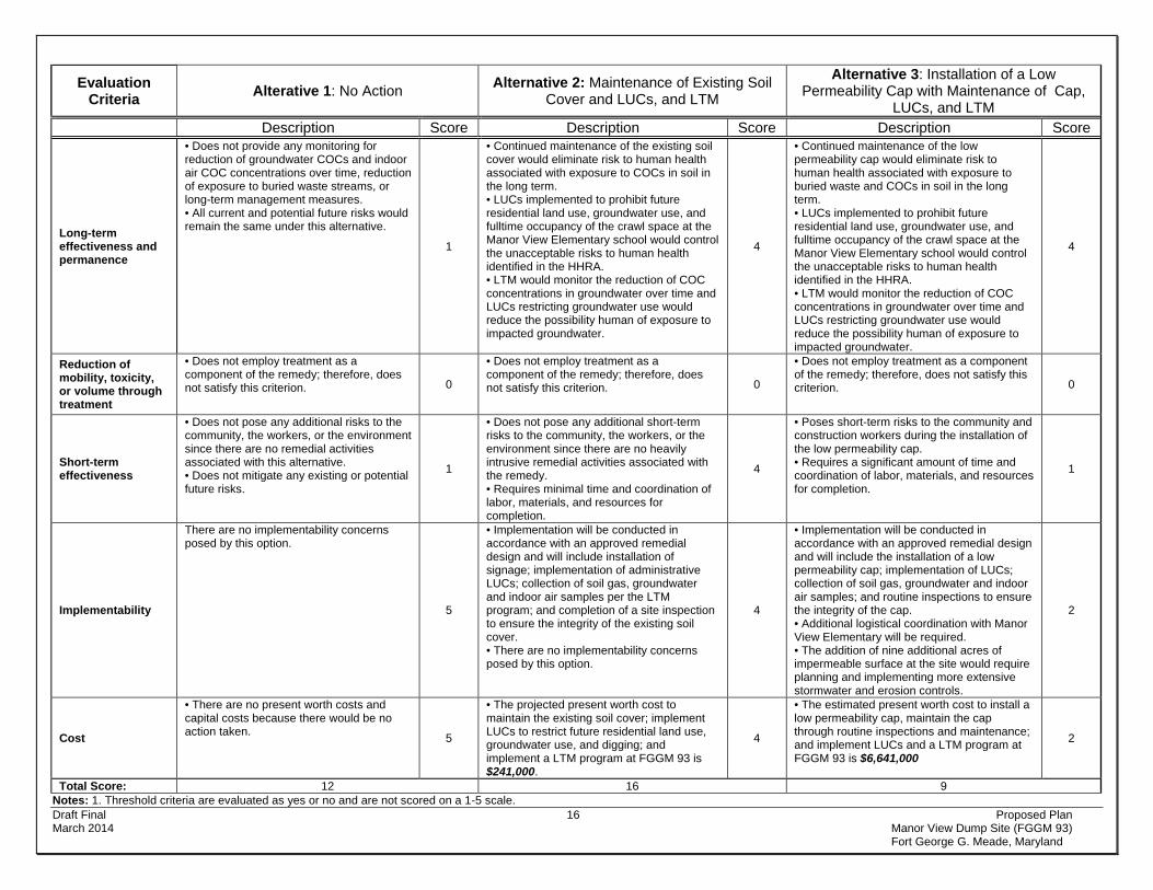
Draft Final 16 Proposed Plan March 2014 Manor View Dump Site (FGGM 93) Fort George G. Meade, Maryland
Evaluation Criteria Alterative 1: No Action Alternative 2: Maintenance of Existing Soil
Cover and LUCs, and LTM
Alternative 3: Installation of a Low Permeability Cap with Maintenance of Cap,
LUCs, and LTM Description Score Description Score Description Score
Long-term effectiveness and permanence
• Does not provide any monitoring for reduction of groundwater COCs and indoor air COC concentrations over time, reduction of exposure to buried waste streams, or long-term management measures. • All current and potential future risks would remain the same under this alternative.
1
• Continued maintenance of the existing soil cover would eliminate risk to human health associated with exposure to COCs in soil in the long term. • LUCs implemented to prohibit future residential land use, groundwater use, and fulltime occupancy of the crawl space at the Manor View Elementary school would control the unacceptable risks to human health identified in the HHRA. • LTM would monitor the reduction of COC concentrations in groundwater over time and LUCs restricting groundwater use would reduce the possibility human of exposure to impacted groundwater.
4
• Continued maintenance of the low permeability cap would eliminate risk to human health associated with exposure to buried waste and COCs in soil in the long term. • LUCs implemented to prohibit future residential land use, groundwater use, and fulltime occupancy of the crawl space at the Manor View Elementary school would control the unacceptable risks to human health identified in the HHRA. • LTM would monitor the reduction of COC concentrations in groundwater over time and LUCs restricting groundwater use would reduce the possibility human of exposure to impacted groundwater.
4
Reduction of mobility, toxicity, or volume through treatment
• Does not employ treatment as a component of the remedy; therefore, does not satisfy this criterion. 0
• Does not employ treatment as a component of the remedy; therefore, does not satisfy this criterion. 0
• Does not employ treatment as a component of the remedy; therefore, does not satisfy this criterion. 0
Short-term effectiveness
• Does not pose any additional risks to the community, the workers, or the environment since there are no remedial activities associated with this alternative. • Does not mitigate any existing or potential future risks.
1
• Does not pose any additional short-term risks to the community, the workers, or the environment since there are no heavily intrusive remedial activities associated with the remedy. • Requires minimal time and coordination of labor, materials, and resources for completion.
4
• Poses short-term risks to the community and construction workers during the installation of the low permeability cap. • Requires a significant amount of time and coordination of labor, materials, and resources for completion.
1
Implementability
There are no implementability concerns posed by this option.
5
• Implementation will be conducted in accordance with an approved remedial design and will include installation of signage; implementation of administrative LUCs; collection of soil gas, groundwater and indoor air samples per the LTM program; and completion of a site inspection to ensure the integrity of the existing soil cover. • There are no implementability concerns posed by this option.
4
• Implementation will be conducted in accordance with an approved remedial design and will include the installation of a low permeability cap; implementation of LUCs; collection of soil gas, groundwater and indoor air samples; and routine inspections to ensure the integrity of the cap. • Additional logistical coordination with Manor View Elementary will be required. • The addition of nine additional acres of impermeable surface at the site would require planning and implementing more extensive stormwater and erosion controls.
2
Cost
• There are no present worth costs and capital costs because there would be no action taken. 5
• The projected present worth cost to maintain the existing soil cover; implement LUCs to restrict future residential land use, groundwater use, and digging; and implement a LTM program at FGGM 93 is $241,000.
4
• The estimated present worth cost to install a low permeability cap, maintain the cap through routine inspections and maintenance; and implement LUCs and a LTM program at FGGM 93 is $6,641,000
2
Total Score: 12 16 9 Notes: 1. Threshold criteria are evaluated as yes or no and are not scored on a 1-5 scale.

Draft Final 17 Proposed Plan March 2014 Manor View Dump Site (FGGM 93) Fort George G. Meade, Maryland
SUMMARY OF THE PREFERRED REMEDIAL ALTERNATIVE FOR FGGM 93 The preferred alternative for FGGM 93 is:
• Alternative 2 – Maintenance of Existing Soil Cover, LUCs, and LTM
Based on the results of the comparative analysis and detailed evaluation presented in the FS, the Army recommends that Alternative 2 be implemented as the preferred to mitigate exposure pathways identified at the Site. Alternative 2 is the most appropriate remedy for the Site because it meets the RAOs and RGs while providing the optimum balance with respect to the evaluation criteria, as described in the Evaluation of Remedial Alternatives section above. Furthermore Alternative 2 is the most readily implementable and cost effective option for achieving the RAOs and RGs.
Since the risk to human health and the environment at Manor View Dump Site is very low, the degree of protection of health, welfare, and the environment provided by Alternative 2 is equal to or greater than that provided by Alternative 3 – Installation of an Low Permeability Cap over the Eastern Parcel, LUCs, and LTM. In addition, Alternative 3 may actually impede the natural breakdown of groundwater COCs in the aquifer. Furthermore, Alternative 2 poses significantly less short term risk and hazards to construction workers and the surrounding community.
Based on information currently available, the U.S. Army believes the preferred alternative meets the threshold criteria and provides the best balance of tradeoffs among the other alternatives with respect to the balancing and modifying criteria. The Army expects the preferred alternative to satisfy the following statutory requirements of CERCLA 121(b): 1) to be protective of human health and the environment; 2) to comply with ARARs; 3) to be cost-effective; 4) to utilize permanent solutions and alternative treatment technologies to the maximum extent practicable; and, 5) to satisfy the preference for treatment as a principal element.
It should be noted that the alternatives recommended can be changed in light of new information or in response to public comments as described below.
COMMUNITY PARTICIPATION Public participation is an important component of remedy selection. The Army, USEPA, and MDE are soliciting input from the community on the preferred alternative. The comment period extends from March 20, 2014 to April 19, 2014 (30 days). This period includes a public meeting at which the Army will present the PP as agreed to by the USEPA and MDE. The Army will accept both oral and written comments at this meeting and written comments following the meeting through April 19, 2014.
The Restoration Advisory Board (RAB) is a critical component of the FGGM Installation Restoration Program to keep the public informed about the
environmental cleanup activities and involved in decision-making. The RAB gives community members, particularly those who may be affected by the cleanup activities, and government representatives a chance to exchange information and participate in meaningful dialogue. The Site has been discussed regularly with the RAB including briefings on methane monitoring results and updates throughout the duration of the NTCRA. Public Comment Period
The Army is providing a 30-day comment period from March 20, 2014 to April 19, 2014 to provide an opportunity for public involvement in the decision-making process for the proposed action. The public is encouraged to review and comment on this PP. During the public comment period, the public is encouraged to review the following reports and other documents pertinent to this site and the Superfund process: the Final FS for FGGM 93, Manor View Dump Site (ARCADIS, 2014b), the Final Variance Request Report for FGGM 93, Manor View Dump Site (ARCADIS, 2013b) and the Final RI Report Final Addendum for FGGM 93, Manor View Dump Site (ARCADIS, 2014a). This information is available at the Anne Arundel County Library, West County Area Branch located at 1325 Annapolis Road in Odenton, MD, and the Fort George G. Meade Environmental Division Office, located at 4215 Roberts Ave, Suite 320 at Fort George G. Meade. To obtain further information, the following representatives may be contacted:
Ms. Mary Doyle U.S. Army Garrison Fort George G. Meade
Public Affairs Office 4409 Llewellyn Avenue Fort Meade, MD 20755
(301) 677-1361
Mr. John Burchette Remedial Project Manager - USEPA Region III
1650 Arch Street Philadelphia, PA 19103-2029
(215) 814-3378 [email protected]
Ms. Elisabeth Green, Ph.D. Maryland Department of the Environment
Federal Facilities Division 1800 Washington Blvd. Suite 625
Baltimore, MD 21230-1719 (410) 537-3346
Written Comments
If the public would like to comment in writing on the PP or other relevant issues, comments should be delivered to the Army at the public meeting or mailed (postmarked no later than April 19, 2014 to Ms. Mary Doyle at the address provided.

Draft Final 18 Proposed Plan March 2014 Manor View Dump Site (FGGM 93) Fort George G. Meade, Maryland
Public Meeting
The Army will hold a public meeting to accept comments on this PP on March 27, 2014, at 7:00 p.m., at the McGill Training Center, Classroom 6, 8452 Zimborski Avenue, Fort Meade, Maryland 20755. This meeting will provide an opportunity for the public to comment on the proposed action. Comments made at the meeting will be transcribed. A copy of the transcript will be included in the ROD Responsiveness Summary and will be added to the FGGM Administrative Record file and information repositories. Army’s Review of Public Comment
The Army will review the public’s comments as part of the process in reaching a final decision on the most
appropriate action to be taken. The Army’s final choice of action will be issued in a ROD. A Responsiveness Summary, documenting and responding to written and oral comments received from the public, will be issued with the ROD. Once community response and input are received and the Army and USEPA sign the ROD, it will become part of the Administrative Record.

ACRONYMS AND ABBREVIATIONS
µg/L .................................. micrograms per liter µg/m3 ................................ micrograms per cubic meter ARARs .............................. Applicable or Relevant and Appropriate Requirements ARCADIS .......................... ARCADIS U.S., Inc. Army .................................. U.S. Department of the Army bgs .................................... below ground surface BRAC ................................ Base Realignment and Closure C&D .................................. construction and demolition CERCLA ........................... Comprehensive Environmental Response, Compensation, and Liability Act of 1980 CFR ................................... Code of Federal Regulations cm/sec ............................... centimeters per second COC .................................. chemical of concern COMAR ............................. Code of Maryland Regulations cy ...................................... cubic yard DERP ................................ Defense Environmental Restoration Program EPC ................................... Exposure Point Concentration FS ..................................... Feasibility Study ft ........................................ feet FGGM ............................... Fort George G. Meade FGGM 93 .......................... Manor View Dump Site HHRA ................................ Human Health Risk Assessment HI ...................................... Hazard Index HQ..................................... Hazard Quotient LEL.................................... Lower Explosive Level LTM ................................... Long Term Monitoring LUC ................................... Land Use Control MCL .................................. Maximum Contaminant Level MCLG ................................ Maximum Contaminant Level Goal MDE .................................. Maryland Department of the Environment mg/kg ................................ milligrams per kilogram MGW ................................ methane generating waste NCP .................................. National Oil and Hazardous Substances Pollution Contingency Plan NPL ................................... National Priorities List NTCRA .............................. Non-Time-Critical Removal Action O&M .................................. Operation and Maintenance OSWER ............................ Office of Solid Waste and Emergency Response PA/SI ................................. Preliminary Assessment/Site Investigation PAHs ................................. polynuclear aromatic hydrocarbons PP ..................................... Proposed Plan ppmv ................................. parts per million by volume PRG .................................. Preliminary Remediation Goal RA… ................................. Remedial Action RAB ................................... Restoration Advisory Board RAO .................................. Remedial Action Objective RG..................................... Remedial Goal RI ...................................... Remedial Investigation ROD .................................. Record of Decision RSL ................................... Regional Screening Level SVOC ................................ Semi-Volatile Organic Compound TCE ................................... trichloroethene USEPA .............................. U.S. Environmental Protection Agency VISL .................................. Vapor Intrusion Screening Level VC ..................................... vinyl chloride VOC .................................. Volatile Organic Compound
Draft Final 20 Proposed Plan March 2014 Manor View Dump Site (FGGM 93) Fort George G. Meade, Maryland
GLOSSARY OF TERMS Administrative Record: This is a collection of documents (including plans, correspondence and reports) generated
during site investigation and remedial activities. Information in the Administrative Record is used to select the preferred Response Action and is available for public review.
Applicable or Relevant and Appropriate Requirements (ARARs): The federal and State statutory and regulatory environmental and facility siting requirements that a selected remedy must attain. These requirements may vary among sites and alternatives.
Capital Costs: This includes costs associated with construction, treatment equipment, site preparation, services, transportation, disposal, health and safety, installation and start-up, administration, legal support, engineering, and design associated with Response Actions.
Comprehensive Environmental Response, Compensation, and Liability Act (CERCLA): This federal law was passed in 1980 and is commonly referred to as the Superfund Program. It provides for liability, compensation, cleanup, and emergency response in connection with the cleanup of inactive hazardous waste disposal sites that endanger public health and safety or the environment.
Defense Environmental Restoration Program (DERP): Addresses the cleanup of Department of Defense hazardous waste sites consistent with the requirements of CERCLA. The three main objectives of DERP are: 1) the identification, research and development, and cleanup of contamination from hazardous substances, pollutants, and contaminants; 2) the correction of other environmental damage that creates an imminent and substantial endangerment to public health or the environment; and 3) the demolition and removal of unsafe buildings and structures at sites formerly used by or under the jurisdiction of the Secretary of Defense.
Feasibility Study (FS): This CERCLA document reviews the chemicals of concern at a site, and evaluates multiple remedial technologies for use at the site. Finally, it identifies the most feasible Remedial Alternative.
Human Health Risk Assessment (HHRA): This assessment describes the formal step-by-step scientific process for quantifying health risks to human receptors (residents, workers, recreationalists), thereby estimating the nature and probability of adverse health effects in humans who may be exposed to chemicals in contaminated environmental media under current or future scenarios. A risk assessment uses standardized tools, formats, and scientifically accepted assumptions.
National Oil and Hazardous Substances Pollution Contingency Plan (NCP): These CERCLA regulations provide the federal government with the authority to respond to the problems of abandoned or uncontrolled hazardous waste disposal sites as well as to certain incidents involving hazardous wastes (e.g., spills).
National Priorities List (NPL): A list of contaminated sites that require cleanup under CERCLA and where CERCLA funds may be expended.
Operation and Maintenance (O&M): Annual post-construction cost necessary to ensure the continued effectiveness of a Response Action.
Present Worth Costs: Used to evaluate expenditures that occur over different time periods by discounting all future costs to a common base year. This allows the cost of the Response Actions to be compared on the basis of a single figure representing the amount of money that would be sufficient to cover capital and O&M costs associated with each Response Action over its planned life.
Record of Decision (ROD): This legal document is signed by the Army and the USEPA in consultation with the MDE. It describes the cleanup action or remedy selected for a site, the basis for selecting that remedy, public comments, responses to comments, and the estimated cost of the remedy.
Remedial Investigation (RI): An investigation under CERCLA that involves sampling environmental media such as air, soil, and water to determine the nature and extent of contamination and human health and environmental risks that result from the contamination present at a site.
Responsiveness Summary: A part of the ROD in which the Army documents and responds to written and oral comments received during the public comment period regarding the alternatives presented in the PP.
Restoration Advisory Board (RAB): The board provides a forum for exchange of information and partnership among citizens, the military installation, USEPA, and MDE. The RAB offers an opportunity for community members to provide input to the cleanup process.

Draft Final 21 Proposed Plan March 2014 Manor View Dump Site (FGGM 93) Fort George G. Meade, Maryland
REFERENCES ARCADIS U.S., Inc. (ARCADIS). 2012. Final Non-Time Critical Removal Action Work Plan for FGGM 93, Manor View
Dump Site. February.
ARCADIS. 2013a. Final Interim Removal Action Report for FGGM 93, Manor View Dump Site. September
ARCADIS. 2013b. Final Variance Request Report for FGGM 93, Manor View Dump Site. August. ARCADIS. 2014a. Final Remedial Investigation Report Final Addendum. Revised Human Health Risk Assessment and Development of Preliminary Remediation Goals - Manor View Dump Site. March.
ARCADIS. 2014b. Final Feasibility Study, Revision 1 for FGGM 93, Manor View Dump Site. March.
ATKINS. 2011. Real Property Master Plan Digest for Fort George G. Meade, Maryland. October.
Malcolm Pirnie. 2001. Final Soil Background Concentration Report of Fort George G. Meade, Maryland. Prepared for U.S. Army Corps of Engineers. October.
URS. 2008. Remedial Investigation Report, Manor View Dump Site, Fort George G. Meade, Maryland. Prepared for U.S. Army Corps of Engineers. November.
URS. 2013. Site Management Plan 2013 Annual Update Fort George G Meade, Maryland. September.

Figures
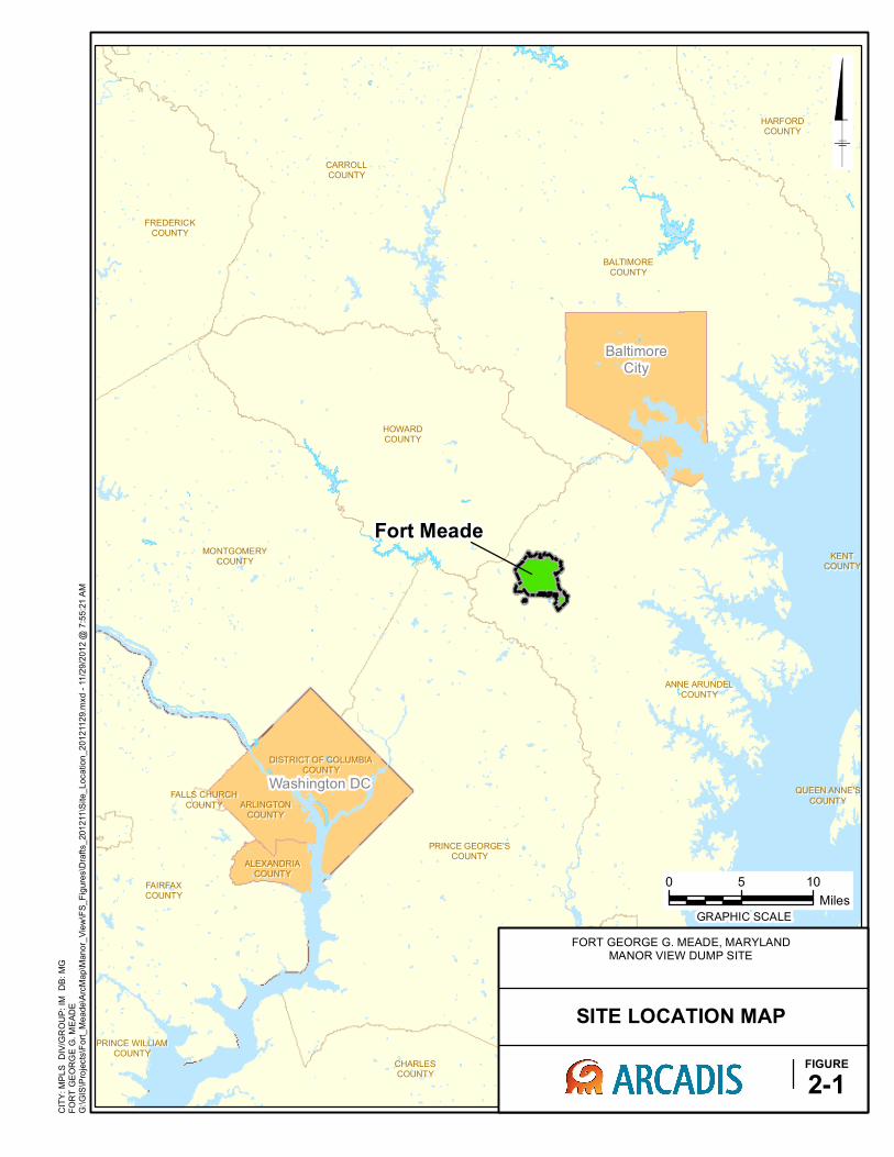
BALTIMOREBALTIMORE
COUNTYCOUNTY
ANNE ARUNDELANNE ARUNDEL
COUNTYCOUNTY
CARROLLCARROLL
COUNTYCOUNTY
FAIRFAXFAIRFAX
COUNTYCOUNTY
HOWARDHOWARD
COUNTYCOUNTY
PRINCE GEORGE'SPRINCE GEORGE'S
COUNTYCOUNTY
MONTGOMERYMONTGOMERY
COUNTYCOUNTY
CALVERTCALVERT
COUNTYCOUNTY
FREDERICKFREDERICK
COUNTYCOUNTY
CHARLESCHARLES
COUNTYCOUNTY
HARFORDHARFORD
COUNTYCOUNTY
TALBOTTALBOT
COUNTYCOUNTY
QUEEN ANNE'SQUEEN ANNE'S
COUNTYCOUNTY
DISTRICT OF COLUMBIADISTRICT OF COLUMBIA
COUNTYCOUNTY
ARLINGTONARLINGTON
COUNTYCOUNTY
ALEXANDRIAALEXANDRIA
COUNTYCOUNTY
PRINCE WILLIAMPRINCE WILLIAM
COUNTYCOUNTY
KENTKENT
COUNTYCOUNTY
DORCHESTERDORCHESTER
COUNTYCOUNTY
FALLS CHURCHFALLS CHURCH
COUNTYCOUNTY
CITY: MPLS DIV/GROUP: IM
DB: MG
FORT GEORGE G. MEADE
G:\GIS\Projects\Fort_Meade\ArcMap\M
anor_View\FS_Figures\Drafts_201211\Site_Location_20121129.m
xd - 11/29/2012 @
7:55:21 AM
FORT GEORGE G. MEADE, MARYLANDMANOR VIEW DUMP SITE
SITE LOCATION MAP
FIGURE
2-1
Fort Meade
BaltimoreCity
Washington DC
0 5 10
Miles
GRAPHIC SCALE

2nd Cor p Bl vd
Annapolis Road
MD 32
Ernie Pyle Street
Clark Road
Wildlife Loop
Reece Road
Rockenbach Road
Rock Avenue
O'Br ien Road
Mapes R
oad
MacAr th
ur R
oad
Disney Road
Ridge Road
Chisholm Avenue
Emory RoadCooper AvenueB
altimore Washington Parkway
Range Road
Bal d Eagl e Dr ive
Llewe
llyn Av
enue
Wilson Str e
et
Dutt R
oad
Road A
26th Street
New Tank Road
Chamberlin
Avenue
Pepper R
oad
Taylor A
venue
Roberts A
venue
English Avenue
29th Division Road
Perimeter Road
Rose Stre
et
Griffin
Avenue
Samford Road
Magazine Road
State Route
198
Engstrom Road
Huber Road
Y Str e
et
Ream Road
20th S
treet
Grant R
oad
Barkle
y Street
Pat uxent Road
Commodore Drive
Morrison Street
22nd S
treet
Cochrane Lane
York Avenue
1 1/2 Street
3rd Cavalry R
oad
18th Street
Erskine Road
Baker Street
Fox Lane
O'Brien R
oad
MD 32
Reece RoadM
D 32
Baltim
ore Washington Parkway
MacArthur Road
CITY: MPLS DIV/GROUP: IM
DB: MG LD: A. DUGGINS
FORT MEADE
0 1,500 3,000
Feet
GRAPHIC SCALE
G:\GIS\Projects\Fort_Meade\ArcMap\M
anor_View\M
anor_View_Loc_20111128.m
xd - 11/28/2011 @
9:33:50 AM
MANOR VIEW DUMP SITE
SITE LOCATION MAP
FIGURE
2
MANOR VIEW DUMP SITE
LEGEND:
MANOR VIEW SITE BOUNDARY
FORT GEORGE G. MEADE, MARYLANDMANOR VIEW DUMP SITE
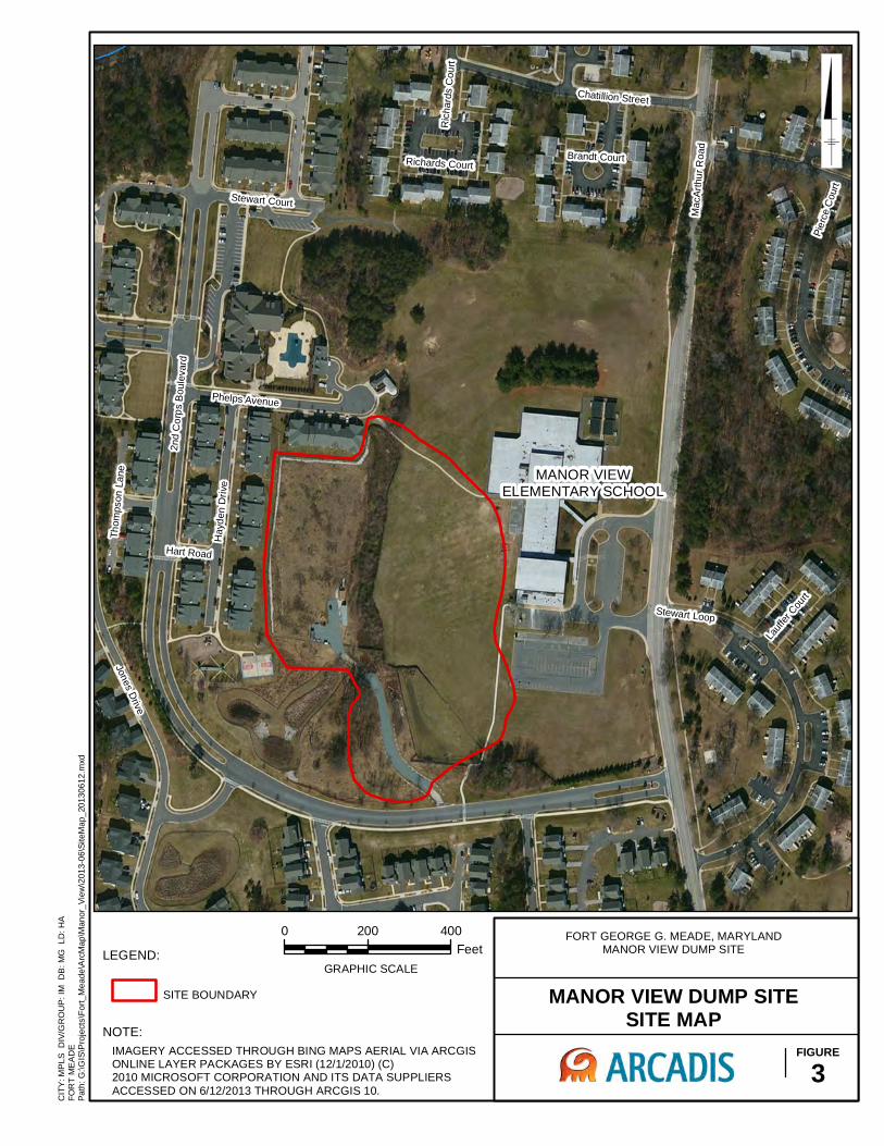
Mac
Arth
ur R
oad
2nd
Cor
ps B
oule
vard
Stewart Loop
Jones Drive
Hay
den
Driv
e
Pier
ce C
ourt
Chatillion Street
Stewart Court
Thom
pson
Lan
e
Phelps Avenue
Hart Road
Lauff
er C
ourt
Brandt Court
Ric
hard
s C
ourt
Richards Court
CIT
Y: M
PLS
DIV
/GR
OU
P: I
M D
B: M
G L
D: H
AFO
RT
ME
AD
E
0 200 400Feet
NOTE:IMAGERY ACCESSED THROUGH BING MAPS AERIAL VIA ARCGISONLINE LAYER PACKAGES BY ESRI (12/1/2010) (C)2010 MICROSOFT CORPORATION AND ITS DATA SUPPLIERSACCESSED ON 6/12/2013 THROUGH ARCGIS 10.
GRAPHIC SCALE
MANOR VIEW DUMP SITESITE MAP
FIGURE3
MANOR VIEWELEMENTARY SCHOOL
LEGEND:
SITE BOUNDARY
FORT GEORGE G. MEADE, MARYLANDMANOR VIEW DUMP SITE
Path
: G:\G
IS\P
roje
cts\
Fort_
Mea
de\A
rcM
ap\M
anor
_Vie
w\2
013-
06\S
iteM
ap_2
0130
612.
mxd
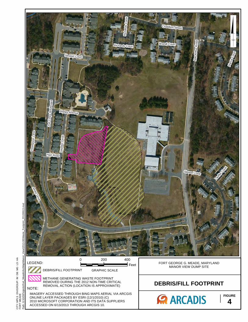
Mac
Arth
ur R
oad
2nd
Cor
ps B
oule
vard
Stewart Loop
Jones Drive
Hay
den
Driv
e
Pier
ce C
ourt
Chatillion Street
Stewart Court
Thom
pson
Lan
e
Phelps Avenue
Hart Road
Lauff
er C
ourt
Brandt Court
Ric
hard
s C
ourt
Richards Court
CIT
Y: M
PLS
DIV
/GR
OU
P: I
M D
B: M
G L
D: H
AFO
RT
ME
AD
E
0 200 400Feet
GRAPHIC SCALE
DEBRIS/FILL FOOTPRINTFIGURE
4
LEGEND:
REMOVED DURING THE 2012 NON-TIME CRITICAL REMOVAL ACTION (LOCATION IS APPROXIMATE)
DEBRIS/FILL FOOTPRINT
METHANE GENERATING WASTE FOOTPRINT
FORT GEORGE G. MEADE, MARYLANDMANOR VIEW DUMP SITE
NOTE:IMAGERY ACCESSED THROUGH BING MAPS AERIAL VIA ARCGISONLINE LAYER PACKAGES BY ESRI (12/1/2010) (C)2010 MICROSOFT CORPORATION AND ITS DATA SUPPLIERSACCESSED ON 6/13/2013 THROUGH ARCGIS 10.
Path
: G:\G
IS\P
roje
cts\
Fort_
Mea
de\A
rcM
ap\M
anor
_Vie
w\2
013-
06\W
aste
_Foo
tprin
t_20
1306
13.m
xd
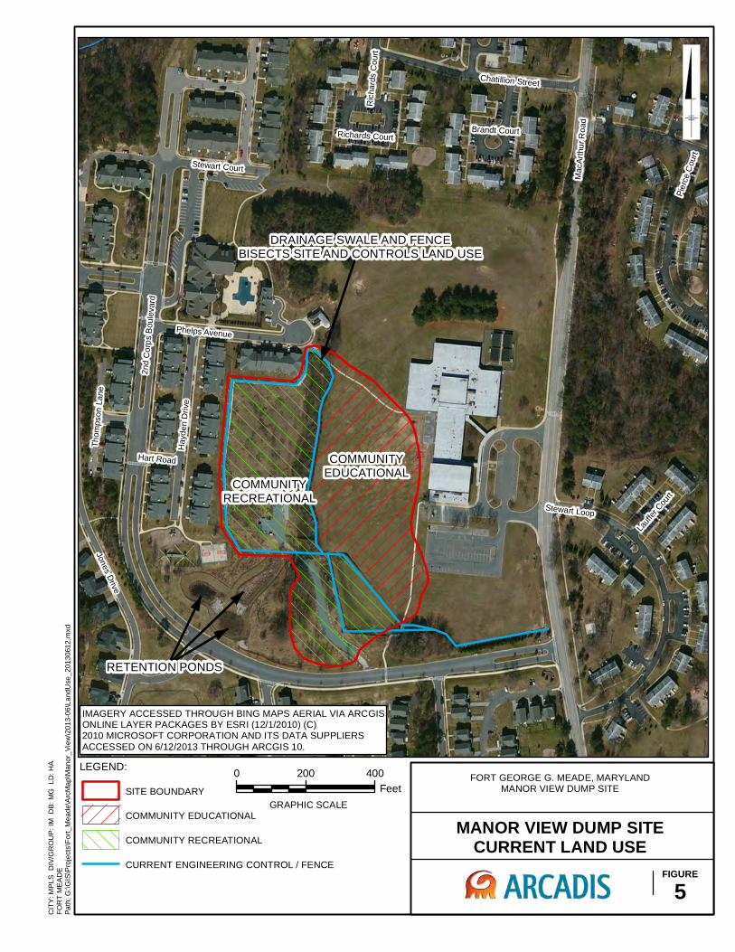
Mac
Arth
ur R
oad
2nd
Cor
ps B
oule
vard
Stewart Loop
Jones Drive
Hay
den
Driv
e
Pier
ce C
ourt
Chatillion Street
Stewart Court
Thom
pson
Lan
e
Phelps Avenue
Hart Road
Lauff
er C
ourt
Brandt Court
Ric
hard
s C
ourt
Richards Court
CIT
Y: M
PLS
DIV
/GR
OU
P: I
M D
B: M
G L
D: H
AFO
RT
ME
AD
E
0 200 400Feet
GRAPHIC SCALE
MANOR VIEW DUMP SITECURRENT LAND USE
FIGURE5
COMMUNITYEDUCATIONAL
LEGEND:
SITE BOUNDARY
COMMUNITY EDUCATIONAL
COMMUNITY RECREATIONAL
CURRENT ENGINEERING CONTROL / FENCE
FORT GEORGE G. MEADE, MARYLANDMANOR VIEW DUMP SITE
COMMUNITYRECREATIONAL
IMAGERY ACCESSED THROUGH BING MAPS AERIAL VIA ARCGISONLINE LAYER PACKAGES BY ESRI (12/1/2010) (C)2010 MICROSOFT CORPORATION AND ITS DATA SUPPLIERSACCESSED ON 6/12/2013 THROUGH ARCGIS 10.
DRAINAGE SWALE AND FENCEBISECTS SITE AND CONTROLS LAND USE
RETENTION PONDS
Path
: G:\G
IS\P
roje
cts\
Fort_
Mea
de\A
rcM
ap\M
anor
_Vie
w\2
013-
06\L
andU
se_2
0130
612.
mxd

!
!
!
!
!
!
!
!
!
!
!
!
!!
!
!
!
!
!
!
!!
!
!
!
!
!
!
!
!!
!
!
(
(
(
(
(
(
(
(
(
(
(
(
((
(
(
(
(
(
(
((
(
(
(
(
(
(
(
((
(
(
ANALYTE RSL DATE
04/01/03Depth Interval (f t BG) -- 1-1Arsenic (mg/kg) 0.39 13
GP-22
ANALYTE RSL DATE 04/01/03Depth Interval (f t BG) -- 1-1Arsenic (mg/kg) 0.39 5
GP-23
ANALYTE RSL DATE 08/23/04Depth Interval (f t BG) -- 0-2.5Arsenic (mg/kg) 0.39 3.3
GP27A
ANALYTE RSL DATE 08/23/04Depth Interval (f t BG) -- 0-3Arsenic (mg/kg) 0.39 5.5 J
GP28A
ANALYTE RSL DATE
08/24/04Depth Interval (f t BG) -- 0-2.5Arsenic (mg/kg) 0.39 3.7 J
GP29A
ANALYTE RSL DATE 08/24/04Depth Interval (ft BG) -- 0-2.5Arsenic (mg/kg) 0.39 2.2
GP30AANALYTE RSL DATE
08/24/04Depth Interval (ft BG) -- 0-2.5Arsenic (mg/kg) 0.39 12
GP31A
ANALYTE RSL DATE 08/25/04Depth Interval (f t BG) -- 0-2Arsenic (mg/kg) 0.39 2.7 J
GP32A
ANALYTE RSL DATE 08/25/04Depth Interval (ft BG) -- 0-3Arsenic (mg/kg) 0.39 2.9 J
GP33AANALYTE RSL DATE
08/25/04Depth Interval (ft BG) -- 0-2.5Arsenic (mg/kg) 0.39 2.4 J
GP34AANALYTE RSL
08/25/04 08/26/04Depth Interval (ft BG) -- 0-3 0-3Arsenic (mg/kg) 0.39 3.2 2.2
GP35ADATE
ANALYTE RSL DATE
08/26/04Depth Interval (f t BG) -- 0-3Arsenic (mg/kg) 0.39 3.6
GP36A
ANALYTE RSL DATE 08/26/04Depth Interval (f t BG) -- 0-3
Arsenic (mg/kg) 0.39 2.8
GP37A
ANALYTE RSL DATE 08/26/04Depth Interval (f t BG) -- 0-3Arsenic (mg/kg) 0.39 2.9
GP38A
ANALYTE RSL DATE 08/26/04Depth Interval (f t BG) -- 0-2Arsenic (mg/kg) 0.39 3.2 [3.4]
GP39A
ANALYTE RSL DATE 08/26/04Depth Interval (f t BG) -- 2-3Arsenic (mg/kg) 0.39 2.7
GP40A
ANALYTE RSL DATE 08/27/04Depth Interval (f t BG) -- 0-2.5Arsenic (mg/kg) 0.39 2.1
GP41A
ANALYTE RSL DATE
08/27/04Depth Interval (f t BG) -- 0-2.5Arsenic (mg/kg) 0.39 5.1 J [7.3 J]
GP42A
ANALYTE RSL DATE 08/27/04
Depth Interval (f t BG) -- 0-3Arsenic (mg/kg) 0.39 2.6
GP43A
ANALYTE RSL DATE 08/27/04Depth Interval (f t BG) -- 0-2.5Arsenic (mg/kg) 0.39 3.2
GP44A
ANALYTE RSL DATE 08/27/04
Depth Interval (f t BG) -- 0-1Arsenic (mg/kg) 0.39 12
GP45A
ANALYTE RSL DATE
04/01/03Depth Interval (f t BG) -- -Arsenic (mg/kg) 0.39 3.2
SS-01
ANALYTE RSL DATE 04/01/03Depth Interval (f t BG) -- -Arsenic (mg/kg) 0.39 3
SS-02
ANALYTE RSL DATE 04/01/03Depth Interval (f t BG) -- -
Arsenic (mg/kg) 0.39 2.7
SS-03
ANALYTE RSL DATE 04/01/03Depth Interval (f t BG) -- -
Arsenic (mg/kg) 0.39 2.1
SS-04
ANALYTE RSL DATE 04/01/03Depth Interval (f t BG) -- -Arsenic (mg/kg) 0.39 3.5
SS-05
ANALYTE RSL DATE
04/01/03Depth Interval (f t BG) -- -Arsenic (mg/kg) 0.39 2.6
SS-06
ANALYTE RSL DATE 04/01/03Depth Interval (f t BG) -- -
Arsenic (mg/kg) 0.39 3
SS-07
ANALYTE RSL DATE 04/01/03Depth Interval (f t BG) -- -Arsenic (mg/kg) 0.39 2.8
SS-08
ANALYTE RSL DATE 08/26/04
Depth Interval (f t BG) -- 2-3Arsenic (mg/kg) 0.39 25 [26] Iron (mg/kg) 55000 130000 [140000]
TP17
GP-25
GP-26
GP-37
GP-32
GP-27
GP-28
GP-45
GP-33GP-34GP-35
GP-36GP-38
TP-17
GP-40
GP-30
GP-31
GP-41
GP-42
GP-43
GP-44GP-39
GP-29
SS-4
SS-2
SS-1
SS-3/8
GP-22
GP-23
SS-5
SS-6
SS-7
Mac
Art
hur
Ro
ad
Chatillion Street
2nd Army Drive
Stewart Court
Brandt Court
Richards Court
CIT
Y: M
PLS
D
IV/G
RO
UP
: IM
D
B:
MG
LD
: H
AF
OR
T M
EA
DE
0 200 400
FeetGRAPHIC SCALE
FORT GEORGE G. MEADE, MARYLANDMANOR VIEW DUMP SITE
SOIL SAMPLE METALS EXCEEDANCESSURFACE SOIL
(0 TO 3 FT BELOW GROUND SURFACE)
FIGURE
6
LEGEND:
!( SOIL SAMPLE LOCATION
Notes:1) All results in milligrams per kilogram (mg/kg)2) The site specific background value for arsenic in surface soils at this siteis 4.84 mg/kg.3) [26] - Duplicate Sample4) J - Estimated concentration.5) Imagery accessed through BING Maps Aerial via ArcGIS online layer packagesby ESRI (12/1/2012) (c) 2010 Microsoft Corporation and its data suppliers. Accessed on 9/17/2012 through ArcGIS 10.
Pa
th:
G:\
GIS
\Pro
ject
s\F
ort
_M
ea
de
\Arc
Ma
p\M
an
or_
Vie
w\2
01
3-0
6\S
urf
ace
So
il_M
eta
ls_
20
13
06
13
.mxd
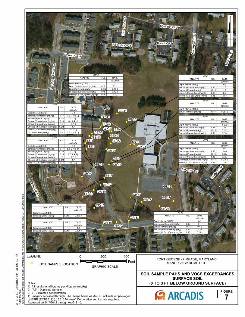
!
!
!
!
!
!
!
!
!
!
!
!
!!
!
!
!
!
!
!
!!
!
!
!
!
!
!
!
!!
!
!
(
(
(
(
(
(
(
(
(
(
(
(
((
(
(
(
(
(
(
((
(
(
(
(
(
(
(
((
(
(CPT-2
ANALYTE RSL DATE 08/26/04Depth Interval (f t BG) 0-2Benzo(a)Anthracene (mg/kg) 0.15 8.9 D [9.8 D] Benzo(a)Pyrene (mg/kg) 0.015 7 [7.3] Benzo(b)f luoranthene (mg/kg) 0.15 6 D [6.4 D] Benzo(k)Fluoranthene (mg/kg) 1.5 8.7 DDibenzo(a,h)Anthracene (mg/kg) 0.015 1.7Indeno(1,2,3-cd)Pyrene (mg/kg) 0.15 3.5 [4.2]
GP39
ANALYTE RSL DATE 10/01/04Depth Interval (f t BG) -Benzo(a)Anthracene (mg/kg) 0.15 0.2 JBenzo(a)Pyrene (mg/kg) 0.015 0.18 JBenzo(b)fluoranthene (mg/kg) 0.15 0.19 JIndeno(1,2,3-cd)Pyrene (mg/kg) 0.15 0.2 J
CTP-2
ANALYTE RSL DATE 08/25/04Depth Interval (f t BG) 0-2Benzo(a)Anthracene (mg/kg) 0.15 0.45Benzo(a)Pyrene (mg/kg) 0.015 0.34 JBenzo(b)f luoranthene (mg/kg) 0.15 0.55 JDibenzo(a,h)Anthracene (mg/kg) 0.015 0.076 JIndeno(1,2,3-cd)Pyrene (mg/kg) 0.15 0.18 J
GP32
ANALYTE RSL DATE
08/25/04Depth Interval (f t BG) 0-3Benzo(a)Pyrene (mg/kg) 0.015 0.064 J
GP35
ANALYTE RSL DATE 08/26/04Depth Interval (f t BG) 0-2Benzo(a)Anthracene (mg/kg) 0.15 8.9 J [9.8 J] Benzo(a)Pyrene (mg/kg) 0.015 7 [7.3] Benzo(b)f luoranthene (mg/kg) 0.15 6 J [6.4 J] Benzo(k)Fluoranthene (mg/kg) 1.5 8.7 JDibenzo(a,h)Anthracene (mg/kg) 0.015 1.7Indeno(1,2,3-cd)Pyrene (mg/kg) 0.15 3.5 [4.2] Trichloroethene (mg/kg) 0.91 2.3 L [8.2 J]
GP39
ANALYTE RSL DATE 08/27/04Depth Interval (f t BG) 0-3Benzo(a)Anthracene (mg/kg) 0.15 1.6Benzo(a)Pyrene (mg/kg) 0.015 1.9Benzo(b)f luoranthene (mg/kg) 0.15 2.2Indeno(1,2,3-cd)Pyrene (mg/kg) 0.15 0.88
GP43
ANALYTE RSL DATE 08/27/04Depth Interval (f t BG) 0-2.5Benzo(a)Anthracene (mg/kg) 0.15 0.24 JBenzo(a)Pyrene (mg/kg) 0.015 0.22 JBenzo(b)f luoranthene (mg/kg) 0.15 0.21 J
GP44
ANALYTE RSL DATE 08/27/04Depth Interval (f t BG) 0-1Benzo(a)Anthracene (mg/kg) 0.15 0.41Benzo(a)Pyrene (mg/kg) 0.015 0.4 JBenzo(b)f luoranthene (mg/kg) 0.15 0.39Indeno(1,2,3-cd)Pyrene (mg/kg) 0.15 0.23 J
GP45
ANALYTE RSL DATE 04/01/03Depth Interval (f t BG) -Benzo(a)Pyrene (mg/kg) 0.015 0.083 J
SS-06
ANALYTE RSL DATE 04/01/03Depth Interval (f t BG) -Benzo(a)Pyrene (mg/kg) 0.015 0.053 J
SS-07
GP-25
GP-26
GP-37
GP-32
GP-27
GP-28
GP-45
GP-33
GP-34GP-35
GP-36GP-38
TP-17
GP-40
GP-30
GP-31
GP-41
GP-42
GP-43
GP-44GP-39
GP-29
SS-7
SS-3/8GP-22
GP-23SS-1
SS-2
SS-4
SS-5
SS-6
Mac
Art
hur
Ro
ad
2nd
Co
rps
Bou
leva
rd
Stewart Loop
Jones Drive
Pie
rce
Cou
rt
Chatillion Street
Stewart Court
Lauf
fer C
ourt
Brandt Court
Ric
hard
s C
ourt
Richards Court
CIT
Y: M
PLS
D
IV/G
RO
UP
: IM
D
B:
MG
LD
: H
AF
OR
T M
EA
DE
FORT GEORGE G. MEADE, MARYLANDMANOR VIEW DUMP SITE
SOIL SAMPLE PAHS AND VOCS EXCEEDANCESSURFACE SOIL
(0 TO 3 FT BELOW GROUND SURFACE)
FIGURE
7
LEGEND:
!( SOIL SAMPLE LOCATION
Notes:1) All results in milligrams per kilogram (mg/kg)2) [7.3] - Duplicate Sample3) J - Estimated concentration.4) Imagery accessed through BING Maps Aerial via ArcGIS online layer packagesby ESRI (12/1/2012) (c) 2010 Microsoft Corporation and its data suppliers. Accessed on 9/17/2012 through ArcGIS 10.
0 200 400
FeetGRAPHIC SCALE
Pa
th:
G:\
GIS
\Pro
ject
s\F
ort
_M
ea
de
\Arc
Ma
p\M
an
or_
Vie
w\2
01
3-0
6\S
urf
ace
So
il_V
OC
PA
H_
201
30
61
3.m
xd

!
!
!
!
!
!
!
!
!
!
!
!
!!
!
!
!
!
!
!
!!
!
!
!
!
!
!
!
!!
!
!
(
(
(
(
(
(
(
(
(
(
(
(
((
(
(
(
(
(
(
((
(
(
(
(
(
(
(
((
(
(
ANALYTE RSL DATE
04/01/03Depth Interval (ft BG) 11-11Arsenic (mg/Jg) 0.39 2.8
GP-22
ANALYTE RSL DATE04/01/03
Depth Interval (ft BG) 12-12
Arsenic (mg/Jg) 0.39 3.3
GP-24
ANALYTE RSL DATE04/01/03
Depth Interval (ft BG) 11-11Arsenic (mg/Jg) 0.39 4.2
GP-25
ANALYTE RSL DATE04/01/03
Depth Interval (ft BG) 10-10Arsenic (mg/Jg) 0.39 4
GP-26
ANALYTE RSL08/23/04 08/23/04 08/23/04 08/23/04
Depth Interval (ft BG) 12-15.5 16-20 4-6.5 8-10.5Arsenic (mg/Jg) 0.39 2 J 4.6 J 2.6 J 2.9 J
GP27
DATE
ANALYTE RSL08/23/04 08/23/04 08/23/04 08/23/04
Depth Interval (ft BG) 12-15.5 16-21.5 4-7.5 8-10Arsenic (mg/Jg) 0.39 2.2 J 3 J 3.1 J 3.9 J
GP28DATE
ANALYTE RSL08/24/04 08/24/04 08/24/04 08/24/04
Depth Interval (ft BG) 12-14.5 16-20.5 4-6.5 8-11Arsenic (mg/Jg) 0.39 3.6 J 1.7 J 3 J [3.9 J] 11 J
DATEGP29
ANALYTE RSL
08/24/04 08/24/04 08/24/04 08/24/04Depth Interval (ft BG) 12-14 16-21.5 4-6.5 8-12Arsenic (mg/Jg) 0.39 1.9 J 2.1 J 3.5 J 1.3
DATEGP30
ANALYTE RSL
08/24/04 08/24/04 08/24/04Depth Interval (ft BG) 16-20 4-6.5 8-10.5Arsenic (mg/Jg) 0.39 2.2 J [8.9] 3.7 13 [16]
DATEGP31
ANALYTE RSL08/25/04 08/25/04 08/25/04 08/25/04
Depth Interval (ft BG) 12-14.5 16-22 4-6.5 8-11.5Arsenic (mg/Jg) 0.39 3.7 4.1 3.6 3.1 J
DATEGP32
ANALYTE RSL08/25/04 08/25/04 08/25/04 08/25/04
Depth Interval (ft BG) 12-14.5 16-20.5 4-6 8-10
Arsenic (mg/Jg) 0.39 2.5 J 2 J [3.1 J] 2 J 0.83 J
GP33DATEANALYTE RSL
08/25/04 08/25/04 08/25/04 08/25/04Depth Interval (ft BG) 12-16 16-18.5 4-6.5 8-12
Arsenic (mg/Jg) 0.39 1.8 0.63 0.65 J 2.7
GP34DATE
ANALYTE RSL08/25/04 08/25/04 08/25/04 08/25/04
Depth Interval (ft BG) 12-15 16-18 4-7 8-11Arsenic (mg/Jg) 0.39 3.9 [5] 1.1 2.8 10
GP35DATE
ANALYTE RSL08/26/04 08/26/04 08/26/04 08/26/04
Depth Interval (ft BG) 12-15 16-20 4-7 8-10.5Arsenic (mg/Jg) 0.39 14 1.5 0.56 2.1
GP36
DATE
ANALYTE RSL08/26/04 08/26/04 08/26/04 08/26/04
Depth Interval (ft BG) 12-15.5 16-20.5 4-6.5 8-11Arsenic (mg/Jg) 0.39 2 3.2 1.2 2.3
GP37DATE
ANALYTE RSL08/26/04 08/26/04 08/26/04 08/26/04
Depth Interval (ft BG) 12-15.5 16-20.5 4-7 8-11Arsenic (mg/Jg) 0.39 0.92 2.2 1.6 2
GP38DATE
ANALYTE RSL08/26/04 08/26/04 08/26/04
Depth Interval (ft BG) 12-15 4-7 8-10.5Arsenic (mg/Jg) 0.39 1.1 0.78 3.9
GP39DATE
ANALYTE RSL08/26/04 08/26/04 08/26/04
Depth Interval (ft BG) 12-17 4-7.5 8-11Arsenic (mg/Jg) 0.39 2.8 1.6 6.3
DATEGP40
ANALYTE RSL08/27/04 08/27/04 08/27/04
Depth Interval (ft BG) 12-14 4-6.5 8-11Arsenic (mg/Jg) 0.39 1.8 3 3.5
GP41DATE
ANALYTE RSL08/27/04 08/27/04 08/27/04
Depth Interval (ft BG) 16-18.5 4-5.5 8-11Arsenic (mg/Jg) 0.39 3.2 11 J [6.3 J] 2.9
GP43DATE
ANALYTE RSL08/27/04 08/27/04 08/27/04 08/27/04
Depth Interval (ft BG) 12-14.5 16-19.5 4-5 8-10Arsenic (mg/Jg) 0.39 7.4 2.2 6.8 3.3Iron (mg/Jg) 55000 NE NE 65000 NEMercury (mg/Jg) 10 NE NE NE 69 J
GP44
DATE
ANALYTE RSL08/27/04 08/27/04 08/27/04 08/27/04
Depth Interval (ft BG) 12-14.5 16-20.5 4-6 8-20
Arsenic (mg/Jg) 0.39 3.6 2.4 3.6 8.3
GP45DATE
GP-37
GP-32
GP-27
GP-28
GP-45
GP-33
GP-34GP-35
GP-36GP-38
TP-17
GP-40
GP-30
GP-31
GP-41
GP-42
GP-43
GP-44GP-39
GP-29
SS-7
SS-5
SS-4
SS-2
SS-1
GP-26
GP-25
CPT-2
GP-23GP-22
SS-3/8GP-24
SS-6
Mac
Art
hur
Ro
ad
2nd
Co
rps
Bou
leva
rd
Stewart Loop
Pie
rce
Cou
rt
2nd Army Drive
Stewart Court
Richards Court
Brandt Court
CIT
Y: M
PLS
D
IV/G
RO
UP
: IM
D
B:
MG
LD
: H
AF
OR
T M
EA
DE
FORT GEORGE G. MEADE, MARYLANDMANOR VIEW DUMP SITE
SOIL SAMPLE METALS EXCEEDANCESSUBSURFACE SOIL
FIGURE
8
LEGEND:
!( SOIL SAMPLE LOCATION
Notes:1) All results in milligrams per kilogram (mg/kg)2) The site specific background value for arsenic in subsurface soils at this site is 4.84 mg/kg.3) [8.9] - Duplicate Sample4) J - Estimated concentration.5) NE - No exceedance.6) Imagery accessed through BING Maps Aerial via ArcGIS online layer packagesby ESRI (12/1/2012) (c) 2010 Microsoft Corporation and its data suppliers. Accessed on 9/17/2012 through ArcGIS 10.
0 200 400
FeetGRAPHIC SCALE
Pa
th:
G:\
GIS
\Pro
ject
s\F
ort
_M
ea
de
\Arc
Ma
p\M
an
or_
Vie
w\2
01
3-0
6\S
ub
Su
rfa
ceS
oil_
Me
tals
_2
01
30
613
.mxd

!
!
!
!
!
!
!
!
!
!
!
!
!!
!
!
!
!
!
!
!!
!
!
!
!
!
!
!
!!
!
!
(
(
(
(
(
(
(
(
(
(
(
(
((
(
(
(
(
(
(
((
(
(
(
(
(
(
(
((
(
(
ANALYTE RSL DATE04/01/03
Depth Interval (f t BG) 11-11Benzo(a)Pyrene (mg/kg) 0.015 0.11
Dibenzo(a,h)Anthracene (mg/kg) 0.015 0.047Indeno(1,2,3-cd)Pyrene (mg/kg) 0.15 0.19
GP-22
ANALYTE RSL DATE08/26/04
Depth Interval (f t BG) 4-7
Benzo(a)Pyrene (mg/kg) 0.015 0.057 J
GP39
ANALYTE RSL08/27/04 08/27/04 08/27/04
Depth Interval (ft BG) 16-18.5 4-5.5 8-11Benzo(a)Anthracene (mg/kg) 0.15 NE 15 J [2.4 J] NEBenzo(a)Pyrene (mg/kg) 0.015 0.039 J 2.4 J [5.1 J] 0.14 JBenzo(b)f luoranthene (mg/kg) 0.15 NE 2 J [3.8 J] NE
Benzo(k)Fluoranthene (mg/kg) 1.5 NE 1.8 J [4.4 J] NEChrysene (mg/kg) 15 NE 18 J NEIndeno(1,2,3-cd)Pyrene (mg/kg) 0.15 NE 0.7 [2.3] NE
GP43
DATE
ANALYTE RSL08/27/04 08/27/04 08/27/04 08/27/04
Depth Interval (f t BG) 12-14.5 16-19.5 4-5 8-10Benzo(a)Anthracene (mg/kg) 0.15 NE 2.2 J 1.1 J 14
Benzo(a)Pyrene (mg/kg) 0.015 NE 1.9 J 1 J 13Benzo(b)f luoranthene (mg/kg) 0.15 NE 1.8 J 0.86 J 12Benzo(k)Fluoranthene (mg/kg) 1.5 NE NE NE 9.6Dibenzo(a,h)Anthracene (mg/kg) 0.015 0.18 J 0.19 J NE 1.4 JIndeno(1,2,3-cd)Pyrene (mg/kg) 0.15 0.21 J 1.2 J 0.6 J 9
GP44DATE
ANALYTE RSL08/27/04 08/27/04
Depth Interval (ft BG) 4-6 8-20
Benzo(a)Pyrene (mg/kg) 0.015 0.09 J 0.041 J
DATEGP45
ANALYTE RSL DATE4/1/2003
Depth Interval (ft BG) 12-12Vinyl Chloride (mg/kg) 0.06 0.14 J
GP-24
GP-37
GP-32
GP-27
GP-28
GP-45
GP-33GP-34GP-35
GP-36GP-38
TP-17
GP-40
GP-30
GP-31
GP-41
GP-42
GP-43
GP-44GP-39
GP-29
SS-7
SS-2
CPT-2
SS-3/8
GP-22
GP-23
GP-24
GP-25
GP-26
SS-1
SS-4
SS-5
SS-6
Mac
Art
hur
Ro
ad
2nd
Co
rps
Bou
leva
rd
Stewart Loop
Jones Drive
Hay
den
Dri
ve
Pie
rce
Cou
rt
Chatillion Street
Stewart Court
Th
omps
on L
ane
Phelps Avenue
Hart Road
Lauf
fer C
ourt
Brandt Court
Ric
hard
s C
ourt
Richards Court
CIT
Y: M
PLS
D
IV/G
RO
UP
: IM
D
B:
MG
LD
: H
AF
OR
T M
EA
DE
FORT GEORGE G. MEADE, MARYLANDMANOR VIEW DUMP SITE
SOIL SAMPLE PAHS AND VOCS EXCEEDANCESSUBSURFACE SOIL
FIGURE
9
LEGEND:
!( SOIL SAMPLE LOCATION
Notes:1) All results in milligrams per kilogram (mg/kg)2) [2.3] - Duplicate Sample3) J - Estimated concentration.4) NE - No exceedance.5) Imagery accessed through BING Maps Aerial via ArcGIS online layer packagesby ESRI (12/1/2012) (c) 2010 Microsoft Corporation and its data suppliers. Accessed on 9/17/2012 through ArcGIS 10.
0 200 400
FeetGRAPHIC SCALE
Pa
th:
G:\
GIS
\Pro
ject
s\F
ort
_M
ea
de
\Arc
Ma
p\M
an
or_
Vie
w\2
01
3-0
6\S
ub
Su
rfa
ceS
oil_
VO
CP
AH
_2
01
30
61
3.m
xd
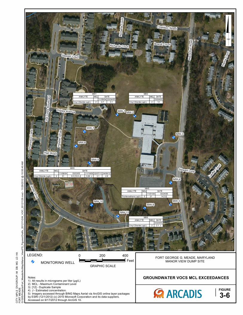
@A @A
@A
@A
@A@A
@A
@A
@A
@A
@A
ANALYTE MCL
11/09/04 03/24/05
Vinyl Chloride (ug/L) 2 4.7 3.1
MW1
DATE ANALYTE MCL DATE
03/24/05
Vinyl Chloride (ug/L) 2 12
MW2
ANALYTE MCL
11/01/04
Trichloroethene (ug/L) 5 21
MW5
DATE
03/24/05
14 [12]
ANALYTE MCL DATE
03/24/05
Vinyl Chloride (ug/L) 2 2.1 J
MW6
ANALYTE MCL
11/08/04 11/19/09 02/07/11 04/06/12
Vinyl Chloride (ug/L) 2 51 5.60 J 3.1 2.8
03/22/05
8.3 [10.0 J]
MW9
DATE
MacA
rthu
r R
oad
2nd C
orp
s B
oule
vard
Stewart Loop
Pie
rce C
ourt
Hayd
en D
rive
Jones D
rive
Chatillion Street
Stewart Court
Th
om
pson
Lane
Phelps Avenue
Hart Road
Lauf
fer Cou
rt
Brandt Court
Ric
hard
s C
ou
rt
Richards Court
MW-9
MW-8
MW-7
MW-6
MW-5
MW-4
MW-3
MW-2MW-1
MW-11
MW-10
CIT
Y: M
PL
S
DIV
/GR
OU
P:
IM
DB
: M
G
LD
: H
AF
OR
T M
EA
DE
0 200 400
Feet
GRAPHIC SCALE
G:\
GIS
\Pro
jects
\Fo
rt_
Me
ad
e\A
rcM
ap
\Man
or_
Vie
w\F
S_
Fig
ure
s\D
raft
s_
20
12
11
\GW
_V
OC
_2
01
211
29
.mxd
- 1
1/2
9/2
01
2 @
10
:55
:40
AM
GROUNDWATER VOCS MCL EXCEEDANCES
FIGURE
3-6
LEGEND:
@A MONITORING WELL
FORT GEORGE G. MEADE, MARYLANDMANOR VIEW DUMP SITE
Notes:1) All results in micrograms per liter (µg/L)2) MCL - Maximum Contaminant Level3) [12] - Duplicate Sample4) J - Estimated concentration.5) Imagery accessed through BING Maps Aerial via ArcGIS online layer packagesby ESRI (12/1/2012) (c) 2010 Microsoft Corporation and its data suppliers. Accessed on 9/17/2012 through ArcGIS 10.
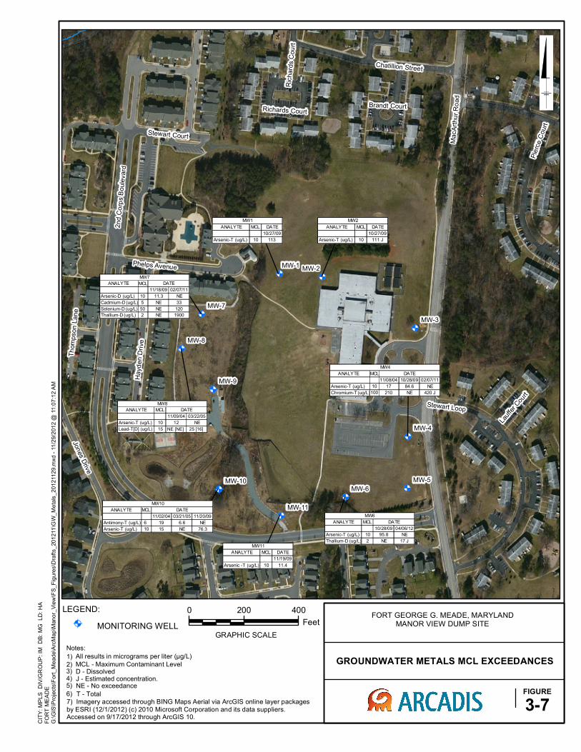
@A @A
@A
@A
@A@A
@A
@A
@A
@A
@A
ANALYTE MCL DATE
10/27/09
Arsenic-T (ug/L) 10 113
MW1
ANALYTE MCL
11/02/04 03/21/05 11/20/09
Antimony-T (ug/L) 6 19 6.6 NE
Arsenic-T (ug/L) 10 15 NE 76.3
MW10
DATE
ANALYTE MCL DATE
11/19/09
Arsenic -T (ug/L) 10 11.4
MW11
ANALYTE MCL DATE
10/27/09
Arsenic-T (ug/L) 10 111 J
MW2
ANALYTE MCL
11/08/04 10/28/09 02/07/11
Arsenic-T (ug/L) 10 17 84.6 NE
Chromium-T (ug/L)100 210 NE 420 J
MW4
DATE
ANALYTE MCL
10/28/09 04/06/12
Arsenic-T (ug/L) 10 95.8 NE
Thallium-D (ug/L) 2 NE 17 J
MW6
DATE
ANALYTE MCL
11/18/09 02/07/11
Arsenic-D (ug/L) 10 11.3 NE
Cadmium-D (ug/L) 5 NE 33
Selenium-D (ug/L) 50 NE 120
Thallium-D (ug/L) 2 NE 1900
DATE
MW7
ANALYTE MCL
11/09/04 03/22/05
Arsenic-T (ug/L) 10 12 NE
Lead-T[D] (ug/L) 15 NE [NE] 25 [16]
DATE
MW8
MacA
rthu
r R
oad
2nd C
orp
s B
oule
vard
Stewart Loop
Pie
rce C
ourt
Hayd
en D
rive
Jones D
rive
Chatillion Street
Stewart Court
Th
om
pson
Lane
Phelps Avenue
Lauf
fer Cou
rt
Brandt Court
Ric
hard
s C
ou
rt
Richards Court
MW-9
MW-8
MW-7
MW-6
MW-5
MW-4
MW-3
MW-2MW-1
MW-11
MW-10
CIT
Y: M
PL
S
DIV
/GR
OU
P:
IM
DB
: M
G
LD
: H
AF
OR
T M
EA
DE
0 200 400
Feet
GRAPHIC SCALE
G:\
GIS
\Pro
jects
\Fo
rt_
Me
ad
e\A
rcM
ap
\Man
or_
Vie
w\F
S_
Fig
ure
s\D
raft
s_
20
12
11
\GW
_M
eta
ls_
20
12
11
29
.mxd
- 1
1/2
9/2
01
2 @
11
:07
:12 A
M
GROUNDWATER METALS MCL EXCEEDANCES
FIGURE
3-7
LEGEND:
@A MONITORING WELL
FORT GEORGE G. MEADE, MARYLANDMANOR VIEW DUMP SITE
1) All results in micrograms per liter (µg/L)
2) MCL - Maximum Contaminant Level3) D - Dissolved 4) J - Estimated concentration.5) NE - No exceedance
7) Imagery accessed through BING Maps Aerial via ArcGIS online layer packagesby ESRI (12/1/2012) (c) 2010 Microsoft Corporation and its data suppliers. Accessed on 9/17/2012 through ArcGIS 10.
Notes:
6) T - Total

@A @A
@A
@A
@A@A
@A
@A
@A
@A
@A
ANALYTE MCL
11/09/04 03/24/05
Beta-Bhc (ug/L) - NE 0.0054 J
Endrin Ketone (ug/L) - NE 0.015 J
MCPP (ug/L) - 6.6 NE
MW1
DATE
ANALYTE MCL
11/02/04 03/21/05
Beta-Bhc (ug/L) - NE 0.0055 J
Bis(2-Ethylhexyl)phthalate (ug/L) 6 2.8 J NE
Endrin Ketone (ug/L) - NE 0.015 J
DATE
MW10
ANALYTE MCL
11/10/04 03/21/05
Benzo(g,h,i)Perylene (ug/L) - 1 J NE
Beta-Bhc (ug/L) - NE 0.019 J
Dibenzo(a,h)Anthracene (ug/L) - 0.85 J NE
Endrin Ketone (ug/L) - NE 0.016 J
DATE
MW11
ANALYTE MCL DATE
03/24/05
Beta-Bhc (ug/L) - 0.0054 J
Endrin Ketone (ug/L) - 0.015 J
MW2
ANALYTE MCL
11/08/04 03/25/05
Benzo(g,h,i)Perylene (ug/L) - 0.94 J NE
Beta-Bhc (ug/L) - NE 0.0057 J
Endrin Ketone (ug/L) - NE 0.016 J
DATE
MW3
ANALYTE MCL DATE
03/24/05
Beta-Bhc (ug/L) - 0.0063 J
Endrin Ketone (ug/L) - 0.018 J
MW4
ANALYTE MCL
11/01/04 02/07/11 04/05/12
Beta-Bhc (ug/L) - NE NE NE
Dieldrin (ug/L) - 0.013 J 0.023 J 0.023 J
Endrin Ketone (ug/L) - NE NE NE
NE
0.016 J [0.15 J]
03/24/05
DATE
MW5
0.0056 J [0.0054 J]
ANALYTE MCL DATE
03/24/05
Beta-Bhc (ug/L) - 0.0055 J
Endrin Ketone (ug/L) - 0.015 J
MW6
ANALYTE MCL DATE
03/22/05
Beta-Bhc (ug/L) - 0.0054 J
Endrin Ketone (ug/L) - 0.015 J
MW7
ANALYTE MCL
11/09/04 03/22/05
3-Methylphenol, 4-Methylphenol (ug/L) - 4.4 J NE
Beta-Bhc (ug/L) - NE 0.0054 J
Endrin Ketone (ug/L) - NE 0.015 J
MW8
DATE
ANALYTE MCL
Beta-Bhc (ug/L) -
Endrin Ketone (ug/L) -
DATE
03/22/05
0.0054 J [ 0.0055 J]
0.015 J [0.015 J]
MW9
MacA
rthu
r R
oad
2nd C
orp
s B
oule
vard
Jon
es D
rive
Stewart Loop
Hayd
en D
rive
Chatillion Street
Pie
rce C
ourt
Stewart Court
Thom
pson
Lane
2nd Army Drive
Hart Road
Lauf
fer Cou
rt
Brandt Court
Ric
hard
s C
ou
rt
Richards Court
MW-9
MW-8
MW-7
MW-6
MW-5
MW-4
MW-3
MW-2
MW-1
MW-11
MW-10
CIT
Y: M
PL
S
DIV
/GR
OU
P:
IM
DB
: M
G
LD
: H
AF
OR
T M
EA
DE
0 200 400
Feet
GRAPHIC SCALE
G:\
GIS
\Pro
jects
\Fo
rt_
Me
ad
e\A
rcM
ap
\Man
or_
Vie
w\F
S_
Fig
ure
s\D
raft
s_
20
12
11
\GW
_P
AH
_2
01
211
29
.mxd
- 1
1/2
9/2
012
@ 1
1:2
2:0
6 A
M
GROUNDWATER PAH AND PESTICIDES RESULTS
FIGURE
3-8
LEGEND:
@A MONITORING WELL
FORT GEORGE G. MEADE, MARYLANDMANOR VIEW DUMP SITE
Notes:1) All results in micrograms per liter (µg/L)2) MCL - Maximum Contaminant Level
3) - No MCL Established4) [0.15 J] - Duplicate Sample5) J - Estimated concentration.6) NE - No exceedance.7) Imagery accessed through BING Maps Aerial via ArcGIS online layer packagesby ESRI (12/1/2012) (c) 2010 Microsoft Corporation and its data suppliers. Accessed on 9/17/2012 through ArcGIS 10.

Appendix A
Response to Comments

1 of 1
CommentNo. Commenter Date of
Comment Page(s) Section Line(s) Comment ResponseCode Response
1 MDE 7/26/2013 General Comment
This Proposed Plan presents the Army's Preferred Remedial Alternative for the site,which is the Maintenance of the Existing Soil Cover, Land Use Controls and Long Term Monitoring. This alternative requires a variance on the Closure Capping requirements specified in COMAR 26.04.07.21. The Army has previously submitted a variance request, which has been evaluated by the Land Restoration Program in coordination with the Solid Waste Program. This Proposed Plan references Section 4.3 of the 2013 Feasibility Study (FS) for a detailed discussion of ARARs (Applicable or Relevant and Appropriate Requirements). As discussed in the FS, MDE considers the closure requirements (COMAR 26.04.07.21) and post-closure requirements (COMAR 26.04.07.22) for sanitary landfills to be relevant and appropriate for the site. MDE has determined the Preferred Remedial Alternative to be appropriate and in compliance with the variance provisions of COMAR 26.04.07.26.
It should be noted that MDE cannot provide concurrence with the action during theProposed Plan stage, because the comments from the community have not beensubmitted. Following the release of the Proposed Plan and public meeting, MDE willdetermine whether it may concur with this plan.
N Noted.
2 MDE 7/26/2013 7Section "Results of HHRA" and Table
1
The text of the section titled "Results of HHRA" states that the Hazard Index is below 1 for Current/Future Students and Teachers. However, entries in table 1 indicate that the HI for current students is 2, for future students is 3, and for future teachers 2. Please correct either the text or the table to the correct value.
A Agree. Table 1 has been removed for clarity and the results of the HHRA are summarized in the text.
3 MDE 7/26/2013 6 Section "Summary of Site Risks"
Per USEPA Guidance ("A Guide to Preparing Superfund Proposed Plans, Records of Decision, and Other Remedy Selection Decision Documents", USEPA, 1999), thissection should conclude with the following statement:
"It is the lead agency's current judgment that the Preferred Alternative identifiedin this Proposed Plan, or one of the other active measures considered in theProposed Plan, is necessary to protect public health or welfare or the environmentfrom actual or threatened releases of hazardous substances into the environment."
Please include this statement in this section.
A Agree. The requested text has been added.
4 MDE 7/26/2013 8There are two headings on Page 8 titled "Remedial Action Objectives." It is unclear why the text is divided this way, and it is confusing for the reader. Please consolidate these sections.
A Agree. This section has been revised per the Final HHRA and the sections were renamed for clarity.
5 MDE 7/26/2013 8-9Section "Summary
of Remedial Alternatives"
Per USEPA Guidance ("A Guide to Preparing Superfund Proposed Plans, Records of Decision, and Other Remedy Selection Decision Documents", USEPA, 1999), thebeginning of this section should clearly state which alternative is the preferredalternative. Please correct this oversight.
A Agree. Alternative 2 has been identified as the preferred alternative.
6 MDE 7/26/2013 10 Section "Alternative 3"
This section lists the Estimated Present Worth Cost of Alternative 3 as $75,100, whereas it is listed as $6,641 ,000 in the Draft Final Feasibility Study (May 2013). Please update the text with the correct value for the Estimated Present Worth Cost for this alternative.
A Agree. The text has been revised.
7 MDE 7/26/2013 11 Section "Overall Protection of …"
The text in this section states that "All alternatives are protective of human health and the environment in the short-term and long-term." This statement is misleading, as there is an unknown risk associated with direct contact with buried waste if no action is taken. Please change the text accordingly.
A Agree. The text has been revised.
8 MDE 7/26/2013 15 Section "Public Comment Period"
The text in this section references the Draft Feasibility Study (FS) for the Manor View Dump Site. The FS should be finalized before the Proposed Plan is released to the public, so this should be changed to Final FS for the Manor View Dump Site. Please correct this oversight.
A Agree. The FS was approved by MDE on 20 August 2013 and EPA directed the Army to finalize the FS on 12 August 2013. The text in the Proposed Plan has been corrected.
9 EPA RPM 8/26/13 6 Summary of Site Risks. “is outdated and no long applicable”. Typo. A Agree. Typo has been corrected and text has been updated to reflect the current HHRA. 10 EPA RPM 8/26/13 6 Cleaning up the aquifer to beneficial use needs to be an RAO. A The RAOs have been revised.
11 EPA RPM 8/26/13 How does the revised HHRA affect Table 1? Currently they are borderline. NNoted. The HHRA has been revised based on the agreements made between USEPA and the Army. As discussed, Table 1 has been removed for clarity and the results of the HHRA are summarized throughout the document.
12 Additional comments were addressed directly Iin the text.
Response to Comments Table
Response Code: A = Agree with comment D = Disagree with comment C = Comment requires clarification N = Comment noted, no action required or taken
FGGM 93 Manor View, Response to Comments on Draft Proposed Plan, June 2013