department of sport and recreation - dlgsc
TRANSCRIPT

PUBLIC PARKLAND PLANNING & DESIGN
GUIDE (WA)
Well-planned, well-designed public
parklands will provide long-term benefits to
Western Australian communities
Department of Sport and Recreation
Department of Water

© State of Western AustraliaPublished by theDepartment of Sport and RecreationPublished March 2014ISBN:978-1-921648-39-7
Suggested Citation
Government of Western Australia. (2014). Public Parkland Planning and Design Guide WA. Perth Western Australia, Department of Sport and Recreation. Images: LeighHambly.com
PartnersDisclaimerThis document has been published by the Department of Sport and Recreation. Any representation, statement, opinion or advice expressed or implied in this publication is made in good faith and on the basis that the government, its employees and agents are not liable for any damage or loss whatsoever which may occur as a result of action taken or not taken, as the case may be, in respect of any representation, statement, opinion or advice referred to herein. Professional advice should be obtained before applying the information contained in this document to particular circumstances.
This resource has been developed by the Department of Sport and Recreation and the Department of Water, with financial
assistance from the Western Australian Planning Commission.
The Department of Sport and Recreation and Department of Water would like to acknowledge the contribution of AECOM and PlaceScape.
Department of Sport and Recreation
Department of Water

PUBLIC PARKLAND PLANNING & DESIGN
GUIDE (WA)

A message from the Minister for Sport And Recreation
Public parklands are wonderful places for social interaction, recreation, leisure, sporting activity, exercise, rest and relaxation.
It’s important that all communities have equal access to good quality parkland that creates a sense of place and enhances feelings of social attachment and cohesion, identity and belonging.
Good quality parklands are valuable community assets that require well-considered planning, design and management to achieve optimal levels of amenity and functional performance. While initial establishment costs may be high, the long-term return to today and tomorrow’s communities is beyond measure.
To achieve this it’s important to:
• Plan and design more diverse, well-distributed, well-connected parkland that meets different community needs, provides spaces suited for different purposes and functions and encourages higher levels of usage and positive social interaction for people of all ages and abilities.
• Adopt planning and design practices that recognise the value of local biodiversity, including existing bushland and wetlands and enhance and protect natural ecosystems.
• Adopt sustainability principles within parkland planning and design to ensure efficient use and protection of water resources.
In Western Australia, a growing population is increasing demand for access to good quality parklands. At the same time, climatic trends are resulting in lower allocations of water resources being made available to irrigate new and existing public parklands.
These guidelines consider challenges and opportunities unique to Western Australia and offer good practice planning and design principles and case studies to assist in the creation and care of our parkland assets.
FOREWORD
i

A message from the Minister for Water
Providing the water necessary to support the development and maintenance of parklands for community sport and recreation is an important focus for the State Government.
In the State’s south west, the drying climate and rising population means we are conscious of the need to effectively identify and share groundwater to meet community needs.
In dryland areas of regional Western Australia, parklands irrigated with treated wastewater and harvested stormwater have been integral in maintaining our outdoor lifestyle and amenity over many years.
These communities have shown the way and we are embracing innovation in all parts of the State to continue to supply the water that’s needed for these important public spaces.
We are investigating new water sources and how we can use our existing water resources to create the right number of high quality parklands across our communities, particularly in some of our newer urban neighbourhoods.
We are rethinking our approach to parkland planning and design and the options available for water sources, storage, irrigation systems and landscaping.
The Department of Water and the Department of Sport and Recreation have collaborated with turf industries, planners, urban designers and local governments to develop a guide which responds to the unique challenges in meeting Western Australia’s parkland in the 21st century.
This guide provides valuable information on water sensitive urban designed communities that match water use to levels of activity, including the environmental benefits that parklands provide.
Through good planning, sensitive design and appropriate management, we should be able to create parklands which are attractive, adaptable, accessible and resilient, whilst making the best use of the available water.
Cooperation and collaboration are essential as we move forward. It’s only by working together that we can continue to provide quality parklands supported by sustainable water sources in which our community can relax, interact, rest and play.
PUBLIC PARKLAND PLANNING & DESIGN GUIDE (WA) ii

INTRODUCTION
CONTENTS
Land & water use planning 06
Stages of parkland planning 09
Local Government parkland policy 12
Why parklands are important 01
Water supply – constraint or an opportunity for innovation?
01
Purpose of this guide 02
How to use this guide 02
Objectives And Principles 03
Parkland Classification 04
iii
SECTION ONE SECTION TWO SECTION THREE
Land & water use planning 06
Stages of parkland planning 09
Local Government parkland policy 12
Planning objective 14
Guiding principles 14
Critical considerations 14
Key planning points 15
Sourcing water 18
Design objective 26
Guiding principles 26
Critical considerations 27
Key design points 27
Stormwater management 35
Irrigation systems 37
LAND & WATER USE PLANNING IN
WESTERN AUSTRALIA
PARKLAND PLANNING
PARKLAND DESIGN
REFERENCES AND RESOURCES
PUBLIC PARKLAND PLANNING & DESIGN GUIDE (WA)PUBLIC PARKLAND PLANNING & DESIGN GUIDE (WA)DRAFT iv

INTRODUCTION
Why parklands are importantOur parklands are important community assets that help keep us healthy, active and socially connected. To maintain these valuable assets, it is important that parklands being planned now continue to meet the needs of current and future generations through user-focused, sustainable design and efficient use of our water resources.
Public parkland enhances urban amenity and provides landscapes that can positively impact community health and social connectivity, biodiversity, local water quality and water management, air quality and mitigation of the urban heat island effect.
Parkland refers to land that has been reserved for the purpose of formal and informal sport and recreation and/or preservation of natural environments such as bushland, wetlands, river and coastal foreshore systems.
Public parklands include places with conservation and heritage value, and natural landscape features that can engender a unique sense of place. Parkland for sport and recreation may include sporting fields and physical activity spaces; open areas with picnic, playground and barbeque facilities; and quiet places to rest and reflect.
In order to achieve community benefits, it is important that all those involved in parkland planning and design understand the common functions of parklands within urban and regional areas.
Various parkland functions that must be considered during all stages of parkland provision include:
• Sport and recreation: providing for a range of formal (organised sport and structured activity) and informal (exercise, play and socialising) recreation activities;
• Culture and heritage: preserving places with significant heritage or cultural connections (both colonial and Aboriginal);
• Environmental conservation: protecting wildlife habitat and maintaining ecological linkages;
• Landscape and buffer zones: enhancing the visual appeal of urban landscapes, providing green buffers and softening of the built environment;
• Physical linkages: linking larger areas of open space, natural features and community facilities through walkable corridors and greenways;
• Environmental quality: ameliorating the impact of urban heat island effect and improving air quality; and
• Water quality: filtering stormwater and run-off and providing buffer zones for watercourses and wetlands.
Water Supply – Constraint or an opportunity for innovation?Most parkland in Western Australia is currently irrigated by groundwater. Groundwater has historically been regarded as an abundant resource, conveniently located just beneath the surface, easily tapped to keep our parklands green year-round.
Water is an increasingly scarce resource across the South West of Western Australia, with rainfall, groundwater-recharge and dam inflow all declining markedly since the mid-1970s. This has coincided with growth in urban development, population and demand for water, including for irrigation of public parkland. It is essential that consideration of alternative water sources and maximum efficiency of water use is incorporated into parkland planning and design.
Therefore, this guide to good parkland planning and design encourages consideration of Water Sensitive Urban Design (WSUD) principles, fit-for-purpose water sources and efficient water use, while maintaining high levels of parkland function and usability.
1

Purpose of this guide This guide is intended to inform those working in planning and design about principles and practices to assist in achieving parkland that:
• meets user needs; • optimises community benefits; • augments existing landscape features; • suits the local environment; and • supports sustainable water use.
This guide may be used as a reference point for discussion between planners, developers, designers and associated agencies and authorities throughout the planning and development process. Addressing issues relating to planning, design and diversity of public parklands will ensure optimal provision that meets community needs into the future.
It is envisaged that use of this guide will assist to:
• ensure that parkland can adequately meet the functional needs of the community;
• promote greater industry knowledge and understanding through multi-disciplinary approaches to collaborative decision making;
• encourage and support integrated planning and policy development at all levels; and
• focus planning and design on end-user experience.
It is expected that this guide will be relevant to:
• officers from state and local government departments and agencies engaged in parks planning and management, park operations and irrigation design; environmental planning and management; community development and engagement; engineering; water management; local area planning; and
• individuals and organisations involved in residential development, planning and design.
How to use this guideThis guide is presented in three sections.
1. Land and water use planning in Western Australia outlines the different stages of land and water use planning and how this relates to parkland planning.
2. Parkland planning outlines objectives, guiding principles and critical considerations in land allocation and water planning to meet community needs and ensure best use of water resources.
3. Parkland design outlines objectives, guiding principles and critical considerations to enhance parkland usability and function and create sustainable, water-efficient sport, recreation and nature spaces.
Case studies are included in planning and design sections and provide examples of how key aspects described within this document have been applied effectively in Western Australia.
A list of relevant policies, strategies, guidelines and other resources is also included at the end of this document.
2PUBLIC PARKLAND PLANNING & DESIGN GUIDE (WA)

OBJECTIVES AND PRINCIPLES
Guiding principles
• Determine range of potential functions and allocate appropriate parkland area.
• Plan parklands as a suite of multi-functional open spaces accommodating sport, recreation and nature spaces.
• Plan for conservation, protection and enhancement of local landforms, ecological systems, cultural assets and heritage sites.
• Plan for water allocation and access to fit-for-purpose water sources.
• Apply collaborative, integrated, multi-disciplinary planning processes to inform decision making.
• Challenge planning frameworks as necessary to ensure optimal provision of parkland types and functions.
To ensure optimal allocation of land and water resources to provide a well-distributed and connected suite of parklands that can be adapted to meet changes in social and environmental conditions.
To ensure access to high quality, well-activated, sustainable parkland systems that meet diverse community needs and expectations.
Guiding principles
• Start with consideration of parkland function and end-user needs.
• Develop multiple-use parklands and balance provision of sport, recreation and nature spaces.
• Integrate and enhance existing landscape and geographic features in site design.
• Ensure human activity interacts positively with natural processes.
• Ensure stormwater management infrastructure and other utility areas are well-placed.
• Ensure maintenance requirements are considered and integrated into the initial design process.
• Make efficient use of local resources and materials.
planning objective
design
objective
3

PARKLAND CLASSIFICATION
Public open space (parkland) is often defined in hierarchical terms using criteria related to size. Within many parkland hierarchies, areas for structured, organised sport have traditionally been described as “active open space”, with “passive open space” used to describe areas for recreation and more informal activity. This criteria and terminology is now generally regarded as inadequate and confusing.
To counter this, a cross-industry classification framework based on agreed terminology was developed by the Department of Sport and Recreation.
Within the Classification Framework for Public Open Space, different types of parkland are categorised by primary function: recreation, sport and nature space; and by expected catchment: local, neighbourhood, district or regional open space.
Descriptions of primary function comprise:
• Recreation space - Provides a setting for informal play and physical
activity, relaxation and social interaction. - Includes open parkland and gardens, community
gardens, corridor links, amenity spaces, community use facilities, civic commons or squares.
• Sport space - Provides a setting for formal structured
sporting activities. - Includes playing surfaces, buffer zones and
supporting infrastructure such as clubrooms.• Nature space
- Provides a setting where people can enjoy nearby nature. - Includes sites managed to encourage
recreational access while protecting local ecological and biodiversity values.
Catchment category descriptions are based on expected purpose, typical size and how far a user might travel from their home to visit parkland, and include:
• Local Open Space - Usually small parklands that service the recreation
needs of nearby residents. - 0.4ha to 1ha in size and within 400 metres or
a 5 minute walk.• Neighbourhood Open Space
- Usually provide a variety of features and facilities with opportunities to socialise.
- 1ha to 5ha in size and within 800 metres or a 10 minute walk.
• District Open Space - Usually designed to provide for organised formal
sport and inclusion of substantial recreation and nature space
- 5ha to 15ha in size and within 2 kilometres or a 5 minute drive.
Larger areas of Regional Open Space are expected to serve one or more geographical or social regions and attract visitors from outside any one local government (LG) area. Size will be variable and dependant on function. When sport space is identified as a necessary regional function, land allocations for playing fields and sports facilities are expected to be upwards of 20 hectares in area.
CLASSIFICATION FRAMEWORK
For public open space
The Classification Framework for Public Open Space (POS) in Western Australia can be accessed through the Department of Sport and Recreation website: www.dsr.wa.gov.au
4PUBLIC PARKLAND PLANNING & DESIGN GUIDE (WA)

SECTION ONELAND AND WATER
USE PLANNING IN WESTERN AUSTRALIA
5

The Western Australian planning system involves statutory and strategic planning activities. Statutory planning is the legal arm of planning, dictated by legislation and regulations, which controls the process of land use, land supply and urban development. Strategic planning focuses on longer-term goals and integrates a wide range of economic, social and environmental considerations to deliver sustainable communities.
The WA system follows a hierarchical process that identifies relevant planning and development issues at different stages prior to determining planning applications.
Parkland planning fits within this broader planning framework and an understanding of what decisions are made at which stage is required in order to produce the best outcomes. Parkland planning must balance many competing and complex issues relating to user needs and community expectations while making the best use of available resources.
Parkland planning and design must be integrated with other broader land use and resource planning processes. This requires collaboration between professionals involved in numerous disciplines including statutory and strategic planning, recreation and sports planning, conservation and natural resource management, heritage planners, landscape and urban design, engineering, community and cultural development, and public health, among others.
LAND AND WATER USE PLANNING IN WESTERN AUSTRALIA
GUIDE TO THE WA PLANNING SYSTEM
For the sport and recreation professional
This guide provides an overview of the WA planning process and information about how to balance potentially competing economic, social and environmental issues.
It can be accessed through the Department of Sport and Recreation website: www.dsr.wa.gov.au
To assist professionals working in parkland planning to navigate the WA planning system, the Department of Sport and Recreation produced a useful guide. The Guide to the WA Planning System for the sport and recreation professional includes key questions to be considered in planning parkland and community infrastructure.
It is important that parkland planning starts with identification of end user (community) needs and the allocation of an appropriate amount of land to accommodate projected needs. In addition to meeting statutory requirements, parkland planners need to consider the following aspects:
• social and recreational needs of current and projected users;
• equitable community access;• opportunities and constraints within each parkland
site and surrounding catchment, such as available natural resources (including water) and existing infrastructure; and
• accommodation of natural, cultural and heritage features.
Integrated planning is essential to ensure quality outcomes
6PUBLIC PARKLAND PLANNING & DESIGN GUIDE (WA)

In new developments, sufficient land must be allocated to enable development of a well-distributed suite of parkland that complement existing open space networks in adjoining suburbs. It is also important to recognise that different types or functions of parkland may require different land allocations.
For example, sporting fields have specific spatial and gradient requirements, as well as supporting infrastructure, that need to be accommodated.
To ensure adequate allocation of land for sport spaces, the Department of Sport and Recreation published the Sports Dimensions Guide for Playing Fields outlining spatial requirements and field dimensions for various organised sports and activities.
SPORTS DIMENSIONS GUIDE FOR PLAYING AREASThis guide provides information about sports field and buffer zone requirements.
It can be accessed through the Department of Sport and Recreation website: www.dsr.wa.gov.au
7

8PUBLIC PARKLAND PLANNING & DESIGN GUIDE (WA)

Different aspects of parkland planning and design occur at different stages of the land planning and development process. Reference must be made to key documents such as the Structure Plan Preparation Guidelines, Liveable Neighbourhoods and Better Urban Water Management (BUWM). Figure 1 provides an overview of relationships between planning and design considerations, water management strategy and plans, and BUWM at different stages of the planning process.
It is important that parkland specific planning and design are considered in conjunction with the allocation of water resources at each stage of the planning and development process.
STAGES OF PARKLAND PLANNING
1. Regional or sub-regional planning level• Determine allocation of parkland• Determine purpose and function• Site regional and district playing fields• Consider/identify fit-for-purpose water source options• Identify areas of environmental and biodiversity value
In development of regional or sub-regional strategies, region schemes or structure plans, determinations are made on whether an area is capable of supporting urban development and if so, what areas will be allocated to public parkland.
At this point it is important to assess potential end user needs to identify appropriate purpose and function of parkland areas, including retention of conservation areas and allocation of regional (15+ha) and district open spaces (5-15ha).
Areas of environmental and biodiversity value such as wetlands and bushland should also be identified and accommodated within, or adjacent to, larger, multiple-purpose parkland where possible.
Allocation of regional and district sports spaces must be balanced with proposed water requirements. The feasibility of accessing fit-for-purpose water supply for large sports spaces (particularly sport turf areas) should be assessed at this stage of planning. Assessment of water requirements will determine whether there is an adequate level of conventional supply (groundwater) available in relative proximity, and if not, alternative fit-for-purpose water sources can be identified and pursued.
2. District planning • Determine arrangement
and uses of parkland• Configure multiple-purpose
parcels of parkland • Consider co-location of school
sites and parkland• Investigate fit-for-purpose water
source and supply options
The structure and arrangement of district, neighbourhood and local parkland is made at the District Structure Plan stage of planning.
School sites are also identified at the District Structure Planning stage and co-location of schools with large local or neighbourhood parks and district sporting ovals should be considered.
At this stage, parkland water requirements should be accommodated within a District Water Management Strategy (DWMS) to ensure adequate water supply and that the right balance of conventional and alternative sources of water for irrigation is available for parkland to meet its intended purpose.
9

3. Local planning
• Determine parkland type, connectivity, sizing and general landscaping requirements
• Determine likely water budget • Apply for parkland groundwater allocation or
seek approval for alternate water supply• Integrate BUWM principles into parkland design
Within Local Structure Plans, determinations are made regarding parkland purpose, typology, connectivity and size (in alignment with regional and district spaces already allocated at the regional or sub-regional stage). It is recommended that a public open space or landscape master plan is created at this time to support parkland development. The physical condition of the land selected for parkland will determine its capacity to provide for sport and recreational purposes.
Neighbourhood and local parklands need to be adequately located to give all residents walkable access (up to 400m) to green spaces within a parkland network. Access by road, as well as links to pedestrian and cycleway systems in a neighbourhood are indicated within Local Structure Plans.
Placement of drainage features and green infrastructure for stormwater management within parklands must be in keeping with the Department of Water (DoW) Stormwater Management Manual for Western Australia and indicated within Local Structure Plans.
At this stage, a Local Water Management Strategy (LWMS) should outline how development of parkland landscaping plans will be balanced with available water strategies that fit the requirements of the local area. If water resources are limited, relevant approvals to access required water may be necessary.
4. Subdivision • Determine parkland, landscape,
water management and infrastructure requirements
The conceptual layout and content of parkland is determined at the subdivision stage of development. Though not a statutory requirement, landscape concept plans for individual areas of parkland are often discussed with the relevant LG to ensure that proposed parkland design meets desired purpose and expectations. At this time, concerns or issues that will need to be addressed during the next stage of detailed design can be identified.
Plans for irrigation systems and stormwater drainage are best discussed at the same time landscape concept plans for the parkland are being developed. This provides opportunity to design systems to divert and store stormwater where appropriate for reuse as a beneficial irrigation resource.
5. Establishment• Design and construct parkland using
sustainable landscape principles• Design irrigation systems
Detailed landscape design and construction documentation for public parkland occurs during this stage. Detailed design and construct plans are submitted to the relevant LG for approval and further conditions may be placed on parkland designs to ensure asset management requirements (including long-term maintenance) are incorporated into development plans prior to parkland construction. Most LGs require a two-year period of maintenance by a developer prior to accepting hand-over of responsibility for ongoing asset management.
At this level, an Urban Water Management Plan (UWMP) will document how parkland-specific landscape and irrigation systems are designed to fit within an overall water budget for each subdivision area.
10PUBLIC PARKLAND PLANNING & DESIGN GUIDE (WA)

Figure 1: Parkland and water planning considerations at different stages within the WA planning system hierarchy
Planning System Hierarchy
Planning and Design Considerations
Water Management Strategy and Plans
Better Urban Water Management
Regional or sub-regional structure plan or region scheme
• Determine allocation of parkland• Determine purpose and function• Site regional and district playing fields• Consider/identify fit-for-purpose
water source options• Identify areas of environmental
and biodiversity value
District Water Management Strategy (DWMS) reviews water supply options to ensure the right balance of conventional and alternative irrigation is available to support parklands to meet intended functions
Integrated water cycle management
Consideration of catchments, regional scale issues, long-term water resource management and planning
Is this area capable of supporting proposed urban/parkland development and if so, what water is available?
Investigate and discuss water demand and availability
District structure plan • Determine arrangement and uses of parkland• Configure multiple-purpose parcels of parkland • Consider co-location of school sites and parkland• Investigate fit-for-purpose water
source and supply options
Local structure plan or local planning scheme
• Determine parkland type, connectivity, sizing and general landscaping requirements
• Determine likely water budget • Apply for parkland groundwater allocation or
seek approval for alternate water supply• Integrate BUWM principles into parkland design
Local Water Management Strategy (LWMS) ensures development of parkland landscaping plans are balanced with water strategies that fit the requirements of the local area
Water Sensitive Urban (Parkland) Design
Consideration of local scale responses, balanced water provision and built focus
How will urban/parkland structure address water use and management?
Identify landscape and water efficiency methods and irrigation requirements. Reconfirm water availability and commit to handing over the allocation to local government
Water Sensitive Urban (Parkland) Development
Consideration of development scale and built focus
How will the final urban form/parkland use and manage water?
Submit and gain approval for required licencing application for water use and commit to handing over the allocation to local government at handover
Subdivision• Determine parkland, landscape, water
management and infrastructure requirements Urban Water Management Plan (UWMP) ensures parkland-specific landscape and irrigation responses are designed to fit within an overall water budget for each subdivision areaEstablishment
• Design and develop parkland using sustainable landscape principles
• Design irrigation systems
11

State planning policies are interpreted at the local level and local government (LG) plays an important role in determining quality and quantity of parklands in their municipality. Well-articulated parkland planning policies, strategies and guidelines can greatly assist to inform expectations relating to provision, location, design, development and management of public parklands. In addition to addressing broader allocation, infrastructure and resource requirements at regional and district levels, LG parkland planning policies, strategies and guidelines can be developed for use as reference points in assessment of structure plans and subdivision development applications.
LG parkland planning policies, strategies and guidelines can facilitate interpretation and application of state government guidelines such as Liveable Neighbourhoods and Better Urban Water Management to suit local conditions and community expectations.
LOCAL GOVERNMENT PARKLAND POLICY
Adoption of LG planning policies, strategies and guidelines can:
• ensure that parkland optimises community benefit;• provide for long-term efficiencies in
parkland resource management;• enhance environmental outcomes; and• ensure best financial outcomes with regard
to asset management and maintenance.
Specific issues that may be addressed in LG planning policies, strategies and guidelines include:
• adequate allocation of well-distributed parklands;• diversity of parkland type and function;• integration of WSUD principles;• sustainability of parkland design and water resources; • protection of local bushland, enhancement of
biodiversity and retention of ecological linkages;• consideration of long-term asset
management within the design process;• technical specifications relating to drainage
and irrigation infrastructure; and• handover and audit procedures to ensure
infrastructure functions as intended.
CITY OF ARMADALE
Landscape Design Guide for Public Open Space in New Residential Developments
This guide provides an overview of the local planning process in the City of Armadale and outlines desired outcomes for parkland.
It is supported by a comprehensive Parks Facilities Strategy.
These documents can be accessed through the City of Armadale website: www.armadale.wa.gov.au
12PUBLIC PARKLAND PLANNING & DESIGN GUIDE (WA)

SECTION TWOPARKLAND PLANNING
13
To ensure optimal allocation of land and water resources to provide a well-distributed and connected suite of parklands that can be adapted to meet changes in social and environmental conditions
1. Determine range of potential functions and allocate appropriate parkland area at regional, district and local levels of planning to avoid duplication, over-provision or future redundancy.
2. Plan parklands to act as a suite of well-connected multi-functional sport, recreation and nature spaces that collectively provide diversity of opportunities to meet end users’ needs.
3. Plan for conservation, protection and enhancement of local landforms, ecological systems, cultural assets and heritage sites as these areas can generate substantial community interest and enjoyment.
4. Plan for water allocation and access to fit-for-purpose water sources that may require special infrastructure and approvals, or need particular land use groupings to achieve efficiency of delivery.
5. Apply collaborative, integrated, multi-disciplinary planning processes to inform decision-making and achieve positive community outcomes and resource efficiencies.
6. Challenge planning frameworks as necessary to ensure optimal provision of parkland types and functions to ensure that networks of local, neighbourhood, district and regional parkland are accessible to all community members, now and into the future.
Parkland must meet the varied demands of many different users and can only do this if sufficient land is allocated at regional, district and local levels of planning.
Climate change is causing us to rethink our water sources and use, limiting the available water for parkland irrigation.
Better coordination between state and local government agencies is required to secure fit-for-purpose water sources and deliver functional parkland for new and established communities.
Population increases will continue to place greater demand on open space resources and parkland facilities. In general, it is better to provide well-located and connected neighbourhood and district parklands rather than many small isolated local parks.
Small local parks have value as rest points, through ways, community meeting places and play points and can also make a substantial contribution to neighbourhood amenity. Small local parks are best provided as part of a neighbourhood network of connected green streetscapes and/or linear parklands, with proximal access (within walking distance) for all residents.
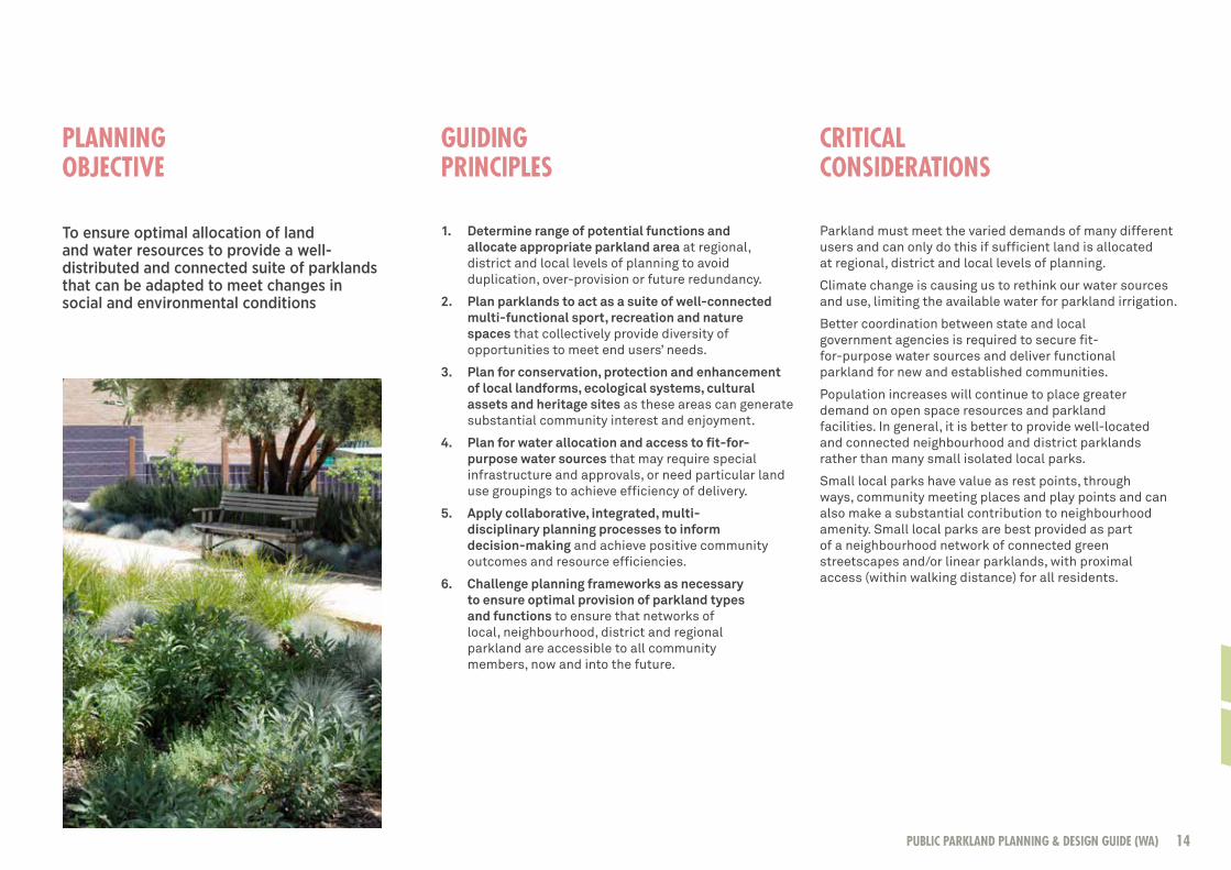
PLANNING OBJECTIVE
GUIDING PRINCIPLES
CRITICAL CONSIDERATIONS
14PUBLIC PARKLAND PLANNING & DESIGN GUIDE (WA)

Purpose and functionIdentify parkland purpose and function to ensure diversity of functions (sport, recreation and nature space) can be provided within a specified area. Ensure balanced distribution of spaces to enable equitable access from within identified catchments.
Allocation and sizeThe allocation of parkland and sizes of land parcels must be adequate for the planned purpose and functions. Complementary functions (sport, recreation and nature space) can all be accommodated within various sizes of parkland and consideration of how to make the best use of available space and proposed facilities needs to occur within the planning phase. Space for organised sport is best located within regional or district parkland to accommodate peak period events and access.
KEY PLANNING POINTS
Allocation of space for formal, organised sports and specialised activities (such as skate parks) within identified sporting or activity precincts allows opportunities for development of joint-user and shared-use facilities, and co-location with schools and other community infrastructure.
Arrangement and usesParkland within a defined area should be arranged into a suite of spaces that encourage pedestrian movement, retain ecological linkages and improve neighbourhood amenity. Planning for diverse, multiple-function parklands that provide opportunities for a range of formal and informal sporting activities, general recreation activities and nature conservation requirements are favoured over single-use spaces. Existing attributes and intended use will define the spatial arrangement of parkland. Other considerations like car parking, access to facilities and placement of stormwater drainage infrastructure must be considered when designing parkland.
Where possible, compatible uses (such as a living stream near a picnic or BBQ area) should be grouped and functions that may require distance between them (such as an active sports area and a place for quiet relaxation) should be planned with appropriate space for vegetated buffers or other separation zones.
Connectivity and accessibilityParkland should be accessible for all residents as part of a diverse public open space network. Well-planned and designed linear parklands shaded with trees and integrated into stormwater drainage systems as living streams and open swales can assist with connectivity, encourage pedestrian movement, and provide wildlife corridors. Linear linkages and clear pedestrian pathways and cycle ways between parklands can improve access for people of all ages and enhance the diversity of experiences available within a neighbourhood, district or region.
Photo courtesy of UDLA15

Overview
The City of Wanneroo in Perth’s northern outskirts is experiencing a high rate of urban growth and development. This rapid expansion has led the City to experience challenges in the delivery of public open space including:
• Cost associated with the provision of parkland infrastructure;
• Access to a secure water supply for irrigation;• Long-term maintenance costs;• A lack of diversity in parkland design; • A large number of small pocket parks;• A lack of appropriately sized spaces for sporting use; and• Compromised community outcomes in relation
to the incorporation of bushland and drainage areas into open space allocations and co-location of parkland and schools.
The City subsequently developed a local planning policy to guide Council, staff and developers in considering how to plan parkland in new areas and overcome these significant challenges.
Delivery
The policy review was initiated as the previous policy no longer aligned with State Government policy (including Liveable Neighbourhoods) nor addressed current issues relating to parkland provision. The Policy was prepared in collaboration with numerous operational units within the City of Wanneroo (planning, community development, engineering, parks maintenance and health services) as well as external agencies including the Department of Planning, the Department of Sport and Recreation, and the Department of Water.
Outcomes
• Greater attention is now given to meeting sporting and conservation requirements in new development areas;
• Detailing minimum development standards has highlighted the issue of asset costs and whole of life costs in new developments;
• Better on ground outcomes for the community in terms of parkland provision and embellishment;
CITY OF WANNEROOLOCAL PLANNING POLICY – PUBLIC OPEN SPACE
• Contribution to the debate on effectiveness of the 10% public open space allocation to deliver good community outcomes;
• Further City involvement in parkland related research undertaken by the Department of Sport and Recreation and the Centre for Sport and Recreation Research at Curtin University into the availability of playing fields in outer metropolitan growth areas;
• Improved clarity for the planning and development sector on recreation and community development requirements in relation to open space; and
• Policy provides a framework for the implementation of related strategies, eg. the North West Corridor Water Supply Strategy.
The City of Wanneroo Local Planning Policy – Public Open Space document can be accessed through www.wanneroo.wa.gov.au
Photo courtesy of UDLA 16PUBLIC PARKLAND PLANNING & DESIGN GUIDE (WA)
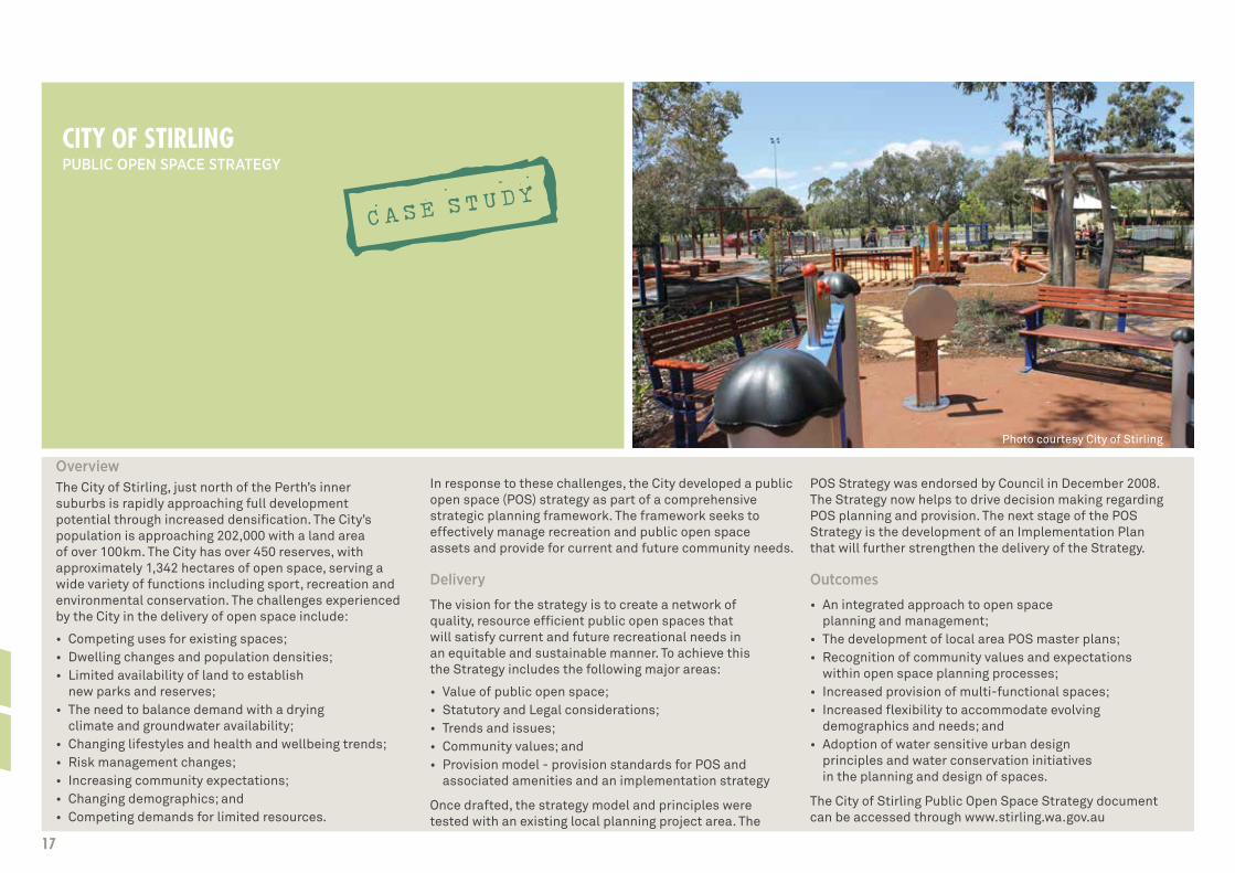
OverviewThe City of Stirling, just north of the Perth’s inner suburbs is rapidly approaching full development potential through increased densification. The City’s population is approaching 202,000 with a land area of over 100km. The City has over 450 reserves, with approximately 1,342 hectares of open space, serving a wide variety of functions including sport, recreation and environmental conservation. The challenges experienced by the City in the delivery of open space include:
• Competing uses for existing spaces;• Dwelling changes and population densities; • Limited availability of land to establish
new parks and reserves;• The need to balance demand with a drying
climate and groundwater availability;• Changing lifestyles and health and wellbeing trends;• Risk management changes;• Increasing community expectations;• Changing demographics; and• Competing demands for limited resources.
In response to these challenges, the City developed a public open space (POS) strategy as part of a comprehensive strategic planning framework. The framework seeks to effectively manage recreation and public open space assets and provide for current and future community needs.
Delivery
The vision for the strategy is to create a network of quality, resource efficient public open spaces that will satisfy current and future recreational needs in an equitable and sustainable manner. To achieve this the Strategy includes the following major areas:
• Value of public open space;• Statutory and Legal considerations; • Trends and issues;• Community values; and • Provision model - provision standards for POS and
associated amenities and an implementation strategy
Once drafted, the strategy model and principles were tested with an existing local planning project area. The
POS Strategy was endorsed by Council in December 2008. The Strategy now helps to drive decision making regarding POS planning and provision. The next stage of the POS Strategy is the development of an Implementation Plan that will further strengthen the delivery of the Strategy.
Outcomes
• An integrated approach to open space planning and management;
• The development of local area POS master plans;• Recognition of community values and expectations
within open space planning processes;• Increased provision of multi-functional spaces; • Increased flexibility to accommodate evolving
demographics and needs; and• Adoption of water sensitive urban design
principles and water conservation initiatives in the planning and design of spaces.
The City of Stirling Public Open Space Strategy document can be accessed through www.stirling.wa.gov.au
Photo courtesy City of Stirling
CITY OF STIRLING PUBLIC OPEN SPACE STRATEGY
17

Increased demand and reduced groundwater availability is driving consideration of other fit-for-purpose sources to supply water for parkland irrigation.
Depending on the type of water available, numerous issues need to be addressed to ensure all water sources and parkland design elements are sustainable in the long term. Planning considerations for sourcing water include:
• meeting peak water demand;• source, volume and quality of water likely to be available;• level of treatment and technologies required;• acceptable risk management (public
health and environment);• storage options (below or above ground);• costs associated with treatment, storage,
transfer and distribution;• compatibility with existing irrigation infrastructure;• costs associated with irrigation
maintenance and monitoring;• community awareness and acceptance; and• required regulatory approvals.
Fit-for-purpose water supply options should be considered early during planning to ensure adequate time to meet all regulatory requirements. Some situations, such as co-location of public parklands and school sports ovals, will involve across-agency approvals and alignment of planning processes.
Water supply optionsFit for purpose water supply options should be discussed with DoW in the early stages of parkland planning.
Groundwater
Shallow aquifers have historically provided a low-cost option to irrigate the majority of public parklands and sports grounds.
Access to groundwater is granted by DoW under the Rights in Water and Irrigation Act 1914. The relevant regional office of DoW should be contacted at the district planning stage to determine whether a proposal requires licensing and also to determine if sufficient groundwater is available for allocation. If water availability is limited, an application for licences should be submitted before the local structure planning stage. An irrigation demand estimate based on the area of parkland under permanent irrigation must be calculated and submitted in support of a licence application.
A groundwater allocation may not always be available. Trading enables the re-allocation of water resources through selling or leasing entitlements. Potential water sellers and information about the entitlement can be found in the Water Register available on the DoW website.
Potable water
Potable (scheme) water is high quality drinking water and should only be used for irrigation purposes when there is no other cost-effective alternative available. In addition to being an expensive water source, the use of scheme water is subject to changes in pressure and water restrictions.
SOURCING WATER
Stormwater harvesting and use
The quantity and quality of stormwater depends on other land uses in the catchment area. In addition, stormwater harvesting can be highly variable and is seasonal in nature. As such, stormwater should be considered as part of a suite of water supply sources that together may offer greater diversity and security of supply. Environmental water requirements (determined by DoW) of any ecosystems previously receiving the stormwater runoff or recharge must be taken into account.
Where stormwater is harvested from existing drainage infrastructure, permission for access and use is required from the asset owner.
Stormwater will require storage if it is being used for irrigation and collection areas will have to account for seasonal variation. Stormwater is particularly effective in offsetting water demand during shoulder periods, i.e. spring and autumn. Traditional challenges to widespread adoption of stormwater harvesting are the upfront capital cost to install collection, treatment and storage infrastructure as well as an ongoing commitment to maintain the infrastructure and monitor water quality.
Stormwater harvesting and use for irrigation is best considered for:
• high-density residential or commercial areas;• areas with limited infiltration potential (due to high
groundwater levels or less permeable soils);• areas with existing large-scale stormwater discharge
systems (such as traditional drains or large sumps); and• areas where an economically viable storage mechanism is
available (i.e. lake, storage cells or aquifer recharge).
Use of stormwater for irrigation is subject to regulation and the stormwater management manual for WA needs to be followed.
18PUBLIC PARKLAND PLANNING & DESIGN GUIDE (WA)

WATERWISE COMMUNITY TOOLKITThe Department of Water online Waterwise Community Toolkit provides land developers, local governments and householders with further information on water-use efficiency, water conservation and non-drinking water sources in urban developments and in the community.
It can be accessed through the Department of Water website: www.water.wa.gov.au
MANAGED AQUIFER RECHARGE (MAR) POLICYThe Department of Water has developed a policy for MAR schemes: Operational policy 1.01 — Managed aquifer recharge in Western Australia
The policy document can be accessed through the Department of Water website: www.water.wa.gov.au
19
Treated wastewater
Treated wastewater is discharged from a wastewater treatment facility after it has passed through treatment processes to reduce its nutrient and bio-chemical load. Further treatment may be required to ensure it is fit for intended use in a given location.
In regional Western Australia, irrigating public open space with treated wastewater is common practice and has provided a cost-effective irrigation and wastewater disposal option for many years, while maintaining outdoor lifestyle and amenity.
In new urban developments recycled water can be a safe and climate-independent option for irrigation of parkland. The volume of wastewater currently available for recycling will increase with population growth.
Subject to availability, the Water Corporation will provide treated wastewater for community benefit free-of-charge at the treatment plant boundary. Users (developer or LG) will be responsible for any additional treatment, piping and transport costs. With relevant environmental and health approvals, this water could be used to irrigate parkland, playing fields and recreation areas.
The viability of a wastewater reuse system will depend on several factors including:
• volume and delivery rate required;• required level of treatment for intended uses;• management of health and environmental risks;• site limitations, including proximity to public drinking
water source areas or to conservation category wetlands;• infrastructure requirements;• cost of implementation and ongoing
management of the supply system; and• governance issues surrounding long-term
ownership, operation and management.
Costs associated with use of recycled water systems can vary greatly. Efficiently designed recycled water schemes with relatively low distribution and/or treatment requirements have proven to be cost effective. However, costs can increase substantially if significant distribution or treatment costs are required, or if the system infrastructure requires retrofitting. To minimise costs associated with distribution and storage, the co-location of irrigated areas with wastewater treatment plants should be considered at the district structure planning stage.
Managed Aquifer Recharge (MAR)
While not providing a direct source of water, MAR offers a mechanism for storage of water for later extraction.
Sources of water for aquifer recharge that can be used in Western Australia include treated wastewater, stormwater or excess surface water.
MAR schemes are highly dependent on suitable hydrogeological conditions for water injection and storage. It is essential that MAR does not have an adverse impact on the groundwater system, the surrounding environment, or existing groundwater users through changes in water quality or quantity.
There can be significant treatment and infrastructure costs associated with MAR schemes. In determining the viability of MAR projects, the costs associated with each of the following aspects must be considered:
• infrastructure needs and land requirements;• obtaining sufficient quantities of
proposed source water;• treatment of the source water to prevent
biofouling of the existing aquifer system;• movement of source water to the injection point; and• immediate and long term management.
MAR should be considered early in the land planning process, usually at the district structure planning stage.
20PUBLIC PARKLAND PLANNING & DESIGN GUIDE (WA)

GUIDELINE FOR THE APPROVAL OF NON-DRINKING WATER SYSTEMS IN WESTERN AUSTRALIA – URBAN DEVELOPMENTS This DoW guideline provides information and links to regulatory requirements from relevant agencies.
It can be accessed through the Department of Water website: www.water.wa.gov.au
Non-Drinking Water Approval Framework
The approval of non-drinking water systems is the responsibility of various state agencies and local government. The DoW Guideline for the Approval of Non-Drinking Water Systems in Western Australia – Urban Developments, aims to streamline the approvals process to make it easier for developers to incorporate NDW systems into their plans.
The guideline outlines a step-by-step process which may be taken by a proponent to establish a non-drinking water system in subdivisions during concept planning and design, approvals and implementation.
The guideline applies to development-scale non-drinking water systems, such as third-pipe schemes with recycled water or groundwater community bores and may involve managed aquifer recharge with treated wastewater or stormwater for later use.
To assist proponents, the Department of Water can coordinate pre-approval advice on proposals across relevant agencies and provide consolidated feedback to the proponent.
Approval Requirements for Non-Drinking Water SystemsNon-drinking water (NDW) systems provide water that can have lower quality standards than potable water but is still suitable for many uses, such as irrigating public parkland and private lawns and gardens.
Details of proposed NDW systems, such as source, intended uses, volumes, and contingency planning, required treatment, storage, distribution and governance arrangements, need to be included in land planning documentation.
Where a non-drinking water source is proposed relevant regulatory agencies should be contacted early in the planning process for advice on approval requirements.
If the non-drinking water is derived from municipal wastewater or stormwater, approval is required from the relevant service provider or asset manager to secure access and use of that source.
Where recycled water from a treatment plant will be used for irrigation, a nutrient irrigation management plan (NIMP) may be required and an environmental risk assessment undertaken. Approvals will be required from the Department of Health (DoH) and the Department of Environment Regulation (DER).
Where irrigation of parkland with non-drinking water is proposed, the relevant LG must be consulted as the future asset owner and/or manager of the irrigation system. Each LG may have developed their own local water planning policy that mandates design standards for public open space, including fit-for-purpose water supply.
21

Overview
Hartfield Park is a large recreation reserve at the base of the Darling Scarp in Perth’s eastern metropolitan region. The reserve incorporates sporting fields, a golf course and protected native vegetation areas. A drying climate, increasing demand for irrigation, and uncertainty regarding the future of existing groundwater sources prompted the Shire of Kalamunda to explore potential new sources of water, including managed aquifer recharge.
The project proposes to take stormwater from a drain managed by the Water Corporation and inject it into the superficial aquifer to provide increased water availability for irrigation in the drier months.
Delivery
The Shire has embarked upon a complex and extensive process of commissioning feasibility and technical viability assessments prior to proceeding with a trial project. The project has been supported by regulatory approval agencies, including; Department of Water, Department of Environment Regulation and Department of Health.
Outcomes
• Greater understanding of local viability to undertake this MAR scheme;
• Inter-agency cooperation to support alternative water source development;
• Sustainable use of local groundwater resources; • Improved water security for the Shire; and• Return of stormwater to the environment for reuse.
SHIRE OF KALAMUNDA HARTFIELD PARK MANAGED AQUIFER RECHARGE (MAR) SCHEME
22PUBLIC PARKLAND PLANNING & DESIGN GUIDE (WA)

Overview
There is limited groundwater available in Perth’s north west development corridor to meet all demands. The majority of groundwater in the region is reserved for public drinking water purposes and licensed to the Water Corporation (public water supply provider). Limited amounts of water are available for private or local government use and there is a need to achieve balance between supply for community amenity and other uses.
The City of Wanneroo and Department of Water co-operated to develop a strategy to determine how to maximize efficient use of available water resources, and manage access and licensing process issues.
Delivery
Discussions have been ongoing since 2009, when it was identified that there was limited water available in the Yanchep and Eglinton groundwater licensing sub-areas. The sub-areas have individual allocation limits and licenses have been traditionally issued on a first-in-first-served basis consistent with Department of Water policy. In 2012, the Department of Water and City of Wanneroo agreed to develop a strategy to ensure sufficient water resources for irrigation of public parkland. A draft strategy was completed in 2013 for agency endorsement. Major stakeholders including Urban Development Institute of Australia (UDIA), relevant government agencies, landowners, and developers were consulted on the draft strategy. The strategy is being implemented through amendments to City of Wanneroo local planning policies and changes to the licensing approach used by the Department of Water.
Outcomes
• Improved collaborative working relationships between partner organisations;
• Improved efficiencies in parkland and irrigation design;
• Improved certainty for communities and developers regarding ability to access appropriate water for efficient park irrigation;
• Improved equity and certainty in the parkland allocation process; and
• Potential model to use for other local government areas experiencing similar problems.
The North West Water Supply Strategy can be accessed through www.water.wa.gov.au
CITY OF WANNEROO AND DEPARTMENT OF WATER NORTH WEST CORRIDOR WATER SUPPLY STRATEGY
23

Overview
The City of Stirling has approximately 50 major sporting reserves and over 400 other parks and public open spaces. In 2006, the City was exceeding their licensed groundwater allocation from the Department of Water by 22%. In response, the City has developed the Water Smart Parks Strategy to support water conservation initiatives.
Delivery
The City worked collaboratively with the Department of Water to develop the strategy with a goal to reducing the amount of groundwater used on the City’s parks and reserves to ensure the City could operate within its annual allocation. The strategy identifies priority parks for a range of water conservation measures including;hydrozoning and ecozoning, irrigation system retrofits, soil moisture monitoring and a centralised irrigation system.
The Water Smart Parks Strategy is the first stage of the City’s broader Groundwater Conservation Strategy that considers the impacts of a changing climate and potential changes in groundwater availability, while reducing the City’s water usage and delivering maintenance cost savings.
Outcomes
• Pilot program to trial the effectiveness of soil moisture sensors;
• Substantial reductions in water use, fertiliser use, and power consumption;
• Increased biodiversity and native habitat through increased use of local plants and enhancement of remnant bushland;
• Inclusion of community education and engagement within strategy development and implementation;
• Changes in turf management practices to accommodate the changes in watering, as well as fertilising and application of soil amendments and wetting agents.
• The City of Stirling was awarded for Government Leading by Example at the 2009 Western Australian Environment Awards and for Sustainable Initiatives at the 2010 Parks and Leisure Australia (PLA) State and National Awards of Excellence.
CITY OF STIRLING WATER SMART PARKS STRATEGY
For more detail refer to ICLEI–Local Governments for Sustainability: Water Campaign Case Study – City of Stirling Western Australia. http://archive.iclei.org/index.php?id=11620
24PUBLIC PARKLAND PLANNING & DESIGN GUIDE (WA)

SECTION THREEPARKLAND DESIGN
25

To ensure access to high quality, well-activated, sustainable parkland systems that meet diverse community needs and expectations
1. Start with consideration of parkland function and end-user needs through identification of the types of activities that are likely to occur. In new residential areas, where information about community demographics and potential use is often limited or lacking, design should focus on flexibility and future adaptability.
2. Develop multiple-use parklands and balance provision of sport, recreation and nature spaces to ensure diverse parkland experiences. Creating multiple-use spaces encourages use for different purposes at different times of the day. Multiple use parkland and shared use of facilities can reduce initial development costs and ongoing management costs.
3. Integrate and enhance existing landscape and geographic features in site design by preserving natural landforms such as hills and ridges, surface water flows and wetlands. Existing geographic and other features can be important local places and contribute to community development through interest, identity and a sense of pride and ownership.
4. Ensure human activity interacts positively with natural processes by conducting a thorough analysis of the parkland site, its natural features, ecology and natural climatic responses to inform design.
5. Ensure stormwater management infrastructure and other utility areas are well-placed to minimise impact on parkland functionality or recreational value. Well-designed swales, living streams, biofilters and open watercourses can be attractive and functional.
6. Ensure maintenance requirements are considered and integrated into the initial design process through early consultation with the eventual asset manager (usually LG). Infrastructure and parkland embellishments (such as public art) should be long-lasting, require limited maintenance and incorporate sustainability principles.
7. Use local resources and materials and consider use of robust, recycled and recyclable products, and those that have lower embodied energy and water in their manufacture. The reuse of local materials and adoption of local building styles is encouraged as these can contribute to sense of place and feelings of authenticity within the parkland.
DESIGN OBJECTIVE
GUIDING PRINCIPLES
PARKLAND TREES AND THE URBAN FORESTThe contribution of parkland and streetscape trees to increasing the “urban forest” is well recognised. Several local governments (including the City of Subiaco in Western Australia) have integrated tree protection, regeneration and enhancement projects into local greening strategies.
Retention of existing trees and establishment of new trees raises questions about placement, species selection, shade provision and maintenance. Trees are key components of parkland enhancement and development. Engaging qualified arborists and horticulturists to guide establishment works and ongoing tree maintenance may greatly assist long-term vigour and health.
26PUBLIC PARKLAND PLANNING & DESIGN GUIDE (WA)

Establishing a vision for enhancement or development of parkland can guide the design process.
Optimising existing site opportunities and local characteristics can assist to engender sense of place.
Parkland landscape design needs to be climate responsive and consider local environmental conditions.
Asset management needs to be considered in the early stages of planning and design to ensure parkland quality and safety is assured now and into the future.
Purpose and functionDesign to reach the vision for the parkland and follow the agreed design principles to achieve a built outcome that fulfils intended purpose and function. Make the best use of available information to assess end user needs, and if unknown, adopt a simple, flexible design.
Provide quality activity spacesQuality activity spaces offer accessible environments and support inclusion and participation by people of all ages through enabling choice in the types of activities undertaken. Activities may promote cognitive and imaginative play opportunities as well as physically active and team play. Sensory experiences can provide balance across the activity spectrum through use of fast and slow, busy and quiet, light and shade environments.
Parkland infrastructureMaintaining a simple and adaptable approach to design and selection of parkland infrastructure allows for future enhancement. As part of designing for future flexibility, it is important to identify physical and cultural features that can be preserved. Locate recreational facilities close to other compatible infrastructure to minimise duplication; and design to create spaces able to be used for different community purposes and events.
Inclusion and placement of infrastructure to support community events and event management such as emergency access, location of public facilities and access to power and water should be considered in the early stages of design.
Inclusion and accessIncorporation of universal design and social inclusion principles will provide facilities that cater for people of all ages and abilities, and from diverse cultural backgrounds.
Careful design of pathways, and location and configuration of seating and shelter can encourage social interaction and minimise user conflicts. Incorporation of amenity lighting wherever practical can encourage early morning and evening use and an enhanced sense of safety and security.
Safety and comfortAdoption of Crime Prevention through Environmental Design (CPTED) principles can enhance feelings of safety and comfort. Locating facilities with clear lines of sight, providing appropriate lighting and ensuring placement of vegetation does not block paths or provide places for inappropriate concealment can substantially improve perceptions of safety.
CRITICAL CONSIDERATIONS
KEY DESIGN POINTS
Photo courtesy of AECOM
27

Sense of placeIntegrate physical geographic features of the parkland (e.g. topographic features, trees, water bodies etc.) to preserve identity and let the things most unique about the place show through the design. Conserve and integrate cultural, historical and heritage features and develop an arts strategy if appropriate.
Sustainability Adoption of sustainability principles and design processes can enhance and protect existing landscapes, natural ecosystems and water resources.
Use local flora as much and where possible to enhance sense of place and sustainability outcomes. Careful selection and placement of suitable vegetation can minimise water demand.
Photo courtesy of UDLA
SUSTAINABLE DESIGN PRINCIPLESThe Australian Landscape Principles provide an ethical decision-making framework to direct landscape interventions towards more sustainable, holistic outcomes.
Key principles include:
• Value our landscape• Protect - Enhance - Regenerate• Design with respect• Design for the future• Embrace responsive design
Putting a Value on Landscape can be accessed through the Australian Institute of Landscape Architects website: www.aila.org.au
28PUBLIC PARKLAND PLANNING & DESIGN GUIDE (WA)

Diversity and choiceA suite of parkland that offers a range of activities and landscape types is able to meet the needs of a range of community members, from young children and their parents seeking time in the playground, to walkers and cyclists wanting to exercise in an attractive environment, to people seeking space to rest and relax in nature and those wishing to participate in organised sport and recreation.
Places offering diverse experiences are more likely to be well-activated, considered safe and valued by communities.
HEALTHY ACTIVE BY DESIGN (HABD) HABD is a web-based tool to inform the design of communities that support and promote healthy and active living.
Practical guidance, evidence, checklists and case-studies are categorised into nine key design features that will assist planners, urban designers and related professionals to design a built environment that enables people to be healthy and active in their community.
Information can be accessed through the HABD website:
www.healthyactivebydesign.com.au
Landscape settings and materials Parkland settings can be designed across a range from natural and semi-natural places to highly modified areas for large gatherings and organised sports. Intimate recreation spaces that allow quiet contemplation and small social gatherings are sometimes overlooked in favour of infrastructure for more active pursuits. Retention of existing trees (and establishment of new trees) can substantially add to parkland comfort and amenity.
Use of appropriate materials for landscape works and infrastructure within the parkland will have significant impact on the level of community use, durability and longevity.
29

Overview
The Shire of Kalamunda and the High Wycombe Community Association identified the need to redesign/upgrade Fleming Reserve in 2007, following the removal of all the pine trees from the reserve by the Department of Agriculture to protect against the spread of the European borer. This left the playground and BBQ area unshaded, hot and relatively unusable, resulting in decreased community use and increased unsociable activities, vandalism and graffiti.
The redevelopment plan aimed to develop Fleming Reserve into a multi-generational community space that encouraged physical activity and social interaction.
Delivery
The process was collaborative and community led with the Shire working closely with the High Wycombe Community Association (HWCA) and the broader community.
In early 2008, the HWCA successfully applied for a grant from the Office of Crime Prevention to fund community consultation and development of a concept plan. Members of HWCA formed a working party and engaged a Perth-based environmental design team to develop a concept plan that retained the central open space, included more informal and formal sporting and general recreation options and expanded planted areas which embraced water-sensitive design. In 2010, further funding for parkland infrastructure (approx. $250K) was received from Lotterywest.
Outcomes
• Greatly improved community facilities including playground with access for people with disabilities, improved picnic and BBQ areas, and extensive upgrade to the existing skate park;
• The site is now able to be used for an annual event as part of the Corymbia Festival;
• Increased community ownership and engagement with decreased vandalism and graffiti;
• Good community outcomes achieved through balancing community needs against staff concerns;
• Improved internal staff knowledge and enthusiasm to undertake redevelopment projects;
• Installation of more efficient irrigation systems and implementation of hydrozoning to reduce water use, irrigation and mowing costs;
• Overwhelming increase in community use has resulted in higher than expected maintenance costs (e.g. cleaning and rubbish removal); and
• The Fleming Reserve Redevelopment Project was a finalist for the 2011 Department of Sport and Recreation Parkland Activation Award.
SHIRE OF KALAMUNDA FLEMING RESERVE
30PUBLIC PARKLAND PLANNING & DESIGN GUIDE (WA)

Overview
The City of Belmont identified a need to improve the environmental value and community use of Centenary Park. Objectives for redevelopment included; enhancing biodiversity and aesthetics, reducing groundwater use, improving water quality of the adjacent lake, encouraging recreational opportunities and improving visitor experiences. The park adjoins a sporting facility with clubrooms which support multi-functional use of the parkland.
Delivery
Community consultation commenced in 2006 with the project being developed and implemented by City staff. Extensive consultation also occurred with the Swan River Trust and the Water Corporation (as the lake was part of their drainage network). The plan was implemented over two financial years from 2008-2010.
Outcomes
• Improvements to park infrastructure including pathways, seating, BBQ facilities, and play equipment;
• Reduction of underutilised turf areas and increased planting of wetland and terrestrial vegetation;
• Community involvement in development of upgrade options;
• Project development by the City involved staff from different departments with extensive involvement by external stakeholders and funding providers;
• Reduced water use;• Significant increase in biodiversity, aesthetics
and wildlife including birds and tortoises;• Improved community use and satisfaction; and• The Centenary Park redevelopment was a
finalist in the 2011 Department of Sport and Recreation - Parkland Activation Award.
CITY OF BELMONTCENTENARY PARK REDEVELOPMENT
31

Overview
Ellenbrook is a growing community, which is dominated demographically by families with children under the age of 15. The City of Swan has been faced with the challenge of providing facilities that meet the needs of people of diverse ages and abilities, while supporting the building of social capital and a sense of community in this growth suburb.
In 2006 the City embarked upon an ambitious project to create an inclusive community hub offering a variety of recreational and leisure opportunities within the town centre. The Charlie Gregorini Memorial Reserve now includes multiple opportunities for recreation such as a water playground, a BMX track, playing fields, walking and cycling tracks, and community gardens.
Delivery
An integrated planning approach was adopted by the City, with a multifunctional team which included representatives from across the agency and elected members. Extensive community consultation and a needs assessment were undertaken early in the project to identify community requirements and to support ongoing participation through the design and implementation phases. The final product is a result of strong partnerships between the City and local land developer LWP Property Group. A contribution to capital costs was provided by the State Government of WA.
Outcomes
• Facilities which are well used and valued by both local residents and those from beyond the local area;
• A central location for festivals and other community events;
• The largest and first free outdoor water playground in Perth;
• A site which attracts a mulit-generational mix of people to recreate in the same location; and
• The Ellenbrook Town Centre Project won the 2011 Department of Sport and Recreation Parkland Activation Award.
CITY OF SWAN ELLENBROOK TOWN CENTRE
32PUBLIC PARKLAND PLANNING & DESIGN GUIDE (WA)

Overview
The City of Subiaco identified the upgrade of Dom Serra Grove as a significant project recognising the heritage links of the site to the early history of the Benedictine Monks. The City also recognised sustainability and conservation as priority issues and the need to consider future water shortages, support energy efficiency and improve green spaces. The intention was to maximise community use of the public open space, improve amenities to support that use and to beautify the area.
In terms of site functionality, the primary aim was to create a reflective and serene environment. To achieve this, the existing mature olive grove was retained and supplemented with additional fruit trees, herbs and a mix of Mediterranean and local native species. Small retaining walls were constructed to enhance the ‘grove’ aspect and provide multiple spaces within the park for groups to meet.
Improved seating and pathways were incorporated and in keeping with the Mediterranean theme, an arbor was constructed. Wisteria will be grown over the arbor to provide additional shade.
Delivery
Community needs were assessed through the Think2030 visioning process. Extensive community consultation was undertaken from the initial concept through to the development of a detailed design, with community members having the opportunity to participate in design workshops, forums, group meetings and activities. The Benedictine Community of New Norcia participated in the design process and provided suggestions for historical interpretation for the park.
The design embraces the City’s open space management in a drying environment policy, hydrozoning policy and local greening plan. The site uses a high efficiency irrigation system, solar and wind generated electricity to power LED lights, and recycled plastic furniture battens. Permeable surfaces throughout the site also promote drainage and local stormwater infiltration.
Outcomes
• A high level of project planning led to a quick and efficient redevelopment and kept costs to budget;
• Extensive community consultation and engagement resulted in high acceptance of design, improved working relationships with local community and residents with a strong connection and commitment to the site;
• History and heritage links have been strengthened;• The City is monitoring groundwater usage in order to
quantify savings arising from the redevelopment;• Increased labour to maintain planted areas being offset
by reductions in mowing, fertilising and wetting agent requirements and reduction in irrigated area; and
• The Dom Serra Grove project was highly commended in the national Parks and Leisure Australia Park Redevelopment Awards in 2013.
CITY OF SUBIACO DOM SERRA GROVE
33

Overview
The Broome North development, once complete will provide business opportunities and residential housing for up to 13,000 people. LandCorp engaged an urban design and landscape implementation team to develop drainage, parklands and open space areas in multi-use corridors for the development. Broome North will consist of multiple estates and the first, Waranyjarri, includes a botanical park and youth precinct with spaces for relaxation and contemplation and more active recreational pursuits. Local, neighbourhood and district parks each provide different levels of recreational space, with play equipment targeting different age groups. The parkland designs aim to maximise community value with regard to ‘sense of place’, and ‘connection to country’. They also incorporate a robust response to local environmental and seasonal conditions, with the wet season and pindan soils posing challenges in relation to water management and the re-establishment of vegetation.
Delivery
Community consultation was undertaken during the preliminary design of the district and local development plans and ongoing engagement continued throughout the planning and design of the botanical park and youth precinct. An approval and review process was undertaken with the Yawuru, the local traditional owners, in addition to Shire and LandCorp officers. Consultants worked closely with Shire staff and LandCorp engineers to find design solutions which met the water management needs whilst continuing to deliver quality, usable open space for the community. Local plants and materials are central to the design, with existing bushland and trees being retained where possible. Seed collection prior to development started enabled local growers to propagate truly endemic species for use in parkland vegetation.
Outcomes
• A strong commitment to local sense of place;• Improved opportunities for recreation
and physical activity;
• Park design is sensitive to local climatic conditions (heat, seasonal rainfall), improving both public usability and accommodating water management needs;
• Specific needs for youth have been identified and incorporated; and
• Engagement with traditional owners improved community ownership and recognised community connection to country.
Key Points
• Provide strategic parkland spaces that are flexible and meet evolving community need;
• Minimise the use of small pocket parks;• Locate swales so as not to impact park function; and • Ensure that designs are coupled with adequate
funding to meet ongoing maintenance costs.
SHIRE OF BROOME BROOME NORTH
34PUBLIC PARKLAND PLANNING & DESIGN GUIDE (WA)
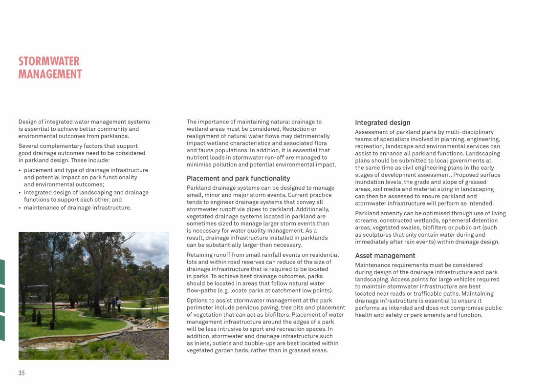
STORMWATER MANAGEMENT
Design of integrated water management systems is essential to achieve better community and environmental outcomes from parklands.
Several complementary factors that support good drainage outcomes need to be considered in parkland design. These include:
• placement and type of drainage infrastructure and potential impact on park functionality and environmental outcomes;
• integrated design of landscaping and drainage functions to support each other; and
• maintenance of drainage infrastructure.
The importance of maintaining natural drainage to wetland areas must be considered. Reduction or realignment of natural water flows may detrimentally impact wetland characteristics and associated flora and fauna populations. In addition, it is essential that nutrient loads in stormwater run-off are managed to minimise pollution and potential environmental impact.
Placement and park functionalityParkland drainage systems can be designed to manage small, minor and major storm events. Current practice tends to engineer drainage systems that convey all stormwater runoff via pipes to parkland. Additionally, vegetated drainage systems located in parkland are sometimes sized to manage larger storm events than is necessary for water quality management. As a result, drainage infrastructure installed in parklands can be substantially larger than necessary.
Retaining runoff from small rainfall events on residential lots and within road reserves can reduce of the size of drainage infrastructure that is required to be located in parks. To achieve best drainage outcomes, parks should be located in areas that follow natural water flow-paths (e.g. locate parks at catchment low points).
Options to assist stormwater management at the park perimeter include pervious paving, tree pits and placement of vegetation that can act as biofilters. Placement of water management infrastructure around the edges of a park will be less intrusive to sport and recreation spaces. In addition, stormwater and drainage infrastructure such as inlets, outlets and bubble-ups are best located within vegetated garden beds, rather than in grassed areas.
Integrated designAssessment of parkland plans by multi-disciplinary teams of specialists involved in planning, engineering, recreation, landscape and environmental services can assist to enhance all parkland functions. Landscaping plans should be submitted to local governments at the same time as civil engineering plans in the early stages of development assessment. Proposed surface inundation levels, the grade and slope of grassed areas, soil media and material sizing in landscaping can then be assessed to ensure parkland and stormwater infrastructure will perform as intended.
Parkland amenity can be optimised through use of living streams, constructed wetlands, ephemeral detention areas, vegetated swales, biofilters or public art (such as sculptures that only contain water during and immediately after rain events) within drainage design.
Asset management Maintenance requirements must be considered during design of the drainage infrastructure and park landscaping. Access points for large vehicles required to maintain stormwater infrastructure are best located near roads or trafficable paths. Maintaining drainage infrastructure is essential to ensure it performs as intended and does not compromise public health and safety or park amenity and function.
35

STORMWATER MANAGEMENT MANUAL FOR WESTERN AUSTRALIAThis manual includes information to assist with integrated design of drainage infrastructure for parklands.
It can be accessed through the Department of Water website: www.water.wa.gov.au
INFORMATION BROCHURESThe Department of Water has developed a series of brochures that provide summaries of the main benefits and design factors of Water Sensitive Urban Design:
• Water Sensitive Urban Design: an introduction
• Stormwater design considerations• Biofilters• Constructed wetlands for
stormwater management• Dry or ephemeral detention areas• Infiltration basins and trenches• Litter and sediment traps• Living streams• Pervious paving• Rainwater storage and
reuse systems• Swales and buffer strips
Each can be downloaded from the Department of Water website: www.water.wa.gov.au
NEW WATER WAYSThis online publication provides information on water sensitive urban design and development for industry practitioners and local government. It also provides information on training, educational site visits of demonstration projects, networking events and presentations by a range of international and national experts in water sensitive urban design.
New Water Ways is a partnership between the Department of Water, Department of Planning, WA Local Government Association, Urban Development Institute of Australia and the Swan River Trust.
Information can be accessed through the New Water Ways website: www.newwaterways.org.au
36PUBLIC PARKLAND PLANNING & DESIGN GUIDE (WA)
Well-designed irrigation systems deliver optimal water application to meet plant water requirements in order to maintain desired parkland appearance and function.
To achieve optimal efficiency and effectiveness, design of irrigation systems needs to be considered in the early stages of parkland design. Ideally this will occur in collaboration with certified irrigation specialists and park landscape designers, horticulturalists or landscape architects.
Several factors that support desired outcomes need to be considered when designing and managing a parkland irrigation system. These can be broken down into several key areas that include:
• establishment of water budgets and appropriate water accounting and meter systems to track irrigation function and water use;
• hydrozoning (also known as ecozoning), xeriscaping and science-based horticultural practices;
• efficient distribution of water, ideally controlled through sensor based irrigation scheduling with independent control of all hydrozones; and
• continuous improvement in water management through benchmarking, research and innovation.
Water budgeting, accounting and meteringA water budget needs to be developed at the parkland design stage to determine the level of irrigation and water use required to maintain vegetation at different times of the year.
Water accounting and monitoring of irrigation systems enables assessment of water use, identification of inefficiencies and guides potential water conservation measures and management actions. Water accounting is highly dependent on the accuracy and frequency of information gathered and will require irrigation systems to be metered. A water meter with a flow rate output signal that can link to the controller will help detect leaks and manage water use.
Hydrozoning, xeriscaping and horticultural practicesHydrozoning (or ecozoning) and xeriscaping are landscaping and irrigation practices that group plants of similar type, or with similar water requirements, into zones. Hydrozones are irrigated at optimal rates to conserve water, while xeriscaped areas are designed to require little or no supplementary irrigation.
Hydrozones and xeriscaped areas can be fitted retrospectively to parkland but are better incorporated into initial parkland layout and design.
Hydrozoned parklands are categorised into irrigation zones depending on water requirements (in decreasing order of irrigation dependence):
• high quality turf or lawn areas such as sports grounds and playing fields;
• recreation spaces such as BBQ and picnic areas, playgrounds and play areas;
• general parkland such as walking trails or dog exercise areas; and
• bushland and other areas reliant on rainfall.
Care must be taken when introducing hydrozones into established parklands to ensure the health of existing trees is not compromised. Simply “turning off “or cutting back irrigation to established trees that have adapted to soil moisture conditions may have a detrimental impact.
To support efficient irrigation, it is essential that soil condition is identified at the early stages of parkland design. Poor soils may require substantial soil amendment to ensure plant vigour and health.
Ongoing management and monitoring of vegetation growth, turf quality and soil condition will assist to ensure that long-term parkland amenity is achieved, water use is optimised and ongoing maintenance costs are minimised.
IRRIGATION SYSTEMS
37

Distribution and schedulingDistribution uniformity, or the capacity of irrigation systems to distribute water evenly, is a primary design consideration. A system with high distribution uniformity minimises the extent of both over and under watering, requiring shorter irrigation run times to achieve desired vegetation quality.
The rate and frequency of water application is crucial to meet vegetation water needs and maximise the efficiency of water resources. Irrigation scheduling determines when and how much water to apply to maintain the required plant quality throughout the year.
Effective irrigation scheduling depends on forecasting plant water needs combined with regular monitoring of soil moisture levels and vegetation condition. The installation of soil moisture monitoring and centralised irrigation systems can facilitate effective and efficient management.
Benchmarking and evaluationThe use of benchmarking is an effective tool to aid in the improvement of water efficiency performance over time. It allows comparison of an operations performance from year to year, and comparison with industry best practice.
Collection of base line data when parklands are first established can greatly assist with ongoing benchmarking, performance evaluation and development of adaptive management strategies.
Urban irrigation best management practicesIrrigation Australia Ltd published Urban Irrigation Best Management Practices to assist the development of irrigation system specifications as part of their committed to the sustainable use of water resources.
It provides a point of reference for the design and installation of landscape irrigation systems and informs assessment for approval of development of parkland.
It can be accessed through www.irrigation.org.au
Example of poor Distribution Uniformity Example of good Distribution Uniformity 38PUBLIC PARKLAND PLANNING & DESIGN GUIDE (WA)

Overview
The City of Joondalup has initiated a major water efficiency campaign in response to challenges associated with the drying climate, water availability and increased community demand for irrigated parks and reserves. The campaign includes the implementation of hydrozoning principles across the City, changes to irrigation targets, installation of new irrigation infrastructure and improved monitoring and tracking of irrigation and water use.
Delivery
Prior to commencing implementation of water efficiency measures, the City established an extensive communication campaign to ensure the community remained informed of upcoming works and the reasoning behind the new directions. As a participant in the International Council for Local Environmental Initiatives (ICLEI) water campaign as well as a member of the Waterwise Council program, the City has worked closely with the Department of Water and the Water Corporation in delivering efficiency measures.
The introduction of hydrozoning involved differential irrigation being implemented for sporting areas, recreation areas, verges and median strips. Additionally, improved irrigation infrastructure and irrigation methods have enabled high and low need areas to receive the amount of water specific to need and thus reducing the overall demand. Groundwater consumption has been reduced by 45% since the implementation of the water efficiency program in 2009.
Outcomes
• Reduced water consumption;• Reduced expenditure on power;• Improved flexibility of new irrigation
infrastructure to water as needed;• Reductions in scheme and groundwater use; and• Winner of Waterwise Council award at 2011
WA Water Awards for their innovative and sustainable water management.
CITY OF JOONDALUP HYDROZONING OF PARKS AND RESERVES
39

Overview
Established in 2008, the Larkhill Sports Complex is a regional multifunctional sporting and recreational facility with extensive playing fields. In 2010, some of those fields were badly infected by sting nematode populations. This had significant impact on the quality of the turf and resulted in safety concerns from players, umpires and City staff.
The City of Rockingham’s ground curators were familiar with traditional treatment measures which had previously proven to be costly with limited effectiveness on sting nematodes. These included intensive chemical treatment, turf replacement and supplemental fertilizer and irrigation. They instead, decided to tackle the problem using a soil amendment approach, commencing with the rugby pitch.
Delivery
A mature composted soil carbon product was applied to the rugby field as a top dressing. This particular approach relied on the organic carbon in the product feeding the natural soil biology. This led to better water infiltration, storage of water and nutrients in the root zone and resulted in improved resilience of the turf. Modifications were also made to existing irrigation systems to improve efficiency and distribution uniformity.
Outcomes
• Decreased fungicidal, herbicidal and fertilizer treatments;
• 90% reduction in nematode populations;• 20% savings of water costs with the facility
now operating within allocation limits;• Improved quality and resilience of
the turf on playing fields; and• Reduced staff costs to treat damaged fields.
CITY OF ROCKINGHAM LARKHILL SPORTS COMPLEX
40PUBLIC PARKLAND PLANNING & DESIGN GUIDE (WA)

Overview
Following a community request for new park facilities in Yokine, City of Stirling staff undertook an assessment in line with the City’s Public Open Space (POS) Strategy. This assessment identified a shortfall of parks providing for local play, recreation and social connection opportunities in the suburb of Yokine. Officers recommended an upgrade to an existing small park. The 2,400m2 (1,600m2 of usable space) site delivered the primary function of meeting drainage needs of the area and offered little social benefit to the community.
Project challenges included; designing the first waterless park with the same social outcomes as a reticulated park, designing out lawn, limited budget and space constraints.
The vision was to develop a quality, attractive public open space which required no irrigation beyond the initial establishment period and to provide the local community with a completely new experience. This was to be a pilot for low cost waterless park projects with the potential of using similar design at other locations across the City.
Delivery
The City of Stirling Recreation and Leisure Services and Parks and Reserves teams collaborated to design a waterless park that delivered local play and leisure opportunities. Strong community support for this new ‘waterless’ initiative was developed though a consultation and engagement process with the local community, including an onsite meeting to discuss design options. The successful redevelopment now incorporates pathways, play areas, seating and rain-fed native vegetation that has required no watering beyond initial establishment. Trees have also been planted to improve shade to the open area. The total project cost was $130,000 which
was fully funded by the City and since construction in 2011 the project has been performing extremely well. The community has embraced the concept with the City receiving positive feedback both anecdotally and in writing. The water usage is almost nil and as part of the construction one of the adjacent neighbours upgraded his fence to show support and improve the amenity.
Outcomes
• Local area beautification;• The first waterless park developed within the City;• A quality park, delivered on a limited budget;• Improved playground facilities both structure
and more natural elements for local families;• No water costs for the site;• Minimized operating and maintenance costs; • Inclusion of native vegetation; and • Social improvements through increased usage,
connecting communities and recreation opportunities.
CITY OF STIRLING MOULDEN RESERVE
41

42PUBLIC PARKLAND PLANNING & DESIGN GUIDE (WA)
REFERENCES AND RESOURCES
Government policy and strategy documents
Western Australian Planning Commission: www.planning.wa.gov.au
• Directions 2031 and Beyond: Metropolitan planning beyond the horizon
• Liveable Neighbourhoods Operational Policy• Structure Plan Preparation Guidelines (August 2012)• Policy No DC 2.4: School Sites: Co-location of
parkland and playing fields with schools • Policy No. DC 2.3: Public Open Space in Residential Areas• Capital City Planning Framework: a
vision for Central Perth (2012)• Better Urban Water Management (2008) • Planning Bulletin 92: Urban Water Management • State Planning Policy 2.9: Water Resources
WA Department of Water: www.water.wa.gov.au
• Guideline for the approval of non-drinking water systems in Western Australia - Urban Developments (December 2013)
• Guidelines for water meter installation (2009) • Operational Policy 1.01: Managed
Aquifer Recharge in WA (2011) • Operational Policy 5.13: Water entitlement
transactions for Western Australia (previously State-wide policy 6: Transferable (tradeable) water entitlements for Western Australia)
• Rights in Water and Irrigation Act 1914 • Stormwater management manual for Western Australia • Water monitoring guidelines for better urban water
management strategies/plans, WA (2011) • Water recycling and efficiency note:
Community bore (December 2013) • Water quality protection note 33: Nutrient and
irrigation management plans (June 2010)• North West Corridor Water Supply Strategy (2014)
WA Department of Health: www.public.health.wa.gov.au
• Code of Practice for the Design, Manufacture, Installation and Operation of Aerobic Treatment Units (ATUs) (2001) and additional guidelines for water recycling in unsewered areas
• Draft Alternate Water Supply Guidelines – Stormwater and Rainwater (April 2009)
• Guidelines for the Non-potable Uses of Recycled Water in Western Australia (August 2011)
43

WA Department of Education: Strategic Asset Planning: www.det.wa.edu.au
• Shared assets – best outcome or compromise? Resource Sharing, Education and Community Facilities
WA Department of Sport and Recreation: www.dsr.wa.gov.au
• Active Living for All: a framework for physical activity in Western Australia 2012-2016 (2012)
• Classification Framework for Public Open Space• Guide to the WA Planning System• Sports Dimensions Guide for Playing Areas
WA Office of the Government Architect: www.finance.wa.gov.au
• Better Places and Spaces – a policy for the built environment in Western Australia (2013)
Commonwealth Department of Infrastructure and Transport: Major Cities Unit: www.infrastructure.gov.au
• Creating Places for People: an urban design protocol for Australian cities
Commonwealth Environment Protection and Heritage Council (EPHC): www.ephc.gov.au
• Australian Guidelines for Water Recycling: Managing Health and Environmental Risks (Phase 1, 2006)
• Australian Guidelines for Water Recycling: Managing Health and Environmental Risks (Phase 2, 2009): Managed Aquifer Recharge
• Australian Guidelines for Water Recycling: Stormwater Harvesting and Reuse (Phase 2, 2009)
Other publications• Hunter New England Population Health:
Liveability Assessment Tool (2012): www.hnehealth.nsw.gov.au
• Water by Design: Multiple Uses of Open Spaces Discussion Paper (2010) & Framework for the Integration of Flooding and Stormwater Management into Open Space (2011): waterbydesign.com.au
• Institute of Public Works Engineering Australia (IPWEA) (WA Division Inc.): Subdivisional Guidelines Edition No. 2 (2009): Module No. 6– Public Open Space Guidelines: www.planning.wa.gov.au/publications/5833.asp
• Institute of Public Works Engineering Australia (IPWEA) and NATSPEC: AUS-SPEC standards for Urban and open spaces (including NATSPEC Landscape): www.natspec.com.au/Documents/Forms/AUS-SPECorder.pdf
• Heart Foundation (WA): Healthy Active by Design: A Western Australian project for designing places for active and healthy living (2013): www.healthyactivebydesign.com.au
• Planning Institute of Australia: Healthy Spaces and Places: A national guide to designing places for healthy living: www.planning.org.au
• Irrigation Asutralia: Urban Irrigation Best Management Practices (2006)
44PUBLIC PARKLAND PLANNING & DESIGN GUIDE (WA)
