david russell associates - north hertfordshire district ... · greene king plc january 2018. david...
TRANSCRIPT

David Russell Associatesplanning and development consultants
11 East Mount, Wheathampstead, tel: 01582 833768St Albans, Herts, AL4 8BJ email: [email protected]
THIS STATEMENT IS FOR: Matter 10 – The housing allocations and the settlement boundaries: BaldockISSUES: 10.1, 10.2, 10.3, 10.4 and 10.5
Examination of North Hertfordshire District Council's Local Plan 2011-2031
Hearing Statement
on behalf ofGreene King plc
January 2018

David Russell Associates
2
1 Introduction
1.1 This statement is made on behalf of Greene King plc, who own land on London
Road, Baldock, between the George IV Public House to the south and Chalk Hills to
the north. It is referenced by the LPA as site BA12 – see Appendix A Extract from
Proposals Plan.
1.2 Our focus is on how the Submission Document's overall housing proposals and
alterations to the boundary of the Metropolitan Green Belt affect the town of Baldock
and our client's land. We have already submitted separate representations on Matter
4 and Matter 6.
David Russell Associates
3
2 Matter 10 – The housing allocations and the settlement boundaries
Issue: Baldock 10.1
Are all of the proposed housing allocations deliverable? In particular, are they: a) confirmed by all of the landowners involved as being available for the use
proposed? b) supported by evidence to demonstrate that safe and appropriate access for
vehicles and pedestrians can be provided? c) deliverable, having regard to the provision of the necessary infrastructure and
services, and any environmental or other constraints?
2.1 We note the Statement of Common Ground, dated November 2017, between North
Hertfordshire District Council and Hertfordshire County Council, concerning Strategic
Allocation BA1. We agree that the landowner has confirmed site BA1's availability.
2.2 The Statement contains two short paragraphs on infrastructure that include a single
reference to transport, a proposed link road to connect the A505 with the A507. We
understand that the nature and route of this proposed link has yet to be determined,
but we assume it will form a by-pass to the site from the roundabout where the B656
meets the A505 Baldock by-pass to a new junction with the A507 somewhere north
of Blackhorse Farm.
2.3 In our opinion, substantial improvements will be needed to the A507 northwards to its
junction with the A1(M) and southwards towards the junction with the B656. There is
little or no opportunity for improvements to increase the capacity of the junction with
the B656, which is currently traffic-light controlled. This junction is already frequently
congested, a problem that can only be exacerbated by the additional traffic
generated by the proposed new development of site BA1. The B656 runs through
Baldock town centre and still acts as a busy through road to Letchworth as well as
serving local traffic. The proposed A505 to A507 link is unlikely to provide an
alternative to the B656 unless it were taken across the A1(M) to connect with
Letchworth's industrial area.
2.4 The Statement says on other infrastructure:
“It is agreed that key social infrastructure of a local centre, community hall, GP

David Russell Associates
4
surgery and primary and secondary education provision will be provided.”
The proposed school provision has not yet entered the standard education planning
process as reported on the County Council's website. There is a predicted surplus of
around 15 primary school places up to 2020/2021. Secondary school spaces vary
between a small deficit and small surplus up to 2020/2021. It is clear that new
school provision will be needed, but specific planning for it has yet to begin.
2.5 Paragraph 8 says that a planning application is expected in early December 2017.
As of 21 December 2017, and according to North Hertfordshire District Council's
online planning application database, no such application had been submitted.
2.6 Paragraph 9 says:
“It is expected that from the grant of outline planning permission, that
housebuilding would commence 12 months later with the first financial
completion expected 18 months from the grant of outline planning
permission.”
In the light of the research published by Nathaniel Lichfield and Partners in their
November 2016 report, “Start to Finish”, we think this timetable is wholly unrealistic.
The report examined 70 sites with a capacity of 500 or more dwellings. It said the
average planning approval period was 5 years, and 6.1 years for sites of 2000 or
more dwellings. The planning approval period was defined as:
“The ‘planning approval period’ is measured from the validation date of the
first application for the proposed development (be that an outline, full or hybrid
application). The end date is the decision date of the first detailed application
which permits the development of dwellings on site (this may be a full or
hybrid application or the first reserved matters approval which includes details
for housing).”
This research is based on real life experience, which we think provides a better and
more objective basis for estimating site BA1's housing trajectory. Assuming that the
outline application referred to in the Statement's paragraph 8 is submitted in January

David Russell Associates
5
2018, a more realistic start date for a start on site is 2023/2024. The first
completions could be then expected in 2024/2025 or even 2026.
2.7 Our argument is not that the necessary infrastructure cannot be provided; it is about
the planning and timing of its provision. For example, it took about ten years from
the initial decision to proceed with its design to giving planning permission for the
Little Hadham by-pass in East Hertfordshire. The process involved detailed
economic, landscape and ecological assessments; consultation on alternative routes
and connections with the existing road network; a pre-application consultation and
then the application itself. Yes, the circumstances here were different and it may well
take less than ten years for example to plan and get permission for the proposed
A505 to A507 road link. A start on development could possibly be made before the
completion of the proposed masterplan and the necessary consultation and
negotiations on the provision of essential infrastructure. However, we think this
would be most unwise, given the local controversy that the scheme has caused.
Such a move would not be in the true spirit of proper public consultation.
Issue: Baldock 10.2
Are all of the proposed housing allocations justified and appropriate in terms of the
likely impacts of the development?
2.8 The simple answer is that nobody knows what the likely impacts on the town will be.
We have seen no evidence of any assessment of the impact of any of the proposed
allocations, either individually or collectively, on the social, economic and
environmental character of the town as a whole.
2.9 We have already referred to the existing traffic congestion problems, regularly
affecting Baldock town centre, that go well beyond the “normal” morning and evening
commuting peaks. In the short term these problems will be exacerbated by the
amount of construction traffic that, in the absence of any alternative route, will have
to go through the town. This could be at least partly ameliorated by early completion
of the proposed A505 to A507 link. However this link is not even a line on a map as
yet. If housing construction were to begin in accordance with the Common Ground

David Russell Associates
6
Statement's timetable, then it would be Baldock's historic centre, and the A507/B656
junction in particular, that would bear the burden.
2.10 In the longer term, the 3600 additional dwellings proposed for Baldock as a whole,
including 2800 on allocation BA1, will further aggravate existing traffic congestion in
the town and its centre, requiring additional roadworks and traffic management
measures. Again, without an analysis and forecast of resulting traffic flows on the
local road network, we cannot begin to tell what the consequences will be, especially
for the town's historic fabric.
2.11 BA1, together with the other proposed allocations for Baldock will increase the town's
total number of dwellings by 75%. This must surely have significant consequences
for the town as a whole and its historic fabric, but the Plan says nothing about what
these consequences may be and how they will be accommodated.
2.12 Policy SP14 mentions “... A new local centre along with additional neighbourhood-
level provision providing around 500m² (net) class A1 convenience retail provision
and 1,400m² (net) of other A-class floorspace; ...”. The idea is presumably for the
neighbourhood centre to take pressure off the town centre. However, the odds of
both succeeding in complementing and reinforcing each other must be small. The
more likely outcome is that the existing town centre and the new centre will compete
to the detriment of one or the other, or both.
Issue: Baldock 10.3
Are all of the proposed allocations the most appropriate option given the reasonable
alternatives?
2.13 It was indicated at the Hearing session relating to Matter 4 that the EIP would not
consider the merits or otherwise of alternatives or “omission sites” as they were
referred to. We are therefore somewhat perplexed as to exactly what “alternatives”
this question is considering.
2.14 We can illustrate that other, more reasonable, options do exist with reference to the
land we have been promoting through the Local Plan process at London Road,

David Russell Associates
7
Baldock. Like proposed allocations BA1, BA2, BA3 and BA4, it is on the edge of the
town and in the Green Belt. Unlike sites BA1, BA2 and BA3 it does not represent a
major intrusion into open countryside or threaten the preservation of the town's
setting. Its development would not lead to the loss of productive agricultural land, as
is the case with allocation BA1. Its current use is very limited; its development for
new dwellings would be a far more efficient, effective and beneficial use of the land
without compromising any of the principal functions of the Green Belt, as set out in
the NPPF's paragraph 80.
2.15 The LPA made the claim under discussion of Matter 6 that small sites take longer
than large sites to bring into production. Of course there are many factors that
determine how long it takes to get a particular site under way. Many small sites are
the more difficult to develop urban infill sites. However, small urban peripheral
greenfield sites will be easier and quicker; a regional builder estimates that the site
we have been promoting, BA12, would take 6 months to get to the planning
permission stage and then 15 to 16 months to full occupation of the completed
development.
2.16 We appreciate the arguments on not considering every “omission” site at the EIP.
However, in the case of this Local Plan, Green Belt designations are a very
significant part of the overall strategy. It seems only right that other adjustments to
the Green Belt around urban peripheries should be given full consideration. This is
particularly the case with Baldock, where such major incursions are being considered
that will almost double the size of a town that the Green Belt is supposed to protect.
Site BA12 was deemed to be available, achievable and suitable up to the publication
of the Submitted Plan.
Issue: Baldock 10.4
Sites BA1, BA2, BA3 and BA4 comprise of land in the Green Belt. For each:a) Do exceptional circumstances exist to warrant the allocation of the site for
new housing in the Green Belt? If so, what are they? b) What is the nature and extent of the harm to the Green Belt of removing the
site from it? c) To what extent would the consequent impacts on the purposes of the Green

David Russell Associates
8
Belt be ameliorated or reduced to the lowest reasonably practicable extent? d) If this site were to be developed as proposed, would the adjacent Green Belt
continue to serve at least one of the five purposes of Green Belts, or would the Green Belt function be undermined by the site’s allocation?
e) Will the Green Belt boundary proposed need to be altered at the end of the plan period, or is it capable of enduring beyond then?
f) Are the proposed Green Belt boundaries consistent with the Plan’s strategy for meeting identified requirements for sustainable development?
g) Has the Green Belt boundary around the site been defined clearly, using physical features that are readily recognisable and likely to be permanent?Does it avoid including land which it is unnecessary to keep permanently open?
2.17 If there are exceptional circumstances, they are that the current local development
plan, adopted in 1994, is now significantly out of date, resulting in a long term deficit
in housing land supply. By its own admission, the LPA has had to rely on windfall
sites for some years now to maintain any sort of residential land supply. A situation
has developed that undermines one of the planning system's core principles, as set
out in the NPPF's paragraph 17, that it “... be genuinely plan-led”. However, as we
stated in our representations on Matter 6, even now the Submission Document has
to kick the five year land supply issue down the road to 2021.
2.18 The essence of our argument is that Hertfordshire County Council's rural estate
around Baldock has been progressively used as a reservoir to soak up housing
requirements that, for various reasons, the LPA think cannot be met in other parts of
the District. Using the estate as a flexible ‘catch-all’ must surely be completely
contrary to its existing status as part of the Metropolitan Green Belt. The evolution of
allocations BA1 to BA4 illustrates well how this has been done.
2.19 The land that was to eventually make up the majority of the proposed BA1 Strategic
Allocation made its first appearance in consultative documents in 2013. Previous to
this, the options for north Baldock were essentially the four sites listed in Table 1.
These were included in a series of consultations previous to 2013, including the
North Hertfordshire Local Development Framework Core Strategy and Development
Policies Preferred Options September 2007; Land Allocations Issues and Options
Consultation January/March 2008; and the Land Allocations – Additional Suggested

David Russell Associates
9
Sites Consultation July 2009. There was no mention in any of these consultations of
a strategic allocation the size of allocation BA1 on Baldock's northern edge.
2.20 North Hertfordshire published a paper on housing options in February 2013. It
included four sites that lay within the proposed BA1 Strategic Allocation, as shown in
Table 1.
Table 1
Reference Site Area (ha) Dwelling EstimateB/r1a Land at Bygrave Road 2.6 60B/r2a Land south of Bygrave Road 5.1 114B/r11a Land north of Bygrave Road 4.6 140B/r23 Land at North Road 4.4 105Totals 16.7 419
2.21 This was followed by a further consultation on Housing Additional Locations in July
2013. This considered two further sites, referenced 200 and 201, owned by
Hertfordshire County Council, as shown in Table 2. Site 200 included land beyond
the track running from just north of Blackhorse Farm, eastwards to Bygrave village,
that marks the northern boundary of proposed Strategic Allocation BA1. Site 201 lies
entirely within the area of BA1. The report went on to state that “Hertfordshire
County Council have also indicated that if more housing is needed, they may be able
to bring forward other areas of land from their rural estate around Baldock.”
Table 2
Reference Site Area (ha) Dwelling EstimateB/r1a Land at Bygrave Road 2.6 60B/r2a Land south of Bygrave Road 5.1 114B/r11a Land north of Bygrave Road 4.6 140B/r23 Land at North Road 4.4 105200 Land north of Baldock 174 3479201 Land south of Bygrave Road 8.5 170Totals 199.2 4068
2.22 The 2013 update of the SHLAA was published after these two papers, in March
2014. It included sites 200 and 201, but with the northern boundary of site 200
David Russell Associates
10
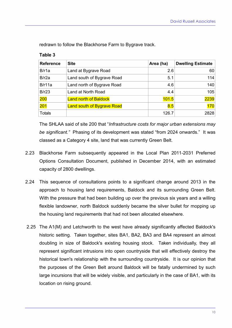
redrawn to follow the Blackhorse Farm to Bygrave track.
Table 3
Reference Site Area (ha) Dwelling EstimateB/r1a Land at Bygrave Road 2.6 60B/r2a Land south of Bygrave Road 5.1 114B/r11a Land north of Bygrave Road 4.6 140B/r23 Land at North Road 4.4 105200 Land north of Baldock 101.5 2239201 Land south of Bygrave Road 8.5 170Totals 126.7 2828
The SHLAA said of site 200 that “Infrastructure costs for major urban extensions may
be significant.” Phasing of its development was stated “from 2024 onwards.” It was
classed as a Category 4 site, land that was currently Green Belt.
2.23 Blackhorse Farm subsequently appeared in the Local Plan 2011-2031 Preferred
Options Consultation Document, published in December 2014, with an estimated
capacity of 2800 dwellings.
2.24 This sequence of consultations points to a significant change around 2013 in the
approach to housing land requirements, Baldock and its surrounding Green Belt.
With the pressure that had been building up over the previous six years and a willing
flexible landowner, north Baldock suddenly became the silver bullet for mopping up
the housing land requirements that had not been allocated elsewhere.
2.25 The A1(M) and Letchworth to the west have already significantly affected Baldock's
historic setting. Taken together, sites BA1, BA2, BA3 and BA4 represent an almost
doubling in size of Baldock's existing housing stock. Taken individually, they all
represent significant intrusions into open countryside that will effectively destroy the
historical town's relationship with the surrounding countryside. It is our opinion that
the purposes of the Green Belt around Baldock will be fatally undermined by such
large incursions that will be widely visible, and particularly in the case of BA1, with its
location on rising ground.

David Russell Associates
11
Issue: Baldock 10.5
Is the proposed settlement boundary:a) consistent with the methodology for identifying the settlement boundaries? b) appropriate and justified?
2.26 The best criteria for deciding whether or not the proposed settlement boundary is
appropriate and justified are the five purposes set out in paragraph 80 of the NPPF.
2.27 We assume that the existing boundary was originally defined in relation to these
purposes. What is important is the relative merits of the alterations that result from
the proposed peripheral land allocations and other potential alterations that would be
consistent with the five purposes.
2.28 We have been consistent in our views on major incursions into the Green Belt
around Baldock. It is a small, historic market town and, apart from the Clothall
Common estate's intrusion, the Green Belt has served well to protect its setting. The
Submission Document now proposes to make sweeping changes to the settlement
boundary to incorporate widely visible areas of countryside that currently serve as an
essential part of the town's setting. Whilst the housing supply crisis that has resulted
from years of planning delay is a significant factor, it does not constitute the very
special circumstances needed to justify such a radical redrawing of the town's
boundaries. Some redrawing is needed, but it should have been done in relation to
the size of the existing town and the preservation of its setting as well as making a
fair contribution to the District's overall housing needs.
2.29 We consider that individually and collectively, the alterations made to exclude
allocations BA1, BA2, and BA3 from the Green Belt represents an inappropriate and
unjustified balance between the purposes of the Green Belt around Baldock and the
proportion of the District's overall housing needs allocated to the town.
2.30 The NPPF's paragraph 85 reminds LPAs in defining Green Belt boundaries to:
“... not include land which it is unnecessary to keep permanently open;”
2.31 We have consistently maintained there is no need to keep an area of land between

David Russell Associates
12
the road known as Chalk Hills, up to and including the George IV Public House,
permanently open. The land has been underused for decades, and will remain so as
long as it has a Green Belt designation. The North Hertfordshire Green Belt Review
2014 categorised this site as making a “moderate” contribution to Green Belt
functions. We have argued strongly against such a categorisation on the following
grounds:
restricting the sprawl of built-up areas – the land has built form on three sides
and its omission from the Green Belt will have no material effect on urban
sprawl from Baldock
preventing towns merging – as a result of its size, character and location it will
not lead towards coalescence between Baldock and the closest urban edge,
which is Letchworth to the south-west
safeguarding the countryside – the land is a well defined and contained site,
its omission from the Green Belt would have no material effect on the
surrounding countryside
preserving the setting and character of historic towns – the land's omission
from the Green Belt would have no material impact on the town's setting.
2.32 We therefore propose that the area of land shown outlined in red on the map at
Appendix A to this statement is excluded from the Green Belt and included within the
revised settlement boundary for Baldock. It would then be available to make an
immediate contribution to the requirement for market and affordable housing, in a
sustainable location with excellent access to existing local schools, healthcare
facilities and the range of community and commercial services provided by Baldock's
town centre.
2.33 Matter 10 is principally concerned with the amount of housing land allocated around
Baldock; whether or not this amount can be supported by the existing and proposed
infrastructure; and the consequences for the Metropolitan Green Belt around the
town.
2.34 It is our opinion that the amount of development proposed, which will almost double

David Russell Associates
13
the town's housing stock, will have serious consequences for its infrastructure. At
the moment, there appears to be no assessment of its impact, for example, on the
local road network as a whole or on town centre and railway station parking
requirements.
2.35 The LPA's housing trajectory makes unrealistic assumptions about the length of time
it will take to provide a comprehensive masterplan for Strategic Allocation BA1, and
for the necessary planning and consultation processes involved in providing the
supporting infrastructure.
2.36 The proposed allocations BA1, BA2, BA3 and BA4 represent major intrusions into
the Metropolitan Green Belt. The history of allocation BA1 in particular suggests that
it has been used to mop up housing provision that has not been made elsewhere in
the District, without any significant assessment of the consequences for Baldock as
a whole or for the Green Belt that surrounds the town. The allocation BA1 is shown
together with those for neighbouring settlements on the Plan’s Proposals Maps. It is
by far the largest, and is completely out of character with the town's existing size and
overall urban structure.
2.37 The LPA’s proposed changes to the town's settlement boundary will fundamentally
alter the relationship between the town and open countryside to the north and east.
Baldock will suffer the same fate as many other historic market towns that have been
progressively “doughnutted” by large housing estates.
2.38 In our opinion, the balance that has been struck by the Submission Document,
between the need to find housing land and maintaining the character of Baldock and
its relationship with the surrounding Green Belt, is fundamentally flawed. Baldock
deserves better. Alterations to the settlement boundary, especially to the north and
east, should be more modest in extent, reflecting both the town's size and its
relationship with the surrounding countryside.
David Russell Associates
January 2018

David Russell Associates
14
Appendix A
