david a. king and richard lorch - university of ... al-kutub,zahirlyah 38). qibla charts, qibla...
TRANSCRIPT
9 • Qibla Charts, Qibla Maps, and Related InstrumentsDAVID A. KING AND RICHARD P. LORCH
INTRODUCTION
For close to fourteen hundred years, the obligation topray and to perform various ritual acts in a sacred direction toward a central shrine has been of paramountimportance to Muslims in their daily lives. Their concernto observe this sacred direction and the means theydevised to determine it are unparalleled in the history ofhuman civilization. A verse of the Qur)an enjoins Muslims to face the sacred precincts of the Kacba in Meccaduring their prayers: "Turn your face toward the SacredMosque, wherever you may be, turn your faces towardit."1 Accordingly, for fourteen centuries mosques havebeen oriented so that the prayer wall faces the Kacba andthe milJrab (prayer niche) indicates the qibla, or localdirection of Mecca. But Islamic tradition further prescribes that certain acts such as burying the dead, recitingthe Qur)an, announcing the call to prayer, and ritualslaughtering of animals for food are also to be performedin the direction of Mecca. On the other hand, bodilyfunctions are to be performed perpendicular to the direction of Mecca.2
It is this fundamental importance within Islam of theconcept of sacred direction (qibla in Arabic3 and all otherlanguages of the Islamic world) in ritual, law, and religion,applying wherever the believer was, that gave rise to thecharts, maps, instruments, and related cartographic methods described in this chapter. These sources clearly reflectthe dual nature of science in Islam.4 On the one handthere was "folk science," ultimately derived from theastronomical knowledge of the Arabs before Islam,which was devoid of theory and innocent of any calculation. On the other hand there was "mathematical science," derived mainly from Greek sources and involvingboth theory and computation. The former was advocatedby legal scholars and widely practiced over the centuries.The latter was practiced by a select few.
In the first tradition, there developed the notion of asacred geography in which the world was divided intosections around the Kacba and the qibla in each sectionwas determined by the procedures of folk astronomy. Inthe second, procedures were developed for finding theqibla in any locality by means of geometric construction
or the application of trigonometric formulas. Of primeimportance, of course, were the coordinates on whichsuch calculations were based.5 We now consider thecharts and maps associated with these two traditions(King), and then mention other graphic methods andinstruments for finding the qibla (Lorch).
QIBLA CHARTS CENTERED ON THE KAcBA
The number and variety of texts in which this sacred,Kacba-focused geography is represented indicate that itwas widely known from the tenth century A.D. onward.6
Sources include treatises on folk astronomy, treatisesdealing with mathematical astronomy (especially annualalmanacs), treatises on geography, treatises on cosmography, encyclopedias, historical texts, and, no lessimportant, texts dealing with the sacred law. Sometimesthe methods are described in words alone, sometimes thetext is clarified with diagrams. All together, more than
1. Qur)an 2:144.2. On the legal obligation to observe the sacred direction, see Arnet
Jan Wensinck, "~ibla: Ritual and Legal Aspects," in The Encyclopaediaof Islam, new ed. (Leiden: E. J. Brill, 1960-), 5:82-83. For more information on the sacred direction in medieval Islam, see David A. King'sforthcoming monograph titled The World about the Kacba: A Studyof the Sacred Direction in Medieval Islam, to be published by IslamicArt Publications.
3. The term qibla and the associated verb istaqbala, "standing in theqibla," appear to derive from the name of the east wind, the qabal.These terms correspond to the situation where one is standing with thenorth wind (al-shamal) on one's left (shamal) and Yemen on one'sright (yamin); see David A. King, "Makka: As the Centre of the World,"in Encyclopaedia of Islam, new ed., 6:180-87, esp. 181; see also idem,"Astronomical Alignments in Medieval Islamic Religious Architecture,"Annals of the New York Academy of Sciences 385 (1982): 303-12, esp.307-9, and idem, "Architecture and Astronomy: The Ventilators ofMedieval Cairo and Their Secrets," Journal of the American OrientalSociety 104 (1984): 97-133.
4. David A. King, "The Sacred Direction in Islam: A Study of theInteraction of Religion and Science in the Middle Ages," Interdisciplinary Science Reviews 10 (1985): 315-28.
5. Edward S. Kennedy and Mary Helen Kennedy, Geographical Coordinates of Localities from Islamic Sources (Frankfurt: Institut fur Geschichte der Arabisch-Islamischen Wissenschaften, 1987).
6. The material in this section is analyzed in detail in David A. King,"The Sacred Geography of Islam," Islamic Art, forthcoming; see alsoKing, "Makka," 181 (note 3).
189

190
thirty different texts attesting to this tradition have beenfound, compiled between the ninth century and the eighteenth century. Of these, only five have been published;the rest are manuscripts. Many more such works musthave been written that have not survived.
Despite the multiplicity of ways that Muslims haveused over the centuries to ensure they were facing theKacba, these sources allow us to make some generalizations. It is immediately clear from their contexts that theqibla lies at the heart of Islamic cultural and religiouslife. Although this concept has obvious parallels in medieval traditions of a world centered on Jerusalem, theIslamic treatment is more sophisticated than either theJewish or the Christian. It was true that, as in the JudeoChristian view of Jerusalem, Mecca was regarded as thecenter and navel of the world, but in early Islamic cosmography the entire inhabited world outside this centralpoint came to be precisely and constantly related,through astronomical determinations, to Mecca and tothe Kacba itself.
The Kacba is a cube-shaped monument in the heart ofthe city, formerly a pagan shrine of uncertain historicalorigin. It is a simple structure on a rectangular base, andits two axes indicate significant astronomical directions.7
The first generation of Muslims who were familiar withthe structure at first hand knew, as they stood before it,which astronomical direction they faced. Similarly, Muslims in any part of the world could know which wall ofthe Kacba they wanted to face and, when required, couldturn to face the direction as if they were standing directlyin front of that wall of the Kacba. This is the basic notionof "direction" underlying Islamic sacred geography.Remember that the definition of direction toward a distant point is to some extent arbitrary.
From the ninth century onward, various sections ofthe perimeter of the Kacba came to be associated withareas in the Muslim world.8 In the time of the ProphetMu1)ammad (d. 13/632) the four corners of the astronomically aligned base had already been named accordingto the geographical regions they faced, which the Meccans knew from their trading contacts: Syria, Iraq, Yemen,and "the West." In due course, architectural details wereused to define subdivisions. Thus, while the four wallsand four corners of the structure indicated a division ofthe world into four or eight sectors, giving rise to a number of four- and eight-sector schemes, features such asthe waterspout on the northwestern wall and the dooron the northeastern wall were used to demarcate smallersectors. In this way the sacred geography of the inhabitedparts of the earth comprised a variable number of sectors(jihah or lJadd), all directly related to the Kacba. Thetwelfth-century Egyptian legal scholar Zayn (?) aI-DIn alDimyafl, author of the illustration in figure 9.3 below,summed it up thus: "The Kacba with respect to the inhab-
Islamic Cartography
N
YEMEN
S
FIG. 9.1. RENDITION OF A SCHEME OF SACRED GEOGRAPHY. Described by Ibn Khurradadhbih and based on theedition of his text by Michael Jan de Goeje, Kitab al-masalikwa>[-mamalik (Liber viarum et regnorum), Bibliotheca Geographorum Arabicorum, vol. 6 (Leiden: E. J. Brill, 1889;reprinted 1967), 5.
ited parts of the world is like the center of a circle withrespect to the circle. All regions face the Kacba, surrounding it as a circle surrounds its center, and eachregion faces a particular part of the Kacba."9
The earliest known Kacba-centered geographicalscheme is recorded in a manuscript of the Kitab al-masaUk wa-al-mamalik (Book of routes and provinces) bythe ninth-century scholar Ibn Khurradadhbih. It may notbe original, but it is most certainly early. It involves asimple four-sector scheme (fig. 9.1): each part of the
7. Various medieval Arabic texts inform us that the major axis ofthe Kacba points toward the rising of Canopus, the brightest star in thesouthern celestial hemisphere, and that the minor axis points towardthe summer sunrise. For the latitude of Mecca, these directions areroughly perpendicular. A modern plan of the Kacba and its environs,based on aerial photography, essentially confirms the information givenin the texts, but reveals more: for epoch 0 A.D., the major axis is alignedwith the rising of Canopus over the southern horizon to within twodegrees, and the minor axis is aligned with the southernmost settingpoint of the moon over the southwestern horizon to within one degree.This last feature of the Kacba is not specifically mentioned in the texts,and its significance, if any, is not yet clear. More detailed informationcan be found in Gerald S. Hawkins and David A. King, "On the Orientation of the Kacba," Journal for the,History ofAstronomy 13 (1982):102-9.
8. See King, "Makka," 181-82 and fig. 1 (note 3) for the differentschemes dividing the perimeter of the Kacba that gave rise to thesepermutations in the diagrams.
9. Oxford, Bodleian Library, MS. Marsh 592; al-Dimya~I wrote ashorter treatise on the qibla that was copied ca. A.D. 1350 (Damascus,Dar al-Kutub, Zahirlyah 38).

Qibla Charts, Qibla Maps, and Related Instruments
world is associated with a different segment of the perimeter of the Kacba. Thus the region between northwestern Africa and northern Syria is associated with thenorthwestern wall of the Kacba and has a qibla that variesfrom east to south. The region between Armenia andKashmir is associated with the northeastern wall of theKacba and has a qibla that varies from south to west. Athird region, Man~iirah (India), Tibet, and China (meaningIndochina), is associated with the Black Stone in the eastern corner of the Kacba and for this reason is stated tohave a qibla a little north of west. The fourth region, theYemen, is associated with the southern corner of theKacba and has a qibla of due north. Many similar fouror eight-sector schemes are found in other texts (fig. 9.2).The tenth-century geographer al-Muqaddasi's AlJsan a/taqasim fi macrifat a/-aqa/im (The best of divisions onthe knowledge of the provinces), for example, containsa description, with a diagram, of a simple eight-sectorscheme. lO Other schemes show a tendency roward a morecomplex subdivision of the sacred space of Islam.
The principal scholar involved in this further development of a Kacba-centered sacred geography is Mul;1am-
191
pUIMJOqealaM
PIOOJaIU!M
FIG. 9.2. FOUR-QIBLA SCHEME. Representation taken froman anonymous eighteenth-century Ottoman treatise (see alsofigs. 9.5 and 9.13), with translation to the right.Size of the original: 18 X 13 em. By permission of the Dar alKutub, Cairo (Tal'at majam,-' 811, fo!. 60r).
mad ibn Suraqah al-cAmiri (d. 410/1019), a Yemeni faqih(legal scholar) who studied in Basra. Little is known aboutthis man, and none of his works survive in their originalform. However, from quotations in later works it appearsthat he devised three distinct schemes with eight, eleven,and twelve sectors focusing on the Kacba.ll Althoughthese later recensions of Ibn Suraqah's treatises lack diagrams, it is possible to use them to piece together hisdetailed prescriptions for finding the qibla in each of the
10. See the French translation of Abu 'Abdallah Mu~ammad ibnA~mad al-Muqaddasi's work by Andre Miquel, A!Jsan at-taqasim fima'rifat al-aqalim (Damascus: Institut Fran~ais de Damas, 1963).
11. Ibn Suraqah's eight-sector scheme is known from the writings ofone Ibn Ra~iq, a legal scholar of Mecca who was the author of atreatise on folk astronomy in the eleventh century. Several significantregions of the Muslim world were omitted from this scheme. Ibn Suraqah's eleven-sector scheme is known from a fourteenth-century Egyptian treatise, and in it he has simply added three sectors to his eightsector scheme. His twelve-sector scheme was used by al-Dimya~i, whowas upset, however, that Ibn Suraqah put Medina and Damascus in thesame sector, and so he himself presented a thirteen-sector scheme. IbnSuraqah's twelve-sector scheme was also used by the thirteenth-centuryYemeni astronomer al-Farisi in his book on folk astronomy.

192 Islamic Cartography
various regions associated with his schemes. For eachregion, Ibn Suraqah explains how people should standwith respect to the rising or setting of four particulargroups of stars and the four winds. Thus, for example,we are informed how the inhabitants of Iraq and Iranshould stand in relation to the stars of the Great Bear,which rise and set behind the right ear; a group of starsin Gemini should rise directly behind the back; the eastwind should blow at the left shoulder, the west windshould blow at the right cheek, and so on. That the starsof the Great Bear neither rise nor set but appear circumpolar in places as far north as Iraq and Iran indicates thatIbn Suraqah's instructions were probably formulated inMecca. To stand in the position he described would havebeen to face the winter sunset, though this is not explicitly stated. The ultimate object of the exercise was toface the northeastern wall of the Kacba.
The qibla charts themselves do not appear in survivingmanuscripts until after the eleventh century. A recurrentinterpretative problem is that the charts were often corrupted in the copying process. Even in elegantly copiedmanuscripts, the corners of the Kacba have sometimesbeen confused. In some copies of the works of Zakariya'ibn Mubammad al-Qazwini (600-682/1203-83) and Sirajai-Din Abu I:Iaf~ cUmar ibn al-Wardi (d. 861/1457) containing the twelve-sector scheme, for instance, Medinaoccurs in two sectors. In other copies one of these hasbeen suppressed, and only eleven sectors appear aroundthe Kacba.
Although the numbers of sectors remain one criterionfor classifying the Kacba-centered qibla diagrams, theremay be significant variations in different versions of thesame scheme during the Islamic Middle Ages. Even thesame authors could produce charts of different design.AI-Dimya!i, for example, records a simple scheme withonly four directions, as well as the partial diagram showing only three sectors of a larger scheme, perhapsintended to illustrate the notion of Cayn al-Kacba (facingthe Kacba head on) (fig. 9.3). But he was also responsiblefor a rather· crude eight-sector scheme where the Kacbais represented by a circle and each of the eight regionsis associated with a wind (fig. 9.4). We may also comparethis informal representation-where the scribe has donelittle more than arrange his text in a wheel-like formwith another eight-sector scheme that appears in an anonymous Ottoman treatise (fig. 9.5). This scheme is muchmore carefully drafted. The qiblas are defined by meansof the Pole Star and by those stars that rise or set behindone's back when one is standing in the qibla.
The same variations also extend to the twelve-sectordiagrams. Thus Ibn Suraqah's twelve-sector scheme wasused and illustrated by the thirteenth-century Yemeniastronomer al-Farisi in his book on folk astronomy,TulJfat al-raghib wa-turfat al-talib fi taysir al-nayyirayn
Cairo
Jerusalem
\
South
~,~w~
tt\DIRECTIONOF SYRIA
(Aleppo)
DamascusI
FIG. 9.3. ILLUSTRATION FROM A TREATISE ON THESACRED DIRECTION BY AL-DIMYATi. The diagram showsthe directions of the Kacba for several locations including Cairo,Jerusalem, and Damascus. It was assumed that people in eachlocality would face a different part of the Kacba (partial translation provided).Size of the original: 19 X 12.5 em. By permission of the BodleianLibrary, Oxford (MS. Marsh 592, fo!' 88v).

Qibla Charts, Qibla Maps, and Related Instruments
FIG. 9.4. EXTRACT FROM THE SHORTER TREATISE ONTHE QIBLA BY AL-DIMYATl. This diagram shows eight pansof the world arranged in the cardinal and solstitial directionsabout the Ka'ba, crudely represented by a circle. No geographical regions are mentioned; rather, each part of the world isassociated with a wind. The qibla was found in each region bymeans of the Pole Star.Size of the original: not known. By permission of Dar al-Kutub,Damascus (~ahiriyah 38, fol. 14r).
wa-lJarakat al-kawakib (The sun, the moon, and themovements of the fixed stars made easy as a gift to thedesirous and a luxury for the seeker) (fig. 9.6). But in thesame century, the well-known geographer Yaqiit (575626/1179-1229) also reproduced a twelve-sectorscheme, without the instructions for finding the qibla, inhis Kitab mu'jam al-buldan (Dictionary of countries) (fig.9.7). Are we to assume that in this case the diagram andits annotations would speak for itself? The same schemewas copied by al-QazwlnI in his celebrated cosmography'Ajiiib al-makhliiqat (Wonders of creation).J2
Qibla charts centered on the Ka(ba had a long tradition.In surviving manuscripts, they begin to appear in thetwelfth century; they were still found, as we will see, in
12. Zakariya' ibn Mu~ammad al-Qazwini, Kitab 'aja'ib al-makhluqatwa-ghari1'ib al.mawjudat (Marvels of things created and miraculousaspects of things existing), in Zakarija ben Muhammed ben Mahmudel-Cazwini's Kosmographie, 2 vols., ed. Ferdinand Wiistenfeld (Gottingen: Dieterichsche Buchhandlung, 1848-49; facsimile reprint Wiesbaden: Marrin Sandig, 1967), 1:83.
193
FIG. 9.5. EIGHT DIVISIONS OF THE WORLD ABOUT THEKA'BA. According to an anonymous Ottoman treatise datingfrom the eighteenth century. The loops pointing toward theKa'ba in the center contain the names of the regions or citiesfor which the qibla is defined (see the translation of this centralpart of the figure). Outside these are descriptions of the astronomical directions to be faced in the qibla for these regionsand the parts of the perimeter of the Ka'ba associated withthem. For each division the qibla is defined in terms of stellarrisings and settings.Size of the original: 18 X 13 em. By permission of the Dar alKutub, Cairo (Tal'at ma;iimi' 811, fol. 60v).
194 1slamic Cartography
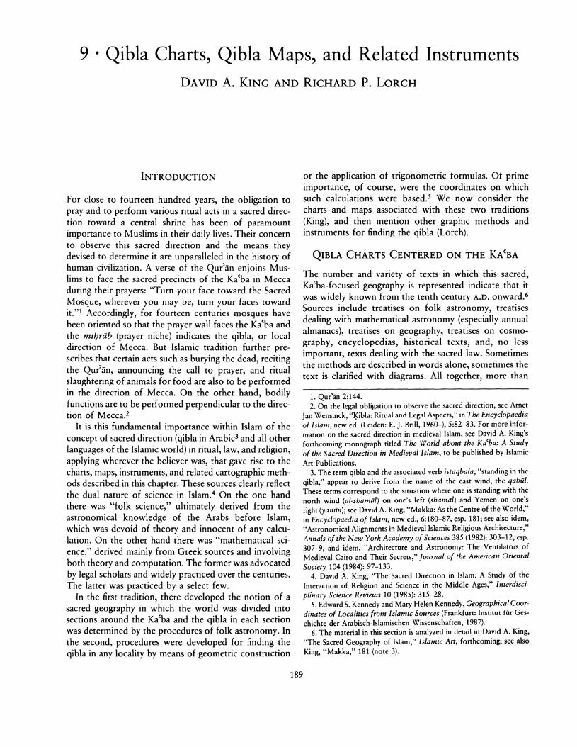
FIG. 9.6. TWO PAGES FROM A TREATISE ON FOLKASTRONOMY. This work is by Mul)ammad ibn Abi Bake alFarisi, a scholar active in Aden in the thirteenth century. Thetwo diagrams display two different schemes of the worldarranged in twelve sectors about the Ka'ba. For each sector
manuscripts of the later Ottoman period. The Ottomanexamples show substantial development over ,the earliercharts, but they also contain fanciful elements. As in someearlier Arabic schemes, for instance, the orientation ofthe Ka'ba with respect to the cardinal directions, or withrespect to localities around it, is often in error. At thesame time, they also reflect particular Otroman interests.Thus, some late schemes include Ottoman provincialcities in the Balkans as well as various European ports.
One of the main manuscripts to be illustrated was thecosmography, Kharfdat' al-'aja>ib wa-(arfdat al-ghara>ib(The unbored pearl of wonders and the precious gem ofmarvels) of Ibn al-Wardl, which was translated into Turkish several times. In One version there are eleven sectors,with instructions for finding the qibla in Turkish (fig. 9.8).In another version, prepared in 570/1562 by Mal}miidel-l:IatIb er-Riiml, there is a chart with seventy-two sectors about the Ka'ba (fig. 9.9); this is independent of thefive-, six-, and thirty-four-sector schemes attested in various Arabic copies of this work. These variations are
there is a statement regarding the corresponding segment of theperimeter of the Ka'ba as well as the appropriate astronomicaldirections that enabled the user to face that particular segment.Size of the original: not known. By permission of the BibliotecaAmbrosiana, Milan (Supp!. 73, fols. 36v-37r).
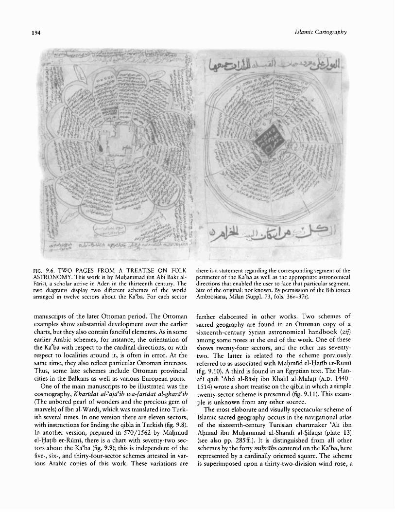
further elaborated in other works. Two schemes ofsacred geography are found in an Ottoman copy of asixteenth-century Syrian astronomical handbook (zfj)among some notes at the end of the work. One of theseshows twenty-four sectors, and the other has seventytwo. The latter is related to the scheme previouslyreferred to as associated with Mal}miid el-l:Iar1b er-Riiml(fig. 9.10). A third is found in an Egyptian text. The Hanafl qadi (Abd al-Basir ibn KhalIl al-Malarl (A.D. 14401514) wrote a short treatise on the qibla in which a simpletwenty-sector scheme is presented (fig. 9.11). This example is unknown from any other source.
The most elaborate and visually spectacular scheme ofIslamic sacred geography occurs in the navigational atlasof the sixteenth-century Tunisian chartmaker (AlI ibnAbmad ibn Mul}ammad al-Sharafl al-Sifaqsi (plate 13)(see also pp. 285 If.). It is distinguished from all otherschemes by the forty miIJrabs centered on the Ka(ba, hererepresented by a cardinally oriented square. The schemeis superimposed upon a thirty-two-division wind rose, a

Qibla Charts, Qibla Maps, and Related Instruments
FIG. 9.7. SIMPLIFIED TWELVE-SECTOR SCHEME OFSACRED GEOGRAPHY. Taken from the published text ofYaqut's geographical work, Mu'jam al-buldan.Diameter of the original: 10.7 em. From Jacut's geographischesWorterbuch,6 vols., ed. Ferdinand Wiistenfeld (Leipzig: F. A.Brockhaus, 1866-73), 1:36, by permission of F. A. Brockhaus.
device Arab sailors used to find directions by the risingsand settings of the stars. The two known copies of thisdiagram have different arrangements of the localitiesabout the Kacba.
By the eighteenth century, however, the notion of anIslamic sacred geography was seriously weakened byOttoman scholars increasingly familiar with Europeangeography. For example, Katib ~elebI's Cihannuma(World mirror), an influential work on geography printedin Istanbul in the early eighteenth century, omitted anymention of the concept of the world centered on theKacba.13 In most regions of the Islamic world traditionalqibla directions, used over the centuries, were now beingabandoned for a new direction computed for the localityin question from modern geographical coordinates.Nevertheless, diagrams of the kind described above werestill being copied as late as the nineteenth century, if onlyas illustrations to Ibn al-WardI's Kharidat al-Caja'ib.Written instructions for finding the qibla also continuedto be transmitted in one form or another. A mid-nineteenth-century anonymous Ottoman navigational compendium, recently discovered in Cairo, presents extensiveinstructions for finding the qibla in different localities. Infact, the information is a garbled version of one of IbnSuraqah's schemes, taken verbatim from a treatise on folkastronomy by a fourteenth-century legal scholar workingin the Hejaz. The existence of this text proves not onlythat such material was still available to Ottoman writers
195
FIG. 9.8. INSTRUCTIONS ON AN ELEVEN-SECTOR DiAGRAM OF SACRED GEOGRAPHY. Found in a Turkish translation of Ibn al-WardI's Kharidat al-(aja'ib. One of the sectorsin the original twelve-sector scheme had already been droppedin an earlier Arabic version.Size of the original: not known. By permission of the TopkapiSarayl Miizesi Kiitiiphanesi, Istanbul (R. 1088, fol. 94r).
in the nineteenth century, but also that it was still considered worth copying.
Those schemes divided into thirty-six or seventy-twosectors lent themselves to representation on a horizontaldisk fitted with a magnetic compass. Several examples ofsuch qibla indicators survive,14 but the organization ofcities around the Kacba at the center is not based oncalculation and so often departs drastically from geographical reality. Such qibla indicators were fitted tootherwise serious astronomical instruments; the motive
13. Mugafa ibn 'Abdallah Katib C;e1ebi (1017-67/1609-57) beganwork on a second version of the CihiJnnumiJ in 1065/1654 after consulting Western sources, such as Gerardus Mercator's Atlas Major. Itwas printed in 1145/1732.
14. All such instruments are surveyed in David A. King, "Some Medieval Qibla Maps: Examples of Tradition and Innovation in IslamicScience," Johann Wolfgang Goethe Universitat, Institut fOr Geschichteder Naturwissenschaften, Preprint Series, no. 11, 1989.

196
FIG. 9.9. SEVENTY-TWO-SECTOR SCHEME OF SACREDGEOGRAPHY. From a Turkish translation of Ibn al-Wardi'sKharfdat al-'aja'ib dated 1092/1681.Size of the original: not known. By permission of the TopkapiSarayl Miizesi Kiitiiphanesi, Istanbul (B. 179, fo!' 52r).
for including them was both aesthetic and an attempt toprovide a universal solution to the qibla problem. Illustrating the mathematically computed qibla directions ofspecific cities would have produced unhappy clusteringsand asymmetries unpleasing to the eye.
QIBLA MAPS BASED ON COORDINATES
In the corpus of qibla representations as a whole, thereare far fewer extant examples in the category of qiblamaps based on coordinates. Nevertheless, several qiblamaps have been discovered in which the positions oftowns are determined by their longitudes and latitudes.A minority display a coordinate grid or at least longitudinal and latitudinal axes. A distinction may be drawnbetween those maps with a prime meridian at the CanaryIslands, as in Ptolemy'S Geography (defined here as type
Islamic Cartography
A) and those with a prime meridian on the Atlantic coastof Africa (defined as type B).
Underlying these maps is the understanding that theqibla of a locality can be found from its position relativeto Mecca.ls Ideally, said the Muslim scientists, the qiblamay be defined as the direction of the great circle joiningthe two. But how to represent this on a map? As readerswill see from appendix 9.1, Muslim scientists were in fullpossession of the techniques necessary to calculate theqibla. In this section we shall consider only cartographicsolutions to the qibla problem. Nevertheless we shall findit convenient to use the following mathematical notation:
L terrestrial longitudeLM longitude of MeccaLlL longitude difference from Mecca (L- LM )
<P terrestrial latitude<PM latitude of MeccaLl<p latitude difference from Mecca (<P-<PM)q qibla (measured as an angle to the local
meridian)
The first surviving example (fig. 9.12, with simplifiedtranslation), is taken from a treatise on folk astronomyby an early thirteenth-century Egyptian author. Apartfrom his name, Siraj al-Dunya wa-al-Dln, we know nothing about him. The horizontal axis of the map, designedto measure longitudes on the equator, is divided into 170equal parts (the last five degrees at each end have notbeen marked). The vertical axis, serving to measure latitudes, is divided into 80 equal parts north of the equator(the last ten degrees are likewise excluded), though inreality the vertical diameter measures not ninety degreesof longitude, but eighty-five degrees. On the map, thetowns are usually located by means of two perpendicularcoordinate lines. To find the qibla, one draws a line fromone's locality to Mecca and investigates where this linecuts the base circle; the corresponding direction of sunrise or sunset defines the qibla. The influence of folkastronomical methods upon the compilation makes theprocedure less accurate than it might otherwise havebeen. It is interesting to note here that the coordinatesare of type B, in the tradition of al-BlriinI's al-Qanun alMas(udi, a work that was generally unknown in medievalEgypt.
15. David A. King, "I~jbla: Astronomical Aspects" and "Makka: Asthe Centre of the World," in Encyclopaedia of Islam, new ed., 5:8388 and 6:180-87; idem, "The Earliest Islamic Mathematical Methodsand Tables for Finding the Direction of Mecca," Zeitschrift fur Geschichte der Arabisch-Islamischen Wissenschaften 3 (1986): 82-149; andidem, "AI-Bazdawi on the Qibla in Early Islamic Transoxania," Journalfor the History of Arabic Science 7 (1983): 3-38. For information onqibla values at Cordoba, Spain, see David A. King, "Three Sundialsfrom Islamic Andalusia," Journal for the History of Arabic Science 2(1978): 358-92; reprinted as item XV in his Islamic AstronomicalInstruments (London: Variorum Reprints, 1987).
Qibla Charts, Qibla Maps, and Related Instruments 197
FIG. 9.10. VARIOUS SCHEMES OF SACRED GEOGRAPHY.These are appended to an Ottoman copy of a Syrian text dealingwith mathematical astronomy.
Also from Egypt is the more schematic diagram in figure 9.13. In the manuscript this appears opposite theKa'ba-centered chart illustrated as figure 9.5. Again, theordinates and abscissas are equally spaced, so that theconfiguration corresponds only roughly to geographicalreality. In the coordinates (x,y), x is measured horizontally from the left and y vertically from the top. Themeridians and parallels are marked with the labels listedin table 9.1. The Ka'ba is represented by a square at (1,1) appropriately inclined to the local meridian. The namesof the corners of the edifice are written in. Other localitiesare shown by means of circles, usually at the intersectionsof grid lines, sometimes with their longitudes and a letterrepresenting 2, 3, or 4 to indicate the geographical climatein which they are situated. The longitudes are confusedand do not correspond to geographical reality.
The next example, engraved on an astrolabe made inLahore, is shown in figure 9.14. Here the positions ofMecca and various other localities are marked, and each
Size of the original: 18.5 x 25 em. By permission of the Bibliotheque Nationale, Paris (MS. Arabe 2520, fols. 174v-75r).
place is connected to Mecca by a straight line representing the qibla. Both longitude and latitude scales arenonlinear, corresponding to an orthographic projectionof the globe. The longitudes are of type A, for Meccahas coordinates approximately (77°, 22°). With theexception of the Atlantic coast of North Africa, whichis close to (0°, 0°), Jazir al-Zanj (?) in western Sudan,Jerusalem, and Medina, most of the localities marked arein Iran and Kashmir.
A more practical map is found on the qibla indicatordisplayed in figure 9.15. Mecca is shown at the center ofthe dial, and various places, mainly in Iran, are markedaround it. Their positions are intended to be approximate, but they are nevertheless carefully arranged. Forexample, Jerusalem is shown about 45° west of north ofMecca (correct for medieval coordinates), and Baghdadis 10° east of north of Mecca. The other markings onthe instrument south of the parallel of latitude for Meccarelate to an unusual variety of horizontal sundial for an

198
FIG. 9.11. SIMPLE TWENTY-SECTOR SCHEME OFSACRED GEOGRAPHY. From al-Mala{i's short treatise on theqibla.Size of the original: not known. By permission of the TopkapiSarayl Miizesi Kiitiiphanesi, Istanbul (A. 527, fol. 93r).
unspecified latitude, the gnomon of which is at the bottom of the instrument.
In 1989 a remarkable qibla indicator was sold at Sotheby's of London (fig. 9.16). The calligraphy and variousornamental features reveal the provenance: Isfahan,about A.D. 1700. It is circular with a radius of 22.5 centimeters. The rim is marked in labeled ten-degree intervals each subdivided in half, and individual degrees areindicated by dots. The cardinal directions are identifiedby name, and the north-south and east-west lines aredrawn in. Three pieces have been cut out of the perimeter; some other parts-now missing-were added toserve other (astronomical) functions.
The instrument bears a distinctive grid with two families of markings. The first are linear, parallel meridiansfor each two degrees of longitude up to 48° on eitherside of meridian 77° (see below). The second are nonrectilinear curves for each two degrees of latitude from10° up to 50°. The meridians are produced below latitude 10° and are cut off by a straight line parallel to theeast-west line and corresponding to a latitude of about2° (there is no indication that this was supposed to represent the equator). An inscription on the alidade indicatesthat the point at the center of the disk is Mecca. A scale
Islamic Cartography
in farsakhs marked on one-half of this alidade is intendedto measure distances from Mecca.
The longitude of Mecca is taken as 77°10', that is, anonintegral value, and this is a feature that caused themaker a lot of extra work. The longitudes correspondingto the meridians for odd longitudes are marked along aband above the curve for latitude 50°. The argumentscorresponding to the latitude curves are marked in a bandbetween the meridians for 51 ° and 53°. The seven climates are identified (in Persian) along this scale. Localiti.esare indicated by inlaid studs, the names being engravedon neighboring "squares" of the grid. The size of the gridwas chosen so that, for example, Beijing (Khanbaligh)would just fit on it.
The now-empty frame of a magnetic compass adornsthe lower center of the disk, its radius being about onethird that of the disk. There is no indication that thecompass might not point due north, but this fact wasknown to at least some Ottoman astronomers in the sixteenth century and presumably also thereafter.
The estimated coordinates of various localities arelisted in table 9.2. These estimates are sufficient to identifythe source as the astronomical handbook of Ulugh Beg,compiled in Samarkand in the early fifteenth century.Variations are all within acceptable limits. Also Sri Lanka(SarandIb), with coordinates (10°, 130°) in the z/i, isindeed off the grid altogether; presumably the stud righton the perimeter of the plate at about 20° south of eastwas intended to mark it.
The problem of constructing a rect-azimuthal gridcould have been easier for a Muslim astronomer than itwas for a twentieth-century researcher like Schoy, whofirst investigated the mathematics of such a projection.16
The former had access to tables displaying the qibla directions for all points on the kind of grid on our instrument(and more), whereas Schoy had to make his calculationshimself. The medieval tables, of which several sets areknown to us, display a function such as q(t.L, q» for arange of arguments. The table of Shams aI-DIn Abu(Abdallah MUQammad ibn MUQammad al-Khalili ofDamascus (fl. ca. A.D. 1365),17 for example, displays thisfunction for the domains:
q> == 10°, 11 0, ••• 56°, and t.L = 1°,2°, ... 60°.
16. For a discussion of this projection, see Carl Schoy, "Die Mekkaoder Qiblakarte," Kartographische und Schulgeographische Zeitschrift6 (1917): 184-86, and idem, "Mittagslinie und Qibla: Notiz zur Geschichte der mathematischen Geographie," Zeitschrift der GeseJlschaftfur Erdkunde zu Berlin (1915): 558-76; both reprinted in Beitriige zurArabisch-lslamischen Mathematik und Astronomie, 2 vols. (Frankfurt:Institut fiirGeschichte der Arabisch-lslamischen Wissenschaften, 1988),1:157-59 and 1:132-50, respectively.
17. David A. King, "AI-Khalili's Qibla Table," Journal of Near Eastern Studies 34 (1975): 81-122; reprinted as item XIII in his IslamicMathematical Astronomy (London: Variorum Reprints, 1987).

FIG. 9.12. QIBLA MAP CONTAINED IN A TREATISE ONFOLK ASTRONOMY. This is by an otherwise unknown earlythirteenth-century Egyptian author named Siraj al-Dunya waai-Din. In the lower diagram, which illustrates his principle, onlythree of the localities are shown: Mecca, Constantinople, and]armi (Aksum) in Ethiopia. A line has been added joining ]armiand Mecca that is extended to the circumference of the circle.
According to the system of this map, the qibla of ]armi wouldtherefore be roughly the rising point of the sun when it is atthe beginning of Taurus or Virgo.Diameter of outermost circle: 18.5 em. By permission of theYahuda Collection of Arabic Manuscripts, Princeton UniversityLibrary, Princeton (Yahuda Arabic manuscript no. 4657, fols.65v-66r).

200 Islamic Cartography
PARALLELS OF LATITUDE
MERIDIANS OF LONGITUDE
TABLE 9.1 Labels for a Schematic Qibla Diagram (seefigure 9.13)
MedinaAleppoDamascusJerusalemAntiochCairoBursa
Lower Frame
Mosulo1 al-Ka'ba, Mosul, Erzurum2 Medina, Azerbaijan3 Aleppo, Mardin4 Damascus5 Tarsus6 Konya7 Antioch8 Cairo9 Bursa
x Upper Frame
y
o1 (al-Ka'ba)2 Medina3 Cairo4 Jerusalem5 Damascus6 Mosul7 Antioch8 Erzurum, Konya, Bursa
FIG. 9.13. QIBLA MAP BASED ON COORDINATES. Takenfrom an anonymous Ottoman treatise (see also figs. 9.2 and 9.5),this map shows the locations of various major cities with respectto the Ka'ba, the cities being shown on an orthogonal longitudelatitude grid.Size of the original: 18 x 13 cm. By permission of the Dar alKurub, Cairo (Tal'at maiamt 811, fo!. 61r).
However, underlying this table is the parameter <PM 21 °30', and besides, our astronomer accepted 77°10' forthe longitude of Mecca (al-KhalIlI used 77°, so his tablesserve all integral longitudes). This means that a table suchas al-KhaIIII's would provide qibla values for integrallatitudes, but for integral longitudes plus ten minutes. It ismore likely that the astronomer computed a matrix ofvalues q(!'..L, <p) for each degree of <P from 10° to 50° anda set of nonintegral values of !'..L (2° apart or perhaps 6°or 10°), which would yield the required values of q forthe integral values of L used on his grid. In other words,he tabulated q(L, <pl. His values would no doubt havebeen for the parameter <PM = 21 °40'.
Our astronomer would then have proceeded as follows. First, he drew the meridians as equally spaced parallels. Actually, on the instrument the meridians are notall equally spaced: those on the outer edges are separatedby about four-fifths of the distance between those closerto the center of the ensemble. This feature is still underinvestigation. Second, to construct the point on the
meridian for longitude L corresponding to latitude <p, hesimply read q(L, <p) from the table and drew a line throughthe center inclined at angle q to the meridian there. Thatthe meridians are parallel ensures that this angle is theqibla of the locality. The latitude curves on our instrument have been drawn with remarkable precision. Onlyin two places in the northeastern quadrant has the makerhad to repeat a part of a curve that did not satisfy him.
This cartographic solution to the qibla problem is tobe regarded as a brilliant achievement for an astronomerworking in the medieval tradition. The basic idea is, ofcourse, quite simple, but it required a spark of genius torealize just that. The instrument also merits mention asone of the numerous universal solutions to problems inspherical astronomy (the qibla problem is equivalent toone such) devised by Muslim astronomers and also asone of various graphical representations of two-argumentfunctions they developed.
METHODS OF QIBLA DE'fERMINATION WITHSPHERES AND ASTROLABES
A direct mathematical method of finding the qibla wasdescribed by the little-known astronomer Na~r ibn(Abdallah. His dates are uncertain, but his procedure forfinding the qibla is no later than A.D. 1162-63, the date

Qibla Charts, Qibla Maps, and Related Instruments
FIG. 9.14. QIBLA MAP INSCRIBED ON A SEVENTEENTHCENTURY INDO-PERSIAN ASTROLABE.Diameter of the original: 25 em. By permission of the Trusteesof the Science Museum, London. Photograph courtesy of Christie's of New York.
of the manuscript. I8 His method involved drawing a mapon a sphere. It will be seen in figure 9.17 that the meridianline AEB and the east-west line GED are drawn on thecurved surface of a hemisphere whose base representsthe horizon. Then the north pole (Z) is marked on thezenith (ZB = <P, the latitude of the locality), and theequator circle GHD is drawn; a point T is marked, sothat HT = tlL (the difference in longitude); this point (T)and the pole (Z) are joined by an arc of great circle(KTMZ); from this arc TM is cut off equal to <PM; andfinally an arc of the great circle (EMN) is drawn throughthe end point of this arc and the zenith (E). The intersection (N) of this last arc with the horizon circle givesthe azimuth of Mecca when the hemisphere is alignedwith the meridian. Clearly, the instrument would havebeen simple enough to use where a suitable pair of compasses and a curved graduated ruler were available,though making an accurate hemisphere would be difficult. It does not, however, seem to have been wellknown.
201
FIG. 9.15. MAP INSCRIBED ON A LATE PERSIAN QIBLAINDICATOR. Undated.Diameter of the original: 7.5 em. Museum of the History ofScience, Oxford (ref. no. 57-84/44). By permission of the Bertman Archive, New York.
Another type of instrument, the "solid sphere," calledin Arabic dhiit al-kursi (the instrument with the frame)or, more simply, al-kurah (the sphere), was also sometimes used to determine the qibla directly. This consistedof a sphere-with equator and other celestial markingsthat could be rotated about its poles. It was mounted ina fixed horizontal ring and (usually) a fixed meridian ring.cAbd al-Ra1)man al-Khazini (fl. early twelfth century)described an automatically rotating sphere of this sortand showed how the qibla was found with it. I9 First,Mecca is marked on the sphere according to its geographical coordinates, that is, as though its geographicallongitude and latitude were the right ascension and de-
18. Damascus, Dar al-Kurub, ZahirJyah 4871, fol. 83r. See RichardP. Lorch, "Na~r b. 'Abdallah's Instrument for Finding the Qibla," Journal for the History of Arabic Science 6 (1982): 123-31.
19. Richard P. Lorch, "AI-Khazini's 'Sphere That Rotates by Itself,' "Tournai for the History of Arabic Science 4 (1980): 287-329, and formore on al-Khllzinl, see idem, "The Qibla-Table Attributed to al-KhazinJ," Journal for the History of Arabic Science 4 (1980): 259-64.

202
FIG. 9.16. RECT-AZIMUTHAL QIBLA MAP. This was usedfor finding the qibla of any locality. Mecca is at the center, andnumerous cities between Spain and China, Europe and theYemen are marked on a cartographic grid. The rule attachedat the center enables one to read off the qibla on the circularscale around the circumference of the instrument, and the scaleon the rule gives the corresponding distance between the twolocalities. This instrument came to the attention of scholarsonly in 1988.Diameter of the original: 22.5 cm. Photograph reproduced courtesy of the owner.
TABLE 9.2 Estimated Coordinates of Localities on theRect-azimuthal Qibla Indicator
Place q> L
Mecca 21 °40' 77°10'Aden 11 ° 0' 75°50'Beijing 46° 0' 124° 0'Cairo 30°20' 63°30'Istanbul 45° 0' 60° 0'
clination of a star. Second, the place from which the qiblais to be determined is similarly marked on the sphere.The sphere is then rotated until the second mark coincides with the zenith. Then the spot marking Mecca isjoined to the zenith by a curved ruler that fits the sphere,to give the point on the horizon that defines the qibla.
A much earlier treatise on the solid sphere was writtenby Qusra ibn Liiqa in the ninth century. This gives whatappears to be a similar, but not identical, method. Nothing comparable, however, is included in a short accountof the instrument by l:Iabash al-l:Iasib (fl. 240/850),20 orin the enormous treatise (157 chapters) by (Abd al-Ra~
man ibn (Umar aI-SufI (d. 372/983), although the latter
Islamic Cartography
FIG. 9.17. DIRECT MATHEMATICAL METHOD FORFINDING THE QIBLA. Na~r ibn 'Abdallah (fl. before A.D.1162-63) suggested finding the qibla by drawing a map on ahemisphere. If E and M are the zeniths of the chosen place andof Mecca, respectively, AN will be the azimuth of Mecca fromthis place.
does give four chapters on finding the azimuth of the sunor of a star (for more information on these authors, seechapter 2).
A treatise describing the spherical astrolabe compiledfor the Libras del saber de astronomia of King AlfonsoX of Castile (r. 1252-84) gives a method for finding theazimuths of terrestrial locations. On the spherical astrolabe, a sphere carries the horizontal coordinates, that is,the lines of equal altitude and lines of equal azimuth (seepp. 41-42 and fig. 2.25). The rete (Arabic (ankabiit), ornet that fits over the sphere and could rotate round itabout the celestial pole, carried the stars and the usualcelestial circles such as the equator and ecliptic. A markwas made at that point on the rete that lies over themeridian and is distant from the equator by the latitudeof the place (here Mecca) whose azimuth is required. Therete was then rotated through an angle equal to the difference of longitudes of the two places. The requiredazimuth could then be read off from the position of themark among the azimuth circles. The astronomers ofAlfonso's court probably took this use of the sphericalastrolabe ultimately from Arabic sources, for althoughthey found no Arabic treatise to work from, they musthave found someone familiar with the instrument to beable to describe it all.
The plane astrolabe-mathematically the stereographicprojection of the spherical astrolabe from the South Poleonto the equatorial plane-and the astrolabe quadranta quadrant made by folding the markings of an astrolabe
20. Richard P. Lorch and Paul Kunitzsch, "l:iabash al-l:iasib's Bookon the Sphere and Its Use," Zeitschrift fur Geschichte der Arabischlslamischen Wissenschaften 2 (1985): 68-98.
,/
Qibla Charts, Qibla Maps, and Related Instruments
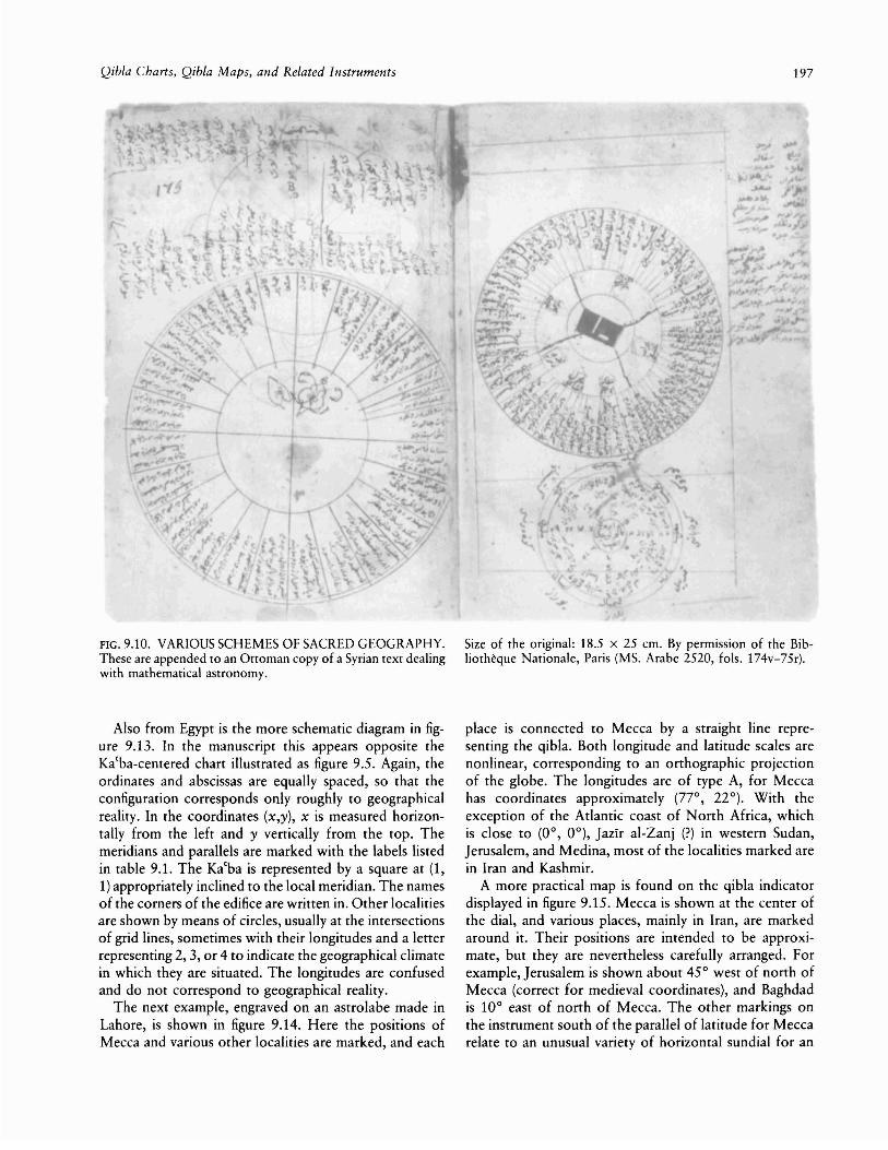
FIG. 9.18. DETAIL OF A QIBLA MAP INSCRIBED ON THEBACK OF AN ASTROLABE. Bears the signature Mu\:lammadMahdI al-Khadim; undated (ca. A.D. 1650).Size of the original: not known. Museum of the History ofScience, Oxford (ref. no. 57-84/6). By permission of the Bettman Archive, New York.
twice-were also adapted to the purpose of finding theqibla.21 To be sure, some astrolabe treatises describe onlyhow the instrument may be used to display a resultalready known or give a method by calculation. In thiscontext it should be remembered that another type ofquadrant (the sine quadrant) had the means of makingtrigonometric calculations and that the backs of astrolabes usually incorporated such quadrants in their markmgs.
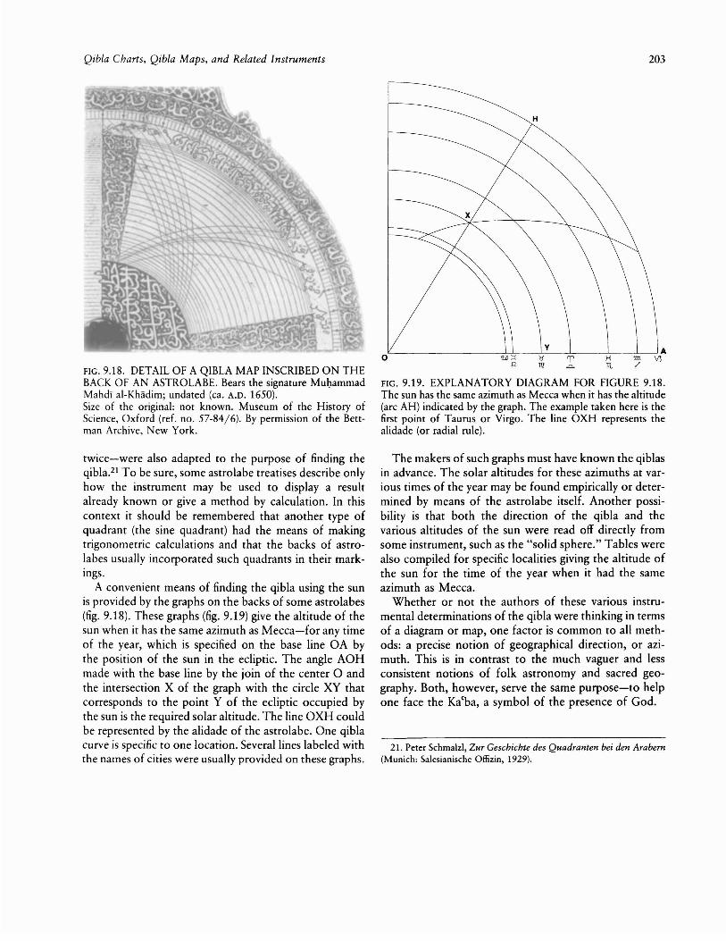
A convenient means of finding the qibla using the sunis provided by the graphs on the backs of some astrolabes(fig. 9.18). These graphs (fig. 9.19) give the altitude of thesun when it has the same azimuth as Mecca-for any timeof the year, which is specified on the base line OA bythe position of the sun in the ecliptic. The angle AOHmade with the base line by the join of the center 0 andthe intersection X of the graph with the circle XY thatcorresponds to the point Y of the ecliptic occupied bythe sun is the required solar altitude. The line OXH couldbe represented by the alidade of the astrolabe. One qiblacurve is specific to one location. Several lines labeled withthe names of cities were usually provided on these graphs.
203
H
'---------------:!~-----:'7---::'=__-----,L,______-'-------:-' Ao H Vl11t
FIG. 9.19. EXPLANATORY DIAGRAM FOR FIGURE 9.18.The sun has the same azimuth as Mecca when it has the altitude(arc AH) indicated by the graph. The example taken here is thefirst point of Taurus or Virgo. The line OXH represents thealidade (or radial rule).
The makers of such graphs must have known the qiblasin advance. The solar altitudes for these azimuths at various times of the year may be found empirically or determined by means of the astrolabe itself. Another possibility is that both the direction of the qibla and thevarious altitudes of the sun were read off directly fromsome instrument, such as the "solid sphere." Tables werealso compiled for specific localities giving the altitude ofthe sun for the time of the year when it had the sameazimuth as Mecca.
Whether or not the authors of these various instrumental determinations of the qibla were thinking in termsof a diagram or map, one factor is common to all methods: a precise notion of geographical direction, or azimuth. This is in contrast ro the much vaguer and lessconsistent notions of folk astronomy and sacred geography. Both, however, serve the same purpose-to helpone face the Ka(ba, a symbol of the presence of God.
21. Peter Schmalzl, Zur Geschichte des Quadranten bei den Arabern(Munich: Salesianische Ollizin, 1929).

204
APPENDIX 9.1METHODS TO CALCULATE THE QIBLA
An approximate method for finding the qibla was described byal-BattanI (d. 317/929) and al-JaghmInI (fl. thirteenth century).In essence, these authors described taking a horizontal graduated circle quartered by two diameters whose end points facenorth, south, east, and west (fig. 9.20a), and cutting off AB equalto ~L (the difference in longitude between Mecca and the location concerned) and CD equal to ~<P (the difference in latitude).Then BM was drawn perpendicular to OC and OM perpendicular to OA. The join of 0 and their intersection at M gave theapproximate qibla. A comparison with figure 9.20b and perhapsfigure 9.3 shows immediately the connection with cartographicprocedures. Clearly, this simple procedure is equivalent to themodern formula:
{sin ~L}q = tan-1 -.-- .sin d<p
Several other approximate formulas were known. A favoritemethod of displaying the results was a 20 X 20 table based onone or other of these formulas giving the azimuths of the qiblafor values of dL and ~<P going up by degrees from 10 to 20 0
•
Far more sophisticated were the "analemma" methods (thename coming from the title of a book by Ptolemy containingsimilar graphic procedures) for finding the qibla. The earliestknown procedure of this kind-by J:Iabash al-J:Iasib in the ninthcentury1-may be summarized by the following instructions (fig.9.21a):
Draw the meridian ABGD, the vertical AG, and the horizonBD
AZ = <P; ZH = <PM; ZT = ~L
HY II ZK; M is midpoint of HYES = HMSO 1.. HY
OFQ II AGOLN II DB
EF = LNFEG is the required angle.
To justify the construction, we compare figure 9.21a withfigure 9.21b, which carries lowercase letters correspondingwhere possible to the uppercase letters of figure 9.21a. Unfortunately, the correspondence cannot be consistent because theplane of the analemma represents different planes in the spaceof the diagram at various stages of the construction. At the
Islamic Cartography
beginning ABGD represents the meridian circle zp, with A asthe zenith p. A circle HY may be imagined perpendicular tothe plane of the paper with Mecca imagined on it at a pointX, whose angular distance from H is equal to dL (X will bedirectly above 0). Correspondingly, xo is perpendicular to themeridian plane bphz. Thus if I is the center of the circle parallelto the horizon and passing through x (the position of Mecca),then OL = 01. The required azimuth is Ldef, which is equal toLolx. Since xl = XL (the radius of the circle IN), this anglemay be constructed by taking EF = LN. In the final result circleABGD represents the horizon circle.
Such procedures gave rise to several sets of verbal instructionsequivalent to correct trigonometrical formulas. 2 These aremathematically equivalent to the modern formula:
_ -1 {Sin <P cos ~L - cos <P tan <PM}q - cot sin ~L
Qibla tables based on exact procedures are of considerableinterest to the history of mathematics. Particularly impressiveis the table of Shams aI-DIn al-KhalIlI (fl. Damascus, ca. 1365),in which q (<p, dL) was tabulated with remarkable accuracy foreach degree of <P from 100 to 56 0 and each degree of ~L from1 0 to 60 0
•
Finally, there were several methods of finding the qibla basedon the fact that the direction of Mecca is the azimuth of thesun when it is standing above the city. The day when this occursis the day (toward the end of Mayor about the middle of July)when the declination of the sun is equal to <PM' the latitude ofMecca. Since on this day the sun will stand above Mecca atnoon, the difference in longitude (dL) was converted at the rateof four minutes per degree to find when this occurred accordingto local time-before or after noon according to one's locationwest or east of Mecca. The time of day would have been determined from the solar altitude. Graphs of the type shown infigure 9.18 may be considered an extension of this method.
1. Edward S. Kennedy and Yusuf cId, "A Letter of al-BlrunI: I:Iabashal-I:Iasib's Analemma for the Qibla," Historia Mathematica 1 (1974):3-11; reprinted in Studies in the Islamic Exact Sciences by E. S. Kennedy, Colleagues and Former Students, ed. David A. King and MaryHelen Kennedy (Beirut: American University of Beirut, 1983), 621-29;J. L. Berggren, "A Comparison of Four Analemmas for Determiningthe Azimuth of the Qibla," Journal for the History of Arabic Science4 (1980): 69-80.,
2. David A. King, "The Earliest Islamic Mathematical Methods andTables for Finding the Direction of Mecca," Zeitschrift fur Geschichteder Arabisch-Islamischen Wissenschaften 3 (1986): 82-149.

b
Mq
o
a ~-~- B
A
FIG. 9.20. APPROXIMATE METHOD FOR FINDING THE QIBLA DESCRIBED BY AL-BATTANI AND AL-JAGHMINI.
oz
NorthPole
b
c
Y B
J
F....r-'-----+--+------~-_____4,Q
a
A~----+------'r---~----------t G
FIG. 9.21. ANALEMMA METHOD FOR FINDING THE QIBLA DESCRIBED BY !:IABASH AL-!:IASIB.