data preparedness workshop - napsg foundation · data preparedness workshop ... training, webinars,...
TRANSCRIPT
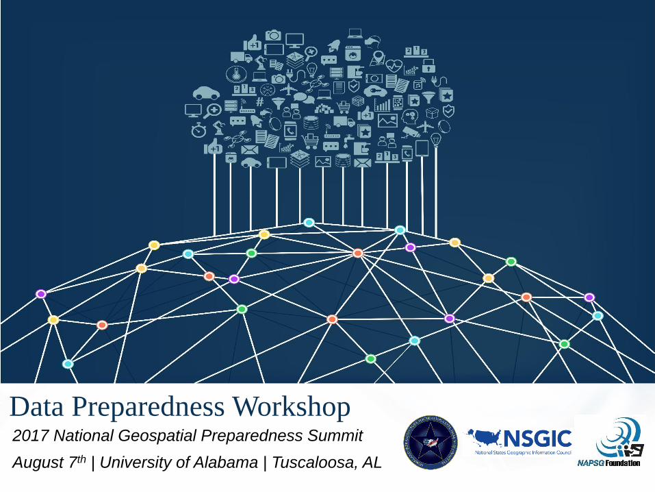
Data Preparedness Workshop2017 National Geospatial Preparedness Summit
August 7th | University of Alabama | Tuscaloosa, AL

2
Michael Donnelly Deputy Director (Acting)
DHS Geospatial Management Office
Welcome & Introductions
David BialekHSIP Program Manager
NGA Source Office of Geography

Goals:
• Review Community Perspectives & Data Driven Lessons Learned from this Past Year
3
• Identify & Prioritize Common Core Geospatial Data Needs of the Public Safety Community
• Discuss National Priority Areas
• Discover Available Data Sets
• Dialogue Around National Data Needs in Public Safety
• Uncover Gaps & Unmet Data Needs
• Network & Build Partnerships to Strengthen Data Preparedness
Objectives:

Deriving ‘Data to Impact’ – Overview of Core Information Requirements
Mission Critical Decision Points
Required by Senior Leaders and Operators
Information required to make best
decisions
Data(EEIs or CODs) required
to fulfill information requirements
Attribute-level data required to fulfill
information needs
Analysis required to fulfill
information needs
4
Start the process by defining critical decision points…
• What decisions need to be made?• By who and when?
• What information is required to fulfill those decision points?
• What data and attributes are needed to fill needs?
• What analysis on the data and attributes is needed to make information actionable?
Applies to all decisions…• Identifying and assessing risk• All types of planning• Developing & conducting exercises• Determining mitigation investments• Managing and allocating resources• Response operations• Recovery operations

Example Core Information Requirements –Situational Awareness
Situational Awareness
Information Point
Description
1. Event scale This point refers to event complexity, extent, and general location. It is an initial
information point needed as soon as available, even if it is a preliminary
determination of event location and extent based on best available data or just-
in-time/predetermined planning assumptions immediately following an incident.
2. Event forecast/prediction For notice events, such as hurricanes and planned events, assumptions and
predictions are commonly used to assess event magnitude and severity. This
includes forecasting consequences to areas directly affected and potential
cascading consequences to/from neighboring communities.
3. Event magnitude For both notice and no-notice events, event magnitude is generally assessed
within 0-12 hours of initial incident. By about 24 hours, the magnitude of the
event has typically been ground-truthed and decision makers are provided with
updated consequence analysis.
4. Demographic trends Key demographic indicators within affected areas are critical information points
for both notice and no-notice events. Demographic information for aiding
decision making is not just basic population and number of households data. This
information must go deeper to include trends and other factors such as primary
languages spoken, socio-economic/income brackets, populations with access or
functional needs, transportation dependencies, and analysis of commodity and
support service requirements based on demographic trends.
5. Critical Infrastructure Impact No later than 24 hours post incident, decision makers need to be provided with
information regarding effects on critical infrastructure. This specifically relates to
impacts on community lifelines such as: transportation infrastructure, electricity,
communications, health systems, potable water, sewer/sanitation, and others.
Updates to this information should be provided on a regular basis but updated
once a day minimally or as additional information becomes available.5

6
Looking Back at 2016
GIS Collaboration
Lessons Learned.
Local Perspective – Lessons Learned
from Recent Events and Exercises
Phil Beilin, GIS Coordinator,
City of Walnut Creek, California

2016 Lessons Learned in GIS Collaboration and Preparedness
from CaliforniaAugust 7, 2017
Phil Beilin
City of Walnut Creek
Data Preparedness Workshop
napsgfoundation.org | @napsgfoundation 7

Synopsis of Your Story
Actionable decision-making
Partnerships
napsgfoundation.org | @napsgfoundation 8

Origins of the Clearinghouse Concept
1st Clearinghouse called for by Gov. Ronald Reagan after 1971 San Fernando Earthquake—2017 is our 46 Year Anniversary!

Managing Organizations
California Seismic Safety Commission
Chair: California Geological Survey (Permanent Lead Agency)
Vice Chair: Earthquake Engineering Research Institute
California Office of Emergency Services
U.S. Geological Survey

Clearinghouse Objectives
● Facilitate field investigations by earth scientists, engineers and social scientists, who converge on the disaster site
● Synthesize information for response agencies
● Clearinghouse does not direct or control activities of participants
Nisqually, WA Clearinghouse, Feb. 2001
2014 S. Napa Earthquake, DR-4193 (photo A.Rosinski)

Federal Agencies:
10+
State and Local:
22+
Academic and Research: 7+
Non-Governmental
Organizations: 12+
Neighboring States and
Jurisdictions: 12+
Private Sector: 16+
Clearinghouse Exercise Successes
9 EXERCISES

Sept. 22, 2015: “…a geospatial method, technique, capability or resource that provides superior support to the mission; and is used by the geospatial community as a benchmark for success”
California Earthquake Clearinghouse
CA CLEARINGHOUSE RECOGNIZED BY
U.S. Department of Homeland Security as
a GeoCONOPS Best Practice!

• Common Operational Data - Multiple data sources and formats orchestrated and made available to other applications
• Make data intelligent so can use for analysis so responders can make informed decisions
• Support sharing on both geospatial and NON-geospatial information
• https://www.youtube.com/watch?v=m5GvWUeTFvE&feature=youtu.be
USGS-Open Geospatial Consortium recommendation for technology interoperability with XchangeCore
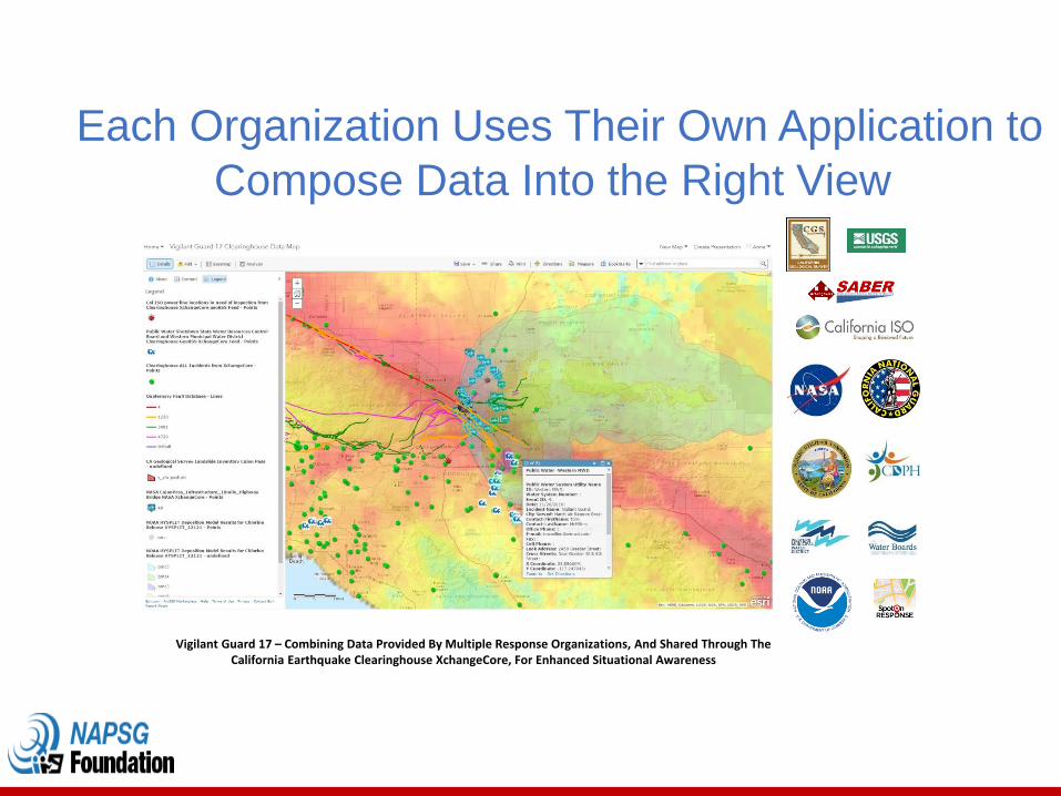
Vigilant Guard 17 – Combining Data Provided By Multiple Response Organizations, And Shared Through TheCalifornia Earthquake Clearinghouse XchangeCore, For Enhanced Situational Awareness
Each Organization Uses Their Own Application to
Compose Data Into the Right View

DHS Science &
Technology
Directorate
XchangeCore
CA Earthquake
Clearinghouse
Information
Sharing &
Technology
Interoperability
Mandate Means to accomplish mandate
•State of California
•National Earthquake Consortia
•DHS FEMA NEHRP
Information Sharing: Improving Situational
Awareness and Decision Support

Take Away Message
CA Earthquake
CH AAR
SymbologyStandards
Essential Elements
of Informatio
n
Multiple levels of
government
Multiple disciplines
“Data” person -decision maker
relationship
Training, ExercisesWebinars,
lessons learned,
stakeholder engagement
napsgfoundation.org | @napsgfoundation 17
Thank you!
Phil Beilin
City of Walnut Creek GIS Coordinator, CA GIS Council Chair 2017; NAPSG R9 co-Coordinator
http://californiaeqclearinghouse.org or [email protected]
napsgfoundation.org | @napsgfoundation 18

19
HIFLD Program Overview
Mike Donnelly
Deputy Director (Acting)
DHS Geospatial Management Office

20

21

22
GeoPlatform: The Future of HIFLD OPEN
https://hifld-geoplatform.opendata.arcgis.com

23
Current HIFLD Open Statistics Since Inception
# SHP GDB CSV KML
1 Colleges and Universities
Electric Power Transmission Lines Colleges and Universities Electric Substations
2Hospitals Generating Units Hospitals
Electric Power Transmission Lines
3Public Schools
Electric Retail Service Territories
Fortune 500 Corporate Headquarters
National Bridge Inventory (NBI) Bridges
4 Electric Power Transmission Lines Fire Stations Public Schools
Natural Gas Liquid Pipelines
5 Natural Gas Liquid Pipelines Electric Substations Pharmacies Hospitals
Top 5 downloaded layers by file formats:
* Data as of 8/2/2017

24
HIFLD Secure
❖ Location: https://gii.dhs.gov/hifld/data/secure
❖ What’s available:
98 data layers across 21 categories
35 FOUO data layers
63 Licensed data layers
❖ How to request access to licensed data via HIFLD website: https://gii.dhs.gov/HIFLD
❖ Work being done to expand access to Licensed layers
The overall classification of this presentation is:
Classified by:
Derived from:
Declassify on:
David Bialek
8/7/2017
Approved for public release, 17-764
HIFLD 2017 Feedback Session
UNCLASSIFIED
Approved for public release, 17-764

26
HIFLD 2017 Feedback Session
Approved for public release, 17-764
Recent Acquisitions and Strategy
❖ Transportation Data—• OY 1 purchased 29-June 2017• Data Disclosure Uplift-Local• August 2017 Delivery to NGA
❖ Parcel Data—• Will exercise OY1 28-September-2017• Distinct Feature Class breakout of Residential and Commercial Parcels
• Delivery 05 December 2017
❖ Business Points Data—Request For Proposal and strategy for FY18
27
HIFLD 2017 Feedback Session
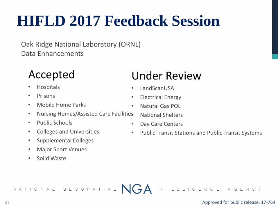
Oak Ridge National Laboratory (ORNL) Data Enhancements
Approved for public release, 17-764
Accepted• Hospitals
• Prisons
• Mobile Home Parks
• Nursing Homes/Assisted Care Facilities
• Public Schools
• Colleges and Universities
• Supplemental Colleges
• Major Sport Venues
• Solid Waste
Under Review• LandScanUSA
• Electrical Energy
• Natural Gas POL
• National Shelters
• Day Care Centers
• Public Transit Stations and Public Transit Systems

28
Data Enhancement Lifecycle
Approved for public release, 17-764
HIFLD 2017 Feedback Session

29
❖ Since September of 2015
• Contacted 63 HIFLD Data Providers to Discuss Enhancements
• Performed “QA/QC” process on 390+ Data Layers
• Completed Enhancement & Posted 75+ Layers on HIFLD Open
• Ingested 85+ Web Services on HIFLD Open
❖ What’s Next:
• Continue to Partner with Data Providers
• Continue to Enhance Data Layers & Post on HIFLD Open
• Continue to Welcome Input & Feedback
Approved for public release, 17-764
Data Enhancement Strategy
HIFLD 2017 Feedback Session

30
❖ Data Enhancements Metrics:
• Average number of edits: 6,624
• Highest number of edits: 60,743
❖ In Fiscal Year 2017:
• Averaging 20+ layer updates per month
• 30 data providers participated in specific communications:
• Confirmed authoritative data source
• Provided data updates
• Participated in quality control process
Approved for public release, 17-764
Data Enhancement Continued
HIFLD 2017 Feedback Session

31
Does now represent an opportunity to simplify our brand for the benefit of the user community?
Approved for public release, 17-764
❖Data access to authorized users
• Current-Federal Use Only
• Revised to include State and Local/Tribal exposure• When applicable
• Access and Use Constraint Language• Simplify this information
• Provide easy access to commodity data license agreements
• Provide easy access to constraint information associated with non-commodity datasets
Data Use Agreement (DUA)
HIFLD 2017 Feedback Session


Breakout Group Discussions to Prioritize Information and Data
Requirements
33

Report Out From Breakout Groups
34

35
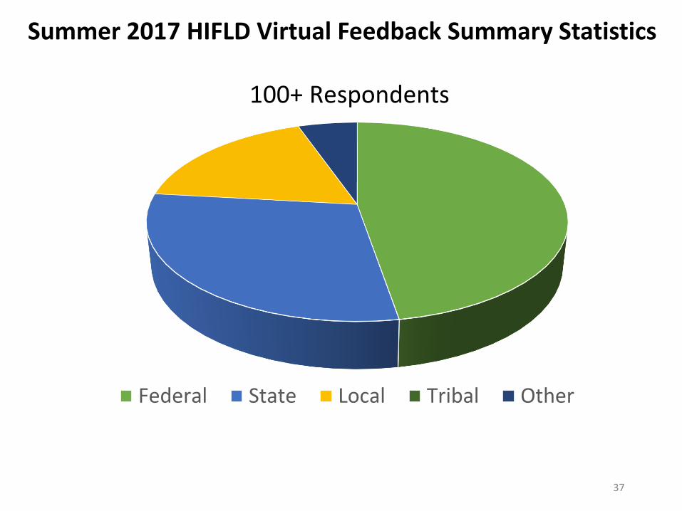
Summer 2017 HIFLD Virtual Feedback Results
Outdated Data
Status of Parcel Data?
I have data to give

36
Summer 2017 HIFLD Virtual Feedback Summary Statistics
Law Enforc., 15%
Fire/EMS, 9%
EM, 51%
Military, 1%
Critical Infra., 16%
State GIS, 3%
Public Health, 2%
Urban Planning , 2% Private Sector, 1% Other, 1% Mission
Affiliation
37
Federal State Local Tribal Other
100+ Respondents
Summer 2017 HIFLD Virtual Feedback Summary Statistics

38
Layers We Can’t Live Without
❖ Location of Federal Buildings
❖ Emergency Services (Fire, EMS, EOCs, etc.)
❖ Law Enforcement
❖ Public Health (Hospitals, Pharmacies, Nursing Homes
❖ Education (Schools, Colleges/Uni., Day Care Facilities)
❖ Pipelines (both Water and Gas)
❖ Electrical Transmission Lines
❖ Electrical Substations
❖ National Bridge Inventory
❖ Communication Towers
❖ Parcels
HIFLD Layers the Community Says It
Cannot Live Without

39
Layers We Can’t Live Without
❖ US Cable Undersea Landing Areas
❖ Cell Phone Service Areas
❖ Building Footprints
❖ Internet Exchange Ports
❖ Imagery*
❖ Thermal Imagery*
❖ Elevation Data*
HIFLD Layers the Community is
Desirous for in the Future
40
Layers We Can’t Live Without
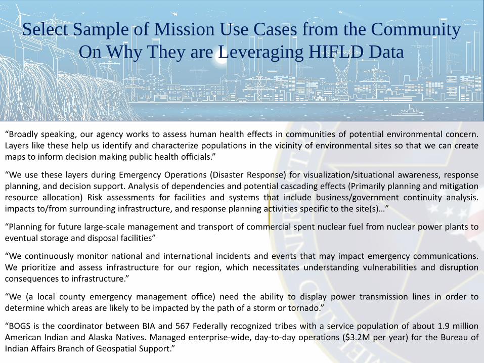
Select Sample of Mission Use Cases from the Community
On Why They are Leveraging HIFLD Data
“Broadly speaking, our agency works to assess human health effects in communities of potential environmental concern.Layers like these help us identify and characterize populations in the vicinity of environmental sites so that we can createmaps to inform decision making public health officials.”
“We use these layers during Emergency Operations (Disaster Response) for visualization/situational awareness, responseplanning, and decision support. Analysis of dependencies and potential cascading effects (Primarily planning and mitigationresource allocation) Risk assessments for facilities and systems that include business/government continuity analysis.impacts to/from surrounding infrastructure, and response planning activities specific to the site(s)…”
“Planning for future large-scale management and transport of commercial spent nuclear fuel from nuclear power plants toeventual storage and disposal facilities”
“We continuously monitor national and international incidents and events that may impact emergency communications.We prioritize and assess infrastructure for our region, which necessitates understanding vulnerabilities and disruptionconsequences to infrastructure.”
“We (a local county emergency management office) need the ability to display power transmission lines in order todetermine which areas are likely to be impacted by the path of a storm or tornado.”
“BOGS is the coordinator between BIA and 567 Federally recognized tribes with a service population of about 1.9 millionAmerican Indian and Alaska Natives. Managed enterprise-wide, day-to-day operations ($3.2M per year) for the Bureau ofIndian Affairs Branch of Geospatial Support.”

Facilitated Questions & Answers
41
What Else….? Workshop Wrap Up

42
Michael Donnelly Deputy Director (Acting)
DHS Geospatial Management Office
Closing Remarks
David BialekHSIP Program Manager
NGA Source Office of Geography