data collection survey on traffic improvement in … · the objectives of the survey are to collect...
TRANSCRIPT

JR
EI
12-193
OCTOBER 2012
JAPAN INTERNATIONAL COOPERATION AGENCY (JICA)
NIPPON KOEI CO., LTD. EIGHT-JAPAN ENGINEERING CONSULTANTS INC.
THE FEDERAL DEMOCRATIC REPUBLIC OF NEPALMINISTRY OF PHYSICAL PLANNING, WORKS AND TRANSPORT
MANAGEMENTDEPARTMENT OF ROADS
DATA COLLECTION SURVEYON
TRAFFIC IMPROVEMENTIN
KATHMANDU VALLEY
FINAL REPORT
COMPOSITION OF THE REPORT
- EXECTIVE SUMMARY - PHOTOGRAPH - LOCATION MAP - MAIN REPORT - APPENDIX
CURRENCY EXCHANGE RATE (as of October. 2011) (1) Nepal Rupee vs. Japanese Yen NPR 1= JPY 0.996 (2) US Dollar vs. Japanese Yen USD 1= JPY 76.63

Final Report Data Collection Survey on Traffic Improvement in Kathmandu Valley
ES-1
EXECUTIVE SUMMARY
CHAPTER 1 INTRODUCTION
1.1 Outline of the Survey
The objectives of the Survey are to collect traffic data and to identify main transport problems and issues in the Kathmandu Valley. The cooperating agencies are the Department of Roads (hereinafter referred to as “DOR”), Ministry of Physical Planning, Works and Transport Management (hereinafter referred to as MOPPWTM”), and other relevant organizations.
1.2 Target Area and Terms of Reference
The target area is the Kathmandu Valley, which constitutes three districts including five municipalities. The terms of reference of the Survey are as follows:
(1) Review of the Existing Information, Studies, Plans, and Projects;
(2) Basic Data Collection of Urban Planning;
(3) Traffic Survey and Road Inventory Survey;
(4) Future Traffic Demand Forecast (Target Year: 2022);
(5) Identification of Major Traffic Related Issues/Problems in the Kathmandu Valley; and
(6) Counterpart Training in Japan.
1.3 Schedule of the Survey
Calendar MonthWork Item
FY 2011 FY 201212 3
[1] Preparatory Works and Data Collection1 5 72 4 98611
Traffic Survey & Data Processing
[4] Analysis of Survey Results
[6] Draft Final Report, Final Report
[3] Interim Report
[5] Identification of Major Traffic Issues
[2]
DFR FR
Figure 1.1 Schedule of the Survey
1.4 Organization of the Survey
The DOR set up the Technical Committee for effective and efficient implementation of the Survey under the chairmanship of the Director General of DOR. The Committee comprises representatives from the following agencies and organizations:
(1) Department of Roads (DOR); (2) Department of Urban Development and Building Construction (DUDBC); (3) Department of Transport Management (DOTM); (4) Metropolitan Traffic Police (MTP); (5) Kathmandu Metropolitan City (KMC); (6) Lalitpur Sub-Metropolitan City (LSMC); and (7) Bakhtapur Municipality (BMC).

Final Report Data Collection Survey on Traffic Improvement in Kathmandu Valley
ES-2
CHAPTER 2 OVERVIEW OF THE KATHMANDU VALLEY
2.1 Natural Condition
Kathmandu is the capital city of Nepal located in the Kathmandu Valley and it is surrounded by high mountains with 2000 meters in height. The climate of the Kathmandu Valley is sub-tropical in nature which is influenced by the south-west monsoon during summer as shown in the table.
Geologically, Kathmandu Valley consists of recent alluvial soil (sal) of the Cenzonic Era and other three formations and is located in the Himalayas orogenic zone having a long history of destructive earthquakes. The seismic record of the region suggested a return period of about 25 years, indicating that a devastating earthquake is inevitable in the long run and likely will happen in the near future.
There are four major rivers, namely, Bagmati, Manahara, Bishnumati, and Dhobi Khola, flowing through the heart of Katmandu City. These rivers function not only as storm water drainage but also served as sewerage of the Kathmandu Valley. The river banks have been encroached and squatter settlements can be found in abundance.
2.2 Socio-economic Profile of the Kathmandu Valley
The key macro-economic indices of Nepal are shown in Table 2.1. During the past two decades, nominal GDP rose about tenfold, from NPR111 billion to NPR1,171 billion, whereas real GDP increased only 2.5 times. Per-capita nominal GDP for 2010 was NPR41,546 or USD558, which was 7.1 times from 1990.
The Kathmandu Valley comprising of three districts, i.e., Kathmandu, Lalitpur, and Bhaktapur includes five major municipalities, namely, Kathmandu, Lalitpur, Bhaktapur, Kirtipur, and Thimi. However, the combined area of the three districts covers around 899 sq.km, whereas the area of the valley as a whole is only 665 sq.km.
The preliminary results of the National Population Census in 2011 for Kathmandu Valley are as follows:
(a) Total population of Kathmandu Valley including the three districts was around 2.5 million, where 1.5 million lives in urban areas and the rest in rural areas.
(b) The population density of Kathmandu Valley was estimated at 27.9 persons per ha. The urban areas of Kathmandu and Lalitpur municipalities have the high density of 155.5 and 148.9, respectively.
(c) The population growth rate of the whole Kathmandu Valley was 4.32%.
Kathmandu is the center of administration, industrial, commercial, social, and economic activities. It is the most densely populated region in Nepal and its population has been increasing rapidly during the past two decades. It is considered to be the engine of growth since the planned urban development will result in overall economic development of the nation.
The rapid unplanned urbanization of the Kathmandu Valley caused by the informal process of settlement development in the past has brought several physical, social, and environmental problems in the Kathmandu Valley. The fragile Kathmandu Valley eco-system is severely affected by the over-expanding urban development and unsuitable economic activities.
IndicesReal GDP Billion NPR 616.2
Billion US$ 8.2Growth Rate % 4.4%
Real GDP per caipta NRP 21,864US$ 293
Nominal GDP Billion NPR 1,171.0Billion US$ 15.7
Growth Rate % 14.7%Per-capita Nominal GDP NRP 41,546
US$ $558Inflation (CPI) 9.0%Exchange Rate US$ 74.5DGP by Sector Agriculture % 32.6
Industry % 15.8Services and others % 51.6
Population below Poverty % 24.7
Export (2009) Billon US$ 0.85
Import (2208) Billon US$ 5.26
Key Macro-economic Indices in 2010
Main Industry (Tourisim, garment, food and beverages,metal manufactures, herbs
Source: ADB Key Indicators 2010, UNDP HumanDevelopment Report 2010
Table 2.1 Key Macro-economic Indices

Final Report Data Collection Survey on Traffic Improvement in Kathmandu Valley
ES-3
2.3 Transport Sector Status
The road network in Kathmandu Valley is classified into two groups depending on the jurisdiction of administration body of DOR and local governments as shown below:
The Kathmandu Valley is served with a ring road and radial pattern of road network and the expansion of urban areas have proceeded along the major (or primary) feeder roads radiating from the Ring Road. Feeder road is classified into primary (or major) and secondary (or minor). The former generally leads from the national highway to the district headquarters and the latter connects the primary feeder road with major towns and villages.
All the national highways and strategic urban roads except for some sections of the urban road in Lalitpur District are paved, however, the feeder roads including primary and secondary are only 60% paved, and earthen road still exist in Kathmandu and Lalitpur districts.
There are approximately 570,000 vehicles registered in the Bagmati Zone which is almost half of the total vehicles registered in Nepal. The number of registered vehicles is rapidly increasing in Kathmandu, particularly, in the recent five years accompanied with the rapid increase of urban population and economic development.
The motorcycle has increased at an alarming rate of more than 20% in the past five years. If the demand on the motorcycle will increase continuously as the people become affluent, the city roads of Kathmandu Valley will be saturated with motorcycles within the next few years.
At present, public transport is being operated by buses, mini buses, micro buses, and tempos in the valley, however, the services being provided by this public transport are far below the satisfactory level. Over-crowding, left-of-passengers, and malfunction of fleets are daily events. Vehicles used for public transport are usually old and the total number is not sufficient to cater with the demands of the riding public.
Since there is no railway system in the valley at all, public transportation in Kathmandu Valley has been provided by bus and minibuses on major roads, micro buses, and tempo network on secondary roads.
These bus services are being operated by private bus companies, however, city bus service and commuter bus service are very complicated and most of these routes that end in the central area of the city, contributes to chaotic traffic jam of the city road.
YearBus、Mini,
Micro&TempCar/Jeep/Van Motorcycle Truck/others Total Accumulative
2000 10,150 44,777 89,782 7,453 152,162 152,162
2001 710 2,649 22,852 782 26,993 179,155
2002 760 2,999 21,558 811 26,128 205,283
2003 1,082 6,788 18,035 561 26,466 231,749
2004 1,353 12,287 20,003 512 34,155 265,904
2005 1,048 3,603 21,604 1,070 27,325 293,229
2006 868 4,235 33,022 678 38,803 332,032
2007 1,086 6,601 38,852 1,237 47,776 379,808
2008 1,214 6,019 35,365 1,891 44,489 424,297
2009 912 9,471 69,359 2,096 81,838 506,135
2010 737 8,069 53,960 1,244 64,010 570,145
19,920 107,498 424,392 18,335 570,145
3.5% 18.9% 74.4% 3.2% 100%Total
Vehicles registered in Bagmati Zone
Table 2.2 Road Network of Kathmandu Valley
Figure 2.1 Road Network System in Kathmandu Valley
Table 2.3 Vehicles Registered in Kathmandu Valley
Jurisdiction ClassificationKathmandu
DistrictBhaktapur
DistrictLalitpurDistrict
Total Remarks
Highway 39.9 14.1 18.0 72.0 H02, H03, H16Feeder Road (Primary) 136.0 70.5 112.6 319.0 14 Feeder roadsFeeder Road (Secondary) 45.1 27.0 0.0 72.1 22 Feeder roadsStrategic Urban Road 59.6 4.9 27.2 91.7 59 Urban RoadsTotal 280.5 116.5 157.8 554.8District Road 400.4 36.0 90.6 527.0Urban Road 269.6 116.0 127.3 512.9Total 670.0 152.0 217.9 1,039.9
Total 950.5 268.5 375.7 1,594.7Source: DOR Statistic of Strategic Road Network 2009/2010
Department ofRoad (DOR)
District/Municipality

Final Report Data Collection Survey on Traffic Improvement in Kathmandu Valley
ES-4
CHAPTER 3 ROAD DEVELOPMENT POLICY AND EXISTING PLANS
3.1 Latest Policy of Road Development
The Twenty-year Road Plan was published in 2001 to develop the SRN by DOR. The planned future status of SRN is 4,040 km extension of the total length to reach up to 9,206 km for the whole country.
The Study on Sector-wide Road Programme and Priority Investment Plan was conducted primarily for the maintenance and development of the SRN. The key objective of the study is to prepare a Ten-year Priority Investment Plan (2007-2016) for SRN, including recommendations for expansion and improvement.
After the two primal national plans, the Business Plan was published in 2010 which is the latest activated plan in DOR. This plan is based on the performance evaluation of the Three-year Interim Plan-I (2007-2010) and covers plan period of the Three-year Interim Plan-II (2010-2013). The overall goal of this plan is the development of SRN to provide a sustainable and efficient road service by managing the main arteries of the road network.
3.2 Road Network Development Plan in the Previous M/P (in 1993) and Subsequent Progress
The JICA M/P “Kathmandu Urban Road Development” conducted in 1993 aimed to formulate the master plan of urban road network for Kathmandu Valley with a target year of 2015 as shown in Figure 3.1.
The basic concepts employed for the road development and the major development plan and projects proposed in the previous M/P (in 1993) are as follows:
(1) To strengthen the east-west transportation corridor as an axis of the capital of Kathmandu Valley;
(2) To build an efficient road network system inside the Ring Road to streamline the traffic in central areas;
Figure 3.1 Proposed Road Network System in 1993 M/P
Source: JICA M/P in 1993

Final Report Data Collection Survey on Traffic Improvement in Kathmandu Valley
ES-5
(3) To strengthen the feeder road network to promote a well-balanced urban development and to provide efficient transportation network in newly developed area shifting outward; and
(4) To dissolve the bottleneck points of the city road network;
In accordance with the recommendation made in the above previous M/P (in 1993), DOR has implemented high priority projects in the past two decades to solve the bottlenecks of traffic flow in the valley and the following are the major projects implemented:
- Construction of New Bagmati Bridge including Thapatali Intersections in 1995 (JICA)
- Western Link of the Inner Ring Road along Bishunumati River (ADB)
- Signalization of Nine Major Intersections on Major Urban Road inside the Ring Road (JICA)
- Construction of Balaju Bus Terminal (JICA)
- Southern and Eastern Links of Inner Ring Road along Dhobhi Khola and Bagmati River (under construction by DOR)
- Kathmandu–Bhaktapur Road Improvement Project in 2011 (JICA)
3.3 On-going Major Road Improvement Project
Bhaktapur-Dhulikel Road Widening Project is planned by DOR to mitigate the traffic congestion on the road of Arniko Highway taking into consideration the full opening of the Sindhuli Road in 2015. The detailed engineering survey and design were already completed in 2011 under the administration of DOR.
Kathmandu Sustainable Urban Transport Project (KSUTP), which is being implemented with the assistance of ADB, consists of four major improvement components comprising public transport, traffic management, pedestrianisation, and air quality.
Widening of the Existing Ring Road is planned with a technical and financial assistance of the Chinese government to relieve the traffic congestion of the existing Ring Road. It is planned to widen four traffic lanes including service roads and green belts, intersection improvements, installation of parking facilities for public transport, etc. The construction of widening is expected to be commenced soon.
Outer Ring Road Development Project has been planned by the Nepalese government to facilitate the expansion of urban area as well as guiding the present trend of fast urbanization outside the existing Ring Road. Prefeasibility study was already conducted in 2000 and proposed a road alignment of 66 km. The concept of land pooling process was accepted by the Government of Nepal, and the Outer Ring Road Development Project (hereinafter referred to as “ORRDP”) Office was established in 2004/2005.
Grade Separated Intersections at Five Major Junctions in Kathmandu is planned by DOR in order to improve the level of service for vehicular and pedestrian traffic at intersections of the major road inside the Ring Road, which includes the junctions of Old Baneshwor, New Baneshwor, Thapathali, Tripureshwor, and Kalimati. Construction of flyover at New Baneshwor Intersection will be commenced in advance out of the five junctions.
Widening of Existing Major Urban Roads is being undertaken by KVTDC in collaboration with MTP and DOR. The government decided to demolish illegally occupied roadside houses and buildings built inside the ROW. The actual progress as of the end of June 2012 has reached to approximately 35 km, and another 30 km will be demolished in the near future according to the present plan of KVDA.
Railway and Metro Development Project is planned by the Department of Railways to cope up with the rapid increase of population in the future as well as the traffic demand in the Kathmandu Valley. The feasibility study of mass rapid transit system in Kathmandu Valley is undertaken by the consortium of the Korean engineering groups and will be completed within 2012. The underground and elevated railway systems along and within the Ring Road will be examined to solve the problems of traffic congestion, slow movement of traffic, and movement of large numbers of passengers in the Kathmandu cities.

Final Report Data Collection Survey on Traffic Improvement in Kathmandu Valley
ES-6
CHAPTER 4 PRESENT ROAD CONDITIONS
4.1 Road Inventory Survey
A road inventory survey was conducted on major arterial roads including national highways, feeder roads, and urban roads to identify the existing characteristics, problems, and issues on the traffic and road network in Kathmandu Valley.
In addition, roadside condition survey was also conducted along the major roads to examine the future road development from the viewpoint of land acquisition situation.
4.2 Target Road of Road Inventory Survey
Road inventory survey was conducted on the roads inside the Kathmandu Valley with a total length of 452.8 km. The 421.1 km of the total road length is under the jurisdiction of DOR and the remaining 31.7 km is under the jurisdiction of the municipality. The survey covered the three routes of the national highway, 26 routes of major feeder roads, ten routes of minor feeder roads, 48 routes of strategic urban roads, and 40 routes of ordinary urban roads.
Roadside condition survey covered 41 routes with a total span of 346.9 km covering three national highways, 26 major feeder roads, 10 minor feeder roads, and two river corridors (Dhobhi Khola and Bishunumati River).
4.3 Present Road Conditions
(1) National highway
Black topped pavement and good surface condition were observed along almost all the surveyed sections of the national highway. The target roads are comprised of more than two-lane sections. There are no one-lane sections observed along the national highway.
1) Tribuvan Highway (H02):
The Tribuvan Highway is composed of a four-lane section from Tripureswor to Kalanki and a two-lane from Kalanki to Nag Dhunga Bus Stop. Fair or bad surface conditions along the two-lane part from Kalanki to Nag Dhunga Bus Stop were observed. In terms of the extent of difficulty for road widening, moderate to difficult level (Number of encroached houses is about 6–10 houses or more within the ROW per 100 m) were observed at majority of the sections.
2) Arniko Highway (H03):
The Arniko Highway is composed of a four-lane section from Maitighar to Suryabinayak (Bhaktapur) and a two-lane from Suryabinayak to Sanga. Especially for the four-lane section, Arniko Highway was improved by the current project on the improvement of Kathmandu-Bhaktapur Road. Good surface conditions were observed along all surveyed sections. In terms of the extent of difficulty for road widening, a non-significant level (Number of encroached houses is about 0–5 houses within the ROW per 100 m) were observed at majority of the sections excluding the area near Sanga.
3) Ring Road (H16):
The Ring Road is composed of the two-lane section excluding sections near Kalanki, Gaushala- Chabahil, and Tinkune-Koteshwor which are four-lane partially according to the result of pavement width. Good surface condition were observed along the majority of the sections, however, fair surface condition were recorded near Sinamangal (Tribuvan Airport), Ekantakuna, and the part between Gaushala and Chabahil, specifically. In terms of difficulty for road widening, non-significant level (Number of encroached houses is about 0–5 houses within the ROW per 100 m) were observed at majority of the sections except for the area between Gaushala and Sinamangal (Tribuvan International Airport) which was recorded as difficult from medium level (Number of encroached houses is about 6–10 houses or more within ROW per 100 m).

Final Report Data Collection Survey on Traffic Improvement in Kathmandu Valley
ES-7
(2) Major feeder road
The sections of black topped pavement were observed on majority of the surveyed major feeder roads, however fair and bad surface condition were recorded on 30% of the surveyed routes. Therefore, the extent of pavement surface condition was very low compared with the quality of the National Highway.
The surveyed major feeder roads were located in all directions from the center of Kathmandu Valley. The characteristics of each part are as follows:
Northern part: Except Budhanilkantha Road (F025), the present condition of pavement width is relatively narrow and the routes in general were determined to have 1 to 1.5-lane. Budhanilkantha Road (F025) was observed to have the highest upgraded road in terms of pavement width, type, and pavement condition compared with other major feeder roads located in the northern part of the valley. It was observed that all sections of this road have black topped pavement, and composed of four-lane part at the city central area from Tripureswor to Lainchaur, and two-lane part from Lainchaur to Budanilkantha.
Eastern part: The routes which have more than two-lane are located on the parts of Sankhu Road (F026) between Chabahil and Bagmati River, and whole section of Thimi Road (F086) from Jadibuti to Sallaghari. These routes were made up of black topped pavement. However, bad surface conditions were observed on some parts of these routes. Lubhu Road (F072) is one of the major radial roads in the eastern part. In terms of pavement type and condition, almost all sections were considered as black topped road and a part between Gwarko and Lubhu were observed with good surface condition. However, this road is classified as 1 to 1.5-lane only, and the extent of difficulty for widening was observed as moderate to difficult level on some parts between Gwarko and Lubhu. In the southern area from Arniko Highway within eastern part, no major arterial routes were upgraded to more than two-lane.
Southern part: Several major radial roads are located within the southern part. In terms of the results of pavement width, type, and condition, Bungmati Road (F103), Dakshinkali Road (F022), Godawari Road (F024), and Chapagaun Road (F023) can be classified as main arterial radial roads.
Western part: There were no major routes upgraded to more than two-lane section as well as black topped pavement with good condition except for Tribuvan Highway in the western part.
(3) Minor feeder road
All surveyed minor feeder roads are located in the eastern part of the valley. The routes located in remote areas such as Mulpani-Sangdaha-Changunarayan-Tilkot Road (F095), Sankhu–Kattike (F096), and Kamalbinayak-Sudal-Adikarigaun Road (F098) are classified as earthen or gravel roads. More than half of the surveyed routes were assessed to have bad surface condition. Almost all parts of the minor feeder roads comprised only of 1 to 1.5-lane section.
(4) Strategic urban road
Majority of surveyed routes were classified as black topped pavement road. Half of the routes were assessed to have good surface condition, however half of the routes were measured as fair or in bad surface condition. Kalimati-Balkhu (TU Road) (KMU002), Tripura Marga (KMU012), and Prithvi Path (KMU013) etc. are classified as four-lane routes.
(5) Urban road
Almost all routes comprised of one- to two-lane sections and made up of black topped pavement. However, about 30% of the routes were observed to have bad surface condition. Majority of the surveyed routes are located in KMC core area such as Thamel and Kathmandu Durbar Square. In this area, several routes were observed to have two-lane sections and black topped pavement based on the survey result, however, the actual condition along these routes are quite different due to many street shops opening in the daytime and tourists around the Thamel core area. Therefore, the actual capacity to deal with vehicle movement can be lowered even if there is enough space for a two–lane section.

Final Report Data Collection Survey on Traffic Improvement in Kathmandu Valley
ES-8
CHAPTER 5 METHODOLOGY OF THE TRAFFIC SURVEY 5.1 Basic Policy for the Traffic Survey
Traffic survey was conducted based on the following policies: 1) Consistency with the traffic survey in the previous M/P (in 1993);
Consistency of survey method such as zoning, location of survey point, and survey duration is required for comparison of survey results between 1991 and 2021.
2) Reflection of urbanization in recent years; and Urban expansion and transition of land use affects the traffic movement. Decision of the survey
method should be made considering the urbanization in the survey area. 3) Traffic surveys which consider measures for the improvement of traffic condition.
To solve the current traffic issues, multiple measures including road development and public transport improvement are required. The traffic survey method should be decided in view of these measures.
5.2 Survey Schedule
Table 5.1 Survey Schedule
5.3 Household Interview Survey
(1) Outline
Table 5.2 Summary of Household Interview Survey Type of survey Purpose Method Contents of survey
Household interview survey
To capture people’s movement such as origin, destination, trip purpose, travel time, and etc.
Interview household members in their houses and prepare questions
Sample households: 18,000 within the survey area
(2) Survey Area
The survey area of the household interview survey in 1991 was limited to the Kathmandu municipality, Lalitpur Municipality, and Bhaktapur Municipality. Considering the expansion of urban area and the distribution of population, the survey area of household interview survey in 2011 was expanded to the Kathmandu Valley which excludes mountainous area of three districts.
(3) Questionnaires for Household Interview
Questionnaires for home interview consists of 1) questions for household, 2) information of family

Final Report Data Collection Survey on Traffic Improvement in Kathmandu Valley
ES-9
members, and 3) questions for trips made by family members.
(3) Number of Collected Data A total of 18,100 households were interviewed in December 2011 and January 2012 for the survey.
Sampling rate was 3.13%, which exceeded the target sampling rate.
Table 5.3 Total Number of Collected Data for Household Interview Survey Total number of collected household data 18,100 Valid household data 17,592 Total number of valid household member data 70,524 Sampling rate 3.13%
Source: JICA Survey Team
5.3 Traffic Survey
Table 5.4 Summary of the Traffic Survey
No. Type of Survey
Purpose Method Contents of the Survey
1
Roadside interview (OD) survey
To capture vehicle’s origin, destination, trip purpose, and etc. Survey points surrounding the Ring Road and surrounding the Bhaktapur urban area compose cordon lines which control the result of household interview survey.
Interview drivers at survey points
Survey point: 18 points
2 Traffic count survey
To capture traffic movement Traffic counts by direction and by type of vehicle at survey points along the arterial roads
Survey points: 44
3 Screen line survey
To confirm the accuracy of person trip survey
Traffic count at the river crossing points
Survey point: 10 points
4 Traffic count survey of major intersections
To optimize signalized system at major intersections
Traffic count by vehicle type and by direction at major intersections
Survey point: 10 points3hrs in morning peak and 3hrs in evening peak
5 Travel speed survey
To analyze vehicle speed affected by traffic congestion
Investigation of travel time by running each route
Survey route: 163 rounds per day
6
Parking survey To capture parking demand of trucks
Counting number of vehicles parking along the Ring Road where many parking vehicles were observed regularly at night
Survey route: Ring Roadonce (starting 11pm)
5.4 Bus Transport Survey
Table 5.5 Summary of Bus Transport Surveys
No. Type of Survey
Purpose Method Contents of Survey
1
Bus traffic count survey
To capture the total number of bus transport operating from bus terminals.
Counting number of bus transport at Old and Gongabun Bus Park by type
Survey point: 2 24 hrs, 1 day (workday)
2 Bus OD survey
To capture the operating routes of bus transport coming into the bus terminal.
Interview bus drivers at bus terminals
Survey point: 2 24 hrs, 1 day (workday)
3
Bus passenger interview survey
To capture the travel demand and needs of bus transport passengers.
Interview bus transport passengers
Survey point: 2 24 hrs, 1 day (workday) 2,500 passengers (2,000 in Old, 500 in Gongabun)
4
Public transport firm interview survey
To obtain the information of operation and administration of bus transports.
Interview bus transport operating firms
100 firms

Final Report Data Collection Survey on Traffic Improvement in Kathmandu Valley
ES-10
CHAPTER 6 PRESENT TRAFFIC CONDITION 6.1 Movement of Persons
(1) Trip Production Rate The total number of trips made by residents in the survey area
was counted to 3,483,393 trips. Trip generation rate is the average number of trips made by one person.
The average trip production rate in the survey area was 1.409. The trip production rate of people having vehicles was higher than people without vehicles because vehicles enable people to move freely.
(2) Trip Purpose
Comparison in the composition of trip purpose between 1991 and 2011 showed that the proportion of “Others” decreased while “To Work” and "To School” increased insignificantly. Work and school activities increased more than other activities.
Source: JICA Survey Team
Figure 6.2 Comparison of Trip Purposes between 1991 and 2011
Table 6.1 Trip Composition by Purpose Trip Purpose Number of Trips Percentage
(%) To Work 634,461 18.5To School 657,030 19.1To Home 1,649,236 48.0Business 153,469 4.5Others 344,197 10.0Total 3,438,393 100.0
Source: JICA Survey Team
(3) Trip Distribution
Figure 6.3 shows the trip distribution of all purposes. Concentration of trips to Kathmandu N.P. (100) and Lalitpur N.P. (300) was evident and movement within the said municipalities was largest.
(4) Travel Mode
Walking occupied the largest proportion among travel modes. But if the 2012 survey is compared with the 1991 survey, proportion of walking decreased largely, while motorcycle increased filling the decrease as shown in Table 6.2 and Figure 6.4.
Source: JICA Survey Team Figure 6.4 Comparison of Travel Mode between
1991 and 2011
Table 6.2 Trip Composition by Mode Travel Mode Number of
Trips Percentage
Walk 1,398,378 40.7
Bicycle 52,445 1.5
Motorcycle 893,126 26.0
Car 145,980 4.2
Bus 948,464 27.6
Total 3,438,393 100.0
Source: JICA Survey Team
18.5%
14.5%
19.1%
17.6%
48.0%
47.4%
4.5%
4.8%
10.0%
15.7%
0% 20% 40% 60% 80% 100%
2011
1991 To Work
To School
To Home
Business
Others
40.7
53.1
1.5
6.6
26
9.3
4.2
3.8
27.6
27.2
0% 20% 40% 60% 80% 100%
2012
1991 Walk
Bicycle
Motorcycle
Car
Bus
Source: JICA Survey Team Figure 6.1 Trip Production Rate
by Ownership of Vehicles
Figure 6.3 General Person Trip Movement in the Survey Area
1.359 1.4221.537 1.568
1.409
0.0000.2000.4000.6000.8001.0001.2001.4001.6001.8002.000
No Veh
icle
Motorcycle owner
No Car
Motorcycle owner
Car owner
No M
otorcycle
Car owner
Average

Final Report Data Collection Survey on Traffic Improvement in Kathmandu Valley
ES-11
6.2 Vehicle Movement
(1) Trip Distribution Desire line of vehicle trips is
shown in Figure 6.5. Almost all the desire lines of vehicle trips are concentrated in Kathmandu N.P. and Lalitpur N.P.
(2) Traffic Volume
Figure 6.6 shows the 24 hour traffic volume of all vehicle types. Largest volume was observed at survey point 16 (Thapathali). Second largest was at 24 (in front of the Supreme Court). Inside the Ring Road, traffic volume exceeded 20,000 at most of the points.
6.3 Bus Operation and Movement
The number of operations at each bus parks was obtained through the public transport firm interview survey and bus count survey carried out by the Survey Team. The number of operations starting from these bus parks is shown in Table 6.3. The total number of operations starting from Kathmandu City Center was around 12,900. Operations from Ratnapark and N.A.C outnumbered the operations in the Old Bus Park. The area of the Old Bus Park was not sufficient to manage all the buses coming into the city center area. Since the bus parks other than the Old Bus Park are located along roadside of the trunk road in the city center, buses hampered the traffic.
Table 6.3 Bus Operations from Bus Parks
Large Bus Minibus Micro Bus Tempo Total
Old Bus Park 110 1,115 1,086 0 2,311
Ratnapark 45 288 3,438 1,025 4,796
NAC 0 367 2,042 2,444 4,853
Sahid gate 0 69 833 0 902
TOTAL (Kathmandu center)
155 1,839 7,399 3,469 12,862
Lagankhel 80 1,324 2,584 1,200 5,144
Gongabun Bus Park 169 605 230 0 1,004 Remark: Old Bus Park and Gongabun Bus Park were surveyed using the bus count survey. Other stations were done using the public transport firm interview survey. Source: JICA Survey Team
Source: JICA Survey Team Figure 6.5 Vehicle Trip Desire Line (All Vehicle Type)
Figure 6.6 Daily Traffic Volume (24-hour Traffic)

Final Report Data Collection Survey on Traffic Improvement in Kathmandu Valley
ES-12
CHAPTER 7 LAND-USE SURVEY AND URBAN PLANNING
7.1 History and Urbanization of the Kathmandu Valley Unplanned rapid urbanization is a major issue on the development of the Kathmandu Valley. The figures
below clearly show this situation.
Expansion of Built-up Area in the Kathmandu Valley
Spill-out of population to outside the Ring Road started around the 1980s. Spread pattern of urbanization was just out of the fringe in the Ring Road and along the feeder roads. Urbanization for the last decade was widespread in the valley.
Population Growth Rate 2001-2011 Population Density in 2011
High population growth can be seen outside the Ring Road, especially in the north and east.
4 VDCs showed more than 12% annual growth rate in the last decade.
Three-quarter of inside the Ring Road have over 200 person/ha population density.
Old town area has over 1,000 person/ha density. Outside the Ring Road reached 80 person/ha.
Population distribution policy and appropriate population density planning is necessary to accommodate the increasing population on limited land in the valley.
2011
Final Report Data Collection Survey on Traffic Improvement in Kathmandu Valley
ES-13
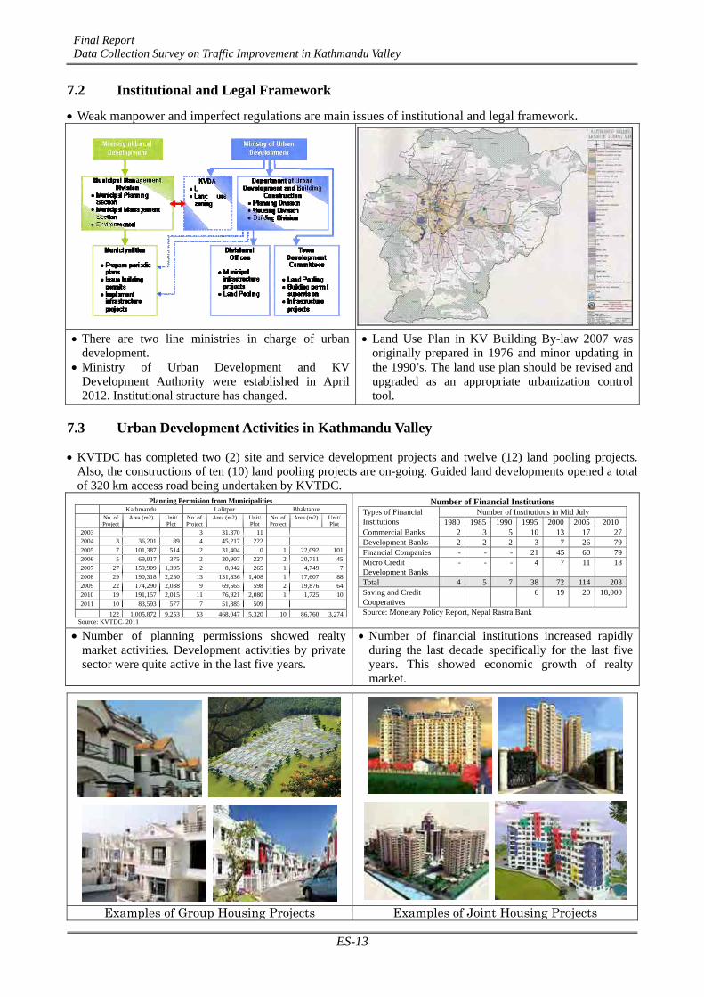
7.2 Institutional and Legal Framework
Weak manpower and imperfect regulations are main issues of institutional and legal framework.
There are two line ministries in charge of urban development.
Ministry of Urban Development and KV Development Authority were established in April 2012. Institutional structure has changed.
Land Use Plan in KV Building By-law 2007 was originally prepared in 1976 and minor updating in the 1990’s. The land use plan should be revised and upgraded as an appropriate urbanization control tool.
7.3 Urban Development Activities in Kathmandu Valley
KVTDC has completed two (2) site and service development projects and twelve (12) land pooling projects. Also, the constructions of ten (10) land pooling projects are on-going. Guided land developments opened a total of 320 km access road being undertaken by KVTDC.
Planning Permision from Municipalities Kathmandu Lalitpur Bhaktapur
No. of Project
Area (m2) Unit/ Plot
No. of Project
Area (m2) Unit/ Plot
No. of Project
Area (m2) Unit/ Plot
2003 3 31,370 11 2004 3 36,201 89 4 45,217 222 2005 7 101,387 514 2 31,404 0 1 22,092 101 2006 5 69,017 375 2 20,907 227 2 20,711 45 2007 27 159,909 1,395 2 8,942 265 1 4,749 7 2008 29 190,318 2,250 13 131,836 1,408 1 17,607 88 2009 22 174,290 2,038 9 69,565 598 2 19,876 64 2010 19 191,157 2,015 11 76,921 2,080 1 1,725 10 2011 10 83,593 577 7 51,885 509
122 1,005,872 9,253 53 468,047 5,320 10 86,760 3,274 Source: KVTDC, 2011
Number of Financial Institutions Number of Institutions in Mid July Types of Financial
Institutions 1980 1985 1990 1995 2000 2005 2010 Commercial Banks 2 3 5 10 13 17 27Development Banks 2 2 2 3 7 26 79Financial Companies - - - 21 45 60 79Micro Credit Development Banks
- - - 4 7 11 18
Total 4 5 7 38 72 114 203Saving and Credit Cooperatives
6 19 20 18,000
Source: Monetary Policy Report, Nepal Rastra Bank
Number of planning permissions showed realty market activities. Development activities by private sector were quite active in the last five years.
Number of financial institutions increased rapidly during the last decade specifically for the last five years. This showed economic growth of realty market.
Examples of Group Housing Projects Examples of Joint Housing Projects

Final report Data Collection Survey on Traffic Improvement in Kathmandu Valley
ES-14
40.7%
38.8%
1.5%
1.6%
26.0%
29.3%
4.2%
6.8%
27.6%
23.6%
0% 10% 20% 30% 40% 50% 60% 70% 80% 90% 100%
in 2011
in 2022(Case1)
Modal Split in 2011 and in 2022
Walk Bicycle Motorcycle Car Bus
CHAPTER 8 TRAFFIC DEMAND FORECAST (1) Future Socio-economic Background of the Traffic Demand
●In 2022, population in the survey area is assumed to be 3,835,600, with an annual growth rate of 4.18% in 2011 to 2022, this means a population increase of 56.9% since 2011. The growth rate was estimated based on the population census in 1991, 2001, and 2011.
●Future growth of vehicle ownership was estimated by the JICA Survey Team based on household interview survey, growth of population, and GDP per capita. Motorcycle and car ownership of household in Kathmandu Valley will increase to 1.72 and 2.40 times of the present level, respectively.
Source: JICA Survey Team
(2) Future Traffic Demand
●Total trips in the valley was forecasted to be 5,456 thousand/day in 2022 by 1.59 times of the present (2011).
● Intra-central trips by 1.59 times, inter-trips between the central and suburbs by 1.62 times were relatively higher than intra-suburbs.
●Based on the vehicle ownership estimation, the share of both motorcycle and car will increase continuously in the long run.
●It is fairly said that if nothing will be done for the future, ten years later every activity will be restricted due to severe traffic congestion, particularly along the central area inside the Ring Road.
●On the other hand, if ongoing projects like the Ring Road expansion are completed, it is certain that the level of mobility in 2022 will sustain the same existing level.
Person Trip Distribution Pattern
Source: JICA Survey Team
1.57 1.37
1.09
1.72 1.56
2.40
1.00
1.20
1.40
1.60
1.80
2.00
2.20
2.40
2.60
2.80
Population in Kathmandu
Valley
GDP per Capta in Nepal
Motorcycle Ownership per 1,000 people in Kathmandu
Valley
Number of Motorcycles in Kathmandu
Valley
Car Ownership per 1,000 peoplein
Kathmandu Valley
Number of Cars in Kathmandu
Valley
Growth Ratio (2022/2011)
Do-nothing scenario until 2022 will lead 80% of the roads inside the Ring Road to be terribly congested.

Final report Data Collection Survey on Traffic Improvement in Kathmandu Valley
ES-15
(3) Case Study for Sustainable Transport in the Long Run
Based on the growth of population, GDP, and vehicle ownership perspectives, it seems that the growth of traffic demand after 2022 might be higher compared to the years between 2011 and 2022. Therefore, to maintain a sustainable transport in the long run, an effective and efficient measure to handle the continuous increase of traffic demand in Kathmandu Valley is required. The following four cases were studied and evaluated for the traffic demand in 2022. As a result, although it was difficult to conclude what is the most suitable strategy for the long-term, it was fairly recommended that Case-4, where the additional road network combined with a change of urban structure and a modal-shift-measure from private to public transport, should be studied as one alternative for the future M/P.
Comparative Evaluation of Four Cases as Long-term Strategies
(Case-1)-------------------------------------------------------------------- ●Case-1 assumed that ongoing road projects will be completed: a) Expansion of 1) Ring Road, 2) Arniko Highway, and 3) Tribuvan Highway; and 4) Important feeder and urban roads will be improved to have a capacity of at least two-lane and have at least a fair surface condition. ●Against the increase of 59% demand until 2022, several expansion projects will be very effective. ●Nevertheless, it is difficult for the Case-1 network to deal with the growing demand inside the Ring Road appropriately after 2022 because the network cannot afford to have sufficient capacity. (Case-2)-------------------------------------------------------------------- ●Case-2 assumed that Inner Ring Road (four-lane) and Outer Ring Road (two-lane) will be added to Case-1 network. ●Inner and Outer Ring Road construction can greatly improve the whole mobility in Kathmandu Valley and congestion inside the Ring Road. ●To produce more effects in the long run, a future M/P envisioned to utilize three Ring Roads effectively by all transport modes in conjunction with efficient land use and preserving historical places will be planned. (Case-3)-------------------------------------------------------------------- ●Case-3 assumed that bus rapid transit (BRT) between the center of Kathmandu and Bhaktapur will be introduced to Case-2 network. ●To avoid strong dependency on private vehicles, BRT introduction will be one of the effective measures. ●Although modal shift from private motorcycle and car to bus can be promoted by BRT, an introduction of BRT without changing the urban structure and incentives for modal shift are not efficient and sufficient to catch the demand in the long run. ● In order to promote public transport use, not only BRT but also LRT and other measures should be studied in the future M/P. (Case-4)-------------------------------------------------------------------- ●In order to sustain urban mobility and vitality in the long run, in Case-4 an idea to build a compact city with twin centers is recommended as one of the solutions. As a new sub-center, KB-Development (Kathmandu-Bhaktapur Corridor Development) is suggested. Land use and distribution pattern of population are different from Cases-1, 2, and3 which are based on the trends of expanding to suburb with one center. ● Bhaktapur Ring Road (four-lane) and Outer Ring Road expansion (four-lane) in the development area are added to Case-3 network. ●Case-4 was estimated to reduce the demand of both areas within the central and between the central and suburb by 20%. In practice, it is not easy to build a compact city where people can make trips shorter and can move through walking, use of bicycle, and public transport, so as not too dependent on private vehicles. It is desirable to build, for example, a new industrial park, cargo terminal, and office area along the Arniko Highway close to the new residential towns.

Final report Data Collection Survey on Traffic Improvement in Kathmandu Valley
ES-16
CHAPTER 9 RECOMMENDATIONS TO FUTURE TRAFFIC MASTER PLAN
9.1 Traffic Survey Results and Issues
(1) Future Traffic Demand and Transport System Based on the future traffic demand forecast the following points were identified:
- Network system of the Kathmandu Valley may withstand the traffic demand by improving the existing network system such as installation of flyover, construction of inner ring road, and widening of existing road until 2022.
- After 2022, service level of road network will decline rapidly and introduction of new transport system/land use system will be inevitable to sustain the present mobility and urban activity.
- Therefore, ten years before 2022 is the period for the introduction of new system including the establishment of implementation plan, implementation of pilot projects, and reinforcement of relevant institutions.
(2) New Public Transport System If the transport network system is dependent on the use of private vehicles, it is expected that the
transport system will not meet the future demand in the long-term. The future M/P shall make an intensive investigation on the introduction of new public transport system. Along with the network plan, land use plan should be established simultaneously. Transit oriented development (TOD) system is the expected development scheme in Kathmandu Valley.
(3) Road Network System 1) Network inside the Ring Road: Necessity for the development of basic network such as inner
ring road and linking roads with arterial roads, will be required continuously.
2) Improvement of roads cleared from ROW: Importance of carriageway and sideway construction in the demolished ROW of major feeder road.
3) Improvement of feeder roads where traffic demand is concentrated.
(4) Public Bus 1) Bus terminal: Development of a new bus terminal equipped with sufficient facilities for
passengers along the Ring Road at the north-east, west, and south.
2) Bus route: Expansion of feeder road network for bus operation.
(5) Motorcycle Responsibility as a road user: Motorcycle users shall bear due responsibility such as payment of
parking fees.
(6) Pedestrian 1) Pedestrian at central area: Separation from vehicles is crucial in the central commercial and
heritage areas where walking is the most important travel mode.
2) Pedestrian network: Establishment of a pedestrian network plan as the most primary travel mode.
Final report Data Collection Survey on Traffic Improvement in Kathmandu Valley
ES-17
(7) Bicycle 1) The topography in Kathmandu Valley is generally gentle and the trip length of daily travel in
Kathmandu Valley is adequate for bicycle use.
2) Therefore bicycle has potential to become citizens’ means of daily transportation. The future M/P shall take into account of latent possibility of bicycle use in Kathmandu Valley.
(8) Non-motorized Transport (NMT) 1) Promotion of walk and bicycle will not only contribute to decreasing the vehicles but also
contribute to improve environment in air quality and noise and to decrease the energy consumption.
2) The future M/P shall contain establishment of network and facilities for Non-Motorized Transportation including pedestrian and bicycle by scrutinizing the strategy.
9.2 Land Use Problem and Issues
(1) Population issues 1) Rapid population growth: Under the 4.6% annual population growth rate in Kathmandu Valley,
population growth is moving towards outer VDCs of Kathmandu and Lalitpur. Built-up area expansion trend might go east and south area because of land availability.
2) Disorderly sprawling built-up area: Built-up area spreads over a large area outside the Ring Road without certain road network expansion. The KVBB 2007 did not contribute to strengthen the road network in the valley.
3) High population concentration inside the Ring Road: Most of the areas inside the Ring Road have over 300 p/ha density. If high population density land use is applied, Kathmandu Valley can accommodate a certain volume of population in the near future.
(2) Land use and urban development issues 1) Inappropriate land use plan especially outside the Ring Road: The existing Kathmandu Valley
Land Use Plan was prepared in 1976. The outside Ring Road suburban area did not have building control regulation at that time. Land use zoning outside the Ring Road was done quite roughly to preserve and/or conserve mountain slope, river banks, and agricultural fields.
2) Inadequate use of land pooling project: Land pooling (LP) projects in the valley are not contributing much to strengthen road network although some LP projects can build connection roads to the Ring Road.
3) Inadequate urbanization control and environmental protection measure: Land use zoning outside the Ring Road was done quite roughly to control urbanization expansion. Mountain slope, river banks, and agricultural fields should be clearly defined as protection or conservation zone.
4) Lack of planned cargo terminals: Cargo trucks coming from outside the valley used the roadside of the Ring Road as transshipment yard. This caused traffic congestion along the Ring Road.
(3) Regulation and institutional issues 1) Divided urban development management in Kathmandu Valley: The Kathmandu Valley
Development Authority (KVDA) was established as an upgraded and integrated institute from KVTDC. However, there are still unclear demarcation among related ministries, local governments (municipalities and VDCs) and KVDA.
2) Lack of manpower for building control: Building permission system is functioning only for large-size private sector development projects. The system was ineffective due to lack of manpower.

Final report Data Collection Survey on Traffic Improvement in Kathmandu Valley
ES-18
3) Necessity of continuous training for professional staffs in the public sector: Continuous training of government staffs is not enough to keep certain level of knowledge to implement projects appropriately especially in the municipality and VDC level.
9.3 Major Findings and Issues on Road Development
(1) Overall observation of the existing road network 1) Need of road network reinforcement: Existing road network will become outdated in the near
future due to substandard road geometry and lack of connector roads, if the recent trend in traffic volume will continue to increase at the existing road network.
2) Need of an outer ring road leading to regional development: Since the outer ring road plays a key role in facilitating the expansion of urban area as well as guiding the present trend in urbanization, it is recommended for DOR to prepare a concrete implementation plan at an early stage.
3) Necessity of additional links between Kathmandu–Bhaktapur Corridor: The city of Bhaktapur will be exposed to the wave of urbanization and as expected the city will expand in the near future. Examination of additional links between Kathmandu and Bhaktapur corridor is recommended.
4) Weakness of north-south axis inside the Ring Road: The north-south axis inside the Ring Road is extremely weak due to insufficient road capacity. Widening of these roads is expected to be implemented at an earlier stage.
5) Low standard of feeder roads: Improvement or upgrading to higher standard with more traffic lanes on the feeder road is necessary especially for those located in the northern and eastern parts of Kathmandu Valley where population is increasing with a high rate in recent years.
(2) Specific issues on the existing road network 1) Issue in the Tribhuban National Highway: The construction of substitute route of Tribhuban
National Highway should be examined in the future M/P study.
2) Need of upgrading the Bhaktapur–Dhulikhel (Arniko Highway): Since Banepa and Dhulikhel are located within the influence area of Kathmandu Valley, the upgrading of the existing road between Bhaktapur and Dhulikhel should be examined in the future M/P study.
3) Necessity of widening the existing Ring Road: Widening of the existing Ring Road is crucial as one of the vital arterial roads in Kathmandu Valley with a function of dispersing the through traffic away from the central area.
4) Need the dissolution of bottleneck on the feeder roads: DOR should examine the upgrading of the road standards including road widening in the future M/P to break off the traffic jams on feeder roads.
5) Necessity of having the inner Ring Road with high standard: The inner Ring Road was recommended in the previous M/P (1993) as a core arterial road inside the Ring Road. The function of the proposed inner Ring Road becomes more vital today than what was planned in 1993 due to an excessive increase of traffic demand.
6) Necessity of a flyover at main intersections: Intersection survey identified intersections on the main roads that are almost saturated. Since the traffic volume at these intersections which far exceeds the capacity of signalized control, the provision of either an alternative road or construction of grade separated flyover is recommended.
7) Shortage of bridge capacity inside the Ring Road: The shortage of bridge is one the major reasons of traffic congestion in the city roads inside the Ring Road. An earlier realization of the inner Ring Road is one of the solutions to this problem.

Final report Data Collection Survey on Traffic Improvement in Kathmandu Valley
ES-19
(3) Issues on road structure and design 1) Measures for an increasing number of motorcycles: It is suggested for DOR to examine the
standardization of motorcycle lane in the road design and apply in the widening and/or new construction road project.
2) Provision of sidewalk for pedestrian safety: Provision of a sidewalk separated by roadway, pedestrian bridge, pedestrian crossing, setting of the signalized control for exclusive use of pedestrians, etc. are indispensable for securing the safety of pedestrians and these facilities should be standardized as incidental institution, especially for city roads.
3) Need of bicycle lane and road: The bicycle lane or bicycle road is considered as an effective measure for the improvement on air pollution as well as tourism development in the valley.
(4) Traffic management, safety, environment, and others 1) Need of a comprehensive traffic management plan: At present, various traffic management
measures are being undertaken in the Katmandu Valley. However, inspite of these measures, the overall situation of road traffic is getting worse which can be seen in the increase in traffic accidents and degradation of the environment.
The future M/P study should examine traffic management measures taking into consideration the following aspects:
a. Engineering measures (provision of traffic signal, pedestrian bridge and crossing, etc.)
b. Physical measures (more parking space, zebra crossing, safety fence, etc.)
c. Legal measures (traffic regulation, penalty system, etc.)
d. Administrative measures (one-way system, parking control, etc.)
e. Educational measures (awareness program on better driving, TV, etc.)
2) Need of a traffic control system: A traffic control system by a traffic control center with sensors and cameras should also be examined in the future M/P either in the medium- or long-term plan.
9.4 Recommendation to the Future M/P Study
9.4.1 Necessity of the Future M/P Study
The urbanization of the Kathmandu Valley would continue at rather high speed accompanied by the population increase with a high growth rate.
This data collection surveys including road inventory survey, traffic survey, and land-use survey identified the following facts:
(1) Traffic congestion occurs everywhere in major roads and is becoming chronic due to rapid increase of traffic demand.
(2) Insufficient public transport services that cannot support the increasing traffic demand. (3) Urbanization is proceeding in disorderly manner due to lack of proper land-use policy and
road network system as well. In order to solve the above problems radically, it is indispensable to conduct the future M/P which unifies
with the road development, public transport development, and land-use development plans.
Furthermore, it is suggested that the future M/P should be developed taking into consideration the following:

Final report Data Collection Survey on Traffic Improvement in Kathmandu Valley
ES-20
1) To clarify the practical city image which Kathmandu should aim
2) To draw up a future urban traffic policy corresponding to the future image of Kathmandu
3) To devise a concrete enforcement plan to realize the future urban traffic policy
9.4.2 Issues to be Considered in the Future M/P Study
(1) Balanced traffic development plan: It is expected that the population in the Kathmandu Valley will come to about 4 million within ten
years or so according to the estimation made by the Survey Team. A well balanced future M/P shall be developed by the introduction of three basic polices, that is: strengthening of road network, traffic management, and public transport including the introduction of mass transit.
(2) Greater Kathmandu covering Banepa and Dhulikhel: According to the past trend of urban expansion and availability of land, the expansion of urban area to
the eastward will continue and proceed even beyond the Kathmandu Valley up to Banepa and Dhulikhel in the long-term.
It may be considered in the future M/P the integration of Banepa and Dhulikhel into Kathmandu Valley which will be called as “Greater Kathmandu”.
(3) Examination of mass transit system: The feasibility study on Railway and Metro Development Project is being conducted by the DOR
(Department of Railways), MOPPWTM, which is expected to be completed in October 2012.
The realization of the mass transit makes a big influence on the transport policy and road development network as well, it is necessary to share information in conjunction with the study results in making the future M/P.
(4) Consideration of disaster prevention for earthquake: It is expected that an earthquake will hit the Kathmandu Valley in the near future. Since the core areas
of Kathmandu City is densely populated and developed with small roads and old houses, it is necessary to make a proper evacuation system in the future M/P plan from the viewpoint of disaster prevention.
Evacuation routes with sufficient space for the inhabitants living in the core areas should be considered.
(5) Needs of extension links connecting the proposed inner ring road with the existing Ring Road:
In addition to the southern extension link proposed by ADB, northern extension, eastern extension and south-eastern extension links connecting the proposed inner ring road with the existing Ring Road should be examined in the M/P Study to decrease the traffic congestion of city roads inside the Ring Road
(6) Surface water drainage system The appropriate drainage system is indispensable for maintaining the road structure. Therefore, basic
plan for the surface drainage network of the Valley shall be examined in the future M/P study.
(7) Need of supplemental road and traffic surveys: To proceed to the future M/P stage, following two supplemental surveys will be needed.
1) Road survey:
- Re-survey on the urban roads inside the Ring Road where the KVDA is now performing the widening of ROW.
2) Traffic survey:
- Parking survey at the central area of Kathmandu to clarify the parking condition.
- Preference survey (PS) to capture the factor for promotion of envisaged traffic mode.

Final report Data Collection Survey on Traffic Improvement in Kathmandu Valley
ES-21
- Survey for goods movement between survey area and outside to identify location of cargo terminal and logistic center.
(8) Review on the Role of Bhaktapur in the Kathmandu Valley: The previous M/P (1993) recommended the valley’s integrated development of three core cities such
as Kathmandu, Lalitpur, and Bhaktapur. However, population and economic activities are still concentrated in Kathmandu and Lalitpur, but not enough in Bhaktapur area. After the completion of the Kathmandu-Bhaktapur Road construction project in 2010, it is time to reformulate the development plan of Bhaktapur area in the future M/P.
The scenarios should consider population distribution by population density planning to accommodate increasing population in the limited land in the valley.
(9) Concept of the Kathmandu Valley Land Use and Zoning Plan: Land use/zoning classifications and supporting regulations and building by-laws would be designed
(amongst others) to support all aspects of improved transportation planning, especially the relative location of residential, commercial and industrial areas, as well as the increase in development densities around public transport nodes. Strengthened environmental management provisions are also needed.
It is necessary to review the direction and outline of existing Kathmandu Valley Land Use and Zoning Plan (2007). Detailed revision of the land use zoning should be discussed in the next phase.
(10) Necessity of Bus and Cargo Terminals: The Survey revealed insufficient capacity of bus and cargo terminals. Although it is difficult to find an
open space, these facilities are essential for facilitating the increasing traffic demand including public transport buses and cargo trucks.
The bus terminal plan should be developed in the surrounding areas along the arterial road or the Ring Road taking into consideration the future urban development scheme.
Cargo terminals and logistic center should be discussed in the future M/P to serve the existing cargo movement as well as to encourage economic and social development in Kathmandu Valley.
(11) Need on Traffic Management Study: The survey on traffic management was not included in the data collection survey. Since the traffic
management is one of the main means for solving the traffic problems, it should be discussed in the future M/P. Traffic management can expect an effect for few expenses in the short-term, therefore, it should be examined as an immediate action plan in the future M/P.
A traffic control system by a traffic control center with sensors and cameras should also be examined as an improvement plan in the medium or long-term plan.
(12) Application of the JICA Guideline for Environmental and Social Considerations During the future M/P study, the measures for environmental and social considerations should be
applied in the plan by ensuring a wide range of meaningful stakeholder participation and transparency of decision-making, as well as by working for information disclosure and ensuring efficiency.
i
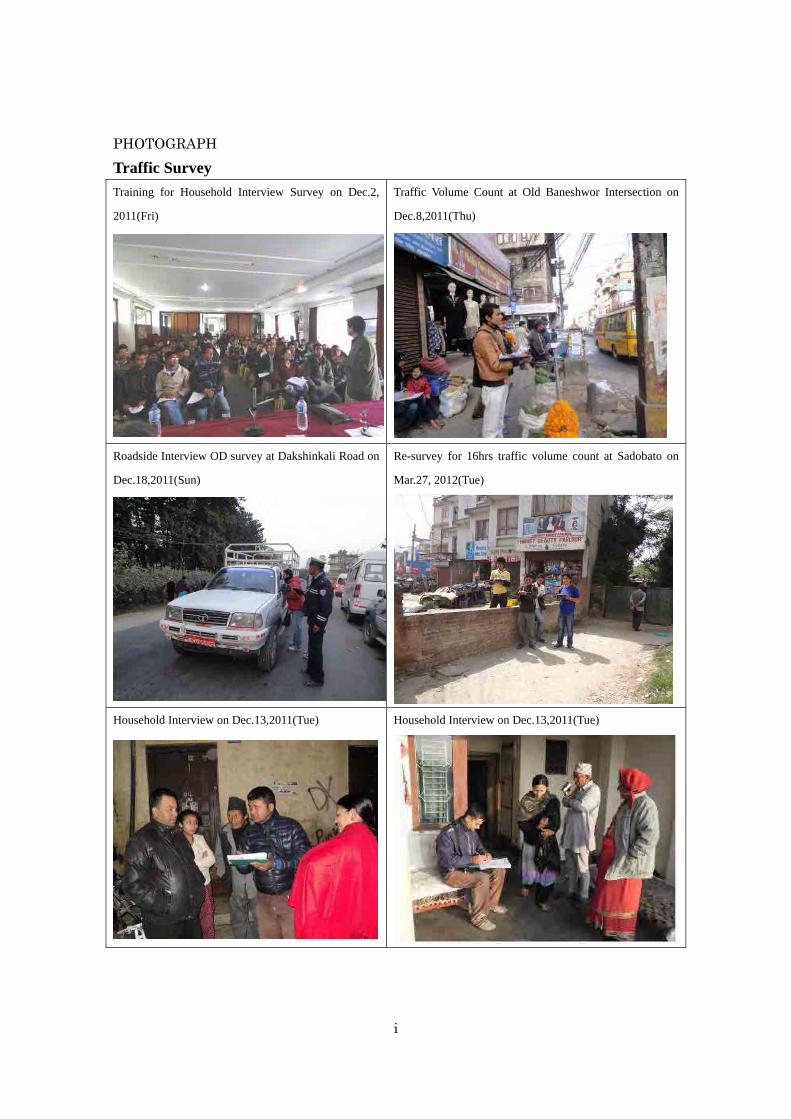
PHOTOGRAPH
Traffic Survey Training for Household Interview Survey on Dec.2,
2011(Fri)
Traffic Volume Count at Old Baneshwor Intersection on
Dec.8,2011(Thu)
Roadside Interview OD survey at Dakshinkali Road on
Dec.18,2011(Sun)
Re-survey for 16hrs traffic volume count at Sadobato on
Mar.27, 2012(Tue)
Household Interview on Dec.13,2011(Tue) Household Interview on Dec.13,2011(Tue)

ii
PHOTOGRAPH
Traffic Survey
Bus Passengers Interview at Purano Bus Park on
Jan.3,2012(Tue)
Roadside Interview OD Survey at Dakshinkali
Road on Dec.18,2011(Sun)
Road Inventory Survey Field Surveyor wearing Jacket, Measuring Tape
and ID card.
Measuring the width of Road 1
Measuring the width of Road 2 Marking each 100m for measuring

iii
PHOTOGRAPH
Meeting Inception Report Meeting at DOR
Nov.9, 2011(Wed)
Tender for Traffic Survey & Road Inventory
Survey Nov.21, 2011(Mon)
Workshop for Interim Report
Apr.27, 2012 (Fri)
Draft Final Report Meeting at DOR
Jul.22, 2012(Sun)
Workshop for Draft Final Report
Jul.27, 2012 (Fri)
Workshop for Draft Final Report
Jul.27, 2012 (Fri)

iv
PHOTOGRAPH
Land Use and Urban Development Site visit to Group Housing project site
Nov. 25, 2011 (Wed)
Visit to a Land Pooling project office,
Nov. 29, 2011 (Wed)
Visit to a Land Pooling project site,
Nov. 29, 2011 (Wed)
Site visit to apartment development project site
Nov. 30, 2011 (Wed)
Interview to former Mayer of Bhaktapur city,
Dec. 15, 2011 (Wed)
Site visit to Planned Outer Ring Road
Dec. 16, 2011 (Wed)

v
Technical Tour to Japan
Opening Lecture from Prof. Ohta
May. 15, 2012 (Tue)
Visit to Nagoya Guide Way Bus operation center
May. 17, 2012 (Thu)
Simulation at Toyota Traffic Safety Education
Center, May. 18, 2012 (Fri)
Visit Historical Landscape conservation area of
Takayama, May. 20, 2012 (Sun)
Trial ride of shared bicycle system at Toyama
city, May. 21, 2012 (Mon)
Visit MRT “Astram line” depot at Hiroshima city
May. 23, 2012 (Wed)

K A T H M A N D UD I S T R I C T
BHAKTAPURDISTRICT
L A L I T P U RD I S T R I C T
Lalitpur
Kathmandu
BhaktapurBhaktapur N.P.
Madhyapur Thimi N.P.
Kathmandu N.P.
Lalitpur N.P.
Kirtipurpur N.P.
Tribhuvan Highway
Bungm
ati Road
F072
F120
F023
F103
F103
F103
F023
F180
F078
F079
F075
F022
F104
F102
F024
F084
F095
F096
F026
F027
F082
F081
F080F021
F077
F025
F025
F026
F087
F089
F028
F086
F028
F098
F097
F094
F093
F094
F090
F092
F081
F081F021
F075
F072
F100F099
H02
H02
H16
H16
H16H03
H03
Araniko Highway
Ring Road
Ring Road
Ring R
oad
TribhuvanInternationalAirport
SCALE
0 1 2 3 4 5 km
1:100,000
Highway
Feeder Road
District Road
Other Road
District Boundary
Municipalities
Kathmandu Valley Area
Topography * Surrounded by mountains with 2000m in a height * 650sq.km with an average altitude 1300m approx.
Temperature * 9ºC -27ºC in summer * 2ºC -20ºC in winter * 75% humidity
Rainfall * 7mm in November and 364mm in July * Monsoon season from July to September * Mean annual rainfall 2000mm approx.
KathmanduKarnali
Dha
wal
agiri
Bheri
Gandaki Bagmati
Mah
akal
i
Seti
Rapti
Lumbini Narayani Janakpur Saga
rmat
ha
KoshiMechi
Midwest Region West Region Central Region Eest Region
Far W
est R
egio
n
KathmanduDistrict
Lalitpur District
BhaktapurDistrict
Bagmati Zone
Nepal
N
Key Map
Geographical Feature of Kathmandu Valley
Legend
L o c a t i o n M a p

Final Report Data Collection Survey on Traffic Improvement in Kathmandu Valley
TOC-1
FINAL REPORT
TABLE OF CONTENTS
EXECTIVE SUMMARY
PHOTOGRAPH
LOCATION MAP
TABLE OF CONTENTS
LIST OF ABBREVIATION
CHAPTER 1 INTRODUCTION .................................................................................................. 1-1 1.1 Background of the Survey .................................................................................................. 1-1
1.2 Outline of the Survey .......................................................................................................... 1-1
1.2.1 Objectives ....................................................................................................................... 1-1
1.2.2 Cooperating Agencies .................................................................................................... 1-1
1.2.3 Target Area ..................................................................................................................... 1-1
1.2.4 Terms of Reference of the Survey .................................................................................. 1-3
1.3 Schedule of Survey, Reporting, and Workshop .................................................................. 1-4
1.4 Organization of the Survey Team ....................................................................................... 1-4
1.4.1 Organizational Chart ...................................................................................................... 1-4
1.4.2 JICA Survey Team ......................................................................................................... 1-5
1.4.3 Technical Committee ..................................................................................................... 1-5
CHAPTER 2 OVERVIEW OF KATHMANDU VALLEY ........................................................ 2-1 2.1 Natural Condition ............................................................................................................... 2-1
2.1.1 Topography and Climate ................................................................................................ 2-1
2.1.2 Geology and Earthquake ................................................................................................ 2-1
2.1.3 Rivers and Hydrology .................................................................................................... 2-3
2.2 Socio-economic Profile of Kathmandu Valley ................................................................... 2-4
2.2.1 Administrative Division of Kathmandu Valley .............................................................. 2-4
2.2.2 Economic Profile ............................................................................................................ 2-5
2.2.3 Population Growth ......................................................................................................... 2-6
2.2.4 Social Conditions and Environmental Issues ................................................................. 2-9
2.3 Transport Sector Status ..................................................................................................... 2-11

Final Report Data Collection Survey on Traffic Improvement in Kathmandu Valley
TOC-2
2.3.1 Road Sector .................................................................................................................. 2-11
2.3.2 Vehicles Registered ...................................................................................................... 2-14
2.3.3 Public Transport ........................................................................................................... 2-15
CHAPTER 3 road Development policy and Existing plans ....................................................... 3-1 3.1 Latest Policy of Road Development ................................................................................... 3-1
3.1.1 Twenty-Year Road Plan .................................................................................................. 3-1
3.1.2 Sector-wide Road Programme and Priority Investment Plan......................................... 3-1
3.1.3 Business Plan ................................................................................................................. 3-1
3.2 Road Network Development Plan in the Previous M/P (in 1993)
and Subsequent Progress .................................................................................................... 3-2
3.2.1 Development Concept of the Previous M/P (in 1993) ................................................... 3-2
3.2.2 Implemented Projects after the Previous M/P (in 1993) ................................................ 3-3
3.3 On-going Major Road Improvement Project ...................................................................... 3-4
3.3.1 Bhaktapur–Dhulikel Road Widening Project ................................................................. 3-4
3.3.2 Kathmandu Sustainable Urban Transport Project (KSUTP) .......................................... 3-5
3.3.3 Ring Road Improvement Project .................................................................................... 3-7
3.3.4 Outer Ring Road Development Project.......................................................................... 3-7
3.3.5 Grade-Separated Intersections at Five Major Junctions in Kathmandu ......................... 3-8
3.3.6 Kathmandu Valley Road Widening Projects .................................................................. 3-9
3.3.7 Railway and Metro Development Project .................................................................... 3-10
CHAPTER 4 PRESENT ROAD CONDITION .......................................................................... 4-1 4.1 Outline of Road Inventory Survey ...................................................................................... 4-1
4.1.1 Road Inventory Survey .................................................................................................. 4-1
4.1.2 Roadside Condition Survey ........................................................................................... 4-1
4.2 Target Route of the Survey ................................................................................................. 4-1
4.2.1 Road Inventory Survey .................................................................................................. 4-1
4.2.2 Roadside Condition Survey ........................................................................................... 4-3
4.3 Survey Results .................................................................................................................... 4-3
4.3.1 Overall Characteristics of SRN ...................................................................................... 4-3
4.3.2 Major Findings ............................................................................................................... 4-6
CHAPTER 5 METHODOLOGY OF THE TRAFFIC SURVEY ............................................. 5-1 5.1 Outline of the Traffic Survey .............................................................................................. 5-1
5.1.1 Basic Policy of the Traffic Survey ................................................................................. 5-1
5.1.2 Traffic Survey Items and Schedule ................................................................................ 5-1
5.1.3 Zoning in Traffic Survey ................................................................................................ 5-3
5.2 Household Interview Survey .............................................................................................. 5-5

Final Report Data Collection Survey on Traffic Improvement in Kathmandu Valley
TOC-3
5.2.1 Basic Concept and Outline of Household Survey .......................................................... 5-5
5.2.2 Survey Area .................................................................................................................... 5-5
5.2.3 Sampling Rate ................................................................................................................ 5-6
5.2.4 Questionnaires for Household Interview ....................................................................... 5-7
5.2.5 Grouping of Trip Information ........................................................................................ 5-8
5.2.6 Survey Method ............................................................................................................... 5-9
5.2.7 Number of Collected Data ............................................................................................. 5-9
5.2.8 Data Expansion ............................................................................................................ 5-10
5.3 Traffic Survey ................................................................................................................... 5-10
5.3.1 Outline and Summary of Traffic Survey ...................................................................... 5-10
5.3.2 Roadside Interview Survey (Origin-Destination: OD) ................................................ 5-12
5.3.3 Traffic Count Survey .................................................................................................... 5-15
5.3.4 Screen Line Survey ...................................................................................................... 5-18
5.3.5 Traffic Count Survey of Major Intersections ............................................................... 5-19
5.3.6 Travel Speed Survey .................................................................................................... 5-20
5.3.7 Parking Survey ............................................................................................................. 5-21
5.4 Bus Transport Survey ........................................................................................................ 5-21
5.4.1 Outline System of Bus Transport Survey ..................................................................... 5-21
5.4.2 Bus Traffic Count Survey ............................................................................................. 5-22
5.4.3 Bus OD Survey ............................................................................................................ 5-22
5.4.4 Bus Passenger Interview Survey .................................................................................. 5-22
5.4.5 Public Transport Firm Interview Survey ...................................................................... 5-23
CHAPTER 6 PRESENT TRAFFIC CONDITION .................................................................... 6-1 6.1 Movement of Persons (Results of Household Interview Survey) ....................................... 6-1
6.1.1 Characteristics of the Population ................................................................................... 6-1
6.1.2 Trip Generation .............................................................................................................. 6-3
6.1.3 Trip Distribution ............................................................................................................. 6-7
6.1.4 Travel Mode ................................................................................................................. 6-11
6.2 Vehicle Movement ............................................................................................................ 6-18
6.2.1 Vehicle Movement (Results of Roadside Interview Survey) ....................................... 6-18
6.2.2 Traffic Condition on the Roads .................................................................................... 6-22
6.2.3 Traffic Condition at Intersection .................................................................................. 6-33
6.2.4 Parking Condition in the Ring Road ............................................................................ 6-37
6.3 Bus Operation and Movement .......................................................................................... 6-39
6.3.1 Bus Operation .............................................................................................................. 6-39
6.3.2 Bus Operation at Stations ............................................................................................. 6-40
6.3.3 Bus Passengers at the Old Bus Park and Gongabun Bus Park ..................................... 6-44

Final Report Data Collection Survey on Traffic Improvement in Kathmandu Valley
TOC-4
CHAPTER 7 LAND-USE SURVEY AND URBAN DEVELOPMENT STUDY ..................... 7-1 7.1 Outline of Land Use and Urban Development Study ......................................................... 7-1
7.1.1 Land Use Study .............................................................................................................. 7-1
7.1.2 Urban Planning Study .................................................................................................... 7-1
7.2 History and Urbanization of Kathmandu Valley ................................................................. 7-2
7.2.1 History of Kathmandu Valley ......................................................................................... 7-2
7.2.2 Urban Area Expansion ................................................................................................... 7-4
7.2.3 Population Growth in Kathmandu Valley ...................................................................... 7-7
7.2.4 Typical Population Density in Kathmandu Valley ....................................................... 7-10
7.2.5 Suitable or Unsuitable Land for Development in Kathmandu Valley .......................... 7-13
7.3 Institutional and Legal Framework ................................................................................... 7-15
7.3.1 Institutional Frameworks ............................................................................................. 7-15
7.3.2 Legal and Regulatory Framework ................................................................................ 7-16
7.3.3 Policy on Urban Development ..................................................................................... 7-17
7.3.4 Building Permission System ........................................................................................ 7-27
7.4 Urban Development Activities in Kathmandu Valley ....................................................... 7-27
7.4.1 Current Situation .......................................................................................................... 7-27
7.4.2 Key Players .................................................................................................................. 7-28
7.4.3 Urban Development Activities in the Public Sector .................................................... 7-29
7.4.4 Development Activities in the Private Sector .............................................................. 7-31
7.4.5 Housing Loan ............................................................................................................... 7-34
7.5 Recommendations for the Next Steps ............................................................................... 7-36
CHAPTER 8 TRAFFIC DEMAND FORECAST ....................................................................... 8-1 8.1 Future Population Projection .............................................................................................. 8-1
8.2 Methodology of Traffic Demand Forecast .......................................................................... 8-4
8.3 Traffic Demand Forecast .................................................................................................. 8-12
8.3.1 Trip Generation ............................................................................................................ 8-12
8.3.2 Trip Distribution ........................................................................................................... 8-15
8.3.3 Modal Split ................................................................................................................... 8-19
8.3.4 Traffic Assignment ....................................................................................................... 8-24
8.4 Case Study of Future Traffic Assignment in 2022 ............................................................ 8-31
8.4.1 Comparative Case Setting ............................................................................................ 8-31
8.4.2 KB Development (Kathmandu-Bhaktapur Corridor Development) ............................ 8-35
8.4.3 Evaluation of Four Cases ............................................................................................. 8-38

Final Report Data Collection Survey on Traffic Improvement in Kathmandu Valley
TOC-5
CHAPTER 9 RECOMMENDATION FOR FUTURE TRAFFIC MASTER PLAN .............. 9-1 9.1 Issues and Problems on the Traffic Situation of Kathmandu Valley .................................. 9-1
9.1.1 Issues from the Traffic Survey and Demand Forecast ................................................... 9-1
9.2 Land Use Problem and Issues ............................................................................................. 9-5
9.2.1 Overall Observation of the Existing Land Use and Urban Development ...................... 9-5
9.3 Major Findings and Issues on Road Development ............................................................. 9-8
9.3.1 Overall Observation of the Existing Road Network ...................................................... 9-8
9.3.2 Specific Issues on Existing Road Network .................................................................. 9-10
9.3.3 Issues on Road Structure and Design ........................................................................... 9-14
9.3.4 Traffic Management Issues .......................................................................................... 9-15
9.4 Recommendations to the Future M/P Study ..................................................................... 9-16
9.4.1 Necessity of the Future M/P Study .............................................................................. 9-16
9.4.2 Issues to be Considered in the Future M/P Study ........................................................ 9-16

Final Report Data Collection Survey on Traffic Improvement in Kathmandu Valley
TOC-6
Figure 1.2.1 Survey Area ............................................................................................................... 1-2
Figure 1.3.1 Schedule of Survey, Reporting, and Workshop ......................................................... 1-4
Figure 1.4.1 Organization of the Survey Team .............................................................................. 1-4
Figure 2.1.1 Earthquake Distribution Map in Nepal (1255-2001) ................................................ 2-2
Figure 2.1.2 Case Study on the Casualty in Kathmandu Valley based on Earthquake Scenario ... 2-3
Figure 2.1.3 Drainage System of Kathmandu Valley .................................................................... 2-4
Figure 2.2.1 Administrative Division of Kathmandu Valley ......................................................... 2-5
Figure 2.2.2 Economic Growth Rate of Nepal .............................................................................. 2-6
Figure 2.2.3 Inflation Ratio and Consumers Price Index in the Past 20 Years .............................. 2-6
Figure 2.2.4 Population Growth of Kathmandu Valley by District ............................................... 2-8
Figure 2.3.1 Road Network System in Kathmandu Valley .......................................................... 2-11
Figure 2.3.2 Condition of Roads in Kathmandu Valley (1) ......................................................... 2-13
Figure 2.3.3 Condition of Roads in Kathmandu Valley (2) ......................................................... 2-13
Figure 2.3.4 Proposed Inner Ring Road ...................................................................................... 2-13
Figure 2.3.5 Growth of Vehicles Registered in Bagmati Zone .................................................... 2-15
Figure 2.3.6 Strengthening Plan of DOTM and it’s Bagmati Zone Office .................................. 2-17
Figure 3.2.1 Proposed Road Network System in Previous M/P (in 1993) .................................... 3-3
Figure 3.2.2 Implemented Projects after the Previous M/P (in 1993) ........................................... 3-3
Figure 3.3.1 Typical Cross-section Planned in the Detailed Design on 2011
Administered by DOR ............................................................................................... 3-4
Figure 3.3.2 Two Pilot Routes for .................................................................................................. 3-5
Figure 3.3.3 Improvement of Inner Ring Road ............................................................................. 3-5
Figure 3.3.4 Typical Cross-section after Widening of the Existing Ring Road ............................. 3-7
Figure 3.3.5 Present Proposed Alignment of the Outer Ring Road ............................................... 3-8
Figure 3.3.6 Target Five Intersections for Flyover Project in Kathmandu City Area .................... 3-9
Figure 3.3.7 Kathmandu and Lalitpur Roads By-laws Map (Width of defined ROW) ................. 3-9
Figure 3.3.8 Proposed Route Network ......................................................................................... 3-11
Figure 4.2.1 Target Road Map Classified by Road Classification ................................................. 4-2
Figure 4.2.2 Target Route Map for Roadside Condition Survey ................................................... 4-3
Figure 4.3.1 Measurement Length ................................................................................................. 4-5
Figure 4.3.2 Road Length by Pavement Type ................................................................................ 4-9
Figure 4.3.3 Road Length by Pavement Condition ....................................................................... 4-9
Figure 4.3.4 Road Network Classified by Pavement Width ........................................................ 4-10
Figure 4.3.5 Road Network Classified by Pavement Type .......................................................... 4-11
Figure 4.3.6 Road Network Classified by Pavement Condition .................................................. 4-12
Figure 4.3.7 Road Network Classified by the Extent of Difficulty for Road Widening .............. 4-13
Figure 5.1.1 Zoning Map ............................................................................................................... 5-4
Figure 5.2.1 Survey Area of Household Interview Survey In 1991 and 2011 ............................... 5-5
Figure 5.3.1 Location of Roadside Interview (OD) Survey in the previous M/P (1993) ............ 5-12

Final Report Data Collection Survey on Traffic Improvement in Kathmandu Valley
TOC-7
Figure 5.3.2 Location of Roadside Interview (OD) Survey (2012) ............................................. 5-13
Figure 5.3.3 Location Map of Traffic Count Survey in the previous M/P (1993) ....................... 5-16
Figure 5.3.4 Location Map of Traffic Count Survey (2012) ........................................................ 5-17
Figure 5.3.5 Survey Point for Screen Line Survey (2012) .......................................................... 5-19
Figure 5.3.6 Survey Point for Traffic Count Survey of Measured Intersections (1993) ............. 5-19
Figure 5.3.7 Survey Point for Traffic Count Survey of Major Intersections (2012) ................... 5-20
Figure 5.3.8 Route for Travel Speed Survey ............................................................................... 5-20
Figure 5.4.1 Locations of the Old Bus Park and Gongabun Bus Park ........................................ 5-22
Figure 6.1.1 Working Population at Residences and Workplaces ................................................. 6-2
Figure 6.1.2 Number of Students at Residences and Place of School ........................................... 6-2
Figure 6.1.3 Ownership Level by Large Zone ............................................................................... 6-3
Figure 6.1.4 Household Income and Motorcycle Ownership ........................................................ 6-3
Figure 6.1.5 Household Income and Car Ownership ..................................................................... 6-3
Figure 6.1.6 Trip Production Rate by Sex ..................................................................................... 6-4
Figure 6.1.7 Trip Production Rate by Occupation ......................................................................... 6-4
Figure 6.1.8 Ratio of Trip Generation by Sex and Age ................................................................. 6-4
Figure 6.1.9 Net Trip Production Rate by Sex and Age ................................................................ 6-4
Figure 6.1.10 Trip Production Rate by Large Zone ......................................................................... 6-5
Figure 6.1.11 Trip Production Rate by Ownership of Vehicles ....................................................... 6-5
Figure 6.1.12 Composition of Trip Generation by Large Zone ....................................................... 6-5
Figure 6.1.13 Composition of Population by Large Zone ............................................................... 6-5
Figure 6.1.14 Comparison of Trip Purposes between 1991 and 2011 ............................................. 6-6
Figure 6.1.15 Proportion of Trip Purposes by Large Zone .............................................................. 6-6
Figure 6.1.16 Hourly Trip Generation by Purpose .......................................................................... 6-7
Figure 6.1.17 General Person Trip Movement in the Survey Area .................................................. 6-7
Figure 6.1.18 Person Trip Desire Line Map (All Purposes) ............................................................ 6-8
Figure 6.1.19 Person Trip Desire Line Map by Purpose (To Work) ................................................ 6-8
Figure 6.1.20 Person Trip Desire Line Map by Purpose (To School) .............................................. 6-9
Figure 6.1.21 Person Trip Desire Line Map by Purpose (To Home) ............................................... 6-9
Figure 6.1.22 Person Trip Desire Line Map by Purpose (Business) .............................................. 6-10
Figure 6.1.23 Person Trip Desire Line Map by Purpose (Others) ................................................. 6-10
Figure 6.1.24 Comparison of Travel Modes between 1991 and 2011 ........................................... 6-11
Figure 6.1.25 Travel Mode by Trip Purpose .................................................................................. 6-12
Figure 6.1.26 Trip Purpose by Travel Mode .................................................................................. 6-12
Figure 6.1.27 Trip Length by Travel Mode ................................................................................... 6-13
Figure 6.1.28 Travel Mode by Distance ........................................................................................ 6-13
Figure 6.1.29 Travel Mode by Vehicle Ownership ........................................................................ 6-14
Figure 6.1.30 Hourly Trip Variation by Travel Mode .................................................................... 6-14
Figure 6.1.31 Trip Generation/Attraction Density in Central Area ............................................... 6-15

Final Report Data Collection Survey on Traffic Improvement in Kathmandu Valley
TOC-8
Figure 6.1.32 Person Trip Desire Line Map by Mode (Walk) ....................................................... 6-16
Figure 6.1.33 Person Trip Desire Line Map by Mode (Motorcycle) ............................................. 6-16
Figure 6.1.34 Person Trip Desire Line Map by Mode (Bus) ......................................................... 6-17
Figure 6.1.35 Person Trip Desire Line Map by Mode (Car) .......................................................... 6-17
Figure 6.2.1 Trip Purpose by Vehicle Type .................................................................................. 6-18
Figure 6.2.2 Trip Frequency of Each Vehicle Type ..................................................................... 6-18
Figure 6.2.3 Accumulated Trip Length Frequency ...................................................................... 6-19
Figure 6.2.4 Vehicle Trip Desire Line Map (All Vehicle Types) ................................................. 6-20
Figure 6.2.5 Vehicle Movement to/from Outside the Survey Area ............................................. 6-21
Figure 6.2.6 Composition of Commodities Carried by Trucks in Thankot ................................. 6-21
Figure 6.2.7 Composition of Commodities Carried by Trucks in Nagkhel ................................. 6-21
Figure 6.2.8 Composition of Commodities Carried by Trucks in Banepa .................................. 6-22
Figure 6.2.9 Daily Traffic Volume (24-Hour Traffic, All Vehicle Types) .................................... 6-23
Figure 6.2.10 Comparison of Traffic Volume between 2011 and 1991 ......................................... 6-25
Figure 6.2.11 Hourly Variation at the National Highway (1) ........................................................ 6-26
Figure 6.2.12 Hourly Variation at the National Highway (2) ........................................................ 6-27
Figure 6.2.13 Traffic Volume in PCU and V/C Ratio in 24 Hours ................................................ 6-29
Figure 6.2.14 V/C Balance at River Crossing ............................................................................... 6-30
Figure 6.2.15 V/C Balance at the Cordon Line ............................................................................. 6-30
Figure 6.2.16 Vehicle Speed on Major Roads (Morning) .............................................................. 6-32
Figure 6.2.17 Vehicle Speed on Major Roads (Daytime) .............................................................. 6-32
Figure 6.2.18 Vehicle Speed on Major Roads (Evening) .............................................................. 6-33
Figure 6.2.19 Degree of Saturation at Major Intersections ............................................................ 6-34
Figure 6.2.20 Results of Parking Survey ....................................................................................... 6-37
Figure 6.3.1 Existing Bus Routes ................................................................................................ 6-40
Figure 6.3.2 Major Bus Stations in Kathmandu City Center ....................................................... 6-41
Figure 6.3.3 Total Number of Buses by Type at the Old Bus Park
and Gongabun Bus Park (Departure) ...................................................................... 6-42
Figure 6.3.4 Hourly Bus Traffic Variation at Old Bus Park and Gongabun Bus Park (1) ........... 6-42
Figure 6.3.5 Hourly Bus Traffic Variation at the Old Bus Park and Gongabun Bus Park (2) ..... 6-43
Figure 6.3.6 Operation Frequency of Buses from the Old Bus Park and Gongabun Bus Park ... 6-44
Figure 6.3.7 Trip Purpose of Passengers Departing from the Old Bus Park
and Gongabun Bus Park .......................................................................................... 6-44
Figure 6.3.8 Travel Time Frequency of Passengers Departing from Old Bus Park
and Gongabun Bus Park .......................................................................................... 6-45
Figure 6.3.9 Access Mode to the Old Bus Park and Gongabun Bus Park ................................... 6-45
Figure 6.3.10 Trip Frequency of Passengers Departing from the Old Bus Park
and Gongabun Bus Park .......................................................................................... 6-46
Figure 6.3.11 Requests on Bus Operations by Bus Passengers ..................................................... 6-46

Final Report Data Collection Survey on Traffic Improvement in Kathmandu Valley
TOC-9
Figure 7.2.1 Early Settlement of Kathmandu ................................................................................ 7-2
Figure 7.2.2 Grids Superimposed by Mallas ................................................................................. 7-3
Figure 7.2.3 Land Use Change in Different Periods ...................................................................... 7-6
Figure 7.2.4 Population Growth Rate in Kathmandu Valley (1) .................................................... 7-7
Figure 7.2.5 Population Growth Rate in Kathmandu Valley (2) .................................................... 7-8
Figure 7.2.6 Population Density in Kathmandu Valley ............................................................... 7-10
Figure 7.2.7 Typical Population Density in Kathmandu Valley .................................................. 7-12
Figure 7.2.8 Protection Area from Urbanization along Rivers .................................................... 7-13
Figure 7.2.9 Possible Areas for Large-scale Urban Development ............................................... 7-14
Figure 7.3.1 Relation between MOPPW and MOLD .................................................................. 7-16
Figure 7.3.2 Development Proposition (Functional Hierarchy) .................................................. 7-21
Figure 7.3.3 Development Proposition (Development Corridors) .............................................. 7-22
Figure 7.3.4 Kathmandu Valley Land Use Zoning Map .............................................................. 7-24
Figure 7.3.5 Kathmandu Metropolitan City Zoning Map ............................................................ 7-24
Figure 7.3.6 Kathmandu Valley Heritage Site ............................................................................. 7-25
Figure 7.3.7 Kathmandu Durbar Square Cultural Heritage Conservation Zone ......................... 7-25
Figure 7.3.8 Land Use Zones by KMC ........................................................................................ 7-26
Figure 7.3.9 Land Use Plan by KMC .......................................................................................... 7-26
Figure 7.4.1 Image of Each Development Type, Group Housing, and Joint Housing
in the Valley ............................................................................................................. 7-33
Figure 8.1.1 Population Trend in Urban and Rural Area 1991-2011 ............................................. 8-2
Figure 8.2.1 Process of Traffic Demand Forecast .......................................................................... 8-4
Figure 8.2.2 Four-Step Approach ................................................................................................... 8-4
Figure 8.2.3 Small Zones around the Ring Road(50 Zones) .................................................... 8-5
Figure 8.2.4 Zones for Traffic Assignment in Kathmandu Valley(86 Zones) .......................... 8-6
Figure 8.2.5 Growth Ratio of Population, GDP per Capita and Car Ownership ........................... 8-9
Figure 8.2.6 Road Network in Case-0 and Case-1 ...................................................................... 8-11
Figure 8.3.1 Trip Generation Rate per Person ............................................................................. 8-12
Figure 8.3.2 Estimated Trip Flow in 2011 and 2022 (Between Areas) ........................................ 8-16
Figure 8.3.3 Estimated Trip Flow in 2011 and 2022 (All Purposes) ........................................... 8-17
Figure 8.3.4 Estimated Trip Flow in 2022 (Case-1: “To Work” and “To School”) ..................... 8-18
Figure 8.3.5 Modal Split Hierarchy ............................................................................................. 8-19
Figure 8.3.6 Inter-zonal Modal Split Model for Walk and Bicycle ............................................. 8-20
Figure 8.3.7 Person Trips by Mode (in 2022 and 2022(Case-1))in Kathmandu Valley .............. 8-22
Figure 8.3.8 Travel Speed Variation with Vol/C .......................................................................... 8-24
Figure 8.3.9 Flow Chart of Making Present VTOD Table ........................................................... 8-25
Figure 8.3.10 Checked Result of Estimated Traffic Volume on the Survey Points ....................... 8-25
Figure 8.3.11 Flow Chart for Making Future VTOD Table ........................................................... 8-26

Final Report Data Collection Survey on Traffic Improvement in Kathmandu Valley
TOC-10
Figure 8.3.12 Growth of Future Vehicle Generation (Case-1) by Large Zone
in Kathmandu Valley ............................................................................................... 8-27
Figure 8.3.13 Comparison of Congestion Ratio Inside the Ring Road ......................................... 8-28
Figure 8.3.14 Future Congestion Ratio for Case-0 and Case-1 ..................................................... 8-29
Figure 8.3.15 Future Traffic Volume for Case-0 and Case-1 ......................................................... 8-30
Figure 8.4.1 Future Network for Case-1 and Case-2 ................................................................... 8-33
Figure 8.4.2 Future Network for Case-3 and Case-4 ................................................................... 8-34
Figure 8.4.3 Estimated Future Trip Flow Pattern Change caused by KB Development ............. 8-35
Figure 8.4.4 Population for Case-1 and Case-4 by Large Zone ................................................... 8-36
Figure 8.4.5 Estimated Future Trip Flow Pattern Change Between Small Zones ....................... 8-37
Figure 8.4.6 Comparison of Congestion Ratio inside the Ring Road .......................................... 8-38
Figure 8.4.7 Comparison of Congestion Ratio (Case-1 and Case-4) ........................................... 8-39
Figure 9.1.1 BRT (Transjakarta, Indonesia) .................................................................................. 9-1
Figure 9.1.2 MRT (Bangkok) ......................................................................................................... 9-1
Figure 9.1.3 LRT (Manila Light Rail Transit System) ................................................................... 9-2
Figure 9.1.4 LRT (Toyama Light Rail, Japan) ............................................................................... 9-2
Figure 9.1.5 Conceptual Chart of TOD.......................................................................................... 9-2
Figure 9.1.6 Increase in Number of Trips by Walk and Bicycle from 2011 to 2022 ..................... 9-4
Figure 9.1.7 Comfortable Pedestrian Way ..................................................................................... 9-4
Figure 9.2.1 Population Growth Rate 2001-2011 .......................................................................... 9-5
Figure 9.2.2 Existing Land Use 2011 ............................................................................................ 9-5
Figure 9.2.3 Population Density 2011 ........................................................................................... 9-5
Figure 9.2.5 KVBB Land Use Plan ............................................................................................... 9-6
Figure 9.2.5 Land Pooling Plan Example ...................................................................................... 9-6
Figure 9.2.6 Divided Urban Management in KV .......................................................................... 9-6
Figure 9.3.1 Road Network System in Kathmandu Valley ......................................................... 9-8
Figure 9.3.2 Need of an Outer Ring Road ..................................................................................... 9-8
Figure 9.3.3 Need of Additional Link between K-B ...................................................................... 9-9
Figure 9.3.4 Weakness of North-South Axis ................................................................................. 9-9
Figure 9.3.5 Alternative Route of Tribuban Highway ................................................................. 9-10
Figure 9.3.6 Upgrading of Bhaktapur – Dhulikel Road .............................................................. 9-10
Figure 9.3.7 Proposed Widening Plan of Ring Road ................................................................... 9-11
Figure 9.3.8 Need of Dissolution of Bottleneck on Feeder Road ................................................ 9-11
Figure 9.3.9 Proposed Inner Ring Road ...................................................................................... 9-12
Figure 9.3.10 Heavily Saturated Intersections ............................................................................... 9-13
Figure 9.3.11 Alternative Flyover Proposed by JICA Survey Team .......................................... 9-13
Figure 9.3.12 Need for Additional Bridges .................................................................................... 9-13
Figure 9.3.13 Measures for an Increasing Motorcycle .................................................................. 9-14

Final Report Data Collection Survey on Traffic Improvement in Kathmandu Valley
TOC-11
Table 2.1.1 Topography and Climate of Kathmandu Valley ........................................................ 2-1
Table 2.2.1 Key Macro-economic Indices ................................................................................... 2-5
Table 2.2.2 Population Census of Nepal ...................................................................................... 2-7
Table 2.2.3 Population Census of Kathmandu Valley in 2011 ..................................................... 2-8
Table 2.3.1 Road Network System in Kathmandu Valley .......................................................... 2-12
Table 2.3.2 Numbers of Vehicles Registered in Nepal ............................................................... 2-14
Table 2.3.3 Vehicle Registered in Kathmandu Valley (Bagmati Zone) ...................................... 2-15
Table 3.3.1 Activities of Each Component .................................................................................. 3-6
Table 4.2.1 Summary of Target Roads for Road Inventory Survey ............................................. 4-1
Table 4.2.2 Details of Target Routes for Roadside Condition Survey ......................................... 4-3
Table 4.3.1 Characteristics of National Highway and Feeder Road ............................................ 4-4
Table 4.3.2 Characteristics of Strategic Urban Road* ................................................................. 4-5
Table 4.3.3 Result of Roadside Condition Survey for River Corridor ......................................... 4-9
Table 5.1.1 Traffic Survey Item ................................................................................................... 5-2
Table 5.1.2 Comparison of Traffic Survey Items between the survey
in the previous M/S and this time .............................................................................. 5-2
Table 5.1.3 Survey Schedule ........................................................................................................ 5-3
Table 5.1.4 Number of Zones ....................................................................................................... 5-3
Table 5.2.1 Summary of Household Interview Survey ................................................................ 5-5
Table 5.2.2 Population and Number of Household in the Districts in 2001 and 2011 ................. 5-6
Table 5.2.3 Estimated Population and Number of Households in the Survey Area in 2011 ........ 5-6
Table 5.2.4 Estimation of Population of Five Years and Above in 2011 ...................................... 5-6
Table 5.2.5 Questionnaire of Household Interview ...................................................................... 5-8
Table 5.2.6 Trip Purpose Category ............................................................................................... 5-8
Table 5.2.7 Travel Mode Category ............................................................................................... 5-9
Table 5.2.8 Total Number of Collected Data for Household Interview Survey ........................... 5-9
Table 5.2.9 Estimated Total Number of Trips by Data Expansion ............................................. 5-10
Table 5.3.1 Summary of Traffic Survey ..................................................................................... 5-11
Table 5.3.2 Roadside Interview (OD) Survey Point ................................................................... 5-13
Table 5.3.3 Questionnaire of Roadside Interview Survey .......................................................... 5-14
Table 5.3.4 Vehicle Category ..................................................................................................... 5-14
Table 5.3.5 Number of Roadside OD Interviews ....................................................................... 5-15
Table 5.3.6 Vehicles Interviewed in OD Surveys ....................................................................... 5-15
Table 5.3.7 Location of Survey Points ....................................................................................... 5-17
Table 5.3.8 Ratio of Traffic Volumes Between Normal Traffic and Unusual Traffic
due to Fuel Shortage ................................................................................................ 5-18

Final Report Data Collection Survey on Traffic Improvement in Kathmandu Valley
TOC-12
Table 5.4.1 Summary of Bus Transport Surveys ........................................................................ 5-21
Table 5.4.2 Result of Bus OD Interview Survey ........................................................................ 5-22
Table 5.4.3 Questionnaire of Bus Passenger Interview Survey ................................................. 5-23
Table 5.4.4 Result of Bus Passenger Interview Survey .............................................................. 5-23
Table 5.4.5 Questionnaire of Public Transport Firm Interview Survey ..................................... 5-23
Table 5.4.6 Types of Firms Interviewed in the Survey .............................................................. 5-23
Table 6.1.1 Composition of Population by Occupation ............................................................... 6-1
Table 6.1.2 Proportion of Working Population and Students at Residence by Large Zone ......... 6-1
Table 6.1.3 Number of Vehicles in the Survey Area .................................................................... 6-2
Table 6.1.4 Trip Purpose Categories in Chapter 6 ....................................................................... 6-5
Table 6.1.5 Trip Composition by Purpose .................................................................................... 6-6
Table 6.1.6 Average Trip Length by Purpose ............................................................................... 6-7
Table 6.1.7 Trip Categories in Chapter 6 ................................................................................... 6-11
Table 6.1.8 Trip Composition by Mode ..................................................................................... 6-11
Table 6.1.9 Average Trip Length by Mode ................................................................................ 6-12
Table 6.2.1 Average Trip Length by Vehicle Type ..................................................................... 6-19
Table 6.2.2 Average Number of Passengers ............................................................................... 6-19
Table 6.2.3 Vehicle Movement to/from Outside ........................................................................ 6-20
Table 6.2.4 Highest Growth Rate Points .................................................................................... 6-24
Table 6.2.5 Average Growth Ratio by Each Vehicle Type from 1991 ....................................... 6-24
Table 6.2.6 Day-Night Ratio ...................................................................................................... 6-25
Table 6.2.7 Passenger Car Unit .................................................................................................. 6-27
Table 6.2.8 Road Capacity ......................................................................................................... 6-28
Table 6.2.9 Highest Traffic V/C Ratio ....................................................................................... 6-28
Table 6.2.10 Average Travel Speed by Route .............................................................................. 6-31
Table 6.2.11 Average Number of Passengers by Vehicle Type .................................................... 6-33
Table 6.2.12 Degree of Saturation ................................................................................................ 6-35
Table 6.2.13 Traffic Flow at Major Saturated Intersections ......................................................... 6-35
Table 6.2.14 Summary of Results of Parking Survey .................................................................. 6-38
Table 6.3.1 Number of Operating Buses by Public Transport Firms ......................................... 6-39
Table 6.3.2 Bus Operations from Bus Stations .......................................................................... 6-41
Table 6.3.3 Average Number of Passenger of Bus ..................................................................... 6-43
Table 6.3.4 Number of Passengers to/from Bus Parks ............................................................... 6-44
Table 7.2.1 Land Use Statistics .................................................................................................... 7-5
Table 7.2.2 Population Densities of Districts and Municipalities (persons/ha) ........................... 7-8
Table 7.2.3 Population Density of Major Cities in the World .................................................... 7-12
Table 7.3.1 Allocation of Government Resources
under Different Periodic Plans Since 1956 ............................................................. 7-18
Table 7.3.2 Summary of Kathmandu Valley Long-term (2002-2020) Development Concept .. 7-19

Final Report Data Collection Survey on Traffic Improvement in Kathmandu Valley
TOC-13
Table 7.3.3 Contents of the Kathmandu Valley Building By-laws (2007) ................................. 7-22
Table 7.3.4 Procedure of Building Permission ........................................................................... 7-27
Table 7.4.1 Major Organizations Involved in Housing and Urban Development in Nepal ....... 7-28
Table 7.4.2 Completed Land Pooling Projects ........................................................................... 7-30
Table 7.4.3 Land Pooling Projects Implementing ...................................................................... 7-30
Table 7.4.4 Planning Permissions from Municipalities .............................................................. 7-32
Table 7.4.5 Number of Approved Development Project by Type .............................................. 7-33
Table 7.4.6 Number of Financial Institutions ............................................................................. 7-34
Table 8.1.1 Population Trend in Nepal 1981-2011 ...................................................................... 8-1
Table 8.1.2 Population Projection for Nepal, 2002-2021 ............................................................. 8-1
Table 8.1.3 Population Trend in Kathmandu, Bhaktapur and Lalitpur Districts, 1991-2011....... 8-1
Table 8.1.4 Future Population Increase Rate ................................................................................ 8-2
Table 8.1.5 Population Projection in Kathmandu, Bhaktapur and Lalitpur Districts ................... 8-3
Table 8.1.6 Estimated Future Population ..................................................................................... 8-3
Table 8.2.1 Number of Traffic Zones for Demand Forecasting in the Survey Area .................... 8-5
Table 8.2.2 Trip Purpose Categories in Demand Forecasting ...................................................... 8-7
Table 8.2.3 Travel Mode Categories in Demand Forecasting ...................................................... 8-7
Table 8.2.4 Level of Service for Analysis and Demand Forecasting ........................................... 8-8
Table 8.2.5 Vehicle Ownership Rate per 1,000 People in Kathmandu Valley ............................. 8-9
Table 8.2.6 Base Case for Future Demand Forecast (Case-1) ................................................... 8-10
Table 8.3.1 Trip Generation Rate per Person ............................................................................. 8-12
Table 8.3.2 Trip Generation Model by Trip Purpose ................................................................. 8-13
Table 8.3.3 Future Trip Generation in 2022 (Unit: person trips/day) ........................................ 8-14
Table 8.3.4 Future Trip Attraction in 2022 (Unit: person trips/day) .......................................... 8-14
Table 8.3.5 Trip Attraction/Generation Ratios ........................................................................... 8-14
Table 8.3.6 Intra-areal Trip Ratios ............................................................................................. 8-15
Table 8.3.7 Trip Distribution Model (Gravity Model) ............................................................... 8-16
Table 8.3.8 Modal Split Model for Walk and Bicycle ................................................................ 8-19
Table 8.3.9 Modal Split Model for Motorcycle, Car and Bus .................................................... 8-21
Table 8.3.10 Future Modal Split (Case-1) in Kathmandu Valley ................................................. 8-22
Table 8.3.11 Future Modal Split (Case-1) for Areal Flow in Kathmandu Valley ........................ 8-23
Table 8.3.12 Future Vehicle Generation (Case-1) in Kathmandu Valley ..................................... 8-27
Table 8.3.13 Comparison of Congestion Ratio ............................................................................ 8-28
Table 8.4.1 Four Kinds of Cases for the Long Term Perspective .............................................. 8-31
Table 8.4.2 Image of Urban Structure and Brief Contents of Four Cases .................................. 8-32
Table 8.4.3 Framework of Four Cases (Population) ............................................................... 8-36
Table 8.4.4 Comparison of Four Cases ...................................................................................... 8-38
Table 8.4.5 Comparative Evaluation of Four Cases as a Long Term Strategy ........................... 8-40

Final Report Data Collection Survey on Traffic Improvement in Kathmandu Valley
TOC-14
APPENDIX 1 TRAFFIC SURVEY Appendix 1.1 Household Interview Survey ············································································· AP 1-1
Appendix 1.2 Result of Traffic Survey ···················································································· AP 1-9
APPENDIX2 FUTURE TRAFFIC DEMAND Appendix 2.1 Methodology of Traffic Demand Forecast ························································ AP 2-1
Appendix 2.2 Results of Traffic Demand Forecast ·································································· AP 2-6
APPENDIX3 ROAD INVENTORY SURVEY Appendix 3.1 Field Survey Sheet for Road Inventory Survey ············································· AP 3-1
Appendix 3.2 Measurement Items ························································································ AP 3-2
Appendix 3.3 Target road classified by road classification within Kathmandu Valley ········ AP 3-4
Appendix 3.4 Target road classified by road classification within KMC, LSMC and BMC AP 3-5
Appendix 3.5 Target road classified by pavement width within Kathmandu Valley ············ AP 3-6
Appendix 3.6 Target road classified by pavement width within KMC and LSMC ·············· AP 3-7
Appendix 3.7 Target road classified by pavement type ························································ AP 3-8
Appendix 3.8 Target road classified by pavement condition ················································ AP 3-9
Appendix 3.9 Target road classified by number of houses within ROW ······························ AP 3-10
Appendix 3.10 Target river corridor classified by width of land clearance ···························· AP 3-11
Appendix 3.11 Characteristics for All Target Road ································································ AP 3-12
APPENDIX4 LAND-USE SURVEY AND URBAN DEVELOPMENT STUDY Appendix 4.1 Private Sector Development Projects ····························································· AP 4-1
APPENDIX5 MINUTE OF MEETING Appendix 5.1 Minute of Meeting between JICA and DOR/MOPPW ·································· AP 5-1
Appendix 5.2 Minute of Meeting for Inception Report ························································ AP 5-5
Appendix 5.3 Minute of Meeting for Interim Report ··························································· AP 5-11
Appendix 5.4 Minute of Meeting for Draft Final Report ····················································· AP 5-15
APPENDIX6 WORKSHOP Appendix 6.1 Presentation Document for Interim Report Workshop ··································· AP 6-1
Appendix 6.2 Participant List of Interim Report Workshop ················································· AP 6-18
Appendix 6.3 Presentation Document for Draft Final Report Workshop ····························· AP 6-22
Appendix 6.4 Participant List of Draft Final Report Workshop ··········································· AP 6-40
APPENDIX7 COUNTERPART TRAINING IN JAPAN Appendix 7.1 Schedule for Counterpart Training in Japan ··················································· AP 7-1

Final Report Data Collection Survey on Traffic Improvement in Kathmandu Valley
LOA-1
FINAL REPORT
LIST OF ABBREVIATION
ADB Asian Development Bank
ADT Average Daily Traffic
BMC Bhaktapur Municipality
BRT Bus Rapid Transit
CBS Central Bureau of Statistics
CDO Chief District Officer
DDC District Development Committee
DoLIDAR Department of Local Infrastructure Development & Agricultural Roads
DOR Department of Roads
DOTM Department of Transport Management
DR District Road
DUDBC Department of Urban Development and Building Construction
EIA Environmental Impact Assessment
F/S Feasibility Study
FNNTE Federation of Nepalese National Transport Entrepreneurs
FR Feeder Road
GLD Guided Land Development
GON Government of Nepal
IEE Initial Environmental Examination
JICA Japan International Cooperation Agency
KMC Kathmandu Metropolitan City
KVBB Kathmandu Valley Building By-laws
KVDA Kathmandu Valley Development Authority
KVTDC Kathmandu Valley Town Development Committee
KVUDPP Kathmandu Valley Urban Development Plan & Programs
LP Land Pooling
LRT Light Rail Transit
LRN Local Road Network
LSMC Lalitpur Sub-metropolitan City
MOE Ministry of Environment
MOLD Ministry of Local Development
MOLE Ministry of Labor and Employment
MOPPW Ministry of Physical Planning, Works
MOPPWTM Ministry of Physical Planning, Works and Transport Management
MOUD Ministry of Urban Development
M/P Master Plan
MRT Mass Rapid Transit

Final Report Data Collection Survey on Traffic Improvement in Kathmandu Valley
LOA-2
MTP Metropolitan Traffic Police
N.A.C. Nepal Airline Corporation
NH National Highway
N.P. Nagar Palica (Municipality Office)
NPC National Planning Commission
NPR Nepal Rupee
OD Origin and Destination
ORR Outer Ring Road
pcu Passenger Car Unit
PIP Priority Investment Plan
PT Person Trip
QV Quantity - Velocity
RBN Road Board Nepal
ROW Right of Way
RR Ring Road
SRN Strategic Road Network
TDC Town Development Committee
TDF Town Development Fund
TOD Transit Oriented Development
TYIP Three Years Interim Plan
VDC Village Development Committee
VT Vehicle Trip
WB World Bank

Final Report Data Collection Survey on Traffic Improvement in Kathmandu Valley
1-1
CHAPTER 1 INTRODUCTION
1.1 Background of the Survey
The increase in the number of vehicles has caused severe traffic congestions in Kathmandu Valley. Vehicles are caught up in the traffic congestion during the entire day. Traffic congestion is currently one of the most serious problems in the valley.
In 1993, the Japan International Cooperation Agency (hereinafter referred to as “JICA”) formulated the Master Plan for Kathmandu Valley Urban Development Plan. Some of the proposed projects have been implemented and helped to improve traffic conditions in Kathmandu Valley. On the other hand, it has been almost 20 years since the master plan was formulated thus it is very critical to update it.
Therefore, the Government of Nepal (hereinafter referred to as “GON”) requested the Government of Japan (hereinafter referred to as “GOJ”) for the study of the “Kathmandu Valley Traffic Management and Road Development Master Plan” in August 2009 and the “Traffic Improvement Master Plan Study for Kathmandu Valley FY2011-2012” in July 2010.
Based on the requests, JICA dispatched the preparatory survey mission to Nepal in September 2010 and had a series of discussions with relevant organizations and institutions.
After the above-mentioned survey, JICA decided to implement the data collection survey within the framework of the previous master plan (hereinafter referred to as “M/P”) to identify main traffic issues and problems in Kathmandu Valley. It is expected that the data will be utilized by GON as well as related organizations and donors to deal with the traffic issues and problems in Kathmandu Valley.
1.2 Outline of the Survey
1.2.1 Objectives
The objectives of the Survey are to collect traffic data and to identify main transport problems and issues in Kathmandu Valley.
1.2.2 Cooperating Agencies
The cooperating agencies are the Department of Roads (hereinafter referred to as “DOR”), the Ministry of Physical Planning, Works and Transport Management (hereinafter referred to as MOPPWTM”), and other relevant organizations.
1.2.3 Target Area
Kathmandu Valley is shown in Figure 1.2.1. Kathmandu Valley comprises of three districts including five municipalities as follows:
1) Kathmandu District including Kathmandu Metropolitan City and Kirtipur Municipality;
2) Lalitpur District including Lalitpur Sub-metropolitan City; and
3) Bhaktapur District including Bhaktapur Municipality and Madhyapur-Thimi Municipality;

Final Report Data Collection Survey on Traffic Improvement in Kathmandu Valley
1-2
Source: JICA Survey Team
Figure 1.2.1 Survey Area

Final Report Data Collection Survey on Traffic Improvement in Kathmandu Valley
1-3
1.2.4 Terms of Reference of the Survey
(1) Review of the Existing Information, Studies, Plans, and Projects 1) Review the existing traffic plan of Kathmandu Valley.
2) Review the socio-economic characteristics of Kathmandu Valley.
3) Review and analyze exiting laws, regulations, policies, and institutional arrangements related to the urban transport.
4) Review the urban transport related organizations.
5) Review the urban transport projects done by other donors and related organizations and institutions.
(2) Basic Data Collection of Urban Development Plan 1) Review the existing urban development plans within Kathmandu Valley.
2) Review and analyze the existing land use characteristic and urban development characteristic.
3) Review the business operations of private enterprises (developers).
4) Review the urban planning related projects done by other donors and related organizations and institutions.
(3) Traffic Survey and Road Inventory Survey 1) Conduct the traffic surveys including household interview survey, traffic count survey, roadside
interview survey (Origin-Destination survey (O-D)), travel speed survey, traffic survey at major intersections, bus transport survey, and parking survey.
2) Conduct road inventory survey and other transport facilities survey.
3) Formulate present O-D matrix.
(4) Future Traffic Demand Forecast (Target Year: 2022) 1) Formulate urban development scenario.
2) Estimate future socio-economic framework.
3) Identify future transport network.
4) Formulate future O-D matrix.
5) Indentify bottleneck areas.
(5) Identification of Major Traffic Related Issues and Problems in Kathmandu Valley 1) Identify major traffic related issues and problems in Kathmandu Valley.
2) Propose major important issues related to urban development.
(6) Counterpart Training in Japan 1) Counterpart personnel can participate in the related training course in Japan.
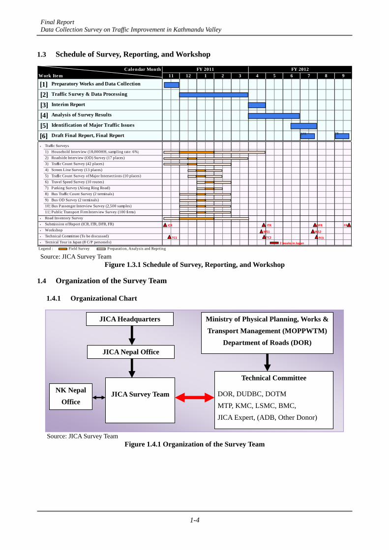
Final Report Data Collection Survey on Traffic Improvement in Kathmandu Valley
1-4
1.3 Schedule of Survey, Reporting, and Workshop
Calendar MonthWork Item
・ Traffic Surveys
1) Household Interview (18,000HH, sampling rate: 6%)
2) Roadside Interview (OD) Survey (17 places)
3) Traffic Count Survey (42 places)
4) Screen Line Survey (13 places)
5) Traffic Count Survey of Major Intersections (10 places)
6) Travel Speed Survey (10 routes)
7) Parking Survey (Along Ring Road)
8) Bus Traffic Count Survey (2 terminals)
9) Bus OD Survey (2 terminals)
10) Bus Passenger Interview Survey (2,500 samples)
11) Public Transport Firm Interview Survey (100 firms)
・ Road Inventory Survey
・ Submission of Report (ICR, ITR, DFR, FR)
・ Workshop
・ Technical Committee (To be discussed)
・ Tecnical Tour in Japan (8 C/P personels)
Legend : Field Survey Preparation, Analysis and Reprting
FY 2011 FY 201212 3
[1] Preparatory Works and Data Collection1 5 72 4 98611
Traffic Survey & Data Processing
[4] Analysis of Survey Results
[6] Draft Final Report, Final Report
[3] Interim Report
[5] Identification of Major Traffic Issues
[2]
WS2WS1
ICR
TC3TC2TC1
ITR FRDFR
2 weeks in Japan
DFR FR
Source: JICA Survey Team
Figure 1.3.1 Schedule of Survey, Reporting, and Workshop
1.4 Organization of the Survey Team
1.4.1 Organizational Chart
Source: JICA Survey Team
Figure 1.4.1 Organization of the Survey Team
JICA Headquarters
JICA Nepal Office
JICA Survey Team
Technical Committee
DOR, DUDBC, DOTM
MTP, KMC, LSMC, BMC,
JICA Expert, (ADB, Other Donor)
Ministry of Physical Planning, Works & Transport Management (MOPPWTM)
Department of Roads (DOR)
NK Nepal Office

Final Report Data Collection Survey on Traffic Improvement in Kathmandu Valley
1-5
1.4.2 JICA Survey Team
The Study Team will include the following members:
1) Mr Hiroki SHINKAI Team Leader/Road Planning 1
2) Mr Yasushi OHWAKI Traffic Survey 1
3) Mr Atsuyuki NAKASEKO Future Demand Forecasting
4) Mr Akio ODAKE Urban Planning/Land Use Planning
5) Mr Hiroaki TAKAHASHI Traffic Survey 2
6) Mr Masahiro TORIU Road Planning 2
1.4.3 Technical Committee
The DOR set up the technical committee for the effective and efficient implementation of the survey under the chairmanship of the Director General of DOR. The committee comprises representatives from the following agencies and organizations:
1) Department of Roads (DOR);
2) Department of Urban Development and Building Construction (DUDBC);
3) Department of Transport Management (DOTM);
4) Metropolitan Traffic Police (MTP);
5) Kathmandu Metropolitan City (KMC);
6) Lalitpur Sub-metropolitan City (LSMC); and
7) Bakhtapur Municipality (BMC).
Final Report Data Collection Survey on Traffic Improvement in Kathmandu Valley
2-1
CHAPTER 2 OVERVIEW OF KATHMANDU VALLEY
2.1 Natural Condition
2.1.1 Topography and Climate
Nepal is a landlocked Himalayan country in South Asia with an area of approximately 147,000 sq km. It is bordered by China in the north and by India in the south, east, and west. The capital city of Nepal is Kathmandu located in the Kathmandu Valley, size of which is about 25 km from east to west and about 20 km from south to north.
Kathmandu Valley is an intermountain oval-shaped basin surrounded by high mountains with approximately 2,000 m in height. It occupies about 650 sq km of area and ranges in an average altitude of about 1300 m above sea level.
The climate condition in Kathmandu Valley is subtropical in nature which is influenced by the south-west monsoon during the summer. It is characterized as a continental climate with a large temperature difference from day to night. The temperature ranges from a minimum of -3 ºC in January to a maximum of 35 ºC in summer from June to August. The temperature in general varies from 19 ºC to 27 ºC in summer and 2 ºC to 20 ºC in winter with an annual average of 75% humidity.
The mean monthly rainfall ranges from 7 mm in November to 364 mm in July. Approximately 80% of the annual rainfall occurs during the monsoon seasons from June to September. The mean annual rainfall is as high as 2,000 mm in surrounding hills but about 1,400 mm in the valley.
The major meteorological rainfall stations are strategically located at 17 different places in the valley, namely Thankot, Godavari, Bhakutapur, Khokana, Sundarijal, Tribhuvan International Airport, and others.
Summary of geographical feature is shown below:
Table 2.1.1 Topography and Climate of Kathmandu Valley
Surrounded by mountains with 2000m in a height
650sqkm. with an average altitude 1300m approx.
9ºC -27ºC in summer
2ºC -20ºC in winter
75% humidity
7mm in November and 364mm in July
Monsoon season from July to September
Mean annual rainfall 2000mm approx.
Geographical Feature of Kathmandu Valley
Topography
Temperature
Rainfall
Source: JICA Survey Team
2.1.2 Geology and Earthquake
(1) Geological Characteristic Geologically, Kathmandu Valley consists of recent alluvial soil (sal) of the Cenzonic Era, Gokarma
Formation of Plio-Pleistocene, Chapagoan Formation, and Kalimati Formation.
Recent alluvial soil consists of temporal sediment of a flood plain and fill terrace. The northern section consists of sand and gravel in the site river rocks. Silt, sand, and gravel can be found at the central and southern section. Density is low and the consistency of the soil is soft and clayey. It is easily eroded, settled, or flooded. The bearing capacity is expected to be poor and will be easily flooded.
Gokarama Formation consists of bright brown gray and dense rectangular silt with poor grain size distribution. Total thickness is 330 m or thicker and the bearing capacity is expected to be between mid to high degree.
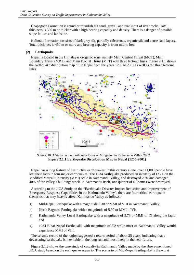
Final Report Data Collection Survey on Traffic Improvement in Kathmandu Valley
2-2
Chapagoan Formation is round or roundish silt sand, gravel, and rare input of river rocks. Total thickness is 300 m or thicker with a high bearing capacity and density. There is a danger of possible slope failure and landslide.
Kalimati Formation consists of dark grey silt, partially calcareous, organic silt and dense sand layers. Total thickness is 450 m or more and bearing capacity is from mid to low.
(2) Earthquake Nepal is located in the Himalayas orogenic zone, namely Main Central Thrust (MCT), Main
Boundary Thrust (MBT), and Main Frontal Thrust (MFT) with three tectonic lines. Figure 2.1.1 shows the earthquake distribution map hit in Nepal from the years 1255 to 2001 as well as the three tectonic lines.
Source: JICA Study on the Earthquake Disaster Mitigation in Kathmandu Valley, 2002
Figure 2.1.1 Earthquake Distribution Map in Nepal (1255-2001)
Nepal has a long history of destructive earthquakes. In this century alone, over 11,000 people have lost their lives in four major earthquakes. The 1934 earthquake produced an intensity of IX-X on the Modified Mercalli Intensity (MMI) scale in Kathmandu Valley, and destroyed 20% and damaged 40% of the valley’s buildings stock. In Kathmandu itself, one quarter of all homes were destroyed.
According to the JICA Study on the “Earthquake Disaster Impact Reduction and Improvement of Emergency Response Capabilities in the Kathmandu Valley”, there are four critical earthquake scenarios that may heavily affect Kathmandu Valley as follows:
1) Mid-Nepal Earthquake with a magnitude 8.30 or MMI of VIII in Kathmandu Valley;
2) North Bagmati Earthquake with a magnitude of 5.99 or MMI of VI;
3) Kathmandu Valley Local Earthquake with a magnitude of 5.73 or MMI of IX along the fault; and
4) 1934 Bihar-Nepal Earthquake with magnitude of 8.2 while most of Kathmandu Valley would experience MMI of VIII.
The seismic record of the region suggested a return period of about 25 years, indicating that a devastating earthquake is inevitable in the long run and most likely in the near future.
Figure 2.1.2 shows the case study of casualty in Kathmandu Valley made by the above-mentioned JICA study based on the earthquake scenario. The scenario of Mid-Nepal Earthquake is the worst
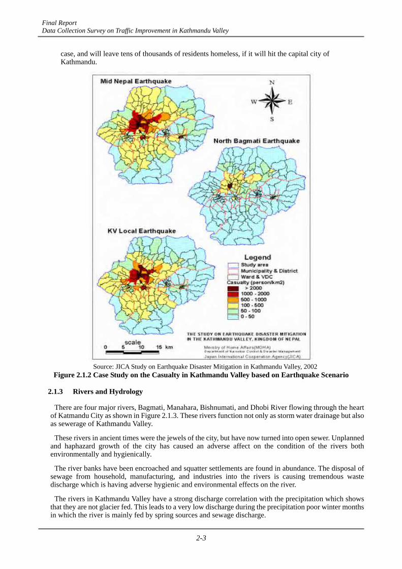
Final Report Data Collection Survey on Traffic Improvement in Kathmandu Valley
2-3
case, and will leave tens of thousands of residents homeless, if it will hit the capital city of Kathmandu.
Source: JICA Study on Earthquake Disaster Mitigation in Kathmandu Valley, 2002
Figure 2.1.2 Case Study on the Casualty in Kathmandu Valley based on Earthquake Scenario
2.1.3 Rivers and Hydrology
There are four major rivers, Bagmati, Manahara, Bishnumati, and Dhobi River flowing through the heart of Katmandu City as shown in Figure 2.1.3. These rivers function not only as storm water drainage but also as sewerage of Kathmandu Valley.
These rivers in ancient times were the jewels of the city, but have now turned into open sewer. Unplanned and haphazard growth of the city has caused an adverse affect on the condition of the rivers both environmentally and hygienically.
The river banks have been encroached and squatter settlements are found in abundance. The disposal of sewage from household, manufacturing, and industries into the rivers is causing tremendous waste discharge which is having adverse hygienic and environmental effects on the river.
The rivers in Kathmandu Valley have a strong discharge correlation with the precipitation which shows that they are not glacier fed. This leads to a very low discharge during the precipitation poor winter months in which the river is mainly fed by spring sources and sewage discharge.

Final Report Data Collection Survey on Traffic Improvement in Kathmandu Valley
2-4
Drainage is also a significant problem in Kathmandu and water backlogging is very common in many areas of the city due to an inadequate and technically unsound drainage system. Both storm water drainage and sewerage has been combined and illegally connected in many places.
Although there are some waste water treatment systems in Kathmandu Valley, these are not functional and as a result, waste water from the drains and sewers were discharged directly into the Bagmati, Manahara, Bishnumati, and Dobhi Khola.
Figure 2.1.3 Drainage System of Kathmandu Valley
2.2 Socio-economic Profile of Kathmandu Valley
2.2.1 Administrative Division of Kathmandu Valley
Kathmandu Valley comprises of three districts namely Kathmandu, Lalitpur, and Bhaktapur and includes five major municipalities: Kathmandu, Lalitpur, Bhaktapur, Kirtipur, and Thimi as shown in the Figure 2.2.1.
However, the area of the three districts together covers an area of 899 sq km, whereas the area of the valley as a whole is 665 sq km. The valley encloses the entire area of Bhaktapur District, 85% of Kathmandu District, and 50% of Lalitpur District.
The three valley districts have a total of 150 local administrative units (Village Development Committees and Municipalities), out of which, five city governments (municipality) have the highest population and economic activities. The Kathmandu Valley, the most important urban concentration in Nepal, possesess basic amenities like water supplies, electricity, gas, telecommunications, roads, sanitation, education security, and transportation.
Kathmandu Metropolitan City is the largest city in Nepal and the cosmopolitan heart of the Himalayan region. With a history and culture dating back 2000 years, the city along with the other towns in the valley, ranks among the oldest human settlements in the central Himalaya.
Old Kathmandu corresponds to the current city core, encompassing a compact zone of temples and narrow streets. The old royal palace complex of Durbar Square is in the center of Old Kathmandu and has been designated as a World Heritage Site by UNESCO.
Source: JICA Survey Team

Final Report Data Collection Survey on Traffic Improvement in Kathmandu Valley
2-5
2010Real GDP Billion NPR 616.2
Billion US$ 8.2Growth Rate % 4.4%
Real GDP per capita NRP 21,864US$ 293
Nominal GDP Billion NPR 1,171.0Billion US$ 15.7
Growth Rate % 14.7%Per-capita Nominal GDP NRP 41,546
US$ $558Inflation (CPI) 9.0%Exchange Rate US$ 74.5DGP by Sector Agriculture % 32.6
Industry % 15.8Services and others % 51.6
Population below Poverty % 24.7
Export (2009) Billon US$ 0.85
Import (2208) Billon US$ 5.26
Paticular
Main Industry (Tourisim, garment, food and beverages,metal manufactures, herbs
Source: ADB Key Indicators 2010, UNDP HumanDevelopment Report 2010
Kathmandu’s culture has been inspired by the convergence of Hindu and Buddhist traditions in traditional customs, festival, art, and literature.
Source: Kathmandu Valley Profile, by Pradip Raj Pant & Devendra Dongol
Figure 2.2.1 Administrative Division of Kathmandu Valley
2.2.2 Economic Profile
The key macro-economy of Nepal in 2010 is shown in Table 2.2.1.
During two decades, nominal GDP rose about ten times, form NPR 111.0 billion to NPR 1,171.0 billion, whereas real GDP increased only by 2.5 times. Per-capita nominal GDP for the year 2010 was NPR 41,546 or USD 558, which rose 7.1 times from the year 1990 as shown in Figure 2.2.2
Inflation ratio ranged from 6% to 10% in the past five years and consumers price index increased from 95.20 in 2005 to 144.73 in 2010 as shown in Figure 2.2.3.
Area of Kathmandu Valley encloses; - 85% of Kathmandu district - 50% of Lalitpur district - 100% of Bhaktapur district
Table 2.2.1 Key Macro-economic Indices

Final Report Data Collection Survey on Traffic Improvement in Kathmandu Valley
2-6
0
200
400
600
800
1000
1200
1400
0.0
200.0
400.0
600.0
800.0
1000.0
1200.0
1400.0
1990 1995 2000 2005 2010
US$
NPR (Billion)
Nominal GDP (NPR)
Real GDP (NPR)
Per‐capita Nominal GDP (US$)
Source: IMF-World Economic Outlook (2011.9)
Figure 2.2.2 Economic Growth Rate of Nepal
0
5
10
15
20
25
Inflation (%)
Inflation Ratio
0
20
40
60
80
100
120
140
160Index
Consumers Price Index
Source: IMF-World Economic Outlook (2011.9)
Figure 2.2.3 Inflation Ratio and Consumers Price Index in the Past 20 Years
2.2.3 Population Growth
(1) Population Census 2011 The national population census was conducted by the Central Bureau of Statistics in 2011 last year
and was published as the preliminary results of the National Population Census 2011.
Table 2.2.2 shows the population status of the whole country of Nepal.

Final Report Data Collection Survey on Traffic Improvement in Kathmandu Valley
2-7
Table 2.2.2 Population Census of Nepal Increase Ratio
147,000 147,000 2011/2001
Total 23,151,423 26,620,809 15.0%
Urban 3,227,879 13.9% 4,525,787 17.0% 40.2%
Rural 19,923,544 86.1% 22,095,022 83.0% 10.9%
Average 157 181 15.3%
Urban 985 1,380 40.1%
Rural 138 153 10.9%
Average 2.25% 1.40%
Urban 6.65% 3.38%
Rural 1.72% 1.03%
Sex Ratio of Male per 100 Female 99.8 94.4
Total 762,181 1,917,903 151.6%
Male 679,469 89.1% 1,663,237 86.7% 144.8%
Female 82,712 10.9% 254,666 13.3% 207.9%
Housing Unit No. 3,598,212 4,767,196 32.5%
Households No. 4,253,220 5,659,984 33.1%
Average Household Size person 5.44 4.70
Source: Preliminary Results of National Population and Housing Census 2011
Particulars 2001 Census 2011 Census
Average Annual GrowthRate in past 10 years
Population (person)
Population Density persq.km
Population Absent (aboard)
Area (sq.km)
Highlights of the preliminary results reported in the census are as follows:
1) Population of Nepal as of the census day, June 2011 recorded to 26.6 million. Total addition in the population of Nepal during last ten years was recorded as 3.45 million with an average growth of 1.40 %;
2) Population density of Nepal was estimated to be 181 per sq km. Kathmandu District has the highest density (4407) and Manang has the least (only 3);
3) Kathmandu has recorded the highest decadal population growth (60.93%) compared to the entire Nepal (14.99%) and lowest in Manang (-31.92%);
4) Terai constituted 50.1% of the population while hill constituted 43.1% and mountain 6.8%;
5) The Central Development Region recorded th highest population (36.5%) and Far Western Development Region recorded the lowest (9.6%);
6) Sex ratio was estimated to be 94% (male per hundred females) in the current census as compared to 99.8% in the previous census 2001;
7) Average household size has decreased from 5.4 in 2001 to 4.7 in 2011. The household size was recorded to be highest in Rautahat (6.33) and lowest (3.71) in Kathmandu;
8) Absent population of Nepal was recorded as 1.92 million against 0.76 million in 2001; and
9) About 4.5 million (17% of the total population) lived in urban areas and the average population density in urban areas in Nepal was 1380 persons per sq km compared to 153 persons per sq km for rural areas.
(2) Population Situation of Kathmandu Valley The JICA Survey Team has analyzed the population situation of Kathmandu Valley based on the
national population census of 1991, 2001 as well as 2011. Figure 2.2.4 shows the growth rate of population by district of Kathmandu Valley.

Final Report Data Collection Survey on Traffic Improvement in Kathmandu Valley
2-8
Figure 2.2.4 Population Growth of Kathmandu Valley by District
Table 2.2.3 shows the population situation of Kathmandu Valley by district and the summary of the analysis and highlights of the results are described as shown below:
Table 2.2.3 Population Census of Kathmandu Valley in 2011 Particulars
area % area % area % area %Total 395 43.9% 119 13.2% 385 42.8% 899 (100%)Urban 69 17.5% 18 15.1% 15 3.9% 102 11.3%Rural 342 82.5% 52 84.9% 370 96.1% 764 88.7%Total 1,740,977 69.3% 303,027 12.1% 466,784 18.6% 2,510,788 (100%)Urban 1,072,726 61.6% 168,152 55.5% 223,285 47.8% 1,464,164 58.3%Rural 668,251 38.4% 134,875 44.5% 243,499 52.2% 1,046,626 41.7%
Total 4,407 2,546 1,212 3,184 (average)
Urban 15,547 9,342 14,886 14,355 (average)Rural 1,954 2,594 658 1,370 (average)Total 4.87% 3.00% 3.28% 4.32% (average)Urban 4.17% 3.41% 3.17% 3.92% (average)Rural 6.11% 2.52% 3.37% 4.89% (average)
Sex Ratio of Male per 100 Female 109 103 103 106 (average)Total 97,626 7,701 23,790 129,117 (total)Male 69,434 71.1% 7,588 98.5% 16,936 71.2% 93,960 72.8%
Female 28,192 28.9% 113 1.5% 6,854 28.8% 35,159 27.2%Housing Unit No. 242,274 66.1% 50,586 13.8% 73,643 20.1% 366,503 (total)Households No. 469,145 71.4% 73,084 11.1% 114,443 17.4% 656,672 (total)Average Household Size person 3.71 4.15 4.08 3.94 (average)Source: Preliminary Results of National Population and Housing Census 2011Note: Urban area includes five (5) municipalities, Kathmandu, Kirtipur, Lalitpur, Bhaktapur, Thimi
Lalitpur DistrictBhaktapur DistrictKathmandu District
Population Density(person/km2)
Population (person)
Area (km2)
Average Annual Growth Rate(past 10 years)
Population Absent (aboard)
Kathmandu Valley
0
200,000
400,000
600,000
800,000
1,000,000
1,200,000
1,400,000
1,600,000
1,800,000
2,000,000
Total Urban Area
Rural Area
Total Urban Area
Rural Area
Total Urban Area
Rural Area
Kathmandu District Bhakutapur District Lalitpur District
Population Growth of Kathmandu Valley
1991Census
2001Census
2011Census
Source: National Population Census 1991, 2001 and 2011

Final Report Data Collection Survey on Traffic Improvement in Kathmandu Valley
2-9
1) Population of Kathmandu Valley and Each District
The population of Kathmandu District constituted 69.3% of population while Bhaktapur District constituted 12.1%, and Lalitpur District 18.6%.
2) Population Density
The population density of Kathmandu Valley was estimated to be 3,186 persons per sq km. The urban areas of Kathmandu and Lalitpur municipalities have the high density of 15,547 and 14,886 respectively. The urban density of 14,355 persons per sq km in Kathmandu Valley is more than ten times the density of rural areas of 1,370 persons per sq km.
It is said that, in many areas of Kathmandu, the population density exceeded 40,000 to 45,000 persons per sq km and at the core of Kathmandu, the density exceeded 80,000 sq km.
3) Annual Population Growth in the Past Ten years
The population growth rate of the whole Kathmandu Valley was 4.32%. It became clear that the growth rate of rural area was bigger than that of the urban area in the Kathmandu Valley. The main cause was that the population of rural area in Kathmandu District has increased remarkably with a growth rate of 6.11 % in the past ten years. The other three districts showed a moderate increase in both urban and rural population growth.
4) Sex Ratio (male per hundred females)
The average sex ratio in Kathmandu Valley was estimated to be 106%. Kathmandu District has 109, whereas, Bhaktapur and Lalitpur were 103 and 103 respectively.
5) Absent population
The absent population of Kathmandu Valley was recorded as 129,000 out of which 72% is male and rest is female.
6) Number of house units, Households, and Size of Household
The average household size in Kathmandu Valley was recorded to be 3.94 and Kathmandu District was lowest with 3.71.
2.2.4 Social Conditions and Environmental Issues
(1) Social Conditions 1) History, Religion, and People
Kathmandu, the center of Nepal and often called “The City of Gods”, has a history of over 2000 years. Records stated that the Newaris have settled here, whose descendants are still found. Kathmandu entered as the official capital again in 1768, when the King of Gorkha united Kathmandu Valley and moved the capital to Kathmandu. Kathmandu has been the capital of Nepal since then.
There are more than 70 different minorities in Nepal and the population is about 26.6 million. As there are numerous minorities, the language also varies, verging on 70 different kinds. According to the 2001 Census, 80% of the entire population were Hindus, 15% were Buddhists, and 3% were Muslims. The rest of the religious accounted 2% of the population.
The distribution of different races and people reflects the diversity of the topography. The majority of the population consists of Indo-Arians, and the rest include Tibetans such as Sherpas, Dolpas, and Lopas in North, Newars, Tamang, Rais, Limbus, Suwars, etc., in the central region and Tharu Rajbangsu and others in the southern Terai.
The caste system in Nepal’s Hindu religion consists of the four tiers of Brahman, Chhetris, Vaiya, and Sudra. The surname of Hindu caste reflects occupation or regionality, and the most prevalent surnames in the east and central regions are Goutam, Sharma, Regmi, Acharya, Nepal, Upadhyay, Adhikhari, Bhandari Aryal, and Paudyal, whereas, the ones in the west are Pant, Joshi, Bistha, Bhatta, Pandey, Awastthi, Lohani, Oli, etc.
Final Report Data Collection Survey on Traffic Improvement in Kathmandu Valley
2-10
2) Culture
The ancient and refined traditional culture of Kathmandu is an uninterrupted and exceptional meeting of the Hindu and Buddhist ethos practiced by its highly religious people. The city core has the most remarkable cultural wealth that evolved during the reign of the Malla (Nepal) kings between the 15th and 18th centuries. The city was filled with sculptures, pagodas, stupas, and palace buildings of exceptional beauty.
Though the valley embraces most of Nepal’s ethnic group, Newars are the indigenous inhabitants and the creator of most of its cultural traditions. The variety of festivals such as the Ghode (horse) jatra, India jatra, Dasai DurgaPuja festivals, Shivratri, and many more are observed by all Hindu and Buddhist communities of Kathmandu with great devotional fervor and enthusiasm.
Cultural communities has been maintained for centuries from ancient to modern period in the exclusive worship of goddesses and deities and so forth in Kathmandu and the rest of the country.
(2) Environmental Issues of Kathmandu Valley The Kathmandu, the center of administration, industrial, commercial, social, and economic activities,
is the mostly densed populated region in Nepal and its population has been increasing rapidly during the past two decades. It is considered to be the engine of growth since the planned urban development will result in the overall economic development of the nation.
The rapid unplanned and haphazard urbanization of the Kathmandu Valley caused by the informal process of settlement development in the past has brought about several physical, social, and environmental problems in Kathmandu Valley. The fragile Kathmandu Valley eco-system is severely affected by the ever-expanding urban development and incompatible economic activities.
Some of the most visible consequences of the haphazard development are shown below:
1) River Pollution:
In most places of Kathmandu Valley, storm water drainage and sewerage have been combined and the four major rivers, Bagmati, Manahara, Bishnumati, and Dhobi Khola, have now turned into open sewer. The city is becoming an example of a terribly polluted city with open sewers and unhygienic disposal of waste leading to the pollution of all the existing rivers in Kathmandu.
2) Air Pollution:
Increase of vehicles, unplanned settlements, and conflicting land uses lead to air pollution caused by emissions from vehicles plying along narrow and winding roads and city streets. To reduce air pollution, the government has to take necessary actions such as the introduction of electronic vehicles, the control of smoke emissions from factories, etc.
3) Solid Waste Disposal:
Illegal dumping of waste in the areas like riverbanks, public land, and unplanned settlement is very common. Those areas are either not served by the municipal solid waste collection system or the community is not organized to handle the problem.
4) Traffic Congestions:
Inadequate road network and inefficient transport management system are creating severe traffic congestion during peak commuting periods in the city. Public transport cannot operate effectively in and outside the city areas.
5) Loss of Cultural Heritage:
The cultural heritage of the Kathmandu Valley is gradually eroding and historic ponds, courtyards, public places, and playing fields are being converted into public buildings and private properties.
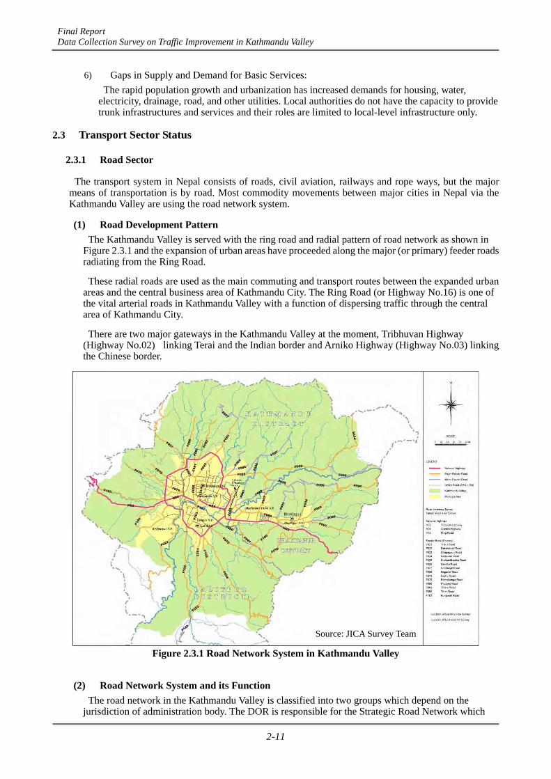
Final Report Data Collection Survey on Traffic Improvement in Kathmandu Valley
2-11
6) Gaps in Supply and Demand for Basic Services:
The rapid population growth and urbanization has increased demands for housing, water, electricity, drainage, road, and other utilities. Local authorities do not have the capacity to provide trunk infrastructures and services and their roles are limited to local-level infrastructure only.
2.3 Transport Sector Status
2.3.1 Road Sector
The transport system in Nepal consists of roads, civil aviation, railways and rope ways, but the major means of transportation is by road. Most commodity movements between major cities in Nepal via the Kathmandu Valley are using the road network system.
(1) Road Development Pattern The Kathmandu Valley is served with the ring road and radial pattern of road network as shown in
Figure 2.3.1 and the expansion of urban areas have proceeded along the major (or primary) feeder roads radiating from the Ring Road.
These radial roads are used as the main commuting and transport routes between the expanded urban areas and the central business area of Kathmandu City. The Ring Road (or Highway No.16) is one of the vital arterial roads in Kathmandu Valley with a function of dispersing traffic through the central area of Kathmandu City.
There are two major gateways in the Kathmandu Valley at the moment, Tribhuvan Highway (Highway No.02) linking Terai and the Indian border and Arniko Highway (Highway No.03) linking the Chinese border.
Figure 2.3.1 Road Network System in Kathmandu Valley
(2) Road Network System and its Function The road network in the Kathmandu Valley is classified into two groups which depend on the
jurisdiction of administration body. The DOR is responsible for the Strategic Road Network which
Source: JICA Survey Team
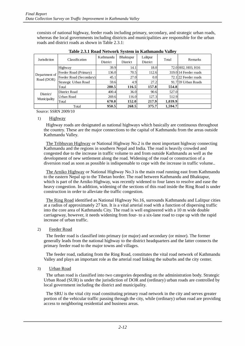
Final Report Data Collection Survey on Traffic Improvement in Kathmandu Valley
2-12
consists of national highway, feeder roads including primary, secondary, and strategic urban roads, whereas the local governments including districts and municipalities are responsible for the urban roads and district roads as shown in Table 2.3.1:
Table 2.3.1 Road Network System in Kathmandu Valley
Jurisdiction ClassificationKathmandu
DistrictBhaktapur
DistrictLalitpurDistrict
Total Remarks
Highway 39.9 14.1 18.0 72.0 H02, H03, H16Feeder Road (Primary) 136.0 70.5 112.6 319.0 14 Feeder roadsFeeder Road (Secondary) 45.1 27.0 0.0 72.1 22 Feeder roadsStrategic Urban Road 59.6 4.9 27.2 91.7 59 Urban RoadsTotal 280.5 116.5 157.8 554.8District Road 400.4 36.0 90.6 527.0Urban Road 269.6 116.0 127.3 512.9Total 670.0 152.0 217.9 1,039.9
Total 950.5 268.5 375.7 1,594.7
Department ofRoad (DOR)
District/Municipality
Source: SSRN 2009/10
1) Highway
Highway roads are designated as national highways which basically are continuous throughout the country. These are the major connections to the capital of Kathmandu from the areas outside Kathmandu Valley.
The Tribhuvan Highway or National Highway No.2 is the most important highway connecting Kathmandu and the regions in southern Nepal and India. The road is heavily crowded and congested due to the increase in traffic volume to and from outside Kathmandu as well as the development of new settlement along the road. Widening of the road or construction of a diversion road as soon as possible is indispensable to cope with the increase in traffic volume..
The Arniko Highway or National Highway No.3 is the main road running east from Kathmandu to the eastern Nepal up to the Tibetan border. The road between Kathmandu and Bhaktapur, which is part of the Arniko Highway, was recently widened to four lanes to resolve and ease the heavy congestion. In addition, widening of the sections of this road inside the Ring Road is under construction in order to alleviate the traffic congestion.
The Ring Road identified as National Highway No.16, surrounds Kathmandu and Lalitpur cities at a radius of approximately 27 km. It is a vital arterial road with a function of dispersing traffic into the core area of Kathmandu City. The road is well engineered with a 10 m wide double carriageway, however, it needs widening from four- to a six-lane road to cope up with the rapid increase of urban traffic.
2) Feeder Road
The feeder road is classified into primary (or major) and secondary (or minor). The former generally leads from the national highway to the district headquarters and the latter connects the primary feeder road to the major towns and villages.
The feeder road, radiating from the Ring Road, constitutes the vital road network of Kathmandu Valley and plays an important role as the arterial road linking the suburbs and the city center.
3) Urban Road
The urban road is classified into two categories depending on the administration body. Strategic Urban Road (SUR) is under the jurisdiction of DOR and (ordinary) urban roads are controlled by local government including the district and municipality.
The SRU is the vital city road constituting primary road network in the city and serves greater portion of the vehicular traffic passing through the city, while (ordinary) urban road are providing access to neighboring residential and business areas.
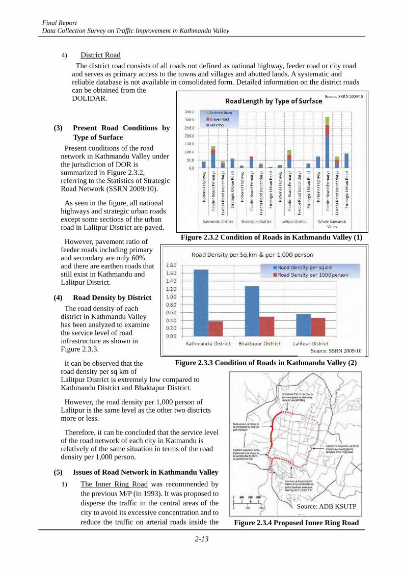
Final Report Data Collection Survey on Traffic Improvement in Kathmandu Valley
2-13
4) District Road
The district road consists of all roads not defined as national highway, feeder road or city road and serves as primary access to the towns and villages and abutted lands. A systematic and reliable database is not available in consolidated form. Detailed information on the district roads can be obtained from the DOLIDAR.
(3) Present Road Conditions by Type of Surface
Present conditions of the road network in Kathmandu Valley under the jurisdiction of DOR is summarized in Figure 2.3.2, referring to the Statistics of Strategic Road Network (SSRN 2009/10).
As seen in the figure, all national highways and strategic urban roads except some sections of the urban road in Lalitpur District are paved.
However, pavement ratio of feeder roads including primary and secondary are only 60% and there are earthen roads that still exist in Kathmandu and Lalitpur District.
(4) Road Density by District The road density of each
district in Kathmandu Valley has been analyzed to examine the service level of road infrastructure as shown in Figure 2.3.3.
It can be observed that the road density per sq km of Lalitpur District is extremely low compared to Kathmandu District and Bhaktapur District.
However, the road density per 1,000 person of Lalitpur is the same level as the other two districts more or less.
Therefore, it can be concluded that the service level of the road network of each city in Katmandu is relatively of the same situation in terms of the road density per 1,000 person.
(5) Issues of Road Network in Kathmandu Valley 1) The Inner Ring Road was recommended by
the previous M/P (in 1993). It was proposed to disperse the traffic in the central areas of the city to avoid its excessive concentration and to reduce the traffic on arterial roads inside the
Figure 2.3.2 Condition of Roads in Kathmandu Valley (1)
Source: SSRN 2009/10
Figure 2.3.3 Condition of Roads in Kathmandu Valley (2)
Source: SSRN 2009/10
Source: ADB KSUTP
Figure 2.3.4 Proposed Inner Ring Road

Final Report Data Collection Survey on Traffic Improvement in Kathmandu Valley
2-14
Ring Road. The proposed route of Inner Ring Road is shown in Figure 2.3.4. It consists of the Bishnumati Link which will be implemented under the program of ADB’s KSUTP, the Southern Link along Bagmati River to be constructed by DOR, the Dhobi Khola Link under improvement by DOR and the North Link to be investigated.
2) The Inner Ring Road becomes the most effective road to solve the serious traffic congestion inside the Ring Road, therefore, early implementation of the Inner Ring Road with a high design standard is expected.
3) To cope up with the future traffic demand, the Inner Ring Road should be examined, studied and considered as the most important urban road with sufficient traffic capacity having flyovers at the major intersections or as an elevated expressway.
4) River crossing capacity is too small to meet the increasing traffic demand in Kathmandu City. The number of bridges across the existing rivers, such as Bagmati, Bishunumati, and Dhobi Khola, are insufficient and most of the existing bridges are old and narrow with a small traffic capacity. These bridges create bottlenecks that block traffic to the city.
5) Traffic capacities of intersections on major roads are insufficient and seriously obstruct the smooth traffic flow in the city. A grade separation on these intersections is an urgent issue on the traffic of the Kathmandu Valley.
6) Improvement of feeder road is an urgent issue to the development of the Kathmandu Valley corresponding to the expansion of urban area with the rapid increase of population. Appropriate upgrading or widening due to the increase of traffic demand is indispensable to provide the population with adequate transportation service.
7) Evacuation roads against the expected earthquake in the near future in Kathmandu Valley are not properly provided to the inhabitants. The city road of Katmandu does not have that function as the evacuation road for earthquakes. Most of the roads are narrow and winding which are not adequate enough to safely evacuate the people and lead them outside the Ring Road at the time of the earthquake.
8) Furthermore, these evacuation roads may be disturbed by the rivers of Bagmati, Bishunumai, and Dhobi Khola, because these roads do not have enough number of bridges and sufficient capacities. There would be several possible solutions for the earthquake, however, one recommended plan is to cover the Bisunumati and Dobhi Khola with the cap made of concrete or box culvert and builds the road on the cap with sufficient width to evacuate the people outside the city.
2.3.2 Vehicles Registered
There are approximately 1,178,000 vehicles registered in the whole country of Nepal and Bagmati zones and out of the 14 zones accounted for an almost half of the total vehicle registered in Nepal as shown in Table 2.3.2.
Table 2.3.2 Numbers of Vehicles Registered in Nepal
Source: Details of Registration of Trnasport up to Fiscal Year 2010, Department of Transport Management
Number of vehicles
registered
(1989-2010) 48.4% 22.4% 29.3% 100%
570,145 263,815 344,835 1,178,795
Whole CountryOther 12 ZonesNarayani ZoneBagmati Zone
The number of vehicles registered is rapidly increasing in Kathmandu particularly in the recent five years accompanied by the rapid increase of urban population and economic development.
Table 2.3.3 shows the total number of vehicles registered until 2010 in Bagmati Zone with the following
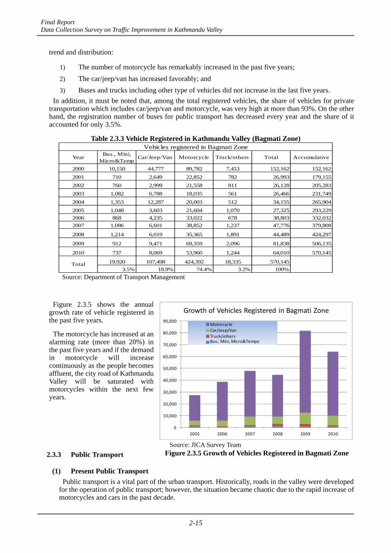
Final Report Data Collection Survey on Traffic Improvement in Kathmandu Valley
2-15
trend and distribution:
1) The number of motorcycle has remarkably increased in the past five years;
2) The car/jeep/van has increased favorably; and
3) Buses and trucks including other type of vehicles did not increase in the last five years.
In addition, it must be noted that, among the total registered vehicles, the share of vehicles for private transportation which includes car/jeep/van and motorcycle, was very high at more than 93%. On the other hand, the registration number of buses for public transport has decreased every year and the share of it accounted for only 3.5%.
Table 2.3.3 Vehicle Registered in Kathmandu Valley (Bagmati Zone)
YearBus、Mini,
Micro&TempCar/Jeep/Van Motorcycle Truck/others Total Accumulative
2000 10,150 44,777 89,782 7,453 152,162 152,162
2001 710 2,649 22,852 782 26,993 179,155
2002 760 2,999 21,558 811 26,128 205,283
2003 1,082 6,788 18,035 561 26,466 231,749
2004 1,353 12,287 20,003 512 34,155 265,904
2005 1,048 3,603 21,604 1,070 27,325 293,229
2006 868 4,235 33,022 678 38,803 332,032
2007 1,086 6,601 38,852 1,237 47,776 379,808
2008 1,214 6,019 35,365 1,891 44,489 424,297
2009 912 9,471 69,359 2,096 81,838 506,135
2010 737 8,069 53,960 1,244 64,010 570,145
19,920 107,498 424,392 18,335 570,145
3.5% 18.9% 74.4% 3.2% 100%Total
Vehicles registered in Bagmati Zone
Source: Department of Transport Management
Figure 2.3.5 shows the annual growth rate of vehicle registered in the past five years.
The motorcycle has increased at an alarming rate (more than 20%) in the past five years and if the demand in motorcycle will increase continuously as the people becomes affluent, the city road of Kathmandu Valley will be saturated with motorcycles within the next few years.
2.3.3 Public Transport
(1) Present Public Transport Public transport is a vital part of the urban transport. Historically, roads in the valley were developed
for the operation of public transport; however, the situation became chaotic due to the rapid increase of motorcycles and cars in the past decade.
Source: JICA Survey Team Figure 2.3.5 Growth of Vehicles Registered in Bagmati Zone
0
10,000
20,000
30,000
40,000
50,000
60,000
70,000
80,000
90,000
2005 2006 2007 2008 2009 2010
Growth of Vehicles Registered in Bagmati Zone
Motorcycle
Car/Jeep/Van
Truck/othersBus、Mini, Micro&Tempo
Final Report Data Collection Survey on Traffic Improvement in Kathmandu Valley
2-16
At present, public transport is operated by buses, mini buses, micro buses, and tempos in the valley, however, the services provided by these public transports were far below the satisfactory level. Over-crowding, left-of-passengers, and malfunction of fleets are the daily events and the vehicles used for the public transport are usually old and the total number is not sufficient.
The growing demand for public transport accompanied by the increase of population and economic development will bring about a number of problems in the transportation system and people cannot use any mode of transportation in the valley due to the poor operation of bus services including insufficient numbers of buses.
(2) Public Transport by Bus Network Services Since there is no railway system in the valley at all, public transportation in Kathmandu Valley has
been provided with buses and minibuses on major roads, micro buses, and tempo network on secondary roads. These bus services are normally operated by private bus companies.
At present, there are three categories of bus services in the Kathmandu Valley as follows:
1) City bus service which operates the service within the built-up areas or core areas of Kathmandu Valley, generally within the Ring Road;
2) Commuter bus service which operates the service of 1.0 hour to 1.5 hours travel distance beyond the build-up area to towns and villages mostly within the Kathmandu Valley, such as Bakhutapur, Thimi, Kirtipur, Nagarkot, Godawari, Dakshinkali, and other important towns; and
3) Long distance bus service which operates the service to connect Kathmandu and the cities and towns throughout Nepal. The bus terminal of long distance service is located on the north-west section of the Ring Road.
Both city bus service and commuter bus service are very complicated and most of these routes end in the central area of the city, which regularly results in chaotic traffic jams in the city roads.
The Kathmandu Sustainable Urban Transport Project (KSUTP) prepared by ADB in 2009 proposed that the urban bus route network should be designated with a hierarchy of routes as follows:
- Primary route;
- Secondary route; and
- Tertiary route.
The KSUTP suggested that every type of routes shall be operated by the most appropriate type of buses, wherever possible, the small buses and mini buses will be replaced by fewer or larger buses based on the policy that a vehicle used on each route will be of maximum size and can be safely operated on the road.
It is said that this will have two benefits. First, the number of public transport vehicles on the city roads will be substantially reduced, with corresponding reductions in the level of congestion and exhaust emission. Second, the transportation cost per passenger for a larger fleet will be lower than that of smaller vehicles carrying the same number of passengers.
(3) Issues of Bus Services Level The service level, in general, is very low as against growing demand by users in the following points:
1) Absolute shortage in fleet numbers;
2) Fleets in use are obsolete and prone to break down during the service;
3) The service routes are not always provided with sufficient number of buses, keeping imbalance with the size of demand;
4) Bus stops are not located systematically by the different companies and there is no coordination among the companies;
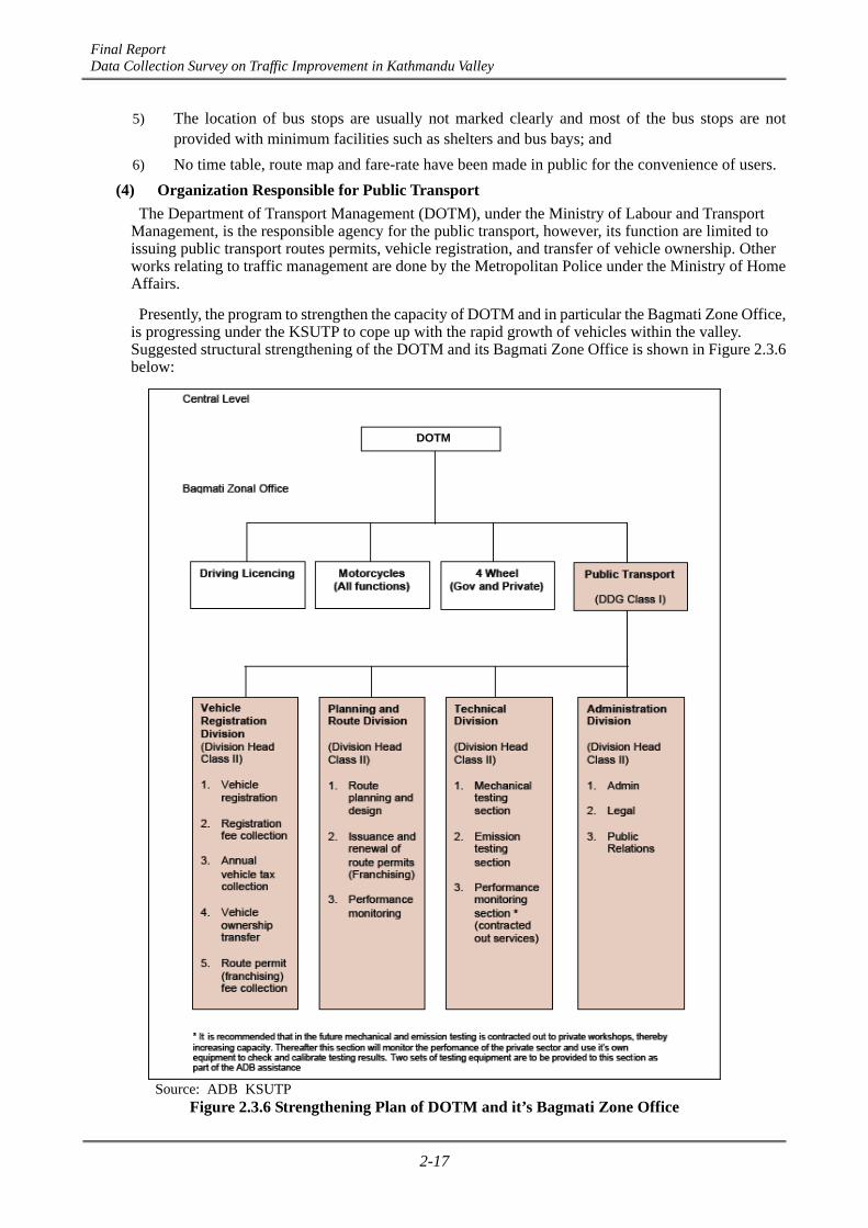
Final Report Data Collection Survey on Traffic Improvement in Kathmandu Valley
2-17
5) The location of bus stops are usually not marked clearly and most of the bus stops are not provided with minimum facilities such as shelters and bus bays; and
6) No time table, route map and fare-rate have been made in public for the convenience of users.
(4) Organization Responsible for Public Transport The Department of Transport Management (DOTM), under the Ministry of Labour and Transport
Management, is the responsible agency for the public transport, however, its function are limited to issuing public transport routes permits, vehicle registration, and transfer of vehicle ownership. Other works relating to traffic management are done by the Metropolitan Police under the Ministry of Home Affairs.
Presently, the program to strengthen the capacity of DOTM and in particular the Bagmati Zone Office, is progressing under the KSUTP to cope up with the rapid growth of vehicles within the valley. Suggested structural strengthening of the DOTM and its Bagmati Zone Office is shown in Figure 2.3.6 below:
Source: ADB KSUTP
Figure 2.3.6 Strengthening Plan of DOTM and it’s Bagmati Zone Office
DOTM

Final Report Data Collection Survey on Traffic Improvement in Kathmandu Valley
3-1
CHAPTER 3 ROAD DEVELOPMENT POLICY AND EXISTING PLANS
3.1 Latest Policy of Road Development
3.1.1 Twenty-Year Road Plan
Based on 9th Five-Year Plan including the long-term development goal by formulating the 20-Year Development Concept from the 10th Plan to 13th Plan, the 20-Year Road Plan was published in 2001 to develop the Strategic Road Network (SRN) by DOR. The planned future status of SRN is 4,040 km extension of total length to reach 9,206 km in the whole country. The major four objectives of this plan are as follows;
1) Strengthening of political and administrative linkages;
2) Poverty alleviation;
3) Development and utilization of social, economic, and cultural potentials; and
4) Minimisation of the total transportation cost and the adverse effect on the environment.
3.1.2 Sector-wide Road Programme and Priority Investment Plan
The study was conducted in two major parts by DOR: Part I was the overall planning study and Part II involved the detailed feasibility study of approximately 800 km of high priority road improvement. The study was carried out with funding support from the World Bank/International Development Association Loan, over a 18-month period commencing in September 2005.
The study was primarily concerned with the maintenance and development of the SRN. The objective of the study was the preparation of a 10-year Priority Investment Plan (2007-2016) (PIP) for the SRN, including recommendations for its expansion and improvement. The contents of PIP comprised the following three main tasks:
1) Regular annual maintenance and periodic maintenance plan;
2) Upgrading to sealed standards plan; and
3) Expansion/extension plan by new construction, network strengthening, and improvement.
3.1.3 Business Plan
After the two primal national plans, the 20-Year Road Plan published in 2001 which envisioned the development of the SRN (2002-2021) and PIP approved in 2007 as a form of 10-year priority investment plan (2007-2016), the Business Plan was published in 2010 which is the latest activated plan by DOR. This plan is based on the performance evaluation of Three-Year Interim Plan-I (2007-2010) (TYIP-I) and covering the plan period of Three-Year Interim Plan-II (2010-2013) (TYIP-II), and it seeks to present clearly and concisely the DOR vision for the road sector such as the goals and outcomes to be achieved. The overall goal of this plan is the development of SRN to provide sustainable and efficient road service by managing the main arteries of the road network, links to rural roads and connectivity to potential tourism, hydropower and natural resources development areas, and the area along international trade routes. It also intends to contribute towards the betterment of the living conditions of the people through effective, efficient, safe, and reliable road connectivity.

Final Report Data Collection Survey on Traffic Improvement in Kathmandu Valley
3-2
3.2 Road Network Development Plan in the Previous M/P (in 1993) and Subsequent Progress
3.2.1 Development Concept of the Previous M/P (in 1993)
The JICA M/P “Kathmandu Urban Road Development” was conducted in 1993 aiming at the formulation of the M/P of urban road network for Kathmandu Valley with a target year of 2015. The basic concepts employed for the road development, the major development plan, and the projects proposed in the previous M/P (in 1993) are as follows:
(1) To strengthen the east-west transportation corridor as an alignment of the capital of the Kathmandu Valley.
1) Construction of Arniko Bypass (Kathmandu-Bhaktapur)
2) Construction of 2nd Tribuvan Highway
(2) To build an efficient road network system inside the Ring Road to streamline the traffic in central areas.
1) Development of Inner Ring Road
The Inner Ring Road was proposed to promote the urban development inside the Ring Road as well as to disperse the traffic in the central areas of the city. It was recommended to apply the following stages of construction:
- 1st Stage (Short-term) : Completion of the construction of a 2-lane road
- 2nd stage (Long-term) : Widening into a 4-lane road
(3) To strengthen the feeder road network to promote a well-balanced urban development and to provide an efficient transportation network in newly developed areas shifting outward.
1) Eight feeder roads which are used as the main bus routes were proposed to be upgraded to accommodate the increasing traffic demand
2) Development of the Outer Ring Road
3) Development of the Thimi North-South Ladder Step Roads
(4) To dissolve the bottleneck points of the city road network. 1) Widening of Bagmati Bridge at Kupanddol to increase river crossing capacity over Bagmati
River
2) Improvement of road connecting Nayabazar to the bus terminal in Balaju
3) Widening of Kantipath Road (F025) and Thapatari-Patan Road (F103), etc.
Figure 3.2.1 shows the Road Network Plan proposed by the previous M/P (in 1993).

Final Report Data Collection Survey on Traffic Improvement in Kathmandu Valley
3-3
Source: JICA Survey Team
Figure 3.2.1 Proposed Road Network System in Previous M/P (in 1993)
3.2.2 Implemented Projects after the Previous M/P (in 1993)
The implemented projects after the previous M/P (in 1993) are presented in Figure 3.2.2.
Source: JICA Survey Team
Figure 3.2.2 Implemented Projects after the Previous M/P (in 1993)

Final Report Data Collection Survey on Traffic Improvement in Kathmandu Valley
3-4
3.3 On-going Major Road Improvement Project
3.3.1 Bhaktapur–Dhulikel Road Widening Project
The need for the immediate improvement of the corridor between Kathmandu and Terai was indicated in the 20-Year Road Plan of 2002 and the condition of the traffic congestion plying in this corridor have been considered not only in the 20-Year Road Plan but also in the PIP and Business Plan such as the bypass of Bagmati Corridor, Kathmandu-Terai Tunnel Fast Track, etc.
The Bhaktapur-Dhulikel Road Widening Project was planned by DOR to mitigate the amount of vehicles plying the route of Kathmandu-Naubise-Birgunj as an alternative route with the widening of the existing road between Kathmandu-Bhaktapur Road and the construction project of Bardibas-Dhulikel Road under the funding of JICA.
Based on the above mentioned project background, the Detailed Engineering Survey and Design of the Widening of Roads to Six-Lane Standard including initial environmental examination, preparation of contract documents for execution of construction works, and the preparation of detailed project report were completed on 2011 under the administration of DOR. The construction period will commence within several years. The planned typical cross-section of the road is shown in Figure 3.3.1 below.
Source: Detailed Design of Upgrading/Widening of Roads to Six-Lane Standard Arniko Lokmarg (Suryabinayak-Dhulikhel Section) by Full Bright Consultancy (Pvt.) Ltd.
Figure 3.3.1 Typical Cross-section Planned in the Detailed Design on 2011 Administered by DOR
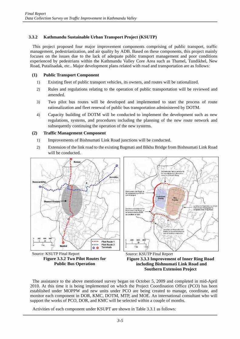
Final Report Data Collection Survey on Traffic Improvement in Kathmandu Valley
3-5
3.3.2 Kathmandu Sustainable Urban Transport Project (KSUTP)
This project proposed four major improvement components comprising of public transport, traffic management, pedestrianization, and air quality by ADB. Based on these components, this project mainly focuses on the issues due to the lack of adequate public transport management and poor conditions experienced by pedestrians within the Kathmandu Valley Core Area such as Thamel, Tundikhel, New Road, Putalisadak, etc.. Major development plans related with road and transportation are as follows:
(1) Public Transport Component 1) Existing fleet of public transport vehicles, its owners, and routes will be rationalized.
2) Rules and regulations relating to the operation of public transportation will be reviewed and amended.
3) Two pilot bus routes will be developed and implemented to start the process of route rationalization and fleet renewal of public bus transportation administered by DOTM.
4) Capacity building of DOTM will be conducted to implement the development such as new regulations, systems, and procedures including the planning of the new route network and subsequently continuing the operation of the new systems.
(2) Traffic Management Component 1) Improvements of Bishnumati Link Road junctions will be conducted.
2) Extension of the link road to the existing Bagmati and Blkhu Bridge from Bishnumati Link Road will be conducted.
Source: KSUTP Final Report Figure 3.3.2 Two Pilot Routes for
Public Bus Operation
Source: KSUTP Final Report Figure 3.3.3 Improvement of Inner Ring Road
including Bishnumati Link Road and Southern Extension Project
The assistance to the above mentioned survey began on October 5, 2009 and completed in mid-April
2010. At this time it is being implemented on which the Project Coordination Office (PCO) has been established under MOPPW and new units under PCO are being created to manage, coordinate, and monitor each component in DOR, KMC, DOTM, MTP, and MOE. An international consultant who will support the works of PCO, DOR, and KMC will be selected within a couple of months.
Activities of each component under KSUPT are shown in Table 3.3.1 as follows:

Final Report Data Collection Survey on Traffic Improvement in Kathmandu Valley
3-6
Table 3.3.1 Activities of Each Component Components Implementing
Agency Activities
Public Transport DOTM Redesign bus route network and introduce new types of serviceIdentify locations for bus stops and locations for lay-bys and peripheral terminalsReview public transport regulations and amend as necessary, including introduction of franchisingRestructure public transport industry and rationalize bus fleet Determine bus depot requirementsRationalize taxi operationsEnsure that all public transport vehicles abide by standard and regulations for vulnerable groups Operate public transport cross subsidy for the poor Awareness campaigns for promotion of public transport Financial advice to DOTM
DOR Construct bus stop lay-bys in central areaTraffic Management Police Improved traffic management, operations, and enforcement,
including demonstration projectsAssessment and revision of traffic regulations and enforcement of penaltiesAwareness campaigns for better drivingInstallation of CCTV cameras and monitorsPurchase of other equipment for Traffic Police Traffic management trainer (UK police)
KMC, DOR
Ensure that physical works comply with appropriate standards for vulnerable groupsParking policy and traffic entry restraints
DOR Leknath Marg/Lazimpat road junction improvement and road wideningJunction improvements in central area (excluding the Bishnumati Link Road)Construction of junctions along Bishnumati Link Road (Sorhakhutti Pati to Teku)Construction of bus lanesSouthern extension to Bishunmati Link Road (DOR) Install new traffic signals in central areaResettlement of affected persons
Pedestrianization KMC Contract out bus station /parking west side of Tundikhel Contract out redevelopment of the Old Bus Park Contract out development and operations of car park in Social Welfare CompoundImprovements to pedestrian routes and related traffic management in historic coreTraffic management regulations and enforcement Public awareness campaignConstruct 2 and upgrade 2 pedestrian bridges over Bishnumati RiverFinancial advice to KMCPedestrian links & footpaths in central area (33.3%ADBcontribution) : Phase IPedestrian links & footpaths in central area (33.3%ADBcontribution) : Phase II
Air Quality Police Mobile emission testing equipment for police MOE Resume air quality monitoring and disseminate results to peopleDOR Feasibility for trolley bus (Separate TA)DOTM Purchase and install emission testing equipment
Purchase and install mechanical testing equipment Source: KSUTP Final Report

Final Report Data Collection Survey on Traffic Improvement in Kathmandu Valley
3-7
3.3.3 Ring Road Improvement Project
The existing Ring Road with a length 27.8 km was constructed from 1978 to 1979. This road is considered as an important part of SRN of the Kathmandu Valley which has links to major arterial radial roads from the Kathmandu City Core Area to the borders of Kathmandu Valley.
The existing Ring Road is characterized with rapid growth of the settlement on both sides and high volume of traffic. Presently, the encroachments on the Ring Road, the unaccounted number of access roads, and poor service road system have heightened in the road corridor. These issues significantly reduced the vehicular traffic speed.
To address these issues, the KVTDC has initiated and studied the Ring Road Improvement Project comprising the development and improvement of the service road, conservation and management of green belts, intersection improvement of access roads within the Ring Road, and the installment of road furniture such as parking facilities for public vehicles in 2003. In this report administered by KVTDC, a total of four-lane typical cross-section was planned as shown in Figure 3.3.4 below.
Source: KVTDC (KVDA) Figure 3.3.4 Typical Cross-section after Widening of the Existing Ring Road
Subsequent to the above mentioned report by KVTDC, the widening of the Ring Road to four-lane is
being re-designed in coordination with the Government of People’s Republic of China (China) in 2011-2012. The construction works of this widening project will commence within the next Nepali fiscal year with grant assistance of the Chinese government.
3.3.4 Outer Ring Road Development Project
Due to lack of proper connectivity between the radial roads leading outwards from the existing Ring Road, the pressure of traffic flow is more concentrated in the Ring Road and the increasing unplanned settlement growth on either side of the radial roads has created more problems in the Kathmandu Valley. The need for an Outer Ring Road has been felt and the 20-Year Road Plan envisions the construction of the Outer Ring Road as Priority II.
Pre-feasibility study of the Outer Ring Road was conducted by the Nepal Engineering Consultancy Services (NEPECON), a government undertaking consultancy in 2000, proposed a road alignment of 66 km. The concept of land pooling process was accepted by the Government of Nepal and the Outer Ring Road Development Project (ORRDP) Office was established in the fiscal year of 2004/2005.
After the establishment of ORRDP Office, the proposed alignment of 66 km was evaluated and amended to a new alignment of about 72 km in accordance with the nodal points decided by the cabinet. The present proposed alignment of the Outer Ring Road is shown in Figure 3.3.5 below.

Final Report Data Collection Survey on Traffic Improvement in Kathmandu Valley
3-8
Source: ORRDP Office
Figure 3.3.5 Present Proposed Alignment of the Outer Ring Road
3.3.5 Grade-Separated Intersections at Five Major Junctions in Kathmandu
The DOR has planned to develop five major intersections as grade-separated ones in order to improve the level of service for vehicular and pedestrian traffic in the entire network of intersections along the arterial axes for East West Corridor and North South Corridor within the Kathmandu Valley. Furthermore, it intended to contribute significantly towards mitigating traffic congestion and safety in the entire city. The proposed intersections are as follows and shown in Figure 3.3.6:
1) Old Baneshwor Junction
2) New Baneshwor Junction
3) Thapathali Junction
4) Tripureshwor Junction
5) Kalimati Junction
In this project, the basic design and detailed project report of all the five junctions were prepared under the administration of DOR in recent months and the New Baneshwor Junction has the most progress in the preparation of the detailed project report and commenced the construction in advance compared to the other target junctions.

Final Report Data Collection Survey on Traffic Improvement in Kathmandu Valley
3-9
Source: DOR
Figure 3.3.6 Target Five Intersections for Flyover Project in Kathmandu City Area
3.3.6 Kathmandu Valley Road Widening Projects
In recent months, after the end of 2011, improvement of major roads including not only the national highway and the feeder road but also the urban roads requiring high traffic capacity under DOR and municipalities within Kathmandu Valley Core Area has been conducted especially for land preparation works administrated by KVTDC (KVDA) in cooperation with the Municipality, MTP, and DOR to facilitate substantial progress. The houses which encroached within ROW have been demolished. The actual progress until the end of June 2012 has reached to approximately 35 km, and another 30 km will be demolished aftertime according to the present plan of KVDA. The ROW was defined by Kathmandu Valley Building By-laws issued by KVTDC in 2007, and the defined routes and width for each route are shown in the following figure.
Source: KVTDC (KVDA)
Figure 3.3.7 Kathmandu and Lalitpur Roads By-laws Map (Width of defined ROW)
5
4 3 2
1

Final Report Data Collection Survey on Traffic Improvement in Kathmandu Valley
3-10
3.3.7 Railway and Metro Development Project
The Department of Railways under Physical Planning and Works, Government of Nepal assigned on December 28, 2011 the consortium to Chungsuk Engineering. Co. Ltd., Korea, Transport Institute, Korea, Korea Rail Network Authority, Korea, ERMC (P) Ltd, Nepal, BDA (P) Ltd., Nepal for the Feasibility Study of Mass Rapid Transit (Underground and Elevated Railway) Systems in Kathmandu Valley.. The study will be completed within ten months (until the middle of November 2012).
According to inception report of the above mentioned study, scope of works are as follows:
(1) Status analysis and related plans review: 1) Analyze the socio-economic status and railway operation status.
2) Review the national and regional development plans and the plans for reinforcing transportation and industrial facilities.
(2) Demand forecast: 1) Forecast the total future transport demand, including departures and arrivals.
2) Forecast passenger and freight demands.
(3) Review urban railway system and set technological standards: 1) Review and propose vehicle systems.
2) Set technological standard and propose design basis for the vehicle systems.
(4) Train operation and management plan: 1) Review and propose train operation and management plans, considering transport demands.
(5) Route selection and technological review through preliminary designs: 1) Route selection, construction plans based on preliminary designs.
2) Technological review regarding roadbed, track, power, signal, communication, car, station, structures, and depots/estimate project cost.
(6) Economic and financial feasibility analysis: 1) Estimate economic cost and benefit and conduct economic feasibility study and sensitivity
analysis.
2) Estimate financial cost, earnings, and conduct financial analysis.
(7) Review socio-environmental impacts: 1) Review socio-environmental impacts and establish socio-environmental impact management
plans.
(8) Project execution strategy: 1) Comprehensive review and proposal of construction plans and yearly investment plans.
2) Establish financing measures and development methods.
3) Comprehensive evaluation and proposal of the execution plan.
The proposed route network for metro railway is as shown in Figure 3.3.8.

Final Report Data Collection Survey on Traffic Improvement in Kathmandu Valley
3-11
Source: Inception Report on the Feasibility Study of Mass Rapid Transit Systems in Kathmandu Valley
Figure 3.3.8 Proposed Route Network

Final Report Data Collection Survey on Traffic Improvement in Kathmandu Valley
4-1
CHAPTER 4 PRESENT ROAD CONDITION
4.1 Outline of Road Inventory Survey
4.1.1 Road Inventory Survey
A road inventory survey on major arterial roads was conducted by the JICA Survey Team from December, 2011 to April, 2012. The survey constitutes the frame of Kathmandu Valley which includes all national highways, feeder roads and urban roads. The inventory survey aims to identify the existing characteristics, problems and issues on the traffic and road network in Kathmandu Valley. In this survey, the road width (roadway width, pavement width), pavement (type, condition), bridge and box culvert (number of location), short sight distance (number of location), condition of traffic control (length of one-way and two-way system route) and parking place (number of location) were measured on target routes at 100 m intervals based on the field works. The pavement type and condition were judged especially through visual observations in the field. A detailed explanation and definition of survey items are presented in Appendix 3.2.
4.1.2 Roadside Condition Survey
Roadside condition surveys were conducted on national highways, feeder roads and major river corridors (Bishnumati River and Dhobi Khola) to clarify the possibility of improvement of the road for future road widening, in terms of the difficulty of land acquisition. In this survey, a number of houses encroached within the ROW of target roads, river width, land clearance along target river corridors and the number of houses within 30 m from the center of the target river corridors were measured using satellite image maps in AutoCAD application. The ROW for this survey is referred to the Nepal Road Standards (2027) issued by DOR. In the standard, 25 m and 15 m width on either side of the road center line were defined as optimal ROW for national highways and feeder roads, respectively. A detailed explanation and definition of survey items are mentioned in Appendix 3.2.
4.2 Target Route of the Survey
4.2.1 Road Inventory Survey
All existing routes which are operated and maintained by DOR within Kathmandu Valley, such as national highways, major and minor feeder roads, as well as strategic urban roads, are decided as target routes of the survey by the JICA Survey Team. Furthermore, major urban roads under the municipality, which links the roads under DOR within Kathmandu Valley, are selected by the JICA Survey Team as shown in Table 4.2.1 and Figure 4.2.1.
Table 4.2.1 Summary of Target Roads for Road Inventory Survey
km km %
National Highway DOR 3 58.4 72.0 81.1%
Major Feeder Road DOR 26 222.9 319.0 69.9%
Minor Feeder Road DOR 10 54.6 72.1 75.7%
Strategic Urban Road DOR 26 85.2 91.7 92.9%
Urban Road Municipality 1 31.7 512.9 6.2%
66 452.8 1067.7 42.4%
Occupancy of target road tototal length of 3 districts*
Total network lengthwithin 3 districts*
Total
Class of Roads JurisdictionNumber of
Target RoutesTarget Length
* The districts are Kathmandu, Bhaktapur and Lalitpur districts and the total network length within 3 districts refers to Statistics of Strategic Road Network (SSRN2009/10) published by DOR. Source: JICA Survey Team
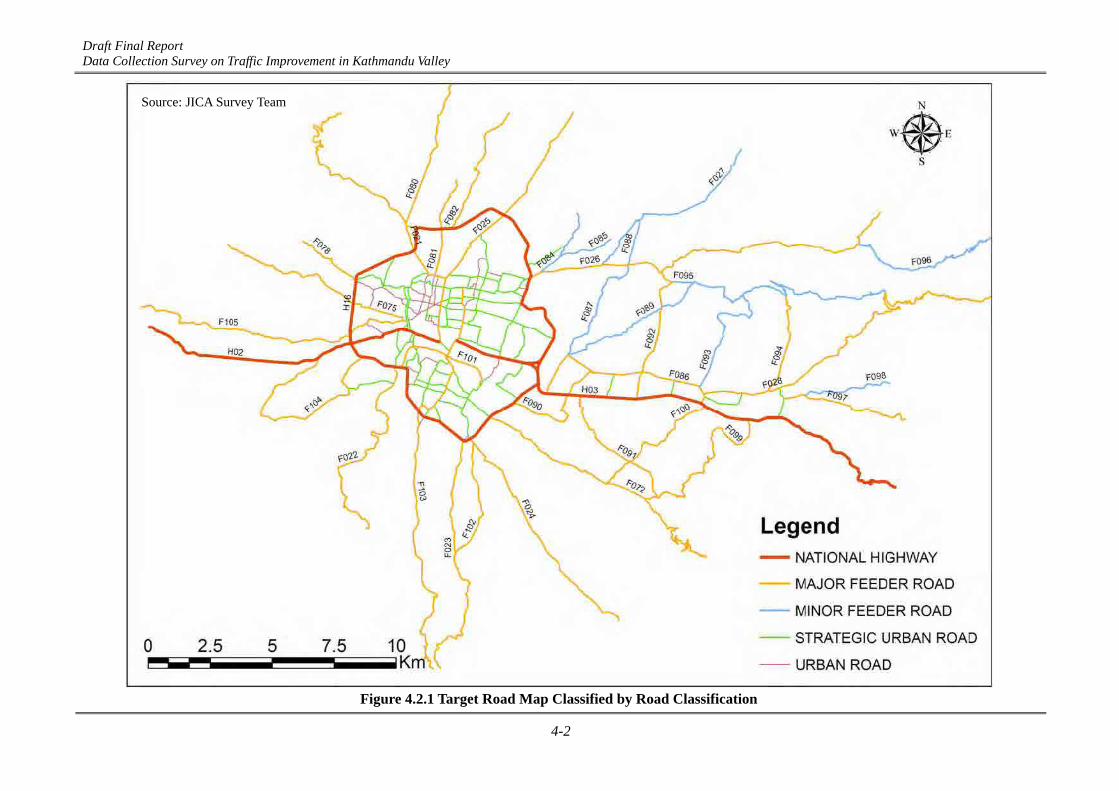
Draft Final Report Data Collection Survey on Traffic Improvement in Kathmandu Valley
4-2
Source: JICA Survey Team
Figure 4.2.1 Target Road Map Classified by Road Classification

Final Report Data Collection Survey on Traffic Improvement in Kathmandu Valley
4-3
4.2.2 Roadside Condition Survey
Roadside condition surveys have been conducted on the following routes as shown in Table 4.2.2 and Figure 4.2.2.
Table 4.2.2 Details of Target Routes for Roadside Condition Survey
National Highway (SRN) DOR 3 58.4
Major Feeder Road (SRN) DOR 26 222.9
Minor Feeder Road (SRN) DOR 10 54.6
River Corridor - 2 11.0
41 346.9
Class of Roads JurisdictionNumber of
RoutesLength
km
Total
Source: JICA Survey Team
Source: JICA Survey Team
Figure 4.2.2 Target Route Map for Roadside Condition Survey
4.3 Survey Results
4.3.1 Overall Characteristics of SRN
The following table shows the summary of characteristics for SRN based on the road inventory survey. Details of characteristics of all surveyed roads are explained in Appendix 3.11.

Final Report Data Collection Survey on Traffic Improvement in Kathmandu Valley
4-4
Table 4.3.1 Characteristics of National Highway and Feeder Road
BT(km)
GR(km)
ER(km)
Total(km)
Total No.No. per
km
4 Tripureswor Kalanki
2 Kalanki Nag Dhunga Bus Stop
4 Maitighar Suryabinayak
2 Suryabinayak Sanga
H16 Ring Road 2 ~ 4 11.28 27.6 0.0 0.0 27.6 210 8 Kalanki Kalanki
F021 Trisuli Road 1 ~ 2 4.86 11.6 0.0 0.0 11.6 336 29 Lainchaur Tinpiple Bus Stop
2 Balkhu Chobhar
1 ~ 1.5 Chobhar Bansbari
F023 Chapagaun Road 1 ~ 1.5 5.65 8.6 2.6 0.0 11.2 707 63 Satdobato Tikabhairav
F024 Godawari Road 1 ~ 2 4.98 9.5 0.0 0.0 9.5 698 73 Satdobato Godawari
2 ~ 4 Tripureswor Lainchaur
2 Lainchaur Budanilkantha
2 Chabahil Bagmati River
1 ~ 1.5 Bagmati River Lapsephedi
F028 Nagarkot Road 1 ~ 2 4.28 18.0 0.0 0.0 18.0 507 28 Sallaghari Nagarkot
F072 Lubhu Road 1 ~ 1.5 3.96 9.3 0.0 3.9 13.2 617 47 Gwarko Lakuri Bhanjyang
F075 Bhimdhunga Road 1 ~ 1.5 5.11 6.1 1.9 0.0 8.0 522 65 Tankeswor Bhimdhungga
F078 Hal Chok - Narayanthan Road 1 3.94 2.7 0.0 0.0 2.7 142 53 Swayambhu Narayanthan
F080 Phutung Road 1 ~ 1.5 5.24 3.6 2.6 0.0 6.2 557 90 Balaju Chunigaon
F081 Lainchaur - Samakhusi Chok - Baniyatar Road 1.5 5.51 4.1 0.0 0.0 4.1 596 145 Lainchaur Baniyatar
F082 Tokha Road 1 ~ 1.5 4.83 4.1 1.5 0.0 5.6 414 74 Samakhusi Chowk Chandesh warigaon
F086 Thimi Road 2 6.95 7.5 0.0 0.0 7.5 738 98 Jadibuti Sallaghari
F090 Dharmeshwar - Tikathali - Manohara - Lokanthali- Thimi Road 1 ~ 1.5 4.01 4.2 0.6 0.1 4.9 354 72 Balkumari Sano Thimi
F091 Kausaltar - Balkot - Sirutar - Chamelidada Road 1 3.55 4.0 0.2 0.6 4.8 354 74 Kausaltar Chamelidada
F092 Thimi - Mulpani Road 1.5 4.43 5.2 0.3 0.0 5.5 342 62 Thimi Mulpani
F094 Byasi - Changunarayan Road 1.5 4.64 6.0 0.0 0.0 6.0 171 29 Chocckhen Sangdaha
F097 Bhaktapur - Nala - Banepa Road 1 ~ 2 4.86 2.6 3.3 0.0 5.9 279 47 Kamalhinayak Amaldol
F099 Suryabinayak - Chamelidada - Bhujunge Road 1 3.76 2.8 5.7 0.0 8.5 508 60 Suryabinayak Bhujunge
F100 Sallaghari - Katunje - Sumlingtar Road 1 2.83 3.3 0.0 2.1 5.4 292 54 Sallaghari Lubhu
F101 Balkhu - UN Park Lane - Shankhamul 1.5 ~ 2 6.14 4.1 0.0 0.0 4.1 128 31 Balkhu Shankhamul
F102 Satdobato - Dhapakhel - Thecho Road 1 ~ 1.5 4.24 4.9 0.0 0.0 4.9 307 63 Satdobato Thecho
2 ~ 4 Hattisar Bhaisepati
1.5 Bhaisepati Bungamati
F104 Kashibazar - Kirtipur - Machhegaun - TinthanaRoad 1 ~ 2 4.36 8.3 1.2 0.0 9.5 705 74 Nariwalphant Tinthana
F105 Nagdhunga - Tankeswor Road 1.5 5.11 5.3 5.9 0.0 11.2 590 53 Tankeswor Nagdhunga
F027 Sundarijal Road 1.5 4.67 7.0 0.0 0.0 7.0 579 83 Jorpati Sundarijal
2 Chuche Pati Mahankal
1.5 Mahankal Kapan
F085 Mahankal - Atterkhel Road 1.5 5.97 2.1 0.0 0.0 2.1 185 88 Mahankal Tinchuli
F087 Pepsikola - Gothatar Road 1 ~ 2 5.64 2.7 0.0 0.0 2.7 31 11 Sinamangal Gothatar
F088 Gokarna - Jorpati - Gothatar 1.5 5.89 3.7 0.1 0.0 3.8 165 43 Gokarna Gothatar
F089 Pepsicola - Karkigaun Road 1 ~ 1.5 5.24 5.2 1.6 0.0 6.8 396 58 Sinamangal Phuyalgaon
F093 Sallaghari - Duwakot-Changunarayan Road 1 ~ 1.5 4.17 4.7 0.0 0.0 4.7 384 82 Nekosera Changu
F095 Mulpani - Sangdaha - Changunarayan - TilkotRoad 1 ~ 1.5 4.39 1.7 9.8 0.0 11.5 283 25 Mulpani Tilkot
F096 Sankhu - Kattike 1 ~ 1.5 4.27 2.5 5.0 0.0 7.5 234 31 Sankhu Kattike
F098 Kamalbinayak - Sudal - Adikarigaun Road 1.5 5.24 2.6 2.8 0.0 5.4 185 34 Kamalbinayak Sudal
913.1 0.0 0.0
Sankhu Road
10.8
15.50.02.113.45.98
3.1 281Chuchepati - Mahankal - Kapan - DandagaunRoad 6.37
RouteNo.
Nat
iona
l Hig
hway
Maj
or F
eede
r R
oad
Min
or F
eede
r R
oad
H02
F022
F025
F103
F084
F026
H03
Name of Road
House withinR.O.W
Lane No.Based on
Pavement WidthApprox.
Ave.Pavement
Width(m)
Pavement Type
Location of Start Location of End
18.2 899 49Bungmati Road 7.39 12.0 6.2 0.0
Budhanilkantha Road 726 67
661028
8.98 10.8 0.0 0.0
5.33Dakshinkali Road
7793512.10.00.012.19.87Tribuvan Highway
3434110.10.00.0
12Arniko Highway 14.74 18.7 0.0 0.0 18.7 230
10.1
Source: JICA Survey Team

Final Report Data Collection Survey on Traffic Improvement in Kathmandu Valley
4-5
Table 4.3.2 Characteristics of Strategic Urban Road*
BT(km)
GR(km)
ER(km)
Total(km)
Total No.No. per
km
KMU001 TU Gate - Naya Bazar (TU Road) 2 7.39 1.7 0.0 0.0 1.7 TU Gate Naya Bazar
KMU002 Kalimati - Balkhu (TU Road) 2 ~ 4 12.33 1.7 0.0 0.0 1.7 Kalimati Balkhu
KMU004 Kalimati - Bijeshwari - Sorhakhutte 1 ~ 4 11.99 3.5 0.0 0.0 3.5 Kalimati Sorhakhutte
KMU006 Kalimati Bridge - Puspalal Path 2 ~ 4 9.50 1.8 0.0 0.0 1.8 Kalimati Bridge Indrani Temple
KMU012 Tripura Marga 4 17.52 0.5 0.0 0.0 0.5 Tripureswor Thapathali
KMU013 Prithvi Path 4 17.78 0.9 0.0 0.0 0.9 Singha Durbar Sundhara
KMU014 Exhibition Road 4 12.00 0.5 0.0 0.0 0.5 Padmodaya Junction Durbar Murg Junction
KMU015Sinamangal Road - Dilli Bazar Road - Bag BazarRoad - Ratnapark Road
2 7.93 4.2 0.0 0.0 4.2 Sinamangal Bhotahiti
KMU016 Gyaneshwor Road 1.5 ~ 4 9.91 3.0 0.0 0.0 3.0 Gaushala Jamal
KMU017 Chabahil - Narayanhiti Path 1.5 ~ 4 7.75 3.5 0.0 0.0 3.5 Chabahil Kanti Path Junction
KMU019 Gairidhara Road - Uttar Dhoka Road 2 7.72 1.3 0.0 0.0 1.3 Maligaon Budhanilkantha Road Junction
KMU021 Durbar Marg 4 15.37 1.6 0.0 0.0 1.6 Prithvi Path Junction Narayanhiti
KMU022 Narayanhiti Path - Uttar Dhoka Road 2 8.56 0.5 0.0 0.0 0.5 Narayanhiti Path Junction Uttar Dhoka Road Junction
KMU024 Maharajgunj - Dilli Bazar - Kumari Galli 2 1.5 ~ 2 5.88 4.0 0.0 0.0 4.0 Maharajgunj Kumari Galli 2 Junction
KMU025 Kumari Galli 2 - Tankaprasad Ghumuti Road 2 9.71 1.5 0.0 0.0 1.5 Padmodaya Bijulibazar Road Junction
KMU026 Pattisputali Road - Old Baneshwor Road 2 ~ 4 10.35 2.2 0.0 0.0 2.2 Gaushala New Baneshwor
KMU027 Bjulibazar Road - Bhaktithapa Road 2 7.78 1.6 0.0 0.0 1.6 Maitighar New Baneshwor
KMU029 Teku - Kalo Pul Road 1.5 ~ 2 5.68 0.5 0.0 0.0 0.5 Teku Kalo Pul
KMU030 Chabahil - Tenzing Chowk Road 2 7.61 1.6 0.0 0.0 1.6 Chabahil (Dhobi Khola) Tenzing Chowk
KMU031 New Road 2 11.68 0.5 0.0 0.0 0.5 Kantipath Road Junction Ganga Path Junction
KMU033 Kamaladi Road 2 7.58 0.6 0.0 0.0 0.6 Bungmati Road Junction Durbar Murg Junction
BMU001 Gathaghar - Sano Thimi 1.5 ~ 2 6.12 1.0 0.0 0.0 1.0 Gathaghar Sano Thimi
BMU003 Sallaghari - Tekhacho - Nagarkot Road 1.5 ~ 2 6.27 1.8 0.0 0.0 1.8 Sallaghari Nagarkot Road Junction
BMU004 Garud Kundal Road 2 ~ 4 10.89 1.3 0.0 0.0 1.3 Jagati Kamalbinayak
LMU001 Gwarko - Pulchowk - Sanepa - Kalo Pul Road 1.5 ~ 2 6.45 4.8 0.0 0.0 4.8 Gwarko Kalo Pul
LMU004 Lagankhel Road 2 ~ 4 12.52 2.3 0.0 0.0 2.3 Satdobato Jawalakhel
No Data
No Data
No Data
No Data
No Data
No Data
No Data
No Data
Str
ateg
ic U
rban
Roa
d
No Data
No Data
No Data
No Data
No Data
No Data
No Data
No Data
No Data
No Data
No Data
No Data
No Data
No Data
No Data
No Data
No Data
No Data
RouteNo.
Name of Road
House withinR.O.W
Lane No.Based on
Pavement WidthApprox.
Ave.Pavement
Width(m)
Pavement Type
Location of Start Location of End
Source: JICA Survey Team * Above listed roads were selected as major strategic urban roads by the JICA Survey Team Route numbers for national highways as well as major and minor feeder roads were defined in the above
table as per reference number mentioned in the Statistics of Strategic Road Network (SSRN 2009/10) published by DOR. Route numbers for strategic urban and rural roads were numbered by the JICA Survey Team.
The result of the survey for pavement width on all target roads is shown in Figure 4.3.4. Pavement width for roads comprising of gravel or earthen type was measured as roadway width as shown in Figure 4.3.1.
Figure 4.3.1 Measurement Length
Final Report Data Collection Survey on Traffic Improvement in Kathmandu Valley
4-6
4.3.2 Major Findings
(1) National Highways Black topped pavements were observed on all surveyed routes. Good surface conditions were judged
along almost all of the surveyed sections of the national highway as shown in Figure 4.3.2, Figure 4.3.3, Figure 4.3.5, and Figure 4.3.6.
The target roads are comprised of two-lane sections or more, as shown in Table 4.3.1 and Figure 4.3.4. There is no one-lane section along the national highway.
1) Tribuvan Highway (H02):
The Tribuvan Highway is composed of a four-lane section from Tripureswor to Kalanki and a two-lane section from Kalanki to Nag Dhunga bus stop. Fair to bad surface conditions were observed along the two-lane part of the road from Kalanki to Nag Dhunga bus stop. In terms of the extent of difficulty for road widening, it is determined to be medium to difficult level (the number of encroached houses is about 6–10 houses or more within ROW per 100 m) as observed in majority of the sections as shown in Figure 4.3.7.
2) Arniko Highway (H03):
The Arniko Highway is composed of a four-lane section from Maitighar to Suryabinayak (Bhaktapur) and a two-lane section from Suryabinayak to Sanga, respectively. The four-lane section of the Arniko Highway was improved by the current project for the improvement of the Kathmandu-Bhaktapur Road. Good surface conditions are observed along all of the surveyed sections. In terms of difficulty for road widening, it is determined to be easy (the number of encroached houses is about 0-5 houses within ROW per 100 m) as observed on majority of the sections, excluding the area near Sanga as shown in Figure 4.3.7.
3) Ring Road (H16):
The Ring Road is composed of a two-lane section excluding the sections near Kalanki, Gaushala- Chabahil and Tinkune-Koteshwor which partially has four lanes, according to the result of pavement width. Good surface conditions are observed along majority of the sections, however, fair surface condition are recorded near Sinamangal (Tribuvan Airport), Ekantakuna and the part between Gaushala and Chabahil. In terms of difficulty for road widening, it is determined to be easy (number of encroached houses is about 0-5 houses within ROW per 100 m) as observed on majority of the sections, excluding the area between Gaushala and Sinamangal (Tribuvan International Airport) which is determined to be medium to difficult level (number of encroached houses is about 6-10 houses or more within ROW per 100 m), as shown in Figure 4.3.7.
(2) Major Feeder Roads Sections of black topped pavement are observed on majority of the surveyed major feeder roads.
However, fair and bad surface conditions were recorded on 30% of the surveyed routes as shown in Figure 4.3.2 and Figure 4.3.3. Therefore, the extent of pavement surface condition is very low compared with the pavement quality of national highways.
The surveyed major feeder roads are located in all directions, starting from the center of Kathmandu Valley. The characteristics of each part are as follows:
1) Northern part:
Except for the Budhanilkantha Road (F025), the present condition of pavement width is relatively narrow. The routes are judged as generally one to 1.5-lane. However, in terms of the level of difficulty for road widening, Phutung Road (F080), Lainchaur-Samakhusi Chok-Baniyatar Road (F081) and Tokha Road (F082) are determined to be difficult (number of encroached houses is more than 11 within ROW per 100 m). In terms of pavement conditions, almost all parts of the Tokha Road (F082) are judged to have bad surfaces.

Final Report Data Collection Survey on Traffic Improvement in Kathmandu Valley
4-7
Budhanilkantha Road (F025) is observed as the highest upgraded road in terms of pavement width, type and pavement condition as compared with other major feeder roads located in the northern part of the valley. Along all sections of this road, black topped pavements were observed. The road is composed of a four-lane part located at the central area of the city from Tripureswor to Lainchaur, and a 2-lane part located from Lainchaur to Budanilkantha, respectively. Fair pavement conditions are observed outside of Ring Road. Bad pavement conditions were also found at some partial section near Budhanilkantha.
2) Eastern part:
The routes with more than two lanes are located on a part of the Sankhu Road (F026) between the Chabahil and Bagmati River, and the whole section of the Thimi Road (F086) from Jadibuti to Sallaghari. These routes are composed of black topped pavement. However, bad surface conditions are observed on these routes partially.
The Lubhu Road (F072) is one of the major radial roads in the eastern part. In terms of pavement type and condition, almost all of the sections are judged as black topped road and a part between Gwarko and Lubhu are observed to have good surface condition. However, this road only has 1-1.5 lanes and the extent of difficulty for widening was determined as medium to difficult on a part between Gwarko and Lubhu.
Nagarkot Road (F028) has a role of linkage between Kathmandu and Nagarkot. The road is one of the familiar travel spots that people take when seeing the scenery, although the number of lanes on this road was judged to have 1-1.5 lanes. The road is generally comprised of black topped pavement and good pavement conditions along majority of the sections.
In the southern area from Arniko Highway within the eastern part, there are no major arterial routes which are to be upgraded to more than 2-lane especially.
3) Southern part:
Several major radial roads are located within the southern part. In terms of the result of pavement width, type and condition, Bungmati Road (F103), Dakshinkali Road (F022), Godawari Road (F024), Chapagaun Road (F023) can be classified as a main arterial radial road.
Bungmati Road (F103) is one of the major radial roads. The road is composed of 2-4 lane sections from Hattisar to Bhaisepati, with some parts having 1-1.5 lane sections from Bhaisepati to Bungamati. All parts of the 2-4 lane section between Hattisar and Bhaisepati are classified as black topped pavement with good surface condition. On a part between Bhaisepati and Bungamati which has only 1-1.5 lanes, the pavement type was judged as black topped generally. The pavement condition was classified however as bad or fair pavement conditions on approximately 50% of the route.
Dakshinkali Road (F022) is also one of the major radial roads. This road is comprised of one to two lanes generally. The route between Balkhu and Chobhar was classified as a 2-lane and judged as having black topped pavement with good surface condition. The other section from Chobhar to Bansbari is observed as 1-1.5 lanes and black topped pavements. The condition of the pavement was determined as fair condition.
Chapagaun Road (F023) has black topped pavement on majority of the route and the pavement condition is judged as good. However, majority of the routes are classified as 1.5-lane.
Godawari Road (F024) was classified as a 1-2-lane section road. A part between Satdobato and Harisiddhi is judged as 2-lane and classified as black topped pavement. However, in terms of pavement condition, majority of the routes are recorded as fair.
4) Western part:
Almost all routes within the western part of the valley were classified as 1-1.5 lanes and were judged as fair or bad pavement conditions. Therefore, there are no major routes to be upgraded to more than a 2-lane section. The road was maintained with black topped pavement and with good condition excluding Tribuvan Highway in the western part.
Final Report Data Collection Survey on Traffic Improvement in Kathmandu Valley
4-8
(3) Minor Feeder Roads All of the surveyed minor feeder roads are located in the eastern part of the valley. The routes which
are located in remote areas such as Mulpani–Sangdaha–Changunarayan–Tilkot Road (F095), Sankhu–Kattike (F096) and Kamalbinayak–Sudal–Adikarigaun Road (F098) are generally classified as earthen or gravel roads.
More than half of the surveyed routes are judged as having bad surface conditions as shown in Figure 4.3.3.
Almost all parts of minor feeder roads are comprised of only 1-1.5 lane sections. Especially, the roads which are classified as 2-lane sections are as follows:
1) A part of Chuchepati–Mahankal–Kapan–Dandagaun Road (F084) between Chuche Pati and Mahankal
2) A part of Pepsikola–Gothatar Road (F087) from Sinamangal to Kandhaghari
(4) Strategic Urban Road Majority of the surveyed routes are classified as black topped pavement road. Half of the routes were
judged as having good surface conditions, however, the other half of the route were observed as having fair or bad surface conditions as shown in Figure 4.3.2 and Figure 4.3.3.
The major arterial roads which are composed of 4-lane sections are as follows:
1) Kalimati–Balkhu (TU Road) (KMU002) except a part of 2-lane section between Kuleshwor to Balkhu;
2) Kalimati–Bijeshwari–Sorhakhutte (KMU004) except a part of 1 to 1.5-lane from Dallu to Bijeshwari;
3) Kalimati Bridge–Puspalal Path (KMU006) except a part of 2-lane from Kalimati Bridge to Dallu;
4) Tripura Marga (KMU012);
5) Prithvi Path (KMU013);
6) Gyaneshwor Road (KMU016) in a part from Gaushala to Dhobi Khola and from Jamal to Durbar Marg;
7) Chabahil–Narayanhiti Path (KMU017) only in a part near Narayanhiti Palace Museum;
8) Durbar Marg (KMU021);
9) Pattisputali Road–Old Baneshwor Road (KMU026) only in a part near New Baneshwor and from Old Baneshwor to Gaushala; and
10) Lagankhel Road (LMU004) only in a part between Jawalakhel and Lagankhel.

Final Report Data Collection Survey on Traffic Improvement in Kathmandu Valley
4-9
(5) Urban Road Almost all of the routes are comprised of 1 to 2-lane sections and classified as black topped pavement.
However, about 30% of the routes are classified as bad surface conditions as shown in Figure 4.3.2 and Figure 4.3.3.
The majority of surveyed routes are located in the KMC core area such as Thamel and Kathmandu Durbar Square where many street vendors sell and tourists are walking around. In these areas, Tankeswor–Paropakar Marga–Paknajol Road (KMU008) and Hanuman Dhoka Road (KSU019) are especially observed as 2-lane section roads and judged as black topped pavement based on the survey results. The actual conditions along these routes are quite different due to many street sales opening in daytime and tourists walk around the Thamel core area as mentioned above. Therefore, the actual capacity to deal with vehicle movement can be lower than the existing condition even if there is enough space such as 2-lane.
(6) River Corridor The condition survey along the Bishnumati River and Dhobi Khola was conducted to clarify the
availability of river beds for future road construction site. The result is shown in Table 4.3.3. In terms of land clearance along target river corridors, the widths which were less than 40 m in length were observed at several local points. However, in terms of the average result, widths along both corridors were observed to be more than 40 m as shown in Table 4.3.3. Detailed information about land clearance is described in Appendix 3.10.
Table 4.3.3 Result of Roadside Condition Survey for River Corridor
Name of River Corridor Target LengthRiver Width
(Avg.)(m)
Land Clearance(Avg.)(m)
No. of Houseswithin 30 m fromthe center of river
Dhobi Khola 5.50 9.4 42.1 658
Bishnumati River 5.45 20.1 52.8 508
Source: JICA Survey Team Figure 4.3.2 Road Length by Pavement Type
Source: JICA Survey Team Figure 4.3.3 Road Length by Pavement Condition

Final Report Data Collection Survey on Traffic Improvement in Kathmandu Valley
4-10
Figure 4.3.4 Road Network Classified by Pavement Width
Source: JICA Survey Team

Final Report Data Collection Survey on Traffic Improvement in Kathmandu Valley
4-11
Figure 4.3.5 Road Network Classified by Pavement Type
Source: JICA Survey Team

Final Report Data Collection Survey on Traffic Improvement in Kathmandu Valley
4-12
Figure 4.3.6 Road Network Classified by Pavement Condition
Source: JICA Survey Team
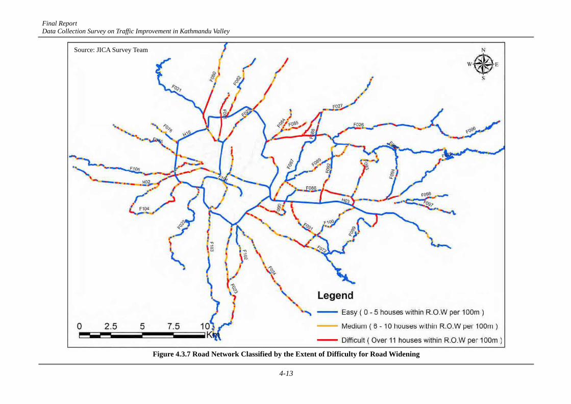
Final Report Data Collection Survey on Traffic Improvement in Kathmandu Valley
4-13
Figure 4.3.7 Road Network Classified by the Extent of Difficulty for Road Widening
Source: JICA Survey Team