daily operations briefing - disaster centerdaily+ops+briefing+01-06-2016.pdf · •daily operations...
TRANSCRIPT

•Daily Operations BriefingWednesday, January 6, 2016
8:30 a.m. EST
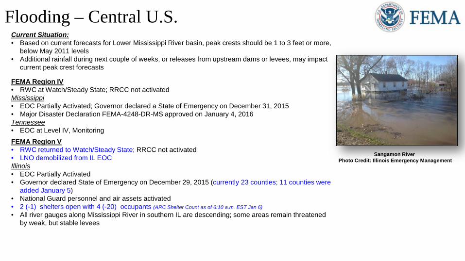
Flooding – Central U.S.Current Situation:• Based on current forecasts for Lower Mississippi River basin, peak crests should be 1 to 3 feet or more,
below May 2011 levels• Additional rainfall during next couple of weeks, or releases from upstream dams or levees, may impact
current peak crest forecasts
FEMA Region IV• RWC at Watch/Steady State; RRCC not activatedMississippi• EOC Partially Activated; Governor declared a State of Emergency on December 31, 2015• Major Disaster Declaration FEMA-4248-DR-MS approved on January 4, 2016Tennessee• EOC at Level IV, MonitoringFEMA Region V• RWC returned to Watch/Steady State; RRCC not activated• LNO demobilized from IL EOC Illinois• EOC Partially Activated• Governor declared State of Emergency on December 29, 2015 (currently 23 counties; 11 counties were
added January 5)• National Guard personnel and air assets activated • 2 (-1) shelters open with 4 (-20) occupants (ARC Shelter Count as of 6:10 a.m. EST Jan 6)• All river gauges along Mississippi River in southern IL are descending; some areas remain threatened
by weak, but stable levees
Sangamon River Photo Credit: Illinois Emergency Management
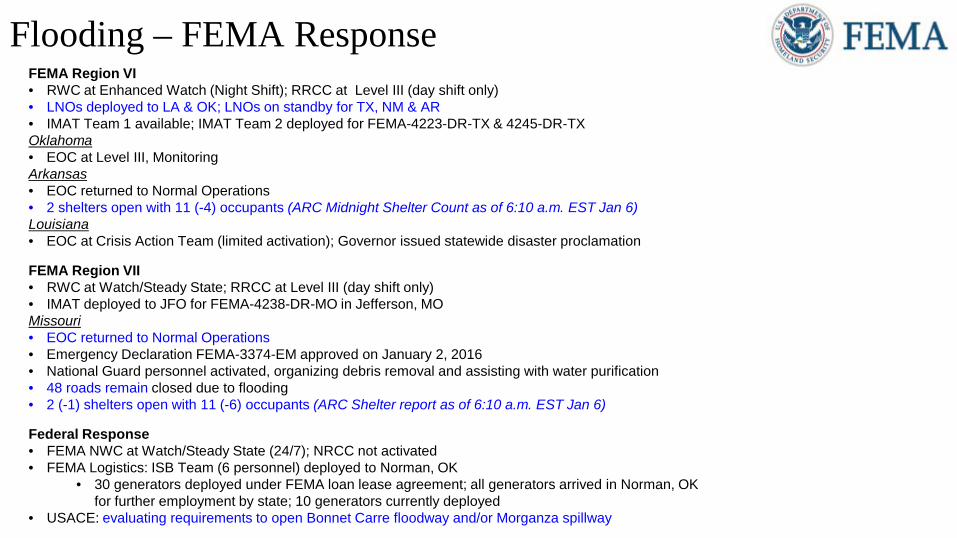
Flooding – FEMA ResponseFEMA Region VI• RWC at Enhanced Watch (Night Shift); RRCC at Level III (day shift only)• LNOs deployed to LA & OK; LNOs on standby for TX, NM & AR• IMAT Team 1 available; IMAT Team 2 deployed for FEMA-4223-DR-TX & 4245-DR-TXOklahoma• EOC at Level III, MonitoringArkansas• EOC returned to Normal Operations• 2 shelters open with 11 (-4) occupants (ARC Midnight Shelter Count as of 6:10 a.m. EST Jan 6)Louisiana• EOC at Crisis Action Team (limited activation); Governor issued statewide disaster proclamation
FEMA Region VII• RWC at Watch/Steady State; RRCC at Level III (day shift only) • IMAT deployed to JFO for FEMA-4238-DR-MO in Jefferson, MOMissouri• EOC returned to Normal Operations• Emergency Declaration FEMA-3374-EM approved on January 2, 2016• National Guard personnel activated, organizing debris removal and assisting with water purification• 48 roads remain closed due to flooding• 2 (-1) shelters open with 11 (-6) occupants (ARC Shelter report as of 6:10 a.m. EST Jan 6)
Federal Response• FEMA NWC at Watch/Steady State (24/7); NRCC not activated• FEMA Logistics: ISB Team (6 personnel) deployed to Norman, OK
• 30 generators deployed under FEMA loan lease agreement; all generators arrived in Norman, OK for further employment by state; 10 generators currently deployed
• USACE: evaluating requirements to open Bonnet Carre floodway and/or Morganza spillway
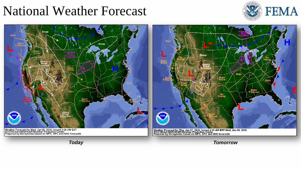
National Weather Forecast Day 1
TomorrowToday
http://www.wpc.ncep.noaa.gov/national_forecast/natfcst.php
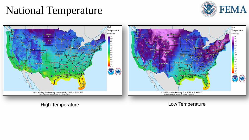
National Temperature
High Temperature Low Temperature
http://w2.weather.gov/images/crh/dhs/maxt_day1.png
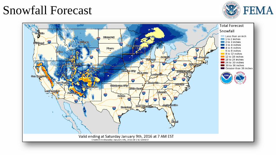
Snowfall Forecast
http://w2.weather.gov/images/crh/dhs/wpc_snow.png
http://www.wpc.ncep.noaa.gov/qpf/qpf2.shtml
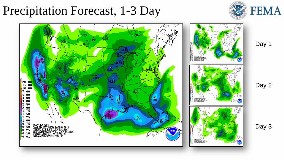
Day 3
Day 2
Day 1
Precipitation Forecast, 1-3 Day
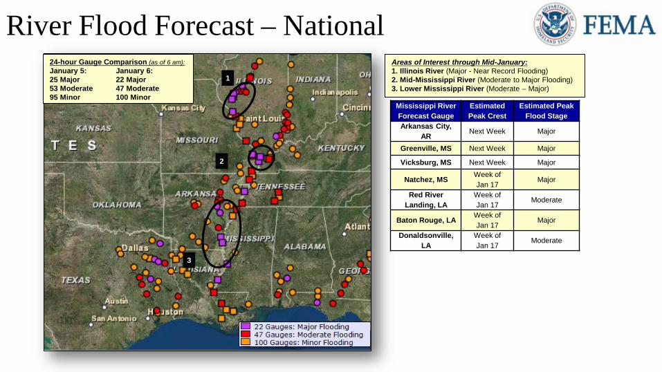
River Flood Forecast – National1
2
3
Areas of Interest through Mid-January:1. Illinois River (Major - Near Record Flooding)2. Mid-Mississippi River (Moderate to Major Flooding)3. Lower Mississippi River (Moderate – Major)
24-hour Gauge Comparison (as of 6 am):January 5: January 6:25 Major 22 Major53 Moderate 47 Moderate95 Minor 100 Minor
Mississippi River Forecast Gauge
Estimated Peak Crest
Estimated Peak Flood Stage
Arkansas City, AR Next Week Major
Greenville, MS Next Week Major
Vicksburg, MS Next Week Major
Natchez, MS Week of Jan 17
Major
Red River Landing, LA
Week of Jan 17
Moderate
Baton Rouge, LA Week of Jan 17
Major
Donaldsonville, LA
Week of Jan 17
Moderate
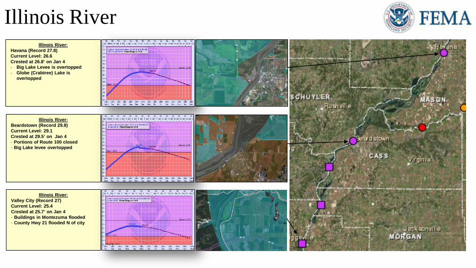
Illinois RiverIllinois River:
Havana (Record 27.8)Current Level: 26.6Crested at 26.8’ on Jan 4- Big Lake Levee is overtopped- Globe (Crabtree) Lake is
overtopped
Illinois River:Beardstown (Record 29.8)Current Level: 29.1Crested at 29.5’ on Jan 4- Portions of Route 100 closed - Big Lake levee overtopped
Illinois River:Valley City (Record 27)Current Level: 25.4Crested at 25.7’ on Jan 4- Buildings in Montezuma flooded- County Hwy 21 flooded N of city
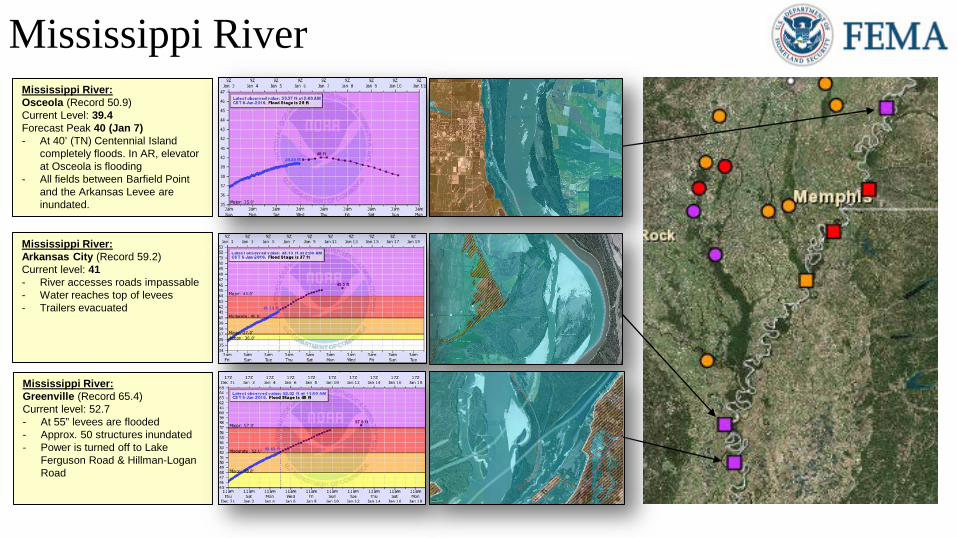
Mississippi River
Mississippi River:Arkansas City (Record 59.2)Current level: 41- River accesses roads impassable- Water reaches top of levees- Trailers evacuated
Mississippi River:Osceola (Record 50.9)Current Level: 39.4Forecast Peak 40 (Jan 7)- At 40’ (TN) Centennial Island
completely floods. In AR, elevator at Osceola is flooding
- All fields between Barfield Point and the Arkansas Levee are inundated.
Mississippi River:Greenville (Record 65.4)Current level: 52.7- At 55” levees are flooded- Approx. 50 structures inundated- Power is turned off to Lake
Ferguson Road & Hillman-Logan Road
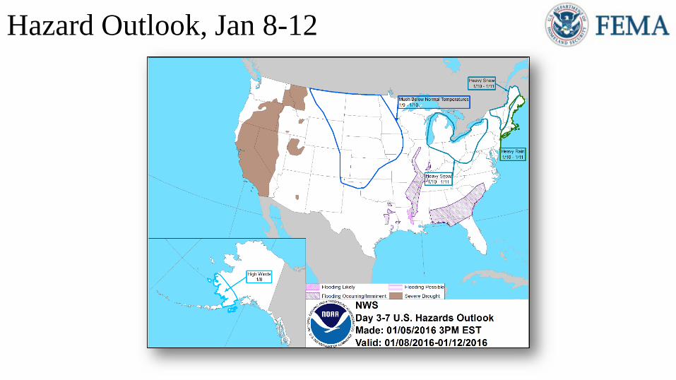
Hazard Outlook, Jan 8-12
http://www.cpc.ncep.noaa.gov/products/predictions/threats/threats.php
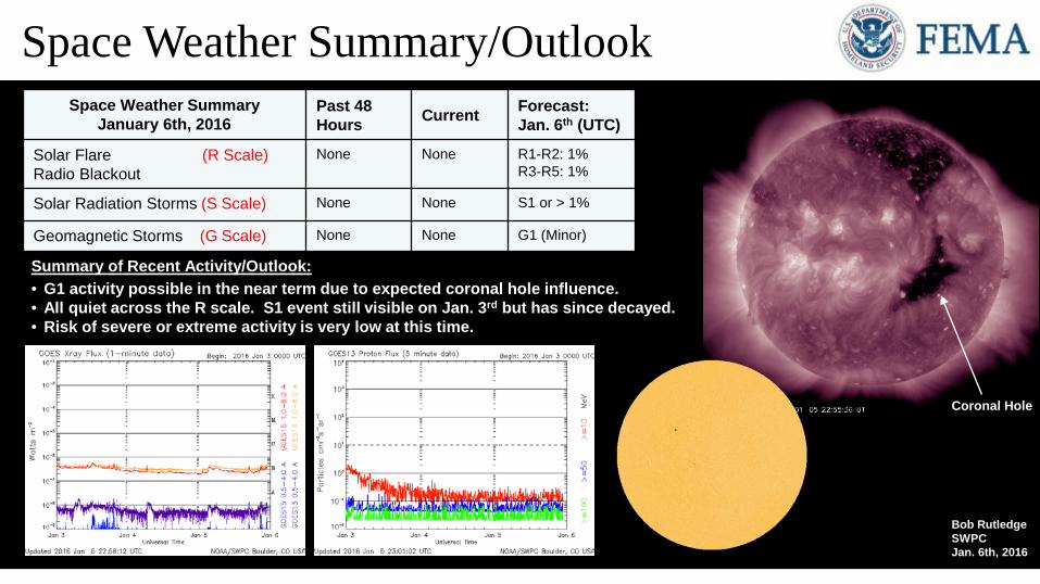
Space Weather SummaryJanuary 6th, 2016
Past 48 Hours Current Forecast:
Jan. 6th (UTC)
Solar Flare (R Scale)Radio Blackout
None None R1-R2: 1%R3-R5: 1%
Solar Radiation Storms (S Scale) None None S1 or > 1%
Geomagnetic Storms (G Scale) None None G1 (Minor)
Summary of Recent Activity/Outlook:• G1 activity possible in the near term due to expected coronal hole influence.• All quiet across the R scale. S1 event still visible on Jan. 3rd but has since decayed.• Risk of severe or extreme activity is very low at this time.
Space Weather Summary/Outlook
Bob RutledgeSWPC Jan. 6th, 2016
Coronal Hole
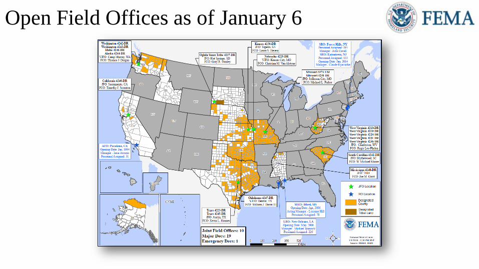
Open Field Offices as of January 6
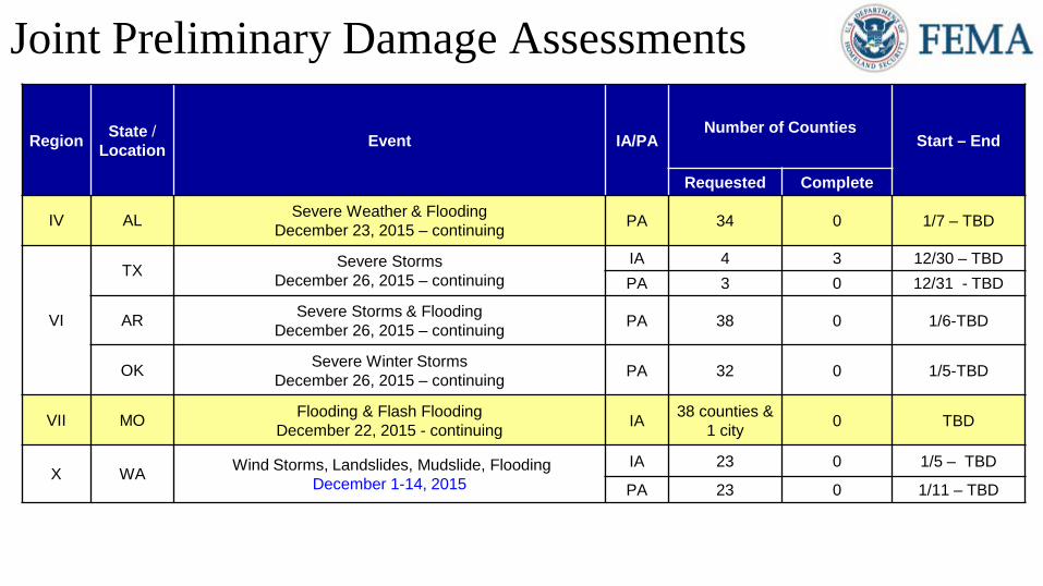
Joint Preliminary Damage Assessments
Region State / Location Event IA/PA
Number of CountiesStart – End
Requested Complete
IV AL Severe Weather & FloodingDecember 23, 2015 – continuing PA 34 0 1/7 – TBD
VI
TX Severe StormsDecember 26, 2015 – continuing
IA 4 3 12/30 – TBDPA 3 0 12/31 - TBD
AR Severe Storms & FloodingDecember 26, 2015 – continuing PA 38 0 1/6-TBD
OK Severe Winter StormsDecember 26, 2015 – continuing PA 32 0 1/5-TBD
VII MO Flooding & Flash FloodingDecember 22, 2015 - continuing IA 38 counties &
1 city 0 TBD
X WA Wind Storms, Landslides, Mudslide, FloodingDecember 1-14, 2015
IA 23 0 1/5 – TBD
PA 23 0 1/11 – TBD
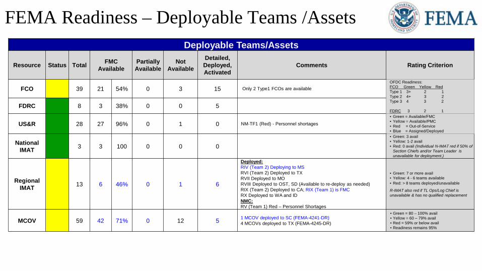
FEMA Readiness – Deployable Teams /Assets Deployable Teams/Assets
Resource Status Total FMCAvailable
Partially Available
Not Available
Detailed,Deployed,Activated
Comments Rating Criterion
FCO 39 21 54% 0 3 15 Only 2 Type1 FCOs are available OFDC Readiness:FCO Green Yellow RedType 1 3+ 2 1Type 2 4+ 3 2Type 3 4 3 2
FDRC 3 2 1FDRC 8 3 38% 0 0 5
US&R 28 27 96% 0 1 0 NM-TF1 (Red) - Personnel shortages• Green = Available/FMC• Yellow = Available/PMC• Red = Out-of-Service• Blue = Assigned/Deployed
National IMAT 3 3 100 0 0 0
• Green: 3 avail • Yellow: 1-2 avail• Red: 0 avail (Individual N-IMAT red if 50% of
Section Chiefs and/or Team Leader is unavailable for deployment.)
Regional IMAT 13 6 46% 0 1 6
Deployed: RIV (Team 2) Deploying to MSRVI (Team 2) Deployed to TXRVII Deployed to MORVIII Deployed to OST, SD (Available to re-deploy as needed) RIX (Team 2) Deployed to CA; RIX (Team 1) is FMCRX Deployed to WA and IDNMC:RV (Team 1) Red – Personnel Shortages
• Green: 7 or more avail• Yellow: 4 - 6 teams available• Red: > 8 teams deployed/unavailable
R-IMAT also red if TL Ops/Log Chief is unavailable & has no qualified replacement
MCOV 59 42 71% 0 12 5 1 MCOV deployed to SC (FEMA-4241-DR)4 MCOVs deployed to TX (FEMA-4245-DR)
• Green = 80 – 100% avail• Yellow = 60 – 79% avail• Red = 59% or below avail• Readiness remains 95%
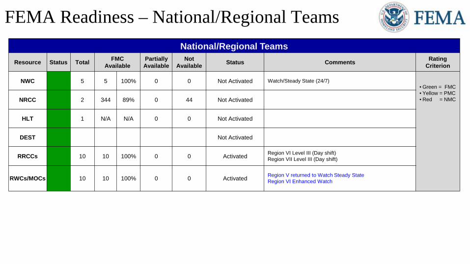
FEMA Readiness – National/Regional TeamsNational/Regional Teams
Resource Status Total FMCAvailable
Partially Available
Not Available Status Comments Rating
Criterion
NWC 5 5 100% 0 0 Not Activated Watch/Steady State (24/7)• Green = FMC• Yellow = PMC• Red = NMCNRCC 2 344 89% 0 44 Not Activated
HLT 1 N/A N/A 0 0 Not Activated
DEST Not Activated
RRCCs 10 10 100% 0 0 Activated Region VI Level III (Day shift)Region VII Level III (Day shift)
RWCs/MOCs 10 10 100% 0 0 Activated Region V returned to Watch Steady StateRegion VI Enhanced Watch