d07175175 edgeworth renewal corridor report - exhibition …€¦ · edgeworth renewal corridor...
TRANSCRIPT
2014
Edgeworth Renewal Corridor An urban design framework for future development

Edgeworth Renewal Corridor Report i
This page is intentionally blank
Edgeworth Renewal Corridor Report ii
Executive Summary
Edgeworth Renewal Corridor is one of five corridors identified in the Lower Hunter Regional
Strategy (LHRS) and is recognised as a renewal corridor in the Newcastle — Lake Macquarie
Western Corridor Planning Strategy. The LHRS defines a renewal corridor as an opportunity for
economic renewal and/or housing renewal, and intensification, and as a link between strategic
centres on strategic transport routes.
The key principles of the framework are outlined below.
Transport Strategy
Support a transport system that provides high levels of accessibility and connectivity, and that
reduces car dependency and supports a quality urban environment.
Principles:
• Increase walkability into, and around the neighbourhood centre, through pleasant, safe, and
convenient pedestrian routes including well located places to cross Main Road.
• Support strong links between the Corridor, the Education Precinct and Glendale with
pleasant, safe, convenient pedestrian and cyclist routes.
• Provide safe, convenient and well-connected cyclists routes including an alternative route off
Main Road and links to the broader area
• Minimise the barrier effect of fast traffic along Northville Drive through design.
• Develop transit hubs where transport paths intersect with activity centres
• All turning movements and traffic light phasing improve vehicular movement through and
around the Corridor, with priority where Main Road intersects Minmi Road, Garth Street and
Neilson Street.
• Road congestion and land use conflict is alleviated through prioritising and implementing the
outcomes of Edgeworth Transport and Traffic Study.
• Changes to roads will preserve or improve public transport accessibility e.g. bus stop
location

Edgeworth Renewal Corridor Report iii
Urban Growth Strategy
Provide a series of attractive urban places located to improve and define precinct character and
amenity and to encourage a reduction in car dependence.
Principles:
• Support built form that promotes street activity and encourages pedestrian access at the
Crossroads, Frederick Street intersection, and at Main Road and Arnott Street in the
Neighbourhood Centre.
• Provide a clearly defined visual and pedestrian corridor between Arnott Street, the main
shopping area and the intersection of Main Road and Minmi Road.
� Intensify land use zones in locations well supported by good transport connections.
• Support land use zone flexibility on Main Road to minimise the impacts of air and noise pollution
on sensitive users and to increase housing choice options.
• Increase housing choice by intensifying residential density in selected areas close to activity centres.
• Promote the development of significant sites along Main Road.
• Reorient the shopping complex and associated buildings to address Arnott Street and improve the
relationship between the street and development on the southern side of Arnott Street to create a
“main street” for the Neighbourhood Centre along Arnott Street.
• Encourage new strategic developments provide transit shelters/ hubs, such as public art/internet cafes.
• Reinvigorate the public domain in the Neighbourhood Centre with a diversity of public spaces including
a place to gather, e.g. a plaza, square, and park.
Cultural Strategy
Develop distinctive urban identities in the Corridor Precincts that have visual connections to key
destinations.
Principles
• Encourage more intensive urban development to expand the client base of Main Road's
existing assets e.g. tavern, bowling club, clubs, retail and services, and sports centres.
• Upgrade the streetscape with pavement improvements and street planting that reflect the
road hierarchy.
• Built form allows and supports view corridors between Glendale Regional Centre, the
Education Precinct, and Main Road, for pedestrians and cyclists.
• View corridors from transport routes should be open to Mount Sugarloaf and to Lake
Macquarie.
Edgeworth Renewal Corridor Report iv
Environmental Strategy
Improve the environmental qualities of the Corridor by enhancing and restoring its natural
systems, and by reducing man made impacts.
Principles
• Avoid, reduce and mitigate noise and air quality impacts when locating buildings to house
sensitive development/users.
• Develop the open space network providing a wider range of recreation settings and
improved public access.
• Develop an integrated creek management system that protects and rehabilitates the creek
systems.
• Improve air quality through a more compact city, better transit oriented and active transport.
Economic Strategy
Maximise Main Road's potential to deliver positive social, environmental and economic outcomes
for the benefit of the community through more intensive development.
Principles:
• Support the aim of State Government to provide for housing and employment by a
substantial increase in the population and jobs in the Corridor and its surrounds.
• Provide flexibility for land uses fronting Main Road to promote mixed-use districts, and,
where possible, mixed use buildings without significantly interfering with traffic movement
along Main Road.
• Advocate addressing business needs such as improved mobile phone coverage, and
internet speed.

Edgeworth Renewal Corridor Report v
TABLE OF CONTENTS:
1 Introduction .............................................................................................................................................. 2
2 The Process and this Report .................................................................................................................. 3
3 Character Areas and Precincts ............................................................................................................... 5
3.1 Character Areas and Precincts ......................................................................................................... 5
4 Access: Connections and Barriers .......................................................................................................11
4.1 Physical Connections ......................................................................................................................11
4.2 Visual Connections ..........................................................................................................................11
4.3 Physical Barriers to Movement ........................................................................................................13
4.4 Visual Barriers to Movement ...........................................................................................................13
5 Access and Directions ...........................................................................................................................15
5.1 Public Transport ..............................................................................................................................15
5.2 Pedestrian Movement......................................................................................................................15
5.3 Cycling .............................................................................................................................................17
5.4 Vehicular Movement ........................................................................................................................17
6 Significant Sites ......................................................................................................................................21
6.1 The Crossroads ...............................................................................................................................21
6.2 Frederick Street Intersection ...........................................................................................................21
6.3 Intersection of Main Road and Minmi Road .....................................................................................23
6.4 Main Road East (from the Crossroads to the Neighbourhood Centre) ............................................23
6.5 Johnson Street Park and Neighbourhood........................................................................................23
7 Activity and Recreation ..........................................................................................................................25
7.1 Activity Focus Areas Within the Corridor .........................................................................................25
7.2 Recreation Focus Areas Within the Corridor ...................................................................................25
8 SWOT .......................................................................................................................................................29
8.1 Strengths .........................................................................................................................................29
8.2 Weaknesses ....................................................................................................................................29
8.3 Opportunities ...................................................................................................................................31

Edgeworth Renewal Corridor Report vi
8.4 Threats ............................................................................................................................................ 31
9 Business and Community Consultation ............................................................................................... 33
9.1 Business Retention and Expansion Survey (BRES) ....................................................................... 35
9.2 Interactive Map ............................................................................................................................... 35
9.3 Information Stall .............................................................................................................................. 35
9.4 Written comments ........................................................................................................................... 37
9.5 Summary ......................................................................................................................................... 37
10 Stakeholder Consultation ................................................................................................................. 38
10.1 Issues Raised by Stakeholders ....................................................................................................... 38
10.2 Themes of Agency Consultation ..................................................................................................... 39
10.2.1 Roads ..................................................................................................................................... 39
10.2.2 Land Use Zoning .................................................................................................................... 39
10.2.3 Transport ................................................................................................................................ 40
10.2.4 Development Controls ............................................................................................................ 40
10.2.5 Environmental Conservation and Management...................................................................... 40
11 Analysis and Consultation Outcomes ............................................................................................. 41
11.1 Site Analysis Outcomes .................................................................................................................. 41
11.2 Business Consultation Outcomes ................................................................................................... 41
11.3 Community Consultation Outcomes ................................................................................................ 41
11.4 Agency Consultation areas of focus were as follows ...................................................................... 41
12 Urban Design Framework ................................................................................................................. 43
12.1 Transport Strategy .......................................................................................................................... 43
12.2 Urban Growth Strategy ................................................................................................................... 45
12.3 Cultural Strategy ............................................................................................................................. 47
12.4 Environmental Strategy ................................................................................................................... 47
12.5 Economic Strategy .......................................................................................................................... 48
13 Structure Plan ...................................................................................................................................... 2
14 Implementation Plan ........................................................................................................................... 2
14.1 Transport and Traffic Upgrades ........................................................................................................ 3
14.2 Preparation of a Planning Proposal................................................................................................... 3

Edgeworth Renewal Corridor Report vii
14.3 Preparation of Edgeworth Renewal Corridor Area Plan ................................................................... 4
14.4 Development of a streetscape Master Plan ...................................................................................... 4
14.5 Council owned land .......................................................................................................................... 4
14.6 Conclusion ........................................................................................................................................ 5
TABLE OF FIGURES:
Figure 1: Local context of the Edgeworth Renewal Corridor ..................................................... 1
Figure 2: Cloud Map of the Issues Raised on the Interactive Map ............................................ 2
Figure 3: Photo from Information Day ....................................................................................... 2
Figure 4: Character Precincts of the Edgeworth Renewal Corridor .......................................... 3
Figure 5: The Crossroads(top) and Neighbourhood Centre Precincts (bottom) ....................... 6
Figure 6: Industrial Character Precinct ...................................................................................... 8
Figure 7: Frederick Street Intersection Character Precinct ....................................................... 8
Figure 8: Main Road Residential Character Precinct ................................................................ 9
Figure 9: Physical Connections and Entry Points .................................................................... 10
Figure 10: Visual Connections ................................................................................................... 10
Figure 11: Visual Connections – Views of Mount Sugarloaf and the Lake ............................... 11
Figure 12: Physical Barriers to Movement ................................................................................. 12
Figure 13: Lack of Visual Clarity ................................................................................................ 12
Figure 14: Physical Barrier – Main Road ................................................................................... 12
Figure 15: Lack of visual clarity near the Crossroads and behind the bowling club .................. 13
Figure 16: Footpaths and bus stops .......................................................................................... 14
Figure 17: Pedestrian access and connectivity ......................................................................... 14
Figure 18: Photographs – Footpaths and Signage in the Corridor ............................................ 14
Figure 19: Traffic Lights ............................................................................................................. 16
Figure 20: Council’s current Cycleway Strategy for Edgeworth Corridor .................................. 16
Figure 21: Main Road and Minmi Road intersection – traffic at west approach ........................ 16
Figure 22: Road hierarchy in the Edgeworth Renewal Corridor and the broader area ............. 19
Figure 23: Significant sites identified in the renewal corridor .................................................... 20
Figure 24: Possible areas for mixed use development as a buffer to Main Road ..................... 20
Figure 25: The Crossroads ........................................................................................................ 20
Figure 26: Potential new areas to provide Medium Density Residential Housing ..................... 22
Edgeworth Renewal Corridor Report viii
Figure 27: Possible Location for Medium Density Housing ....................................................... 22
Figure 28: Recreation and activity areas in the Corridor ........................................................... 24
Figure 29: Photos of some of the recreation and activity areas in the Corridor ........................ 24
Figure 30: Screen shot – interactive map with markers for comments ..................................... 32
Figure 31: Screen shot – interactive map statistics ................................................................... 34
Figure 32: Option 5 from the Land Use Review......................................................................... 36
Figure 33: Opportunities outlined in the Exhibited Land Use Review ....................................... 36
Figure 34: Pedestrian and cycleway proposed strategy ............................................................ 42
Figure 35: Roads and intersections proposed strategy ............................................................. 42
Figure 36: Accommodate Growth – Potential intensification of land uses ................................ 44
Figure 37: Sites requiring new development controls ................................................................ 44
Figure 38: Active street frontage – Crossroads ......................................................................... 44
Figure 39: Active street frontage – Neighbourhood Centre ....................................................... 45
Figure 40: Example: Community open space provision in Edgeworth ...................................... 46
Figure 41: Community open space in other areas ..................................................................... 46
Figure 42: Potential new shared paths linking with Green Space ............................................. 46
Figure 43: Proposed mixed use land for flexibility along Main Road ......................................... 48
Figure 44: Structure Plan ............................................................................................................. 1

Edgeworth Renewal Corridor Report 1
Figure 1: Local context of the Edgeworth Renewal Corridor

Edgeworth Renewal Corridor Report 2
1 Introduction
Lake Macquarie City Council was funded by the then NSW Department Planning and Infrastructure
(DoPI) to undertake the Edgeworth Renewal Corridor Project. The Lower Hunter Regional Strategy
(LHRS) recognised this Renewal Corridor as one of five such corridors "for economic renewal
and/or housing renewal and intensification". The Newcastle - Lake Macquarie Western Corridor
Planning Strategy further identified planning principles, development criteria and infrastructure
requirements for the area in order to implement the actions of the Regional Strategy.
The Renewal Corridor Project presents a timely opportunity to build on the momentum of the
Glendale Master Plan work. In particular, it recognises the LHRS aim to accommodate an
additional 10,000 residents and provide an additional 6,200 jobs in the area. The Project
supports and recognises the role of Glendale as a regional centre, by providing a more
efficient and accessible corridor link to this area. The Corridor is a major gateway to Glendale
and more generally to the Lake Macquarie LGA. The Corridor adjoins significant open space
and recreation areas (Winding Creek, Cockle Creek, the Hunter Regional Sports Centre and
the Edgeworth Sporting Complex) and is adjacent to a broad mix of land uses including the
Glendale Shopping Centre, Edgeworth industrial land, proposed commercial development
along Main Road and Glendale TAFE and High School.
The Project investigated ways to improve accessibility for pedestrians, cyclists and vehicles
across and along Edgeworth Renewal Corridor and to increase dwellings and employment
opportunities in this area. The outcome provides a design framework to guide the form of the
urban area. The focus was to protect the integrity and safety of the transport corridor, and
build a desired character and sense of place within this corridor. The Project aimed to
achieve the following:
• Participation and input of the various sectors of the community;
• A collaborative and holistic approach to all project elements
• Leadership to assist in increasing business and service provision
• Recognition and development of the significant role and potential of the Renewal Corridor
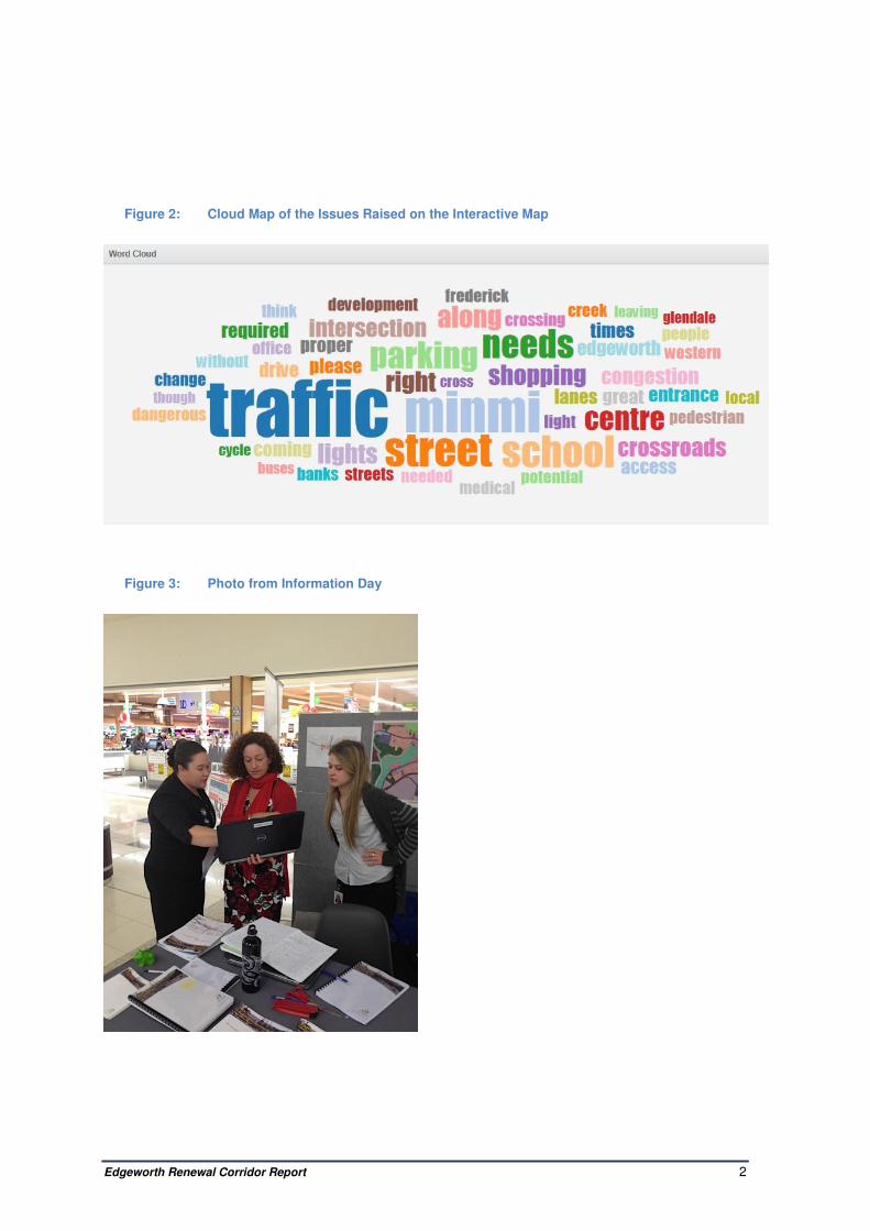
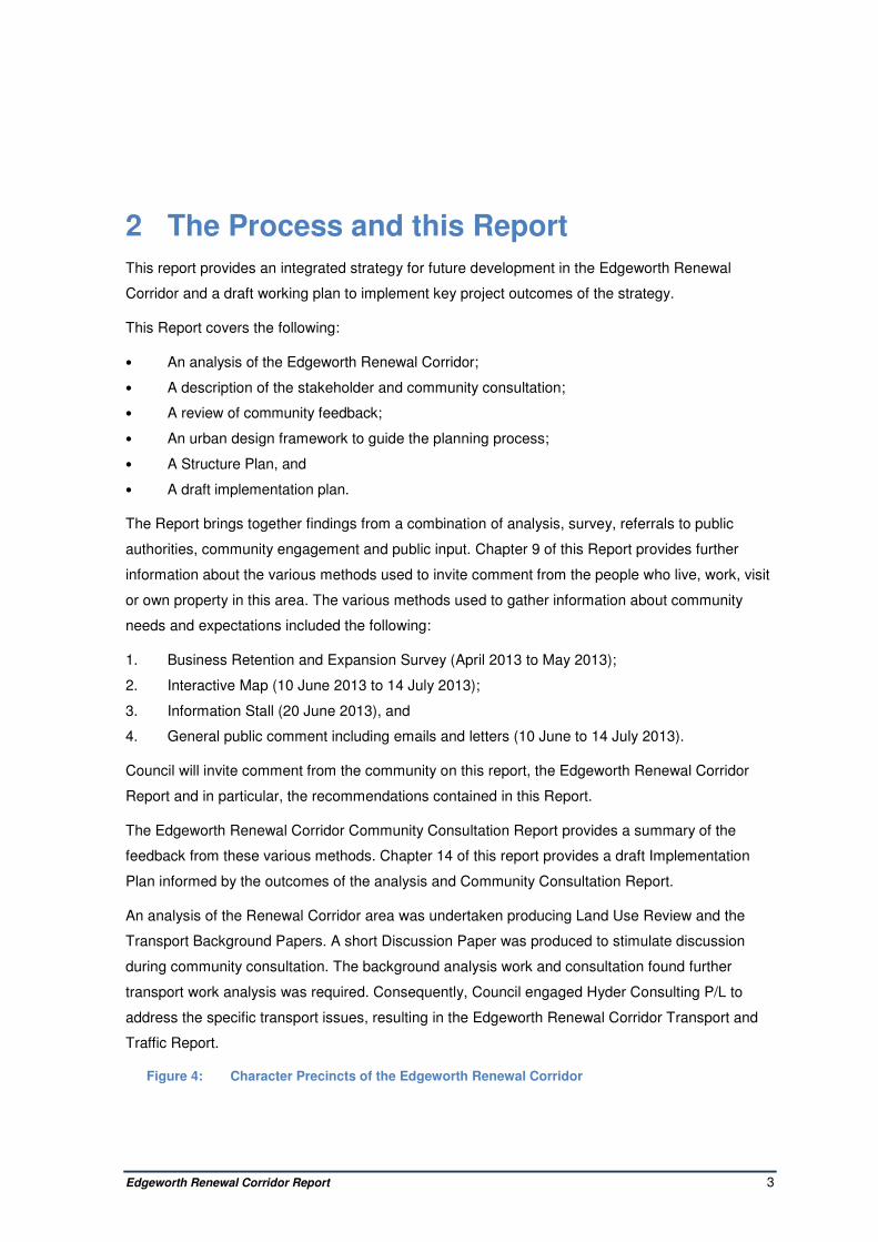
• Identification of the priorities and actions required to deliver the Project goals
Consultation was an integral part of the planning process and various methods were used to
invite comment from the people who live, work, visit or own property in this area.
Edgeworth Renewal Corridor Report 2
Figure 2: Cloud Map of the Issues Raised on the Interactive Map
Figure 3: Photo from Information Day
Edgeworth Renewal Corridor Report 3
2 The Process and this Report
This report provides an integrated strategy for future development in the Edgeworth Renewal
Corridor and a draft working plan to implement key project outcomes of the strategy.
This Report covers the following:
• An analysis of the Edgeworth Renewal Corridor;
• A description of the stakeholder and community consultation;
• A review of community feedback;
• An urban design framework to guide the planning process;
• A Structure Plan, and
• A draft implementation plan.
The Report brings together findings from a combination of analysis, survey, referrals to public
authorities, community engagement and public input. Chapter 9 of this Report provides further
information about the various methods used to invite comment from the people who live, work, visit
or own property in this area. The various methods used to gather information about community
needs and expectations included the following:
1. Business Retention and Expansion Survey (April 2013 to May 2013);
2. Interactive Map (10 June 2013 to 14 July 2013);
3. Information Stall (20 June 2013), and
4. General public comment including emails and letters (10 June to 14 July 2013).
Council will invite comment from the community on this report, the Edgeworth Renewal Corridor
Report and in particular, the recommendations contained in this Report.
The Edgeworth Renewal Corridor Community Consultation Report provides a summary of the
feedback from these various methods. Chapter 14 of this report provides a draft Implementation
Plan informed by the outcomes of the analysis and Community Consultation Report.
An analysis of the Renewal Corridor area was undertaken producing Land Use Review and the
Transport Background Papers. A short Discussion Paper was produced to stimulate discussion
during community consultation. The background analysis work and consultation found further
transport work analysis was required. Consequently, Council engaged Hyder Consulting P/L to
address the specific transport issues, resulting in the Edgeworth Renewal Corridor Transport and
Traffic Report.
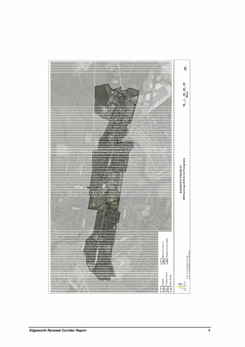
Figure 4: Character Precincts of the Edgeworth Renewal Corridor
Edgeworth Renewal Corridor Report 4
Edgeworth Renewal Corridor Report 5
3 Character Areas and Precincts
3.1 Character Areas and Precincts
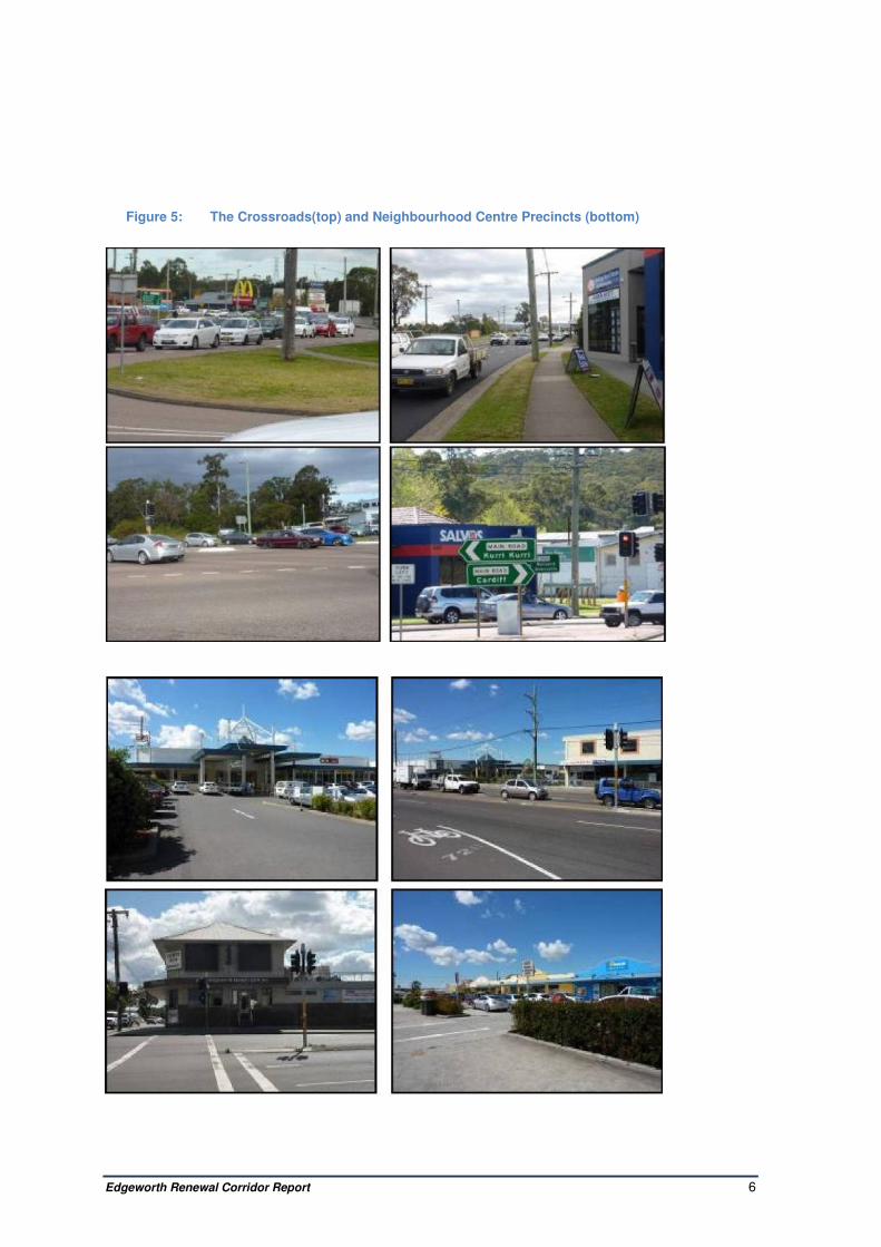
The Crossroads Precinct — The intersection of Lake Road and Main Road (the two main roads
of this area) is characterised by high traffic volumes and an open appearance attributed to the
width of the road, the flat topography and the low intensity of development on all but the north-
western corner. The high visibility sites that surround the intersection can provide a strong sense of
place and identity for the Precinct The land on the northeastern corner is vacant and owned by
NSW Land and Housing Corporation. This corner has a maximum height limit of 10 metres. It is
likely this land is developed for medium density public housing.on the southeastern corner, the land
is zoned for commercial use and the lot sizes are much larger. A car yard operates on the Lake
Road frontage, and the land on the Main Road frontage is vacant and zoned for commercial use.
The height limit is 13 metres for properties fronting both of these roads.
The southwestern corner has a sports oval with a small amenities block and Winding Creek flows
east west through the middle of the site. This corner site has a maximum height limit of 8.5 metres.
The land on the northwest corner includes commercial development serving a local market as well
as passing trade (e.g. takeaway food). It is characterised by land parcels of varying size constrain-
ed by a storm water channel and residential development to the north/ northwest.
The Main Road frontage on the northwestern corner has a series of separate shops built to the
front property boundary in a “main street” format. Buildings fronting Lake Road vary, but are
generally set back from the front property boundary. The height limit for the commercial properties
on the northwestern corner, and fronting both Lake Road and Main Road is a maximum 13 metres.
Education Precinct — Beyond the northwestern corner of the Crossroads is an area is character-
ised by large buildings used for various levels of education. Set back at a distance from front
boundaries, each educational institution is separated from the others, and from other destinations
e.g. Glendale Centre, the proposed Lake Macquarie Transport Interchange (LMTI) and the Hunter
Sports Centre. There is minimal signage in this area, and pedestrian and cycleway links could be
improved.
The TAFE site has considerable undeveloped land. This land has an 8.5 metre height limit. There
is scope to develop and link educational institutions as a “precinct” with improved signposting, and
better bike and pedestrian links. A range of destinations is within walking and cycling distance for
the young users of the Education Precinct but links to and from these destinations need to be safe
and convenient. The adjacent residential area is zoned to permit medium density development that
could capitalise on the high accessibility of the Crossroads for bus services, and complement the
education institutions.
Edgeworth Renewal Corridor Report 6
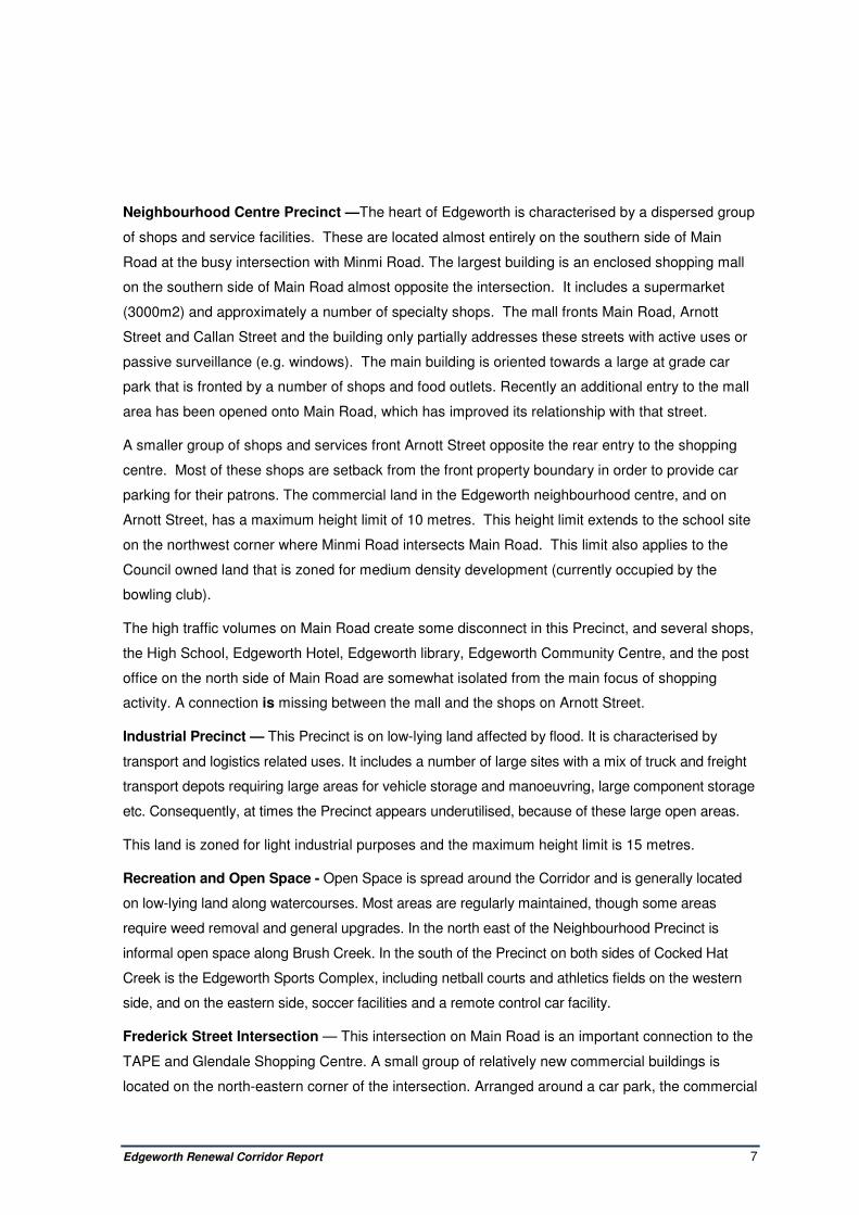
Figure 5: The Crossroads(top) and Neighbourhood Centre Precincts (bottom)
Edgeworth Renewal Corridor Report 7
Neighbourhood Centre Precinct —The heart of Edgeworth is characterised by a dispersed group
of shops and service facilities. These are located almost entirely on the southern side of Main
Road at the busy intersection with Minmi Road. The largest building is an enclosed shopping mall
on the southern side of Main Road almost opposite the intersection. It includes a supermarket
(3000m2) and approximately a number of specialty shops. The mall fronts Main Road, Arnott
Street and Callan Street and the building only partially addresses these streets with active uses or
passive surveillance (e.g. windows). The main building is oriented towards a large at grade car
park that is fronted by a number of shops and food outlets. Recently an additional entry to the mall
area has been opened onto Main Road, which has improved its relationship with that street.
A smaller group of shops and services front Arnott Street opposite the rear entry to the shopping
centre. Most of these shops are setback from the front property boundary in order to provide car
parking for their patrons. The commercial land in the Edgeworth neighbourhood centre, and on
Arnott Street, has a maximum height limit of 10 metres. This height limit extends to the school site
on the northwest corner where Minmi Road intersects Main Road. This limit also applies to the
Council owned land that is zoned for medium density development (currently occupied by the
bowling club).
The high traffic volumes on Main Road create some disconnect in this Precinct, and several shops,
the High School, Edgeworth Hotel, Edgeworth library, Edgeworth Community Centre, and the post
office on the north side of Main Road are somewhat isolated from the main focus of shopping
activity. A connection is missing between the mall and the shops on Arnott Street.
Industrial Precinct — This Precinct is on low-lying land affected by flood. It is characterised by
transport and logistics related uses. It includes a number of large sites with a mix of truck and freight
transport depots requiring large areas for vehicle storage and manoeuvring, large component storage
etc. Consequently, at times the Precinct appears underutilised, because of these large open areas.
This land is zoned for light industrial purposes and the maximum height limit is 15 metres.
Recreation and Open Space - Open Space is spread around the Corridor and is generally located
on low-lying land along watercourses. Most areas are regularly maintained, though some areas
require weed removal and general upgrades. In the north east of the Neighbourhood Precinct is
informal open space along Brush Creek. In the south of the Precinct on both sides of Cocked Hat
Creek is the Edgeworth Sports Complex, including netball courts and athletics fields on the western
side, and on the eastern side, soccer facilities and a remote control car facility.
Frederick Street Intersection — This intersection on Main Road is an important connection to the
TAPE and Glendale Shopping Centre. A small group of relatively new commercial buildings is
located on the north-eastern corner of the intersection. Arranged around a car park, the commercial

Edgeworth Renewal Corridor Report 8
buildings serve a wider spatial market than the local area and include a large dental clinic, a
service station, automobile parts retailer, and a fast food outlet. This land is zoned for commercial
use and has a 13 metre height limit.
The buildings on this northeastern corner are slightly elevated above Main Road, and its visual
prominence makes it an important "gateway" site. The other three corners of this intersection are
zoned for residential use, have a height limit of 8.5 metres. These three corners comprise single
storey domestic scale detached buildings. A dental business occupies one corner, and the other
two are used as dwellings.
Figure 6: Industrial Character Precinct
Figure 7: Frederick Street Intersection Character Precinct

Edgeworth Renewal Corridor Report 9
Corridor: Main Road General — Main Road is characterised by through traffic, with very high
volumes of traffic creating a barrier between the north and south sides of Main Road. A strong
commercial presence occurs at the Lake Road, Frederick Street and Minmi Road intersections and
there are high numbers of vehicle turning movements to destinations such as the Glendale
Regional Centre, or the Education Precinct. The high traffic volumes result in relatively poor
amenity.
Built form is characterised by single storey detached residential development. Particularly on the
southern side blocks are generally rectilinear in shape and around 70m x 280m with the shorter
width fronting Main Road. The subdivision of the area has occurred over several decades, and this
has unfortunately led to some breaks in the street system connectivity. Streets are generally wide
with grass footpaths, with only some streets having paved footpaths. Almost the entire Precinct has
a bus route in easy walking distance.
The western end of the Precinct has two primary schools, Edgeworth Heights Primary at the
intersection of Northville Drive and Main Road (southern side) and St Benedict's Catholic Primary,
just east of this intersection (northern side).
A small park on Johnson Street provides a focus for the neighbourhood on the southern side of
Main Road, just east of the shopping centre and industrial area.
A McDonalds fast food outlet is located on Main Road north at its intersection with Impala Street.
This site has a 13 metre height limit. Medium density development is scattered throughout the
area, and is predominantly single storey "villa" style homes.
Lot sizes vary, and while some streets have larger lots suitable for small-scale medium density
development, most lots would require amalgamation for medium density development. Refer to
Figure 8 below. The height limit for this residential land is 8.5 metres. Small lot sizes and fragment-
ed ownership of private housing will limit the speed and scale of private sector redevelopment even
though the topography is relatively flat, and there is good street connectivity, access to schools,
general stores and bus route making the land attractive for medium density redevelopment.
Figure 8: Main Road Residential Character Precinct