d. crossfborder cooperationon · d.8.3!crossfbordercooperation!on!...
TRANSCRIPT

Collaborative Project
Grant Agreement No. 312384 Start date of the project: 1st March 2013
Duration: 24 months
D.8.3 CROSS-‐BORDER COOPERATION ON EMERGENCY RESPONSE MANAGEMENT
AND LESSONS LEARNT
WP8 Sustainability and take-‐up
Due date of deliverable: 28 Feb 2015 Actual submission date: 28 Feb 2015
D.8.3 CROSS-‐BORDER COOPERATION ON EMERGENCY RESPONSE MANAGEMENT AND LESSONS LEARNT
FP7-‐SPACE-‐2011 1 of 90 GA n. 312384 Collaborative Project PU
Document Information
Deliverable number and title D.8.3 Cross-‐border cooperation on Emergency Response Management and Lessons learnt
Nature of deliverable Report (R)
Dissemination level Public (PU)
Lead beneficiary Umberto Pernice (UP)
Participant partners CNR, DPC, KCL, ALTA, KCL, PWCSt&, GMX
WP contributing WP8, WP9
Document responsible Umberto Pernice
Reference Documents D.2.4 User Needs and Gap Analysis Report D.8.1 Business Plan D.8.2 Service Integration Report
Document review history
Revision date Version Summary of changes Author / Partner short name
10 Feb 2014 0.1 Template and first inputs Umberto Pernice (UP)
23 Sep 2014 1.0 Integrations in sections 1, 2, 3 Umberto Pernice (UP)
10 Feb 2015 2.0 First complete draft Umberto Pernice (UP)
19 Feb 2015 2.1 Inputs in sections 2.3.4 and 2.5
A. Mondini (CNR); R. Onori /C. Proietti (DPC); M. Garcia (ALTA) G. Vaitkus (GMX);
20 Feb 2015 2.1 BDM Revision B. Malamud (KCL)
21 Feb 2015 3.0 Integrations Umberto Pernice (UP)
25 Feb 2015 3.1 Integration of conclusions Umberto Pernice (UP)
Approvals This document requires the following approvals
Name/Organization Status Date of approval
Umberto Pernice (UP) Approved 28-‐02-‐2014

D.8.3 CROSS-‐BORDER COOPERATION ON EMERGENCY RESPONSE MANAGEMENT AND LESSONS LEARNT
FP7-‐SPACE-‐2011 2 of 90 GA n. 312384 Collaborative Project PU
Table of contents Executive Summary ....................................................................................................................... 5 1. Introduction ........................................................................................................................... 5
1.1 Structure of the document ................................................................................................. 5 1.2 Methodology used .............................................................................................................. 6
2. LAMPRE products and the Copernicus context ..................................................................... 7 2.1 Brief overview of Copernicus .............................................................................................. 7
2.1.1 The Copernicus Emergency Management Service (EMS) ............................................ 8 2.1.2 The Copernicus Land Monitoring Service (LMS) .......................................................... 9
2.2 LAMPRE products and the Copernicus Services ................................................................ 10 2.3 Capacities on adopting the Copernicus EMS ..................................................................... 13
2.3.1 The interim-‐evaluation of the GMES Preparatory Action .......................................... 14 2.3.2 GIO-‐EMS Copernicus User Uptake ............................................................................. 15 2.3.3 Towards the procurement of the Copernicus Services .............................................. 17 2.3.4 Benchmarking Copernicus-‐derived products and services ........................................ 18
2.4 Synergies with the Copernicus Emergency Projects ......................................................... 19 2.5 Evidence from recent Copernicus events ......................................................................... 23
3. Cooperation opportunities .................................................................................................. 28 3.1 Defining cross-‐border and territorial cooperation ............................................................ 29 3.2 Organizations involved in cooperation ............................................................................. 30
3.2.1 European organizations ............................................................................................. 31 3.2.2 International organisations ........................................................................................ 33
3.3 EU programmes fostering cooperation ............................................................................. 35 3.3.1 Worldwide .................................................................................................................. 35 3.3.2 Latin America and the Caribbean ............................................................................... 38 3.3.3 Asia ............................................................................................................................. 40 3.3.4 Europe ........................................................................................................................ 41 3.3.5 The Euro-‐Mediterranean Region ................................................................................ 49 3.3.6 The Mediterranean Region ........................................................................................ 50 3.3.7 The ENPI East Region ................................................................................................. 51
3.4 EU funded projects on cooperation .................................................................................. 53 3.4.1 FP7 and CIP funded projects ...................................................................................... 53 3.4.2 ETC and LIFE funded projects ..................................................................................... 55 3.4.3 Civil Protection Exercises ........................................................................................... 61
4. Clusters opportunities ......................................................................................................... 62 4.1. Defining clusters ............................................................................................................... 62 4.2 EU initiatives and programmes fostering clusters ............................................................ 64
4.2.1 EU policy framework on clusters ................................................................................ 64 4.2.1 EU programmes for clusters ....................................................................................... 66
4.3 Examples of clusters and meta-‐clusters ............................................................................ 73 5. Combining policies and financial instruments ..................................................................... 75
5.1 Summary of EU programmes and related policies ............................................................ 75 5.2 Other financial mechanisms and instruments .................................................................. 76 5.3 Strategies to combined funding ........................................................................................ 79
6. Conclusions .......................................................................................................................... 79 6.1 Lessons learnt from Cooperation and Clusters ................................................................. 79 6.2 Scenarios for clusters and benefits ................................................................................... 80 6.3 Impact on EU Policies and Strategies ................................................................................ 83
Appendix 1 – Survey to SUG members ....................................................................................... 85 References .................................................................................................................................. 88

D.8.3 CROSS-‐BORDER COOPERATION ON EMERGENCY RESPONSE MANAGEMENT AND LESSONS LEARNT
FP7-‐SPACE-‐2011 3 of 90 GA n. 312384 Collaborative Project PU
List of tables Table 1 -‐ LAMPRE products, users and uses ............................................................................... 12 Table 2 -‐ Relevance of LAMPRE products to Copernicus Services .............................................. 13 Table 3 – Factors for benchmarking the adoption of Copernicus-‐related products ................... 19 Table 4 -‐ Expected impact of SPACE calls .................................................................................... 20 Table 5 -‐ Synergies between LAMPRE and other Copernicus-‐related projects .......................... 21

D.8.3 CROSS-‐BORDER COOPERATION ON EMERGENCY RESPONSE MANAGEMENT AND LESSONS LEARNT
FP7-‐SPACE-‐2011 4 of 90 GA n. 312384 Collaborative Project PU
List of acronyms cited ALTA ALTAMIRA Information CBC Cross-Border Cooperation CNR Consiglio Nazionale delle Ricerche CORINE Coordination of Information on the Environment CPA Civil Protection Authorities D. Deliverable DPC Dipartimento della Protezione Civile DRM Disaster Risk Management DRR Disaster Risk Reduction EEA European Enterprise Agency EMS Emergency Management Service ENI European Neighbourhood Instrument ERCC Emergency Response Coordination Centre ESA European Space Agency ESIF European Structural & Investment Funds ETC European Territorial Cooperation GEOS Global Earth Observation System of Systems GMES Global Monitoring for Environment and Security GMX Geomatrix UAB IGME Instituto Geológico y Minero de España JRC Joint Research Centre KCL King’s College London LMS Land Monitoring Service NFP National Focal Point PWCStr& Price Waterhouse Coopers Strategy & REA Research Executive Agency RTD Research and Technology Development SDI Spatial Data Infrastructure SEM Satellite-based Emergency Mapping SUG Stakeholder User Group UNIFI Università degli Studi di Firenze UNISDR United Nations Office for Disaster Risk Reduction UP Umberto Pernice WP Work Package

D.8.3 CROSS-‐BORDER COOPERATION ON EMERGENCY RESPONSE MANAGEMENT AND LESSONS LEARNT
FP7-‐SPACE-‐2011 5 of 90 GA n. 312384 Collaborative Project PU
Executive Summary Task 8.3 “Exploring LAMPRE cross-‐border cooperation between countries” is one of the three tasks composing Work Package 8 “Sustainability and take up” of LAMPRE. WP8 is devoted to exploitation activities for the economic sustainability of the outcomes of LAMPRE (i.e. geospatial products and services) and their potential uptake by end-‐users. The outcome of this task consists of D.8.3 “Cross-‐border cooperation on emergency response management and lessons learnt”, due in M24 (last month) of the LAMPRE project. D8.3 is also the last deliverable of WP8, and contributes to the identification of potential ways to move forward the final scientific and technological results of LAMPRE, through cooperation and clustering activities between different organizations and countries, funded by EU financial programmes.
1. Introduction Starting from the geospatial-‐based products developed by LAMPRE and from the exploration of the outcomes (i.e., tools, products and services) of other EU-‐funded research and technology development projects, including the analysis of synergies between Copernicus-‐related projects conducted by Task 8.21 and Task 8.3, D.8.3 aims to explore the possibilities of stimulating cooperation between different organizations (i.e., research organizations, companies, governments at various levels) involved in these projects, considering also synergies with the Copernicus Emergency Management Service (EMS). Such an investigation also extends to the possibility of creating thematic (e,g, based on natural hazards) or regional clusters to stimulate the adoption of LAMPRE and other geospatial products and services between different organizations which are involved in different ways in the natural hazards setting and disaster risk reduction scenario, in Europe and elsewhere. Furthermore, clustering activities may facilitate different forms of cooperation between partners of existing FP7 projects and other actors, through new projects supported by new EU financial instruments. Under such a perspective, potential links between LAMPRE products and the Copernicus EMS (but also the Land Monitoring Service) are considered, in the logic of mainstreaming the Copernicus Services in user specific environments and organizations. Finally, D.8.3 identifies recommendations on the potential impact of LAMPRE cooperation and clustering activities for EU policies related to natural hazards and disaster risk reduction.
1.1 Structure of the document This document is structured as follows:
• Chapter 1. Describes the aim and scope of Task 8.3 and D.8.3.
1 The outcome of Task 8.2 was the deliverable “D8.2 Service Integration Report” which describes the assessment of functional and operational links of LAMPRE with existing Copernicus services (see §2.4).
D.8.3 CROSS-‐BORDER COOPERATION ON EMERGENCY RESPONSE MANAGEMENT AND LESSONS LEARNT
FP7-‐SPACE-‐2011 6 of 90 GA n. 312384 Collaborative Project PU
• Chapter 2. Describes the Copernicus Services context (and chiefly the Emergency Response Management) in which the products of LAMPRE can be fit, looking for synergies with projects and initiatives with the aim of contributing to strengthen the operational capacities of those organizations involved in disaster risk management (prevention and reduction). This chapter also includes the proposal of a benchmarking grid for assessing the adoption of Copernicus-‐derived products.
• Chapter 3. Gives a European and international overview of key organizations engaged in cooperation activities, identifies funding opportunities coming from EU programmes enhancing cooperation, and provides relevant examples of projects and initiatives on cooperation between organizations and countries in the field of natural hazards, towards the goal of Disaster Risk Reduction.
• Chapter 4. Depicts the European policy framework for clusters, identifies opportunities from EU programmes enhancing “clustering” activities, and provides relevant examples of projects and initiatives on clustering in several fields (not only Space and Earth Observation technologies).
• Chapter 5. Recaps EU policies and programmes, adding to these other financial mechanisms and highlights the need for combined funding.
• Chapter 6. Using evidence from all the previous chapters, summarises forms of lessons learned and depicts some funding scenarios to move forward.
• Appendix 1. Gives the answers provided by members of the LAMPRE Stakeholder and User Group (SUG) to the survey delivered at the first LAMPRE Exploitation workshop.
1.2 Methodology used The methodology to develop this task (T8.3) was based on both a desk and a field analysis, exploiting different relevant international events. In particular, a very comprehensive desk analysis of EU programmes, initiatives and projects, covered both the last EU programming period (2007−2013) and the present one (2014−2020), exploring an extensive list of official EU documentations (e.g., Regulations, EU COMM, Policy papers, Work Programmes), institutional websites and relevant sources. This analysis produced structured information that was integrated with input from a field analysis, based on interviews and discussions with relevant stakeholders in the Space sector and the Disaster Risk Reduction sector. In particular, a set of specific questions was included in the survey presented to SUG members invited at the 1st Exploitation Workshop. Answers (see Appendix 1) contain indications about the perception and interest of these organizations toward the evolution of the Copernicus Services, the potential exploitability of the products delivered by LAMPRE, the potential synergies with other Copernicus projects and initiatives and to possibility of cooperation and clustering through funding-‐mechanisms. Further insights were achieved through the participation of partners of task 8.3 at several relevant dissemination events, including:
• the international SPACE4You Conference (Bari on 27-‐28 February 2014) • the Copernicus Big Data Workshop (Brussels, 13-‐14 March 2014) • the European Space Solutions conference (Prague, 12th June 2014) • the 3rd International Space Research Conference (Rome, 15-‐17 Sept. 2014) • the Copernicus Emergency Projects workshop (Brussels, 4 December 2014)

D.8.3 CROSS-‐BORDER COOPERATION ON EMERGENCY RESPONSE MANAGEMENT AND LESSONS LEARNT
FP7-‐SPACE-‐2011 7 of 90 GA n. 312384 Collaborative Project PU
The methodology and approach used is represented by the flow diagram given in Figure 1.
2. LAMPRE products and the Copernicus context This section provides a short overview of the Copernicus context in which LAMPRE operates and where LAMPRE products can be integrated, considering the analysis and findings about the Copernicus programme and related EU projects produced by other LAMPRE deliverables (i.e. D.2.4 User Needs and Gap Analysis Report and D.8.2 Service Integration Report).
2.1 Brief overview of Copernicus Copernicus (formerly known as GMES, Global Monitoring of Environment and Security) is the European system for monitoring the Earth. The programme represents the most important contribution of the European Union to Global Earth Observation System of Systems (GEOSS). The Copernicus programme is based on a partnership between the EU, ESA and the Member States. Copernicus integrates satellites, in-‐situ data and modelling to provide user-‐focused information services to support policymakers, businesses and citizens. It aims at strengthening existing European and national capacities for Earth Observations (EO) and providing operational services in the field of the environment, civil protection and civil security, though recognizing national mandates on official warnings.
Figure 1 -‐ Process flow to define cooperation and clusters scenarios for moving forward

D.8.3 CROSS-‐BORDER COOPERATION ON EMERGENCY RESPONSE MANAGEMENT AND LESSONS LEARNT
FP7-‐SPACE-‐2011 8 of 90 GA n. 312384 Collaborative Project PU
Copernicus consists of a complex set of systems which collect data from multiple sources: earth observation satellites and in situ sensors such as ground stations, airborne and sea-‐borne sensors. It processes these data and provides users with reliable and up-‐to-‐date information through a set of services related to environmental and security issues. The services address six thematic areas: land, marine, atmosphere, climate change, emergency management and security. They support a wide range of applications, including environment protection, management of urban areas, regional and local planning, agriculture, forestry, fisheries, health, transport, climate change, sustainable development, civil protection and tourism. The Copernicus services have reached different degrees of maturity stage (i.e. operational, pre-‐operational under development). They are exploiting:
• Available contributing EO missions and in situ data provided mainly by the Member States;
• Capacities for space-‐borne observations and services of Member States; • Capacities of commercial initiatives in Europe, contributing to the development of a
viable commercial “Space” sector in Europe. Relevance for LAMPRE: of the six Copernicus services, the set of LAMPRE geospatial products and services can give added value and contribute to enrich mainly the portfolio the Copernicus Emergency Management Service (EMS) and the Copernicus Land Monitoring Service (LMS).
2.1.1 The Copernicus Emergency Management Service (EMS) The Copernicus Emergency Management Service (EMS) aims to reinforce Europe's capacity to respond to emergency situations caused by extreme weather, geophysical hazards, human-‐made disasters and humanitarian crises. The EMS started with the GMES Initial Operations (GIO) which covered the period 2011-‐2013. The precursors of the EMS-‐Mapping were the SAFER project and then the linKER project. The EMS-‐Mapping was the first operational service within GIO and it is operational since April 2012. The main aim of this service is to provide timely and accurate geospatial information to decision makers in all phases of the emergency management cycle. The service addresses user needs among civil protection authorities, humanitarian actors and Commission services responsible for Environment, Humanitarian Aid, and External Relations across the full range of disasters and emergencies (e.g. floods, earthquakes, landslides, fires, severe storms, volcanoes, humanitarian crises and tsunamis). Services under EMS-‐Mapping are offered upon activation by authorised users and are free of charge. The information generated by the service (i.e. data and products) can be used as supplied (e.g. as digital or printed map outputs) or further combined with other data sources (e.g. as digital feature sets in a Geographic Information System -‐ GIS) to support geospatial analysis and decision making processes of emergency managers. The Copernicus EMS-‐Mapping uses satellite images, completed by available reference data or open data sources. It is designed to provide standard information layers that can be directly incorporated into users’ GIS / decision support systems. Data products are made available to users, such as civil protection agencies, directly through the Emergency Response Coordination Centre (ERCC) at the Monitoring and Information Centre (MIC), via secure FTP download.

D.8.3 CROSS-‐BORDER COOPERATION ON EMERGENCY RESPONSE MANAGEMENT AND LESSONS LEARNT
FP7-‐SPACE-‐2011 9 of 90 GA n. 312384 Collaborative Project PU
The ERCC is the operational heart of the EU Civil Protection Mechanism, coordinating the emergency response of its 32 Participating States. It is active on a 24/7 basis and makes sure that all contributions are properly handled to reach the most vulnerable. It supports the transport of civil protection assets, by providing early warning and analytical capacity as well as a robust situational and satellite mapping system2. The EMS-‐Mapping is provided during all phases of the emergency management cycle, in either rush or non-‐rush mode. Two main categories of products3 are delivered:
• Rapid Mapping consists of the on-‐demand and fast provision (within hours or days) of geospatial information in support of emergency management activities immediately following an emergency event. The products are standardised. There are three categories of maps offered:
o Reference Maps o Delineation Maps o Grading Maps;
• Risk and Recovery Mapping consists of the on-‐demand provision of geospatial information in support of Emergency Management activities not related to immediate response. This applies in particular to activities dealing with prevention, preparedness, disaster risk reduction and recovery phases. There are three broad product categories:
o Reference Maps, o Pre-‐disaster Situation Maps o Post-‐disaster Situation Maps.
2.1.2 The Copernicus Land Monitoring Service (LMS) The Copernicus Land Monitoring Service (LMS), became operational in 2012, and provides geographical information on land cover and on variables related, for instance, to the vegetation state or the water cycle. It supports applications in a variety of domains such as spatial planning, forest management, water management, agriculture and food security, etc. The LMS consists of three main components:
• A global component, coordinated by the EC DG Joint Research Centre (JRC). It creates data across a wide range of biophysical variables, at a worldwide scale, to describe the state of vegetation, the energy budget and the water cycle.
• A Pan-‐European component, coordinated by the European Environment Agency (EEA). It produces high-‐resolution data sets describing the main land cover types: artificial surfaces (e.g. roads and paved areas), forest areas, agricultural areas (grasslands), wetlands, and small water bodies. It also updates the CORINE Land Cover (CLC) dataset to the reference year 2012
• A local component, coordinated by the EEA. It provides specific and complementary information to the Pan-‐European component, focusing on "hotspots" which are prone
2 Since its launch in 2001, the EU Civil Protection Mechanism has monitored 253 disasters and has received over 150 requests for assistance -‐ European Commission -‐ Humanitarian Aid And Civil Protection, 10 Years of the EU Civil Protection Mechanism 3 A “Copernicus EMS Risk and Recovery Mapping product portfolio specifications” for risk and recovery mapping services was produced with the contribution of the Joint Research Centre (JRC) (http://emergency.copernicus.eu/mapping/ems/user-‐guide).

D.8.3 CROSS-‐BORDER COOPERATION ON EMERGENCY RESPONSE MANAGEMENT AND LESSONS LEARNT
FP7-‐SPACE-‐2011 10 of 90 GA n. 312384 Collaborative Project PU
to specific environmental challenges. In particular it provides detailed land cover and land used information over major European cities, which are the first type of "hotspots" (so-‐called Urban Atlas).
2.2 LAMPRE products and the Copernicus Services LAMPRE has developed a set of products (Figure 2) which improve the response capacity of different actors (e.g., Civil Protection Authorities, planning and development authorities, transportation authorities and utility managers, agricultural and forest agencies) operating in the preparedness and recovery phases of the disaster cycle. The set includes:
1. Landslide Inventory Map (LIM). This type of map shows the location, spatial extent and type of landslides in a region.
2. Event Landslide Inventory Map (E-‐LIM). This type of map shows the location and extent of landslides caused by a specific natural trigger, such as an intense rainfall event, a period of prolonged rainfall, a rapid snowmelt event, or an earthquake. LAMPRE has developed advanced methods and tools to prepare both LIMs and E-‐LIMs exploiting high and very-‐high resolution optical satellite images.
3. Landslide Susceptibility Model & Map (LSMM). These models and maps predict where landslides are expected to occur or be more or less abundant based on terrain conditions, including the local morphological, geological, and land use settings. LAMPRE has developed this specific software to model landslide susceptibility and to produce the associated maps using statistical modelling tools.
4. Statistics of landslide size (LStats). This software developed by LAMPRE determines the statistics of landslide areas. This is important for landslide hazard and vulnerability modelling, for risk assessment, and for landscape and erosion modelling. The software can be used anywhere information on the size of the landslides is available. This information can be obtained from a geomorphological landslide inventory, an event landslide inventory, or a seasonal or multitemporal inventory in a GIS. The software is most appropriate for analysis of low mobility landslides, and should be used with caution when examining rock falls or debris flows.
5. 3D Surface Deformation Models (3DSDM). LAMPRE has developed methods to preparing 3DSDMs for slow-‐moving landslides anywhere adequate time-‐series of surface and sub-‐surface displacements are available, together with topographic, geological, geotechnical and groundwater information. The methods are applicable to landslides of different sizes, and work best where continuous monitoring devices are available. 3DSDMs prepared by LAMPRE exploit advanced Finite Element Models (FEMs4) and combine advanced space-‐borne DInSAR products, in-‐situ monitoring data, and geological, geotechnical and groundwater information. They are well suited to predict the temporal evolution of slow-‐moving landslides in urban and sub-‐urban areas, and for landslides affecting infrastructures.
6. Landslide-‐Road Impact Model (LRIM). LAMPRE has developed the LRIM to explore different potential scenarios of regional road network disruption by different numbers of landslide. The model can be applied to any region where triggered landslide events
4 A FEM is a numerical representation of the stress-‐strain behaviour of a slope, and can be used to predict the kinematical behaviour of slow moving landslides.

D.8.3 CROSS-‐BORDER COOPERATION ON EMERGENCY RESPONSE MANAGEMENT AND LESSONS LEARNT
FP7-‐SPACE-‐2011 11 of 90 GA n. 312384 Collaborative Project PU
occur and road network, susceptibility and elevation data is available to simulate the most likely impact upon the road network (i.e. number of roads blocked by landslides, number of landslides nearby the roads, potential resultant road network disruptions).
7. LAMPRE Educational (LEdu). A set of resources and activities has been developed for teachers, students and the general public so that they can better understand individual landslide processes, landslide monitoring, and triggered landslide events.
Although the LAMPRE geospatial products are at a prototype level, they can be integrated with products developed by other projects and/or the Copernicus EMS portfolio. The maturity of LAMPRE products in terms of Technology Readiness Level has been evaluated by the project partners (chiefly ALTA and CNR), by assuming input to these are available and considering the following features: Automatic; Robust, Extrapolation.
Figure 2 -‐ List of LAMPRE products

D.8.3 CROSS-‐BORDER COOPERATION ON EMERGENCY RESPONSE MANAGEMENT AND LESSONS LEARNT
FP7-‐SPACE-‐2011 12 of 90 GA n. 312384 Collaborative Project PU
Different users can use and benefit from LAMPRE products as illustrated in Table 1 Table 1 -‐ LAMPRE products, users and uses
User Product
Civil Protection authorities
Planning & development authorities
Transportation authorities &
utility managers
Agricultural & forest agencies
Scientists
Landslide Inventory Map (LIM)
In the aftermath of an event for improved rescue and recovery operation.
To identify areas affected by landslides so that dangerous areas can be avoided or considered for planning activities.
To evaluate the impact of landslides on transportation or utility networks.
To assess the impact of landslides on crops and forests.
For erosional studies and to determine the statistics of landslide areas.
Event Landslide Inventory Map (ELIM)
Landslide Susceptibility Model & Map (LSSM)
In landslide regional or national early warning systems, and to improve their response capacity.
To identify landslide prone areas and to zone a territory accordingly.
To predict the impact of landslides on transportation or utility network, and for maintenance strategies.
To identify landslide prone areas, for improved agricultural and forest management.
To predict the expected climate and environmental changes on landslide abundance and activity.
Landslide Statistics (LStats)
To anticipate the sizes of the landslides caused by an intense or prolonged rainfall, an earthquake, or a rapid snowmelt event.
To anticipate the size of the landslides expected in a territory.
To evaluate the potential vulnerability to event landslides of transportation or utility network.
To evaluate the potential vulnerability of crops and forests to event landslides.
For erosional studies and landscape modelling.
3D Surface Deformation Modelling (3DSDMs)
To anticipate the behaviour of slow-‐moving landslides for early warning and improved vulnerability and risk analyses.
To construct landslide scenarios for improved planning, and to investigate the efficacy of remedial and mitigation measurements.
To anticipate the impact of slow-‐moving landslides on transportation or utility networks.
To assess the impact of slow-‐moving landslides on crops and forests.
To understand the kinematics of landslides in a changing climate.
Landslide-‐Road Impact Model (LRIM)
To model scenarios of network impact of different sized triggered landslide events and potential resources that might be needed.
To identify potentially vulnerable road network scenarios and plan appropriate redundancies in the road networks.
To model potential road distance unavailable in the road network, and resultant disruption, as a result of landslides.
To model potentially vulnerable road network scenarios in forests.
To simulate the potential impact of landslides, and other types of hazards, on different kinds of infrastructure networks.

D.8.3 CROSS-‐BORDER COOPERATION ON EMERGENCY RESPONSE MANAGEMENT AND LESSONS LEARNT
FP7-‐SPACE-‐2011 13 of 90 GA n. 312384 Collaborative Project PU
Table 2 illustrates the relevance of LAMPRE products to the Copernicus Services, in a scale of relevance comprised between one X (less relevant) and three X (more relevant): Table 2 -‐ Relevance of LAMPRE products to Copernicus Services
Emergency Management Service Land Monitoring Service
Product Rush mode Non rush mode
Landslide Inventory Map (LIM) XX XXX XXX
Event Landslide Inventory Map (ELIM) XXX XX XX
Landslide Susceptibility Model & Map (LSSM) XX XXX XXX
Landslide Statistics (LStats) XX XXX XXX
3D Surface Deformation Modelling (3DSDM) XX XXX XX
Landslide-‐Road Impact Model (LRIM) XX XXX XX
According to the analysis provided by D.2.4 “User Needs and Gap Analysis Report”, three LAMPRE products can better contribute to the Copernicus EMS and LMS which are ELIM, LIM and LSMM (Figure 3). In particular:
• LIM can be included in the portfolio of Copernicus EMS “non-‐rush mode” as well as in the Copernicus EMS in its Local component.
• E-‐LIM for the Rapid Mapping of the Copernicus EMS; • LSMM which is at European scale can be useful to be integrated both in the Copernicus
LMS at local and in the pan-‐European components.
2.3 Capacities on adopting the Copernicus EMS This section briefly discusses how European projects and initiatives have worked to create and strengthen capacities of Member States in the adoption of the Copernicus EMS. It also tries to identify which relevant factors should be considered for assessing operational capacities in the adoption of Copernicus-‐derived products and services. The ultimate goal is to provide input to common issues which can be jointly handled through cooperation and coordination activities between countries.
Figure 3 -‐ Integration of LAMPRE products with Copernicus EMS and LMS

D.8.3 CROSS-‐BORDER COOPERATION ON EMERGENCY RESPONSE MANAGEMENT AND LESSONS LEARNT
FP7-‐SPACE-‐2011 14 of 90 GA n. 312384 Collaborative Project PU
The EC's Emergency Response Coordination Centre5 (ERCC) hosted a workshop on the usefulness of Copernicus EMS products for flood events. End-‐users joining the workshop outlined various specific issues with the aim of making further improvements to the service in the future and, in particular, the following needs were raised:
• Shorten the timescale between the initial activation of the service by the user, the reception of the satellite data and the generation of the maps (i.e. rapid delivery of the maps, even when this is at the expense of quality);
• Provide maps in the local language. The ERCC workshop proved how mutual understanding of users’ needs and satellite capabilities, in spite of different constraints (e.g., receiving satellite data, processing workflows), can facilitate further improvement of the service at all levels6.
2.3.1 The interim-‐evaluation of the GMES Preparatory Action Many Member States are characterised by a multi-‐agency environment (i.e. multiple agencies in each country at national, regional and local levels) which creates a general challenge of ensuring effective coordination across different areas of emergency management at a multiple-‐level. The importance of ensuring strong coordination of civil protection agencies through the setting up and operation of the network of National Focal Points (NFPs) is more evident in Member States such as Germany, Italy and Spain having federal and regionalised civil protection structures. In particular, there is a need to ensure that coordination structures are in place across different Member States so that there are procedures for ensuring that sub-‐regional and local actors can both trigger the GIO-‐EMS through the NFP and that, when triggered at national level, all interested agencies can access the data products, and not only those that directly activated the service. In the view of DG ECHO, DG JRC and users themselves, the project linKER helped to promote much stronger and more effective coordination between civil protection agencies and emergency response organisations (e.g. fire and rescue, police), by giving users technical support for better accessing Emergency Response Service (ERS) data and products. LinKER contributed to structuring the civil protection user community at European level and intra-‐Member State communication by providing NFPs with access to a common EU-‐wide user-‐interface to communicate via Intranet, to access the server and download data products through FTP. The European Union has an important coordination role to play since users in the emergency management field are comparatively fragmented compared with some other Copernicus services, such as atmosphere, where meteorological institutes are used to cooperating one another on a pan-‐European basis.
5 Source: http://ec.europa.eu/echo/files/aid/countries/factsheets/thematic/ERC_en.pdf. 6 Source: http://newsletter.gmes.info/article/ecs-‐emergency-‐response-‐coordination-‐centre-‐hosts-‐workshop-‐usefulness-‐copernicus-‐ems-‐products
D.8.3 CROSS-‐BORDER COOPERATION ON EMERGENCY RESPONSE MANAGEMENT AND LESSONS LEARNT
FP7-‐SPACE-‐2011 15 of 90 GA n. 312384 Collaborative Project PU
In order to ensure that users are fully engaged and to strengthen coordination, there is a need to continue discussions in Member States about the role of the network of NFPs, within DG ECHO’s MIC, in disseminating imagery / data products to all relevant actors and in coordinating the involvement and participation of national, regional and local actors in the civil protection field. Sub-‐structures should be put in place in order to ensure that there is strong coordination with first responders and across the full range of emergency services depending on the nature of the emergency or humanitarian crisis. This applies equally to the “rush” and “non-‐rush” mode services. As mentioned in the Final Report prepared by the Centre for Strategy and Evaluation Services (CSES)7, the data products (e.g. maps) produced in support of rapid impact delineation in rush mode through the GIO-‐EMS were seen by end users as being highly relevant and, the ability to integrate EMS-‐Mapping data with other data sources, was viewed as highly relevant to stakeholders’ needs. The launch and initial phase of implementation of the EMS-‐Mapping Service has been able to draw on lessons learned through linkER and SAFER which stimulated service uptake among users. Users have made inputs since 2005 through the forum of dedicated thematic workshops, user meetings and working groups. In 2006, the Commission established an expert group, the Implementation Group for the definition of the Emergency Response Core Service (ERCS) with user representatives including civil protection authorities and Commission services responsible for Environment, Humanitarian Aid, and External Relations. Many emergencies affect cross-‐border areas, and necessitate a multi-‐lateral response from different actors across a number of Member States. Many Earth observation needs for policy makers and public users are inherently cross-‐border in nature, partly because of Member States having shared responsibility for monitoring border areas and the inter-‐connectedness of different regions, both those in immediate cross-‐border areas, and different countries that share similar environmental or urban characteristics e.g. bio-‐diversity monitoring in riparian zones, urban planning challenges between cities of a similar size. The GIO-‐EMS demonstrated European value-‐added since it addressed users’ cross-‐border EO monitoring needs in the emergency management and land sphere. However, although the GIO-‐EMS could be set up at national level, many Member States could not afford to operate the service and there are cost efficiencies associated with procuring EU-‐wide satellite imagery. The 2010 GIO Regulation covers EU27. Although there is some cooperation with EFTA and candidate countries in the Balkans and Turkey, the Regulation limits the extent of formal cooperation. However, there is a need to engage with these countries in producing GIO land data products, since environmental data across EEA39 is required.
2.3.2 GIO-‐EMS Copernicus User Uptake
7 Interim Evaluation of GMES Initial Operations (2011-‐2013), Centre for Strategy & Evaluation Services (CSES), January 2013.

D.8.3 CROSS-‐BORDER COOPERATION ON EMERGENCY RESPONSE MANAGEMENT AND LESSONS LEARNT
FP7-‐SPACE-‐2011 16 of 90 GA n. 312384 Collaborative Project PU
Different test cases on emergency were organised under task 3A of the GIO Lot2 User Uptake project8 with the aim of promoting the Copernicus Emergency Services and raising awareness and knowledge of the operational use and the potential benefit of the GIO EMS services. The test cases performed consisted of:
• National Showcases performed at user sites, involving the main national Emergency stakeholders.
• A European Showcase addressing a broader EU audience designed to encourage uptake of the Copernicus GIO EMS in those EU countries who have made infrequent or no use of the EMS (i.e. Greece, Poland, Bulgaria) to foster an understanding of the EMS service workflow, EMS user access and the correct usage of the GIO EMS products.
In particular, as emerged from the main conclusions for the Bulgaria test case:
• The process for formulating EMS activations can be improved. • There is a need to integrate national data and information in the Copernicus EMS
maps and to create a national catalogue of geospatial data and procedures for sharing data.
• Mechanisms and procedures for accessing and sharing information, including available remote sensing data are still needed.
• Potential bureaucratic obstacles within and between the different institutions involved in emergency and disaster risk management need to be understood and overcome.
• It would be advantageous if the EMS mapping products produced during the activation could be made available to all the members of the National Crisis Management Committee through a “common information system for crisis management”.
Although good progress has been made in strengthening awareness about GMES services and the potential benefits of using GMES data products, on-‐going work is needed to encourage user service uptake among specific types of users that are less familiar, such as local and regional authorities and some of the New Member States. This could be achieved through various mechanisms and initiatives stimulating the development of downstream GMES services and applications. Of these, the NEREUS-‐ESA joint initiative “Improving Copernicus take-‐up among Local and Regional Authorities (LRAs) via dedicated thematic workshops”, through a series of thematic workshops, wished to animate the dialogue between end users (mainly Local and Regional Authorities -‐ LRAs) and the supply side with the objective to gain more information about the factors that are behind a slow Copernicus uptake and potential roadblocks. Taking up the findings of the 2012-‐NEREUS/ESA-‐initiative, “The Growing Use of GMES Across Europe’s Regions” publication collects 67 examples of regional Copernicus applications illustrating the deployment situation at regional level. The collection had revealed plenty available Copernicus services at regional level, however stated that their actual deployment within regional administrations is slow-‐moving.
8 Source: http://www.user-‐uptake-‐portal.org/wp-‐content/uploads/2014/09/LOT2-‐RPT-‐EGE-‐T3A-‐07-‐00006-‐1.0-‐Emergency-‐Mainstreaming-‐Report.pdf

D.8.3 CROSS-‐BORDER COOPERATION ON EMERGENCY RESPONSE MANAGEMENT AND LESSONS LEARNT
FP7-‐SPACE-‐2011 17 of 90 GA n. 312384 Collaborative Project PU
The main Copernicus outlook presented at the latest Copernicus Emergency projects Workshop organised by the Research Executive Agency (REA) and DG Enterprise on December 20149 indicates, among various aspects, that:
• Data Policy adopted since end 2013 is based on full, free and open data; • Copernicus Services are looking forward to access data of Sentinels; • Continuation of research for development of services is needed.
In particular, to promote and facilitate the use of Earth observation technologies both by local authorities and by small and medium-‐sized enterprises (SMEs), dedicated networks for Copernicus satellite data distribution, including national and regional bodies, should be promoted10. The production and dissemination of satellite data between different users raise several issues, such as for example, security restrictions imposed by national authorities on satellite data according to national security interests which may endanger competitiveness and development of downstream services) and the unplanned release of data acquired by satellite sensors (e.g. high-‐resolution imaging). With this respect, the cross-‐border nature of satellite data exchanges requires cooperation between countries concerned by Earth observation could effectively ensure the compatibility of competitiveness standards with security considerations11.
2.3.3 Towards the procurement of the Copernicus Services As mentioned in the Regulation establishing the Copernicus Programme12, through Copernicus the European Commission aims to generate economic growth and jobs in Europe also strengthening the Earth Observation market, and in particular the “Downstream sector” with positive fallout into other commercial and export markets. For this purpose, the European Commission will delegate budget authority for the provision of the six Copernicus Services to a number of Entrusted Entities (EE’s), public bodies at European (not national) level, through a delegation agreement. The EE will be responsible for procuring the defined services and for maintaining and expanding the list of services through a competitive tender process. Quality of services will be assured through an independent authority, separate from any of the EE’s. Among the international analysts of the Space sector, the European Association of Remote Sensing Companies (EARSC) expressed, through several position papers, a point of view about the impact of the Copernicus Regulation13 for the industry and the procurement approach for
9 REA implements part of the FP7 and H2020 Work Programme for Space on behalf of DG Enterprise and therefore manages and monitors the progress of Copernicus Emergency FP7-‐funded projects. 10 Position of the European Parliament adopted at first reading on 12 March 2014. 11 Source: Communication from the Commission to the European Parliament, the Council, the European Economic and Social Committee and the Committee of the Regions EU Space Industrial Policy, Releasing the potential for economic growth in the Space sector -‐ http://eur-‐lex.europa.eu/LexUriServ/LexUriServ.do?uri=COM:2013:0108:FIN:EN:PDF 12 REGULATION (EU) No 377/2014 OF THE EUROPEAN PARLIAMENT AND OF THE COUNCIL of 3 April 2014 establishing the Copernicus Programme and repealing Regulation (EU) No 911/2010 13 EARSC Position Paper on the Copernicus Regulation, October 2013

D.8.3 CROSS-‐BORDER COOPERATION ON EMERGENCY RESPONSE MANAGEMENT AND LESSONS LEARNT
FP7-‐SPACE-‐2011 18 of 90 GA n. 312384 Collaborative Project PU
the Copernicus Services14. Essentially, the mix of European scale and national interest involved in Copernicus, the interests of the various stakeholders, including industry, which drive different models in the organisation of the supply chain of the EO downstream sector represent challenges to manage. Concerns were raised by EARSC that without clear guidance and mandatory rules, SMEs cannot become fully engaged and able to grow the downstream business sector. In such a direction some measures to be taken to harmonise the procurement of Copernicus Services by the Entrusted Entities were proposed in order to:
• Ensure that the procurement of the Copernicus services can benefit from all European strengths, both public and private sectors as well as in academia, through clear rules by which Copernicus Services will be procured. This leads to new Public-‐Private partnerships where: Academia and public bodies perform R&D into new techniques and technologies and enable the knowledge transfer into both public and private players; public bodies supply core public information needs (in line with their thematic and geographic mandates); the Private sector (i.e the Industry) takes responsibility and risk in delivering Copernicus Services and accessing and developing new markets for geospatial information;
• Identify specific measures to enable companies to lead and to participate to the maximum extent possible in the supply of Copernicus services, so that the industry can develop and apply the necessary skills and competences to develop and access new markets. This also includes, for example, the possibility to break down Copernicus services into several smaller blocks of products, with limits on the number of blocks any one company can get assignment;
• Ensure that services with a pan-‐European or global dimension involve a strong collaboration amongst all players irrespective of national boundaries and interests.
2.3.4 Benchmarking Copernicus-‐derived products and services In the constellation of the Copernicus Services and derived products where LAMPRE also fits, it is not an easy goal to define a benchmarking methodology for assessing the adoption by operational users (e.g. Civil Protection Authorities) of Copernicus-‐related products. D.2.4 User Needs and Gaps Analysis, led by the Italian Civil Protection Department (DPC), partner of LAMPRE has evaluated the improvement of the operational capability of Civil Protection Authorities with the adoption of some specific LAMPRE products (i.e. E-‐LIM, LIM, LSMM) and the perspective of their integration in the Copernicus EMS and LMS (see §2.2). Table 3 proposes a list of factors that can be considered when considering the adoption of Copernicus-‐related products. These factors, identified by Task 8.3, are grouped into four main aspects (i.e. Strategic/Political, Managerial, Technological, Operational), as follows:
14 EARSC Views on the Procurement of the Copernicus Services, September 2014

D.8.3 CROSS-‐BORDER COOPERATION ON EMERGENCY RESPONSE MANAGEMENT AND LESSONS LEARNT
FP7-‐SPACE-‐2011 19 of 90 GA n. 312384 Collaborative Project PU
Table 3 – Factors for benchmarking the adoption of Copernicus-‐related products
Strategic and Political Managerial
• Capabilities to respond to Copernicus procurement tenders
• Remote sensing data acquisition plans and policies
• INSPIRE compliancy • Financial capabilities to establish emergency
management systems: o Integration with the existing Copernicus
services and national emergency management systems
o Long-‐term sustainability and evolution of the services
• Procedures for multi-‐level (national, regional and local) coordination of players
• Specific technical skills and standard procedures to apply both in the risk prevention and emergency phases
• Assessment of the delivery time constraints derived from the processing time and data availability versus the delivery time required by the user.
• Service activation procedures (including procedures of service validation, quality assurance and quality control)
Technological Operational
• Pre-‐processing capabilities (including ortho-‐rectification, calibration, atmospheric corrections, removal of digital noise, etc.)
• Processing capabilities (allowing transformation of one or more images into products, through manual, semi-‐automatic and automatic methods)
• Spatial resolution (allowing comparison or combined of EO-‐based products)
• Synergies with the in-‐situ component (through modelling, GIS and interpretation capabilities)
• Automation of image pre-‐processing, modelling and analysis work-‐flows
• Web-‐based access to data catalogues and services/products
• Open source platforms/tools • Capability of integration with the BIG Data
repositories
• Quality Standards for products generation • Standards for image processing • Data availability and quality • Data acquisition requirements • Time series • Delivery time (resulting from the assessment
performed as per above – managerial aspect) • Data specification (min. 1-‐2 images) • Other Service specifications foreseen in SLAs (e.g.
geographic, temporal and vertical coverage) • Ability to produce information (layers) for
ingestion in various tools • Interoperability on software and data levels
Relevance for LAMPRE: the above-‐motioned factors and wider considerations are relevant when considering the goal of integrating LAMPRE products into Copernicus or creating synergies with other Copernicus-‐derived products.
2.4 Synergies with the Copernicus Emergency Projects In parallel with the evolution of the EMS, several Copernicus Emergency projects were funded under the 6th and 7th call from respectively the 2012 and 2013 FP7 Space Work Programme, including: 6th call SPA.2012.1.1-‐04 -‐ Support to emergency response management
1. InCREO -‐ Increasing Resilience through Earth Observation 2. LAMPRE -‐ LAndslide Modelling and tools for vulnerability assessment Preparedness
and REcovery management

D.8.3 CROSS-‐BORDER COOPERATION ON EMERGENCY RESPONSE MANAGEMENT AND LESSONS LEARNT
FP7-‐SPACE-‐2011 20 of 90 GA n. 312384 Collaborative Project PU
3. PREFER -‐ Space-‐based Information Support for Prevention and Recovery of Forest Fires Emergency in the MediteRranean Area
4. SENSUM -‐ Framework to Integrate Space-‐based and In-‐situ SENSIng for dynamic vUlnerability and recovery Monitoring
7th call SPA.2013.1.1-‐07 -‐ Remote sensing methods
5. APHORISM -‐ Advanced Procedures for volcanic and Seismic Monitoring 6. FAST -‐ Foreshore Assessment using Space Technology 7. PHAROS -‐ Project on a Multihazard Open Platform for Satellite Based Downstream
Services 8. RASOR -‐ Rapid Analysis and Spatialisation and Of Risk
While the FP7 projects of the 6th Space call (covering the “pre-‐ and post crisis”) are concluded or close to their conclusions with final results clearly defined, most of the FP7 project of the 7th call Space (covering the "crisis/emergency phase”) are still at a quite early stage to show their results. These eight projects address two different FP7-‐Space call requiring different expected impact (Table 4) and therefore having different scope and contribution to the Copernicus constellation of services. Table 4 -‐ Expected impact of SPACE calls
SPA.2012.1.1-‐04 Support to emergency response management
SPA.2013.1.1-‐07 Remote sensing methods
i) to significantly contribute to operational capacities in the GMES context by developing mapping and geo-‐information products ready for deployment in emergency and crisis situations; ii) to contribute to up-‐take by users and the definition of specifications for future operational capacities in the context of responding to natural disasters in Europe and globally.
i) to establish a basis for the development of innovative new GMES products or applications combining in a novel manner existing and upcoming sensor data and in-‐situ data; ii) to demonstrate that improved service performances are achievable by applying innovative remote sensing methods; iii) to substantiate the needs for new observation techniques to be implemented in the next generation of observation satellites.
In particular, for the FP7 projects of the 6th Space call, InCREO, LAMPRE, PREFER, SENSUM are strategically focused on the phases of Prevention, Preparedness and post-‐disaster Recovery which are not addressed by the Copernicus Emergency Management service. As a whole, the four projects deal with storm surges, floods, landslides, earthquakes and forest fires, at various levels of spatial and temporal resolution, in Europe and globally, taking direct and/or indirect advantage of the fast growing, space borne, European Earth Observation capacity. Their contribution to the improvement of the European Union's structured Disaster Response Framework, is centred on the following: i) the development of advanced geo-‐information products to establish pre-‐disaster thematic baselines, and ii) the definition of specifications for carrying out of pre-‐event, quantitative territorial intelligence activities, with a global perspective.

D.8.3 CROSS-‐BORDER COOPERATION ON EMERGENCY RESPONSE MANAGEMENT AND LESSONS LEARNT
FP7-‐SPACE-‐2011 21 of 90 GA n. 312384 Collaborative Project PU
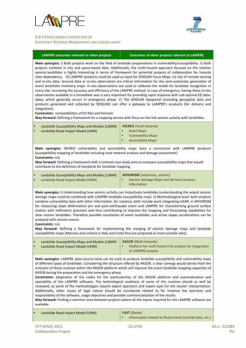
LAMPRE has a dedicated task, T.8.2 and deliverable (D.8.2), devoted to explore potential synergies of LAMPRE with the above-‐mentioned projects15. The exploration is performed through the analysis of functional, operational and technological links that can be identified between the outcomes of LAMPRE (i.e. its set of products) and the outcomes of these other projects. Table 5 illustrates the main synergies identified between LAMPRE and these projects, including some indication to move forward a common work between them, as follows: Table 5 -‐ Synergies between LAMPRE and other Copernicus-‐related projects
LAMPRE outcomes relevant to other projects Outcomes of other projects relevant to LAMPRE
• Event Landslide Inventory Maps [eLIM] • Landslide Inventory Maps (LIM) • Landslide Susceptibility Maps and Models (SSM)
PREFER (fires) • Burn Scar Maps • Damage Severity map • Post Fire vegetation recovery maps • 3D damage and soil erosion probability
Main synergies: Interdependency of landslides and fires (linking soil erosion susceptibility maps to LIM and/or LSM). Constraints: No common test sites between the two projects to maximize integration and joint-‐work. Way forward: i) Analyse if Damage Severity map and Post-‐fire Recovery map can be suitably assimilated in the computation of LSM. ii) Further explore how to integrate erosion data as an input to LAMPRE model. iii) Explore links between the emergency mapping scenario and the long-‐term analysis post event.
• Maps: Landslide Inventory Maps (LIM), Landslide Susceptibility Maps (LSM), maps for rockfall
• Software: for rockfall modelling (STONE) and Rockyfor3D
PHAROS (multi-‐hazards, fires) • Multi hazard open service platform to display
integrated LAMPRE outputs
Main synergies: Interdependency of hazards present in PHAROS could allow LAMPRE inputs to be integrated into the PHAROS system. PHAROS incorporates a forest fire scenario as main hazard around which the whole design, implementation and final demonstration is articulated. The hazard to which LAMPRE is devoted, i.e. landslides, is not specifically addressed in PHAROS. There is, however, some room for synergies deriving from the system conception. The system architecture is to be displayed at two levels: one more general (long term) and one specific for the case of forest fire (short term). Within the general level, the system design will take into account the eventual adaptation to other hazards. Related to this, PHAROS has also a sub Work Package dedicated to multi-‐hazards with an associated deliverable where cases for other hazards will be defined. As a result, one possible synergy could be established by including landslides as one of this specific hazard scenario for this task aimed at addressing derived aspects of using the system for the management of multi-‐hazard scenarios. Constraints: Compatibilities of EO files and formats, and IT issues (code, language). The use of LAMPRE products demands a certain level of expertise (training and human interaction). If these products shall be used as inputs to the PHAROS platform, this shall be accounted. Way forward: Defining a framework for the actual integration of LAMPRE outputs into PHAROS platform following the detailed requirements resulting once the PHAROS task for the specific hazard scenario for landslides is complete.
• Landslide Susceptibility Maps and Models (LSMM) • Landslide-‐Road Impact Model (LRIM)
SENSUM (multi-‐hazards) • Focus Maps • SENSUM Geoportal (for integration of LAMPRE
outputs)
15 These projects were invited at two networking events organised by the Research Executive Agency of the European Commission: the European Space Solution Conference (Prague, 12th June 2014) and the Copernicus Emergency Project Workshop (Brussels, 4th December 2014).
D.8.3 CROSS-‐BORDER COOPERATION ON EMERGENCY RESPONSE MANAGEMENT AND LESSONS LEARNT
FP7-‐SPACE-‐2011 22 of 90 GA n. 312384 Collaborative Project PU
LAMPRE outcomes relevant to other projects Outcomes of other projects relevant to LAMPRE
Main synergies: i) Both projects work on the field of landslide preparedness in vulnerability/susceptibility. ii) Both projects combine in situ and space-‐based data. Additionally, the multi-‐hazard approach focused on the relation seismic-‐landslides is highly interesting in terms of framework for potential projects of collaboration for hazards inter-‐dependency. Iii) LAMPRE products could be used as input for SENSUM Focus Maps. Iv) Use of remote sensing and in-‐situ data. Ground data or in-‐situ observation are critical information for the semi-‐automatic generation of event landslides inventory maps. In-‐situ observations are used to calibrate the model for landslide recognition in every site, increasing the accuracy and efficiency of the LAMPRE method. In case of emergency, having these in-‐situ observations available in a immediate way is very important for providing rapid response with sub-‐optimal EO data-‐takes, which generally occurs in emergency phase. V) The SENSUM Geoportal (including geospatial data and products generated and collected by SENSUM) can offer a gateway to LAMPRE’s products (for delivery and integration). Constraints: compatibilities of EO files and formats Way forward: Defining a framework for a mapping service with focus on the link seismic activity with landslides.
• Landslide Susceptibility Maps and Models (LSMM) • Landslide-‐Road Impact Model (LRIM)
INCREO (multi-‐hazards) • Asset Maps • Vulnerability Maps • Accessibility Maps
Main synergies: INCREO vulnerability and accessibility maps have a connection with LAMPRE products (susceptibility mapping of landslides including road network analysis and damage assessment) Constraints: n/a Way forward: Defining a framework with a common test study area to compare susceptibility maps that would contribute to the definition of standards for landslide mapping.
• Landslide Susceptibility Maps and Models (LSMM) • Landslide-‐Road Impact Model (LRIM)
APHORISM (volcanoes, seismic) • Seismic damage Maps and derived zonation
information
Main synergies: i) Understanding how seismic activity can (re)activate landslides (understanding the extent seismic damage maps could be combined with LAMPRE landslide susceptibility map). Ii) Methodological level: both projects combine vulnerability data with other information, for instance, both include work integrating InSAR, in APHORISM for measuring slope deformation pre and post-‐earthquake event and LAMPRE for characterising ground surface motion with millimetric precision and thus contributing to improve the mapping and forecasting capabilities for slow motion landslides. Therefore possible correlation of event landslides and active slopes accelerations can be analysed with seismic events. Constraints: n/a Way forward: Defining a framework for implementing the merging of seismic damage maps and landslide susceptibility maps (Messina and Umbria in Italy and Costa Rica are proposed as most suitable sites).
• Landslide Susceptibility Maps and Models (LSMM) • Landslide-‐Road Impact Model (LRIM)
RASOR (Multi-‐hazards) • Platform for multi hazard risk analysis for integration
of LAMPRE outputs
Main synergies: LAMPRE open-‐source tools can be used to produce landslide susceptibility and vulnerability maps of different types of landslides. Considering the structure offered by RASOR, a clear synergy would derive from the inclusion of these routines within the RASOR platform which will improve the event landslide mapping capacities of RASOR during the preparation and the emergency phase. Constraints: adaptation of the codes for the particularities of the RASOR platform and automatisation and operability of the LAMPRE software. The technological readiness of some of the routines should as well be reviewed, as some of the methodologies require expert operators and expert eyes for the results’ interpretation. Additionally, other issues of legal nature should be considered related to for instance the warranty and responsibility of the software, usage objectives and possible commercialization of the results. Way forward: Finding a common area between projects where all the inputs required for the LAMPRE software are available.
• Landslide Road Impact Model (LRIM) FAST (floods) • Information related to flood events (rainfall data, etc.)

D.8.3 CROSS-‐BORDER COOPERATION ON EMERGENCY RESPONSE MANAGEMENT AND LESSONS LEARNT
FP7-‐SPACE-‐2011 23 of 90 GA n. 312384 Collaborative Project PU
LAMPRE outcomes relevant to other projects Outcomes of other projects relevant to LAMPRE
that could input into LAMPRE system
Main synergies: Interdependency between flood and landslides. The work developed in FAST for the foreshore and floodplain identification shall be considered as useful information for LAMPRE. LSSM and LRIM can use information derived from FAST (e.g., heavy rainfall data) as input information and further contribute to explore the correspondence between precipitation levels and severe flooding with landslides. Constrains: n/a Way forward: Further work to be developed once FAST outputs are ready in order to assess quantity and suitability of the derived information for integration into LAMPRE tools.
Leveraging on the above mentioned synergies task 8.2 has: • Identified the technologies, tools and products of LAMPRE most susceptible to
integration with the other projects (E-‐LIM, LIM, LSMM, LRIM); • Identified common geographical areas where synergies can be maximised (where
Mediterranean countries result the most vulnerable to natural-‐hazards but also the richest in terms of test sites)
• developed two main frameworks for cooperation between the projects, as follows:
1. Main hazards: landslides – forest fires. Integrating work from PREFER, PHAROS, LAMPRE. Develop an in-‐depth study of how combining burn scars and vegetation recovery information as an indicator of change of the land cover. This would result in new methods to improve the susceptibility analysis and therefore improved risk assessment over burned areas followed by intense rainfall events.
2. Main hazards: seismic-‐volcanic-‐landslides. Integrating work from APHORISM, SENSUM, LAMPRE. To perform a study of possible correlations of event landslides and active slope accelerations with seismic events that would strengthen the understanding of the interrelation between seismic-‐volcanic activity and landslide susceptibility.
Based on the above findings, D.8.3 explores and reports which EU programmes and financial instruments can help to move forward through cooperation and clustering activities between different organizations, including those members of the consortia of the above-‐mentioned projects.
2.5 Evidence from recent Copernicus events In addition to the analysis on synergies between Copernicus projects made by T.8.2, relevant considerations emerged during the two years of LAMPRE implementation in the occasion of several Copernicus related dissemination events where partners of task 8.3 were involved. This section summarises these consideration by event with the aim of building upon them for future cooperation and clustering opportunities. The International Space4You conference (Bari 27-‐28 Feb. 2014), promoted by the Apulia Region, NEREUS and the Apulian Aerospace District. The event highlighted the many benefits of Space-‐related services and applications with respect to the needs of the Local and Regional Authorities (LRAs). Emphasis was given to the need of facilitating access for regional bodies to the technologies associated with Copernicus, since regions can be seen as "strategic

D.8.3 CROSS-‐BORDER COOPERATION ON EMERGENCY RESPONSE MANAGEMENT AND LESSONS LEARNT
FP7-‐SPACE-‐2011 24 of 90 GA n. 312384 Collaborative Project PU
laboratories for the utilisation of Space services and for the development of SMEs”, and there is a strong presence of European regions in the aerospace industry. For such a purpose, ESA responded positively to the idea of a specific regional programme, mutually agreed upon by EU Member States and local government bodies. All this is very relevant for the EU funding programmes (see § 3.3) within the various EU Policies, and in particular the Cohesion Policy, the European Neighbourhood Policy and the Enlargement Policy where the role of cross-‐border cooperation involving different regions is crucial. Copernicus Big Data Workshop (Brussels, 13-‐14 March 2014), organised by the EC, DG Enterprise. The event promoted the uptake of Copernicus, focusing on the need to ensure the best possible access to big data and information for users. The four V's of big data (i.e. volume, velocity, variety, and veracity) were widely discussed through several examples of existing infrastructures. In particular, the event tried to assess the potential technical solutions for Copernicus data dissemination infrastructures as well as the formats of the data and information and support provided to users. Among the main items that emerged:
• Three Sentinel families will be ready soon delivering 8 terabytes of EO per day to support deployment of Copernicus services;
• Although there are many possible approaches to big data infrastructure, there is no dissemination infrastructure already foreseen from now to the next 5 years while effort to define some possible dissemination infrastructures is needed. Also, a clear indication on how such infrastructures can cope with ESA data policies is required;
• Services should consider broad set of users for their infrastructure and user interface implementation;
• More coming synergies between ESA and EEA will stimulate the integration into infrastructures and services of both Copernicus data and in-‐situ data also supporting the EEA’s mission and their reporting task;
• Services should enrich capabilities to address not just status mapping of areas rather their continuous changes;
• Lack of harmonisation has emerged between several existing systems already created (e.g. in France and Germany) and EU coordination is thus required;
• Advanced cloud computing infrastructures can help big science (big data) applications running in a federated manner (with several examples such as the Helix Nebula market)
• The procurement and use of commercial cloud services by public administration has already started. But a coordinated approach by public organizations will help structure the market and reduce the burden on individual organizations. As such, plans for collaborative Copernicus data access and exploitation infrastructures are needed.
European Space Solutions conference (Prague, 12 June 2014) devoted a side event to illustrate achievements and short-‐/mid-‐term RTD perspectives in the Copernicus Emergency Service and Land Monitoring Service. In particular, coordinators and partners of projects from the 6th and 7th FP7Space calls (see §2.5) were invited into a round table organised at the end a side event to discuss potential synergies answering to specific questions. A short document was produced and delivered to the REA of which some indications, more pertaining to strengthening the operational capacity of Copernicus through cooperation and clustering opportunities, are reported here below: How can the EC-‐REA support the transition of these projects from RTD to an operational service environment, supporting the Copernicus services?
D.8.3 CROSS-‐BORDER COOPERATION ON EMERGENCY RESPONSE MANAGEMENT AND LESSONS LEARNT
FP7-‐SPACE-‐2011 25 of 90 GA n. 312384 Collaborative Project PU
• By developing geo-‐information products such as hazard, risk, susceptibility, vulnerability and assets maps in combination with providing them via online platforms and as contributions to spatial decision support systems, some results of these projects can strengthen the product portfolio of Copernicus for preparedness and prevention measures.
• Flexible information integration schemes for data with different resolutions (i.e., spatial, temporal, thematic detail, certainty etc.) able to consider data availability and uncertainties can be made available for Copernicus in order to define innovative information products, which are able to consider real life situations. Moreover projects outcomes can give valuable insights about current accuracy standards of information products which can be considered as baselines for future prototypes.
• New calls addressed to those projects which are capable to demonstrate the maturity and validity of the developed products should be further funded for completing the validation process and the implementation and adoption of the product in the operational procedure of users.
• However, the Copernicus services could become a threat to the services that are being deployed from private companies and service providers involved in EU projects. For this reason the conditions of application of the Copernicus services need to be clearly defined in order not to enter into rivalry with services providers, at least for what concerns profit activities.
How to exploit cooperation and clustering for competitiveness and growth?
• The cross-‐border nature of satellite data exchanges requires cooperation between countries concerned by Earth Observation. Cooperation activities, sustained by different EU programs available for the period 2014-‐2020, would effectively support the compatibility of competitiveness standards with security considerations.
• Cooperation between research institutes and universities through projects for service providers, i.e. companies with a very high technical level, represent an excellent opportunity to bring experience regarding technical developments, transforming research into operational solutions and offer these solution to the clients.
• The exploitation of cooperation and clustering is most appropriately being implemented by the SMEs involved in the projects to deepen and solidify their service portfolio for the international geo-‐information market for pre-‐/post-‐disaster management and risk assessment. Likewise, the results achieved within the projects (user-‐approved and validated prototypes and demonstrators) will further strengthen the credibility of the respective SMEs as a high-‐quality geo-‐information service providers for standardized, high utility information solutions for the European and worldwide markets.
What is needed to bring products and services of these projects as key package/component of a Copernicus EMS?
• To avoid overlapping with the Copernicus EMS covering landslide mapping and rapid mapping, it is necessary to understand how and where the EMS needs to be improved and which financial resources and working framework can be made available. Defining standards and quality controls which ensure to define the quality and the robustness of the outputs, can help such an assessment.
• To facilitate the incorporation of the results of these projects as a component of the Copernicus EMS, the products and services developments of these projects should be considered into the specifications of the EC tenders related to the “risk and recovery” mapping (e.g. for assets mapping, landslide mapping, etc.).

D.8.3 CROSS-‐BORDER COOPERATION ON EMERGENCY RESPONSE MANAGEMENT AND LESSONS LEARNT
FP7-‐SPACE-‐2011 26 of 90 GA n. 312384 Collaborative Project PU
Which synergies between the projects (i.e. products, services, approaches to markets) can be exploited?
• The Copernicus EMS uses satellite data to provide timely and accurate geo-‐spatial information before, during and after disasters, through an extensive range of products. Floods, earthquakes, volcanic eruptions and landslides can occur simultaneously. In general one or more such events trigger landslides, and vice-‐versa. Synergies between projects can support a multi-‐risk approach that considers interdependencies between natural hazards and can strengthen disaster response capacity at national, regional and cross-‐border level by integrating results of these projects into the Copernicus EMS.
Some initial synergies between these projects were identified during the Prague event and lately analysed with the work produced by Task 8.2 (see § D.8.2). What are the complementarities with the Space research?
• The Copernicus Services are by nature generic, as they provide some standard products that will not fit to all situations and/or problems to be solved. As such, the EO Downstream sector can provides specific services for particular regions, situations or scales. The outcomes of the RTD projects either can improve the core-‐services or they are innovative downstream services (something the core services do not deliver). Results of these projects can contribute to the Copernicus EMS in different ways and will have to face the challenge to effectively integrate different data sets.
Which is the most important challenge each project should handle?
• Answers, from the various projects, covered different aspects: o from landslide mapping standards for comparing products and assessing the
quality of service, to methodologies for working in sub-‐optimal situations (i.e. situations of emergency response or areas without enough input and information) delivering meaningful outputs (LAMPRE);
o from difficulties in convincing users who rely upon traditional techniques to adopt new products, even if they present significant improvement with respect those commonly used (PREFER) to processing of all kind of data in a way that they can be actually used for the value-‐adding (accuracy, completeness, metadata etc.) and the time-‐consuming procedures of obtaining data from the users and the service providers (IncREO);
o from Spatial scales of the EO data with the spatial scales in the field and the creation of a product that appeals to a broad market whilst at the same time meeting the needs of different end-‐user groups (DELTARES), to define or adapt to standards that can be satisfied in a viable way and are at the same time accepted by scientific and non-‐scientific users, especially when dealing with empirical relations and local idiosyncrasies (SENSUM).
3rd International Space Research Conference (Rome, 15-‐17 Sept. 2014), organized by the EC to show the current status and results of the projects funded by the 4th and 5th FP7 Space calls. These included six projects exploiting Earth Observation within the various Copernicus Services of which LAMPRE and HELM, Harmonised European Land Monitoring (see §3.4.2), respectively represented the Copernicus EMS and LMS. The conference highlighted future options for European research in the Space field exploiting H2020 calls (see §3.4.1)

D.8.3 CROSS-‐BORDER COOPERATION ON EMERGENCY RESPONSE MANAGEMENT AND LESSONS LEARNT
FP7-‐SPACE-‐2011 27 of 90 GA n. 312384 Collaborative Project PU
The Copernicus Emergency Projects workshop (Brussels, 4 December 2014), organised by the REA and DG Enterprise, aimed at presenting the new products and services developed by the Copernicus Emergency Projects (see §2.4) to the EC-‐REA and at offering the opportunity to the projects to further identify cooperation opportunities and synergies between the consortia. As part of the Copernicus programme, the advanced geo-‐information products (developed at different scales, i.e. local, regional, national, global) and services of all the eight above mentioned projects are based on earth observation data acquired and developed in the frame of Copernicus Programme. They aim at improving the European capacity to respond to the preparedness, prevention, and recovery management phases of the disaster cycle, contributing to the operational Copernicus Emergency Management Service and Land Monitoring Services but also to the future development of Copernicus. From an early feedback of the participants at the workshop about how projects results could be taken into account in the frame of EU needs and policy requirements, the following main items emerged from the workshop:
• DG ECHO can have interest for products and services in the prevention side which can strengthen the EFAS (European Flood Awareness Service) and EFFIS (European Forest Fire Information System) early warning systems for Floods and Forest Fire. The interested projects can consider the upcoming Civil Protection Forum 2015 which will include an exhibition on new technologies, methodologies and innovations, ideally developed through Civil Protection projects, FP7 and Cohesion Policy.
• DG JRC (which technically manages by delegation the EMS) and DG ENTR have interest for the new service development, especially in gathering more information from the projects on validation.
• The EEA confirmed the importance of the development of Copernicus services for the Environment sector, for the implementation at the local and national levels of such directives as the Flood directive and the Air quality directive and for future environment monitoring activities.
• Concerning the economic sustainability of products and services developed by these projects, the main obstacle remain the motivation and financial capability of users to pay for purchasing and maintaining these, especially as prevention activities are not often budgeted for, even by local end users. The development of free tools, possibly augmented by applications on mobile and add-‐on services that would be paid for, can represent a promising business model. However, even if free, products and services involve maintenance costs.
• Standardisation and harmonisation in maps and products can help building a market place. However regulations and implementing rules are not the same around Europe, and issues related to public safety are the concern of local institutions. These tend to prefer acquiring local products from local providers.
• Quite rarely users know their own needs, and thus establishing a clear and simple portfolio it is not very straightforward.
• Training users on the use of Spatial Data Infrastructures (SDIs) and geo products for decision-‐making is a necessity, and building trust and providing reliable solutions are essential for developing the market.

D.8.3 CROSS-‐BORDER COOPERATION ON EMERGENCY RESPONSE MANAGEMENT AND LESSONS LEARNT
FP7-‐SPACE-‐2011 28 of 90 GA n. 312384 Collaborative Project PU
3. Cooperation opportunities LAMPRE research and development activities have aimed at improving the ability of operational users (chiefly Civil Protection Authorities) to detect and map landslides, to assess and forecast the impact of triggered landslide events, and to model landscape changes caused by slope failures. Partners have collaborated to develop methods, tools and products (see §2.2) able to enhance landslide risk mitigation/preparedness efforts, post event-‐landslide recovery and reconstruction activities in highly vulnerable geographic and geologic regions. Natural hazards are interconnected. Single hazards can often interact in multi-‐hazard interactions, with a given primary hazard triggering another secondary hazard (e.g., earthquakes or large storms triggering landslides) or the primary hazard increasing the probability of a secondary hazard occurring (e.g., a wildfire increasing the probability of landslides). The primary hazard might be large in scale—spatially, temporally, intensity—with the resultant secondary hazard that is triggered (or probability increased) local or regional in scale, and intensities of the secondary hazards across all scales. As described in D.8.2, Gill and Malamud (2014), for 21 different natural hazards, designed a visualisation of the potential multi-‐hazard interactions or synergies that might occur. A realisation of the synergies between natural hazards can be extended to synergies between anthropic influences (e.g., building roads or undercutting a river bank) and their potential for triggering or increasing the probability of secondary natural hazards, and subsequent cascades in the process. Within the context of hazards, the visualization of these synergies and interactions is an important one to have a more holistic multi-‐hazard perspective of the combined natural and built environment. Further to this, Disaster Risk Management (DRM) can be defined as “a systematic process that produces a range of measures associated with hazard mitigation, emergency preparedness, impact response and disaster recovery, and which contributes to the safety of communities and the environment; and at the same time parallels risk management and good management practices” (Britton 2005). It also emphasizes pre-‐disaster, not post-‐disaster measures, a combination of “top-‐down” and “bottom-‐up” thinking, and linking mitigation with development, all of which requires a multi-‐hazard or all-‐hazard approach (Mattingly 2002). Disaster Risk Reduction (DRR), encouraged by the UNISDR, aims to reduce the damage caused by natural hazards like earthquakes, floods, droughts and cyclones, through an ethic of prevention. DRR includes disciplines like disaster management, disaster mitigation and disaster preparedness. And it is also part of sustainable development since development activities can be sustainable if they also reduce disaster risk and disaster losses. Moreover, DRR involves every part of society, every part of government, and every part of the professional and private sector. One of the policy recommendation of the Committee of Regions states that: “The damage caused by previous natural and man-‐made disasters shows there is still some need for improvement in Member States; there is also room for further improvement in transnational

D.8.3 CROSS-‐BORDER COOPERATION ON EMERGENCY RESPONSE MANAGEMENT AND LESSONS LEARNT
FP7-‐SPACE-‐2011 29 of 90 GA n. 312384 Collaborative Project PU
and interregional cooperation. It is here that the EU can make a valuable contribution to even more effective and efficient cooperation, above all by improving coordination”.16 Civil Protection Authorities contribute to DRR through their activities on disaster preparedness and response, but also by stimulating the engagement of governments to address appropriate disaster risk reduction policies, through the participation in National Platforms for disaster risk reduction and through transnational and international cooperation activities. Related to the above, improvements in the operational capability of Civil Protection Authorities, should consider synergies between natural hazards, pursue a Disaster Risk Management approach and exploit EU instruments for transnational and international cooperation activities. In such a context, for LAMPRE cooperation can be seen as:
• Cooperation between territories which can adopt geospatial-‐based products generated by LAMPRE and other projects;
• Cooperation between actors pursuing common and/or complementary objectives. LAMPRE tries to explore forms of cooperation at both levels, by considering:
• Smart specialization strategies, especially in the Space sector; • The need to face global competition by engaging neighbouring regions in “co-‐optition”
(defined as co-‐operation for competition) 17.
3.1 Defining cross-‐border and territorial cooperation Different definitions can be used to describe territorial cooperation. According to the new Commission instrument ‘European Grouping for Territorial Cooperation’ (EGTC), the first European legal basis for territorial cooperation, cross-‐border cooperation should aim to tackle common challenges identified jointly in the border regions, including lack of networks among local and regional administrations, low levels of research and innovation and take-‐up of ICT, environmental pollution, risk prevention, and aim to exploit development of cross-‐border research and innovation facilities and clusters, cross-‐border labour market integration, cooperation among education providers, while enhancing the cooperation process for the purpose of the overall harmonious development of the Union . The Cohesion Policy encourages regions and cities from different EU Member States to work together and learn from each other through joint programmes, projects and networks. In the context of the EU Cohesion Policy, the European Commission, through the European Regional Development Fund (ERDF), supports three forms of cooperation or dimensions of the European Territorial Cooperation (ETC) Objective, as in figure 4:
16 Opinion of the Committee of the Regions on towards a stronger European disaster response. 17 OECD (2013), Regions and Innovation: Collaborating across Borders, OECD Reviews of Regional Innovation, OECD Publishing. http://dx.doi.org/10.1787/9789264205307-‐en
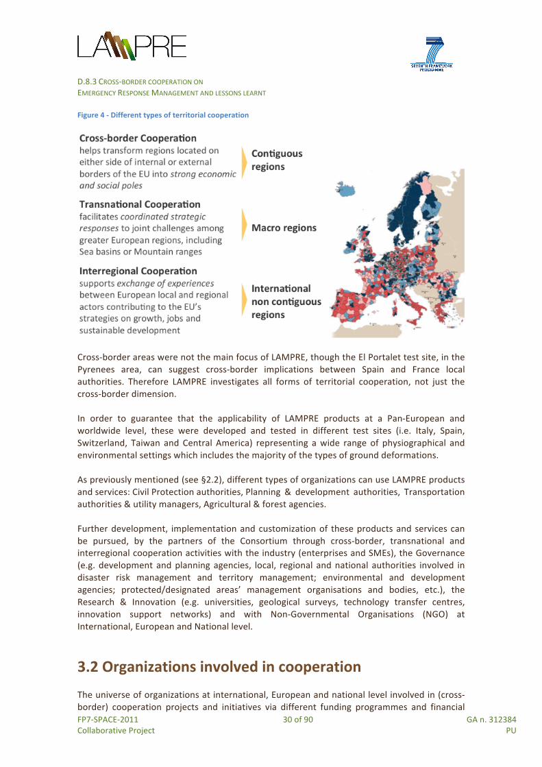
D.8.3 CROSS-‐BORDER COOPERATION ON EMERGENCY RESPONSE MANAGEMENT AND LESSONS LEARNT
FP7-‐SPACE-‐2011 30 of 90 GA n. 312384 Collaborative Project PU
Figure 4 -‐ Different types of territorial cooperation
Cross-‐border areas were not the main focus of LAMPRE, though the El Portalet test site, in the Pyrenees area, can suggest cross-‐border implications between Spain and France local authorities. Therefore LAMPRE investigates all forms of territorial cooperation, not just the cross-‐border dimension. In order to guarantee that the applicability of LAMPRE products at a Pan-‐European and worldwide level, these were developed and tested in different test sites (i.e. Italy, Spain, Switzerland, Taiwan and Central America) representing a wide range of physiographical and environmental settings which includes the majority of the types of ground deformations. As previously mentioned (see §2.2), different types of organizations can use LAMPRE products and services: Civil Protection authorities, Planning & development authorities, Transportation authorities & utility managers, Agricultural & forest agencies. Further development, implementation and customization of these products and services can be pursued, by the partners of the Consortium through cross-‐border, transnational and interregional cooperation activities with the industry (enterprises and SMEs), the Governance (e.g. development and planning agencies, local, regional and national authorities involved in disaster risk management and territory management; environmental and development agencies; protected/designated areas’ management organisations and bodies, etc.), the Research & Innovation (e.g. universities, geological surveys, technology transfer centres, innovation support networks) and with Non-‐Governmental Organisations (NGO) at International, European and National level.
3.2 Organizations involved in cooperation The universe of organizations at international, European and national level involved in (cross-‐border) cooperation projects and initiatives via different funding programmes and financial

D.8.3 CROSS-‐BORDER COOPERATION ON EMERGENCY RESPONSE MANAGEMENT AND LESSONS LEARNT
FP7-‐SPACE-‐2011 31 of 90 GA n. 312384 Collaborative Project PU
instruments is very heterogeneous. Associations, Networks, Institutes, Working Groups, Platforms, they all operate and collaborate in several aspects of the Disaster Risk Reduction context, involving the adoption of space technologies. This sections list some examples relevant for future networking.
3.2.1 European organizations AEBR -‐ Association of European Border Regions: Works on behalf of the European border and cross-‐border regions with the aim: i) to initiate, support and coordinate cooperation between the regions throughout Europe; and ii) to promote exchanges of experience and information with a view to identifying and coordinating common interests among the diverse range of cross-‐border problems and opportunities, proposing possible solutions. AER -‐ Association of European Regions: A forum for interregional co-‐operation and a lobbyist for regional interests on the European stage. CoR -‐ Committee of Regions: Represents the voice of regions and cities in the European Union (with 353 members, regional and locally elected representatives from the 28 EU countries) which underlines the importance of local and regional authorities in civil protection matters. The EU has to support the measures taken by Member States to further improving transnational and interregional cooperation and enhancing coordination between civil protection authorities for disaster response. For this, the EU Monitoring and Information Centre (MIC) has a coordinating role. EFDRR -‐ European Forum for Disaster Risk Reduction: Brings actors in the European and Mediterranean Region together to exchange ideas and knowledge and discuss themes pertinent to DRR within the region, identifying specific opportunities for cross-‐fertilization between countries and sub-‐regions, as well as inter-‐government and inter-‐sector cooperation18. ERRIN -‐ European Regions Research and Innovation Network: Facilitates cross-‐border cooperation, knowledge exchange, joint action and project partnerships between its members (currently more than ninety members) with the aim to strengthen their region's research and innovation capacities. It also engages in debate with EU institutions to influence EU policies in order to make them better responding to the needs of the European regions. Euro-‐Institute -‐ Institute for cross-‐border cooperation: A Franco-‐German organization developing tools and methods (including trainings, support to projects, mentoring measures, studies, conferences, publications, essays) that contribute to the building of capacities of actors working on a cross-‐border level. EARSeL -‐ European Association of Remote Sensing Laboratories: A scientific network of European remote sensing institutes, coming from both academia and the commercial/industrial sector with about 250 member laboratories. Founded in 1977 under the
18 Source: http://www.unisdr.org/files/19800_efdrrwebfinal.pdf

D.8.3 CROSS-‐BORDER COOPERATION ON EMERGENCY RESPONSE MANAGEMENT AND LESSONS LEARNT
FP7-‐SPACE-‐2011 32 of 90 GA n. 312384 Collaborative Project PU
auspices of the European Space Agency, the Council of Europe and the EC, EARSeL cooperates with other societies, among which EUROGI, EARSC and EURISY. EUROGI -‐ European umbrella organization for Geographic Information: Aims to maximise the availability, effective use and exploitation of Geographic Information (GI) throughout Europe, also through its involvement in different projects (e.g., the eSDI-‐Net initiative which aims to foster the dialogue between European sub-‐national SDI stakeholders by providing a platform so that knowledge and best practises’ experiences are being shared). EARSC -‐ European Association of Remote Sensing Companies: Coordinates and promotes activities of their members in the area of services based on the delivery of geo-‐information products on customer demand. The members of EARSC (64 full members and 11 observers coming from 22 countries) are active on the market for the exploitation of EO data by converting these data in geo-‐information suitable and accessible for their clients. EURISY: A non-‐profit association which includes 40 governmental space offices and space agencies, international organisations, research institutions, and private businesses involved in space-‐related activities and in scientific and technological activities. It raises awareness of emerging satellite applications which can help professional communities in many sectors of application and provides feedback to decision-‐makers on possible measures to overcome obstacles to the diffusion of space-‐derived innovation in society. LAMPRE partners (i.e. GMX) disseminated the project results at the Conference “Copernicus Services in the Sentinel Era – Benefits for Eastern Europe" co-‐organised by EURISY on October 2014. EUROAVIA -‐ European Association of Aerospace Students: A non-‐political and non-‐profit association who acts as a bridge between companies, universities and students. It represents the interests of over 2000 students from 38 universities in 19 European countries. NEREUS -‐ Network of European Regions Using Space Technologies: Established in 2008, it is a pan European growing network of regions from all over Europe which aims to explore the benefits of space technologies for regions and their citizens and to spread their applications. The NEREUS Working Groups include: Earth Observation / Copernicus WG; GNSS WG; Telecommunication WG; Technologies from Space Exploration WG; Communication, Education and Training (CET) WG; Clusters WG. LAMPRE partners (i.e. UP) disseminated the project outcomes at the Space4You conference co-‐organised by NEREUS on February 2014. NEREUS has contributed to develop different projects contributing to increase the use of space technologies, such as:
• DORIS Net -‐ Downstream Observatory organized by Regions active in Space Network – it created a network of Regional Contact Offices (RCOs) in different EU regions which aim to monitor and map existing Copernicus services at regional level and connecting the demand/supply of new products and EO-‐based services promoting partnerships and pilot initiatives, as well as technology and/or commercial cooperation agreements;
• SABER -‐ Satellite Broadband for European Regions -‐ a Thematic Network allowing stakeholders to collaborate into satellite-‐based services.
IWG-‐SEM -‐ International Working Group on Satellite-‐Based Emergency Mapping: Founded in 2011, IWG-‐SEM provides a forum for collaboratively advancing the technical rigor of satellite-‐based mapping. It consists of experts representing a wide spectrum of satellite-‐based emergency mapping (SEM) capabilities, mandates and roles, all sharing the common aim to

D.8.3 CROSS-‐BORDER COOPERATION ON EMERGENCY RESPONSE MANAGEMENT AND LESSONS LEARNT
FP7-‐SPACE-‐2011 33 of 90 GA n. 312384 Collaborative Project PU
improve the quality and consistency of SEM products. For such a purpose, IWG-‐SEM compiled the Emergency Mapping Guidelines. These guidelines support an effective exchange and harmonization of emergency mapping efforts leading to improved possibilities for cooperation amongst involved Emergency Mapping Organizations. By enabling easier exchange, merging and quality checking of individual data/information layers generated by more than one Emergency Mapping Organization, the final goal of enhancing coordination and community effectiveness can be achieved among those willing to engage. ESPI -‐ European Space Policy Institute: Provides decision-‐makers with an informed view on mid-‐ to long-‐term issues relevant to Europe’s space activities. In this context, ESPI acts as an independent platform for developing positions and strategies. ESOA -‐ European Satellite Operators Associations: A non-‐profit European organisation promoting the common interests of European satellite operators and acting as the reference point for the European satellite operators who deliver information services across the globe. EGS – EuroGeoSurveys: The Geological Surveys of Europe is a not-‐for-‐profit organisation representing 33 National Geological Surveys and some regional Surveys in Europe, an overall workforce of several thousand experts. At European level, EGS collaborates in many cross-‐border and EU-‐projects to develop interoperable, harmonized geo-‐scientific information in multiple domains, based on their national knowledge and databases. For LAMPRE, this concerns (for example) the Soil Thematic Strategy, the Water Framework Directive and the INSPIRE Directive. Several partners of LAMPRE are members of EGS (which hosted the final dissemination conference of LAMPRE).
3.2.2 International organisations Civil Protection Authorities when responding to emergencies collaborate with international organisations and cooperation platforms. Of these, some of the most relevant actors engaged in Disaster Risk Reduction to be involved in future cooperation activities include: UNISDR -‐ United Nation Office for Disaster Risk Reduction: Created in December 1999 as part of the UN Secretariat with the purpose of ensuring the implementation of the International Strategy for Disaster Risk Reduction. UNISRD coordinates international efforts in DRR and guides, monitors and reports regularly on the progress of the implementation of the Hyogo Framework for Action. UNISRD organizes a biennial Global Platform on disaster risk reduction with leaders and decision makers to advance risk reduction policies and support the establishment of regional, national and thematic platforms. EADRCC -‐ Euro-‐Atlantic Disaster Response Coordination Centre: The NATO’s civil emergency response mechanism for the Euro-‐Atlantic area. It is active all year round, and involves NATO’s 28 associates and 41 partner countries from across the globe. The Centre functions as a focal point for coordinating disaster relief efforts among NATO member and partner countries19.
19 For example, following a request by the government of Bosnia and Herzegovina to the Euro-‐Atlantic Disaster Response Coordination Centre (EADRCC) on 15th of May 2014, over 20 NATO and partner

D.8.3 CROSS-‐BORDER COOPERATION ON EMERGENCY RESPONSE MANAGEMENT AND LESSONS LEARNT
FP7-‐SPACE-‐2011 34 of 90 GA n. 312384 Collaborative Project PU
GDACA -‐ Global Disaster Alert and Coordination System: A cooperation framework between the United Nations, the European Commission and disaster managers worldwide to improve alerts, information exchange and coordination in the first phase after major disasters. GDACS offers automatic links to map products such as baseline maps, situation specific maps, damage assessments and web-‐maps. GDACS collects and organizes several data types (e.g. GIS, in-‐situ, model output data, priority areas, baseline data, satellite image derived data) for flood extent, earthquake damage assessment, landslide extent, etc. GFDRR -‐ Global Facility for Disaster Reduction and Recovery: Established in 2006, it is a partnership of 41 countries and 8 international organizations committed to helping developing countries reduce their vulnerability to natural hazards and adapt to climate change. The partnership’s mission is to mainstream disaster risk reduction (DRR) and climate change adaptation (CCA) in country development strategies by supporting a country-‐led and managed implementation of the Hyogo Framework for Action (HFA). LAMPRE partners (i.e. UP) disseminated the project outcomes at the IDRC Davos 2014 Conference co-‐organised by GFDRR. GEO -‐ Group on Earth Observations: established at the Third Earth Observation Summit in February 2005 to carry out the GEOSS 10-‐Year Implementation Plan. It supports different global initiatives worldwide among which the Supersites Initiative on natural hazards. UfM -‐ Union for the Mediterranean: Supports civil protection actors in the Euro-‐Mediterranean region and identifies possible areas of project cooperation to enable the civil protection actors to better anticipate the risks to which the countries are exposed20. In the field of civil protection, an enhanced cooperation is promoted in an effort to improve global governance between the state, local and civil society stakeholders, as well as to improve capacity building and coordinated responses on a regional level to crisis and disasters. Beside the 28 EU member states, 15 Southern Mediterranean, African and Middle Eastern countries are members of the UfM: Albania, Algeria, Bosnia and Herzegovina, Egypt, Israel, Jordan, Lebanon, Mauritania, Monaco, Montenegro, Morocco, Palestine, Syria (suspended), Tunisia and Turkey. One of the key initiatives on its current agenda is “a Joint Civil Protection Programme on Prevention, Preparation and Response to natural and man-‐made disasters”21. EUR-‐OPA -‐ European and Mediterranean Major Hazards Agreement: A platform for co-‐operation between European and Southern Mediterranean countries in the field of major natural and technological disasters. It has to date 26 Member States. The main objectives of EUR-‐OPA are to reinforce and to promote co-‐operation between Member States in a multi-‐disciplinary context to ensure better prevention, protection against risks and better preparation in the event of major natural or technological disasters. EUR-‐OPA has developed different projects, at national and regional level aimed to improve the awareness and resilience to major risks within the population.
countries have offered assistance for ongoing flood‚ landslide relief efforts in the North Eastern and Central parts of the country (http://www.nato.int/eadrcc/) 20 Source: http://ufmsecretariat.org/ufm-‐ready-‐to-‐support-‐civil-‐protection-‐actors-‐in-‐the-‐euro-‐mediterranean-‐regio 21 Source: http://www.eeas.europa.eu/euromed/index_en.htm

D.8.3 CROSS-‐BORDER COOPERATION ON EMERGENCY RESPONSE MANAGEMENT AND LESSONS LEARNT
FP7-‐SPACE-‐2011 35 of 90 GA n. 312384 Collaborative Project PU
World Bank: Engaged in disaster risk management projects worldwide by encouraging and facilitating, though funded projects, the incorporation of climate and disaster resilience into broader development processes. Particular attention is given to low-‐income and lower middle-‐income countries22 which have the least capacity to cope and, in general, suffer the highest human toll, accounting for 85% of all disaster fatalities (Munich Re 2010).
3.3 EU programmes fostering cooperation This section provides a short and punctual overview of the most relevant EU Programmes, financial mechanisms and strategies supporting cooperation activities, in the range 2014-‐2020, to further advance the results of LAMPRE in the field of natural hazards. These can be grouped into the following geographical areas:
• Worldwide • Central and Latin America • North, South East, Central and South Asia • Europe (including the European Union Member States and the Candidate countries) • The Mediterranean Region (including ENPI South Countries: Egypt, Algeria, Israel,
Jordan, Lebanon, Libya, Morocco, the Palestinian Territories, Syria and Tunisia) • The ENPI East Region (including ENPI east Countries: Armenia, Azerbaijan, Belarus,
Georgia, Moldova, Ukraine, Russia). A concise summary of the main opportunities relevant for LAMPRE is included in the Appendix 1 of this deliverable.
3.3.1 Worldwide Horizon 2020 is the EU Framework Programme for Research and Innovation. It aims at strengthening the European Research Area (ERA), removing obstacles to (cross-‐border) cooperation between countries. Likewise the previous 7th Framework Programme (FP7), H2020 is also open to participation of organizations from across the world, and international cooperation activities with “Third Countries” are promoted on the basis of common interest and mutual benefit, by supporting policy dialogues, networking and twinning activities. Of the various priority areas of H2020, two in particular are currently relevant to move forward the outcomes of LAMPRE through cooperation and collaboration activities:
• Societal Challenges (Climate Action, Environment, Resource Efficiency and Raw Materials Fighting and adapting to climate change)
• Industrial leadership (SPACE)
22 More information available on World Bank , 2013. Building Resilience: Integrating climate and disaster risk into development. Lessons from World Bank Group experience. The World Bank, Washington DC.
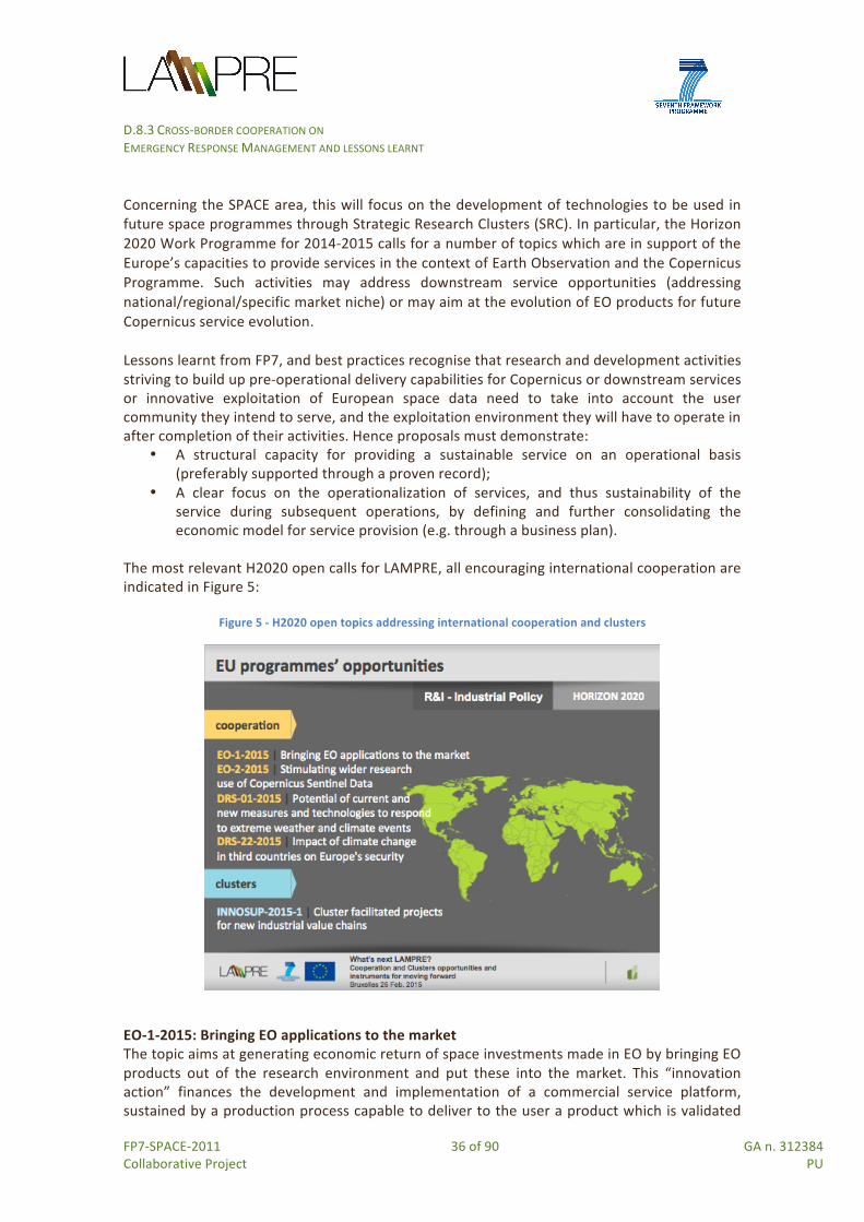
D.8.3 CROSS-‐BORDER COOPERATION ON EMERGENCY RESPONSE MANAGEMENT AND LESSONS LEARNT
FP7-‐SPACE-‐2011 36 of 90 GA n. 312384 Collaborative Project PU
Concerning the SPACE area, this will focus on the development of technologies to be used in future space programmes through Strategic Research Clusters (SRC). In particular, the Horizon 2020 Work Programme for 2014-‐2015 calls for a number of topics which are in support of the Europe’s capacities to provide services in the context of Earth Observation and the Copernicus Programme. Such activities may address downstream service opportunities (addressing national/regional/specific market niche) or may aim at the evolution of EO products for future Copernicus service evolution. Lessons learnt from FP7, and best practices recognise that research and development activities striving to build up pre-‐operational delivery capabilities for Copernicus or downstream services or innovative exploitation of European space data need to take into account the user community they intend to serve, and the exploitation environment they will have to operate in after completion of their activities. Hence proposals must demonstrate:
• A structural capacity for providing a sustainable service on an operational basis (preferably supported through a proven record);
• A clear focus on the operationalization of services, and thus sustainability of the service during subsequent operations, by defining and further consolidating the economic model for service provision (e.g. through a business plan).
The most relevant H2020 open calls for LAMPRE, all encouraging international cooperation are indicated in Figure 5:
Figure 5 -‐ H2020 open topics addressing international cooperation and clusters
EO-‐1-‐2015: Bringing EO applications to the market The topic aims at generating economic return of space investments made in EO by bringing EO products out of the research environment and put these into the market. This “innovation action” finances the development and implementation of a commercial service platform, sustained by a production process capable to deliver to the user a product which is validated
D.8.3 CROSS-‐BORDER COOPERATION ON EMERGENCY RESPONSE MANAGEMENT AND LESSONS LEARNT
FP7-‐SPACE-‐2011 37 of 90 GA n. 312384 Collaborative Project PU
and accepted as a marketable product, realising highly automated processes with minimum manual intervention. Opportunity for LAMPRE: this topic can offer opportunities to the set of LAMPRE products and services to be integrated into a technology platform operating as a sustainable supply chain for innovative EO applications with commercial value in the emergency management service and applied at local level (e.g. municipalities and other local authorities) for operational services useful for disaster risk reduction plans and activities. EO-‐2-‐2015: Stimulating wider research use of Copernicus Sentinel Data The topic aims at fully benefiting from the high scientific, operational and commercial potential of the Sentinel data, by widening the use of Copernicus Sentinel data23 in Europe and internationally. This “research and innovation action” finances the identification of possible models for operational supply/deployment of data to users through services and for further scientific exploitation. For methods designed for operational deployment, the EC requires that proposals shall collaborate closely with services and downstream users to ensure that commercial and operational opportunities are fully identified and exploited. Opportunity for LAMPRE: considering the relationship between landslides and other hazards (seismic, floods, volcanoes, etc.), leveraging on the technology developed by LAMPRE (landslide rapid mapping and INSAR technology), this topic can offer LAMPRE partners and other Copernicus Emergency Projects the possibility to provide processing and analysis tools for EO and ancillary data to perform multi-‐hazard studies, allowing different thematic scientists the performance of studies regarding the inter-‐connection or the cascade effect between different natural hazards. DRS-‐01-‐2015: Crisis management topic 1: potential of current and new measures and technologies to respond to extreme weather and climate events The topic aims at enhancing the response capacity of organizations involved in emergency management operations (covering the whole crisis management) to those extreme weather and climate events which affect the security of people and assets. In particular this Innovation Action aims at linking awareness and early warning to effective responses within society and coordination with first responders, etc. Opportunity for LAMPRE: the set of products developed by LAMPRE to improve the response capacity of those actors operating in the preparedness/ mitigation and recovery/ reconstruction disaster phases can be integrated into now-‐ and fore-‐casting systems for disasters triggered by (extreme) weather conditions requested by this topic to strengthen the operational capacity to provide adequate emergency responses. DRS-‐22-‐2015: Ethical/Societal Dimension topic 3: Impact of climate change in third countries on Europe's security
23 In particular, Sentinel 1 (SAR data), 2 and 3 (optical imaging data), 4 and 5, through the development of innovative tools and stable and predictable access methods.

D.8.3 CROSS-‐BORDER COOPERATION ON EMERGENCY RESPONSE MANAGEMENT AND LESSONS LEARNT
FP7-‐SPACE-‐2011 38 of 90 GA n. 312384 Collaborative Project PU
The topic aims at examining the causes and the impact of climate-‐driven crises (i.e. extreme weather or other climate events) in Third Countries (which devastate lives, infrastructure, institutions and budgets) that can have disastrous consequences on the European’ security with the twofold expected impact of: (i) helping stakeholders to better understand consequences of climate change events in
Third Countries and its security implications for the EU; (ii) defining a framework for improving situation analysis and policy planning at the EU
level. In particular through this coordination and support action the EC finances the analysis of instruments, tools, and actions that can be used, alongside mitigation and adaptation policies, to address the climate change security risks; and it also funds the exploration of the most efficient ways of developing contingency plans for the EU's response to the effects of climate-‐driven crises occurring outside the Union Opportunity for LAMPRE: LAMPRE has developed and tested its products in Europe, Taiwan, and Central America. Also the project has created strategic links for cooperation activities with members of a Stakeholder and User Group worldwide. A number of the key LAMPRE study sites have considered triggered landslide events which have been triggered by heavy rains (e.g., Umbria, Italy; Guatemala; Taiwan). Based on these products it would make sense to leverage strategic links in other countries (e.g., other parts of Central America and going further South, to South America). Although LAMPRE has not explicitly focused yet on the impact of climate-‐change, LAMPRE partners can leverage on the strategic links represented by SUG members for moving forward a proposal under such a topic in Latin America.
3.3.2 Latin America and the Caribbean Latin America is highly vulnerable to climate change and to natural disasters due to its geography, distribution of population and infrastructures, economic reliance on fragile natural resources. Increased high-‐intensity cyclones, reduced arable land and the loss of low-‐lying regions are just some of the possible consequences for Latin America and the Caribbean (LAC) if global temperatures were to rise 4°C by 210024. In particular, LAC regions must increase their resilience to climate change by:
• Ensuring the region's infrastructure can withstand the new climatic extremes; • Growing a wider variety of crops which perform well in droughts, floods and heat; • Prioritizing land use to preserve and manage multiple threats; • Implementing emergency response plans and early-‐warning alert systems; • Developing social safety nets to protect the region's most vulnerable groups; • Sharing best practices and information systems between countries.
The EU is a major provider of development cooperation assistance through different EU-‐funding instruments. Several cooperation projects funded by EU programmes have already taken place in Latin America, among which two of particular relevance for LAMPRE are:
• Central America Probabilistic Risk Assessment (CAPRA), involving CEPREDENAC, UNISDR, IADB, World Bank, SFLAC, the Department of Foreign Affairs and Trade of the
24 World Bank Group, 2014, Turning Down the Heat”

D.8.3 CROSS-‐BORDER COOPERATION ON EMERGENCY RESPONSE MANAGEMENT AND LESSONS LEARNT
FP7-‐SPACE-‐2011 39 of 90 GA n. 312384 Collaborative Project PU
Australian Government. Started in 2008, and still ongoing, the project aims to strengthen the institutional capacity for assessing, understanding and communicating disaster risk, and to integrate disaster risk information into development policies and programs. The main results are: Technical Assistance Projects (TAPs) in disaster risk assessment and software platforms for risk assessment and cost-‐benefit analysis.
• Regional Action Programme Central America (RAPCA), involving UNESCO, CEPREDENAC, ITC, the Dutch government. Started in 1999, and still ongoing, the project aims to provide training of professionals from Central America in the use of GIS and Remote Sensing techniques for Natural Hazard, Vulnerability and Risk Assessment; development of a series of pilot studies in Central America used as illustrative case studies on the use of GIS and RS for disaster prevention at the local level. The main results consist of knowledge and networking created for several professionals to promote scientific methodologies to analyze geo-‐data and risk phenomena.
The “EU-‐LAC Joint Initiative for R&I” is supporting the development of the “EU-‐LAC Knowledge Area” by improving cooperation in research and innovation, scientific and technological infrastructure, and increasing social inclusion in both regions. The Action Plan identifies instruments and activities which should lead to concrete results guaranteeing ownership and capacity building in different priorities them priority no. 2: “Sustainable development; environment; climate change; biodiversity; energy” is the most relevant to move forward cooperation activities of LAMPRE with LAC partners. The Action Plan identifies the following expected results through cooperation activities EU-‐LAC:
• improved knowledge on problems and consequences of climate change including vulnerability and risk assessment, biodiversity loss and environment issues, and integration of these issues into sustainable development and climate adaptation strategies and activities;
• reinforced capacities and emergency networks to prevent and address the effect of natural disasters.
The two main programmes and financial instruments supporting cooperation between Europe and Latin America are:
• Horizon 2020 (of which the most relevant H2020 supporting international cooperation are mentioned in section 3.3.1)
• the Development cooperation Instrument (DCI) for the period 2014-‐2020 Concerning the DCI for the period 2014-‐2020, on 19 November 2014, the 2014-‐2020 Multi-‐annual indicative programme for regional cooperation between EU and LA under the (DCI) was presented to the Ambassadors of the Latin American countries in Brussels. This Programme includes two main components, as shown in Figure 6:

D.8.3 CROSS-‐BORDER COOPERATION ON EMERGENCY RESPONSE MANAGEMENT AND LESSONS LEARNT
FP7-‐SPACE-‐2011 40 of 90 GA n. 312384 Collaborative Project PU
Figure 6 -‐ Funding opportunities from DCI Multi-‐annual programme
In particular, for the component 2, the priority “Climate change and disaster management” aims at contributing to building more resilient and sustainable societies through a better preparation of the region to address climate change. Projects to be funded will have to produce the following results:
• Reinforce the implementation at regional and national level of proper disaster risk reduction plans (indicator: level of disaster management coordination at regional level in CA countries.
• Strengthen research, data collection and promote information exchange (including early warning systems) on reducing and managing disaster risk among national and regional institutions (indicators: number of CA countries with updated disaster management coordination networking; number of regional DRR plans for vulnerable coastal cities due to climate change);
• Reinforce capacities to take over from humanitarian aid operations attending victims of large-‐scale or recurrent disasters (indicator: number of CA countries where disaster early warning systems are in place at intra-‐regional level).
A training and dissemination event was organised by LAMPRE in Costa Rica on the 19-‐22 of January 2015. The two above-‐mentioned financial instruments were presented by UP to a wide audience of researchers from universities, public and private business organizations in Costa Rica with the purpose of stimulating cooperation possibilities with LAMPRE partners. Dialogue based on the next calls of H2020 and the DCI instruments are on-‐going with LAMPRE SUG members and other organizations.
3.3.3 Asia

D.8.3 CROSS-‐BORDER COOPERATION ON EMERGENCY RESPONSE MANAGEMENT AND LESSONS LEARNT
FP7-‐SPACE-‐2011 41 of 90 GA n. 312384 Collaborative Project PU
Development cooperation is high on the EU's agenda with Asia through EU policies aimed at addressing common challenges such as climate change, sustainable development, security and stability, governance and human rights, as well as the prevention of, and response to natural and human disasters. The main EU funding programme for the three Asian regions is the Development Cooperation Instrument (DCI) for the period 2014-‐2020.
• For North and South Asia, according to the DCI, activities covered under this geographical area should aim at: (i) supporting sustainable development and increase the resilience of Asian societies against climate change and natural disasters; (ii) supporting climate change mitigation and adaptation, promoting sustainable consumption and production; (iii) supporting the regions to mainstream climate change into sustainable development strategies, to develop policies and instruments for adaptation and mitigation, to address the adverse effects of climate change and enhance long term cooperation initiatives and to reduce the vulnerability to disasters; (iv) ensuring an appropriate follow up to short-‐term emergency measures addressing post-‐disaster or post-‐crisis recovery implemented through other financing instruments; (v) supporting disaster preparedness and post-‐disaster long-‐term recovery.
• For Central Asia, according to the DCI, activities covered under this geographical area, should aim at (i) supporting efficient border management and cross-‐border cooperation to promote sustainable economic, social and environmental development in border regions; promoting key investments through appropriate mechanisms to mobilise financial resources in the education, environment and resilience to climate change impacts.
3.3.4 Europe The following EU Programmes addresses Member States, Accession Countries, at a national or regional level:
• INTERREG Europe 2014-‐2020 • ETC MED Programme 2014-‐2020 • Central Europe 2014-‐2020 • Operational Programme Italy–Malta 2014-‐2020 • INTERREG GR-‐IT Programme 2014-‐2020 • Operational Programme Italy–France Maritime 2014-‐2020 • Adriatic Ionian Programme 2014-‐2020 • South Baltic Cross-‐border Cooperation Programme 2014-‐2020 • The Balkan-‐Mediterranean Programme 2014-‐2020 • Life Programme 2014-‐2020 • The Union Civil Protection Mechanism for the period 2014-‐2020 • IPA Civil Protection Cooperation Programme II (2013-‐2015) • Instrument for Pre-‐accession Assistance (IPA II – 2014-‐2020)
INTERREG Europe Programme 2014-‐2020

D.8.3 CROSS-‐BORDER COOPERATION ON EMERGENCY RESPONSE MANAGEMENT AND LESSONS LEARNT
FP7-‐SPACE-‐2011 42 of 90 GA n. 312384 Collaborative Project PU
The new INTERREG EUROPE Program was launched at the end of 2014. The cooperation program aims at reinforcing cooperation across borders25. Partners from 30 countries (28 Member States of the European Union, plus Norway and Switzerland) can exchange experience and work on improving their regional development policies.
Figure 7 -‐ Opportunities for cooperation and clusters from INTERRG Europe
Under Priority Axis 4 “Environment and Resource Efficiency” and Investment Priority 6.c “Conserving, protecting, promoting and developing natural and cultural heritage”, the specific objective 4.1 specifies that ”Regional actors need to protect ecosystems and vulnerable landscapes and prevent biodiversity loss and soil degradation in their territories to prevent (further) degradation of these natural assets”26 To this end, regional actors in management of natural and cultural heritage should define coordinated, place-‐based strategies and actions that balance measures of preservation with sustainable exploitation of these assets. INTERREG supports two actions to allow partners from the different Partner States to work together for the protection and development of natural and cultural heritage: Interregional Cooperation Projects and Policy Learning Platforms. Examples of possible Interregional Cooperation Projects, which more relevant for LAMPRE, include Regional authorities and knowledge institutes exchanging experiences on methods to assess vulnerability of regional and cross-‐border ecosystems, identify mitigation measures and plan their application through regional growth and jobs and ETC/cross-‐border cooperation programmes. The implementation of these projects should contribute to increase resilience of regional ecosystems and biodiversity in the participating regions. The main activities of the projects include: a) elaboration of action plans, b) studies and analysis on natural and cultural heritage policies, c) meetings and activities with the local stakeholder groups, d) exchange visits to study partners’ natural and cultural heritage interventions, e) Interregional seminars and events for capacity building; f) contributions to
25 Source: http://europa.eu/rapid/press-‐release_MEMO-‐13-‐1011_en.htm 26 Source: http://www.interreg4c.eu/fileadmin/User_Upload/PDFs/INTERREG_EUROPE_-‐_final.pdf
D.8.3 CROSS-‐BORDER COOPERATION ON EMERGENCY RESPONSE MANAGEMENT AND LESSONS LEARNT
FP7-‐SPACE-‐2011 43 of 90 GA n. 312384 Collaborative Project PU
Policy Learning Platform activities and outputs, g) communication and dissemination of project results; h) monitoring and analysis of action plan results, i) pilot actions, etc. ETC MED Programme 2014-‐2020 The MED programme will grant a specific attention to the way tourism activities are being developed, and how strategies and development plans can be adapted and improved to reduce or better manage the impact of tourism activities on the environment (adaptation of activities, seasonality, land use, water management, etc.). The development of activities respectful of natural and cultural resources shall also take into account environmental changes, such as the risks of droughts or floods, hydrological stress, soil and coastal erosion, extreme weather events that have direct interconnections with economic development and urbanisation and direct impact on natural and cultural heritage (improvement of observation, information and alert systems, adaptation of planning tools, land management tools, coastal and maritime management, etc.). The objective is to ensure that development of economic activities, and most of all tourism, will be pursued with stronger attention paid to environmental changes and to the impact of these activities on natural and cultural heritage. Under Priority Axis 3 “Protecting and promoting Mediterranean natural and cultural resources”, Thematic Objective 6 “Preserving and protecting the environment and promoting resources efficiency”, the Investment Priority 6c “Conserving, protecting, promoting and developing natural and cultural heritage” includes the Specific Objective 3.1 aimed at “enhancing sustainable development policies for more efficient valorisation of natural resources and cultural heritage in coastal and adjacent maritime areas”. Examples of actions are: improving the implementation of strategies and tools to better take into account weather events, drought, floods, land and coastal erosion in economic and tourism development strategies27. The process of defining and setting up the intervention strategy for the ETC MED programme 2014-‐2020 is underway. Central Europe Programme 2014-‐2020 Within the four priority axes of the Programme28, specific actions supported under Priority axis 3 “Cooperating on natural and cultural resources for sustainable growth in Central Europe” are relevant to LAMPRE. In particular, under Investment Priority 6c “Conserving, protecting, promoting and developing natural and cultural heritage” and the Specific Objectives 3.1, transnational cooperation activities should aim to improve integrated environmental management capacities for the protection and sustainable use of natural heritage and resources. To this end, examples of actions supported are: a) developing and implementing integrated strategies and tools for the sustainable management of protected or environmentally highly valuable areas (e.g. biodiversity, landscapes, eco-‐systems, etc.); b) developing and testing the application of innovative technologies and tools that facilitate effective integrated environmental
27Source: http://www.programmemed.eu/fileadmin/PROG_MED/MED_2014_/EN_MED_2014_OP_summary_priorities_public.pdf 28 Source: http://www.central2013.eu/fileadmin/user_upload/Downloads/CE2014/CE2020_CP_Summary.pdf

D.8.3 CROSS-‐BORDER COOPERATION ON EMERGENCY RESPONSE MANAGEMENT AND LESSONS LEARNT
FP7-‐SPACE-‐2011 44 of 90 GA n. 312384 Collaborative Project PU
management (e.g. remediation technologies, monitoring tools etc.); c) harmonising environmental management concepts and tools on the transnational level for risk prevention and management (e.g. flood risk management plans) and to reduce negative climate change impacts on the environment and human life (e.g. adaptation measures). Operational Programme Italy–Malta 2014-‐2020 The Programming Document (PD) Italy-‐Malta 2014-‐2020, under Priority Axis 3, Thematic Objective 6, Priority Investment – IP 5b) is aimed “to promote investment to address specific risks, ensuring disaster resilience and developing systems for disaster management”.29 Hydrogeological risk (from landslides and floods) is one of the main risk factors for the Maltese Islands mentioned in the PD which encourages and promotes cross border actions and advanced technology systems to mitigate the effects of climate change and the risks of natural and man-‐made disasters, with particular reference to the risk from the sea. The objectives, priorities and the amount of funding allocated to the future Operational programme Italy–Malta 2014-‐2020 are still in the negotiation phase. INTERREG GR-‐IT 2014-‐2020 Programme The Cross Border Cooperation (CBC) Programme Greece Italy (GRIT) links eleven (11) NUTS III level prefectures and six (6) provinces from two different EU Member States: Greece and Italy. Under Priority Axis 2 and the Specific Objective SO2.2 “Improvement of joint management and governance plans for biodiversity of coastal and rural ecosystems, paying attention on natural resources and protected areas and development of environmental protection measures”, the Member States seek to achieve with the Union support the adoption of joint protocols for risk prevention and in particular: risk prevention and management of non-‐climate related natural risks (i.e. earthquakes) and risks linked to human activities (e.g. technological accidents), including awareness raising, civil protection and disaster management systems and infrastructures. The draft Programme Document for the Programming Period 2014-‐2020 is still under negotiation and final approval by the EC30. Operational Programme Italy–France Maritime 2014-‐2020 Under Priority Axis 2 ”Protection and enhancement of natural and cultural resources and risk management” the Objective Theme 5 “Promoting adaptation to climate change as well as prevention and risk management” and Priority Investment 5A “Supporting investments for adaptation to climate change, including ecosystem-‐based approaches” include actions to improve the capacity of public institutions and actors to promote jointly the prevention and management of the specific risks of climate change: hydrogeological risk, coastal erosion, fires.
29 Source: http://www.unict.it/sites/default/files/magazine/Cooperazione%20Territoriale%20Europea_Bozza%20PC%20Italia%20Malta%202014_2020.pdf 30 http://www.greece-‐italy.eu/index.php/news/89-‐submission-‐for-‐approval-‐of-‐%E2%80%9Cinterreg-‐v-‐a-‐greece-‐italy%E2%80%9D-‐2014-‐2020.html

D.8.3 CROSS-‐BORDER COOPERATION ON EMERGENCY RESPONSE MANAGEMENT AND LESSONS LEARNT
FP7-‐SPACE-‐2011 45 of 90 GA n. 312384 Collaborative Project PU
The objectives, priorities and the amount of funding allocated to the future CBC programme Italy–France Maritime 2014-‐2020 are still in the negotiation phase31. Adriatic Ionian Programme 2014-‐2020 It consists of a new transnational ETC programme. Under Priority Axis 3: “Endowed Region” the Thematic Objective 6 “Protecting the environment and promotion resource efficiency” supports the investment priority 6d “Protecting and restoring biodiversity, soil protection and restoration and promoting ecosystem services including NATURA 2000 and green infrastructures”32. Within this priority the main aim of Specific Objective (SO) 3.2 is “to enhance the capacity in transnationally tacking environmental vulnerability, fragmentation and the safeguarding of ecosystem services in the Adriatic Ionian Region”. The Programme’s interventions under IP 6d should integrate two aspects:
• one oriented towards dynamic protection and risk management (protection, conservation and connectivity of “ecosystems”);
• one oriented towards sustainable use and risk prevention (integration of ecosystem services).
The AIO aims to harmonise management approaches, facilitate knowledge transfer and share responsibilities with the goal of integrating environmental interests and ecosystems functions Example of actions to be supported are:
• Set up transnational frameworks and platforms for the interoperability of existing databases, promotion of data availability and the integration of management approaches (hazard and risk assessment, planning methodologies, management plans, sustainability and adaptation assessments etc.);
• Design implementation strategies, set up models and test pilot activities and transnational, regional and intercommunity cooperation of risk management (risk assessment, risk communication, risk managing measures and hazard prevention) as a tool of ecosystem conservation and protection.
According to the Commission proposal33 the new transnational programme will cover fully or partially 4 EU countries (Greece, Italy and Slovenia, and Croatia) and 4 non-‐EU countries (Albania, Bosnia-‐Herzegovina, Montenegro, Serbia), having the same geographical scope than the forthcoming EU Strategy for the Adriatic-‐Ionian Region. The objectives, priorities and the amount of funding allocated to the future Adriatic Ionian Programme 2014-‐2020 are still in the negotiation phase. South Baltic Cross-‐border Cooperation Programme 2014-‐2020
31 Source: P.O. Italie France Maritime 2014-‐2020 -‐ Intervention Logic (V. 21.03.2014). http://www.maritimeit-‐fr.net/cms/index.php?option=com_shared_private_space&task=showfile&fileid=1889 32 Source: European Territorial Cooperation -‐ Adriatic Ionian Cooperation Programme 2014-‐2020 -‐ 1st Draft_Section I and II July, 9th 2014. http://www.southeast-‐europe.net/en/about_see/adriaticionianprogramme 33 http://ec.europa.eu/regional_policy/newsroom/detail.cfm?LAN=en&id=1498&lang=en

D.8.3 CROSS-‐BORDER COOPERATION ON EMERGENCY RESPONSE MANAGEMENT AND LESSONS LEARNT
FP7-‐SPACE-‐2011 46 of 90 GA n. 312384 Collaborative Project PU
The overall objective of this multilateral cross-‐border cooperation programme, created on the maritime borders between the Southern Baltic Sea regions, is to strengthen the sustainable development of the South Baltic area through joint actions increasing its competitiveness and enhancing integration among people and institutions. The South Baltic Programme covers the coastal territory of five EU Members States, and specifically Denmark, Lithuania, Germany, Poland, Sweden, as shown in Figure 8.
Figure 8 -‐ Opportunities from the South Baltic CBC Programme
The “Management of the Baltic Sea environment” is one of the Priorities of the Programme. Indicative actions include: joint cross-‐border actions to enhance local and regional preparedness and response in case of natural and/or environmental disasters on the Baltic Sea, including cross-‐border risk management systems and related infrastructure. The draft programme intervention strategy is available at the official programme web site34. Balkan-‐Mediterranean Programme 2014-‐2020 This is a new cooperation programme which brings together five countries, three EU member states (Bulgaria, Cyprus and Greece) and two candidate countries (Albania and the former Yugoslav Republic of Macedonia). The Programme is focused on ecosystems’ restoration and green infrastructure development which have both important socio-‐economic benefits including for public health. It therefore encourages actions aimed at achieving the management and monitoring of designated areas. Studying, mapping, zoning and restoring degraded areas enhance both, scientific knowledge and the targeted ecosystems’ quality. Priority Axis 2 is built upon natural/cultural heritage and resources’ efficiency. The draft
34 The Joint Programming Committee of the South Baltic Programme 2014-‐2020 approved the final draft of the Cooperation Programme (CP) at their 8th meeting on 14-‐15 October 2014 in Gdańsk. Source: http://en.southbaltic.eu/news/?lang_id=2&id_news=1582

D.8.3 CROSS-‐BORDER COOPERATION ON EMERGENCY RESPONSE MANAGEMENT AND LESSONS LEARNT
FP7-‐SPACE-‐2011 47 of 90 GA n. 312384 Collaborative Project PU
Programme Document for the Programming Period 2014-‐2020 is still under negotiation and final approval by the EC. Life Programme 2014-‐2017 The Life 2014-‐2020 programme is based on several sub-‐programmes and related priorities35 of which the most relevant for LAMPRE are:
• LIFE Environment & Resource Efficiency. This includes activities contributing to the implementation of the Soil Thematic Strategy36 with special emphasis on mitigation and compensation of soil sealing, and improved land use;
• LIFE Climate Change Mitigation. This includes activities which should contribute to the development and implementation of Union climate-‐related policy and legislation, in particular with regard to policies related to land use and forestry, etc.;
Depending on the selected abovementioned priorities the actions can be best-‐practices, demonstration, pilot or information, awareness and dissemination projects37. Union Civil Protection Mechanism -‐ 2014-‐2020 Within the framework of the EU Civil Protection Policy, the Union Civil Protection Mechanism coordinates the EU's response to natural and man-‐made disasters within and outside the Union. The Mechanism supports, complements and facilitates coordination of Member States’ action in pursuit of the following common specific objectives:
• to achieve a high level of protection against disasters by preventing or reducing their potential effects, by fostering a culture of prevention and by improving cooperation between the civil protection and other relevant services;
• to enhance preparedness at Member State and Union level to respond to disasters; • to facilitate rapid and efficient response in the event of disasters or imminent
disasters; • to increase public awareness and preparedness for disasters.
As stated by the European Commission38, primary responsibility for dealing with the immediate effects of a disaster lies with the country in which it has occurred. However, when the scale of the emergency overwhelms national response capabilities, a country can benefit from civil protection resources or teams from other countries. The following general actions are eligible for financial assistance to enhance prevention of, preparedness for and effective response to disasters:
a) Studies, surveys, modelling and scenario building to facilitate the sharing of knowledge, best practices and information;
35 Source: http://ec.europa.eu/environment/life/funding/life2014/ 36 See the Commission Communication of 22 September 2006 entitled "Thematic Strategy for Soil Protection" available at : http://eur-‐lex.europa.eu/legal-‐content/EN/TXT/?uri=CELEX:52006DC0231 37 Source: http://ec.europa.eu/environment/life/funding/life2014/call/documents/2014_orientation_doc.pdf 38 10 Years of the EU Civil Protection Mechanism, European Commission, Humanitarian Aid and Civil Protection 2012.

D.8.3 CROSS-‐BORDER COOPERATION ON EMERGENCY RESPONSE MANAGEMENT AND LESSONS LEARNT
FP7-‐SPACE-‐2011 48 of 90 GA n. 312384 Collaborative Project PU
b) Training, exercises, workshops, exchange of staff and experts, creation of networks, demonstration projects and technology transfer;
c) Monitoring, assessment and evaluation actions; d) Public information, education and awareness raising and associated dissemination
actions, so as to involve citizens in preventing and minimising the effects of disasters in the Union;
e) Establishment and running of a programme of lessons learnt from interventions and exercises in the context of the Union Mechanism;
f) Communication actions and measures to raise awareness of the civil protection work of the Member States and of the Union in the areas of prevention of, preparedness for and response to disasters.
The Commission adopts annual work programmes39 which contain a description of actions to be financed, giving through calls for proposals, opportunity to all beneficiaries organisations of all EU Member States (state administration bodies, universities, International organizations, non-‐government organizations, enterprises and SMEs) to benefit from the EU Civil Protection Mechanism. The Mechanism is also open to the participation of: a) European Free Trade Association (EFTA) countries which are members of the European Economic Area (EEA); b) Acceding countries, candidate countries and potential candidates; c) Countries that are part of the ENP, to the extent that that financial assistance complements funding available under a future Union legislative act relating to the establishment of the Instrument for Pre Accession Assistance (IPA II) and a future Union legislative act relating to the establishment of a European Neighbourhood Instrument. IPA Civil Protection Cooperation Programme II -‐ 2013-‐2015 Within the framework of the EU Enlargement Policy, the overall objective of the IPA Civil Protection Cooperation Programme II (2013-‐2015) is to reduce risks and the vulnerability of Partner countries to natural and man-‐made disasters at national and regional levels. The two specific purposes are: a) to increase the ability of the Partner countries to cooperate with the EU Civil Protection Mechanism and relevant EU institutions; b) to increase the capability of the Partner countries to further develop effective national civil protection / disaster response systems. The beneficiaries partner countries are: Albania, Bosnia and Herzegovina, the former Yugoslav Republic of Macedonia, Montenegro, Serbia, as well as Kosovo, Turkey. The programme consists of three component activities: 1) trainings and exchanges of experts; 2) planning conferences, table-‐top exercises, regional field exercises, mechanism exercises; 3) policy workshops, table-‐top exercises and technical assistance40.
39http://ec.europa.eu/echo/files/funding/opportunities/proposals/2014_call_prevprep_cp_marine_pol/Work_Programme_2014.pdf 40An example of the Exchange of Expert programme was the recent EoE which took place between 7 and 11 of July 2014 hosted by the Slovenian Administration for Civil Protection and Disaster Relief (URSZR) and the Croatian Protection and Rescue Directorate (DUZS). In Slovenia, five experts from Montenegro and Kosovo firstly visited URSZR where the Slovenian system of protection was presented with an emphasis on (earthquake) risk and damage assessment. The presentations were followed by the visit of the national and regional notification (112) centers. The EoE continued in the Slovenian Training center for civil protection and disaster relief where experts were able to see in practice risk management measures in the case of landslides. During the EoE in Croatia experts were familiarized with the Croatian
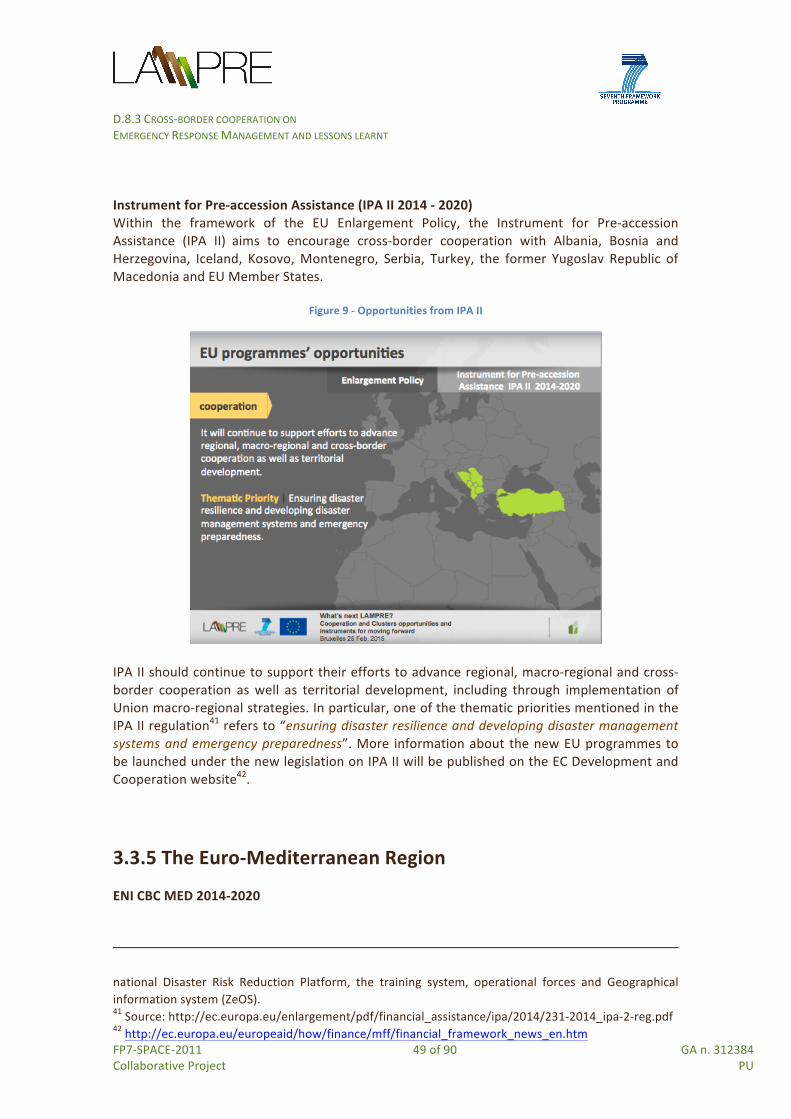
D.8.3 CROSS-‐BORDER COOPERATION ON EMERGENCY RESPONSE MANAGEMENT AND LESSONS LEARNT
FP7-‐SPACE-‐2011 49 of 90 GA n. 312384 Collaborative Project PU
Instrument for Pre-‐accession Assistance (IPA II 2014 -‐ 2020) Within the framework of the EU Enlargement Policy, the Instrument for Pre-‐accession Assistance (IPA II) aims to encourage cross-‐border cooperation with Albania, Bosnia and Herzegovina, Iceland, Kosovo, Montenegro, Serbia, Turkey, the former Yugoslav Republic of Macedonia and EU Member States.
Figure 9 -‐ Opportunities from IPA II
IPA II should continue to support their efforts to advance regional, macro-‐regional and cross-‐border cooperation as well as territorial development, including through implementation of Union macro-‐regional strategies. In particular, one of the thematic priorities mentioned in the IPA II regulation41 refers to “ensuring disaster resilience and developing disaster management systems and emergency preparedness”. More information about the new EU programmes to be launched under the new legislation on IPA II will be published on the EC Development and Cooperation website42.
3.3.5 The Euro-‐Mediterranean Region ENI CBC MED 2014-‐2020
national Disaster Risk Reduction Platform, the training system, operational forces and Geographical information system (ZeOS). 41 Source: http://ec.europa.eu/enlargement/pdf/financial_assistance/ipa/2014/231-‐2014_ipa-‐2-‐reg.pdf 42 http://ec.europa.eu/europeaid/how/finance/mff/financial_framework_news_en.htm
D.8.3 CROSS-‐BORDER COOPERATION ON EMERGENCY RESPONSE MANAGEMENT AND LESSONS LEARNT
FP7-‐SPACE-‐2011 50 of 90 GA n. 312384 Collaborative Project PU
Within the framework of The European Neighbourhood Policy (ENP), the recent Regulation (EU) No 232/2014 of the European Parliament and of the Council of 11 March 2014, establishing a European Neighbourhood Instrument, mentions in Article 2, how the Union support under this Regulation shall target environmental protection, climate action and disaster resilience. It also emphasizes on enhancing sub-‐regional, regional and European Neighbourhood-‐wide collaboration as well as cross-‐border cooperation. Within the context of the “ENI Regional South Strategy for 2014-‐2020 and the Multiannual Indicative Programme (2014-‐2017)”43 -‐ which set out a “policy framework” for addressing the main challenges of the Mediterranean Region (including climate changes adaptation and mitigation) -‐ potential areas of intervention under Objective 2 “Building a partnership for inclusive and sustainable economic development” of the present EU strategy include the following:
• Space applications: promote uptake of GMES and EGNOS satellite based augmentation systems and multi-‐sector applications;
• Climate change: enhancing the resilience of the region against the negative impacts of climate change.
The “Regulation (EU) No 232/2014 of the European Parliament and of the Council of 11 March 2014 establishing a European Neighbourhood Instrument (ENI)” contains provisions for new Cross Border Cooperation (CBC) programmes also in the environmental sector. In particular it foresees cross-‐border cooperation programmes addressing cooperation between Member States and partner countries (or the Russian Federation) along their shared part of the external border of the Union44. Among these ENI CBC Programmes we found the new ENI CBC Mediterranean Sea Basin Programme. Economic development, education & research, social inclusion and environmental protection are the key topics of the new ENI CBC MED for the period 2014-‐2020. Key policy priorities of the current programme intervention strategy45 -‐ which are relevant for this analysis -‐ include the following:
• Strengthen and support euro-‐Mediterranean networks, clusters, consortia and value-‐chains in traditional (agro-‐food, tourism, textile/clothing, etc.) and non-‐traditional sectors (innovative ideas solutions for urban development, eco-‐housing, sustainable water-‐related and other clean technologies, renewable energy, creative industries, etc.);
• Support technological transfer and commercialisation of research results, strengthening the linkages between research, industry as well as private sector actors;
• Support SMEs in accessing research and innovation also through clustering.
3.3.6 The Mediterranean Region
43 Source: Programming of the European Neighbourhood Instrument (ENI) -‐ 2014-‐2020 Regional South Strategy Paper (2014-‐2020) and Multiannual Indicative Programme (2014-‐2017), edited by EEAS and EUROPEAID, September 2014. See: http://eeas.europa.eu/enp/pdf/financing-‐the-‐enp/regional_south_strategy_paper_2014_2020_and_multiannual_indicative_programme_2014_2017_en.pdf 44 Source: http://www.enpicbcmed.eu/sites/default/files/l_07720140315en00270043.pdf 45 Source: http://www.enpicbcmed.eu/sites/default/files/jop_strategy_2014-‐2020_en.pdf

D.8.3 CROSS-‐BORDER COOPERATION ON EMERGENCY RESPONSE MANAGEMENT AND LESSONS LEARNT
FP7-‐SPACE-‐2011 51 of 90 GA n. 312384 Collaborative Project PU
New EC Civil Protection programme in the Euro-‐Mediterranean region (PPRD South II) In the framework of the European Neighbourhood Policy (ENP), the new Euro-‐Mediterranean Regional Programme for the Prevention, Preparedness and Response to natural and man-‐made disasters (PPRD South II -‐ http://euromedpprdsouth2.eu/), started in the spring of 2013 and will run until 2016. The programme focuses on prevention and preparation rather than on response to disasters and addresses the following issues:
• reinforcing co-‐operation between the EU and the Southern Mediterranean Partner institutions (Algeria, Israel, Jordan, Lebanon, Libya, Morocco, Palestine, Syria, and Tunisia) involved in civil protection;
• encouraging coordinated responses of countries affected by the same disaster; • stimulating the development of a regional approach to disaster management, based
on prevention and preparedness, involving not only governments but also civil society46.
The programme will allow for further development of the Vademecum and an extension of the Risk Atlas previously developed in the framework of the PPRD South I (2008-‐2011). The Vademecum helps EU Member States and their neighbourhood partners to improve their reciprocal knowledge on the national civil protection systems in the Mediterranean region, on their risk profile, and to establish a first regional network of national correspondings. The Risk Atlas serves as an online tool, displaying vulnerability and exposure to natural and man-‐made disasters around the Mediterranean. Regarding the operational strategy, the PPRD South II has the following three intervention levels:
• European: reinforce institutional co-‐operation between the EU Civil Protection Mechanism and the ENP South partner countries' civil protection and marine pollution systems.
• Regional: encourage inter-‐regional co-‐ordination and co-‐operation in order to have coordinated response of partner countries affected by the same disaster.
• National: stimulate the development of a national approach to disaster management based on prevention, mitigation and preparedness rather than on response, with the involvement of governmental actors as well as civil society stakeholders.
3.3.7 The ENPI East Region This Region includes the following EU Programme:
• Programme on Prevention, Preparedness and Response to man-‐made and natural Disasters in the ENPI East Region (PPRD East I and II)
• EU-‐Eastern Partnership Civil Protection Flagship Initiative in the period 2010-‐2017 Programme on Prevention, Preparedness and Response to man-‐made and natural Disasters in the ENPI East Region (PPRD East I and II) In the framework of the European Neighbourhood Policy (ENP), the PPRD East runs from 2010 to 2014. Participation in the programme is open to Civil Protection/Disaster Management authorities of Armenia, Azerbaijan, Belarus, Georgia, Moldova and Ukraine, as well as to State
46 Source: http://europa.eu/rapid/press-‐release_IP-‐12-‐1188_en.htm

D.8.3 CROSS-‐BORDER COOPERATION ON EMERGENCY RESPONSE MANAGEMENT AND LESSONS LEARNT
FP7-‐SPACE-‐2011 52 of 90 GA n. 312384 Collaborative Project PU
institutions involved in civil protection and disaster management, national and international NGOs, mass media, academic community and wide public.
Figure 10 -‐ Opportunities from PPRD East I and II
Its main purposes are: 1) to contribute to the development of the Partner Countries' civil protection capacities for disaster prevention, preparedness and response through regional cooperation; 2) to bring the Partner Countries progressively closer to the EU Civil Protection Mechanism and improve their bilateral and regional cooperation. It is expected that a new Programme will build on current achievements and results which include among others the followings47:
• Better knowledge of risk exposure and available resources; • Electronic Regional Risk Atlas installed and running in all 6 Partner Countries and at the
regional level; • Civil Protection Operational Manual/Guidebook and Regional Guidelines on Cross-‐
Border Movement of Assistance; • Increased theoretical and practical knowledge on Civil Protection Mechanism, Flood
Directive, SEVESO Directives; • Practical skills enhanced through Table Top Exercises; • Recommendations on how to enhance legislative and institutional civil protection
frameworks adopted; • Partner Countries included in the “Improving the Safety of Tailing Management
Facilities” Project; • Increased DRR knowledge and awareness of journalists, CP/DM stakeholders and
general public. EU-‐Eastern Partnership Civil Protection Flagship Initiative -‐ 2010-‐2017 47 http://euroeastcp.eu/en/general-‐description-‐of-‐the-‐pprd-‐east-‐programme.html
D.8.3 CROSS-‐BORDER COOPERATION ON EMERGENCY RESPONSE MANAGEMENT AND LESSONS LEARNT
FP7-‐SPACE-‐2011 53 of 90 GA n. 312384 Collaborative Project PU
Six Countries are concerned by this programme, dedicated to Armenia, Azerbaijan, Belarus, Georgia, Moldova and Ukraine which are vulnerable to different types of disasters events (i.e. nearly 50% of population exposed to the risk of floods, more than 22% of population exposed to the risk of earthquakes, 155 disasters registered in the past ten years48). The programme aim at: i) strengthening regional and bilateral cooperation in the field of civil protection; ii) improving capacities for risk assessment and mapping; iii) increasing awareness of disaster risk exposure; iv) enhancing Civil Protection operational skills; v) ensuring more effective and coordinated national civil protection systems. To achieve these objectives, the programme will financially support projects delivering the key outcomes, such as: a) exchange of disaster management experiences and civil protection good practices; b) access to the EU Civil Protection Mechanism PPRD East Electronic Regional Risk Atlas; c) regional workshops, trainings and exercises; d) technical assistance on enhancement of the national frameworks for disaster risk management; e) implementation of the Hyogo Framework of Action.
3.4 EU funded projects on cooperation Within the framework of different EU Programmes (i.e. FP7, CIP, several ETC Programmes, ENPI CBC MED Programme, etc.), in the previous programming period 2007-‐2013, several projects have investigated aspects of (cross-‐border) co-‐operation in the fields of disaster risk reduction (DRR) and emergency management (EM): some of these projects focused on single hazards, a few tried to adopt a multi-‐risk approach. The following section presents the results of a desk analysis, conducted by T.8.3. The analysis explored objectives and main outcomes of EU-‐funded projects handling mainly natural hazards aspects with the aim to learn from previous experiences and derive recommendations useful for LAMPRE to develop cooperation and clustering activities in the short/mid term. Insight from on the results of these projects integrate the exploration of synergies the “Copernicus Emergency Management Projects” performed by task 8.2 (see §2.4). The analysis extended also to some Civil Protection Exercise financed through the Civil Protection Financial Instrument 2007-‐2013.
3.4.1 FP7 and CIP funded projects This section identifies relevant projects, financed under FP7 or CIP still on-‐going or recently closed which LAMPRE can build upon for future cooperation possibilities, expanding the list of the FP7 Copernicus Emergency projects previously cited (see §2.4). EGDI-‐Scope FP7 -‐ Period of implementation: 2012-‐2014 The project studies the creation of a European Geological Data Infrastructure (EGDI). It focuses on: i) preparing the realization of pan-‐European, interoperable, thematic geological data and derived information (with regard to e.g. groundwater quality, active faults, active landslides,
48 http://euroeastcp.eu/assets/files/Factsheet_EC.pdf

D.8.3 CROSS-‐BORDER COOPERATION ON EMERGENCY RESPONSE MANAGEMENT AND LESSONS LEARNT
FP7-‐SPACE-‐2011 54 of 90 GA n. 312384 Collaborative Project PU
subsidence, geo-‐hazards, etc.); ii) preparing an implementation plan for the EGDI to provide access to the above mentioned data with due consideration to the needs of various end user groups; iii) sustaining results from past, on-‐going and future European projects; iv) Integrating 3D geological and hydrogeological models into an EGD. Expected results include, among others, strategies and coordination structures for large or highly distributed and heterogeneous scientific databases (including service architectures, applications and standardization). The project sets the basis for a common European Geological Service to support national and EU institutions in effective decision-‐making and strategic planning related to the subsurface, working under cross-‐border and multi-‐risk approaches. Relevance for LAMPRE: Data generated by LAMPRE can be considered for EGDI databases and contribute to the creation of a sustainable, long term European platform on geoscience disciplines (the EGDI), that will collect and provide high quality harmonized geological data for many cross-‐boundary applications (which is seen as a necessity for the EU). DISASTER -‐ Data Interoperability Solution At Stakeholders Emergency Reaction FP7 -‐ Period of implementation: 2012-‐2015 The project aims at developing an integrative and modular ontology for establishing a common knowledge structure between all the first responders involved in an emergency, compliant with legacy international data formats exchanged in the EU. The modular ontology for the EMS can be applied within a multi-‐risk (multi-‐hazard) approach. Relevance for LAMPRE: Results and standards on landslides modelling proposed by LAMPRE can enrich the EMS ontology developed by DISASTER. KULTURISK -‐ Knowledge-‐based approach to develop a cULTUre of Risk prevention FP7 -‐ Period of implementation 2011 -‐ 2013 The project aims at: i) developing a risk-‐based methodology for the evaluation and accounting of risk prevention measures, able to consider alternative options, tested with a number of case studies; ii) demonstrating that prevention measures are more effective from a social and economic point of view than post-‐disaster recovery for different types of water-‐related risks (landslides, flash floods, storm surges, large scale inundations) characterized by different temporal and spatial scales and diverse socio-‐economic contexts within Europe; iii) promoting a culture of risk prevention. Relevance for LAMPRE: educational activities (as produced through the LEDU – see §2.2) developed by LAMPRE for teaching and learning activities on landslides can further evolve into training activities to the citizens, the public and the private sector, taking into account the findings achieved in the culture of risk prevention by KULTURISK. ENHANCE -‐ Enhancing risk management partnerships for catastrophic natural disasters in Europe FP7 -‐ Period of implementation: 2012 -‐ 2016 The project aims to develop and analyse new ways to enhance society’s resilience to catastrophic natural hazard impacts, such as new multi-‐sector partnerships (MSPs) between

D.8.3 CROSS-‐BORDER COOPERATION ON EMERGENCY RESPONSE MANAGEMENT AND LESSONS LEARNT
FP7-‐SPACE-‐2011 55 of 90 GA n. 312384 Collaborative Project PU
public and private sectors, with an important role for the financial sector (e.g. insurers). The hazards are related to heat waves, forest fires, flood, drought, storm surge, and volcanic eruptions. Relevance for LAMPRE: the project delivers: new risk based scenarios of hazards and socio-‐economic trends and innovative concepts for new MSPs that reduce or redistribute risks. Both these outcome can complement the vulnerability approach of LAMPE into a more holistic vision of products and solutions to increase resilience to landslides and other natural hazards. ELF -‐ European Location Framework CIP -‐ Period of implementation: 2013-‐2016 The goal of ELF project is to deliver the European Location Framework (ELF) required to provide up-‐to-‐date, authoritative, interoperable, cross-‐border, reference geo-‐information for use by the European public and private sectors. Expected results include a pan European cloud platform and web services to build on the existing work of the INSPIRE Directive and enable access to data and geo-‐information, harmonised at a cross-‐border and pan-‐European level. The project will foster the wider use of geo-‐information and enable the creation of innovative value-‐added services, supporting emergency mapping. Relevance for LAMPRE: the set of products developed by LAMPRE can enrich the portfolio of value-‐added services delivered by the project. CIPRNet -‐ Critical Infrastructure Preparedness and Resilience Research Network FP7 -‐ Period of implementation: 2013-‐2018 The project performs research and development that addresses a wide range of stakeholders including (multi)national emergency management, critical infrastructure operators, policy makers, and the society, establishing a Network of Excellence in Critical Infrastructure Protection (CIP). By integrating resources of the CIPRNet partners acquired in more than 60 EU co-‐funded research projects, CIPRNet will create new advanced capabilities for its stakeholders. A key technology for the new capabilities will be modelling, simulation and analysis for CIP. CIPRNet builds a long-‐lasting virtual centre of shared and integrated knowledge and expertise in CIP. This virtual centre shall provide durable support from research to end users. It will form the foundation for the European Infrastructures Simulation & Analysis Centre (EISAC) by 2020. Relevance for LAMPRE: results related to vulnerability assessment of infrastructures (i.e. road networks) developed by LAMPRE can enrich the network of projects of CIPRNet and help to identify exploitation capabilities for stakeholders involved in critical infrastructures.
3.4.2 ETC and LIFE funded projects European Territorial Cooperation Programme (ETC) Programmes (e.g. Greece-‐Bulgaria 2007-‐2013, Romania-‐Bulgaria Cross-‐Border Cooperation Programme for 2007-‐2013, South East Europe Transnational Cooperation for 2007-‐2013, MED Programme 2007-‐2013, Central Europe
D.8.3 CROSS-‐BORDER COOPERATION ON EMERGENCY RESPONSE MANAGEMENT AND LESSONS LEARNT
FP7-‐SPACE-‐2011 56 of 90 GA n. 312384 Collaborative Project PU
2007-‐2013, Interreg IVC, Interreg IV B, Italy – Greece 2007-‐2013, Italy Malta operational programme 2007-‐2013, etc.) provide a framework for exchanging experience between regional and local bodies in different countries. From 2007 until 2013, several projects have investigated the natural and man-‐made hazards. Fairly small in budget, these projects have: i) increased awareness of the local people as to the risk of natural hazards and the impact on population and properties; ii) proposed joint risk management plans; iii) produced policy recommendations and tailor made local/regional Disaster Prevention Policy Plans; iv) developed digital maps with specific thematic layers for a hazardous area, etc. Detailed information about these projects is available on Keep database.49 Here below goals and results of some recent (often still on-‐going) projects from the various ETC Programmes are briefly mentioned with the purpose of highlighting those results relevant for future (cross-‐border) cooperation projects which can involve LAMPRE’s partners and create synergies with the projects outcomes. RISKLIDES Greece-‐Bulgaria 2007-‐2013 -‐ Period of implementation: 2011-‐2013 The project aimed to develop an integrated system for landslide risk assessment in a road line covering a total road length of 160 km, from which 92 km in the Greek and 68 km to Bulgarian territory and produced the following results: i) the identification of the most susceptible to landslides sites along the road line with promising development prospects, including ski resorts in the two countries; ii) the identification of areas affected by critical stability conditions where more in depth geological investigations can be planned along with local authorities; iii) the provision of local and governmental authorities with a tool for taking of short term preventive measures and policies as well as planning of new roads or improvement of characteristics of existing ones; iv) raising of the awareness of the local people as to the risk of landslides and the damage to health and properties; v) an emergency response DSS tool emergency response; vi) the provision of digital maps with specific thematic layers for a hazardous area, including zonation maps, risk and hazard maps. ARDAFORECAST Greece-‐Bulgaria 2007-‐2013 -‐ Period of implementation: 2012-‐2014 The project aims to support the implementation of flood mitigation measures and reduce the adverse consequences of flood events for human health, environment, cultural heritage and economic activity in the southeast Balkans. The project serves as a basis to promote cross-‐border cooperation and educate the local population on proper means of reaction and prevention against such hazards. Expected results include: i) the “Flood warning system establishment in Arda river basin for minimising the risk in the cross border Arda River; ii) development of a GIS database and forecasting models, in order to facilitate real-‐time data sharing in the cross-‐border region; iii) training and educational activities in cooperation with
49 Keep -‐ http://www.territorialcooperation.eu/keep -‐ is the most comprehensive source of authoritative information on the projects and partners of Territorial Cooperation among the member States of the European Union and between these States and the Union's neighbouring countries. The project is co-‐financed by the European Regional Development Fund (ERDF) and implemented by INTERACT.

D.8.3 CROSS-‐BORDER COOPERATION ON EMERGENCY RESPONSE MANAGEMENT AND LESSONS LEARNT
FP7-‐SPACE-‐2011 57 of 90 GA n. 312384 Collaborative Project PU
the local administration, in which a set of warning procedures have been explained; iv) web-‐based tools created for information exchange, and access made available for decision makers, stakeholders and the general public to all the necessary data, forecasts and promotional materials JOINTRISK Romania-‐Bulgaria -‐ Cross-‐Border Cooperation Programme for 2007-‐2013 -‐ Period of implementation: 2010-‐2013 The project aimed to reduce damages caused by environmental disasters such as hail, air pollution and floods in the Danube border area, through the development of joint monitoring systems and improved cooperation between public authorities, academic circles and rescue services in Bulgaria and Romania. It focused on different fields of risk prevention where an integrated monitoring and reaction system can generate the highest benefits. Among the most relevant expected results: i) a joint glossary of terms in Romanian, Bulgarian and English to facilitate understanding; ii) the publication of a handbook and maps pointing out the risks in the area; iii) joint database of incidents -‐ pollution history consisting of information brought by partners on both sides of the border; iv) joint seminars and joint exercises for disseminating information of common manuals of good practice in control procedures; v) air quality monitoring network; vi) enhanced cooperation for sustainable flood risk management and environmental protection in the Danube border area; vii) improved flood risk management and Increased capacity of the institutions and the communities for joint risk management. DANUBE FLOODRISK South East Europe Transnational Cooperation for 2007-‐2013 -‐ Period of implementation: 2009-‐2012. Co-‐financed by the European Regional Development Fund, the project has introduced the most cost-‐effective measures to reduce flood risk across the region, with large benefits for the rural and urban environment. It focused on risk assessment, risk mapping, involvement of stakeholders and risk reduction by adequate spatial planning. It brought together scientists, public servants, NGOs and stakeholders from all the Danube countries. It included Partners from 19 institutions all along these countries (Austria, Bulgaria, Croatia, Hungary, Italy, Romania, Slovakia, Serbia). Together, they developed a scalable system of flood risk maps for the Danube floodplains and delivered a transnational methodology and models for flood risk assessment and mapping. The project team also introduced a series of flood mitigation measures, new spatial development plans and assessment tools for economic development in flood plains. Their work has resulted in a heightened awareness of flood risk among key stakeholders, including the general public, politicians, planners etc. COASTGAP MED Programme 2007-‐2013 -‐ Period of implementation: 2013-‐2015 The project aims to capitalize on best practices offered by 9 projects of a cluster of MED and other programmes which concern adaptation and governance policies of the Mediterranean coastal zones with focus on climate change effects and other natural/anthropogenic threats. COASTGAP aims as well to design, characterize and prepare to launch the Macro-‐Project BEACHMED-‐3, already sketched in previous projects (MEDGOV, COASTANCE, MAREMED). COASTGAP will deliver concrete proposals (projects, researches, network, etc.) in order to face focal questions like the quantitative coastal hazard assessment (EUROSION-‐MED), the

D.8.3 CROSS-‐BORDER COOPERATION ON EMERGENCY RESPONSE MANAGEMENT AND LESSONS LEARNT
FP7-‐SPACE-‐2011 58 of 90 GA n. 312384 Collaborative Project PU
characterization of coastal territory and its sustainable development, coastal sediments and their individuation and sustainable use for adaptation policies, the shared monitoring of coastal areas exposed to climate change effects through a network of observatories (EURIOMCODE), etc. Expected results include: a Joint Action Plan on adaptations to climate changes in the MED basin to face climate change effects and coastal zone risk at Mediterranean basin scale, based on the capitalization, streamline and use of the 12 selected best practices. Of these, particularly relevant for LAMPRE is the SDI and GEOPORTAL Geoportal for ICZM which provides a tool for data sharing and distribution to achieve Integrated Coastal Zone Management in the context of the FP7 PEGASO Project. CEframe Central Europe 2007-‐2013 -‐ Period of implementation: 2010-‐2013 The project aimed to ensure sustainable integrated flood protection management in a region with densely used small-‐areas by different national authorities. It supported the three phases of prevention, contingency and reconstruction in the cycle of flood risk management. Expected results included a flood management plan jointly elaborated as synthesis, a web-‐based communication site to provide substantial information and an integrated multilingual thesaurus for the partners and decision makers applicable to other regions in the CENTRAL EUROPE programme area. CivPro Interreg IVC -‐ Period of implementation: 2010-‐2013 The main objective of the project was to exchange and share knowhow on development of regional policies and on a strategic approach and models to prevent and reduce potential threat and damage for people, property, environment and society, by accident and disasters (natural or/and manmade). Expected results included, among others, overall policy recommendations and tailor made local/regional Disaster Prevention Policy Plans developed on the basis of a pre-‐defined model tested at regional level; exchange of experiences with risk mapping, early warning systems, risk screening models. AMICE -‐ Adaptation of the Meuse to the Impacts of Climate Evolutions Interreg IV B -‐ Period of implementation: 2009-‐2012 The project focused on the adaptation of the Meuse50 and its catchment to the impact of flooding and low waters from climate change. Working together are 17 partner organisations
50 In France, the Public Entity for the Management of the River Meuse and its Tributaries (EPAMA) supports local authorities and communities in the Meuse watershed to better prevent and manage flood risks. In particular the interregional Consortium uses satellite information for transnational cooperation on floods. In 2013, EPAMA teamed up with partners from Germany, the Netherlands and Belgium to improve transnational flood management on the Meuse basin. A web-‐based platform with information on water-‐related risks was set up by combining the available tools and data from national organisations. The platform is key to coordinate prevention and preparedness strategies. It provides free and easy-‐to-‐update preparedness information for flood crisis management on a local level. It helps local authorities to set up their community safety plans and it could permit partners to benefit from free satellite maps in case of disasters.

D.8.3 CROSS-‐BORDER COOPERATION ON EMERGENCY RESPONSE MANAGEMENT AND LESSONS LEARNT
FP7-‐SPACE-‐2011 59 of 90 GA n. 312384 Collaborative Project PU
from Germany, Belgium, France and the Netherlands, AMICE developed a flood crisis management software to improve flood crisis management and emergency planning, tested through a transnational flood-‐risk management exercise. VOL.NET Italy – Greece 2007-‐2013 -‐ Period of implementation: 2010-‐2012. The project aimed to examine alternatives for fire risks prevention and mitigation in order to better control them and reduce the material losses and casualties associated with fire risks in cross-‐border areas, with the exchange of information and practices on fire prevention and mitigation policies and measures. The main output was the creation of a joint volunteerism network, working supportively to “civil protection” services. Other results included among others a manual (i.e. guidelines) regarding the volunteers’ role and tasks in emergency situations, “fire prevention and mitigation” management plans, equipment for the volunteers (palm top pc, GPS, relevant software, etc. VAMOS SEGURO Italy Malta operational programme 2007-‐2013 -‐ Period of implementation: 2010-‐2012 The project aims at the creation of an automatic monitoring and forecasting system regarding the dispersal of volcanic ash over the cross-‐border area between Sicily and Malta with the final view of identifying the areas of risk for aviation. Expected results include among other the automatic monitoring and forecasting system which is able to identify the areas between Sicily and Malta that, in the event of explosive activity, will be concerned with dangerous concentrations of volcanic ash and gases and produce alert systems for the authorities responsible for air traffic. Local-‐Sats ENPI CBC MED 2007-‐2013 -‐ Period of implementation: 2013-‐2015 The overall objective of the project is to offer to local governments new and flexible tools and a whole suit of information based on geospatial applications that would enrich their decision-‐making process in the interest of the people living in the Mediterranean Basin. Expected results include: i) enhanced regional consensus and strengthened local administrations capacities on the use of geospatial technologies by local administrations through the production of gap analysis, roadmaps and performance indicators studies; ii) a Decision Support System integrated by a Geographical Information System for policy design, progress and impact assessment adopted and implemented in the target areas; iii) a cross-‐border network at basin level among cities, regional institutions, universities, NGOs, involved in local governance processes, sustainability and geospatial sciences that will work during and after the end of the project, incorporating new organizations interested in the project results and its update and feedback. LIFE+IMAGINE LIFE plus 2012 -‐ Period of implementation: 2013-‐2016

D.8.3 CROSS-‐BORDER COOPERATION ON EMERGENCY RESPONSE MANAGEMENT AND LESSONS LEARNT
FP7-‐SPACE-‐2011 60 of 90 GA n. 312384 Collaborative Project PU
The project deals with the integrated management of coastal zone management (ICZM) and the implementation of environmental policies in the sector, with particular reference to two application scenarios: landslides in coastal zones and soil consumption in coastal zones. The project implements an infrastructure based on web services for environmental analysis, integrating in its own architecture specifications from the INSPIRE Directive and the guidelines of the Shared Environment Information System for Europe (SEIS), interfacing the processes with Copernicus. In particular for the landslide scenario, results, derived by the application of this infrastructure are expected: to (re)shape risk analysis models, based on INSPIRE compliant datasets; to define standard procedures to create landslide risk maps, identifying, for specific meteorological events, the inference area of phenomena occurrence; to define a procedure to evaluate environmental impacts, with a set of indicators to estimate the percentage of population/ territory/infrastructures involved by landslide and/or floods events. PUNNET -‐ LAND STABILITY MONITORING & MAPPING ESA-‐funded project 2012-‐2014 The Punnet project is a satellite-‐based land stability monitoring and mapping solution for exploration, construction, and environmental protection purposes. The project is based on a novel algorithm, which enables the software to deliver extensive and clear imagery of deformation features over a wide range of land covers. Punnet Land Instability Maps provide solutions for geohazards monitoring, such as landslides, earthquakes and land subsidence due to natural resources. The service aims to map and monitor land stability with millimetre-‐precision, facilitating large-‐scale coverage of land deformation from mining, groundwater extraction, drilling and other causes. On 23 October 2014, the Copernicus Masters was awarded to this project. GENESIS -‐ Geoinformation Networks For the Cross-‐Border National Park Region Saxon-‐ Bohemian Switzerland Interreg IIIA CBC – Period of implementation 2004 -‐ 2006 This project provided high quality topographic information for a cross-‐border national park region along the German-‐Czech border, creating a homogenous geographic data set including high accuracy topographic and optical data for the whole cross-‐border nation park region. Data acquisition was provided using one sensor system without splitting the region into several parts. HELM – Harmonized European Land Monitoring FP7 – Implementation period 2010-‐2013 The project provides a list of best practices of Land Monitoring systems. These were gathered throughout a participative process in workshops, following selecting criteria (innovative; proven to solve commonly occurring problems; suitable to optimize operational work between environmental monitoring and cartographic products; suitable to be understood by either specialists and relatively broad audience; illustrative for the integration of European services within national land monitoring programmes) and according to four main groups of objects (operational issues, empirical knowledge, strategy, technical issues).

D.8.3 CROSS-‐BORDER COOPERATION ON EMERGENCY RESPONSE MANAGEMENT AND LESSONS LEARNT
FP7-‐SPACE-‐2011 61 of 90 GA n. 312384 Collaborative Project PU
3.4.3 Civil Protection Exercises Simulation exercises organised at the European Community level aim mainly at establishing a common understanding of the cooperation in civil protection assistance interventions and to improve the quality of the response in major emergencies between the EU Member States. The exercises need to be based on the provisions of the Community Civil Protection Mechanism. The Humanitarian Aid and Civil Protection Department (ECHO) website51 provides with the lists of civil protection exercises by year, time/place, disaster scenario, EC contribution: Two examples of community civil protection exercises, involving Italy and the Italian Civil Protection Department52 (DPC), partner of LAMPRE, are given below. Although they do not relate to landslides, but instead to tsunami and earthquake, they provide useful information to understand how civil protection units cooperate. Tidal Wave In Southern Tyrrhenian Sea (TWIST) The Twist operation53 was organized by the Italian Civil Protection and co-‐financed by the EU. This operation – which takes place in the Province of Salerno from 24 to 27 October 2013 and involved around 2,500 military and civilian personnel – was aimed at simulating a tidal wave in the Southern Tyrrhenian Sea. The project aimed to increase the awareness of citizens and institutions on tsunami risk, through operational activities, training and dissemination of knowledge and to support civil protection planning at the local level. The civil protection structures of Croatia, France, Greece, Malta, Portugal and Spain took part to the drill activities -‐ which involved the components and the operating structures of local and national level of the entire National Service of Civil Protection. A team of experts from the European Civil Protection Mechanism has also been engaged in fieldwork. With the aim of encouraging the development of strategies for prevention of tsunami risk and the spread of the culture of civil protection, in the weeks before the drill, in the towns and in schools in the Province of Salerno, training activities for managers and technical officials of municipalities and school administrators and security managers of schools were also carried out. Tuscany Earthquake Relief EXercise (TEREX) The objective of Terex 2010 was to check the effectiveness of the Civil Protection System on a national and international level. In particular, this exercise aimed to test the response capacity of the members and operating units of the National Civil Protection Service and Europe’s capacity to tackle serious calamity (i.e. floods and seismic events) through activation of the Community Mechanism for civil protection54. Within the framework of the GMES Emergency Response Service (GMES-‐ERS) which offers customer-‐ready satellite mapping products that are useful for the management of
51 http://ec.europa.eu/echo/en/funding-‐evaluations/financing-‐civil-‐protection/civil-‐protection-‐exercises 52 Source: http://ec.europa.eu/echo/en/funding-‐evaluations/financing-‐civil-‐protection/civil-‐protection-‐exercises#2015 53 For further information see the website of the Italian Civil Protection Department at: http://www.protezionecivile.gov.it/jcms/it/view_dossier.wp?contentId=DOS41830 54 For further information see the website of the Italian Civil Protection Department at: http://www.protezionecivile.gov.it/jcms/it/view_dossier.wp?contentId=DOS15077

D.8.3 CROSS-‐BORDER COOPERATION ON EMERGENCY RESPONSE MANAGEMENT AND LESSONS LEARNT
FP7-‐SPACE-‐2011 62 of 90 GA n. 312384 Collaborative Project PU
emergencies and for risk monitoring of a territory. On the occasion of Terex 2010 Exercise, the GMES-‐ERS was available to support functions activated by the Di.COMA.C. (workstation) based in Viareggio (Italy). During this exercise, an integration of cartographic products in the satellite mapping system used by the Department of Civil Protection -‐ GIS and WebGIS -‐ has been carried out to support the teams engaged in activities related to the census of damages.
4. Clusters opportunities
4.1. Defining clusters Many definitions of clusters exist. Definitions are fundamentally context-‐related and driven by purpose (i.e. from an economic perspective the main purpose is to better understand the drivers of competitiveness and growth). The "Community Framework for State Aid for Research and Development and Innovation"55 defines innovation clusters as: "groupings of independent undertakings — innovative start-‐ups, small, medium and large undertakings as well as research organisations — operating in a particular sector and region and designed to stimulate innovative activity by promoting intensive interactions, sharing of facilities and exchange of knowledge and expertise and by contributing effectively to technology transfer, networking and information dissemination among the undertakings in the cluster." In more general terms, clusters can be defined as a group of firms, related economic actors, and institutions that are located near each other and have reached a sufficient scale to develop specialised expertise, services, resources, suppliers and skills. Clusters are also defined as “geographically close groups of interconnected companies and associated institutions such as research institutes, business associations as well as local authorities, linked by shared strategies and vision of development, common technologies and skills”56. A common element of most cluster definitions is the aspect of a concentration of one or more sectors within a given region as well as the emphasis on networking and cooperation between companies and institutions. Clusters are defined by relationships, not memberships and their spatial boundaries are variable and not necessarily corresponding with political borders. Clusters are powerful engines of economic development and drivers of innovation in the European Union. They provide a fertile business environment for companies, especially SMEs, to collaborate with research institutions, suppliers, customers and competitors located in the same geographical area57.
55 Community Framework for State Aid for Research and Development and Innovation, which is published in the Official journal of the European Union (2006/C 323/01) of 30.12.2 56 Analysing ERDF co-‐financed innovative projects -‐ Final report prepared in the framework of the European Commission study on the ERDF co-‐financed innovative projects and comparative analyses, Technopolis, April 2008. 57 Source: http://ec.europa.eu/enterprise/policies/innovation/policy/clusters/index_en.htm

D.8.3 CROSS-‐BORDER COOPERATION ON EMERGENCY RESPONSE MANAGEMENT AND LESSONS LEARNT
FP7-‐SPACE-‐2011 63 of 90 GA n. 312384 Collaborative Project PU
Clusters have the potential to affect competition in three ways: by increasing the productivity of the companies in the cluster, by driving innovation in the field, and by stimulating new businesses in the field (Michael Porter, 1990) The concept of clusters generally comprises of three important dimensions58:
1. Clusters are seen as “geographical concentrations of specialised firms, advanced skills and competences in the labour forces, and supporting institutions which increase knowledge flows and spillovers” as a result of their proximity.
2. Clusters serve a functional purpose to provide a range of specialised and customised services to a specific group of firms, such as the provision of advanced and specialised infrastructure, specific business support services or training and coaching of staff. Cluster organisations help to channel, facilitate or provide access to facilities and services, which may include specialised research and test centres, consultancy, training, and so on. In this sense, clusters are a form of "self-‐organisation" that offers competitive advantages. Clusters facilitate both intense competition and close cooperation, sometimes described with the term "coopetiton". Geographical proximity is believed to facilitate the flows of tacit knowledge and the unplanned interactions that are critical parts of the innovation process. This flow relies upon the willingness of firms to inform others about their knowledge, which depends upon the trust established between actors. This in turn can be facilitated through continuous face-‐to-‐face contacts, to which efficient cluster organisations contribute by encouraging networking and cooperation.
3. Clusters are characterised by a certain dynamic social and organisational element, the so called "institutional fix" or social glue that holds the different interlinked innovation actors such as universities, businesses and public authorities together and facilitates intense interaction and cooperation amongst them. Over time, clusters tend to develop a set of idiosyncratic norms, institutions, personal networks, and trust.
Furthermore, it is important to distinguish between clusters, cluster policies, cluster initiatives and cluster services: clusters consist of a real economic phenomenon that can be economically measured; cluster policies represent an expression of political commitment to support existing clusters or the emergence of new clusters; cluster initiatives are practical actions to strengthen cluster development (based or not on a formulated cluster policy); cluster services are specific, tailor-‐made services provided by cluster organisations to their respective members (or cluster participants). Cluster organisations can play a relevant role for the development of new industrial value chains and emerging industries, by creating a favourable environment for facilitating entrepreneurship and cross-‐sectoral cluster collaboration, offering a wide portfolio of services through different collaborative tools that can include: market intelligence services for identifying opportunities in various markets (using tools such as road mapping, trend-‐scouting, foresight analysis); matchmaking services for finding partners and stakeholders in other
58 Source: Commission Staff Working Document SEC (2008) 2637, “The concept of clusters and cluster policies and their role for competitiveness and innovation”-‐ Europe INNOVA / PRO INNO Europe paper N"9 – page 11

D.8.3 CROSS-‐BORDER COOPERATION ON EMERGENCY RESPONSE MANAGEMENT AND LESSONS LEARNT
FP7-‐SPACE-‐2011 64 of 90 GA n. 312384 Collaborative Project PU
industries/sectors (with competence mapping tools); project development services to translate new ideas into cross-‐sectoral innovation projects (using innovation platforms); technology transfer services; innovation vouchers to get initiatives, programmes and projects of the cluster up and running59.
4.2 EU initiatives and programmes fostering clusters
4.2.1 EU policy framework on clusters The EU encourages the creation and strengthening of world-‐class excellence clusters60 within a policy framework for action aiming to: raising the level of excellence and openness of clusters; ii) fostering transnational cooperation between cluster organisations. In particular the EU has established a high-‐level European Cluster Policy Group to explore ways on how to best assist EU countries in supporting clusters expanding the policy dialogue under the European Cluster Alliance (ECA). The ECA is an open platform established to maintain a permanent policy dialogue at EU level among national and regional public authorities responsible for developing cluster policies and managing or funding cluster programmes in their countries or regions. The ECA has developed a number of initiatives and programmes to support cluster policy makers and encourage trans-‐national cooperation and pilot initiatives. These include the European Cluster Collaboration Platform (embedded within the European Cluster Excellence Initiative) and the European Cluster Observatory (ECO). ECCP -‐ European Cluster Collaboration Platform The ECCP is a platform financed by the Competitiveness and Innovation Programme (CIP) which provides online quality information and networking support for clusters (organisations and members). The goal is to facilitate cluster cooperation, both between cluster organisations, as well as between cluster members (i.e. companies, R&D institutions, other players). from the same or a different sector. The ECCP organizes matchmaking events for cluster organisations and their SME members, promoting international cluster cooperation, and matchmaking missions in Europe with partners from Third Countries. ECO -‐ European Cluster observatory
59 This set of cluster services takes into account the result of the analysis of more than 500 benchmarking exercises and quality audits of cluster organisations conducted by the European Secretariat for Cluster Analysis, indicated in the European Cluster Observatory REPORT, Cluster Collaboration and Business Support Tools to Facilitate Entrepreneurship, Cross-‐sectoral Collaboration and Growth, T. Lämmer-‐Gamp et al., September 2014 60 Towards world-‐class clusters in the European Union: Implementing the broad-‐based innovation strategy {SEC(2008) 2637} -‐ COM(2008) 652 final
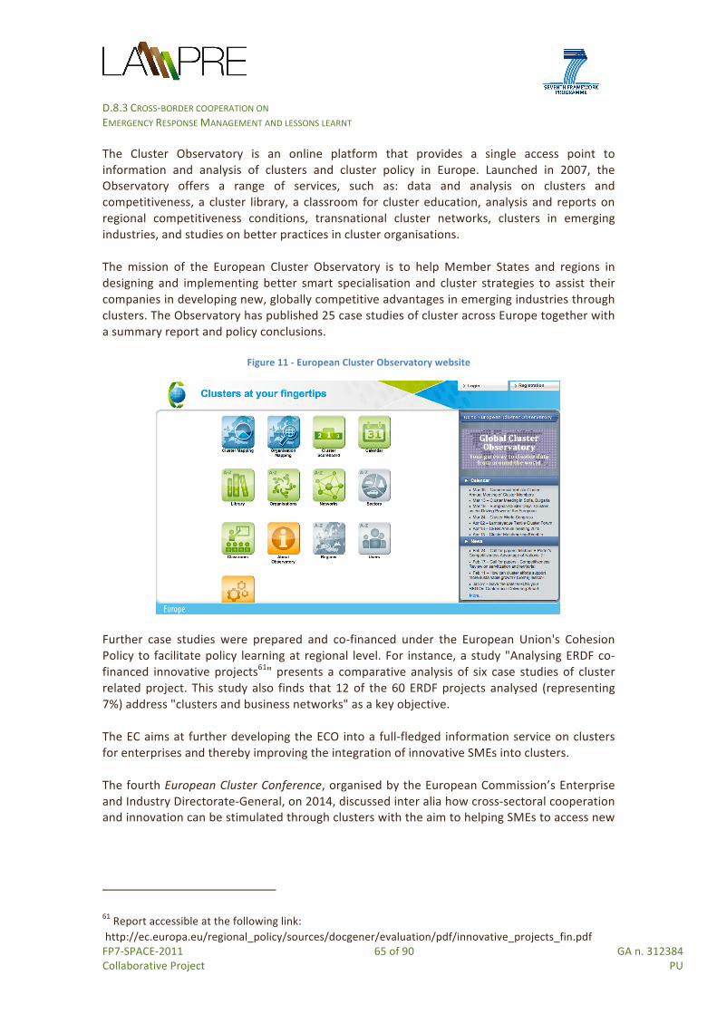
D.8.3 CROSS-‐BORDER COOPERATION ON EMERGENCY RESPONSE MANAGEMENT AND LESSONS LEARNT
FP7-‐SPACE-‐2011 65 of 90 GA n. 312384 Collaborative Project PU
The Cluster Observatory is an online platform that provides a single access point to information and analysis of clusters and cluster policy in Europe. Launched in 2007, the Observatory offers a range of services, such as: data and analysis on clusters and competitiveness, a cluster library, a classroom for cluster education, analysis and reports on regional competitiveness conditions, transnational cluster networks, clusters in emerging industries, and studies on better practices in cluster organisations. The mission of the European Cluster Observatory is to help Member States and regions in designing and implementing better smart specialisation and cluster strategies to assist their companies in developing new, globally competitive advantages in emerging industries through clusters. The Observatory has published 25 case studies of cluster across Europe together with a summary report and policy conclusions.
Figure 11 -‐ European Cluster Observatory website
Further case studies were prepared and co-‐financed under the European Union's Cohesion Policy to facilitate policy learning at regional level. For instance, a study "Analysing ERDF co-‐financed innovative projects61" presents a comparative analysis of six case studies of cluster related project. This study also finds that 12 of the 60 ERDF projects analysed (representing 7%) address "clusters and business networks" as a key objective. The EC aims at further developing the ECO into a full-‐fledged information service on clusters for enterprises and thereby improving the integration of innovative SMEs into clusters. The fourth European Cluster Conference, organised by the European Commission’s Enterprise and Industry Directorate-‐General, on 2014, discussed inter alia how cross-‐sectoral cooperation and innovation can be stimulated through clusters with the aim to helping SMEs to access new
61 Report accessible at the following link: http://ec.europa.eu/regional_policy/sources/docgener/evaluation/pdf/innovative_projects_fin.pdf

D.8.3 CROSS-‐BORDER COOPERATION ON EMERGENCY RESPONSE MANAGEMENT AND LESSONS LEARNT
FP7-‐SPACE-‐2011 66 of 90 GA n. 312384 Collaborative Project PU
industrial value chains and find complementary international partners. As a result, a declaration62 was made based on the following main five statements to be adopted:
1. Challenges for European Cluster Policy – The EU's cluster approach to supporting the implementation of regional smart specialisation should prioritise facilitating cross-‐sectoral and cross-‐border collaboration and promoting synergies and partnering between regions with similar smart specialisation priorities.
2. Cluster Policy Development: create a favourable business environment for SMEs, notably in emerging industries, and help SMEs to integrate into value chains and secondly to integrate EU priorities such as internationalisation, resource efficiency and service innovation.
3. Clusters and Emerging Industries: exploit innovation and new financial tools adapted to emerging industries (e.g. crowd-‐funding, micro-‐loans) and secondly, tools that encourage collaboration across sectors (e.g. vouchers and matchmaking services);
4. Cluster Internationalisation: New European Strategic Cluster Partnerships (meta clusters) should be supported at EU level by a mixed top-‐down and bottom-‐up approach.
5. Cluster Excellence: training and coaching to guide individual strategy development.
4.2.1 EU programmes for clusters The main EU Programmes fostering the creation and/or strengthening of clusters are:
• Horizon 2020 • COSME • INTERREG Europe • ETC MED 2014-‐2020 • Central Europe 2014-‐2020 • Operational programme Italy –Malta 2014-‐2020 • INTERREG GR-‐IT 2014-‐2020 • Operational Programme Italy –France Maritime 2014-‐2020 • Adriatic Ionian Programme 2014-‐2020 • The Balkan-‐Mediterranean Programme 2014-‐2020 • ENI CBC MED 2014-‐2020
Horizon 2020 The experience of 'Regions of Knowledge' and 'Research potential in Convergence and Outermost regions' initiative in FP7 encouraged EU-‐wide cooperation among partnerships in the ‘triple helix’ of universities/research centres, enterprises, and regional authorities to develop research-‐driven clusters. Activities targeted the coordination of mutual research agendas, knowledge exchange and new research-‐driven clusters for which projects developed joint action plans. Following the above mentioned policy framework, including the EU Space
62 http://ec.europa.eu/enterprise/initiatives/cluster/observatory/european-‐cluster-‐conference-‐2014-‐declaration.pdf
D.8.3 CROSS-‐BORDER COOPERATION ON EMERGENCY RESPONSE MANAGEMENT AND LESSONS LEARNT
FP7-‐SPACE-‐2011 67 of 90 GA n. 312384 Collaborative Project PU
industrial policy, Horizon 2020 strengthens the support to the creation of clusters and meta-‐clusters. In particular, the following H2020 topic can be considered of particular relevance for LAMPRE: INNOSUP-‐1-‐2015 Cluster facilitated projects for new value chains This topic aims at developing new cross-‐sectoral industrial value chains across the EU, by building upon the innovation potential of SMEs. The EU needs to support the development of emerging industries, which will provide the growth and employment of the future. The development of new industrial value chains calls for the collaboration and integration of different innovation actors, including large enterprises and especially SMEs, across different sectors towards the implementation of a joint vision. As such, this innovation action promotes cross-‐border and cross-‐sectoral collaboration, innovation and entrepreneurship across different regions and value chains. The coordination and facilitation shall be led by cluster organisations and other intermediary organisations, by following a systemic approach that combines different resources, tools and instruments. Opportunity for LAMPRE: SMEs partners of LAMPRE, as well as SMEs partners of the other Cooperation Emergency Projects consortia are operating in emerging industries (e.g. geo-‐spatial services, location based intelligence, sensing technologies), often throughout Europe, with expertise covering different industry value chains (ICT, Space, etc.), in different sectors. Some of these SMEs are also partners of well internationally recognized clusters. Therefore an opportunity exists for developing a project which enables innovative (open) collaboration between SMEs and innovation actors for better addressing specific problems and challenges in disaster risk reduction, by creating new competitive value-‐chains able to boost the EO sector and linking it to other sectors. The project can create a collaborative environment where SMEs can validate ideas for structured innovation projects driven by them, in different sectors and countries, exploiting a mix of different targeted entrepreneurial and innovation support measures (such as mentoring, coaching, innovation and technical assistance vouchers, etc.). Programme for the Competitiveness of Enterprises and small and medium-‐sized enterprises (COSME) (2014 – 2020) Established in 2013, COSME 2014 -‐ 202063 indicates the needs for actions to improve the framework conditions for the competitiveness and sustainability of Union enterprises, particularly SMEs. Such actions may include measures to improve the design, implementation and evaluation of policies affecting the competitiveness and sustainability of enterprises, including through the sharing of good practices on framework conditions and on the management of world-‐class clusters and business networks; and through promoting transnational collaboration among clusters and business networks, the development of sustainable products, services, technologies and processes, as well as resource-‐ and energy-‐efficiency and corporate social responsibility. Two work programmes supported clusters:
63 Source: http://eur-‐lex.europa.eu/LexUriServ/LexUriServ.do?uri=OJ:L:2013:347:0033:0049:EN:PDF

D.8.3 CROSS-‐BORDER COOPERATION ON EMERGENCY RESPONSE MANAGEMENT AND LESSONS LEARNT
FP7-‐SPACE-‐2011 68 of 90 GA n. 312384 Collaborative Project PU
• Cluster Go International COS-‐WP 2014-‐3-‐03)64 whose expected results include: establishment and further development of Pan-‐European strategic cluster partnerships, to support SMEs in global competition (‘Cluster Go International’);
• Cluster Excellence Programme (COS-‐WP2014-‐3-‐04)65 whose expected results include: Establishment of PanEuropean consortia of partners who will be trained to promote cluster excellence in the EU to offer better business services to SMEs.
COSME supports the European Cluster strategy 2010-‐2020 which should complement national and regional efforts to encourage clusters towards excellence and international cooperation, taking into account the fact that the clustering of SMEs can be a key means of strengthening their capacity to innovate and to begin operating in overseas markets”. INTERREG EUROPE 2014-‐2020 Within the Priority Axis 1 “Research, Technological Development and Innovation” and Thematic objective 1 “Strengthening research, technological development and innovation,” the Investment Priority 1b aims at promoting business investment in innovation and research, and developing links and synergies between enterprises, R&D centres and higher education, in particular product and service development, technology transfer, social innovation, eco-‐innovation, cultural and creative industries, public service applications, demand stimulation, networking, clusters and open innovation through smart specialisation and supporting technological and applied research, pilot lines, early product validation actions, advanced manufacturing capabilities and first production, in particular in Key Enabling Technologies and diffusion of general purpose technologies. ETC MED Programme 2014-‐2020 Within the Priority Axis 166 “Promoting Mediterranean innovation capacity to develop smart and sustainable growth” and Investment priority 1b “Promoting business investment in innovation and research”, the Specific objective 1.1 aims “to increase transnational activity of innovative clusters and networks of key sectors of the MED area”.
64 Source: http://ec.europa.eu/easme/en/cos-‐cluster-‐2014-‐3-‐03-‐cluster-‐go-‐international 65 http://ec.europa.eu/easme/en/cos-‐wp-‐2014-‐3-‐04-‐cluster-‐excellence-‐programme 66 Source: MED 2014+ Intervention Strategy available at: http://www.programmemed.eu/fileadmin/PROG_MED/MED_2014_/EN_MED_2014_OP_summary_priorities_public.pdf

D.8.3 CROSS-‐BORDER COOPERATION ON EMERGENCY RESPONSE MANAGEMENT AND LESSONS LEARNT
FP7-‐SPACE-‐2011 69 of 90 GA n. 312384 Collaborative Project PU
Figure 12 -‐ Cooperation and clusters opportunities from ETC MED Programme
According to ETC MED Programme, transnational cooperation and better connections between actors of the quadruple helix (research bodies, businesses, public authorities, civil society) are needed to improve innovation capacities of public and private actors (within and between existing clusters, economic sectors and networks) involved in green and blue growth sectors, creative industries and social economy. The goal is to improve empowerment of these actors with, within and between existing clusters, economic sectors and networks. The Programme provides the following “indicative types of actions” fostering clustering and cooperation:
• Designing common approaches and strategies at transnational level: o Establishing and further strengthening transnational innovation networks and
clusters and supporting internationalisation o Increasing cooperation between research, SMEs and the public sector to
stimulate innovation and entrepreneurship • Transfer, dissemination and capitalisation activities:
o Training cluster managers and members and public authorities on stimulating interdisciplinary cooperation
o Creating or strengthening sustainable active networks of cooperating actors of the quadruple helix system in the relevant sectors with a link to existing or foreseen European networks and platforms (ex: Sevilla S3 platform, INTERREG EUROPE thematic platforms…)
o Engaging Regions (beyond direct partnership) to strengthen connections and cooperation of existing smart specialisation strategies at transnational level (cooperation platforms…)
o Strengthening existing clusters and networks and increasing their connectivity and synergies at MED level.
Central Europe 2014-‐2020

D.8.3 CROSS-‐BORDER COOPERATION ON EMERGENCY RESPONSE MANAGEMENT AND LESSONS LEARNT
FP7-‐SPACE-‐2011 70 of 90 GA n. 312384 Collaborative Project PU
The Priority Axis 1, “Cooperating on innovation to make Central Europe more competitive”67 aims at more effective investment in research, innovation and education.
Figure 13 -‐ Opportunities from CENTRAL EUROPE programme
The Specific objective 1.1 aims at “improving sustainable linkages among actors of the innovation systems for strengthening regional innovation capacity in central Europe”. This will be achieved through transnational and internationalised regional networks and clusters fostering technology transfer and the development and implementation of new services supporting innovation in businesses. The programme will help strengthening potentials of technology-‐oriented areas that are destinations of foreign investments and capital flows, through better linking actors of innovation systems. This will enhance the transfer of research and development (R&D) results and the set-‐up of cooperative initiatives and clusters. Increased cooperation between actors of the innovation systems, especially between business and research, will improve access to research results for enterprises, notably SMEs, thus stimulating further investment in innovation. Furthermore, the link between research and public administration will be strengthened (e.g. by setting up specific mechanisms and promoting public procurement of innovation) which could positively contribute to both economic and social innovation transfer. Operational programme Italy –Malta 2014-‐2020 The Priority Axis 1 “Strengthening research, technological development and innovation”68 specifies that, “the Programme’s actions relate to the creation of clusters and networks that
67 Source: http://www.central2013.eu/fileadmin/user_upload/Downloads/CE2014/CENTRAL_EUROPE_2020_Cooperation_Programme_non-‐technical_summary.pdf 68 Source:

D.8.3 CROSS-‐BORDER COOPERATION ON EMERGENCY RESPONSE MANAGEMENT AND LESSONS LEARNT
FP7-‐SPACE-‐2011 71 of 90 GA n. 312384 Collaborative Project PU
connect the two sectors of research and business of the two islands (Sicily and Malta) as well as to the development of models and prototypes of innovative ideas, including actions to finance the transfer of knowledge and the provision of vouchers to enable cross-‐border training stages”. In particular, within the Priority investment 1.b “Increasing innovation activity and research to meet the needs of development and cooperation”, the Specific objective 1.1 supports “actions aimed to develop new systems and technologies for security, monitoring, remediation and conservation of the marine and coastal environment as well as innovative systems for integrated emergency management, defence and safety of the territory and the sea”. List of possible project initiatives include:
• A.1 Actions to support technology clusters which are aimed to find innovative solutions to assist firms to develop products, brands, processes, or introduce the Best Available Technology (BAT), marketing and more innovative services for companies operating within the cross-‐border area;
• B.1 Intervention of Research & Innovation with high added value in order to satisfy the needs of environmental protection, security of land and sea.
INTERREG GR-‐IT 2014-‐2020 Within the Priority Axis 1 “Innovation and competitiveness” the Investment Priority 1b69 aims at “Promoting business investment in R&I, developing links and synergies between enterprises, research and development centres and the higher education sector, in particular supporting investment in product and service development, technology transfer, social innovation, eco-‐innovation, public service applications, demand stimulation, networking, clusters and open innovation through smart specialisation, and supporting technological and applied research, pilot lines, early product validation actions, advanced manufacturing capabilities and first production, in particular in key enabling technologies”. Operational Programme Italy–France Maritime 2014-‐2020 Within the Priority Axis 1 “Promotion of business competitiveness within cross-‐border priority sectors” and the Objective theme 3 “Improve SME competitiveness”, the Investment Priority 3D aims at “Supporting the capacity of SMEs to engage in growth in regional, national and international markets as well as in the innovation process”. The following actions are supported: (i) Aid for creating advanced forms of cooperation (clusters / networks) for innovation among SMEs in cross-‐border priority sectors; (ii) Aid for clusters / networks to purchase services and to invest in innovation of process and products; (iii) Aids for networks / clusters-‐of cross border business to exploit new and innovative research ideas in cross-‐border priority sectors related to the blue and green economy.
http://www.unict.it/sites/default/files/magazine/Cooperazione%20Territoriale%20Europea_Bozza%20PC%20Italia%20Malta%202014_2020.pdf 69 Source: http://greece-‐italy.eu/images/News/news4122014_newProgram/2Programme_2014TC16RFCB020_1_0_en.pdf

D.8.3 CROSS-‐BORDER COOPERATION ON EMERGENCY RESPONSE MANAGEMENT AND LESSONS LEARNT
FP7-‐SPACE-‐2011 72 of 90 GA n. 312384 Collaborative Project PU
Adriatic Ionian Programme 2014-‐2020 In particular, the Specific objective 1.1 is aimed to “support the development of innovation networks and clusters among regions, academia and enterprises in the AIO region”. Indicative Actions include among others: (i) Develop transnational models for the design, testing, up-‐scaling, comparison and evaluation of innovations (policies, tools, processes, actors, organisations and interfaces); (ii) Set up transnational frameworks, platforms and networks for the coordination of innovation policy. The Programme text was submitted to the European Commission on 18 December 2014 and awaits approval in 201570. The Balkan-‐Mediterranean Programme 2014-‐2020 As mentioned in the document “Citizens’ Summary TNCP Balkan – Mediterranean 2014 – 2020”71, the Priority Axis 1 “Entrepreneurship & Innovation” of this new transnational ETC programme72 is devoted to “actions that foster the area’s entrepreneurship potential by encouraging SMEs’ cooperation and networking, clusters and clusters policies, new business models’ applications and in particular the ones promoting innovation, opens up new markets and support internationalisation”. ENI CBC MED 2014-‐2020 Two Investments Priorities are relevant for LAMPRE, as shown in figure 14.
Figure 14 -‐ Opportunities from ENI CBC
70 Source: http://www.southeast-‐europe.net/en/about_see/adriaticionianprogramme/ 71 Source: http://www.interreg.gr/images/news-‐en/Balkan-‐Mediterranean/241014/News241014a1.pdf 72 Source: http://www.southeast-‐europe.net/en/news_and_events/news/publicconsultationofthefirstdraftofthebalkan-‐mediterranean2014-‐2

D.8.3 CROSS-‐BORDER COOPERATION ON EMERGENCY RESPONSE MANAGEMENT AND LESSONS LEARNT
FP7-‐SPACE-‐2011 73 of 90 GA n. 312384 Collaborative Project PU
• within the Thematic Objective 1 “Business and SMEs development”73, Investment priority 1 “Strengthen and support euro-‐Mediterranean networks, clusters, consortia and value-‐chains in traditional (agro-‐food, tourism, textile/clothing, etc.) and non-‐traditional sectors (innovative ideas solutions for urban development, eco-‐housing, sustainable water-‐related and other clean technologies, renewable energy, creative industries, etc.)”;
• within the Thematic Objective 2 “Support to education, research, technological development and innovation”, Investment Priority 2 “Support SMEs in accessing research and innovation also through clustering”.
4.3 Examples of clusters and meta-‐clusters Clusters can have different scope and goals, origin and organization models. They can have a regional, national, transnational composition. The following sections provide with different examples of clusters, projects devoted to create clusters or strengthen existing ones. In fact, this section also includes some examples of meta-‐clusters (meant as connection between clusters) whose development is supported by different EU programs (i.e. Central Europe, FP7, COSME). The European Defence Agency -‐ which supports the European Council and the Member States in their effort to improve the European Union’s defence capabilities through cooperative projects and programmes provides a list of regional and/or industrial portals & clusters, split by country and including space technologies74. The Eureka Cluster Initiative undertaken by EUREKA EUREKA is an intergovernmental organisation for market-‐driven industrial R&D which integrates over 40 pan-‐European economies, but also includes Israel, South Korea, and Canada. As a decentralised network, it facilitates the coordination of national funding on innovation aiming to boost the productivity & competitiveness of European industries. EUREKA network undertook the Cluster Strategic Initiative to develop generic technologies of key importance for European competitiveness. There are seven on-‐going EUREKA Clusters (ACQUEAU, CATRENE, CELTICPLUS, EUROGIA+, EURIPIDES, ITEA2, and MF.IND) none of these strictly aggregate industries in the EO and geo-‐spatial sector. Furthermore to this four EUREKA umbrella involve tech areas such as manufacturing, materials, tourism and agri-‐food. On the other side, several clusters on space technologies have been created all across Europe. And the NEREUS Working Group on Clusters, led by Aerospace Valley, is working to create a group of entities interested by the development of SMEs in the domain of space applications. This group may act as SMEs interface with ESA or EC. This group will be managed by entities
73 Source: http://www.enpicbcmed.eu/sites/default/files/jop_strategy_2014-‐2020_en.pdf 74 https://www.eda.europa.eu/procurement-‐gateway/information/industry-‐rto-‐directory/regional-‐industrial-‐portals-‐clusters

D.8.3 CROSS-‐BORDER COOPERATION ON EMERGENCY RESPONSE MANAGEMENT AND LESSONS LEARNT
FP7-‐SPACE-‐2011 74 of 90 GA n. 312384 Collaborative Project PU
mandated and selected by public regional authorities. The working group is also preparing a “meta cluster” initiative in the domain of space applications. EACP -‐ European Aerospace Cluster Partnership EACP is a network of European aerospace clusters established in the frame of the project CLUNET that encourages the sharing of experiences and supports the implementation of concrete projects regarding cluster innovation and development policies. The EACP currently has 41 members from 14 European countries. Several Aerospace Clusters exist in many European Countries such as for example:
• the Aerospace Valley Cluster Association which is a b-‐regional aerospace cluster created in 2005, only in France which provides a wide range of services to SMEs: financial engineering, networking, collaboration R&D projects, and internationalization.
• The Austrian Cluster for GMES which is a project combining industry, applied research, university institutes and user organisations to develop sustainable Earth Observation (based services in the settlement and alpine environment context. GeoVille is the project co-‐ordinator of this project financed by the FFG/BMVIT via the Austrian National Space Programme (ASAP).
SIC adapt! – Adaptation to the spatial impact of climate change INTERREG IVB North-‐West Europe (NWE) Programme – Implementation period 2011 -‐ 2013 The project is a Strategic Initiative Cluster (SIC) of the INTERREG IV B North West Europe (NWE) Programme dealing with adaptation to the impacts of climate change. Eight approved transnational projects (i.e. ALFA, AMICE, C-‐CHANGE, FRC, ForeStClim, Future Cities, IMCORE, WAVE), originating from seven Member States of the NWE Programme with around 100 partner organisations are involved joining public authorities from all levels, scientific institutions, non-‐profit and private organisations. They all deal with the effects of climate change, possible adaptation strategies and look for sustainable, cost-‐efficient, good-‐practice solutions in four main settings: building environment (urban areas); water environment (water, river, coasts); nature environment (nature, forest, agriculture); social environment (social aspects). In order to share expertise on the use of the tools and measures of the different projects their partners get the opportunity for cross-‐project exchange between partners from the different projects within the range of five topics of general interest (vulnerability assessment, climate proofing, heat and bio-‐climatic stress in urban areas, impacts of flash floods and possible counteractive measures, multifunctional land-‐use). BEAWARE -‐ Bridging East West for Aerospace Research FP7 – Implementation period 2014-‐2016 The BEAWARE project aims at connecting leading aerospace clusters and support organisations in Western Europe (France, Germany, United Kingdom, Spain and Italy) with quickly evolving aerospace clusters and strongholds in Eastern Europe (Poland, Romania, Czech Republic, Slovakia and Baltic States). In this way the project creates the necessary conditions for utilizing the existing and emerging potential in the field of Aeronautics and Air Transport for a continuous and sustainable contribution in European aerospace programmes and projects.

D.8.3 CROSS-‐BORDER COOPERATION ON EMERGENCY RESPONSE MANAGEMENT AND LESSONS LEARNT
FP7-‐SPACE-‐2011 75 of 90 GA n. 312384 Collaborative Project PU
ClusterCOOP CENTRAL EUROPE Programme – Implementation period 2011-‐2014 The ClusterCOOP project aims at enhancing framework conditions for effective transnational cluster cooperation in Central European countries: i) enhancing existing and create new synergies among national/regional cluster policies and funding frameworks; ii) facilitating emerging industry development; iii) promoting flow of information between, and provide a common knowledge base for clusters of Central Europe to facilitate their networking and cooperation. EU NanoSafety Cluster The EU NanoSafety Cluster is a DG RTD NMP initiative to maximise the synergies between the existing FP6 and FP7 projects addressing all aspects of nanosafety including toxicology, ecotoxicology, exposure assessment, mechanisms of interaction, risk assessment and standardisation. Participation in the NanoSafety cluster is voluntary for projects that commenced prior to April 2009, and is compulsory for nano-‐EHS projects started since April 2009. The members of the European Nanosafety Cluster have produced a research strategy for the European Commission. The strategy outlines the focal points of nanomaterial safety research for Horizon 2020. CLUSNET -‐ Clusters & Cities Network INTERREG IVC – Implementation period 2009 -‐ 2011 The CLUSNET project aimed to improve the effectiveness of European city based cluster support policies. Through the analysis of cluster policies, the project produced highly operational policy recommendations targeting each partner city on how to strengthen their territorial impact of their cluster support policies. It also facilitated the creation of links between clusters from partner cities and thereby improve criteria’s of critical mass and cluster competitiveness at European levels. Moreover, several initiatives have taken place and other are under development (e.g. THE-‐ISSUE-‐Meta-‐Cluster).
5. Combining policies and financial instruments
5.1 Summary of EU programmes and related policies Figure 15 summarizes the main EU programmes supporting Cooperation and/or Clustering activities and the EU Policies they implement.
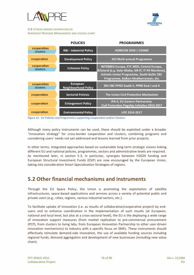
D.8.3 CROSS-‐BORDER COOPERATION ON EMERGENCY RESPONSE MANAGEMENT AND LESSONS LEARNT
FP7-‐SPACE-‐2011 76 of 90 GA n. 312384 Collaborative Project PU
Figure 15 -‐ EU Policies and Programmes supporting Cooperation and/or Clusters
Although many policy instruments can be used, these should be exploited under a broader “innovation strategy” for cross-‐border cooperation and clusters, combining programs and considering users’ needs not yet addressed and lessons learned from prior projects. In other terms, integrated approaches based on sustainable long-‐term strategic visions linking different EU and national policies, programmes, sectors and administrative levels are required. As mentioned later, in section 5.3, in particular, synergies between H2020 funding and European Structural Investment Funds (ESIF) are now encouraged by the European Union, taking into consideration Smart Specialization Strategies of regions.
5.2 Other financial mechanisms and instruments Through the EU Space Policy, the Union is promoting the exploitation of satellite infrastructures, space-‐based applications and services across a variety of potential public and private users (e.g., cities, regions, various industrial sectors, etc.). To facilitate uptake of innovation (i.e. as results of collaborative/cooperative project) by end-‐users and to enhance coordination in the implementation of such results (at European, national and local level, but also at a cross-‐sectoral level), the EU is the deploying a wide range of innovation support measures (from market replication to pre-‐commercial procurement (PCP), from clusters to living labs, from European Innovation Partnership to other user-‐driven innovation mechanisms) to industry with a specific focus on SMEs. These instruments should effectively stimulate demand-‐side innovation, the use of available funding sources including regional funds, demand aggregation and development of new businesses (including new value chain).
D.8.3 CROSS-‐BORDER COOPERATION ON EMERGENCY RESPONSE MANAGEMENT AND LESSONS LEARNT
FP7-‐SPACE-‐2011 77 of 90 GA n. 312384 Collaborative Project PU
There are also instruments, such as EIPs, ETPs, and more recently PPPs and P2Ps75 which can attract private capital to innovation and to foster cooperation and clustering activities in the Space Industry and for projects addressing natural hazards and DRR. EIPs -‐ European Innovation Partnerships: their creation represents a new approach to EU Research and Innovation. The EIP model has been designed to address large-‐scale social challenges76. EIPs are initiatives to help economic growth and transformation of the Union in different sectors with impacts on the associated markets. There are currently six EIPs: the EIP Agricultural Productivity and Sustainability; the EIP Active & Healthy Ageing; the EIP Water; the EIP Raw Materials; the EIP Smart Cities and Communities (SCC) and the latest one created, the EIP Space EIP. EIPs act across the whole research and innovation chain, bringing together all relevant actors at EU, national and regional levels in order to: i) step up research and development efforts; ii) coordinate investments in demonstration and pilots; iii) anticipate and fast-‐track any necessary regulation and standards; and iv) activate demand in particular through better coordinated public procurement to ensure that any breakthroughs are quickly brought to market. Rather than taking the above steps individually, the aim of the EIPs is to design and implement them in parallel to cut lead times. The EIP Space will provide a cooperation framework where European space regions can collaborate to set the most favourable environment to stimulate space technologies being commercialized. The collaborative development of market applications addressing the key EU societal challenges within existing EIPs will make a considerable step forward to link the space domain with non-‐space sectors, and bring the added value of space applications for the benefit of the society and to the attention of the citizens. Space-‐based technologies are gaining a relevant role in smart specialisation strategies of many European regions. Also, cross-‐correlation of existing EIPs and Space are explored in the EU regions, for example between EIP Space and EIP SCC77. The EIP Space will gather research actors, business players, institutional actors, to co-‐develop applications to tackle the key EU societal challenges. This places the EIP Space in the best position to create highly competitive consortia for R&D&I activities where excellence, leadership and markets are naturally combined to maximize the partnership’s possibilities to attract EU R&D funding, from Horizon 2020 and also other support programmes (such as COSME and others).
75 The 2015 Science Business Horizon 2020 Conference will discuss, on the 24th of March 2015 in Brussels, under the EU’s Horizon 2020 programme the new initiatives launched to attract private capital to innovation work -‐ http://sciencebusiness.net/events/Horizon2020_NewCommission_NewAgenda/ 76 Directorate-‐General for Research and Innovation, Report of the Independent Expert Group, Outriders for European Competitiveness -‐ European Innovation Partnerships (EIPs) as a Tool for Systemic Change, European Union, 2014 77 EIP SCC looks at the integration of technologies across different sectors (e.g. Energy, ICT, and Transport) while the EIP Space looks at integrating different technologies regarding positioning, communication, monitoring, modelling and forecasting. However they both put strong emphasis on the role of end user communities.

D.8.3 CROSS-‐BORDER COOPERATION ON EMERGENCY RESPONSE MANAGEMENT AND LESSONS LEARNT
FP7-‐SPACE-‐2011 78 of 90 GA n. 312384 Collaborative Project PU
Relevance for LAMPRE: partners of the project should look at possibilities for joining consortia and activities proposed by the EIP Space, also considering activities from the other EIPs. ETP -‐ European Technology Platforms: these are independent, industry-‐led stakeholder fora that develop the Strategic Research Agendas (SRA) and roadmaps for action at EU and national level to be supported by both private and public funding. Of these, the European Space Technology Platform (ESTP): i) establishes a coherent framework for the development of space technology in Europe; ii) drives technology R&D strategy in response to EU needs; iii) facilitate International cooperation on technology issues. The ESTP involves virtually all the space technology stakeholders and prepares the ground for a coherent deployment of technologies in the context of a European Space Programme. The SRA builds on a concentration process involving the EC/ESA Joint Secretariat, EC’s DG-‐ENTR, DG-‐Research, Member States and National Space Agencies, Industry and EUROSPACE Internal ESA consultation. Public-‐Private Partnerships (PPPs): these partnerships are based on a contractual agreement between the Commission and the industry partners, setting out the objectives, commitments, key performance indicators and outputs to be delivered. Horizon 2020 may be implemented through PPP where all the partners concerned commit to support the development and implementation of research and innovation activities of strategic importance to the Union’s competitiveness and industrial leadership or to address specific societal challenges. PPPs can help to: i) solving problems together with industry; ii) strengthening European industrial leadership; iii) facilitating prioritisation of R&I in line with the Europe 2020 objectives and industry needs; iv) leveraging research and innovation elements; v) strongly committing industry to joint objectives. There are two types of PPPs in Horizon 2020:
• Contractual PPP (CPPP) (whose budget is only committed on an annual basis through H2020 calls in Work Programmes) and
• Institutional PPP (IPPP) (namely Joint Technology Initiatives with ring fenced 7 year budget).
Several cases of PPPs in the Space sector exist (e.g., Galileo PPP, Skynet 5 System, etc.). Furthermore, in the first batch of H2020 eight CPPPs were financed: four cross-‐Thematic PPPs (FoF, EeB, EGVI and SPIRE) and four ICT-‐based CPPPs (Robotics, Photonics, Future Internet, High Performance Computing). Public-‐Public Partnerships (P2Ps): means partnerships where public sector bodies or bodies with a public service mission at local, regional, national or international level commit with the Union to jointly support the development and implementation of a research and innovation programme or activities78. Recently some P22 initiatives are under consideration to improve governance of natural hazards (e.g., the FP7 ENHANCE project, §3.4.1).
78 Further information at: http://netwatch.jrc.ec.europa.eu/web/lp/learning-‐platform/p2p-‐in-‐h2020

D.8.3 CROSS-‐BORDER COOPERATION ON EMERGENCY RESPONSE MANAGEMENT AND LESSONS LEARNT
FP7-‐SPACE-‐2011 79 of 90 GA n. 312384 Collaborative Project PU
5.3 Strategies to combined funding Combined funding strategies can be developed to use different public funding sources within a programme, project or a group of projects. These strategies allow to exploiting complementarities and synergies especially between RTD investments while at the same time avoiding overlaps and excluding double-‐financing. As mentioned in the Commission guidance for policy-‐makers and implementing bodies79 on the ways to achieve more synergies between the different EU Funds in support of innovation and competitiveness, synergies among EU programmes can be achieved through:
• Bringing together Horizon 2020 and ESIF funding in the same project in view of achieving greater impact and efficiency;
• Successive projects that build on each other; • Parallel projects that complement each other.
Such a combination of funding instruments can also include the exploitation of PPPs, P2P, etc. Based on the synergies identified in the Copernicus Emergency projects but also on the other on-‐going FP7 projects focusing on natural hazards, space technologies etc., research and innovation investments of LAMPRE and other projects and their impact on competitiveness, jobs and growth in the EU can be strongly amplified.
6. Conclusions
6.1 Lessons learnt from Cooperation and Clusters
As a result of the analysis of an extensive number of projects through different funding programmes (see §3.4.1), some evidence can be used as lessons learnt for which future cooperation and clustering activities involving LAMPRE can build upon. And in particular:
• Cloud-‐based platform of INSPIRE-‐compliant geo-‐information should be harmonised at a cross-‐border and pan-‐European level to foster the wider use of geo-‐information and enable the creation of innovative value-‐added services, supporting emergency mapping (collaboration with the ELF project which is working on this are suggested for future delivery of LAMPRE products);
• In sea basins and coastal regions, cooperation and transnational actions allow ecosystem-‐based management and integrated coastal zone management through Joint Action Plan which consider adaptations to climate changes. The COASTGAP
79 Enabling synergies between European Structural application: and Investment Funds, Horizon 2020 and other research, innovation and competitiveness-‐related Union programmes. Guidance for policy-‐makers and implementing bodies. EC, Directorate-‐General for Regional and Urban policy. 2014. See: http://ec.europa.eu/regional_policy/sources/docgener/guides/synergy/synergies_en.pdf

D.8.3 CROSS-‐BORDER COOPERATION ON EMERGENCY RESPONSE MANAGEMENT AND LESSONS LEARNT
FP7-‐SPACE-‐2011 80 of 90 GA n. 312384 Collaborative Project PU
cluster of project which s working on this can be considered as a best practice for a clustering project in the natural hazard context.
• Cooperation projects can facilitate Cross Border Information Management in Emergency Operations in order to make Emergency Management Systems (EMSs) of each Member State and information data models and formats interoperable and compatible with each other. This can allow cooperation between emergency forces for cross-‐border disaster risk management activities. The DISASTER project, working on this, can be considered as a reference for integrating LAMPRE products into EMSs;
• Cooperation activities to develop joint-‐solutions (especially for cross-‐border areas), such as joint early warning systems and DSS tools, joint risk management plans, joint measures, can learn from the experience fro projects like RISKLIDES, ARDAFORECAST, JOINTRISK, DANUBE-‐FLOODRISK, CEframe.
6.2 Scenarios for clusters and benefits Different drivers stimulating (cross-‐border) cooperation activities and creation/strengthening of clusters have emerged from:
• Findings from the LAMPRE business plan (§D.8.1) • Updated, systemic and comprehensive analysis of the priorities of the various EU
programmes (see §3.4 and §4.2.1) • Evidence and trends discussed at several Copernicus-‐related events in the two last
years (see §2.5) • Analysis of the synergies between projects and the potential cooperation frameworks
provided by D.8.2 (see §2.4) • Lessons learnt by analysing existing projects on cooperation and clusters (see §6.1)
Such drivers stimulate different forms of cooperation and clusters taking into account the following aspects:
• Territories: o Characteristics (e.g. socio-‐economic and physiographic aspects, national,
regional and local scales, susceptibility and vulnerability to natural hazards) o Exploitation of smart specialization strategies, especially in the Space sector in
the various regions; • Sectorial interdependencies:
o Linkages between the Space sectors and other commercial sectors (e.g. Transport, Utilities, Construction & Planning, Meteo, Insurance, Tourism, etc., representing the various segments of LAMPRE and broadly of Copernicus) toward the creation of new industrial value chains.
• Organizations: o Role in the project or cluster (partners, stakeholders) o Common and/or complementary objectives (e.g. RTD, consulting,
products/services delivery); • Multi-‐environment context:
o Organizational models of Civil Protection Authorities in the various countries (see CPA models in Europe -‐ §D.8.1)
o Procedures o Technology platforms

D.8.3 CROSS-‐BORDER COOPERATION ON EMERGENCY RESPONSE MANAGEMENT AND LESSONS LEARNT
FP7-‐SPACE-‐2011 81 of 90 GA n. 312384 Collaborative Project PU
These drivers suggest the possibility for LAMPRE and other organizations (such as, for example, partners of the Copernicus Emergency projects) to strengthen the development and delivery of products and services, and the related technology infrastructures by developing new projects on cooperation and clusters which focus on Disaster Risk Management (Preparedness and Reduction), with impact on various other sectors. In particular, different scenarios for moving forward (through cooperation and clusters) can be considered:
• Aggregation of organizations (and in particular of SMEs) exploiting on-‐going and future calls from H2020 or COSME (for example toward new industrial value chains) or also European Structural & Investment Funds (ESIF)
• Aggregation of EU Funded projects, exploiting funding opportunities from H2020: o Strengthening the prototyped products of LAMPRE by integrating these with
other technologies and features in view of achieving greater impact and efficiency, through coordinated actions/operations toward a pan-‐European service for landslides.
o Linking successive projects that build on each other focusing on single (e.g. DORIS, LAMPRE) or multiple hazards (Copernicus-‐Emergency Projects)
o Linking parallel projects that complement each other (for approach, expertise, gaps to be filled in, extension of existing platforms), such as the Copernicus-‐Emergency Projects.
Any of the three scenarios require activities from partners aimed at presenting a proposal on one of the previously mentioned EU programmes, considering the most appropriate consortium and the above-‐mentioned aspects influencing various forms of cooperation and clusters.
Figure 16 -‐ Potential scenario to move forward

D.8.3 CROSS-‐BORDER COOPERATION ON EMERGENCY RESPONSE MANAGEMENT AND LESSONS LEARNT
FP7-‐SPACE-‐2011 82 of 90 GA n. 312384 Collaborative Project PU
A wide range of partner organisations including universities, research centres, local and regional authorities, SMEs and enterprises, non-‐profit and private organisations, can collaborate to better handle the impact of natural and man-‐made hazards to societies and infrastructures, through technologies, geospatial products, solutions and measures for disaster risk reduction plans. European and international organizations actively engaged with different initiatives and roles in disaster risk reduction from one side and in the geo-‐spatial industry from the other (see §3.2) can certainly be involved in future projects, as partners or stakeholders. Individual or plural cross-‐project exchange between partners from the different projects, e.g. within working group meetings allow to share expertise on the use of the tools, products and services provided by the different projects and their partners. Clusters aggregating different organizations or existing projects (i.e. on those of the Copernicus Emergency) can share:
• Best practices of collaboration with end-‐users in different natural hazards contexts and different phases of the disaster risk cycle;
• Knowledge deeply acquired with previous activities on test-‐sites; • Data, algorithms (including data-‐sharing problems and increasing of geographic
accessibility to data for disaster risk reduction activities at cross-‐border levels); • Technologies and infrastructures (i.e. developing common cloud-‐based multi-‐risk
platforms); • Products (at the various stages of maturity; • Services (facilitating the interoperability of geo-‐service in the future, fostering
complementarities between different Copernicus Services, such as the LMS and the EMS).
Clusters based on projects focusing on interdependent natural-‐hazards, can start by considering the two scenarios identified by D.8.2:
• PREFER, PHAROS, LAMPRE (for landslides and forest fire) • APHORISM, SENSUM, LAMPRE (for seismic-‐volcanic-‐landslides)
Other scenarios considering linkages and synergies with other projects not strictly related to the FP7 space calls but instead other FP7 or Structural Funding Programmes can be explored, addressing specific geographical areas. To summarise the broad range of benefits that can be achieved, in particular, through clustering projects or organizations, these have been grouped into the following main categories: Perform Research & Innovation:
• Access and exploit of the wide range of financial instruments and programmes for 2014-‐2020 on transnational, interregional and international cooperation for territorial management and for DRM;
• Share investment in R&D activities to transform prototypes into products and services; • Develop joint activities through tasks-‐force, cross-‐projects teams, etc.; • Enhance projects’ results by avoiding duplication beyond national boundaries and
strengthening cross-‐border application; • Facilitate the tailoring of the outputs (i.e. tools, products, services) from the projects
across a range of sectors and locations; • Share best practices and experiences in defining users-‐needs and customize solutions
to users.
D.8.3 CROSS-‐BORDER COOPERATION ON EMERGENCY RESPONSE MANAGEMENT AND LESSONS LEARNT
FP7-‐SPACE-‐2011 83 of 90 GA n. 312384 Collaborative Project PU
Impact European Policies (e.g., R&I, Cohesion Policy, Development Policy, European Neighbourhood Policy, Enlargement Policy, Environmental Policy, Space Policy, etc.):
• Get more Governmental and European strategic and operational support for Disaster Risk Management and Reduction plans;
• Strengthen the impact of each project on the various EU policies; • Encourage policy recommendations for the Copernicus policy framework but also for
International cooperation embracing in this way international (emerging) markets; • Facilitate the development of plans for collaborative Copernicus data access and
exploitation infrastructures. Exploit Joint-‐markets:
• Foster the implementation and marketability of products and services in joint-‐markets; • Test and validate projects results in other test sites and regions in Europe and
worldwide; • Increase joint promotion of the tools, products, services developed by the projects; • Facilitate technology transfer between research and SMEs; • Facilitate the procurement and use of commercial cloud services by public
administration sharing a coordinated approach and exchange experiences.
6.3 Impact on EU Policies and Strategies Finally, moving forward LAMPRE through new projects under the (cross-‐border) cooperation and/or clusters contexts can generate positive fallout on the following EU Policies and strategies: Integrated strategy for the prevention, preparedness and response to natural risks: Cooperation and clustering opportunities between different projects can contribute to the implementation of this strategy by improving the response capacity of organizations involved in these DRM and DRR in the Member States. Natural hazards are not limited by administrative or political boundaries, and a harmonised treatment of data, methodologies and tools will facilitate the interaction between Member States to cope with different natural hazards also adopting a multi-‐risk approach. Standards and quality criteria generated with the collaboration of different projects can contribute to establish a common language, shared tools and common methodologies that will facilitate cross-‐border and cross-‐agency cooperation, with long-‐term (strategic) positive feedbacks (as recommended by EGDI). EU Soil Thematic Strategy: the project for a Soil Framework directive requires Member States to identify regions at risk from natural hazards on the basis of a common methodology. Empowering LAMPRE products, through new projects which integrate these with products of other project (also under a multi-‐risk hazard approach) will allow a better delineation and systematic update of natural-‐hazard risk areas, as proposed by the Soil Information Working Group of the European Soil Bureau Network and improve the response capacity not only of Civil Protection Authorities in Europe but also to other actors responsible for the management of natural hazards in the EU Member States.

D.8.3 CROSS-‐BORDER COOPERATION ON EMERGENCY RESPONSE MANAGEMENT AND LESSONS LEARNT
FP7-‐SPACE-‐2011 84 of 90 GA n. 312384 Collaborative Project PU
INSPIRE: sharing results on delivering interoperable geospatial products (geo-‐referenced images, maps, geographical databases, spatial assessments) and services will lead to more efforts for achieving compliance with the INSPIRE initiative. Hyogo-‐framework for action: Collectively, the results of the LAMPRE and the potential synergies with other projects through further (cross-‐border) cooperation and clusters activities can contribute to the implementation of the Hyogo Framework for Action. In particular, for Priority Action 2 (Identify, assess and monitor disaster risks and enhance early warning) by developing innovative tools to explain how landslide hazards and vulnerabilities (and their interactions with other natural hazards) are changing in the short and long term, with the final aim of helping decision-‐makers to undertake appropriate actions for preparedness, recovery and reconstruction (LAMPRE). For Priority Action 5 (Strengthen disaster preparedness for effective response at all levels), by developing tools which help civil protection authorities to improve their ability to detect and map landslides, to assess and forecast the impact of triggered landslide events on vulnerable elements, and to model landscape changes caused by slope failures. Civil protection authorities can exploit the knowledge, services and tools generated by LAMPRE to improve their disaster management capacities, reducing impacts and losses generated by event landslides. The post-‐2015 Framework for Disaster Risk Reduction should further communicate cost-‐benefits analysis and financial mechanisms to increase public and private engagement in disaster risk reduction, at national, local, and community levels.

D.8.3 CROSS-‐BORDER COOPERATION ON EMERGENCY RESPONSE MANAGEMENT AND LESSONS LEARNT
FP7-‐SPACE-‐2011 85 of 90 GA n. 312384 Collaborative Project PU
Appendix 1 – Survey to SUG members Members of the LAMPRE SUG were requested to provide strategic inputs to the potential exploitation of the project outcomes. In particular, a survey was delivered at the first SUG exploitation workshop in February 2014 in London. Below is an extract of the answers to the questions most related to task 8.3 and WP8 in general. Section D: Sustainability and take-‐up
D.1: What is the interest of your organisation in the scope of a long-‐term service provision under a Copernicus framework? (e.g. R&D, Service provision, frequent / occasional user, gain experience, standardisation, etc.)
Occasional (hopefully) user. (D.1-‐ Regione Liguria) Any new tools and gained experience are of interest. Ready made tools. State of the art tools with visits of LAMPRE people (D.1, D.2, D.3 – Geological Survey of Israel) Occasional user (emergencies) and training and information for local and regional services of Civil Protection (frequent user) (D.1 -‐ National Civil Protection and Emergency Department, Spain) GEO through its 150 more partners is promoting real-‐time data-‐sharing and standardized procedures, terminologies, communications and evacuation practices needed for supporting geohazards assessments. GEO is also supporting key global and national players in developing regional-‐coordinated warning system to improve prediction and emergency response at the local, national and regional levels. The GEO Community is developing decision-‐support tools and applications for the full cycle of natural-‐disaster management, particularly for developing countries. (D.1 GEO Secretariat -‐ Group on Earth Observations)
D.2: How can the role of industry be leveraged in the frame of LAMPRE and COPERNICUS? If you are from industry, what role would you seek in a long term service provision of LAMPRE (from an investment / service provision perspective)?
Ready made tools. State of the art tools with visits of LAMPRE people (D.1 – Geological Survey of Israel) Adding value to data and information provided through national and regional mechanisms. High-‐end innovative tools and products (sensors) and new research activities. (D.2 -‐ GEO Secretariat -‐ Group on Earth Observations)
D.3: What Quality of Service do you believe LAMPRE can/should achieve within 2 years – in terms of performance, service level (e.g. repeatability and time to serve)? D.4: Within 5 years if funding was not an issue? [i.e. how do you define the quality of service expectations within 2 years, within 5 years]
Evaluation of the efficiency and quality of the service provided in the different territorial contests. Repeatability of the service. Cost of the service. (D.3, D.4 Regione Liguria) State of the art tools with visits of LAMPRE people (D.3 – Geological Survey of Israel) 2 or 3 fully operational pilots and a concept of proof for potential service provision. Same as the previous point. (D.3, D.4 -‐ GEO Secretariat -‐ Group on Earth Observations)
D.5: What do you think should be the scope of LAMPRE in 5 years? In 10 years? D.6: From a product perspective? D.7: From a service provision perspective? D.8: From a geographical coverage perspective?
Defining robust and tested products that could be safely used in an operative context. Defining operational procedures to connect the different junctions of the network in the phase of emergency management in order to achieve a timely and well-‐focussed service activation (D.5-‐8 – Regione Liguria) From a product perspective (D.7 – Geological Survey of Israel) Define standards for products and services for landslide early warning, monitoring and response.

D.8.3 CROSS-‐BORDER COOPERATION ON EMERGENCY RESPONSE MANAGEMENT AND LESSONS LEARNT
FP7-‐SPACE-‐2011 86 of 90 GA n. 312384 Collaborative Project PU
Building on outcomes and users feedback from the first phase of LAMPRE, develop a portfolio of services and products for European users. (D.5 -‐ GEO Secretariat -‐ Group on Earth Observations)
D.9: What additional impact could LAMPRE have on society? (e.g. education, information centre / centre of excellence). D.10: What other service opportunities do you see around LAMPRE?
Local administration sensitization on the opportunity to define standard procedures for systematic event landslide mapping and periodic LSM update. LAMPRE could represent a good opportunity to disseminate the information on the usefulness of RS data and GIS tools in the field of landslide risk management and emergency management. (D.9 , D.10 -‐ Regione Liguria) Training end-‐users to use the products to the benefits of society (D.9 -‐ Geological Survey of Israel)) Define the European framework for landslide disaster risk reduction and management in Europe. Work with the Academia and Industry to design and implement (downstream) services for end users (Local Administrations). Develop and fertilize discussion between users and service providers through the establishment of a Landslide Community of Practice. (D.9, D.10 -‐ GEO Secretariat -‐ Group on Earth Observations)
D.11: If you are from Industry, how can your company become more competitive through being involved in LAMPRE project and subsequently though a long term service provision (horizon 2 to 5 years)?.
Not answered.
D.12: In your opinion, what should be the long term mission of LAMPRE?
As many end-‐users of the products in as many locations (D.12 -‐ Geological Survey of Israel)
D.13: Are you aware of similar services in other parts of the world?
No (D.13 -‐ Geological Survey of Israel) No (D.13 -‐ GEO Secretariat -‐ Group on Earth Observations)
D.14: What are the needs you expect LAMPRE to fulfil that cannot be currently fulfilled?
Serve as a forum to enhance standards for metadata, interoperability, and implementation practices for exposing data and services to GEOSS. (D.14 -‐ GEO Secretariat -‐ Group on Earth Observations)
D.15: If you are from a User organisation, what monthly / yearly budget would your organisation be ready to spend on LAMPRE services? And on all landslide information services? D.16: If you are from a User organisation, what are the key direct economic benefits of using a service such as LAMPRE? What are the key indirect / Long term economic benefits of using such a service? [you can describe qualitatively, or quantitatively] D.17: What critical role should institutions play in a service like LAMPRE -‐ in the long term service provision?
2.500-‐5.000 Euro yearly. Less work on R&D when LAMPRE tools are available (D.15, D.16 -‐ Geological Survey of Israel) Invest in risk reduction measures and awareness campaigns. (D.17 -‐ GEO Secretariat -‐ Group on Earth Observations)
Section E: Functional and operational links with existing GMES services
LAMPRE will be functionally and operationally integrated with existing EU level core services and downstream services. In the frame of this integration: E.1: What GMES services for Rapid Response and Land Monitoring would you link with LAMPRE? Which synergies would you see? E.2: What would be the nature of those links? E.3: Are you aware of any other initiatives which could benefit from LAMPRE services and products?

D.8.3 CROSS-‐BORDER COOPERATION ON EMERGENCY RESPONSE MANAGEMENT AND LESSONS LEARNT
FP7-‐SPACE-‐2011 87 of 90 GA n. 312384 Collaborative Project PU
Land monitoring and emergency management (E.1 -‐ Regione Liguria) Possible links are to: Biophysical parameters and land use layer from Land Monitoring. Eventually, to make use of these layers inside LAMPRE products (E.1, E.2 – EURAC) Rapid post-‐event landslide mapping using remote sensing data acquired via LAMPRE. (E.1 – Geological Survey of Israel) Meeting of LAMPRE people with local scientist and emergency personnel. (E.2 – Geological Survey of Israel) Urban areas for LM and Emergency Mapping for EMS. Synergies are with urban and territorial planning for urban development and territorial planning for urban development and new infrastructure designing (Energy and Traffic Networks). LAMPRE products will add value to maps and information provided through Copernicus. (E.1, E.2 -‐ GEO Secretariat -‐ Group on Earth Observations) Pan-‐European Geological Data Infrastructure (EGDI): http://www.egdi-‐scope.eu/ PoC: Pedersen, Mikael [email protected] http://www.rasor-‐project.eu/://www.floodis.eu/ PoC (E.3 -‐ GEO Secretariat -‐ Group on Earth Observations)
Section F: Exploring LAMPRE cross-‐border cooperation between countries
F.1: Which existing or potential cooperation opportunity related to landslide management between Civil Protection Authorities (and/or other public-‐private actors) of different countries can you mention? And factors can obstacle or stimulate cooperation? F.2: Which main aspects should be considered to assess and enhance capacities at Member States level on the adoption of Copernicus services? F.3: Which example of pre-‐commercial procurements or public procurements of innovative solutions are you aware of?
Scientific cooperation between scientists working on landslides. Meetings. Scientific cooperation on landslides problems. (F.1, F.2, F.3 – Geological Survey of Israel) Latin American countries (eg. Chile-‐ONEMI, Guatemala-‐CONRED) and Brasil-‐DEFENSA CIVIL RJ (D.1 -‐ National Civil Protection and Emergency Department, Spain)
Section I: Additional comments
Please provide any additional comments on the project that you would like to share with the team:
It would be important, at least for the Italian case, since emergency management and land use planning are carried out mainly at a regional scale, to be aware of the different internal organization of the regional administrations. The use of such tools as the one provided by LAMPRE requires specific technical skills and standard procedures to apply both in the phase of risk prevention and during the emergency phase. These skills are not so often available or widespread. (Regione Liguria) I will be interested in case studies comparing use of LAMPRE tools versus other methods or work done. (Geological Survey of Israel)
Section J: Value Statement
I think LAMPRE develops valuable tools for pre and post event landslide hazard analysis. (Geological Survey of Israel) In-‐time information on event-‐based landslide inventories, maps and susceptibility models will greatly improve the whole landslide hazard and risk management cycle, especially within projects of technical cooperation with developing countries. (Geological Survey of Germany, BGR)

D.8.3 CROSS-‐BORDER COOPERATION ON EMERGENCY RESPONSE MANAGEMENT AND LESSONS LEARNT
FP7-‐SPACE-‐2011 88 of 90 GA n. 312384 Collaborative Project PU
References
• Annex A: Copernicus EMS Risk and Recovery Mapping product portfolio -‐ 03.1 Technical Specifications Annex A – EC-‐JRC
• Interim Evaluation of GMES Initial Operations (2011-‐2013), Centre for Strategy & Evaluation
Services (CSES), January 2013.
• Communication from the Commission to the European Parliament, the Council, the European Economic and Social Committee and the Committee of the Regions EU Space Industrial Policy, Releasing the potential for economic growth in the Space sector, Brussels, 2013
• REGULATION (EU) No 377/2014 OF THE EUROPEAN PARLIAMENT AND OF THE COUNCIL of 3
April 2014 establishing the Copernicus Programme and repealing Regulation (EU) No 911/2010
• EARSC Position Paper on the Copernicus Regulation, October 2013
• EARSC Views on the Procurement of the Copernicus Services, September 2014
• Towards a stronger European disaster response: the role of civil protection and humanitarian assistance" COM, 2010 600
• Regions and Innovation: Collaborating across Borders, OECD Reviews of Regional Innovation,
OECD Publishing, 2013
• Building Resilience: Integrating climate and disaster risk into development. Lessons from World Bank Group experience. The World Bank, Washington DC, 2013
• Turning Down the Heat, World Bank Group, 2014,
• Citizens’ Summary of Interreg CENTRAL EUROPE Cooperation Programme, December 2014
• Interim Evaluation of the GMES Preparatory Action, Centre for Strategy & Evaluation Services
(CSES), December 2012
• Directorate-‐General for Research and Innovation, Report of the Independent Expert Group, Outriders for European Competitiveness -‐ European Innovation Partnerships (EIPs) as a Tool for Systemic Change, European Union, 2014
• P.O. Italie France Maritime 2014-‐2020 -‐ Intervention Logic (V. 21.03.2014)
• European Territorial Cooperation -‐ Adriatic Ionian Cooperation Programme 2014-‐2020 -‐ 1st
Draft_Section I and II July, 9th 2014
• Communication from the Commission to the Council, the European Parliament, the European Economic and Social Committee and the Committee of the Regions -‐ Thematic Strategy for Soil Protection [SEC(2006)620] [SEC(2006)1165]
• 10 Years of the EU Civil Protection Mechanism, European Commission, Humanitarian Aid and
Civil Protection 2012.

D.8.3 CROSS-‐BORDER COOPERATION ON EMERGENCY RESPONSE MANAGEMENT AND LESSONS LEARNT
FP7-‐SPACE-‐2011 89 of 90 GA n. 312384 Collaborative Project PU
• Programming of the European Neighbourhood Instrument (ENI) -‐ 2014-‐2020 Regional South
Strategy Paper (2014-‐2020) and Multiannual Indicative Programme (2014-‐2017), edited by EEAS and EUROPEAID, September 2014.
• Community Framework for State Aid for Research and Development and Innovation, which is
published in the Official journal of the European Union (2006/C 323/01) of 30.12.2
• Analysing ERDF co-‐financed innovative projects -‐ Final report prepared in the framework of the European Commission, Technopolis Group, 2008
• Commission Staff Working Document SEC (2008) 2637, “The concept of clusters and cluster
policies and their role for competitiveness and innovation”-‐ Europe INNOVA / PRO INNO Europe paper N"9 – page 11
• Towards world-‐class clusters in the European Union: Implementing the broad-‐based innovation
strategy {SEC(2008) 2637} -‐ COM(2008) 652 final
• The Competitive Advantage of Nations, Michael Porter, 1990
• European Cluster Observatory REPORT, Cluster Collaboration and Business Support Tools to Facilitate Entrepreneurship, Cross-‐sectoral Collaboration and Growth, T. Lämmer-‐Gamp et al., September 2014
• Enabling synergies between European Structural application: and Investment Funds, Horizon
2020 and other research, innovation and competitiveness-‐related Union programmes. Guidance for policy-‐makers and implementing bodies. EC, Directorate-‐General for Regional and Urban policy. 2014
-‐ End of document -‐