cycling & walking scheme prioritisation
TRANSCRIPT
CSV CWIP Scheme Prioritisation
1 of 12
Cycling & Walking Scheme Prioritisation
Background document for the Central Severn Vale
Cycling and Walking Infrastructure Plan
Gloucestershire County Council’s Transport Planning Team October 2018
CSV CWIP Scheme Prioritisation
2 of 12
CONTENTS
1. METHODOLOGY 3
2. CYCLING PRIORITISATION 3
2.1 EFFECTIVENESS CRITERIA 4
2.2 POLICY CRITERIA 5
2.3 FUNDING CRITERIA 5
2.4 DELIVERABILITY CRITERIA 5
CYCLING SCHEME RANKING 6
CHELTENHAM CYCLING SCHEME PRIORITISATION 6
GLOUCESTER CYCLING SCHEME PRIORITISATION 7
3. WALKING PRIORITISATION 8
3.1 EFFECTIVENESS CRITERIA 8
3.2 POLICY CRITERIA 9
3.3 FUNDING CRITERIA 9
3.4 DELIVERABILITY CRITERIA 9
WALKING SCHEME RANKING 10
APPENDIX 5. CHELTENHAM WALKING SCHEME PRIORITISATION 11
APPENDIX 6. GLOUCESTER WALKING SCHEME PRIORITISATION 12
CSV CWIP Scheme Prioritisation
3 of 12
1. METHODOLOGY
1.1.1 This prioritisation process follows the principles set out in the Department for Transport’s Local Cycling and Walking Infrastructure Plan (LCWIP) Technical guidance and includes four main factors: effectiveness, policy, deliverability and funding. Instead of a numerical scoring approach, we have used a red-amber-green rating for each of the assessment criteria and a suggested ranking at the end. This approach reflects the limitations of the assessment process for small scale walking and cycling improvements, the absence of local journey data and the need to balance an objective assessment with wider, changing political and planning circumstances.
1.1.2 Walking and cycling schemes are considered separately because changes to walking infrastructure differ from cycling requirements, are generally smaller in scale and cost, and could be delivered incrementally if required.
1.1.3 The average cycle trip is also longer than the average walk trip and so the route lengths and purposes are different. In addition, the scheme description tabs in the DfT Active Mode Appraisal Tooltkit (AMAT) spreadsheet are relevant to most of the cycling schemes but few of the walking schemes.
2. CYCLING PRIORITISATION
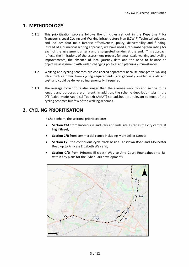
In Cheltenham, the sections prioritised are;
Section C/A from Racecourse and Park and Ride site as far as the city centre at High Street;
Section C/B from commercial centre including Montpellier Street;
Section C/C the continuous cycle track beside Lansdown Road and Gloucester Road up to Princess Elizabeth Way and;
Section C/D from Princess Elizabeth Way to Arle Court Roundabout (to fall within any plans for the Cyber Park development).
CSV CWIP Scheme Prioritisation
4 of 12
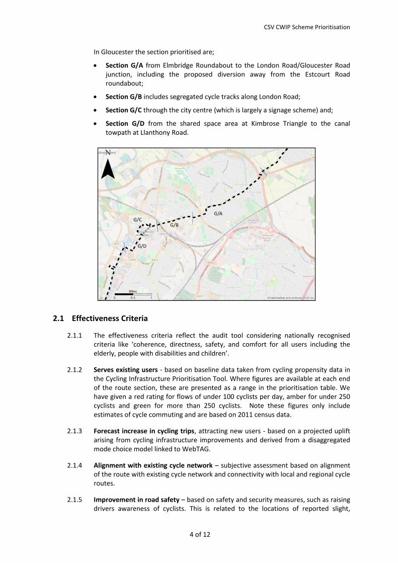
In Gloucester the section prioritised are;
Section G/A from Elmbridge Roundabout to the London Road/Gloucester Road junction, including the proposed diversion away from the Estcourt Road roundabout;
Section G/B includes segregated cycle tracks along London Road;
Section G/C through the city centre (which is largely a signage scheme) and;
Section G/D from the shared space area at Kimbrose Triangle to the canal towpath at Llanthony Road.
2.1 Effectiveness Criteria
2.1.1 The effectiveness criteria reflect the audit tool considering nationally recognised criteria like ‘coherence, directness, safety, and comfort for all users including the elderly, people with disabilities and children’.
2.1.2 Serves existing users - based on baseline data taken from cycling propensity data in the Cycling Infrastructure Prioritisation Tool. Where figures are available at each end of the route section, these are presented as a range in the prioritisation table. We have given a red rating for flows of under 100 cyclists per day, amber for under 250 cyclists and green for more than 250 cyclists. Note these figures only include estimates of cycle commuting and are based on 2011 census data.
2.1.3 Forecast increase in cycling trips, attracting new users - based on a projected uplift arising from cycling infrastructure improvements and derived from a disaggregated mode choice model linked to WebTAG.
2.1.4 Alignment with existing cycle network – subjective assessment based on alignment of the route with existing cycle network and connectivity with local and regional cycle routes.
2.1.5 Improvement in road safety – based on safety and security measures, such as raising drivers awareness of cyclists. This is related to the locations of reported slight,
CSV CWIP Scheme Prioritisation
5 of 12
serious and fatal cycle casualties taken from Crashmap STATS 19 data for the last five years (2013-2017). A green rating applies to no casualties along the section, amber for isolated incidents and red for sections with clusters of incidents. We have not investigated individual accident reports.
2.2 Policy Criteria
2.2.1 A key policy criterion is the Government’s Inclusive Transport Strategy and it’s agenda. This is the main plank of the Gloucestershire LCWIP. The challenge will be to understand how these selected pieces of the network will be able to offer outstanding inclusive cycling environments – looking at radii, path widths, soft barriers, gradients and signing. This is why only a small amount of the county has been selected because it will take such a concentrated approach to doing something that has never been done in Gloucestershire – or most of England - before.
2.2.2 Delivery against local policy and local transport plan objectives – subjective assessment based on proximity of the route to the main development areas. These include major retail centres and strategic growth sites.
2.2.3 Integration with walking and public transport – based on the proximity of key public transport routes, park and ride sites, and bus and train interchanges. Corridors with shared public transport, walking and cycling connections offer greater possibilities for integrated journeys.
2.3 Funding Criteria
2.3.1 Value for Money – a BCR (benefit cost ratio) has been estimated using standardised DfT WebTAG assessment calculations. Costs are based on those reported in the Technical Note for Cycling Infrastructure document. Benefits calculations are limited to generic route descriptions of segregated cycle route, unsegregated cycle route and widened cycle lane. Baseline cycling flows have been estimated after a comparison of automatic cycle count data and cycling propensity data where this is available, to include non-work cycle journeys.
2.3.2 Potential to attract funding – subjective assessment based on proximity of large local developments, planned highway and public transport schemes, and highway maintenance.
2.4 Deliverability Criteria
2.4.1 Feasibility – subjective assessment based on land ownership, the highway space available and any deviation from usual design practice. The deviation from design practice may be extensive and will be aligned to the London standards or the Highways England standards. This will require greater land take and poor tolerance of bottlenecks and pinch points.
2.4.2 Dependency on other schemes – subjective assessment based on likelihood of other projects coming to fruition which provide connectivity or which will be influential on design constraints. Green reflects no dependency and amber reflects dependency where there may be some uncertainty about funding, timing and physical constraints. For example justification for the cycle route proposals west of GCHQ are dependent on other cycling improvements by Highways England; and proposals along
CSV CWIP Scheme Prioritisation
6 of 12
Cheltenham Road in Gloucester are partially dependent on bus corridor improvements.
2.4.3 Political acceptability – subjective assessment based on possible public reaction to schemes which may lead to increased delay to vehicles, involve lower speed limits, loss of parking and which could lead to increased pedestrian/cyclist conflict. The likelihood of public opposition to proposals is dependent on the final designs, the presentation of proposals and acceptance or understanding of the wider community and environmental benefits.
CYCLING SCHEME RANKING
Cheltenham Cycling Scheme Prioritisation
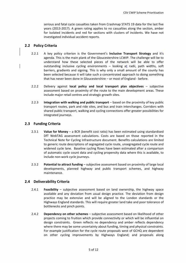
The prioritisation for proposed cycling schemes in Cheltenham is shown in the table below. The schemes are ranked as follows, with greatest benefits first:
1st (C/C) Parabola Road to Princess Elizabeth Way 2nd (C/B) High Street to Parabola Road (town centre) 3rd (C/D) Princess Elizabeth Way to Arle Court roundabout 4th (C/A) New Barn Lane to High Street
Each of the sections shows clear benefits for cyclists. Schemes C/B and C/C both have high BCRs and score well for estimates of user numbers. Scheme C/C has been ranked highest because of the level of usage, ease of implementation, and clear benefits for access to GCHQ and the proposed Cyber Park. Scheme C/D is ranked 3rd above Scheme C/A principally because it has higher projected user numbers and is more deliverable on counts of feasibility. It is also strategically important, filling the gap between scheme C/C and the planned cycle route along the B4063 towards Gloucester.
Prioritisation -
Cheltenham
Section Cost £K
Ranking based on
overall weighting
of RAG rating but
with stronger
emphasis on
funding and
deliverability
Serv
es e
xist
ing
use
rs
Fore
cast
incr
ease
in c
yclin
g
trip
s
alig
nm
ent
wit
h e
xist
ing
cycl
e n
etw
ork
Imp
rove
men
t in
ro
ad s
afet
y
Del
iver
y ag
ain
st p
olic
y an
d
loca
l tra
nsp
ort
pla
n
Inte
grat
ion
wit
h w
alki
ng
and
pu
blic
tra
nsp
ort
Val
ue
for
Mo
ney
= B
CR
Pote
nti
al t
o a
ttra
ct f
un
din
g
Feas
ibili
ty
Dep
end
ancy
on
oth
er
sch
emes
Polit
ical
acc
epta
bili
ty
Ran
k
Scheme C/A New Barn Lane to High
Street 1 4
Scheme C/B
High Street to
Parabola Road 4.4 2
Scheme C/C
Parabola Road to
Princess Elizabeth Way 3.7 1
Scheme C/D
Princess Elizabeth Way
to Arle Court Rbt 1.9 3
Funding Deliverability PriorityPolicyEffectiveness
CSV CWIP Scheme Prioritisation
7 of 12
Gloucester Cycling Scheme Prioritisation
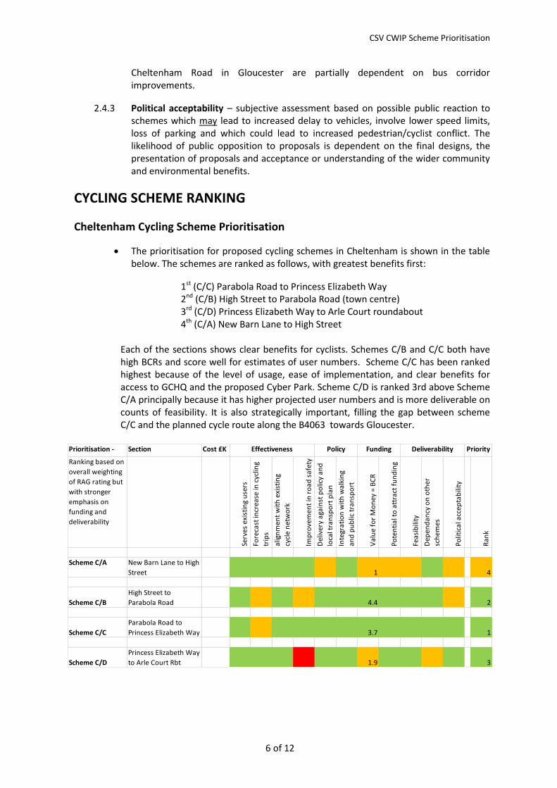
The prioritisation for the proposed cycling schemes in Gloucester is shown in the table below. The schemes are ranked as follows:
1st(G/A) Cheltenham Road/Kenilworth Avenue 2nd (G/B) London Road/Black Dog Way junction 3rd (G/C) City Centre routes 4th (G/D) Southgate Street/Llanthony Road
There are projections for an uplift in cycling for each of the schemes although the BCRs for Gloucester are generally lower than in Cheltenham. Scheme G/A offers very similar benefits to Scheme G/B and are rated highest. There is more certainty that a reduction in junction capacity for vehicles at Black Dog Way will impact on traffic flows and is therefore scored as being less politically acceptable. Scheme G/C, improved city centre signage, can be delivered reasonably easily. The BCR calculation should be treated with caution since the WebTAG appraisal tool ignores the impact of improved signage and changes to cycling restrictions. Scheme G/D offers a lower BCR but looks to offer a reasonable uplift in cycling. This scheme my also be affected by the decision regarding the ‘shared space’ concept at Kimbrose Triangle and future reductions in traffic flow along Southgate Street once the local A430 ‘pinch point’ scheme is completed.
Prioritisation -
Gloucester
Section Cost £K
Ranking based on
overall weighting
of RAG rating but
with stronger
emphasis on
funding and
deliverability
Serv
es e
xist
ing
use
rs
Fore
cast
incr
ease
in c
yclin
g
trip
s (C
yIPT
)
alig
nm
ent
wit
h e
xist
ing
cycl
e n
etw
ork
Imp
rove
men
t in
ro
ad s
afet
y
Del
iver
y ag
ain
st p
olic
y an
d
loca
l tra
nsp
ort
pla
n
Inte
grat
ion
wit
h w
alki
ng
and
pu
blic
tra
nsp
ort
Val
ue
for
Mo
ney
= B
CR
Pote
nti
al t
o a
ttra
ct f
un
din
g
Feas
ibili
ty
dep
end
ancy
on
oth
er
sch
emes
Polit
ical
acc
epta
bili
ty
Ran
kScheme G/A Elmbridge Rbt to
London Road junction 1.3 1
Scheme G/B
London Road junction
to Northgate Street 1.3 2
Scheme G/C
Northgate Street to
Kimbrose Triangle 0.1 3
Scheme G/D
Kimbrose Triangle to
Canal Towpath 0.4 4
Funding Deliverability PriorityPolicyEffectiveness
CSV CWIP Scheme Prioritisation
8 of 12
3. WALKING PRIORITISATION
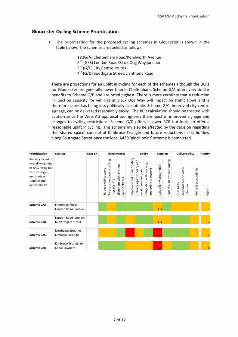
3.1.1 In Cheltenham the route prioritised runs from Cheltenham Spa rail station in the east to Princess Elizabeth Way in the west. The route branches off along Shakespeare Road to access the college site, or Shelly Road to access GCHQ.
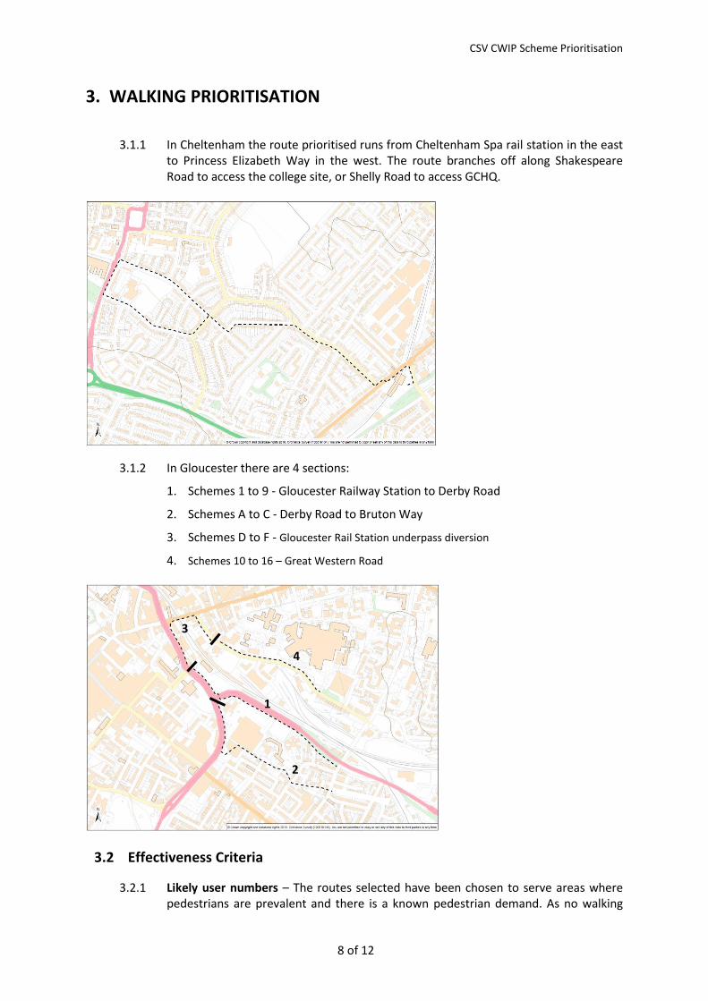
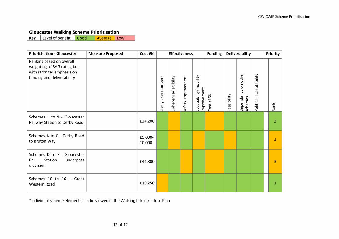
3.1.2 In Gloucester there are 4 sections:
1. Schemes 1 to 9 - Gloucester Railway Station to Derby Road
2. Schemes A to C - Derby Road to Bruton Way
3. Schemes D to F - Gloucester Rail Station underpass diversion
4. Schemes 10 to 16 – Great Western Road
3.2 Effectiveness Criteria
3.2.1 Likely user numbers – The routes selected have been chosen to serve areas where pedestrians are prevalent and there is a known pedestrian demand. As no walking
1
2
3
4
CSV CWIP Scheme Prioritisation
9 of 12
data was available outside the rail station, we have assumed higher pedestrian flows closest to the main destinations/origins, which are the station and hospital in Gloucester. In Cheltenham, pedestrian flows are likely to be more evenly distributed along the route because of other short, localised journeys, for example journeys to school. Effectiveness criteria will need baseline data.
When these routes have been agreed they should be subject to footfall counts before and after walk infrastructure improvements.
3.2.2 Coherence and legibility – These are based on the visibility of an improvement and the tangible improvement to the pedestrian journey from a users’ perspective. For example, dropped kerbs indicate defined crossing points, whereas vegetation cutback is less indicative of change and is temporal in nature.
3.2.3 Safety improvement – This is a subjective assessment based on the added safety benefits from a users’ perspective. Only 2 very minor pedestrian casualty incidents have been recorded in the last 5 years, neither of which were attributed to road layout.
3.2.4 Accessibility and mobility improvement – This is a subjective assessment based on the benefits to those with impaired mobility such as route continuity, signposting, dropped kerbs for wheelchair users and tactile paving serving visually impaired people.
3.3 Policy Criteria
3.3.1 Because the walking routes are so short and local to identified walking ‘centres’, public transport interchanges and growth sites, the policy value is implicit in the whole route rather than each individual measure. Policy has therefore not been scored for the individual measures. However, this is considered in the technical note for walking Infrastructure.
3.4 Funding Criteria
3.4.1 Cost – Each of the schemes has a modest cost in transport terms, but we have scored schemes costing less than £5K higher.
3.4.2 Value for Money – It has not been possible to provide a BCR (benefit cost ratio) for each scheme because the schemes are low cost in transport terms, there is no baseline pedestrian flow data and the standardised DfT AMAT assessment calculations do not differentiate between the various pedestrian interventions. However, in terms of the overall route, data exists regarding station footfall in the Station Travel Plans. Pre and post delivery statistics will be required.
3.5 Deliverability Criteria
3.5.1 Feasibility – subjective assessment based on land ownership, the highway space available, including options to relocate parking, and any deviation from usual design practice.
3.5.2 Dependency on other schemes – subjective assessment based on other projects which must be considered, such as possible relocation of bus stops as part of a bus service planning review, and lighting column replacement programmes.
CSV CWIP Scheme Prioritisation
10 of 12
3.5.3 Political acceptability – subjective assessment based on possible public reaction to schemes which may lead to increased delay to vehicles, loss of parking and which could lead to increased pedestrian/cyclist conflict. We do not consider that any of the walking route proposals would attract significant opposition.
WALKING SCHEME RANKING
3.5.4 Each of the measures proposed would provide benefits for pedestrians and are scored in the tables below. The lowest ranked schemes are generally the higher cost schemes, including those requiring alterations to junctions, new parking arrangements and footway resurfacing or which are dependent on other work being completed first. For example, relocating the bus stop on Metz Way in Gloucester would affect the desired crossing point and any guardrail requirements. Changes to the alignment of the main vehicle entrances to the Hospital are dependent on a review of future servicing needs, patient transport and bus routings.
3.5.5 With sufficient budget it would be more effective to complete the route incrementally in one direction rather than cherry pick particular schemes as this would deliver a more tangible marked uplift to route users.
CSV CWIP Scheme Prioritisation
11 of 12
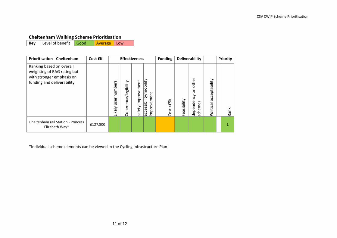
Cheltenham Walking Scheme Prioritisation Key Level of benefit Good Average Low
Prioritisation - Cheltenham Cost £K Effectiveness Funding Deliverability Priority
Ranking based on overall weighting of RAG rating but with stronger emphasis on funding and deliverability
Like
ly u
ser
nu
mb
ers
Co
her
ence
/leg
ibili
ty
safe
ty im
pro
vem
ent
acce
ssib
ility
/mo
bili
ty
imp
rove
men
t
Co
st <
£5
K
Feas
ibili
ty
dep
end
ency
on
oth
er
sch
emes
Po
litic
al a
ccep
tab
ility
Ran
k
Cheltenham rail Station - Princess Elizabeth Way*
£127,800 1
*Individual scheme elements can be viewed in the Cycling Infrastructure Plan
CSV CWIP Scheme Prioritisation
12 of 12
Gloucester Walking Scheme Prioritisation Key Level of benefit Good Average Low
Prioritisation - Gloucester Measure Proposed Cost £K Effectiveness Funding Deliverability Priority
Ranking based on overall weighting of RAG rating but with stronger emphasis on funding and deliverability
Like
ly u
ser
nu
mb
ers
Co
her
ence
/leg
ibili
ty
safe
ty im
pro
vem
ent
acce
ssib
ilty/
mo
bili
ty
imp
rove
men
t
Co
st <
£5
K
Feas
ibili
ty
dep
end
ancy
on
oth
er
sch
emes
Po
litic
al a
ccep
tab
ility
Ran
k
Schemes 1 to 9 - Gloucester Railway Station to Derby Road
£24,200 2
Schemes A to C - Derby Road to Bruton Way
£5,000-10,000
4
Schemes D to F - Gloucester Rail Station underpass diversion
£44,800 3
Schemes 10 to 16 – Great Western Road
£10,250 1
*Individual scheme elements can be viewed in the Walking Infrastructure Plan