cycling action plan
TRANSCRIPT
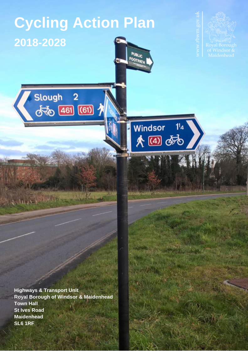
Cycling Action Plan
2018-2028
Highways & Transport Unit
Royal Borough of Windsor & Maidenhead
Town Hall
St Ives Road
Maidenhead
SL6 1RF

Contents
Page
1. Introduction 1
2. Guiding Principles 2
3. Strategic Framework 3
4. The Current Situation 8
5. Vision, Aims and Objectives 12
6. Action Plan 13
• Cycle routes 13
• Wayfinding 15
• Cycle parking 16
• Transport Interchanges 18
• Public Bike Share 19
• Working with schools 20
• Working with businesses 21
• Health and wellbeing 22
• Recreational / sports cycling 23
• Practical support and training 24
• Marketing and communications 25
7. Funding 26
8. Monitoring 27
Appendices:
• Appendix 1: Area Profile – Ascot and Sunnings 29
• Appendix 2: Area Profile – Bisham and Cookham 34
• Appendix 3: Area Profile – Bray 41
• Appendix 4: Area Profile – Datchet 47
• Appendix 5: Area Profile – Eton and Eton Wick 52
• Appendix 6: Area Profile – Horton and Wraysbury 58
• Appendix 7: Area Profile – Hurley and the Walthams 62
• Appendix 8: Area Profile – Maidenhead and Cox Green 69
• Appendix 9: Area Profile – Old Windsor 79
• Appendix 10: Area Profile – Windsor 84
• Appendix 11: Prioritised List of Schemes 92

1
1. Introduction
1.1 The benefits of cycling are numerous and well documented and show that even a
relatively modest shift from car to cycling for local journeys can potentially deliver benefits
in the following areas:
• Traffic congestion
• Air quality
• Traffic noise
• Health and fitness
• Employee absenteeism
• Economic growth
1.2 This action plan identifies our priorities for capital and revenue investment in cycling
for the period 2018/19 to 2027/28, in order that more of our residents, commuters and
visitors will be encouraged and enabled to choose cycling as an everyday form of
transport, as well as for leisure and fitness.
1.3 A key focus of the action plan is connecting residential areas to destinations, such as
town centres, local centres, employment sites, and education facilities. We will achieve this
by providing a network of safe, convenient, connected and legible cycle routes and by
improving road conditions so they are safer for cyclists and encourage cycling. The action
plan also recognises the need to coordinate with neighbouring authorities to better cater
for cross-boundary journeys.
1.4 If we are to encourage more cycling trips, it is also important to ensure that there is
sufficient secure cycle parking at destinations. This action plan addresses the requirement
to have high quality cycle parking at existing destinations, as well as being integrated into
new developments.
1.5 In addition to catering for local journeys, this action plan seeks to better integrate
cycling with other forms of transport (particularly rail), so it can play a vital part in catering
for longer distance travel to create seamless end-to-end journeys.
1.6 In order to bring about a culture of cycling within the Royal Borough, improvements to
infrastructure must be supported by a programme of information, training, appropriate
support and adequate funding. This will ensure that people have the knowledge, skills and
confidence to be able to make the switch to travelling by bike.
1.7 Lastly we recognise that we cannot achieve all of this alone, and we must therefore
work closely with our partners in the public, private and voluntary sectors. Together, we
will develop and deliver a series of Action Plans in order to deliver a sustained and
effectively targeted programme of investment in cycling.
2
2. Guiding Principles
2.1 This action plan has been developed around the following guiding principles:
Residents First
• Design cycling schemes that cater for all cyclists regardless of age, gender or ability.
• Integrate cycling with other forms of transport to improve interchange and provide
seamless end-to-end journeys to, from and within the Royal Borough.
• Regularly consult residents and other local stakeholders to ensure that provision for
cycling is fit for purpose and meet the needs of local users.
Value for Money
• Appraise schemes and prioritise those that are likely to have the greatest benefits for
cyclists.
• Identify opportunities to pool budgets where this would deliver additional benefits for
cyclists.
• Ensure that the needs of cyclists are incorporated into other highway scheme
designs and new development.
• Maximise third party investment in cycling (e.g. developer contributions, Growth Deal
funding and Department for Transport grants).
Equipping ourselves for the future
• Arrange training for officers who are involved in delivering the Cycling Action Plan, so
they are familiar with relevant guidance, design standards and legislation.
• Actively seek out and learn from best practice in the UK and abroad.
• Make appropriate and effective use of technology when designing and implementing
cycling solutions.
Partnership Working
• Work with local residents, schools, businesses, neighbourhood plan groups, parish
councils and local ward members to identify cycling schemes.
• Identify opportunities to work jointly with other Council service areas, such as Public
Health and Leisure in order to deliver shared priorities.
• Work with the Thames Valley Berkshire Local Enterprise Partnership (LEP) and
neighbouring authorities to deliver cross-boundary cycling schemes and initiatives.
• Work closely with other organisations, such as Crown Estate, Network Rail, public
transport operators, Thames Valley Police, developers, and third sector groups to
coordinate activities and resources and thus maximise the benefits for cycling.
3
3. Strategic Framework
3.1 This action plan should be considered in the context of a wider strategic framework
National:
Door to Door: A action plan for improving sustainable transport integration
3.2 Published in 2013, ‘Door-to-Door’ describes the government’s vision for integrated
sustainable journeys. It focuses on a number of key areas that need to be addressed so
that people can be confident in choosing greener forms of transport. These include
“regular and straightforward connections at all stages of the journey and between different
modes of transport”.
Infrastructure Act
3.3 The Infrastructure Act (2015) places a statutory duty on the Secretary of State for
Transport to prepare a Cycling and Walking Investment Action plan for England. This must
specify:
(a) Objectives to be achieved during the period to which it relates, and
(b) The financial resources to be made available by the Secretary of State for the purpose
of achieving those objectives.
3.4 The Cycling and Walking Investment Strategy was published in April 2017. This
outlines the government’s ambition to make cycling and walking a natural choice for
shorter journeys or as part of longer journeys by 2040. It sets targets that Government will
work towards in the shorter term, it details the financial resources that will be made
available for walking and cycling, and It includes a number of key performance indicators
that will be used to track performance at the national level. It also sets out the governance
arrangements that will be put in place and outlines actions that Government has already
taken, as well as planned future actions.
Regional:
3.5 The Thames Valley Berkshire Local Enterprise Partnership (LEP) includes
representatives from business and the six local authorities in Berkshire. It contributes to
the economic growth of the area through the implementation of a Strategic Economic Plan.
Covering the period 2015/16 – 2020/21, this contains policies and proposals relating to:
• Enterprise and Innovation
• Employment and Skills
• International
• Infrastructure
3.6 The LEP provides funding for major transport schemes (typically £5 million or more),
such as park and ride, mass-rapid transit schemes, and road and rail infrastructure
improvements, particularly where these support and enable new residential or commercial
development, or where they address deficiencies in the existing transport network. It also
4
contributes to investment in packages of local transport measures, including walking and
cycling schemes, particularly where these cross local authority boundaries. All schemes
must be supported by a webTAG compliant business case that demonstrates high value
for money with a benefit to cost ratio of two or more.
Local:
3.7 The Cycling Action Plan is nested within a suite of local transport and planning
documents:
Local Transport Plan (2012-2026)
3.8 The Local Transport Plan (LTP) adopts an evidence based approach to transport
planning and sets out high level policies for all aspects of local highways and transport
provision within the borough, including walking and cycling.
3.9 In broad terms, the LTP aims to:
• Improve access to local services and facilities
• Improve road safety and personal security
• Support economic growth
• Improve quality of life and minimise the negative impacts of transport
• Tackle climate change.
3.10 The LTP provides an overarching set of policies within which more detailed plans and
strategies can be prepared, such as the Cycling Action plan. These include policies for:
• Walking and cycling networks
• Provision of secure cycle parking
• Public rights of way
• Transport interchange
• Travel information
• Access
• Road safety education, enforcement and engineering
• Smarter choices programmes (designed to promote sustainable travel behaviours)
• Network management
• New development
• Health (including promotion of active travel modes)
3.11 Each year, the Council publishes details of its LTP capital programmes for the
coming financial year together with indicative programmes for the following two years.
Planned expenditure is broken down by themes, such as: Cycling; Safer Routes to School;
Footways; Public Rights of Way, etc.
The Borough Local Plan
3.12 When adopted, the Borough Local Plan (BLP) will set out a vision and framework for
future development in the period to 2033, addressing local needs and opportunities in
relation to housing, the economy, community facilities and infrastructure, as well as
5
providing a basis for safeguarding the environment, adapting to climate change and
securing good design.
3.13 It will also provide a critical tool (together with local Neighbourhood Plans) to guide
decisions about individual development proposals. Representations were invited on the
submission version between Friday 30 June and Wednesday 27 September 2017. The
Council submitted the Proposed Submission BLP and supporting documents to the
Secretary of State on 31 January 2018.
3.14 Like the Local Transport Plan, it provides an overarching policy document within
which more detailed plans and strategies can be prepared. These will address issues such
as travel plans and requirements for provision of cycle parking, showers and changing
facilities for cyclists.
3.15 A key supporting document for the BLP is the Infrastructure Delivery Plan (IDP). The
primary purpose of the IDP is to identify the infrastructure considered necessary to enable
the development proposed in the BLP and to outline how and when this will be delivered.
3.16 The IDP is also an infrastructure planning tool which can be used as a framework to
guide decision-making on infrastructure delivery, including the future allocation of funds
from the Community Infrastructure Levy. The IDP provides a strategic overview of how and
when key infrastructure will be required, highlighting schemes that may be required to
unlock development, and providing the basis for supporting the delivery and
implementation of the BLP. Cycling schemes are included within the IDP, which has been
informed by the work undertaken in the preparation of the Cycling Action Plan.
3.17 As part of the planning process, developers will be required provide cycling
infrastructure as an integral part of their developments and to link their development to key
local destinations. The Council will ensure that the needs of cyclists are considered in
development master planning.
Maidenhead Town Centre Area Action Plan
3.18 Adopted in September 2011, the Maidenhead Town Centre Area Action Plan (AAP)
is a daughter document of the Borough Local Plan. It seeks to rejuvenate Maidenhead
town centre and the surrounding area and sets out to deliver attractive streets and places,
new shops, homes and business and leisure opportunities.
3.19 The AAP aims to create a sense of place, a destination for shoppers, residents,
businesses or visitors. This involves exploring opportunities for new buildings, streets and
spaces, for improved shopping facilities and attracting new businesses, for creating new
homes and providing social and cultural attractions, as well as further improving the town’s
accessibility. The approach encapsulates the following themes:
• Place making
• Economy
• People
• Movement

6
3.20 The document seeks to improve accessibility to the town centre, with a specific focus
on creating a safe and comfortable environment for pedestrians and cyclists as well as
improving access by public transport.
Neighbourhood Plans
3.21 The Localism Act introduces statutory neighbourhood planning in England. It enables
communities to draw up a neighbourhood plan for their area and is intended to give
communities a greater say in the development of their local area. There are 11 designated
Neighbourhood Plan areas within the Royal Borough. Of these, the following have been
completed:
• Ascot Sunninghill and Sunningdale
• Hurley and the Walthams
3.22 Most development will individually or cumulatively have an impact on transport and
travel patterns and so good planning of transport is of paramount importance. Therefore, it
is essential to work with developers to ensure that the impacts of development on the
transport network are fully considered for new sites or re-development of existing sites.
Appropriate levels of financial contributions can then be sought from the developers
towards the capital and ongoing maintenance costs of on and off-site transport
infrastructure and services considered necessary to mitigate the impact of their
development on the transport network.
3.23 Communities will always have concerns about transport, but Neighbourhood Plans
can allay these concerns by setting out realistic solutions to existing local issues which, in
turn, would help to facilitate the delivery of future investment in the Plan area. Also,
measures that encourage modal shift to cycling and walking contribute to economic growth
by tackling congestion and environmental improvements through reductions in exhaust
emissions.
3.24 Neighbourhood plans can contain policies to address key transport issues, such as:
• Facilitating provision of traffic calming and 20 mph speed limits
• Encouraging the provision of transport hubs and interchange between travel modes
• Identifying safe routes for walking and cycling
3.25 The Neighbourhood Plan Groups have been engaged to ensure that any cycling
issues are identified and considered as part of the Cycling Action Plan.
Parking Strategy
3.26 The Council is in the process of updating its Parking Strategy, which will also be a
daughter document to the Borough Local Plan. This will include a review of parking
standards to be applied to all new developments in the Royal Borough. It will also include
a comprehensive set of guidelines for the provision of cycle parking, which will consider
aspects such as:

7
• Location
• Design
• Dimensions
• Layout
• Access
• Capacity
• Management arrangements
8
4. The Current Situation
Travel Patterns
4.1 In 2014/15, the Active People Survey showed that 14.6% of Royal Borough residents
indicated that they cycle at least once a month, with 9.2% cycling at least once a week.
This includes cycling for all journey purposes, including leisure and fitness, as well as for
travel to work and education. This is broadly similar to the UK average, but slightly lower
than the South East average and lower than most of the other Berkshire authorities.
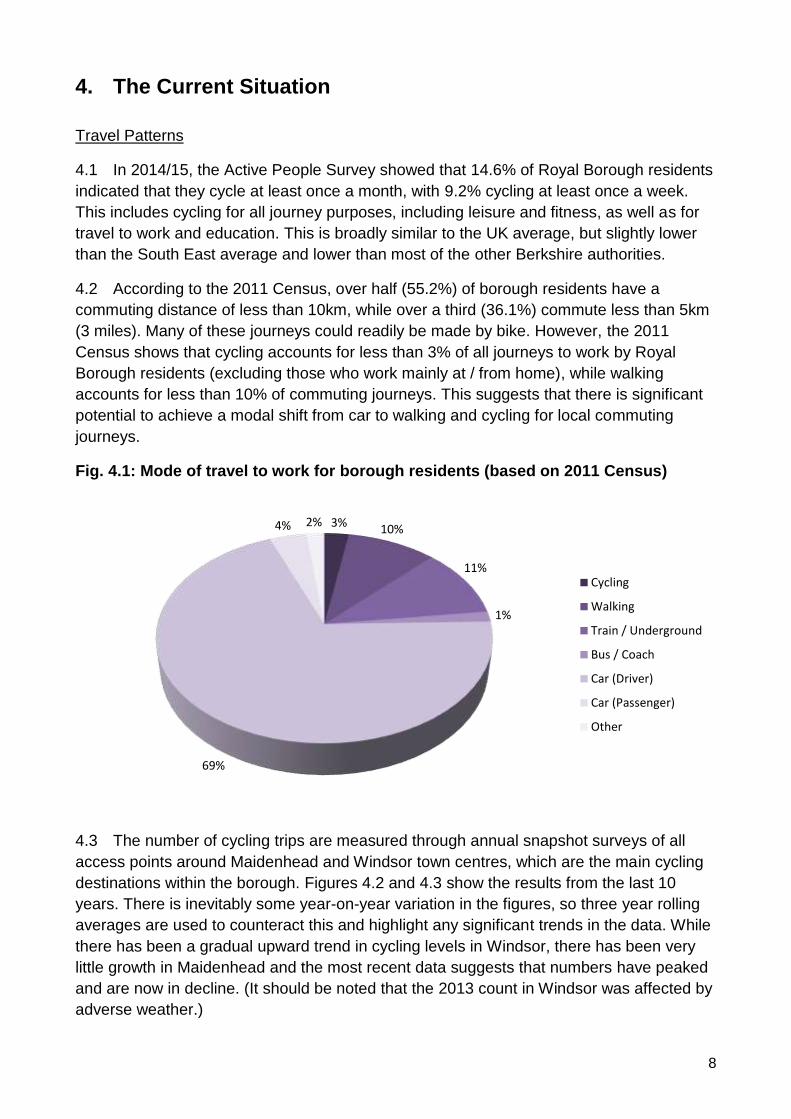
4.2 According to the 2011 Census, over half (55.2%) of borough residents have a
commuting distance of less than 10km, while over a third (36.1%) commute less than 5km
(3 miles). Many of these journeys could readily be made by bike. However, the 2011
Census shows that cycling accounts for less than 3% of all journeys to work by Royal
Borough residents (excluding those who work mainly at / from home), while walking
accounts for less than 10% of commuting journeys. This suggests that there is significant
potential to achieve a modal shift from car to walking and cycling for local commuting
journeys.
Fig. 4.1: Mode of travel to work for borough residents (based on 2011 Census)
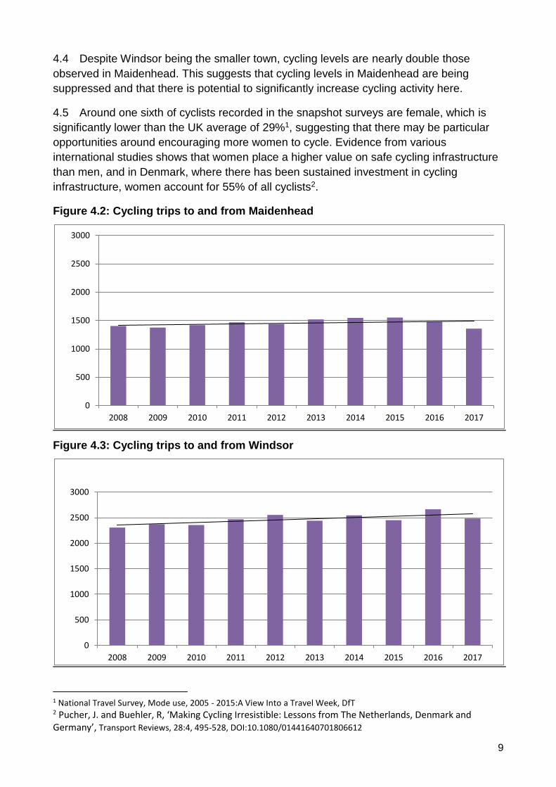
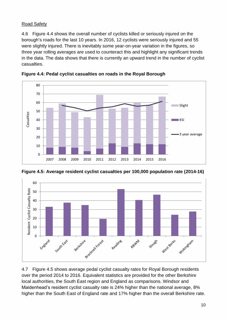
4.3 The number of cycling trips are measured through annual snapshot surveys of all
access points around Maidenhead and Windsor town centres, which are the main cycling
destinations within the borough. Figures 4.2 and 4.3 show the results from the last 10
years. There is inevitably some year-on-year variation in the figures, so three year rolling
averages are used to counteract this and highlight any significant trends in the data. While
there has been a gradual upward trend in cycling levels in Windsor, there has been very
little growth in Maidenhead and the most recent data suggests that numbers have peaked
and are now in decline. (It should be noted that the 2013 count in Windsor was affected by
adverse weather.)
3%10%
11%
1%
69%
4% 2%
Cycling
Walking
Train / Underground
Bus / Coach
Car (Driver)
Car (Passenger)
Other
9
4.4 Despite Windsor being the smaller town, cycling levels are nearly double those
observed in Maidenhead. This suggests that cycling levels in Maidenhead are being
suppressed and that there is potential to significantly increase cycling activity here.
4.5 Around one sixth of cyclists recorded in the snapshot surveys are female, which is
significantly lower than the UK average of 29%1, suggesting that there may be particular
opportunities around encouraging more women to cycle. Evidence from various
international studies shows that women place a higher value on safe cycling infrastructure
than men, and in Denmark, where there has been sustained investment in cycling
infrastructure, women account for 55% of all cyclists2.
Figure 4.2: Cycling trips to and from Maidenhead
Figure 4.3: Cycling trips to and from Windsor
1 National Travel Survey, Mode use, 2005 - 2015:A View Into a Travel Week, DfT 2 Pucher, J. and Buehler, R, ‘Making Cycling Irresistible: Lessons from The Netherlands, Denmark and Germany’, Transport Reviews, 28:4, 495-528, DOI:10.1080/01441640701806612
0
500
1000
1500
2000
2500
3000
2008 2009 2010 2011 2012 2013 2014 2015 2016 2017
0
500
1000
1500
2000
2500
3000
2008 2009 2010 2011 2012 2013 2014 2015 2016 2017
10
Road Safety
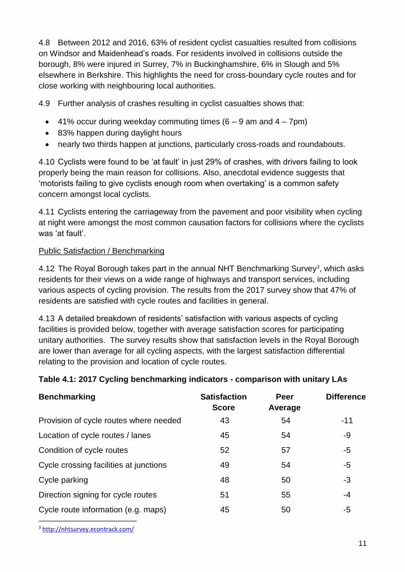
4.6 Figure 4.4 shows the overall number of cyclists killed or seriously injured on the
borough’s roads for the last 10 years. In 2016, 12 cyclists were seriously injured and 55
were slightly injured. There is inevitably some year-on-year variation in the figures, so
three year rolling averages are used to counteract this and highlight any significant trends
in the data. The data shows that there is currently an upward trend in the number of cyclist
casualties.
Figure 4.4: Pedal cyclist casualties on roads in the Royal Borough
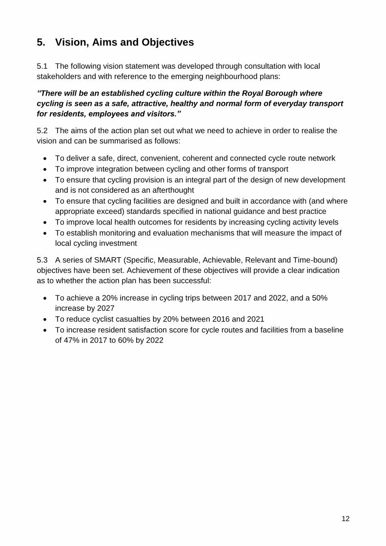
Figure 4.5: Average resident cyclist casualties per 100,000 population rate (2014-16)
4.7 Figure 4.5 shows average pedal cyclist casualty rates for Royal Borough residents
over the period 2014 to 2016. Equivalent statistics are provided for the other Berkshire
local authorities, the South East region and England as comparisons. Windsor and
Maidenhead’s resident cyclist casualty rate is 24% higher than the national average, 8%
higher than the South East of England rate and 17% higher than the overall Berkshire rate.
0
10
20
30
40
50
60
70
80
2007 2008 2009 2010 2011 2012 2013 2014 2015 2016
Cas
ual
ties
Slight
KSI
3 year average
0
10
20
30
40
50
60
Res
iden
t C
yclis
t C
asu
alty
Rat
e
11
4.8 Between 2012 and 2016, 63% of resident cyclist casualties resulted from collisions
on Windsor and Maidenhead’s roads. For residents involved in collisions outside the
borough, 8% were injured in Surrey, 7% in Buckinghamshire, 6% in Slough and 5%
elsewhere in Berkshire. This highlights the need for cross-boundary cycle routes and for
close working with neighbouring local authorities.
4.9 Further analysis of crashes resulting in cyclist casualties shows that:
• 41% occur during weekday commuting times (6 – 9 am and 4 – 7pm)
• 83% happen during daylight hours
• nearly two thirds happen at junctions, particularly cross-roads and roundabouts.
4.10 Cyclists were found to be ‘at fault’ in just 29% of crashes, with drivers failing to look
properly being the main reason for collisions. Also, anecdotal evidence suggests that
‘motorists failing to give cyclists enough room when overtaking’ is a common safety
concern amongst local cyclists.
4.11 Cyclists entering the carriageway from the pavement and poor visibility when cycling
at night were amongst the most common causation factors for collisions where the cyclists
was ‘at fault’.
Public Satisfaction / Benchmarking
4.12 The Royal Borough takes part in the annual NHT Benchmarking Survey3, which asks
residents for their views on a wide range of highways and transport services, including
various aspects of cycling provision. The results from the 2017 survey show that 47% of
residents are satisfied with cycle routes and facilities in general.
4.13 A detailed breakdown of residents’ satisfaction with various aspects of cycling
facilities is provided below, together with average satisfaction scores for participating
unitary authorities. The survey results show that satisfaction levels in the Royal Borough
are lower than average for all cycling aspects, with the largest satisfaction differential
relating to the provision and location of cycle routes.
Table 4.1: 2017 Cycling benchmarking indicators - comparison with unitary LAs
Benchmarking Satisfaction
Score
Peer
Average
Difference
Provision of cycle routes where needed 43 54 -11
Location of cycle routes / lanes 45 54 -9
Condition of cycle routes 52 57 -5
Cycle crossing facilities at junctions 49 54 -5
Cycle parking 48 50 -3
Direction signing for cycle routes 51 55 -4
Cycle route information (e.g. maps) 45 50 -5
3 http://nhtsurvey.econtrack.com/
12
5. Vision, Aims and Objectives
5.1 The following vision statement was developed through consultation with local
stakeholders and with reference to the emerging neighbourhood plans:
“There will be an established cycling culture within the Royal Borough where
cycling is seen as a safe, attractive, healthy and normal form of everyday transport
for residents, employees and visitors.”
5.2 The aims of the action plan set out what we need to achieve in order to realise the
vision and can be summarised as follows:
• To deliver a safe, direct, convenient, coherent and connected cycle route network
• To improve integration between cycling and other forms of transport
• To ensure that cycling provision is an integral part of the design of new development
and is not considered as an afterthought
• To ensure that cycling facilities are designed and built in accordance with (and where
appropriate exceed) standards specified in national guidance and best practice
• To improve local health outcomes for residents by increasing cycling activity levels
• To establish monitoring and evaluation mechanisms that will measure the impact of
local cycling investment
5.3 A series of SMART (Specific, Measurable, Achievable, Relevant and Time-bound)
objectives have been set. Achievement of these objectives will provide a clear indication
as to whether the action plan has been successful:
• To achieve a 20% increase in cycling trips between 2017 and 2022, and a 50%
increase by 2027
• To reduce cyclist casualties by 20% between 2016 and 2021
• To increase resident satisfaction score for cycle routes and facilities from a baseline
of 47% in 2017 to 60% by 2022
13
6. Action Plan
Cycle Routes
6.1 Fears over safety are a major barrier to getting more people cycling. People need to
perceive that it is safe to cycle, either because traffic volumes and speeds are low, or
because there is dedicated space for cycling that minimises conflict with other road users.
6.2 Cycle route networks need to be designed so they are: safe, continuous, direct,
attractive and comfortable. Routes should be capable of meeting the needs of all cyclists
from novices or families with young children through to confident commuter and sports
cyclists.
6.3 We will:
• Review the current cycle route networks to identify gaps, taking account of current
and predicted journey patterns and travel behaviour.
• Develop a network of routes that are suitable for cycling and which connect
residential areas to key destinations, such as:
o Transport interchanges
o Town and village centres
o Shops / supermarkets
o Employment
o Schools / colleges
o Healthcare services
o Leisure facilities
o Visitor attractions
• Give cyclists priority over side-roads and private accesses where it is safe to do so.
• Where possible, design facilities to meet or exceed standards set out in national
cycling design guidance, taking account of emerging best practice.
• Improve road traffic and surface conditions for cyclists where there is no space for
dedicated provision.
• Introduce 20 mph speed limits around schools and in other areas where there may
be significant numbers of cyclists and / or pedestrians.
• Ensure that provision of new cycle routes is an integral part of new developments.
• Ensure that provision for cyclists is incorporated in the Borough Local Plan and
associated documents such as the Infrastructure Delivery Plan.
• Review and develop maintenance regimes to better consider the needs of cyclists,
particularly in relation to carriageway levels around drainage gulleys and access
covers and at road humps.
• Link to and enhance the public rights of way network where appropriate.
• Work with private landowners to secure new and improved routes where these
cannot be delivered within the confines of the public highway or public rights of way
networks.
• Work in partnership to develop multi-user routes (wide surfaced paths designed for
pedestrians, cyclists and horse riders) and create links to fill gaps in the network.
14
• Work with neighbouring authorities to secure cross-boundary routes.
6.4 We have engaged with the Cycle Forum and Neighbourhood Plan Groups to identify
potential improvements to the cycle route network. Proposed schemes are shown in
Appendices 1-10.
15
Wayfinding
6.5 Wayfinding provides information to help cyclists navigate to their destination, making
use of signs, road markings, maps and other environmental signals, as well as electronic
devices such as mobile phones and satnavs.
6.6 When designing wayfinding systems, it is important to know what information is
required, and to identify where and when it should be provided. Wayfinding should be
designed around the needs of the intended user. For example, a commuter would
generally seek the quickest, most direct cycle route, while a leisure cyclist may prefer a
quieter, more scenic route.
6.7 Wayfinding should be informative, providing data about routes, destinations, terrain,
distances and journey times. Wayfinding should be coherent and consistent along routes
and across an area. It should also be intuitive and legible without overloading the user or
resulting in unnecessary clutter. It should also be legible and understandable by all users,
including those with visual, mobility and learning impairments, as well as foreign visitors.
6.8 Wayfinding systems also help to advertise the presence of cycle routes and
encourage people to explore and consider making journeys by bike.
6.9 We will:
• Agree a system of wayfinding signs and road markings in consultation with local
cycling groups and other stakeholders, and drawing on established best practice
case studies.
• Consider branding of key routes to give them an identity and provide additional visual
clues to those who are following them.
• Review and update the borough’s cycle route map to ensure that it remains current
and includes information that is useful and relevant to cyclists. Demand will be
reviewed regularly to see whether further reprints are needed.
• Work with local cycling groups and other stakeholders to review and improve the
accuracy of online cycling journey planners such as those provided by Google and
CycleStreets.
16
Cycle Parking
6.10 Having enough convenient and secure cycle parking at people's homes and at
cycling destinations is important. Access to cycle storage should be at least as convenient
as access to car parking if cycling is to be encouraged.
6.11 Inadequate or poorly designed cycle parking can lead to problems with facilities
being unused and bikes being left attached to railings or other items of street furniture.
This can look unsightly, cause damage to property and even obstruct pedestrian routes.
6.12 There is an ongoing issue with cycle theft in the Royal Borough, with bikes stolen
from residential properties and public spaces (e.g. on-street and transport interchanges).
Good quality cycle parking is key to the prevention of cycle theft and hence the promotion
of cycling.
6.13 We will:
• Review existing cycle parking provision to identify locations with unmet demand.
• Provide cycle parking within town, village and district centres, at schools and at
Council offices that is:
o Accessible and easy to use
o Safe and secure – in prominent locations with CCTV / good natural surveillance
o Fit for purpose – providing good support and allowing multiple fixing points
o Attractive and in keeping with agreed street furniture schemes
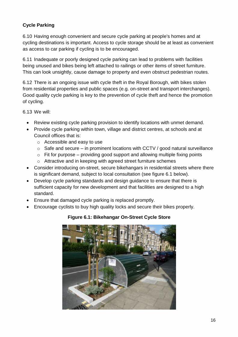
• Consider introducing on-street, secure bikehangars in residential streets where there
is significant demand, subject to local consultation (see figure 6.1 below).
• Develop cycle parking standards and design guidance to ensure that there is
sufficient capacity for new development and that facilities are designed to a high
standard.
• Ensure that damaged cycle parking is replaced promptly.
• Encourage cyclists to buy high quality locks and secure their bikes properly.
Figure 6.1: Bikehangar On-Street Cycle Store

17
6.14 We have engaged with the Cycle Forum and Neighbourhood Plan Groups to identify
sites where additional cycle parking is needed. Proposed schemes are shown in
Appendices 1 - 10.
18
Transport Interchanges
6.15 Cycling can form an integral part of longer-distance journeys. Increasing numbers of
people are choosing to cycle to or from train stations, either leaving their bikes at the
station, or taking folding bikes on the train. Bikes also have the potential for use as part of
longer distance bus and coach journeys.
6.16 With significant growth in rail passenger numbers anticipated on the back of recent /
planned investment in trains, electrification, the Elizabeth Line and the Western Rail Link
to Heathrow, it is important that cycling provision at rail stations is enhanced and access
routes improved.
6.17 Many station car parks are now operating at or close to capacity, while roads around
stations can experience significant peak hour congestion. It is therefore important to
encourage more rail passengers to travel to and from the station by more sustainable
forms of transport, such as cycling.
6.18 We will:
• Review existing cycle routes and cycle parking provision to identify gaps.
• Work with partners in the rail industry to:
o improve cycle route connectivity to / from stations
o increase the availability of secure cycle parking at stations
o ensure adequate on-train capacity for cycles
o ensure that station buildings are accessible for cyclists (e.g. lifts)
o develop bespoke station travel plans that encourage and enable sustainable
travel to and from rail stations
• Provide cycle parking at bus and coach stops where there is demand
19
Public Bike Share
6.19 A public bike share scheme is where bikes are made available for members of the
public to hire and use. There are several different operating models including:
• Docked
• Dockless
• Lockers
• Rail station hubs
6.20 Bike share is an effective means of getting people to start cycling / cycle more often –
66% of those surveyed started to cycle or increased the amount they cycle as a result of a
bike share scheme. They also effective at encouraging more women to cycle, with women
accounting for 41% of bike share trips versus 25% of all cycling trips.
6.21 Bike share can replace short car trips in urban areas (23% of users previously made
their most frequent journey by car) and it is often used in conjunction with public transport.
6.22 Analysis of the factors that lead to a successful bike share scheme suggests that
there may be potential for a scheme in Maidenhead and / or Windsor. However, the case
is not particularly strong, since populations are at the lower end of what is considered
viable and the cycle route network should be improved before a scheme is introduced.
There are also a number of local factors that would need to taken into account in the
design and operation of any scheme, particularly security issues in Windsor.
6.23 We will:
• Defer the decision to introduce a bike share scheme until such time as critical links in
the cycle network can be completed to improve access to Maidenhead and Windsor
town centres and rail stations (i.e. Maidenhead Missing Links).
• Undertake a feasibility study and financial assessment including research with
potential partners to gauge likely levels of interest for a local scheme.
• Liaise with Heathrow Airport and Slough Borough Council to explore possible options
for a scheme that is able to accommodate cross-boundary cycling trips.
6.24 In the event that a public bike share scheme is introduced, we will:
• Seek to avoid / minimise any financial liability for on-going revenue costs and officer
time associated with managing the contract. Presentations from operators of docked
and dockless schemes suggest that commercial operations could be achieved in the
Royal Borough.
• Ensure that any operator is CoMo (formerly BikePlus) accredited.
• Develop clear operating guidelines to be agreed with the operator in advance to
ensure that local requirements are met in addition to those covered by the CoMo
accreditation.
• Introduce the scheme for a trial period to evaluate its impacts.
• Seek to secure anonymised usage data from operators to help inform cycle network
development.
20
Working with Schools
6.25 Across the Royal Borough, the proportion of children who travel to and from school
by car is significantly higher than the national average and (with a few notable exceptions)
the proportion of pupils who are cycling to school is very low. This leads to increased
problems with traffic congestion and contributes to the perception that roads are not safe
for cycling. As traffic levels increase, so fewer parent are prepared to let their children walk
or cycle to school, which simply exacerbates the situation.
6.26 Teenage years are particularly important as this is a time when attitudes to travel and
physical activity become set. There is evidence to suggest that girls and boys have similar
attitudes to cycling until the age of 14 at which point gender attitudes diverge and girls
often stop cycling4. The reasons for this are that teenage girls tend to be more aware of
body image while exercising, they are more concerned about safety issues, and they are
more worried about peer attitudes to cycling. This trend is particularly pronounced at
Windsor Boys and Windsor Girls Schools, which have markedly different levels of cycling
to school. The trend appears to continue into adulthood with the annual cycle counts in
Maidenhead and Windsor showing that male cyclists outnumber women by 5:1.
6.27 We will:
• Encourage and assist schools and colleges to develop, monitor and maintain their
school travel plans, which seek to increase walking and cycling and reduce car use
for travel to and from school.
• Work with schools to ensure that uniform policy and access to showers and changing
facilities support cycling to school.
• Work with schools, parents and pupils to identify improvements that can be made to
walking and cycling infrastructure to create ‘Safer Routes to School’.
• Introduce 20 mph speed limits around schools
• Provide or enhance secure cycle parking provision at RBWM schools.*
• Provide Level 1 and 2 Bikeability training for primary aged children and Level 3
training for secondary aged children.
• Work with colleagues in Leisure Services and Public Health, and third parties, such
as British Cycling to deliver extra-curricular cycling activities such as Go Ride and
Breeze with a particular focus on encouraging more girls to cycle.
*NB: Academies are funded directly by central government and so will not be eligible for
RBWM funding for cycle parking.
4 Goddard, T. (2013) ‘Are Bicycling and Walking Cool? Adolescent Attitudes about Active Travel’, Portland State University. [Available at: https://youtu.be/6QO5dEg9u8s]
21
Working with Businesses
6.28 Less than 3% of Borough residents currently cycle to work, despite the fact that
over 50% have a commuting distance of 10 km (approximately 6 miles) or less. This
suggests that there is significant capacity to encourage more people to leave the car at
home and commute by bike.
6.29 There are a number of potential barriers to increasing cycle commuting:
• Over 50% of the adult population do not own / have access to a bike5.
• Many adults have not cycled for years and may lack confidence.
• Cycle parking may not be available at some workplaces.
• Showers, changing facilities and storage lockers may not be available at some
workplaces.
6. 30 We will:
• Encourage businesses to become members of easitMAIDENHEAD6, which offers a
variety of benefits, such as:
o loan bikes
o discounts on new bikes, cycle clothing and equipment
o bicycle try-out sessions
• Encourage businesses to take part in the National Workplace Cycle Challenge7,
which aims to get more people cycling through a targeted marketing campaign and
an inter-workplace competition.
• Secure provision for cyclists through the planning system, including provision of
showers, lockers and secure cycle parking at new employment sites.
• Secure Workplace Travel Plans through the planning system and encourage
businesses to develop voluntary Travel Plans that promote sustainable forms of
transport.
• Provide advice and support to businesses that are looking to provide cycling facilities
for their staff.
• Offer cycling road show events at business parks and major employers to promote
cycling and related safety messages, including the dangers of motorists passing too
close to cyclists.
5 National Travel Survey 2014-2016 6 http://www.easit.org.uk/easitmaidenhead.php 7 https://www.lovetoride.net/uk?locale=en-GB
22
Health and Wellbeing
6.31 Cycling has been shown to deliver numerous health benefits, including:
• Improving cardiovascular fitness
• Helping to reduce instances of Type 2 Diabetes
• Toning and building muscle with little impact on joints
• Boosting the metabolism and helping with weight management
• Improving mental health
• Strengthening the immune system
6.32 Research funded by British Cycling8 suggests that achieving Danish levels of
cycling in the UK could save the NHS £20 billion over 20 years.
6.33 The Health Profile for Windsor and Maidenhead9 shows that 38.7% of adult residents
are classed as being physically inactive, while 62.4% of adults are overweight or obese
and 15.1% of children in year six are classified as obese. This suggests that there could
be significant health benefits from encouraging more residents to take up cycling as part of
active lifestyles, focusing on those who are identified to be at risk from factors associated
with sedentary lifestyles.
6.34 We will:
• Support local volunteer ride leaders to deliver a programme of led bike rides.
• Work with colleagues in Leisure Services, the Berkshire Sports Partnership and local
cycling clubs to deliver cycling taster sessions as part of ‘Fit for Life’ and Get
Berkshire Active’s ‘Workplace Challenge’.
• Work with colleagues in Public Health and local Clinical Commissioning Groups to
include cycling within GP lifestyle management referral schemes.
8 British Cycling (2014), ‘Benefits of Investing in Cycling,’, Rachel Alred [Available at https://www.britishcycling.org.uk/zuvvi/media/bc_files/campaigning/BENEFITS_OF_INVESTING_IN_CYCLING_DIGI_FINAL.pdf 9 Public Health England (2017) ‘Health Profile 2017 – Windsor and Maidenhead’ [Available at: http://fingertipsreports.phe.org.uk/health-profiles/2017/e06000040.pdf]
23
Recreation and Sports Cycling
6.35 There are many existing opportunities for recreational cycling in and around the
Royal Borough, including the Jubilee River, permitted routes through Windsor Great Park
and paths round Dorney Lake, as well as various bridleways and byways.
6.36 The Royal Borough is served by several long-distance cycle routes including arms of
the National Cycle Network and the London to Land’s End Cycle Route, which is becoming
popular amongst cycle tourers.
6.37 There are several charity rides and sportives that finish in / pass through the area,
including Palace to Palace, London to Windsor, and London Revolution. Local roads are
also used for numerous cycling time trials and triathlons. This requires careful traffic
management to ensure the safety of users and to balance competing pressures on the
road network.
6.38 There is also increasing demand for specialist cycling facilities within the borough,
including a closed road cycling circuit and mountain bike trails, which has been identified
through the Cycle Forum and evidence of illegal activity on private land.
6.39 We will:
• Enhance existing recreational cycling routes / develop new routes in order to meet
local demand.
• Provide and enhance links to existing recreational cycle routes, such as the National
Cycle Network, the Jubilee River and Windsor Great Park.
• Work with Sustrans, neighbouring authorities and local landowners to enhance local
elements of the National Cycle Network and develop / link to new NCN routes.
• Work with partners in the visitor economy to promote sustainable tourism, including
cycle touring.
• Work with local landowners to explore the potential for creating new / improved
mountain bike routes in the borough.
• Work with local landowners and British Cycling to explore the potential for creating a
closed cycling circuit in the borough.
• Work with local clubs wishing to run triathlons, time trials and road races on the
public highway, ensuring that these are coordinated with other planned events, and
that impacts on residents and other road users are minimised. We will also ensure
that such events have the permission of the police.
• Work with charity bike ride / sportive organisers wishing to organise events on the
public highway, ensuring that these are coordinated with other planned events, and
that impacts on residents and other road users are minimised.
24
Practical Support and Training
6.40 New or returning cyclists may need practical advice and training to address issues
and concerns that they may have and to give them the confidence to be able to make
everyday journeys by bike. This may include:
• Training on how to ride safely in traffic (e.g. adult Bikeability)
• Education about how to undertake basic cycle maintenance and repairs (e.g.
checking brakes, inflating tyres, oiling a chain, fixing punctures, etc)
• Dr Bike sessions where cyclists can get their bike checked and adjusted, and receive
advice on any repairs that are needed
• Journey planning advice to help cyclists find routes to local destinations based on
their particular needs (e.g. quietest or quickest routes)
6.41 In order to be most effective, programmes should seek to engage local businesses
as well as borough residents.
6.42 We will:
• Work with Maidenhead Cycle Hub, Parkwood Leisure, cycle shops and other
partners to develop a training and education programme for local cyclists – this
should be scalable to reflect funding availability.
25
Marketing and Communications
6.43 Marketing and communications are vital for engaging existing and potential cyclists,
understanding their needs, and informing them about schemes and initiatives that may be
of interest and benefit to them.
6.44 In order to be effective the Council and its partners must engage their audiences via
their preferred channels and provide information in their preferred formats. Wherever
possible, content should be tailored to the needs of particular market segments.
6.45 We will:
• Engage cyclists through the Infrastructure Overview and Scrutiny Panel and the
Maidenhead and Windsor Town Forums
• Engage with existing and potential cyclists via social media
• Promote cycling through local media and press releases
• Include regular articles on cycling in ‘Around the Royal Borough’
• Provide cycling information on the Council’s website
• Deliver road safety campaigns, supporting the national ‘THINK!’ campaigns,
supplemented by local campaigns to encourage safe and responsible behaviours by
cyclists and other road users.
• Work with Thames Valley Police to deliver a ‘Close Pass’ initiative targeting motorists
who leave insufficient space when overtaking cyclists.
• Deliver cycle security campaigns to help reduce instances of cycle thefts
• Promote national and local events that are designed to encourage more people to
cycle (e.g. led bike rides, Workplace Cycle Challenge, Bike Week events, etc)

26
7. Funding
7.1 Creating a high quality cycle network will require significant capital spending over
many years. Money is also required for revenue budgets to support ‘soft measures’ such
as Bikeability training and marketing communications. The All Party Parliamentary Cycling
Group Report, ‘Get Britain Cycling’ recommended a cycling budget of around £10 per
person per year. For the Royal Borough, this would equate to an annual spend of around
£1.49 million.
7.2 We will seek to make effective use of existing internal funding sources, including:
• Local Transport Plan Capital Programme
• Highways maintenance budgets
• Public health budgets
• Physical activity budgets
• Developer contributions
7.3 This will require joint working between different services areas.
7.4 We will also seek to make effective use of external funding sources, such as:
• Local Growth Deal funding10
• Highways England funding
• Department for Transport funding (including Bikeability Grant)
• Funding for improvements at rail stations (e.g. Access for All, National Station
Improvement Programme, and funding provided by train operating companies)
• Sport England / British Cycling funding
• Corporate sponsorship
• Heathrow Airport
10 Funding bids submitted via the Thames Valley Berkshire Local Enterprise Partnership
27
8. Monitoring
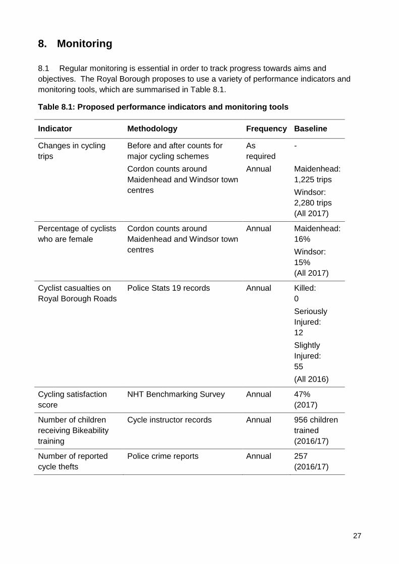
8.1 Regular monitoring is essential in order to track progress towards aims and
objectives. The Royal Borough proposes to use a variety of performance indicators and
monitoring tools, which are summarised in Table 8.1.
Table 8.1: Proposed performance indicators and monitoring tools
Indicator Methodology Frequency Baseline
Changes in cycling
trips
Before and after counts for
major cycling schemes
Cordon counts around
Maidenhead and Windsor town
centres
As
required
Annual
-
Maidenhead:
1,225 trips
Windsor:
2,280 trips
(All 2017)
Percentage of cyclists
who are female
Cordon counts around
Maidenhead and Windsor town
centres
Annual Maidenhead:
16%
Windsor:
15%
(All 2017)
Cyclist casualties on
Royal Borough Roads
Police Stats 19 records Annual Killed:
0
Seriously
Injured:
12
Slightly
Injured:
55
(All 2016)
Cycling satisfaction
score
NHT Benchmarking Survey Annual 47%
(2017)
Number of children
receiving Bikeability
training
Cycle instructor records Annual 956 children
trained
(2016/17)
Number of reported
cycle thefts
Police crime reports Annual 257
(2016/17)

28

29
Appendix 1: Area Profile - Ascot & the Sunnings
1. Description of the Area
The south of the borough comprises the following wards: Ascot and Cheapside; Sunninghill and
South Ascot; and Sunningdale. The area is bounded by Windsor Great Park to the north,
Bracknell Forest to the west and north-west and Surrey to the south and east.
2. Local Destinations
The following have been identified as the main cycling destinations within the local area:
Community:
• Ascot Durning Library
• Sunningdale Container Library
• Sunningdale Parish Offices
• Sunningdale Village Hall
• Sunninghill Library
• Sunninghill and Ascot Parish Offices
• The Hope Centre
• The Pavilion
Education:
• Charters School
• Cheapside Primary School
• Heathermount School (Special)
• Holy Trinity C of E Primary School
• Hurst Lodge School (Independent)
• Papplewick School (Independent)
• St Francis Catholic Primary School
• St George’s School, Ascot (Independent)
• St Mary’s School, Ascot (Independent)
• St Michael’s C of E Primary School
• South Ascot Village Primary School
• Sunningdale School (Independent)
• The Marist Schools (Independent)
Employment:
• Ascot Racecourse
• South Ascot Industrial Estate
Leisure
• Ascot Racecourse
• Charters Leisure Centre
• Virginia Water
• Windsor Great Park
Shopping:
• Ascot Village Centre
• South Ascot Centre
30
• Sunninghill Village Centre
• Sunningdale Village Centre (including Waitrose superstore)
Transport:
• Ascot Station
• Sunningdale Station
Given that the area is virtually surrounded by neighbouring local authorities, cross-boundary links
are important.
3. Existing Cycling Activity and Potential for Growth
The Propensity to Cycle Tool (www.pct.bike) has been used to model existing cycle commuter
flows based on 2011 Census data. It has also been used to identify routes that are likely to
experience the highest levels of growth in cycling activity under the ‘Government Target’ scenario,
which looks at what would happen if cycling levels were to double.
2011 Baseline:
• The PCT mapping shows that all links have low numbers of commuter cycle trips with fewer
than 50 movements per day.
Government Target Scenario:
• The highest commuter cycle flows are shown along A329 High Street and Hatchet Lane, where
there is forecast to be between 100 and 249 movements per day.
• Commuter cycle flows are shown to increase to between 50 and 99 movements per day on
some of the other A-roads, including the eastern section of the A329, the A30 and parts of the
A330.
Strava Heat Maps provide some indication as to cycling levels. Strava smartphone apps tends to
be used by sports cyclists rather than utility cyclists, so the results are not necessarily
representative of everyday cycling activity.
Notwithstanding these caveats, the heat maps show that there are a number of routes that are
currently well-used by cyclists, including many of the A and B roads:
• A30 London Road
• A329 London Road / High Street
• A330 Devenish Road / Brockenhurst Road / Station Hill
• A330 Hatchet Lane / Winkfield Road
• A332 Windsor Road
• B383 Broomhall Lane / Buckhurst Road / Sunningdale Road
• B3020 High Street / Bagshot Road
Minor roads that are well used include:
• Cheapside Road
• Coronation Road
• Mill Lane
• New Mile Ride
• Watersplash Lane
31
4. Existing Cycling Infrastructure
The area has little in the way of existing cycling infrastructure. The only cycle route is along the
A329 London Road, from the Bracknell Boundary to Heatherwood Roundabout and up to Burleigh
Road. This is being extended towards Ascot Town Centre with the existing crossing outside the
racecourse reception upgraded to a toucan crossing.
Cycle parking is provided at the following locations:
• A329 London Road – bus stop opposite Heatherwood Hospital (west)
• Ascot High Street
• Ascot Station
• High Street, Sunninghill
• Sunningdale Station
5. Key Issues
The following issues have been identified from a desktop audit and previous correspondence:
• The area is crossed by a large number of main roads, including the A30, A329, A330, A332,
B383, and B3020.
• A lack of available highway land is a key constraint to providing more cycle routes.
• There are few quiet through routes in the area, which makes it difficult to create filtered
permeability for cyclists (i.e. through routes for cyclists but not motor vehicles).
• There are no cycle routes to local rail stations at Ascot and Sunningdale.
• Charters School and Leisure Centre is surrounded by busy main roads and is particularly
challenging to cycle to.
• Ascot Racecourse and Windsor Great Park are major visitor destinations, and roads can be
heavily trafficked outside of the traditional commuter peak hours.
• Visitor numbers to the Great Park have increased considerably in recent years, reaching 4
million per year. The area is very popular with cyclists and there is significant conflict between
cyclists and other visitors at weekends and public holidays.
• Much of Windsor Great Park is affected by environmental designations, including Special Area
of Conservation and Sites of Special Scientific Interest – these limit the potential for additional
cycle routes to Windsor and to The Lookout in Bracknell.
• Crown Estate owns many of the highway verges alongside public roads through the Great
Park, which restricts where cycle routes can be constructed.
• The lack of cycling infrastructure means that cycling trips are low for commuting and education
purposes.
• There is no cycle parking serving local shops in South Ascot and Sunningdale.
• Need to ensure that major developments planned for the area will provide / fund new cycle
facilities.
6. Road Safety
The following cyclist casualties have been recorded in the area during the five years –2012-2016:
• 0 fatal
• 6 serious
• 18 slight casualties.
The following locations have clusters of three or more casualties:
32
• A329 London Road / A332 Windsor Road / A329 High Street / A332 Kings Ride (Heatherwood
Roundabout).
The following schools have taken part in Bikeability during the 2016/17 academic year:
• Charters
• Holy Trinity CE Primary School
• St Francis Catholic Primary School
• St Michael’s CE Primary School
• South Ascot Village School.
7. Action Plan
A number of potential actions have been identified to respond to the issues identified in the audit.
These will be consulted upon internally and with key stakeholders including ward members, parish
councils, the neighbourhood plan group, local cycling groups, and neighbouring local authorities.
Action Responsibility Deliverability Cost
1. Encourage local schools to take part in the
Bikeability training programme.
RBWM/ Cycle
Experience
✓✓✓ £
2. Install cycle parking at Chobham Road shops RBWM
✓✓✓ £
3. Install cycle parking at South Ascot shops RBWM
✓✓✓ £
4. Improve St George’s Lane as part of the
redevelopment of the Shorts site
RBWM
✓✓✓ ££
5. Investigate upgrading Sunninghill Footpath 10 RBWM
✓✓ ££
6. Upgrade Exchange Road to provide a cycle
route connecting both ends (Byway 35)
RBWM
✓✓ ££
7. Upgrade the surface on Sunningdale
Bridleway 1
RBWM / Surrey
County Council
✓✓ ££
8. Investigate the potential to upgrade the cycle
route between Ascot and Ascot Gate,
Cheapside.
RBWM /
Bracknell Forest
Council
✓✓ £££
9. Liaise with adjacent landowners / Network Rail
re construction of a cycle route between
Heatherwood and Ascot Station.
RBWM /
Neighbourhood
Plan Group
✓ £££
10. Liaise with adjacent landowners / Network Rail
re construction of a cycle route to Charters
School / Leisure Centre
RBWM /
Neighbourhood
Plan Group
✓ £££
11. Secure a cycle route between High Street,
Sunninghill and King’s Corner as part of the
gas holder site redevelopment.
RBWM ✓ £££
33
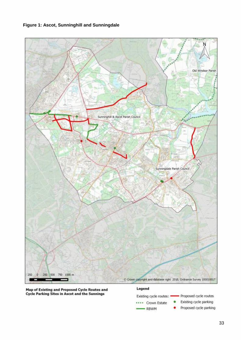
Figure 1: Ascot, Sunninghill and Sunningdale
34
Appendix 2: Area Profile: Bisham and Cookham
1. Description of the Area
Bisham and Cookham are the most northerly parishes in the borough. They are predominantly
rural in nature, incorporating the settlements of Bisham, Burchetts Green (part), Cookham Dean,
Cookham Rise and Cookham.
2. Local Destinations
The following have been identified as the main cycling destinations within the local area:
Community:
• Cookham Dean Village Hall
• Cookham Library
• Pinder Hall
Education:
• Bisham CE Primary School
• Cookham Dean C.E. Aided Primary School
• Cookham Rise Primary School
• Holy Trinity C of E Primary School
• The Herries Preparatory School
Employment /Business:
• Moor Hall, Cookham
• The Odney Club, Cookham
Sports / Leisure:
• Bisham Abbey National Sports Centre
• River Thames (Cookham and Bisham)
• Stanley Spencer Gallery, Cookham
Shopping:
• Cookham Village Centre
• Cookham Rise Village Centre
• Stubbings Garden Centre
Transport Interchanges:
• Cookham Station
Cross-boundary links are important for communities in the north of the borough, since in some
cases residents are closer to Marlow and Bourne End than they are to Maidenhead.
Since there are no secondary schools in the area, pupils must travel to schools in Maidenhead,
Marlow and Bourne End.
3. Existing Cycling Activity and Potential for Growth
The Propensity to Cycle Tool (www.pct.bike) has been used to model existing cycle commuter
flows based on 2011 Census data. It has also been used to identify routes that are likely to

35
experience the highest levels of growth in cycling activity under the ‘Government Target’ scenario,
which looks at what would happen if cycling levels were to double.
2011 Baseline:
• The PCT mapping shows that all links have low numbers of commuter cyclists with less than
50 cyclists per day.
Government Target Scenario:
• The highest flows are along Bisham Road / Marlow Road, A308 Marlow Road, A4094 Sutton
Road, where commuter cycle flows increase to between 100 and 249 movements per day
• Commuter cycle flows are shown to increase to between 50 and 99 movements per day on
B4447 High Street / The Pound / Maidenhead Road.
• The A404 is also shown to carry over 50 movements per day, but this is an extremely hostile
environment for cyclists and is not considered a viable cycle route. In reality, cyclists would be
more likely to use the parallel route through Marlow.
Strava Heat Maps also provide some indication as to cycling levels.The Strava smart phone apps
tend to be used by sports cyclists rather than utility cyclistsso, the results are not necessarily
representative of everyday cycling activity.
Notwithstanding these caveats, the heat maps show that there are a number of routes that are
currently well-used by cyclists, including all of the A and B roads:
• A308 Marlow Road
• A4130 Henley Road
• A4094 Sutton Road / Sheet Street Road
• B4447 High Street / The Pound / Maidenhead Road / Cannondown Road / Switchback Road
North
Minor roads that are well used include:
• Bisham Road
• Temple Lane
• Quarry Wood Road
• Winter Hill / Terry’s Lane
• Dean Lane
• Lower Road
• Grubwood Lane / Hockett Lane / Winter Hill Road
• Hills Lane / Spring Lane
• Choke Lane / Long Lane
• Henley Road
4. Existing Cycling Infrastructure
The permitted cycle route between Maidenhead and Cookham Rise forms part of National Cycle
Network Route 50, which was conceived as a long-distance cycle route between Maidenhead and
Winslow. The path has recently been upgraded to address issues regarding long-standing issues
regarding access and surfacing.
Other local routes include the shared use footway / cycleway that runs along the east side of
Switchback Road North and Cannondown Road, which provides a link between Maidenhead and
Cookham Rise.
36
There is also a signed quiet route between Maidenhead and Hurley via Dungrove Hil Lane and
Hurley Lane, which crosses the A404 via an underpass.
Public cycle parking has been provided at Cookham Station.
Few of the destinations identified in Section 2 are served by the current cycle route network.
However, there are 20 mph speed limits through The Pound, on High Road outside Cookham Rise
Primary School and on School Lane outside Holy Trinity C of E Primary School in Cookham. An
advisory 20 mph is proposed for Bisham Road / Marlow Road supported by flashing lights at the
start and end of the school day.
There are a number of quiet lanes in the area that are popular for recreational cycling.
5. Key Issues
The following issues have been identified from a desktop audit and previous correspondence:
• The existing cycle route between Cookham Rise and Maidenhead does not link through to the
centre of either settlement.
• Although there are some pleasant, quiet lanes in the area, there are few dedicated cycle
routes, which may deter people from making for local journeys by bike.
• Some local lanes are heavily used by motorists during peak periods. This makes them
unattractive for commuter cycling.
• Cross-boundary cycling links are poor – neither Cookham Bridge nor Marlow Bridge has
provision for cyclists. Traffic signals do not allow cyclists to clear Cookham Bridge before a
green signal is given to opposing traffic. Both bridges are listed structures, which limits
opportunities for providing parallel / cantilevered cycle bridges.
• The area is crossed by a number of main roads, including the A308, A404, A4094 and A4130,
which are heavily trafficked and difficult to cross, presenting major barriers to cycling. The
Bisham Roundabout junction of the A308 / A404 is particularly hazardous for cyclists.
• Few children / young people currently cycle to school / college, which may be due to the lack of
protected cycle routes.
• There is no cycle parking serving the shops in Cookham and Cookham Rise, nor at Cookham
Library.
• Despite not being permitted, cycling on the Thames Path and parallel public footpaths is
commonplace, particularly between Temple and Hurley.
• A lack of available highway land is a key constraint to providing more cycle routes.
• Some bridleways and byways are unsurfaced and are therefore unsuited to utility cycling trips.
• The small size of local communities and the low numbers of cyclists make it hard to achieve
high cost benefit ratios for major cycling investment in the area.
• There are few major developments planned for the area that will provide / fund new cycle
facilities.
• Park Wood, The Hockett, Quarry Wood, Long Copse and Coney Copse are being used
extensively for mountain biking, including paths that are not currently designated as public
rights of way and those that are designated only as public footpaths.
6. Road Safety
The following cyclist casualties have been recorded in the area during the five years –2012 - 2016:
• 0 fatal
• 4 serious
• 5 slight casualties.
37
Two of the above casualties occurred at the BIsham Roundabout at the junction of the A404 /
A308.
The following schools have taken part in Bikeability during the 2016/17 academic year:
• Cookham Dean CE Primary School
• Cookham Rise Primary School
• Holy Trinity C E Primary School.
7. Action Plan
A number of potential actions have been identified to respond to the issues identified in the audit.
These will be consulted upon internally and with key stakeholders including ward members, parish
councils, the neighbourhood plan group, local cycling groups, and neighbouring local authorities.
Action Responsibility Deliverability Cost
1. Encourage local schools to take part in
the Bikeability training programme.
RBWM
✓✓✓ £
2. Improve direction signing on existing
cycle routes.
RBWM
✓✓✓ £
3. Install cycle parking in Cookham and
Cookham Rise village centres and at
Cookham Library.
RBWM
✓✓✓ £
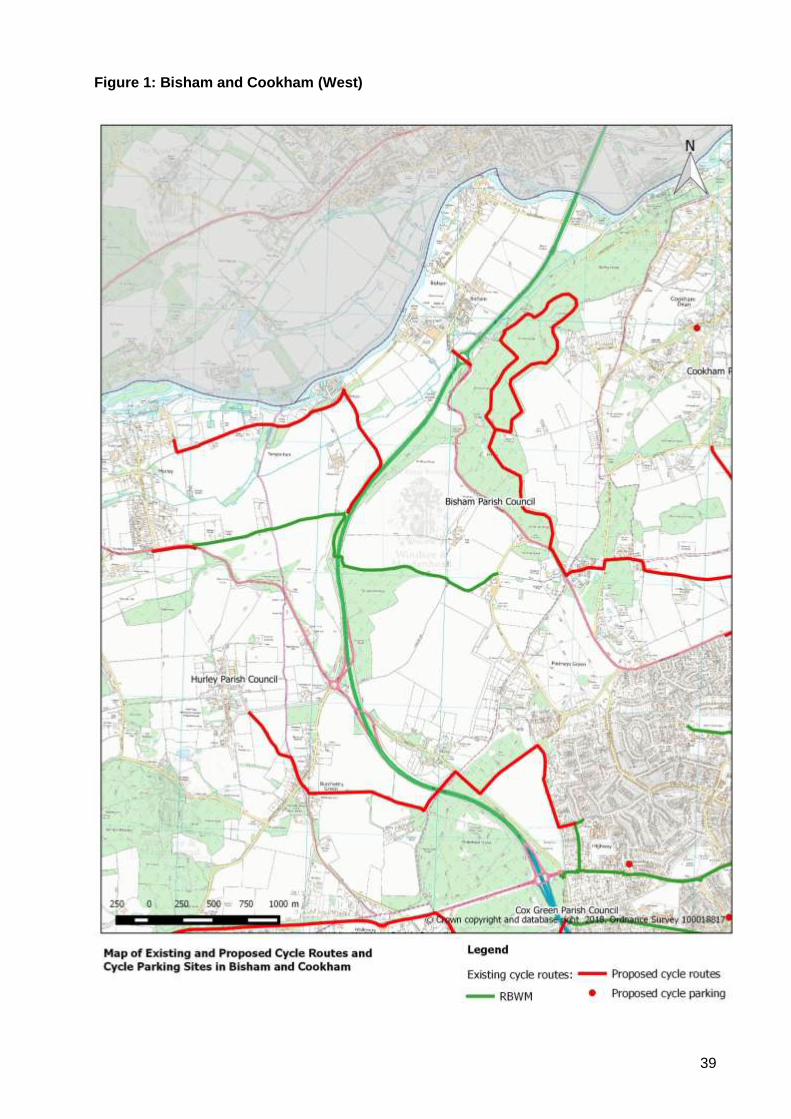
4. Investigate new cycle route between
B4447 and Cookham Station
RBWM ✓✓ ££
5. Liaise with Highways England and local
landowners regarding a new cycle link
between Hurley Lane and Bradenham
Lane.
RBWM
✓✓ ££
6. Liaise with landowners regarding the
potential for cycle access between Hurley
and Bisham along Temple Lane.
RBWM
✓✓ ££
7. Liaise with Highways England to secure
improvements for cyclists as part of the
Bisham Roundabout improvements.
RBWM
✓✓ £££
8. Liaise with landowners regarding cycle
links between Maidenhead, Cookham,
Cookham Rise and Cookham Dean, and
possible connections to Bourne End.
RBWM
✓✓ £££
9. Liaise with local landowners regarding the
potential for establishing formal mountain
bike trails in Park Wood, The Hockett,
Quarry Wood, Long Copse and Coney
Copse.
RBWM
✓ £££

38
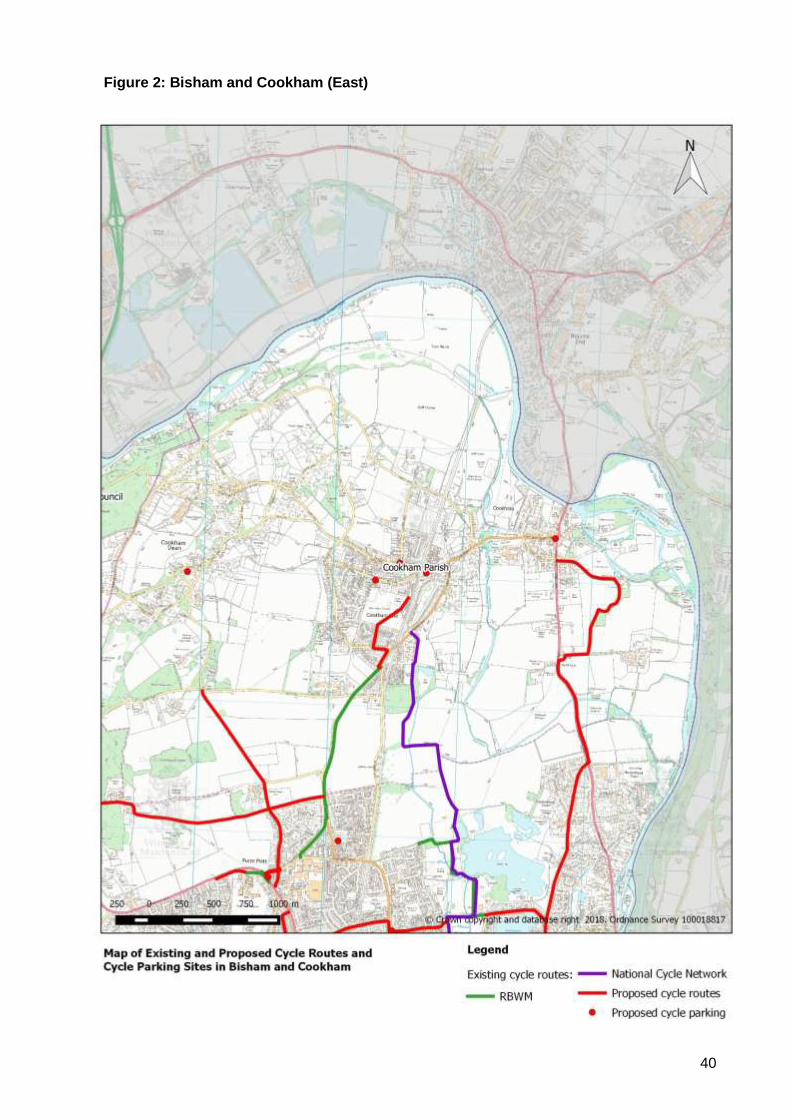
Action Responsibility Deliverability Cost
10. Liaise with landowners regarding the
potential for a new cycle route between
BCA and Maidenhead.
RBWM
✓ £££
11. Liaise with landowners regarding
construction of a new cycle route parallel
to the A4094 between Maidenhead and
Cookham as an alternative to NCN50.
RBWM ✓ £££
39
Figure 1: Bisham and Cookham (West)
40
Figure 2: Bisham and Cookham (East)
41
Appendix 3: Area Profile - Bray
1. Description of the Area
Bray Parish occupies the area to the south of the River Thames between Maidenhead and
Windsor. It incorporates the settlements of Bray, Holyport, Moneyrow Green, Touchen End, Paley
Street (part), Fifield, Oakley Green, and the western fringe of Windsor.
2. Local Destinations
The following have been identified as the main cycling destinations within the local area:
Community:
• Bray Village Hall
• Holyport Village Hall
Education:
• Alexander First School
• Braywick Court School
• Braywood C of E First School
• Holyport C of E Primary School
• Holyport College
Employment:
• Prior’s Way Industrial Estate
Leisure
• Bird Hills Golf Centre
• Bray Lake Water Sports
• Bray Village Centre
• Braywick Park
• River Thames
Shopping:
• Holyport Village Centre
• Squires Garden Centre
• Tithe Barn Shops
• Wyevale Garden Centre
Cross-boundary links are important for local communities (e.g. Bracknell is a major centre of
employment).
Most secondary school pupils travel outside the parish to attend schools in Maidenhead or
Windsor.
3. Existing Cycling Activity and Potential for Growth
The Propensity to Cycle Tool (www.pct.bike) has been used to model existing cycle commuter
flows based on 2011 Census data. It has also been used to identify routes that are likely to
experience the highest levels of growth in cycling activity under the ‘Government Target’ scenario,
which looks at what would happen if cycling levels were to double.
42
2011 Baseline:
• The PCT mapping shows the heaviest flows are along A308 Windsor Road, which carries
between 100 and 249 commuter cycle trips per day.
• The only other significant flows are along A308 Braywick Road, B3028 Upper Bray Road / Bray
Road, which carry between 50 and 99 commuter cycle movements per day.
Government Target Scenario:
• The highest commuter cycle flows are seen along the A308 corridor, where most sections carry
in excess of 100 movements per day, with some sections carrying between 250 and 499
movements per day.
• A number of other roads are shown as carrying between 100 and 249 commuter cycle
movements per day, including:
o B3028 Upper Bray Road / Bray Road
o The A330 between Forest Green Road and Paley Street
o B3024 Dedworth Road on the approach to Windsor
Strava Heat Maps also provide some indication as to cycling levels. Strava smart phone apps tend
to be used by sports cyclists rather than utility cyclists, so the results are not necessarily
representative of everyday cycling activity.
Notwithstanding these caveats, the heat maps show that there are a number of routes that are
currently well-used by cyclists, including all of the A and B roads:
• A308 Windsor Road
• A330 Ascot Road
• B3024 Forest Green Road / Oakley Green Road
• B3028 Bray Road / Upper Bray Road
Minor roads that are well used include:
• Harvest Hill Road
• Hibbert Road
• Old Mill Lane / Monkey Island Lane
• Holyport Road
• Moneyrow Green
• Drift Road
• Fifield Lane
• Fifield Road
It should be noted that Drift Road is a popular route for cycle racing including time trials and
triathlon events, as well as mass participation / charity bike rides.
4. Existing Cycling Infrastructure
The area is crossed by NCN4, which is a long-distance cycle route between London and
Fishguard, via Reading, Bath, Bristol, Swansea, Carmarthen, Tenby, Haverfordwest and St
David’s. It also forms part of the London to Land’s End long-distance cycle route that is becoming
increasingly popular with British and European cycle tourers.
NCN4 also provides local links between Maidenhead, Bray and Windsor. The route mostly follows
quiet roads, such as Monkey Island Lane, and surfaced public rights of way, such as The Green
Way through Braywick Park. It crosses the Thames into Buckinghamshire via Monkey Island
Bridge.
43
There is also a shared use path along the northern side of the A308 that connects Maidenhead
and Windsor.
Public cycle parking has been provided at the following locations:
• Braywick Nature Centre
Few of the destinations identified in Section 2 are served by the current cycle route network.
However, the following areas are traffic calmed and subject to a 20 mph speed limits:
• Guards Road (on the approach to Alexander First School)
• Bray Road (within the village centre)
An advisory 20 mph speed limit has been introduced on Oakley Green Road, with flashing lights
that operate at the start and end of the school day.
5. Key Issues
The following issues have been identified from a desktop audit and previous correspondence:
• There are few dedicated cycle routes, which may deter people from making local journeys by
bike.
• The width of the footway / cycleway along the north side of the A308 is very narrow, which
makes it difficult for cyclists to pass other path users. There is also limited visibility between
cyclists and motorists emerging from side-roads and numerous private accesses, which has
led to several (damage only) collisions. It also has numerous level changes, which makes
cycling uncomfortable, and cyclists frequently have to give way at side roads. As a result, many
cyclists choose to remain on-carriageway.
• The alternative route via Monkey Island Lane is not lit and it therefore not suitable as a winter
commuting route.
• Cross-boundary cycle links to Bracknell are poor.
• The area is crossed by a number of main roads, including the A308, A330, B3024, B3028 and
B3383, which are heavily trafficked with significant numbers of HGV movements. As such, they
present significant barriers to cycling.
• Cyclists using the A308 and A330 at peak times cause significant congestion due to the
narrowness of the roads, the volume of traffic and a lack of overtaking opportunities.
• Many rural roads are used as cut-throughs by motorists during peak periods. This makes them
unattractive for commuter cycling.
• Inappropriate traffic speeds on some routes can cause problems for cyclists (e.g. Drift Road).
• Very few children / young people currently cycle to school / college due to the lack of protected
cycle routes.
• Although NCN4 is waymarked, there are few destination signs at key junctions.
• There is no cycle parking serving Holyport Village Centre or the Tithe Barn shops.
• A lack of available highway land is a key constraint to providing more cycle routes.
• There are no cycle bypasses for the traffic calming in Bray Village.
• Some bridleways and byways are unsurfaced and are therefore unsuited to utility cycling trips.
• It can be difficult to achieve high cost benefit ratios for major cycling investment to serve some
of the more rural communities.
6. Road Safety
The following cyclist casualties have been recorded in the area during the five years –2012 - 2016:
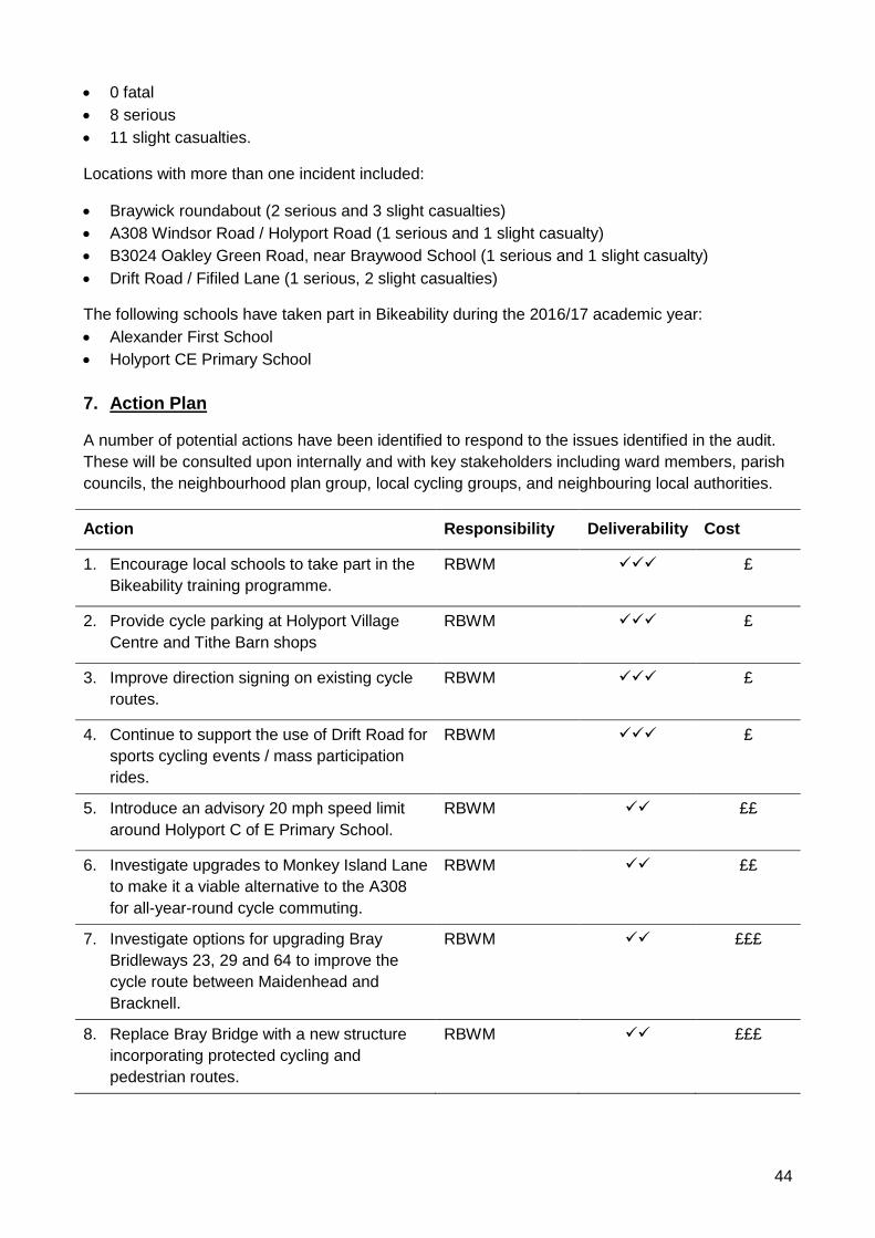
44
• 0 fatal
• 8 serious
• 11 slight casualties.
Locations with more than one incident included:
• Braywick roundabout (2 serious and 3 slight casualties)
• A308 Windsor Road / Holyport Road (1 serious and 1 slight casualty)
• B3024 Oakley Green Road, near Braywood School (1 serious and 1 slight casualty)
• Drift Road / Fifiled Lane (1 serious, 2 slight casualties)
The following schools have taken part in Bikeability during the 2016/17 academic year:
• Alexander First School
• Holyport CE Primary School
7. Action Plan
A number of potential actions have been identified to respond to the issues identified in the audit.
These will be consulted upon internally and with key stakeholders including ward members, parish
councils, the neighbourhood plan group, local cycling groups, and neighbouring local authorities.
Action Responsibility Deliverability Cost
1. Encourage local schools to take part in the
Bikeability training programme.
RBWM
✓✓✓ £
2. Provide cycle parking at Holyport Village
Centre and Tithe Barn shops
RBWM
✓✓✓ £
3. Improve direction signing on existing cycle
routes.
RBWM
✓✓✓ £
4. Continue to support the use of Drift Road for
sports cycling events / mass participation
rides.
RBWM
✓✓✓ £
5. Introduce an advisory 20 mph speed limit
around Holyport C of E Primary School.
RBWM
✓✓ ££
6. Investigate upgrades to Monkey Island Lane
to make it a viable alternative to the A308
for all-year-round cycle commuting.
RBWM ✓✓ ££
7. Investigate options for upgrading Bray
Bridleways 23, 29 and 64 to improve the
cycle route between Maidenhead and
Bracknell.
RBWM
✓✓ £££
8. Replace Bray Bridge with a new structure
incorporating protected cycling and
pedestrian routes.
RBWM
✓✓ £££
45
Action Responsibility Deliverability Cost
9. Liaise with local landowners / developers to
secure land necessary to widen the A308
shared use footway / cycleway between
Fifield and Windsor.
RBWM
✓ £££
10. Investigate an alternative to the A308 cycle
route between Monkey Island Lane and The
Binghams via Monkey Island Lane and
Hibbert Road / The Causeway.
RBWM
✓ £££
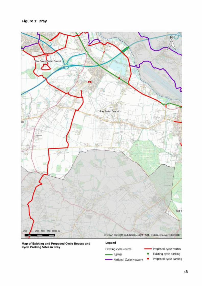
46
Figure 1: Bray
47
Appendix 4: Area Profile - Datchet
1. Description of the Area
Datchet is situated on the north side of the River Thames to the east of Windsor. It is adjacent to
Slough, which is an important destination for commuting, education and retail journeys. Datchet
Station lies on the Windsor to London Waterloo railway line.
2. Local Destinations
The following have been identified as the main cycling destinations within the local area:
Community:
• Datchet Library
• Datchet Village Hall
Education:
• Churchmead School
• Datchet St Mary’s C of E Primary School
Employment:
• Datchet Village Centre
• Ditton Park
Leisure
• Jubilee River
• Liquid Leisure
• Thames Valley Athletics Centre
• Upton Court Park (including BMX track)
Shopping:
• Datchet Village Centre
• Tesco Express, Horton Road
Transport:
• Datchet Station
Cross-boundary links are important for local communities, with many people cycling to Slough and
Langley for commuting purposes.
There are significant numbers of young people living in Datchet who attend secondary schools in
Windsor and Slough / Langley.
3. Existing Cycling Activity and Potential for Growth
The Propensity to Cycle Tool (www.pct.bike) has been used to model existing cycle commuter
flows based on 2011 Census data. It has also been used to identify routes that are likely to
experience the highest levels of growth in cycling activity under the ‘Government Target’ scenario,
which looks at what would happen if cycling levels were to double.
48
2011 Baseline:
• The PCT mapping shows the heaviest flows are along the B376 between Queen’s Road and
London Road – this section carries between 100 and 249 cycle commuter trips per day.
• A number of other routes carry between 50 and 99 trips per day including:
o B376 Slough Road
o B376 Horton Road (between Ditton Road and London Road)
o B470 Windsor Road (west of Queen’s Road)
o B470 London Road (between Montrose Avenue and Horton Road)
o Queen’s Road
Government Target Scenario:
• The PCT shows the number of commuter cycle trips on the central section of the B376 and
Queen’s Road rising to between 250 and 499 movements per day, with all other sections of the
B376 carrying between 100 and 249 trips per day.
• A number of other roads are forecast to carry between 100 and 249 commuter cycle trips per
day, including:
o B470 Windsor Road (west of Queen’s Road)
o B470 London Road
o B3021 Southlea Road
o The Myrke
o National Cycle Network Route 61 through Upton Park
Strava Heat Maps provide some indication as to cycling levels. Strava smart phone apps tend to
be used by sports cyclists rather than utility cyclists, so the results are not necessarily
representative of everyday cycling activity.
Notwithstanding these caveats, the heat maps show that there are a number of routes that are
currently well-used by cyclists, including:
• B376 Slough Road / Horton Road
• B470 Windsor Road / London Road / Major’s Farm Road
• B3021 Southlea Road
• B3026 Eton Road
• High Street
• Queen’s Road
• Riding Court Road
• The Myrke
• Upton Court Park
4. Existing Cycling Infrastructure
National Cycle Network Route 61 crosses the north-western edge of Datchet ward. This is a long-
distance cycle route that connects Maidenhead to Hatfield, Welwyn Garden City, and Hertford. It
follows the Jubilee River as far as The Myrke before crossing the B376 Slough Road into Upton
Park.
There is a cycle track / shared use path along the south side of the B376 Horton Road between
Litchfield Road and the village centre.
There is a shared use path along the south side of the B470 Major’s Farm Road between Ditton
Road and the borough boundary. This route crosses the Borough boundary to link into Slough’s
cycle route network via the A4.

49
There is also a cycle track that runs through Ditton Park, where access is permitted and
maintained by the site owner, Computer Associates.
Public cycle parking has been provided at the following locations:
• Datchet Station
A number of the destinations identified in Section 2 are served by the current cycle route network.
Also, Datchet village centre is traffic calmed with speed cushions and subject to a 30 mph speed
limit.
5. Key Issues
The following issues have been identified from a desktop audit, site visits and previous
correspondence:
• Cycle links to / from Datchet Village Centre are poor.
• There is no direct cycle link to Windsor.
• There is significant peak hour traffic congestion in the centre of the village.
• NCN 61 and the route through Ditton Park are predominantly leisure routes – they are mostly
unlit and are therefore unsuited to winter commuting.
• The cycle route alongside B470 Major’s Farm Road is partially obstructed by an earth
embankment that has been installed to prevent illegal Gypsy encampments in the adjacent
field. It is also unlit for much of its length.
• A lack of available highway land is a key constraint to providing more cycle routes.
• The bridges over the River Thames are key pinch points.
• The village green has protected status.
• There is no cycle parking anywhere within the village.
6. Road Safety
The following cyclist casualties have been recorded in the area during the five years –2012 - 2016:
• 0 fatal
• 3 serious
• 19 slight casualties.
Locations with more than one incident included:
• B376 Slough Road / B470 The Green / B470 High Street (3 slight casualties)
• B470 Windsor Road / Queen’s Road (2 slight casualties)
• B470 Windsor Road / High Street (2 slight casualties)
• B470 Major’s Farm Road / Ditton Road (2 slight casualties)
Datchet St Mary’s C of E Primary School took part in the Bikeability programme in 2016/17.
7. Action Plan
A number of potential actions have been identified to respond to the issues identified in the audit.
These will be consulted upon internally and with key stakeholders including ward members, parish
councils, the neighbourhood plan group, local cycling groups, and neighbouring local authorities.
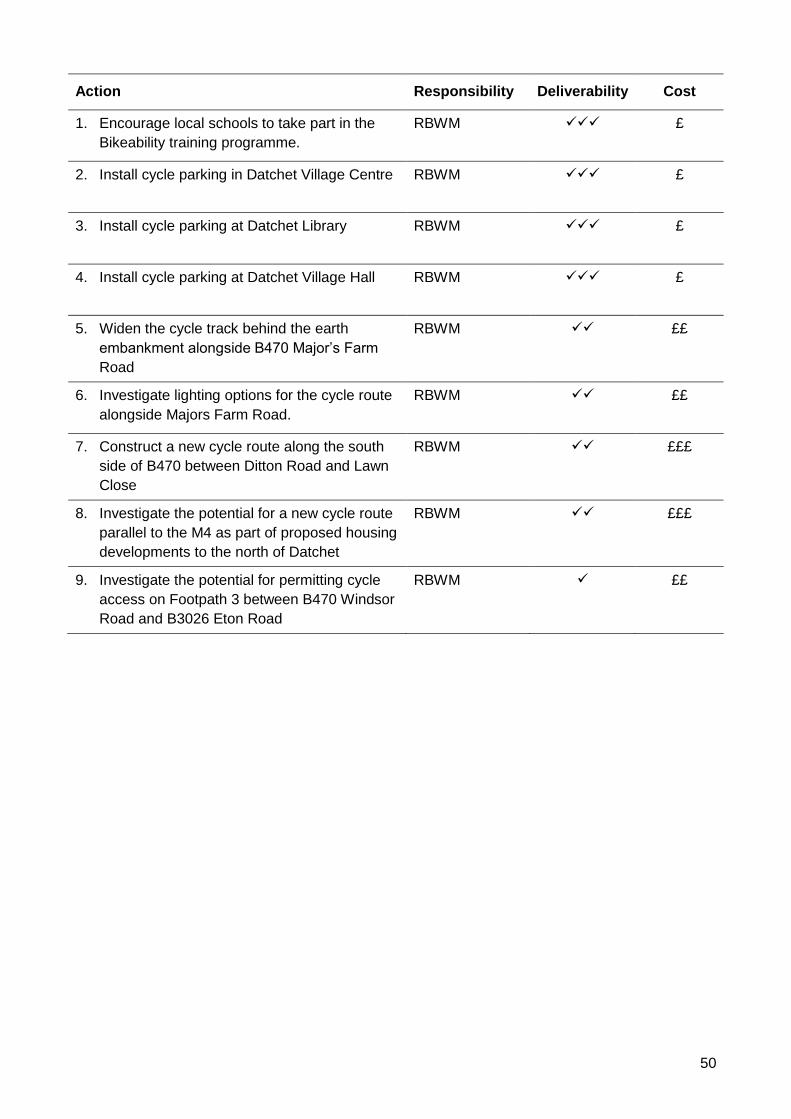
50
Action Responsibility Deliverability Cost
1. Encourage local schools to take part in the
Bikeability training programme.
RBWM
✓✓✓ £
2. Install cycle parking in Datchet Village Centre RBWM
✓✓✓ £
3. Install cycle parking at Datchet Library RBWM
✓✓✓ £
4. Install cycle parking at Datchet Village Hall RBWM
✓✓✓ £
5. Widen the cycle track behind the earth
embankment alongside B470 Major’s Farm
Road
RBWM
✓✓ ££
6. Investigate lighting options for the cycle route
alongside Majors Farm Road.
RBWM
✓✓ ££
7. Construct a new cycle route along the south
side of B470 between Ditton Road and Lawn
Close
RBWM
✓✓ £££
8. Investigate the potential for a new cycle route
parallel to the M4 as part of proposed housing
developments to the north of Datchet
RBWM ✓✓ £££
9. Investigate the potential for permitting cycle
access on Footpath 3 between B470 Windsor
Road and B3026 Eton Road
RBWM
✓ ££
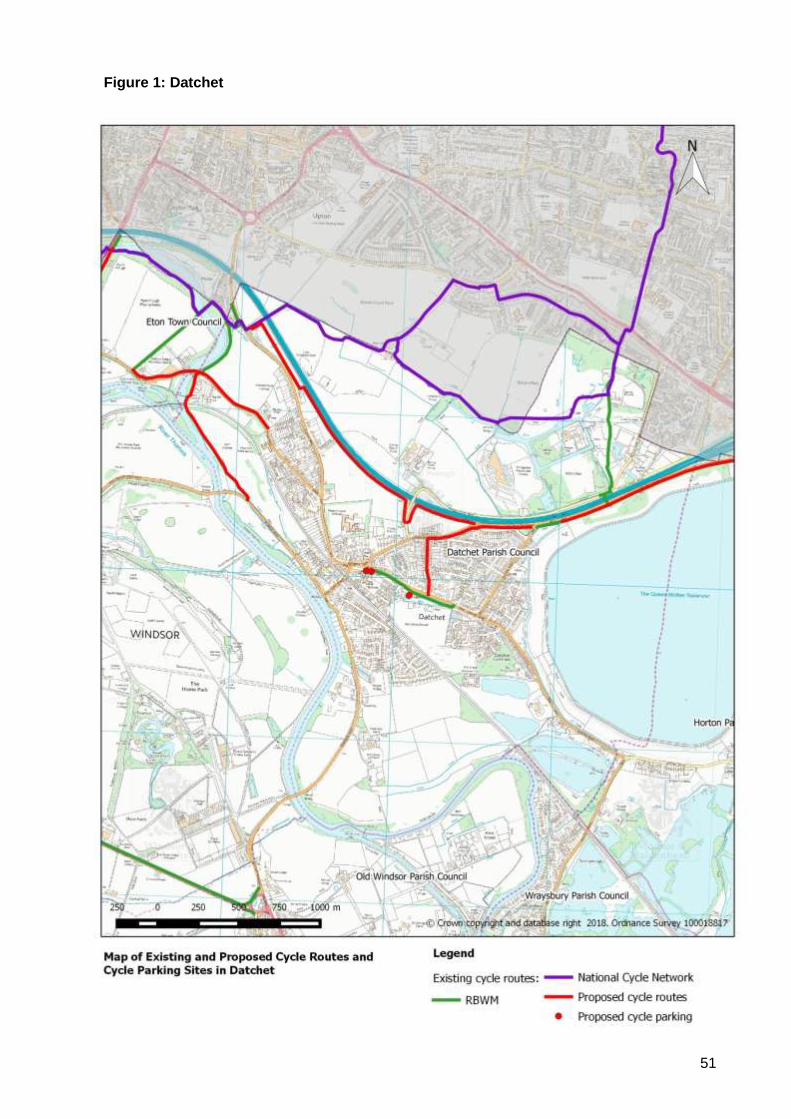
51
Figure 1: Datchet
52
Appendix 5: Area Profile - Eton & Eton Wick
1. Description of the Area
The town of Eton and the village of Eton Wick are situated on the northern side of the River
Thames. Eton is a key shopping and visitor destination that enjoys close links with Windsor, while
Eton Wick has a number of shops and other facilities that serve the needs of local residents.
2. Local Destinations
The following have been identified as the main cycling destinations within the local area:
Community:
• Eton Library
• Eton Wick Library
• Eton Wick Village Hall
Education:
• Eton Porny C of E First School
• Eton Wick C of E First School
Employment:
• Eton College
• Eton Town Centre
Leisure:
• Jubilee River
• River Thames
• Thames Valley Athletics Centre
Shopping:
• Eton Town Centre
• Eton Wick Village Centre
Cross-boundary links are important for local communities, with many people cycling between
Slough and Windsor for commuting and education purposes.
Since there are no secondary schools (other than Eton College) in the area, secondary school
pupils must travel to schools in Windsor, Datchet or Slough.
Also, Dorney Lake in South Buckinghamshire is a popular recreational cycling destination.
3. Existing Cycling Activity and Potential for Growth
An annual cordon count is undertaken around Windsor town centre each year – the results
consistently show that Windsor Bridge is the most popular cycling route to / from Windsor town
centre followed by Barry Avenue (see Appendix 10 for further details).
The Propensity to Cycle Tool (www.pct.bike) has been used to model existing cycle commuter
flows based on 2011 Census data. It has also been used to identify routes that are likely to
experience the highest levels of growth in cycling activity under the ‘Government Target’ scenario,
which looks at what would happen if cycling levels were to double.
53
2011 Baseline:
• The PCT mapping suggests that there are several routes that carry between 100 and 249
commuter cycle trips per day:
o A332 Windsor Road (north of the B3022 roundabout)
o B3022 Slough Road (between Pococks Lane and High Street)
o High Street (north of Eton Court)
o Windsor Bridge
• The PCT also suggests that the A332 / A355 Royal Windsor Way carries over 100
commuter cycle trips per day, however this road presents very challenging conditions for
cyclists and it is likely that many of these trips will actually utilise the cycle track alongside
the railway line or the shared use path on the B3022 Slough Road instead.
• A number of other roads are shown to carry between 50 and 99 commuter cycle movements
per day, including:
o B3022 Slough Road (north of Pococks Lane)
o B3026 Eton Wick Road
Government Target Scenario:
• The PCT shows that the number of daily commuter cycle trips would increase to between
250 and 499 on the following routes:
o A332 / A355 Royal Windsor Way (but as mentioned earlier, this road is not suitable
for cycling)
o B3022 Slough Road (south of Pococks Lane and north of the Jubilee River)
o High Street (north of Eton Court)
• A332 Windsor Road (north of the B3022 roundabout) is shown to carry between 250 and
499 cycle commuter trips per day (but as mentioned earlier, this road is not suitable for
cycling)
• Under this scenario, the following routes would carry between 100 and 249 cycle commuter
trips:
o B3022 (north of Pococks Lane)
o Pococks Lane
o High Street (south of Eton Court)
Strava Heat Maps provide some indication as to cycling levels. Strava smart phone apps tend to
be used by sports cyclists rather than utility cyclists. Therefore, the results are not necessarily
representative of everyday cycling activity.
Notwithstanding these caveats, the heat maps show that there are a number of routes that are
currently well-used by cyclists, including:
• B3022 Slough Road
• B3026 Eton Wick Road
• B3026 Pococks Lane
• High Street, Eton
• Brocas Street
• Atherton Court
• Eton Court
• NCN4 Thames Path / Meadow Lane
• NCN61 Jubilee River
• NCN461 Eton to Slough alongside railway viaduct
54
4. Existing Cycling Infrastructure
The area is crossed by NCN4, which is a long-distance cycle route between London and
Fishguard, via Reading, Bath, Bristol, Swansea, Carmarthen, Tenby, Haverfordwest and St
David’s. It also forms part of the London to Land’s End long-distance cycle route that is popular
with British and European cycle tourers. NCN4 also provides local links to Dorney Lake, Bray,
Maidenhead and Windsor Great Park. The route follows the Thames Path from Eton Wick and
enters Eton via Meadow Lane and Brocas Lane, before crossing Windsor Bridge, which is closed
to motor traffic.
NCN61 connects Maidenhead to Hatfield, Welwyn Garden City, and Hertford. It follows the Jubilee
River between the A4 / Berry Hill junction and Upton Court Park.
NCN461 connects Windsor to Slough and Farnham Common - the path runs alongside the railway
viaduct between Eton and the boundary with Slough and was upgraded as part of the preparations
for the London 2012 Olympic and Paralympic Games.
There are shared use footway / cycleways along both sides of Slough Road between Eton College
and Pococks Lane and on the east side from Pococks Lane to the borough boundary.
There is a permitted cycle track that runs parallel to Eton Wick Road between the railway viaduct
and Eton Wick and another between Eton Wick Road and the Thames Path. Cycling is also
permitted on the bridleways across South Field.
Cycling is permitted on Public Footpath 36 between Pococks Lane and the Jubilee River, past
Thames Valley Athletics Centre, with a toucan crossing on Pococks Lane.
Public cycle parking has been provided at the following locations:
• Eton Court, Eton
• High Street, Eton
• Princes Close, Eton Wick
• Thames Valley Athletics Centre
Many of the destinations identified in Section 2 are served by the current cycle route network.
In addition, Eton Wick Road is traffic calmed with speed cushions and subject to a 30 mph speed
limit through the village, while Eton Wick C of E First School has a 20 mph speed limit in force
along Sheepcote Road. There is also a 20 mph speed limit in force across most of Eton Town
Centre.
5. Key Issues
The following issues have been identified from a desktop audit, site visits and previous
correspondence:
• Cyclists regularly ignore the one-way restriction that is in force on High Street, Eton. This is the
cause of numerous complaints.
• The cycle track alongside Eton Wick Road does not continue as far as Eton town centre.
• NCN4 / 61 / 461 are predominantly leisure routes. They are mostly unlit and therefore unsuited
to winter commuting.
• The shared use paths on B3022 Slough Road are of a substandard width, with street lights and
traffic signs causing obstructions.
• The permitted cycle tracks across South Field are very narrow.
55
• A lack of available highway land is a key constraint to providing more cycle routes.
• Roads such as Eton Wick Road and Pococks Lane are heavily trafficked during peak periods
with some reports of inappropriate vehicle speed. This makes them unattractive for commuter
cycling.
• Although NCN routes are waymarked, with destination signs at some junctions, the routes
would benefit from additional signage, particularly on Slough Road.
• While there is cycle parking on Princes Court to serve the shops on the south side of Eton Wick
Road, it is not well used and there is no cycle parking to serve the shops on the north side.
• There is no cycle parking at Eton Wick library and the village hall, and inadequate cycle parking
at the social club and football club.
• There is limited cycle parking in Eton.
• Some bridleways are unsurfaced and are therefore unsuitable for utility cycling trips.
• Some sections of the riverside route (footpath 1) are semi-flooded or badly puddled after rain,
especially in the area around Long Bridge.
• Illegal cycling regularly occurs across The Brocas.
6. Road Safety
The following cyclist casualties have been recorded in the area during the five years –2012 - 2016:
• 0 fatal
• 0 serious
• 8 slight casualties.
Locations with more than one incident included:
• A332 Royal Windsor Way / A332 Slough Spur Road (2 slight casualties)
Datchet St Mary’s CE Primary School took part in Bikeability during the 2016/17 academic year.
7. Action Plan
A number of potential actions have been identified to respond to the issues identified in the audit.
These will be consulted upon internally and with key stakeholders including ward members, parish
councils, the neighbourhood plan group, local cycling groups, Eton College and neighbouring local
authorities.
Action Responsibility Deliverability Cost
1. Encourage local schools to take part in the
Bikeability training programme.
RBWM
✓✓✓ £
2. Improve direction signing on B3022 Slough
Road
RBWM/ Slough
Borough Council
✓✓✓ £
3. Provide cycle parking at Eton Wick shops,
village hall / library and the social / football
club.
RBWM ✓✓✓ £
4. Investigate possible additional cycle parking
around the Budgens convenience store.
RBWM ✓ £
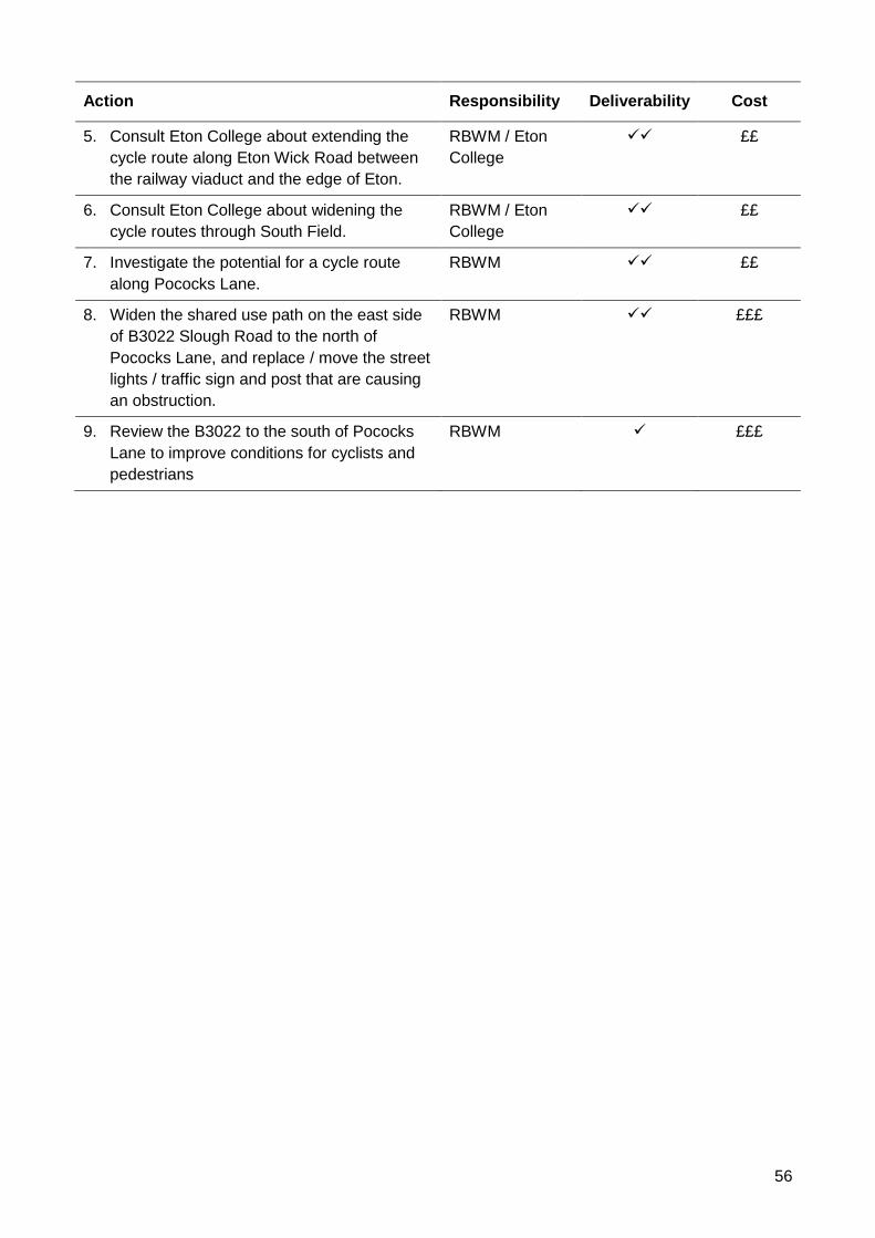
56
Action Responsibility Deliverability Cost
5. Consult Eton College about extending the
cycle route along Eton Wick Road between
the railway viaduct and the edge of Eton.
RBWM / Eton
College
✓✓ ££
6. Consult Eton College about widening the
cycle routes through South Field.
RBWM / Eton
College
✓✓ ££
7. Investigate the potential for a cycle route
along Pococks Lane.
RBWM ✓✓ ££
8. Widen the shared use path on the east side
of B3022 Slough Road to the north of
Pococks Lane, and replace / move the street
lights / traffic sign and post that are causing
an obstruction.
RBWM
✓✓ £££
9. Review the B3022 to the south of Pococks
Lane to improve conditions for cyclists and
pedestrians
RBWM
✓ £££
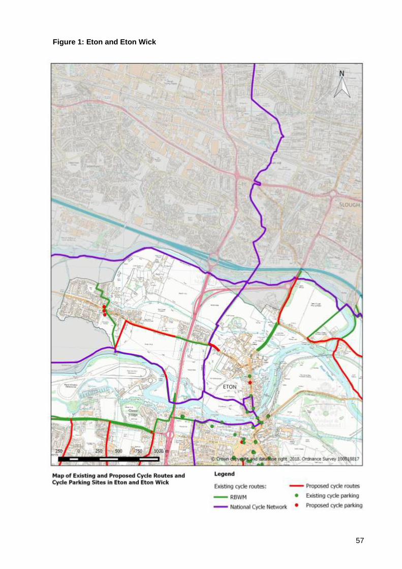
57
Figure 1: Eton and Eton Wick
58
Appendix 6: Area Profile - Horton & Wraysbury
1. Description of the Area
The parishes of Horton and Wraysbury are located at the eastern end of the Royal Borough on the
north side of the River Thames. They include the villages of Horton, Wraysbury and Hythe End.
The area has two rail stations – Sunnymeads and Wraysbury - which lie on the Windsor to London
Waterloo railway line.
2. Local Destinations
The following have been identified as the main cycling destinations within the local area:
Community:
• Wraysbury Club
• Wraysbury Container Library
• Wraysbury Village Halls
Education:
• Wraysbury Primary School
Employment:
• Horton Trading Estate / Horton Depot
• Wraysbury Village Centre
Leisure:
• Ankerwycke
Shopping:
• Wraysbury Village Centre
Transport:
• Sunnymeads Station
• Wraysbury Station
Cross-boundary links are important for these communities – Slough and Langley lie to the north,
Heathrow Airport to the east and Staines-Upon-Thames lies immediately to the south. These are
important destinations for commuting, education and shopping trips. Links to Windsor are also
considered to be important.
3. Existing Cycling Activity and Potential for Growth
The Propensity to Cycle Tool (www.pct.bike) has been used to model existing cycle commuter
flows based on 2011 Census data. It has also been used to identify routes that are likely to
experience the highest levels of growth in cycling activity under the ‘Government Target’ scenario,
which looks at what would happen if cycling levels were to double.
2011 Baseline:
• The PCT mapping shows that all roads have fewer than 50 commuter cycle trips per day,
with the exception of the A30 southbound which runs parallel to the M25, which has
between 50 and 99 trips per day.
59
Government Target Scenario:
• The PCT shows that the number of daily commuter cycle trips would increase to between
100 and 249 on the following routes:
o A30 southbound
o B376 Staines Road
• The PCT also shows that the number of daily commuter cycle trips would increase to
between 50 and 99 movements per day on the following roads:
o A30 northbound
o B376 Welley Road
o B376 Wraysbury Road
Strava Heat Maps provide some indication as to cycling levels. Strava smart phone apps tend to
be used by sports cyclists rather than utility cyclists, so the results are not necessarily
representative of everyday cycling activity.
Notwithstanding these caveats, the heat maps show that there are a number of routes that are
currently well-used by cyclists, including:
• B376 Welley Road / Staines Road / Wraysbury Road
• Coppermill Road
• Datchet Road
• High Street
• Horton Road
• Stanwell Road
• Station Road
4. Existing Cycling Infrastructure
There are no sections of the National Cycle Network that pass through the area.
There is a cycle track that runs along the eastern edge of Horton Road for nearly 1km.
Horton Bridleway 4 runs parallel to Horton Road between Drift Way in Colnbrook and Foundry
Lane in Horton.
Public cycle parking has been provided at the following locations:
• Wraysbury Station
• Wraysbury Village Halls
Horton village centre is traffic calmed with speed cushions and full-width humps and is subject to a
30 mph speed limit.
Wraysbury village centre is traffic calmed with speed cushions and full-width humps and is subject
to a 20 mph speed limit.
5. Key Issues
The following issues have been identified from a desktop audit, site visits and previous
correspondence:
• Cycle links within the area and to adjacent areas are poor.
• None of the destinations identified in Section 2 are served by the current cycle route network.
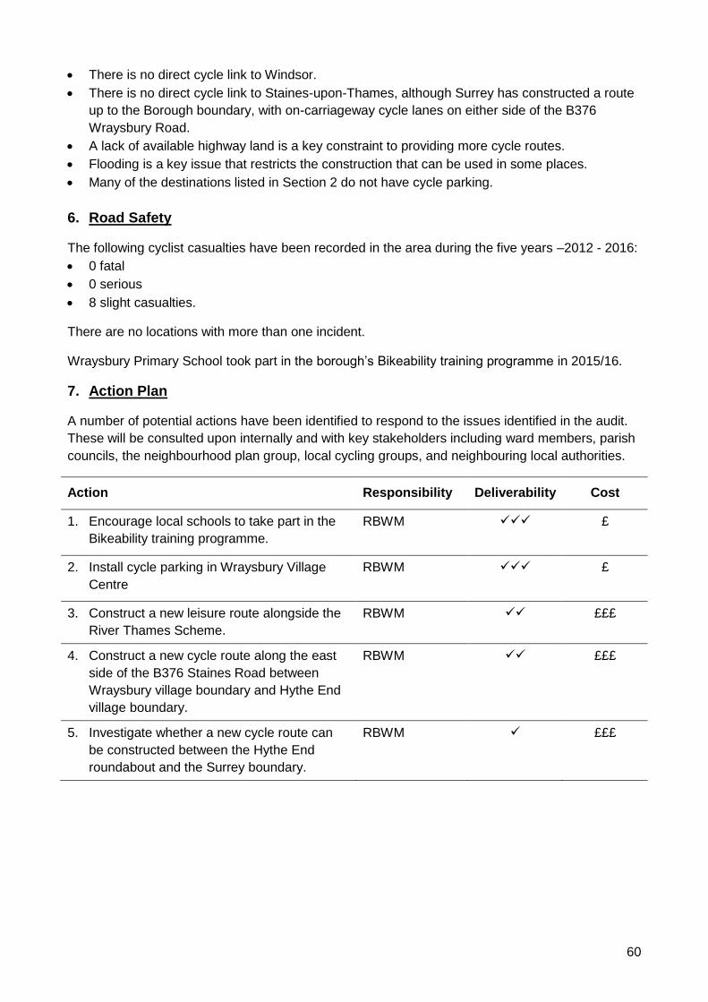
60
• There is no direct cycle link to Windsor.
• There is no direct cycle link to Staines-upon-Thames, although Surrey has constructed a route
up to the Borough boundary, with on-carriageway cycle lanes on either side of the B376
Wraysbury Road.
• A lack of available highway land is a key constraint to providing more cycle routes.
• Flooding is a key issue that restricts the construction that can be used in some places.
• Many of the destinations listed in Section 2 do not have cycle parking.
6. Road Safety
The following cyclist casualties have been recorded in the area during the five years –2012 - 2016:
• 0 fatal
• 0 serious
• 8 slight casualties.
There are no locations with more than one incident.
Wraysbury Primary School took part in the borough’s Bikeability training programme in 2015/16.
7. Action Plan
A number of potential actions have been identified to respond to the issues identified in the audit.
These will be consulted upon internally and with key stakeholders including ward members, parish
councils, the neighbourhood plan group, local cycling groups, and neighbouring local authorities.
Action Responsibility Deliverability Cost
1. Encourage local schools to take part in the
Bikeability training programme.
RBWM
✓✓✓ £
2. Install cycle parking in Wraysbury Village
Centre
RBWM
✓✓✓ £
3. Construct a new leisure route alongside the
River Thames Scheme.
RBWM ✓✓ £££
4. Construct a new cycle route along the east
side of the B376 Staines Road between
Wraysbury village boundary and Hythe End
village boundary.
RBWM
✓✓ £££
5. Investigate whether a new cycle route can
be constructed between the Hythe End
roundabout and the Surrey boundary.
RBWM
✓ £££

61
Figure 1: Horton and Wraysbury
62
Appendix 7: Area Profile - Hurley and the Walthams
1. Description of the Area
Comprising the western parishes of the Royal Borough (Hurley, Waltham St Lawrence,
Shottesbrooke and White Waltham), this area is predominantly rural in nature, incorporating the
settlements of Hurley, Burchett’s Green (part), Warren Row, Knowl Hill, Littlewick Green,
Woodlands Park, White Waltham, Waltham St Lawrence and Shurlock Row, and Paley Street
(part).
2. Local Destinations
The following have been identified as the main cycling destinations within the local area:
Community:
• Knowl Hill Village Hall
• Neville Hall
• Woodlands Park Container Library
• Woodlands Park Village Centre
Education:
• Berkshire College of Agriculture (BCA)
• Burchett’s Green CE Infant School
• Knowl Hill CE Primary School
• Waltham St Lawrence Primary School
• White Waltham C of E Academy
• Woodlands Park Primary School
Employment:
• Grove Park, White Waltham
• Horizon, Hurley
• Maidenhead Office Park, Littlewick Green
• White Waltham Airfield
Leisure
• Knowl Hill Bridleway Circuit
• River Thames
• Waltham Place
Shopping:
• Woodlands Park district centre
Cross-boundary links are important for communities in the west of the borough, since in many
cases they are closer to Twyford, Henley or Marlow than they are to Maidenhead.
Since there are no secondary schools in the area, pupils must travel to schools in Maidenhead or
The Piggott, which is located between Twyford and Wargave.
63
3. Existing Cycling Activity and Potential for Growth
The Propensity to Cycle Tool (www.pct.bike) has been used to model existing cycle commuter
flows based on 2011 Census data. It has also been used to identify routes that are likely to
experience the highest levels of growth in cycling activity under the ‘Government Target’ scenario,
which looks at what would happen if cycling levels were to double.
2011 Baseline:
• The PCT mapping shows that all roads carry fewer than 50 commuter cycle trips per day,
with the exception of a short section of Waltham Road in Woodlands Park.
Government Target Scenario:
• The PCT shows between 250 and 499 commuter cycle trips on the northernmost section of
Waltham Road.
• The PCT shows that the following routes would carry between 100 and 249 commuter cycle
trips:
o A4 east of Burchetts Green Lane
o A4 between Bottle Lane and Warren Row Road
o Waltham Road / B3024 Broadmoor Road between Woodlands Park and Waltham St
Lawrence
o B3024 Littlefield Green
o Howe Lane
• A number of roads are shown to carry between 50 and 99 cycle commuter trips:
o All other sections of the A4
o B3024 Twyford Road
o Church Hill
o Paley Street
o Sill Bridge Lane
Strava Heat Maps provide some indication as to cycling levels. Strava smart phone apps tend to
be used by sports cyclists rather than utility cyclists, so the results are not necessarily
representative of everyday cycling activity.
Notwithstanding these caveats, the heat maps show that there are a number of routes that are
currently well-used by cyclists, including all of the A and B roads:
• A4 Bath Road
• A4130 Henley Road
• B3010 Straight Mile / Twyford Road
• B3024 Broadmoor Road / Hurst Road
Minor roads that are well used include:
• Temple Lane
• Bradenham Lane
• Hurley Lane
• Honey Lane
• Burchett’s Green Road
• Warren Road Road
• Bottle Lane / Butchers Lane
• Waltham Road
64
• Milley Road
• School Road / Plough Lane / West End Lane
• Shurlock Road / The Street / Beenhams Heath
• Smewins Road
• Hungerford Lane
4. Existing Cycling Infrastructure
The area is crossed by NCN4, which is a long-distance cycle route between London and
Fishguard, via Reading, Bath, Bristol, Swansea, Carmarthen, Tenby, Haverfordwest and St
David’s. It also forms part of the London to Land’s End long-distance cycle route that is popular
with British and European cycle tourers.
NCN4 also provides local links between Knowl Hill, Littlewick Green and Woodlands Park, with
links to Maidenhead Office Park. It also provides onward connections to Maidenhead and Windsor
in the east and Wargrave and Twyford in the west. The route mostly follows quiet roads and
surfaced public rights of way, but the section between the borough boundary and Wargrave follows
an unsurfaced bridleway and is only suitable for use by mountain bikes and hybrids. Also, the
connection to Twyford is very indirect.
There is a signed quiet route between Hurley and Pinkney’s Green, which uses Hurley Lane,
Dungrove Hill Lane and Lee Lane, crossing the A404 via an underpass. However, there is a
missing link between the western end of Hurley Lane and Hurley High Street.
The Knowl Hill Bridleway Circuit provides a recreational route via existing public rights of way,
linking Knowl Hill, Warren Row, Burchett’s Green, Littlewick Green, White Waltham and Waltham
St Lawrence. However, this circuit is predominantly aimed at equestrians and uses some
unsurfaced bridleways that may be muddy or uneven in places and may be unsuitable for some
bikes. There are other bridleways and byways that are available to cyclists, but these have similar
issues to those mentioned above.
Public cycle parking has been provided at the following locations:
• Hurley car park
• Woodlands Park Village Centre
Few of the destinations identified in Section 2 are served by the current cycle route network.
However, Burchett’s Green Road is traffic calmed and subject to a 20 mph speed limit and
Waltham Road is subject to an advisory 20 mph speed limit at the start and end of the school day.
An advisory 20 mph speed limit is proposed for Woodlands Park Primary School. An advisory 20
mph speed limit was previously proposed for Waltham St Lawrence Primary School, but the
scheme was dropped following local consultation.
5. Key Issues
The following issues have been identified from a desktop audit and previous correspondence:
• Although there are some pleasant, quiet lanes in the area, there are few dedicated cycle
routes, which deters many people from cycling for local journeys.
• Many local lanes are used as cut-throughs by motorists during peak periods. This makes them
unattractive for commuter cycling.
• Cross-boundary cycling links are poor.
65
• The area is crossed by a number of main roads, including the A4, A404 and A4130, which are
heavily trafficked and difficult to cross, presenting major barriers to cycling.
• There is some demand for commuter cycle routes along the A4 to cater for inter-urban
commuters.
• There are often significant numbers of bikes parked at Grove Park, suggesting that this is a key
destination for cyclists.
• Very few children / young people currently cycle to school / college due to the lack of protected
cycle routes.
• NCN4 is very narrow between Knowl Hill Common and Star Lane, and is constrained by
protected trees.
• Although NCN4 is waymarked, there is no destination signing at key junctions.
• NCN4 is not suitable for use by road bikes due to surfacing issues in some locations.
• Despite not being permitted, cycling on the Thames Path and parallel public footpaths is
commonplace.
• There is no cycle parking serving the shops within Woodlands Park district centre.
• A lack of available highway land is a key constraint to providing more cycle routes.
• Previous attempts to introduce cycle routes in the area have been unsuccessful due to
objections from parish councils and local landowners.
• There are no cycle bypasses for the traffic calming on Burchett’s Green Road and the condition
of humps is poor.
• Some bridleways and byways are unsurfaced and are therefore unsuited to utility cycling trips.
• The small size of local communities and the low numbers of cyclists make it hard to achieve
high cost benefit ratios for major cycling investment in the area.
• There are few major developments planned for the area that will provide / fund new cycle
facilities.
6. Road Safety
The following cyclist casualties have been recorded in the area during the five years –2012 - 2016:
• 0 fatal
• 5 serious
• 10 slight casualties.
Locations with more than one casualty include :.
• A4 Bath Road / Burchetts Green Road (2 slight casualties)
• B3024 Littlefield Green / Church Hill (1 serious and 1 slight casualty)
None of the local schools took part in Bikeability in 2016/17.
7. Action Plan
A number of potential actions have been identified to respond to the issues identified in the audit.
These will be consulted upon internally and with key stakeholders including ward members, parish
councils, the neighbourhood plan group, local cycling groups, and neighbouring local authorities.
Action Responsibility Deliverability Cost
1. Encourage local schools to take part in the
Bikeability training programme.
RBWM
✓✓✓ £
66
Action Responsibility Deliverability Cost
2. Improve direction signing on NCN4,
incorporating destination signs at key
junctions.
RBWM
✓✓✓ £
3. Investigate the potential to upgrade the
surface on NCN4.
RBWM ✓✓ ££
4. Offer to install cycle parking at Woodlands
Park shops.
RBWM
✓✓ £
5. Liaise with landowners regarding the potential
for cycle access between Hurley and Bisham
along Temple Lane
RBWM
✓✓ ££
6. Construct a new cycle route between Grove
Park and Woodlands Park, with onward
connections to Cox Green and Maidenhead.
RBWM
✓✓ £££
7. Investigate the potential for a new cycle route
between BCA and Maidenhead.
RBWM
✓ £££
8. Consult with local landowners regarding the
potential for a new cycle link to White
Waltham Primary via the airfield service road
/ a new route along the perimeter.
RBWM
✓ £££
9. Work with Wokingham Borough Council to
investigate the feasibility of constructing a
cycle route alongside the A4 Bath Road
between Twyford and Maidenhead.
RBWM
✓ £££
10. Liaise with landowners regarding the missing
section of cycle route between Hurley Lane
and Hurley High Street.
RBWM
✓ £££
11. Liaise with Wokingham Borough Council
regarding upgrading Waltham St Lawrence
Footpath 9 / Ruscombe Footpath 4 to improve
links to Twyford.
RBWM
✓ £££
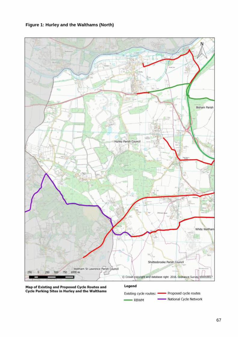
67
Figure 1: Hurley and the Walthams (North)
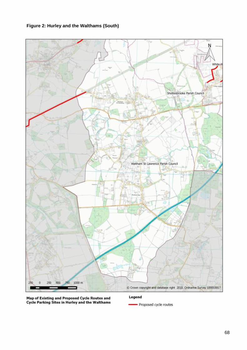
68
Figure 2: Hurley and the Walthams (South)
69
Appendix 8: Area Profile - Maidenhead and Cox Green
8. Description of the Area
The Maidenhead and Cox Green area includes the following wards: Riverside; Furze Platt;
Pinkneys Green; Belmont; Boyn Hill; Oldfield; and Cox Green. The area is bounded by: the River
Thames to the east; Bisham and Cookham to the north; Hurley and Walthams to the west; and
Bray to the south.
9. Local Destinations
The following have been identified as the main cycling destinations within the local area:
Community:
• 4 Marlow Road
• Boyn Grove Library
• Cox Green Library
• Cox Green Leisure Centre / Youth and Community Centre
• Furze Platt Container Library
• Larchfield Community Centre
• Maidenhead Heritage Centre
• Maidenhead Library
• Pinkneys Green Youth and Community Centre
• St Luke’s Community Hall
• Town Hall
Education:
• All Saints CE Junior School
• Altwood C of E School
• Alwyn Infants School
• Boyne Hill Infants School
• Braywick Court School
• Claires Court School (College Avenue)
• Claires Court School (Ray Mill Road East)
• Courthouse Junior School
• Cox Green School
• Desborough College
• Forest Bridge School
• Furze Platt Infants and Junior Schools
• Furze Platt Senior School
• Highfield School
• Larchfield Primary School
• Lowbrook Primary School
• Manor Green School
• Newlands Girls’ School
• Oldfield Primary School
• Redroofs Theatre School
• Riverside Primary School
70
• St Edmund Campion Catholic Primary School
• St Luke’s C of E School
• St Mary’s Catholic Primary School
• St Piran’s School
• Wessex Infant and Junior School
Employment:
• Boyn Valley Industrial Estate
• Concorde Park / Norreys Drive
• Cordwallis Business Park
• Foundation Park
• Furze Platt Business Centre Park
• Howarth Road Business Park
• Maidenhead Town Centre
• Oldfield Road / Reform Road Industrial Estate
• Stafferton Way Retail Park
• Vanwall Business Park
• Whitebrook Park
Leisure:
• Braywick Sports and Recreation Ground
• Cox Green Leisure Centre
• Furze Platt Leisure Centre
• Grenfell Park
• Ivy Leaf Club
• Kidwells Park
• Magnet Leisure Centre
• Maidenhead Lawn Tennis Club
• Maidenhead United Football Club
• North Town Moor
• Ockwells Park
• Oaken Grove Park
• Ray Mill Island / Boulters Lock
• Riverside Gardens
• Tenpin
• Town Moor
Shopping:
• A4 Bridge Road Shops
• Cookham Road Shops
• Highway Avenue Shops
• Lidl Superstore
• Maidenhead Town Centre
• Sainsbury’s Superstore
• Stafferton Way Retail Park
• Switchback Road Shops
• Wessex Way Shops
• Wootton Way Shops
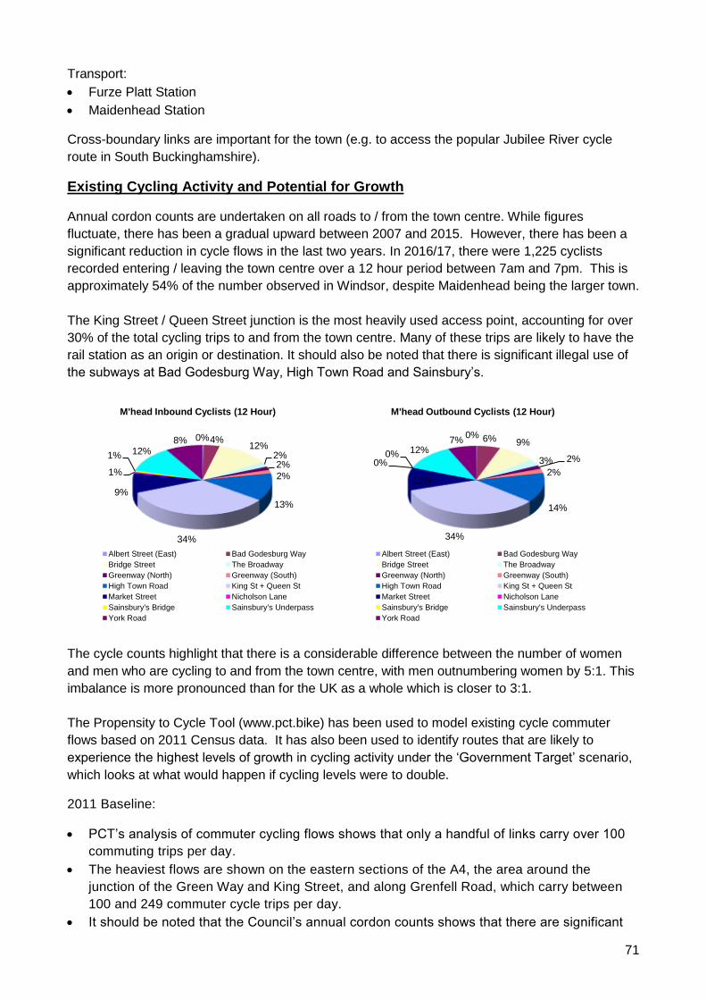
71
Transport:
• Furze Platt Station
• Maidenhead Station
Cross-boundary links are important for the town (e.g. to access the popular Jubilee River cycle
route in South Buckinghamshire).
Existing Cycling Activity and Potential for Growth
Annual cordon counts are undertaken on all roads to / from the town centre. While figures
fluctuate, there has been a gradual upward between 2007 and 2015. However, there has been a
significant reduction in cycle flows in the last two years. In 2016/17, there were 1,225 cyclists
recorded entering / leaving the town centre over a 12 hour period between 7am and 7pm. This is
approximately 54% of the number observed in Windsor, despite Maidenhead being the larger town.
The King Street / Queen Street junction is the most heavily used access point, accounting for over
30% of the total cycling trips to and from the town centre. Many of these trips are likely to have the
rail station as an origin or destination. It should also be noted that there is significant illegal use of
the subways at Bad Godesburg Way, High Town Road and Sainsbury’s.
The cycle counts highlight that there is a considerable difference between the number of women
and men who are cycling to and from the town centre, with men outnumbering women by 5:1. This
imbalance is more pronounced than for the UK as a whole which is closer to 3:1.
The Propensity to Cycle Tool (www.pct.bike) has been used to model existing cycle commuter
flows based on 2011 Census data. It has also been used to identify routes that are likely to
experience the highest levels of growth in cycling activity under the ‘Government Target’ scenario,
which looks at what would happen if cycling levels were to double.
2011 Baseline:
• PCT’s analysis of commuter cycling flows shows that only a handful of links carry over 100
commuting trips per day.
• The heaviest flows are shown on the eastern sections of the A4, the area around the
junction of the Green Way and King Street, and along Grenfell Road, which carry between
100 and 249 commuter cycle trips per day.
• It should be noted that the Council’s annual cordon counts shows that there are significant
0%4%12%
2%2%
2%
13%
34%
9%
1%
1% 12%8%
M'head Inbound Cyclists (12 Hour)
Albert Street (East) Bad Godesburg Way
Bridge Street The Broadway
Greenway (North) Greenway (South)
High Town Road King St + Queen St
Market Street Nicholson Lane
Sainsbury's Bridge Sainsbury's Underpass
York Road
0% 6% 9%
3% 2%
2%
14%
34%
11%
0%0% 12%
7%
M'head Outbound Cyclists (12 Hour)
Albert Street (East) Bad Godesburg Way
Bridge Street The Broadway
Greenway (North) Greenway (South)
High Town Road King St + Queen St
Market Street Nicholson Lane
Sainsbury's Bridge Sainsbury's Underpass
York Road
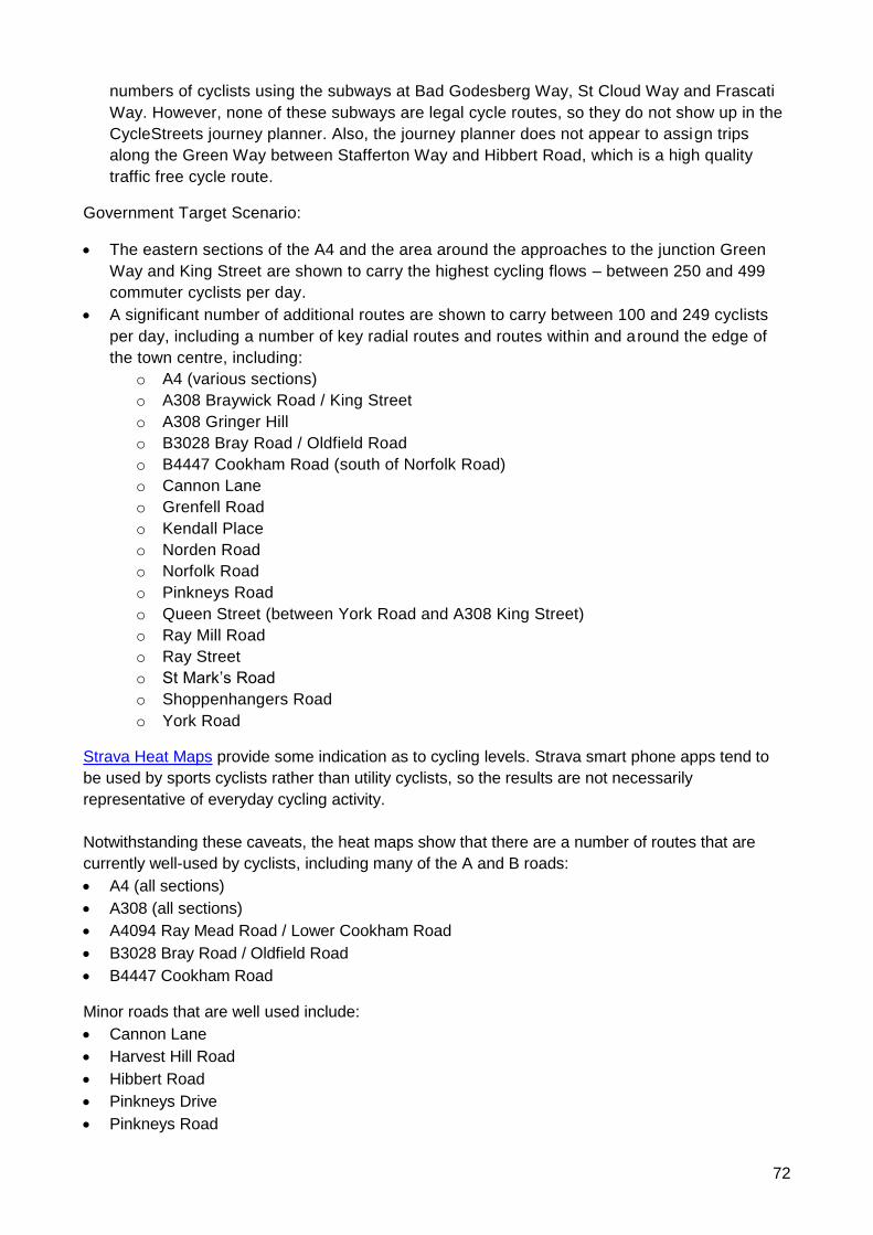
72
numbers of cyclists using the subways at Bad Godesberg Way, St Cloud Way and Frascati
Way. However, none of these subways are legal cycle routes, so they do not show up in the
CycleStreets journey planner. Also, the journey planner does not appear to assign trips
along the Green Way between Stafferton Way and Hibbert Road, which is a high quality
traffic free cycle route.
Government Target Scenario:
• The eastern sections of the A4 and the area around the approaches to the junction Green
Way and King Street are shown to carry the highest cycling flows – between 250 and 499
commuter cyclists per day.
• A significant number of additional routes are shown to carry between 100 and 249 cyclists
per day, including a number of key radial routes and routes within and around the edge of
the town centre, including:
o A4 (various sections)
o A308 Braywick Road / King Street
o A308 Gringer Hill
o B3028 Bray Road / Oldfield Road
o B4447 Cookham Road (south of Norfolk Road)
o Cannon Lane
o Grenfell Road
o Kendall Place
o Norden Road
o Norfolk Road
o Pinkneys Road
o Queen Street (between York Road and A308 King Street)
o Ray Mill Road
o Ray Street
o St Mark’s Road
o Shoppenhangers Road
o York Road
Strava Heat Maps provide some indication as to cycling levels. Strava smart phone apps tend to
be used by sports cyclists rather than utility cyclists, so the results are not necessarily
representative of everyday cycling activity.
Notwithstanding these caveats, the heat maps show that there are a number of routes that are
currently well-used by cyclists, including many of the A and B roads:
• A4 (all sections)
• A308 (all sections)
• A4094 Ray Mead Road / Lower Cookham Road
• B3028 Bray Road / Oldfield Road
• B4447 Cookham Road
Minor roads that are well used include:
• Cannon Lane
• Harvest Hill Road
• Hibbert Road
• Pinkneys Drive
• Pinkneys Road
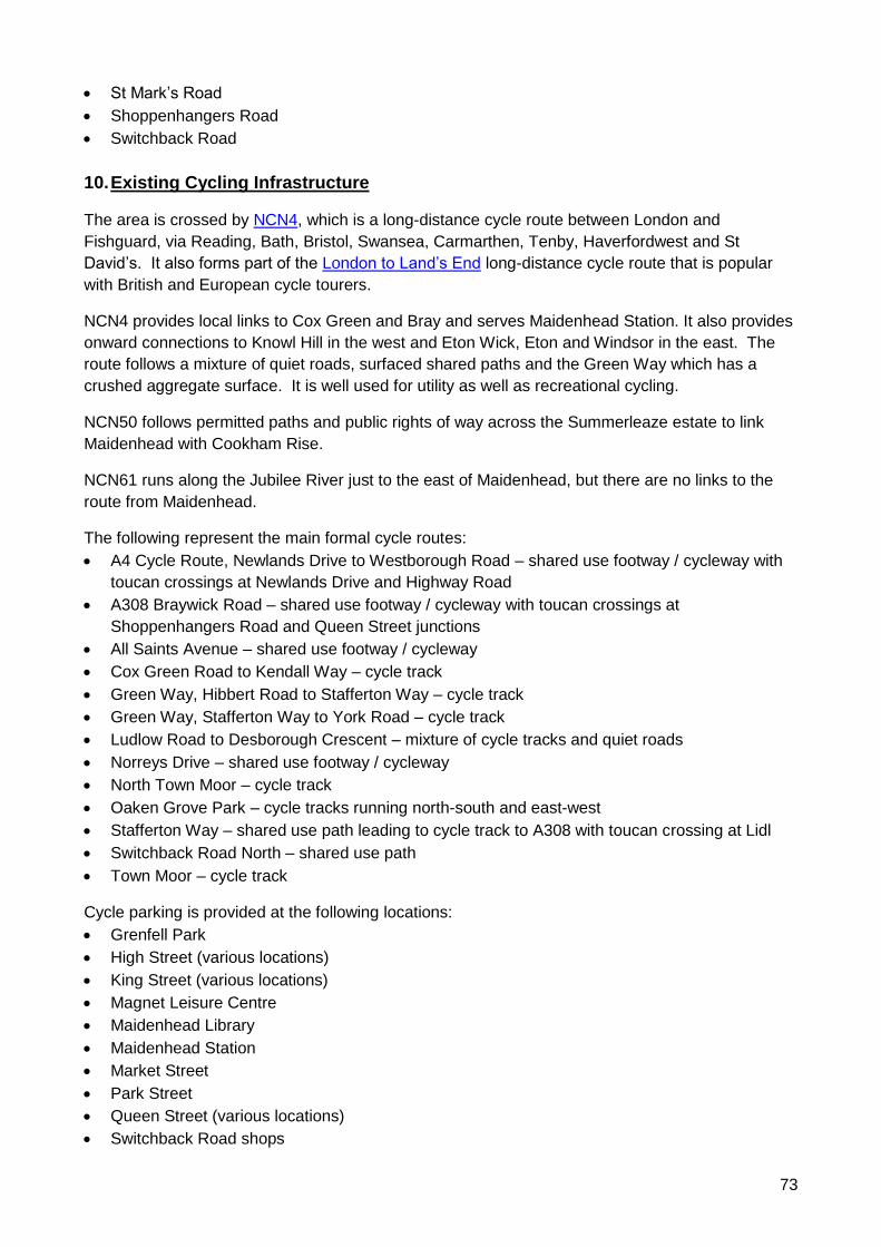
73
• St Mark’s Road
• Shoppenhangers Road
• Switchback Road
10. Existing Cycling Infrastructure
The area is crossed by NCN4, which is a long-distance cycle route between London and
Fishguard, via Reading, Bath, Bristol, Swansea, Carmarthen, Tenby, Haverfordwest and St
David’s. It also forms part of the London to Land’s End long-distance cycle route that is popular
with British and European cycle tourers.
NCN4 provides local links to Cox Green and Bray and serves Maidenhead Station. It also provides
onward connections to Knowl Hill in the west and Eton Wick, Eton and Windsor in the east. The
route follows a mixture of quiet roads, surfaced shared paths and the Green Way which has a
crushed aggregate surface. It is well used for utility as well as recreational cycling.
NCN50 follows permitted paths and public rights of way across the Summerleaze estate to link
Maidenhead with Cookham Rise.
NCN61 runs along the Jubilee River just to the east of Maidenhead, but there are no links to the
route from Maidenhead.
The following represent the main formal cycle routes:
• A4 Cycle Route, Newlands Drive to Westborough Road – shared use footway / cycleway with
toucan crossings at Newlands Drive and Highway Road
• A308 Braywick Road – shared use footway / cycleway with toucan crossings at
Shoppenhangers Road and Queen Street junctions
• All Saints Avenue – shared use footway / cycleway
• Cox Green Road to Kendall Way – cycle track
• Green Way, Hibbert Road to Stafferton Way – cycle track
• Green Way, Stafferton Way to York Road – cycle track
• Ludlow Road to Desborough Crescent – mixture of cycle tracks and quiet roads
• Norreys Drive – shared use footway / cycleway
• North Town Moor – cycle track
• Oaken Grove Park – cycle tracks running north-south and east-west
• Stafferton Way – shared use path leading to cycle track to A308 with toucan crossing at Lidl
• Switchback Road North – shared use path
• Town Moor – cycle track
Cycle parking is provided at the following locations:
• Grenfell Park
• High Street (various locations)
• King Street (various locations)
• Magnet Leisure Centre
• Maidenhead Library
• Maidenhead Station
• Market Street
• Park Street
• Queen Street (various locations)
• Switchback Road shops
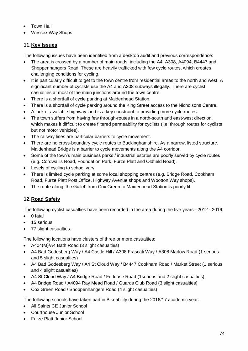
74
• Town Hall
• Wessex Way Shops
11. Key Issues
The following issues have been identified from a desktop audit and previous correspondence:
• The area is crossed by a number of main roads, including the A4, A308, A4094, B4447 and
Shoppenhangers Road. These are heavily trafficked with few cycle routes, which creates
challenging conditions for cycling.
• It is particularly difficult to get to the town centre from residential areas to the north and west. A
significant number of cyclists use the A4 and A308 subways illegally. There are cyclist
casualties at most of the main junctions around the town centre.
• There is a shortfall of cycle parking at Maidenhead Station.
• There is a shortfall of cycle parking around the King Street access to the Nicholsons Centre.
• A lack of available highway land is a key constraint to providing more cycle routes.
• The town suffers from having few through-routes in a north-south and east-west direction,
which makes it difficult to create filtered permeability for cyclists (i.e. through routes for cyclists
but not motor vehicles).
• The railway lines are particular barriers to cycle movement.
• There are no cross-boundary cycle routes to Buckinghamshire. As a narrow, listed structure,
Maidenhead Bridge is a barrier to cycle movements along the A4 corridor.
• Some of the town’s main business parks / industrial estates are poorly served by cycle routes
(e.g. Cordwallis Road, Foundation Park, Furze Platt and Oldfield Road).
• Levels of cycling to school vary.
• There is limited cycle parking at some local shopping centres (e.g. Bridge Road, Cookham
Road, Furze Platt Post Office, Highway Avenue shops and Wootton Way shops).
• The route along ‘the Gullet’ from Cox Green to Maidenhead Station is poorly lit.
12. Road Safety
The following cyclist casualties have been recorded in the area during the five years –2012 - 2016:
• 0 fatal
• 15 serious
• 77 slight casualties.
The following locations have clusters of three or more casualties:
• A404(M)/A4 Bath Road (3 slight casualties)
• A4 Bad Godesberg Way / A4 Castle Hill / A308 Frascati Way / A308 Marlow Road (1 serious
and 5 slight casualties)
• A4 Bad Godesberg Way / A4 St Cloud Way / B4447 Cookham Road / Market Street (1 serious
and 4 slight casualties)
• A4 St Cloud Way / A4 Bridge Road / Forlease Road (1serious and 2 slight casualties)
• A4 Bridge Road / A4094 Ray Mead Road / Guards Club Road (3 slight casualties)
• Cox Green Road / Shoppenhangers Road (4 slight casualties)
The following schools have taken part in Bikeability during the 2016/17 academic year:
• All Saints CE Junior School
• Courthouse Junior School
• Furze Platt Junior School
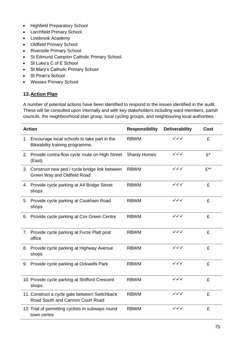
75
• Highfield Preparatory School
• Larchfield Primary School
• Lowbrook Academy
• Oldfield Primary School
• Riverside Primary School
• St Edmund Campion Catholic Primary School
• St Luke’s C of E School
• St Mary’s Catholic Primary School
• St Piran’s School
• Wessex Primary School
13. Action Plan
A number of potential actions have been identified to respond to the issues identified in the audit.
These will be consulted upon internally and with key stakeholders including ward members, parish
councils, the neighbourhood plan group, local cycling groups, and neighbouring local authorities.
Action Responsibility Deliverability Cost
1. Encourage local schools to take part in the
Bikeability training programme.
RBWM
✓✓✓ £
2. Provide contra-flow cycle route on High Street
(East)
Shanly Homes ✓✓✓ £*
3. Construct new ped / cycle bridge link between
Green Way and Oldfield Road
RBWM
✓✓✓ £**
4. Provide cycle parking at A4 Bridge Street
shops
RBWM
✓✓✓ £
5. Provide cycle parking at Cookham Road
shops
RBWM
✓✓✓ £
6. Provide cycle parking at Cox Green Centre RBWM
✓✓✓ £
7. Provide cycle parking at Furze Platt post
office
RBWM
✓✓✓ £
8. Provide cycle parking at Highway Avenue
shops
RBWM
✓✓✓ £
9. Provide cycle parking at Ockwells Park RBWM
✓✓✓ £
10. Provide cycle parking at Shifford Crescent
shops
RBWM ✓✓✓ £
11. Construct a cycle gate between Switchback
Road South and Cannon Court Road
RBWM ✓✓✓ £
12. Trial of permitting cyclists in subways round
town centre
RBWM ✓✓✓ £
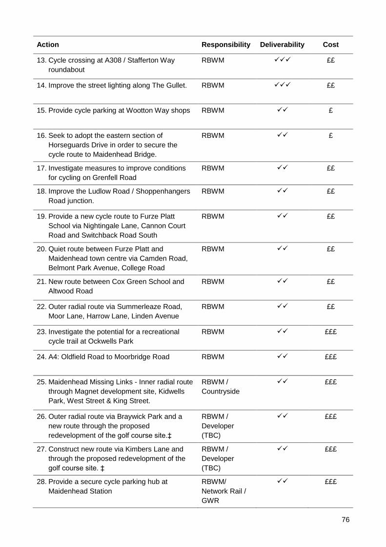
76
Action Responsibility Deliverability Cost
13. Cycle crossing at A308 / Stafferton Way
roundabout
RBWM
✓✓✓ ££
14. Improve the street lighting along The Gullet. RBWM
✓✓✓ ££
15. Provide cycle parking at Wootton Way shops RBWM
✓✓ £
16. Seek to adopt the eastern section of
Horseguards Drive in order to secure the
cycle route to Maidenhead Bridge.
RBWM
✓✓ £
17. Investigate measures to improve conditions
for cycling on Grenfell Road
RBWM ✓✓ ££
18. Improve the Ludlow Road / Shoppenhangers
Road junction.
RBWM
✓✓ ££
19. Provide a new cycle route to Furze Platt
School via Nightingale Lane, Cannon Court
Road and Switchback Road South
RBWM
✓✓ ££
20. Quiet route between Furze Platt and
Maidenhead town centre via Camden Road,
Belmont Park Avenue, College Road
RBWM ✓✓ ££
21. New route between Cox Green School and
Altwood Road
RBWM
✓✓ ££
22. Outer radial route via Summerleaze Road,
Moor Lane, Harrow Lane, Linden Avenue
RBWM
✓✓ ££
23. Investigate the potential for a recreational
cycle trail at Ockwells Park
RBWM
✓✓ £££
24. A4: Oldfield Road to Moorbridge Road RBWM
✓✓ £££
25. Maidenhead Missing Links - Inner radial route
through Magnet development site, Kidwells
Park, West Street & King Street.
RBWM /
Countryside
✓✓ £££
26. Outer radial route via Braywick Park and a
new route through the proposed
redevelopment of the golf course site.‡
RBWM /
Developer
(TBC)
✓✓ £££
27. Construct new route via Kimbers Lane and
through the proposed redevelopment of the
golf course site. ‡
RBWM /
Developer
(TBC)
✓✓ £££
28. Provide a secure cycle parking hub at
Maidenhead Station
RBWM/
Network Rail /
GWR
✓✓ £££
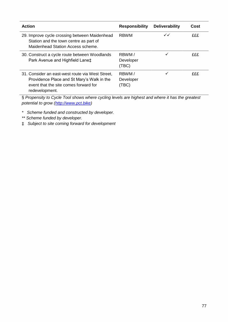
77
Action Responsibility Deliverability Cost
29. Improve cycle crossing between Maidenhead
Station and the town centre as part of
Maidenhead Station Access scheme.
RBWM ✓✓ £££
30. Construct a cycle route between Woodlands
Park Avenue and Highfield Lane‡
RBWM /
Developer
(TBC)
✓ £££
31. Consider an east-west route via West Street,
Providence Place and St Mary’s Walk in the
event that the site comes forward for
redevelopment.
RBWM /
Developer
(TBC)
✓ £££
§ Propensity to Cycle Tool shows where cycling levels are highest and where it has the greatest
potential to grow (http://www.pct.bike)
* Scheme funded and constructed by developer.
** Scheme funded by developer.
‡ Subject to site coming forward for development
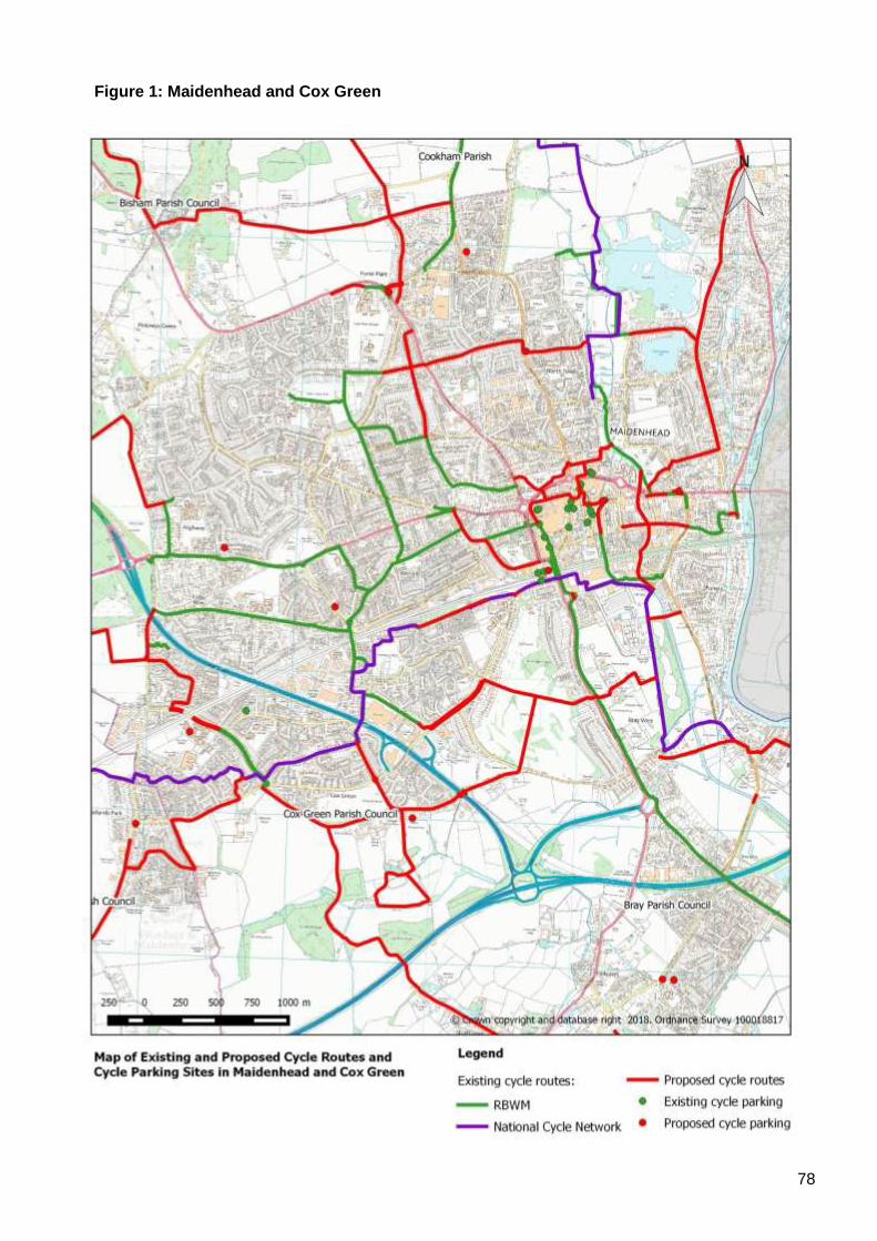
78
Figure 1: Maidenhead and Cox Green
79
Appendix 9: Area Profile - Old Windsor
1. Description of the Area
The Old Windsor ward covers the area between Windsor and Ascot, Sunninghill and Sunningdale.
The area is dominated by Windsor Great Park and the only settlement of note is Old Windsor itself.
The area is bounded by the River Thames to the east, Bracknell Forest to the west and Surrey to
the south.
2. Local Destinations
The following have been identified as the main cycling destinations in and around the local area:
Community:
• Old Windsor Library
• Old Windsor Memorial Hall
• Old Windsor Club
• Old Windsor Hub
Education:
• King’s Court First School
• St Peter’s C of E Middle School
• The Royal School
Employment:
• N/A
Leisure
• Smith’s Lawn
• Savill Gardens
Shopping:
• St Luke’s Road district centre
• Old Friary Post Office, Old Windsor
• Windsor Great Park Post Office and Shop
Cross-boundary links are important for local communities, particularly to Egham and Staines-upon-
Thames which are on the Reading to London Waterloo rail line and are major sources of
employment.
Since there are no secondary schools in the area, pupils must travel to schools in Windsor.
3. Existing Cycling Activity
The Propensity to Cycle Tool (www.pct.bike) has been used to model existing cycle commuter
flows based on 2011 Census data. It has also been used to identify routes that are likely to
experience the highest levels of growth in cycling activity under the ‘Government Target’ scenario,
which looks at what would happen if cycling levels were to double.
80
2011 Baseline:
• The PCT mapping shows that the A308 Straight Road / Albert Road have the highest
number of cycle commuting trips with between 50 and 99 movements per day.
• All other roads carry fewer than 50 cycle commuter trips per day.
• Existing cycle routes include:
o A shared use path on the north side of A308 Albert Road with a toucan crossing on
the approach to the Straight Road roundabout.
o A cycle gate between St Luke’s Road and Albany Road.
o Various routes through Windsor Great Park, including NCN4, which use traffic free
paths and estate roads to link Windsor to Englefield Green, Cheapside and
Sunningdale, with a toucan crossing at Rangers Gate.
Government Target Scenario:
• The following roads are all shown to carry between 100 and 249 commuter cyc le trips per
day:
o A308 Straight Road / Albert Road
o B3021 Datchet Road / Southlea Road
• The number of commuter cycle trips on Albany Road is shown to increase to between 50
and 99 movements per day.
Strava Heat Maps provide some indication as to cycling levels. Strava smart phone apps tend to
be used by sports cyclists rather than utility cyclists, so the results are not necessarily
representative of everyday cycling activity.
Notwithstanding these caveats, the heat maps show that there are a number of routes that are
currently well-used by cyclists, including all of the A and B roads:
• A308 Albert Road / Straight Road
• A332 Sheet Street Road
• B383 Mounts Hill
• B3021 Burfield Road / St Luke’s Road / Datchet Road
Minor roads that are well used include:
• Albany Road
• Crimp Hill
• Duke’s Lane
• Prince Consort’s Drive
4. Existing Cycling Infrastructure
The area is crossed by NCN4, which is a long-distance cycle route between London and
Fishguard, via Reading, Bath, Bristol, Swansea, Carmarthen, Tenby, Haverfordwest and St
David’s. It also forms part of the London to Land’s End long-distance cycle route that is popular
with British and European cycle tourers.
NCN4 also provides local links to Windsor. It also provides onward connections to Maidenhead in
the west and Egham and Staines in the east. The route mostly follows unmetalled tracks and
estate roads.
81
There is a wide shared-use footway/cycleway alongside the A308 Albert Road, with a toucan
crossing at the eastern end. There is also a cycle contra-flow at the southern end of Albany Road.
There are no known sites with formal public cycle parking within the area.
5. Key Issues
The following issues have been identified from a desktop audit and previous correspondence:
• The area is crossed by a number of main roads, including the A308, A332, B383 and B3021.
These are heavily trafficked and present major barriers to cycling.
• With the exception of NCN4, there are no cross-boundary cycle routes.
• Visitor numbers to the Great Park have increased considerably in recent years, reaching 4
million per year. The area is very popular with cyclists and there is significant conflict between
cyclists and other visitors at weekends and public holidays.
• Very few children / young people currently cycle to school due to the lack of protected cycle
routes.
• The surface of NCN4 between St Leonards Road and Sheet Street Road has been cut up by
equestrians on a number of occasions.
• The Crown Estate does not permit waymarking of NCN4 through the Great Park.
• Cycling is not permitted along the section of the Thames Path in Old Windsor.
• There is no cycle parking serving the St Luke’s Road district centre or the Old Friary Post
Office.
• A lack of available highway land is a key constraint to providing more cycle routes.
• Much of Windsor Great Park is affected by environmental designations, including Special Area
of Conservation and Sites of Special Scientific Interest – these limit the potential for additional
cycle routes.
• Crown Estate owns many of the highway verges alongside public roads through the Great
Park, which restricts where cycle routes can be constructed.
• The small size of local communities and the low numbers of cyclists make it hard to achieve
high cost benefit ratios for major cycling investment in the area.
• There are few major developments planned for the area that will provide / fund new cycle
facilities.
• There are a number of major charity bike rides that pass through the area each year, including
the Palace to Palace and the London to Windsor
6. Road Safety
The following cyclist casualties have been recorded in the area during the five years –2012 - 2016:
• 0 fatal
• 2 serious
• 10 slight casualties.
The main cluster is along A308 Straight Road.
The following schools have taken part in Bikeability during the 2016/17 academic year:
• King’s Court First School
• The Royal School
• St Peter’s Middle School.
82
7. Action Plan
A number of potential actions have been identified to respond to the issues identified in the audit.
These will be consulted upon internally and with key stakeholders including ward members, parish
councils, the neighbourhood plan group, local cycling groups, and neighbouring local authorities.
Action Responsibility Deliverability Cost
1. Encourage local schools to take part in the
Bikeability training programme.
RBWM
✓✓✓ £
2. Improve and sign the cycle contra-flow at the
southern end of Albany Road.
RBWM
✓✓✓ £
3. Install cycle parking at St Luke’s Road district
centre
RBWM
✓✓✓ £
4. Install cycle parking at Old Friary Post Office RBWM
✓✓ £
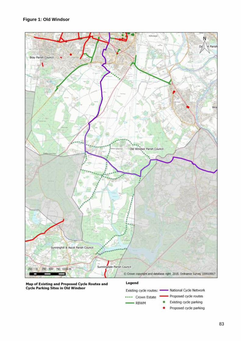
83
Figure 1: Old Windsor
84
Appendix 10: Area Profile - Windsor
1. Description of the Area
The Windsor area includes the following wards: Clewer North; Clewer South; Clewer East; Castle
Without; the southern part of Eton and Castle; and Park. It is bounded by the River Thames to the
north; Datchet to the east; Bray to the west; and Windsor Great Park to the south. It encompasses
both of the Windsor Neighbourhood Plan areas.
2. Local Destinations
The following have been identified as the main cycling destinations within the local area:
Community:
• Clewer Youth and Community Centre
• Dedworth Library
• Gardeners Hall
• Manor Youth and Community Centre
• Windsor Library
• Windsor Youth and Community Centre
Education:
• Brigidine School
• Clewer Green CE First School
• Dedworth Green First School
• Dedworth Middle School
• Hilltop First School
• Homer First School
• Oakfield First School
• St Edward’s Catholic First School
• St Edward’s Royal Free Ecumenical School
• The Queen Anne Royal Free CE First School
• Trevelyan School
• Trinity St Stephens Primary School
• Upton House School
• Windsor Boys’ School
• Windsor Girls’ School
Employment:
• Centrica
• Keeler
• LEGOLAND®
• Tinkers Lane
• Vansittart Industrial Estate
• Windsor Racecourse
• Windsor Town Centre
Leisure
• Alexandra Gardens
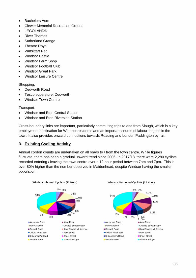
85
• Bachelors Acre
• Clewer Memorial Recreation Ground
• LEGOLAND®
• River Thames
• Sutherland Grange
• Theatre Royal
• Vansittart Rec
• Windsor Castle
• Windsor Farm Shop
• Windsor Football Club
• Windsor Great Park
• Windsor Leisure Centre
Shopping:
• Dedworth Road
• Tesco superstore, Dedworth
• Windsor Town Centre
Transport:
• Windsor and Eton Central Station
• Windsor and Eton Riverside Station
Cross-boundary links are important, particularly commuting trips to and from Slough, which is a key
employment destination for Windsor residents and an important source of labour for jobs in the
town. It also provides onward connections towards Reading and London Paddington by rail.
3. Existing Cycling Activity
Annual cordon counts are undertaken on all roads to / from the town centre. While figures
fluctuate, there has been a gradual upward trend since 2006. In 2017/18, there were 2,280 cyclists
recorded entering / leaving the town centre over a 12 hour period between 7am and 7pm. This is
over 80% higher than the number observed in Maidenhead, despite Windsor having the smaller
population.
4% 3%
14%
0%8%
6%5%
0%
9%
8%9%
34%
Windsor Inbound Cyclists (12 Hour)
Alexandra Road Alma Road
Barry Avenue Charles Street Bridge
Goswell Road King Edward VII Avenue
Oxford Road East Park Street
St Leonard's Road Sheet Street
Victoria Street Windsor Bridge
4% 2%13%
0%
11%
11%
5%0%
5%7%8%
34%
Windsor Outbound Cyclists (12 Hour)
Alexandra Road Alma Road
Barry Avenue Charles Street Bridge
Goswell Road King Edward VII Avenue
Oxford Road East Park Street
St Leonard's Road Sheet Street
Victoria Street Windsor Bridge
86
Windsor Bridge is the most heavily used access point, accounting for over 30% of the total cycling
trips to and from the town centre. Many of these trips are likely to have the town’s two rail stations
as an origin or destination.
The cycle counts highlight that there is a considerable difference between the number of women
and men who are cycling to and from the town centre, with men outnumbering women by over 5:1.
This imbalance is more pronounced than for the UK as a whole which is closer to 3:1.
The Propensity to Cycle Tool (www.pct.bike) has been used to model existing cycle commuter
flows based on 2011 Census data. It has also been used to identify routes that are likely to
experience the highest levels of growth in cycling activity under the ‘Government Target’ scenario,
which looks at what would happen if cycling levels were to double.
2011 Baseline:
• The PCT shows that there are a handful of roads that carry between 100 and 249 commuter
cycle trips per day:
o B3022 St Leonard’s Road / Winkfield Road (between Imperial Road and Kimber
Close
o B3024 Dedworth Road / Clarence Road
o Barry Avenue / River Street / Thames Avenue
o St Leonard’s Road / Albany Road / Dagmar Road
o Vansittart Road (between Arthur Road and Albert Street)
o Windsor Bridge
• A332 Royal Windsor Way is shown as carrying over 100 cycle commuter trips per day, but
the adverse traffic conditions are likely to deter the majority of cyclists from using this road.
• A number of other routes carry between 50 and 99 commuter cycle trips per day, including:
o A308 Maidenhead Road
o A308 Albert Road
o B3173 Imperial Road
o Arthur Road (between Royal Windsor Way and Vansittart Road)
o Barry Avenue (between Vansittart Road and Goswell Road)
o Charles Street
o Clewer Hill Road
o Goswell Road
o Guards Road
o St Leonards Road
Government Target Scenario:
• The PCT shows that several routes would carry between 250 and 499 commuter cycle
movements per day:
o Clarence Road
o Dedworth Road (east of Vale Road)
o Barry Avenue / River Street / Thames Avenue
o St Leonard’s Road / Albany Road / Dagmar Road
Strava Heat Maps provide some indication as to cycling levels, but the data must be treated with a
degree of caution, since the Strava smartphone apps tends to be used by sports cyclists rather
than utility cyclists. Therefore, the results are not necessarily representative of everyday cycling
activity.
87
Notwithstanding these caveats, the heat maps show that there are a number of routes that are
currently well-used by cyclists, including many of the A and B roads:
• A308 Albert Road
• A308 Goslar Way / Imperial Road / Osborne Road
• A308 Maidenhead Road
• A332 Sheet Street Road
• B470 Datchet Road / King Edward VII Road
• B3022 St Leonard’s Road / Winkfield Road
• B3022 Thames Street / High Street / Sheet Street
• B3024 Dedworth Road / Clarence Road
• B3173 Imperial Road
Minor roads that are well used include:
• Arthur Road
• Barry Avenue
• Clewer Hill Road
• Goswell Road
• Mill Lane
• Windsor Bridge
4. Existing Cycling Infrastructure
The area is crossed by NCN4, which is a long-distance cycle route between London and
Fishguard, via Reading, Bath, Bristol, Swansea, Carmarthen, Tenby, Haverfordwest and St
David’s. It also forms part of the London to Land’s End long-distance cycle route that is popular
with British and European cycle tourers.
NCN4 also provides local links to Eton, Eton Wick and the Great Park. It also provides onward
connections to Maidenhead in the west and Egham and Staines in the east. The route mostly
follows unmetalled tracks and estate roads.
The following represent the main formal cycle routes:
• A308 Albert Road – shared use footway / cycleway with toucan crossing near Kings Road
roundabout
• A308 Alma Road – toucan crossing
• A308 Maidenhead Road – shared use footway / cycleway with toucan crossing near Gallys
Road and cycle refuges at key junctions
• A308 Osborne Road – toucan crossing
• B3022 Winkfield Road – shared use footway / cycleway to LEGOLAND®
• B3022 Winkfield Road / Clewer Hill Road – toucan crossings
• B3173 Imperial Road – shared use footway / cycleway with toucan crossings at northern and
southern ends
• Barry Avenue – shared use footway / cycleway with underpass beneath A332 Royal Windsor
Way
• Vansittart Road - cycle track
• Vansittart Road to Alma Road – cycle track
Cycle parking is provided at the following locations:
• Windsor Coach park
88
• Datchet Road
• Dedworth Road
• High Street
• Jubilee Arch
• Madeira Walk
• Oxford Road East
• Rail stations (x2)
• River Street
• St Leonard’s Road
• Victoria Street
• William Street
• Windsor Bridge
• Windsor Library
5. Key Issues
The following issues have been identified from a desktop audit and previous correspondence:
• The area is crossed by a number of main roads, including the A308, A332, B3022, B3024 and
B3173. These are heavily trafficked and present major barriers to cycling.
• A lack of available highway land is a key constraint to providing more cycle routes.
• Dedworth has a road layout with few through routes in a north-south and east-west direction,
which makes it difficult to create filtered permeability for cyclists (i.e. through routes for cyclists
but not motor vehicles.
• Dedworth Road is not wide enough for a cycle route to be provided along its length.
• The Dedworth Road / Clarence Road/ Parsonage Lane / Hatch Lane junction causes problems
for cyclists – there is conflict with vehicles entering / leaving the convenience store.
• Clarence Road roundabout is a key junction for all intra and inter-urban journeys through the
town. However, it does not have any provision for cyclists, which makes it difficult to get
between Dedworth and the town centre.
• The terraced streets in the old part of Windsor have extensive car parking, which limits
opportunities to provide cycle routes.
• With the exception of NCN4, there are no cross-boundary cycle routes.
• Windsor is a major visitor destination, which means that roads can be heavily trafficked outside
of the traditional commuter peak hours.
• Levels of cycling to school vary hugely – for example, Windsor Boys School regularly has
upwards of 200 pupils cycling to school, while Windsor Girls School has a handful of cyclists.
• There is limited cycle parking serving the local shops along Dedworth Road.
• Visitor numbers to the Great Park have increased considerably in recent years, reaching 4
million per year. The area is very popular with cyclists and there is significant conflict between
cyclists and other visitors at weekends and public holidays.
• The surface of NCN4 between St Leonards Road and Sheet Street Road has been cut up by
equestrians on a number of occasions.
• There are few major developments planned for the area that will provide / fund new cycle
facilities.
• The Crown Estate does not permit waymarking of NCN4 through the Great Park.
• Much of Windsor Great Park is affected by environmental designations, including Special Area
of Conservation and Sites of Special Scientific Interest – these limit the potential for additional
cycle routes.
89
• Crown Estate owns many of the highway verges alongside public roads through the Great
Park, which restricts where cycle routes can be constructed.
• There are a number of major charity bike rides that pass through the area each year, including
the Palace to Palace and the London to Windsor Bike Rides.
6. Road Safety
The following cyclist casualties have been recorded in the area during the five years –2012 - 2016:
• 0 fatal
• 17 serious
• 64 slight casualties.
The following locations have clusters of three or more casualties:
• A308 Maidenhead Road / Mill Lane junction (6 slight casualties)
• A308 Maidenhead Road / A332 Royal Windsor Way junction (1 serious and 2 slight casualties)
• A308 Osborne Road / A308 Albert Road / A332 Kings Road junction (3 serious and 1 slight
casualty)
• A332 Royal Windsor Way / A308 Goslar Way / B3175 Imperial Way / Clarence Road /
Dedworth Road (2 serious and 3 slight casualties)
• B3022 Thames Avenue / B470 Datchet Road / Thames Street junction (1 serious and 4 slight
casualty)
The following schools have taken part in Bikeability during the 2016/17 academic year:
• Dedworth Green First School
• Dedworth Middle School
• Hilltop First School
• Homer First School
• St Edward’s Catholic First School
• St Edward’s Royal Free Ecumenical Middle School
• Trinity St Stephen CE First School
7. Action Plan
A number of potential actions have been identified to respond to the issues identified in the audit.
These will be consulted upon internally and with key stakeholders including ward members, parish
councils, the neighbourhood plan group, local cycling groups, and neighbouring local authorities.
Action Responsibility Deliverability Cost
1. Encourage local schools to take part in the
Bikeability training programme.
RBWM
✓✓✓ £
2. Install cycle parking at Sutherland Grange RBWM
✓✓✓ £
3. Approach Tesco re installation of cycle
parking at Hatch Lane store.
RBWM
✓✓✓ £
4. Install cycle parking at shops along Dedworth
Road to fill any gaps in current provision.
RBWM
✓✓✓ £
90
Action Responsibility Deliverability Cost
5. Install a bike hangar at St Leonard’s Road /
Albany Road
RBWM ✓✓✓ £
6. Install cycle parking at Windsor and Eton
Riverside Station as necessary
RBWM/ South
Western
Railway
✓✓✓ £
7. Signed quiet route between Alma Road and
Windsor Town Centre
RBWM ✓✓✓ £
8. Provide toucan crossingson A308 west of Mill
Lane
RBWM
✓✓✓ ££
9. Provide toucan / parallel cycle crossings
adjacent to zebra crossings at A308 / B3022
junction (King Edward VII Hospital)
RBWM
✓✓✓ ££
10. Install cycle parking at Clewer Hill Shops RBWM
✓✓ £
11. Install cycle parking off Goswell Road (next to
lift)
RBWM
✓✓ £
12. Upgrade bridleway between St Leonard’s Hill
and Wilton Crescent.
RBWM
✓✓ £
13. Consult on area-wide 20 mph speed limits on
residential roads in Clewer Green
RBWM ✓✓ ££
14. Investigate measures to improve conditions
for cyclists on Ruddlesway.
RBWM ✓✓ ££
15. Investigate measures to improve conditions
for cyclists on Smith’s Lane / Manor Road.
RBWM ✓✓ ££
16. Investigate measures to improve conditions
for cyclists on Vale Road
RBWM ✓✓ ££
17. Investigate measures to improve conditions
for cyclists along Hatch Lane / Parsonage
Lane corridor / Mill Lane
RBWM ✓✓ ££
18. Improve cycle route between Dedworth Road
and Vansittart Road
RBWM ✓✓ ££
19. Investigate measures to to improve
conditions for cyclists on Dedworth Road.
RBWM ✓✓ £££
20. Investigate measures to to improve
conditions for cyclists on Clewer Hill Road.
RBWM ✓✓ £££
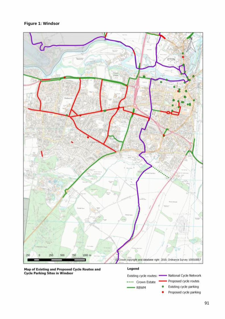
91
Figure 1: Windsor
92
Appendix 11 – Prioritised Schemes
The schemes identified in Appendices 1 – 10 above have been subject to an objective assessment
process. Each scheme has been scored as low (1 point), medium (2 points) or high (3 points), for the
following factors:
• Propensity to Cycle Tool - future importance of the route under the ‘Government Target’ scenario
• Porosity – improvement to an existing connection between two areas / a new connection between
two areas / new connections between three or more areas
• Safety – at least one casualty on the route / two casualties on the route / three or more casualties on
the route, assessed over a 5 year period
• Security – up to one cycle theft / two cycle thefts / three or more cycle thefts in the last year
Safety and Security have been given a weighting of 2x to reflect their relative importance.
Overall ratings have then been applied to each scheme as follows:
• High priority = 8 or more points
• Medium priority = 4 to 7 points
• Low priority = up to 3 points
Initial cost estimates have been prepared for schemes assessed as being a high priority. These are
shown in Table 1 below together with cycling schemes that have already been committed as part of the
Local Transport Plan Capital Programme or, which have funding allocated / provisionally allocated
through the Local Enterprise Partnership. It should be noted that cost estimates may be subject to
change as schemes are costed in more detail, and taking account of site-specific factors, such as
topography, drainage and utility protection / diversion works.
These are considered to be the priority schemes to be delivered over the first 5 years of the Cycling
Action Plan. The list will be kept under review taking account of the results of feasibility studies, as well
as changes to traffic conditions and casualty numbers. In the event that schemes cannot be delivered as
planned, then other schemes will be brought forward from the long-list.
Also, developers will be expected to fund / construct new cycle routes and cycle parking within major
developments and to provide new / improved cycle routes that connect to the site. This may include
schemes promoted by the developer or sought by the Council through the planning process. In
particular, developments delivered as part of the Maidenhead Town Centre Regeneration Programme
will be expected to fund / construct schemes that improve cycle links to / through the town centre and to
deliver cycle parking for residents, workers and visitors.
Table 2 shows the full list of prioritised schemes.
93
Table 1: Priority Schemes with Costings
Neighbourhood Scheme Name Scheme Description Cost £000s
External Funding
Priority Completion Year
All Wayfinding Improvements Signing and waymarking existing routes 14 - 2018/19
Bisham & Cookham
Bisham Roundabout Grade separated crossing - to be delivered by Highways England as part of A404/(M) Expressway project
TBC Highways England
High
Cycle route between BCA and Maidenhead
Feasibility study 15 High
Bray A308 Cycle Route Widening as development comes forward TBC Developer Funding
Medium
Monkey Island Lane / the Causeway / Hibbert Road
Feasibility study 12 High
Datchet B470 cycle route between Ditton Road and Lawn Close
Segregated shared path between Ditton Road and London Road; signed quiet route on service road; segregated share path between service Road and Lawn Close
125 High
New cycle route parallel to M4 as part of proposed housing developments to the north of Datchet
Feasibility study 12 High
Horton & Wraysbury
Cycle route between Wraysbury & Hythe End
New shared path along east side of B376 250 Medium
Cycle route between Hythe End and Surrey boundary
Feasibility study 12 High
Maidenhead & Cox Green
Stafferton Way roundabout Informal cycle crossing on eastern arm 27 Medium 2018/19
Adopt the eastern section of Horseguards Drive
Needed to secure the cycle route to Maidenhead Bridge
5 Medium 2018/19
Provide contra-flow cycle route on High Street (East)
Eastbound contra-flow to be provided between St Ives Rd and Bridge Ave
TBC Developer Funding
Medium 2018/19
Maidenhead Station Access 300+ space cycle hub and improved ped / cyc crossing to town centre
612 Growth Deal /
Developer
High 2019/20
94
Neighbourhood Scheme Name Scheme Description Cost £000s
External Funding
Priority Completion Year
Maidenhead & Cox Green (cont.)
Ludlow Road / Shoppenhangers Road
Junction enhancement / safety scheme 50 Medium
A4 - Oldfield Road to Moorbridge Road
Address problems on existing shared path: on-carriageway cycle lane to Moorbridge Road; Moorbridge Road cycle slip lane; upgrade pelican crossing to toucan; segregated shared path - Ray Street to crossing
150 Developer Funding
High
Maidenhead Missing Links Oldfield Bridge, King Steet to West Street cycle route, new A4 surface crossing / subway, Kidwells Park cycle route(s), B4447 Cookham Road toucan crossing, Town Moor bridge replacement, Town Moor cycle route enhancements
3,600 Growth Deal /
Developer Funding
High 2020/21
Trial of permitting cycling in A4 subways
Traffic order, signing and lining 10 High
Measures to improve conditions for cycling on Grenfell Road
Feasibility study 12 High
Quiet route via Camden Road, Belmont Road and College Avenue
Signing and lining 5 High
Outer radial route via Summerleaze Road, Moor Lane, Harrow Lane, Linden Avenue
Feasibility study 15 High
Windsor A308 Maidenhead Rd / Mill La / Parsonage La
Upgrade zebra crossings to toucans 67 High 2018/19
Signed quiet route - Alma Road to town centre
Signing and waymarking 5 High
Improve cycle route between Dedworth Road and Windsor town centre
Toucan crossing on Dedworth Road, lining improvements on Imperial Road, signing improvements throughout
60 High
Dedworth Road Feasibility study 15 High
Total Value of Schemes 5,073
95
Table 2: Prioritised List - All Schemes
Action Responsibility Deliverability Cost Destinations Served
PCT Impact
Porosity Impact
Safety Impact
Security Impact
Priority
Ascot, Sunninghill & Sunningdale
1. Encourage local schools to take part in the Bikeability training programme.
RBWM/ Cycle Experience
High £ - - - High - Medium
2. Install cycle parking at Chobham Road shops
RBWM High £ Local Centre - - - Low Low
3. Install cycle parking at South Ascot shops
RBWM High £ Local Centre - - - Medium Medium
4. Improve St George’s Lane as part of the redevelopment of the Shorts site
RBWM High ££ Town Centre / Residential
Medium Low - - Low
5. Investigate upgrading (Sunninghill Footpath 10) to a cycle track
RBWM Medium ££ Residential Low - - - Low
6. Upgrade Exchange Road (Byway 35) to provide a cycle route connection
RBWM Medium ££ Residential Low - Low - Low
7. Upgrade the surface on Sunningdale Bridleway 1
RBWM / Ascot & Sunnings Neighbourhood Plan Group / Surrey County Council
Medium ££ Leisure Low - - - Low
8. Investigate the potential to upgrade the cycle route between Ascot and Ascot Gate, Cheapside.
RBWM / Bracknell Forest Council
Medium £££ Inter-Urban / Low - - - Low
9. Liaise with adjacent landowners / Network Rail re construction of a cycle route between Heatherwood and Ascot Station.
RBWM / Ascot & Sunnings Neighbourhood Plan Group
Low £££ Rail Station / Hospital /
Residential
High - Medium - Medium
10. Liaise with adjacent landowners / Network Rail re construction of a cycle route to Charters School / Leisure Centre
RBWM / Ascot & Sunnings Neighbourhood Plan Group
Low £££ School / Residential
Low Medium Medium - Medium
96
Action Responsibility Deliverability Cost Destinations Served
PCT Impact
Porosity Impact
Safety Impact
Security Impact
Priority
11. Secure a cycle route between High Street, Sunninghill and King’s Corner as part of the gas holder site redevelopment.
RBWM Low £££ Local Centre / Residential
Low Medium Low - Medium
Bisham & Cookham
1. Encourage local schools to take part in the Bikeability training programme.
RBWM ✓✓✓ £ - - - High - Medium
2. Improve direction signing on existing cycle routes.
RBWM ✓✓✓ £ Inter-Urban / Leisure
Low - - - Low
3. Install cycle parking in Cookham and Cookham Rise village centres and at Cookham Library.
RBWM ✓✓✓ £ Local Centre / Community
- - - High Medium
4. Investigate new cycle route between B4447 and Cookham Station
RBWM ✓✓ ££ Rail Station / Residential
Medium Medium - - Medium
5. Liaise with Highways England and local landowners regarding a new cycle link between Hurley Lane and Bradenham La.
RBWM ✓✓ ££ Inter-Urban / Leisure
Low Medium - - Low
6. Liaise with landowners regarding the potential for cycle access between Hurley and Bisham along Temple Lane.
RBWM ✓✓ ££ Inter-Urban / Leisure
Low - - - Low
7. Liaise with Highways England to secure improvements for cyclists as part of the Bisham Roundabout improvements.
RBWM ✓✓ £££ Inter-Urban High Medium Medium - High
8. Liaise with landowners regarding cycle links between Maidenhead, Cookham, Cookham Rise and Cookham Dean, as well as possible connections to Bourne End.
RBWM ✓✓ £££ Inter-Urban / Leisure
High Medium - - Medium
9. Liaise with local landowners regarding the potential for establishing formal mountain bike trails in Park Wood, The Hockett, Quarry Wood, Long Copse and Coney Copse.
RBWM ✓ £££ Leisure Low - - - Low
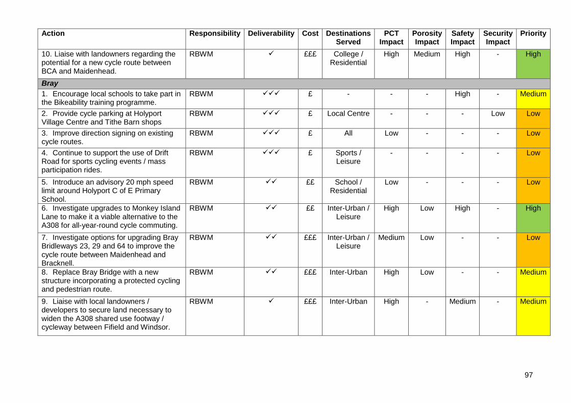
97
Action Responsibility Deliverability Cost Destinations Served
PCT Impact
Porosity Impact
Safety Impact
Security Impact
Priority
10. Liaise with landowners regarding the potential for a new cycle route between BCA and Maidenhead.
RBWM ✓ £££ College / Residential
High Medium High - High
Bray
1. Encourage local schools to take part in the Bikeability training programme.
RBWM ✓✓✓ £ - - - High - Medium
2. Provide cycle parking at Holyport Village Centre and Tithe Barn shops
RBWM ✓✓✓ £ Local Centre - - - Low Low
3. Improve direction signing on existing cycle routes.
RBWM ✓✓✓ £ All Low - - - Low
4. Continue to support the use of Drift Road for sports cycling events / mass participation rides.
RBWM ✓✓✓ £ Sports / Leisure
- - - - Low
5. Introduce an advisory 20 mph speed limit around Holyport C of E Primary School.
RBWM ✓✓ ££ School / Residential
Low - - - Low
6. Investigate upgrades to Monkey Island Lane to make it a viable alternative to the A308 for all-year-round cycle commuting.
RBWM ✓✓ ££ Inter-Urban / Leisure
High Low High - High
7. Investigate options for upgrading Bray Bridleways 23, 29 and 64 to improve the cycle route between Maidenhead and Bracknell.
RBWM ✓✓ £££ Inter-Urban / Leisure
Medium Low - - Low
8. Replace Bray Bridge with a new structure incorporating a protected cycling and pedestrian route.
RBWM ✓✓ £££ Inter-Urban High Low - - Medium
9. Liaise with local landowners / developers to secure land necessary to widen the A308 shared use footway / cycleway between Fifield and Windsor.
RBWM ✓ £££ Inter-Urban High - Medium - Medium
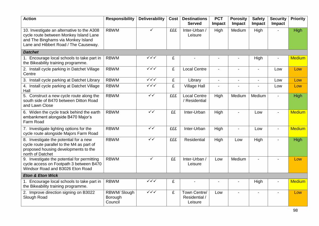
98
Action Responsibility Deliverability Cost Destinations Served
PCT Impact
Porosity Impact
Safety Impact
Security Impact
Priority
10. Investigate an alternative to the A308 cycle route between Monkey Island Lane and The Binghams via Monkey Island Lane and Hibbert Road / The Causeway.
RBWM ✓ £££ Inter-Urban / Leisure
High Medium High - High
Datchet
1. Encourage local schools to take part in the Bikeability training programme.
RBWM ✓✓✓ £ - - - High - Medium
2. Install cycle parking in Datchet Village Centre
RBWM ✓✓✓ £ Local Centre - - - Low Low
3. Install cycle parking at Datchet Library RBWM ✓✓✓ £ Library - - - Low Low
4. Install cycle parking at Datchet Village Hall
RBWM ✓✓✓ £ Village Hall - - - Low Low
5. Construct a new cycle route along the south side of B470 between Ditton Road and Lawn Close
RBWM ✓✓ £££ Local Centre / Residential
High Medium Medium - High
6. Widen the cycle track behind the earth embankment alongside B470 Major’s Farm Road
RBWM ✓✓ ££ Inter-Urban High - Low - Medium
7. Investigate lighting options for the cycle route alongside Majors Farm Road
RBWM ✓✓ £££ Inter-Urban High - Low - Medium
8. Investigate the potential for a new cycle route parallel to the M4 as part of proposed housing developments to the north of Datchet
RBWM ✓✓ £££ Residential High Low High - High
9. Investigate the potential for permitting cycle access on Footpath 3 between B470 Windsor Road and B3026 Eton Road
RBWM ✓ ££ Inter-Urban / Leisure
Low Medium - - Low
Eton & Eton Wick
1. Encourage local schools to take part in the Bikeability training programme.
RBWM ✓✓✓ £ - - - High - Medium
2. Improve direction signing on B3022 Slough Road
RBWM/ Slough Borough Council
✓✓✓ £ Town Centre/ Residential /
Leisure
Low - - - Low
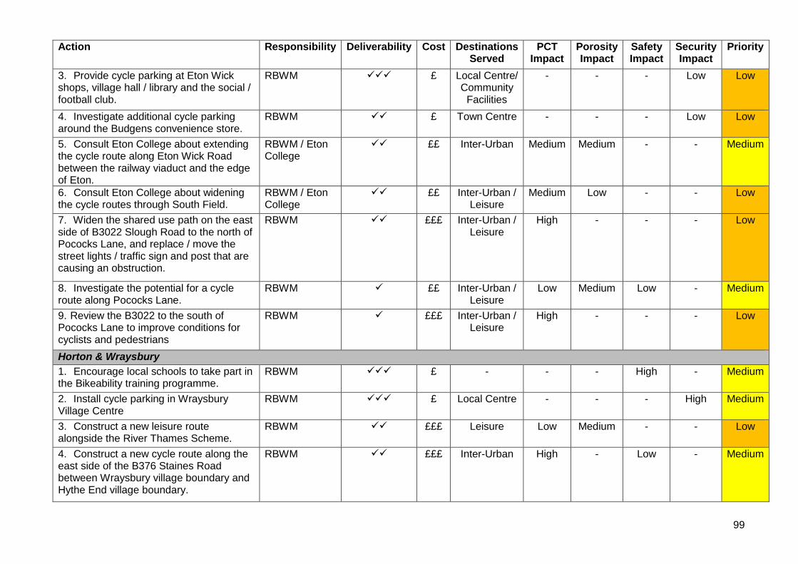
99
Action Responsibility Deliverability Cost Destinations Served
PCT Impact
Porosity Impact
Safety Impact
Security Impact
Priority
3. Provide cycle parking at Eton Wick shops, village hall / library and the social / football club.
RBWM ✓✓✓ £ Local Centre/ Community
Facilities
- - - Low Low
4. Investigate additional cycle parking around the Budgens convenience store.
RBWM ✓✓ £ Town Centre - - - Low Low
5. Consult Eton College about extending the cycle route along Eton Wick Road between the railway viaduct and the edge of Eton.
RBWM / Eton College
✓✓ ££ Inter-Urban Medium Medium - - Medium
6. Consult Eton College about widening the cycle routes through South Field.
RBWM / Eton College
✓✓ ££ Inter-Urban / Leisure
Medium Low - - Low
7. Widen the shared use path on the east side of B3022 Slough Road to the north of Pococks Lane, and replace / move the street lights / traffic sign and post that are causing an obstruction.
RBWM ✓✓ £££ Inter-Urban / Leisure
High - - - Low
8. Investigate the potential for a cycle route along Pococks Lane.
RBWM ✓ ££ Inter-Urban / Leisure
Low Medium Low - Medium
9. Review the B3022 to the south of Pococks Lane to improve conditions for cyclists and pedestrians
RBWM ✓ £££ Inter-Urban / Leisure
High - - - Low
Horton & Wraysbury
1. Encourage local schools to take part in the Bikeability training programme.
RBWM ✓✓✓ £ - - - High - Medium
2. Install cycle parking in Wraysbury Village Centre
RBWM ✓✓✓ £ Local Centre - - - High Medium
3. Construct a new leisure route alongside the River Thames Scheme.
RBWM ✓✓ £££ Leisure Low Medium - - Low
4. Construct a new cycle route along the east side of the B376 Staines Road between Wraysbury village boundary and Hythe End village boundary.
RBWM ✓✓ £££ Inter-Urban High - Low - Medium
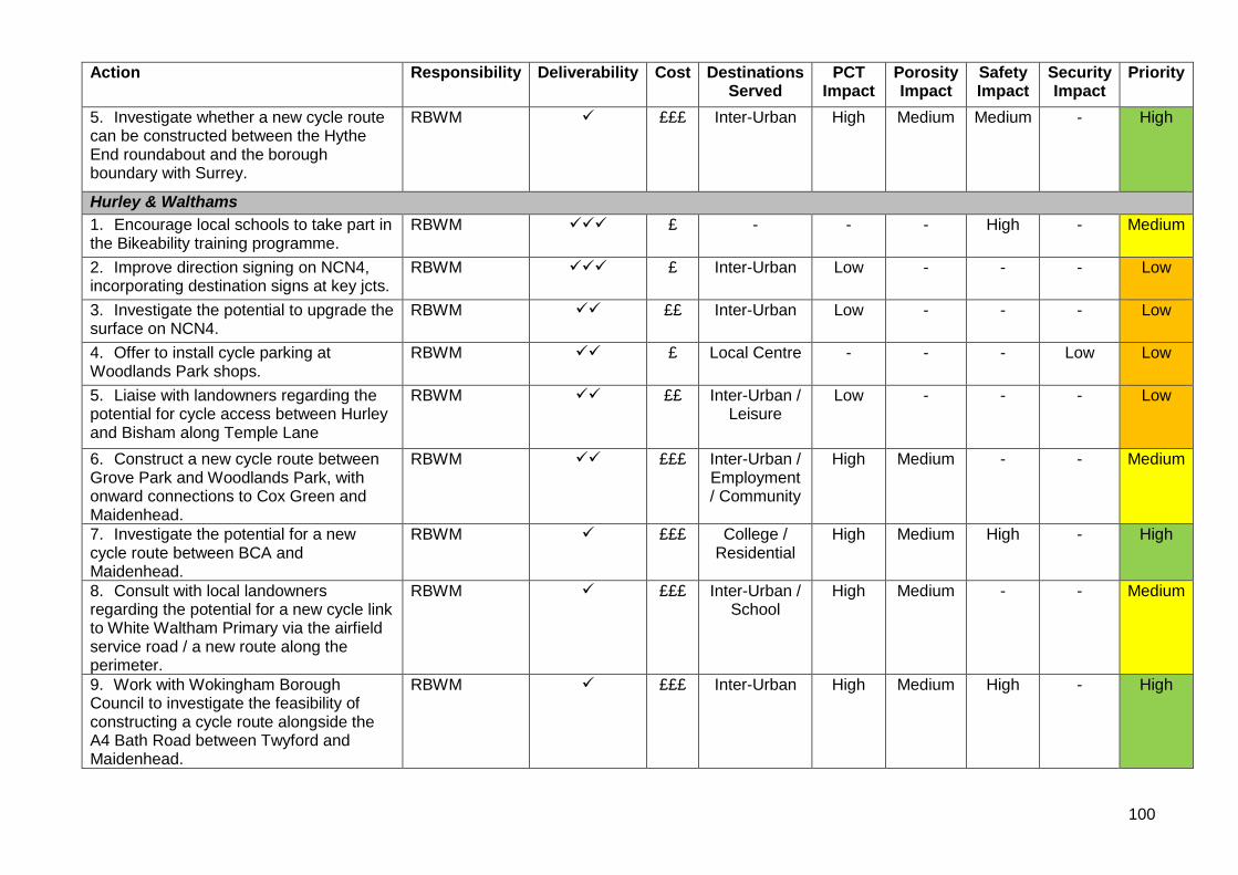
100
Action Responsibility Deliverability Cost Destinations Served
PCT Impact
Porosity Impact
Safety Impact
Security Impact
Priority
5. Investigate whether a new cycle route can be constructed between the Hythe End roundabout and the borough boundary with Surrey.
RBWM ✓ £££ Inter-Urban High Medium Medium - High
Hurley & Walthams
1. Encourage local schools to take part in the Bikeability training programme.
RBWM ✓✓✓ £ - - - High - Medium
2. Improve direction signing on NCN4, incorporating destination signs at key jcts.
RBWM ✓✓✓ £ Inter-Urban Low - - - Low
3. Investigate the potential to upgrade the surface on NCN4.
RBWM ✓✓ ££ Inter-Urban Low - - - Low
4. Offer to install cycle parking at Woodlands Park shops.
RBWM ✓✓ £ Local Centre - - - Low Low
5. Liaise with landowners regarding the potential for cycle access between Hurley and Bisham along Temple Lane
RBWM ✓✓ ££ Inter-Urban / Leisure
Low - - - Low
6. Construct a new cycle route between Grove Park and Woodlands Park, with onward connections to Cox Green and Maidenhead.
RBWM ✓✓ £££ Inter-Urban / Employment / Community
High Medium - - Medium
7. Investigate the potential for a new cycle route between BCA and Maidenhead.
RBWM ✓ £££ College / Residential
High Medium High - High
8. Consult with local landowners regarding the potential for a new cycle link to White Waltham Primary via the airfield service road / a new route along the perimeter.
RBWM ✓ £££ Inter-Urban / School
High Medium - - Medium
9. Work with Wokingham Borough Council to investigate the feasibility of constructing a cycle route alongside the A4 Bath Road between Twyford and Maidenhead.
RBWM ✓ £££ Inter-Urban High Medium High - High
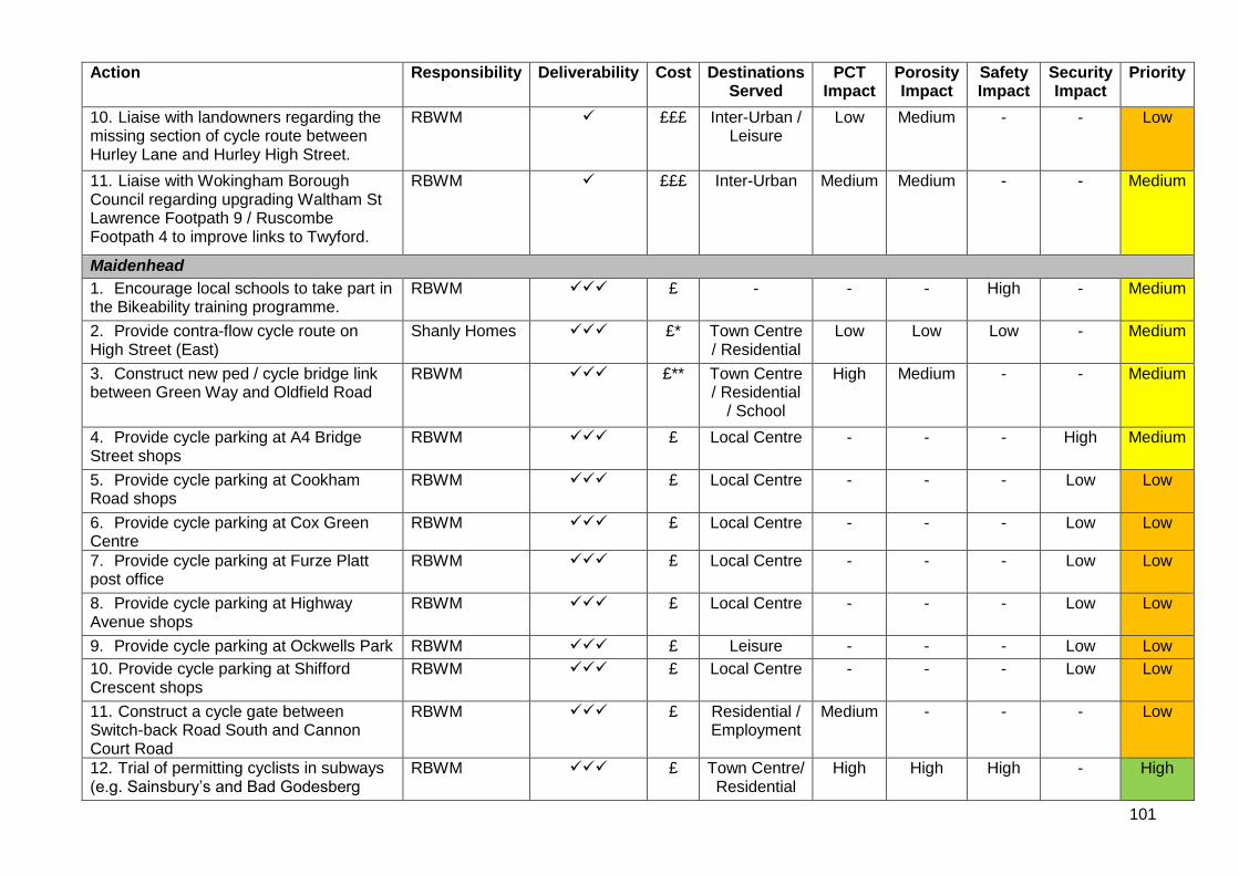
101
Action Responsibility Deliverability Cost Destinations Served
PCT Impact
Porosity Impact
Safety Impact
Security Impact
Priority
10. Liaise with landowners regarding the missing section of cycle route between Hurley Lane and Hurley High Street.
RBWM ✓ £££ Inter-Urban / Leisure
Low Medium - - Low
11. Liaise with Wokingham Borough Council regarding upgrading Waltham St Lawrence Footpath 9 / Ruscombe Footpath 4 to improve links to Twyford.
RBWM ✓ £££ Inter-Urban Medium Medium - - Medium
Maidenhead
1. Encourage local schools to take part in the Bikeability training programme.
RBWM ✓✓✓ £ - - - High - Medium
2. Provide contra-flow cycle route on High Street (East)
Shanly Homes ✓✓✓ £* Town Centre / Residential
Low Low Low - Medium
3. Construct new ped / cycle bridge link between Green Way and Oldfield Road
RBWM ✓✓✓ £** Town Centre / Residential
/ School
High Medium - - Medium
4. Provide cycle parking at A4 Bridge Street shops
RBWM ✓✓✓ £ Local Centre - - - High Medium
5. Provide cycle parking at Cookham Road shops
RBWM ✓✓✓ £ Local Centre - - - Low Low
6. Provide cycle parking at Cox Green Centre
RBWM ✓✓✓ £ Local Centre - - - Low Low
7. Provide cycle parking at Furze Platt post office
RBWM ✓✓✓ £ Local Centre - - - Low Low
8. Provide cycle parking at Highway Avenue shops
RBWM ✓✓✓ £ Local Centre - - - Low Low
9. Provide cycle parking at Ockwells Park RBWM ✓✓✓ £ Leisure - - - Low Low
10. Provide cycle parking at Shifford Crescent shops
RBWM ✓✓✓ £ Local Centre - - - Low Low
11. Construct a cycle gate between Switch-back Road South and Cannon Court Road
RBWM ✓✓✓ £ Residential / Employment
Medium - - - Low
12. Trial of permitting cyclists in subways (e.g. Sainsbury’s and Bad Godesberg
RBWM ✓✓✓ £ Town Centre/ Residential
High High High - High
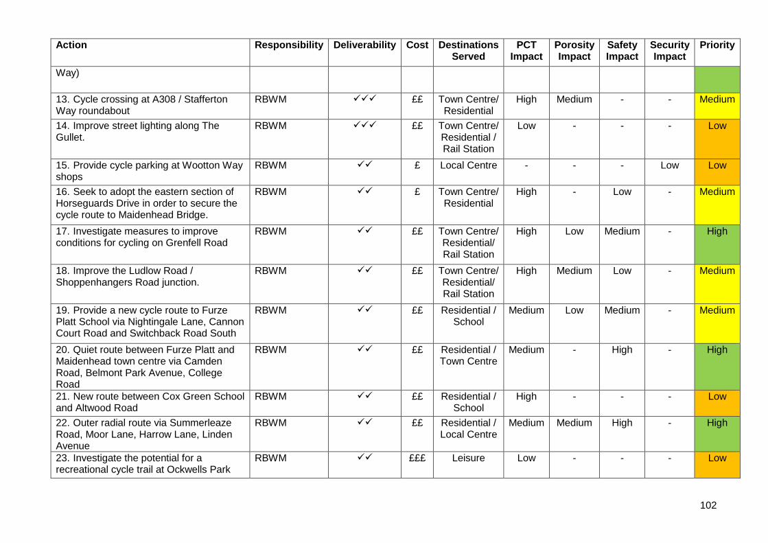
102
Action Responsibility Deliverability Cost Destinations Served
PCT Impact
Porosity Impact
Safety Impact
Security Impact
Priority
Way)
13. Cycle crossing at A308 / Stafferton Way roundabout
RBWM ✓✓✓ ££ Town Centre/ Residential
High Medium - - Medium
14. Improve street lighting along The Gullet.
RBWM ✓✓✓ ££ Town Centre/ Residential / Rail Station
Low - - - Low
15. Provide cycle parking at Wootton Way shops
RBWM ✓✓ £ Local Centre - - - Low Low
16. Seek to adopt the eastern section of Horseguards Drive in order to secure the cycle route to Maidenhead Bridge.
RBWM ✓✓ £ Town Centre/ Residential
High - Low - Medium
17. Investigate measures to improve conditions for cycling on Grenfell Road
RBWM ✓✓ ££ Town Centre/ Residential/ Rail Station
High Low Medium - High
18. Improve the Ludlow Road / Shoppenhangers Road junction.
RBWM ✓✓ ££ Town Centre/ Residential/ Rail Station
High Medium Low - Medium
19. Provide a new cycle route to Furze Platt School via Nightingale Lane, Cannon Court Road and Switchback Road South
RBWM ✓✓ ££ Residential / School
Medium Low Medium - Medium
20. Quiet route between Furze Platt and Maidenhead town centre via Camden Road, Belmont Park Avenue, College Road
RBWM ✓✓ ££ Residential / Town Centre
Medium - High - High
21. New route between Cox Green School and Altwood Road
RBWM ✓✓ ££ Residential / School
High - - - Low
22. Outer radial route via Summerleaze Road, Moor Lane, Harrow Lane, Linden Avenue
RBWM ✓✓ ££ Residential / Local Centre
Medium Medium High - High
23. Investigate the potential for a recreational cycle trail at Ockwells Park
RBWM ✓✓ £££ Leisure Low - - - Low
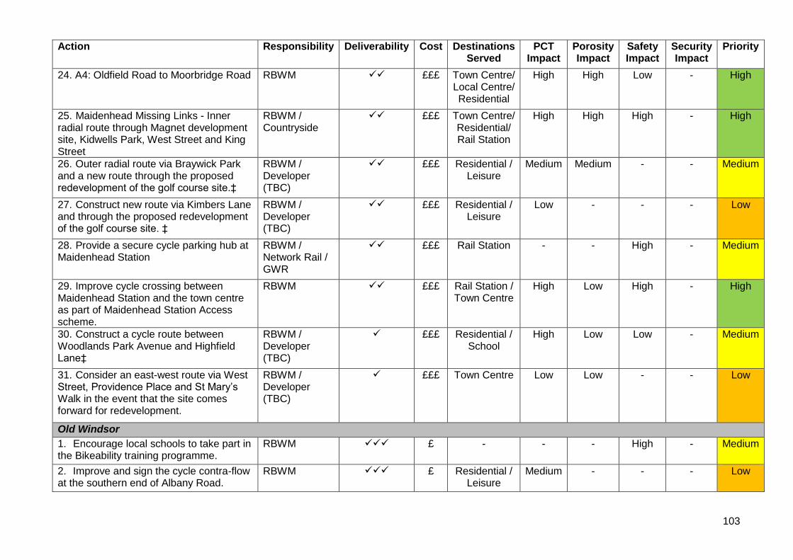
103
Action Responsibility Deliverability Cost Destinations Served
PCT Impact
Porosity Impact
Safety Impact
Security Impact
Priority
24. A4: Oldfield Road to Moorbridge Road RBWM ✓✓ £££ Town Centre/ Local Centre/ Residential
High High Low - High
25. Maidenhead Missing Links - Inner radial route through Magnet development site, Kidwells Park, West Street and King Street
RBWM / Countryside
✓✓ £££ Town Centre/ Residential/ Rail Station
High High High - High
26. Outer radial route via Braywick Park and a new route through the proposed redevelopment of the golf course site.‡
RBWM / Developer (TBC)
✓✓ £££ Residential / Leisure
Medium Medium - - Medium
27. Construct new route via Kimbers Lane and through the proposed redevelopment of the golf course site. ‡
RBWM / Developer (TBC)
✓✓ £££ Residential / Leisure
Low - - - Low
28. Provide a secure cycle parking hub at Maidenhead Station
RBWM / Network Rail / GWR
✓✓ £££ Rail Station - - High - Medium
29. Improve cycle crossing between Maidenhead Station and the town centre as part of Maidenhead Station Access scheme.
RBWM ✓✓ £££ Rail Station / Town Centre
High Low High - High
30. Construct a cycle route between Woodlands Park Avenue and Highfield Lane‡
RBWM / Developer (TBC)
✓ £££ Residential / School
High Low Low - Medium
31. Consider an east-west route via West Street, Providence Place and St Mary’s Walk in the event that the site comes forward for redevelopment.
RBWM / Developer (TBC)
✓ £££ Town Centre Low Low - - Low
Old Windsor
1. Encourage local schools to take part in the Bikeability training programme.
RBWM ✓✓✓ £ - - - High - Medium
2. Improve and sign the cycle contra-flow at the southern end of Albany Road.
RBWM ✓✓✓ £ Residential / Leisure
Medium - - - Low
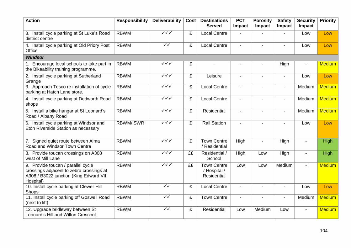
104
Action Responsibility Deliverability Cost Destinations Served
PCT Impact
Porosity Impact
Safety Impact
Security Impact
Priority
3. Install cycle parking at St Luke’s Road district centre
RBWM ✓✓✓ £ Local Centre - - - Low Low
4. Install cycle parking at Old Priory Post Office
RBWM ✓✓ £ Local Centre - - - Low Low
Windsor
1. Encourage local schools to take part in the Bikeability training programme.
RBWM ✓✓✓ £ - - - High - Medium
2. Install cycle parking at Sutherland Grange
RBWM ✓✓✓ £ Leisure - - - Low Low
3. Approach Tesco re installation of cycle parking at Hatch Lane store.
RBWM ✓✓✓ £ Local Centre - - - Medium Medium
4. Install cycle parking at Dedworth Road shops
RBWM ✓✓✓ £ Local Centre - - - Medium Medium
5. Install a bike hangar at St Leonard’s Road / Albany Road
RBWM ✓✓✓ £ Residential - - - Medium Medium
6. Install cycle parking at Windsor and Eton Riverside Station as necessary
RBWM/ SWR ✓✓✓ £ Rail Station - - - Low Low
7. Signed quiet route between Alma Road and Windsor Town Centre
RBWM ✓✓✓ £ Town Centre / Residential
High - High - High
8. Provide toucan crossings on A308 west of Mill Lane
RBWM ✓✓✓ ££ Residential / School
High Low High - High
9. Provide toucan / parallel cycle crossings adjacent to zebra crossings at A308 / B3022 junction (King Edward VII Hospital)
RBWM ✓✓✓ ££ Town Centre / Hospital / Residential
Low Low Medium - Medium
10. Install cycle parking at Clewer Hill Shops
RBWM ✓✓ £ Local Centre - - - Low Low
11. Install cycle parking off Goswell Road (next to lift)
RBWM ✓✓ £ Town Centre - - - Medium Medium
12. Upgrade bridleway between St Leonard’s Hill and Wilton Crescent.
RBWM ✓✓ £ Residential Low Medium Low - Medium
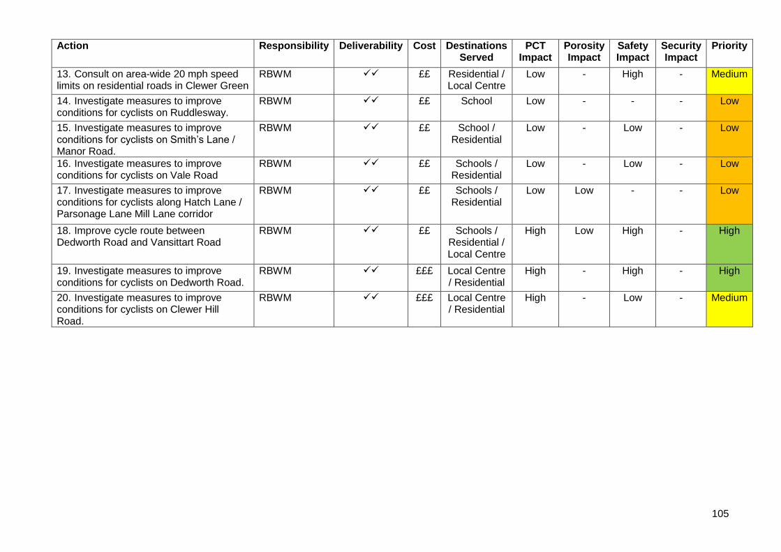
105
Action Responsibility Deliverability Cost Destinations Served
PCT Impact
Porosity Impact
Safety Impact
Security Impact
Priority
13. Consult on area-wide 20 mph speed limits on residential roads in Clewer Green
RBWM ✓✓ ££ Residential / Local Centre
Low - High - Medium
14. Investigate measures to improve conditions for cyclists on Ruddlesway.
RBWM ✓✓ ££ School Low - - - Low
15. Investigate measures to improve conditions for cyclists on Smith’s Lane / Manor Road.
RBWM ✓✓ ££ School / Residential
Low - Low - Low
16. Investigate measures to improve conditions for cyclists on Vale Road
RBWM ✓✓ ££ Schools / Residential
Low - Low - Low
17. Investigate measures to improve conditions for cyclists along Hatch Lane / Parsonage Lane Mill Lane corridor
RBWM ✓✓ ££ Schools / Residential
Low Low - - Low
18. Improve cycle route between Dedworth Road and Vansittart Road
RBWM ✓✓ ££ Schools / Residential / Local Centre
High Low High - High
19. Investigate measures to improve conditions for cyclists on Dedworth Road.
RBWM ✓✓ £££ Local Centre / Residential
High - High - High
20. Investigate measures to improve conditions for cyclists on Clewer Hill Road.
RBWM ✓✓ £££ Local Centre / Residential
High - Low - Medium