ctsw d04 dwp fy 18-19 · pdf filecalifornia department of transportation stormwater management...
TRANSCRIPT

California Department of Transportation
Stormwater Management Program
District 4 Work Plan
Fiscal Year
2018-2019
CTSW-RT-17-316.11.1
California Department of Transportation Division of Environmental Analysis Stormwater Management Program
111 Grand Avenue PO Box 23660
Oakland, California 94623
http://www.dot.ca.gov/hq/env/stormwater
October 1, 2017

For individuals with sensory disabilities, this document is available in alternate formats upon request.
Please call or write to the Stormwater Liaison, Caltrans Division of Environmental Analysis, MS-27, P.O.
Box 942874, Sacramento, CA 94274-0001, (916) 653-8896 Voice, or dial 711 to use a relay service.


This page was intentionally left blank.

Table of Contents i Fiscal Year 2018-2019
Table of Contents
1 Introduction ....................................................................................................................................... 1-1
2 District Personnel and Responsibilities ........................................................................................... 2-1
3 District Facilities and Water Bodies ................................................................................................ 3-1
4 Drinking Water Reservoirs and Recharge Facilities ...................................................................... 4-1
5 Slopes Prone to Erosion .................................................................................................................... 5-1
6 Implementation .................................................................................................................................. 6-1
7 Region-Specific Activities ................................................................................................................. 7-1
8 DWP Noncompliance and Improvements ....................................................................................... 8-1
Figures
Figure 2-1: District 4 Organizational Chart ............................................................................................. 2-11 Figure 5-1: District 4 2017 Areas Prone to Erosion ................................................................................... 5-3
Tables
Table 2-1: District 4 Stormwater Personnel and Responsibilities ............................................................. 2-8 Table 2-2: District 4 Signatory Authority for Key Documents ................................................................ 2-10 Table 4-1: District 4 Drinking Water Reservoirs and Recharge Facilities ................................................ 4-1 Table 5-1: District 4 Inventory of Road Segments Prone to Erosion......................................................... 5-1 Table 6-1: District 4 Anticipated Project Development and Construction Schedule ................................. 6-3 Table 6-2: District 4 Anticipated Significant Road Maintenance Activities ........................................... 6-31 Table 6-3: District 4 Monitoring Activities ............................................................................................. 6-33 Table 7-1: District 4 Maintenance Notification to North Coast Regional Water Quality Control Board .. 7-5 Table 8-1: District 4 Prior DWP Noncompliance Incidents and Improvements ........................................ 8-1

Table of Contents ii Fiscal Year 2018-2019
This page was intentionally left blank.

Section 1: Introduction 1-1 Fiscal Year 2018-2019
1 Introduction
General Information about the District Work Plan
The District Work Plans (DWPs) describe the organization of each California Department of
Transportation (Caltrans) District’s Stormwater Management Program and outline the planned stormwater
activities for the upcoming fiscal year. They are prepared and submitted on October 1 each year. Since the
DWP is District-specific, each Regional Water Quality Control Board (RWQCB or Regional Board) is
provided a copy of the DWPs relevant to their jurisdiction.
This DWP presents information about District 4’s water bodies, Best Management Practices (BMPs), and
monitoring programs. It describes how the District will specifically implement the requirements of the
Statewide Stormwater Management Plan (SWMP) during fiscal year 2018-19. Implementation activities
will be conducted in accordance with the procedures presented in the SWMP. In addition, this DWP
fulfills Provision E.3.b of the National Pollutant Discharge Elimination System (NPDES) Statewide
Stormwater Permit Waste Discharge Requirements (WDRs) for State of California Department of
Transportation (Order Number 2012-0011-DWQ, NPDES Number CAS000003, Effective July 1, 2013)
(NPDES Permit). The NPDES Permit was amended by Orders WQ 2014-0006-EXEC (January 17, 2014),
WQ 2014-007-DWQ (May 20, 2014), and WQ 2015-0036-EXEC (April 7, 2015). A conformed NPDES
Permit was issued on April 7, 2015 (Conformed NPDES Permit or Caltrans NPDES Permit), available on
the California State Water Resources Control Board’s (SWRCB) website:
http://www.waterboards.ca.gov/board_decisions/adopted_orders/water_quality/2012/wq2012_0011_dwq
_conformed_signed.pdf
The DWP’s eight sections describe how the District plans to implement the Stormwater Management
Program during the upcoming fiscal year. Section 1 introduces the DWP, describes its organizational
structure, and identifies the key goals and commitments made by the District for the upcoming fiscal year.
Section 2 describes the personnel with stormwater operations responsibilities in the District. In Section 3,
the District’s facilities are listed and categorized by type and location. Section 4 describes and identifies
the high-risk locations where spills from the District’s owned rights-of-way, roadways or facilities can
discharge directly to a drinking water reservoir or ground water recharge facility. In Section 5, the
District’s road segments that are prone to erosion are identified. Section 6 summarizes the District’s
implementation activities, including projects that will be in the design and construction phases during the
fiscal year, maintenance projects, and planned stormwater monitoring activities. Section 7 identifies the
planned region-specific activities (if applicable) to address the requirements listed in Attachment V of the
Conformed NPDES Permit. Section 8 identifies deviations that occurred from the prior DWP that resulted
or will result in noncompliance with the Conformed NPDES Permit or SWMP and describes
improvements performed in response to the incidents of noncompliance.
District Goals and Commitments
The current goals of District 4 include: implementing sustainable practices that provide a safe
transportation system for its users and workers; delivering efficient quality transportation projects and
preserving the State’s environmental resources; implementing public outreach efforts; and working with
local partners to develop alternative compliance/watershed-based solutions that are cost-effective. The
District plans to accomplish this by continuing to:
• Train staff on the Conformed NPDES Permit provisions related to new development and
redevelopment requirements that require stormwater treatment and hydromodification control
measures.
• Train staff on compliance requirements in the Construction General Permit (CGP).

Section 1: Introduction 1-2 Fiscal Year 2018-2019
• Train staff on the use of the updated Caltrans Stormwater Project Planning and Design Guide.
• Maintain relationships with the RWQCBs to meet our shared stormwater management goals by
engaging in discussions that:
o Establish consistency with Caltrans’ statewide practices on stormwater treatment and
hydromodification control requirements for projects that require Clean Water Act Section
401 Water Quality Certifications and/or Waste Discharge Requirements.
o Establish a clear understanding on alternative compliance process when on-site
stormwater treatment compliance measures have been determined infeasible based on
engineering/economic feasibility considerations.
o Successful implementation of construction site risk assessment and water pollution
control measures designed to minimize the risk for pollutant discharges into receiving
waters as required by the CGP, including the electronic filing of the following documents
onto the State Water Resources Control Board’s Stormwater Multi-Application & Report
Tracking System (SMARTS): 1) Project Registration Documents (PRDs); 2) Notice of
Intent (NOI) and; 3) Notice of Termination (NOT).
• Coordinate with local partners to provide guidance in the planning (design) phase to ensure
compliance with new development and redevelopment requirement mandates that require
incorporation of on-site stormwater treatment and hydromodification control measures; facilitate
discussions with the RWQCBs on alternative compliance/off-site watershed based solutions.
Following are actions Caltrans will take in compliance with the Attachment IV (TMDL Requirements)
and V (region-specific requirements) in the Conformed NPDES permit:
• Continue to work with local municipal separate storm sewer system (MS4) permittees to identify
opportunities for partnerships through meetings with the Bay Area Stormwater Management
Agencies Association (BASMAA) and by partnering with County stormwater management
programs including the following programs: Alameda County Clean Water Program, San Mateo
Countywide Water Pollution Prevention Program; Contra Costa County Clean Water Program;
and the Marin County Stormwater Pollution Prevention Program, Fairfield-Suisun Urban Runoff
Management Program, and Vallejo Sanitation and Flood Control District. Partnership
considerations will include an annual TMDL compliance unit commitment per Attachment IV
and trash reduction requirements in Attachment V of the Conformed NPDES permit; a common
reach prioritization; and the implementation of BMPs that are effective for addressing the
reduction of trash and other pollutants.
North Coast Region
To address sediment sources within sediment impaired watersheds, Caltrans will prepare an inventory of
sources of excess sediment and quantify the discharge or threatened discharge in the North Coast
RWQCB.
San Francisco Bay Region
Trash Load Reduction
Caltrans conducted an on-land visual assessment to identify areas that are generating very-high and high
trash deposits. The assessment used a methodology like the methods used by local municipalities such
that there are four trash generation areas categories: low, medium, high, and very high. Out of 1,100
centerline miles of roadway and 886 highway ramps, the field assessment identified approximately 24.1
highway centerline miles and 116 highway ramps that have high and very-high trash generation rates.

Section 1: Introduction 1-3 Fiscal Year 2018-2019
Caltrans submitted a Trash Reduction Work Plan in June 2016. San Francisco Bay Regional Water
Quality Control Board issued a Notice of Violation (NOV) of Conformed NPDES Permit, for failure to
demonstrate Timely Implementation of Trash Control Measures in December 2016.
In the February 2017 response to the NOV, Caltrans outlined the actions it will take to demonstrate timely
implementation of trash control measures in high trash generating areas within the following high trash
generating areas identified as the following:
• Freeway on- and off-ramps in high density residential, commercial and industrial land uses.
• Rest areas and park-and-rides.
• State highways in commercial and industrial land use areas.
• Other freeway segments as identified by maintenance staff and/or trash surveys.
Caltrans will continue to implement the following actions outlined in the February 2017 response to the
NOV:
• Conduct joint visual assessments with MS4 permittees to reach consensus on the methodology to
designate High, Medium and Low trash generation areas and revise the designations where
needed. The revised visual assessment designations will be used to prioritize implementation of:
o Full trash capture systems through drainage system retrofits within Caltrans Right of Way
(right-of-way)
o Full trash capture systems through drainage system retrofits outside Caltrans right-of-way
in partnership with local MS4s that will treat both Caltrans and local MS4 sheds.
o Source control measures control measures (enhanced manual pick up and street sweeping
within Caltrans right-of-way, or cleanup efforts in partnership with local MS4s)
o Public education efforts
• Continue Stormwater Treatment Feasibility Studies throughout the District (complete Phase 1 by
December 2017; Phase 2 by December 2018; Phase 3 by December 2020) to identify
opportunities for implementing stormwater treatment/full capture system retrofits within Caltrans
right-of-way, or outside Caltrans right-of-way in partnerships with local (MS4) permittees.
• Develop Project Initiation Reports for programming stormwater treatment/full trash capture
systems retrofits for candidate projects (identified through Phase 1, Phase 2 and Phase 3 studies
and partnerships with MS4 permittees for work outside Caltrans’ right-of-way) into the 2017
State Highway System Management Plan (Ten Year Plan) by June 30, 2019.
• Continue implementation of a pilot project on sections of Interstate 880 in Alameda County that
proposes to evaluate full trash capture system technologies for addition to the Caltrans-approved
BMP toolbox.
• Continue to implement source control measures, such as public education and outreach programs,
litter pickup and street sweeping efforts.
• Develop a strategy to enhance implementation of street sweeping and manual pickup efforts by
establishing a baseline for ongoing efforts in the designated high trash generation areas, and
proposing enhancement of these measures above and beyond the established base line effort.
• Develop a crediting mechanism for source control trash reduction measures.

Section 1: Introduction 1-4 Fiscal Year 2018-2019
Stormwater Pump Stations
Caltrans will perform inspection and monitoring of pump stations in the San Francisco Bay Region. A
total of 62 pump stations were inventoried within District 4. Pump stations within Caltrans District 4 were
evaluated to determine which stations represented the greatest probability for discharging runoff with low
dissolved oxygen (DO) into the local waterway(s). In accordance with the Caltrans NPDES permit,
Attachment V, Part 2, Provision 2b, Caltrans inspected and collected DO data annually from 20 percent of
the pump stations on the priority list. The inspection and monitoring results are reported in the District’s
Annual Report. Fiscal year 2018-2019 will be the fifth of five years in which inspection and monitoring
have been conducted. Eighty percent of the pump stations on the priority list have been inspected and
monitored for DO.

Section 2: District Personnel and Responsibilities 2-1 Fiscal Year 2018-2019
2 District Personnel and Responsibilities
Section 2 of the DWP describes positions, addresses, and telephone numbers of personnel with
responsibilities for stormwater operations within the District. This section also identifies positions having
signatory authority for various notifications or documents required for submittal by a District (e.g.,
Project Registration Documents (PRDs), including Notices of Intents or NOIs).
Water Quality Program Manager
The District Water Quality Program Manager (Manager) is the Office Chief of the Office of Water
Quality and Mitigation. He supervises the Stormwater Coordination Branch, the Water Pollution Control
Branch, the Water Quality Permits Branch, and the Erosion Control Branch. The Manager oversees all
stormwater activities in the District. The Manager is also accountable for establishing an effective water
quality/Stormwater Management Program and maintaining a liaison with Headquarters and District
Program Managers (Division Chiefs) for effective communication, collaboration, and coordination of
stormwater activities.
The responsibilities of the Manager are as follows:
• Direct District operations regarding water quality and stormwater.
• Align District efforts to interpret, implement, and comply with the Caltrans NPDES permit.
• Be the ultimate signatory authority in the District for all compliance documents and commitments
regarding water quality and stormwater management.
• Work as the primary liaison on water quality and waste discharge issues between the District and
Headquarters, the SWRCB, the RWQCBs, the U.S. Environmental Protection Agency (U.S.
EPA), and other agencies.
• Arbitrate disputes and disagreements on policies, activities, assignments, and responsibilities
regarding stormwater issues.
• Develop and establish the District’s Public Education Program.
District NPDES Coordinator
The District NPDES Coordinator is responsible for providing technical assistance to guide staff in
resolving water quality permitting issues and concerns related to project development design, construction
and maintenance with respect to Caltrans compliance with the statewide NPDES Permit and project-
specific permits from the RWQCBs and/or other resource agencies. The District NPDES Coordinator
provides functional unit support to Project Managers, Project Engineers and other District and HQ
functional units and Divisions for all phases of project activities, by providing support in obtaining
project-specific permits from the RWQCB(s), and assisting with responding to enforcement actions from
the RWQCBs.
The specific stormwater tasks for which the NPDES Coordinator is responsible for include:
• Serving as the focal point for the interpretation and implementation of the Caltrans NPDES
Permit.
• Serving as the District’s Stormwater Mitigation Program Advisor to develop and implement a
work plan to ensure the District’s performance objectives (stormwater treatment/compliance
units) in the Ten-Year State Highway System Management Plan are met.
• Participating in coordination activities with Headquarters Stormwater Advisory Teams (SWATs)
– Water Quality and Project Design.

Section 2: District Personnel and Responsibilities 2-2 Fiscal Year 2018-2019
• Preparing the Annual Report that summarizes the stormwater activities for District 4 and ensuring
that the conditions of the Caltrans NPDES Permit have been met.
• Preparing the DWP annually in a manner that addresses future District goals and commitments in
compliance with Caltrans’ SWMP.
• Serving as the lead for the implementation of the DWP, fulfilling its commitments and reporting
the progress in the Annual Reports.
• Ensuring Stormwater Data Report (SWDR) information at each phase of project development
including Project Initiation Document (PID), Project Approval (PA), Plans, Specifications and
Estimate (PS&E), and Construction is accurately uploaded to the Stormwater Portal.
• Coordinating with Resident Engineers and the DSWC to ensure permanent stormwater treatment
control measures are built in accordance with the project plans, and document the as-built
condition for treatment controls that will be included in the Integrated Maintenance Management
System (IMMS) and into the Storm Drain System Inventory (SDSI).
• Coordinating with District Functional Unit stormwater coordinators to ensure that all activities
are in compliance with the statewide permit.
• Assisting functional unit stormwater coordinators in implementing the Enforcement Response
Program (ERP) to address and report non-compliance issues.
• Coordinating with RWQCBs to ensure that the project development processes in the SWMP are
consistently implemented, and facilitating discussions to develop processes to address alternative
compliance strategies for stormwater treatment that take engineering and economic feasibility
into consideration.
• Coordinating with local MS4 permittees to identify opportunities for partnership on alternative
stormwater treatment compliance projects.
District Stormwater Coordinator
The District Stormwater Coordinator (DSWC) is the Branch Chief of the Stormwater Coordination
Branch. Under the general direction of the Manager, the DSWC is responsible for developing District
stormwater quality policies and guidance, and daily management of the District Stormwater Management
Program. The DSWC is responsible for identifying issues and developing recommendations related to
stormwater quality, regulated wastes, and other environmental issues that affect the District. The DSWC
supervises the staff that supports and executes activities related to the DSWC and to the Stormwater
Management Program. The specific stormwater tasks for which the DSWC is responsible includes the
following:
• Provide guidance and direction for the preparation, development, and implementation of a
comprehensive District Stormwater Management Program.
• Oversee activities related to the notification procedures for the reuse of lead contaminated soil in
accordance with the variances issued by the Department of Toxic Substances Control (DTSC).
• Monitor and evaluate the stormwater activities and procedures of municipalities, developers, and
other agencies that encroach upon or administer projects within Caltrans’ right-of-way.
• Establish impartial and equitable decisions that benefit Caltrans in attaining the objectives of the
Stormwater Management Program.
• Provide stormwater quality language which is included in Design Project Reports.

Section 2: District Personnel and Responsibilities 2-3 Fiscal Year 2018-2019
• Prepare technical Water Quality studies to assess water quality impacts resulting from
transportation improvements in compliance with the California Environmental Quality Act and/or
National Environmental Policy Act (CEQA/NEPA).
• Prepare SWDRs, contract plans, PS&E for inclusion of permanent erosion and sediment control
measures, including permanent stormwater treatment measures that are designed to improve or
minimize a project’s water quality impacts.
• Participate in the Design SWAT.
• Provide data for inclusion in the DWP and Annual Report.
• Assist in development of training programs.
Water Pollution Control Coordinator
The Water Pollution Control Coordinator (WPCC) is the Branch Chief of the Water Pollution Control
Branch. The WPCC is responsible for working closely with the DNC and the Erosion Control
Coordinator (ECC) to incorporate water pollution control recommendations into the planning, design, and
construction of all projects in the District. The specific stormwater tasks for which the WPCC
Coordinator is responsible include the following:
• Determine and evaluate stormwater impacts during CEQA/NEPA screening.
• Provide guidance in determination and evaluation of temporary impacts of construction activities
upon stormwater during construction.
• Identify costs related to water pollution control, non-stormwater discharges, waste management,
and de-watering activities on programming documents.
• Prepare contract PS&E for construction site water pollution control measures to comply with the
CGP, and for additional project-specific control measures pertaining to handling and disposal of
non-stormwater discharges, temporary stream crossings and temporary creek diversion systems.
• Prepare Stormwater Pollution Prevention Plans (SWPPPs), Permit Registration Documents
(PRDs) and electronically filing NOI for obtaining coverage under the CGP prior to beginning
construction.
• Assist the District Encroachment Permits Branch in evaluating water quality impacts and
requirements of encroachment permit applications.
• Participate in the Design SWAT.
• Provides water quality language to be included in the Project Report.
Water Quality Permits Coordinator
The Water Quality Permits (WQP) Coordinator is the Branch Chief for the Water Quality Permits Branch.
The WQP Coordinator is responsible for providing technical assistance to guide staff in resolving water
quality permitting issues and concerns related to project development design, construction and
maintenance with respect to Caltrans compliance with the statewide NPDES Permit and project-specific
permits from the RWQCBs and/or other resource agencies. The WQP Coordinator provides functional
unit support to Project Managers, Project Engineers and other District and HQ functional units and
Divisions for all phases of project activities, by providing support in obtaining project-specific permits
from the RWQCB(s), and assisting with responding to enforcement actions from the RWQCBs.

Section 2: District Personnel and Responsibilities 2-4 Fiscal Year 2018-2019
The specific stormwater tasks for which the WQP Coordinator is responsible for include:
• Serving as the focal contact to the RWQCB for any permitting requirements that may impact
waters of the U.S. and/or waters of the state due to construction and maintenance activities.
• Coordinating the preparation of Technical Water Quality Studies during Project
Approval/Environmental Document (PAED) phase.
• Coordinating with the RWQCBs prior to completion of PAED phase, to reach consensus on the
strategy for avoidance and minimization of impacts to waters of the State (including scheduling,
construction site water pollution control and stormwater treatment/hydromodification control
measures), and the mitigation strategy for unavoidable impacts to waters of the State.
• Prepares CWA Section 401 Water Quality Certification and/or Waste Discharge Requirements
(WDRs) and Caltrans NPDES Permit applications.
• Coordinate with Districts functional units to ensure environmental commitments in the project-
specific 401 Water Quality Certifications/WDRs are accounted for in the project work plans and
fulfilled during the construction and post-construction phases prior to project closeout.
Erosion Control Coordinator
The Erosion Control and Mitigation Branch facilitates the incorporation of erosion and sediment control
recommendations into the planning, design, and construction of all projects within District 4. The Erosion
Control and Mitigation Branch Chief is the Erosion Control Coordinator (ECC) and responsible for
working closely with the Water Pollution Control Coordinator (WPCC) and the District Stormwater
Coordinator (DSWC) to incorporate erosion control recommendations into the planning, design, and
construction of all projects in the District. The ECC also provides field support to Construction,
Maintenance, and Permits. The specific stormwater tasks for which the Erosion Control Coordinator
(ECC) is responsible include the following:
• Determine and evaluate stormwater impacts during CEQA/NEPA screening.
• Evaluate and recommend the vegetation-type for the permanent control and treatment control
measures for addressing project stormwater impacts.
• Identify costs related to erosion control and on-site mitigation/restoration work on programming
documents.
• Prepare and/or review the contract PS&E for inclusion of permanent and/or temporary erosion
and sediment control measures that are designed to improve or minimize a project’s water quality
impacts.
• Prepare NOTs. Upon completion of a project’s construction, the ECC will electronically file the
required supporting documentation that terminates coverage under the CGP.
• Ensure that reuse locations of soil-containing lead in accordance with variances issued by
Department of Toxic Substances Control (DTSC) are not subject to erosion and are stabilized as
part of project design.
• Assist the District Encroachment Permits Branch in evaluating encroachment permit application
erosion control requirements.
• Conduct studies that explore options for improving water quality objectives on highway planting
projects.
• Assist in development of training programs -especially training programs that are attributed to
tasks performed by the Erosion Control staff.

Section 2: District Personnel and Responsibilities 2-5 Fiscal Year 2018-2019
• Participate in the Design SWAT.
• Provides Erosion Control language to be included in the Water Quality section of the Design
Project Report.
The ECC acts as the liaison with the Headquarters Office of Landscape Architecture to develop, submit,
review, and gain approval for all specifications and details related to erosion and sediment control.
Furthermore, the ECC is the contact for the Headquarters Design Program in the approval or concurrence
with specifications related to water pollution control related to erosion and sediment control.
Construction Environmental Engineering Support Coordinator
The Construction Environmental Engineering Support Coordinator (CEESC) is responsible for providing
technical support to the Resident Engineer (RE) to ensure compliance with the Caltrans Statewide
NPDES Permit, Construction General Permit (CGP), project-specific Clean Water Act Section 401
Certifications/Waste Discharge Requirements (WDRs) and other NPDES permits for dewatering
discharges.
CEESC is responsible for reviewing and recommending approval to the RE for all District 4 Water
Pollution Control Programs (WPCPs) and Stormwater Pollution Prevention Plans (SWPPPs), including
Dewatering and Discharge Plans (DDPs) and Temporary Creek Diversion System Plans (TCDSPs). The
CEESC will submit approved SWPPPs or other reports to the RWQCBs and the Stormwater Multi-
Application Reporting and Tracking System (SMARTS) as required.
The CEESC ensures that all enforcement actions or corrections requested by the RWQCBs are promptly
implemented, and documented. The CEESC serves as the primary conduit for information during the
construction phase for the RWQCBs, Headquarters Construction, and construction field staff. The
CEESC also supports the design related functional units in determining specific project needs and
evaluation of water pollution control measures in the field.
Construction Stormwater Coordinator
Under the general direction of the Division of Construction (Construction), the Construction Stormwater
Coordinator (CSWC) is responsible for developing stormwater quality policies and guidance, and daily
management of Construction’s stormwater quality program. The CSWC is responsible for the proper
implementation of the SWMP and the DWP within Construction. The CSWC supervises staff, which
implements the program requirements in the field during the construction phase. The specific tasks for
which the CSWC will be responsible include:
• Work as the primary point of contact for stormwater issues during the construction phase.
• Develop and administer stormwater training for Construction staff.
• Track critical compliance milestones that occur before and during construction.
• Conduct final project closeout inspections. The CSWC submits final project closeout inspection
results to the WQPC, which provides RWQCBs with NOCC/NOT for SWPPP projects.
• Review SWPPPs and provide oversight inspections for SWPPP projects.
• Prepare and submit Illicit Connection/Discharge reports for Construction.
• Participate on the Construction SWAT identified in the SWMP and represent Construction in the
Stormwater Management Committee (SWMC) meetings.
• Provide data for the Annual Report.
• Provides WQPC with Final SWPPP Close-Out report for NOCC documentation.

Section 2: District Personnel and Responsibilities 2-6 Fiscal Year 2018-2019
The CSWC ensures that all enforcement actions or corrections requested by the RWQCBs are promptly
implemented, and documented. The CSWC serves as the primary conduit for information during the
construction phase for the RWQCBs, Headquarters Construction, and construction field staff. The CSWC
also supports the design related functional units in determining specific project needs and evaluation of
water pollution control measures in the field.
Maintenance Coordinator
The Maintenance Coordinator is responsible for communicating with the District Division Chiefs of
Maintenance and the Maintenance Operation Team (MOT) regarding the proper implementation of
maintenance related sections of the SWMP and the DWP. The Maintenance Coordinator reports all
stormwater related maintenance activities to the SWMC. The specific stormwater tasks for which the
Maintenance Coordinator is responsible include:
• Oversee maintenance activities to ensure compliance with environmental permits and the SWMP.
• Review, monitor, and evaluate BMP implementation and effectiveness for Maintenance activities.
• Coordinate stormwater training for District Maintenance staff.
• Oversee Vegetation Control Plan (VCP) compliance and prepare VCPS.
• Conduct Facility Pollution Prevention Plan (FPPP) inspections and prepare FPPPs.
• Participate in the Maintenance SWAT as identified in the SWMP and represent Maintenance in
the SWMC Meetings.
• Review SWDRs and other project reports for SWPPP projects to ensure compliance with
Maintenance requirement as well as ensure maintainability of stormwater control measures upon
completion of construction.
• Serve as the primary contact for Maintenance related activities with regulatory agencies.
• Provide data for the DWP and Annual Report.
The Maintenance Coordinator is chairperson of the MOT that meets routinely to discuss water quality
issues, update the Maintenance portion of the DWP, and compile information for the Annual Reports as
well as the SWMP. The Maintenance Coordinator also serves as the conduit for information between the
SWMC and maintenance offices, as well as the Headquarters Maintenance Program (especially the
Maintenance SWAT as identified in the SWMP).
Right-of-Way Representative
The Right of Way (ROW) Representative is a member of the SWMC and is responsible for the following:
• Attend all SWMC meetings and report any ROW stormwater activities.
• Ensure that stormwater training is available to ROW Agents tasked with property inspection
responsibilities.
• Ensure that regular property inspections include stormwater inspections.
• Maintain documentation of the inspection findings and corrective actions.
• Prepare a summary of completed stormwater property inspections for use in the Annual Report.
• Disseminate information and answer questions regarding Caltrans’ stormwater policy to all ROW
staff involved in stormwater inspections.
• Notify the SWMC and/or the DNC of discharges or situations that appear to be in gross violation
of the Permit, the SWMP, and the DWP.

Section 2: District Personnel and Responsibilities 2-7 Fiscal Year 2018-2019
• Report instances where ROW may conduct construction activities that require the development of
a SWPPP and related notification.
• Provide ROW information for water quality permit applications.
Engineering Services (Hydraulics) Representative
The Engineering Services (Hydraulics) Coordinator is a member of the SWMC and is responsible for
providing information that is being planned, designed, and implemented on construction project as related
to permanent hydrology control measures, except those related to erosion control. The Hydraulics
Coordinator is responsible for providing input and review of the Annual Report and District Work Plans
(DWP). In addition, the Hydraulics Coordinator also ensures:
1. The management and staff of the Hydraulics Group are aware of the following information and
activities:
a. The District Work Plan;
b. The implementation of various water pollution control strategies throughout the District
and;
c. Our commitments to minimize or prevent pollutants from being present in our discharges.
2. The design processes used by the Hydraulics Group are consistent with the DWP and the SWMP,
especially those processes related to the evaluation, selection, and design of permanent control
and treatment control measures.
Public Affairs Representative
The Public Affairs Coordinator is a member of the SWMC and is responsible for maintaining an effective
public information program as specified in this DWP. The Public Affairs Coordinator is directly
responsible for the following:
• Ensures publication of stormwater articles within District publications (e.g., newsletters).
• Provides incident information for spill reports, water quality permit applications, and other
reports/notifications submitted to various agencies.
• Distributes the District’s stormwater pamphlets.
• Develops and distributes public service announcements regarding stormwater.
• Ensures that stormwater information is available at miscellaneous events, such as county fairs and
fleet week, for which Caltrans might be a participant.
Encroachment Permits Coordinator
The Encroachment Permits Coordinator, a member of the SWMC, is responsible for ensuring that the
District Office of Permits complies with the Permit, the SWMP, and the DWP. The Office of Permits is
responsible for issuing Encroachment Permits to local agencies, utility companies, and others (i.e., film
production companies, marathon sponsors, etc.) that encroach into Caltrans’ right-of-way for conducting
construction, maintenance, or other activities necessary for their organization. The Encroachment Permits
Coordinator ensures that all the activities by those permittees encroaching into Caltrans’ right-of-way
comply with the Project’s Encroachment Permit, in a manner that is consistent with that required of
Maintenance, Construction, and Design. The Encroachment Permit Branch also reviews the SWPPP and
WPCP for encroachment permit projects. The Encroachment Permits Coordinator is directly responsible
for the following:
• Provide guidance on preparing Stormwater Data Reports (SWDRs) and Water Quality Study
Reports (WQSRs), as well as review and approve SWDRs and WQSRs.

Section 2: District Personnel and Responsibilities 2-8 Fiscal Year 2018-2019
• Ensure the accuracy and adequacy of the stormwater workload allocations for each fiscal year and
coordinate and track resource distributions, workload, and projects within the District.
• Assist the District’s functional units in prioritizing, monitoring, tracking, and evaluating
stormwater resources, activities, and operations.
• Implement a quality assurance and quality control (QA/QC) program for monitoring the activities
of the District functional units, to ensure that the conditions of the Permit, the SWMP, and the
DWP are implemented properly.
• Provides the guidance and direction necessary to develop strategies for addressing regulations and
mandates on stormwater and waste discharges set forth by federal, state, and local regulatory
agencies.
• Work as leader and chairperson of the District Stormwater Management Committee (SWMC) as
well as represent the District at the Stormwater Advisory Team meetings.
Table 2-1 lists staff members responsible for implementing the Stormwater Management Program.
Table 2-1: District 4 Stormwater Personnel and Responsibilities
Staff Name Title Phone No. E-mail Responsibility
Hardeep Takhar
District Water Quality Program Manager
(510) 715-6816 hardeep_s_takhar@ dot.ca.gov
For a complete list of responsibilities, please refer to Section 2: “District Personnel and Responsibilities” found immediately above.
Vacant District NPDES Coordinator
(510) 715-6816 hardeep_s_takhar@ dot.ca.gov
For a complete list of responsibilities, please refer to Section 2: “District Personnel and Responsibilities” found immediately above.
Norman Gonsalves
District Stormwater Coordinator
(510) 286-5930 norman_gonsalves@ dot.ca.gov
For a complete list of responsibilities, please refer to Section 2: “District Personnel and Responsibilities” found immediately above.
Kamran Nakhjiri
Water Pollution Control Coordinator
(510) 286-5664 kamran_nakhjiri@ dot.ca.gov
For a complete list of responsibilities, please refer to Section 2: “District Personnel and Responsibilities” found immediately above.
Cyrus Vafai Water Quality Permits Coordinator
(510) 286-5585 cyrus_vafai@ dot.ca.gov
For a complete list of responsibilities, please refer to Section 2: “District Personnel and Responsibilities” found immediately above.
Vacant Erosion Control Coordinator
(510) 286-5662 hardeep.takhar@ dot.ca.gov
For a complete list of responsibilities, please refer to Section 2: “District Personnel and Responsibilities” found immediately above.
Dragomir Bogdanic
District Construction Environmental Engineering Support Coordinator
(510) 622-0716 dragomir_bogdanic@ dot.ca.gov
For a complete list of responsibilities, please refer to Section 2: “District Personnel and Responsibilities” found immediately above.

Section 2: District Personnel and Responsibilities 2-9 Fiscal Year 2018-2019
Table 2-1: District 4 Stormwater Personnel and Responsibilities
Staff Name Title Phone No. E-mail Responsibility
John Muench District Construction Stormwater Coordinator
(510) 286-5200 john_muench@ dot.ca.gov
For a complete list of responsibilities, please refer to Section 2: “District Personnel and Responsibilities” found immediately above.
Gary Mears Maintenance Coordinator
(510) 715-8474 gary_mears@ dot.ca.gov
For a complete list of responsibilities, please refer to Section 2: “District Personnel and Responsibilities” found immediately above.
Nancy Bocanegra
Right of Way Representative
(510) 286 5420 nancy_bocanegra@ dot.ca.gov
For a complete list of responsibilities, please refer to Section 2: “District Personnel and Responsibilities” found immediately above.
Sharon Patch Hydraulics Coordinator
(510) 286-4869 sharon_patch@ dot.ca.gov
For a complete list of responsibilities, please refer to Section 2: “District Personnel and Responsibilities” found immediately above.
Myeast McCauley
Public Affairs Coordinator
(510) 286-5522 myeast_mccauley@ dot.ca.gov
For a complete list of responsibilities, please refer to Section 2: “District Personnel and Responsibilities” found immediately above.
Marisa Muliadi-Kleiber
Encroachment Permits Coordinator
(510) 622-0138 Marisa_muliadi-Kleiber@ dot.ca.gov
For a complete list of responsibilities, please refer to Section 2: “District Personnel and Responsibilities” found immediately above.
Table 2-2 lists individuals authorized to sign the documents, reports, and other information submitted by
the District to either the SWRCB or the RWQCB(s). These individuals/positions may delegate
authorization to their staff to sign various documents and reports required for implementation of the
Stormwater Management Program. It also includes delegation of signatory authority for key Conformed
NPDES Permit and SWMP required documents.

Section 2: District Personnel and Responsibilities 2-10 Fiscal Year 2018-2019
Table 2-2: District 4 Signatory Authority for Key Documents
Position or Individual Phone No. E-mail Documents Authorized for Signatures
Bijan Sartipi District Director
(510) 286-5900 bijan_sartipi@ dot.ca.gov
All District Documents
Hardeep Takhar Water Quality Program Manager
(510) 715-6816 hardeep_s_takhar@ dot.ca.gov
All District Documents except District Work Plan
Vacant NPDES Coordinator
(510) 715-6816 hardeep_s_takhar@ dot.ca.gov
All District Documents except District Work Plan
Norman Gonsalves Stormwater Coordinator
(510) 286-5930 norman_gonsalves@ dot.ca.gov
All District Documents except District Work Plan
Kamran Nakhjiri Water Pollution Control Coordinator
(510) 286-5664 kamran_nakhjiri@ dot.ca.gov
Completing and filing Notice of Intent (NOI) documentation for obtaining coverage under CGP
Vacant Erosion Control Coordinator
(510) 286-5662 david_yam@ dot.ca.gov
Completing and filing Notification of Termination (NOT) documentation for terminating coverage under CGP
Dragomir Bogdanic Construction Environmental Engineering Support Coordinator
(510) 622-0716 dragomir_bogdanic@ dot.ca.gov
Notice and Report of Non-Compliance, Discharge or threat of Discharge Notification
Gary Mears Maintenance Stormwater Coordinator and Laura Horan Hazardous Materials Manager
(510) 286-4436
(510) 286-4492
susan_simpson@ dot.ca.gov laura_horan@ dot.ca.gov
Notice and Report of Non-Compliance, Discharge or Threat of Discharge Notification, Report of Illegal Connection/Illicit Discharge (IC/ID)
Encroachment Permits Coordinator
(510) 622-0138 Marisa Muliadi-Kleiber@ dot.ca.gov
SWPPPs, NOC/NCC, Notice and Report of Non-Compliance, Discharge or Threat of Discharge Notification, and Report of IC/ID
Chris Wilson Environmental Engineering Coordinator
(510) 286-5647 chris_r_wilson@ dot.ca.gov
Notice of Soil Reuse with Aerially Deposited Lead (ADL)
Resident Engineers Various – project dependent
various – project dependent
SWPPP, Notice and Report of Non-Compliance, Discharge or Threat of Discharge Notification, NOC/NCC
Nancy Bocanegra Right-of-Way Representative
(510) 286-5420 nancy_bocanegra@ dot.ca.gov
SWPPPs, NOC/NCC, Notice and Report of Non-Compliance, Discharge or Threat of Discharge Notification, and Report of IC/ID
Gary Mears Maintenance Stormwater Coordinator
(510) 715-8474 gary_mears@ dot.ca.gov
FPPP
Figure 2-1 shows an organizational chart describing key persons with responsibilities for stormwater
operations within the District.

Section 2: District Personnel and Responsibilities 2-11 Fiscal Year 2018-2019
Figure 2-1: District 4 Organizational Chart

Section 2: District Personnel and Responsibilities 2-12 Fiscal Year 2018-2019
This page was intentionally left blank.
Section 3: District Facilities and Water Bodies 3-1 Fiscal Year 2018-2019
3 District Facilities and Water Bodies
Section 3 of the DWP identifies maintenance stations (including crew functions and street addresses),
vista points, commercial vehicle enforcement areas, roadside rest areas, park and ride facilities, toll road
and bridge plazas, equipment shops, and other Caltrans facilities. Facility Pollution Prevention Plans
(FPPPs) are prepared and implemented at Maintenance facilities within the District’s boundaries, such as
maintenance stations, material storage facilities, and equipment shops. To comply with Department of
Homeland Security policy, the table and map identifying these facilities is not available to the public. For
more information, contact Caltrans’ Office of Emergency Management or Division of Environmental
Analysis.

Section 3: District Facilities and Water Bodies 3-2 Fiscal Year 2018-2019
This page was intentionally left blank.

Section 4: Drinking Water Reservoirs and Recharge Facilities 4-1 Fiscal Year 2018-2019
4 Drinking Water Reservoirs and Recharge Facilities
Section 4 of the DWP describes and identifies the high-risk areas, which are locations where spills or
other releases from District-owned rights-of-way, roadways, or facilities may discharge directly to
municipal or domestic water supply reservoirs or ground water percolation facilities. Projects that
potentially drain to these high-risk areas consider project features that enhance spill response.
Drinking water reservoirs and recharge facilities are areas such as locations where spills from District-
owned rights-of-way or facilities can discharge directly to municipal or domestic water supply reservoirs
or ground water percolation facilities. To generate the list of municipal, domestic water supply reservoirs,
and ground water percolation facilities, the District first contacted known public and private water supply
providers. From the information received, the District determined which facilities were susceptible to a
direct spill from a District activity or facility. This determination was based on proximity between the
water body and the District’s facility, use characteristics of the facility, and the probable spill response
time.
When planning projects within these defined areas, District 4 considers project design features for aiding
in the prevention of accidental spills that could impact the area; these features are typically commensurate
with safety improvements for reducing vehicle accidents. Examples of these features may include, but are
not limited to, median barrier, guardrail, signalization, and vehicle restrictions. Features considered for
improving spill response time typically include elongated drainage paths, call boxes, signage, or video
surveillance.
A list of drinking water reservoirs and recharge facilities within District 4 is presented in Table 4-1.
Table 4-1: District 4 Drinking Water Reservoirs and Recharge Facilities
Road Segment/ Facility County
Regional Board
Drinking Water Reservoir or
Recharge Facility Area Description Comments
Route 128 Napa County 2 Lake Berryessa Lake Berryessa is used as a domestic water supply.
The tight curves and steep grades along this section of Route 128 deter truck traffic resulting in a reduced exposure to hazardous spills.
None Alameda 2 Bethany Reservoir Located in eastern Alameda County
Does not receive runoff from a state route
None Alameda 2 Lake Chabot Located in Alameda County
Does not receive runoff from a state route
None Alameda 2 Lake Del Valle Located in southeastern Alameda County
Does not receive runoff from a state route
Routes 84 and 680
Alameda 2 San Antonio Reservoir
Its purpose is to store water for the Hetch Hechy Aqueduct and local wells and watersheds.
Located two miles from State Route 084 and Interstate 680.
Routes 24 and 13
Alameda 2 Lake Temescale Located in the Oakland hills
Potentially received runoff from Highways 24 and 13.

Section 4: Drinking Water Reservoirs and Recharge Facilities 4-2 Fiscal Year 2018-2019
Table 4-1: District 4 Drinking Water Reservoirs and Recharge Facilities
Road Segment/ Facility County
Regional Board
Drinking Water Reservoir or
Recharge Facility Area Description Comments
None Alameda 2 Whitfield Reservoir Open water storage facility
Does not receive runoff from a state route
None Contra Costa 2 Briones Reservoir Located two miles north of Highway 24 in Orinda
Does not receive runoff from a state route
Route 4 Contra Costa 2 Clifton Court Forbay Located 1 mile south of Highway 4
Potentially received runoff from Highway 4
Route 24 Contra Costa 2 Lafayette Reservoir Located just south of Highway 24 in Orinda
Potentially received runoff from Highway 24
None Contra Costa 2 Las Vaqueros Reservoir Located in south eastern Contra Costa County near the Alameda County Line
Does not receive runoff from a state route
None Contra Costa 2 San Pablo Reservoir Located two miles north of Highway 24 in Orinda
Does not receive runoff from a state route
None Marin 2 Nicasio Reservoir Located one mile east of Highway 1.
Does not receive runoff from a state route
Route 128 Napa 2 Lake Hennessey Locate along Highway 128
Potentially receives runoff from route 128
None Napa 2 Rector Reservoir Located northeast of Yountville
Does not receive runoff from a state route
None San Francisco 2 Laguna Honda Reservoir
Located in San Francisco
Does not receive runoff from a state route
None San Francisco 2 Sunset Reservoir Located in San Francisco
Does not receive runoff from a state route
280 San Mateo 2 Bear Gulch Reservoir Located in the city of Atherton northeast of Highway 280
Potentially received runoff from Highway 280
280/35 San Mateo 2 Crystal Springs Reservoir
Located along Highways 280 and 35
Potentially receive runoff from highway 280 and 35
280/35 San Mateo 2 San Andreas Lake Located along Highways 280 and 35
Potentially receive runoff from highway 280 and 35
17 Santa Clara 3 Almaden Reservoir Located approximately 5 miles east of Highway 17
May receive runoff from highway 17
101 Santa Clara 2 Anderson Lake Located one mile east of Highway 101.
Does not receive runoff from a state route
680 Santa Clara 2 Calaveras Reservoir Located 4 miles east of Highway 680
Does not receive runoff from any state route
101 Santa Clara 2 Calero Reservoir Located 2 miles west of Highway 101
Does not receive runoff from any state route

Section 4: Drinking Water Reservoirs and Recharge Facilities 4-3 Fiscal Year 2018-2019
Table 4-1: District 4 Drinking Water Reservoirs and Recharge Facilities
Road Segment/ Facility County
Regional Board
Drinking Water Reservoir or
Recharge Facility Area Description Comments
101 Santa Clara 2 Chesbro Reservoir Located 4 miles west of Highway 101
Does not receive runoff from any state route
101 Santa Clara 2 Coyote Lake Located 2 miles east of Highway 101
Does not receive runoff from any state route
101 Santa Clara 2 Lake Cunningham Located 2 miles east of Highway 101
Does not receive runoff from any state route
17 Santa Clara 3 Lake Elsman Located 2 miles east of Highway 17
Does not receive runoff from any state route
None Santa Clara 2 Guadalupe Reservoir Located in the mountains of south of San Jose
Does not receive runoff from any state route
17 Santa Clara 3 Lexington Reservoir Located adjacent to Highway 17
May receive runoff from Highway 17
85 Santa Clara 2 Stevens Creek Reservoir
Located 1 mile west of Highway 85
Does not receive runoff from any state route
101 Santa Clara 2 Uvas Reservoir Located 5 miles west of Highway 101
Does not receive runoff from any state route
128 Sonoma 2 Lake Sonoma Located in Geyserville just west of Highway 128
Does not receive runoff from any state route

Section 4: Drinking Water Reservoirs and Recharge Facilities 4-4 Fiscal Year 2018-2019
This page was intentionally left blank.

Section 5: Slopes Prone to Erosion 5-1 Fiscal Year 2018-2019
5 Slopes Prone to Erosion
Section 5 of the DWP identifies the road segments within District 4 that have slopes which are prone to
erosion and sediment discharge. The road segments that are in sensitive watersheds, or where there is an
existing or potential threat to water quality, will be prioritized for implementing appropriate controls to
the maximum extent practicable. In each Annual Report, the status of stabilization activities where
applicable will be reported. Table 5-1 is District 4’s inventory of vulnerable road segments where erosion
occurs and stabilization may be required, or where rock cut slopes are located and rock falls have
occurred.
Table 5-1: District 4 Inventory of Road Segments Prone to Erosion
Road Segment County Regional Board Watershed Scheduled Stabilization Date
Route 84B Alameda 2 Alameda Creek TBD
Route 24 Contra Costa 2 Pinole TBD
Route 24 Contra Costa 2 Pinole TBD
Route 680 Contra Costa 2 Concord Walnut Creek
TBD
Route 101 Marin 1 Novato TBD
Route 29 Napa 2 Napa River TBD
Route 128 Napa 5 Berryessa Capell Creek
TBD
Route 9 Santa Clara 3 Santa Cruz San Lorenzo
TBD
Route 9 Santa Clara 2 Palo Alto TBD
Route 84 San Mateo 2 San Gregorio Creek TBD
Route 84 San Mateo 2 Palo Alto TBD
Route 84 San Mateo 2 San Gregorio Creek TBD
Route 80 Solano 2 San Pablo Bay TBD
Route 128 Solano 5 East Rocky Ridge TBD
Route 1 Sonoma 1 Estero Americano TBD
Route 1 Sonoma 1 Lower Russian River TBD
Route 1 Sonoma 1 Russian Gulch TBD
Route 1 Sonoma 1 Gualala River TBD
Route 116 Sonoma 1 Lower Russian River TBD
Route 116 Sonoma 1 Lower Russian River TBD
Route 128 Sonoma 1 Middle Russian River TBD
Figure 5-1 is a map showing California State Highway System areas that required maintenance within
District 4 in 2016, including rock cut slopes, landslides, and moderate soil erosion.

Section 5: Slopes Prone to Erosion 5-2 Fiscal Year 2018-2019
This page was intentionally left blank.

?½E
?½E
AçH
AçH ?õE
IÆ
?ÔE
?ÔE
?ÝE
AÜH
AÜH
AçH
AàH
AàH
?õE
?õE?ÝE
IÆ
?ÝE
!"c$%&p(
%&m(
!"c$
?ÝE
AÚH
IÆ
IÆ?ïE
AþHAþH
AþH
?ÔE
?âE
?âE
?þE
?»E
?»E
?»E
?½E
?½E
?½E
?½E
?¾E
?¾E
?ÉE
?ÉE
IÆ
AéH
AËH
%&j(%&p(
%&t(
?ÛE
?ÙE
?ÙE
%&n(%&n(
%&p(
?ÔE
?ÔE
IÆ
!"c$
!"c$%&n(
?̀E
?îEAâHAêH
?ÙE
?îE
?ÞE
?}EA|H
?ÔE
?þE
?þEIÆ
%&j(
?»E AÌH
%&t(
AdH
AàH A¾H
-P/
AÞH
?ÂE
?́E
AÏH
%&r(
%&n(
AÜH
AçH
10.198
R1.847
20.196
0.098
0.000R
R0.000
10.918
21.148R0.000
R0.000
0.000
0.000
10.000
10.473
L0.000
0.000
10.000
R0.000
R0.000
R0.000
0.092R
9.77019.770
R29.770
L39.888
M0.000
R9.875
R20.397
R0.000
10.275
20.275
30.2750.009
T0.056R
L0.000
R9.601
R20.161
T30.185
T30.185
40.023
R0.000R0.000
0.000
10.000
0.000
0.000
R0.000R0.000
0.000
R0.000
R10.025
19.717
0.00010.000
20.000
30.000
40.000
50.017
50.509
L0.000
9.505
19.505
0.000
0.000
0.000
0.000
R10.000
19.940
30.057
40.057
6.814
0.000
10.120
20.120
0.000
10.01720.017
30.017
0.000
0.000
9.999
0.000
10.000
0.000
R0.000
9.974
R0.000
9.593
19.546
0.00010.000
R19.824
0.000
0.028
R10.021
R20.021
29.659
39.655
49.655
0.000
10.000
20.000
0.000
M10.000
19.765
R29.700
0.000
R0.602
R0.000
T9.924
R0.000
8.618
18.618
M0.000
0.000
10.000
R0.0000.000
L3.786
R0.2080.000
9.447
R0.000
0.000
10.000
20.000
30.000
40.000
0.000
10.000
20.000
R28.751
0.000
10.000
20.000
0.000 10.000
20.000
R30.089
R30.149
0.000
R9.274
0.000
10.000
20.000
1.103
1.870
R0.000
9.461 9.461
R19.461
0.0009.007
19.000
0.000
R0.000
10.163
0.000
R10.000
19.989
30.005
40.005
0.134
10.134
0.000
10.000
20.190
0.000
0.000
R0.000
R10.000
R10.626
L0.000
R9.038
0.6820.682
0.000
10.000
20.000
30.000
40.058
50.201
19.259
29.259
39.259
0.000
0.000
10.000
20.000
30.007
R39.917
R49.917
0.000
10.133
20.133
40.295
0.000
10.004
0.000
8.173
18.173
21.223
ALAMEDA
CONTRACOSTA
MARIN
NAPA
SANTACLARA
SANFRANCISCO
SANMATEO
SOLANO
SONOMA
Fairfield
Vallejo
Vacaville
SanJose
SantaClara
Milpitas
MountainView
UnionCity
Pleasanton Livermore
SanRamon
WalnutCreek
Richmond
Concord
Napa
RedwoodCity
SantaRosa
State of CaliforniaDepartment of TransportationDivision of Maintenance GIS
July 19,2017C:\GIS\Erosion\MXD\2017_District04.mxd
California State Highway System2017 Areas Prone to Erosion
District 4
Areas Prone to Erosion
County Boundary
Water Feature
NOTE:
Map indicates locations of Major/Minorstorm damage repair activities conducted on three (3) consecutive years by the Division of Maintenance.Erosion data obtained from IMMS.
«
0 8 16 24 324Miles
Areas Prone to Erosion
2
8
69
3
5
1
7
10
11
4
4
12
Caltrans District Boundary
Figure 5-1

Section 5: Slopes Prone to Erosion 5-4 Fiscal Year 2018-2019
This page was intentionally left blank.

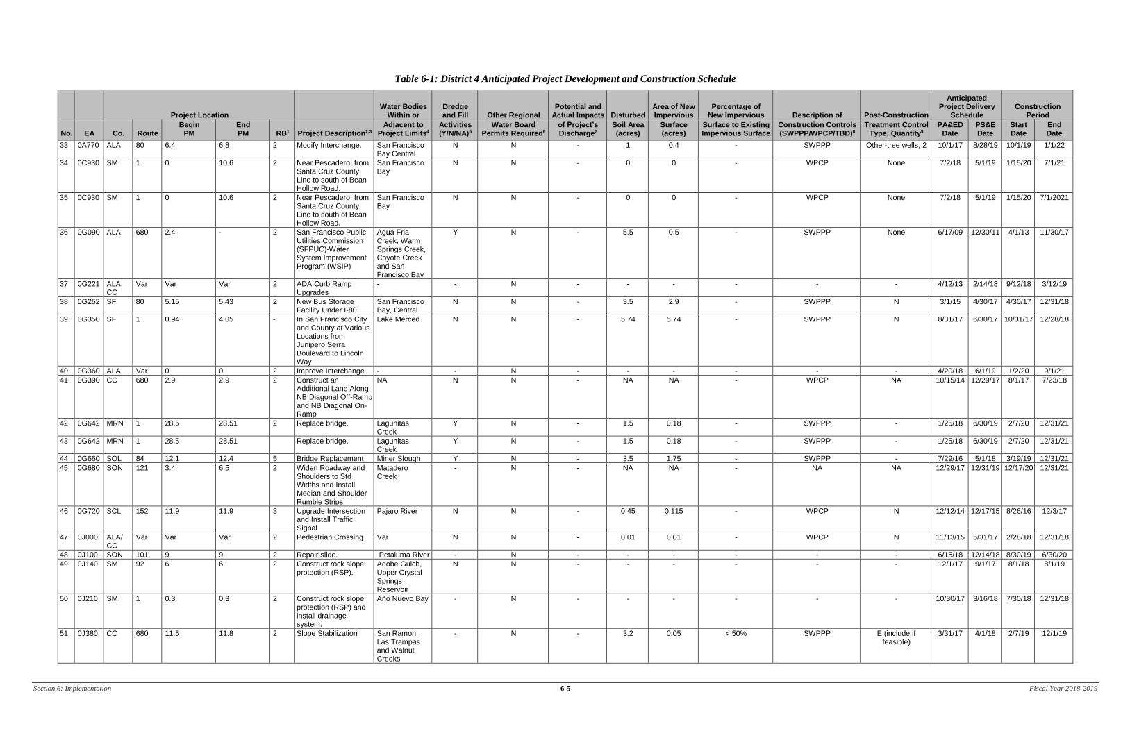
Section 6: Implementation 6-1 Fiscal Year 2018-2019
6 Implementation
Section 6 of the DWP identifies the specific projects in which work is planned during the fiscal year
within the Project Approval/Environmental Document (PA/ED), Plans, Specifications, and Estimates
(PS&E), and Construction development phases. The anticipated schedule of construction and
maintenance projects is subject to change. These projects are limited to those meeting any of the
following criteria:
1. All projects that require soil disturbing activities
2. Adjacent to a Drinking Water or Ground Water Recharge Facility, as described in Section 4 of
the DWP
3. A supplemental environmental project
4. Additional projects per agreement between the District and local RWQCB
Projects listed in Table 6-1 include (where applicable):
1. Location (county, route and post mile limits)
2. Project number (expense authorization)
3. Basic Project Description
4. Disturbed soil area
5. Presence of receiving waters within or adjacent to project limits, with special designation for
303(d) listed water bodies (adopted)
6. Drinking Water Reservoir or Ground Water Recharge Facility within or adjacent to project (as
identified in Section 4 of the DWP)
7. Projected milestone dates of PA/ED, PS&E, begin Construction, and end Construction
8. Description of Construction Controls
9. Post-Construction Treatment Controls (types and quantities)
10. Dredge and fill (CWA-401) activities within the project
11. Other Regional Water Control Board Permits Required
12. Potential and Actual Impacts of Project’s Discharge
13. Area of New Impervious Surface
14. Percentage of New Impervious Surface to Existing Impervious Surface
The updated lists of projects meeting these criteria will also be provided to the RWQCB annually on
October 1st. Furthermore, this section identifies planned maintenance projects with soil disturbance.
Information associated with the project includes location, affected water body, and area of disturbance. In
addition, this section also describes the planned stormwater monitoring activities within the District;
however, these activities may be conducted jointly with other Districts and HQ. Consequently, the
information contained in a DWP may be repeated in another DWP.

Section 6: Implementation 6-2 Fiscal Year 2018-2019
This page was intentionally left blank.

Section 6: Implementation 6-3 Fiscal Year 2018-2019
Table 6-1: District 4 Anticipated Project Development and Construction Schedule
Project Location Water Bodies
Within or Dredge and Fill Other Regional
Potential and Actual Impacts Disturbed
Area of New Impervious
Percentage of New Impervious Description of Post-Construction
Anticipated Project Delivery
Schedule Construction
Period
No. EA Co. Route Begin
PM End PM RB1 Project Description2,3
Adjacent to Project Limits4
Activities (Y/N/NA)5
Water Board Permits Required6
of Project’s Discharge7
Soil Area (acres)
Surface (acres)
Surface to Existing Impervious Surface
Construction Controls (SWPPP/WPCP/TBD)8
Treatment Control Type, Quantity9
PA&ED Date
PS&E Date
Start Date
End Date
1 01350 SF 80 7.8 8.2 - Landscape and Restore Vegetation
San Francisco Bay-Central
- N N - 0 N/A WPCP E - 9/15/18 1/15/19 1/15/22
2 01352 SF/ ALA
80 8.6 (SF) 1.2 (Ala) - Remove Bridge and Salvage Elements
San Francisco Bay-Central
Y N Y 1.2 0 N/A SWPPP E 7/11/01 3/20/14 4/17/15 3/28/18
3 01357 59V04 80 8.5 8.9 - In the City of San Francisco from 0.8 Mile East of Yerba Buena Tunnel to 1.1 Mile West of Toll Plaza
TBD TBD TBD TBD TBD TBD TBD TBD TBD - 3/9/16 3/30/16 12/28/18
4 01358 59V04 80 8.3 8.3 - In the City of and County of San Francisco from 0.6 Mile East of Yerba Buena Tunnel and in Alameda County from 0.9 Mile West of Toll Plaza to 1.3 Mile West of Toll Plaza.
TBD TBD TBD TBD TBD TBD TBD TBD TBD - 12/3/18 1/2/19 9/1/21
5 01413 ALA 80 1.8 1.9 2 Building Renovations and Site Improvements
San Francisco Bay-Central
N N N 0.5 0.05 6 WPCP E - 3/31/15 11/4/15 9/25/17
6 15531 ALA 238 11.2 R12.9 2 Right of Way Activities for Land Disposition of Hayward Bypass Properties
TBD TBD TBD TBD TBD TBD TBD TBD TBD 12/1/16 10/1/17 - -
7 16030 ALA 84 13 13.6 2 Replace Bridge Alameda Creek Y N Y 3.5 – 4.2 1.29 – 1.74 - SWPPP - 6/30/17 1/1/19 12/8/19 12/1/22
8 17247 ALA Var 0 0 2 Environmental Mitigation (Site 2)
TBD TBD TBD TBD TBD TBD TBD TBD TBD 6/18/18 8/2/19 11/1/19 1/18/24
9 20950 MRN/ SON
1 50.2 (MRN); 0.0 (SON)
50.5 (MRN); 0.2 (SON)
1 Bridge Replacement Americano Creek, Estero Americano
Y N Y 1.7 1.35 130 SWPPP BIOSWL, 4 1/30/15 5/3/16 1/30/17 12/30/18
10 23536 SM 101; 84
5.1 (101); 25.3 (84)
6.0 (101); 25.7 (84)
2 Interchange Improvement
Redwood Creek
N N Y 20.9 – 28.9 (w/in CT right-of-way)
14.8 – 22.9 (w/in CT
right-of-way)
106 – 185 (w/in CT right-of-way)
SWPPP BIOSTP/BIOSWL preferred
12/19/16 12/1/18 - 8/1/23
11 23562 SM/ SCL
101 0.0 (SM)/ 52.5 (SCl)
0.0 (SM)/ 52.5 (SCl)
2 Bridge Replacement San Francisquito Creek
Y N Y 2.43 0.16 - SWPPP BIOSWL, 1 3/14/12 11/19/14 5/11/15 11/28/17
12 23584 SM 101 16.3 17.1 2 Interchange Reconstruction
Mills, Easton and Sanchez Creeks, and San Francisco Bay-Lower
Y N Y 7.9 (w/in CT right-of-way)
4.87 (w/in CT right-of-way)
>100 SWPPP BIOSWL, 8 3/24/11 8/30/13 7/17/14 1/25/18
13 25460 SM 1 41.7 43.0 2 Operational Improvement
Calera, Rockaway and Sanchez Creeks, and Laguna Salada
Y N Y 10.2 7.01 - SWPPP BIOSTP, 1; BIOSWL, 5
8/2/13 3/1/19 4/1/20 4/1/22
1 Regional Board 2 Supplemental Environmental Projects designated as “SEP.” [Note: This Project Description should match the project description shown in the Project Resourcing and Schedule Management (PRSM) database.] 3 Projects adjacent to Drinking Water Reservoirs or Ground Water Recharge Facilities are noted (DW) and (GW), respectively. 4 Water bodies with a 303(d) designation are noted in parentheses. 5 If yes, a 401 permit will be required for this project. NA = Not Available at this time. 6 Regional Water Board Permits required other than Construction General Permit and Clean Water Act Section 401 water quality certification, such as Waiver of Discharge Requirements, Dewatering Permits, Bridge Painting WDRs, etc. 7 This information may come from the Water Quality Assessment Report prepared for each project, a Water Quality Technical Memorandum, or other document that evaluates the water quality impacts of a project. 8 A description of the Construction Controls is available in the project’s SWPPP, WPCP, or is To Be Determined (TBD) if the Disturbed Soil Area is unavailable. 9 Treatment Control Status identified by: device type/number of devices, exempt (“E”), or under consideration (“C”). See Treatment Control Status Legend below for device type abbreviations.

Section 6: Implementation 6-4 Fiscal Year 2018-2019
Table 6-1: District 4 Anticipated Project Development and Construction Schedule
Project Location Water Bodies
Within or Dredge and Fill Other Regional
Potential and Actual Impacts Disturbed
Area of New Impervious
Percentage of New Impervious Description of Post-Construction
Anticipated Project Delivery
Schedule Construction
Period
No. EA Co. Route Begin
PM End PM RB1 Project Description2,3
Adjacent to Project Limits4
Activities (Y/N/NA)5
Water Board Permits Required6
of Project’s Discharge7
Soil Area (acres)
Surface (acres)
Surface to Existing Impervious Surface
Construction Controls (SWPPP/WPCP/TBD)8
Treatment Control Type, Quantity9
PA&ED Date
PS&E Date
Start Date
End Date
14 25941 NAP 29 25.5 28.4 2 Roadway Rehabilitation
Bale Slough, Sulphur Creek, Napa River
N N N 6.5 7.40 64 SWPPP BIOSTP, 6; INDTRE, 29
6/29/07 3/21/14 4/2/15 8/1/17
15 26409 MRN, SON
101 26.8 (MRN); R0.0 (SON)
27.6 (MRN); R2.0 (SON)
2 Realignment and Widening
San Antonio Creek
Y N Y 72.1 33.8 - SWPPP BS, 9 10/29/09 7/10/14 2/18/16 11/1/18
16 26470 SCL 101 40.5 41.5 2 Interchange Reconstruction
Guadalupe River
N N - 23.3 (w/in CT right-of-way)
6.9 52 SWPPP BIOSWL, 21 3/11/16 8/3/17 8/16/18 5/13/20
17 26560 SM 1 40.6 41 2 Bridge Replacement San Pedro Creek (303d), Pacific Ocean at Pacifica Beach (303d)
Y N - 5.97 2.61 - SWPPP BIOSSTP, 2; BIOSWL, 4
10/31/11 6/17/13 3/24/14 4/1/18
18 26980 CC 242 R0 R3.4 2 Pavement rehabilitation.
Suisun N N - 0 0 - WPCP - 7/1/17 7/1/19 3/1/20 3/1/22
19 27010 ALA 580 R30.8 R41.5 2 Rehabilitate pavement. San Leandro Creek
N N - 0 0 0 WPCP - 7/29/16 12/29/17 10/31/18 12/31/20
20 27205 SCL 280 7.5 11.5 2 Rehabilitate Existing Pavement On Ramps
San Francisco Bay
N N - 0 0 0 WPCP - 12/31/13 3/24/15 12/11/15 10/18/17
21 27282 SM 101 R0.8 R1.4 2 Interchange Improvements
MS4 N N N 1 – 2 0.6 - SWPPP - - 6/15/17 9/15/17 6/25/19
22 27830 ALA 185 0.9 3.8 2 In Alameda County on Route 185 Near the City of Hayward from 162nd Street to Rufus Court
- - N - - - - - - 9/30/12 6/20/19 12/20/19 12/21/20
23 28120 NAP 29/221 5.0/0.0 7.1/0.7 2 Intersection Improvements
Soskol Creek, Napa River
Y N - 10 - - SWPPP - 7/16/18 8/31/20 10/31/21 12/15/23
24 29494 Ala, CC
24 5.3 (Ala); 0.0 (CC)
6.2 (Ala); 1.3 (CC)
2 Replacement Planting San Pablo Creek
N N N 6.1 1.0 - SWPPP None (existing T-BMP)
9/12/07 11/1/13 8/21/14 6/28/19
25 29762 ALA 24 22.9 25.7 2 Expressway Widening – Segment 2 South Widen and Upgrade Existing SR 84 from Two to Four Lanes
Arroyo del Valle, Arroyo Mocho
Y N - 43.5 22.7 22 SWPPP BIOSTP, 5; BIOSWL, 7; MF-
ADS, 2
9/4/08 12/15/14 10/20/15 8/24/18
26 29763 ALA 84/680 17.9/10.3 22.9/15.3 2 Widening from 2 Lanes to 4 Lanes and Interchange Modification
Arroyo de la Laguna, Alameda Creek, Arroyo del Valle
Y N - 59 33 - SWPPP - 2/1/18 8/7/19 4/16/20 4/21/22
27 44500 SCL 17 7.7 7.7 2 Install Weigh-In-Motion Systems in both directions and construct a maintenance Vehicle Pullout
Los Gatos Creek
N N - 0.5 0.44 - WPCP None 6/30/14 2/9/16 10/14/16 12/29/17
28 0120T SF 80 7.8 8.2 2 Construct & Remove Bridge, Roadways
San Francisco Bay -Central
Y N - 13 - SWPPP - - 11/14/11 2/1/13 9/30/17
29 0A020 SON 1 15.1 15.8 1 Realign Roadway. Scotty Creek, Pacific Ocean
Y N - 13 3.5 - SWPPP - 6/30/16 4/2/18 2/1/19 12/31/20
30 0A081 CC 80 3.9 5.3 2 Construct Interchange, Pedestrian
San Pablo and Wildcat Creeks
- N - 0.8 0.05 - WPCP E 5/24/10 12/29/14 12/7/15 11/30/17
31 0A534 SOL 80 12 13.1 2 Reconstruct I-80 WB/SR WB Connector and Green Valley Rd. Interchange
Green Valley Creek, Jameson Canyon Creek
Y N - 35.1 8.1 - SWPPP BIOSTP, 1 10/25/12 1/31/13 4/9/14 12/29/17
32 0A537 SOL 80/ 680
12.2/ 11.0
13.5/ 12.2
2 Construct the Connector from I-80 Westbound to I-680 Southbound.
Green Valley Creek, Dan Wilson Creek
Y N - - - - SWPPP - 10/25/12 12/1/17 7/20/18 6/1/20
Section 6: Implementation 6-5 Fiscal Year 2018-2019
Table 6-1: District 4 Anticipated Project Development and Construction Schedule
Project Location Water Bodies
Within or Dredge and Fill Other Regional
Potential and Actual Impacts Disturbed
Area of New Impervious
Percentage of New Impervious Description of Post-Construction
Anticipated Project Delivery
Schedule Construction
Period
No. EA Co. Route Begin
PM End PM RB1 Project Description2,3
Adjacent to Project Limits4
Activities (Y/N/NA)5
Water Board Permits Required6
of Project’s Discharge7
Soil Area (acres)
Surface (acres)
Surface to Existing Impervious Surface
Construction Controls (SWPPP/WPCP/TBD)8
Treatment Control Type, Quantity9
PA&ED Date
PS&E Date
Start Date
End Date
33 0A770 ALA 80 6.4 6.8 2 Modify Interchange. San Francisco Bay Central
N N - 1 0.4 - SWPPP Other-tree wells, 2 10/1/17 8/28/19 10/1/19 1/1/22
34 0C930 SM 1 0 10.6 2 Near Pescadero, from Santa Cruz County Line to south of Bean Hollow Road.
San Francisco Bay
N N - 0 0 - WPCP None 7/2/18 5/1/19 1/15/20 7/1/21
35 0C930 SM 1 0 10.6 2 Near Pescadero, from Santa Cruz County Line to south of Bean Hollow Road.
San Francisco Bay
N N - 0 0 - WPCP None 7/2/18 5/1/19 1/15/20 7/1/2021
36 0G090 ALA 680 2.4 - 2 San Francisco Public Utilities Commission (SFPUC)-Water System Improvement Program (WSIP)
Agua Fria Creek, Warm Springs Creek, Coyote Creek and San Francisco Bay
Y N - 5.5 0.5 - SWPPP None 6/17/09 12/30/11 4/1/13 11/30/17
37 0G221 ALA, CC
Var Var Var 2 ADA Curb Ramp Upgrades
- - N - - - - - - 4/12/13 2/14/18 9/12/18 3/12/19
38 0G252 SF 80 5.15 5.43 2 New Bus Storage Facility Under I-80
San Francisco Bay, Central
N N - 3.5 2.9 - SWPPP N 3/1/15 4/30/17 4/30/17 12/31/18
39 0G350 SF 1 0.94 4.05 - In San Francisco City and County at Various Locations from Junipero Serra Boulevard to Lincoln Way
Lake Merced N N - 5.74 5.74 - SWPPP N 8/31/17 6/30/17 10/31/17 12/28/18
40 0G360 ALA Var 0 0 2 Improve Interchange - - N - - - - - - 4/20/18 6/1/19 1/2/20 9/1/21
41 0G390 CC 680 2.9 2.9 2 Construct an Additional Lane Along NB Diagonal Off-Ramp and NB Diagonal On-Ramp
NA N N - NA NA - WPCP NA 10/15/14 12/29/17 8/1/17 7/23/18
42 0G642 MRN 1 28.5 28.51 2 Replace bridge. Lagunitas Creek
Y N - 1.5 0.18 - SWPPP - 1/25/18 6/30/19 2/7/20 12/31/21
43 0G642 MRN 1 28.5 28.51 Replace bridge. Lagunitas Creek
Y N - 1.5 0.18 - SWPPP - 1/25/18 6/30/19 2/7/20 12/31/21
44 0G660 SOL 84 12.1 12.4 5 Bridge Replacement Miner Slough Y N - 3.5 1.75 - SWPPP - 7/29/16 5/1/18 3/19/19 12/31/21
45 0G680 SON 121 3.4 6.5 2 Widen Roadway and Shoulders to Std Widths and Install Median and Shoulder Rumble Strips
Matadero Creek
- N - NA NA - NA NA 12/29/17 12/31/19 12/17/20 12/31/21
46 0G720 SCL 152 11.9 11.9 3 Upgrade Intersection and Install Traffic Signal
Pajaro River N N - 0.45 0.115 - WPCP N 12/12/14 12/17/15 8/26/16 12/3/17
47 0J000 ALA/ CC
Var Var Var 2 Pedestrian Crossing Var N N - 0.01 0.01 - WPCP N 11/13/15 5/31/17 2/28/18 12/31/18
48 0J100 SON 101 9 9 2 Repair slide. Petaluma River - N - - - - - - 6/15/18 12/14/18 8/30/19 6/30/20
49 0J140 SM 92 6 6 2 Construct rock slope protection (RSP).
Adobe Gulch, Upper Crystal Springs Reservoir
N N - - - - - - 12/1/17 9/1/17 8/1/18 8/1/19
50 0J210 SM 1 0.3 0.3 2 Construct rock slope protection (RSP) and install drainage system.
Año Nuevo Bay - N - - - - - - 10/30/17 3/16/18 7/30/18 12/31/18
51 0J380 CC 680 11.5 11.8 2 Slope Stabilization San Ramon, Las Trampas and Walnut Creeks
- N - 3.2 0.05 < 50% SWPPP E (include if feasible)
3/31/17 4/1/18 2/7/19 12/1/19

Section 6: Implementation 6-6 Fiscal Year 2018-2019
Table 6-1: District 4 Anticipated Project Development and Construction Schedule
Project Location Water Bodies
Within or Dredge and Fill Other Regional
Potential and Actual Impacts Disturbed
Area of New Impervious
Percentage of New Impervious Description of Post-Construction
Anticipated Project Delivery
Schedule Construction
Period
No. EA Co. Route Begin
PM End PM RB1 Project Description2,3
Adjacent to Project Limits4
Activities (Y/N/NA)5
Water Board Permits Required6
of Project’s Discharge7
Soil Area (acres)
Surface (acres)
Surface to Existing Impervious Surface
Construction Controls (SWPPP/WPCP/TBD)8
Treatment Control Type, Quantity9
PA&ED Date
PS&E Date
Start Date
End Date
52 0J470 59V04 Var 0 0 2 Crosswalk safety enhancements.
San Francisco Bay
N N N 0.01 0 0 WPCP NA 10/30/17 10/4/18 4/23/19 10/31/19
53 0J520 ALA 580 8 8 2 Rehabilitate westbound structure.
Arroyo Las Pasitos
- N - 0.9 0.03 - WPCP E 1/15/18 5/1/19 2/3/20 5/2/22
54 0J530 ALA 880 11.3 12.3 2 In Fremont, from 0.5 mile south to 0.5 mile north of Patterson Slough Bridge No. 33-0250 (PM 11.8). Bridge rehabilitation.
Alameda Creek N N - <1 <1 < 50% WPCP NA 5/22/19 4/20/20 2/10/21 2/10/22
55 0J540 CC 24 R0.01 R0.01 2 Caldecott Tunnel 1, 2, 3 Rehab
San Pablo Reservoir, Temescal Creek
- N - 0.1 0.06 <50% WPCP N/A 8/15/16 10/2/17 1/2/18 3/14/22
56 0J550 ALA 84 17.2 17.2 2 Bridge scour mitigation and bridge rail upgrade.
Russian River - N - - - - - - 9/15/18 3/16/20 1/18/21 1/18/23
57 0J560 SCL 101 0.03 50.3 2 In various cities, on Routes 101 and 237 at various locations. Bridge rail upgrade at 8 locations. (G13 Contingency Project)
Pajaro River, Llagas Creek, Coyote Creek, Silver Creek, Guadalupe River, Saratoga Creek, Stevens Creek, Permanente Creek
N N N <1 <1 <50% WPCP NA 9/14/18 3/16/20 12/21/20 10/15/21
58 0J570 MRN 1 33.4 33.4 2 Repair damaged embankment and construct retaining wall.
Tomales Bay Y N Y <1 <1 <50% WPCP C 12/1/17 5/17/19 2/4/20 10/30/20
59 0J600 SOL 80 1.1 34.5 2 In and near Vallejo, Dixon and Vacaville, at Route 80/29 Separation Bridge No. 23-0087, McCune Creek Bridge No. 23-0084 L/R and Horse Creek Bridge No. 23-0077 L. Bridge preventative maintenance.
McCune Creek, Horse Creek, Carquinez Strait
Y N N 0.5 0 <50% WPCP N 8/31/18 4/30/20 11/2/20 12/31/21
60 0J620 ALA 680 12.4 21.9 2 In and near Pleasanton and Dublin, from north of Route 84 to Alcosta Boulevard. Roadway rehabilitation.
Alameda Creek N N - 35 32 <50% SWPPP C 10/2/18 2/28/20 3/30/21 10/2/23
61 0J640 SON 101 29.3 54.2 - In Sonoma County in and near Windsor, from town of Windsor to Geyserville. (Pavement Rehabilitation)
Russian River N N N 4.53 4.53 <50% SWPPP BIOSTP (5) 12/23/15 6/27/16 3/24/17 12/31/18
62 0J642 SON 101 29.3 R54.3 1 Roadway rehabilitation.
Russian River N N - <1 <1 <50% WPCP N 6/30/18 2/1/19 11/1/19 12/30/21
63 0J642 SON 101 29.3 54.2 1 Roadway rehabilitation.
Russian River N N - <1 <1 <50% WPCP N 6/30/18 2/1/19 11/1/19 12/30/21
64 0J660 SCL 680 M0 M9.9 2 - Silver Creek, Coyote Creek
N N - 10.5 10.5 <50% SWPPP C 9/7/17 10/1/18 7/15/19 10/30/19
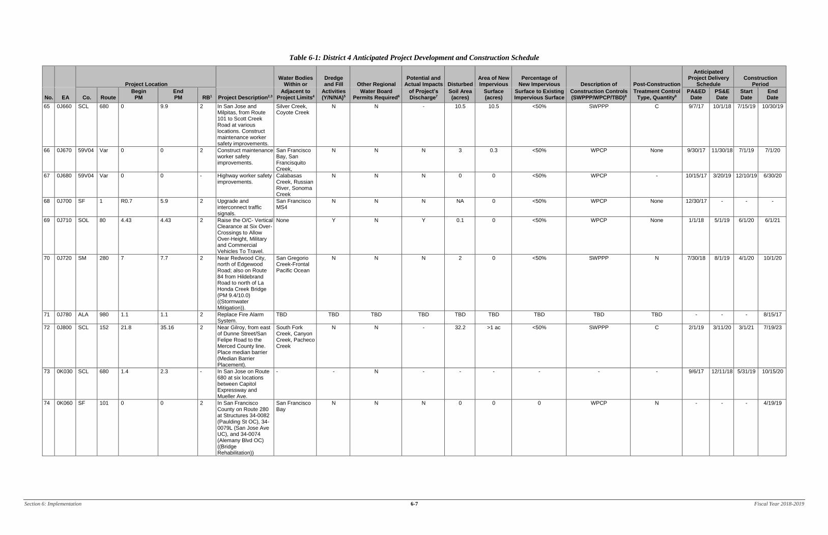
Section 6: Implementation 6-7 Fiscal Year 2018-2019
Table 6-1: District 4 Anticipated Project Development and Construction Schedule
Project Location Water Bodies
Within or Dredge and Fill Other Regional
Potential and Actual Impacts Disturbed
Area of New Impervious
Percentage of New Impervious Description of Post-Construction
Anticipated Project Delivery
Schedule Construction
Period
No. EA Co. Route Begin
PM End PM RB1 Project Description2,3
Adjacent to Project Limits4
Activities (Y/N/NA)5
Water Board Permits Required6
of Project’s Discharge7
Soil Area (acres)
Surface (acres)
Surface to Existing Impervious Surface
Construction Controls (SWPPP/WPCP/TBD)8
Treatment Control Type, Quantity9
PA&ED Date
PS&E Date
Start Date
End Date
65 0J660 SCL 680 0 9.9 2 In San Jose and Milpitas, from Route 101 to Scott Creek Road at various locations. Construct maintenance worker safety improvements.
Silver Creek, Coyote Creek
N N - 10.5 10.5 <50% SWPPP C 9/7/17 10/1/18 7/15/19 10/30/19
66 0J670 59V04 Var 0 0 2 Construct maintenance worker safety improvements.
San Francisco Bay, San Francisquito Creek,
N N N 3 0.3 <50% WPCP None 9/30/17 11/30/18 7/1/19 7/1/20
67 0J680 59V04 Var 0 0 - Highway worker safety improvements.
Calabasas Creek, Russian River, Sonoma Creek
N N N 0 0 <50% WPCP - 10/15/17 3/20/19 12/10/19 6/30/20
68 0J700 SF 1 R0.7 5.9 2 Upgrade and interconnect traffic signals.
San Francisco MS4
N N N NA 0 <50% WPCP None 12/30/17 - - -
69 0J710 SOL 80 4.43 4.43 2 Raise the O/C- Vertical Clearance at Six Over-Crossings to Allow Over-Height, Military and Commercial Vehicles To Travel.
None Y N Y 0.1 0 <50% WPCP None 1/1/18 5/1/19 6/1/20 6/1/21
70 0J720 SM 280 7 7.7 2 Near Redwood City, north of Edgewood Road; also on Route 84 from Hildebrand Road to north of La Honda Creek Bridge (PM 9.4/10.0) ((Stormwater Mitigation)).
San Gregorio Creek-Frontal Pacific Ocean
N N N 2 0 <50% SWPPP N 7/30/18 8/1/19 4/1/20 10/1/20
71 0J780 ALA 980 1.1 1.1 2 Replace Fire Alarm System.
TBD TBD TBD TBD TBD TBD TBD TBD TBD - - - 8/15/17
72 0J800 SCL 152 21.8 35.16 2 Near Gilroy, from east of Dunne Street/San Felipe Road to the Merced County line. Place median barrier (Median Barrier Placement).
South Fork Creek, Canyon Creek, Pacheco Creek
N N - 32.2 >1 ac <50% SWPPP C 2/1/19 3/11/20 3/1/21 7/19/23
73 0K030 SCL 680 1.4 2.3 - In San Jose on Route 680 at six locations between Capitol Expressway and Mueller Ave.
- - N - - - - - - 9/6/17 12/11/18 5/31/19 10/15/20
74 0K060 SF 101 0 0 2 In San Francisco County on Route 280 at Structures 34-0082 (Paulding St OC), 34-0079L (San Jose Ave UC), and 34-0074 (Alemany Blvd OC) ((Bridge Rehabilitation))
San Francisco Bay
N N N 0 0 0 WPCP N - - - 4/19/19

Section 6: Implementation 6-8 Fiscal Year 2018-2019
Table 6-1: District 4 Anticipated Project Development and Construction Schedule
Project Location Water Bodies
Within or Dredge and Fill Other Regional
Potential and Actual Impacts Disturbed
Area of New Impervious
Percentage of New Impervious Description of Post-Construction
Anticipated Project Delivery
Schedule Construction
Period
No. EA Co. Route Begin
PM End PM RB1 Project Description2,3
Adjacent to Project Limits4
Activities (Y/N/NA)5
Water Board Permits Required6
of Project’s Discharge7
Soil Area (acres)
Surface (acres)
Surface to Existing Impervious Surface
Construction Controls (SWPPP/WPCP/TBD)8
Treatment Control Type, Quantity9
PA&ED Date
PS&E Date
Start Date
End Date
75 0K120 59V04 Var 0 0 2 In Alameda & Contra Costa Counties on Various Routes (Install Rectangular Rapid Flashing Beacons at ramp termini with uncontrolled pedestrian crossings)
San Joaquin River, Walnut Creek, San Ramon Creek, Coyote Creek, Alameda Creek, San Francisco Bay, San Lorenzo Creek, Perella Creek, Lake Temescal, San Pablo Creek, Wildcat Creek
N N - 2 <1 ac <50% WPCP N 10/11/18 3/21/24 5/2/24 7/13/28
76 0K130 59V04 Var 0 0 - On SON-12-116, MRN-1-131, NAP-29 at Var Locations.
- - N - - - - - - 8/1/18 9/17/19 12/18/19 2/28/24
77 0K160 CC 80 0 13.7 2 In CC County on I-80 from County Line to Carquinez Bridge (Install safety lighting and upgrade median)
San Francisco Bay, Cerrito Creek, Carquinez Strait, Rodeo Creek, Wildcat Creek, Garrity Creek, Pinole Creek
N N N <1 0 <50% WPCP N 10/8/18 3/18/24 1/2/25 7/10/28
78 0K240 SCL 237 7 8 2 In Santa Clara County in San Jose on Eastbound Route 237 from North First Street Overcrossing to Zanker Road Overcrossing
Coyote Creek, Guadalupe River
N N - 3.7 1.65 <50% SWPPP C 8/6/18 6/4/19 12/24/19 3/7/24
79 0K240 SCL 237 7.1 8 2 In Santa Clara County in San Jose on Eastbound Route 237 from North First Street Overcrossing to Zanker Road Overcrossing
Coyote Creek, Guadalupe River
N N - 3.7 1.65 <50% SWPPP C 8/6/18 6/4/19 12/24/19 3/7/24
80 0K250 SCL 237 7 8 2 In Santa Clara County in San Jose on Westbound Route 237 from Zanker Road Overcrossing to North First Street Overcrossing Construction of Auxiliary Lane)
Coyote Creek, Guadalupe River
N N - 5.7 2.47 <50% SWPPP C 8/6/18 - 11/1/22 11/1/23
81 0K280 ALA Var 0 0 - In Alameda County on Routes 580, 880 and 980 at various locations (Bridge maintenance Repair)
San Leandro Bay, Oakland Inner Harbor, Lake Merritt, Oakland Outer Harbor
N N N 0 0 <50% WPCP N 8/15/15 6/10/16 - 4/19/19

Section 6: Implementation 6-9 Fiscal Year 2018-2019
Table 6-1: District 4 Anticipated Project Development and Construction Schedule
Project Location Water Bodies
Within or Dredge and Fill Other Regional
Potential and Actual Impacts Disturbed
Area of New Impervious
Percentage of New Impervious Description of Post-Construction
Anticipated Project Delivery
Schedule Construction
Period
No. EA Co. Route Begin
PM End PM RB1 Project Description2,3
Adjacent to Project Limits4
Activities (Y/N/NA)5
Water Board Permits Required6
of Project’s Discharge7
Soil Area (acres)
Surface (acres)
Surface to Existing Impervious Surface
Construction Controls (SWPPP/WPCP/TBD)8
Treatment Control Type, Quantity9
PA&ED Date
PS&E Date
Start Date
End Date
82 0K450 SOL Var Var Var 2 In Solano County on multiple bridge along Routes 37, 80, 680, & 780 (Treat bridge deck with methacrylate, replace joint seals, repair loose concrete and repair concrete spalls)
Suisun Bay, Mare Island Strait, Cordelia Slough
N N N 0 0 <50% WPCP N - - - 7/27/18
83 0K490 ALA 185 0.3 6.4 2 In ALA County on Rte 185 from A St to Route 112 (Roadway Rehabilitation)
Lorenzo Creek, Estudillo Canal, Cordelia Slough, Ulatis Creek
N N N 0 0 <50% WPCP N 10/24/18 4/3/24 5/15/24 7/26/28
84 0K510 MRN 1 11.2 11.2 2 In MRN in the City of Stinson Beach on US 1 PM 11.2(Bridge Culvert Replacement).
San Rafael Creek
N N N 0.05 0 <50% WPCP N 10/24/18 4/3/24 5/15/24 7/26/28
85 0K570 SM 1 1.12 1.12 2 In SM county, on Rte 1, at Año Nuevo, at 1.1 miles north of Santa Cruz county line (Roadway Rehabilitation).
Año Nuevo Creek
N N N 0.25 0.25 <50% WPCP N 8/23/18 10/9/19 6/29/20 3/26/24
86 0K650 59V04 Var 0 0 - In Alameda and Contra Costa Counties on Various Routes at Various Post Miles.
- - N - - - - - - 11/14/18 4/24/24 6/5/24 8/16/28
87 0K670 SM 82 19.8 19.8 2 In SM county, on Rte 82, in South San Francisco City, 0.1 mile north of Francisco Drive (Roadway Rehabilitation).
San Mateo Creek, Colma Creek
N N N 0.25 0.25 <50% WPCP N 9/7/18 10/23/19 6/29/20 4/10/24
88 0K710 SCL 101 38 40 2 US 101 Zanker Road/Skyport Drive/Fourth Street project new interchange (Interchange Improvements)
Coyote Creek and Guadalupe River
N N N 40 30 >50% SWPPP C 9/14/18 10/30/19 2/5/20 4/17/24
89 0K750 SF 101 5.9 8 2 Near San Benito, north of Route 146.
- - N - - - - - - 9/18/18 11/1/19 2/7/20 4/19/24
90 0K800 MRN 101 13.7 13.7 2 In MRN County in the City of San Rafael, on Rte 101, PM 13.7 (Install APS, upgrade curb ramps and repair sidewalks).
Gallinas Creek N N N 0.5 0.46 - WPCP N 12/4/18 5/15/24 6/24/24 8/29/28
91 0K840 CC 680 13.9 22.7 2 Install Lighting Along Median and Upgrade Median Barrier.
Walnut Creek N N N - - - WPCP E 4/13/17 3/30/18 10/25/18 10/25/19
92 0P000 MRN 1 0.1 0.1 - In Marin County, in Mill Valley, at the Route 101 separation
- - N - - - - - - - - - 12/6/18
93 0P010 ALA 84 12 13 - In Alameda County, near Fremont, from 1.0 mile to 2.0 miles west of Palomares Road
- - N - - - - - - - - - 12/5/18

Section 6: Implementation 6-10 Fiscal Year 2018-2019
Table 6-1: District 4 Anticipated Project Development and Construction Schedule
Project Location Water Bodies
Within or Dredge and Fill Other Regional
Potential and Actual Impacts Disturbed
Area of New Impervious
Percentage of New Impervious Description of Post-Construction
Anticipated Project Delivery
Schedule Construction
Period
No. EA Co. Route Begin
PM End PM RB1 Project Description2,3
Adjacent to Project Limits4
Activities (Y/N/NA)5
Water Board Permits Required6
of Project’s Discharge7
Soil Area (acres)
Surface (acres)
Surface to Existing Impervious Surface
Construction Controls (SWPPP/WPCP/TBD)8
Treatment Control Type, Quantity9
PA&ED Date
PS&E Date
Start Date
End Date
94 0P130 MRN 1 11.5 11.5 - In Marin County, near Stinson Beach, at 0.6 mile south of Panoramic Highway north junction
- - N - 0.12 0.05 - WPCP E - - - 12/13/18
95 0P150 SM 92 0.91 0.91 2 In San Mateo County, near Half Moon Bay, at 0.7 mile east of Main Street (Storm Damage)
Pilarcitos Creek Emergency Project
N - 0.04 0.01 <50% WPCP N - 6/15/17 7/3/17 8/31/17
96 0P160 SM 1 13.5 15.1 2 In San Mateo County, near Pescadero, from Pescadero Creek Road to 1.6 miles north of Pescadero Creek Road
Pescadero Marsh, Pacific Ocean
Emergency Project
N - 0.5 0.02 <50% WPCP N - - - 12/5/18
97 0P180 SON 12 17.6 18.5 - In Sonoma County, in Santa Rosa, from 0.1 mile west of Hoen Avenue to 0.4 mile east of Farmers Lane (Storm Damage)
TBD TBD TBD TBD TBD TBD TBD TBD TBD - - - 11/6/18
98 0P200 ALA 238 14.4 16.6 - In Alameda County, in Hayward, from Route 580 to Route 880
TBD TBD TBD TBD TBD TBD TBD TBD TBD - - - 11/19/18
99 0P210 ALA 680 0.4 0.4 - In Alameda County, in Fremont, at Scott Creek Road
TBD TBD TBD TBD TBD TBD TBD TBD TBD - - - 12/5/18
100 0P250 SM 280 8.5 10 2 In San Mateo County, in Belmont, from 0.2 mile to 1.2 miles south of the route 92 separation (replace culverts and backfill sinkholes).
Upper Crystal Springs Lake, San Francisco Bay
Emergency Project
N - 0.065 0.003 <50% WPCP N - - - 7/12/17
101 0P260 SM 35 26.1 28.9 - In San Mateo County, near Daly City, from 0.1 mile south of Westborough Avenue to 0.2 mile north of the route 1 separation
TBD TBD TBD TBD TBD TBD TBD TBD TBD - - - 12/5/18
102 0P280 SM 280 20.4 20.4 - In San Mateo, in San Bruno, at Cedar Mills Lane
TBD TBD TBD TBD TBD TBD TBD TBD TBD - - - 7/3/18
103 0P460 SCL 101 26.7 26.7 - In Santa Clara County, in San Jose, at the Route 85 separation.
TBD TBD TBD TBD TBD TBD TBD TBD TBD - - - 12/7/18
104 1637E SF 101 8 9.8 2 South Access to Golden Gate Bridge Doyle Dr Replacement Project-All Right-Of-Way Activities for Entire Project
San Francisco Bay
N/A N/A N/A N/A N/A N/A N/A N/A 1/28/09 6/1/09 10/1/09 8/15/17
105 1637U SF 1 8 9.8 2 Structure Rehab and Seismic Restoration of Tunnels and Viaducts Highway Planting
Crissy Marsh, San Francisco Bay-Central
Y N Y 42 33.37 ~100 SWPPP C 1/28/09 5/1/12 8/1/12 8/15/17
106 1A100 SM 1 - - 2 Construct Northbound and Southbound Off Ramp
- Y N Y 0.08 - - WPCP E 11/1/17 1/1/18 6/1/18 6/1/19

Section 6: Implementation 6-11 Fiscal Year 2018-2019
Table 6-1: District 4 Anticipated Project Development and Construction Schedule
Project Location Water Bodies
Within or Dredge and Fill Other Regional
Potential and Actual Impacts Disturbed
Area of New Impervious
Percentage of New Impervious Description of Post-Construction
Anticipated Project Delivery
Schedule Construction
Period
No. EA Co. Route Begin
PM End PM RB1 Project Description2,3
Adjacent to Project Limits4
Activities (Y/N/NA)5
Water Board Permits Required6
of Project’s Discharge7
Soil Area (acres)
Surface (acres)
Surface to Existing Impervious Surface
Construction Controls (SWPPP/WPCP/TBD)8
Treatment Control Type, Quantity9
PA&ED Date
PS&E Date
Start Date
End Date
107 1A200 SCL 152 R26.9 0 3 Install Traffic Census Station with Weigh-In-Motion
Pacheco Creek N N N 0.61 0.61 - WPCP E 6/11/13 1/26/16 10/14/16 8/1/17
108 1A210 SON 37 2.6 2.6 2 Install Traffic Census Station with Weigh-In -Motion. And RR 300 Ft Pavement Section
San Pablo Bay Estuaries
Y N Y 0.1 0 - WPCP E 4/1/18 4/1/19 12/30/19 10/30/20
109 1A290 SON 12 9.6 9.6 1 Replace Bridge for Scour
Laguna De Santa Rosa Flood Control Channel
Y N Y 3.2 0.55 - SWPPP BIOSTP, 1 6/25/10 10/12/12 3/24/14 7/15/18
110 1A340 SCL 9 3.6 11.4 2 Bridge Rail Replacement and Upgrades
- - N - 0.1 0.016 - WPCP E 3/21/14 5/13/15 2/4/16 12/14/17
111 1A421 SON 116 19.2 19.5 1 Signalization of the Intersection of Route 116 & Mirabel Road (Phase I)
Jones Creek N N N 4.14 0.56 - SWPPP C 10/24/13 12/1/17 6/1/18 12/1/19
112 1A661 MRN 101 8.2 8.7 - In Marin County, from Tamalpias Drive Interchange in Corte Madera to Sir Francis Drake Blvd. in Larkspur, improvement on SB and NB 101 and multimodal improvements.
- - N - - - - - - 1/31/17 9/21/17 3/15/18 10/31/18
113 1A672 ALA 580 46 46.8 2 Bridge Rehab Paint/Electrical Work
San Francisco Bay, Central
N N N 0.08 0 - WPCP E 7/2/08 5/7/15 12/22/15 5/1/19
114 1A683 ALA 880 28.6 29 2 Rehabilitate roadway. San Francisco Bay, Central
TBD TBD TBD TBD TBD TBD TBD TBD 2/15/11 4/15/18 11/28/18 11/1/19
115 1A904 SF 1 5.9 6.3 2 In the City of San Francisco, at Presidio National Park. Water Quality Improvement
Mountain Lake N N N 0.33 0 - WCPC E 12/12/14 9/9/15 4/6/17 12/28/18
116 1A905 SF 1 6 6 2 Water quality improvements
Mountain Lake TBD TBD TBD TBD TBD TBD TBD TBD 3/1/19 4/2/20 2/10/21 12/31/21
117 1G020 SM 82 13.69 13.69 2 Install left turn signal. Coyote Creek N N N 0.32 0.13 - WPCP E 11/15/17 6/9/17 11/8/17 11/8/19
118 1G110 SF 101 0 0 2 High Speed Rail from San Francisco to San Jose
- - N - - - - - - 12/1/17 12/1/19 - -
119 1G120 SCL 280 4 10 2 High Speed Rail from San Jose to Merced
TBD TBD TBD TBD TBD TBD TBD TBD TBD 12/1/17 - - -
120 1G430 NAP 128 R7.4 7.4 2 Replace bridge. Conn Creek, Napa River
Y N Y 1.2 0.46 >50% SWPPP BIOSTP, 1 10/5/15 10/2/17 7/30/18 7/24/20
121 1G621 SM 101 8.1 8.6 2 Street Interchange Reconstruction
Phelps Slough/ Lower SF Bay
Y N Y 18.83 2.14 14% SWPPP DETBAS, 1 9/25/15 8/3/17 7/1/17 10/1/18
122 1G622 SM 101 8.3 8.3 2 Pedestrian/ Bicycle Overcrossing
Phelps Slough/ Lower SF Bay
Y N Y 1.29 0.83 - SWPPP C 5/24/16 5/17/17 - 11/15/18
123 1G660 SF 80 5.5 7.7 - Bicycle/Pedestrian/Maintenance Path
- - N - - - - - - 12/31/18 - - -
124 1G840 SON 116 26.6 26.9 1 Reconstruct and upgrade existing ramps and drainage
Mark West Creek
N N N N/A N/A N/A WCPC E 9/30/15 6/8/17 2/1/18 12/31/18
125 1G860 SCL 880 1.28 1.36 2 In Santa Clara County, In San Jose at Bascom Avenue off-ramps.
Guadalupe River-Frontal SF Bay Estuaries
N N N 0.39 0.39 - WCPC E 6/30/15 3/30/17 10/23/17 12/20/18

Section 6: Implementation 6-12 Fiscal Year 2018-2019
Table 6-1: District 4 Anticipated Project Development and Construction Schedule
Project Location Water Bodies
Within or Dredge and Fill Other Regional
Potential and Actual Impacts Disturbed
Area of New Impervious
Percentage of New Impervious Description of Post-Construction
Anticipated Project Delivery
Schedule Construction
Period
No. EA Co. Route Begin
PM End PM RB1 Project Description2,3
Adjacent to Project Limits4
Activities (Y/N/NA)5
Water Board Permits Required6
of Project’s Discharge7
Soil Area (acres)
Surface (acres)
Surface to Existing Impervious Surface
Construction Controls (SWPPP/WPCP/TBD)8
Treatment Control Type, Quantity9
PA&ED Date
PS&E Date
Start Date
End Date
126 1G870 SCL 152 13.8 14.7 5S Shoulder widening Llagas Creek and Pajaro River
N N N 3.6 0.9 - WCPC C 6/30/15 3/10/17 3/15/18 12/17/18
127 1G910 ALA 185 3.25 9.75 2 Reinstall and/or upgrade existing curb ramps and sidewalks to ADA standards.
- - N - - - - WPCP E 3/1/18 5/1/19 2/28/20 12/31/20
128 1G990 ALA 580 30.4 30.4 - - TBD TBD TBD TBD TBD TBD TBD TBD TBD 12/1/17 12/3/18 - -
129 1J010 ALA 880/ 238
20.902 16.7 2 Improve safety visibility by installing lighting and improving signs.
San Lorenzo Creek-Frontal SF Bay Estuaries
N N N 0 0 0 WPCP E 11/4/16 10/25/17 7/2/18 1/2/19
130 1J020 SON Var 22.4 22.4 1, 2 High Friction Surface Treatment
Mark West Creek
N N N 0 0 0 WCPC E 10/30/15 5/8/17 12/15/17 10/15/18
131 1J320 SON 116 13.6 13.9 1 Construct Retaining Walls, Place RSP, Modify Drainage & Repair Roadway.
- Y N Y 0.03 - - WPCP E 3/2/12 7/3/14 4/5/16 12/29/17
132 1J360 SON 12 34.2 41 2 Pavement rehabilitation
Sonoma Creek N N N 0 0 0 WPCP E 3/1/18 9/5/19 6/4/20 6/3/21
133 1J520 ALA 84 0.5 29.3 2 Public Access/ vista point
Lower Cayote Creek-Frontal SF Bay Estuaries
N N N 0.37 0.08 - WCPC E 8/15/09 9/8/14 4/2/15 9/1/18
134 1J560 SM / SCL
101 0 / 50.6
21.8 / 52.6
2 Congestion Relief, Increase throughput
San Mateo Creek & SF Bay & Various (VAR)
N N N 139 12.2 - SWPPP C 11/1/17 11/1/19 6/1/20 9/1/22
135 1J600 ALA 85, 92, 112, 185, 238
Var Var 2 Install Pedestrian Beacons
Var N N N 0.04 0 - WPCP E 9/29/17 1/14/19 12/2/19 12/2/20
136 1J630 SCL 101 16 27.9 2 Pavement Preservation
Lower Coyote Creek-Frontal SF Bay Estuaries
N N N NA NA NA WPCP E 1/7/15 6/26/15 3/22/16 10/16/17
137 1J700 ALA 123 2.83 2.83 2 Install Traffic Signal & Install Extended Curb Ramps
NA N N N NA NA NA WPCP E 12/7/16 5/25/18 12/7/18 2/18/19
138 1J750 SON 1 22.48 22.48 1 Fire Damaged Tieback Retaining Wall.
Pacific Ocean, Russian Gulch
N N N 0 0 NA WPCP E 11/16/16 11/1/17 7/1/18 12/30/18
139 1J820 SOL 80 17.08 17.08 2 Upgrade electrical distribution system by replacing main distribution panel and adding sub distribution panels. Tie-In a new emergency Generator
Woodlen Valley Creek – Frontal SF Bay Estuaries
N N N <1 0 NA WCPC E 9/30/16 12/15/16 5/2/17 5/16/18
140 1J950 SCL 880 280
0 5.1
0.7 5.2
2 Construct replacement highway planting and landscaping
Los Gatos Creek, Guadalupe River
N N N 7.8 0 NA SWPPP C 7/25/11 - 11/11/16 8/15/17
141 1J960 MRN 1 22.8 45.0
31.2 50.5
1, 2 Capital Preventive Maintenance – RR pavement and associated features along 2 segments locations – Culvert Repairs
- N N Y 1.1 1.1 - SWPPP C 10/1/18 10/3/19 7/9/20 10/24/21

Section 6: Implementation 6-13 Fiscal Year 2018-2019
Table 6-1: District 4 Anticipated Project Development and Construction Schedule
Project Location Water Bodies
Within or Dredge and Fill Other Regional
Potential and Actual Impacts Disturbed
Area of New Impervious
Percentage of New Impervious Description of Post-Construction
Anticipated Project Delivery
Schedule Construction
Period
No. EA Co. Route Begin
PM End PM RB1 Project Description2,3
Adjacent to Project Limits4
Activities (Y/N/NA)5
Water Board Permits Required6
of Project’s Discharge7
Soil Area (acres)
Surface (acres)
Surface to Existing Impervious Surface
Construction Controls (SWPPP/WPCP/TBD)8
Treatment Control Type, Quantity9
PA&ED Date
PS&E Date
Start Date
End Date
142 1J970 SCL 17 2.8 13.94 - In and near Los Gatos, Campbell and San Jose, from Hebard Way to Route 280.
- - N - - - - - - 7/2/18 7/5/19 7/15/20 5/3/22
143 1J990 ALA CC
13 24 24
13.5 1.00 R4.2
19.5 R2.49 R4.99
2 Safety Lighting Sausal Creek SF Bay Central San Francisco Bay
N N Y NA NA NA WPCP E 5/1/18 5/1/19 11/12/18 7/15/19
144 1K270 SCL 880 5.68 5.75 - In Santa Clara County in City of San Jose, route 880 between Paragon drive and Oakland Road.
TBD TBD TBD TBD TBD TBD TBD TBD TBD 12/21/18 - - 7/22/22
145 1K280 SCL 101 R28.4 R28.9 2 Widening Blossom Hill Overcrossing.
Coyote Creek N N N 7 3.2 - SWPPP BIOSWL, TBD 12/20/17 - - 5/15/19
146 1K330 SF 101 1.77 1.77 2 Reconstruct bridge railing and sidewalk due to truck collision damage.
TBD TBD TBD TBD TBD TBD TBD TBD TBD - - - 8/15/17
147 1K340 ALA 185 3.2 3.75 2 AC Resurfacing, upgrade curb ramps.
San Francisco Bay
N N N 0 0 0 WPCP E 10/7/16 12/12/16 7/21/17 12/15/17
148 1K360 CC 4 16.8 17.8 2 Replace Failed Concrete Pavement
San Francisco Bay
N N N 0 0 0 WPCP E 9/30/16 12/15/16 6/30/17 6/29/18
149 1K370 MRN 37 11.2 11.8 2 AC Resurfacing – Rubberized HMA Pavement
San Pablo Estuary
N N N 0.08 0.08 - WPCP E 9/30/16 12/15/16 6/30/17 6/29/18
150 1K400 MRN 131 2.7 3 - AV.M. Flores L/west of Pine Terrace to Gilmartin Drive.
TBD TBD TBD TBD TBD TBD TBD TBD TBD 10/2/17 1/22/18 6/13/18 12/3/18
151 1K430 SCL 17 0 0 - Develop Prime Conservation Easement/Mitigation Bank for Special Status Species and for Jurisdiction A
TBD TBD TBD TBD TBD TBD TBD TBD TBD 1/7/19 2/24/20 5/26/20 8/5/24
152 1K480 ALA Var 0 0 2 Remove and Dispose of Trees.
TBD TBD TBD TBD TBD TBD TBD TBD TBD TBD TBD TBD 8/30/17
153 1K490 SM 1 47.2 47.2 2 Repair Eroded Slope with Rock Slope Protection
TBD TBD TBD TBD TBD TBD TBD TBD TBD TBD TBD TBD 9/7/17
154 1K650 SM 1 36.2 36.2 2 Repair washout with rock slope protection (RSP) and provide traffic control.
TBD TBD TBD TBD TBD TBD TBD TBD TBD TBD TBD TBD 10/5/17
155 1K670 ALA 980 1.2 1.2 - Alameda County on State Route 980 at Post Mile 1.2.
TBD TBD TBD TBD TBD TBD TBD TBD TBD 12/3/18 11/1/19 11/1/20 8/29/25
156 1K720 SON 1 1 28.7 - In Sonoma County on route 1 from 0.6 miles south of Middle Road to Jewell Gulch.
TBD TBD TBD TBD TBD TBD TBD TBD TBD 4/3/19 5/18/20 8/17/20 10/28/24
157 1K730 SON 1 30.8 40.6 - Culvert Rehabilitation Pacific Ocean Y N - 0.15 0.12 - WPCP C 4/3/19 5/18/20 8/17/20 10/28/24
158 1K750 SON 1 41.2 54.6 - Drainage System Restoration
Pacific Ocean Y N - 0.14 0.14 - WPCP C 4/3/19 5/18/20 8/17/20 10/28/24
159 1K760 SON 1 45.41 45.41 - Drainage System Restoration
Pacific Ocean N N - 0.01 0.01 - WPCP C 4/3/19 5/18/20 8/17/20 10/28/24
160 1K770 SON 116 1.03 1.03 - Culvert Rehabilitation Russian River Y N - 0.02 0.02 - WPCP BIOSWL 1 4/3/19 5/18/20 8/17/20 10/28/24
161 1K790 SON 1 15.3 15.5 1 - Scotty Creek, Pacific Ocean
- N - 0.68 0 N/A WPCP E - - - 11/13/17

Section 6: Implementation 6-14 Fiscal Year 2018-2019
Table 6-1: District 4 Anticipated Project Development and Construction Schedule
Project Location Water Bodies
Within or Dredge and Fill Other Regional
Potential and Actual Impacts Disturbed
Area of New Impervious
Percentage of New Impervious Description of Post-Construction
Anticipated Project Delivery
Schedule Construction
Period
No. EA Co. Route Begin
PM End PM RB1 Project Description2,3
Adjacent to Project Limits4
Activities (Y/N/NA)5
Water Board Permits Required6
of Project’s Discharge7
Soil Area (acres)
Surface (acres)
Surface to Existing Impervious Surface
Construction Controls (SWPPP/WPCP/TBD)8
Treatment Control Type, Quantity9
PA&ED Date
PS&E Date
Start Date
End Date
162 1K840 59V04 Var 0 0 TBD Dead Tree Removal due to Drought
TBD TBD TBD TBD TBD TBD TBD TBD TBD - - - 11/20/17
163 1K980 SCL 280 4.5 6 - In Santa Clara County, in the City of San Jose on route 280 at Winchester Blvd. On-Ramp, 0.7 mile west of Route 17.
TBD TBD TBD TBD TBD TBD TBD TBD TBD 6/28/19 2/26/21 6/1/21 -
164 1SS02 ALA 13 8.3 8.3 2 Storm Damage Repair Temescal Creek
N N - 1.2 <1.0 - WPCP E 12/3/12 10/19/15 4/5/16 2/28/18
165 1SS41 ALA 13 4.8 5 2 Storm Damage Repair Lion Creek, San Leandro Bay
N N - 0.49 0.28 - WPCP C 10/28/14 3/19/15 11/4/15 12/14/17
166 1SS43 ALA 880 2.3 2.3 - Pavement Repair Agua Creek N N - 0.02 0 - WPCP E 2/22/16 3/30/17 10/11/17 7/31/18
167 1SS44 ALA 880 19.3 19.3 2 Improve Drainage System. Construct Maintenance Access Road; and Reconstruct Irrigation System.
Alameda Creek N N - 0.02 0 - WPCP E 12/24/14 6/6/16 1/23/17 10/31/17
168 1SS58 MRN 1 2.2 2.2 - Storm Damage Repair Coyote Creek N N - 0.26 0.2 - WPCP E 6/29/15 9/16/16 5/9/17 12/28/18
169 1SS59 MRN 580 2.7 2.7 2 Storm Damage Repair San Francisco Bay-Central
N N - 0.52 0 - WPCP E 6/20/14 10/2/15 7/27/16 12/30/17
170 2356A SM 101 0 3.6 2 Replacement Landscaping
- N N - 12.6 - - SWPPP C 6/4/12 3/28/13 10/3/13 11/2/17
171 2640F SON 101 3.7 7.5 2 Segment C HOV Widening Project
Petaluma River Y N - 46.8 35.69 - SWPPP BIOSTP 7, BIOSWL 26
10/29/09 9/7/17 4/1/18 12/31/20
172 2A251 SCL 152 0 6.2 3 Planting and environmental mitigation.
Bodfish Creek, Uvas Creek
- N - - - - - - 2/4/13 12/15/17 8/31/18 4/2/19
173 2A252 SCL 152 0 5.2 3 Environmental species mitigation.
Bodfish Creek, Uvas Creek
N N - - - - - - 3/3/10 - - 4/2/18
174 2A320 NAP 121 8.9 9.4 - Bridge Replacement Sarco Creek, Napa River, San Pablo Bay
N N - 1.8 0.15 - SWPPP C 6/28/12 2/29/16 1/11/17 12/28/18
175 2A332 ALA 84 10.8 18 - Safety Improvement Alameda Creek Y N - 11.1 2.27 - SWPPP BIOSWL 1 8/30/17 3/10/19 10/27/19 6/1/20
176 2A400 ALA 185 112 77 13
5.73 1.51 0.45 11.61
10.56 1.78 0.45 11.61
2 Bus Rapid Transit Improvement and Landscape Reduction
Lion Creek, San Leandro Creek, Elmhurst Creek, Sausal Creek, Peralta Creek, Seminary Ave Drain, Arroyo Viejo Creek, 14th Avenue Creek Culvert
N N - 11.7 0 - SWPPP E 1/15/13 - - 9/28/18
177 2A490 SF 280 4.2 6.6 - Rehabilitate Bridge Deck
Corte Madera Creek
N N - < 1 0 - WPCP E 5/2/11 4/18/16 1/11/17 1/10/19
178 2A960 SOL 80 10 11.2 - Culvert Rehabilitation Suisun Bay Y N - 0.3 0.061 - WPCP C 1/11/19 2/28/20 6/1/20 8/9/24
179 2G000 ALA 185 3.64 3.86 - In Ala County on Route 185, East 14th Street/Hesperian Boulevard/150th Avenue Street.
TBD TBD TBD TBD TBD TBD TBD TBD TBD 12/30/17 12/30/18 9/30/19 8/30/20
180 2G250 CC 80 580
0.22 0.24
0.22 0.24
2 Traffic Operations Albany Marsh, Hoffman Marsh
N N - 0.08 0.02 - WPCP E 1/25/13 6/30/17 2/12/18 8/9/18
181 2G340 SON 101 20.7 21.8 - In Sonoma County, on Route 101, from PM 20.7 to 21.8
TBD TBD TBD TBD TBD TBD TBD TBD TBD 9/28/18 - - -

Section 6: Implementation 6-15 Fiscal Year 2018-2019
Table 6-1: District 4 Anticipated Project Development and Construction Schedule
Project Location Water Bodies
Within or Dredge and Fill Other Regional
Potential and Actual Impacts Disturbed
Area of New Impervious
Percentage of New Impervious Description of Post-Construction
Anticipated Project Delivery
Schedule Construction
Period
No. EA Co. Route Begin
PM End PM RB1 Project Description2,3
Adjacent to Project Limits4
Activities (Y/N/NA)5
Water Board Permits Required6
of Project’s Discharge7
Soil Area (acres)
Surface (acres)
Surface to Existing Impervious Surface
Construction Controls (SWPPP/WPCP/TBD)8
Treatment Control Type, Quantity9
PA&ED Date
PS&E Date
Start Date
End Date
182 2G350 SCL 280 18.6 18.6 2 Safety Improvement Matadero Creek
N N - 0.3 0 - WPCP E 2/15/18 2/21/18 8/15/18 12/18/19
183 2G360 ALA 92 4.8 6.7 2 Replacement Planting and Irrigation
SF BAY Y N - 12.5 0.057 - SWPPP E - 10/31/13 10/20/14 6/1/18
184 2G362 ALA 92 R5.1 R5.8 2 Highway Planting Project
San Lorenzo Creek
Y N - 5.73 0.24 - SWPPP E 12/1/03 10/31/13 10/20/14 6/1/18
185 2G460 ALA 13 10.79 12.06 2 Upgrade curb ramps Cerrito Creek-Frontal San Francisco Bay Estuaries
N N - 0.46 0 - WPCP E 7/11/18 10/11/19 4/24/20 3/1/21
186 2G481 ALA 13 12.1 13.4 2 ADA Improvements Frontal San Francisco Bay Estuaries
N N - 0.4 0.4 - WPCP E 6/30/15 6/22/16 12/13/16 7/30/17
187 2G482 ALA 13 12.1 13.4 2 ADA Improvements Corte Madera Creek
N N - <1 0.03 - WPCP E 2/1/16 5/30/18 3/29/19 9/27/19
188 2G502 ALA Var 0 0 2 Upgrade Metal Beam Guard Rail Transition Railings
Corte Madera Creek
N N - 0.21 0 - WPCP E 3/19/15 5/31/16 2/1/17 7/1/17
189 2G521 ALA 560, 680
Var Var 2 Install MBGR transition railing
San Lorenzo Creek, Cerrito Creek – Frontal San Francisco Bay Estuaries, Arroyo de la Laguna, and South San Ramon Creek
N N - 0 0 - WPCP E 1/7/14 3/13/15 10/15/15 10/2/17
190 2G540 SCL 82 14.83 18.14 2 Drainage Improvements, Curb Ramp Upgrades, and Modify Traffic Signal and Lighting
Guadalupe River, San Francisco Bay South
N N - 0.5 0.5 - WPCP E 1/2/13 6/10/15 1/26/16 12/20/17
191 2G660 ALA 13 9.75 10.79 2 Upgrade Curb Ramps Cerrito Creek-Frontal San Francisco Bay Estuaries
N N - 0.3 0 - WPCP E 2/14/18 5/6/19 12/2/19 10/1/20
192 2G690 MRN 1 0 0.5
0.2 0.8
2 ADA Standard Upgrade
Coyote Creek, Richardson Bay
N N - 0.1 0.1 - WPCP E 6/16/17 8/31/18 5/1/19 12/27/19
193 2G730 ALA SCL
80 85
2.5 18.0
8.0 24.0
TBD Install and/or upgrade existing curb ramps and pedestrian facilities to ADA standards.
San Francisco Bay, Cerrito Creek, Codornices Creek, Stevens Creek, Calabasas Creek
N N - 0.35 0.35 - WPCP E 10/2/17 4/1/19 12/23/19 11/2/20
194 2G740 ALA 185 9.75 0.38
10.09 0.90
- Upgrade existing curb ramps and replace existing sidewalk
San Lorenzo Creek
N N - 2.76 0 - SWPPP E 1/2/19 7/1/20 1/6/21 12/31/21
195 2G830 ALA 13 8.8 8.8 2 Retaining Wall Cerrito Creek-Frontal San Francisco Bay Estuaries
N N - 0.22 0.06 - WPCP E 2/19/14 4/1/15 12/17/15 12/20/17
196 2G860 ALA 580 33.4 33.4 2 Storm Damage Repair NA N N - 0.53 0.08 - WPCP E 5/16/13 2/19/14 9/15/15 12/30/17
197 2G890 MRN 1 8.1 8.1 2 Storm Damage Repair Pacific Ocean N N - 0.37 0.4 - WPCP E 6/30/15 4/20/16 11/30/16 12/29/17
198 2G940 NAP 128 17.9 17.9 Construct Roadway Retaining System
Soda Creek, Capell Creek, Lake Berryessa
N N - 0.13 0 - WPCP E 7/6/14 10/6/15 6/14/16 12/28/18

Section 6: Implementation 6-16 Fiscal Year 2018-2019
Table 6-1: District 4 Anticipated Project Development and Construction Schedule
Project Location Water Bodies
Within or Dredge and Fill Other Regional
Potential and Actual Impacts Disturbed
Area of New Impervious
Percentage of New Impervious Description of Post-Construction
Anticipated Project Delivery
Schedule Construction
Period
No. EA Co. Route Begin
PM End PM RB1 Project Description2,3
Adjacent to Project Limits4
Activities (Y/N/NA)5
Water Board Permits Required6
of Project’s Discharge7
Soil Area (acres)
Surface (acres)
Surface to Existing Impervious Surface
Construction Controls (SWPPP/WPCP/TBD)8
Treatment Control Type, Quantity9
PA&ED Date
PS&E Date
Start Date
End Date
199 2G960 SCL 9 4.6 4.7 2 Construct Retaining Wall
Saratoga Creek, South San Francisco Bay
N N - 0.3 0.06 - WPCP E 5/26/15 5/26/16 1/2/17 1/2/18
200 2G990 SCL 130 5.6 6 2 Retaining Wall and Shoulder Widening
South Babb Creek, Silver Creek, Coyote Creek
N N - 0.083 0.044 - WPCP E 6/11/15 5/11/16 1/2/17 1/2/18
201 2J000 CC 4 12.9 14.4 2 Install safety lighting, high reflective striping and markings.
Kirker Creek - N - 0 0 0 WPCP E 9/1/17 4/27/18 12/26/18 10/30/19
202 2J042 CC 4 28.7 31 - In Contra Costa County in Antioch and Oakley on SR 4 from 0.2 mile west of Hillcrest Avenue OC to 0.6 mile west of Laurel Road OC and on SR 160 from Newlove OH to Oakley Road OC.
TBD TBD TBD TBD TBD TBD TBD TBD TBD 7/6/06 7/16/18 12/3/18 4/15/22
203 2J070 ALA 880 2.9 27.3 - In Alameda County, in Fremont, Union City, Hayward, San Leandro, and Oakland, from 0.4 Miles South of Fremont Boulevard Overcrossing to 0.3 Miles South of High Street In Oakland.
- - N - - - - - - 4/28/15 6/29/15 3/29/16 12/31/18
204 2J140 ALA 13 0 0 2 Replace Overhead Sign Panels
VAR N N N 0 0 0 WPCP E 1/30/15 5/18/15 3/16/16 9/15/17
205 2J150 CC Var 0 0 - Replace Overhead Sign Panels
NA N N N 0 0 0 WPCP None 2/27/15 6/8/15 2/18/16 10/2/17
206 2J170 SCL 17 6 13.95 2 Replace Overhead Sign Panels
Los Gatos Creek
N N N 0 - - WPCP - 2/23/15 6/2/15 12/1/15 10/30/17
207 2J180 59V04 Var 0 0 - Replace Overhead Sign Panels
VAR N N N 0 0 0 WPCP E 1/30/15 6/3/15 2/2/16 10/1/17
208 2J320 ALA 880 14.7 14.7 2 Install weigh-in-motion system in both directions.
San Lorenzo Creek
- N - 0.02 0 0 WPCP E 6/29/15 12/3/18 11/29/19 12/1/20
209 2J440 ALA 92 R4 R5.49 2 Install Safety Lighting and Upgrade Lighting.
- N N N - - - - - 3/17/17 3/1/18 10/1/18 11/1/19
210 2J480 MRN 101 10.1 10.1 - In San Rafael, at the Route 101/580 interchange.
- - N - - - - - - 4/27/16 2/21/17 10/27/17 10/30/18
211 2J500 SON 37 0.27 0.27 2 Restore eastern bridge approach settlement.
San Pablo Bay Y N Y 0.01 0.01 - WPCP E 8/15/17 2/1/18 9/15/18 10/1/19
212 2J510 MRN 1 35.26 35.26 - In Marin County on Route 1 near Marshall from 0.3 mile north of Ellis Creek Bridge (Br#27-0025) to 0.1 mile south of Clark Road.
TBD TBD TBD TBD TBD TBD TBD TBD TBD - 8/14/18 11/14/18 1/31/23
213 2J540 SON 1 24.3 24.4 1 Construct Soldier Pile Wall, and Rock Slope Protection.
Russian River Gulch
Y N Y 0.1 0.1 1% WPCP NONE 2/16/18 10/1/18 5/15/19 12/30/19
214 2J550 SON 101 33.5 33.5 1 Grouting, Steel Piles and Regrading.
Russian River - N - - - - - - 7/17/17 1/15/18 9/15/18 10/1/19

Section 6: Implementation 6-17 Fiscal Year 2018-2019
Table 6-1: District 4 Anticipated Project Development and Construction Schedule
Project Location Water Bodies
Within or Dredge and Fill Other Regional
Potential and Actual Impacts Disturbed
Area of New Impervious
Percentage of New Impervious Description of Post-Construction
Anticipated Project Delivery
Schedule Construction
Period
No. EA Co. Route Begin
PM End PM RB1 Project Description2,3
Adjacent to Project Limits4
Activities (Y/N/NA)5
Water Board Permits Required6
of Project’s Discharge7
Soil Area (acres)
Surface (acres)
Surface to Existing Impervious Surface
Construction Controls (SWPPP/WPCP/TBD)8
Treatment Control Type, Quantity9
PA&ED Date
PS&E Date
Start Date
End Date
215 2J560 MRN 1 0.3 0.3 2 Repair roadway slip-out.
Coyote Creek (Marin County), Richardson Bay
Y N Y 0.13 0.12 <50% WPCP N/A 6/30/17 5/11/18 11/30/18 10/31/19
216 2J570 NAP 121 20.5 20.7 5 Embankment stabilization and culvert repair.
Capell Creek, Lake Berryessa
Y N Y <1 0.04 <50% WPCP N/A 5/23/17 4/20/18 11/19/18 11/29/19
217 2J580 CC 24 4.3 4.3 - In Contra Costa County, on Route 24, at the Eastbound Route 24 Off Ramp to Southbound Accalanes Road.
TBD TBD TBD TBD TBD TBD TBD TBD TBD 6/28/19 3/2/20 4/19/10 6/17/14
218 2J590 CC 4 48.2 48.2 5 Construct retaining walls to repair storm damage slip-outs.
San Francisco Bay-Central (303d)
Y N Y 5.5 - - SWPPP BS, 2 D, 3 3/3/17 4/27/18 1/4/19 10/31/19
219 2J660 SCL 237 0 0.2 - In Mountain View, from El Camino Real (Route 82) to east of Church Street. Install median barrier.
- - N - - - - - - 6/8/15 3/24/17 10/3/17 2/1/19
220 2J670 ALA 238 R14.5 16.7 2 Install and upgrade safety lighting.
San Lorenzo Creek
N N N 0 0 0 WPCP E 3/1/17 3/1/18 11/1/18 11/5/19
221 2J680 CC 580 0 4.8 2 Corridor Improvement. NA N N N 8.07 NA NA SWPPP NA - 7/5/16 10/15/16 9/18/17
222 2J720 CC 580 1.17 1.17 2 Bridge rehabilitation. Stege Creek, San Francisco Bay Central
Y N Y 0.2 0.31 >50% WPCP C 11/30/18 1/3/20 10/12/20 6/1/21
223 2J730 SM 101 7.13 7.13 2 Replace Bridge Cordilleras Creek, San Francisco Bay Lower
- N - 2 0.35 < 50% SWPPP BS, 1 6/1/18 12/1/19 12/7/18 2/17/23
224 2J740 SM 101 0.1 23.4 2 Replace Bridge Rail. San Francisco Bay-Central (303d)
Y N Y 0 4.08 - WPCP E 12/1/17 6/1/19 12/4/19 11/20/19
225 2J750 SCL 280 R2.87 R17.8 2 Seismic Restoration Saratoga Creek - N - 0 0 0 WPCP E 2/27/18 4/11/19 2/28/20 1/4/21
226 2J760 ALA 880 27.23 27.23 2 Sub-Structure Rehab/Scour Mitigation
TBD TBD TBD TBD TBD TBD TBD TBD TBD 7/21/17 9/6/19 12/6/18 4/17/21
227 2J770 NAP 29; 121
32.06, 38.96, 42.83 (SR29), 18.59 (SR121)
32.06, 38.96, 42.83 (SR29), 18.59 (SR121)
2; 5S In and near Saint Helena and Calistoga, at Mill Creek Bridge No. 21-0056, Garnett Creek Branch Bridge No. 21-0111, and No Name Creek Bridge No. 21-0100.
Garnett, Mill, “No Name”, and Capell Creeks
Y N N <1 0 0 WPCP E 9/1/18 2/1/20 10/30/20 12/1/21
228 2J780 SCL VAR 0 0 - In various cities on various routes at Saratoga Creek Bridge, Carnadero Creek Bridge, San Francisco Creek Bridge, San Tomas Aquino Creek Bridge, and Bodfish Creek Bridge. Bridge preventative maintenance.
TBD TBD TBD TBD TBD TBD TBD TBD TBD 10/1/18 3/1/20 12/22/20 10/1/21

Section 6: Implementation 6-18 Fiscal Year 2018-2019
Table 6-1: District 4 Anticipated Project Development and Construction Schedule
Project Location Water Bodies
Within or Dredge and Fill Other Regional
Potential and Actual Impacts Disturbed
Area of New Impervious
Percentage of New Impervious Description of Post-Construction
Anticipated Project Delivery
Schedule Construction
Period
No. EA Co. Route Begin
PM End PM RB1 Project Description2,3
Adjacent to Project Limits4
Activities (Y/N/NA)5
Water Board Permits Required6
of Project’s Discharge7
Soil Area (acres)
Surface (acres)
Surface to Existing Impervious Surface
Construction Controls (SWPPP/WPCP/TBD)8
Treatment Control Type, Quantity9
PA&ED Date
PS&E Date
Start Date
End Date
229 2J790 SM 1 28.92 28.92 - In SM County in Half Moon Bay on Rte 1 at Pilarcito Creek Bridge #35-0139l/R and Near San Gregorio on Rte 84 At San Gregorio Creek Bridge #35-0166.
TBD TBD TBD TBD TBD TBD TBD TBD TBD 10/31/18 1/31/20 8/8/20 11/1/21
230 2J800 SF 101 4.12 R4.25 2 Paint superstructure steel members.
SF Bay Central N N N 0.1 0 0 WPCP NONE 12/1/18 9/1/20 8/1/21 10/1/24
231 2J810 ALA 880 4 11.3 2 Highway worker safety improvements.
TBD TBD TBD TBD TBD TBD TBD TBD TBD 6/7/18 5/6/19 12/20/19 7/2/20
232 2J820 CC Var 0 0 - Construct maintenance worker safety improvements
San Pablo Creek
- N - 0 0 - WPCP E 1/2/18 7/26/19 3/24/20 11/30/20
233 2J830 ALA 80 1.9 4 2 Upgrade/replace Transportation Management System elements.
Mountain House Creek
N N N 0.1 0.02 1% WPCP NONE 3/1/19 4/1/20 12/24/20 12/24/21
234 2J840 SON 116 0 0 - In Var Counties, on Var Routes and at Var Locations.
TBD TBD TBD TBD TBD TBD TBD TBD TBD 9/30/18 9/1/19 5/15/20 12/30/20
235 2J880 NAP 29 38.9 38.9 - In NAP County Route 29 at Garnett Creek BR. #21-0005.
TBD TBD TBD TBD TBD TBD TBD TBD TBD 9/1/18 2/1/20 10/30/20 12/1/21
236 2J890 SCL 101 9 16.78 - In and near Morgan Hill, from south of Masten Avenue to East Main Avenue.
TBD TBD TBD TBD TBD TBD TBD TBD TBD 8/1/18 8/29/19 5/1/20 5/31/21
237 2J940 ALA 880 27.1 27.32 2 Install Outer Separation Type 60 Concrete Barrier
San Lorenzo Creek
- N - <1 Acre - - WPCP E 8/16/17 1/2/19 10/23/19 11/15/20
238 2K040 SON 116 22.13 22.13 1 - - - N - - - - - - - - - 12/6/17
239 2K140 SCL 17 0 6.55 - Hebard Way Intersection to Main Street Overcrossing.
TBD TBD TBD TBD TBD TBD TBD TBD TBD 5/9/19 1/13/20 9/23/20 10/5/22
240 2K170 ALA Var 0 0 - In Alameda County on route 77 and 880 at various locations at San Leandro OC-BR# 33-284, Tennyson Road OC-BR# 33-0236, Washington Ave. OC-BR# 33-0166 and Damon Slough (SB on-ramp) BR# 33-0142K.
TBD TBD TBD TBD TBD TBD TBD TBD TBD 5/14/19 6/29/20 9/28/20 12/11/24
241 2K190 SM 1 44.21 44.21 - In San Mateo County in Pacifica on Route 1 at Paloma Ave OC) Br No. 35-0187), and; in the city and county of San Francisco on Route 101 at Alemany Circle Undercrossing (SB 101 on-ramp, Br. No. 34-0064K). Alemany Circle Undercrossing (NB 101 on-ramp,
TBD TBD TBD TBD TBD TBD TBD TBD TBD 5/14/19 6/29/20 9/28/20 12/11/24

Section 6: Implementation 6-19 Fiscal Year 2018-2019
Table 6-1: District 4 Anticipated Project Development and Construction Schedule
Project Location Water Bodies
Within or Dredge and Fill Other Regional
Potential and Actual Impacts Disturbed
Area of New Impervious
Percentage of New Impervious Description of Post-Construction
Anticipated Project Delivery
Schedule Construction
Period
No. EA Co. Route Begin
PM End PM RB1 Project Description2,3
Adjacent to Project Limits4
Activities (Y/N/NA)5
Water Board Permits Required6
of Project’s Discharge7
Soil Area (acres)
Surface (acres)
Surface to Existing Impervious Surface
Construction Controls (SWPPP/WPCP/TBD)8
Treatment Control Type, Quantity9
PA&ED Date
PS&E Date
Start Date
End Date
242 2K230 SON 101 0.74 2.55 2 - - - N - - - - - - - - - 1/5/18
243 2K240 MRN 101 15.57 15.57 In Marin County in San Rafael on US-101 at Miller Creek Road OC and in Sonoma County in Santa Rosa on US-101 at Todd Road OC and Baker Avenue OC.
TBD TBD TBD TBD TBD TBD TBD TBD TBD 5/24/19 7/9/20 10/8/20 12/23/24
244 2K250 59V04 Var 0 0 - Remove and Dispose of Trees.
- - N - - - - - - - - - 1/8/18
245 2K280 SCL 9 5.97 5.97 - In Santa Clara County, near Saratoga, at 0.2 mile north of Piece Road.
TBD TBD TBD TBD TBD TBD TBD TBD TBD 6/3/19 7/16/20 10/15/20 12/31/24
246 2K330 SON 101 38.7 41.4 - In Sonoma County, on Route 101, at median areas north of Lytton Sprint Road IC ant at Geyserville Avenue on-ramp.
TBD TBD TBD TBD TBD TBD TBD TBD TBD 6/5/19 7/20/20 10/19/20 1/3/25
247 2K350 SON 101 55.5 55.5 - In Sonoma County on Route 101, near Cloverdale at 2-mile North of Route 128.
TBD TBD TBD TBD TBD TBD TBD TBD TBD 6/5/19 7/20/20 10/19/20 1/3/25
248 2K360 SON 116 9.5 9.5 - In Sonoma County on route 116, near Monte Rio, at 0.7 mile of old Monte Rio Road.
TBD TBD TBD TBD TBD TBD TBD TBD TBD 6/5/19 7/20/20 10/19/20 1/3/25
249 2K370 SON 116 43.3 43.3 - In Sonoma County on Route 116, Near Monte Rio, at 0.7 Mile East of Old Monte Rio Road.
TBD TBD TBD TBD TBD TBD TBD TBD TBD 6/5/19 7/20/20 10/19/20 1/3/25
250 2K380 SON 121 9.7 9.7 - In Sonoma County on Route 121, near Schellville, 0.1 mile east of Ramal Road.
TBD TBD TBD TBD TBD TBD TBD TBD TBD 6/5/19 7/20/20 10/19/20 1/3/25
251 2K390 SON 128 1.8 1.8 - In Sonoma County, on Route 120, at 3 miles West of North Cloverdale Blvd.
TBD TBD TBD TBD TBD TBD TBD TBD TBD 6/5/19 7/20/20 10/19/20 1/3/25
252 2K420 NAP 128 9.2 9.2 2 Storm Damage Restoration
Conn Creek, Lake Hennessey
Y N Y 0.09 0.012 - WPCP E 6/5/19 7/20/20 10/19/20 1/3/25
253 2K510 MRN 1 14.4 14.6 2 Roadway Realignment Drakes Bay - N - 0.17 0.16 - WPCP E TBD TBD TBD 1/31/18
254 2K550 SF 35 2 3.2 - In the city and county of San Francisco, on State Route 35 (Sloat Blvd), between Route 1 (19th Ave) and Skyline Blvd.
- - N - - - - - - 2/29/16 10/7/16 3/15/17 6/28/19
255 2K590 SM 84 27 27 - In Menlo Park on route 84 Bay Front Expressway, 1500 feet East of Chilco Street.
- - N - - - - - - 9/1/17 12/15/17 6/13/18 7/13/18
256 2K690 ALA 84 6.9 10.8 2 Pavement Preservation
Alameda Creek (303d)
- N - 0 28.36 0 WPCP E 1/2/19 7/1/20 12/10/20 12/31/21

Section 6: Implementation 6-20 Fiscal Year 2018-2019
Table 6-1: District 4 Anticipated Project Development and Construction Schedule
Project Location Water Bodies
Within or Dredge and Fill Other Regional
Potential and Actual Impacts Disturbed
Area of New Impervious
Percentage of New Impervious Description of Post-Construction
Anticipated Project Delivery
Schedule Construction
Period
No. EA Co. Route Begin
PM End PM RB1 Project Description2,3
Adjacent to Project Limits4
Activities (Y/N/NA)5
Water Board Permits Required6
of Project’s Discharge7
Soil Area (acres)
Surface (acres)
Surface to Existing Impervious Surface
Construction Controls (SWPPP/WPCP/TBD)8
Treatment Control Type, Quantity9
PA&ED Date
PS&E Date
Start Date
End Date
257 2K700 ALA 880 0 12 - In Alameda County, in Fremont and Union City, from Santa Clara/Alameda County line to 0.20 mile north of Patterson Slough Bridge.
TBD TBD TBD TBD TBD TBD TBD TBD TBD 1/2/19 7/2/20 - 12/31/21
258 2K730 CC 680 12.6 21.2 - In Contra Costa County from Rudgear Rd Undercrossing to Route 4/680 Separation.
TBD TBD TBD TBD TBD TBD TBD TBD TBD 1/2/19 7/1/20 12/11/20 12/31/21
259 2K750 SCL 152 7.6 10.3 - In Santa Clara County from 0.3 mile West of Santa Teresa Blvd. to Route 101.
TBD TBD TBD TBD TBD TBD TBD TBD TBD 6/15/18 8/1/18 3/18/19 3/16/20
260 2K830 ALA 80 5.8 5.8 2 Bridge Replacement San Francisco Bay and the Angel Island-San Francisco Bay Estuaries Subwatershed
TBD N N TBD TBD TBD SWPPP TBD 1/1/19 5/1/20 12/1/20 11/1/22
261 2K940 ALA 880 32.6 33.4 - In Alameda County in the City of Oakland on I-880 PM 32.6/33.4 (Union Pacific Line MP 5.2/5.8).
- - N - - - - - - 2/2/18 4/1/19 10/2/19 9/15/20
262 3A580 CC 680 11.2 16.6 2 HOV Lanes Las Trampas Creek, Tice Creek, San Ramon Creek, Walnut Creek
- N - 15 2.7 - SWPPP BIOSTP BIOSWL MF-ADS
12/1/14 5/31/17 6/8/17 12/1/18
263 3A790 SOL 80 23 23.1 5 Reconstruction of Interchange
Laguna Creek, Alamo Creek, Ulatis Creek
- N - 7.24 4.64 <50% SWPPP INDBAS 12/6/17 12/18/18 3/15/18 2/8/19
264 3A860 CC 680 R3.6 R4 2 High Occupancy Vehicle (HOV) Direct Access Ramps
- Y N - 3.25 to 3.5 0.62 to 1.67 60 to 162 SWPPP BS (number TBD) 12/29/16 7/1/17 1/1/18 3/1/19
265 3E602 SF 101 6.7 8.1 2 Rehabilitate pavement. San Francisco Bay, Central
N N - 0.3 - - WPCP E 3/11/16 11/29/17 7/1/18 12/1/20
266 3E790 SM 101 23.66 23.66 2 Bridge Maintenance Project
San Mateo Creek
N N - 0 0 - WPCP E 5/13/14 11/6/14 8/19/15 12/29/17
267 3G060 SOL 680 7.7 8.1 2 Storm Damage Repair Cordelia Slough Y N - 0.38 0.02 <50% WPCP E 4/2/15 9/30/15 11/4/16 12/1/17
268 3G070 SON 1 7.21 7.21 1 Place Rock Slope Protection.
Cheney Gulch, Bodega Harbor
N N - 0.06 0 <50% WPCP E 7/25/14 3/7/16 10/20/16 12/29/17
269 3G080 SON 1 30.5 30.5 1 Slide Damage Repair - Y N - 1.2 0.15 <50 SWPPP BIOSWL, 1 6/26/14 6/22/16 12/1/16 12/31/17
270 3G140 NAP 29 36.9 38 2 Curb Ramps Project Napa River, MS4
N N - 0.065 0.01 0.01 WPCP E 4/29/16 6/29/17 4/2/18 11/1/18
271 3G180 SCL 17 6.9 9.1 2 Install/Upgrade Curb Ramps and Pedestrian Facilities
TBD TBD TBD TBD 0.1 TBD TBD WPCP E 5/31/18 7/17/19 6/10/20 5/18/22
272 3G210 MRN 101 0 4.4 2 ADA Curb Ramp Upgrade
Corte Madera Creek-Frontal San Francisco Bay Estuaries
- N - <1 0.16 - WPCP E 2/5/16 5/25/17 12/15/17 10/31/18
273 3G301 CC 680 23.2 24.9 2 Replace Fog Horns, Radar Beacons and Navigational Lights at Various Toll Bridges
- N N - 0 - - WPCP E 12/17/13 6/24/16 5/14/18 5/13/19

Section 6: Implementation 6-21 Fiscal Year 2018-2019
Table 6-1: District 4 Anticipated Project Development and Construction Schedule
Project Location Water Bodies
Within or Dredge and Fill Other Regional
Potential and Actual Impacts Disturbed
Area of New Impervious
Percentage of New Impervious Description of Post-Construction
Anticipated Project Delivery
Schedule Construction
Period
No. EA Co. Route Begin
PM End PM RB1 Project Description2,3
Adjacent to Project Limits4
Activities (Y/N/NA)5
Water Board Permits Required6
of Project’s Discharge7
Soil Area (acres)
Surface (acres)
Surface to Existing Impervious Surface
Construction Controls (SWPPP/WPCP/TBD)8
Treatment Control Type, Quantity9
PA&ED Date
PS&E Date
Start Date
End Date
274 3G305 ALA 84 0 0.7 2 In the City and County of San Francisco and San Mateo County at various locations
San Francisco Bay
- N - 0 0 0 WPCP E 6/30/13 4/24/15 10/2/17 10/1/18
275 3G364 CC 580 6.1 7.8 2 Upgrade electrical substations at the Richmond-San Rafael Bridge (Bridge Number 28-100)
San Francisco Bay-Central (303d)
N N - 0 0 - WPCP E 6/30/13 6/24/16 9/29/17 9/28/18
276 3G442 SF 80 5.8 7.8 2 Replace Seismic Dampers on SFOBB West Span
San Francisco Bay-Central
N N - 0 0 0 WPCP E 7/3/12 8/1/16 TBD 6/2/18
277 3G444 SF 80 5.9 7.7 SFOBB West Span. TBD TBD TBD TBD TBD TBD TBD TBD TBD 6/18/13 4/1/18 9/1/18 6/1/19
278 3G462 SOL 680 25.4 0.5 2 Bridge Floor Beam Fatigue Crack Mitigation
Suisun Bay - N - 0 0 - WPCP C 6/30/14 5/27/16 2/15/17 7/15/18
279 3G482 SOL 680 0.7 0.7 2 Replace Seismic Joint Header.
TBD TBD TBD TBD TBD TBD TBD TBD TBD - - - 7/3/17
280 3G484 CC 580 6.3 7.7 2 Repaint Bridge Structure
SF Bay-Central N N - 0 0 0% WPCP E 7/3/12 7/1/13 6/1/14 2/1/18
281 3G486 SM 92 14.4 18.8 Remove existing paint and apply new layers of paint
- N N - 0.25 - - WPCP E 7/3/12 - - -
282 3G602 ALA 680 0 4 2 Pavement Rehabilitation
- - N - 4.53 1.42 0.05 SWPPP C 4/12/16 6/23/17 1/31/18 12/1/18
283 3G603 ALA 680 0 4 2 Pavement Rehabilitation
Scott Creek, Toroges Creek, Agua Feria, Agua Caliente, Canada Del Allso Creek
- N - 4.6 2.9 - SWPPP SA OTHER 4/12/16 6/1/17 1/31/18 11/30/18
284 3G630 SCL 9 4.8 5 2 Replace bridge. Bonjetti Creek, Saratoga Creek
Y N - 3.5 2 - SWPPP CNTBOX, LNGTBE 2/19/18 8/13/19 10/19/20 10/19/22
285 3G64A NAP 29 37.03 37.03 In Calistoga at Napa River Bridge No. 21-0018.
Napa River N - - - - - - 2/9/15 4/15/19 - 3/31/22
286 3G690 SOL 80 13.92 13.92 2 Bridge Deck Replacement
Dan Wilson Creek, Suisun Bay
Y N - 0.6 0.03 <50% WPCP E 2/22/17 1/2/18 8/3/18 2/1/19
287 3G720 SON 12, 101
R15.6 (12), 19.5 (101)
R19.5 (12), 20.1 (101)
1 Roadside Safety Improvements
Mark West Creek
N N - 0 0 0 WPCP E 6/26/15 6/16/16 12/15/16 12/28/17
288 3G820 CC 242 0.1 1.9 2 Interchange and Local Road Improvements
Pine Creek N N - 17 17 51% SWPPP E 10/31/16 2/5/18 3/1/19 TBD
289 3G840 CC 4 20.1 20.1 2 Pedestrian & Bicycle access improvement
Suisun Bay N N - 1.41 0.62 - SWPPP E 1/16/17 5/3/18 12/20/18 TBD
290 3G860 SM 101 22.8 26.1 2 Roadway Widening San Francisco Bay (Lower)
- N - 40.5 28.6 - SWPPP BIOSTP, BIOSWL 12/1/17 9/1/20 5/5/21 11/1/23
291 3G900 SON 116 46 46.7 2 Roadway Improvement Sonoma Creek, Yellow Creek
Y N - 9.9 4.9 35 SWPPP C 6/15/17 10/31/18 8/15/19 10/30/20
292 3G960 ALA 61 14.8 16.07 2 Interstate 880 (I-880) Integrated Corridor Management Northern Segment Project (I-880 ICM Northern Segment Project)
- - N - 0.05 - - WPCP E 12/30/13 - 12/15/17 2/1/19

Section 6: Implementation 6-22 Fiscal Year 2018-2019
Table 6-1: District 4 Anticipated Project Development and Construction Schedule
Project Location Water Bodies
Within or Dredge and Fill Other Regional
Potential and Actual Impacts Disturbed
Area of New Impervious
Percentage of New Impervious Description of Post-Construction
Anticipated Project Delivery
Schedule Construction
Period
No. EA Co. Route Begin
PM End PM RB1 Project Description2,3
Adjacent to Project Limits4
Activities (Y/N/NA)5
Water Board Permits Required6
of Project’s Discharge7
Soil Area (acres)
Surface (acres)
Surface to Existing Impervious Surface
Construction Controls (SWPPP/WPCP/TBD)8
Treatment Control Type, Quantity9
PA&ED Date
PS&E Date
Start Date
End Date
293 3G980 SCL 82 8.6 25.8 2 Integrate Bus Rapid Transit (BRT) Support Elements on State Route 82
Los Gatos Creek, Guadalupe River, Saratoga Creek, Stevens Creek, Permanente Creek, Matadero Creek, San Francisquito Creek
N N - - - - - - 12/31/18 10/2/17 6/14/18 7/2/19
294 3J050 ALA 580 30.81 46.46 2 Install/Upgrade Traffic Management System
Corte Madera Creek
- N - 0.2 0.1 0.10% WPCP E 10/1/18 4/15/20 11/16/20 11/15/21
295 3J060 SM 101 16.5 23 2 Pavement Preservation (CAPM).
SF BAY - N - 0 0 0 WPCP E 4/2/18 10/1/19 - 5/1/21
296 3J070 CC 80 10.1 13.5 2 - Rodeo Creek, San Pablo Bay, Carquinez Strait
- - - - - - - - 1/2/18 7/1/19 - 4/1/21
297 3J080 SON 101 0.01 0.01 - On Rte 101 at PM 0.01 in SON County, Near the City of Petaluma. San Antonia Creek Bridge Preservation.
- - - - - - - - - 3/30/19 3/30/20 4/15/21 12/1/22
298 3J110 ALA Var 0 0 2 Crosswalk safety enhancements.
- - - - - - - - - 11/1/17 3/1/19 12/30/19 1/4/21
299 3J130 ALA Var 0 0 2 APS Systems and Pedestrian Countdown Timers
- - N - 0.013 0 0 WPCP E 10/13/17 11/29/18 3/1/19 5/12/23
300 3J140 CC 4 0 0 2 APS Systems and Pedestrian Count- Down Timers
- - N - 0.013 0 0 WPCP E 1/2/19 7/1/20 12/31/20 12/31/21
301 4G810 CC 242 1.6 1.6 - In Concord, at Buchanan Field Viaduct No. 28-0186. Rehabilitate bridge.
Kirker Creek, Mt. Diablo Creek, Pine Creek, Suisun Bay, Walnut Creek
N N - 0.2 0 - WPCP E 2/12/16 6/2/17 2/26/18 9/28/18
302 4G820 MRN 101 10.6 10.9 2 Replace bridge. San Rafael Creek, San Francisco Bay
Y N - 0.43 0.27 - SWPPP C 1/16/17 3/15/18 7/24/18 11/1/19
303 4G830 SCL 85 19.9 20.2 - In Santa Clara County in Sunnyvale and Mountain View at Stevens Creek Bridge.
Silver Creek and San Francisco Bay-South
N N - 0.2 0 - - E 12/28/15 1/6/17 8/15/17 12/1/18
304 4G840 NAP 128 19.7 20.7 5 Bridge Rehabilitation. Delta Waterways (central portion)
Y N - 2 0.3 - WPCP C 6/16/16 2/1/18 12/31/18 12/31/21
305 4G850 SM 1 44.04 44.04 - Replace Pedestrian Overcrossing Structure
San Francisco Coastal Hydrologic Area of San Mateo Hydrologic Unit
Y N - 0 0 - WPCP E 3/3/16 5/11/17 1/22/18 1/20/19
306 4G871 MRN 101 15.4 15.4 - Bridge Scour Petaluma River N N - 0.43 0 - WPCP E 8/8/16 6/28/17 12/20/17 10/31/18
307 4G872 SOL 80 14.55 14.55 2 Scour Mitigation TBD Y N Y TBD TBD TBD TBD TBD 8/29/18 2/3/20 7/13/20 3/4/21

Section 6: Implementation 6-23 Fiscal Year 2018-2019
Table 6-1: District 4 Anticipated Project Development and Construction Schedule
Project Location Water Bodies
Within or Dredge and Fill Other Regional
Potential and Actual Impacts Disturbed
Area of New Impervious
Percentage of New Impervious Description of Post-Construction
Anticipated Project Delivery
Schedule Construction
Period
No. EA Co. Route Begin
PM End PM RB1 Project Description2,3
Adjacent to Project Limits4
Activities (Y/N/NA)5
Water Board Permits Required6
of Project’s Discharge7
Soil Area (acres)
Surface (acres)
Surface to Existing Impervious Surface
Construction Controls (SWPPP/WPCP/TBD)8
Treatment Control Type, Quantity9
PA&ED Date
PS&E Date
Start Date
End Date
308 4G880 ALA 880 10.7 10.7 2 Seismic Retrofit Crandell Creek; Coyote Hills Slough, San Francisco Bay – Lower
Y N - 1.5 0 - SWPPP - 6/3/16 4/30/18 1/24/19 1/24/20
309 4G890 CC 580 5.8 5.8 - Seismic Retrofit San Francisco Bay Central
- N - 0.1 0 - WPCP E 2/19/16 6/29/17 2/28/18 11/30/18
310 4G920 NAP 121 6.4 6.4 2 Repair bridge girders. Tulucay Creek-Frontal San Pablo Bay Estuaries
N N - 0 0 - WPCP E 10/19/16 1/31/18 12/7/18 6/3/19
311 4G950 Var Var Var Var TBD Upgrade pump houses.
Silver Creek, Guadalupe River, Saratoga River, Los Gatos River, Stevens Creek, Permanente Creek, Matadero Creek, San Francisquito Creek
N N - 0.83 0.68 - WPCP E 4/28/15 8/29/16 4/27/17 3/15/18
312 4G960 SOL 80 1.1 R25.1 2, 5 Install roadside safety improvements.
Tulucay Creek-Frontal SF Bay Estuaries
N N - 0.65 0.65 - WPCP E 7/17/15 4/27/16 1/30/17 11/24/17
313 4G970 ALA Var Var Var 2 Pave beyond gore areas.
San Francisco Bay central
N N - 2.6 2.6 - SWPPP BIOSWL (2) 6/30/16 12/29/16 7/31/17 7/31/18
314 4G980 CC 4 0 31.5 - construct maintenance vehicle pullouts (MVPs), pave gore areas, and provide vegetation control treatment under guardrails
Frontal San Pablo Bay and Suisun Bay Estuaries.
N N - 9.2 9.2 - SWPPP C 5/2/16 6/15/17 1/2/18 12/31/18
315 4G990 SCL 85 2 4.5 2 Pave from Shoulder to Soundwall.
None N N - 3.34 1.8 - SWPPP C 10/15/15 11/1/16 7/21/17 12/6/17
316 4H000 SCL 101 28.5 40.7 3 Pave Areas Beyond the Gore and Collector Strips
Guadalupe River, Coyote Creek
N N - 1.8 1.8 - WPCP BIOSWL 12/31/15 1/13/17 7/14/17 10/15/17
317 4H010 ALA 880 20.4 22.9 Roadside Safety Improvement
San Francisco Bay
N N - 3 - - SWPPP - 12/23/15 3/1/17 10/25/17 7/18/18
318 4H050 SON 12 25.8 33.3 2 Bridge Scour Mitigation
Calabasas Creek, San Pablo Bay, Sonoma Creek
Y N - 0.83 0.2 - SWPPP BIOST/BIOSWL 6/1/18 3/1/19 12/1/20 12/31/20
319 4H060 SOL 84 2 3 5 Bridge Preservation. Sacramento River, Suisun Bay, San Pablo Bay and San Francisco Bay
N N - 0.85 0.1 - SWPPP E 6/15/18 12/15/19 4/1/21 10/15/21
320 4H080 ALA 238, 580
Var Var 2 Bridge maintenance. Sausal Creek – Frontal San Francisco Bay Estuaries
N N - 0.6 0.07 - WPCP E 9/30/16 4/25/18 3/22/19 3/25/20
321 4H120 ALA 580 0 0 2 BART extension. TBD TBD TBD TBD TBD TBD TBD TBD TBD 10/1/18 12/1/20 2/1/22 2/3/25
322 4H130 SCL 101 50.7 50.7 3 Construct Pedestrian / Bicycle Overcrossing
San Francisco Bay
Y N - 0 0.05 - WPCP - 3/21/18 10/17/18 TBD 12/16/20
323 4H160 CC 4 34.9 36.6 - Widening SR 4 Deer Creek and Dry Creek
Y N - 57.8 11.4 - SWPPP BIOSWL 3/16/16 7/22/16 11/1/16 5/1/19

Section 6: Implementation 6-24 Fiscal Year 2018-2019
Table 6-1: District 4 Anticipated Project Development and Construction Schedule
Project Location Water Bodies
Within or Dredge and Fill Other Regional
Potential and Actual Impacts Disturbed
Area of New Impervious
Percentage of New Impervious Description of Post-Construction
Anticipated Project Delivery
Schedule Construction
Period
No. EA Co. Route Begin
PM End PM RB1 Project Description2,3
Adjacent to Project Limits4
Activities (Y/N/NA)5
Water Board Permits Required6
of Project’s Discharge7
Soil Area (acres)
Surface (acres)
Surface to Existing Impervious Surface
Construction Controls (SWPPP/WPCP/TBD)8
Treatment Control Type, Quantity9
PA&ED Date
PS&E Date
Start Date
End Date
324 4H170 ALA 84 3.17 3.56 - Bridge Replacement/ Rehabilitation
- - - - 2.46 - - - - 9/1/15 2/16/17 2/16/17 8/1/18
325 4H222 ALA 580 R41.2 47 2 Rehabilitate pavement/curb ramps.
San Francisco Bay-Central
N N - - - - WPCP E 5/9/14 3/25/15 9/15/16 9/7/17
326 4H260 ALA 580 41.4 41.5 - In Oakland, between Fruitvale Avenue/Champion Street and Harold Street /Montana Street.
- - - - - - - - - 5/20/15 5/12/16 1/11/17 7/31/18
327 4H280 SCL 237 0.4 3 - Convert Existing HOV Lane to Express Lane
San Tomas Aquinas Creek, Guadalupe River
Y N - 0.9 0.26 - WPCP - 6/10/15 3/17/17 2/6/18 2/6/19
328 4H290 SCL 237 101
2.7 3.3
45.4 45.8
- Interchange and local Street improvements
Sunnyvale West Channel
N N - 22 - WPCP C 1/20/17 1/7/19 5/21/19 6/8/20
329 4H310 SM 101 0.9 0.9 2 Construct Pedestrian Overcrossing
San Francisquito Creek, San Francisco Bay, South
- - - 0.5 - - WPCP - 10/3/16 12/30/16 3/15/17 5/31/18
330 4H360 SM 101 21.4 21.6 2 Interchange for Safety Enhancements and Improve Traffic Operations of Produce Avenue and US 101.
- - - - NA NA NA NA NA 10/1/17 2/1/19 TBD 4/1/22
331 4H440 CC 4 - - TBD Construct Mokelumne Trail Bicycle/Pedestrian Overcrossing
- - - - 0 - - WPCP - 11/1/17 10/1/18 4/1/19 6/19/20
332 4H460 SM 101 14.5 14.9 2 Interchange Improvements
San Mateo Creek
N N - 7.6 2.5 - SWPPP C 12/1/17 12/1/21 TBD TBD
333 4H610 CC 680 R8.0 25 - Convert existing HOV Lanes to Express Lanes
Stone Valley Creek, Miranda Creek, San Ramon Creek, Tice Creek, Walnut Creek, Grayson Creek, Vine Hill Creek, Peyton Slough
N N - 10.53 3.92 - SWPPP C 1/23/17 4/10/17 7/3/17 12/28/18
334 4H710 SM 1 29.1 29.6 2 Highway 1 Traffic Reduction and Safety Improvements, and Traffic Signal.
- - - - - - - - - 6/30/17 6/30/19 - 12/31/20
335 4H720 SM 1 27.3 28.5 2 Highway 1 Traffic Reduction and Safety Improvements.
- - - - - - - - - 12/31/15 5/31/18 - 12/31/18
336 4H860 SCL 152 6.1 R35.2 3 Install rumble strips. Coyote Creek, Pacheco Creek
N N - 2.45 0 - WPCP E 2/5/16 1/3/17 9/6/17 12/28/18
337 4H870 MRN NAP
1 29
3.1 48.0
50.5 48.58
- Install rumble strips. Frontal Pacific Ocean, various
N N - - - - WPCP E 7/14/16 6/23/17 12/20/17 10/31/18
338 4H880 SCL 280 15 15 - Realign of Northbound Route 280 Off-Ramp
Saratoga Creek, Adobe Creek, Permanente Creek, and Matadero Creek.
N N - 0.56 - - WPCP E 3/4/14 12/15/16 6/21/17 10/1/18
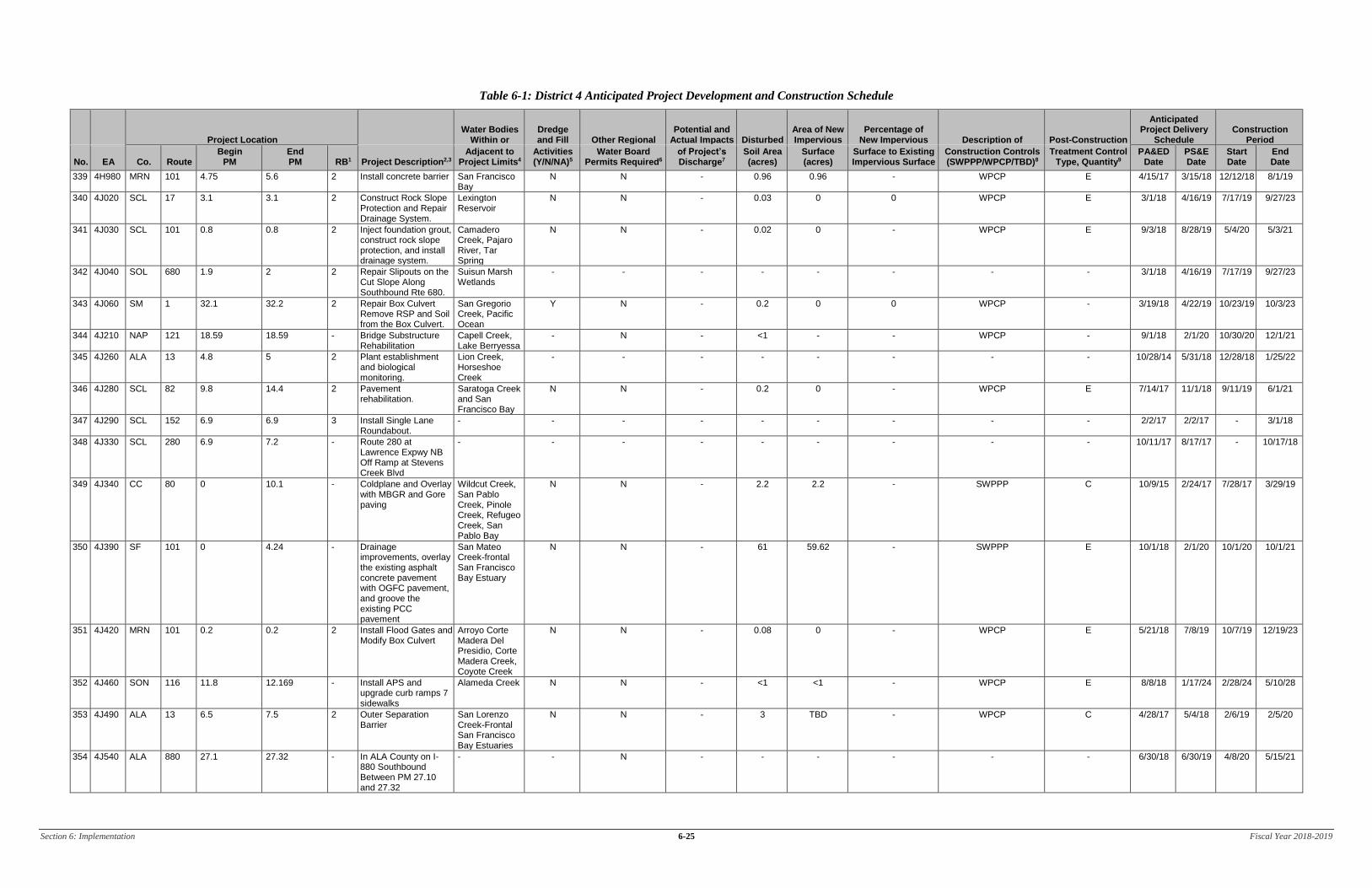
Section 6: Implementation 6-25 Fiscal Year 2018-2019
Table 6-1: District 4 Anticipated Project Development and Construction Schedule
Project Location Water Bodies
Within or Dredge and Fill Other Regional
Potential and Actual Impacts Disturbed
Area of New Impervious
Percentage of New Impervious Description of Post-Construction
Anticipated Project Delivery
Schedule Construction
Period
No. EA Co. Route Begin
PM End PM RB1 Project Description2,3
Adjacent to Project Limits4
Activities (Y/N/NA)5
Water Board Permits Required6
of Project’s Discharge7
Soil Area (acres)
Surface (acres)
Surface to Existing Impervious Surface
Construction Controls (SWPPP/WPCP/TBD)8
Treatment Control Type, Quantity9
PA&ED Date
PS&E Date
Start Date
End Date
339 4H980 MRN 101 4.75 5.6 2 Install concrete barrier San Francisco Bay
N N - 0.96 0.96 - WPCP E 4/15/17 3/15/18 12/12/18 8/1/19
340 4J020 SCL 17 3.1 3.1 2 Construct Rock Slope Protection and Repair Drainage System.
Lexington Reservoir
N N - 0.03 0 0 WPCP E 3/1/18 4/16/19 7/17/19 9/27/23
341 4J030 SCL 101 0.8 0.8 2 Inject foundation grout, construct rock slope protection, and install drainage system.
Camadero Creek, Pajaro River, Tar Spring
N N - 0.02 0 - WPCP E 9/3/18 8/28/19 5/4/20 5/3/21
342 4J040 SOL 680 1.9 2 2 Repair Slipouts on the Cut Slope Along Southbound Rte 680.
Suisun Marsh Wetlands
- - - - - - - - 3/1/18 4/16/19 7/17/19 9/27/23
343 4J060 SM 1 32.1 32.2 2 Repair Box Culvert Remove RSP and Soil from the Box Culvert.
San Gregorio Creek, Pacific Ocean
Y N - 0.2 0 0 WPCP - 3/19/18 4/22/19 10/23/19 10/3/23
344 4J210 NAP 121 18.59 18.59 - Bridge Substructure Rehabilitation
Capell Creek, Lake Berryessa
- N - <1 - - WPCP - 9/1/18 2/1/20 10/30/20 12/1/21
345 4J260 ALA 13 4.8 5 2 Plant establishment and biological monitoring.
Lion Creek, Horseshoe Creek
- - - - - - - - 10/28/14 5/31/18 12/28/18 1/25/22
346 4J280 SCL 82 9.8 14.4 2 Pavement rehabilitation.
Saratoga Creek and San Francisco Bay
N N - 0.2 0 - WPCP E 7/14/17 11/1/18 9/11/19 6/1/21
347 4J290 SCL 152 6.9 6.9 3 Install Single Lane Roundabout.
- - - - - - - - - 2/2/17 2/2/17 - 3/1/18
348 4J330 SCL 280 6.9 7.2 - Route 280 at Lawrence Expwy NB Off Ramp at Stevens Creek Blvd
- - - - - - - - - 10/11/17 8/17/17 - 10/17/18
349 4J340 CC 80 0 10.1 - Coldplane and Overlay with MBGR and Gore paving
Wildcut Creek, San Pablo Creek, Pinole Creek, Refugeo Creek, San Pablo Bay
N N - 2.2 2.2 - SWPPP C 10/9/15 2/24/17 7/28/17 3/29/19
350 4J390 SF 101 0 4.24 - Drainage improvements, overlay the existing asphalt concrete pavement with OGFC pavement, and groove the existing PCC pavement
San Mateo Creek-frontal San Francisco Bay Estuary
N N - 61 59.62 - SWPPP E 10/1/18 2/1/20 10/1/20 10/1/21
351 4J420 MRN 101 0.2 0.2 2 Install Flood Gates and Modify Box Culvert
Arroyo Corte Madera Del Presidio, Corte Madera Creek, Coyote Creek
N N - 0.08 0 - WPCP E 5/21/18 7/8/19 10/7/19 12/19/23
352 4J460 SON 116 11.8 12.169 - Install APS and upgrade curb ramps 7 sidewalks
Alameda Creek N N - <1 <1 - WPCP E 8/8/18 1/17/24 2/28/24 5/10/28
353 4J490 ALA 13 6.5 7.5 2 Outer Separation Barrier
San Lorenzo Creek-Frontal San Francisco Bay Estuaries
N N - 3 TBD - WPCP C 4/28/17 5/4/18 2/6/19 2/5/20
354 4J540 ALA 880 27.1 27.32 - In ALA County on I-880 Southbound Between PM 27.10 and 27.32
- - N - - - - - - 6/30/18 6/30/19 4/8/20 5/15/21

Section 6: Implementation 6-26 Fiscal Year 2018-2019
Table 6-1: District 4 Anticipated Project Development and Construction Schedule
Project Location Water Bodies
Within or Dredge and Fill Other Regional
Potential and Actual Impacts Disturbed
Area of New Impervious
Percentage of New Impervious Description of Post-Construction
Anticipated Project Delivery
Schedule Construction
Period
No. EA Co. Route Begin
PM End PM RB1 Project Description2,3
Adjacent to Project Limits4
Activities (Y/N/NA)5
Water Board Permits Required6
of Project’s Discharge7
Soil Area (acres)
Surface (acres)
Surface to Existing Impervious Surface
Construction Controls (SWPPP/WPCP/TBD)8
Treatment Control Type, Quantity9
PA&ED Date
PS&E Date
Start Date
End Date
355 4J710 CC 580 0 4.8 2 Prepare PS&E to construct bicycle and pedestrian lane on the (Upper Deck) westbound direction at the Richmond/San Rafael Br.
TBD TBD TBD TBD TBD TBD TBD TBD TBD TBD 7/5/16 10/15/16 9/18/17
356 4J730 ALA 880 20.9 20.9 - In ALA County I-880 and Rte 238 Connector.
TBD TBD TBD TBD TBD TBD TBD TBD TBD 7/2/18 2/3/20 11/2/20 12/31/21
357 4J750 ALA 84 0.73 3.06 - Outer Separation Barrier
Don Edwards San Francisco Bay National Wildlife Refuge, San Francisco Bay-Lower and -South
N N - 3.6 3.4 - SWPPP C 9/30/18 2/24/20 12/7/20 4/1/22
358 4J790 SF 101 6.7 8.0 2 Streetscape and utility upgrade
San Francisco Bay
N N - 2 2 - SWPPP Other (not needed) 5/2/16 9/1/16 1/2/17 6/1/18
359 4J890 SCL 82 19.2 26.4 - Resurface the existing AC
Saratoga Creek-Frontal San Francisco Bay Estuaries
N N - <1.0 <1.0 - WPCP E 7/27/18 9/12/19 12/13/19 2/23/24
360 4J930 SCL 101 0 52.5 - In Santa Clara County, on Route 101 at Various Locations.
TBD TBD TBD TBD TBD TBD TBD TBD TBD 7/26/18 9/11/19 12/13/19 2/27/24
361 4J970 SF 101 2 4.2 - In SF on Highway 101 Between PM 2.0 and 4.2.
TBD TBD TBD TBD TBD TBD TBD TBD TBD 8/2/18 - - 3/5/24
362 4J980 ALA SCL
Var Var Var - Stormwater Treatment BMPs
San Leandro Creek, Old Alameda and Alameda Creeks, Coyote Creek, San Francisco Bay-Central
N N - 2.6 - - SWPPP Other (not needed) 7/31/18 9/16/19 12/18/19 3/1/24
363 4K090 SM 84 25.8 27 - In Menlo Park on Route 84 at Chrysler Drive Intersection
TBD TBD TBD TBD TBD TBD TBD TBD TBD 10/28/16 11/30/16 4/1/17 8/30/18
364 4K210 SM 35 13.13 13.13 - In San Mateo County, near Sky Londa, at 0.1 mile north of Bear Gulch Road.
TBD TBD TBD TBD TBD TBD TBD TBD TBD - - - 9/17/18
365 4K220 CC 680 12.7 17.6 - In Contra Costa County, in Walnut Creek, from Rudgear Road to Monument Boulevard
TBD TBD TBD TBD TBD TBD TBD TBD TBD - - - 12/3/18
366 4K230 SCL 17 5.8 5.8 - In Santa Clara County, near Los Gatos, at 0.7 mile north of East Main Street.
TBD TBD TBD TBD TBD TBD TBD TBD TBD - - - 9/14/18
367 4K270 SCL 9 0 5 - In Santa Clara County, near Saratoga, from the Santa Cruz County line to Sanborn road.
TBD TBD TBD TBD TBD TBD TBD TBD TBD - - - 9/17/18

Section 6: Implementation 6-27 Fiscal Year 2018-2019
Table 6-1: District 4 Anticipated Project Development and Construction Schedule
Project Location Water Bodies
Within or Dredge and Fill Other Regional
Potential and Actual Impacts Disturbed
Area of New Impervious
Percentage of New Impervious Description of Post-Construction
Anticipated Project Delivery
Schedule Construction
Period
No. EA Co. Route Begin
PM End PM RB1 Project Description2,3
Adjacent to Project Limits4
Activities (Y/N/NA)5
Water Board Permits Required6
of Project’s Discharge7
Soil Area (acres)
Surface (acres)
Surface to Existing Impervious Surface
Construction Controls (SWPPP/WPCP/TBD)8
Treatment Control Type, Quantity9
PA&ED Date
PS&E Date
Start Date
End Date
368 4K280 SM SF
101 17.9 0.0
26.1 1.8
- Repair AC Pavement including Digouts, Planing, Overlay, Repair Loops Detectors and Delineate
- N N - - - - WPCP E - - - 8/29/18
369 4K380 SCL 152 1.5 1.5 - In Santa Clara County, near Gilroy, at 1.5 miles east of Pole Line road.
TBD TBD TBD TBD TBD TBD TBD TBD TBD - - - 7/5/18
370 4K390 SON 1 25.1 25.3 - Restore damaged road with soldier pile back wall
Salman Creek-Frontal Pacific Ocean Estuaries
N N - 0.4 0 - WPCP E - - - 7/5/18
371 4K410 SCL 17 3 3.1 - Drainage Improvements, Curb Ramp Upgrades, and Modify Traffic Signal and Lighting
- N N - - - - SWPP C - - - 10/1/18
372 4K430 SON 128 1.3 1.3 - In Sonoma County, near Cloverdale, at 3.5 east of North Cloverdale Blvd..
TBD TBD TBD TBD TBD TBD TBD TBD TBD - - - 7/6/18
373 4K450 SON 101 37.1 37.2 - In Sonoma County, in Healdsburg, at 0.9 mile north of Dry Creek Road.
TBD TBD TBD TBD TBD TBD TBD TBD TBD - - - 7/11/18
374 4K460 SM 1 17 17.5 - In San Mateo County, near San Gregorio, at 0.9 mile south of route 92.
TBD TBD TBD TBD TBD TBD TBD TBD TBD - - - 7/11/18
375 4K470 ALA 13 4.4 4.4 - In Alameda County, in Oakland, at Calaveras Avenue.
TBD TBD TBD TBD TBD TBD TBD TBD TBD - - - 10/4/18
376 4K480 SM 35 9.8 9.9 - In San Mateo County, near Skylonda, at 0.1 mile north of Chapman Road.
TBD TBD TBD TBD TBD TBD TBD TBD TBD - - - 7/11/18
377 4K490 MRN 1 1.6 2.5 - In Marine County, near Muir Beach, from Shasta Way to California Avenue.
TBD TBD TBD TBD TBD TBD TBD TBD TBD - - - 10/8/18
378 4K500 MRN 1 33.4 33.4 - Construct retaining walls and fish passage opening, remove temp diversion fish passage (cofferdam), all to stabilize erosion scour at SR1 Millerton Gulch Bridge - 14’x7’ culvert box
Tomales Bay Y N Y 0.08 - - SWPP E- restoring existing after repairs made
- - - 10/8/18
379 4K550 SM 35 11.48 11.48 - In San Mateo County, near Skylonda, at 0.6 mile north of Morse Lane.
TBD TBD TBD TBD TBD TBD TBD TBD TBD - - - 10/8/18
380 4K560 ALA 185 0.4 3.2 - In Alameda County, in and near Hayward, from A Street to Plaza Drive
TBD TBD TBD TBD TBD TBD TBD TBD TBD - - - 10/8/18

Section 6: Implementation 6-28 Fiscal Year 2018-2019
Table 6-1: District 4 Anticipated Project Development and Construction Schedule
Project Location Water Bodies
Within or Dredge and Fill Other Regional
Potential and Actual Impacts Disturbed
Area of New Impervious
Percentage of New Impervious Description of Post-Construction
Anticipated Project Delivery
Schedule Construction
Period
No. EA Co. Route Begin
PM End PM RB1 Project Description2,3
Adjacent to Project Limits4
Activities (Y/N/NA)5
Water Board Permits Required6
of Project’s Discharge7
Soil Area (acres)
Surface (acres)
Surface to Existing Impervious Surface
Construction Controls (SWPPP/WPCP/TBD)8
Treatment Control Type, Quantity9
PA&ED Date
PS&E Date
Start Date
End Date
381 4K570 ALA 880 16.5 18.3 - In Alameda county, in Hayward, from Route 92 to west A Street.
TBD TBD TBD TBD TBD TBD TBD TBD TBD - - - 10/8/18
382 4K580 ALA 880 20.7 24.1 - In Alameda county, in San Leandro and Oakland, from 0.8 mile south of Marina Boulevard to 0.3 mile north of 16th Avenue.
TBD TBD TBD TBD TBD TBD TBD TBD TBD - - - 10/8/18
383 4K590 CC 24 8 9.1 - In Contra Costa county, in Walnut Creek, from Pleasant Hill Road to Route 680
TBD TBD TBD TBD TBD TBD TBD TBD TBD - - - 11/27/18
384 4K600 CC 80 0 9 - In Contra Costa County, In El Cerrito, San Pablo, Pinole, and Hercules, from the Alameda County line to the Route 80/4 separation
TBD TBD TBD TBD TBD TBD TBD TBD TBD - - - 11/27/18
385 4K610 CC 80 10.7 13 - In Contra Costa, in and near Hercules, from Willow Avenue to 0.3 mile east of Cummings Skyway.
TBD TBD TBD TBD TBD TBD TBD TBD TBD - - - 10/8/18
386 4K620 SCL 152 7.9 9.4 - In Santa Clara County, in Gilroy, from Santa Teresa Boulevard to Monterey Road
TBD TBD TBD TBD TBD TBD TBD TBD TBD - - - 10/8/18
387 4K640 SCL 35 9.5 10.5 - Emergency Slide Repair
- N N - 0.5 0.13 - WPCP N - - - 10/4/18
388 4K660 SON 1 31.4 31.9 - In Sonoma County, at Font Ross, at 1.1 miles south of Fort Ross Road.
TBD TBD TBD TBD TBD TBD TBD TBD TBD - - - 10/4/18
389 4K680 SCL 130 9.3 9.3 - In San Clara County, near san Jose, at 2.0 miles west of Quimby Road.
TBD TBD TBD TBD TBD TBD TBD TBD TBD - - - 11/7/18
390 4K690 MRN 1 7.6 7.6 - In Marin county, near Muir Beach, at 0.2 mile north of Cold Streamfire Road
TBD TBD TBD TBD TBD TBD TBD TBD TBD - - - 11/26/18
391 4K790 SCL 101 52.2 52.2 - In Santa Clara County, in Palo Alto, at Embarcadero Road
TBD TBD TBD TBD TBD TBD TBD TBD TBD - - - 12/12/18
392 4K800 SCL 35 10.5 10.5 - In Santa Clara County, near Los Gatos, at 1.2 miles north of Las Cumbres Road
TBD TBD TBD TBD TBD TBD TBD TBD TBD - - - 12/18/18
393 4K810 ALA 80 0 0 - In Alameda County at the EB80/EB580, WB580/WB80 and WB80/SB880 Connector Ramps
TBD TBD TBD TBD TBD TBD TBD TBD TBD 1/1/19 5/1/20 2/1/21 11/1/22
394 4K820 MRN 1 6.6 6.6 - In Marin Count, at Muir Beach, 0.3 mile north of Seascape Drive
TBD TBD TBD TBD TBD TBD TBD TBD TBD - - - 11/21/18
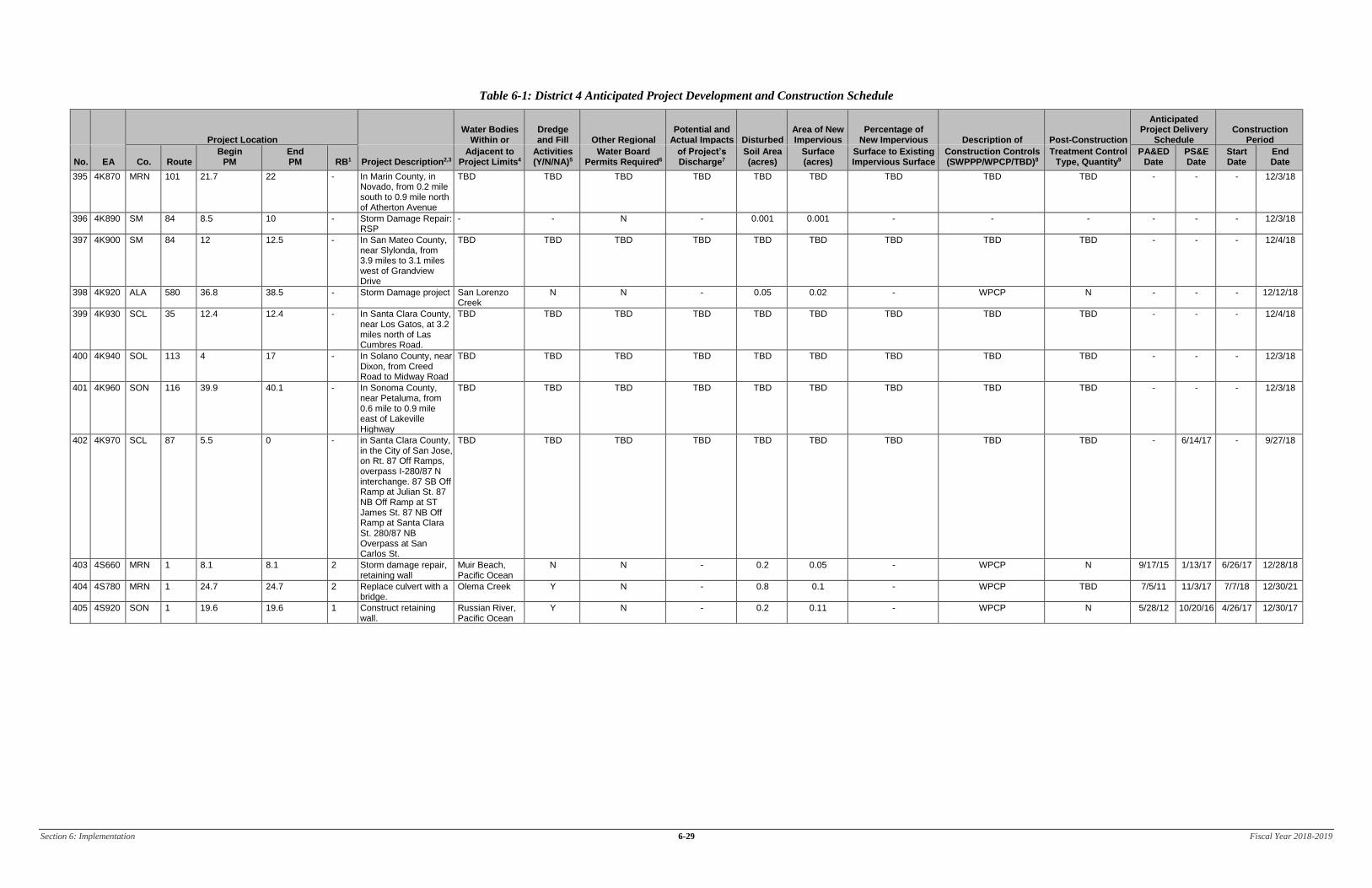
Section 6: Implementation 6-29 Fiscal Year 2018-2019
Table 6-1: District 4 Anticipated Project Development and Construction Schedule
Project Location Water Bodies
Within or Dredge and Fill Other Regional
Potential and Actual Impacts Disturbed
Area of New Impervious
Percentage of New Impervious Description of Post-Construction
Anticipated Project Delivery
Schedule Construction
Period
No. EA Co. Route Begin
PM End PM RB1 Project Description2,3
Adjacent to Project Limits4
Activities (Y/N/NA)5
Water Board Permits Required6
of Project’s Discharge7
Soil Area (acres)
Surface (acres)
Surface to Existing Impervious Surface
Construction Controls (SWPPP/WPCP/TBD)8
Treatment Control Type, Quantity9
PA&ED Date
PS&E Date
Start Date
End Date
395 4K870 MRN 101 21.7 22 - In Marin County, in Novado, from 0.2 mile south to 0.9 mile north of Atherton Avenue
TBD TBD TBD TBD TBD TBD TBD TBD TBD - - - 12/3/18
396 4K890 SM 84 8.5 10 - Storm Damage Repair: RSP
- - N - 0.001 0.001 - - - - - - 12/3/18
397 4K900 SM 84 12 12.5 - In San Mateo County, near Slylonda, from 3.9 miles to 3.1 miles west of Grandview Drive
TBD TBD TBD TBD TBD TBD TBD TBD TBD - - - 12/4/18
398 4K920 ALA 580 36.8 38.5 - Storm Damage project San Lorenzo Creek
N N - 0.05 0.02 - WPCP N - - - 12/12/18
399 4K930 SCL 35 12.4 12.4 - In Santa Clara County, near Los Gatos, at 3.2 miles north of Las Cumbres Road.
TBD TBD TBD TBD TBD TBD TBD TBD TBD - - - 12/4/18
400 4K940 SOL 113 4 17 - In Solano County, near Dixon, from Creed Road to Midway Road
TBD TBD TBD TBD TBD TBD TBD TBD TBD - - - 12/3/18
401 4K960 SON 116 39.9 40.1 - In Sonoma County, near Petaluma, from 0.6 mile to 0.9 mile east of Lakeville Highway
TBD TBD TBD TBD TBD TBD TBD TBD TBD - - - 12/3/18
402 4K970 SCL 87 5.5 0 - in Santa Clara County, in the City of San Jose, on Rt. 87 Off Ramps, overpass I-280/87 N interchange. 87 SB Off Ramp at Julian St. 87 NB Off Ramp at ST James St. 87 NB Off Ramp at Santa Clara St. 280/87 NB Overpass at San Carlos St.
TBD TBD TBD TBD TBD TBD TBD TBD TBD - 6/14/17 - 9/27/18
403 4S660 MRN 1 8.1 8.1 2 Storm damage repair, retaining wall
Muir Beach, Pacific Ocean
N N - 0.2 0.05 - WPCP N 9/17/15 1/13/17 6/26/17 12/28/18
404 4S780 MRN 1 24.7 24.7 2 Replace culvert with a bridge.
Olema Creek Y N - 0.8 0.1 - WPCP TBD 7/5/11 11/3/17 7/7/18 12/30/21
405 4S920 SON 1 19.6 19.6 1 Construct retaining wall.
Russian River, Pacific Ocean
Y N - 0.2 0.11 - WPCP N 5/28/12 10/20/16 4/26/17 12/30/17
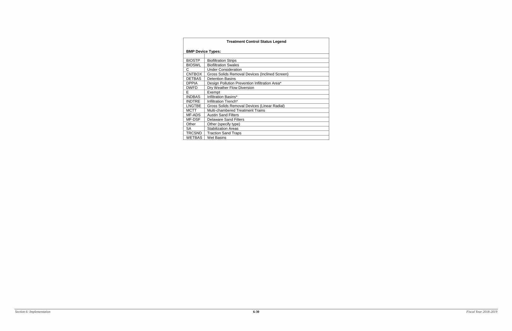
Section 6: Implementation 6-30 Fiscal Year 2018-2019
Treatment Control Status Legend
BMP Device Types:
BIOSTP Biofiltration Strips
BIOSWL Biofiltration Swales
C Under Consideration
CNTBOX Gross Solids Removal Devices (Inclined Screen)
DETBAS Detention Basins
DPPIA Design Pollution Prevention Infiltration Area*
DWFD Dry Weather Flow Diversion
E Exempt
INDBAS Infiltration Basins*
INDTRE Infiltration Trench*
LNGTBE Gross Solids Removal Devices (Linear Radial)
MCTT Multi-chambered Treatment Trains
MF-ADS Austin Sand Filters
MF-DSF Delaware Sand Filters
Other Other (specify type)
SA Stabilization Areas
TRCSND Traction Sand Traps
WETBAS Wet Basins

Section 6: Implementation 6-31 Fiscal Year 2018-2019
Table 6-2 lists the planned maintenance projects that will disturb soil.
Table 6-2: District 4 Anticipated Significant Road Maintenance Activities
No. Co. Route Beg PM End PM Regional
Board Description Water Bodies
Affected10
Other Regional Water Board
Permits Required11
Potential and Actual Impacts of Project’s
Discharge12
Disturbed Soil Area (acres)
Area of New Impervious
Surface (acres)
Percentage of New Impervious
Surface to Existing Impervious Surface
Description of Construction Controls
(SWPPP/WPCP/TBD/NA)13
Post-Construction Treatment Control Type, Quantity14 Start Date Completion Date
1 SM 35 21 23 2 Rubberized Bonded Wearing Course Overlay
NA NA NA 0.22 0 NA WPCP NA 7/1/2018 12/1/2018
2 NAP 121 Var Var 2 and 5 Replace Culverts'/ headwalls/down drains (7 locations between PM 12.76/19.16)
TBD 401 NA 0.06 0 NA WPCP NA 7/1/2018 11/1/2018
3 NAP 121 Var Var 5 Replace Culverts/headwalls/down drains (5 locations between PM 20.33/21.68)
Lake Berryessa 401 NA 0.1 0 NA WPCP NA 7/1/2018 11/1/2018
4 NAP 121 Var - 2 Replace Culverts/headwalls/ down drains (4 locations between PM 7.86/11.6)
TBD 401 NA 0.1 0 NA WPCP NA 7/1/2018 11/1/2018
5 SOL 80 41.3 41.3 5 Slope Paving at Kidwell Road Overcrossing
NA NA NA 0.002 0 NA TBD NA 7/1/2018 11/1/2018
6 SOL 80 17.02 17.02 5 Backfill Slope at Ledgewood Creek
TBD TBD NA 0.005 0 NA TBD NA 7/1/2018 11/1/2018
10 Receiving waters within or adjacent to maintenance activity designated as “303(d) (constituent type).” Activity adjacent to Drinking Water Reservoir or Ground Water Recharge Facilities designated as “DW.” 11 Regional Water Board Permits required other than Construction General Permit, such as Clean Water Act Section 401 water quality certification, Waiver of Discharge Requirements, Dewatering Permits, Bridge Painting WDRs, etc. 12 This information may come from the Water Quality Assessment Report prepared for each project, a Water Quality Technical Memorandum, or other document that evaluates the water quality impacts of a project. 13 A description of the Construction Controls is available in the project’s Stormwater Pollution Prevention Plan (SWPPP), Water Pollution Control Plan (WPCP), is To Be Determined (TBD) if the Disturbed Soil Area is unavailable, or is Not Applicable (NA) because there is no Disturbed Soil Area associated with the project. 14 Treatment Control Status identified by: device type/number of devices, exempt (“E”), or under consideration (“C”). See Treatment Control Status Legend below for device type abbreviations.

Section 6: Implementation 6-32 Fiscal Year 2018-2019
Treatment Control Status Legend
BMP Device Types:
BIOSTP Biofiltration Strips
BIOSWL Biofiltration Swales
C Under Consideration
CNTBOX Gross Solids Removal Devices (Inclined Screen)
DETBAS Detention Basins
DPPIA Design Pollution Prevention Infiltration Area*
DWFD Dry Weather Flow Diversion
E Exempt
INDBAS Infiltration Basins*
INDTRE Infiltration Trench*
LNGTBE Gross Solids Removal Devices (Linear Radial)
MCTT Multi-chambered Treatment Trains
MF-ADS Austin Sand Filters
MF-DSF Delaware Sand Filters
Other Other (specify type)
SA Stabilization Areas
TRCSND Traction Sand Traps
WETBAS Wet Basins

Section 6: Implementation 6-33 Fiscal Year 2018-2019
Table 6-3 lists the District’s planned monitoring activities.
Table 6-3: District 4 Monitoring Activities
Statewide Monitoring Program Activities
ASBS Core Monitoring Sites
District sites include the following:
• 6 Core Monitoring sites
ASBS Ocean Receiving Water and Reference Monitoring Sites
District sites include the following:
• 2 Ocean Receiving Water sites
TMDL Monitoring Sites
District sites include the following:
• 7 Monitoring sites

Section 6: Implementation 6-34 Fiscal Year 2018-2019
This page was intentionally left blank.

Section 7: Region-Specific Activities 7-1 Fiscal Year 2018-2019
7 Region-Specific Activities
Section 7 of the DWP identifies the applicable region-specific activities that District 4 has planned for the
fiscal year 2018-19 to comply with Attachment V of the Conformed NPDES Permit.
North Coast Region
Activities to Address Sediment Sources within Sediment Impaired Watersheds
Caltrans will prepare an inventory of sources of excess sediment and quantify the discharge or threatened
discharge in the North Coast RWQCB jurisdiction per Attachment V of the Caltrans NPDES Permit.
Per Attachment V of the amended Caltrans NPDES Permit, the inventory and prioritization step is not
required if Caltrans is implementing the requirements of Attachment IV for sediment TMDLs, as the
given reaches have already been prioritized within the context of statewide implementation. Per
Attachment IV of the amended permit, Caltrans is required to submit a plan and schedule for conducting a
stream crossings survey for Napa River and Sonoma Creek watershed with the TMDL Status Review
Report. Caltrans complied with this requirement by submitting the workplan for the Stream Crossings
Survey for Napa River and Sonoma Creek as part of the TMDL Status Review Report that was submitted
in October 2015. Caltrans intends to submit an updated workplan based on analysis and field work as part
of the TMDL Status Review Report to the SWRCB in October 2017.
Notification to North Coast RWQCB: Routine Maintenance Work within the North Coast RWQCB Jurisdiction
Table 7-1 below has been included as a notification of upcoming work over water. Many of the projects
will not result in disturbed soil areas. Standard Caltrans BMPs combined with the Caltrans Maintenance
Staff Guide will be implemented in an effort to avoid and minimize the potential for sediment discharges
and/or to implement temporary erosion control measures. Table 7-1 lists anticipated routine maintenance
work within the North Coast RWQCB jurisdiction.
Riparian Vegetation Removal
TMDL activities will be implemented in accordance with Attachment IV of the Caltrans NPDES Permit.
Region specific requirements will be implemented in accordance with Attachment V of the Caltrans
NPDES Permit. Implementation of Attachments IV and V have not commenced pending ongoing
negotiations between Caltrans, the SWRCB, and the RWQCBs.
San Francisco Bay Region
Trash Load Reduction
Caltrans conducted an on-land visual assessment to identify areas that are generating very-high and high
trash deposits. The assessment used a methodology like the methods used by local municipalities such
that there are four trash generation areas categories: low, medium, high, and very high. Out of 1,100
centerline miles of roadway and 886 highway ramps, the field assessment identified approximately 24.1
highway centerline miles and 116 highway ramps that have high and very-high trash generation rates.
Caltrans submitted a Trash Reduction Work Plan in June 2016. San Francisco Bay RWQCB issued an
NOV of the Conformed NPDES Permit, for failure to demonstrate Timely Implementation of Trash
Control Measures in December 2016.
In the February 2017 response to the NOV, Caltrans outlined the actions it would take to demonstrate
timely implementation of trash control measures in high trash generating areas within the following
identified high trash generating areas:
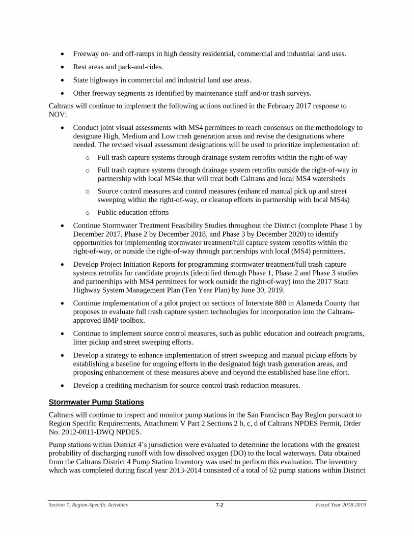
Section 7: Region-Specific Activities 7-2 Fiscal Year 2018-2019
• Freeway on- and off-ramps in high density residential, commercial and industrial land uses.
• Rest areas and park-and-rides.
• State highways in commercial and industrial land use areas.
• Other freeway segments as identified by maintenance staff and/or trash surveys.
Caltrans will continue to implement the following actions outlined in the February 2017 response to
NOV:
• Conduct joint visual assessments with MS4 permittees to reach consensus on the methodology to
designate High, Medium and Low trash generation areas and revise the designations where
needed. The revised visual assessment designations will be used to prioritize implementation of:
o Full trash capture systems through drainage system retrofits within the right-of-way
o Full trash capture systems through drainage system retrofits outside the right-of-way in
partnership with local MS4s that will treat both Caltrans and local MS4 watersheds
o Source control measures and control measures (enhanced manual pick up and street
sweeping within the right-of-way, or cleanup efforts in partnership with local MS4s)
o Public education efforts
• Continue Stormwater Treatment Feasibility Studies throughout the District (complete Phase 1 by
December 2017, Phase 2 by December 2018, and Phase 3 by December 2020) to identify
opportunities for implementing stormwater treatment/full capture system retrofits within the
right-of-way, or outside the right-of-way through partnerships with local (MS4) permittees.
• Develop Project Initiation Reports for programming stormwater treatment/full trash capture
systems retrofits for candidate projects (identified through Phase 1, Phase 2 and Phase 3 studies
and partnerships with MS4 permittees for work outside the right-of-way) into the 2017 State
Highway System Management Plan (Ten Year Plan) by June 30, 2019.
• Continue implementation of a pilot project on sections of Interstate 880 in Alameda County that
proposes to evaluate full trash capture system technologies for incorporation into the Caltrans-
approved BMP toolbox.
• Continue to implement source control measures, such as public education and outreach programs,
litter pickup and street sweeping efforts.
• Develop a strategy to enhance implementation of street sweeping and manual pickup efforts by
establishing a baseline for ongoing efforts in the designated high trash generation areas, and
proposing enhancement of these measures above and beyond the established base line effort.
• Develop a crediting mechanism for source control trash reduction measures.
Stormwater Pump Stations
Caltrans will continue to inspect and monitor pump stations in the San Francisco Bay Region pursuant to
Region Specific Requirements, Attachment V Part 2 Sections 2 b, c, d of Caltrans NPDES Permit, Order
No. 2012-0011-DWQ NPDES.
Pump stations within District 4’s jurisdiction were evaluated to determine the locations with the greatest
probability of discharging runoff with low dissolved oxygen (DO) to the local waterways. Data obtained
from the Caltrans District 4 Pump Station Inventory was used to perform this evaluation. The inventory
which was completed during fiscal year 2013-2014 consisted of a total of 62 pump stations within District

Section 7: Region-Specific Activities 7-3 Fiscal Year 2018-2019
4’s jurisdiction in Region 2, including locations and key characteristics such as receiving water body,
catchment area, and wet weather storage capacity. To prioritize these pump stations for monitoring, the
key characteristics and the geographic locations were considered.
Per the Caltrans NPDES permit, Attachment V, Part 2, Provision 2b, Caltrans inspected and collected DO
data from 20 percent of the pump stations annually from the priority list. The inspection and monitoring
results were reported in the Annual Report. Fiscal year 2018-2019 will be the fourth of five years of
inspection and monitoring, at which time, 80 percent of the pump stations on the priority list will have
been inspected and monitored for DO.
Fiscal year 2018-2019 will be the last year for this monitoring effort. Unless there is a need to perform
any corrective actions, the permit requirement to monitor all pump stations within District 4 and the
jurisdiction of Region 2 will be completed.

Section 7: Region-Specific Activities 7-4 Fiscal Year 2018-2019
This page was intentionally left blank.

Section 7: Region-Specific Activities 7-5 Fiscal Year 2018-2019
Table 7-1: District 4 Maintenance Notification to North Coast Regional Water Quality Control Board
Project Location
Construction Period
No. EA CO RTE
BEGIN PM
END PM RWQCB
Water Bodies Within or Adjacent to Project Limits Maintenance Activities
Disturbed Soil Area (acres)
Water Pollution Control Strategy (BMPs)
Start Date
End Date
BRIDGE MAINTENANCE PROJECTS
1 1K5800 0416000268 SON 101, 128 R51.62
R54.21 6.44
1 Various In Sonoma County on Route 101 at Structure #20-0251R Central Cloverdale UC, treat bridge deck with methacrylate. On Route 101/128 Separation, Structure #20-0262, treat bridge deck with methacrylate, and paint bridge ID on Abutments 1 and 2. On Route 101 Structures #20-0200, 20-0245, 20-0039 and 20-0164K, repair / replace AC approach slabs.
0 Water Pollution Control Plan (Chapter 13 of Caltrans Standard Specifications); Caltrans Maintenance Staff Guide.
04/20/18 04/20/21
2 0P5900 04-1700-0478
SON 121 101 12
R7.30 15.53 R15.30
R7.31 29.35 R17.10
1 Various In Sonoma County on multiple bridges on Routes 121, 101, 12. The purpose of this project is to treat bridge deck with methacrylate, repair potholes in the AC approach slabs, and paint bridge ID. On Route 121, Structure #20-0022 Sonoma Creek. On Route 101, Structures #20-0171K Santa Rosa Avenue On-Ramp OC, #20-0172 Todd Road OC, and #20-0184R Windsor Lane UC. On Route 12, Structure #20-0203R Dutton Avenue UC, #20-0204R South Santa Rosa OH, #20-0209R Santa Rosa Avenue UC, and #20-0217R Brigham Avenue UC.
0 Water Pollution Control Plan (Chapter 13 of Caltrans Standard Specifications); Caltrans Maintenance Staff Guide.
04/19/19 04/20/22

Section 7: Region-Specific Activities 7-6 Fiscal Year 2018-2019
This page was intentionally left blank.

Section 8: DWP Noncompliance and Improvements 8-1 Fiscal Year 2018-2019
8 DWP Noncompliance and Improvements
Section 8 of the DWP identifies the deviations that occurred from the prior DWP that resulted or will
result in noncompliance with the Conformed NPDES Permit or SWMP. In addition, it describes the
improvements that were performed in response to the incidents of noncompliance. Table 8-1 identifies
those incidents of noncompliance and the resulting improvements that District 4 implemented to address
each incident.
Table 8-1: District 4 Prior DWP Noncompliance Incidents and Improvements
Summary of Noncompliance Incidents Summary of Improvements
San Francisco Bay RWQCB issued a NOV of the Conformed NPDES Permit, for failure to demonstrate Timely Implementation of Trash Control Measures in December 2016.
In the February 2017 response to the NOV, Caltrans outlined the actions it would take to demonstrate timely implementation of trash control measures within high trash generating areas as outlined in Section 7.

Section 8: DWP Noncompliance and Improvements 8-2 Fiscal Year 2018-2019
This page was intentionally left blank.