critical issues in early israelite history
TRANSCRIPT
Offprint from
Critical Issues inEarly Israelite History
Edited by
Richard S. Hess, Gerald A. Klingbeil,
and Paul J. Ray Jr.
Winona Lake, Indiana
Eisenbrauns
2008
Library of Congress Cataloging-in-Publication Data
Critical issues in early Israelite history / edited by Richard S. Hess, Gerald A. Klingbeil, and Paul J. Ray Jr.
p. cm. — (Bulletin for biblical research supplements ; 3)Includes bibliographical references and index.ISBN 978-1-57506-804-6 (hardcover : alk. paper)1. Palestine—Antiquities—Congresses. 2. Bronze age—
Palestine—Congresses. 3. Iron age—Palestine—Congresses.4. Excavations (Archaeology)—Palestine—Congresses. 5. Bible. O.T.—Antiquities—Congresses. 6. Bible. O.T.—Criticism, interpretation, etc.—Congresses. I. Hess, Richard S.II. Klingbeil, Gerald A., 1964– III. Ray, Paul J.
DS111.C75 2008221.9
u
5—dc222008040324
The paper used in this publication meets the minimum requirements of theAmerican National Standard for Information Sciences—Permanence of Paperfor Printed Library Materials, ANSI Z39.48-1984.
†‰
ç
Copyright 2008 by Eisenbrauns.All rights reserved.
Printed in the United States of America.
www.eisenbrauns.com
iii
Contents
Foreword . . . . . . . . . . . . . . . . . . . . . . . . . . . . . . . . . . . . . . . . . . . . . . . . . . . viiAbbreviations . . . . . . . . . . . . . . . . . . . . . . . . . . . . . . . . . . . . . . . . . . . . . . ixIntroduction . . . . . . . . . . . . . . . . . . . . . . . . . . . . . . . . . . . . . . . . . . . . . . . xv
Part 1
Textual Studies
The Rhetorical Structuring of the Joshua Conquest Narratives . . 3
K. Lawson Younger Jr.
The Jericho and Ai of the Book of Joshua . . . . . . . . . . . . . . . . . . . . . 33
Richard S. Hess
Merenptah’s Reference to Israel:Critical Issues for the Origin of Israel . . . . . . . . . . . . . . . . . . . . 47
Michael G. Hasel
The Persian Period and the Origins of Israel: Beyond the “Myths” . . . . . . . . . . . . . . . . . . . . . . . . . . . . . . . . . . . . 61
Efraín Velázquez II
Part 2
Archaeological Studies, Broader Context
Classical Models for the Appearance of Israel in Palestine . . . . . . . 79
Paul J. Ray Jr.
The Appearance of Israel in Canaan in Recent Scholarship . . . . . . 95
Patrick Mazani
“Between North and South”: The Archaeology of Religion in Late Bronze Age Palestine and the Period of the Settlement . . . . . . . . . . . . . . . . 111
Gerald A. Klingbeil
The Context of Early Israel Viewed through the Archaeologyof Northern Mesopotamia and Syria . . . . . . . . . . . . . . . . . . . . . 151
Mark W. Chavalas
iv
Part 3
Archaeological Studies, Regional Contexts
The Survey of Manasseh and the Origin of the Central Hill Country Settlers . . . . . . . . . . . . . . . . . . . . . . . . . . . . 165
Ralph K. Hawkins
Israelite Settlement at the Margins of the Northern Hill Country: Connections to Joshua and Judges from Tell Dothan . . . . . . . . . . . . . . . . . . . . . . 181
Daniel M. Master
Rewriting Philistine History: Recent Trends in Philistine Archaeology and Biblical Studies . . . . . . . . . . . . . . . . 191
Steven M. Ortiz
The Search for Joshua’s Ai . . . . . . . . . . . . . . . . . . . . . . . . . . . . . . . . . . . 205
Bryant G. Wood
References . . . . . . . . . . . . . . . . . . . . . . . . . . . . . . . . . . . . . . . . . . . . . . . . . 241
Index . . . . . . . . . . . . . . . . . . . . . . . . . . . . . . . . . . . . . . . . . . . . . . . . . . . . . . 313Index of Authors . . . . . . . . . . . . . . . . . . . . . . . . . . . . . . . . . . . . . . . 313Index of Scripture . . . . . . . . . . . . . . . . . . . . . . . . . . . . . . . . . . . . . . 321
Indexes . . . . . . . . . . . . . . . . . . . . . . . . . . . . . . . . . . . . . . . . . . . . . . . . . . . . 331Index of Authors . . . . . . . . . . . . . . . . . . . . . . . . . . . . . . . . . . . . . . . 331Index of Scripture . . . . . . . . . . . . . . . . . . . . . . . . . . . . . . . . . . . . . . 339
Offprint from:Hess, Klingbeil, and Ray (eds.), Critical Issues in Early Israelite History[Bulletin for Biblical Research Supplement 3] ç Copyright 2008 Eisenbrauns. All rights reserved.
205
The Search for Joshua’s Ai
Bryant G. Wood
Associates for Biblical Research
Abstract
The sites of Joshua’s Ai, Beth Aven and Bethel, are chronologically and geo-graphically linked by Josh 7:2 and related passages. Joshua’s Ai is commonlythought to be located at et-Tell and Bethel at Beitin. Assuming these twoidentifications to be correct, no viable location for Beth Aven has been sug-gested. A detailed review of the geographical and archaeological data per-taining to et-Tell and Beitin reveals that et-Tell does not meet the biblicalrequirements for Joshua’s Ai, and Beitin does not meet the biblical andextrabiblical requirements for Bethel. Based on present evidence, the onlycombination that meets the complex matrix of biblical and extrabiblical re-quirements for the three sites is to locate Bethel at el-Bira, Beth Aven atBeitin, and Joshua’s Ai at the newly excavated site of Khirbet el-Maqatir.
The identification of et-Tell (17485/14710) as Joshua’s Ai has been a majorproblem in biblical archaeology. Excavations at the site have demonstratedthat there was no occupation during the Late Bronze Age, the time of the con-quest (Callaway 1993: 44). In the words of Joseph Callaway (1968: 312), themost recent excavator of et-Tell (1964–70): “ºAi is simply an embarrassment toevery view of the conquest that takes the biblical and archaeological evidenceseriously.” As a result, most scholars have concluded that the biblical accountof the conquest of Ai in Joshua 7–8 is nonhistorical. In this essay, I will reviewthe reasons for identifying et-Tell as Joshua’s Ai, demonstrate that this sitecannot be Ai, and identify an alternate location. An integral part of the studyalso will be to identify alternate locations for the related sites of Bethel andBeth-aven.
Ai in the Bible
Ai is mentioned in a number of places in the Hebrew Bible, sometimes withdifferent spellings. The earliest reference is in Gen 12:8, which states: “Then he
Author’s note
: This essay is dedicated to friend, colleague, and mentor, David Living-ston, who pioneered the research on the problem of Ai.
25-Wood-BBRSup_3 Page 205 Wednesday, September 24, 2008 5:46 PM
Bryant G. Wood
206
[Abraham] proceeded from there [Shechem] to the mountain on the east ofBethel, and pitched his tent, with Bethel on the west and Ai on the east.” Onhis return from Egypt, Abraham again came “to the place where his tent hadbeen at the beginning, between Bethel and Ai” (Gen 13:3). In terms of biblicalchronology, this would be ca. 2100
b.c.e.
or a little after, at the interface be-tween the Early Bronze and Middle Bronze Ages.
1
The most detailed description of Ai is given in Joshua 7–8, the account ofthe capture of the site by Joshua and the Israelites during the conquest, around1400
b.c.e.
, at the end of the Late Bronze Age I period. More geographical andarchaeological information is given for Ai in these two chapters than any otherbiblical site. Presumably, this would make the identification of the site rela-tively straightforward (Grintz 1961: 201). Ironically, this has not been the case.
The fact that “the men of Bethel and Ai” are listed among the returning ex-iles in Ezra 2:28 and Neh 7:32 implies that there was a settlement at Ai at theend of the Iron Age (ca. 587
b.c.e.
). It also suggests that these sites were rees-tablished by the returning exiles early in the Persian period (late 6th century
b.c.e.
). Aiath in Isa 10:28 also may refer to Iron Age Ai. The question naturally arises: were all of these settlements named Ai,
spread over a millennium and a half, located at the same place? It is commonlyassumed that the Ai of Abraham and the Ai of Joshua were one and the same,because both were located east of Bethel (Gen 12:8, Josh 7:2). On closer exami-nation, however, this does not appear to be the case. Abraham’s Ai must havebeen a major landmark, because it was used to fix his position. Joshua’s Ai, onthe other hand, was a small place because only a few men were stationed there( Josh 7:3) and it was smaller than Gibeon ( Josh 10:2), or less than ca. 12 acres insize (Broshi and Gophna 1986: 82). From these considerations, it appears thatAbraham’s Ai and Joshua’s Ai, separated chronologically by nearly seven centu-ries, were also separated geographically, albeit both east of Bethel. The migra-tion of place names within a localized area in antiquity was commonplace(Albright 1924: 142, 144; 1939: 14; F. Kenyon 1940: 190; Wolf 1964: 90; Rainey1978: 10, 1988a: 362; Aharoni 1979: 123–24; Hess 1996b: 225). Iron Age and Per-sian period Ai only can be located by means of archaeological evidence, be-cause the Bible provides no topographic information on their location(s).
The Meaning of Ai
When the name of Ai is spelled
ºay
, it is always prefixed with the definite ar-ticle
h
a
(Gen 12:8, 13:3; Joshua 7, 8; Ezra 2:28; Neh 7:32). The definite article doesnot appear with the alternative (?) spellings
ºayy
a
t
(Isa 10:28) and
ºayyâ
(Neh
1. Biblical chronology in this essay is based on an exodus date of 1446
b.c.e.
(Young 2003).The approximate date when Abraham entered Canaan can be determined from the genealogicaldata given in Exod 12:40; Gen 47:9, 25:26, 21:5, 12:4.
25-Wood-BBRSup_3 Page 206 Wednesday, September 24, 2008 5:46 PM
The Search for Joshua’s Ai
207
11:31). The generally accepted meaning of
ºay
is “ruin” (BDB s.v.). By this rea-soning,
h
a
º
a
y
means “the ruin,” or “the ruin par excellence” (Albright 1934: 11).Jehoshua Grintz (1961: 210), however, points out that the use of the definite ar-ticle may be peculiar to the tribal area of Benjamin, because it appears with 11of the 26 place names
2
listed in the inheritance of Benjamin in Josh 18:21–28. Inaddition, he disagrees with the meaning “ruin,” maintaining instead that itmeans “pile or heap of stones” (Grintz 1961: 211; cf. Simons 1959: 270; Kauf-mann 1985: 118–19 n. 64). Ziony Zevit (1983: 26; cf. 1985: 62–63) also has a differ-ent understanding of
ºay
and says that it “may refer to some topographical orgeographical feature characteristic of the site’s location” (see below, p. 239).
Pre-1924 Suggestions for the Location of Ai
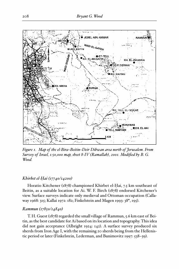
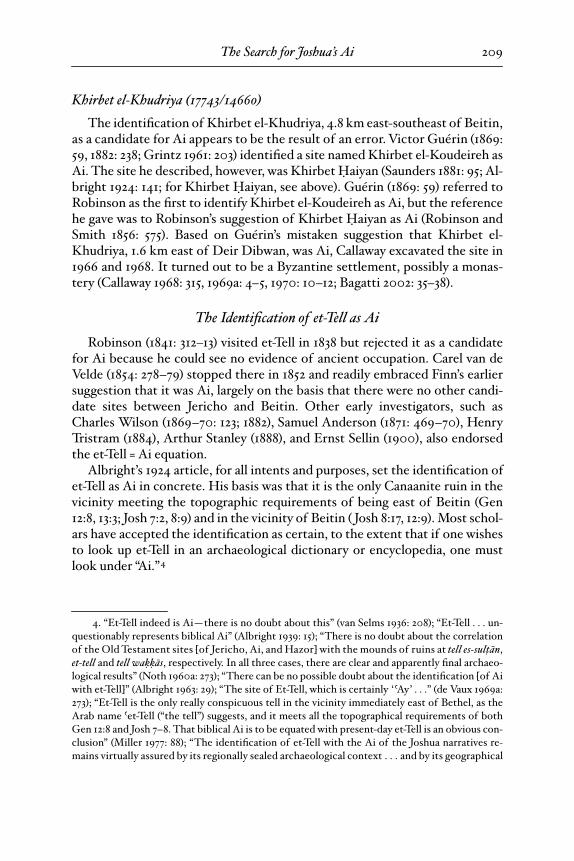
Prior to David Livingston’s work on the location of Ai, first published in1970, every investigation into the location of Ai began with Beitin (17280/14820), assuming it to be Bethel (see “The Location of Bethel,” pp. 214ff.). Thecriteria for potential locations for Ai were that the site was located east of Bei-tin and the element
ai
should be preserved in the modern Arabic name. Severalsites were considered as potential candidates (fig. 1). In 1924, however, W. F. Al-bright published a watershed article in which he endorsed et-Tell as the only vi-able possibility for Ai. This virtually eliminated all other contenders fromconsideration and closed the case. In the interest of completeness, we brieflyshall review the other pre-1924 suggested sites.
Khirbet
Ó
aiyan (17560/14570)
Khirbet
Ó
aiyan is located at the southern edge of the small town of DeirDibwan, 3.7 km southeast of Beitin. Edward Robinson visited the site in 1838and favored it over et-Tell as the location of Ai because he did not see anyevidence of an ancient settlement at et-Tell (1841: 312–13).
3
Claude Conder (1878:108–9, 1881a: 254, 1881b: 222, 1881c: 36–37, 1898: 58; F. Conder and C. Conder1882) also identified Khirbet
Ó
aiyan as Ai, as did Trelawney Saunders (1881: 95–97) and Frants Buhl (1896: 177). Callaway excavated the site in 1964 and 1969.The earliest architecture found was Byzantine (Callaway and Nicol 1966; Call-away 1969b: 239, 1970: 10, 1976: 14). Surface surveys have since turned up a fewearlier sherds: Middle Bronze Age (2%), and Hellenistic and Roman periods(32%), out of 112 sherds (Finkelstein and Magen 1993: 36*, 183); as well as a fewEarly Bronze III and Iron Age sherds (Kallai 1972: 178–79).
2. Grintz (1961) listed 10 occurrences, but he left out Ha-Ramah (v. 25), so the total shouldbe 11.
3. There are a number of editions and reprints of Robinson’s travels in Palestine in 1838 and1852. Here I cite the original 1841 edition, which is available online at http://books.google.com.
25-Wood-BBRSup_3 Page 207 Wednesday, September 24, 2008 5:46 PM
Bryant G. Wood
208
Khirbet el-
Ó
ai (17740/14200)
Horatio Kitchener (1878) championed Khirbet el-
Ó
ai, 7.5 km southeast ofBeitin, as a suitable location for Ai. W. F. Birch (1878) endorsed Kitchener’sview. Surface surveys indicate only medieval and Ottoman occupation (Calla-way 1968: 315; Kallai 1972: 182; Finkelstein and Magen 1993: 38*, 195).
Rammun (17850/14840)
T. H. Guest (1878) regarded the small village of Rammun, 5.6 km east of Bei-tin, as the best candidate for Ai based on its location and topography. This ideadid not gain acceptance (Albright 1924: 142). A surface survey produced sixsherds from Iron Age I, with the remaining 20 sherds being from the Hellenis-tic period or later (Finkelstein, Lederman, and Bunimovitz 1997: 538–39).
Figure 1. Map of the el-Bira–Beitin–Deir Dibwan area north of Jerusalem. From Survey of Israel, 1:50,000 map, sheet 8-IV (Ramallah), 2001. Modified by B. G. Wood.
25-Wood-BBRSup_3 Page 208 Wednesday, September 24, 2008 5:46 PM
The Search for Joshua’s Ai
209
Khirbet el-Khudriya (17743/14660)
The identification of Khirbet el-Khudriya, 4.8 km east-southeast of Beitin,as a candidate for Ai appears to be the result of an error. Victor Guérin (1869:59, 1882: 238; Grintz 1961: 203) identified a site named Khirbet el-Koudeireh asAi. The site he described, however, was Khirbet
Ó
aiyan (Saunders 1881: 95; Al-bright 1924: 141; for Khirbet
Ó
aiyan, see above). Guérin (1869: 59) referred toRobinson as the first to identify Khirbet el-Koudeireh as Ai, but the referencehe gave was to Robinson’s suggestion of Khirbet
Ó
aiyan as Ai (Robinson andSmith 1856: 575). Based on Guérin’s mistaken suggestion that Khirbet el-Khudriya, 1.6 km east of Deir Dibwan, was Ai, Callaway excavated the site in1966 and 1968. It turned out to be a Byzantine settlement, possibly a monas-tery (Callaway 1968: 315, 1969a: 4–5, 1970: 10–12; Bagatti 2002: 35–38).
The Identification of et-Tell as Ai
Robinson (1841: 312–13) visited et-Tell in 1838 but rejected it as a candidatefor Ai because he could see no evidence of ancient occupation. Carel van deVelde (1854: 278–79) stopped there in 1852 and readily embraced Finn’s earliersuggestion that it was Ai, largely on the basis that there were no other candi-date sites between Jericho and Beitin. Other early investigators, such asCharles Wilson (1869–70: 123; 1882), Samuel Anderson (1871: 469–70), HenryTristram (1884), Arthur Stanley (1888), and Ernst Sellin (1900), also endorsedthe et-Tell = Ai equation.
Albright’s 1924 article, for all intents and purposes, set the identification ofet-Tell as Ai in concrete. His basis was that it is the only Canaanite ruin in thevicinity meeting the topographic requirements of being east of Beitin (Gen12:8, 13:3; Josh 7:2, 8:9) and in the vicinity of Beitin ( Josh 8:17, 12:9). Most schol-ars have accepted the identification as certain, to the extent that if one wishesto look up et-Tell in an archaeological dictionary or encyclopedia, one mustlook under “Ai.”
4
4. “Et-Tell indeed is Ai—there is no doubt about this” (van Selms 1936: 208); “Et-Tell . . . un-questionably represents biblical Ai” (Albright 1939: 15); “There is no doubt about the correlationof the Old Testament sites [of Jericho, Ai, and Hazor] with the mounds of ruins at
tell es-sul
†a
n
,
et-tell
and
tell wa
˚˚a
s
, respectively. In all three cases, there are clear and apparently final archaeo-logical results” (Noth 1960a: 273); “There can be no possible doubt about the identification [of Aiwith et-Tell]” (Albright 1963: 29); “The site of Et-Tell, which is certainly ‘ ºAy’ . . .” (de Vaux 1969a:273); “Et-Tell is the only really conspicuous tell in the vicinity immediately east of Bethel, as theArab name ºet-Tell (“the tell”) suggests, and it meets all the topographical requirements of bothGen 12:8 and Josh 7–8. That biblical Ai is to be equated with present-day et-Tell is an obvious con-clusion” (Miller 1977: 88); “The identification of et-Tell with the Ai of the Joshua narratives re-mains virtually assured by its regionally sealed archaeological context . . . and by its geographical
25-Wood-BBRSup_3 Page 209 Wednesday, September 24, 2008 5:46 PM
Bryant G. Wood
210
Problems with the Identification of et-Tell as Joshua’s Ai
The only information from the Old Testament era concerning Joshua’s Ai iswhat is contained in the Hebrew Bible. Therefore, if one wishes to locateJoshua’s Ai, one must satisfy the biblical requirements for the site.
Topographical Requirements for Joshua’s Ai
The topographical requirements for Joshua’s Ai are: (1) that it was near oradjacent to (
ºim
) Beth-aven ( Josh 7:2);
(2) that it was east of Bethel ( Josh 7:2);(3) there was an ambush site or sites between Bethel and Ai, west of Ai ( Josh8:9, 12); (4) there was a militarily significant hill north of Ai where “all thepeople of war . . . camped” ( Josh 8:11); (5) there was a shallow valley north of Aiwhere Joshua and his diversionary force could be seen by the king of Ai ( Josh8:13–14); (6) the site was smaller than Gibeon ( Josh 10:2), which was less than12 acres (Broshi and Gophna 1986: 82); and (7) it was in the vicinity of (
mi
ßß
ad
,“beside”) Bethel ( Josh 12:9). The only other place in the Hebrew Bible where
mi
ßß
ad
is used to describe the relationship between two towns is Josh 3:16.Here, it says that Adam was
mi
ßß
ad
Zarethan. These two cities are located onthe east side of the Jordan Valley. Adam is at Damiyeh and Zerethan is gener-ally thought to be at Tell es-Saºidiyah, some 18.4 km to the north. Thus,
mi
ßß
ad
need not indicate immediate proximity. It appears that the meaning of the He-brew root
ß
ad
in
mi
ßß
ad
is related to the Arabic cognate, which means “vicinity,”“in front of ” or “in the vicinity of ” (BDB, s.v.).
Archaeological Requirements for Joshua’s Ai
The archaeological requirements include: (1) occupation at the time of theconquest (late 15th century
b.c.e.
, end of the Late Bronze Age I period); (2) be-ing fortified at the time of the conquest ( Josh 7:5, 8:29); (3) having a gate on thenorth side of the site ( Josh 8:11); (4) being destroyed by fire ( Josh 8:19, 28) and(5) left in ruins after ca. 1400
b.c.e.
( Josh 8:28).
Evaluation of et-Tell as Joshua’s Ai
It is often assumed that et-Tell meets the biblical topographical and archae-ological requirements for Joshua’s Ai, with the exception of occupation in the
locus” (Zevit 1983: 28); “All geographical indications in the Biblical text point to the area of Khir-bet et-Tell as the location of Ai” (Zevit 1985: 61); “Between Beitin and the desert to its east, thereis only one site which could have been referred to as ºAi —the large mound of et-Tell near DeirDibwan” (A. Mazar 1990: 331); “East of Beitin only one site can possibly be identified with Ai, andthat is the large site of et-Tell, near Deir Dibwan” (A. Mazar 1992: 283); “Albright’s identificationof et-Tell with Ai was therefore based upon biblical traditions and the topography of the regionand was supported by the evidence of an ancient city of the Canaanites which lay under heaps ofstones. His location of the site of Ai has not been seriously challenged in the last half-century”(Callaway 1992: 126).
25-Wood-BBRSup_3 Page 210 Wednesday, September 24, 2008 5:46 PM
The Search for Joshua’s Ai
211
biblical time frame of the conquest (Miller 1977: 88; Rainey and Notley 2006:125). In actuality, et-Tell does
not
meet the biblical requirements for Joshua’s Ai.A number of investigators have expressed doubts concerning the identifica-tion, but since there has been no other viable candidate in the vicinity, et-Tellbecame Joshua’s Ai by default. Let us consider how et-Tell measures up to thebiblical requirements.
5
1.
Adjacent to Beth-aven ( Josh 7:2).
Beth-aven has been variously identifiedas Khirbet
Ó
aiyan, Deir Dibwan, Burg Beitin, Burqa, Tell Maryam, or KhirbetTell el-ºAskar (see “The Location of Beth-aven” below, pp. 221ff.). None ofthese sites, however, was occupied prior to the Hellenistic period, with the ex-ception of Tell el-ºAskar, which was occupied in Iron Age I.
6
Thus, there is nocandidate site for Beth-aven in the vicinity of et-Tell that was occupied at thetime of the conquest.
2.
East of Bethel ( Josh 7:2).
This biblical requirement is met by et-Tell,which is 2.4 km southeast of Beitin and ca. 5 km northeast of el-Bira.
7
3.
An ambush site between Bethel and Ai ( Josh 8:9, 12).
There is a small hill0.7 km northwest of et-Tell, between it and Beitin, that would provide coverfor a small ambush force hiding on the northwest side of the hill. However, thenorthwest side of the hill is in plain view of Beitin, Bethel according to Al-bright’s model, an ally of Ai ( Josh 8:17). Others also have pointed out thisshortcoming (Kitchener 1878: 75; Grintz 1961: 203, 211). If Bethel was located atel-Bira, an ambush force could have taken up a position to the southwest ofet-Tell, in the valley where the modern Beitin–Deir Dibwan road currentlyruns or in the Wadi Sheban, and be hidden from both et-Tell and el-Bira.
4.
A militarily significant hill north of Ai ( Josh 8:11).
It appears that Joshuaplaced most of his army on a hill north of Ai, making the hill the “commandpost” for his generals (Briggs 2005: 180–81). The small hill 0.7 km northwest ofet-Tell would make a suitable command post.
5.
A shallow valley north of Ai ( Josh 8:13–14).
The Wadi el-Gayeh on thenorth side of et-Tell is very deep and narrow, with exceedingly steep sides. Itwould not be possible for the king of Ai to see Joshua and his diversionaryforce in this valley, contrary to Josh 8:14.
6.
Smaller than Gibeon ( Josh 10:2).
At 27 acres (Callaway 1993: 39), et-Tell ismore than twice the size of Gibeon, which is less than 12 acres in size (Broshiand Gophna 1986: 82; Wells 1947).
5. In the following discussion, both Beitin and el-Bira are considered as potential locationsfor Bethel (see “The Location of Bethel” below, pp. 214ff.).
6. Because Khirbet Tell el-ºAskar is 4.5 km southeast of et-Tell, it is too distant to be consid-ered adjacent to et-Tell.
7. The center of el-Bira at the time of the conquest is assumed to be the acropolis at Ras et-Tahuneh (1702/1462).
25-Wood-BBRSup_3 Page 211 Wednesday, September 24, 2008 5:46 PM
Bryant G. Wood
212
7.
In the vicinity of Bethel ( Josh 12:9).
Et-Tell’s location, 2.4 km southeast ofBeitin and ca. 5 km northeast of el-Bira, qualifies it as being in the vicinity ofBethel.
8.
Occupation at the time of the conquest.
Here, et-Tell fails miserably, becauseit was unoccupied during the Middle and Late Bronze Ages (Callaway 1993: 40;Grintz 1961: 205, 207, 211).
8
Because there was no occupation at the time of theconquest, et-Tell fails all five archaeological tests for Joshua’s Ai.
In total, et-Tell meets only 3 or possibly 4 of the 12 biblical and archaeologi-cal requirements for Joshua’s Ai.
Evaluation of Khirbet Nisya as Joshua’s Ai
Livingston (Bimson and Livingston 1987: 48–51; Livingston 1994: 159; 1999;2003: 203–22) has suggested that Khirbet Nisya (17175/14495), located 2 kmsoutheast of el-Bira, should be identified as Joshua’s Ai. He (1994: 159) claims“the topography around the site matches every detail given in the account ofthe destruction of Ai in Joshua 7–8.” The following is an evaluation of KhirbetNisya as Joshua’s Ai in light of the above requirements.
1.
Adjacent to Beth-aven (Josh 7:2).
Livingston (2003: 212–13) identifiesKhirbet el-Maqatir (17378/14693) as Beth-aven. Khirbet el-Maqatir is 3 kmnortheast of Khirbet Nisya and separated from it by the deep Wadi Shebanand high hills on either side of Wadi Sheban. One site cannot be seen from theother. Thus, Khirbet Nisya cannot be considered to be adjacent to Khirbet el-Maqatir.
2.
East of Bethel (Josh 7:2).
In Livingston’s model, el-Bira (17050/14585) isidentified as Bethel (see “The Location of Bethel” below, pp. 214ff.). KhirbetNisya is 2 km southeast of el-Bira.
3.
An ambush site between Bethel and Ai (Josh 8:9, 12).
There is a valley be-tween Khirbet Nisya and el-Bira, which is hidden from view from KhirbetNisya by Jebel et-Tawil. As with the ambush site northwest of et-Tell, however,the valley is in clear view of el-Bira/Bethel, the ally of Ai ( Josh 8:17).
4.
A militarily significant hill north of Ai (Josh 8:11).
There is a small hill 0.5km north of Khirbet Nisya that could have served as a military command postfor Joshua’s generals.
5.
A shallow valley north of Ai (Josh 9:13–14).
The small, narrow valley be-tween Khirbet Nisya and the small hill 0.5 km to the north is too confining tobe the scene of military operations of the type described in Josh 8:13–17.
8. Since et-Tell has been extensively excavated, it is unrealistic to believe that a Late BronzeAge phase will yet be found or that the Late Bronze Age phase was subject to “serious denuda-tion,” as some have maintained (Allen 1977: 44, 52; Kitchen 2003: 189).
spread is 12 points short
25-Wood-BBRSup_3 Page 212 Wednesday, September 24, 2008 5:46 PM
The Search for Joshua’s Ai
213
6.
Smaller than Gibeon (Josh 10:2).
Khirbet Nisya is smaller than Gibeon asit is approximately 4–6 acres in size (Livingston 2003: 12).
7.
In the vicinity of Bethel (Josh 12:9).
Khirbet Nisya is 2 km southeast of el-Bira and thus can be considered to be in the vicinity of Bethel.
8.
Occupation at the time of the conquest.
Livingston (2003: 36–43) has identi-fied 17 sherds excavated in 16 seasons between 1979 and 2000 as coming fromthe time period of the conquest (Late Bronze Age I). Another 22 sherds arepossibly Late Bronze Age I in date: 14 from the Middle Bronze/Late BronzeAge transition, 4 from Middle Bronze Age or Late Bronze Age, and 4 dated toLate Bronze Age in general (Livingston 2003: 36–43). The majority of the 39sherds (31, or 79%) that could possibly be Late Bronze Age I came from the fillof a Byzantine building complex within a later agricultural terrace on thesoutheast side of the site (Squares 50–54;
9
Livingston 2003: 30–32, 128–29, siteplan). Four additional sherds came from fill in the next lower agricultural ter-race to the southeast (Squares 3 and 4; Livingston 2003: site plan), while the re-maining four came from fill in agricultural terraces 25–55 m to the northeastand north of Squares 50–54 (Squares 10, 77, 78, 100; Livingston 2003: site plan).The types of vessels represented include: 14 bowls, 8 storage jars, 7 cookingpots, 4 pithoi, 2 jugs, 2 dipper juglets, 1 krater, and 1 lamp, all representing anordinary domestic repertoire. The quantity, type, and distribution of possibleLate Bronze Age I sherds at Khirbet Nisya indicate a limited presence at thattime, perhaps a small farmstead.
9.
Fortified at the time of the conquest (Josh 7:5, 8:29).
No architecture fromthe Late Bronze Age I was found at Khirbet Nisya (Livingston 2003: 29).
10.
A gate on the north side at the time of the conquest (Josh 8:11).
No architec-ture from the Late Bronze Age I was found at Khirbet Nisya (Livingston2003: 29).
11.
Destroyed by fire at the time of the conquest (Josh 8:19, 28).
No in situ ma-terial from the Late Bronze Age I was found at Khirbet Nisya (Livingston2003: 29).
12.
Left in ruins after ca. 1400
b.c.e.
(Josh 8:28).
No in situ material from theLate Bronze Age I was found at Khirbet Nisya (Livingston 2003: 29).
Although Khirbet Nisya scores higher than et-Tell, it meets only 5 of the 12required criteria to be identified as the Ai of Joshua (Waltke 1990: 193).
10
9. During the 1985 season, I supervised the excavation of Squares 51 and 53, where 15 of the31 sherds were found.
10. Another post-1924 theory for the location of Ai is the suggestion of Ben-Zion Luria (1989)that Ai should be located in the Jordan Valley. This cannot be taken seriously, however, becausethe Jordan Valley is too far removed from the known locus of Bethel, Beth-aven, and Ai north ofJerusalem (Zevit 1983: 33 n. 11).
25-Wood-BBRSup_3 Page 213 Wednesday, September 24, 2008 5:46 PM
Bryant G. Wood
214
In order to solve the problem of the location of Joshua’s Ai, it is necessarynot only to look for a viable site for Ai but also to properly locate Bethel andBeth-aven, because all three sites are intimately related. They form a triadlinked together by a complex network of topographical and archaeological pa-rameters. Only one unique set of sites can fulfill the precise requirements setforth in the Hebrew Bible.
The Location of Bethel
Robinson (1841: 125–28) was the first to locate Bethel at Beitin, when he vis-ited the site on May 5, 1838. He gave two reasons why Beitin should be identi-fied as biblical Bethel. The first is that the distance from Beitin to Jerusalemmatches the figure of 12 Roman miles between Bethel and Jerusalem given byEusebius in his
Onomasticon
(Freeman-Grenville 2003: 30). Robinson deter-mined the distance by timing his horse. A Roman mile is equivalent to 1614yards (Wilkinson 2002: vii), or 0.917 of an English mile, making 12 Roman milesequal to 11 English miles. It took Robinson’s horse 3 3/4 hours to travel fromBeitin to Jerusalem (1841: 127–28). Using his rule of thumb of three Englishmiles per hour for the rate of travel of his horse (Robinson 1856: 635), he calcu-lated the distance from Beitin to Jerusalem to be approximately 12 Romanmiles (1841: 128). Second, the modern Arabic name Beitin preserves the an-cient name Bethel, with a well-known change of Hebrew
el
to Arabic
în
(1841:128). In addition, subsequent to the excavations at Beitin in 1934, 1954, 1957,and 1960, investigators have invoked archaeological evidence to bolster theBeitin = Bethel equation (Albright 1968: 3; A. Mazar 1990: 331; Rainey 2006:269; Rainey and Notley 2006: 118).
Scholars have uncritically accepted this identification to the present day.Anson Rainey (2006: 270; Rainey and Notley 2006: 116; cf. Ritter 1866: 226; Al-bright 1968: 1; A. Mazar 1990: 331, 1992: 283) has gone so far as to say “the equa-tion of
Beitîn
with biblical Beth-el is absolutely certain” and (1988b: 68) “thevalidity of the equation, Beitin = Bethel is unimpeachable. . . . If Bethel is not
Beitin
, then there is no Historical Geography of the Bible.” The identificationis so fixed in the literature, as with et-Tell, that if one wishes to look up Beitinin an archaeological dictionary or encyclopedia, generally one must look under“Bethel.”
11
Livingston (1970; 1971; 1989; 1994; 1998; see also Bimson and Livingston1987: 47–48) pioneered research on the location of Joshua’s Ai by first reinves-tigating the location of Bethel. He gives the following reasons why Beitin can-not be Bethel and why Bethel must be located at el-Bira.
12
11. An exception is
The Anchor Bible Dictionary
(Dever 1992a).12. For a defense of Robinson’s location of Bethel at Beitin, see Rainey 1971; 1978: 9–10; 1980;
1988b; 2006; Rainey and Notley 2006: 116–18.
25-Wood-BBRSup_3 Page 214 Wednesday, September 24, 2008 5:46 PM
The Search for Joshua’s Ai
215
Beitin Not 12 Roman Miles from Jerusalem
Livingston (1970: 33–37, 38; 1994: 154–57; 1998: 78–80; Bimson and Living-ston 1987: 47) points out that the location of Beitin is in disagreement with thelocation given by Eusebius, who located Bethel 12 Roman milestones fromJerusalem (Freeman-Grenville 2003: 30) and about four Roman milestonesfrom Gibeon (Freeman-Grenville 2003: 41). Beitin, however, is 15 Roman milesfrom Jerusalem and at least 5.5 Roman miles from Gibeon (Chapman and Tay-lor 2003: 177; Chapman 2003: 117–18). Rupert Chapman (2003: 131) notes, “Eu-sebius’ statement that Gibeon was four miles west of Bethel is wholly incom-patible with the currently accepted identification of Bethel with Beitin.” El-Bira, on the other hand, is 12 Roman milestones from Jerusalem and between3.7 and 4.2 Roman miles from Gibeon (Chapman and Taylor 2003: 177).
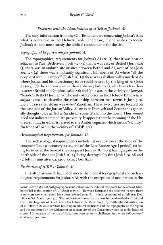
Early Pilgrims Recognized el-Bira as Bethel
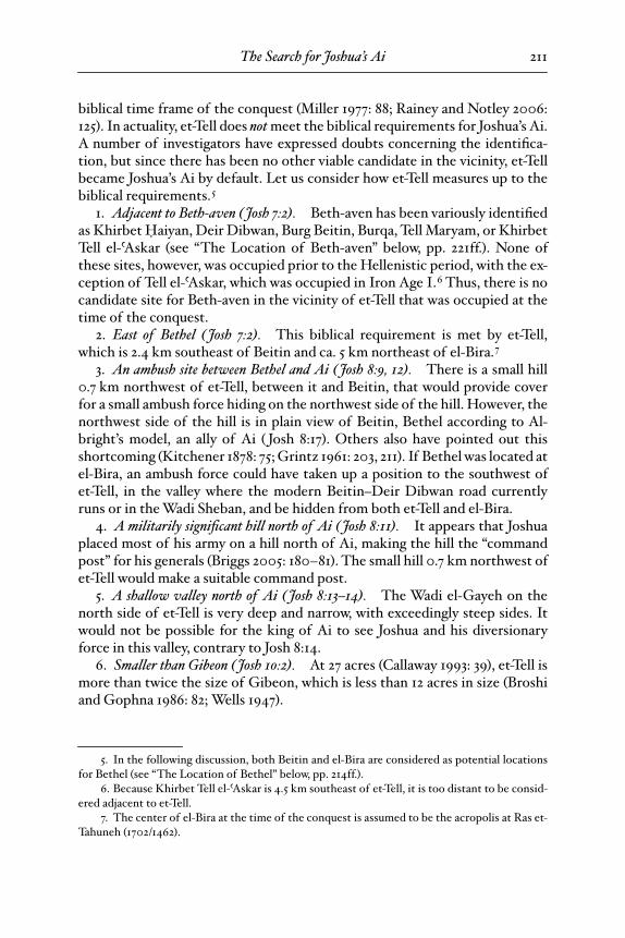
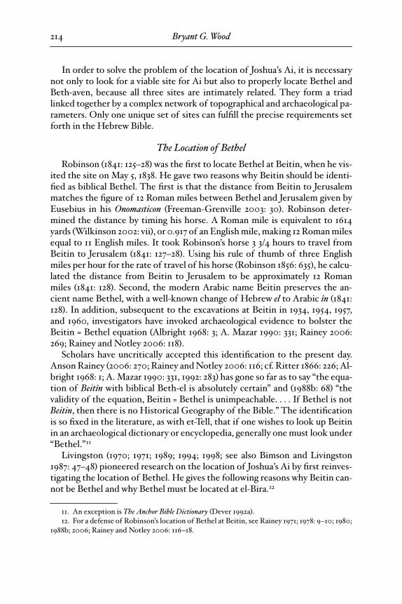
El-Bira was the site of the fortified town of La Grande Mahomerie ofthe Crusaders (Finkelstein, Lederman, and Bunimovitz 1997: 510), so named
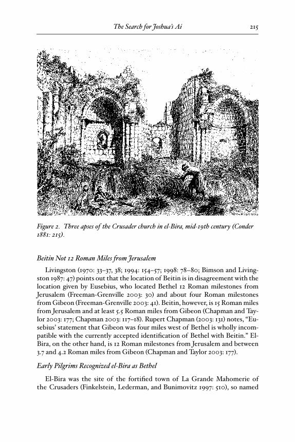
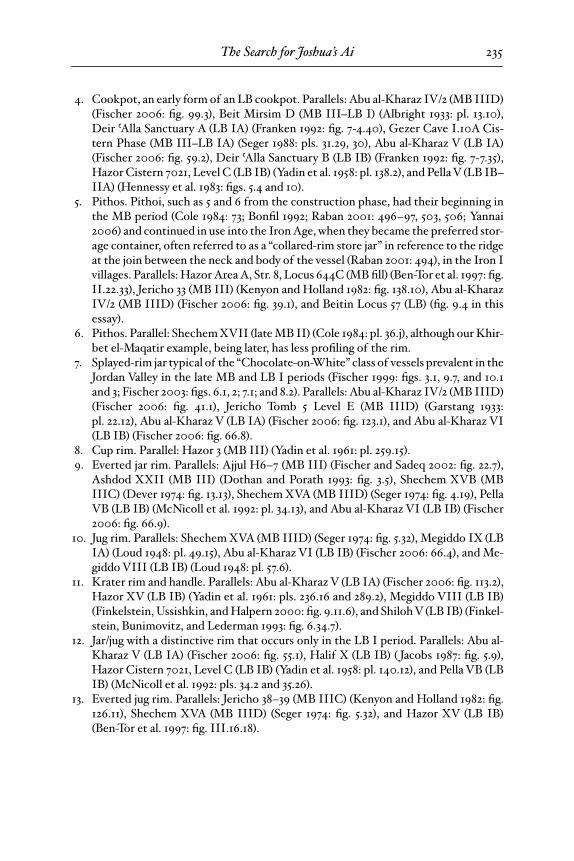
Figure 2. Three apses of the Crusader church in el-Bira, mid-19th century (Conder 1881: 215).
25-Wood-BBRSup_3 Page 215 Wednesday, September 24, 2008 5:46 PM
Bryant G. Wood
216
because of the prominent Muslim sanctuary located there. The Crusadersbuilt a church at el-Bira (fig. 2) to commemorate Mary and Joseph’s return toJerusalem to look for Jesus, because el-Bira was one day’s journey north ofJerusalem. About 200 m south of the church was a khan (fig. 3). Livingston(1989; 1994: 157–58; 1998: 80–82) reports that an anonymous traveler identi-fied La Grande Mahomerie as Bethel. To this can be added the testimony ofJohn of Würzburg, who traveled to the Holy Land in approximately 1160–1170
c.e.
(Stewart 1896: x). He (Stewart 1896: 14) wrote, “But this [ Jacob’s dream atBethel] did not take place here [ Jerusalem], but a long way off, as he was on his
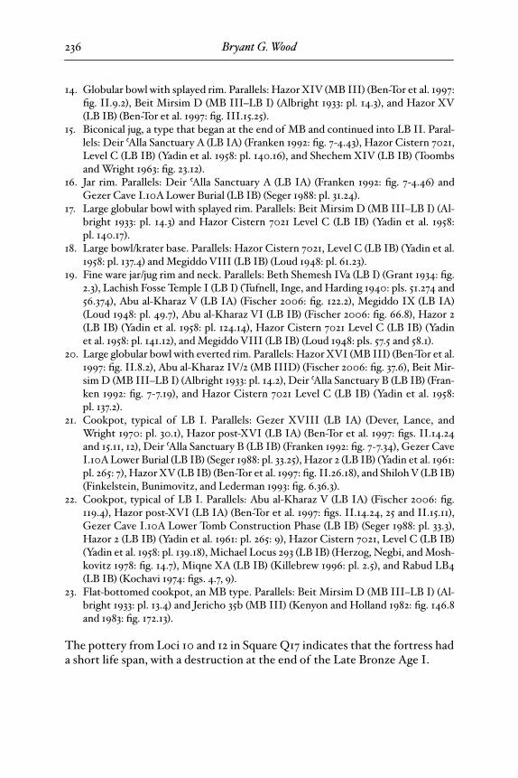
Figure 3. The khan at el-Bira, mid-19th century (Conder 1881: 216).
25-Wood-BBRSup_3 Page 216 Wednesday, September 24, 2008 5:46 PM
The Search for Joshua’s Ai
217
way to Mesopotamia—to wit, near the greater Mahumeria.” The translatoradded the following footnote: “Mahumeria the Great is
el-Bîreh
, to the northof Jerusalem.”
Archaeological Findings at Beitin Do Not Match Bethel
According to the Bible, Bethel was a national religious center in Iron AgeII. In the late 10th century
b.c.e.
, Jeroboam, king of the Northern Kingdom,established a high place there, which included a golden calf, an altar, and acadre of priests (1 Kgs 12:26–33). In the mid-9th century
b.c.e.,
there was aschool of prophets at Bethel (2 Kgs 2:3), and in the mid-8th century
b.c.e.,
Amos 7:13 tells of a “sanctuary of the king and a royal residence” at the site. Jo-siah destroyed the Bethel high place and altar in the 7th century
b.c.e.
(2 Kgs13:15). Livingston (1970: 39; cf. Ross 1941) makes the point that Jeroboam’ssanctuary has not been found at Beitin, a fact readily acknowledged by Al-bright (1934: 3): “our archaeological results have diverged widely from the ex-pected picture. No trace of the sanctuary built by Jeroboam I and still used inthe following two centuries was found, and the constructions of the Iron IIproved to be extremely inferior, in general.”
At Dan, the companion national religious center to the north (1 Kgs 12:29),excavations have revealed a strongly fortified city, including a monumentalgateway, paved roadways, and plazas. On the city acropolis was an elaborate sa-cred precinct comprising a high place, altar, storage rooms, and many culticobjects (Biran 1994: 165–254). Nothing akin to this has been found at Beitin, al-though not from lack of trying. Throughout the four seasons of the excavation( July 6–September 15, 1934; May 26–July 30, 1954; July 11–August 30, 1957; andMay 26–July 19, 1960), the top priority was to find the cultic area and city for-tifications of Iron Age II (Kelso 1968: 4, 37). Probes were made throughout thesite and beyond in an effort to locate evidence for Jeroboam’s Bethel, but not asingle Iron Age II formal cultic object was found at the site.
13
In view of theabundance of such finds at Tel Dan, one would expect to find at least some-thing representative of a national cult center if Beitin were indeed Bethel.
What was found from Iron Age II? After diligently searching the site forfour seasons, only remains of ordinary domestic structures were found in fiveexcavation areas (Kelso 1968: pls. 6, 86b, 92b, 94b, 120). Clearly, Beitin in IronAge II was nothing more than a small agricultural village. William Dever(1997c: 300–301) provides a sober and honest assessment of the findings at Bei-tin: “The [excavation] report offers scant material for the entire [Iron Age II]period, leaving the biblical accounts of Bethel’s importance in the divided
13. A few common Iron Age II domestic figurines were found (Kelso 1968: 83), but nothingwas found that could be construed as coming from a public religious center.
25-Wood-BBRSup_3 Page 217 Wednesday, September 24, 2008 5:46 PM
Bryant G. Wood
218
monarchy without a context.” The contrast between Tel Dan and Beitin couldnot be more striking.
Unfortunately, a modern scholarly myth has grown up around the site, lead-ing to exaggerated claims. James Charlesworth (2000: 49), for example, haswritten that Beitin was fortified throughout Iron Age I and II and Beth Na-khai (1997: 173) maintains that the platform for Jeroboam’s high place wasfound there. There is no evidence for either of these claims. Rainey and Not-ley (2006: 118) write, “Beitîn has all the archaeological evidence one needs toconfirm that it is a proper site for biblical Bethel.” In actual fact, there hasbeen no evidence found at Beitin that would suggest that it should be identi-fied as Bethel.
Proximity to Roads
Beitin is not on a main road as would be expected of a major city such asBethel (Livingston 1970: 29–30, 38; 1998: 82–83). In contrast, el-Bira is a livingtown with a good spring and lies on the natural crossroads for the entire area(Livingston 1970: 42; 1998: 82).
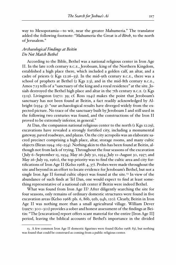
Figure 4. Aerial view of Ras et-Tahuneh at el-Bira, view southeast. The trees in the left center mark the location of the artificial platform (courtesy Israel Finkelstein).
25-Wood-BBRSup_3 Page 218 Wednesday, September 24, 2008 5:46 PM
The Search for Joshua’s Ai
219
Bethel = Beitin Is Not Certain
Livingston (1970: 32–33, 38) maintains that if the modern arabic name Beitinderived from the ancient name Bethel, which is not entirely certain (Soggin1972: 102–3), the name could have migrated from elsewhere.
No Ruins to Equate with Bethar
The Bourdeaux pilgrim (333 c.e.) wrote, “Twenty-eight miles from there[Nablus] on the left of the road to Jerusalem is the village called Bethar, and amile from there is the place where Jacob slept on his way to Mesopotamia, andthe almond tree” (Wilkinson 1999: 27).
The place where Jacob slept is obviously a reference to Jacob’s dream re-counted in Gen 28:10–22, which resulted in changing the name of the placefrom Luz, “almond tree,” to Bethel. As Livingston indicates, if Bethel is lo-cated at Beitin, there is no ruin one Roman mile north that can be equatedwith Bethar (1989; 1994: 158). If, on the other hand, Bethel is placed at el-Bira,the turnoff to Beitin (= Bethar) is one Roman mile to the north.
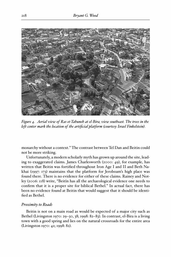
Figure 5. Retaining wall of the platform on the summit of Ras et-Tahuneh at el-Bira (photo by Michael Luddeni).
25-Wood-BBRSup_3 Page 219 Wednesday, September 24, 2008 5:46 PM
Bryant G. Wood220
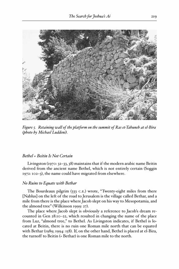
The Archaeology of el-Bira
Although excavations at el-Bira have not been possible, several surface sur-veys of the acropolis at Ras et-Tahuneh (fig. 6) have been conducted. Potteryfrom the Early Bronze Age, Middle Bronze Age, Iron Age I, Iron Age II, andRoman and Byzantine periods has been found, with the highest percentage,69%, being from Iron Age II, the time when Bethel was a national religiouscenter (Finkelstein, Lederman, and Bunimovitz 1997: 512–13). Livingston (1994:159; 1998: 83) suggests that Ras et-Tahuneh was possibly where Jeroboam builtthe high place. The top of the hill is an artificial platform (fig. 5) strewn withIron Age II pottery. It looks very much like a high place (fig. 6).
El-Bira Lacking a Biblical Identification
With its strategic location, abundant water supply, acropolis, and occupa-tional profile, it is evident that el-Bira was an important town in the biblicalperiod. Robinson identified it as Beeroth, but this identification has been re-jected. Recent investigations indicate that Beeroth was located at Khirbet el-
Figure 6. Top of the artificial platform on the summit of Ras et-Tahuneh at el-Bira (photo by Michael Luddeni).
spread is 12 points short
25-Wood-BBRSup_3 Page 220 Wednesday, September 24, 2008 5:46 PM
The Search for Joshua’s Ai 221
Burj (Finkelstein 2008: 13 and references there; cf. Livingston 1970: 39–41;1998: 80), leaving el-Bira bereft of a biblical identity.
On the basis of the historical-geographical information and the smallamount of archaeological work at the site, el-Bira is the most promising candi-date for Bethel.
The Location of Beth-aven
The location of Beth-aven has been a scholarly conundrum, because inves-tigators have been unable to suggest a viable site. The reason is clear: since theinception of historical-geographical research in Palestine, Beitin has been in-correctly identified as Bethel, thus obscuring the correct location of Beth-aven.
Biblical Requirements for Beth-avenThe first mention of Beth-aven, which means “house of wickedness,” in the
Bible is in Josh 7:2. There it states that Beth-aven was ºim, or adjacent to, Ai.Because Ai was east of el-Bira/Bethel, Beth-aven then should have been east ofel-Bira/Bethel as well. From this passage one can conclude that Beth-aven wasoccupied at the time of Joshua (late 15th century b.c.e.), was close to Ai, andwas east of Bethel.
Beth-aven is referred to a second time in the book of Joshua in the descrip-tion of the northern border of the tribe of Benjamin: “On the north side theirboundary began at the Jordan; then the boundary goes up to the shouldernorth of Jericho, then up through the hill country westward; and it ends up atthe wilderness of Beth-aven. From there the boundary passes along southwardin the direction of Luz, to the shoulder of Luz (the same is Bethel)” ( Josh 18:12–13a, rsv). Here we learn that Beth-aven was north of Bethel. Since it was botheast ( Josh 7:2) and north ( Josh 18:13a) of Bethel, in reality it must have beennortheast of the site.14
The next reference to Beth-aven is in the account of Israel’s battles with thePhilistines recorded in 1 Samuel 13 and 14. In response to Jonathan’s attack onthe Philistine outpost at Geba, the Philistines assembled their forces, “andthey came up and camped in Michmash, east of Beth-aven” (1 Sam 13:5b). ThePhilistines were coming from their territory along the Mediterranean coast, sothey evidently first passed Beth-aven and then continued eastward to Mich-mash, most likely located at Khirbet el-Óara el-Fauqa, 0.4 km northwest ofmodern Mukhmas (Arnold 1992b: 814). Beth-aven was therefore located west
14. Biblical Hebrew did not express intermediate points on the compass. There are no candi-date sites for Beth-aven northeast of and reasonably close to Beitin, providing additional evi-dence that Beitin cannot be Bethel.
25-Wood-BBRSup_3 Page 221 Wednesday, September 24, 2008 5:46 PM
Bryant G. Wood222
of Michmash and was occupied at the time of Saul in the mid-11th centuryb.c.e. Because of Jonathan’s bravery in attacking the Philistine outpost atMichmash, the Israelites were victorious that day. As the Philistines retracedthe route back to their homeland, “the battle spread beyond Beth-aven” (1 Sam14:23b). Beth-aven is then mentioned in Hos 4:15, 5:8, and 10:5. No locationalinformation is given in these verses and, in any case, nearly all scholars takeBeth-aven here to be a pejorative name for Bethel.
Scholarly Opinions
A number of suggestions have been made for the location of Beth-aven,only one of which meets the biblical requirements. The confusion on this sub-ject is best illustrated by the changing views of Albright. He first suggested thevillage of Burqa as the location of Beth-aven (1924: 145). Following René Dus-saud, he revised the location to et-Tell 15 years later (1939: 16–17), and 24 yearsafter that to Deir Dibwan (1963: 29).
Khirbet Óaiyan (17560/14570)Wilson (1869–70: 126) appears to be the first person to attempt to locate
Beth-aven. In 1870 he suggested that Khirbet An was Beth-aven. He locatedKhirbet An “some distance below the village [of Beitin], and lower down thesame valley, westward from Michmash and not far from Et-Tel (Ai).” Wilsonwas most likely referring to Khirbet Óaiyan on the southern edge of modernDeir Dibwan, because there is no site named Khirbet An in that vicinity. Sellin(1900: 1–3) and George Smith (1899) also thought Beth-aven could be at Khir-bet Óaiyan. Although west of Mukhmas, Khirbet Óaiyan is east of el-Bira/Bethel rather than northeast as the Bible requires. In addition, excavation andsurveys have shown that the site was not inhabited in the 15th and 11th cen-turies b.c.e. (Callaway and Nicol 1966; Finkelstein and Magen 1993: 36*, 183;Naªaman 1987: 13).
Deir Dibwan (17580/14640)Adolf von Schlatter (1893: 240–42) suggested the village of Deir Dibwan as
another possibility for Beth-aven. Others who adopted this identificationwere Smith (1899), F.-M. Abel (1938: 268), and Albright (1963: 29). However,Deir Dibwan does not qualify as Beth-aven because it is located east of el-Bira/Bethel, not northeast, and was unoccupied in the 15th and 11th centuries b.c.e.
(Finkelstein, Lederman, and Bunimovitz 1997: 533).
Burg Beitin (17333/14771)Gustaf Dalman (1911: 14) suggested that Burg Beitin on the southeast edge
of Beitin could be Beth-aven. He believed Beitin to be Bethel and, becauseBeth-aven was next to Bethel, Burg Beitin was a logical candidate. Klaus-Dietrich Schunck (1963: 150, 155 n. 14) made the same proposal. Burg Beitin is
25-Wood-BBRSup_3 Page 222 Wednesday, September 24, 2008 5:46 PM
The Search for Joshua’s Ai 223
indeed northeast of el-Bira/Bethel and west of Mukhmas as required by theBible, but it cannot be Beth-aven because it was not occupied until the Byz-antine period (Albright 1928: 9; Finkelstein, Lederman, and Bunimovitz 1997:522; Naªaman 1987: 13).
Naªaman (1987: 17) put forward a similar theory. He believes that Beth-avenwas the name of the sanctuary of Bethel, located east of Beitin at a site otherthan Burg Beitin yet to be found. A detailed survey of the area after 1987, how-ever, failed to produce a candidate to match Naªaman’s theory (Finkelstein andMagen 1993; Finkelstein, Lederman, and Bunimovitz 1997).
Burqa (17415/14480)Albright (1924: 145) thought that perhaps the modern village of Burqa was
Beth-aven. To my knowledge, the only other scholar to give credence to thispossibility is George Howley (1979: 318). Burqa cannot be Beth-aven, however,because it is located southeast of el-Bira/Bethel, not northeast, and was not oc-cupied prior to the Hellenistic period (Finkelstein and Magen 1993: 35*, 179;Naªaman 1987: 13).
Et-TellIn view of the almost universal acceptance of et-Tell as the site of Joshua’s
Ai, it is surprising that a few scholars have placed Beth-aven there. The first todo so was Dussaud (1937: 134–41). He was followed by Albright (1939: 16–17),Yehezkel Kaufmann (1959: 118), Grintz (1961: 231–16), and Götz Schmitt (1980:51–58). Sellin (1900: 1–3) also thought that et-Tell could be the location of Beth-aven. Although et-Tell is northeast of el-Bira/Bethel and west of Mukhmas, ex-cavations have shown that it was not occupied in the 15th century b.c.e. (Coo-ley 1997) and therefore does not qualify to be Beth-aven.
Tell Maryam (17550/14185)The most popular candidate for Beth-aven in recent years has been Tell
Maryam, 7 km southeast of el-Bira. Zecharia Kallai (Kallai-Kleinmann 1956;Kallai 1986: 128 n. 68) made this suggestion in 1956. Others who have favoredthis location are Yohanan Aharoni (1979: 256, 431), Howley (1979: 318), RobertBoling (1982: 222), and Patrick Arnold (1992a).
Tell Maryam is the least qualified of the possible sites for Beth-aven. It issoutheast of el-Bira/Bethel rather than northeast, it is too far from the candi-date sites to be considered adjacent to Ai, and it was not occupied prior to theHellenistic period (Finkelstein and Magen 1993: 35*, 180; Naªaman 1987: 13). Itssmall size (0.5 dunam [1/8 acre]; Finkelstein and Magen 1993: 35*, 180) pre-cludes it from being a settlement of any significance.
Khirbet Tell el-ºAskar (17670/14305)Kallai (1991: 175–77) recognized the shortcomings of Tell Maryam, so in
1991 he abandoned the indentification in favor of Khirbet Tell el-ºAskar, 1 km
25-Wood-BBRSup_3 Page 223 Wednesday, September 24, 2008 5:46 PM
Bryant G. Wood224
north-northeast of Mukhmas. He chose the site by default,15 and it fares littlebetter than Tell Maryam. It is southeast of el-Bira/Bethel, not northeast, and iseast rather than west of Mukhmas. In addition, it is located too far from thecandidate sites for Ai, and a survey of the site did not produce evidence for oc-cupation at the time of Joshua in the 15th century b.c.e. (Finkelstein and Ma-gen 1993: 37*, 187–88).
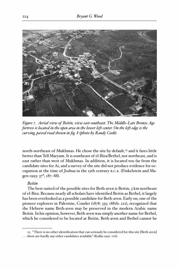
BeitinThe best-suited of the possible sites for Beth-aven is Beitin, 3 km northeast
of el-Bira. Because nearly all scholars have identified Beitin as Bethel, it largelyhas been overlooked as a possible candidate for Beth-aven. Early on, one of thepioneer explorers in Palestine, Conder (1878: 335; 1881b: 221), recognized thatthe Hebrew name Beth-aven may be preserved in the modern Arabic nameBeitin. In his opinion, however, Beth-aven was simply another name for Bethel,which he considered to be located at Beitin. Beth-aven and Bethel cannot be
15. “There is no other identification that can seriously be considered for this site [Beth-aven]. . . there are hardly any other candidates available” (Kallai 1991: 176).
Figure 7. Aerial view of Beitin, view east-southeast. The Middle–Late Bronze Age fortress is located in the open area in the lower left center. On the left edge is the curving, paved road shown in fig. 8 (photo by Randy Cook).
25-Wood-BBRSup_3 Page 224 Wednesday, September 24, 2008 5:46 PM
The Search for Joshua’s Ai 225
two names for the same place, however, since they are referred to as two dis-tinct and separate locations in Josh 7:2 and 18:12–13.
After locating Bethel at el-Bira, Livingston (1994: 158) was the first scholarto suggest that Beitin possibly could be Beth-aven.16 Chapman (2003: 121; cf.Chapman and Taylor 2003: 178) endorses this possibility: “if Bethel = el-Bira,
16. He has since changed his opinion and now believes that Beth-aven should be located atKhirbet el-Maqatir, in conjunction with his location of Joshua’s Ai at Khirbet Nisya (Livingston2003: 212–13). As pointed out above, however, Khirbet el-Maqatir does not fit the requirement ofbeing adjacent to Khirbet Nisya.
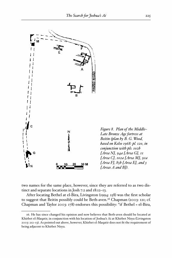
Figure 8. Plan of the Middle–Late Bronze Age fortress at Beitin (plan by B. G. Wood, based on Kelso 1968: pl. 120, in conjunction with pls. 102b [Area N], 94a [Area G], 11 [Area C], 102a [Area M], 91a [Area F], 85b [Area E], and 3 [Areas A and B]).
25-Wood-BBRSup_3 Page 225 Wednesday, September 24, 2008 5:46 PM
Bryant G. Wood
226
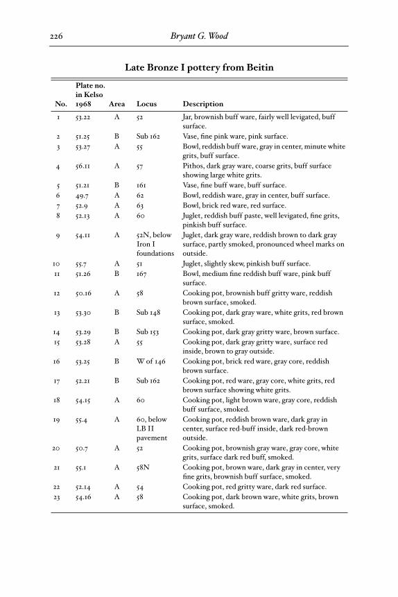
Late Bronze I pottery from Beitin
No.
Plate no. in Kelso 1968 Area Locus Description
1 53.22 A 52 Jar, brownish buff ware, fairly well levigated, buff surface.
2 51.25 B Sub 162 Vase, fine pink ware, pink surface.3 53.27 A 55 Bowl, reddish buff ware, gray in center, minute white
grits, buff surface.4 56.11 A 57 Pithos, dark gray ware, coarse grits, buff surface
showing large white grits.5 51.21 B 161 Vase, fine buff ware, buff surface.6 49.7 A 62 Bowl, reddish ware, gray in center, buff surface.7 52.9 A 63 Bowl, brick red ware, red surface.8 52.13 A 60 Juglet, reddish buff paste, well levigated, fine grits,
pinkish buff surface.9 54.11 A 52N, below
Iron I foundations
Juglet, dark gray ware, reddish brown to dark gray surface, partly smoked, pronounced wheel marks on outside.
10 55.7 A 51 Juglet, slightly skew, pinkish buff surface.11 51.26 B 167 Bowl, medium fine reddish buff ware, pink buff
surface.12 50.16 A 58 Cooking pot, brownish buff gritty ware, reddish
brown surface, smoked.13 53.30 B Sub 148 Cooking pot, dark gray ware, white grits, red brown
surface, smoked.14 53.29 B Sub 153 Cooking pot, dark gray gritty ware, brown surface.15 53.28 A 55 Cooking pot, dark gray gritty ware, surface red
inside, brown to gray outside.16 53.25 B W of 146 Cooking pot, brick red ware, gray core, reddish
brown surface.17 52.21 B Sub 162 Cooking pot, red ware, gray core, white grits, red
brown surface showing white grits.18 54.15 A 60 Cooking pot, light brown ware, gray core, reddish
buff surface, smoked.19 55.4 A 60, below
LB II pavement
Cooking pot, reddish brown ware, dark gray in center, surface red-buff inside, dark red-brown outside.
20 50.7 A 52 Cooking pot, brownish gray ware, gray core, white grits, surface dark red buff, smoked.
21 55.1 A 58N Cooking pot, brown ware, dark gray in center, very fine grits, brownish buff surface, smoked.
22 52.14 A 54 Cooking pot, red gritty ware, dark red surface.23 54.16 A 58 Cooking pot, dark brown ware, white grits, brown
surface, smoked.
25-Wood-BBRSup_3 Page 226 Thursday, September 25, 2008 8:49 AM
The Search for Joshua’s Ai 227
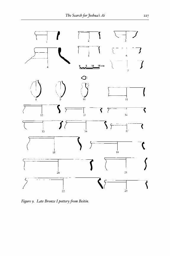
Figure 9. Late Bronze I pottery from Beitin.
25-Wood-BBRSup_3 Page 227 Wednesday, September 24, 2008 5:46 PM
Bryant G. Wood228
Beitin may be Beth-aven, which is linguistically possible.” Livingston pointedout that the Pilgrim of Bordeaux (333 c.e.) located a village named Bethar,which the translator John Wilkinson (1981: 155 n. 3) equated with Beth-aven, 1Roman mile north of Bethel.17 The turnoff to Beitin from the main north-south Roman road is exactly 1 Roman mile north of el-Bira. With Bethel at el-Bira, this would place Beth-aven at Beitin. Beitin is northeast of el-Bira/Betheland west of Mukhmas as required for Beth-aven, but does the archaeology ofthe site support this identification?
Albright (1928) made a sounding at Beitin in November 1927. He was fortu-nate enough to encounter the inside face of a fortification wall (fig. 8, Area C).Major campaigns were then carried out in 1934 under the direction of Albrightand in 1954, 1957, and 1960 under the direction of James Kelso. Unfortunately,Beitin was poorly excavated and not well published (Dever 1992a).
Sufficient work was done, however, to demonstrate that a small fortress ex-isted at the site in the Middle and Late Bronze Ages (Kelso 1968: 10–19). Thenorth, west, and south walls of the fortress were located. They were made ofwell-built courses, 3.5 m wide, and founded on bedrock. The south wall was notplotted on the site plan or related to the other walls in the excavation report,so it is difficult to determine the north-south dimension of the fortress withaccuracy. It was found just to the north of the Deir Dibwan road. From theaerial photo (fig. 7), it appears that the distance from the northwest corner ofthe fortress to the south wall is ca. 200 m. The east wall was not excavated, butthe excavators believed it was located beneath a paved road ca. 70 m east of thewest wall (Kelso 1968: 18). If this is the case, the fortress was quite small, about75 x 200 m or approximately 3.7 acres (fig. 8).
Abundant pottery from the Late Bronze Age I was found at Beitin (fig. 9).Particularly diagnostic is a type of bowl with interior concentric circlespainted in red that was prevalent at this time (Kelso 1968: pls. 34.25, 34.27,34.28, 34.32–34; M. Dothan 1971: 81;Yadin 1972: 32;Yadin et al. 1960: 94; 1989:14, 233, 306; Ben-Tor et al. 1997: 79, 84). In addition, there are abundant IronAge I remains from the time of Saul (Kelso 1968: 32–35). Thus, Beitin meetsboth the geographic and archaeological requirements for Beth-aven.
The Location of Joshua’s Ai
Albright (1963: 29) claimed there is no other site in the region other than et-Tell that could be Ai. He wrote: “Since the writer has scoured the district inquestion in all directions, hunting for ancient sites, he can attest the fact thatthere is no other possible site for Ai than et-Tell.” With such a strong endorse-
17. In the third edition of Egeria’s Travels, however, Wilkinson (1999) did not include the foot-note equating Bethar with Beth-aven.
25-Wood-BBRSup_3 Page 228 Wednesday, September 24, 2008 5:46 PM
The Search for Joshua’s Ai 229
ment from Albright, most scholars accepted the et-Tell = Ai identificationwithout question. Callaway (1968: 315) made a similar assertion: “There is noLate Bronze Age evidence in the region east of Bethel [= Beitin] that I canfind,”as did Mazar (1990: 331): “Between Beitin [= Bethel] and the desert to itseast, there is only one site which could have been referred to as ‘ ºAi’—the largemound of et-Tell.”
A site has now been found in the region that has Late Bronze Age remains,Khirbet el-Maqatir. The same day Robinson visited Beitin, he also visitedKhirbet el-Maqatir, 1.5 km southeast of Beitin. Local inhabitants told him itwas the location of Ai. After inspecting the remains of a Byzantine church onthe summit, Robinson (1841: 126) concluded, “there is not the slightestground for any such hypothesis. There never was anything here but a church;and Ai must have been further off from Bethel [= Beitin], and certainly notdirectly in sight of it.” Had Robinson walked 200 m down the southeast slopeof the site he might have changed the course of Palestinian archaeology.There, also missed by Albright and Callaway, in clear view, is abundant evi-dence for early occupation, including ancient walls on the surface. When
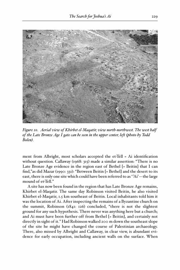
Figure 10. Aerial view of Khirbet el-Maqatir, view north-northwest. The west half of the Late Bronze Age I gate can be seen in the upper center, left (photo by Todd Bolen).
25-Wood-BBRSup_3 Page 229 Wednesday, September 24, 2008 5:46 PM
Bryant G. Wood230
Sellin (1900: 1) visited Khirbet el-Maqatir in 1899, he also was told it was thesite of Ai: “Women of Ramallah, who were searching for snails, called it Khir-bet Ai.” Investigators of the location of Ai have overlooked these notices, aswell as the ruins at Khirbet el-Maqatir.
Evaluation of Khirbet el-Maqatir as Joshua’s Ai
Excavations at Khirbet el-Maqatir from 1995 to 2000 by the Associates forBiblical Research, under my direction, have provided the necessary evidenceto identify the site as Joshua’s Ai (Wood 1999a; 1999b; 2000a; 2000b; 2000c;2001). Khirbet el-Maqatir meets the requirements for Joshua’s Ai as follows.18
1. Adjacent to Beth-aven (Josh 7:2). Khirbet el-Maqatir is 1.5 km southeastof Beitin/Beth-aven and separated from it by a very shallow valley, the begin-ning of the Wadi el-Gayeh. The sites are in clear view of one another.
2. East of Bethel (Josh 7:2). Khirbet el-Maqatir is 3.5 km northeast of el-Bira/Bethel.
3. An ambush site between Bethel and Ai (Josh 8:9, 12). Between Khirbet el-Maqatir and el-Bira/Bethel is a very deep valley, the Wadi Sheban, which couldeasily accommodate a large ambush force. It is out of sight of both Khirbet el-Maqatir and el-Bira/Bethel due to a ridge between Khirbet el-Maqatir and thewadi and a series of hills between the wadi and el-Bira/Bethel.
4. A militarily significant hill north of Ai (Josh 8:11). Jebel Abu Ammar 1.5km north of Khirbet el-Maqatir is the highest hill in the region, providing acommanding view of the battle area around el-Bira/Bethel and Khirbet el-Maqatir.
5. A shallow valley north of Ai (Josh 8:13–14). The Wadi Gayeh betweenKhirbet el-Maqatir and Jebel Abu Ammar is shallow and easily visible fromKhirbet el-Maqatir.
6. Smaller than Gibeon (Josh 10:2). The Late Bronze Age I fortress discov-ered at Khirbet el-Maqatir is small, about 3 acres in size.
7. In the vicinity of Bethel (Josh 12:9). Khirbet el-Maqatir is 3.5 km north-east of el-Bira/Bethel and thus is in the vicinity of Bethel.
8. Occupied at the time of the conquest. Abundant pottery from the 15th cen-tury b.c.e. has been found at Khirbet el-Maqatir (see “Late Bronze Age Potteryfrom Khirbet el-Maqatir” below, pp. 231ff.).
9. Fortified at the time of the conquest (Josh 7:5, 8:29). A small fortress datingto the Late Bronze I period has been found at Khirbet el-Maqatir, with walls4 m thick.
10. Gate on the north side of the site (Josh 8:11). The gate of the Late BronzeI fortress at Khirbet el-Maqatir is on the north side (see fig. 13).
18. Peter Briggs has done a detailed assessment of the suitability of Khirbet el-Maqatir, aswell as et-Tell and Khirbet Nisya, as Joshua’s Ai (2005).
25-Wood-BBRSup_3 Page 230 Wednesday, September 24, 2008 5:46 PM

The Search for Joshua’s Ai 231
11. Destroyed by fire at the time of the conquest (Josh 8:19, 28). Abundant evi-dence for destruction by fire has been found at Khirbet el-Maqatir in the formof ash, refired pottery, burned building stones and calcined bedrock.
12. Left in ruins after 1400 b.c.e. (Josh 8:28). The east half of the Late BronzeAge I fortress at Khirbet el-Maqatir was largely robbed out due to the con-struction of a 2nd–1st century b.c.e. Hasmonean fortress in this area. The west-ern half was heavily robbed out as well, by the builders of a Byzantine monas-tery on the summit of the hill 200 m northwest. The foundation of the westhalf of the gate and remnants of the west half of the fortress, however, are stillpresent and in ruins yet today (fig. 10).
All 12 of the criteria for Joshua’s Ai are satisfied at Khirbet el-Maqatir. Thesite of Ai evidently was known in Jerome’s day (early 5th century c.e.). Hestated: “It is between Bethaun [Beth-aven = Beitin] and Bethel [= el-Bira] . . .now it is desert, but the site is still shown” (Freeman-Grenville 2003: 41). Khir-bet el-Maqatir is located between Beitin/Beth-aven and el-Bira/Bethel (fig. 1).
Late Bronze Age I Pottery from Khirbet el-Maqatir
The Late Bronze Age I ruins at Khirbet el-Maqatir are immediately belowthe surface and badly disturbed as a result of subsequent activity at the site andexposure to the elements. In spite of the fragmentary nature of the remains,
Figure 11. Aerial view of Khirbet el-Maqatir, Wadi el-Gayeh and Beitin, view northwest (photo by Randy Cook).
25-Wood-BBRSup_3 Page 231 Wednesday, September 24, 2008 5:46 PM
Bryant G. Wood
232
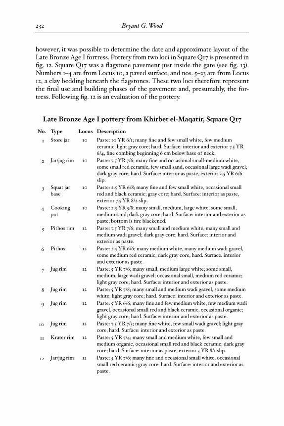
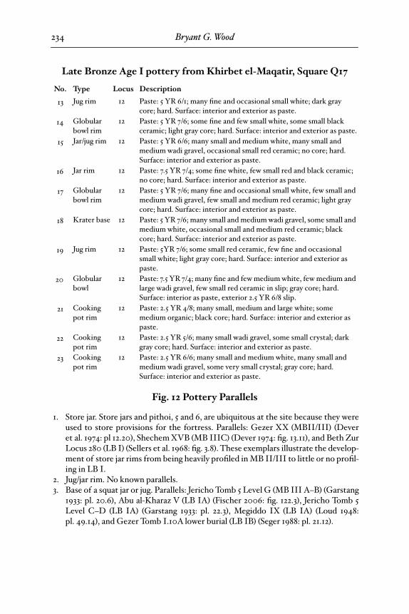
however, it was possible to determine the date and approximate layout of theLate Bronze Age I fortress. Pottery from two loci in Square Q17 is presented infig. 12. Square Q17 was a flagstone pavement just inside the gate (see fig. 13).Numbers 1–4 are from Locus 10, a paved surface, and nos. 5–23 are from Locus12, a clay bedding beneath the flagstones. These two loci therefore representthe final use and building phases of the pavement and, presumably, the for-tress. Following fig. 12 is an evaluation of the pottery.
Late Bronze Age I pottery from Khirbet el-Maqatir, Square Q17
No. Type Locus Description
1 Store jar 10 Paste: 10 YR 6/1; many fine and few small white, few medium ceramic; light gray core; hard. Surface: interior and exterior 7.5 YR 6/4, fine combing beginning 6 cm below base of neck.
2 Jar/jug rim 10 Paste: 7.5 YR 7/6; many fine and occasional small-medium white, some small red ceramic, few small sand, occasional large wadi gravel; dark gray core; hard. Surface: interior as paste, exterior 2.5 YR 6/6 slip.
3 Squat jar base
10 Paste: 2.5 YR 6/8; many fine and few small white, occasional small red and black ceramic; gray core; hard. Surface: interior as paste, exterior 7.5 YR 8/2 slip.
4 Cooking pot
10 Paste: 2.5 YR 5/8; many small, medium, large white; some small, medium sand; dark gray core; hard. Surface: interior and exterior as paste; bottom is fire blackened.
5 Pithos rim 12 Paste: 7.5 YR 7/6; many small and medium white, many small and medium wadi gravel; dark gray core; hard. Surface: interior and exterior as paste.
6 Pithos 12 Paste: 2.5 YR 6/6; many medium white, many medium wadi gravel, some medium red ceramic; dark gray core; hard. Surface: interior and exterior as paste.
7 Jug rim 12 Paste: 5 YR 7/6; many small, medium large white; some small, medium, large wadi gravel; occasional small, medium red ceramic; light gray core; hard. Surface: interior and exterior as paste.
8 Jug rim 12 Paste: 5 YR 7/8; many small and medium wadi gravel, some medium white; light gray core; hard. Surface: interior and exterior as paste.
9 Jug rim 12 Paste: 5 YR 6/6; many fine and few medium white, few medium wadi gravel, occasional small red and black ceramic, occasional organic; light gray core; hard. Surface: interior and exterior as paste.
10 Jug rim 12 Paste: 7.5 YR 7/3; many fine white, few small wadi gravel; light gray core; hard. Surface: interior and exterior as paste.
11 Krater rim 12 Paste: 5 YR 7/4; many small and medium white, few small and medium organic, occasional small red and black ceramic; dark gray core; hard. Surface: interior as paste, exterior 5 YR 8/1 slip.
12 Jar/jug rim 12 Paste: 5 YR 7/6; many fine and occasional small white, occasional small red ceramic; gray core; hard. Surface: interior and exterior as paste.
spread is 12 points long
25-Wood-BBRSup_3 Page 232 Thursday, September 25, 2008 8:49 AM
The Search for Joshua’s Ai 233
Figure 12. Late Bronze Age I pottery from Khirbet el-Maqatir, Square Q17, flagstone pavement inside gate: 1–4, Locus 10, surface of pavement; 5–23, Locus 12, clay bedding below pavement.
25-Wood-BBRSup_3 Page 233 Wednesday, September 24, 2008 5:46 PM
Bryant G. Wood
234
Fig. 12 Pottery Parallels
1. Store jar. Store jars and pithoi, 5 and 6, are ubiquitous at the site because they wereused to store provisions for the fortress. Parallels: Gezer XX (MBII/III) (Deveret al. 1974: pl 12.20), Shechem XVB (MB IIIC) (Dever 1974: fig. 13.11), and Beth ZurLocus 280 (LB I) (Sellers et al. 1968: fig. 3.8). These exemplars illustrate the develop-ment of store jar rims from being heavily profiled in MB II/III to little or no profil-ing in LB I.
2. Jug/jar rim. No known parallels. 3. Base of a squat jar or jug. Parallels: Jericho Tomb 5 Level G (MB III A–B) (Garstang
1933: pl. 20.6), Abu al-Kharaz V (LB IA) (Fischer 2006: fig. 122.3), Jericho Tomb 5Level C–D (LB IA) (Garstang 1933: pl. 22.3), Megiddo IX (LB IA) (Loud 1948:pl. 49.14), and Gezer Tomb I.10A lower burial (LB IB) (Seger 1988: pl. 21.12).
13 Jug rim 12 Paste: 5 YR 6/1; many fine and occasional small white; dark gray core; hard. Surface: interior and exterior as paste.
14 Globular bowl rim
12 Paste: 5 YR 7/6; some fine and few small white, some small black ceramic; light gray core; hard. Surface: interior and exterior as paste.
15 Jar/jug rim 12 Paste: 5 YR 6/6; many small and medium white, many small and medium wadi gravel, occasional small red ceramic; no core; hard. Surface: interior and exterior as paste.
16 Jar rim 12 Paste: 7.5 YR 7/4; some fine white, few small red and black ceramic; no core; hard. Surface: interior and exterior as paste.
17 Globular bowl rim
12 Paste: 5 YR 7/6; many fine and occasional small white, few small and medium wadi gravel, few small and medium red ceramic; light gray core; hard. Surface: interior and exterior as paste.
18 Krater base 12 Paste: 5 YR 7/6; many small and medium wadi gravel, some small and medium white, occasional small and medium red ceramic; black core; hard. Surface: interior and exterior as paste.
19 Jug rim 12 Paste: 5YR 7/6; some small red ceramic, few fine and occasional small white; light gray core; hard. Surface: interior and exterior as paste.
20 Globular bowl
12 Paste: 7.5 YR 7/4; many fine and few medium white, few medium and large wadi gravel, few small red ceramic in slip; gray core; hard. Surface: interior as paste, exterior 2.5 YR 6/8 slip.
21 Cooking pot rim
12 Paste: 2.5 YR 4/8; many small, medium and large white; some medium organic; black core; hard. Surface: interior and exterior as paste.
22 Cooking pot rim
12 Paste: 2.5 YR 5/6; many small wadi gravel, some small crystal; dark gray core; hard. Surface: interior and exterior as paste.
23 Cooking pot rim
12 Paste: 2.5 YR 6/6; many small and medium white, many small and medium wadi gravel, some very small crystal; gray core; hard. Surface: interior and exterior as paste.
Late Bronze Age I pottery from Khirbet el-Maqatir, Square Q17
No. Type Locus Description
spread is short
25-Wood-BBRSup_3 Page 234 Thursday, September 25, 2008 8:49 AM
The Search for Joshua’s Ai 235
4. Cookpot, an early form of an LB cookpot. Parallels: Abu al-Kharaz IV/2 (MB IIID)(Fischer 2006: fig. 99.3), Beit Mirsim D (MB III–LB I) (Albright 1933: pl. 13.10),Deir ºAlla Sanctuary A (LB IA) (Franken 1992: fig. 7-4.40), Gezer Cave I.10A Cis-tern Phase (MB III–LB IA) (Seger 1988: pls. 31.29, 30), Abu al-Kharaz V (LB IA)(Fischer 2006: fig. 59.2), Deir ºAlla Sanctuary B (LB IB) (Franken 1992: fig. 7-7.35),Hazor Cistern 7021, Level C (LB IB) (Yadin et al. 1958: pl. 138.2), and Pella V (LB IB–IIA) (Hennessy et al. 1983: figs. 5.4 and 10).
5. Pithos. Pithoi, such as 5 and 6 from the construction phase, had their beginning inthe MB period (Cole 1984: 73; Bonfil 1992; Raban 2001: 496–97, 503, 506; Yannai2006) and continued in use into the Iron Age, when they became the preferred stor-age container, often referred to as a “collared-rim store jar” in reference to the ridgeat the join between the neck and body of the vessel (Raban 2001: 494), in the Iron Ivillages. Parallels: Hazor Area A, Str. 8, Locus 644C (MB fill) (Ben-Tor et al. 1997: fig.II.22.33), Jericho 33 (MB III) (Kenyon and Holland 1982: fig. 138.10), Abu al-KharazIV/2 (MB IIID) (Fischer 2006: fig. 39.1), and Beitin Locus 57 (LB) (fig. 9.4 in thisessay).
6. Pithos. Parallel: Shechem XVII (late MB II) (Cole 1984: pl. 36.j), although our Khir-bet el-Maqatir example, being later, has less profiling of the rim.
7. Splayed-rim jar typical of the “Chocolate-on-White” class of vessels prevalent in theJordan Valley in the late MB and LB I periods (Fischer 1999: figs. 3.1, 9.7, and 10.1and 3; Fischer 2003: figs. 6.1, 2; 7.1; and 8.2). Parallels: Abu al-Kharaz IV/2 (MB IIID)(Fischer 2006: fig. 41.1), Jericho Tomb 5 Level E (MB IIID) (Garstang 1933:pl. 22.12), Abu al-Kharaz V (LB IA) (Fischer 2006: fig. 123.1), and Abu al-Kharaz VI(LB IB) (Fischer 2006: fig. 66.8).
8. Cup rim. Parallel: Hazor 3 (MB III) (Yadin et al. 1961: pl. 259.15). 9. Everted jar rim. Parallels: Ajjul H6–7 (MB III) (Fischer and Sadeq 2002: fig. 22.7),
Ashdod XXII (MB III) (Dothan and Porath 1993: fig. 3.5), Shechem XVB (MBIIIC) (Dever 1974: fig. 13.13), Shechem XVA (MB IIID) (Seger 1974: fig. 4.19), PellaVB (LB IB) (McNicoll et al. 1992: pl. 34.13), and Abu al-Kharaz VI (LB IB) (Fischer2006: fig. 66.9).
10. Jug rim. Parallels: Shechem XVA (MB IIID) (Seger 1974: fig. 5.32), Megiddo IX (LBIA) (Loud 1948: pl. 49.15), Abu al-Kharaz VI (LB IB) (Fischer 2006: 66.4), and Me-giddo VIII (LB IB) (Loud 1948: pl. 57.6).
11. Krater rim and handle. Parallels: Abu al-Kharaz V (LB IA) (Fischer 2006: fig. 113.2),Hazor XV (LB IB) (Yadin et al. 1961: pls. 236.16 and 289.2), Megiddo VIII (LB IB)(Finkelstein, Ussishkin, and Halpern 2000: fig. 9.11.6), and Shiloh V (LB IB) (Finkel-stein, Bunimovitz, and Lederman 1993: fig. 6.34.7).
12. Jar/jug with a distinctive rim that occurs only in the LB I period. Parallels: Abu al-Kharaz V (LB IA) (Fischer 2006: fig. 55.1), Halif X (LB IB) ( Jacobs 1987: fig. 5.9),Hazor Cistern 7021, Level C (LB IB) (Yadin et al. 1958: pl. 140.12), and Pella VB (LBIB) (McNicoll et al. 1992: pls. 34.2 and 35.26).
13. Everted jug rim. Parallels: Jericho 38–39 (MB IIIC) (Kenyon and Holland 1982: fig.126.11), Shechem XVA (MB IIID) (Seger 1974: fig. 5.32), and Hazor XV (LB IB)(Ben-Tor et al. 1997: fig. III.16.18).
25-Wood-BBRSup_3 Page 235 Wednesday, September 24, 2008 5:46 PM
Bryant G. Wood236
14. Globular bowl with splayed rim. Parallels: Hazor XIV (MB III) (Ben-Tor et al. 1997:fig. II.9.2), Beit Mirsim D (MB III–LB I) (Albright 1933: pl. 14.3), and Hazor XV(LB IB) (Ben-Tor et al. 1997: fig. III.15.25).
15. Biconical jug, a type that began at the end of MB and continued into LB II. Paral-lels: Deir ºAlla Sanctuary A (LB IA) (Franken 1992: fig. 7-4.43), Hazor Cistern 7021,Level C (LB IB) (Yadin et al. 1958: pl. 140.16), and Shechem XIV (LB IB) (Toombsand Wright 1963: fig. 23.12).
16. Jar rim. Parallels: Deir ºAlla Sanctuary A (LB IA) (Franken 1992: fig. 7-4.46) andGezer Cave I.10A Lower Burial (LB IB) (Seger 1988: pl. 31.24).
17. Large globular bowl with splayed rim. Parallels: Beit Mirsim D (MB III–LB I) (Al-bright 1933: pl. 14.3) and Hazor Cistern 7021 Level C (LB IB) (Yadin et al. 1958:pl. 140.17).
18. Large bowl/krater base. Parallels: Hazor Cistern 7021, Level C (LB IB) (Yadin et al.1958: pl. 137.4) and Megiddo VIII (LB IB) (Loud 1948: pl. 61.23).
19. Fine ware jar/jug rim and neck. Parallels: Beth Shemesh IVa (LB I) (Grant 1934: fig.2.3), Lachish Fosse Temple I (LB I) (Tufnell, Inge, and Harding 1940: pls. 51.274 and56.374), Abu al-Kharaz V (LB IA) (Fischer 2006: fig. 122.2), Megiddo IX (LB IA)(Loud 1948: pl. 49.7), Abu al-Kharaz VI (LB IB) (Fischer 2006: fig. 66.8), Hazor 2(LB IB) (Yadin et al. 1958: pl. 124.14), Hazor Cistern 7021 Level C (LB IB) (Yadinet al. 1958: pl. 141.12), and Megiddo VIII (LB IB) (Loud 1948: pls. 57.5 and 58.1).
20. Large globular bowl with everted rim. Parallels: Hazor XVI (MB III) (Ben-Tor et al.1997: fig. II.8.2), Abu al-Kharaz IV/2 (MB IIID) (Fischer 2006: fig. 37.6), Beit Mir-sim D (MB III–LB I) (Albright 1933: pl. 14.2), Deir ºAlla Sanctuary B (LB IB) (Fran-ken 1992: fig. 7-7.19), and Hazor Cistern 7021 Level C (LB IB) (Yadin et al. 1958:pl. 137.2).
21. Cookpot, typical of LB I. Parallels: Gezer XVIII (LB IA) (Dever, Lance, andWright 1970: pl. 30.1), Hazor post-XVI (LB IA) (Ben-Tor et al. 1997: figs. II.14.24and 15.11, 12), Deir ºAlla Sanctuary B (LB IB) (Franken 1992: fig. 7-7.34), Gezer CaveI.10A Lower Burial (LB IB) (Seger 1988: pl. 33.25), Hazor 2 (LB IB) (Yadin et al. 1961:pl. 265: 7), Hazor XV (LB IB) (Ben-Tor et al. 1997: fig. II.26.18), and Shiloh V (LB IB)(Finkelstein, Bunimovitz, and Lederman 1993: fig. 6.36.3).
22. Cookpot, typical of LB I. Parallels: Abu al-Kharaz V (LB IA) (Fischer 2006: fig.119.4), Hazor post-XVI (LB IA) (Ben-Tor et al. 1997: figs. II.14.24, 25 and II.15.11),Gezer Cave I.10A Lower Tomb Construction Phase (LB IB) (Seger 1988: pl. 33.3),Hazor 2 (LB IB) (Yadin et al. 1961: pl. 265: 9), Hazor Cistern 7021, Level C (LB IB)(Yadin et al. 1958: pl. 139.18), Michael Locus 293 (LB IB) (Herzog, Negbi, and Mosh-kovitz 1978: fig. 14.7), Miqne XA (LB IB) (Killebrew 1996: pl. 2.5), and Rabud LB4(LB IB) (Kochavi 1974: figs. 4.7, 9).
23. Flat-bottomed cookpot, an MB type. Parallels: Beit Mirsim D (MB III–LB I) (Al-bright 1933: pl. 13.4) and Jericho 35b (MB III) (Kenyon and Holland 1982: fig. 146.8and 1983: fig. 172.13).
The pottery from Loci 10 and 12 in Square Q17 indicates that the fortress hada short life span, with a destruction at the end of the Late Bronze Age I.
spread is short
25-Wood-BBRSup_3 Page 236 Wednesday, September 24, 2008 5:46 PM
The Search for Joshua’s Ai 237
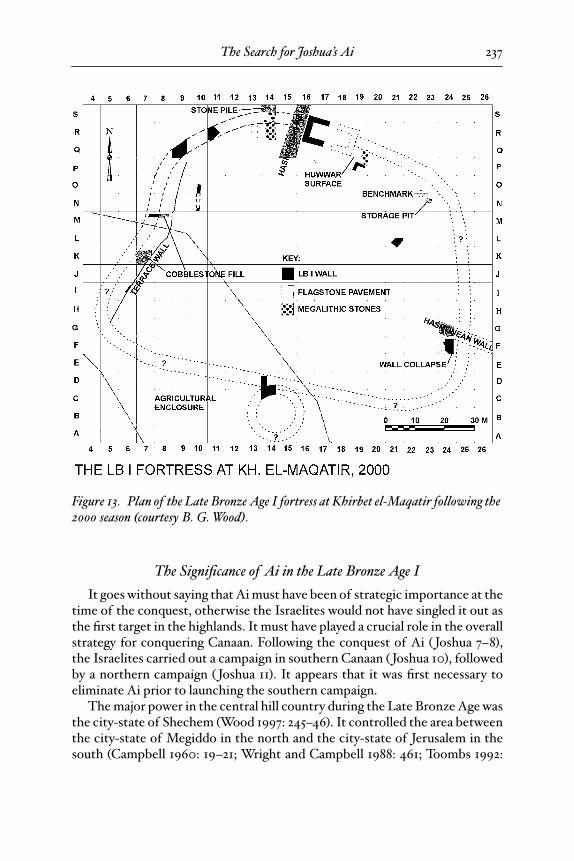
The Significance of Ai in the Late Bronze Age I
It goes without saying that Ai must have been of strategic importance at thetime of the conquest, otherwise the Israelites would not have singled it out asthe first target in the highlands. It must have played a crucial role in the overallstrategy for conquering Canaan. Following the conquest of Ai ( Joshua 7–8),the Israelites carried out a campaign in southern Canaan ( Joshua 10), followedby a northern campaign ( Joshua 11). It appears that it was first necessary toeliminate Ai prior to launching the southern campaign.
The major power in the central hill country during the Late Bronze Age wasthe city-state of Shechem (Wood 1997: 245–46). It controlled the area betweenthe city-state of Megiddo in the north and the city-state of Jerusalem in thesouth (Campbell 1960: 19–21; Wright and Campbell 1988: 461; Toombs 1992:
Figure 13. Plan of the Late Bronze Age I fortress at Khirbet el-Maqatir following the 2000 season (courtesy B. G. Wood).
25-Wood-BBRSup_3 Page 237 Wednesday, September 24, 2008 5:46 PM
Bryant G. Wood238
1183). Biblical evidence suggests that the Israelites were working closely withthe Shechemites in carrying out the conquest of Canaan (Wood 1997: 246–47;1999b: 22).
The Wadi el-Gayeh forms a natural east-west boundary between the territo-ries of Shechem and Jerusalem. This same wadi later became the border be-tween the tribes of Ephraim and Benjamin ( Josh 18:12–13). Khirbet el-Maqatir/Ai was situated on the south side of Wadi el-Gayeh, while Beitin/Beth-aven layjust 1.5 km away on its north side. Why were there two fortresses in such closeproximity to one another?
I suggest that Khirbet el-Maqatir/Ai was the northern border fortress forthe southern Jerusalem city-state coalition. From Khirbet el-Maqatir to Jeru-salem, 15 km to the south, there is clear line-of-sight communication. Beitin/Beth-aven, on the other hand, was the southern border fortress for the city-state of Shechem to the north. The two fortresses were observing one anotheracross the “no man’s land” of the Wadi el-Gayeh. Being associated with She-chem, Beth-aven would presumably be on friendly terms with the Israelites. Ai,conversely, would have provided early warning to Jerusalem in case of attackfrom the north and so was strategically important to the Israelites. Therefore,it was chosen by the Israelites as the first central hill country site to be at-tacked. Beth-aven could have provided logistical support in this undertaking.
With this reconstruction, the pattern of the conquest becomes clear. Aftergaining a foothold in Canaan by capturing Jericho, the overall strategy was toexpand the holdings of the city state of Shechem, perhaps with the under-standing that the Israelites could settle within the borders of the newly en-larged territory. They first defeated the border fortress of Ai at the northernextremity of the southern coalition, opening the way for a southern campaign.After the southern area was secured, the Israelites moved north to Hazor,where they engaged a coalition of northern kings, with the area under the con-trol of Shechem being completely bypassed (Wood 1997: 246–47).
If we are correct in our location of Beth-aven, the border between Benjaminand Ephraim in this area can be traced. It would have passed from the south-east, coming up from Jericho, along the Wadi el-Gayeh to its beginning at Bei-tin. From there, it would have gone southwest, most likely on the west side ofel-Bira because Bethel was included in the tribal area of Benjamin ( Josh 18:22).The border then proceeded to Lower Beth Horon (Beit ºUr et-Tahta 1582/1446;Josh 18:13b; Peterson 1992), 12 km west-southwest of el-Bira.
Locating the Ai of Abraham and the Ai of Ezra and Nehemiah
Relatively little is known of Abraham’s Ai and the Ai of Ezra and Nehemiah.Abraham’s Ai was east of Bethel, with a hill (har) between the two (Gen 12:8). It
25-Wood-BBRSup_3 Page 238 Wednesday, September 24, 2008 5:46 PM
The Search for Joshua’s Ai 239
seems to have been a well-known landmark because it was used to indicateAbraham’s location. The 27-acre Early Bronze Age site at et-Tell, 4.8 km east-northeast of el-Bira/Bethel, was the major city-state in the central hill countryin the Early Bronze Age (Naªaman 1992b: 280; Finkelstein 1994: 172). The im-pressive ruins there would have been a landmark in Abraham’s day and thus themost logical candidate for Abraham’s Ai. There are several hills between el-Bira and et-Tell that could have been Abraham’s camping place, including Khir-bet el-Maqatir with its Byzantine monastery (Bolen 1999).
Because men of Bethel and Ai returned to their settlements after the cap-tivity (Ezra 2:28, Neh 7:32), it follows that Bethel and Ai were occupied in theIron Age II and Persian periods. The fact that Bethel and Ai were lumpedtogether in the lists of returnees suggests that the two communities were inclose proximity. Since no Iron Age II or Persian-period pottery has been foundat Khirbet el-Maqatir, it is unlikely that it was the Ai of Ezra and Nehemiah.Both Beitin and Khirbet Nisya were occupied during the Iron Age II and Per-sian periods (Kelso 1968: 36–38, 52; Livingston 2003: 65–86) and are close toel-Bira/Bethel, so it is possible that one of these sites was the Ai of Ezra andNehemiah.19
Summary and Conclusions
The identifications of Bethel, Beth-aven, and Joshua’s Ai have eluded re-searchers since the beginning of historical-geographical research in Palestine.A misidentification of Bethel resulted in the misidentification of Joshua’s Aiand a masking of the correct location of Beth-aven. This, in turn, has led schol-ars to doubt the veracity of the biblical account of the conquest of Ai recordedin Joshua 7–8. Statements such as the following are commonplace: “There isno evidence of a second-millennium Canaanite city at this spot [that is, et-Tell]or at any other site in the region. This constitutes unequivocal archaeologicalevidence for the lack of correlation between the story in Joshua 8, with all itstopographic details, and a historical reality corresponding to the period of theconquest” (A. Mazar 1992: 283).
A careful analysis of biblical and extrabiblical evidence places Bethel at el-Bira, Beth-aven at Beitin, and Joshua’s Ai at Khirbet el-Maqatir. These are theonly three locations that satisfy the complex matrix of interlocking biblical re-quirements for the sites. Significantly, prior to the influence of modern schol-arship, local tradition placed Ai at Khirbet el-Maqatir, a fact overlooked byprevious investigators.
19. Israel Finkelstein (2008: 9) disregards Kelso’s statement (1968: 38, cf. 52) that “rude walls,probably sheepfolds” from the sixth century b.c.e. were found at Beitin and fails to mention thefinds at Khirbet Nisya. Consequently, he concludes (2008: 13), “Ai of the list of returnees is ariddle.”
25-Wood-BBRSup_3 Page 239 Wednesday, September 24, 2008 5:46 PM

Bryant G. Wood240
Finally, a word about the derivation of the name ºay. Zevit (1983: 26, 1985: 62;cf. Moscati 1980: 39, §8.46) has pointed out the relationship between Hebrewºayin and Arabic ghayin. He (1983: 26) states, “Arabic g%-y-y, ‘to hoist (a standard)’,g%ayat, ‘extreme limit, utmost extremity’, suggest that the Hebrew name ºaymay refer to some topographical or geographical feature characteristic of thesite’s location.” Abraham’s Ai (et-Tell) and Joshua’s Ai (Khirbet el-Maqatir) areboth located on the southern edge of the Wadi el-G%ayeh. The wadi possiblymarked the northen extremity of the territory of Jerusalem. It is conceivablethat the names of the two sites derived from the name of Wadi el-G%ayeh.
25-Wood-BBRSup_3 Page 240 Wednesday, September 24, 2008 5:46 PM