creating places for people - grosvenor london · berkeley square creating places for people the...
TRANSCRIPT

Berkeley Square
Creating Places for People
The TeamBDP: Landscape Architects, Urban Designers & Lighting Consultants
Gardiner & Theobald: Cost & Project Management Consultants
Urban Flow: Transport Planning and Traffic Engineering Consultants
Westminster City Council: Delivery partners and construction implementation
‘SILENCE’ FOUNTAIN, MOUNT STREET, MAyFAIR MOUNT STREET, MAyFAIR
NORTh AUDLEy STREET, MAyFAIR BROwN hART gARDENS MAyFAIR
ELIzABETh STREET, BELgRAvIA NIghTTIME, ELIzABETh STREET, BELgRAvIA
Some Examples of Recently Completed Public Realm ImprovementsIntroductionThe following boards represent the first stage in a process of developing a public realm vision for one of the most important public spaces in Mayfair. Our aim is to revive the spirit of this beautiful square whilst strengthening its distinct identity and sense of grandeur and building upon its relationship to the rest of Mayfair.
Our design objectives for Berkeley Square include:• Achieving a better balance between the
needs of pedestrians and other modes of movement
• Improving the pedestrian and cycle network• Improving the organisation of vehicle and
cycle parking• Improving the organisation of servicing and
deliveries• Increasing the appeal of the area through
enhancements to the public realm and its relationship to adjacent buildings and the garden.
• Improving the visual environment through ‘decluttering’
• Enhancing the Square’s identity through the use of public art and high quality materials
• The proposals will also look to ensure that any implemented works are consistent with aspirations for a more comprehensive enhancement of Berkeley Square at some point in the future

Introducing the Berkeley Square ProjectSetting the scene
vIEw ALONg ThE NORTh wEST CORNER OF BERkELEy SqUARE TOwARDS MOUNT STREET (LEFT) DAvIES STREET (CENTRE) AND BURTON PLACE (RIghT)
BERkELEy SqUARE IS LOCATED TO ThE SOUTh OF gROSvENOR’S MAyFAIR ESTATE, AT ThE hEART OF MAyFAIR
Mount Street
Mount Row
Grosvenor Hill
Grosvenor Street
Gagosian Gallery
Bourdon Street
Berkeley Square
Charles Street
Hill Street
Bruton Street
Brut
on L
ane
Davies S
treet
Carlos P
lace
Bruton Place
New
Bond Street
Phillips Gallery

N
Not to Scale
Narrow footway widths with poor quality surfacing Space is dominated by broad carriageways cluttered with traffic divisions. Poor pedestrian connections.
Illustrative Masterplan of Berkeley SquareNote: Analysis drawings consider Berkerley Square as a whole
key Features of Existing Site:
1
1
1
1
1
2
2
2
2
22
3
3
3
3
3
3
3
3
3
3
3
key Issues. Opportunities and vision
key Opportunities• To reduce carriageway widths and improve pedestrian crossing
opportunities across Davies Street and Berkeley Square• To increase footway widths and improve spatial proportions• To improve the alignment of pedestrian crossing points with
desire lines and destinations• To reduce vehicle speeds, and manage merging vehicles more
effectively• To manage motorcycle and cycle parking in a way that minimises
visual clutter• To manage on-street car parking supply consistent with the aims
of the overall public realm scheme• To create a distinctive place with high quality materials and
features that add visual amenity and assist with intuitive wayfinding
• To reinforce the distinctive oblong form of the central gardens whilst creating spaces for people
• To strengthen the relationship between public space and its surrounding buildings
key Issues • Traffic speeds, traffic dominance, carriageway widths, street
parking (both cars and motorcycles), infrastructure and signing detract from pedestrian movement, visual quality and the enjoyment of the Square and its surrounding buildings
• Physical connectivity is poor with lack of safe and convenient crossing points, especially into the garden
• visual connections between Mount Street and the north end of Berkeley Square and Grosvenor Hill are insufficiently direct and obvious
• Footways around Berkeley Square and its central gardens are narrow and often cluttered with control cabinets and traffic infrastructure
• Pedestrian areas are surfaced in low quality materials that fail to reflect the quality of the surrounding buildings
• Motorcycles are positioned in particularly prominent positions, undermining the visual quality of the square
visionBerkeley Square will once again become the most fashionable Square in the west End. It will be known for its taste, hospitality and luxury. It will be a spectacular green space characterised by its distinctive oblong garden, its mature trees and its fine building facades.
Setting the scene
2
Bruto
n Stre
ethi
ll Stre
et
Moun
t Stre
et
Char
les S
treet
Fitzmaurice Street
Bruto
n Plac
e
Bourd
on S
treet
Davies Street
Berkeley StreetBerkeley Square
Berkeley Square

Berkeley House & GroundsJohn Berkeley, 1st Baron Berkeley of Stratton, erected a mansion to the north of Piccadilly from 1665 to 1673 and subsequently took possession of land to the north of his property. The house was sold in 1697 to william Cavendish, 1st Duke of Devonshire, on condition that the northward view from the building would be protected and no construction carried out within the width of the gardens. This is a condition that has protected the open space of Berkeley Square up to the present day.
The Square Begins to Take ShapeThe first houses to define the square were built around 1738 on the east side by Edward Cock and Francis hillyard. The west side was completed in 1745 and described as being part of a “new intended square” called Berkeley Square.The construction of the north side of the square has a different timescale from the south. Despite an earlier occupation, it did not offer the intended ‘respectable frontage’ to the square until the 1820s when redevelopment was completed.
A Garden Supported by its Residents The gardens to Berkeley Square appear to have been laid out gradually over a period of fifty years during the eighteenth century. The enhancement of the square was carried out thanks to the contribution of residents, who were “willing and keen to raise money sufficient for better paving, lighting, supporting, and maintenance for the future through an adequate contribution among themselves”. Subsequently, in about 1767, the Square took on its oblong form when its corners were rounded.
A Highly Fashionable Location During the Regency Period, Berkeley Square was considered, along with grosvenor Square, to be the most fashionable location in the west End. Its neighbourhood “was constantly spoken of as the very type of London wealth, taste, hospitality, and luxury”.
1705, hOMANN MAP: BERkELEy hOUSE APPEARS ON PICCADILLy, wITh ITS gARDENS AND PASTURE gROUNDS TO ThE NORTh
1799, hORwOOD MAP: ThE SqUARE IS REPRESENTED IN ITS CURRENT OBLONg ShAPE, DESIgNED AS PART OF ThE 1767 ADORNMENT COMPLETED
1746, ROCqUE MAP: ThE BERkELEy ESTATE hAS BEEN DEvELOPED. ThE NORTh, EAST AND wEST SIDES ARE CONSTRUCTED whILE ThE SOUTh REMAINS OPENED TO ThE vIEw FROM DEvONShIRE hOUSE
The Development of Berkeley Square
1830, gREENwOOD MAP: BERkELEy SqUARE APPEARS IN ITS CURRENT LAyOUT. ThE FRONT gARDEN OF LANSDOwNE hOUSE FORMS ThE SOUTh FRONTAgE OF ThE SqUARE
BERkELEy SqUARE, 1813, LOOkINg TOwARDS LANSDOwNE hOUSE ALONg ThE wEST OF ThE SqUARE. ThE ENgRAvINg ShOwS A LARgE CLEARED AREA FOR CIRCULATION wITh CARRIAgEwAy AND PAvEMENTS APPEARINg AS A FLUSh SURFACE
LANSDOwNE AMAzON SCULPTURE: ONCE PART OF ThE LANSDOwNE hOUSE FINE ART COLLECTION, TODAy AT ThE METROPOLITAN MUSEUM, NEw yORk
historic ContextSetting the scene
Credit georgian London Addresses and Locations
© 2000 MOTCO Enterprises Limited
© 2000 MOTCO Enterprises Limited © 2000 MOTCO Enterprises Limited
© 2000 MOTCO Enterprises Limited
Credit Metropolitan Museum of Art (gift of John D. Rockefeller Jr., 1932)

Setting the scene
Site Context
grosvenor Square
grosvenor
Square
Davies Street
Davies Street
North Audley Street
North Audley Street
Duke Street
Duke Street
South Audley Street
South Audley Street
New Bond Street
New Bond Street
wigmore Streetwigmore Street
Mount Street Mount Street
Park Lane
Park Lanehanover
Square hanover
Square
hyde Park hyde Park
green Parkgreen Park
Cavendish Square
Cavendish Square
Berkeley Square
Berkeley Square
Oxford Street
Oxford Street
BERkELEy SqUARE IS ONE OF ThE wEST END PARTNERShIPS STRATEgIC SqUARES. ThIS PROJECT PRESENTS ThE OPPORTUNITy TO STRENgThEN LINkS BETwEEN gROSvENOR SqUARE AND BERkELEy SqUARE
ThIS PROJECT IS LOCATED AT ThE hEART OF ‘LONDON’S LUXURy qUARTER’ AND OFFERS ThE OPPORTUNITy TO STRENgThEN LINkS BETwEEN MOUNT STREET AND NEw BOND STREET
grosvenor Square
grosvenor Square
Davies Street
Davies Street
North Audley Street
North Audley Street
Duke Street
Duke Street
South Audley Street
South Audley Street
New Bond Street
New Bond Street
wigmore Streetwigmore Street
Mount StreetMount Street
Park Lane
Park Lane
hanover
Square hanover
Square
hyde Park
Phillips gallery
gagosian gallery
Bond Street Crossrail west
Bond Street Crossrail East
Bond St Underground
Oxford St Underground
green Park Underground
hyde Park
green Parkgreen Park
Cavendish Square
Cavendish Square
Berkeley Square
Berkeley SquareAspirational Connection
Oxford StreetOxford Street
ThE SITE FRONTS PhILLIPS gALLERy AND IS CENTRAL TO AN EXTENSIvE RANgE OF IMPORTANT gALLERIES
ThE SITE IS LOCATED AT A PIvOTAL LOCATION ON ThE ROUTE BETwEEN BOND STREET(wEST) CROSSRAIL AND gREEN PARk UNDERgROUND STATION

Setting the scene
The Public Realm TodayWhilst Mayfair continues to be seen as a high quality place, it has not been immune to the adverse effects of vehicular traffic. The cumulative impact of traffic has become ingrained in the street fabric of the area and is particularly evident within the public realm environment of Berkeley Square.
Mayfair was designed and laid out long before the advent of the motor vehicle. It was built at a time when there was a better balance between a street’s social context and its role as a place for vehicles. It was also built at a time when vehicles were much slower, less polluting, fewer in number and did not require the quantity of signage and controlling infrastructure that is found today.
Whilst Mayfair is synonymous with high quality streets and spaces, this perception is not reflected in the quality of surfacing, furniture and other materials within the public realm. The result is that the outstanding quality of Mayfair’s buildings and architectural compositions are not complemented by a corresponding quality in the public realm.
A photographic analysis of the northern end of Berkeley Square highlights the existing complex traffic movement that creates an inhospitable pedestrian and cycling environment. The pedestrian connectivity is poor, restricted by a lack of controlled crossing facilities and excessive car, motorcycles and cycle parking. The following photographs highlight a number of these short comings.
vIEw 01 - LOOkINg wEST ALONg MOUNT STREET
vIEw 02 - LOOkINg EAST ACROSS ThE NORThERN END OF BERkELEy SqUARE
vIEw 01
vIEw 02
vIEw 03
vIEw 04
vIEw 07vIEw 05
vIEw 06
vIEw 03 - LOOkINg NORTh TOwARDS ThE JUNCTION OF MOUNT STREET AND DAvIES STREET
vIEw 06 - MOTORCyCLE PARkINg IN A TRAFFIC ISLAND TO ThE NORTh wEST OF BERkELEy SqUARE
vIEw 07 - CyCLE PARkINg IN A TRAFFIC ISLAND TO ThE NORTh EAST OF BERkELEy SqUARE
vIEw 04 - LOOkINg wEST ACROSS ThE NORTh OF BERkELEy SqUARE vIEw 05 - EXISTINg PARkINg BETwEEN JONES STREET AND BRUTON PLACE
vIEw LOCATIONS
vehicle and Pedestrian Circulation
AnalysisSetting the scene
key vehicular routes Study boundary
Car parking baysMotorcycle parking
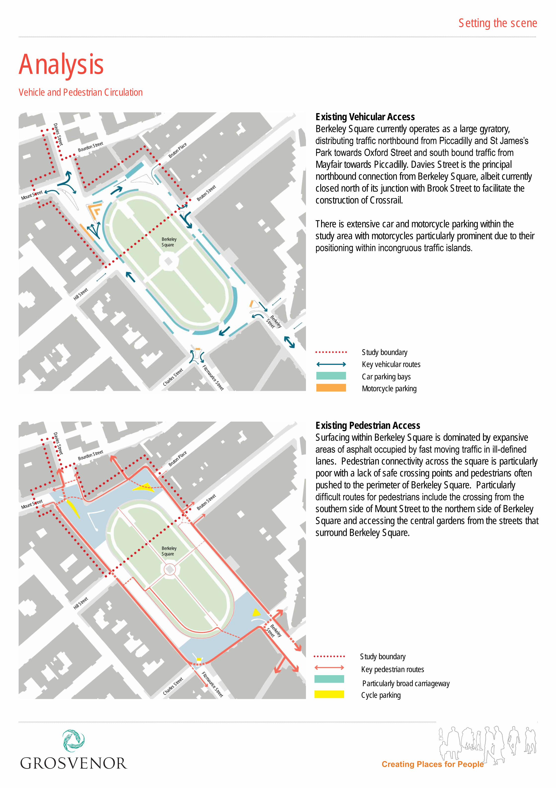
Existing Vehicular Access Berkeley Square currently operates as a large gyratory, distributing traffic northbound from Piccadilly and St James’s Park towards Oxford Street and south bound traffic from Mayfair towards Piccadilly. Davies Street is the principal northbound connection from Berkeley Square, albeit currently closed north of its junction with Brook Street to facilitate the construction of Crossrail.
There is extensive car and motorcycle parking within the study area with motorcycles particularly prominent due to their positioning within incongruous traffic islands.
Existing Pedestrian Access Surfacing within Berkeley Square is dominated by expansive areas of asphalt occupied by fast moving traffic in ill-defined lanes. Pedestrian connectivity across the square is particularly poor with a lack of safe crossing points and pedestrians often pushed to the perimeter of Berkeley Square. Particularly difficult routes for pedestrians include the crossing from the southern side of Mount Street to the northern side of Berkeley Square and accessing the central gardens from the streets that surround Berkeley Square.
key pedestrian routes Study boundary
Particularly broad carriagewayCycle parking
Bruton Street
Bruton Street
hill Street
hill Street
Mount Street
Mount Street
Charles Street
Charles Street
Fitzmaurice Street
Fitzmaurice Street
Bruton Place
Bruton Place
Bourdon Street
Bourdon Street
Berkeley Square
Berkeley Square
Davies StreetDavies Street
Berkeley
StreetBerkeley
Street

Not to Scale
N
Improvement OpportunitiesSetting the scene
highlighting Opportunities for the Enhancement of the Public Realm
Bruton Street
hill Street
Mount Street
Charles Street
Fitzmaurice Street
Bruton Place
Bourdon Street
Davies Street
Berkeley Street
Berkeley Square
Boundary to proposed public realm improvements
The introduction of pedestrian crossing facilities aligned with pedestrian desire lines
Important sight lines
Enhance visual and physical connection between grosvenor hill and Berkeley Square
Opportunity for visual features to animate public realm and assist intuitive wayfinding
The creation of a new public realm with integrated parking
The introduction of a new junction arrangement to improve driver behaviour and pedestrian environment
The public realm design proposals for Berkeley Square seek to maximise opportunities to improve the overall public realm environment and pedestrian connectivity whilst improving traffic management.
The proposals for the northern section of Berkeley Square are considered within the context of the Square as a whole to ensure that a phased approach can be adopted when opportunities to develop the scheme come forward.

Proposals for feedback
The Masterplan
N
Footway widths increased in association with the introduction of convenient pedestrian crossings.
Reducing the visual impact of carriageway surfacing through a narrowing of carriageways, the introduction of pockets for parking and the enhancement of pavement materials.
1
2
3
4
5
The introduction of high quality pedestrian surfacing materials, street furniture, lighting and planting.
The introduction of an artistic or architectural feature at the pivotal point and visually prominent north west corner of Berkeley Square.
Retention of a bus stop on the western side of Berkeley Square.
Illustrative Masterplan for Berkeley Square
Proposed treesEnglish Pennine stone surfacing
granite setts to selected pedestrian crossovers
granite setts to selected carriageway and parking bays
Asphalt carriageway
Existing mature trees
Key
Berkeley Square (dating from 1740), alongside hanover Square (1717), Cavendish Square (1717) and grosvenor Square (1725), is one of four squares within the area represented by the west End Partnership that have been identified as being in need of improvement. It is an important contributor to the character of Mayfair and, being planted in 1789, contains some of the oldest London Plane trees in central London.
The overall vision for Berkeley Square is to create a vibrant and coherent place for people. Our proposals seek to enhance legibility, strengthen connections through Mayfair and reunite Berkeley Square’s central gardens with the pavements and buildings that enclose this spectacular green space.
The gardens and their distinctive oblong form are seen as pivotal to the character of Berkeley Square and are to be respected when considering the way in which carriageways and materials are configured. The broadly rectangular shape of the square’s built form and the varied positioning of streets and movement patterns will help to inform differentials in character to each side and corner of Berkeley Square without undermining the cohesion of the square as a whole.
The northern elevation of Berkeley Square was developed at a contrasting angle to the square’s other sides. This characteristic and the additional space it creates, together with its elevated topography and the way in which Davies Street and Mount Street meet, creates an opportunity to treat this corner of Berkeley Square in a slightly different way to the Square’s other three corners.
Bruton Streethill Street
Charles Street Fitzmaurice Street
Bruton Place
Bourdon Street
Davie
s Stre
et
Berkeley StreetBerkeley Square
Berkeley Square
1
1
1
11
2
33
3 3
3
3
2
22
2
2
2
2
1
1
1
4
1
1
1
1
5

Proposals for feedback
Design Proposals
The creation of convenient crossing points within a high quality pedestrian environment
The potential introduction of small scale tree planting within widened pavements
The creation of a widened footways through a reconfiguration of carriageway and the integration of both servicing and parking (car and motorcycle)
The potential introduction of public art or an architectural feature in collaboration with the Phillips gallery
1
2
5
6
7
The provision of a convenient and obvious crossing point to the central garden
Potential to introduce underground cycle storage within widened pavements
The introduction of high quality Pennine stone surfacing
The introduction of a granite sett carriageway surface and parking bays
Illustrative Plan for Berkeley Square North
N
Not to Scale
1
1
1
2
22
3
3
7
7
7
5
6
4
8
8
8
8
3
48
Proposed treesEnglish Pennine stone surfacing
granite setts to selected pedestrian crossovers
granite setts to selected carriageway and parking bays
Asphalt carriageway
Mature existing trees
Key
Mount Street
Bourdon Place
Bruton Place
Bruton Streethill Street
Davie
s Stre
et

Proposals for feedback
MaterialsPaving Proposals
All kerbs: 300 mm wide granite
Car park bays and sett carriageways: grey mix of 250 x 150 mm granite setts
Flush Loading Bays and sett cross overs: Buff mix of 250 x 150 mm granite setts
Pavements: English Pennine stone, 600 mm wide, random lengths
hot Rolled Asphalt Carriageway
Proposals for surfacing materials combine a simple palette that reflects and integrates with the material palette used across Mayfair. Surfacing materials and street furniture will help to unify the public realm, whilst ensuring that surfacing within Berkeley Square is robust, has longevity, is attractive with associated warmth and richness and is easy to maintain.
ThERE IS AN OPPORTUNITy TO REDUCE ThE PERCEIvED wIDTh OF CARRIAgEwAyS ThROUgh ThE ENhANCEMENT OF hIgh qUALITy MATERIALS UTILISED wIThIN vEhICULAR AREAS
EXTENSIvE AREAS OF ASPhALT hAvE BEEN REMOvED IN NEARBy CARLOS PLACE wITh NO LOSS OF FUNCTIONALITy
A REqUIREMENT FOR hIgh qUALITy MATERIALS

visualisationsProposals for feedback
Sketch Aerial view
AERIAL vIEw ILLUSTRATINg ThE NORTh END OF BERkELEy SqUARE wITh ITS EXTENSIvE CARRIAgEwAyS, NARROw PAvEMENTS AND CLEAR SEPARATION OF ThE CENTRAL gARDEN FROM SURROUNDINg BUILDINgS
AERIAL vIEw ILLUSTRATINg hOw PUBLIC REALM ENhANCEMENTS CAN RESPOND TO ThE DISTINCTIvE FORM OF ThE CENTRAL gARDENS, REINFORCINg ITS PRESENCE AND CONNECTIONS TO IT. ThE vIEw ALSO ShOwS hOw A DRAMATIC NEw PUBLIC SPACE CAN BE CREATED IN FRONT OF ThE SOUTh FACINg NORThERN ELEvATION TO BERkELEy SqUARE

Proposals for feedback
Art and AnimationA vision for public art will be developed in collaboration with the adjacent Phillips gallery. The vision will offer opportunities to engage with artists and create a landmark feature to the north of Berkeley Square. The provision of a landmark feature in this location will significantly contribute to placemaking and will enhance legibility and movement through Mayfair.
vIEw LOOkINg SOUTh FROM DAvIES STREET / BOURDON STREET TOwARDS BERkELEy SqUARE. ThE PROvISION OF ART AT ThIS PIvOTAL POINT COULD ASSIST wAyFINDINg whILST REINFORCINg ThIS IMPORTANT SPACE
vIEw LOOkINg NORTh EAST TOwARDS MOUNT STREET (LEFT), DAvIES STREET (CENTRE) AND BRUTON PLACE (RIghT) wITh LOUISE BOURgEOIS’S ‘MAMAN’ STEEL AND MARBLE SCULPTURE ILLUSTRATED AS AN EXAMPLE OF ThE TyPE OF ART ThAT COULD BE INTEgRATED INTO ThIS STRATEgIC SPACE

Proposals for feedback
Art and Animation
vIEw TO BERkELEy SqUARE FROM BRUTON PLACE wITh TREES AND A POTENTIAL ECO CyCLE DOCkINg STATION TO ThE RIghT OF BRUTON PLACE. ARTIST JEFF kOONS’S SwAN SCULPTURE IS ILLUSTRATED AT ThE DAvIES STREET ENTRANCE TO BERkELEy SqUARE
vIEw TO ThE NORTh EAST CORNER OF BERkELEy SqUARE wITh TREES AND A POTENTIAL ECO CyCLE DOCkINg STATION CLOSE TO ThE ENTRANCE TO BRUTON PLACE. ThE CARRIAgEwAy AND PARkINg ARE REARRANgED TO REINTRODUCE ThE DISTINCTIvE OBLONg FORM OF ThE CENTRAL gARDENS AND BROADENED PAvEMENTS ARE ALLOwED TO ENgAgE MORE STRONgLy wITh ThE ADJACENT BUILDINgS

Proposals for feedback
Potential Cycle FacilityConsideration is being given to the feasibility of incorporating an automated cycle facility within our proposals for Berkeley Square. A system under consideration is illustrated here.
ECO cycle is an innovative solution for the mass storage of bicycles underground and could offer considerable benefits to the provision of cycle parking in Berkeley Square by releasing the space typically used for cycle stands.
It is a fully automated system that has the capacity to store 204 cycles with an average retrieval time of 13 seconds. It is a modular system that can be customised depending on how many cycles are required to be stored. 204 cycles would require a depth of 11.6m.
The system is accessed and controlled via a registered key card system which, along with the structure/mechanisms, is monitored remotely twenty four hours a day. The docking station (ECO cycle pod) itself can be customised and has the potential to be integrated into another structure such as a cafe, flower stall, or kiosk.
ThE DOCkINg STATION BELOw whICh ThE CyCLES ARE STORED
Push the bike onto the gully, up to the door & passing the sensor. Push the bike forward & into the gap in the door.
Bike Drop-Off
Bike Retrieval
Swipe your ECO Cycle Card where indicated.
when the front wheel has been clamped, step away from the entrance zone, and then press the Start Button.
keep away from the entrance zone and wait an average of 13 seconds for delivery.
The entrance door opens automatically, and once the bike is taken inside the door swiftly closes.
The system automatically locates the bike and sends the cradle to collect it from the rack.
The cradle that carries the bike is simultaneously lowered and rotated to an empty rack.
The cradle brings the bike to the entrance level.
The bike is gently pushed onto the rack, and when released the cradle returns to its start position.
The entrance doors open and the bike is pushed out, held in position until you step forward and retrieve it.
AN ILLUSTRATION ShOwINg ThE BELOw gROUND STOARgE ‘CyLINDER’
ECO CyCLE OPERATION
ILLUSTRATIONS COURTESy OF ECO CyCLE LTD

Proposals for feedback
vehicular and Pedestrian MovementBerkeley Square operates as a large gyratory distributing traffic moving north from Piccadilly / St James’ towards Oxford Street and beyond. Davies Street is the main northbound connection leading from the Square, which is currently closed north of Brook Street for Crossrail construction works.
The northern end of the square is characterised by large expanses of tarmac leading to fast moving traffic in ill-defined lanes. Pedestrian connectivity is particularly poor with a lack of any dedicated, controlled crossing facilities.
A large volume of motorcycle parking is present, located on central islands and kerb-side. There is strong evidence of high demand for motorcycle and bicycle parking in and around the square.
key access and movement design objectives include:• Improving pedestrian crossing opportunities across Davies Street and Berkeley
Square• Increasing footway widths and reduce carriageway space• Aligning pedestrian crossing points with desire lines and ‘gateways’ to grosvenor
hill• Reducing vehicle speeds, and managing merging vehicles more effectively• Managing motorcycle parking in a way that minimises visual clutter• Managing on-street car parking supply consistent with the aims of the overall
public realm scheme• Future-proofing the design to accommodate two-way traffic flow on Davies Street
The design of the northern end of Berkeley Square assumes that Davies Street will be changed to two-way operation. The Phase 1 design for implementation in early 2016 retains the current one-way northbound Davies Street flow but has been ‘future-proofed’ so that subsequent phases can be delivered with two-way working without substantial abortive works.
Westminster City Council are currently undertaking a traffic modelling study of the eastern part of Mayfair which is focussing on the planned Bond Street improvement scheme. The modelling study covers an area including Davies Street and the Mount Street junction which will ensure that the combined impact of different schemes are tested and understood.
The Mayfair Transport Study that is being developed by the west End Partnership (wEP) is investigating the feasibility of making changes to the wider Mayfair highway network, including converting existing one-way streets to two-way operation. Potential changes are shown in the figure to the right; it should be noted that these changes are aspirational at present. The implementation of any of these changes is subject to more detailed investigation and would follow a statutory consultation process led by westminster City Council (wCC).
Summary
Movement Objectives
wider Changes to Movement in Mayfair
MERgINg vEhICLES IN BERkELEy SqUARE
MOvEMENT ANALySIS
MERgINg vEhICLES IN BERkELEy SqUARE
ONE-wAy/ TwO-wAy STREETS IN MAyFAIR
POOR/NON-EXISTENT CROSSINg FACILITIES
MERgINg vEhICLES IN BERkELEy SqUARE
Existing two-way working streets
Potential two-way working streets
Existing one-way working streets

Proposals for feedback
ParkingPressures to achieve high quality design and improve the public realm run into conflict with the current level of supply (and demand) for car and motorcycle parking within the area. At present the layout of the highway provides a substantial lengths of kerb along which parking and servicing can take place.
Parking Supply
Recent parking utilisation data has been made available by wCC for spaces in Berkeley Square and the surrounding area. This data is based on new sensors that have been installed in the carriageway in each parking space. This has been supplemented by parking surveys of resident permit bays that were undertaken for the grosvenor hill public realm scheme.
Evidence Base
In the wider area surrounding Berkeley Square the maximum pay-by-phone parking utilisation is 88% on weekdays (peak at 1pm) and 90% on Saturdays (peak at 8pm). This is consistent with site observations and reflects the current situation whereby finding an empty space at peak times can be difficult. There are similar levels of parking utilisation for residents parking with nearby Mount Street and Davies Street spaces being typically 85-90% full at peak times.
Parking Utilisation
A unique feature of this public realm project, compared to previous grosvenor public realm schemes, is the presence of high numbers of motorcycle parking, in and around the scheme area. The proposed scheme reprovides all motorcycle parking provision along the inside of the Berkeley Square circulating carriageway, adjacent to the garden railings.
Motorcycle Parking
Cycle parking is well used in the two islands in the Nw and NE corners of Berkeley Square. Cycle use has increased greatly in recent years and planned improvements to cycle infrastructure, cycle routes and promoting cycling is likely to be lead to increasing requirements for on-street cycle parking provision.
Bicycle Parking
In designing the scheme, achieving a net neutral parking solution has been a key objective. To achieve the desired design objectives, some loss of parking from within the scheme area will be necessary. This parking supply will be relocated within the immediate (Berkeley Square) and wider area, subject to further discussion with westminster City Council. This approach has been successfully achieved on previous public realm schemes, including grosvenor hill immediately to the north.
Nearby off-street car parks, notably the NCP car park on grosvenor hill, typically have lower utilisation levels than on street. Making more use of these under used off-street parking assets could play a useful role in reducing on-street parking demand and enabling consequent reductions in supply in specific locations.
Summary
PARkINg SUPPLy ChANgE STUDy
PROPOSED ON-STREET PARkINg SUMMARy
EXISTINg ON-STREET PARkINg SUPPLy

Proposals for feedback
Construction PhasingScheme phasing has been considered in the development of a preferred design. works would commence with the area of pavement surrounding No30 Berkeley Square (Phillips) with the completion of this area anticipated in April 2016. works would then continue in both an easterly and westerly direction with the commencement of works to the carriageway of Davies Street starting once Transport for London and westminster City Council have undertaken work associated with the introduction of 2-way working on Davies Street north of its junction with Mount Street.
A key consideration in the development of phasing has been to prioritise public realm improvements and to minimise temporary works. It will be necessary to maintain two northbound lanes on Davies Street prior to Davies Street becoming a two way street.
The adjacent diagram illustrates:
• A first phase in front of No 30 Berkeley Square (Phillips)
• Phase 2A extending the improvements associated with phase 1 across the north of Berkeley Square and around the eastern side of Berkeley Square as far as Bruton Street.
• Phase 2B completing improvements to the north west corner of Berkeley Square and improving the western elevation to the square as far as hill Street
The adjacent diagram illustrates:
• A first phase focused on making improvements to the eastern side of Davies Street.
• The retention of the kerb line on the western side of Davies Street with some temporary works ensuring the management of traffic.
• That Davies Street remains one way northbound north of its junction with Mount Street with 2 lanes leaving Berkeley Square and one taking traffic south from Mount Street.
Phase 1
Phase 2A
Phase 2B
Proposed extent of works (all phases)
Proposed kerb line
Existing kerb line
Extent of first phase of works
Phase 1Phase 2A
Phase 2B