county of san mateo werder pier restoration feasibility study · 2004-04-29 · the werder fishing...
TRANSCRIPT

Prepared for: San Mateo County Environmental Services Agency Parks and Recreation Division
County of San Mateo Werder Pier Restoration Feasibility Study March 2004

COUNTY OF SAN MATEO
WERDER PIER
Restoration Feasibility Study
March 2004
Prepared for:
San Mateo County Environmental Services Agency Parks and Recreation Division
Attention: Samuel Herzberg Prepared By: With Assistance From:

TABLE OF CONTENTS
i
I. Background............................................................................................................. 1
II. Site Description....................................................................................................... 2
III. Site Analysis ........................................................................................................... 5
A. Condition Review ......................................................................................... 5
1. Pier Surface and Concrete Deck ....................................................... 5
2. Railing ............................................................................................... 6
3. Concrete Girders and Beams ............................................................ 7
4. Concrete Piles ................................................................................... 7
B. Geotechnical Evaluation ............................................................................ 12
1. Description of Evaluation................................................................. 12
2. Subsurface Conditions .................................................................... 12
3. Regional Seismicity ......................................................................... 12
4. Foundation Design Recommendations............................................ 14
5. Seismic Design................................................................................ 15
C. Structural Evaluation .................................................................................. 15
1. Structural Analysis........................................................................... 15
2. Nondestructive Testing.................................................................... 16
IV. Community Outreach ............................................................................................ 18
A. Focus Group #1 – Fisherman..................................................................... 18
B. Focus Group #2 –Interagency Staff ........................................................... 19
C. Werder Pier Questionnaire......................................................................... 21
D. Concept Alternatives Meeting .................................................................... 24
E. Public Workshop #1 ................................................................................... 24
F. Public Workshop #2 ................................................................................... 25
G. Focus Group #3 – Funding & Permitting .................................................... 26
H. Focus Group #4 – Environmental Education Opportunities ....................... 27
I. Security & Safety Meeting.......................................................................... 28
V. Landside Concept Plan......................................................................................... 30
A. Preferred Plan ............................................................................................ 30
B. Preferred Plan Phase 2.............................................................................. 31

TABLE OF CONTENTS
ii
VI. Waterside Improvements ...................................................................................... 35
A. Pier Improvements ..................................................................................... 35
B. Shoreline Improvements ............................................................................ 40
VII. Pier Rehabilitation................................................................................................. 42
A. Railings ...................................................................................................... 42
B. Structural Components .............................................................................. 44
VIII. Relative Costs....................................................................................................... 47
IX. Phasing of Work.................................................................................................... 48
X. Permitting.............................................................................................................. 49
A. U.S. Army Corps of Engineers ................................................................... 49
B. San Francisco Bay Conservations and Development Commission............ 50
C. California Department of Fish and Game................................................... 50
D. State of California Department of Transportation ....................................... 51
E. City of Foster City....................................................................................... 52
F. County of San Mateo ................................................................................. 52
G. National Marine Fisheries Service.............................................................. 53
H. Regional Water Quality Control Board ....................................................... 53
I. U.S. Fish and Wildlife Service .................................................................... 54
J. State Lands Commission ........................................................................... 54
XI. Funding................................................................................................................. 55
A. Association of Bay Area Governments....................................................... 55
B. San Francisco Bay Conservation and Development Commission ............. 55
C. California Department of Education ........................................................... 56
D. California Department of Parks and Recreation ......................................... 56
E. California Department of Transportation Planning ..................................... 57
F. Caltrans...................................................................................................... 57
G. Coastal Conservancy ................................................................................. 58
H. State of California Wildlife Conservation Board.......................................... 58
I. U.S. Fish and Wildlife Service .................................................................... 59
J. State of California Department of Boating and Waterways ........................ 60
K. California State Library............................................................................... 61
L. Public and Private Contributions ................................................................ 61

TABLE OF CONTENTS
iii
XII. Summary of Findings ............................................................................................ 62
A. Condition Review ....................................................................................... 62
B. Community Outreach ................................................................................. 62
C. Improvements and Rehabilitation............................................................... 62
D. Permitting and Funding .............................................................................. 63
E. Continuation of the Project ......................................................................... 63 LIST OF FIGURES Figure 1 – Vicinity Map ...................................................................................................... 3
Figure 2 – Location Map.................................................................................................... 4
Figure 3 – Site Aerial depicting parcel ownership.............................................................. 5
Figure 4 – Typical Railing and Deck Conditions ................................................................ 9
Figure 5 – Typical Pile, Deck Underside, and Beam Conditions...................................... 10
Figure 6 – Typical Girder Spall ........................................................................................ 11
Figure 7 – Resident Locations for Survey Responses..................................................... 21
Figure 8 – Identified Uses for Werder Pier....................................................................... 22
Figure 9 – Concerns about Reopening the Pier............................................................... 23
Figure 10 – Preferred Landside Plan............................................................................... 33
Figure 11 – Preferred Landside Plan Phase 2................................................................. 34
Figure 12 – Pier Layout ................................................................................................... 36
Figure 13 – New Pier Restroom and Fish Cleaning Station............................................. 37
Figure 14 – Wind Break Plan and Section ...................................................................... 39
Figure 15 – Wind Break at Eckley Pier, Crockett CA....................................................... 38
Figure 16 – Hermosa Pier Access Gate .......................................................................... 40
Figure 17 – Pedestrian Launch Ramp (Non-Vehicular) ................................................... 41
Figure 18 – Example Railing System............................................................................... 43
Figure 19 – Repair Details ............................................................................................... 45
Figure 20 – Repair Details ............................................................................................... 46
Figure 21 – Project Timeline............................................................................................ 64

TABLE OF CONTENTS
iv
LIST OF TABLES Table 1 – Regional Faults and Seismicity........................................................................ 13
Table 2 – WGCEP (1999) Estimates of a 30-Year Probability (2000 – 2003) of a Magnitude 6.7 or Greater Earthquake ..................................................... 14
Table 3 – 24-inch-square Prestressed, Precast Concrete Piles ...................................... 15
Table 4 – Relative Railing Costs...................................................................................... 43
Table 5 – Relative Cost Estimate .................................................................................... 47 LIST OF APPENDICES A. Geotechnical Figures
B. Structural Calculations
C. Nondestructive Testing Locations and Results
D. Environmental Education Invitees List
E. Pier Rehabilitation Cost Estimate
F. San Francisco Bay Trail – Grant Application

20307/0142/1301 - 1 - March 2004
I. BACKGROUND (CMA)
With the opening of the San Mateo/Hayward Bridge on March 3, 1929, the Dumbarton Bridge lost the title of the world’s longest bridge. The $6.5 million bridge measured 12 miles long, with seven of those miles over water. The bridge was originally constructed and operated as a privately owned joint venture. On September 12, 1951, the State of California paid $6 million and took control of the structure. With traffic on the bridge increasing from 2,000 vehicles per day in 1929 to 56,000 per day in 1968, and with drawbridge openings, malfunctions and accidents causing major delays for vehicles crossing the bridge, the opening of the new, high-level fixed bridge in 1968 was imminent. For the token sum of ten dollars, the County of San Mateo purchased the remaining 4,055 foot long trestle approach from the western shoreline out to where the first truss span had been. The County then operated the facility as a public fishing pier through a lease with the California Transportation Department (Caltrans). One contingency of this lease is that Caltrans can revoke the lease at any time so that they can utilize the pier as a staging area and work platform to perform repairs or upgrades to the San Mateo/Hayward Bridge. This has been done on several occasions. A second contingency mandated that the County was to maintain the pier and keep it open for public use for 25 years. The County fulfilled this obligation in 1993 and continued to operate the pier for another three years. Over the period of the bridge’s existence, the marine environment had taken its toll on the concrete structure. The aging components had deteriorated significantly, causing liability concerns resulting in the closure of the facility to public use in 1996. Due to the increase in public access to this area with the construction of the Bay Trail, and with the desire to regain this historic structure as a public attribute, the County of San Mateo solicited consulting services to perform a feasibility study on the pier. The focus of the study was as follows:
• Evaluate the structural capacity of the pier • Estimate repair needs and costs • Perform public outreach to gain input on the desired uses for the facility • Identify permitting agencies and the related issues • Identify funding sources.
The following report presents the findings of this study.

20307/0142/1301 - 2 - March 2004
II. SITE DESCRIPTION (CMA)
The Werder Fishing Pier is located along the Foster City shoreline, just south of the existing San Mateo/Hayward Bridge, as shown on the Figures 1 & 2 – Location and Vicinity maps. Along with the pier, the County owns an associated 2.75 acre, landside parcel. This parcel can be accessed from Beach Park Boulevard and is situated between a Caltrans maintenance yard and Caltrans wetland mitigation sites. See Figure 3 for an aerial showing these parcels. The pier is 30 feet wide and 4,055 feet long and extends into the deepwater shipping channel, as shown on Figure 9 of the Pier Rehabilitation section of this report. The pier has a restroom facility located approximately ¾ of the way out along the pier that is no longer operational. Fish cleaning stations were also once present on the pier.
The landside parcel is occupied by a restroom building, parking lot and small picnic area. The restroom is near the foot of the bridge and is also not functional, due to a severed sewage line. The condition of these improvements has also degraded as a result of being unused and, therefore not maintained.
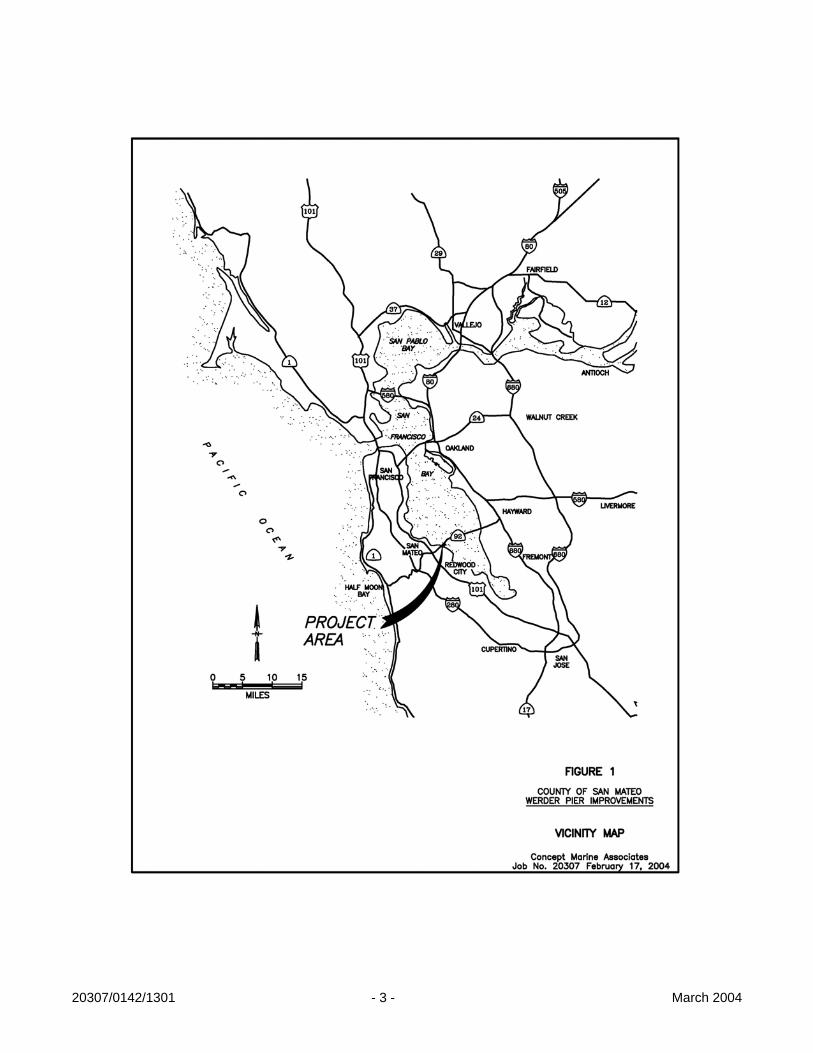
20307/0142/1301 - 3 - March 2004

20307/0142/1301 - 4 - March 2004

20307/0142/1301 - 5 - March 2004
Figure 3: Site aerial depicting parcel ownership. III. SITE ANALYSIS (CMA, Callander Associates, Treadwell & Rollo)
A. Condition Review (CMA) During the initial phases of evaluation, visual observations of the pier’s condition were made by the consultant team. The observations were made both from on the pier and from the water. Water access was provided by staff at the Coyote Point Marina. Due to the extreme currents, the vessel was not able to travel beneath the pier, limiting observations from the water to a distance of approximately 15 feet from the pier. The observations were documented with digital photographs of typical damages and with written notes. The following sections summarize the findings of the observations made of the pier’s components. 1. Pier Surface and Concrete Deck
A majority of the pier surface has been overlaid with asphalt. This was conducted on at least two separate occasions, due to the presence of asphalt overlays of differing ages. The asphalt is in relatively good condition, particularly along the outer portion of the pier where the asphalt was most recently placed. Although the asphalt is in good condition, it may not be beneficial due to its ability to hold moisture against the underlying concrete. This will be discussed further in the Pier Rehabilitation portion of this report.

20307/0142/1301 - 6 - March 2004
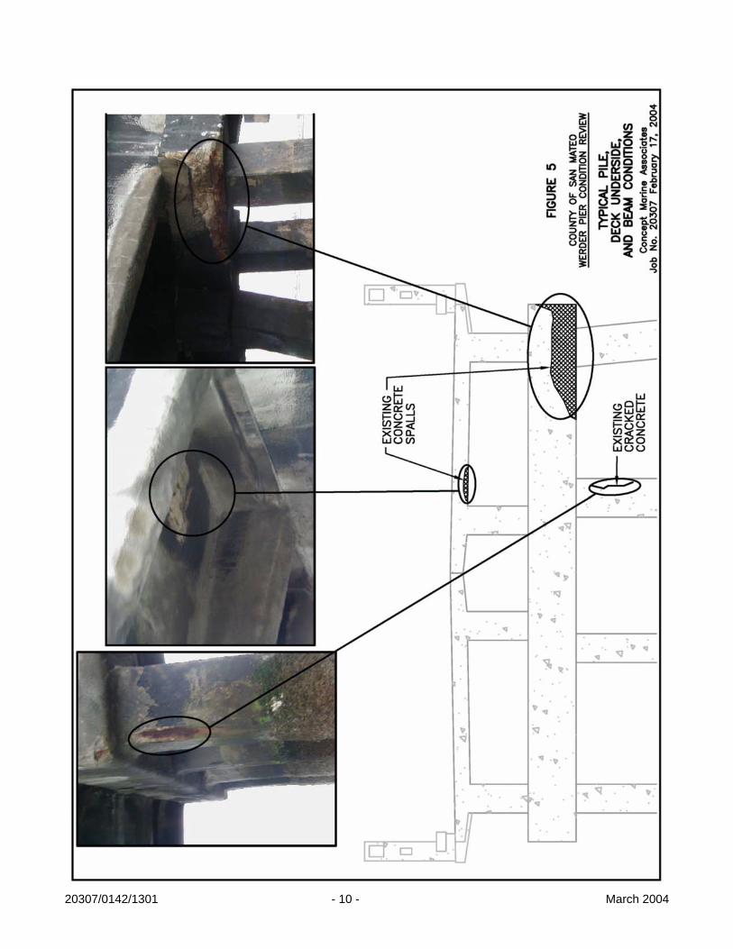
Although the presence of the asphalt overlay inhibited the full review of the concrete deck from the top of the pier, a limited number of locations beneath the asphalt were inspected. This was done by removing the asphalt in randomly selected locations along the length of the pier. The locations also varied across the width of the pier. The location along the width was selected at random and to expose joints at connections between structural components. The locations inspected revealed no indication of significant structural decay of the deck. However, the presence of the asphalt layer, which would have been costly to install along the entire length of the pier, raises the question of why it was needed. It is possible that the asphalt was installed to cover damages and/or exposed steel. Since no evidence of such damages were found within the limited locations uncovered, the question relating to the purpose of the asphalt layer remains unanswered. Also inspected were two approximately one foot wide areas beneath the railings along either side of the pier and the underside of the deck. The areas beneath the railing were observable since asphalt had not been placed in these areas. Observations of both areas revealed varying levels of damage, including cracks in the concrete, spalls and exposed and corroded steel reinforcing. Although the locations of the observed damages varied, a majority were associated with the connection between the deck and railing posts. See Figure 4 for an illustration and photographs of typical observations along the pier surface. Figure 5 shows a typical spall on the underside of the deck.
2. Railing
The existing railing system is the original cast-in-place concrete system. The condition of the railing varies along the length of the pier, from moderately damaged to heavily damaged and failing. Damage to the railing includes concrete cracks, spalls and large amounts of exposed steel reinforcement. See Figure 4. Damage at the curb along the bottom of the railing system consistently showed spalling and cracked concrete that correlate with the joint locations in the deck slab and girders. The lack of joint within the curb appears to be a primary contributor to the damage at these locations, since movement at the joints along the deck could not transmit through the railing without damage. Past repairs observed along the railings varied, depending on the locations and extent of damage being repaired and on the agency or contractor performing the work. Discussions with County staff indicated that repairs have been performed by contractors during Caltrans related activities on the pier and by the County of San Mateo. The observed repairs included new horizontal railing beams (steel) mounted into the existing posts, and replacement of entire railing sections. These repairs were conducted in a manner to restore the failed component of the existing railing to a condition similar to the original design. The repairs did not address code issues related to the oversized gaps in the railing and exposed reinforcement, or the repairs needed at the significant number of cracks and spalls present. Concerns regarding the integrity of these repairs were noted. These concerns were related to the types of materials used, the methods used to attach the repair members, and the location at which these attachments were made. Recommendations for future rehabilitation and/or replacement of the existing railing will be presented later in this report.

20307/0142/1301 - 7 - March 2004
The design of the rail does not meet current design standards for public access due to gaps in the railing that exceed four inches. This would present a significant hazard to users if the railing were restored as originally designed. Any effort to restore the railing, which public comment identified as desirable, would need to also include a retrofit to bring the railing up to current design standards. This will be discussed further in the pier rehabilitation portion of this report. An additional hazard to the public is the presence of exposed rebar with sharp edges and points, which contributed to the closing of the facility and will need to be removed prior to reopening. The condition of the railing varies significantly along the length of the pier, which should be considered when deciding whether to restore or replace the railing. This will be discussed further in the pier rehabilitation section of this report, along with alternative railing types.
3. Concrete Girders and Beams
The condition of the concrete girders and pile cap beams also varies significantly. Although only observed from a distance, the primary type of observed damage was spalling of concrete and loss of reinforcing section due to corrosion. Cracking was also observed but was hard to identify due to the distance from which observations were made. The areas of spalled concrete vary significantly in size. See Figures 5 and 6 for depictions of typical spalls. The extent of the spalls within the members appeared to be primarily limited to the outer layers of the reinforcing steel which will reduce the amount of labor and materials necessary to perform the repairs if the remaining concrete and reinforcing are in good condition. Also observed along these members were many areas that had previously been repaired. Repair plans obtained from Caltrans showed the details of these repairs. Although these repairs were conducted in a manner very similar to repair methods used today, current industry standards have significantly improved he details of how the repairs are performed and the quality of the materials used. Of particular concern regarding past repairs is the level of cleaning (steel and concrete) and surface preparation that is performed prior to placing the concrete based grout or fill material. If proper cleaning is not performed, the patch will not bond properly with the existing surface and damages will reoccur. Although some of the existing repairs appeared sound, many of the areas at which spalls were observed appeared to be locations at which previous repairs had been performed. Therefore, the integrity of the previous repairs should be confirmed. Recommendations for future repairs and possible costs associated with these repairs are presented later in this document.
4. Concrete Piles
A limited review of the above water portion of the piles supporting the pier was conducted from a distance during the condition review of the pier. Observations of the piles revealed cracks in the concrete and some spalls. Many of the cracks had rust stains associated with them, indicating that corrosion of the underlying steel had occurred. See Figure 5 for a depiction and photographs of a cracked pile. Although damage was observed, the piles were noted as having fewer observable damages than the other structural components (girders, beams and underside of deck). Possible causes of these observed conditions

20307/0142/1301 - 8 - March 2004
include the piles being constructed in a more controlled manner (precast), the repairs performed were more effective, and/or the repairs were concealing underlying issues. Of these possible scenarios, the first two appeared to be more likely since any flaws concealed by the repairs, conducted some time ago, would probably have resulted in observable damages. This observation should be confirmed during the rehabilitation process. Repairs to the piles appeared to be limited to the upper portion of the piles and consisted of encasing the piles in a concrete grout material. Some of these repairs resulted in a significant increase in the diameter of the piles. Since no underwater inspection was performed during this study, it is recommended that future efforts include this type of inspection to confirm the integrity of the piles and identify any damages that may be concealed below water.

20307/0142/1301 - 9 - March 2004
20307/0142/1301 - 10 - March 2004

20307/0142/1301 - 11 - March 2004

20307/0142/1301 - 12 - March 2004
B. Geotechnical Evaluation (Treadwell & Rollo)
1. Description of Evaluation
We understand the project team’s approach to this project is to conduct a site review using available existing information to evaluate the current condition of the pier in support of the County of San Mateo Werder Pier Restoration Feasibility Study. According to WDP, the project structural engineer, the pier is supported by 24-inch-square prestressed, precast concrete pile foundation. The base of the pier is at approximately Elevation 10 feet1. Compression and uplift loads for each pile and pile lengths were not available for review during this study.
2. Subsurface Conditions
The site is located approximately 1,000 feet southeast of the existing San Mateo-Hayward Bridge. Available subsurface information indicates the mudline varies from Elevation 0 feet at the shoreline to Elevation -10 feet at approximately 2,750 feet offshore. The mudline drops to Elevation -48 feet at 4,055 feet offshore. A layer of soft, plastic clay, known locally as Bay Mud extends from the mudline to about Elevation -70 feet. Interbedded layers of loose silty sand are encountered within the Bay Mud between Elevations -45 to -60 feet. The Bay Mud is underlain by approximately 5 to 20 feet of dense sand. Beneath the dense sand is stiff and over consolidated clay, known locally as Old Bay Clay that extends beyond Elevation –160 feet.
3. Regional Seismicity
The major active faults in the area are the San Andreas, San Gregorio, Hayward, and Calaveras Faults. These and other faults of the region are shown on Figure 2 in Appendix A. For each of the active faults, the distance from the site and estimated maximum Moment magnitude2 are summarized in Table 1.
1 All elevations referenced to the Mean Lower Low Water Datum. 2 Moment magnitude is an energy-based scale and provides a physically meaningful measure of the size of a
faulting event. Moment magnitude is directly related to average slip and fault rupture area.

20307/0142/1301 - 13 - March 2004
TABLE 1 Regional Faults and Seismicity
Fault Segment
Approximate Distance from Site (km)
Direction from Site
Maximum Magnitude
San Andreas - 1906 Rupture 8 SW 7.9
San Andreas – Peninsula 8 SW 7.2
Monte Vista 15 S 6.8
Hayward – Total 19 NE 7.1
San Gregorio North 22 W 7.3
Northern Calaveras 32 NE 6.9
Hayward - South East Extension 34 E 6.4
Mount Diablo Thrust 38 NE 6.7
San Andreas - North Coast South 39 NW 7.5
Central Calaveras 42 E 6.6
Concord 43 NE 6.5
Northern Greenville 49 NE 6.6
Central Greenville 49 NE 6.7
San Andreas - Santa Cruz Mountains 50 SE 7.2
Figure 2 in Appendix A also shows the earthquake epicenters for events with magnitude greater than 5.0 from January 1800 through January 1996. Since 1800, four major earthquakes have been recorded on the San Andreas Fault. In 1836, an earthquake with an estimated maximum intensity of VII on the Modified Mercalli (MM) scale (Figure 3 in Appendix A) occurred east of Monterey Bay on the San Andreas Fault (Toppozada and Borchardt 1998). The estimated Moment magnitude, Mw, for this earthquake is about 6.25. In 1838, an earthquake occurred with an estimated intensity of about VIII-IX (MM), corresponding to a Mw of about 7.5. The San Francisco Earthquake of 1906 caused the most significant damage in the history of the Bay Area in terms of loss of lives and property damage. This earthquake created a surface rupture along the San Andreas Fault from Shelter Cove to San Juan Bautista approximately 470 kilometers in length. It had a maximum intensity of XI (MM), a Mw of about 7.9, and was felt 560 kilometers away in Oregon, Nevada, and Los Angeles. The most recent earthquake to affect the Bay Area was the Loma Prieta Earthquake of 17 October 1989, in the Santa Cruz Mountains with a Mw of 6.9, approximately 68 km from the site.
In 1868, an earthquake with an estimated maximum intensity of X on the MM scale occurred on the southern segment (between San Leandro and Fremont) of the Hayward Fault. The estimated Mw for the earthquake is 7.0. In 1861, an earthquake of unknown magnitude

20307/0142/1301 - 14 - March 2004
(probably a Mw of about 6.5) was reported on the Calaveras Fault. The most recent significant earthquake on this fault was the 1984 Morgan Hill earthquake (Mw = 6.2).
In 1999, the Working Group on California Earthquake Probabilities (WGCEP 1999) at the U.S. Geologic Survey (USGS) predicted a 70 percent probability of a magnitude 6.7 or greater earthquake occurring in the San Francisco Bay Area by the year 2030. More specific estimates of the probabilities for different faults in the Bay Area are presented in Table 2.
TABLE 2 WGCEP (1999) Estimates of 30-Year Probability (2000 to 2030)
of a Magnitude 6.7 or Greater Earthquake
Fault Probability (percent)
Hayward-Rodgers Creek 32
San Andreas 21
Calaveras 18
San Gregorio 10
Concord-Green Valley 6
Greenville 6
4. Foundation Design Recommendations
Based on the results of our limited engineering analyses, we conclude the 24-inch-square prestressed, precast concrete piles gain strength support through skin friction from the stiff clay or dense sand underlying the Bay Mud. For compressive, dead-plus-live load, we recommend using allowable skin friction of 425 pounds per square foot (psf). Skin friction derived from Bay Mud or loose silty sand within Bay Mud layer should be ignored. The skin friction value recommended above include a factor of safety of at least two; this value may be increased by one-third for total loads that include wind and/or seismic. Support from end bearing should be ignored. For temporary uplift loads, we recommend using allowable skin friction values equal to the allowable values for compressive, dead-plus-live load.
Piles provide lateral resistance from passive pressure acting on the upper portion of the piles and from their structural rigidity. Lateral resistance of piles depend on the pile size, pile head condition (restrained or unrestrained), length of pile above mudline, allowable deflection of the pile top, and the bending moment resistance of the piles. We have performed lateral load analyses for isolated, 24-inch-square prestressed, precast concrete piles at 1000, 3000, and 4000 feet from the shoreline using both restrained and unrestrained head conditions. The results of our analyses are summarized in Table 3.

20307/0142/1301 - 15 - March 2004
TABLE 3 24-inch-square Prestressed, Precast Concrete Piles
Location Pile Head Condition
Deflection at Pile Head
Lateral Load Maximum Moment
1000 feet from shore, 17.5 feet stick-up
Unrestrained 1.0 inch 3.2 kips 900 kip-inch
3000 feet from shore, 38 feet stick-up
Unrestrained 1.0 inch 0.9 kips 500 kip-inch
4000 feet from shore, 60 feet stick-up
Unrestrained 1.0 inch 0.3 kips 300 kip-inch
1000 feet from shore, 17.5 feet stick-up
Restrained 1.0 inch 9.5 kips 1000 kip-inch
3000 feet from shore, 38 feet stick-up
Restrained 1.0 inch 3.4 kips 700 kip-inch
4000 feet from shore, 60 feet stick-up
Restrained 1.0 inch 1.4 kips 450 kip-inch
Plots of deflection and bending moment versus depth for both restrained and unrestrained head conditions are presented on Figures 4 through 7 in Appendix A.
5. Seismic Design
For design in accordance with the 2001 California Building Code, we recommend the following parameters:
a. Seismic Zone Factor 4
b. Soil Profile Type SE
c. Seismic Source Type: Type A (San Andreas Fault located 8.2 kilometers from site)
d. Near Source Factors Na and Nv of 1.07 and 1.34, respectively.
C. Structural Evaluation (WDP)
1. Structural Analysis
A limited preliminary structural analysis was performed as a structural design check of the different components of the bridge. Due to the scope of the overall evaluation, this analysis required making several assumptions regarding the mechanical properties of the in situ

20307/0142/1301 - 16 - March 2004
materials, i.e., concrete compressive strength, concrete unit weight, and structural steel yield stress. The structural analysis included seismic analysis of a general section of the pier. Further analysis included more specific consideration of general structural members including beams and piles. Analysis of these members considered dead and live loads. Specifically excluded from the analysis were any considerations of soil-structural analysis from geotechnical testing as well as consideration of the bent caps. Based on our structural calculations, the typical structural components, including piles and beams appear to be in fair condition. Given the limited nature of the analysis and the scope of the investigation, the capacity and acceptability of specific members cannot be assessed based on the results of the analysis performed. See Appendix B for the structural calculations. The structure was checked against seismic loading and appears to be capable of resisting this type of loading. The shear force resulting from the seismic loading can be balanced by friction between the diaphragms and the bent caps alone. The presence of steel dowels running from the bent caps through the diaphragms enhances this shear capacity. The piles appear to have enough capacity to withstand the weight of the superstructure. The flexural capacity of the piles under seismic loading is somewhat limited by its “effective length”. The ultimate flexural strength of a typical pile section used for analysis exceeds the ultimate loads determined by a geotechnical analysis performed by others. Additional data from the geotechnical analysis shows the “fixity,” or fixed point, depth of the piles to range between 50 and 70 feet. Based on our analysis using a conservative value of 50 feet, the piles can safely withstand seismic loading. The pier girders were checked for gravity loading. In addition to checking the original design, which was found as satisfactory, two levels of deterioration of the original steel reinforcement were considered: 25% and 50%. These levels of deterioration consider the possibility that part or all the bottom layer of steel in the girders may be significantly affected by corrosion. For the first case, the girders appear to be capable of sustaining 100% of the dead load plus only 50% of the live load on the structure. For the second case, the dead load alone exceeds the girders’ capacity.
2. Nondestructive Testing Testing methods included visual evaluation from the surface of the pier as well as by boat, chloride sampling, half-cell corrosion testing, and impact-echo testing. The results of the test methods, including specific comments and raw data, are included in Appendix C. Generally, chloride sampling indicated that those sites tested on the deck and rail portions of the structure contained chloride contents beyond the threshold value at which corrosion of reinforcing steel is theoretically possible. The increasing values of chloride content with depth found in some test locations are not consistent with the nature of chloride intrusion. Based on visual observation of the exposed aggregates in some distressed locations, it is concluded that the phenomenon can be attributed to aggregates with high chloride contents, such as sea shells; anecdotal information regarding the construction practices supports this conclusion as well. Half cell testing of the deck revealed test values both above and below those limits indicating active corrosion at the time of testing. The results are site specific. Generally, effects from active corrosion could not be visually confirmed in the half-cell

20307/0142/1301 - 17 - March 2004
testing areas. Impact-echo testing, likewise, did not indicate apparent concrete flaws that might be associated with corrosion activity in the test areas. Clearly though, visual observations from below indicated there were selected areas of the deck slab that had delaminated from underneath due to corrosion.

20307/0142/1301 - 18 - March 2004
IV. COMMUNITY OUTREACH (Callander Associates)
The community outreach for the Werder Pier Feasibility study was key to this planning process. Gaining input and insight from the community residents and potential park and pier visitors helped guide the “vision” and needs for these facilities. This process included input from four different focus groups, a public survey, two public workshops and other interagency and staff meetings. The following presents summaries of these activities in the order in which they occurred.
A. Focus Group #1 – Fishermen, May 24, 2003
The purpose of this meeting was to allow people to fish from Werder Pier and at the same time present their views, aspirations and visions for the pier. Nine adults and two children were in attendance, spending a total of five hours of fishing and discussing the pier that morning. The fishermen traveled from Daly City, Roseville, San Bruno, San Jose, Belmont, Millbrae and Redwood City for this event. The fishing occurred at the end of the pier, in the deep water channel approximately a mile off shore.
Suggested items of concern and potential proposed improvements are summarized below.
Concerns
• Security of parked vehicles in the parking lot should be addressed.
• Personal safety and security while using the pier is a concern. This includes debris flying from bridge above.
Suggested Improvements
• Majority of users felt a minor charge for parking and concessionaire operation would be extremely beneficial, especially if attendant and security patrol were present.
• Many expressed interest in nighttime use to avail themselves of the best fishing hours, including after 9 pm.
• A broad range of recreational activities on the pier was strongly supported, including biking, strolling, and jogging.
• Improvements relating to improved safety and security included:
1. use of security cameras or other appropriate security devices
2. private security company to provide surveillance
3. limited lighting for improved visibility
4. restricted and enforced access hours, gating the pier and parking lot during evening hours except by reserved/permitted use (including fishing), special events or promotional fundraising events
5. police patrol on bikes
6. improved safety railings, especially for the protection of children
7. life buoys and throw ropes

20307/0142/1301 - 19 - March 2004
8. use of parking lot as California Highway Patrol parking lot
9. public emergency phone and restroom facilities access desired by many
Suggested improvements by more than one attendee included the following: • Fishing amenities: fish cleaning station, garbage cans, fish landing floats, railing mounted
rod holders, designated fishing area, and an imposed limit on “fish take”
• Seating area and benches, including some with windscreens.
• Small concessionaire snack stand and bait shop.
• Picnic area and increased landscaping at Bay Trail and along pier.
• Bicycle racks.
• Interpretive panels at the park and along the pier for pier history, wildlife, ecology, and shipping lane information.
The fishermen sought multi-purpose access to the pier to include fishermen, bikers, strollers, joggers, skaters, bird watchers, and fishing spectators. The participants were appreciative of the opportunity to use the pier and looked forward to the planning process, especially future implementation of the shoreside and waterside improvements to the pier.
B. Focus Group #2 – Interagency Staff, July 31, 2003
This meeting was an information gathering session to uncover opportunities, ideas and concerns associated with reopening Werder Pier. Staff from the City of Foster City included the Parks Department, Community Development and Planning, the County of San Mateo Parks Division, California State Coastal Conservancy, Bay Conservation and Development Commission (BCDC), and Caltrans attended the meeting. Discussion included the following topics and comments: Pier Structural Condition
• Some corrosion of the pier has taken place, including to the concrete and railing.
• Visual inspection underneath the pier had been performed.
• Further evaluation of the piles was in progress. Potential Pier User Groups
• Desirable user groups include fishermen, strollers, joggers, bikers, skaters, and bird watchers.
Recreational Opportunities
• A multi-use park and pier sought by all.
• Access for boating and windsurfing may be difficult due to tides and water depth at this location.

20307/0142/1301 - 20 - March 2004
Potential Funding Sources
• Various environmental funding sources were cited.
• Some grant funding sources provide varying levels of funding depending upon degree of bay restoration contemplated. For example, removing pier sections and exposing the Bay to daylight may increase funding levels.
Existing Conditions of the Werder Pier Area
• Existing gates, picnic areas, restrooms, parking, wetlands, Bay Trail access, utilities were discussed. Pending utility improvements and future vision of the adjacent Caltrans site were reviewed.
Lessons Learned from Prior Public Access
• Concerns over security, maintenance, traffic impacts, vandalism, bonfires, property damage, utility and plant theft, feral cats, and hours of operation were explored.
Permitting and Implementation
• BCDC generally regards increased public access as a benefit and is favorably disposed toward the project.
Responsibility for the Pier
• San Mateo County and the City of Foster City discussed possibilities of collaboration, especially in times of limited funding and limited staff availability.
Maintaining Security
• Some proposals were made including lighting, and restricted hours of use.
• Further concerns and ideas to be provided through community participation and public questionnaire response.
Potential Park and Pier Amenities
• “Park-like” amenities sought, including picnic areas, benches, restroom, drinking fountain, trees and open space, parking lot and Bay Trail access.
Public Outreach Process
• Further input to be gathered from community workshops, focus group meetings, and public questionnaire.
• The City of Foster City to provide some assistance in this outreach effort. The meeting helped to generate enthusiasm and define the planning process, and initiated the collaborative efforts between the County of San Mateo and the City of Foster City.

20307/0142/1301 - 21 - March 2004
San Mateo (29%)
Foster City (29%)Other
(42%)
Foster City- 45San Mateo- 46Other- 66
C. Werder Pier Questionnaire, August to December 2003
A questionnaire was created to help gather insight, recreational needs, and concerns about reopening the park/pier facility. This questionnaire included a section to educate the public on the history of the project and provided opportunities for comment that might not be otherwise shared in a public forum. Questionnaires were mailed to individual residents in the Werder Pier area and were made available at local bike shops, bait shops, community centers and libraries. The questionnaire also posted to UPSAC’s website. The questionnaire was divided into two main topics: prior use and anticipated use. Recreational needs, hours of operation, site amenities, and safety issues were some of the issues covered in the community’s responses.
General Findings
Overall, one hundred and fifty-seven responses from diverse recreational users and members of several Bay area communities were received. The Werder Pier questionnaire received input from Foster City, San Mateo, and other Bay Area residents. See Figure 7 for a graph of the resident locations. Over forty percent of the responses received were from community members outside of the Foster City and San Mateo area. Responses from the Foster City and San Mateo community were equally numbered. Over a majority of respondents had previously used the facilities. The main prior uses included bicycling, fishing and strolling, throughout the year, with little carpooling used to visit the site. Trips to the site were taken in small groups with friends or family, with neither weekday nor weekend trips favored.
Figure 7: Resident Locations for Survey Responses

20307/0142/1301 - 22 - March 2004
0102030405060708090
100
Bicy
clin
gBi
rd W
atch
ing
Fish
ing
Picn
icki
ngSi
ghts
eein
gSk
atin
gSt
rolli
ngOt
her
Prior UsesAnticipated Uses
The respondents currently participate in active and passive recreation use along the Bay. With the reopening of the pier, respondents perceived that use of the pier and park would exceed prior usage and that a greater variety of activities would take place. Routine fishing trips, daily walks, and bicycling were among the activities experienced when the pier was previously open. Bicycling, fishing, and strolling were at the top of the list for anticipated uses. Sightseeing, bird watching, picnicking, strolling, and skating were other anticipated activities. See Figure 8 for a graph showing the anticipated uses and number of respondents that previously participated and anticipate participating in the use of the facilities.
Figure 8: Identified Uses for Werder Pier
Public Concerns
A number of concerns were identified by the responses to the questionnaires in regard to reopening the pier. Questionnaire respondents were allow to check none, several, or all of these topics regarding concerns about the facilities. Answers were generally expressed with respect to prior experience when the pier was previously open. See Figure 8 for the Concerns about Reopening the Pier.

20307/0142/1301 - 23 - March 2004
Litter23%
Graffiti16%
Personal Safety16%
Theft6%
Pier Safety15%
Disorderly conduct
19%
None2%Misc.
2%Litter- 85
Graffiti- 59
Personal Safety- 57
Theft- 23
Pier Safety- 55
Disorderly conduct- 68
Misc.- 9
None- 8
Figure 9: Concerns about Reopening the Pier
There was mixed response on the desire to pay for park or pier use. Some felt access should be free while others didn’t mind paying a minimal fee to help with maintenance and cleanup of the facilities. There were also opinions on charging for parking entrance versus pier use. Nearby residents preferred free parking to minimize impacts on the on-street parking availability or traffic in their neighborhood.
Safety and maintenance concerns were also expressed. A concern for lack of maintenance regarding litter, graffiti, and disorderly conduct were expressed, in addition to pier safety, personal safety, and theft. Alcohol use, illicit behavior, and after hours use were not desirable. Increased patrolling, security measures, gated facilities, increased recreational activities, and maintained park facilities were suggested.
Park amenities are desired such as restrooms and drinking fountains. Regular site visitors such as fishermen and families expressed a preference for a small concessionaire bait and snack shop, while others were opposed to any concessionaire use because of concerns for added trash and types of patrons that may frequent the store.

20307/0142/1301 - 24 - March 2004
Sample Comments Received on Questionnaires
• “This is a valuable asset to the Foster City community and needs to be preserved.”
• “We do not have any kids, but enjoyed walking on the pier. The pier needs to be “Kid Friendly” and safe. Open daylight to dark only. …. A charge would be in order if it would help keep the place clean. I ride the path 3 or 4 times a week.”
• “Must be free, it is our bay.”
• “A pier always adds a unique way to explore and enjoy the natural beauty and wonders of the bay. Would be a great addition to the existing public parks and trails.”
• “The pavement on the bridge will need improvements to facilitate walking and bicycling.”
• “To improve the area, plant some shade trees at the entrance to the pier with benches, tables, improved toilet facilities, protected from the wind by some kind of a wind break. Better landscaping around the entrance to the pier and also the parking lot. Plant trees over the parking area as well.”
• “Certain shading area should be provided for sitting and fishing. It should be wheelchair accessible.”
• “The pier should be closed and chained at sunset to prevent damage to restrooms and fish cleaning stations. Also to prevent it from becoming a teen/young adult hangout.”
• “We think it will need some sort of security by day and securely locked at night.”
• “I think fixing it up is long overdue. People love walking and strolling all over out there because it is so scenic. “
Overall, great enthusiasm was received to reopen the pier and park facilities. Issues of security, maintenance, and safety needed to be addressed to balance this recreational desirability. The County’s mailing list grew with the community’s interest in being informed of the planning process.
D. Concept Alternatives Meeting, September 10, 2003
A meeting was held with the County and the consultant team to evaluate the design concepts before they were presented to the public. Two landside alternative plans were prepared for discussion. Desired pier and landside improvements, existing conditions, donation opportunities, and concept development where the main topics covered. The two concepts were reviewed with the City of Foster City, and refined for presentation to the public. A third alternative was developed for presentation to Caltrans for feedback on an enlarged park site area, including a land-swap of County land for Caltrans land nearer the Bay edge.
E. Public Workshop #1, October 2, 2003
This public workshop presented the alternative concepts to the community for the first time. Pier and shoreside existing conditions, three park alternative plans, and pier alternatives for restroom, fish cleaning stations, railings, and windbreak/bench designs were presented. These concepts were used as a discussion tool to refine the design towards a preferred alternative.

20307/0142/1301 - 25 - March 2004
Workshop #1 Desired Elements PIER
• More and larger windbreaks incorporating the railing design • Security (gate/lighting/security cameras) • Safe railing system • Bike racks • Dredging to increase fishing area • Emergency vehicle access • Adequate lighting • Haul carts • Bait boxes • Human-powered boat launch
SHORESIDE
• More off-street parking • Drop off area • Minimize pedestrian/vehicular crossings • Concession building • Gathering space/group space • Interpretive opportunities • Easy surveillance
Amenities for both pier and shoreside developments are desired. Comments received reiterated the desire to reopen the facilities. The concept plans were further refined to reflect the comments received from this workshop and prepared for the second public workshop.
F. Public Workshop #2, December 4, 2003
At the second public workshop, the preferred pier and shoreside plan were presented. This included a windbreak, railing and restroom design on the pier. The preferred park plan illustrated a drop off area, large parking area, minimal sidewalk and vehicular intersections, restroom and concessionaire facility, large meadow, group gathering area, and marsh-edge interpretive pathway. A phase 2 overlay concept was illustrated with pathway, picnic tables and dry boat storage to the north and a wetlands interpretive trail loop to the south, both needing approval from landowners before further development.
Concerns
• Members would like input from Foster City police and fire department. • Bay Trail and boat ramp may conflict with each other. • Proximity of the pier (fishermen) to the human powered boat launch is a concern. • Kayaker concern regarding the distance from the drop off area to the shore.

20307/0142/1301 - 26 - March 2004
Suggested Improvements SHORESIDE
• Sea kayakers desire floating dock or launch ramp access. Ramp materials, distance from the pier and precedents were discussed.
• Signage to educate both fishermen and kayakers should be installed to appraise both parties of safety issues and awareness of other recreational activities.
• Signage to educate kayakers on the bay currents should also be installed (i.e. deep ship channel can have high-speed currents).
• The pier should be renamed to “San Mateo” versus Werder, since it was previously the San Mateo Bridge.
• Funding from corporate sponsors should be considered.
The preferred pier and shoreside plan were consensually agreeable. Minor additions of safety signage and details of how to create an accessible human-powered boat ramp were discussed. These features will be developed further during design development, which is outside the scope of this feasibility study.
G. Focus Group #3 – Funding and Permitting, December 16, 2003
This group of City, state, and federal agencies with permitting and potential funding authority were invited to share their concerns about and objectives for the project. The group was organized to help the project gain momentum towards implementation. Over nine funding agencies were invited to attend. Several agencies suggested multiple grants that may be applicable to the project. Approximately ten permitting agencies were also invited to discuss jurisdictional limits and permit application procedures. Some agencies addressed both funding and permitting needs of the site. A draft Preferred Plan and Phase 2 Plan, were presented. Members of the County Parks Division, Army Corps of Engineers (USACE) and Caltrans Permits office attended. A summary is outlined below. Funding
• The San Mateo County of Public Works Department should be contacted for potential grant sources regarding transportation or pedestrian trail funding.
• The San Mateo County Parks has a mechanism so that private donations may be volunteered for park use.
• Other funding opportunities were identified for further research. Permitting
• The Army Corps of Engineers is generally supportive of public access that does not degrade the environment.
20307/0142/1301 - 27 - March 2004
• The USACE does not anticipate permitting obstacles if no pilings are being added and just repairs are made. The entire project would be reviewed not just that portion within their jurisdiction.
• In reopening the pier, the potential for resource degradation needs be evaluated.
• Entry drive new construction would need a permit from Caltrans. Property Ownership
• Acquisition of Caltrans land to the west would require Caltrans review.
• Caltrans to look into excess lands at site area and Phase 2 that is not needed for Caltrans operations and could be incorporated into landside improvements.
Other Issues
• Parking lot surfacing materials and off-site drainage should be evaluated with respect to the impact to the adjacent wetland areas design and the existing hydrologic flow.
• Impacts of fishing on the pier may require mitigation.
• Mitigation ‘in kind’ is preferred by the Army Corps. Attendees were very insightful and helpful. A potential opportunity for partnership and/or property acquisition from Caltrans was explored that had been previously contemplated. Subsequently, internet and phone interview research was completed to gain additional information on funding and permitting opportunities. Many funding sources are tied to the state budget and may not be available in the future. Details on potential funding sources are included later in this document.
H. Focus Group #4 – Environmental Education Opportunities, January 15, 2004
This focus group was conducted to identify environmental education themes and methods. Over fifteen different environmental non-profits, research, university, and museum directors and educational coordinators were invited. Attendees included representatives from the Coyote Point Museum, the United Pier and Shore Anglers of California (UPSAC), and the Foster City Parks Director. Opportunities for interpretive/educational outreach and potential themes present on site (shoreside and pier) were explored. Potential Educational Themes
• Trail systems • History of Foster City and Werder Pier • San Mateo bridge/growth of the Peninsula • Fishing • Shipping industry • Ecology: the Bay, the Pier, Wetlands, Shoreline • Native and non-native species • Tidal cycles • Climatological phenomena

20307/0142/1301 - 28 - March 2004
• Water and land species • Pier/Park construction and rehabilitation • Site stewardship • Unique pier features • Diversity of users to area • Exercise
Potential Educational Methods
• Docent walks • Fishing rod loaner program • Backpack check-out • Field trips or interactive outings (school groups, docent programs, ranger walks, etc.) • In-class educational programs • Interpretive signage • Brochures • Interactive opportunities • Public art • Community or regional fundraisers • Organize “Friends of the Werder Pier”
Numerous themes and outreach methods were identified.
I. Security & Safety Meeting, January 21, 2004
A meeting was held with members of the County Parks Division, City of Foster City Parks Department, consultants, California Highway Patrol (CHP) and the Foster City Police. The Foster City Fire Department was also notified of the meeting but was not in attendance. Issues of accessibility to park and pier facilities were discussed. History of previous security needs, how the chain of response to emergencies occurs, and suggested improvements for safety and security were addressed. Collaborative efforts need to be further developed between the County and the City of Foster City on patrolling, maintenance, response to calls and overall park security measures. The following is a list of the issues and information provided by the Foster City Police and CHP. 1. Foster City Police Issues/Comments:
• When open to public, the pier was a drain on police resources, particularly due to being open 24 hours a day
• Two response units are needed per incident
• Incidents include: fires, fireworks, alcohol & drugs
• Past closure of pier during the night was not effective because people cut through or jumped over the fence to gain access to the pier
• Fence continues to be cut to unlawfully gain access

20307/0142/1301 - 29 - March 2004
• During fish runs, 25 to 50 people can be on the pier at night
• Clam beds near pier will also attracts people to the facility
• Rules set at the pier are only as good as the enforcement Recommendations: • Emergency phones should be provided on the pier
• Joint effort with County Sheriff for patrolling and response
• Public patrols are not helpful
• Pier and parking lot needs to be well lit
• Fence or access barrier needs to be full proof (no cutting or climbing possible)
• Landscaping vegetation should be kept high off the ground to maintain good visibility for patrols from the street
• Bathroom would ideally be located near the street and be visible
• Provide lots of garbage cans
• Provide emergency access to facilities
2. California Highway Patrol Issues/Comments: • San Mateo Hayward bridge has been identified as a #1 priority site for terrorism
prevention
• Would not be able to provide support to security at pier
• SFO should be contacted with respects to airport security issues
• Parking lot may also present security issues since it provides access to vehicles in close proximity to the San Mateo/Hayward Bridge.
Recommendations: • CHP would not support re-opening due to current, post 9-11 security situation
• Emergency phones should go directly to the response agency
• CHP would like to be appraised of further plan development

20307/0142/1301 - 30 - March 2004
V. LANDSIDE CONCEPT PLAN (Callander Associates) The Preferred Plan is a graphic summary of park planning efforts to date, including Focus Groups, questionnaire and pubic workshops. Further design development and funding are needed to permit further advancement of the plans.
A. Preferred Plan
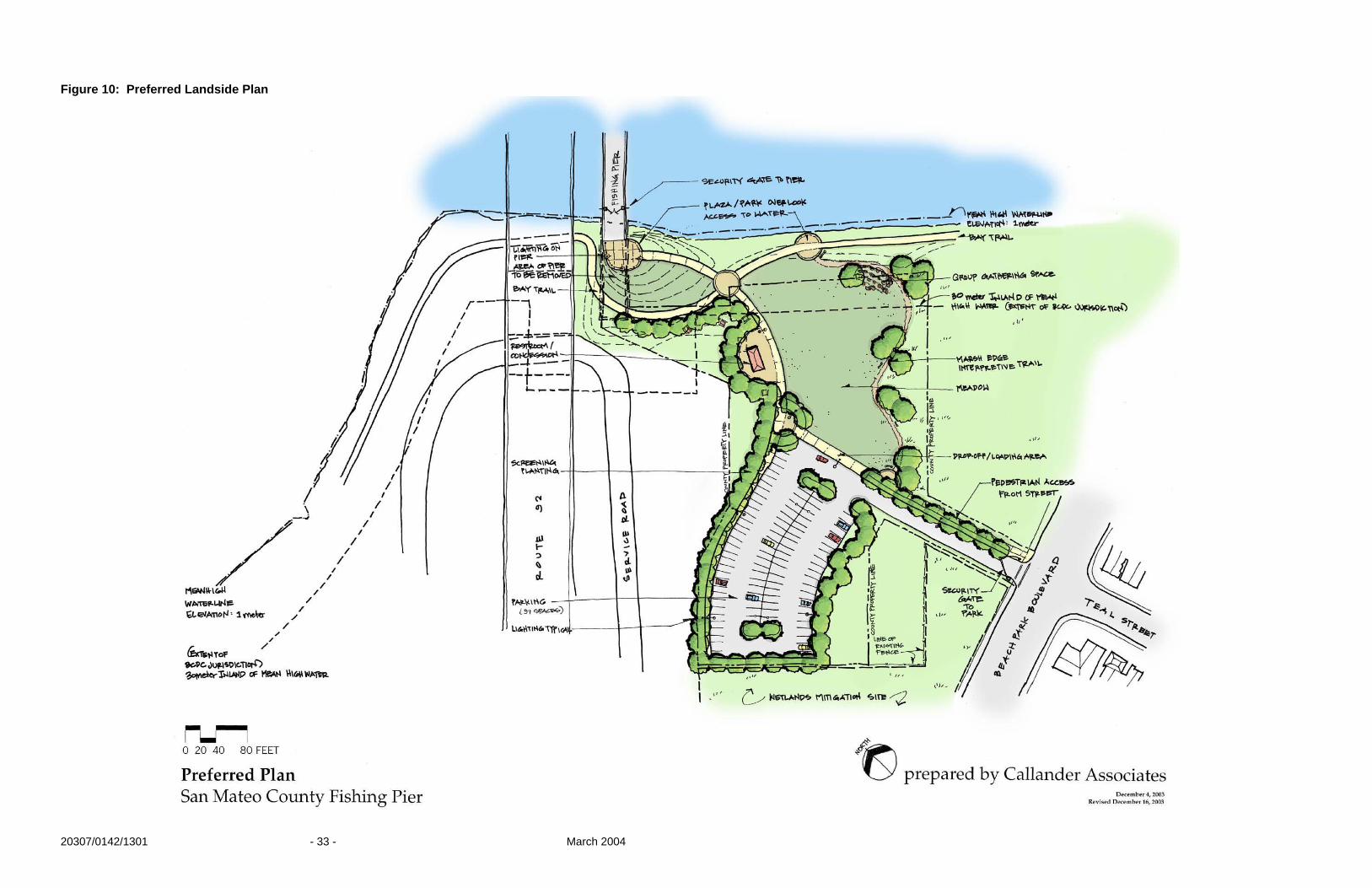
This site plan calls for improved access, open space, parking, and park amenities on this approximately 2.75-acre site. The park links the community to the Bay Trail and to the pier. A meadow, interpretive trail, group gathering space, concession, public restroom, parking area, human powered boat launch, and grand entry to the pier are main features of the park concept. See Figure 7. Access to the site is located at the intersection of Beach Park Boulevard and Teal Street in Foster City. A new entry drive with planting buffer and sidewalk will provide wheelchair access to the site. The entry will be gated for closure after hours. The drop off/loading area is centrally located for ease of dropping of groups of school children or unloading sea kayaks on the edge of the meadow. An increased parking lot with a capacity for over 90 vehicles is located on the south side of the site, away from the Bay edge. Run-off from the parking area will be designed in a manner that does not impact the adjacent wetland areas. Security and safety measures should be provided to provide a safe user experience. To discourage misuse, lighting at the parking lot is recommended even when the park is closed for security reasons. Trees may be planted to help buffer the residential area from the large parking area and adjacent Caltrans corporation yard. Trees shall be pruned up to provide a clear line of vision underneath the main tree canopy. Low ground cover plantings and native seeded meadow areas are also appropriate. Open space and meadow area are natural features of the site to be restored and celebrated. The eastern side of the site is planned as a passive recreational meadow area, providing clear views of the Bay. This green edge buffers users of the Bay trail from adjacent housing. The meadow is bounded by the parking lot, two park trails including an interpretive trail, and the Bay Trail. From the drop-off area at the parking lot, the main paved trail curves past a new concession stand and public restroom. This location is convenient for visitors traveling from the park to the pier and also Bay Trail patrons. Snacks and bait are items that could be made available at this location. A salesperson could provide a constant presence on-site. Informational interpretive signage and computer terminal for educational use may also be available at the concession area. Where the trail to the pier intersects the Bay Trail, an enlarged plaza node is proposed. This will help prevent user conflict at this juncture. The pathway continues to curve, climbing a raised berm to the pier entry. On top of this grassy berm, views to the east and south down to the Bay Trail and the Bay itself will be predominant. Here seating areas and gateway

20307/0142/1301 - 31 - March 2004
landmark features such as banners or metal sculptures will make the pier entry vibrant. A gate will control entry to the pier, to be closed after hours. The Bay Trail just south of the Route 92 overpass will be realigned. A section of the shoreside pier is proposed for removal to allow a more graceful Bay Trail alignment and clearer line of sight at the trail intersection. The Bay Trail segment from the pier node to the launch area will be widened to minimize conflicts between Bay Trail users and persons transporting human powered watercraft to the launch ramp. Across from the launch area a secondary spur trail meanders west of the Bay Trail along the side of the large meadow. A small group gathering space and marsh edge interpretive trail, allow opportunity for educational outreach on site. These are proposed to be ADA accessible and connect back to the entry drive sidewalk area. A continuous trail loops around the meadow. Adjacent Caltrans mitigation wetlands area to the west and south of the site, along Beach Park Boulevard will be maintained. A delineation of the wetland areas needs to be prepared for respective permitting and potential mitigation measures that may be needed for park and pier development. Trails along these environmentally sensitive areas need to have a buffer or setback from the wetland areas. The established native habitat features of the surrounds need to be respected and protected. Educating the public of the presence of habitat areas and ecological lifecycles through interpretive signage and possibly docent walks can help ensure this sustainability. Input was obtained from the Trails Advisory Committee by staff from the County Parks Division in an interim meeting to review three projects including the Werder Pier. Comments included that the concession building could be constructed by a concessionaire to reduce development costs. The Committee also noted that the parking improvements could be phased.
B. Preferred Plan Phase 2
Phase 2 of the Preferred Plan illustrates enlarged park facilities that could occur at a future time. This concept takes into consideration enlarged park area facilities, beyond the County’s current property ownership. This plan illustrates one concept although other concept ideas may be explored. See Figure 8. To the north, additional property would be developed for passive recreational use. This long, narrow addition is adjacent to a service road parallel to Route 92, currently utilized as a Caltrans corporation yard. This addition might include a trail spur from the parking lot to the concession stand/restroom area. Picnic tables and a human powered boat storage area are also suggested. The storage area would be accessed from the Bay Trail for ease of boat portage to the water. Fencing along the service road would be maintained to prevent access into this road and under the Route 92 bridge area. To the south, an additional wetlands interpretive trail is proposed as an extension of the marsh edge trail. This spur trial would increase the interpretive and native habitat experience of the park user. Buffers of the proposed trail with the wetlands and sensitive areas would be

20307/0142/1301 - 32 - March 2004
established and maintained. A detailed wetlands delineation map and areas of environmental mitigation need to be prepared before interpretive trails may be further developed. For Phase 2 to occur, property ownership, site development, and funding need to be further defined. A collaborative effort with District 4 Caltrans for such park shoreside improvements must occur. Safety and security of the bridge facilities also needs to be sufficiently addressed.
20307/0142/1301 - 33 - March 2004
Figure 10: Preferred Landside Plan

20307/0142/1301 - 34 - March 2004
Figure 11: Preferred Landside Plan – Phase 2

20307/0142/1301 - 35 - March 2004
VI. WATERSIDE IMPROVEMENTS (CMA)
The waterside improvements refer to the facilities to be constructed on the pier and along the shoreline or in the water. The pier improvements include benches, wind breaks, fish cleaning stations and restroom facilities. The shoreline improvements refer specifically to a launch ramp facility for human powered vessels. A. Pier Improvements
Through the evaluation of this study and public input, a number of improvements have been identified as needed on the pier as part of the rehabilitation. Two restrooms have been identified as desirable. One would be placed approximately 600 to 800 feet from the end of the pier to serve the fisherman near the deepwater channel and pedestrians enjoying the views. Another restroom is proposed at the halfway point of the pier to serve users along the remainder of the structure. See Figure 12 for a navigational chart showing the proposed locations for the restrooms. One of the restrooms could also contain a concession stand although a roll off stand was identified as an alternative to reduce opportunities for vandalism. The restroom buildings, as shown in Figure 13, have two unisex stalls each and a utility/storage area. Utilities for the facility are shown hung under the pier to reduce exposure and vandalism. Fish cleaning stations are also shown on Figure 13 near the restrooms. This allows cleaning and maintenance supplies to be kept in the nearby restroom building. Since disposal of fish waste in the Bay is no longer allowed for new facilities, the type of disposal system to be used with the cleaning station will require careful consideration. The two typical types of systems are the simple trash receptacle type and the grinder type. The trash receptacle type will need to be cleaned out frequently to minimize odors from the fish waste, but will require little maintenance. The grinder type utilizes a grinder to allow fish waste to be disposed through a sewer system (pipe). Although the frequency of cleaning is reduced, such stations require maintenance to keep the grinder operational and to keep the piping clear and flowing properly, which may be a challenge along this long fixed pier. Additional consideration regarding the grinder type is whether the local sewage treatment facility will accept fish waste and safety hazards. Some facilities cannot handle these materials, which would result in the need for a holding tank to hold the fish wastes. The necessary periodic pumping of the holding tank can be costly. Because of the numerous issues and maintenance needs associated with the grinder type fish cleaning station, the trash receptacle type appears to be a more appropriate solution for Werder Pier.

20307/0142/1301 - 36 - March 2004

20307/0142/1301 - 37 - March 2004

20307/0142/1301 - 38 - March 2004
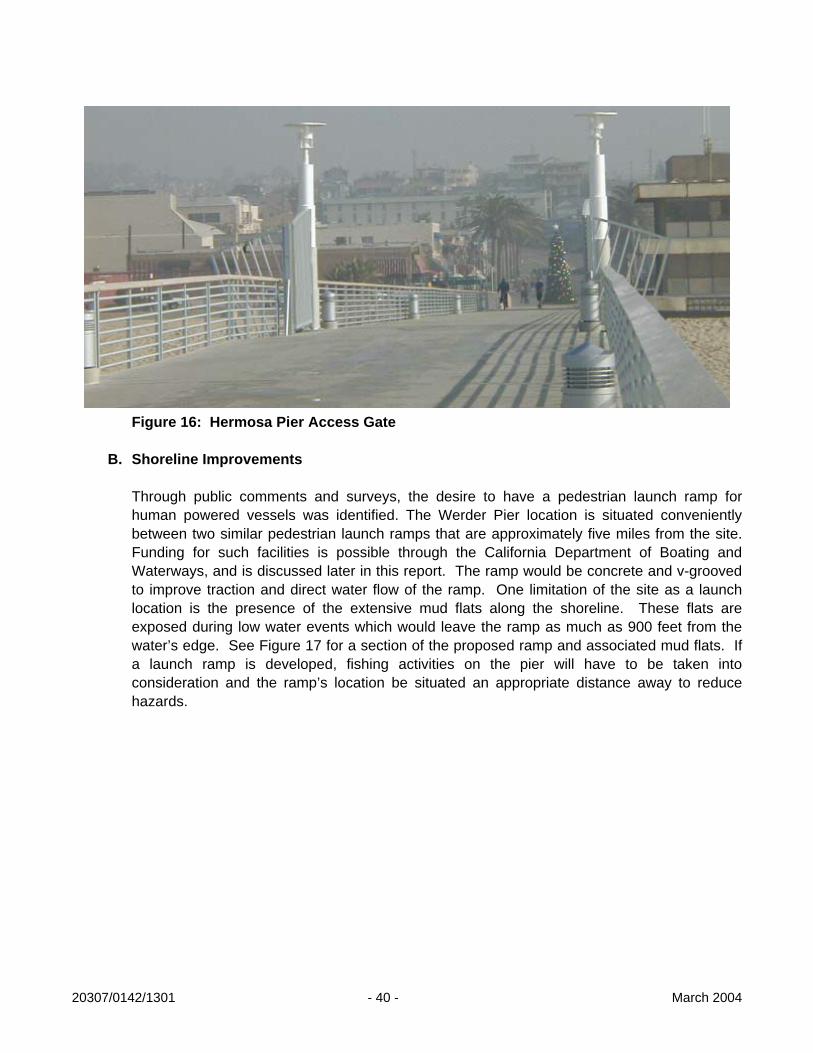
Wind breaks and benches will also be needed. The wind break locations are proposed every 200 feet along the pier, and the orientation could be varied to provide protection from the different wind exposures. See Figure 14 on the following page for a depiction of these improvements. The wind breaks are shown as concave to improve protection from the winds from varying angles. The benches and wind breaks will need to be constructed of durable materials that are vandal resistant. See through wind breaks were suggested and preferred by the public and security officials since this reduces areas where users can conceal illegal activities. See Figure 15 for a picture for an example of a wind break. Numerous trash receptacles will also be needed along the pier. Bait boxes were also suggested by participants from the fishing community as a desirable improvement. Figure 15: Wind Break at Eckley Pier, Crockett CA An access gate will be an important part of the rehabilitation of the pier since the facility is not intended to be a twenty-four hour facility. As the local law enforcement noted, the design of the access gate will have to be well devised, since illegal cutting and climbing of the existing chain link fence continues even though the pier has been closed to public access for some time. The access gate could also be designed as an architectural feature to improve the aesthetic experience of walking onto the pier. See Figure 16 for a picture of a gate at Hermosa Pier as an example.

20307/0142/1301 - 39 - March 2004
20307/0142/1301 - 40 - March 2004
Figure 16: Hermosa Pier Access Gate
B. Shoreline Improvements Through public comments and surveys, the desire to have a pedestrian launch ramp for human powered vessels was identified. The Werder Pier location is situated conveniently between two similar pedestrian launch ramps that are approximately five miles from the site. Funding for such facilities is possible through the California Department of Boating and Waterways, and is discussed later in this report. The ramp would be concrete and v-grooved to improve traction and direct water flow of the ramp. One limitation of the site as a launch location is the presence of the extensive mud flats along the shoreline. These flats are exposed during low water events which would leave the ramp as much as 900 feet from the water’s edge. See Figure 17 for a section of the proposed ramp and associated mud flats. If a launch ramp is developed, fishing activities on the pier will have to be taken into consideration and the ramp’s location be situated an appropriate distance away to reduce hazards.

20307/0142/1301 - 41 - March 2004

20307/0142/1301 - 42 - March 2004
VII. PIER REHABILITATION (CMA)
Due to the proportions of Werder Pier and the amount of damages present along the pier’s entire length, the refurbishment of the structure will likely need to incorporate a detailed database to organize the observed issues, to track restoration measures, and to allow the information to be readily available. Some of the items to be included are the type, location and size of damages, the type and date of repairs conducted, the observed performance of the repairs, and observations of continued degradation of the pier. Due to the limited amount of funding available for this report, the intent of the structural evaluation, geotechnical study and condition review was to obtain a preliminary determination of the pier’s capabilities, needed repairs or upgrades, and the relative cost associated with these needs. This will allow the determination of funding requirements and drive the decision making process for the continuation of the rehabilitation of the pier. The following will present the findings and recommendations for the issues identified during this evaluation. Recommendations are based on industry standards, the knowledge and experience of the consultant team, and discussions with contractors specializing in this type of work. F. Railings
As discussed in the Condition Review section, two primary alternatives have been identified for the railings present on Werder Pier. The first is the total removal and replacement of the railings. The second is the restoration of the existing system for historical and aesthetic purposes. As previously mentioned, restoration of the railing will need to incorporate an upgrade to the system to bring it up to current safety codes. A combination of the two approaches could be considered to allow portions of the railing with lower levels of damage to be restored and upgraded for historical purposes, while heavily damaged areas would be removed and replaced. Issues to be considered for the removal and replacement of the rail include the demolition and disposal of the existing system, the type of new system to be utilized, and the means by which and location where the new system is to be attached. The demolition of the existing railing will have to be conducted in a manner that will minimize costs and limit exposure of the structure to future decay. Two means by which this could be performed were identified. One method would be to saw cut along the outer edge of the concrete deck just inside the railing connection. The railing and a small portion of the deck could then be placed into a barge and disposed of. This approach would be efficient with regard to time and labor, but would expose steel in the deck and generate more debris. Although the exposed steel could be protected through corrosion inhibiting treatment and a urethane sealer, the protection would have to be reapplied periodically, resulting in increased maintenance costs. An alternative approach would be to remove the railing by demolishing the connections between the railing components and deck. Although more labor intensive, the amount of debris to be disposed and the amount of exposed rebar to be protected and maintained would be reduced. Of the two options, the second appears to be the better long term solution. Alternative railing types include wood, galvanized steel, aluminum, brass, or a composite material (plastic, fiber reinforced, etc.). Wood is not a good alternative due to decreasing

20307/0142/1301 - 43 - March 2004
resources and the possible costs associated with the disposal of treated lumber, which may significantly increase in the future. Composite materials raised concerns for possible vandalism and are also not considered to be viable alternatives for this location. Aluminum is a very attractive material that is recommended for such a facility due to its corrosion resistance, but is very costly, particularly when the amount of railing needed to be installed at Werder Pier is considered. Anodized aluminum would be the ultimate alternative; however, it is even more costly. A more economical approach would be a galvanized steel system. This could be accomplished with either steel posts and beams or steel posts and cables. A very economical but unattractive approach would be a steel post and chain link fence system. This could be installed as a temporary railing (with permanent posts) to allow public access while funds are secured to install a more attractive system. The following table presents relative costs for labor and materials for typical aluminum, brass and steel railing systems. A picture of an example railing system is presented in Figure 17.
Table 4: Relative Railing Costs
Material Cost per Foot Approximate Overall Cost
Aluminum $80 $651,200 Anodized Aluminum $100 $814,00 Galvanized Steel $65 $529,100
Figure 18: Example Railing System.

20307/0142/1301 - 44 - March 2004
If restoration of all or part of the railing is to be conducted, a number of issues need to be addressed. These include the repair of existing cracks and spalls, the upgrade to current design codes with regard to safety, and the design life of the rehabilitated railing. Cracks and spalls can be repaired in the same manner that the girders and beams will need to be repaired. Figures 19 and 20 give typical repair methods for these damages. Two approaches to upgrading the railing have been identified. The more aesthetically pleasing, but more costly, approach would be to attach additional precast concrete rails and, possibly, additional posts if the existing posts are unable to withstand the additional loads. A second, more economical method would be to attach steel cables and/or extend them through the posts. Further investigation regarding the integrity of the existing railing components and their remaining useful life should be conducted prior to the rehabilitation of the railing.
G. Structural Components (Girders, Beams, Deck Slab, and Piles)
The structural components of the pier were identified as having varying levels of cracks and spalls along the length of the pier. Since physical examination of these elements was not conducted, a detailed tabulation of the amount of damage present was not prepared. However, the observations made did reveal the type of repairs that will need to be made. Typical repair procedures have been prepared and are provided in Figures 19 and 20. Particular care should be taken to ensure that all loose or unsuitable concrete is removed and the reinforcing steel to remain is well cleaned. This can often be done efficiently through sandblasting, particularly when the areas to be cleaned are large. Additional protection can be provided through the use of corrosion inhibitors. Inhibitors can be applied to both the concrete and/or steel to improve repair performance. Although the structural calculations revealed that the pier would perform adequately under static and dynamic (seismic) loadings, a number of assumptions were made in these calculations and not all elements of the pier and associated soil properties were evaluated. Important in the further evaluation of the pier will be to confirm that the assumptions made are valid and that all elements of the pier perform adequately and the soils are capable of providing adequate support. Included in the structural analysis previously discussed was an evaluation of the remaining steel reinforcing needed to withstand the necessary static and dynamic loads. It is recommended that this be continued during the rehabilitation of Werder Pier. In this way the priority for a given section should be determined according to that area’s ability to withstand the desired static and dynamic loads. Areas with significant damage that cannot withstand the loads would need to be repaired prior to the reopening of the pier, while areas with little damage could be repaired at a later date. It will be important to also determine when the areas that are not in need of immediate repair will require repair in order to maintain public access, since damaged areas that are not repaired will continue to degrade. In this manner the priority for repairs and the funds needed to perform the repairs can be determined and used to create a timetable for the rehabilitation and continued maintenance of the pier.

20307/0142/1301 - 45 - March 2004

20307/0142/1301 - 46 - March 2004

20307/0142/1301 - 47 - March 2004
VIII. RELATIVE COSTS (CMA)
Cost estimates for design and construction have been developed on an order-of-magnitude basis. These cost estimates reflect the proposed Preferred Plan concept design as envisioned in this feasibility study. The costs illustrate a range of pricing to allow for variability in the amount of damage in need of repair on the pier and for flexibility in the number and quality of amenities and site features selected. Because the estimates have been developed without the benefit of specific design drawings, they are considered to be preliminary and subject to change. See Appendix E. for a slightly more detailed breakdown and the assumptions made in the pier rehabilitation portion of the estimates given below. Table 5: Relative Cost Estimate Pier Rehabilitation low high damaged concrete $300,000 $2,000,000 railings $700,000 $1,400,000 surface $550,000 $950,000 improvements $500,000 $800,000 (lighting, restroom, etc.) Landside Improvements parking lot $350,000 $600,000 restroom $150,000 $250,000 paths $50,000 $150,000 planting & irrigation $50,000 $150,000 amenities $150,000 $250,000 launch ramp $400,000 $600,000 Possible Cost Range $3,200,000 $7,200,000 .

20307/0142/1301 - 48 - March 2004
IX. PHASING OF WORK (CMA)
Due to excessive costs associated with the project and the existing financial status of public funds, it will probably be necessary to phase the work on the Werder Pier facilities. To the extent possible, the phasing will have to be linked to an anticipated funding time table. Although full funding may not be achieved for future phases, it will be important to move forward with the portions of the work that can be funded. This is likely to start on the landside since this can be accomplished more economically. Plans have already been initiated between Foster City and the County to attempt to reopen the existing landside restroom due to the high public interest in having a facility in this area. Once redevelopment has been initiated, the facility will begin to take on a more attractive appearance and, as public usage increases, interest and public support for continued improvement of this unique, coastal attribute will increase. As public support intensifies, funding from both public and private sources will also gain support. Phasing the work will also help to facilitate the management, maintenance needs and security needs for the site in a more controlled and acceptable manner. For example, security of the site is a big issue for both the public and law enforcement agencies. Since law enforcement did not give support to the reopening of the pier, it may be beneficial to reopen the landside portion first and allow law enforcement to work out the details of how the facility is to be patrolled and who is to respond to incidents at the facility. Once the policies are set to manage the initial rehabilitated landside facilities and the facilitation of these policies has become common, the rehabilitation of the pier and the associated security issues relating to its reopening will be less daunting.

20307/0142/1301 - 49 - March 2004
X. PERMITTING (CMA) During the feasibility study a variety of local and regional agencies were identified that will be involved in the permitting process. The primary agencies to be contacted will be the U.S. Army Corp of Engineers (USACE) and the San Francisco Bay Conservation and Development Commission (BCDC). After submittal of permit applications, the agency review period could be four to six months prior to approval, which will need to be factored into the planning process. Additional environmental documentation will have to be completed to comply with the California Environmental Quality Act (CEQA) on a local level, and with the National Environmental Policy Act (NEPA) on a national level, which will likely be needed if federal funding is obtained. As mentioned above, the USACE and BCDC will act as lead agencies, which means that it is probable that formal permits will need to be submitted. These agencies will provide the appropriate information to additional agencies that will require consultation, such as the National Marine Fisheries Service. As a part of these reviews, and as a result of the permit process, requirements for construction techniques and work windows will be determined. Since the rehabilitation of the pier will require work over the water, it is anticipated that fish and environmentally sensitive species windows will apply. A review of these windows for this area revealed concerns for Steelhead, Herring, and the California Least Tern. If all of the windows associated with these species need to be applied, then an allowable work period from August 1st to November 3oth could be enforced. Further design and consultation with the respective agencies will be needed to determine the actual windows to be applied. One the work windows are determined, they will have to be incorporated into the phasing of the rehabilitation work. Another consideration with regard to the permitting process is the possible impact to Bay fill, which BCDC regulates. Since the pier was constructed prior to 1966, it is considered part of the shoreline band and its rehabilitation will not be considered new Bay fill, as long as the repairs do not extend outside the existing footprint. A benefit of the structure being considered part of the shoreline is that removal of a portion of it would be considered the removal of Bay fill, which is seen as a benefit, and such activities can receive funding from the Removal of Bay Fill Fund through BCDC. The following is a list of the identified agencies: A. U.S. Army Corps of Engineers (USACE)
• Corps of Engineer Permits Responsible for the following: Section 10 of the River and Harbor Act requiring a permit for any work on structures in or affecting the navigable waters of the U.S.; Section 404 of the Clean Water Act requiring a permit for discharge of dredge or fill materials into the waters of the U.S.; and Section 103 of the Marine Protection, Research and Sanctuaries Act of 1972 requiring a permit for transportation of dredged material for purposes of disposing it into ocean waters, including tidelands and coastal wetland areas.

20307/0142/1301 - 50 - March 2004
Contact: U.S. Army Corps of Engineers Regulatory Branch 333 Market Street, 8th Floor San Francisco, CA 94105-2197 p.415. 977-8436 (general info) p. 415. 977-8343 p. 415. 977-8462 (regulatory) Ed Wylie, South Section Chief p. 415. 977-8464 f. 415. 977-8343 email: [email protected]
B. San Francisco Bay Conservation and Development Commission (BCDC)
• BCDC Permit Jurisdiction limits are tidal waters of the San Francisco Bay from mean high tide to 100’
inland of mean high tide.
Contact: Brad McCrea, Bay Design Analyst San Francisco Bay Conservation and Development Commission 50 California Street, Suite 260 San Francisco, CA 94111 p. 415. 352-3615 f. 415. 352-3606 email: [email protected]
C. California Department of Fish and Game
• Streambed Alteration Permit Responsible for the protection and conservation of State fish and wildlife resources
under sections of the Fish and Game Code. The agency must be notified of any activity that impacts rivers, streams or lakes.
Contact:
Sandy Brunson Department of Fish and Game p. 707. 944-5500 (main) p. 707. 944-5520 (Water Quality, Streambed Alteration) f. 707. 944-5563

20307/0142/1301 - 51 - March 2004
D. State of California Department of Transportation (Caltrans)
• Encroachment Permit Jurisdiction includes the State of California lands, Caltrans property and Caltrans
easements on or adjacent to project parcel.
All work within the vicinity of the State Toll Bridges must be coordinated and concurred by the California Highway Patrol to ensure that any security concerns are addressed. Wetlands mitigation area on adjacent Caltrans property must be maintained in perpetuity. Changes to the State right-of-way would require an amendment to the Freeway Agreement and approval of the Federal Highway Administration and the California Transportation Commission to decertify the proposed right-of-way.*
Contact:
Sean Nozzari, District Office Chief Caltrans, District 4 Office of Permits 111 Grand Avenue, M.S. 7-D Post Office Box 23660 Oakland, CA 94623-0660 p. 510. 286-4435 f. 510. 286-5513 email: [email protected] Thomas Franklin, District Branch Chief Caltrans, District 4 Office of Permits Mail Station 5E Post Office Box 23660 Oakland, CA 94623-0660 p. 510. 286-4424 f. 510. 286-4712 email: [email protected]
*per Caltrans letter of 9/23/03, 2 pages addressed to Callander Associates

20307/0142/1301 - 52 - March 2004
E. City of Foster City
• Project Development Oversight
Contact: Kevin Miller, Director of Parks and Recreation City of Foster City Parks and Recreation Department p. 650. 286-3388 f. 650. 345-1408 email: [email protected] Richard Marks, Community Development Director City of Foster City Community Development Agency 610 Foster City Boulevard Foster City, CA 94404 p. 650. 286-3232 f. 650. 286-3589 email: [email protected] Jeff Juarez, Assistant Planner City of Foster City Community Development Agency p. 650. 286-3242 f. 650. 286-3589 email: [email protected]
F. County of San Mateo
• Building Permit Lands of County of San Mateo
Contact: Jim Eggemeyer Development Review and Service Manager Planning and Building Division
455 County Center, 4th Floor Redwood City, CA 94063-1646 p. 650. 363-1930 f. 650. 363-4849 email: [email protected]

20307/0142/1301 - 53 - March 2004
G. National Marine Fisheries Service (NMFS)
• Consultation; Concurrence letter; Permit (if endangered species present) Must be contacted if a project is Federally initiated, licensed, or permitted, that has the potential to alter any aquatic environment and impact the biological resources which depend on those habitats.
Contact:
National Marine Fisheries Service Southwest Division 501 West Ocean Boulevard, Suite 4200 Long Beach, CA 90802-4213 p. 562. 980-4000 Santa Rosa Office: Gary Stern p. 707. 575-6060 f. 707. 578-3435
H. Regional Water Quality Control Board (RWQCB)
• Notice of Intent for Storm Water Pollution Prevention Plan compliance and any new or changed discharge of storm drain waters into the Bay; Water Quality Certification Regulation of construction activity that would result in an impact to State water quality under Section 401 of the Clean Water Act. Projects with a federal component must obtain approval from this agency.
Contact: Habte Kifle (San Mateo, Bayside) Regional Water Quality Control Board p. 510. 622-2371 f. 510. 622-2460

20307/0142/1301 - 54 - March 2004
I. U.S. Fish and Wildlife Service
• Consultation; Concurrence letter; Permit (if endangered species present) Must be contacted if project is Federally permitted. Responsible for evaluation of the site for presence of endangered species and critical habitats. If a species is present, further consultation is required to determine the affect of the project on the species and identify any alternatives. Contact:
U.S. Fish and Wildlife, Region 1 Chief, Division of Endangered Species Eastside Federal Complex 911 N.E. 11th Avenue Portland, OR 97232-4181 http://pacific.fws.gov/ecoservices Endangered Species Permits Main p. 503. 231-2071 Main f. 503. 231-6243 Linda Belluomini p. 503. 231-6283 f. 503. 231-6243
J. State Lands Commission
• Lease Agreement Amendment to current lease held through Caltrans may be needed. Although Caltrans will have primary review responsibility, plans should be provided to State Lands for review and comment during the development of rehabilitation plans.
Contact:
State of California State Lands Commission 100 Howe Ave., Suite 100 South Sacramento, CA 95825 Dave Plummer p. 916. 574-1858

20307/0142/1301 - 55 - March 2004
XI. FUNDING (CMA)
The following list provides possible sources for funds and a brief description of the purpose for which the funds are set aside. A. Association of Bay Area Governments (ABAG)
• Bay Trail Grant Program Grants may be used for planning studies to identify a preferred Bay Trail alignment, trail design, trail construction and trail improvements, including repaving and signs. This does include trail spurs, though not a high priority. They anticipate to receive $4 million for projects in spring of 2004, while the remaining funds from the last cycle ($7.5 million) are almost fully allocated. Prop 40 funds will be the next to be allocated which might amount to $1 million for the entire Bay Area. An application has been provided in Appendix F. No current deadline for application submittals, but funding decisions will begin being made this summer. www.baytrail.org/grants 2003.htm#overview Contact:
Janet McBride, Regional Planner Association of Bay Area Governments Post Office Box 2050 Oakland, CA 94604-2050 p. 510. 464-7919 f. 510. 433-5519 email: [email protected]
B. San Francisco Bay Conservation and Development Commission (BCDC)
• Bay Fill Cleanup and Abatement Fund
Funding that helps restore natural bay environments due to development impacts that affect the Bay. Focus is on removal of Bay Fill. Available funding is currently spoken for, but funding is replenished periodically.
Contact:
Brad McCrea, Bay Design Analyst Bay Conservation and Development Commission 50 California Street, Suite 260 San Francisco, CA 94111 p. 415. 352-3615 f. 415. 352-3606 email: [email protected]

20307/0142/1301 - 56 - March 2004
C. California Department of Education • Environmental Education Grant Program (EEGP)
Grants are available for public agencies, schools, non-profits, and resource conservation districts for various environmental education outreach methods. Sites and facilities may receive up to $15,000. www.cde.ca.gov/cilbranch/oee/
Contact:
Bill Andrews California Department of Education p 916. 322-9503 f. 916. 322-9360 email: [email protected]
D. California Department of Parks and Recreation
• Habitat Conservation Fund
Funding provided for conservation for wetlands, riparian or recreational use. Applications are reviewed competitively against other projects with funding being allocated to the selected projects. An application and eligibility requirements are available on the internet. Applications are due by October 1st each year for funding to be available at the beginning of the next year.
www.parks.ca.gov
Contact: Albert Ventura California Department of Parks and Recreation p 916. 651-8579 f. 916. 653-6511 email: [email protected]
• Recreational Trails Program
Funding allotted for development of recreational trails and trail related projects. Projects are reviewed competitively with other applicants. An application and eligibility requirements are available on the internet. Applications are due by October 1st each year for funding to be available at the beginning of the next year.
www.parks.ca.gov
Contact: Albert Ventura California Department of Parks and Recreation p 916. 651-8579 f. 916. 653-6511 email: [email protected]

20307/0142/1301 - 57 - March 2004
E. California Department of Transportation Planning • Community-based Transportation Planning Grants
Funding provided to transportation and land use planning projects that support livable community concepts and promote community identity and quality of life. www.dot.ca.gov/hq/tpp/grants
Contact:
Stuart Mori California Department of Transportation Planning p 916. 651-8204 f. 916. 653-4570 email: [email protected]
F. Caltrans
• Transportation Equity Act (TEA-21)
Funding allotted to assist Caltrans, metropolitan regions and local governments for a variety of projects, including freeway improvements to sidewalk improvements. Public access improvements would more likely apply for this project. Additional funding is anticipated to be approved at the end of 2004. www.dot.ca.gov/hq/LocalPrograms Contact:
Geoff Kline County of San Mateo Congestion Management Agency p. 650. 363-4105 f. 650. 361-8220
• Bicycle Transportation Account (BTA)
Funding for City and County programs that improve safety and convenience for bicycle commuters. County must have a Bicycle Transportation Plan to quality. Additional funding is anticipated to be approved at the end of 2004. www.dot.ca.gov/hq/LocalPrograms/bta/btaweb%20page.htm
Contact: Geoff Kline County of San Mateo Congestion Management Agency p. 650. 363-4105 f. 650. 361-8220

20307/0142/1301 - 58 - March 2004
G. Coastal Conservancy • San Francisco Bay Area Conservancy Program Grants
Grant program provides funding for the nine Bay Area counties for projects that promote the preservation, protection and restoration of the California Coast. Restoration/public access is required to a part of the project, but can be completed in phases. Projects are required to report on other funding sources. Local funding is beneficial. Funding is provided year-round, but grants are approved at board meetings which occur every six months. An application is available on the internet. www.coastalconservancy.ca.gov/Programs/BACP.htm
Contact:
David Hayes, Project Manager California State Coastal Conservancy 1330 Broadway, 11th Floor Oakland, CA 94612-2530 p. 510. 286-0736 f. 510. 286-0470 email: [email protected]
H. State of California: Wildlife Conservation Board (WCB)
• Riparian Habitat Conservation Program
Funding is aimed at restoring the State’s riparian ecosystems that include threatened or endangered species habitats. Grant amounts can be as much as a few hundred thousand dollars depending on the project. Currently there is a backlog of projects requesting funding. No natural resource restoration is required to be part of the project. There is no deadline for submittal of applications, but grant approval is given at board meetings that occur four times a year. Applications are available the internet at www.dfg.ca.gov/wcb/. www.dfg.ca.gov/wcb/habitat_enhancement_and_restoration_program Contact:
Scott Clemens Wildlife Conservation Board p. 916. 445-1072 f. 916. 323-0280
• Public Access Program
Financial assistance provided for fishing piers, floats, access roads, boat launching ramps, trails, boardwalks and interpretive facilities. Funding is made available to most projects that qualify, with funding partnerships perceived as a benefit. Funding limit is around $250,000 per project. Project appears to be a likely candidate and the County is encouraged to file an application, which is available on the internet. Applications are

20307/0142/1301 - 59 - March 2004
accepted year-round, with board approval made at quarterly meetings. Funding allocations are made in June. www.dfg.ca.gov/wcb/ Contact:
Peter Perrine Wildlife Conservation Board 1807 13th Street, Suite 103 Sacramento, CA 95814 p 916. 445-1109 f. 916. 323-0280
I. U.S. Fish and Wildlife Service
• Sport Fishing Restoration
Funding available to enhance and restore sport fish populations and public use/benefits from such resources. www.fa.r9.fws.gov/sfr/fasfr Contact: Jay Alvarado, grants fiscal officer
Verlyn Ebert, planning/grant management Ray Temple, fishery biologist/grants management
U.S. Fish and Wildlife Service Eastside Federal Complex
911 N.E. 11th Avenue Portland, OR 97232-4181 p. 503. 231-6128 f. 503. 231-6996
• Wildlife Restoration
Funding available to restore, enhance, or conserve populations of wild birds and mammals and access of public of these resources.
www.fa.r9.fws.gov/wr/fawr
Contact: Jay Alvarado, grants fiscal officer
Verlyn Ebert, planning/grant management Ray Temple, fishery biologist/grants management
U.S. Fish and Wildlife Service Eastside Federal Complex
911 N.E. 11th Avenue Portland, OR 97232-4181 p. 503. 231-6128 f. 503. 231-6996

20307/0142/1301 - 60 - March 2004
• North American Wetlands Conservation Fund (NAWCF)
Funding available to acquire real property and restore/manage/enhance wetland ecosystems.
www.cfda.gov/public/viewprog.asp?progid=457
Contact: Jay Alvarado, grants fiscal officer
Verlyn Ebert, planning/grant management Ray Temple, fishery biologist/grants management
U.S. Fish and Wildlife Service Eastside Federal Complex
911 N.E. 11th Avenue Portland, OR 97232-4181 p. 503. 231-6128 f. 503. 231-6996
J. State of California: Department of Boating & Waterways
• Boating Trails Grant Program (BTGP)
The BTGP was established to aid Cities, Federal agencies, Counties, districts and other State agencies in the development, enhancement, or rehabilitation of small craft boating facilities (human powered vessels) that provide convenient and safe boating access to California. The grant submittals are competitively examined, with emphasis on those projects that provide new access sites and serve large numbers of boaters. The program currently has an annual budget of $300,000, with many requests having been made. Although local agency funding is not required, it is factored in favorably in the application review and awards process. A copy of the Guidelines for Preparing an Application will be provided to the County. Timeframe: BTGP receives funding on July 1st of each year. Applications can be
submitted throughout the year. Contact:
Mike Ammon Department of Boating & Waterways Boating Facilities Division 2000 Evergreen Street, Suite 100 Sacramento, CA 95815-8163 p. 916. 263-8163 email: [email protected]

20307/0142/1301 - 61 - March 2004
K. California State Library • California Cultural and Historical Endowment
The Endowment was created to administer the Proposition 40 funds dedicated to preserving historic and cultural resources. Approximately $128 million will be available to government entities and non-profit organizations through a competitive grant application process. The program guidelines and application materials are being developed with public hearings to be performed as part of the review process. Additional information is available on the internet. www.library.ca.gov/CCHE/index.cfm#grantz Contact:
Jennifer Ruffolo Program Manager [email protected] 916-653-8932 P.O. Box 942837 Sacramento, CA 94237-0001
L. Public and Private Contributions
Funds could be raised through public and private contributions with incentives for significant contributions. Possible incentives include name plates, commemorative plaques, and possibly even renaming the pier for a major contributor.

20307/0142/1301 - 62 - March 2004
XI. SUMMARY OF FINDINGS (CMA)
A. Condition Review
The condition review of Werder Pier revealed an aged structure with concrete cracks, spalls, and exposed steel reinforcement. Previous repairs were noted along the structure and varied in condition from what appeared to be sound to failing. Limited structural, seismic and geotechnical evaluations were performed to develop a preliminary idea of the pier’s stability. Although further evaluation is needed, these reviews disclosed a surprisingly stable structure, given the age of the pier. Although repairs were identified as needed, depending on the level of damage present, the pier’s apparent ability to withstand seismic and static loadings as originally designed will enable its repair to be more economical, since retrofitting structural components does not appear to be necessary.
B. Community Outreach
The community outreach portion of this feasibility study resulted in a significant amount of input from both public and private sectors. The majority of public input was positive and ranged from concerns for security to the desire to gain access to this unique fishing and sightseeing opportunity. The security concerns were received from both the public and law enforcement agencies. The California Highway Patrol was particularly concerned, due to the San Mateo/Hayward Bridge being considered a #1 target for terrorist attacks. Therefore, the safety issue will need to be addressed and resolved early in the design process.
H. Improvements and Rehabilitation
Improvements were proposed and supported on both the landside and waterside of the facility. Landside improvements that were found to be desirable included a restroom, amphitheater, picnic areas, parking, and environmental/interpretive education opportunities. The presence of adjoining wetlands that have been designated by Caltrans as remediation sites provides additional possibilities for future development of the natural environment at the site. Waterside improvements that were identified included restrooms on the pier, frequent wind breaks, shade structures, and fish cleaning stations. An additional improvement along the water is a pedestrian launch ramp for the launching of kayaks, canoes, etc. The rehabilitation of the pier will require a new or upgraded railing system, and a variety of concrete repairs will be needed to ensure that the structure will withstand the given loads. However, major retrofitting for seismic events does not appear to be necessary at this time. For general planning purposes, costs associated with the proposed improvements and pier rehabilitation range from $3 million to over $7 million, depending on the amount and quality of improvements selected and the amount of concrete that is determined to need repair. Additional funding may be needed if further evaluation of the concrete structure reveals more damage than was noted through visual observations.
20307/0142/1301 - 63 - March 2004
I. Permitting and Funding
The first steps in the continuation of this rehabilitation process will be to initiate discussions with funding agencies and to address safety concerns. This will help to identify available sources of funds and begin the necessary processes to receive those funds. Once funding sources have been secured, preparation of a phasing plan is recommended to match the available dollars with the work that can be completed with the funds. Permitting issues for this type of project will likely be related to construction windows and construction methods for the work to be performed. It will be important to understand how much work can be performed during a given construction window since this will relate directly to how much funding is needed on an annual basis. Because the pier has been in existence since before 1966, it is considered a part of the shoreline band. As long as additional surface area, which is considered new bay fill, is not added to the pier during the rehabilitation, it is likely that the regulatory agencies will be concerned with how debris is disposed and when the repairs are performed.
J. Continuation of the Project
In order for the restoration of Werder Pier to become a reality, it will be important to continue the planning process, which will include completion of preliminary design, environmental documentation and resolution of outstanding security issues. See Figure 21 for a proposed project timeline. Since the project is likely to be funded and completed in phases, the tasks that follow the funding can be applied to each phase of the project with the time required to complete each task changing to reflect the scope of that particular phase. Since the California Highway Patrol could not support the re-opening of the pier due to potential terrorist risks associated with Werder Pier’s proximity to the San Mateo/Hayward Bridge, further discussions will be needed and security issues resolved to gain the support of the law enforcement agencies. Once the security issue is resolved and funding is secured, preliminary design plans can be completed. This will allow the environmental documentation and permitting to be completed. Due to the high cost associated with the re-opening of the pier, it may be beneficial to restore the landside area and attract more users to the facility, which could increase support for the project making funds easier to obtain. An agreement between the County and Caltrans will also be needed to memorialize the intent of the piers rehabilitation.

20307/0142/1301 - 64 - March 2004
Figure 21: Project Timeline