pier 16 and bulkhead building haer ca-5 at...
TRANSCRIPT

•
Pier 16 and Bulkhead Building At foot of Howard Street San Francisco San Francisco County California
HAER CA-5
# PHOTOGRAPHS WRITTEN HISTORICAL AND DESCRIPTIVE DATA
Historic American Buildings Survey National Park Service
Department of the Interior Washington, D.C.

J
HISTORIC AMERICAN ENGINEERING FEOOKD
Pier 16 & Bulkhead
CA-5
Location:
Date of Construction:
Present Owner:
Present Use:
Significance:
Historians:
At foot of Howard Street, along the Enbarcadero and San Francisco Bay, San Francisco, San Francisco County, California.
1913 - 1916; Pier 16 completed May 1915.
Port of San Francisco Ferry Building San Francisco, CA. 94111
demolished; two-level promenade to be constructed along waterfront.
Pierrl6 and Bulkhead were last remaining structures of a unified complex of Mission Revival style pier front and bulkhead buildings dating to the early 20th century. The structures were among the best of several remaining pier fronts in San Francisco which show the influence of the Mission Revival. Structures also significant in San Francisco maritime history,
Roger R. Olmsted, Nancy Olmsted, and Dr. Allen Pastrcn (archeology), consultants.

HfitftCA -5 p*fl
SURVEY OF CULTURAL RESOURCES
PIERS 14-22 1/2
THE AGRICULTURE BUILDING & THE FIRE BOAT HOUSE
THE PORT OF SAN FRANCISCO
diaries Hall Page & Associates, Inc. San Francisco, California .
November 14, 1977

Page
•CONTENTS
Foreword - Background, Objectives, and Methodology
The San Francisco Harbor from 1769 to the Present:
Summary gf \®
Discovery and Spanish/Mexican Period H' 12- American Development Begins }X I 2~ Development from 1860 to 1900 ]& * 3 The Seawall ^5" | \e The Modern Port JJB' %0
The Waterfront from the Agriculture Building to the Fire Boat House, Inclusive:
East Street and the Wharves South of Market Before Seawall Construction %l 1% The Seawall, Sections 9a and 9b JH 1 % The Superstructures ?rf % &
The Agriculture Building 30 -
Pier 14 ' 38 launch Offices Between Piers 14 and 16 39 From Pier 16 to Pier 20 ■ ' 39
Piers 16 and 18 46
Pier 20 46
Bulkhead Connections Between Piers 16 and 20 48
Bulkhead Connections Between Piers 20 and 22 48
Pier 22 50 Fire Boat House 50 Archeological Evidence 54
Conclusions 56 Footnotes 58 Bibliography 59
National Register Criteria 62
•

MAPS, PHOTOS, AND PLANS
f A
Page Project Area Location (Map)
Historical Survey Area and Existing Features (Map) The Proposed Promenade (Map) / % San Francisco's Great Seawall - Shoreline 1847, Waterfront 1851, and Waterfront 1878 (Map) yf \ \ The Old Waterfront in the Study Area (Photo) )& * 5* Seawall and Bulkhead Wharf at Section 9a (Plan)
m
East Street South of the Ferry Building, ca. 1900 (Photo) ys H The Waterfront in the Study Area, 1910 (Map) 2^ 25 Howard Street Wharf Area, February, 1914 (Photo) %£ *J> The Waterfront in the Study Area, 1916 (Map) 26* 27
The Enbarcadero - Market to Harrison Streets (Photos) £8 *L°\ Bulkhead Wharf Buildings (Photo) 29 Agriculture Building (Post Office) (Photo) 31 South Facade of the Agriculture Building (Photo) 32 Agriculture Building, Details of Main Entrance (Photo) 33
Agriculture Building, Elevations (Plan) 34 Agriculture Building, Main Entrance (Plan) 35 Agriculture Building, North Entrance (Plan) 36
Agriculture Building, Main Stairway (Plan) 37 Piers 16, 18, 20, and Bulkhead Buildings Facade (Plan) 40 Pier 18, Facade (Plan) 41
Pier 18, Facade Framing (Plan) 42 Piling Detail (Plan) 43 Pier 16 and Remaining Bulkhead Structure (Photo) 44
Interior of Pier 16 (Photo) 45 Piers 22, 20, 18, and 16 from the Bay Side (Photo) 47 Launch Offices South of Pier 20 (Plan) 49
Fire Boat Bouse (Photo) 51 Fire Boat House, Elevations (Plan) 52
Fire Boat House, Qitrance Detail (Plan) 53

FOREWORD - BACB3ROTD, OBJECTIVES, AND MEIBODDLOGy
This report has been prepared in compliance with Section 106 of the National Historic Preservation Act of 1966 (80 Stat. 915); Section 1(3) of Executive Order 11593, "Protection and Enhancement of the Cultural Environment," May 13, 1971 (36 CHF 8921); and Section 800.4(a) of Title 36 Code of Federal Regulations, Procedures for the Protection of Historic and Cultural Properties. This report seeks to identify resources and sites which may be affected by the City and County of San Francisco's project known as "Demolition of Existing Finger Piers 14, 16, 18, 20 and 22, and Construction of a Two Level Waterfront Promenade at the Port of San Francisco." This project is a local public works capital development and investment program to receive funding from the U.S. Department of Commerce, Economic Development Administration (EDA).
Ihe report constitutes a survey of the project, area, such area defined as lying east of the seawall (and the Ehibarcadero) beginning at the south wall of the Agriculture Building (which is south of the Ferry Building, opposite Mission Street), and proceeding southerly to the north wall of the Fire Boat House located at Pier 22 1/2. This report specifically con- siders Sections 9a. and 9b of the seawall; Piers 14, 16, 18, 20 and 22; The Fire Boat Phoenix; the Fire Boat House (Engine Co. 9/Fire Boat 1); as well as bulkhead buildings which have been demolished.
Historical research methodology was employed to construct a general history for this particular area of the San Francisco waterfront and spe- cific history of the sites and structures listed above. National Register criteria were applied to determine the scope and type of data necessary. No archeological methodology was directly applied, since an earlier report covering the archeology of the general area was available and was deter- mined to be sufficient by the California State Office of Historic Preser- vation, the Port of San Francisco, and the consultant. This comprehensive, resourceful document is entitled, Channel Outfalls Consolidation Project, Report on Cultural Resources of Contract Area C-3 (July 25, 1977), and prepared by historical consultants Roger R. Olmsted and Nancy Olmsted, and archeological consultant Dr. Allen Pastron. The report at hand interprets the information presented in the Contract Area C-3 report as it may be applied to the promenade project area.
The first part of the present report outlines the general history of the San Francisco harbor and of that portion of the waterfront extending from the Ferry Building-south to Harrison Street. The second part pre- sents the specific history of sites and structures located in and/or adjacent, to the specific promenade project area. Conclusions are pre- sented at the end of the report.
A substantial amount of the archival research was conducted by review- ing, and analyzing the well-catalogued and remarkably complete records located in the offices of the Port of San Francisco. Materials under review included maps and photographs, plans, and reports and minutes of the State Board of Harbor Commssioners. Interviews were conducted with relevant Port and Fire Department personnel. Site inspections were made of the extant buildings.

' p.lp
PROJECT A&EA LOCATION THE EMBM^CADEPO, 5^N RVWOSCO, CA

• -A 35*4£ i flMC INCH • K»'0*
HlSCWCAl- 5UPVEY )NSE* *SP ©CtSTINei FSa^lUffCS (BUIUTIN^S/^pe WV&O)

*
« ft * * ft ft * « ft
* ft
ft * *
* * * ft ft ft
ft ft ft
»m,WLKtteN7UN£
t dw» • ore MCH-ZM'O"
ft ft ft ft ft ft ft ft ft ft ft ft ft. ft ft ft
-me n*?f%m? PRoMeiwe ANC? tts pei^TcHswF-e?7H& nt5pj«»sLeoi=ver ARE*

Y-°\ The resources and assistance of the San Francisco Maritime Museum,
the Bancroft Library of the tfaiversity of California at Berkeley, the California Historical Society Library in San Francisco, and the San Fran- cisco Room of the Public Library also were invaluable in preparing this report.
An effort was made to determine the precise date and nature of the construction of Sections 9a and 9b of the seawall and its general historical relationship to San Francisco's waterfront. Although not visible at street level, the seawall is of utmost importance. It defines the edge where land meets water: the Bribarcadero runs along its land side, and the piers extend out from its bay side. The present seawall provides stability for the land and seaside structures contiguous to it. Earlier wharves which reached out from the former bulkhead line located on what is now the land side of the seawall are described in the general history section. The remains of these earlier wharves were removed, at least partially, in order to construct the present seawall and the finger piers which replaced them and -which are themselves now being demolished.
In discussing the specific structures located in or adjacent to the area for the proposed promenade, the attempt has been made to provide infor- mation on those structures which no longer remain, as well as those which do. At the time that the present seawall and the finger piers were con- structed, ca. 1915, and from then on to ca. 1960, the. facades of the pier sheds and bulkhead wharf buildings formed a unified section of waterfront sights and activities set off by the Ferry Building and the curve of the Embarcadero at Rincon Point (now punctuated by the Bay Bridge). The Agri- culture Building, the shed on Pier 16, and the adjacent bulkhead wharf build- ing and Fire Boat House are located in an area now partially severed from the city by the Sribarcadero freeway overpass. These structures remain as isolated remnants of a rich past*
-8-
7? 0
3
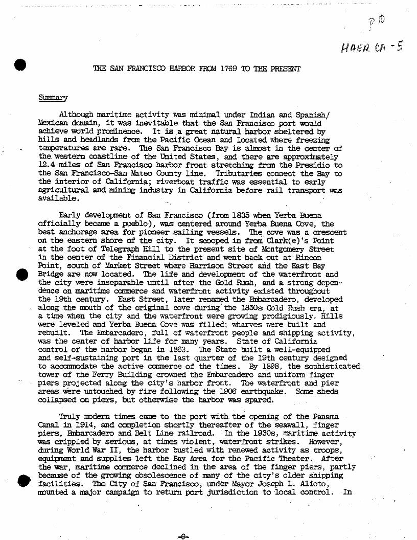
THE SAN FRANCISCO HARBOR HOI 1769 TO THE PRESETS?
Sumnary
Although maritime activity was minimal under Indian and Spanish/ Mexican domain, it was inevitable that the San Francisco port would achieve world prominence. It is a great natural harbor sheltered by hills and headlands fran the Pacific Ocean and located where freezing temperatures are rare. The San Francisco Bay is almost in the center of the western coastline of the United States, and there are approximately 12.4 miles of San Francisco harbor front stretching from the Presidio to the San Francisco-San Mateo County line. Tributaries connect the Bay to the interior of California; riverboat traffic was essential to early agricultural and mining industry in California before rail transport was available.
Early development of San Francisco (from 1835 when Yerba Buena officially became a pueblo), was centered around Yerba Buena Cove, the best anchorage area for pioneer sailing vessels. The cove was a crescent on the eastern shore of the city. It scooped in from Qark(e)'s Point at the foot of Telegraph Hill to the present site of Montgomery Street in the center of the Financial District and went back out at Rincon Point, south of Market Street where Harrison Street and the East Bay Bridge are now located. The life and development of the waterfront and the city were inseparable until after the Gold Rush, and a strong depen- dence on maritime comnerce and waterfront activity existed throughout the 19th century. East Street, later renamed the Bnbarcadero, developed along the mouth of the original cove during" the 1850s Gold Rush era, at a time when the city and the waterfront were growing prodigiously. Hills were leveled and Yerba Buena Cove was filled; wharves were built and rebuilt. The Enbarcadero, full of waterfront people and shipping activity, was the center of harbor life for many years. State of California control of the harbor began in 1863. The State built a well-equipped and self-sustaining port in the last quarter of the 19th century designed to acccranodate the active coimerce of the times. By 1898, the sophisticated tower of the Ferry Building crowned the Bnbarcadero and uniform finger piers projected along the city's harbor front. The waterfront and pier areas were untouched by fire following the 1906 earthquake. Some sheds collapsed on piers, but otherwise the harbor was spared.
Truly modern times came to the port with the opening of the Panama Canal in 1914, and completion shortly thereafter of the seawall, finger piers, Bnbarcadero and Belt Line railroad. In the 1930s, maritime, activity was crippled by serious, at times violent, waterfront strikes. However, during World War II, the harbor bustled with renewed activity as troops, equipment and supplies left the Bay Area for the Pacific Theater. After the war, maritime commerce declined in the area of the finger piers, partly because of the growing obsolescence of many of the city's older shipping facilities. The City of San Francisco, under Mayor Joseph L. Alioto, mounted a major campaign to return port jurisdiction to local control. In
-9-

part \ U^^^Sp/Wj/ffy* _
.Stctto/t ■• If
o o
1>
o o
a* o o
•IN jf S
N
A
I3A
WATERFRONT £ S T. 1373
Reprinted frcm the thesis, Bay Fill in San Francisco, by Gerald Robert Dow, 1973.
h
.in

3
1969, the State Legislature passed a bill to achieve such a transfer of jurisdiction. A required local vote to accept bonded indebtedness of the Port -was passed by the citizenry. In the 1970s the City-run Port is faced with several complex alternatives for future waterfront use and development.
Discovery and Spanish/Mexican Period
In 1769, a Spanish expedition led by Don Gaspar de Portola reached San Francisco Bay on foot after two centuries of unsuccessful Spanish attempts to find a suitable Pacific harbor between Mexico and the Philip- pines. Hie maritime discovery by Europeans came in 1775, when- Spain finally found the inland passage now known as the Golden Gate, the only entrance to the Bay from the sea. Don Manual de Ayala commanded this exploration in the schooner San Carlos and surveyed the great natural har- bor he found east of the narrow entrance channel. The Presidio and the Mission were established in 1776, but Spain did not sanction coranerce. later Mexican rule was more relaxed. In the period from 1825 to 1835, records show that 227 ships visited the coast of Mexican California. Although not all vessels came to San Francisco, seme called more than once. In 1835, Yerba Buena officially became a pueblo. That year, Captain William A. Richardson, a British merchant sailor, built the first permanent house in the settlement. With two schooners and Indian crews he began to transport the produce of the region's missions and ranches to trading ships anchored in the Bay, in the shelter of Yerba Buena Cove on the eastern shore of San Francisco. The local jurisdiction of Spanish law was lenient, and San Francisco became a port of entry. Richardson was appointed Captain of the Port, its first harbor master, in 1836 or 1837.
American Development Begins
A new period began for the emerging town in 1846 when Captain Montgomery of the Portsmouth raised' the American flag over the Mexican customs house. The federally controlled tidal lands of Yerba Buena Cove located between Clark(e)'s Point at the foot of Telegraph Hill and the more southerly Rincon Point were given to the city now called San Francisco. Fund raising began with the sale of water lots. Ships annually calling on the port numbered about 86. The first ship to unload at a pier was the brig Belfast in 1848. She had come around Cape Horn from New York with a load of lumber and docked at the new Broadway Wharf. This first public pier was 150 feet long and 10 feet wide; it cost about $3,000 and was reported to be the only Pacific Coast wharf built on piles north of Panama. Unloading by gangplank to land greatly improved cargo handl- ing. Previous transport from ship to shore had employed lighters, small taxi boats hired by the sailing ships anchored offshore. Ihe construct- ion of the first pier sparked a 25 percent reduction in the cost of imported goods and a 50-100 percent rise in real estate values in the vicinity.. (1)
The American era at the new port exploded in 1849 with the first signs of the Gold Rush (although California gold actually was discovered in 1848). There was no transcontinental railroad at this time, maritime transport was essential to the mining operations. The San Francisco waterfront developed rapidly. Before word of mining riches had reached the Atlantic, the pioneer steamer California left the Eastern seaboard
-11-

p. 13
for the Pacific Cbast carrying freight. In Panama she encountered hundreds who had heard of the discovery of gold in California. The ship arrived in San Francisco overladen with fortune seekers. Manufactured products began to pour in from the East Coast; local industry could not meet all the miners' demands for goods. Central or long Wiarf was the first pier which could readily accommodate ocean-going vessels. It was completed along the line of Comnercial Street in April, 1849, when the Gold Rush traffic really began to pour in. Labor and freight left the Bay by river, headed for the gold fields. Inland-bound vessels traveled the water through the San Pablo'Bay, Carquinez Strait, Suisun Bay, and up the San Joaquin River to Stockton. Others went up the Sacramento River. As early as 1850, approximately 6,000 feet of wharves had been- built at a cost of approximately'$1,000,000. San Francisco saw herself as a well-equipped maritime city by the time California entered the Union. In 1851, "Nearly one half of San Francisco rose on piles above the water. Ihe moment a new wharf was completed, up went frame shanties to house a gambling den, provision dealer, clothing house, or liquor salesman." (2) Ihe first prison was established on a ship in 1851. Ihe first bank was located on the deck of a scow. Early stores were opened on ships as well. _ By the end of 1852, the city's population was almost "42,000. Between i850 and 1854, 160 fast clipper ships were launched on the East Coast to supply speedier sailing to the Pacific Coast. From 1849 to 1859, the Pacific Mail Steamship Company, starting with the single steamship California, added 28 more vessels to her fleet and carried 175,000 people to San Francisco.
By the end of the 1850's the Gold Rush was over and San Francisco had been urbanized. Even by 1853 the downtown area consisted mainly of brick and masonry commercial structures; five serious fires had burned the city since 1849. Glass and other building materials were shipped in from around the Born. Bricks came from Australia as well as Liverpool. Lumber construction was more or less confined to residential buildings and waterfront development. Pile driving activity had been intensive. Lumber for piles included redwood from areas in what are now Marin and Humboldt Counties, and Douglas Fir and Sugar Pine from Puget Sound, all delivered by water. By 1856, the entrance to the cove was criss-crossed by wharves. Montgomery Street, site of the natural eastern waterline, had been passed by wharves and then landfill. Buildings had been con- structed everywhere, sometimes on fill, sometimes on piles. A steam shovel was brought from New York to San Francisco in 1852 to begin to level the 60 to 80 foot dunes in the Mission, Market and Howard Street areas and to fill in the harbor. Yerba Buena Cove was not completely solid fill in 1859, but it was developed, and the official waterfront line of the city showed it as land. Ihe official bulkhead line (the location of a retaining wall to be built at the waterfront) was estab- lished along the path of the present Hribarcadero, which was called East Street at that time.
Development from 1860 to 1900
Waterfront activity and confusion did not fade for long when the Gold Rush ended. Waterfront property including wharves were privately owned. Ihere was no consistent bulkhead except the line on the map. This meant that there was no unified waterfront and no continuous access or roadway. Ihe city government was corrupt., and water lot funds had

tf#££ C$~$
not gone back into port maintenance; such funds probably had never reached the treasury in the first place. Wharves were rotting and even caving in; lives and goods were lost as a result. By this time the San Francisco Bay, however, held maritime supremacy on the Pacific Coast and the State of California was not about to let a great harbor flounder. In 1863, after several years of legal and legislative wrangles concerning waterfront property ownership, the San Francisco port came under the authority of the State Board of Harbor Commissioners. The Commissioners were given the responsibility to ". . . provide for the improvement and protection of the wharves, docks and waterfront in the City and County of San Francisco."
Shipping from the 1860s through the turn of the century grew pro- digiously. During the mid 1860s, the first local railroad and ferry service came to the Bay area. The transcontinental railroad was com- pleted in 1869, by land to Oakland and then to San Francisco by ferry. Agriculture came into the San Francisco harbor by river as Sacramento and Stockton became the farming capitals of California. Manufacturing grew around the Bay. Sugar and oil refineries were established. In 1860, exports totaled over $8,500,000. They topped $33,500,000 in 1875 and $47,250,000 in 1889. The increase in imports was corresponding. Whalers in the Pacific fleet used San Francisco as a port of call. Regular monthly service to the Orient began in 1867 for freight and passengers. By 1878, there was regular service to Honolulu. Scheduled service to New Zealand and Australia was added in 1885. Service to Hamburg and other European ports was regular by 1899, but throughout the 19th century and up to the opening of the Panama fcanal in 1914, San Francisco was prominent as a Pacific city and a Pacific harbor.
Ships changed with the cargoes and destinations. Square riggers replaced clipper ships for heavy industrial transport and the expansion of foreign commerce. These were displaced," in turn, by fast freight steamers in the late 19th century^, although square riggers did not dis- appear entirely until the 1930s. Independent "tramp" steamers were active in the 1870s, but later were absorbed by the large "modern" steamship lines. By the 1880s and '90s, Matson and Dollar were well known shipping names.
Early waterfront life was as tumultuous as the growth of the city and its maritime facilities. During the Gold Rush crews abandoned their vessels in search of mining adventures. Nineteenth century sailors drank,-assembled, bought supplies, ate and slept near the wharves. Their hosts and hostesses cared for the seamen in a- variety of "ways from nurture and nursing to exploitation and even "shanghaiing" or kidnapping. The waterfront was a lively, self-contained world.
The East Street area in the vicinity of the proposed promenade development held warehouse and maintenance facilities which related to maritime trade and then to sailor services. Before the 1870s, South of Market development was patchy: the area was not completely built or filled in. The first wave of buildings around Mission and Howard Streets housed the lumberyards whose business depended on the large sailing ships docked at the nearby wharves. Coalyards also were located here. In the 1880s, the yards began to move elsewhere. They were replaced by 1907
-13-

u u • J
The old waterfront south of the Ferry Building (tower is in the back- ground) with a fruit seller and the figurehead of a sailing vessel, prob- ably, ca. 1907. Photo courtesy of the San Francisco Maritime Museum.
-14--

with a row of sailors' boarding houses, and with restaurants, saloons and stores which catered to seamen. To the south of Mission and Howard Streets, the Folsom Street piers were fairly late additions; they do not appear in the 1877 Habor Cbranissioner' s map. Ihe Folsom Street Wharf #1, also called Pier 12, was important at the turn of the century, however. It was chosen by the United States Transport Service as a point of embarcation for soldiers going to the Philippines during the Spanish- Anerican War. The Harrison Street Wharf is depicted on the 1877 map but not on the 1873 map. Prior to its construction the Rincon Point area housed Hathaway's warehouse business and perhaps an early dock.
In the 1880s, the the Mission and Howard Street wharf area also attracted the city dwellers who came out on Sundays to stroll and look at the sailing ships. Fruit sellers supplied refreshments along the bulkhead wharf. Fishing was popular at the wharves too. Young men and boys gathered up stray cargo like cocoanuts and oranges, as well as more likely catch. For a further, detailed accounting of the development of 19th century San Francisco as it pertains to the waterfront and harbor, see Channel Outfalls Consolidation Project, Report on Cultural Resources of Contract Area C-3 by Roger R. Olmsted, Nancy Olmsted, and Dr. Allen Pastron (July, 1977).
Legal controversies finally ended and the State gained control of all waterfront property by 1871. Waterfront development began to show the positive effect of State supervision. Just two decades after the construction of the first wharf San Francisco's bay shoreline was .a saw- tooth edge of piers. In 1875, the first ferry facilities were constructed at the foot of Market Street. By 1877, almost every block along the city bulkhead line in the original cove area had a wharf, and each was either new or reconstructed from its 1863 condition. Some seawall sections existed at this time but they were inadequate. Streets and wharves were built on pilings and the city's edge often faded into bay mud. Siltation and dredging were continuous processes and the State com- mitted substantial expenditures for maintenance. The State was anxious to put more of its revenues into development.
Ihe Seawall
Construction of an early seawall in 1859 was held up by litigation. At this time mud under the wharves formed bars because water lots had been filled and there was no bulkhead or retaining wall to keep the new city edges from being reclaimed by the Bay. The wharf areas were hazardous to people and ships. The State Board of Harbor Commissions set seawall construction as an early priority. In. 1867, they offered a $1,000 prize for a seawall design. Cne of the joint winners was W. J. Lewis and he was appointed engineer-in-chief for construction of the new seawall. His design was never fully realized, although the Harbor Cbrmri ssioners reported that seawall construction had been completed in 1870. This only meant that the appropriated funding had been spent. An 1877 map prepared by the Engineer of the Board of State Harbor Cbnraissioners shows the 1867-70 seawall and bulkhead wharf along East Street from Pacific to Ifaward. It was situated below the surface of the present Bribarcadero road- way, inside the present bulihead line. South of Howard there was no
-15-

f) 17
<Z2SS-J* £/. * Q. 00%
G0*0'
, s°-*' /O'-O" ,, /QiQ* jh /pip*
'\^r/+oj3?
JOLC <3£e~ A &
" T " ,T, [\ T Jl ,*/V I AX TT—r
^-/ -7/rMJ
Scer/9J\/iO
TrtiH X
£L-m'°°
~m
J=I&-

&
retaining wall and no continuous wharf or roadway for access to the piers. There were wharves at Mission, Howard, Folscra, and Harrison Streets. These early wharves are further discussed in the following section of the report.
In 1877, the Harbor Ccmnissioners issued a report to the State Legislature on the new waterfront of the city, already an official line. The 1877 waterfront was based on a design prepared by a subsequent seawall engineer, T. J. Arnold. His 1872 plans snowed a smoothly curved waterfront instead of the extant zigzag line. Arnold's plan was considered to be worth another delay in actual seawall construction which finally got underway in 1878. The earlier seawall needed constant attention to siltation at the angles where street lines converged.
Construction of "the great seawall" can be recounted by beginning with a description of the old seawall and the changes which were made as dictated by experience, technology, and factors concerning the use and. location of the various sections. It began with a trench or channel approximately 60 feet wide and 20 to 50 feet deep, scooped out of the shoreline up to the level of mean low tide. Dredging the sticky Bay mud was accomplished from a barge as the goo did not seep readily back into the underwater trench. The profile of the trench slanted toward the Bay at the top so the rock base of the seawall would taper upward. The rock to be used was blasted originally from the base of Telegraph Hill and from Sheep's Island off of Point Richmond, and then barged to the con- struction site. It was dumped into the dredged shoreline where it fell into a mound. The bayside face of the rock base was thus placed in a natural and stable slope position. Then, through the use of a flating pile driver, wooden and concrete piles were driven through the loose rock base to provide.vertical supports for the bulkhead wharf. More rocks were added to'the surface of the base to guard against wave action. Construc- tion plans show a hand placed row of rocks set evenly along the outside face. Divers were now employed to cut off the tops of the wooden piles which were located at the peak of the mound. A metal plate was set in place across the top of the mound to act as the bottom of concrete form work and a slab 10 feet wide and 2 feet thick was poured. A concrete wall (perhaps masonry in early sections), generally straight on the land side and tapered on the bay side, was then constructed to a height flush with the concrete piles projecting above the low water level. Steel "I" beams (at least in the later sections) and a wooden deck were laid down to complete the bulkhead wharf, which thus extended outward from the top of the concrete wall and across the piles for a width of 60 feet.
The immensity of this undertaking was due in large part to the technology which existed in the 1870s, the time at which it was planned and started. It is no wonder that delays, in design and implanentation were endured at the outset. Steam, horse and manual power ran all the equipment; concrete was poured originally one barrel at a time, probably hauled to the forms by horse and wagon. (Later photos show a cement mixer poised above a bucket on a rail spur; the cement was then poured continuously in a manner that displaced the water upward until the form was filled with cement.) The seawall was constructed in large part by 1910, delays due to funding lapses. It was a monumental achievement.
-17-

A *
U
East Street San Francisco ,ca. 1900, looking north from Pier 12 (Folsom Street Wharf #1) toward the Ferry Building and Telegraph Hill. To the right of the Ferry Building tower, among the ships' masts, are pile drivers which were used to repair the old wharves in this active area of the waterfront. The Army Transport Service ship, Thomas, is docked at Pier 12. Photo courtesy of the San Francisco Maritime Museum.

x .10
The &fcdern Port
At the turn of the century, the San Francisco port was in a dramatic transition period. The formal silhouette of the Ferry Building clock tower, 235 feet high, struck a new image of peimanence for the port. The new ferry depot replaced two earlier stations at the foot of Market Street on the Embarcadero, both of which had been of wood frame construction and which had not been nearly as impressive as the replacement structure built of concrete, set on pilings and extending 659 feet in overall length. The architect for the Ferry Building was A. Page Brown. There was a new formally styled, twin-turreted post office just south of the Ferry Build- ing, also. Ihe seawall and bulkhead wharf and most of the finger piers north of the Ferry Building were complete to Taylor Street. South of Market beyond the Ferry Building and post office were the old wharves and East Street; the 200 foot wide Embarcadero as we know it was developed as each section of the seawall and bulkhead wharf was com- pleted.
The new Ferry Building was the main passenger gate to the city until construction of the Golden Gate and San Francisco-Oakland Bay bridges. (The depot served as many as 50,000 people annually up to 1940.) In the early years of the 20th cenlniry, one could look south from the Ferry Building tower and see the old sailing ships, sailors1 boarding houses and wharves. To the north one could see the modern port with regular finger piers and the uniform, classical fronts of pier sheds along the Snbarcadero roadway. In front of the Ferry Building was the hub of the city's streetcar lines which stretched as far as the expanding population. Fortunately, the earthquake and fire of 1906 did relatively little harm to the harbor, although much of the city was destroyed up to the western line of the Eribarcadero and East Street. The Board of State Harbor Commissioners reported in 1908 that the port no longer was involved with repairs to collapsed pier sheds and the like as it had been inme- diately after the quake.
Ihe opening of the Panama Canal in 1914 and the completion of Sec- tions 8 through 13 of the seawall south of Market to Channel Street by May, 1915, decisively marked the beginning of the modern maritime era in San Francisco. The seawall and Embarcadero were continuous from Taylor to Channel Street. The port of San Francisco even boasted a State-run Belt Line railroad. It linked every pier to rail lines along the Bnbarcadero and it gave the port direct access to the country's rail system. The Belt Line was begun in 1890 and was extended and connected to the new piers and seawall sections as they were built. There also was a new post office facility near the old site south of the Ferry Building, and a new Fire Boat House on the QEbarcadero across from Harrison Street in 1915. The Panama Pacific International H&position of 1915 was set up west of the active harbor, physically and symbolic- ally heralding the beginning of a new age.
Ihe Port of San Francisco continued to thrive. Along the Fmbarcadero until 1939 and the beginning of World War II, over 175 steamship com- panies were represented in its 18 miles of berthing space. Shipping at this time was. split almost equally between coastal,, intercoastal or
.1Q_

transatlantic service and foreign service. The Port ranked fourth among U.S. ports in "peace time conmerce". Imports included copra, sugar,
^bffee, radio and television parts, paper, rubber goods, and textiles. Exports included industrial machines, petroleum products, chemicals, lumber, barley, processed fish, and raw cotton. In 1940, San Francisco handled 26 percent of the cargo going in and out of Pacific Coast ports in spite of the fact that the 1934 waterfront strike and subsequent labor disputes had shut it down completely at times.
During World War II, the Port was extremely active in shipping men, equipment and supplies to the Pacific Theater. Ihe Port was supervised by the Coast Guard for security reasons; the sheds contained munitions. Photos were censored until the war ended. After Pearl Harbor, San Fran- cisco cleared more military cargo than any other U.S. port, and it was this country's major military shipbuilder.
After World War II, maritime conmerce went through another transition period, resulting in containerized shipping. San Francisco built new facilities south of its finger piers to accommodate contemporary cargo handling methods, but the finger piers declined in maritime activity. In 1958, the Port Authority could still state that the Port of San Francisco was developed and maintained on its own revenues with no tax aid from any source, but pier use was declining and some were vacated. In the 1960s, many plans were developed to study the possibilities of converting much of the waterfront to non-maritime uses. Concern was undoubtedly heightened by the construction of the Bribarcadero Freeway, walling off the once vital area of the Ferry Building and its environs from the rest " f the community. In 1969, a local vote permitted control of the port to
ivert back to the City after 106 years of State jurisdiction.
At the present time, the port continues to face very stiff compe- tition from newer West Coast ports. In 1976, the Port Commission reported that one out of every ten jobs in the city depended on the port. About 4 million tons of cargo were handled in 1976, and the port still ranked among the ten busiest ports in the nation. Ihe 1976 report stated that more than 30 steamship lines call on the port regularly, and San Francisco still is a principal cruise ship port in the United States. At the present time, the Port Commission is committed to developing major points of public access to the Bay along the northern waterfront, the finger pier area.
o ^
-20-

THE WATEEFRCNT FRCM THE AGRICULTUEE BUILDING
TO THE FIEE BOAT BOUSE, INCLUSIVE
East Street and the Wharves South of Market Before Seawall Construction
The first section of what we now call the Erabarcadero was laid out originally as East Street some time after 1854. It ran from Pacific Avenue just east 'of Brufim Street to Rincon Point where city development ended. The stretch fran Jackson to Folsom was depicted on an 1859 U.S. Coast Survey chart as a straight line which also denoted the official city bulkhead line. Rather than being a street or access way at this time, however, East Street mainly was wharves and water lots and a line on a map.
By the time the 1867-70 seawall and bulkhead wharf were built along this line to Howard, the area north of Market and west of the bulkhead was pretty well filled in. In the 1870s, the south of Market area was largely filled in. East Street remained planked until the new Bribarca- dero roadway was filled in following seawall construction.
. Although the new bulkhead line, which was curved instead of jogging, was filed officially with the City of San Francisco on September 12, 1877, the seawall in this study area, from the Ferry Building to Harrison, was actually not completed until 1915. It consisted of Sections 9a and 9b, both of which were begun on January 4, 1913. Section 9a was recorded as complete on November 27, 1914, and 9b on .May 6, 1915.
5br many years, however, this section of the waterfront was per- haps the most vital part of the harbor. Ihe delay in seawall construc- tion may even relate to the State's hesitancy to disturb the major site of shipping activity until new alternative facilities were available
As mentioned in the first section of this report, warehouses, ship maintenance facilities, and lumber and coalyards developed in the south of Market wharf area beginning in the 1870s. Sailors1 lodgings, etc., were located west of East Street, and, later on, on the west side of East Street itself. Ihe sailors' acconmodations and related facilities will not be discussed here, as they do not coincide with the area of the promenade project.
The 1877 bulkhead line map shows wharves extending out. from the foot of both Howard and Mission Streets along the proposed promenade area. The old seawall and bulkhead wharf terminated at the Howard Street wharf, A separate section of wharf ran south of the seawall and turned inland at Folsom. There was another wharf protruding from the foot of Harrison Street.
By 1889, there were more projecting wharves. Mission Street had two to its name, Howard had three, Folsom had two, and Harrison still had one. It appears that East Street extended to Harrison Street in 1892. It was built on pilings and the section south of Howard Street may have

Hft£& CA P. -rt
OFTHE
FROM
SONOMA ST. TO LAGUNA ST.
wa*rcfront in 1910 shows the present seawall in place (between Channel and Taylor eSBf except for Sections 9a and 9b, which coincide with the study area for this report, his area, between Mission and Harrison Streets, the old wharves and the zigzag of the old head line are visible.

(>%
been added later. By 1894, the existing wharves had a new nomenclature as follows:
Pier 2 (Mission Street Wharf #1) Pier 4 (Mission Street Wharf #2) Pier 6 (Howard Street "Wharf #1) Pier 8 (Howard Street Wharf #2) Pier 10 (Howard Street Wharf #3) Pier 12 (Folsom Street Wharf #1) Pier 14 (Folsom Street Wharf #2) Pier 16 (Harrison Street Wharf)
In the 1880s and 1890s, the State Board of Harbor Carmissioners spent considerable maintenance time and funds on these piers and on the East Street access way; repiling, rebuilding and repairing were con- stant activities. The Conmissioners were anxious to construct this portion of the seawall, from Channel Street to the Ferry Building, and first noted concern in the Biennial Report of 1890-92.
Interspersed with subsequent reports on maintenance in this south of Market area are the Board's conments on the reasons for continuing delays in seawall construction. Available harbor funds were being consumed by necessary port maintenance work and by the beginning of construction for the Ferry Building. The contract for Ferry Building foundations and approaches was awarded on May 23, 1893. More new construction was begun in 1896 with the award of a contract for a post office facility just south of the Ferry Building. In the 1896-98 Biennial Report, the Board intensified its plea: "Nothing is so much needed on the waterfront to place it in a condition permanently to meet the requirements of conmerce as the completion of the seawall."
The seawall problems at this time were particularly frustrating. The Legislature's bill for the extension south from Section 8b was not signed by the Governor because it was written incorrectly. And a fire had destroyed most of the superstructure on the "new" Sblscm Street Wharf. The delays and repairs continued on and on.
Meanwhile," wharf activity was extremely high. The concentration of shipping conmerce in this particular area in the 1880s probably added to the need for constant repairs. The Naval Battalion was operating at Pier 10 by 1896. The U.S. Transport Service Wharf for the Spanish Amer- ican War's Philippine acquisitions was Pier 12. Transport Service operation was noted by the Harbor Conmissioners in the Biennial Report of 1898-1900 to he of "...great benefit to San Francisco. It augmented the trade of our merchants and opened up a new avenue of labor for our artisans, mechanics, and worlanen generally."
At the turn of the century the waterfront was built out with the northern piers and the Bnbarcadero, up to the new Ferry Building, more or less as. we know them today. Planked East Street and the old wharves were juxtaposed to the south. Seawall construction of Section 13 from Channel Street to King Street occurred from 1903 to 1905. The earth- quake and fire of 1906 spared the port except for some collapsed pier sheds and the like.

By the end of 1910, all seawall sections were complete frcm Channel Street north to Harrison and frcm Taylor around past Mission. Only Sections 9a and 9b between Mission and Howard to Harrison, the area which is the subject of this report, were not completed. Ibis area still contained the old planked East Street and the old piers numbered 4 through 16, and it had no bulkhead or retaining wall. The 1908-10: Biennial Report noted a 15 percent increase in freight handling since 1895. The port was busier than ever, but the Board of State Harbor Cbmnissioners considered this to be a normal growth rate. A 1910 photo of old Mission Street wharves denotes caning change. In the foregound is a building sign marked "Healy-Tibbets Construction Co., General Con- tractors". This firm was responsible for seawall construction at this time. A later photo, dated February, 1914, and reproduced on the follow- ing page, captures a last vestige of the old Eabarcadero. It shows the old Howard Street wharf area with a temporary north-south wharf marking the line of the new seawall in the water east of East Street. It was apparently taken just nine months before completion of Section 9a of the seawall.
The Seawall, Sections 9a and 9B~
The seawall and bulkhead wharf at Sections 9a and 9b were designed by Charles Newton Young of the State Department of Engineering for the State Board of Harbor Cbmnissioners on plans dated October 19, 1912. Ihe report of the Board of State Harbor Commissioners for 1912-14 describes seawall construction of Sections 9a and 9b as follows:
"Section 9A of the seawall is 990 feet long and extends southerly frcm the end of section 8 near the foot of Mission Street to the foot of Folscra Street; section 9B is 780 feet long, extending frcm the southerly end of Section 9A, at the foot of Folsan Street to the northerly end of section 9 at the foot of Harrison Street.
"Both these sections are of the same type.... The crest of the rock wall is. . .placed at the curb line of The Brfoarcadero, 60 feet back of the waterfront line, ... the concrete retaining wall is located at the crest of the rock embankment, affording the additional advantage of a uniform foundation for the bulkhead pavement...
"The concrete retaining wall is much smaller in section than those used in sections 8 and 9 and is carried down to 13 feet below city base instead of 30 feet, as in the two latter sections, making it possible to deposit all concrete in the dry instead of placing some of it under water, as was necessary in sections 8 and 9. The bottom rests on wooden piles cut off at low water and surrounded by rock and consequently not liable to decay or attach by marine
. borers. 'The deck is supported by reinforced concrete piles sixteen
inches square, driven through the rock embankment; in order to avoid shattering the tips, it was found necessary to shoe the piles.
"On account of the mud bottom on which the rock wall rests, it was considered advisable to make provision, for possible future settlement by constructing the deck of the bulkhead wharf of steel beams carrying a plank and asphalt pavement; the deck can later
-24-

M..CA
/>
-■'■;*
Howard Street wharf area; February,~ 1914. The old wharves south of the Ferry Building just before thernew seawall section was constructed along the line, of the temporary pier running from left to right across the picture. East Street, located inside the present seawall, would be in the foreground. Photo cour- tesy of the San Francisco Maritime Museum.

KtWiZK* U*3 r- » - H
OFTHE
{M®lt FROM
* TWENTY FOURTH ST. TO LAGUNA ST. Scale 600lUlinch
3 waterfront in 1916 shows the completed seawall with the latest Sections, 9a and 9b; the re^teri House at Pier 22 1/2; two bulkhead buildings between Piers 14 and 16; and the Post Ei(^F(Agriculture Building) shortly after the completion of all of these structures.
-26-

Is*
1* be raised if necessary, the steel concreted and the planking replaced by a concrete slab.
"Section 9A is 76^ per cent completed at the present time and it is expected that both sections will be finished by January 1, 1915. When completed there will be a continuous line of seawall from Mission Street to the north line of Qiannel Street. ..."
Construction costs for these sections were:
Section 9a $296,122.66 (balance paid 11/27/14) Section 9b $267,775.08 (total paid 5/16/15)
The seawall still is in place today. The bulkhead line generally corresponds to the curb line in front of the piers. The bulkhead wharf was ccnpleted soon after the seawall was constructed, on concrete piles with steel beams and timber joists. Today, the deck is missing in some places along these sections but its piles mostly remain. The 60-foot wide wharf deck would be replaced by the proposed promenade which would utilize the existing concrete piles. New concrete would be poured around deteriorated piles as necessary, according to the Port's Engineering Department.
The Superstructures
Once the seawall and bulkhead wharf were in place, the piers, bulkhead buildings and the Embarcadero roadway could be built along each completed section. In the survey area of this report, the development of pier shed facades and other bulkhead structures occurred rapidly. By about 1916, the entire bulkhead from Pier 14 to Pier 30 was one continuous wall of similarly styled, large and small buildings, and connecting fences and gates. By 1920, the area between Piers 20 and 22 was completed as part of this wall. As a general rule, between the larger bulkhead wharf build- ings were lower buildings housing launch offices, offices for the many small tugs and other service boats required by the port' s business.
Piers 16, 18, 20 and 22 were occupied by coastal steamship companies from their construction dates in 1915 and 1916 to the times they were withdrawn from maritime service. Coastwise passenger service for steam- ships flourished between 1914 and 1936. These piers were used for freight service as well, which continued to occupy the facilities into the 1950s and '60s.
One of the most prominent companies which berthed here was the Pacific Coast Steamship Company which occupied Piers 16, 18 and 20. The Pacific Coast Steamship Company had a fleet of 14 ships as early as 1877. It transported passengers and freight between San Francisco and the northwest, including Portland, Seattle, and the Columbia River. It also had runs to Alaska and southern routes as well. By 1914, 11 com- panies were competing for coastwise business, but the Pacific Coast Steamship Company was reported as handling more commerce than the other companies combined. At some point after this, the name changed to the Pacific Steamship Company. The change may have indicated a successor to the original company. The Pacific Steamship Company and the Admiral Lines, its passenger service, occupied Piers 16, 18 and 20 for many years,
-27-

THE M3ARCADEE0 - MARKET TO HARRISON STREETS
Looking south, 1934, from the Ferry'Building to the facade of Pier 20. Column in the background is the beginning of- the San Francisco-Oakland Bay Bridge."
looking north from the new San. Francisco-Oakland Bay Bridge, June 27, 1939. Fire Boat House in foreground. Waterfront deserted, presumably, due to the out- break of World War II. * Photos courtesy of San Francisco Public library Special Collections,
-28-

EAST SIDE OF THE EMBARCADERO - BULKHEAD WHARF BUILDINGS
Left to right: Ferry Building, Agriculture Building (Post Office), Wells Far- go Building (Pier 14), Launch Office, Pier 16, ILWU maritime union hall (1948)
Pier 22 with Fire Boat House to the right and Launch Office to the left. Troops probably in preparedness for World War II, "October 19, 1941. Photos courtesy of San JYancisco Public Library Special Collections.
-P.P-

1 jA
at least into the 1930s. Highway and airplane transportation, which developed after World War II, seriously eroded coastal liner commerce. The Pacific Steamship Company apparently declined at this time for that reason.
The Agriculture Building: The Agriculture Building, located on the bulkhead wharf south of the Ferry Building and opposite the foot of Mission Street, was originally built as a U.S. post office. It was designed by A. A. Pyle of the State Department of Engineering for the State Board of Harbor Cbmmssioners, according to plans dated November, 1914. The structural work was designed by L. T. Alden of the same office. The building, as it was originally designed, was completed in August, 1915. A second story rear addition was built in 1918 in the same style as the original building. The building was once connected to a large timber shed to the rear with 16,000 square feet for storage and additional work space. The shed was located on the dolphin (a small boat-shaped pier) between ferry flips 8 and 9. Between the original building and the shed behind it ran a covered walkway which linked the ferry slips to the Ferry Building. The old post office and the shed were connected by raised galleries over the covered walkway.
The Agriculture Building is an excellent example of the Mediterranean Style, and is particularly notable for its fine detailing. It is a two- story steel frame structure with a tile hip roof, walls of 12-inch-long red pressed brick laid up in Flemish bond with light mortar, a granite base, artificial stone details of cement colored French ochre, and a copper cornice. The original building was 167 feet wide by 125 feet deep on the first floor. The second floor was the same width but only 58 feet deep. The 1918 addition added a second story to the south end of the building above the first floor and mezzanine, which projected beyond the end of the original structure and was supported over a driveway on steel columns.
The principal facade is a well proportioned composition with a main central entrance and lesser entrances at each end. The end entrances are set off, as if they were separate pavilions, by wide piers of artificial stone that rise through the full height of the building. All the entrances are framed in this same artificial stone. There are bracketed lintels over the end entrances and a cast iron griffin and shield carry- ing a flag pole over the central entrance. The doors are set in frames of cast and wrought iron with classical colonettes and moldings and decorative transom grills.
Horizontal courses of artificial stone divide the facade into a' high first floor and a squat second floor. The high rectangular windows of the first floor are set in brick architraves outlined in a recessed course of bricks. Between the square windows of the second floor are elaborate decorative brickwork panels. The two central panels are cast iron shields.
The finished design is carried around to the sides of the two-story front of the building. The high ground floor of the original rear of the building is crowned with an artificial stone band. Originally there was a handsome metal marquee on either side, cantilevered on chains from iron plates which are still visible near the tops of the walls. The
-30-
f).%>

CA
O
The Agriculture Building (Post Office), Located south of the Ferry Building opposite Mission Street. (Architectural Photographers)
-31-

HA-fft- C'A-5'
The south facade of the Agriculture Building (Post Office). Rear of second floor, to the right of the central row of artificial stonework, is the 1918 addition. (Architectural Photographers)
-32-

fifiSs
Agriculture Building (Post Office), Details of-'the Main Entrance.
(Photo by E. Andrew McKinney)
-33-

a a c c cz

"•■ffl"
EZ2 rzz cz.

KswssiSiswmts
*^ai&ft^P*¥-r <*«M'**'6>-r

i*^p""
♦ ■=-
EZ EZ C

marquees have been removed and the fenestration has been altered. On the south side of the building, the 1918 addition is visible as the top floor which extends from the back of the second vertical pier of arti- ficial stone beyond the end of the original building over the roadway. This addition has a tiled hip roof, copper cornice, and the same brick as the original structure.
As a post office, the building's interior was designed with a finished public space on the northwest corner of the first floor and work space behind it, a central entrance and stair hall to second floor offices, and a vast workroom over the rest of the floor, with a mezzanine level of lookout galleries, distribution platforms, locker rooms, storage rooms, and toilets.
The main public space had a floor of pink Tennessee marble and elaborate stamp windows of ornamental iron with classical columns and moldings above a marble dado.
The second floor contained the offices of the postmaster and the superintendent of mails at the north end, the dead letter room at the south end, and a variety of postal offices served by dumb-waiters from the workroom below. There were public counters at the top of the stairs for special delivery. The offices of the postmaster and superindendent of mails were finished in wood paneling. Corridors were paneled in Vitrolite.
In the Biennial Report of the Harbor Commissioners of 1914-16, it was stated that the location of the post office was so advantageous that 98 percent of all city mail was distributed there. However, by 1930, the post office had moved and the structure was turned, over to the San Fran- cisco Branch of the Department of Agriculture. ' At that time it was also occupied by the Southern Pacific Commissary- and the offices of the Oakland- Alaraeda Ferry. Once the post office left, there was no longer any need for the large ground floor space and mezzanine, and over the years this area and the old public post office room itself were cut up into offices. Today only the central stair hall remains of the original interior. The building is now occupied by the Fire Marshall of the Port, the Agri- culture Department Testing Laboratory, a U.S. Customs Office, and several private offices.
Pier 14: Pier 14 was built according to plans of the State Depart- ment of Engineering for the State Board of Harbor Commissioners, dated 1912. It is approximately 650 feet long and tapers to a narrow end. It was constructed on wood piles with timber beams and asphalted wooden decking, and was adjacent to and formed one side of what was once Ferry slip 10. The west, or landward, end of the pier was originally occupied by the Wells Fargo And Company Express Building whose facade was on the bulkhead wharf. The bayward end of the pier was occupied by a canvas building as late as 1919, but by 1934 had been replaced by a more per- manent structure. Both major structures were built along the north side of the pier, leaving a wide open deck area on the south where various temporary sheds were built.
The Wells Fargo and Company Express Building was designed by the State Department of Engineering for the State Board of Harbor Commis-
-38-
P

AC a en ■ S
sioners and was completed in May, 1915. The structure was 110 feet wide by 430 feet deep on the first floor, with a second story 202 feet deep across the entire width of the building. It was a wood frame building with a plastered exterior. The first floor was designed for office and workroom space, and the second floor was for clerical work and for sorting and distributing parcels.
The part of the Wells Fargo Building which was built over the bulk- head wharf was designed in the Mediterranean Style. It had a tiled false hip roof suspended from the parapet. "Wells Fargo & Co. Express" signs stood above the roof. The principal facade consisted of a high first floor with two garage doors on either side of a central ornamented entrance area, and a second story of three groups of four double hung windows. A decorative band crossed the building under the eaves and under the sill line of the second story windows. The facade was divided vertically into three bays by four pairs of flat pilasters. The design wrapped around the sides of the building about as far as the bulkhead wharf.
In 1957, Pier 14 was condemned for maritime use but continued to be used by the post office for a while. In 1969, Pier 14 burned, leaving only the damaged deck and pilings, and a small building at the southwest corner. The remaining building was originally constructed in the 1950s and moved to Pier 14 around 1960. It houses two offices and bears the name "Pier -14".
Launch Offices Between Piers 14 and 16: A structure for the housing of launch offices was built between Piers 14 and 16 in 1915 by the Board of Harbor Cormiissioners, on the bulkhead wharf. In 1916, the building was extended slightly to the north and an ornamental fence was built from the launch office structure to the Wells Fargo Building at Pier 14, thereby entirely filling the space along the bulkhead wharf from Pier 14 to Pier 16.
The launch office was in the Mediterranean Style with light plaster walls, tiled roofs, and elaborate ornamental work around the entrances and under the eaves. Ihe principal elevation consisted of a long central section with towers at each end. Each tower had a hip roof and ornamental entrance. The addition at the north end was a small, one-story, hip roofed structure which, although a part of the launch office, was designed to appear as part of the fence to the north. The fence consisted of intermittent stucco piers which tiled coping, linked by decorative iron and steel fences and gates.
The launch office, addition and fence were once part of a continuous wall of compatibly styled structures south, of the Ferry Building. They were- demolished in 1960.
From Pier 16 to Pier 20: The facades of Piers 16, 18, 20, and the bulkhead connections between them, were all designed as a single com- position in the Mission Revival Style and were completed in 1915. Al- together they measured 773 feet along the Embarcadero from the north edge of Pier 16 to the south edge of Pier 20. According to plans on file at the Port, they were designed by 0. W. Jones in the State Department of Harbor Commissioners,.. The plans were dated November- 20, 1913.

A- -f 1 * '^Pa i,
^5«t*V~ t^t^*?*<!?S»H« >^5|
*. *r^ "*5 J??A'
C2 "C3

*=t
cz: JI. _„.J&^z: =^E •_jr 1.1
*>-««* -j«'^_*
^SW^»»- ■& T-V #«*«*
?

ls_ i'TR-Iiii.TiW.Ji'*.!^,^;*
i' #3% "VsVW'lV & «ri'^"^fc,
■^&>ffe.>!&?Z$6&&
I !

ffoffon? ofCo*&r*fe.
v I**^ -P- *- - S6^"
1% ,*i
<4
if
C2 cs -r": rz: .—-,

! ) \l+ Lst 5
Pier 16 and a portion of the bulkhead building. All that's left today of the con- tinuous facade which onee encompassed Piers 16, 18, and 20. (Architectural Photo- graphers)
-44-

•N ft C
Interior of Pier 16, now the Port's maintenance facilities. (Architectural Photo- graphers)
-45-

Frcm Pier 16 to Pier 18: Piers 16 and 18 were built as a nearly identical pair including their piers, sheds and facades. Pier 16 was completed in May, 1915, and Pier 18 in June, 1915. They were originally occupied by the Pacific Coast Steamship Company. Each pier is 140 feet wide by 686 feet long, built on wood piles with timber beams and asphalted wooden decking. The shed on each pier was 101 feet wide by 680 feet long. Ihe sheds were timber framed with exterior horizontal shiplap siding and a monitor roof behind the gabled bulkhead building. The interiors were lit by rows of square clerestory windows high on the outside walls and in the monitor structure. There were large sliding doors in the side walls providing access to the pier siding for both freight and passengers. Tracks of the Belt Line railroad ran the entire lengrtn of the north sides of the piers and part way down the south sides, outside the sheds. Interior spaces were divided into two sections: a narrow 11-foot gallery along the south wall of each shed, and a 90-foot space created by large wooden clear span trusses which were extended upwards in the center to support the monitor.
The bulkhead buildings were designed as entrances to the piers, but also contained space shared by the adjacent bulkhead linkages. The facades of the bulkhead buildings "were designed in the Mission Revival Style with corner piers and a shaped parapet capped by an articu- lated coping. There was a very large central archway with a steel rolling door under a glazed arch. The arch was large enough to acccmm- odate the Belt Line railroad. It was flanked by an arched opening on either side. The names of each pier were placed over each arch in wooden letters two inches thick.
In 1957, Piers 16 and 18 were condemned for maritime use, and by 1973 the shed had been removed from Pier 18.- Pier 16 is still in use as the Port Maintenance Yard. The building is intact and has been altered only in the subdivision of interior space for working and storage areas, and in the shoring up of the clear span trusses in seme places. In view of the history of fire loss at the port, the current use of Pier 16, including painting and storage of inflammable materials, is an unsuitable long-term use of the building. Pier 16 is currently scheduled for demolition to make way for the proposed promenade.
Pier 20: Pier 20 was originally constructed as Pier 12 in 1896, and was occupied by the U. S. Transport Service shortly threafter. In 1915, when Piers 16 and 18 were built, Pier 20 was lengthened and its bulkhead building was added and included in. the cohesive Mission Revival composition, that stretched from Pier 16 to Pier 20. After that time it was occupied by the Pacific Coast Steamship Company. The pier was lengthened again in 1920, and by 1934 was covered by a long, gabled shed. The Mission Revival facade was nearly identical to Piers 16 and 18, having a slightly longer frontage on the Sribarcadero and having two large arches instead of a large central arch flanked by two small arches. A spur of the Belt Line railroad entered through the north arch and ran down the north side of the pier outside the shed. Along with Piers 16 and 18,. Pier 20 was condemned for maritime activity in 1957. In 1972, it burned to the deck.

Left, to right: Piers 22, 20, 18, and 16 seen from the Bay side (1936) Photo courtesy of San Francisco Public Library Special Collections.

H&&H CA-5
Bulkhead Connections Between Piers 16 and 20: In 1915, along with the construction of Piers 16 and 18 and the enlargement of Pier 20, two structures were built along the bulkhead wharf between Piers 16 and 18 and Piers 18 and 20. Each structure measured 205 feet long by 41 feet deep. They were referred to on the plans as "bulkhead connections". They were treated in the same Mission Revival Style as the facades of the piers, contributing to a unified design for the entire area between Piers 16 and 20.
The bulkhead connections were two-story wood frame structures with an exterior sheathing of cement plaster on the main facades, and shiplap on the water sides. Ihey were entered through the adjacent piers and through, the rear. Openings on the Enbarcadero in the bulkhead connections themselves were restricted to large open doors which accommodated railroad spurs down the south sides of Piers 16 and 20. In addition, in the structure between Piers 16 and 18, there were three garage doors for trucks and cars. The structures were lit by double; hung windows grouped in threes. The windows on the first floor were arched. Ihe second story overhung the first at the rear, leaving an open, columned passage which provided access to the first floor. A tiled pent roof ran above the second story, and the articulation of the facade into bays of three vertically paired windows was enhanced by the regular stepping of the parapet.. . ■
The bulkhead connections and the space in the adjacent bulkhead buildings on the piers, which they shared, were built to house the work- rooms, waiting rooms, bagging areas, and offices of the steamship com- panies which were assigned to these piers.
As the piers have been torn down, the bulkhead connections have also been removed. Today only two bays adjacent to Pier 16 remain standing. They are in poor condition and are scheduled for demolition as part of the proposed promenade.
Bulkhead Connections Between Piers 20 and 22: The area between Piers 20 and 22 along the bulkhead wharf was occupied by a launch office and fence, following plans dated September 2, 1919. The plans were drawn by A. A. Pyle of the State Department of Engineering for the State Board of Harbor Commssioners.
The launch office was a vaguely Mediterranean Style structure built close to Pier 22 and connected to it by a short wooden fence in. the same style. It was connected to Pier 20 by a, longer fence with a large wooden gate near Pier 20.
The launch office was a generally rectangular wood frame structure with a flat roof carried on a light single span truss system. The shape of the trusses permitted a short-pitched roof area which was covered with Cordova Tile. Ihe walls of the structure were stuccoed and crowned by a simple wooded molded cornice. Ike landward facade had two arches, one at either end, each with a door set in a frame of wooden panels and colonettes. Large windows lit the back and sides, and garage doors pierced the back and north sides.
-48-

w*
By 1936, part of the fence had been replaced by a snail Mediterranean Style structure. The structures were torn down around 1960.
Pier 22: Pier 22 was completed in March, 1916. It was 125 feet wide and 407 feet long. The length was determined by the depth of water at the outer end which coincided with Rincon Point, the south end of Yerba Buena Cove. It was extended around 1922 after shoaling activity had taken place in this area. The Biennial Report of the Board of State Harbor Conmissioners for the years 1914-16 describes the construction: "The substructure is creosoted piles with a timber deck covered with bituminous concrete and with a wood block driveway." The timber shed was 100 feet wide and 395 feet long. The bulkhead building at its entrance was 44 feet deep and 130 feet long.
The facade was of cement plaster finish and was treated in a combi- nation of the Mediterranean and Mission Revival Styles. It was designed with a large central arched entrance with a glazed arch. Above the arch was a quatrefoil design and a shaped parapet in the manner of the Mission Revival. The arch was flanked-by large rectangular window areas and the parapet above them had a tile coping and ornamental frieze.
In the 1930s, Pier 22 was used by the Panama Pacific Steamship Company, according to a photograph from that period. In 1963, it served the Star Terminal Company which handled freight, the Canadian Gulf Line which had service to British Columbia, and the Kingsley Navigation Com- pany which called at Vancouver, B.C. By 1968, it was withdrawn frcra maritime use and was occupied as an automobile service garage. By 1973, its shed and bulkhead buildings had been removed. .
Fire Boat House: The Fire Boat House is located at the head of Pier 22£ on the bulkhead wharf. It was designed-by A. A. Pyle of the State Department of Engineering for the State Eoard of Harbor Conmissioners on plans dated January, 1915. Pier 22f, which appears on a Harbor Commis- sion map in 1916, was probably built at the same time. The building is a two—story, wood frame structure sheathed in canent plaster and designed in the Mediterranean Style. It is 62 feet wide by 38 feet deep.
It is very simply designed with a false hipped roof of Mission tile suspended from the parapet on implied rafters, a simple frieze under the eaves, and a decorative plaster panel over the central garage door. The panel is marked with the letters "S.F.F.D.". It is surmounted by a pair of volutes which flank the base of a flagpole. The letters and flagpole anchors are cast iron. The simple fenestration is glazed with wooden sash.
Inside, the first floor was designed with a central garage for a fire engine; firemen's, engineers' and pilots' rooms on the north side; a kitchen and dining room, and a sitting room on the south side; and bathrooms, washrooms and storage space at the rear, upstairs is a large room occupying most of the. floor labeled "Hosemen's Dormitory" on the plans, a "turn out room", a captain's and lieutenant's room, and a washroom. Ihe floors are connected by an iron spiral stair in the southwest corner of the building, and two poles. The interior wood finish is largely intact, as is the hardware on windows and doors.
-50-

t b* • 5
V* V\''
The Fire Boat House at Pier 22%, just north of Harrison Street. Construction work has exposed the deck of the bulkhead wharf. (Architectural Photographers)

-r-T—-
„+■—.*.—
^tl™,^-
@r -1" ' < ^4t
T~~i II jf*1—"Tf "
G.t!~.Ltt U.
■'-*.-,c.. <■-*-
ST FD'-^^,^^ i £■—«rf W** t".
"1 ;»•» i*..^
/«*'* r-Ti' i ?j*fc i'.7i' . *■
W. J I) ,.1*
, if- » I-
U..IL T k T I O 1 ".
\V L A *.f
•fli3*
"J'LCT I Ot
•%!■»« frill ftl.TML 0? MA1H, JHTtAKl..

b
51 There is an interesting second floor detail in the posts and beams which project through the wardrobe in the center of the second floor. There have been few alterations to the building and the use of its spaces has remained largely the same.
Hie firehouse currently quarters a captain and a crew of 23 (3 crews of 8) for the fire boat. There is no longer a fire engine stationed at the Fire Boat House.
The Fire Boat Bouse was designed for a company of the fire department which could man either an ordinary fire engine or a fire boat. In 1919, the fire boat was the Dennis T. Sullivan. Since at least the 1930s, there have been a series of fire boats called the Phoenix. The current Phoenix was designed by a Boston naval architect and completed in 1954. The _ present Phoenix has the capability of pumping sea water into the city's high pressure system in the event that an earthquake causes mains to break in the downtown area. According to Port engineers, the pumping system of the current fire boat is not in good condition.
Archeological Evidence
No firsthand archeological research, either archival or testing, was conducted for this study. The proposed promenade project does not require any excavation and ground disturbance of any kind will be minimal. The walkway will consist of a platform or deck built on the existing pilings of the bulkhead wharf. Its inner edge will abut the top of the seawall at the level of the present sidewalk. The outside edge of the deck will form the waterfront line, outside of the official city bulkhead line which was established in 1877,
For background and reference, the excellent document, Channel Outfalls Consolidation Project Report on Cultural Resources of Contract Area C-3 by Roger Olmsted, Nancy Olmsted and Dr. Allen Pastron, provided a very adequate survey of the history and likely archeological remains to be found in the general promenade project area. The interpretation of C-3 Report findings as they relate to the study area for this report is presented below.
Until at least 1853, the project area was in, deep water (at least 12 to 30 feet). Remains from the earliest possible time when any evidence could be expected would be from the Spanish/Mexican period, 1775-1846, when the area was Yerba Buena Cove. Such evidence is unlikely; no sunken vessels are known and maritime activity was relatively light. Any cultural deposits would be scant and would probably have been disturbed by the very active landfill and development efforts which took place in this area later. V
f The earliest period of American occupation of San Francisco is *
more likely to have been rich in debris. This, period is defined as stretching from 1846-60 for the purposes of our study, and it encompasses the Gold Rush of 1849-57 when activity in the general project area would have been high. Yerba Buena Cove was being filled in during this time and the waterfront was pushed out toward the mouth of the Cove, East Street, which was situated somewhat west of the promenate project area,
-**-

W/J-^fc tflt-%
v- CONCLUSIONS
This report has been written in order to provide the State of Cali- fornia 's Office of Historic Preservation with information on which to make a determination of eligibility to the National Register of certain structures within and adjacent to a proposed waterfront promenade project. Although that determination of eligibility must be made by the State, a summary of the significance of the structures in question in relation to the criteria of the National Register is made below.
Based on the research in this report, three structures stand out as having major historical, architectural, and cultural significance: the Agriculture Building, Pier 16 and its shed, and the seawall. At an earlier time the other existing structures might have been considered significant, either individually or as a group. However, as a result of demolition, fire and neglect, Piers 14, 18, 20 and 22, and the bulkhead connections and launch offices between them, are either totally destroyed. or unrecognizable today. Without the context once provided by those structures, which comprised a unified facade of Mission Revival and Medi- terranean Style structures along the Eribarcadero, Pier 16 and the Fire Boat House, which iare intact, are of notably diminished importance. The bulkhead wharf is also less significant by itself, whereas, in the context of the fully built waterfront, it was an integral part of the whole.
A The Agriculture Building is an excellent example of the Mediterranean ^ftyle and one of the finest examples of this style in the Bay Area. It was designed by A. A. Pyle of the State DepartDaent of ^Engineering for the State Board of Harbor Oomnissioners and was completed in 1915, Not much is known about Pyle except that he designed several of the structures for the Harbor Cbnmission in this area. The Agriculture Building is the best of his known designs.
The building is particularly notable for its fine use of materials. The main elevation is handsomely proportioned with a tiled hip roof, copper cornice, and facade of red brick and light ochre artificial stone. There is a tension in the red brick surfaces with their light mortar and decorative patterns around and between windows which is resolved in the massive quality of the artificial stone work and in the proportions of the composition.
The Agriculture Building was designed as a post office and, as such, was the most important postal facility in the city for a tame after its construction. The building was turned, over to the State Department of Agriculture and other tenants by 1930 and its interior was remodeled, including an originally ornate public space in the lower northwest comer.
Pier 16 and. its shed were built as a pair with Pier 18 in 1915 and treated as part of a unified composition of Mission Revival buildings «ich stretched from Pier 16 to Pier 20. The complex, which included the
Ikhead connections between the piers, was designed by 0. W. Jones in the State Department of Engineering for the State Board of Harbor Commis- sioners*

■ifXf-f * v/+
within the alignment of the limbarcadero, was laid out some time after 1854. However, the south of Market area was not actually filled in and developed until the 1870s. Many ships were abandoned during the Gold Bush. But it is extremely unlikely that many would have been left or sunken in the active part of the harbor, especially because salvage was an important business. There is a report of two sunken Gold Rush vessels, however. But the closest one to the project area, the Rome or Roma, supposedly sunk near Market and the Bnbarcadero, is still too far away from the project' area to bear any consideration. And, as mentioned above, any debris from the Gold Rush which settled in the water would have been disturbed by subsequent development efforts.
The next period isolated for this study is 1860-1900 when the harbor developed to its present waterfront line and when maritime activity was particularly high. By 1870, the old seawall reached to Howard Street along the line of East Street. South of Howard to Harrison Street there wasn't any landfill that amounted to anything until the 1870s. The origin of the fill that was used south of Market is not known, and it is not expected to contain any significant cultural materials. By 1877, the official city bulkhead line was established at its present location. There were wharves in the project area and more developed in the 1880s when shipping was at its height along this section of the Embarcadero. Siltation was rapid at the waterfront, especially before any seawall con- struction occurred. But the construction of the early wall and later dredging operations for the present seawall, plus the depression of the mud line by landfill, makes the probability of finds extremely low.
The nature of the site, as it now exists with Piers 14 to 22 set perpendicular to the seawall, was established between 1913 when con- struction began on Sections 9a and 9b of the seawall, and 1916 when all the piers were in place. If anything were to remain from earlier periods, it is extremely unlikely that it was not. disturbed by the dredging for the seawall and the massive pile driving activity which accompanied con- struction of the weawall, the bulkhead wharf, and the piers.

t
All that ranains of the complex is Pier 16 and a fragment of the adjacent bulkhead connection. Pier 16 was designed as part of a complex and its original visual effect was different that the one it has today. However, it can be appreciated as a self-contained design. It is a good example of Mission Revival architecture and among the best of several remaining pier fronts in San Francisco which show the influence of the Mission Revival. As such, along with the classical pier fronts north of the Ferry Building, it represents one of two alternative visions which vied for dominance in San Francisco in the early part of this century.
Pier 16 is built on wooden piles with an asphalted wooden deck. Its shed is in two parts: a gabled structure on the bulkhead wharf with a Mission Revival facade, and a long shed behind it. The Mission Revival facade consists of a cement plaster wall with piers at the corners and a high shaped parapet over a large central entrance arch. The main shed is a timber frame, monitor roof structure with an interior truss system having a clear span of 90 feet.
Pier 16 was long occupied by the Pacific Steamship Company. After it was condemned for maritime use in 1957, it became the Port Maintenance Yard for which it is still used today.
The San Francisco seawall was originally designed by T. J. Arnold in 1872 for the Board of State Harbor Commissioners. Its stone and con- crete design was refined over the years and may have been a proving ground for the developing technology of concrete construction. Although Sections 9a and 9b of the seawall in the area of concern of this project were not built until 1913-1915, the line of_.the seawall was established in 1877. It is this line which was of prime historic importance to the city as it established its present eastern and northern boundary.
The Fire Boat House is a modest example of the Mediterranean Style which was once important as a part of the wall of Mission Revival and Mediterranean Style structures along this section of the waterfront. Without that context, the building is of little interest as a work of architecture. Its principal interest today lies in its long history as the home of the Fire Department's fireboat for the San Francisco water- front .
The bulkhead wharf is a structure in varying states of disrepair. It was constructed on concrete piles with a concrete deck, some of which needs to be replaced. There is nothing unusual in its construction and, as it followed the placement of the seawall, its definition of the city's waterfront was secondary.
}

BIBLIOGRAPHY
Books and Reports
California, State of, San Francisco Bay Ports Commission. A Report of Pacific Coastwise Shipping With Special Reference to the San Francisco Bay Ports Area. 1953.
Camp, Charles L.; et al. Fran land's End to the'Ferry. San Francisco: The Black Vine Press, 1942.
City Planning, San Francisco Department of; Landmarks Preservation Advisory Board. "Ferry Building, Final Case Report". December 15, 1976.
Committee on Standardization and Special Research. Port Dictionary of Technical Terms. New Orleans: The American Association of Port Authorities, 1940.
Dillon, Richard H. Embarcadero. New York: Coward-McCann, Inc., 1959.
Dow, Gerald Bobert. Bay Fill in San Francisco: A History of Change. Thesis for M.A., California State University, San Francisco. 1973.
Federated Harbor Improvement Association, Report of the Engineers. San Francisco Harbor, Its Commerce and Docks with a Complete Plan for Development. 1908.
Kemble, John Haskell. San Francisco Bay A Pictorial Maritime History. Cambridge, Maryland: Cornell Maritime Press, 1957.
Newell, Gordon and Joe Williamson. Pacific Coastal Liners. Seattle: Superior Publishing Company, 1959.
Olmsted, Roger R., Nancy Olmsted, and Allen Pastron. Channel Outfalls Consolidation Project, Report on Cultural Resources of Contract Area C-3. San Francisco: July 25, 1977.
Public Administration, Bureau of. Harbor of San Francisco, Historical Surmary and Digest of Enactments. Port of San Francisco collection, no publisher, no date (ca. 1930's).
State Harbor Corrraissioners, Board of. Biennial Report 1877-79, 1884-86, 1886-88, 1838-90, 1890-92, 1392-94, 1894-96, 1896-98, 1893-1900, 1900-02, 1902-04, 1904-06, 1908-10, 1910-12, 1912-14, 1914-16, 1926-28.
Works Progress Actainistration, the Federal Writers' Project of the. San Francisco, the Bay and Its Cities, American Guide Series. New York: Hastings House, revised edition, 1973.
Magazines, Handbooks and Articles
Bay Area Business magazine. San Francisco: The Daily Commercial News, Fall 1946.
San Francisco Chamber of Commerce, Transportation Department. San Francisco Steamship Directory. San Francisco: 7th edition, 1963.

c*
FOOTNOTES
1. Public Administration, Bureau of. Harbor of San Francisco, Historical Suranary and Digest of Enactments (Port of San Francisco collection). N.d., n.p., n.pag.
2, Works Progress Administration, the Federal Writers' Project of the. San Francisco, the Bay and Its Cities, American Guide Series (New York: Hastings House, revised edition, 1973), p.246. ■■

San Francisco Chronicle:
"How the Port Got Away". Letter to the editor by Jean Kbrtum. January 18, 1967.
"Spectacular Stocky Blase Destroys an Old S.F. Pier". December 1, 1972; p.l.
San Francisco, City and County of; Office of the Mayor:
"Local Public Works Capital Development and Investment Program Appli- cation to the U.S. Department of Cccmerce Economic Development Administration for Project No. 12. Demolition of Existing Finger Piers 14, 18, 20 and 22, and Construction of a T\vo Level "Waterfront Promenade at the Port of San Francisco.M November 19, 1976.
"Application Supplement: Demolition of existing Finger Piers 14, 16, 18, 20 and 22; construction of a San Francisco Port Conmission maintenance facility at SWL 340 and construction of a waterfront promenade at the Port of San Francisco.'1 June 24, 1977.
San Francisco Examiner. "S.F, hopes to be again the port it was." March 8, 1975, p. 11.
San Francisco, Port of. Ocean Shipping Handbook. San Francisco: 1968, 1971, 1973-74, 1975-76.
State Harbor Comnissioners, Board of. Port of San Francisco Sailing List and Shipping Guide. San Francisco: August 1922.
Maps
U.S. Coast Survey Maps:
1859 - Bancroft Library . 1869 - San Francisco Maritime Museum r
Waterfront Maps, State Board, of Harbor Commssioners:
1873 - California Historical Society Library 1877 - Port of San Francisco 1910 - Port of San Francisco 1916 - Port of San Francisco 1918 - Port of San Francisco
San Francisco Maps:
1903 - Chevalier Map, San Francisco Room, San Francisco Public Library. 1907 - Punnet Bros. Map, San Francisco Boom, San Francisco Public Library.
Sanborn Insurance Maps:
1915 updated to 1919 - San Francisco Department of City Planning.
Photo Collections
Bancroft Library, University of California, Berkeley.
Part of San Francisco, Engineering Department. *
San Francisco Maritime Museum.
San Francisco Public Library, San Francisco Boom.

Interviews
Port of San Francisco, Engineering Department and Fire Marshall. (October and November, 1977)
•
_ui_