council chambers monday, january 11`h, 2010, 7:00 …and~minutes/planning~zoning~and... · that the...
TRANSCRIPT

CITY OF LANGFORD
PLANNING, ZONING AND AFFORDABLE HOUSING COMMITTEE
Monday, January 11`h, 2010, 7:00 pm
Council Chambers
AGENDAPage
1. CALL TO ORDER
2. APPROVAL OF THE AGENDA
3. ADOPTION OF THE MINUTES
a) Planning, Zoning & Affordable Housing Committee Meeting- December 14t, 2009 1
4. REPORTS
a) Draft Five Year Financial Plan for 201012014 6- Staff Report (File No. 1715-20-2010)
b) Application to Rezone 935 Walfred Road from GR2 (Greenbelt Residential 2) toRS3 (Residential Small Lot 3 ) to Allow for a Subdivision of Approximately 24 Lots- Staff Report (File No . Z-09-19) 19
c) Walfred and Happy Valley Road Conceptual Plans- Staff Report (File No. 5260-20) 31
5. ADJOURNMENT

CITY OF LANGFORD
MINUTES OF THE PLANNING , ZONING AND AFFORDABLE HOUSINGCOMMITTEE
Monday, December 14°i , 2009, 7:00 pm
Council Chambers
PRESENT
Councillor L. Szpak (Chair), Councillor It Wade; Members: A. Creuzot, M. Hall, and N.Stewart.
ATTENDING
City Planner, Matthew Baldwin; City Engineer, John Manson; Subdivision Coordinator,Brent Molnar;
ABSENT
Councillor D. Blackwell (Vice-Chair); Members: S. Harvey; J. Butler-Smythe and L Kaye
1. CALL TO ORDER
The Chair called the meeting to order at 7:00 p.m.
2. APPROVAL OF THE AGENDA
MOVED BY: A. CREUZOTSECONDED: N. STEWART
That the Planning, Zoning and Affordable Housing Committee approve the Agenda aspresented.
CARRIED.
3. ADOPTION OF THE MINUTES
a) Planning, Zoning & Affordable Housing Committee -November 90', 2009
MOVED BY: A. CREUZOTSECONDED: N. STEWART
That the Minutes of the Planning, Zoning and Affordable Housing Committee ofNovember 9th, 2009 meeting be adopted as circulated.
CARRIED.
P1

Minutes of the Planning , Zoning 8 Affordable Housing Cte.December 14'", 2009
Page 2 of 5
4. REPORTS
a) Development Variance Permit Application -2567 JeanineApplication to vary the exterior side yard setback along a common propertyaccess route from 4.5 metres (15 feet ) to 1.5 metres (5 feet) to allow for a widerbuilding envelope on a proposed lot at 2567 Jeanine Drive.- Staff Report (File No. DVP-09-16)
MOVED BY: M. HALLSECONDED: A. CREUZOT
That the Planning , Zoning and Affordable Housing Committee recommend to Council:That Council proceed with consideration of Development Variance Permit No. DVP-09-16 for the proposed lot 1 at 2567 Jeanine Drive , with the following variances:
a) That Section 6.21.06 (1)(c) of Zoning Bylaw No . 300 be varied by reducing thedistance that a building or structure may be located from the exterior side lot linefrom 4. 5 m (15 ft) to 1.5 m (5 ft) for the proposed lot 1.
CARRIED.
b) Application to rezone the property at 1018 Loma Linda Drive from AGI(Agriculture 1) to R2A (One and Two-Family Residential) in order to constructapproximately seventeen (17) residential units.-'Staff Report (File No. Z-09-13)
MOVED BY: M. HALLSECONDED : N. STEWART
That the Planning, Zoning and Affordable Housing Committee recommend to Council:That Council:
1. Direct staff to prepare a bylaw to amend the zoning designation of the property at1018 Lomalinda Drive from AG1 (Agriculture 1) to R2A (One and Two-FamilyResidential), subject to the following terms and conditions:a) That the owner agrees to provide as a bonus for increased density, the
following contributions per lot at the time of subdivision:i) $4,800 towards the General Amenity Reserve Fund;ii) $2,500 towards the City Park Reserve Fund;iii) $1,500 towards the ALR Acquisition Fund;iv) $500 towards the Affordable Housing Reserve Fund; andv) Construct one (1) affordable housing unit;
b) That the owner agrees to provide, as a bonus for increased density, $5,800towards the realignment of the Galloping Goose crossing;
c) That the owner agrees to provide, as a bonus for increased density, a cashcontribution to be determined prior to first reading, in lieu of the open spaceamenity to be secured in the bylaw to the General Amenity Reserve Fundpayable prior to final subdivision approval equaling 919m2 (9,892ft2) of landto be assessed prior to first reading, based on the presumed assessment atthe time of transfer of subdivision;
P2

Minutes of the Planning, Zoning &Affordable Housing Cie.December 14'", 2009
Page3 of5
d) That the owner agrees to provide as a bonus for increased density,$24,457.03 payable prior to final subdivision approval, toward the SouthLangford Drainage Reserve Fund;
e) That the applicant provide a registered Section 219 Covenant, prior to bylawadoption, that agrees to the following:
i) That the applicant provide a construction parking plan, prior to anyonsite works and/or clearing and to the satisfaction of the CityEngineer;
ii) That the applicant install a fire hydrant to the satisfaction of the FireChief;
iii) That the facades of the dwelling units on the corner lots facingLoma Linda Drive are designed to have a front house appearancetowards Loma Linda Drive, and designed to the satisfaction of theCity Planner, and the driveway of strata lot 16 accesses off of thenew road;
iv) That the applicant blast, as necessary, to provide flat 6 meter (20ft)rear yard setbacks for lots 5 - 10 as proposed on the site plan andthat the blasting and construction be conducted under the approvaland guidance of a geotechnical engineer that assesses the SteepSlope Development Permit Area on the subject property and-theEngineer's report should incorporate rockfall measures into thelandscape design such as retaining walls to prevent rockfall fromthe existing natural bluff or from any excavated rock faces, and afence should also be provided at the top of the rock wall all to bedone prior to subdivision approval;
v) That the applicant construct a rear - catchment drain from the landsproposed to be Common Property, and to be located immediatelywest of lots 5 -10;
vi) The applicant provide engineering drawings detailing any proposedsewer system extensions for the new development to thesatisfaction of West Shore Environmental Services prior tosubdivision approval;
vii) Any sewer extensions within the municipal road right-of-way will beconstructed by West Shore Environmental Services at thedeveloper's expense;
viii) Any on-site sewers will be constructed and paid for by thedeveloper;
ix) Register a nuisance easement on title to allow for legal noisenuisance from South Vancouver Island Rangers, agricultural usesand neighbouring daycare use ("Summer Breeze Daycare" at 1028Loma Linda Drive);
x) Register a "no-build/non-disturbance" covenant along the northernboundary of the watercourse on the subject property for the 3 meterSPEA area, and to ensure the applicant provides a split rail fence (1m or three posts high) that sections off the SPEA for both thenortherly and easterly SPEA's as shown on Appendix A;
xi) That the applicant remove the two driveways and culverts that willnot be used in the project and remediate the watercourse withplantings all to be done in consultation with the project biologist tothe satisfaction of the City Planner and to be constructed prior tosubdivision approval; and
P3

Minutes of the Planning , Zoning &Affordable Housing Cie.December l4 .2009
Page 4 of 5
xll) That the westerly portion of the property, 3,640 m2 ( 0.89 acres)equaling 38% of the total lot, is retained in its natural state and thatthe applicant register a no -build and non -disturbance covenant ontitle in order to ensure the preservation of the portion of the propertydesignated natural open space from any future development ordisturbances;
f) That the applicant provide the following items prior to public hearing:i) Draft elevation drawings of 4 examples of the residential lots
(including the affordable home);ii) A landscape plan, which indicates the landscaping and screening
being proposed to buffer the development from neighbouring landuses;
iii) A certified arborist's report assessing what trees are safe to retain orshould be removed, from the areas of the site to be disturbedincluding the riparian area on municipal boulevard; and
iv) A stormwater management plan prepared by a registeredprofessional.
2. Direct staff to prepare a bylaw to authorize Council to enter into a HousingAgreement for the property at 1018 Loma Linda Drive;
3. That notwithstanding the recommendations from the biologist, the applicantprovides works and services along the roads fronting the subject property asfollows to Subdivision and Servicing Bylaw No. 500 standards and to thesatisfaction of the City Engineer.
4. That Council consider substituting an asphalt/gravel trail for the required concretesidewalk and have the applicant extend the sidewalk southward from the subjectproperty to the intersection of Happy Valley Road and Lomalinda Drive or expendamenity fund contributions from this development to extend this sidewalk to thesouth.
CARRIED.
c) Referral from the Town of View Royal - Proposed Amendment to the OfficialCommunity Plan and Zoning Bylaw- Staff Report ( File No. 6440-02)
MOVED BY: COUNCILLOR WADESECONDED: N. STEWART
That the Planning, Zoning and Affordable Housing Committee recommend to Council:That Council instruct staff to write a letter to the Town of View Royal stating that the Cityof Langford supports the Town of View Royal giving further consideration to theproposed Zoning and OCP amendment to the property located at 2420 Chilco Road.
CARRIED.
P4

Minutes of the Planning, Zoning & Affordable Housing Cte.December 14'", 2009
Page 5 of 5
d) Bylaw No. 1000, "Langford Subdivision and Development Servicing BylawNo. 1000 , 2009".- Staff Report (File No. 3900-20-1000) (BYLAW NO. 1000 ATTACHED)
MOVED BY: COUNCILLOR WADESECONDED : N. STEWART
That the Planning, Zoning and Affordable Housing Committee recommend to Council:That Council:
1. Consider Repealing Bylaw No. 500 and all of its amendments except that the bylawshall remain in force and apply to all applications except for those for which Section943 of the Local Government Act applies; and
2. Consider first three readings of Bylaw No. 1000 as proposed by staff.
CARRIED.
5. ADJOURNMENT
The Chair adjourned the meeting at 8:35 p.m.
CHAIR CERTIFIED CORRECT(Administrator)
PS

CITY OF LANGFORDPlanning and ZoningSecond Floor, 877 GaldsfmamAvenueLengford, BC V9B 1X6
Staff Report
to
em tplennGq@disMI&,pfomberawebstte : dIsMcf.lengfordbace
plane: (250)4741919far (250) 3913436
Planning, Zoning and Affordable Housing StandingCommittee
Date: January 11'^ 2010
File: 1715-20-2010
Subject: Draft Five Year Financial Plan for 2010/2014
PURPOSE
The purpose of this report is to present to the Planning and Zoning Committee, for theirconsideration and approval in principle, the Five Year Financial Plan for 2010 through 2014.
This report begins with a summary of department accomplishments from 1999 through 2009,and highlights the major accomplishments of this past year. The report then provides asummary of the financial targets for the next five years, an overview of Langford's PlanningServices and then summarizes key initiatives for 2010 and beyond.
CONTEXT
The Community Charter requires all municipalities in British Columbia to adopt, by bylaw, a five-year financial plan that includes all operating and capital expenditures in the municipality. Staffhas prepared the attached budget for this five-year period.
P:IPIenn,gWREPORTS1201011715-20 - PSZ 20105ysarplan - ,e sed.daux
P6
Subject: Draft Five YearFfnanclal PlanJanuary 11a', 2010Page 2 of 11
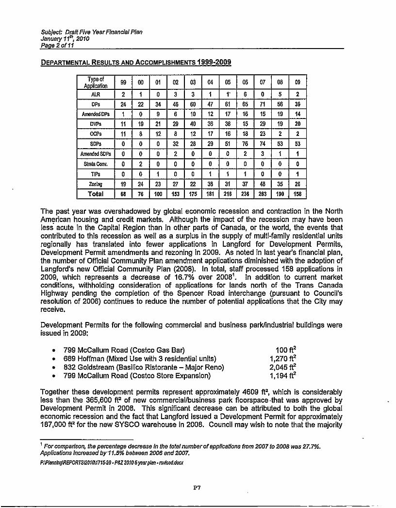
DEPARTMENTAL RESULTS AND ACCOMPLISHMENTS 1999-2009
Type ofApplication
99 00 01 02 03 04 05 06 07 08 09
AIR 2 1 0 3 3 1 V 6 0 5 2
DPs 24 22 34 46 60 47 61 65 71 56 39
Amended rips 1 0 9 6 10 12 17 16 15 19 14
UPS 11 19 21 29 40 36 38 15 29 19 20
OCPs 11 8 12 8 12 17 16 18 23 2 2
SOPS 0 0 0 32 28 29 51 76 74 53 53
Amended SDPs 0 0 0 2 0 0 0 2 3 1 1
Slmta0mv. 0 2 0 0 0 0 0 0 0 0 0
TIPS 0 0 1 0 0 1 1 1 0 0 1
ZonIng 19 24 23 27 22 38 31 37 48 35 26
Total 68 76 100 153 175 181 216 236 263 190 158
The past year was overshadowed by global economic recession and contraction in the NorthAmerican housing and credit markets . Although the impact of the recession may have beenless acute in the Capital Region than in other parts of Canada, or the world , the events thatcontributed to this recession as well as a surplus in the supply of multi-family residential unitsregionally has translated into fewer applications in Langford for Development Permits,Development Permit amendments and rezoning in 2009. As noted in last year's financial plan,the number of Official Community Plan amendment applications diminished with the adoption ofLangford's new Official Community Plan (2008). In total, staff processed 158 applications in2009, which represents a decrease of 16.7% over 2008'. In addition to current marketconditions, withholding consideration of applications for lands north of the Trans CanadaHighway pending the completion of the Spencer Road interchange (pursuant to Council'sresolution of 2006) continues to reduce the number of potential applications that the City mayreceive.
Development Permits for the following commercial and business parkfindustrial buildings wereissued in 2009:
• 799 McCallum Road (Costco Gas Bar) 100 ft2• 689 Hoffman (Mixed Use with 3 residential units) 1,270 ft2• 832 Goldstream (Basilico Ristorante - Major Reno) 2,045 ft2• 799 McCallum Road (Costco Store Expansion) 1,194 ft2
Together these development permits represent approximately 4609 ft2, which is considerablyless than the 365,600 ft2 of new commercial /business park floorspace -that was approved byDevelopment Permit in 2008. This significant decrease can be attributed to both the globaleconomic recession and the fact that Langford issued a Development Permit for approximately187,000 ft' for the new SYSCO warehouse in 2008. Council may wish to note that the majority
' Forcompadson, the percentage decrease In the total numberof applications from 2007 to 2008 was 27.7%.Applications Increased by 11.5% between 2006 and 2007.P:WIannTigWEPORTS1201 0i171530 • PS220105 yearplan-mvlsed.dccx
P7

Subject: Draft Five YearF/nancial PlanJanuary 11", 2010Page 3 of 11
of the floorspace for which Development Permits were issued in 2008 were constructed by theend of 2009.
In addition to the commercial/business park Development Permits, 146 multi-family dwellingunits were approved by Development Permit in 2009. This represents a 40% decline from2008. Of the 146 multi-family dwelling units which were approved by Development Permit in2009, 140 have commenced construction.
The Planning Department also issued Development Permits in 2009 for 144 intensive residential(small lot) single family dwellings. Of these, 99 have commenced construction.
MAJOR ACCOMPLISHMENTS OF 2009
a) Agricultural Strategy : A comprehensive agrology study of the lands in Langford thatare within the Agriculture Land Reserve was completed in 2007. This work wasforwarded to Langford 's Official Community Plan consultant and policies regardingagricultural lands were integrated into Langford's new OCP. Council established anAgricultural Advisory Committee in 2008 to consider applications for non-farming use inALR lands and exclusion of lands from the ALR and to provide recommendations toCouncil with respect to agriculture and agricultural lands. A comprehensive AgriculturalStrategy was developed with input from staff at the Agriculture Land Commission andthe BC Ministry of Agriculture and was presented to Council and adopted as policy inNovember 2009.
The Agricultural Strategy discusses the ways in which Langford may acquire agriculturallands into the public trust , establish guidelines for development around designatedagricultural lands, and provide a net-benefit to agriculture. Specific design guidelines forlands adjacent to agricultural lands will be developed from the Agricultural Strategy forCouncil's consideration in 2010.
Langford's Agriculture Strategy was also the topic of discussion at a meeting of theCapital Region Food and Agriculture Initiatives Roundtable (CR-FAIR) held in Langford,at the Legion, in early December.
b) Economic Forum : A number of new initiatives were unveiled at Langford's EconomicForum, held at Bear Mountain in January of 2009 . For the Planning Department, theeconomic stimulus initiatives included:
• Establish a maximum 30 day timeframe for Development Permit Process(ongoing);
• Pre-zoning of key areas in City Centre (underway);• Revitalization Strategy for Sooke Highway between Jacklin and Happy Valley
Roads (underway);• Deferral of Public Hearing Fees (enacted);• Reduction of Landscape Bonding & New Timing Commitments (enacted);• Eliminate Happy Valley Corridor Study Reserve Fund and do not collect any fee
payments required in zoning bylaw or in Sect . 219 covenant (enacted);
P:IPIsanigREPORTS120101175-20 -P&Z20105yeerp1en - revlsed.dorx
Pa

Subject: Draft Five Year Financial PlanJanuary 11 n', 2010Page 4of11
• Permanently subtract parent parcel from the number of lots that require amenitypayments (i.e., one lot is credited for each development) or the number of lotscounted towards 41 in 10" affordable units (enacted);
• Discontinue practice of charging amenity fees to affordable housing units(enacted);
• Provide, at Council's discretion, up to 10 years of tax holidays to market rentalaccommodations (ongoing);
• Permanently streamline variance process by amending which variances aredelegated to the City Planner rather than going through formal DVP process(underway);
• Compile a library of standard covenants and legal documents for developers toadapt for their use, as a cost saving measure and service to applicants(underway/ongoing);
c) Affordable Housing: To date, thirty-eight (38) affordable housing units have beenconstructed within Langford Affordable Housing Program. Four (4) of these affordablehomes were constructed in 2009. The City of Langford amended the AffordableHousing Program 2009 to allow active members of the Canadian Armed Forces who areposted to Victoria to qualify for the affordable housing program.
d) Downtown Beautification : The City of Langford added approximately $3000 to theDowntown Beautification fund through developer contributions. As reported in lastyear's financial plan report, Langford has now received an exciting three-piece artinstallation designed by Derek Rowe (Artform Sculpture Studio) entitled "Alice" wasInstalled this fall in front of the Goudy Public Library on Goldstream Avenue.
e) Sign Bylaw Update: An adhoc committee was struck in 2008 with the WestshoreDevelopers' Association to look at a comprehensive revision to Sign Bylaw No. 700.Council received a draft bylaw in January 2009, and Sign Bylaw No. 1250 was adoptedon February l6v', 2009.
2010- 2014 FINANCIAL TARGETS
The Five-Year Financial Plan projects an overall decrease in Planning expenditures from$1,231,300 in 2009 to $989,600 in 2010. Actual expenditures for the entire Planning functionreached $1,116,849 in 2009. This was $114,451, or 9. 2% below budget . The overall decreasein expenditures for the Planning Function may be accounted for by a reduction in staff(contributing to a decrease of over $58,000 in planning services over what was originallybudgeted . Please see: " PLANNING SERVICES" below.) and a decrease in expenses relating tobudgeted community development PROJECTS which were either not initiated or completed asplanned in 2009. Council may wish to note that actual expenditures for Planning Servicesincreased by approximately 10% in 2008 over 2007, 21% in 2007 over 2006, and by 21% in2006 over 2005. Between 2008 and 2009, actual expenditures for Planning Services decreasedby 1.2% overall.
The Five-Year Financial Plan proposes a $128,700 decrease in the Planning Services portion ofthe budget for 2010 (a 13.3% decrease) over what was budgeted for 2009. This decrease in
P.MIannTgWEPORra1201011715 .20-P&Z 20103yeerplan - reoised.d=
P9

Subject: Draft Five Year Financial PlanJanuary 11°5, 2010Page 5-Of 11
the Planning Services portion of this Financial Plan can be attributed largely to the reduction inthe size of the Planning Department staff due to departmental restructuring and the eliminationof the Deputy Planner position. The cost of salaries, benefits, general department overheadand legal fees will continue to grow with the inflation and the cost of living.
The Five-Year Financial Plan projected that revenues from applications would be $325,000 in2009, which was significantly less than the $570,000 that was budgeted in 2008. Actualrevenues from application fees in 2009 were $340,000, which exceeded estimates by 4.6%.Notwithstanding this, actual revenues from application fees in 2009 were 28.5% lower thanactual revenues from fees in 2008 ($475,729) which were 12.8% lower than actual revenuesfrom application fees in 2007, and 16.5% lower than the budget estimate for 2008.
As noted above, the number of planning applications received in 2009 decreased by 16.7% (32applications) over 2008 . By comparison , the number of applications received in 2008 was adecrease of 27.7% (73 applications) over 2007.
In 2008 it was reported that application fees were expected to represent approximately 74% ofthe cost of providing Planning Services2 and approximately 55% of the Planning budget as awhole. Yearend figures indicate that this number was actually closer to 50%, due to a late yeardrop off in application fees. Application fees in 2009 are expected to represent only 38.8% ofthe cost of providing Planning Services, and approximately 32.8% of the cost of the Planningfunction as a whole . Community development projects are expected to consume a considerableproportion of staff time in 2010, particularly if work begins on a re-write of Zoning Bylaw No.300. Legal costs, and the costs associated with Public Hearings (advertising, preparing andplacing public hearing signage) are expected to rise in 2010 as they have In the past , but likelyat lower rates. Council may therefore wish to budget for legal costs based on 2008 actualfigures , and adjust public hearing fees to reflect actual costs.
The net cost of the Planning function is expected to be $613,600 in 2010, as compared to anactual net cost of $612,384 in 2009. As a percentage of the budget as a whole, the proposedbudget for 2010 anticipates that the net cost of the Planning function will be approximately 62%of the budget as a whole. In 2009, the actual net cost of the Planning function wasapproximately 55% of budget, which is 5% greater than the actual net cost of the Planningfunction in 2008.
The proposed or actual net cost of the Planning function is the proportion of the proposed oractual Planning budget that is not funded by application fees , license fees , grants and/orreserves. It represents the portion of the Planning function that must be made up from generalrevenues. As there would be obvious resistance , in this period of economic uncertainty, toincreased application fees , Council may wish to maintain application and public hearing fees attheir current levels and fund the net cost of the Planning function from general revenues. Thiswould be similar to the degree to which the net cost of the Planning function was funded in both2008 and 2009.
2 Planning services include: salaries and benefits; legal, advertising consultants and departmentaloverhead in general.
P:Wlennh9WWEPORT5120f01171S20 - PMZ 20105 yaarplen -mvlsed.dacx
Pl c

Subject: Draft Five YearFinancial PlanJanuary 1101, 2010Page 6 of 11
Rather than revise the current fee schedule to increase fees, Council may wish to direct stafftowards revising the schedule itself, so that fees paid are more in line with the servicesprovided. The Local Government Act requires that application fees are based on cost recovery,and given the percentage of the Planning budget that is funded from general revenues it is notdifficult to argue that , in general , this is the case . Staff have, however, noted several instanceswhere the current fee schedule provides either overlapping fees or difficulty in classifying anapplication in terms of the appropriate fees owing . Council may wish to correct these , as theytend to be confusing to the applicant and difficult for staff to interpret.
PLANNING SERVICES
In terms of personnel, 2009 was another year of transition in the Planning Department, althoughthe degree of change was not as great as in previous years . In August, Deputy Planner EmilieAdin left the City to take the City Planner position with the City of North Vancouver, and it wasdecided that the position would be eliminated and that the department should be reorganized atthat level by promoting the two Planner 2 positions to two new Senior Planner positions, withspecific responsibilities for Current Planning and Long Range Planning and PolicyDevelopment. These two positions are now filled by Leah Stohmann and Leanne Blackwoodrespectively.
Therefore, the Planning Department now consists of a Planning Secretary, a Planning Assistant,three Planners, the aforementioned two Senior Planners and the City Planner.
Over the past ten years the Planning Department has hired four summer co-op students(usually completing studies in Geography at UVIC). Having a co-op student has been useful forthe Planning Department at certain times in the past to assist with special project and summerrelief. Two of Langford's co-op students (lain Bourhill and Alison Myerscough) also becamePlanners with the City. It was reported in last year's five year financial plan that the PlanningDepartment did not require a co-op student in 2009. Given current workloads, current staffinglevels are expected to be sufficient through 2011, and therefore a co-op position has beeneliminated from the five year plan. The need for a co-op student may be revisited again in 2011.
2010 KEY INITIATIVES
COMMUNITY DEVELOPMENT PROJECTS:
Community Development projects have been staged to spread the cost impact over a multi-year time frame.
1. Langford Community Energy and Emissions Reduction Strategy : At the SpecialMeeting of Council held on January 12th, 2009, Council passed the following resolutionwith respect to the Langford Energy and Emissions Reduction Strategy:
Direct staff to proceed with management and production of Langford's CommunityEnergy and Emissions Reduction Strategy as an independent project, using the sameconsultant as Coiwood in order to access outside funding supports of up to an additional$100,000;
P:1PIennlg REPORTS12010117l5-20-PSZ 20105 yeerplen-revked,doe[
Pit
Subject: Draft Five YearFinancial PlanJanuary 11^ 2010Page 7 of 11
With assistance from BCHydro and the Ministry of Community Development, the City ofLangford will serve as a pilot for the development of a municipal energy and emissionsreduction strategy.
The City of Langford engaged the services of Jordan Fisher and Associates to furtherexplore the components of a corporate strategy for reducing the City's carbon footprintand report back to Council on findings of a Carbon Footprint Analysis (CFA) andCommunity Energy and Emissions Reduction Strategy (CEERS). A draft report hasbeen prepared, and a final submission to Council will be made, through the Planning andZoning Committee, once the Community Energy and Emission Reductions Strategy(CEERS) has been reviewed at a public open house.
It was reported in the 2008 Draft Financial Plan that Council could likely expect newProvincial legislation in the realm of environmental protection, reducing greenhouse gasemissions and working towards carbon neutral communities over the next few years,and this has come to pass. While Langford's proposed new OCP embraces sustainablecommunity development, Langford will likely have to continue to update policies andregulations to remain current with changing Provincial legislation, or to meet obligationsunder multi-party agreements on climate change. Council, therefore, may wish toconsider budgeting $20,000 in each of the next five years to fund research, projects andpolicy updates relating to climate change, reducing carbon and greenhouse gasemissions, environmental protection, and reducing Langford's environmental footprint.
2. Zoning Bylaw No. 300 Update ( includes Parking Strategy ): In past years Councilhas budgeted funds in 2010, 2011 and 2012 to complete a comprehensive re-write ofZoning Bylaw No. 300. This bylaw, a foundational bylaw of the municipality, was lastrevised in 1998 (adopted in February 1999). It is past due for a comprehensive re-write,and in this period of reduced economic activity, staff feel that this can be accomplishedin-house and without need of an external consultant to prepare this bylaw. Staff havetherefore included $30,000 in 2010 and 2011 and $15,000 in 2012 to complete this work.It is anticipated that the majority of these funds will go towards public openhouses/meetings and legal review.
The comprehensive updating of the Zoning Bylaw also allows for an opportunity toreview parking standards and a downtown parking strategy in the context of a newzoning bylaw.
3. "Green" Design Guidelines : As a direct outgrowth of the CFA and CEERS (seeabove) and as a means of leveling Council's policies and guidelines with respect todeveloping in sustainable manner, Council may wish to budget $60,000 in each of thenext two years to create a comprehensive set of design guidelines to direct newdevelopment towards implementing sustainable development principles. Theseguidelines would draw upon the work that has already been completed with respect tothe Westhills Green Community and South Skirt Mountain. It is expected that some ofthe cost of this work may be recouped from either grant monies or direct contributionsfrom the development community.
P.'PiMnT9WREPORTS12010tl715.20 - PSZ20105ye&Plen -reNsed.docx
P12
Subject: Draft Five YearFlnancial PlanJanuary 110, 2010Page 8 of 11
4. Green Transportation Plan: With the assistance of a co-op student from UVIC in thesummer of 2008, the Planning Department gathered and collated a wide variety ofinformation (including an online survey) pertaining to active, green or alternatetransportation options in Langford. In keeping with active transportation policies of thenew OCP, this plan will be a collation of bicycle routes, safe routes to school, trail andwalking routes as well as facilities for bicycling and transit. In 2009, Ian Kirkpatrick, alocal graphic designer who also designed a brochure and renderings for City CentrePark, was hired to create two bicycle-friendly maps and a brochure promoting bicycleroutes around the Downtown, and Langford and Glen Lakes. An amount of $548 of thebudgeted $10,000 in 2009 was spent on consultant fees to create these products.Council may wish to carry the remainder of $9,452.00 over from 2009 to 2010 in orderfor staff to complete a draft Green Transportation Plan In 2010, which should be able toreplace the now 10-year old Bicycle and Trail Master Plans.
5. Sooke Road Revitalization Plan: The City of Langford announced plans to create arevitalization plan for the Sooke Road commercial corridor from Jacklin Road to GlenLake Road in January 2009 as an economic stimulus measure and building on thepolicies of the new Official Community Plan. This revitalization plan should be precededby the new physical design and alignment for Sooke Road which is now underway withthe Ministry of Transportation following the successful installation of the traffic controlsignal at Books Road and Happy Valley Road. Due to the timeline of the road designand the number of other projects currently being undertaken by staff, Council may wishto carry the budgeted $30,000 over from 2010 to 2011, and add an additional $15,000for this work in 2012 to complete this project. This project, and the budget for this work,will be revisited in next year's financial plan.
6. Millstream Fish Ladders : In 2007 and 2008 it was reported in the Draft Five YearFinancial Plans that Langford may have an opportunity to build an additional (andperhaps last) fish ladder or undertake additional environmental projects on MillstreamCreek in 2008, with work to be funded by developer contributions. This did not occur in2007, 2008 or 2009, but the opportunity to complete this work may arise in future years.The City of Langford has not budgeted money for the completion of this work in 2010.
Other Key Initiatives
1. Langford's Affordable Housing Program Continue to implement the AffordableHousing program and improve the policy where appropriate; develop criteria andprocess for Rental Subsidy Program; market and subsidized rental units in partnershipwith NGO's, other levels of government, industry.
2. Sustainable/Affordable or Pocket House Show Home: Staff will continue to exploreopportunities to partner with developers wishing to create sustainable, affordablehousing alternatives so that they may showcase new technologies and techniques thatothers might follow. Should an appropriate proposal come forward, Council may wish topartner by contributing municipal lands to a proposal in return for guarantees of housingaffordability and sustainable construction.
P.WIenningREPORTS120101171620 - P&Z20105yeerplan -mtfsod.dacx
P13

Subject: Omit Five YearFinanclal PlanJanuary 110, 2010Page 9 of 11
3. Downtown Beautification and Public Art: Staff will continue to look for opportunitiesto obtain contributions towards downtown beautification and public art, as well ascontinue to work with CRD Parks and the Westshore Arts Council towards an installationof public art in conjunction with the E&N Railside Trail Project.
4. CarShare Langford : The City of Langford will seek ways to sponsor and negotiatepartnership for a'CarShare Langford' program.
5. Neighbourhood Planning (Local Area Plans): In last year's five year financial plan itwas reported that the Planning and Engineering departments foresaw an increasingneed for comprehensive small-scale plans for existing neighbourhoods and sub-neighbourhood areas. As required, these plans would consider preferred road andservicing networks, access to lands beyond, environmental impacts, the need for parkand open space as well as topographical challenges and basic lot geometry. Thecompletion of these plans may include contracting the services of Professional Biologiststo report on riparian setbacks, sensitive- ecosystems or potential wildlife habitat, orprofessional engineers to report on floodplain elevations, stormwater management,retention and detention.
In 2009 staff completed a local area plan for the south side of Walfred Road betweenJacklin Road and Happy Valley Road. Completing this work has involved engaging theservices of a professional biologist , and staff has been working closely with severalproperty owners in this area who are seeking rezoning.
In 2008, staff suggested that Council may wish to budget $15,000 in each of the nextthree years to complete two local area plans in each of 2008, 2009 and 2010. This wasnot included in the 2008 budget, and instead the Planning Department budget forconsultants was increased to $10,000, with the understanding that the additional $7000will be directed towards work relating to local area plans. This appears to besatisfactory, as the work on Neighbourhood planning is occurring as needed, whereneed.
A large portion of staff time will continue to be spent on processing development applications,including: zoning and OCP amendments, development permits, development variance permitsand sign development permits and answering public enquiries. Although significant work hasbeen completed for large and complex comprehensive development areas such as: BearMountain, Westhills, Valleyview, Goldstream Meadows and South Skirt Mountain throughrezoning phase of the development, planning related activities on these projects will continue toconsume a great deal of staff time in the coming years.
KEY PROJECT RANKING
The Administration and Finance Committee has requested that each standing committeeprovide some guidance as to the priority it wishes to place on capital purchases, projects ornew staffing requests. This is so that the Administration and Finance committee will be ableto judge the relative priority of all projects when the overall budget is reviewed later in thespring. In this regard the following table has been produced.
P:WIennLn01REPORTSl20f01l71520 -P&Z20105 yemplen - ovIsed.eou
P14

Subject: Draft Five Year Financial PlanJanuary 110, 2010Page 10 of 11
ItemEstimated
Cost Priority
Community Energy and Emissions Reduction Strategy $20,000
Green Transportation Plan (formerly Active Transportation Plan) $9500
Zoning Bylaw Re-Write ( including Parking Strategy) $30,000
Film Commission Funding $2,5003
Green Design Guidelines $60,000
It would be appreciated if the Planning and Zoning Committee could confirm or change thesuggested priority for each of the noted items and add any other items that it wishes toidentify a priority for.
RECOMMENDATION
That the Planning and Zoning Committee recommend:
That Council:
1. approve in principle the Planning and Development Services Five Year Financial Plan aspresented with the following priorities on projects:
2. direct staff to revise the application fee schedule so that it is more complete,comprehensive, easier to read and easier to apply;
e Represents no increase over the amount budgeted for this item in 2008;
P:W/enn6gWEPOR75120101171620-P&Z20105yearplan-revised.doer
P15


$ $ $ 0 $Y ' N $ m
Ct) ` N N N
o 0 o 0 00m ° $ 00 0p e- N O N
O
O O O O O
$ °_$ 0000
0)i N N 0m
0 $ $ O $0m O m O m
m ' N P Nm
°0 0 0 0 0O 0 0 0Co S O
Co r N r G
m
0 00 00 00 00$ O m m m0 r N 0 N
m m
m $ 0) 0 N.m o o m m
o m N C p
O CtOrf mNmQ
m PC6 o m hm
o om O1N C m
m
O n $
ON V N
0 0 0$ °v 00
O0 N
O O 0
bN
oO v
$N
0
0in
00
m
00
10r
0
N0
eq
O
0V
`m
00
n
0
0m e
mof
$
rN0
N
0Co
00 o00 m o
N N N `m'
o o 0 0
O ID 0 N
0 0 0 0O $ 0p N
N t00 m N
moo m
n 00 00 e
N m 0
o O N
0 0 O NN o N
00
m
N
0W
0
N
m
m
m
m
M
v
Co0
0
nj
N
0
0
m0
0
w N d d p d
d a d C d o a
JCDz vzO.z
°Om
Om
00m
N
00to
m
ON_
m
$
[0N
oN
m
$ 00 00 00 $ 00P m 0 O "
0)m
N N m NCO
O O 0 0 O O
No0 0
0 $o
cc N N NN o0
$$0$$mr m o 0 0 00t0 N N 0) 0 (O
00 00 0 00 00 0P N N O O ON
N
N d N 0 Co
d
CD
rn3
P17

oo
0o 00 GO 00 00 00 00 n O N m m N 0 0
O
N o0 o O
N 0 N
OS
0O
0N
o 0
N r' sY t7 N N N
o O 0 0 0 0 0
mO
S N 8
N N
0 0
N
0
N
O
0
N N
O O
NN 10 I: b N W .O 1`0
N N N Q NQ ' Q N N N N
OClNN N N
N N
0 0 0 0 0 0 0 0 O O O O O O O O
0 CW Y 0 N M N N 0m N N0 N O
0 o o O O 00Q r P Q M N N N
mN
In VlN
O O
1` O N O N Q t7V r V P tO O Cl N
o 0 0
0N
Q
o ON O
O O00N
M
N
O O O
C
O
0 0 O
N N M n
O O O O
SO N
O 00
N
0N 0
N 00 00 0 N 0 8 O N o 0 0
n1N N O 0Y r (O N tO O N ID M
NN N 0 N m
Oi Co 0
0N
0
C
IL
42CC
8
CONN
EE0UE
G UOw E
E°^
m
n.yl Nl
V c 0 0
00 NR C
m
m•V
dd
d 0 901
oa-` Cc CQ0U W 0
P28
..
0
>O
^^ E r

CITY OF LANGFORD e-mail: [email protected]: hnn://cinnrtnnefnrd.
Planning and Zoning phone: (250) 474-69192nd Floor, 877 Goldstream Avenue Val fax: (250) 391-3436
Langford, BC V9B 2x8
Staff ReportSCp N
to
Planning, Zoning and Affordable Housing Committee
Date: January 11, 2010
File: Z-09-19
Subject: Application to rezone 935 Walfred Road from GR2 (Greenbelt Residential 2)to RS3 (Residential Small Lot 3) to allow for a subdivision of approximately24 lots
PURPOSE
Mark Johnston has applied, on behalf of Wilfred and Mary Harper, to rezone the property at 935Walfred Road from GR2 (Greenbelt Residential 2) to RS3 (Residential Small Lot 3) to allow fora small lot subdivision with approximately 24 lots.
BACKGROUND
No previous applications have been made with respect to this property.
APPLICATION DATA
Table 1: Site DataApplicant Mark Johnston of Limona Construction Ltd.Owner Wilfred and Mary HarperLocation 935 Walfred RoadLegal Lot 4, Section 84 , Esquimalt District, Plan 21075Size of Property 8,298 .2 m' (89 ,321.219)DP Areas Habitat & Biodiversity and Interface Fire HazardZoning Existing : GR2 (Greenbelt Residential 2) Proposed : RS3 (Residential Small Lot 3)OCP Designation Hillside or ShorelineSLNP Designation Urban Residential
Permitted by GR2 Permitted by R53Height 10.5 m (34 ft) 8.5 m (28 ft)Site Coverage 35% 50%
Front Yard Setback 7.5 m (25 ft) 3m (9.8 fl) or 5.5 ft (18 ft) for a garageInterior Side Yard Setback 3 m (10 ft) 1.2 m (4 fl)Exterior Side Yard Setback 3 m (10 ft) 3.5 m (11.5 fl)
Rear Yard Setback 10 m (33 it) 5.5 m (18 it)Parking Requirement 2 per unit 2 per unit
Table 2: Proposal Data
hffp9/sparepobVsgestZo &VOCP/1-09.19Rha,odOocvmentvPZ Repod-Dafa.doc
P19
Subject: Z-09-19 -935 Walfred Road11 January 2010Page2 of 12
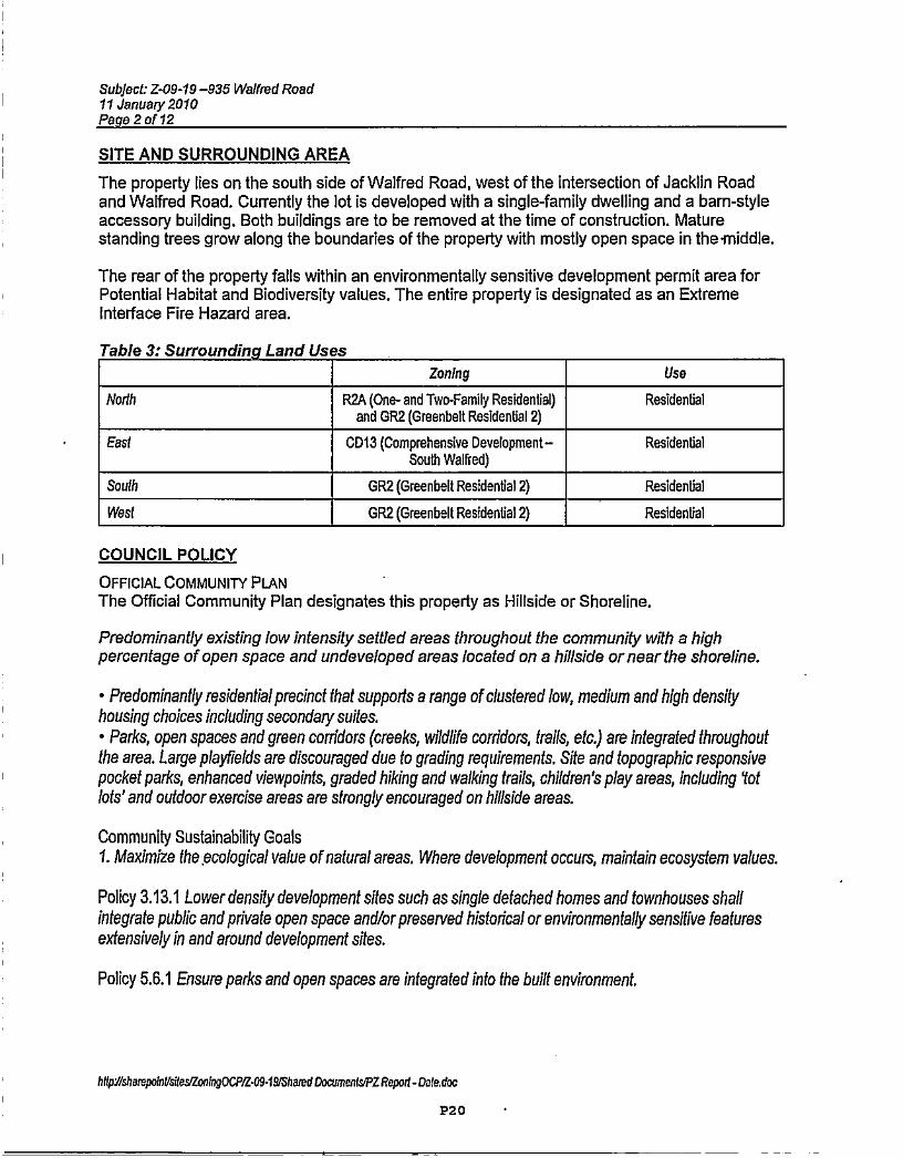
SITE AND SURROUNDING AREA
The property lies on the south side of Walfred Road, west of the intersection of Jacklin Roadand Walfred Road. Currently the lot is developed with a single-family dwelling and a barn-styleaccessory building. Both buildings are to be removed at the time of construction. Maturestanding trees grow along the boundaries of the property with mostly open space in the-middle.
The rear of the property falls within an environmentally sensitive development permit area forPotential Habitat and Biodiversity values. The entire property is designated as an ExtremeInterface Fire Hazard area.
Table 3: Surrounding Land Uses
Zoning Use
North R2A (One- and Two-Family Residential)and GR2 (Greenbelt Residential 2)
Residential
East CD13 (Comprehensive Development -South warred)
Residential
South GR2 (Greenbelt Residential 2) Residential
West GR2 (Greenbelt Residential 2 ) Residential
COUNCIL POLICY
OFFICIAL COMMUNITY PLANThe Official Community Plan designates this property as Hillside or Shoreline.
Predominantly existing low intensity settled areas throughout the community with a highpercentage of open space and undeveloped areas located on a hillside or near the shoreline.
• Predominantly residential precinct that supports a range of clustered low, medium and high densityhousing choices including secondary suites.• Parks, open spaces and green corridors (creeks, wildlife corridors, trails, etc.) are integrated throughoutthe area. Large playfields are discouraged due to grading requirements. Site and topographic responsivepocket parks, enhanced viewpoints, graded hiking and walking trails, children's play areas, including lotlots' and outdoor exercise areas are strongly encouraged on hillside areas.
Community Sustainability Goals1. Maximize the ecological value ofnatural areas . Where development occurs, maintain ecosystem values.
Policy 3.13.1 Lower density development sites such as single detached homes and townhouses shallintegrate public and private open space and/or preserved historical or environmentally sensitive featuresextensively in and around development sites.
Policy 5.6.1 Ensure parks and open spaces are integrated into the built environment.
hdpY/shompolnVsilessZOnfigOCP/1-09-09/Shamd Dowmenl&PZ Report - Dafedoc
P20

Subject: Z-09-19-935 Welfmd Road11 January 2010Page 3 of 12
SOUTH LANGFORD NEIGHBOURHOOD PLANThe designation of the South Langford Neighbourhood Plan (SLNP) for the subject property isUrban Residential:"Applies to areas where the availability ofmunicipal services allows fora variety of residentialdevelopment that is more intensive than Suburban Residential, and that may include singlefamily residential dwellings without secondary suites, townhousing and attached housing. Amaximum density of one unit per 200 m2 (2,152.85 ft2) is applicable".
COMMENTS
DEVELOPMENT PROPOSALThe proposal consists of 24 lots, ranging in size from 221 m2 (2,378.8 ft2) to 303 m2 (3,261.5 ft).The proposed road width is 15 metres and is based on the road width proposed for thesubdivision on the adjacent lots at 931, 927 and 923 Walfred Road. Similarly, the proposed lotlayout is consistent with the layout of the lots next door.
The applicant is proposing to dedicate a 2.5 in (8.2 ft) wide strip of land along Walfred Road forfuture road widening, based on the requirement for the adjacent lots. The total area to bededicated as road is approximately 155 m2 (1,668.4 ft2).
In addition, a 7 m (23 ft) wide strip of land will be dedicated for park and trail purposes, alsobased on the requirements for the adjacent lots. This area will be approximately 427 m2 (4,598.2ft2) in size and equals 5.1% of the subject property, 4.9% less than required by Council policy.
Council, therefore, may wish to ask for cash-in-lieu of the remaining portion of the land, thevalue of which is to be based on the market value after rezoning. As the amount to becontributed will be secured in the bylaw to rezone the property, Council may wish to ask that theapplicant have an appraisal done, prior to First Reading, to determine the amount to becontributed.
COMPLIANCE WITH OFFICIAL COMMUNITY PLANThe proposal will be consistent with the OCP as it will substantially increase the density on thesubject property and result in the expansion of the trail network along Walfred Road.
Furthermore , the proposed park dedication will protect an environmentally sensitive area thatexists along the property 's Walfred Road frontage.
COMPLIANCE WITH THE SOUTH LANGFORD NEIGHBOURHOOD PLAN (SLNP)The proposal is consistent with the SLNP in that it increases the density to more than what isallowed under the Suburban designation but is within the maximum density permitted under theUrban Residential designation . This designation allows for one unit per 200 m2 (2,152 .85 ft2)whereas the proposal will increase the density to approximately one unit per 345.8 m2 (3,721.7ft2).
GREEN TRANSPORTATION AND CLIMATE CHANGEWithin a five to ten minute walking distance from the subject properties there are bus stops forfive different bus routes (#54 - Metchosin, #55 - Happy Valley, #59 - Triangle Mountain, #61 -Sooke/Downtown, and #61x - Sooke/Downtown Express). The frequency of trips ranges from 4minute intervals during peak hours to infrequent service off peak hours.
hMp//shampoh7ttAss2oningCCP2-09.19/ShamdDcumant&PZRepod-Date.doc
P21
Subject: Z-09-19 -935 Walfred Road11 January 2010-9e4of
In addition, the subject properties are located within a 10 minute walk or a short bike ride from-the Galloping Goose Regional Trail.
SMART GROWTH PRINCIPLES OF DEVELOPMENTThis development applies the principles of smart growth by utilizing existing infrastructure andincreasing density on existing residential properties. Higher residential densities can lead to anincrease in demand for public transport, which can lead to an expansion of the publictransportation system.
PUBLIC SAFETYThere are fire hydrants located on the property frontage at 931 and 923 Walfred Road, howeveradditional hydrants may be required, as Bylaw No. 500 specifies that there must be a firehydrant within 150m (492 ft) of the centre of each building envelope in a residential subdivision,as measured along the access route that shall be travelled by emergency response personnel.
As the subject property's interface fire hazard designation is extreme, the applicant hassubmitted an interface fire hazard report. Council may wish to ask that the applicant register aSection 219 covenant to title stating that the property will be developed according to therecommendations outlined in the report.
Sidewalks or pedestrians trails will be developed along the south side of Walfred Road inaccordance with the City of Langford's Safe Routes to School plans.
BUILDING AND SITE DESIGNThe applicant is proposing to create small lots and, therefore, will be required to apply for a form& character development permit. Council may wish to ask that the applicant provide elevationdrawings, prior to public hearing, to show the proposed dwellings. Council may also wish torequire that the applicant register a Section 219 covenant which states that the proposeddwellings will be substantial similar to the drawings shown at Public Hearing.
To ensure that this development will be compatible with the development at 931, 927 and 923Walfred Road, Council may wish to ask that the applicant provide a cross section of theproposed residential grades for the subject property and these properties, including anyretaining walls and blasted or filled slopes, prior to first reading. The applicant should familiarizethemselves with the conceptual plans for Walfred Road, including any proposed grade changes.
As the applicant is proposing to dedicate a portion of the property along Walfred Road for parkand trail purposes, Council may wish to ask that the applicant erect a 1.8 m (6 ft) high solidboard fence along the rear of proposed lots 1 through 6, prior to construction, to ensure that thisarea is not impacted during construction, and that a tree retention plan be prepared, prior topublic hearing.
PEDESTRIAN, CYCLING AND MOTORIST NETWORKCouncil may wish to secure a 2.5 m road dedication for road widening along Walfred Road, priorto bylaw adoption, as well as an additional 7 m land dedication to the City for green buffer andtrail purposes. The end goal of the re-design of Walfred Road is to adequately meet thetransportation network needs of all users: pedestrians, cyclists and motorists.
hflpY/shampoi YsfteslZmTgOCP/Z-0949'SharedOucumenlvPZ Repad - 11 Jan 10.doo
P22

Subject: Z-09-19 -935 Walfred Road11 January 2010Page 5 of 12
Council may also wish to secure , in a Section 219 covenant , the requirement that no directdriveway access off of Walfred Road will be permitted, with the exception of proposed Lot 45,
-located within the adjacent development at 931, 927 and 923 Walfred Road, whichaccommodates an existing driveway and an existing single-family dwelling.
SUSTAINABLE STORMWATER MANAGEMENTAs per Subdivision and Development Servicing Bylaw 500, stormwater resulting from the 2- and10-year storms must be detained on-site . A stormwater management plan in this accord will berequired at the time of subdivision. To address stormwater for the 200-year storm, the applicantwill install those downstream drainage improvements required by the'North Triangle Mountain -Walfred Road Storm Drainage Study' prepared by Focus, dated June 30th, 2009. The extent ofthese improvements will include the entire frontage of the subject property and all necessaryimprovements required to connect to the nearest adequate downstream municipal system, asdetermined by the City Engineer. The developer will be entitled to latecomer benefits and/orDCC credits should the works be contained within the current DCC program in effect at the timeof subdivision.
GREEN INFRASTRUCTUREIn accordance with the City of Langford's Safe Routes to School plans, and the communitydesire to retain a forested road frontage along the south side of Walfred Road, Council maywish to require alternative frontage improvements along Walfred Road rather than the BylawNo. 500 standards for sidewalks. For example, the construction of a trail along this corridor,which connects the students and pedestrians of the Walfred Road area to Happy Valley Roadwithin a proposed linear park, might be Council's preference in this case..Council may wish tosecure this rezoning requirement in a Section 219 Covenant, registered to title.
Staff have considered to ask that the applicant provide a pedestrian pathway connectionbetween the interior roads of the development and Walfred Road. However, it seems that amore suitable location would be at properties further to the west along Walfred Road, due topossible future development of lands on Triangle Mountain.
The subject property is not served by sewers at the present time. However, the developer willbe required to extend sewer service into this area. The developer will be required to enter into afinancial agreement with WSES during the subdivision approval stage in order to work out thetiming and costs associated with extending sewer lines to the subject property.
The following conditions must be met in this agreement:• There is an existing sewer manhole opposite the northwest property corner. This
manhole should be utilized to service the new development.• The developer shall provide engineering drawings detailing any proposed sewer system
extensions for the new development.• Any sewer extensions within the municipal road right-of-way will be constructed by
WSES forces at the developer 's expense.• Any on -site sewers shall be constructed and paid for by the developer.
htlpY/shareponUsdeslZmtngoCPiza1 5hamd0ammenlvPZRepod - 11 Jan f0.doc
P23

Subject: Z-09-19 -935 Walfred Road11 January 2010Page 6 of 12
FINANCIAL CONTRIBUTIONS AND DENSITY BONUSING
AFFORDABLE HOUSINGAs per Council's Affordable Housing, Parks and Amenity Contribution Policy, the applicant isrequired to provide two (2) affordable homes which are to be sold within the Affordable HomeOwnership Program. Payments into the Affordable Housing Reserve Fund will be required asper Council's Affordable Housing, Parks and Amenity Contribution Policy. Council may wish tosecure the contribution of affordable homes and the amenity contribution fees within the bylawto rezone the subject property. Council may also wish to ask that the applicant show which twolots will be designated as the affordable housing lots, prior to first reading.
OPEN SPACE CONTRIBUTIONSCurrent Council policy requires that the applicant provide a minimum public open spacededication to the City of 10% of total parcel land area , or 829.8 m2 (8,932 ft2) in total. Theapplicant's proposal is to dedicate approximately 427 m2 (4,598.2 ft2) of land, or 5.1%, along theproperty's Walfred Road frontage to minimize the environmental and aesthetic impact ofdevelopment. Council may wish to ask that the applicant contribute cash-in-lieu of the remaining4.9% of land.
AMENITY CONTRIBUTIONSAs per Council's Affordable Housing, Parks and Amenity Contribution Policy, amenity fees arebeing charged as per the South Langford area, as summarized in Table 6-AmenityContributions per Council Policy, below.
FINANCIAL IMPLICATIONSRezoning the subject property to residential zones that permit higher densities of developmentmay increase the assessed value of the property, and this will increase municipal revenue. Asthe applicant will connect the development to municipal sewers, and as the applicant willcomplete frontage improvements, the direct capital costs to the municipality associated with thisdevelopment will be negligible. A summary of the applicant's financial and amenity contributionsare as follows:
Table 5- Development Cost ChargesDevelopment Cost Charge Per unit / area contribution Total (24 lots)
Roads $2,373 per parcel created $56,952.00
Storm Drainage $0.67/m2 of site area (8,298 m) $5,559.66
Park Improvement $1,890 per parcel created $45 ,360.00
Park Acquisition $1,100 per parcel created $26,400.00
Subtotal (DCCs paid to Ci ty of Langford) $134,271.66
CRD Water $3,032.16 per unit $72,771.84
School Site Acquisition $698 per parcel created $16,752.00
TOTAL (estimate) DCCs $223,795.50
htlp7/sherepota!siles2oning0CP& 1ThShamd Dacumen&PZRepwt- it Jan ladoc
P24

Subject: Z-09-19 -935 Walked Road11 January 2010Page 7 of 12
Table6-Amenit Contributions er Council PolicAmenity Item Per unit l area contribution Total (22 lots')
Affordable Housing 1 in 10 single family dwellings 2 affordable houses
Open Space Dedication 10% of total lot area 830 m2 (8,934 ttv) of land
General Amenity Reserve Fund $4,800 per lot $105,600
City Park Reserve Fund $2 ,500 per lot $55,000
ALR Acquisition Fund $1 , 500 per lot $33,000
Affordable Housing Reserve Fund $500 per lot $11,000
TOTAL POLICY CONTRIBUTIONS' $204,600'Amenity contributions am not required for the affordable housing lots
Table 7- Additional Amenity ContributionsDescription of contribution TotalI Amenity Item
South Langford Storm Drainage $4.19 per m2 of lot area (8,298.2 m) $34,769.46
OPTIONS
That the Planning and Zoning Committee recommend that Council:
1. Direct staff to prepare a bylaw to amend the zoning of the subject property from GR2(Greenbelt Residential 2) to RS3 (Residential Small Lot 3) in order to accommodate thedevelopment of the property as shown on the plan presented by the applicant, subject to thefollowing terms and conditions:
a) That as a bonus for increased density on the subject property, the applicantagrees to provide the following contributions at the time of subdivision:
i) $4,800 per unit toward the General Amenity Reserve Fund;ii) $2,500 per unit toward the City Park Reserve Fund;iii) $1,500 per unit toward the ALR Acquisition Fund;iv) $500 per unit toward the Affordable Housing Reserve Fund;v) $4.19 per m2 of site area toward the South Langford Stormwater Reserve Fund;
andvi) Two affordable houses;
b) That the applicant have an appraisal done, prior to First Reading , to determine themarket value of the land after rezoning and that the amount, equal to 4.9% of the totalvalue of the property, be dedicated toward the General Amenity Reserve Fund, as cashin-lieu of open space;
c) That the applicant submit a site plan identifying the location of the 2 required affordablehousing lots, prior to First Reading , to the satisfaction of the City Planner;
I This total policy contribution amount does not place a monetary value on the affordable housing unit, Open Space LandDedication, or other non-monetary contributions, but the city recognizes that these have substantial financial and community value.
htlpi/+harepoinVsites/ZanGgoCP/1-09-135hamdDowmenl&PZRepod - 11 Jan f0.doc
P25

Subject: Z-09-19 -935 Waned Road11 January 2010Page 8 of 12
d) That the applicant provide elevation drawings, prior to Public Hearing , showing theelevations of the proposed dwellings;
e) That the applicant submit a tree retention plan, prior to Public Hearing , that addressesand.provides recommendations to mitigate the effects of development on that portion ofthe property that is proposed to be dedicated for park or trail purposes;
f) That the applicant provide a cross section of the proposed grades, north/south andeast/west, for the subject property and the adjacent development, including any retainingwalls and blasted or filled slopes, prior to Public Hearing;
g) That the applicant provide, prior to Bylaw Adoption, a Section 219 covenant,registered in priority over all other charges on title, that agrees to the following:
1) That as a condition of building permit, frontage improvements be provided toSubdivision and Servicing Bylaw No. 500 standards, to the satisfaction of the CityEngineer,
2) That the applicant will install those downstream drainage improvements requiredby the storm water management and drainage study titled 'City of LangfordNorth Triangle Mountain -Walfred Road Storm Drainage Study' prepared byFocus Corporation, dated June 30a', 2009, which are required to providesubdivision drainage, from the subdivision to the nearest downstreamadequate Municipal System, as determined by the City Engineer. Thedeveloper will be entitled to latecomer benefits and/or DCC credits should theworks be contained within the current DCC program in effect at the time ofsubdivision;
3)That the applicant construct a trail and frontage improvements along Walfred Roadfrontage , in accordance with City bylaws and to the satisfaction of the CityEngineer,
4)That the applicant construct a 1.8 m (6 ft) high solid board fence along the rear ofproposed lots 1 through 6, prior to construction , in order to protect the area tobe dedicated for park and trail purposes;
5) That the applicant contribute cash in an amount equal to 4. 9% of the assessedvalue of the land after rezoning , toward the General Amenity Reserve Fund,payable at the time of building permit;
6) That the property will be developed according to the recommendations outlinedin the Wildland Urban Interface Fire Hazard Report , dated November 17th,2009 by Strathcona Forestry Consulting;
7) That the property will be developed according to the recommendations outlinedin the tree retention plan, as noted in item e) above;
http>/sharepdnbSdes2onirgOCP2-094a hamdDocuaentWZ Report- 11 Jan 1adoc
P26
Subject: Z-09-19 -935 Walfmd Road11 January 2010Page 9 of 12
8) That the proposed dwellings will be substantial similar to the drawings shown atPublic Hearing;
9) That the applicant dedicate a 2 .5 m wide strip of road frontage for road wideningalong Walfred Road, at the time of subdivision , as well as dedicate an additional7 m wide strip of land to the City for a green (riparian) buffer and trail purposes;and
10) That no direct driveway access to the subject property off of Walfred Road will bepermitted;
OR
2. Reject this application for rezoning;
1NatthCw Baldw 'n, MCIP No van der Kamp (//Jason ParksCity Planner Planner I / Parks Manager
Manson, P. Eng. SteveSteve Ternent im wden
Bob BeckettFire Chief
City Engineer Treasurer Cie -Administrator
:ivdk
h p//shawp nVs#ex4onhgOLPIZ-0 9-i9/ShamdOacomen&VPZRepmt - 11 Jan laft
P27

Subject: Z-09-19 -935 Wal/red Road11 January 2010Page 10 of 12
REZONING BYLAWAMENDMENT935 Walfred Road
ZONING MAP (Z-09-19)
Scale: N.T.S.
httpi/shampoTNsiffis/LanfngOCP2-09-09/Shemd OowmmisDZRepod-Dale dec
Last Revised : O ecember 09.2009
P28

Subject: Z-09-19 -935 Walfred Road11 January 2010Page 11 of 12
REZONING BYLAWAMENDMENT935 Walfred Road
ZONING MAP (Z-09-19)
Scale: N.T.S.
hdp//shartpolnHSde&ZOnTr90CP2-0949/Shared Dacwnent&PZ Repod - Date doe
Lost Revised: December09, 2009
P29
Subject: Z-09-19 -935 Walfred Road11 January 2010Page 12 of 12
sPRisrSM 'cLmryNgtW PLAN LOT I&CFyfl E! E4oL?^/4r T OL^i!?f/_-'L PLAN 21075
o 1.
0
hl WsharepofnVsilesIZoigOCA2-09.10hared DocomentfPZRepod- Date.doc
P30

CITY OF LANGFORD Engineering & Subdivision2n° Floor, 877 GoldstreamAve Email: engineeringnc.citvoflangford.caLangford, B.C. Web Site: http://cityoflangford.caV9B 2X8 Phone: (250) 474.0068
Fax: (250) 391-3434
Staff Report
to
Planning & Zoning and Affordable Housing
Date: January 11th, 2010
File No.: 5260-20
Subject: Walfred and Happy Valley Road Conceptual Plans
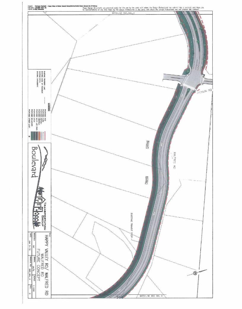
Background
The City retained Boulevard Transportation Group to prepare conceptual designs for HappyValley Road and Walfred Road in anticipation of future build out and development of propertiesin these two areas.
The purpose of the conceptual designs is to allow staff to:
• Assess the widths for road rights of ways when property owners come in forrezoning/redevelopment
• Properly plan for long term use of road rights of ways including such aspects as bicyclelanes, pedestrian connectivity, parking, vehicle turning lanes, and where applicable highoccupancy vehicle lanes
Commentary
Drawings showing the conceptual alignment for both Happy Valley Road and Walfred Road areattached for reference.
P31

Page 2
Happy Valley Road Summary
The current (2009 ) afternoon peak hour traffic volumes and anticipated 2026 afternoon peakhour traffic volumes on Happy Valley Road can be summarized as follows:
Location 2009 m eak vph 2026 m peak v hSouthbound Northbound Southbound Northbound
Sooke to Walfred 317 205 1050 261 to 280RoadsWalfred to Latoria 312 194 1250 730 to 767RoadsLatoria Road to 372 198 674 360 to 384MetchosinBoundary
The peak pm traffic flows in 2026 were projected using a computerized traffic model (WTP IIModel) and assumed a build out in the area of 3200 residential units and up to 17,500 m2 ofindustrial space.
Based on background information for peak traffic flows a maximum road right of way wasdetermined for the road sections above. In the case of the widest proposed ROW (30 m), theroad can be built as an interim design and widened out over time as needed. The proposedroad cross sections for Happy Valley Road are as follows:
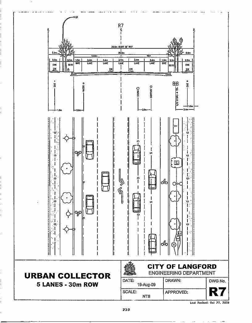
• Up to 5 lanes within a 30 in ROW from Sooke Road to Latoria Road. The middle lanewould be a turning lane (or planted median). In the interim it is anticipated that therewould be one driving lane in either direction. In the future the second driving lanes ineach direction can be added and used for: additional driving lanes, high occupancyvehicle (HOV) traffic or transit lanes. Bicycle lanes are proposed on both sides and couldbe on the paved area next to the single paved driving lane in the interim design andmoved out to the outer road edge if the road is widened out in future if two lanes arerequired in both directions. Parking can be accommodated in the interim design onHappy Valley Road by using the second driving lanes which will not be built out rightaway. A sidewalk is proposed for both sides with a treed boulevard separating thesidewalk from the paved road surface. This is an "R7° road cross section in the proposedBylaw 1000 Subdivision and Servicing Bylaw.
Up to 3 lanes within a 23 m ROW from Latoria Road to Loma Linda Drive. The middlelane would be a turning lane in this area. Bicycle lanes and sidewalks are proposed onboth sides of the road with a treed boulevard separating the sidewalk from the pavedroad surface. This is an "R4° road cross section in the proposed Bylaw 1000 Subdivisionand Servicing Bylaw modified with limited parking allowed due to the road curves in thisarea.
hUpY/shorepoint'sites/EngRepads/Repod/PLANNING and ZONING and Affordable Housing2010 /11 Jan 10/5260-20 Welhed andHappy Valley Roads conceptual Plans.doc
P32

Page 3
• Up to 3 lanes within a 20 m RoW from Loma Linda Drive south to the MetchosinBoundary. This is a more rural area of Happy Valley Road . Sidewalks are proposed onone side (east side; existing transit stops ). Bicycle lanes are not proposed in this stretchas the Galloping Goose Trail parallels Happy Valley Road in this section providing a safemulti use path in this area . An improved, safe crossing of Happy Valley Road/LomaLinda Drive is proposed to improve access to the Galloping Goose Trail. This is an "RB"road cross section in the proposed Bylaw 1000 Subdivision and Servicing Bylaw.
• Roundabouts have been allowed for in the proposed RoWs at the following locations:
o Happy Valley at Marwoodo Happy Valley at Englewoodo Happy Valley at Latoria
This road is designed to accommodate a 50 km /h driver speed. Some curve and sightlineadjustments are required to safely accommodate this. An example would be the rock bluff atEnglewood Avenue.
Walfred Road Summary
Walfred Road is an existing rural road that has steep cross sections and road curvature. Thecurrent topography presents challenges in determining the appropriate road design. Theproposed design provides a compromise to allow access from current properties and to providea safe thoroughfare.
• Up to 3 lanes with a 26 m RoW from Happy Valley Road to 951 Walfred Road. Thisportion of Walfred has been designed to accommodate a 50km/h speed limit and wouldhave a middle turning lane and /or median and selected parking areas . Bicycle laneswould be built on both sides . This is a "R5" road cross section from proposed Bylaw1000 that has a wider uphill bicycle lane.
• Up to 3 lanes with a 26 m RoW from 951 Walfred to Jacklin Road . This section wouldalso have a middle turning lane and/or median as well as selected parking areas. Therewould be bicycle lanes on both sides with pocket boulevards . In this section of roadthere is a multi use trail rather than sidewalks anndn^ it is on one side only. Due tothe grades on the west approach to Jacklin Road /Walfred Road the design speed is40km/h. This is a slightly modified "R5"cross section from the proposed Bylaw 1000 thathas a wider uphill bicycle lane (east direction).
• Up to 2 lanes within a 23m RoW from Jacklin Road to the Colwood boundary (at CuaultaRoad). Paved shoulder and/or bicycle lanes . Multi use path on one side . No parking dueto curves . This portion of road has been designed to accommodate a 40 km /h speedlimit. This is an "R3" urban collector cross section from the proposed Bylaw 1000modified for a multi use trail instead of sidewalk and a wider uphill bicycle lane (eastdirection).
hlfp//sherepolnUsllesfEngReportslReporJPLANNING andZONING2010111 Jan 10/5260-20 Walfred and Happy Valley Roads
conceptualPlans.docP33

Page 4
• A roundabout has been allowed for on Walfred Road at Jacklin Road . A roundabout hadbeen proposed where Walfred meets Happy Valley Road however due to propertyconstraints in this location that cannot be accommodated.
The conceptual design shows that in order to accomplish this design safely there are someselected areas that require grade adjustments and curvature adjustments.
Financial Implications
There are no financial implications in this presentation.
Legal Implications
There are no legal implications in this presentation
Recommendation
That the Planning , Zoning & Affordable Housing Committee recommend to Council that:
1. The conceptual plans for Walfred Road and Happy Valley Road be approved;
OR
2. That the conceptual plans for Walfred Road and Happy Valley Road be approved withadditional recommendations outlined by the committee;
OR
3. That the conceptual plans for Walfred Road and Happy Valley Road not be approved atthis time.
hl fpY/sherepoinl/sitesVEngReport& Repon/PLANNING and ZONING201WII Jan 10.15260-20 Walfred and Happy Valley RoadsconceptualPlans.doc
P34

Page 5
Respectfully submitted,
Michelle Mahovlich , M.Eng .,P.Geo.Deputy Manager of Engineering
Lorne FletcherManager, Community Safety andMunicipal Enforcement
Steve TernentTreasurer
ohn Manson , P.Eng.City Engineer
4 L L
:' Ma ew Baldwin, MCIPCity Planner
Attachments:Road Cross Sections R3 , R4, R5, R7, R8 ( Bylaw 1000)Conceptual Plans Walfred Road and Happy Valley Road
httpY/shaepolnvsltosfEngRepartVRepo JPLANNING andZONING2g1W11 Jan 10/5260-20 Wa/rad and Happy Valley Roads
conceptualP/ans.docP35

R3
Aulm wart w WAY
36n 1Sn - 3]m SN }N ^3n 26n f.] 2bn
aw ®x ws uxt I LV5 wx v].wmc M ill sxm]"
2z u z
aua aPNNMN
C
a cr
URBAN COLLECTOR3 LANES - 23m ROW, I SWK
I
I
Y
CITY OF LANGFORDENGINEERING DEPARTMENT
DATE:19-Aug-09
DRAWN: DWG No.
SCALE:NTS
APPROVED: R3P36
Lost Ra'4 od: Ud 27, 2009
0A U? .N54.W
vt l/ uam wart a WAY V
tm¢ u+a lave lu¢ w¢ >^wm^c sv+tsxe^w (ac wuq e^w
v. az 1 ! u
as,. 1l7m is ,^ zm aa. is^ aem l:m^
T
URBAN COLLECTOR3 LANES - 23m ROW
I
DATE:
SCALE:NTS
DRAWN:
APPROVED:
DWG No.
R4Lea Ravised: Oct 27. 2009
P37
d b
dr 0
CITY OF LANGFORDENGINEERING DEPARTMENT
19-Aug-09

R5e w
:uam mlrt ov iur aw"
aem ,mat
zsm ,$11 >z. 12m &a ,s. zu. 1.s x vuewc mx vx uw wx m¢ vuwo
e^w (s¢nn9 I (ss vw9 aws u u
URBAN COLLECTOR3 LANES - 26m ROW
CITYENGIN
OFLANGFORDEERING DEPARTMENT
DATE:19-Aug-09
DRAWN: DWG No.
SCALE:NTS
APPROVED: R5P38
Loaf Raviaod : Ucl 77.2009
t
zsn fsn S4m ¢^ axn a4m a4n a&n lsn Urn
aw eo¢ uw vi¢ ^tw vac u.¢ aw anxx u u
mo
R7E
xio !f MAY
EFH
Gc
(D
C
0 CP
11
URBAN COLLECTOR5 LANES - 30m ROW
0)
H
CITY OF LANGFORDENGINEERING DEPARTMENT
DATE:19-Aug-09
DRAWN: DWG No.
SCALE:NTS I
APPROVED: R7P39
tam Revised: Oct 27. zany

R8E
xiam mrt ar r*r
^19n li6I Abn
13 4.On 4Sn 1.9 118n
I nwix xx u
INDUSTRIAL COLLECTOR3 LANES - 20m ROW
DATE:
SCALE:
CITY OF LANGFORDENGINEERING DEPARTMENT
19-Aug-99
NTS
DRAWN:
APPROVED:
DWG No.
R8Loa Rev ed: Oct 27. 2009
P40

1~ n vee - te.,e wrr ...•. e ..a a.nWr....au-n.n o... . -'eeenmrwrc : ryaho rts w these Dosign Drunnms ore prepared scaly If the use by the par:y e!Th whom the DeigQn Pro' ess,one' nas entered inta a contract . and Core are
0.0nm s._ene .eery no roprosonlal:one of any kind made by the tins gn Vralws:Onot IO OC) party oath wha. the Deer Profess,onal non not entered lobo Contract

.~ r..w. - M...,...,..! ^ G.IFW.r..Wh.W. a.a w T-ma,nc um, fiaro These Cesi9n Da Lnrn!S ore prepored S0IH/ for tee uie by Ile pary ai:h vhor the te•.^; Proesosral noe entc.ee Into u c<nt2Ct, one Ihe'en..'nv F no !^p^CSC talona Ct any and mod: by Ih. U,,390 pr01033ionOt to any port, ,th .rom the .'CSiyn P olooaaeoi nos nal inhered ^n1. anrircCt

i'^^' » R.M. - t... . ...e h^ P.M/o►nY. terra r. ^a.^..ar rrl. M+et. w ;..s. '7«cn D - '-e" ,re yr.co- , SNesr foe tt. co. by IV p0r'y e. .Mm the Dmg pra . ssond Vs e%te-e1.M) a Cenlreel, cod Per
r0afcocftotC.s of o'+y •i'd mode 0k5gn hoIC,Dgntl b Ony party with .Mn tic Dcfgn 3rotcss,anol ,cs na mtuc •nto contract.
c
0

na nm rNSro rm m [.des=. Cesg^ Cx ^menl3 ure vreporev sou+t for Re u oI nos e,to o; mi9 c -W, cod the'e areo?Ci5S0"A1 ^c5 not c^tcrce oto -tat


nm ere t^plmto >^w those Oesgn Dee men' me prepnretl solely tot the use by be posts «:h ahem the Dese Prows 0001 roe enteeednlo n central, end ItaIre eream<o w.q onsnr no •enr!iiilor,or5 at any kind mode by the Des on Mrotcss,on& to ony port; with whom the Onayn Vrote;swnol 10not teemed mlo cantroct
Ir,-A' H-066 IN

Tour: ri1/sto ^m ti these 7-gn Doc-t or+ Prepo eo :o;eiy for the use oy the po;:y x[h xhn .«n the Oesq, Pro'essonol .nos ent^ o9 n!O o CCfl0C t Ono ;r,rre nre
rl
x
VtTC-Li' P497-«;

These Oes.gn Dec:.rrnt. we prepo•ed sol4y for the seno ltpreser !ot ens t1 any kind mole by the Ccc gn prof

cnaxn .- 1~ rww - ww we ..A.e - "P\W Odws >- m.a a a-wawna a'O An" I a ti these Uesion Oar. menu are prepo'^1 solery for Ire use by Ire pony .rh .hom IM C?'.'^^ Oro'es50rot roe ertere! into u (CntreOt , end therenarrm n.Oq ^^ a0 rrprr;c-^;at On; Ct ory It ao m000 by the Ue ; per Vr01COSK'nol to any forty nth .hom the Design V'otcbnorl n03 not emoted into COnDOet

QocV". IYgIM - IriC Yw MV ^1 eWni1 o s gn i
r. +ymo mo ti Tnese r :cnt Oounenls yo p,epa- soky for Ine v°tO 40 ^O''e °1^1°'^ nD rcprr;eni^lan5 0l one kid ..dc C/ the Jew Yrofe
axtt. of eq. r..Vee - »,er r+e, a .ar Desl o.rVr...^eoro- + aew ee.r e. 0)•aeeq.tor o.u : +ys+e +au ti 1MS< peh yn 0c-,men1-. oro papa-S soieIy fa the use by the port/ sub when"a^D e"e'e '^ no rcprnnntot. ens ei any kind maoa by ;he Dcbgn PtOICSSlany 10 any Potty .ith
0
s
Oesoin Pro'ess onoinoon the Do Polo
enA=•e1 sIc a central cnd Ir£re yeuol nc; ncl cnicrctl nib ccnhccr

lei/ ICrthe Uo
0
Z
I
P52