corangamite waterway strategy community consultation draft 1-5 for web.pdf · corangamite waterway...
TRANSCRIPT


Corangamite Waterway Strategy Community Consultation Draft
i July 2014
Acknowledgments In developing this consultation draft of the Corangamite Waterway Strategy, the Corangamite Catchment
Management Authority would like to acknowledge the input of our partner agencies and g roups, the community members who attended the pre-draft community sessions, and the following contributors:
Technical support provided by Riverness Pty Ltd Pre-draft community sessions facilitated by RM Consulting Group and Kismet Forwa rd GIS support and maps produced by A.S. Miner Geotechnica l
Photog raphy for cover images: Aire, Leigh, Mid Barwon, Moorabool, Otway Coast, Upper Barwon, Woady Yaloak by Alison Pouliot; Murdeduke and Stony Rises by Greening Australia; others by CCMA. Design by GSDM.
The Corangamite CMA acknowledges the traditional custodians of the land where we work and pay our
respects to the Elders past and present.

Corangamite Waterway Strategy Community Consultation Draft
ii July 2014
Introduction...................................................................................................................................iv
Purpose of the Corangamite Waterway Strategy ...............................................................................iv
Structure of the Corangamite Waterway Strategy.............................................................................. v
1. Regional Overview ................................................................................................................... 2
1.1 Geographic overview ........................................................................................................ 2
1.2 History ........................................................................................................................... 3
1.3 Waterways...................................................................................................................... 5
2 Strategic Context ....................................................................................................................11
2.1 Legislation and Policy .......................................................................................................11
2.2 Roles and Responsibilities .................................................................................................11
2.3 Review of the Corangamite River Health Strategy 2006-2011...................................................12
3 Integrated Catchment Management...........................................................................................16
3.1 Overview .......................................................................................................................16
3.2 Opportunities .................................................................................................................16
3.3 Challenges .....................................................................................................................19
3.4 Strategic links .................................................................................................................21
3.5 Other management issues ................................................................................................38
4 Developing the Corangamite Waterway Strategy ..........................................................................45
4.1 Overview .......................................................................................................................45
4.2 Asset-based approa ch ......................................................................................................45
4.3 Guiding principles ............................................................................................................45
4.4 Key steps .......................................................................................................................46
4.5 Program logic .................................................................................................................52
4.6 Consultation...................................................................................................................53
5 Vision, regiona l goals and targets ...............................................................................................56
5.1 Vision............................................................................................................................56
5.2 Regional goals .................................................................................................................56
5.3 Targets ..........................................................................................................................56
6 Regional Priorities and Works Program .......................................................................................60
6.1 Overview .......................................................................................................................60
Aire Landscape Zone ...................................................................................................................64
Bellarine Landscape Zone .............................................................................................................70
Curdies Landscape Zone ..............................................................................................................77
Gellibrand Landscape Zone ..........................................................................................................83
Hovells Landscape Zone ...............................................................................................................89
Leigh Landscape Zone .................................................................................................................95
Lismore Landscape Zone ............................................................................................................ 101
Mid Barwon Landscape Zone ...................................................................................................... 108
Moorabool Landscape Zone ....................................................................................................... 114
Murdeduke Landscape Zone ....................................................................................................... 121

Corangamite Waterway Strategy Community Consultation Draft
iii July 2014
Otway Coast Landscape Zone ..................................................................................................... 127
Stony Rises Landscape Zone ....................................................................................................... 134
Thompsons La ndscape Zone ...................................................................................................... 141
Upper Barwon Landscape Zone ................................................................................................... 147
Woady Yaloak Landscape Zone ................................................................................................... 154
7 Delivering the Stra tegy .......................................................................................................... 160
7.1 Delivery approach ......................................................................................................... 160
7.2 Investment................................................................................................................... 160
7.3 Engagement and community pa rticipation ......................................................................... 161
7.4 Annual works................................................................................................................ 162
8 Monitoring, Evaluation and Reporting ...................................................................................... 164
8.1 Overview ..................................................................................................................... 164
8.2 Monitoring ................................................................................................................... 165
8.3 Evaluation.................................................................................................................... 165
8.4 Reporting ..................................................................................................................... 165
8.5 Knowledge gaps and research.......................................................................................... 166
References .................................................................................................................................. 167
Glossary of Terms and Acronyms .................................................................................................... 168
Terms..................................................................................................................................... 168
Acronyms................................................................................................................................ 171

Corangamite Waterway Strategy Community Consultation Draft
iv July 2014
Introduction
Purpose of the Corangamite Waterway Strategy The waterways (rivers, estuaries and wetlands) of the Corangamite region a re diverse and complex ecosystems and the ‘lifeblood’ of many communities. They have unique environmenta l values, providing habitat for native fish, invertebrates and water birds, while supporting extensive vegetation communities. They also have strong cultural and his toric significance, are a focal point for recreation and tourism, and their catchments provide our community with water for drinking, irrigation and industry .
The purpose of this Corangamite Waterway Strategy 2014-2022 (CWS) is to provide a framework and regional works program for the Corangamite Catchment Management Authority (CMA), in pa rtnership with other agencies, industry and community groups to ma intain or improve the condition of rivers, estuaries and wetlands so they can continue to support environmental, social, cultural and economic values.
The CWS sets priorities and outlines a regional works program (provided in Appendix A) to guide investment over the next eight years through to 2022. The CWS also guides the coordination of efforts by landholders, partner organisations and the wider community.
The regional community highly values the region’s waterways and recognises that a coordinated and collaborative approach is required to improve their current condition.
This strategy was prepared using the framework and guidance set out in the 2013 Victorian Waterway Management Strategy (VWMS) and aligns with the regional direction outlined in the 2013 Corangamite Regional Catchment Stra tegy (RCS).
The 2014-2022 CWS builds upon the 2006 Corangamite River Health Strategy (CRHS) and expands the scope of the former s trategy to include estuaries and wetlands (a nd their associated floodplains) as well as rivers.

Corangamite Waterway Strategy Community Consultation Draft
v July 2014
Structure of the Corangamite Waterway Strategy This CWS cons ists of the following chapters:
Chapter 1 Regional overview
Provides background information on the Corangamite region including a geograhpcic overview and a historic account. Sets the context for waterway management by defining waterways, describing their condition and detailing the connection of people to waterways.
Chapter 2 Strategic context
Covers legislation and policy as it relates to waterway management and explains the different roles and responsibilities. Discusses how the 2006 CRHS relates to the CWS.
Chapter 3 Integrated catchment management
Details what is needed for an integrated approach to waterway management and how the CWS intends to incorporate this. Includes an overview of opportunities and challenges, and the key strategic linkages, regulatory functions and other policy issues that affect waterway health.
Chapter 4 Developing the CWS
Outlines the process for how the CWS was developed, including consultation. Describes the key steps used to set priorities and develop the regional works program.
Chapter 5 Vision, regional goals and targets
Presents the regional direction for waterways over the next 8 years through a vision, regional goals and resource condition targets.
Chapter 6 Regional priorities and works program
Presents high value and regional priority waterways with a summary of works for 15 geographic units termed 'landscape zones'. Describes community values and interests in each zone, acknowledges waterways of local importance and encourages community participation in waterway management.
Chapter 7 Delivering the CWS
Describes the approach to implementing the CWS, including adaptive management, investment and engagement. Outlines the principles for prioritisting annual works.
Chapter 8 MER
Outlines the approach to monitoring, evaluation and reporting (MER) of the CWS and considers knowledge gaps and research.


Corangamite Waterway Strategy Community Consultation Draft
2 July 2014
1. Regional Overview
1.1 Geographic overview The Corangamite region comprises 13,340 square kilometres of south-western Victoria, including 175 kilometres of coastline extending to the tidal high water mark. It includes the shires of Colac Otway, Golden Plains, Surf Coast, and the Borough of Queenscliffe. Also included are most of the Cities of Balla rat and Grea ter Geelong, and pa rts of the shires of Corangamite, Moorabool, and Moyne (Figure 1.1).
Figure 1.1 – Corangamite region
The Corangamite region is famous for its spectacula r coastline (centred on the Great Ocean Road) s tretching from north of Geelong as far west as the Twelve Apostles near Port Campbell. The region is also renowned for the his toric gold mining region centred around Balla rat; and for the Victorian Basalt Pla in, which slopes west to east through the centre of the region, flanked by the Otway Range to the south and the Central Highlands to
the north. The volcanic hills that emerge from the Basalt Plain in the west provide a backdrop to la rge lakes set within an otherwise fla t landscape. These Western District lakes are of international ecological s ignificance for migratory birds, and are home to iconic fauna including brolga, growling grass frog, Corangamite water skink, eels and platypus.
In general terms, the region’s climate is described as temperate Mediterranean, with winter and spring
dominant rainfall and hot dry summers and autumns. Rainfall is highest along the ridge of the Otway Ranges in the south (1500 – 1800 mm) and the Western Uplands in the north (1000 – 1100 mm). The central Victorian

Corangamite Waterway Strategy Community Consultation Draft
3 July 2014
Volcanic Plain experiences much lower rainfall (500 – 600 mm), with the lowest rainfa ll recorded east of the Brisbane Ranges (400 – 500 mm). The future climate of the region is expected to be hotter and drier than today, with a higher frequency of extreme weather events, including an increased number of hot days, a
reduced number of frosts. The greatest rainfall reductions are expected to occur in the spring.
78 % of the 1.3 million ha of land in the region is in private ownership, of which land use is varied and generally tied to land systems and climate. Primary production is important in the region and major industries include grazing, cropping, dairy, plantation forestry and horticulture.
The Corangamite region consists of four drainage basins that ref lect the geology and landscape evolution of
the region. These basins are the Ba rwon River, Lake Corangamite, Moorabool River a nd Otway Coast (refer to Figure 1.2 below). The major population centres of Ballara t and Geelong are bec oming increasingly urbanised, encroaching on surrounding agricultural areas. The spatial distribution of the population is cha nging, with significant expans ion in the coasta l areas including Armstrong Creek, Torquay and the Bellarine Peninsula, as well as the Ballarat to Greater Geelong corridor centred on Bannockburn.
1.2 History
1.2.1 Pre-European Settlement There is known evidence of more than 30,000 years of occupation by aboriginal people in the Corangamite region. Aboriginal people and their ancestors have cared for the environment for thousands of years, always acknowledging their inna te responsibility to care for the land. During this time aboriginals left physical evidence of their activities, which now survive as cultural heritage sites and archaeologica l artefacts. Waterways were important for food, water and travel and many of these sites are in close proximity to
waterways.
The most common inland Aboriginal sites in Corangamite are stone artefact sca tters, which are most likely the remains of resource processing locations or camps. Remains of campfires such as concentrations of charcoa l, burnt rocks and burnt clay can also be found along with scarred trees that a re a result of the removal of bark
from trees for the construction of canoes, shields or containers. Less common s ites are fish traps a nd stone houses. Along the coastline, the most common Aboriginal s ites are shell middens, where discarded shells accumulated over time. These middens sometimes include animal bones, artefacts and charcoal and less frequently, Aboriginal burials.
European settlement of the continent is a relatively recent event, but one that dramatically changed the
course of Australian history forever. Adapting to the effects of European settlement is a challenge that the aboriginal community continues to respond to, and the preservation of aboriginal cultura l heritage is part of this challenge.
1.2.2 Post-European Heritage The first Europeans interested in pastoral settlement of southern Victoria began to land on the coast from Tasmania in the mid-1830s. At that time Victoria comprised the Port Phillip District of the British colony of New South Wales, and Tasmania was the penal colony of Van Dieman’s Land. After the Henty brothers sailed from
Western Australia to establish a farming base near Portland Bay in 1834, ‘overstraiters’ landed further east to explore the Corangamite region.
Less organised parties filled those a reas abandoned or ignored by these pioneers. Initial movement was along the Moorabool and Barwon Rivers. First as squa tters, then as pastoral licensees, these settlers es tablished home stations along these rivers supported by outstations further afield. Salty and brackish waterholes in the
Moorabool kept pushing settlement upstream, with the Moora bool headwaters reached in just a few years.
In the pastoral run period, licensees enla rged existing wa ter holes, crea ted instream dams and undertook limited dra inage work. During the 1850s a nd into the 1860s parts of the Corangamite region were intensively mined for gold. Other parts were fe lled for timber processed by steam-powered forest sawmills. Land settlement intensified and diversified with the sale of Crown land into smaller subdivisions, supported by
emerging towns in need of re liable water supplies. Water was moved across catchment boundaries and the politics of availability and allocation accelerated. Changes in streamflow volume, f low rate and seasonality, in the physical form of river bank and beds, in water qua lity and biodiversity values, crea ted a shifting catchment mosaic. It is this early European settlement context that in pa rt explains the contemporary focus on protecting the remaining flows for our s tressed river systems.

Corangamite Waterway Strategy Community Consultation Draft
4 July 2014
In response to this settlement a new water landscape was also created. Many waterways, including lakes, became hidden behind closed
roads, frontage licences, reservoir bounda ries and freehold fences. At times considerable efforts were made to retain more water landscapes as part of the public domain, with strong cultural links established between particular communities and
their special water places, such as Lake Wendouree in Ballarat. Reconnecting the many communities of Corangamite with their waterways, and engagement in the broader issues of catchment
management, has been an emergent theme from both the region’s pre-European and European settlement history.
1.2.3 Government involvement in waterway management Prior to the 1970s the focus of waterway management was largely threat based with implementa tion of schemes designed to manage rivers and s treams and protect social and economic
assets (roads, bridges, towns and other infrastructure) from threats such as erosion and flooding. In the Corangamite region there were no local river management a uthorities. River rela ted threats to assets such as infrastructure were
usually managed by loca l government with technical advice and funding provided by the State River and Water Supply Commission or Soil Conservation Authority (SCA).
From the mid-1970s waterway management s tarted to evolve from a narrow, loca lised erosion control and flood protection focus toward integrated catchment management. The SCA made significant steps towards integrated catchment management through their group conservation management approach to minimise land and water degradation. The SCA tackled significant gully and river eros ion issues in the Corangamite region including asset protection works in the upper Ba rwon River catchment focussing on protection of road bridges
and the Geelong and Dis trict Water Board’s water supply pipeline from the West Ba rwon Dam to Wurdiboluc Reservoir.
The commencement of Landca re in 1986 heralded a stronger focus for community involvement in all aspects of catchment management in Victoria. In addition, community-based salinity planning g roups had develo ped comprehensive Government endorsed action plans to reduce the impact of salinity on predominantly
agricultural land. In the Corangamite region, while the focus was protection of agricultural land, protection of wetlands and waterways became a high priority.
The 1990s were a period of significant advances in catchment management arrangements. The Catchment and Land Protection Act 1994 created nine Catchment and Land Protection Boards with responsibility for co-ordinating integrated catchment management. In 1995 as pa rt of the state wide review of waterway
management arrangements, the Ba rwon, Moorabool, Corangamite Waterway Management Consultative Action Team (CAT) recommended a Waterway Management Authority be created for the Barwon, Moorabool and Corangamite basins. It also concluded that the optimum management s tructure in the longer term should be one that provides for an organisation tha t deals with waterway management as well as broader catchment issues, within an integrated system.
In 1996 the State Government established the Catchment Management Structures Working Pa rty to help implement the Catchment and Land Protection Board Regional Catchment Stra tegies (RCS) as a key focus of Victoria’s land and water prog ram.
Barwon river upstream of Winche lsea, 1946. Source: CCMA
Parliamentary Public Works Committee inspecting floods at Lake Corangamite near Wool Wool, 1956. Source: CCMA

Corangamite Waterway Strategy Community Consultation Draft
5 July 2014
Figure 1.2 – Major basins of the Corangamite region
The Working Pa rty recommended a community-based service delivery model for catchment management, integrating the advisory roles of the current Catchment and Land Protection Boards, Salinity Implementation Groups, Regional Development Committees a nd Waterway Management Authorities, to create Ca tchment
Management Authorities.
The establishment of the Catchment Management Authorities in July 1997 represented the implementation of a co-ordinated waterway and integrated catchment management focus across the sta te with a major focus on project delivery through engagement and capacity building with local communities and stakeholders that remains in place to this day.
1.3 Waterways The CWS focuses on the management, protection and improvement of all waterways within the region. For the purposes of the strategy waterways are defined as:
All rivers and streams, including their floodplains (and floodplain wetlands) and estua ries.
Non-riverine wetlands, lakes and impoundments.
These waterways are spread throughout the region across four major drainage basins. These basins and their associated major wa terways are shown on Figure 1.2 and are as follows:
Moorabool Basin - includes the
Moorabool River and Hovells Creek, a small creek system that rises in the southern foothills of
the You Yangs and flows into Corio Bay.
Barwon Basin - includes the
Barwon River which rises in the northern slopes of the Otway Range and the Leigh River which begins in the central Victorian
uplands a round Ballarat, joining the Ba rwon a t Inverleigh.
Lake Corangamite Basin - a
landlocked system that includes the Woady Yaloak River and a number of small ephemeral creeks feeding Lake Corangamite and
other significant lakes and wetlands.
Otway Coast Basin - includes the
Curdies River which occupies the western section, the Gellibrand, Aire and numerous small coastal streams which occupy the central
Otways and the Erskine River, Spring and Thompson Creeks which flow through the eastern section.
1.3.1 Waterway Condition The condition of waterways within the Corangamite region has been assessed through a number of large scale monitoring prog rams, aimed at providing a summary of waterway condition across Victoria. These state-wide assessments include the Index of Stream Condition (ISC) and Index of Wetland Condition (IWC)
1.
1The Index of Estuary Condition was still in development at the time
of writing this strategy and has not been used to assess the condition of waterw3ays in the Corangamite region (refer belo w).

Corangamite Waterway Strategy Community Consultation Draft
6 July 2014
In general, these indices a re intended to assess the long-term condition of wa terways, rather than assessing condition a t a point in time or the results of specific management
interventions.
As a result, the condition scores at times do not always align with current conditions or the community’s understanding of condition. An example is the Anglesea estuary that has periodically suffered from fish death events due to naturally
occurring low pH water, which is still rated as being in good condition ref lecting its long term health.
Rivers and Creeks The statewide Index of Stream Condition (ISC) program is an integrated snapshot of the condition of rivers, creeks and estuaries, through the assessment of sub-indices relating to hydrology, physical form, streamside zone (riparian
vegetation), water quality and aquatic life (macroinvertebra tes).
The ISC program undertaken for the third time in 2010 sampled 138 river and estua ry reaches in the Corangamite region and revealed that 20 (11 %) of these were in excellent
condition (Figure 1.3).
It should be noted that a number of significant changes in methodology from previous surveys have occurred, which included the assessment of the entire reach through the use of remote sens ing technologies instead of assessing a small
number of random s ites; and the assessment of condition against expected reference condition. These changes have resulted in a more accurate assessment in terms of assessing the whole of the reach a nd deviation from natura l state (e.g. a
naturally eroding stream in s teeper country is meant to have some erosion present).
The investigations revealed that s tream condition across the Corangamite region varied. The majority of stream leng th in good and excellent condition was clustered in the heavily
forested Otway basin (44 % of s tream length). In contrast, there were no streams in good or excellent condition in the highly modif ied Moorabool basin. The majority of stream lengths in the Barwon, Moorabool, and Corangamite basins were in moderate or poor condition.
Figure 1.3 provides an overview of the condition of rivers and creeks within the Corangamite region and per basin (based on 2010 data – DEPI 2013b). This information is presented spatially in Figure 1.4.
Detailed results for individual reaches within the Corangamite
Region and an explanation and background to the Index of Stream Condition can be viewed via the internet on the DEPI website 2.
2 www.depi.vic.gov.au/water/water-resource-reporting/Third-Index-of-Stream-Condition-report
Figure 1.3 – River condition in the Corangamite region as a percentage of
reaches (based on 2010 ISC data)
13
23
45
7 11 1
Corangamite Region
38
5
57
Moorabool Basin
17
41 37
4 1
Barwon Basin
10
38
47
2 3
Lake Corangamite Basin
3 7
46
15
29
Otway Coast Basin
Very Poor Poor
Moderate Good
Excellent Insufficient Data

Corangamite Waterway Strategy Community Consultation Draft
7 July 2014
Figure 1.4 – Corangamite 2010 ISC Results (DEPI 2013b)

Corangamite Waterway Strategy Community Consultation Draft
8
Estuaries The condition of estuaries within the Corangamite region was assessed as part of the 2010 ISC process, with 18 estuaries included in the assessment (2 in the Barwon Basin and 16 in the Otway Basin). From this assessment,
61 % of es tuaries were classified as being in moderate to excellent condition (Figure 1.5).
It should be noted that ISC has not been developed to reflect all the complexities of estuarine environments, and as a result has some limitations in its ability to
accurately reflect estua ry condition.
Specific assessments of waterway conditions for estuaries within Victoria are continuing to be developed, including the Index of Estuary Condition (IEC), which was released in late 2013. However at the time of
preparation of the strategy this data was not available for the assessment and prioritisation of estuaries for regional wa terway strategies across Victoria. This data may be incorporated into the formal review of the CWS in 2017-18.
Lakes and Wetlands The condition of a wetland affects its ability to provide environmental functions and values. The I ndex of
Wetland Condition (IWC) developed by DEPI provides a guide to the condition of the region’s wetlands. It provides a framework to monitor the extent and quality of wetlands when used in conjunction with threatened species mapping, shorebird sites, and revised typology mapping for wetlands.
The IWC includes Ramsar and Directory of Important Wetlands (DIWA) lis ted wetlands and is currently in progress with the aim to use wetland condition information as a benchmark for future monitoring and assessment. Preliminary data from IWC has been used to
determine wetland condition for inclusion in this strategy (see Figure 1.6).
Although Ramsar and DIWA listed wetlands are assessed under IWC, there a re a large number of other wetlands scattered throughout the region that a re not assessed.
This means there are significant knowledge gaps on condition of wetlands overall in the Corangamite region. Research, such as that through the Environmental Accounts trial (REF) continues to close these gaps and
will be required in future to help direct investments for improved wetland management.
1.3.2 Community Connections to waterways Rivers, estuaries and wetlands a re important to the community and are a fundamental pa rt of our common heritage. All Victorians, from our cities to the regions, have a stake in the health of our waterways and value opportunities to be involved in their management.
In 2010, more than 7,000 Victorians took part in the My Victorian Waterway survey, which found that 99 % of respondents had high aspirations for our waterways. Nearly all pa rticipants (98 %) agreed tha t it is important
for waterways to be as healthy as possible so they continue to provide for our needs. 99 % want healthy waterways in their areas. An overwhelming majority of respondents (96 %) s tated that they have a personal
Figure 1.5 – Estuary condition in the Corangamite region as a percentage of reaches
(based on 2010 ISC data)
11
22
33
22
6 6
Very Poor Poor
Moderate Good
Excellent Insufficient Data
Figure 1.6 – Condition of wetlands in the Corangamite region as a percentage the total number of wetlands (based on 2009-2010 IWC
data)
5
33
47
15
Very Poor Poor
Moderate Good
Excellent Insufficient Data

Corangamite Waterway Strategy Community Consultation Draft
9
responsibility to do the right thing for waterways and 83 % fe lt most personally connected to a local waterway, usually the s tretch of river or creek closest to where they live.
The Corangamite region has a s trong history of community-based na tural resource management, particula rly
through the Landca re movement and programs such as Waterwatch and the newly established Estua rywatch. These volunteers undertake activities such as engaging landholders and local people in na tural resource management, building partnerships, and undertaking on-ground works, monitoring and sharing knowledge. These community participation programs also provide importa nt opportunities for the Victorian government and regional agencies to deliver education and awareness raising programs on sustainable waterway
management and behaviours. Established community networks also deliver their own education and awareness raising activities tha t encourage broader adoption of sustainable land and water resources management by their peers.
1.3.3 Indigenous connection to waterways For Traditiona l Owners, land and waterways (also known as ‘Country’) are a part of who they are, just as they are part of it. Traditional Aboriginal culture revolved a round re lationships to the land and water and these relationships held physical, social, environmental, spiritual and cultural signif icance. Today, the land and its
waterways remain central to Traditional Owners’ cultural identity and aspira tions.
Traditional Owners have a dis tinct cultural perspective on water that relates to their identity and attachment to place, environmental knowledge, resource security and custodial responsibilities for managing Country. Water is the lifeblood for Country and waterways are the basis of many creation stories. Waterways are also a historical and ongoing source of food, fibre and medicine and an important place to camp, hunt, fish, swim and
connect with traditiona l culture and s tories, to ensure that they are passed on to future genera tions. Totem species, which connect people to Country and are a critica l part of cultura l beliefs, may also depend on healthy waterways.
Many Aboriginal cultural sites such as middens, initiation grounds, tools, fish traps, scar trees or other artefacts are located on or near waterways. Some significant s ites may have no observable features but a re
important for their intangible links to past places of spiritual or ceremonial significance, resources, trade, travel or stories.
Until recently, Victorian Traditiona l Owners have not been able to participate in waterway management at a level that appropria tely reflects their rights and interests. While Australian governments have ratified and
established a range of international, national and sta te policies in relation to the rights of Indigenous people, there is still much work to do with regard to the effective implementation of these policies. Victorian Traditional Owners have strong interests in healthy waterways and a right to be involved in regional waterway management on their Country. Future pa rtnerships with Traditional Owners will be more successful if they are supported by improved engagement processes and the provision of specific capacity building opportunities.
The CWS takes steps towards addressing this outcome for Traditional Owners through its development and delivery (refer to Section 3.2.2).


Corangamite Waterway Strategy Community Consultation Draft
11
2 Strategic Context
2.1 Legislation and Policy Legislation, strategies and policies relevant to the CWS are presented in Table 2.1. Further details of these can be found in Appendix B.
Table 2.1 – Relevant legis lation, strategies and policies. Scale Legislation, strategy or policy
International Ramsar Convention
Japan-Australia Migratory Bird Agreement (JAMBA)
China-Australia Migratory Bird Agreement (CAMBA)
Republic of Korea-Australia Migratory Bird Agreement (ROKAMBA)
National Environment Protection and Biodiversity Conservation Act 1999
Native Title Act 1993
National Water Initiative
State Water Act 1989
State Environment Protection Policy (Waters of Victoria)
Victorian Waterway Management Strategy 2013
Flora and Fauna Guarantee Act 1988
Coastal Management Act 1995
Regional Catchment and Land Protection Act 1994
Corangamite Regional Catchment Strategy 2013
Western and Central Region Sustainable Water Strategies
Corangamite Marine and Coastal Biodiversity Strategy 2009
Corangamite Invasive Plant and Animal Management Strategy 2010
Corangamite Landcare Support Plan 2013
2.2 Roles and Responsibilities The Corangamite CMA, along with nine other CMAs, was established in 1997 by the Victorian Government,
under the Catchment and Land Protection Act 1994, with the aim of creating a whole of catchment approach to natural resource management in the sta te.
The prima ry goal of the Corangamite CMA is to ensure the protection and restoration of land and water resources, the sustainable development of natural resources-based industries and the conservation of our
natural a nd cultural heritage within the Corangamite region. Under Part 10 of the Water Act 1989, CMAs are designated with specific responsibility for the management of wa terways, drainage and floodplains.
In terms of waterway management, the Corangamite CMA’s key functions are to:
Develop a regional Waterway Strategy and associated action plans Develop and implement work programs.
Authorise works on wa terways, act as a referral body for planning applications, licences to take and
use water and construct dams, for wa ter use and other waterway health issues. Identify regiona l priorities for environmental watering and facilitate wa ter delivery.
Provide input into wa ter allocation processes.
Develop and co-ordina te regional floodplain management plans. Manage regional drainage, as appropriate.

Corangamite Waterway Strategy Community Consultation Draft
12
Respond to natural disasters and incidents affecting waterways such as bushfires, floods and algal
blooms. Undertake community participation and awa reness programs.
The roles and responsibilities for partners in waterway management are presented in Appendix C.
2.3 Review of the Corangamite River Health Strategy 2006-2011
2.3.1 Overview The Corangamite River Health Stra tegy (CRHS) 2006-2011 and its 2010 addendum provided a five-year framework for managing the region’s rivers, lakes and estuaries. It identified a range of relevant community values, which encompassed environmental, social and economic factors. These values were matched to short and long-term targets, as well as long-term objectives to protect, maintain and improve the health of the
region’s rivers, lakes and estuaries.
The CRHS was developed in close consultation with the community. Key partners such as Landca re, state and local government agencies and the broader community have helped deliver projects over the life of the CRHS.
In 2010 new priorities were added to the CRHS, through an addendum, including planning for changing climatic conditions and protecting threa tened species.
To inform the development of th is CWS, a detailed review of the CRHS and its addendum was undertaken, including a survey of implementation partners. The following is a summa ry of the signif icant findings from the
review and outcomes from the delivery of the CRHS.
2.3.2 Progress Towards Strategy Targets The CRHS set output targets for each of the priority river health actions. Data on the contribution towa rds the
various targets was collected and mapped through the review process, and presented in the Regional Highlights publication3.
A summary of contributions towa rds key targets is provided in Table 2.2 and mapped in in red in Figure 2.1.
Table 2.2 – Summary of targets achieved for 2006-2011 Target management Target achieved
Riparian vegetation Over 1,220 ha (88 % of target) has been replanted with indigenous riparian vegetation.
Riparian weed management (ha)
Over 200 ha (62 % of target) of riparian weed management has been undertaken on priority waterways.
Willow management (km) Over 210 km (93 % of target) of priority waterways have had willows removed.
Construction of boardwalk and fishing platforms
100 % of target boardwalks and fishing platforms were installed.
Stream b ed stabilisation (km) Over 35 kilometres of stream bed stabilisation activities were undertaken. This was 155 % of the target, as additional priorities were identified through investigations in the field.
Water quality monitoring (sites)
Water quality was monitored at 3,500 sites, which was 51 % of the target. Dry conditions during the strategy implementation limited the number of sites where water quality could be monitored.
Number of barriers where fish passage restored
Fish passage was restored through a number of techniques including the removal of structures that limited fish migration and the construction of fishways on structures to facilitate fish migration. Over 600 km (of waterways (Index of Stream Condition Reach length) was opened up to native fish migration through these activities.
Length of river (km) where Instream habitat has been reinstated (re-snagging)
The Barham River estuary near Apollo Bay had large wood (snags) reintroduced to provide habitat for estuarine fish species including Black Bream.
3 Available on the Corangamite CMA website at the following link:
http://www.ccma.vic.gov.au/admin/file/content2/c7/10678%20REGIONAL%20HIGHLIGHTSFIN AL_05_03.pdf

Corangamite Waterway Strategy Community Consultation Draft
13
It is important to note tha t the CRHS identified actions to reduce threats to river health values based on estimated levels of funding required. The actual funding received for implementing these actions was subject to available government and regional funding sources and competing priorities.
Figure 2.1 – On-ground river health works as part of the Corangamite R iver Health Strategy
2.3.3 Key Findings Despite the dry conditions experienced during the implementation of the strategy, significant prog ress was
made towards achieving targets for on-ground works outputs. In the development of the CWS, a seasonally adaptive approach has been adopted to guide the annua l on ground works and environmental wa ter planning processes. This will allow the Corangamite CMA to adapt this learning to the future works program so that it is flexible in response to climatic variability and use.
The use of targets was also reviewed in conjunction with the review of outputs. The key finding was tha t the resource condition targets could not be measured to demonstrate progress or in some cases they were not applicable. For example the targets relied heavily on the use of the Inde x of Stream Condition. Whilst this is a good measure of stream condition for long term trend analysis, it is not appropriate for measuring condition
change at a fine scale, or for a short timeframe.
To address this f inding the CWS will focus on measuring shorter term management outcome targets. These will focus on outputs so they can be more easily measured and reported on within the 8 year life of the CWS . The CWS has still set long term resource condition targets, but these are used only as predictions to demonstrate
the condition change we might expect as a result delivering the on ground actions.

Corangamite Waterway Strategy Community Consultation Draft
14
The review also identified tha t it was critical to ensure that an appropria te Monitoring, Evaluation and Reporting and Improvement (MER) plan and associated systems are in place upon finalisation of the strategy. This will ensure that the right output da ta, in the right format, is colla ted throughout the strategy ’s
implementa tion. This has been cons idered and incorporated in the development of the MER plan for the CWS.
As part of the review process a survey of implementa tion partners was also undertaken. The results of this were pos itive, with the majority of respondents being aware of and referring to the CRHS in the planning of the location and activities of their works around waterways. The results of this survey also helped to inform
the consulta tive approach taken for the development of the CWS.


Corangamite Waterway Strategy Community Consultation Draft
16
3 Integrated Catchment Management
3.1 Overview The role of the Corangamite Regional Catchment Strategy (RCS) is to provide long-term direction for integra ted catchment management outcomes for the region. This same integrated focus extends to waterway management, recognising the importance of waterways as a connection between catchments, aquifers, streamside vegetation, estuaries and the marine environment, at the same time acknowledging the s trong influence land use and catchment condition have in this context.
Integrated catchment management also brings together people, ideas and practices across land tenure bounda ries and a range of natural resource management (NRM) themes. All focussed on improving the coordination of on-g round action to maximise the benef it to ca tchment health.
The information presented in this chapter highlights the considerations needed to achieve integ rated
waterway management. It provides an overview of region-wide opportunities and challenges, and details key strategic links, regulatory functions and other policy issues affecting waterway health. It explains how the Corangamite Waterway Strategy (CWS) has, or intends to; incorporate these into regional waterway management. The Victorian Waterway Management Strategy (VWMS), the Corangamite RCS and other relevant national, state and regional policies and plans inform the direction of the CWS.
3.2 Opportunities
3.2.1 Community involvement in the management of waterways At the hea rt of the Corangamite RCS is the need to encourage the community to pa rticipate, and have a sense of stewardship of catchment management. A motivated community, combined with sound science, the best available knowledge and adequate resources is essential for improving the health of the catchment.
The community value our rivers, estuaries and wetlands. All Victorians, from our cities to the regions, have a stake in waterway health and many want to have a say or be involved in their management.
People in the Corangamite region have a strong his tory of community-based natura l resource management, particularly through the Landcare movement, prog rams such as Waterwatch and EstuaryWatch as well as a variety of environment, industry and recrea tiona l groups. These groups and individuals are involved in waterway management planning, undertaking activities such as engaging and building partnerships, on-ground works, monitoring, building and sharing knowledge. Established community networks also deliver education
and awareness-rais ing activities, and influence peers to improve waterway management.
The Corangamite CMA aims to review its engagement practices to make the most of opportunities to partner with the community to improve waterway health. As outlined in this stra tegy, the Corangamite CMA will do this by:
encouraging community management of waterways, including those not directly listed as priorities in
this CWS, further information can be found in Chapter 6 supporting community monitoring programs such as Waterwatch and EstuaryWatch through
continued support of volunteers, program database maintenance and purchase of equipment supporting efforts and providing opportunities to build and share knowledge by hosting capacity
building events, knowledge exchange and staff extension and assis tance with community -based funding applica tions
undertaking awareness-rais ing activities in the community engaging with Waterwatch and
EstuaryWatch programs

Corangamite Waterway Strategy Community Consultation Draft
17
In addition there is a challenge and a n opportunity to improve knowledge sharing for all parties involved in NRM to expand the collective understanding and provide stronger evidence to support
investment proposals. Working together to identify, share, respect, and advocate agreed investment priorities that transcend both government and local priorities should:
result in a more integra ted approach to investment and on-
ground NRM actions attract greater community pa rticipation in NRM from
people otherwise not involved.
The newly-established Local Catchment Plans will help identify local and joint aspirations and priorities, and how to incorporate these
into future regional planning. There are currently two pilot plans underway in the Thompsons and Woady Yaloak landscape zones.
3.2.2 Indigenous aspirations As outlined in the VWMS, Aboriginal people view themselves as an integral part of waterway systems and Traditional Owners have strong cultural obligations to manage waterways in their own Country without affecting the ability of other communities to do the
same. Indigenous aspirations regarding waterway management span the full range of environmental, social, cultural and economic values that waterways provide.
A recent summary of the Aboriginal values and interests that Traditional Owner Groups in the Corangamite region seek included:
recognition of their cultural, social, environmental, spiritua l and economic connections to land and water
recognition and respect for their traditional knowledge,
ongoing cultural practices and customary rights cultural f lows to ensure there is enough water for people to
conduct their ceremonial business meaningful, active involvement in natural resource
management and river operations adequate resourcing to provide access to important places
and help Traditiona l Owners be actively involved in caring for their Country.
The Wathaurung Aboriginal Corpora tion (trading as Wadawurrung),
is the only Regis tered Aboriginal Pa rty (RAP) in the Corangamite region, have identified their aspirations for waterways on Wadawurrung Country (see Table 3.1). RAPs have important roles and functions in managing and protecting Aboriginal cultural
heritage in Victoria.
Aboriginal cultural heritage
Aboriginal occupation of the Corangamite region has extended thousands of years and is still thriving today. Past occupation can be seen from the physical evidence that Aboriginal people left behind. This evidence is of importance to Aboriginal people as it provides an important link to their culture and past. Quite often Aboriginal objects or places will be located near major food sources such as rivers, lakes, swamps and the coast, making waterways particularly significant.
The Aboriginal Heritage Act 2006 requires that the discovery of Aboriginal cultural heritage places or objects on public or private land in Victoria be reported to the Office of Aboriginal Affairs Victoria (OAAV). The OAAV works in partnership with landowners, land managers and Aboriginal communities to record, protect and manage th ese important places and objects.
If you have an Aboriginal cultural site or object on your property, reporting it will not affect ownership, or stop existing land use from continuing. In some cases current land management practises help to preserve Aboriginal heritage.
Photo: A scar tree found in the Corangamite region. Source: Simone Werts

Corangamite Waterway Strategy Community Consultation Draft
18
Table 3.1 – Aspirations for waterways on Wadawurrung Country4
Aspiration Description
Facilitate id entification of cultural heritage f eatures through ‘Country Mapping’
The Wadawurrung Traditional Owners have commenced identifying cultural heritage features that are not formally recognised in Cultural Heritage Sensitivity Overlays. Property names in the language of traditional own ers are an initial indication of a potential feature. Many early settlements were named after landscape features to enable Aboriginal guides to locate properties.
Private landholder collaboration to protect Aboriginal cultural heritage
As the primary guardians, keepers and knowledge holders of Aboriginal cultural heritage on Wadawurrung Country, we believe that education is the key to raise awareness and reduce confusion and common misconceptions that are currently viewed as barriers to people reporting cultural heritage sites or objects.
The Wadawurrung people would welcome private landholder collaboration to identify new cultural sites. There could be arrangements for landholders undertaking environmental works to receive additional incentives if cultural heritage assessments are allowed and where deemed nec essary actions undertaken to protect sites or objects identified.
Provide capacity building opportunities
Wadawurrung people would encourage participation of Indigenous people in training programs to improve skills and increase employment opportunities in environmental programs. This is especially where these opportunities may facilitate employment opportunities through the support of the development of Aboriginal NRM Green Teams (see below).
Promote knowledge sharing Wadawurrung people would like to be engaged in forums for information exchange and awareness raising, sharing experiences and knowledge about NRM and cultu ral heritage with other landholders.
Encourage planting of endemic species of Indigenous significance
Wadawurrung Traditional O wners are concerned about a loss of plant species that are traditionally used as bush tucker or for medicinal purposes. Revegetation programs are an opportunity to encourage planting of these species.
Facilitate employment opportunities
NRM Green Teams. Wadawurrung people expressed an interest in establishing natural resource management teams that could be contracted to conduct on-ground works such as weed control and revegetation projects. Capacity building would also be welcomed as a means of supporting team establishment.
Cultural heritage advice. Wadawurrung people have skills to undertake due diligence assessments. Wadawurrung people can provide advice on statutory obligations, relating to particular projects, and on how to manage risk and protect Aboriginal cultural heritage (for ex ample providing advice on whether permits, management plans etc may be needed under the Aboriginal Heritage Act 2006).
Focus management effort on waterways that are under the greatest threat
All waterways are of significance to the Wadawurrung people. However, in the context of managing waterways the Wadawurrung believe that waterways under the greatest threat are more significant (and are where management efforts should focus). Examples in the Corangamite region include the Barwon, Yarrowee and Moorabool rivers.
The Corangamite CMA will continue to work with the Wathaurung Aboriginal Corporation, Eastern Maar
Aboriginal Corporation and Kuuyang Maar Aboriginal Corporation, as well as DEPI, Landca re and other community groups to improve Indigenous involvement in wa terway management within the Corangamite region in accordance with the aspirations ou tlined.
4 This information was provided by the Wathaurung Aboriginal Corporation and the Glenelg Hopkins CMA.

Corangamite Waterway Strategy Community Consultation Draft
19
3.3 Challenges The RCS identif ied the following key challenges for natural resource management in the Corangamite region:
increasing participa tion identifying joint priorities for investment
working together, integrating and coordina ting management
sourcing investment
increasing a nd sharing knowledge accounting for investment
population growth
climate change
achieving practice change on private land.
While it was not intended to be an exhaustive list, the RCS provides a comprehensive overv iew of the key
challenges for NRM and outlines the approach to respond to these challenges. For further information see the RCS, which is available on the Corangamite CMA website
5.
Of these challenges, those that are particularly important for wa terway management include:
planning for climate change
management of extreme events
managing the inf luence of the surrounding catchment (and achieving practice change).
3.3.1 Planning for climate change As detailed in the Corangamite RCS, the future climate of the region is expected to be hotter and drier than today, with a higher frequency of extreme weather events, including an increased number of hot days, a reduced number of frosts, and increased fire danger. The greatest ra infall reductions are expected to occur in
the spring6. Climate change will require public and private land managers as well as the broader community to
adapt to new conditions, much as they already adapt to drought or periods of high rainfa ll. Changes in land management practices are inevitable. As knowledge about the impacts of climate change develops, objectives and actions to protect natural resources may need to be revised. It will also, however, present opportunities to
capitalise on the new circumstances by, for example, changing tourism and recreation, introducing new crops and livestock enterprises and participating in ‘carbon fa rming’ initiatives.
The Corangamite CMA acknowledges that climate change needs to be considered now to ensure we appropriate ly plan for managing the region’s natural assets, including its waterways, into the future. As a result, the Corangamite CMA’s ‘NRM Planning for Climate Change Project’ will identify priority landscapes for
carbon sequestration, and will he lp develop strategies to build landscape resilience and guide adaptation and mitigation actions to address climate change impacts on natural ecosystems.
The Corangamite CMA will work closely with CSIRO and other scientific experts, as well as engaging with regional NRM pa rtners and the broader community, to develop an interactive web portal that will host the latest information, through spatia l data layers, to assist wa terway managers to plan for climate change. It is
expected that this project will be completed by June 2016, however data and planning tools to help develop management strategies for the region’s natural assets most susceptible to climate change, will be available in late 2014.
3.3.2 Management of extreme events In the last decade, the Corangamite region has experienced several extreme events including extensive bushfires to periods of flooding. Waterways have evolved with natura l flood and bushf ire cycles and are adapted to benef it and recover from these periodic disturbances. Under natural conditions, floods and
bushfires can be important for susta ining the region’s ecology.
Floods drive many of the geomorphological and biological processes, i.e. nutrient cycling, that sustain the health of rivers, estuaries and wetlands. They can scour sediment deposits from in-stream pools, provide
5 http://www.ccma.vic.gov.au/admin/file/content2/c7/CCMA%20RCS%20FINAL%20JUNE%202013.pdf
6 Further information can be found here: http://www.climatechange.vic.gov.au/regional-projections/corangamite

Corangamite Waterway Strategy Community Consultation Draft
20
inputs of la rge woody habitat to waterways, aid dispersal of na tive species and open estua ry entrances. In addition, many of Australia’s plants and animals have evolved to survive bushf ire events and many plants rely on bushfires to regenerate.
Changes in catchment and floodplain land use from human settlement have contributed to an increased frequency and severity of floods. It is also possible that changes in climate may increase the intensity of future floods and bushfires in Victoria. Under these changed condit ions, waterways may have a reduced ability to withstand or recover from these dis turbances.
The adverse effects of floods and bushfire on wa terways are prima rily re lated to the following:
erosion and mobilisation of sediment resulting in: o channel widening and/or avulsion (the abandonment of the main river channel in favour of a
new course) o infilling of large pools by sediment o loss of vegetation and in-stream habitat o infrastructure damage o in some cases this can cause f ish death events from lack of oxygen in the water
damage to native riparian vegetation loss of or damage to fences protecting riparian vegetation
accelerate the spread of invasive species
cause debris to accumulate above bridges or culverts, threatening their integrity
cause livestock loss and destroy various high value crops.
The VWMS outlines the state-wide approach to managing extreme events including the use of the Emergency
Management Framework, alignment of regional waterway and floodplain management stra tegies and better alignment of bushf ire ma nagement. The Corangamite CMA will work with partner agencies and the community to better manage extreme events in line with policy outlined in the VWMS.
3.3.3 Influence of the surrounding catchment Activities on the land upstream, surrounding or adjacent to waterways e.g. land clearing, forestry, and intensive animal industries, can have a signif icant effect on wa terway condition through changed stream flows, erosion or water quality impacts from salinity, sediment and nutrient run-off. Integrating the management of
the surrounding catchment with waterway management is critical and success relies on participation of the region’s public a nd private landholders. This is particularly important in the Corangamite region’s highly modified catchments, where 78 % of the catchment is in private ownership and a large proportion used for agriculture.
The challenge for implementing the CWS is encouraging and integrating best practice agricultural land
management to improve waterway condition.
Salt deposits in Lake Weering. Photo: CCMA

Corangamite Waterway Strategy Community Consultation Draft
21
3.4 Strategic links
3.4.1 Management of recreational fisheries Recreational f ishing provides an important social and economic contribution to Victoria’s regional communities, and the Corangamite region in particula r, provides popular native and trout recreational fishing opportunities.
DEPI (Fisheries Victoria) is focused on managing f isheries in a balanced way to ensure ecological sustainability and social and economic outcomes. Fisheries Victoria is also responsible for implementing Victorian Government initiatives to improve recreational fishing opportunities by supporting fish habitat recovery works, improving angler access and facilities, fish stocking, protecting fisheries resources and education and compliance activities.
Recreational f ishing is highly dependent on the health of the environment including the availability of suita ble habitat, water quality and f low regimes to sustain productive fisheries. Recreational fishers acknowledged this critical dependency in surveys (2009 and 2012) tha t revealed “repairing where f ish live” was the most important recrea tiona l fishing investment priority. This creates opportunities for the Corangamite CMA, Fisheries Victoria, and recreational fishers to work together to identify and collaborate on habitat rela ted
projects that lead to better f ishing outcomes.
Key recreational fisheries The Corangamite region includes many popular recreational fisheries. In 2012, a survey of recreational fishers highlighted that important f isheries in the region include the Barwon River and Lake Connewa rre, Anglesea River, Lake Bullen Merri, Lake Purrumbete, Lake Tooliorook and Wurdee Boluc Reservoir.
A more complete assessment of Victoria’s recreational fishing waters can be found in a Guide to Inla nd Angling Waters of Victoria
7.
Strategic priorities Fisheries Victoria invests in the following strategic priorities for the management of inla nd fishing in Victoria:
1. protect key fisheries assets 2. advocate for fish habitat recovery works 3. manage fish stocking 4. encourage compliance with regulations 5. improve angler access
6. develop recreational f ishing opportunities.
The first two of these strategic priorities ( bold) fall within the scope of this CWS.
Fishery management priorities On 3 December 2013, Fisheries Victoria and the Corangamite CMA convened a workshop with key recrea tional fishing representatives to identify key fisheries management priorities for the region. The ideas and proposals from this forum were reviewed by Fisheries Victoria against project feasibility criteria and a re captured as fishery management priorities (Table 3.2). The outcomes of this workshop builds on past fishery management
planning processes, in particular the 2008 Corangamite Fishery Management Plan.
7 Available at: http://www.depi.vic.gov.au/fishing-and-hunting/fishing-guides/inland-angling-guide

Corangamite Waterway Strategy Community Consultation Draft
22
Table 3.2 – Corangamite fishery management priorities No. Fishery management priorities
1 Build an understanding of estuary management planning with recreational fishers and identify opportunities to be involved in the planning process (e.g. engage VRFish and locally affiliated memb ers).
2 Investigate opportunities to improve riparian and instream habitat and bank stability in popular river reaches in the Corangamite region (e.g. Curdies River at Boggy Creek and the Narrows, Barwon River at the Sheep wash, Gellibrand and Anglesea River etc.)
3 Establish aquatic habitat hotspots (demonstration sites) which include improving riparian habitat and fishing access (e.g. Gellibrand River downstream of Great Ocean Road Bridge).
4 Support the re-establishment of woody habitat in the Corangamite region based on the outcomes of DEPI’s habitat mapping study recommendations (refer DEPI research report, ARI).
5 Establish and promote two way communication with recreational fishers regarding Corangamite CMA operational programs via community reference groups, regional consultation forums, angling club meetings and public media.
6 Support targeted monitoring of fish populations and fisheries using citizen science (angling club records, angler diary programs etc.) in line with Corangamite CMA river health works.
7 Investigate the historical abundance, distribution and fishery importance of river blackfish and explore options to restore and enhance existing populations and fisheries.
8 Work with recreational fishers to investigate priorities to remove fish barriers in the Barwon -Moorabool River System (e.g. B aum’s Weir, Buckley Falls etc.).
9 Promote recreational fisher awareness of, and participation in, Corangamite Waterway Strategy actions managed by the Corangamite CMA through regional consultation forums, angling club meetings and public media.
3.4.2 Wetland managem ent Wetlands provide a s ignificant and diverse natural ecosystem where specialis t plants and a nimals have adapted to the boom and bust cycles of f lood and drought. The Corangamite region is home to over 1,500 wetlands covering an area of 63,000 hecta res, which is f ive % of the entire region. The wetlands range from massive open water saline lakes to shallow ephemeral freshwa ter meadows rich in f loristic diversity. While 75
% of wetland a rea occurs on public land, this represents only 25 % of the number of wetlands so the large majority of wetlands occur on private land.
The Corangamite region has two s ites recognised as wetlands of international importance under the Ramsar convention, and 24 wetlands of na tiona l importance (Directory of Important Wetlands Australia (DIWA), 2001). In Victoria the wetland classif ication system, produced by Corrick and Norman (1980), provides a list of
broad categories on which to identify wetland type and extent.
Wetlands are valued for the services they provide both to the environment and the community. These include biodivers ity values, pollution control and detoxification, maintenance of hydrological regimes, flood mitigation, commercia l and recreationa l values, social, cultural, scientific and educational values.
Threats to wetlands focus on those activities that change the ecological cha racter of the wetland. T hreat sources have been reported as being up to ten times more prevalent at wetlands on private land than for wetlands on public land8. Threats include; clima te change, physical change (drainage, changing salinities), water storage, diversion and extra ction, inappropriate resource use (particularly cropping and non-strategic grazing), pest plants and animals, poor waste management, urbanisation, and recreational impacts.
The variety of wetland types allows for a divers ity of natura l values across different wetlands. Consequently, maintaining the diversity in flora, fauna, water levels and chemistry is a key driver for wetland conservation. On-ground activities to protect wetland values include fencing, revegetation, invasive species management, grazing management, and water regime management/protection. In addition, regulatory measures such as land use planning controls protect wetlands by ensuring key threats to wetlands are avoided. Wetlands that
are a priority for on ground works over the next e ight years can be viewed in Chapter 6, whilst specific
8 State of the Environment Report, 2013

Corangamite Waterway Strategy Community Consultation Draft
23
activities a re detailed in the regional works program (refer to Appendix A). In addition, specific responsibilities for the region’s two Ramsar sites are discussed below.
Wetland tender Many of the wetlands in the Corangamite region a re on private land where land ma nagers have little economic incentive to conserve them. In recognising this, the Corangamite CMA piloted the first WetlandTender, which
was subsequently implemented across many pa rts of the state. Corangamite CMA has implemented multiple WetlandTender rounds either as standalone projects or as a component of broader tender projects such as the Victorian Volcanic Plains (VVP) Pla insTender, and established projects covering more than 2,000 hecta res using this approach.
WetlandTender is a ma rket based instrument, which assesses and compa res the value of proposed works to
improve the condition of wetlands on private la nd.
WetlandTender identif ies projects that represent the best value for money, while ensuring that the wetlands in the best condition and/or supporting threatened species or vegetation communities are prioritised for funding.
Ramsar sites Australia has 65 sites listed under the Ramsar Convention, including 11 sites in Victoria. Two of these Ramsar sites are in pa rt or wholly within the Corangamite region, including:
Port Phillip Bay (Western Shoreline) and Bellarine Peninsula Ramsar Site; and Western District Lakes Ramsar Site.
The Ramsar Convention is an intergovernmental treaty that provides the framework for international coopera tion for the conservation a nd wise use of wetlands, one of the most threa tened habitats in the world. To be lis ted as a Ramsar wetland, a site needs to meet particular criteria based on international s ignifica nce in
terms of biodiversity and uniqueness of its ecology, botany, zoology, limnology or hydrology. In addition, wetlands of interna tional importance to waterbirds can be included. The Ramsar criteria met for both sites in the Corangamite region is provided in Appendix D.
As a contracting party to the Ramsar Convention, Australia is required to maintain the ecological character of its Ramsar s ites at the time they were listed through conservation and w ise use. The ecological cha racter is
defined by the Convention as “the combination of the ecosystem components, processes and benef its/services that cha racterise the wetlands at a given point in time”. A change in ecological character is the “human induced adverse alteration of any ecosystem component, process and or ecosystem benef it/service.”
To assist in meeting these obligations an Ecological Character Description (ECD) has been prepa red for the
Western District Lakes Ramsar site9 and one is underway for the Port Phillip Bay (Western Shoreline) and
Bellarine Peninsula Ramsar site. The ECDs define limits of acceptable change for ecosystem services/benef its (values) and physical, chemical and biologica l ecosystem components and processes that are considered critical to the ecological character of these Ramsar s ites (Appendix E). They also recommend monitoring needs for the Ramsar sites (see Appendix F).
Western District Lakes The Western District Lakes Ramsar site, which was listed as a Ramsar site in 1982, is a series of nine separate lakes located on the Volcanic Plains between Winchelsea and Camperdown approximately 150 kilometres
southwest of Melbourne (refer to Figure 3.1). The lakes are large, rela tively shallow and dominated by open water. All of the lakes are saline except Lake Terangpom.
Each of the lakes are located on public la nd reserved under the Crown Land (Reserves) Act 1978 with State Game Reserves and Wildlife Reserves also being subject to provisions in the Wildlife Act 1975. Eight of the nine
lakes are in the Corangamite region, characteristics and land tenure of each lake can be seen in Table 3.3.
9 http://www.environment.gov.au/resource/western-district-lakes-ramsar-site-ecological-cha racter-
description

Corangamite Waterway Strategy Community Consultation Draft
24
Figure 3.1 – Western District Lakes Ramsar site
Table 3.3 – Key Characteristics of the Western District Lakes Ramsar site
Wetland Area (Ha) Ramsar wetland type Land tenure Land Manager
Lake Corangamite 25,232 Permanent saline lake Natural Features Reserve - Lake Reserve
Parks Victoria / Lake Corangamite Committee of Management Lake Gnarpurt 2,513 Permanent saline lake
Lake Bookar (Glenelg Hopkins CMA region)
480 Permanent saline lake Natural Features Reserve - State Game R eserve
Parks Victoria
Lake Colongulac 1,516 Permanent saline lake Natural Features Reserve - Lake Reserve
Lake Beeac 672 Seasonal/ intermittent saline lake
Nature Conservation Reserve – Wildlife Reserve
Lake Cundare 301 Seasonal/ intermittent saline lake
Lake Milangil 246 Permanent saline lake
Lake Terangpom 220 Permanent freshwater lake
Lake Murdeduke 1,495 Permanent saline lake Natural Features Reserve - State Game R eserve
Site management The Ramsar planning requirements for this site are now incorporated into this Strategy. Specific management
activities for each lake are listed in the works programs for the respective landscape zone: Lismore, Stony Rises and Murdeduke and are detailed in the regional works program (see Appendix A).

Corangamite Waterway Strategy Community Consultation Draft
25
Port Phillip Bay (Western Shoreline) and Bellarine Peninsula The Port Phillip Bay (Western Shoreline) and Bella rine Peninsula Ramsar site is located in the west of Port Phillip Bay and was designated as a wetland of interna tional importance in 1982. The s ite includes freshwater wetlands, estua ries, intertidal shorelines, sub-tidal beds, inland saline wetlands and a wastewater treatment
facility. It comprises six distinct areas (refer to Figure 3.2), three of which a re in the Corangamite region:
Limeburners Bay: part of the coastal strip from Point Wilson to Limeburners Bay Swan Bay
Lake Connewarre Complex – including Reedy Lake, Hospital Swamp, Salt Swamp, the Barwon estuary
and part of Lake Murtnaghurt.
The other areas that form pa rt of this Ramsar site a re:
Mud Islands
Point Cooke / Cheetham, extending from Skeleton Creek to Point Cooke and including parts of the
Cheetham wetlands Werribee / Avalon: extending from the Werribee River to The Spit and including the Western
Treatment Pa nt Point Wilson, part of the coastal strip from Point Wilson to Limeburners Bay.
Land tenure within this Ramsar site is complex and comprises a combination of conservation reserves, freehold land and unreserved Crown land. Table 3.4 outlines land tenure and the responsible la nd manager for areas relevant to the Corangamite CMA.
Figure 3.2 – Port Phillip Bay (Western Shoreline) and Bellarine Peninsula Ramsar Site

Corangamite Waterway Strategy Community Consultation Draft
26
Table 3.4 – Land tenure and management relevant to the Corangamite region within the Port Phillip Bay (Western Shoreline) and Bellarine Peninsula Ramsar s ite Area Land tenure Land Manager
Limeburners Lagoon (Hovells Creek Flora and Fauna Reserve)
Nature Conservation Parks Victoria
Limeburners Lagoon (State Nature Reserve)
Nature Conservation City of Greater Geelong
Swan Bay component of the Port Phillip Heads Marine National Park
Marine National Park Parks Victoria
Lake Connewarre Complex Natural Features Reserve – Wildlife Reserve (hunting)
Parks Victoria
Site management Specific management of the Port Phillip Bay (Western Shoreline) and Bellarine Peninsula Ramsar site will be determined through an updated management pla n for the site, to be completed during 2014/15. However, where threats have been identif ied for the wetlands that a re within the Corangamite region, works have been
determined for this Strategy. A summary of these works can be found in Chapter 6 for the Bellarine and Hovells landsca pe zones, with detailed actions provided in the regional works program (see Appendix A).
3.4.3 Management of the Environmental Water Reserve The efficient and effective management of environmental wa ter is vital to protecting and improving the condition of some of our region’s larger wa terways. Environmental water management has evolved rapidly during the past 10 years with the establishment of the Victorian and Commonwealth environmental wa ter holders, and implementation of a number of water management initiatives including: the 2004 Victorian
Government White Paper Securing Our Water Future Together; the Victorian Sustainable Water Strategies, and the establishment of the Commonwealth Water Act 2007.
River regulation and water consumption and artificia l barriers have affected natural flow and watering regimes, reducing access to the natural wa ter sources. The objective of the Environmental Water Reserve is to “preserve the environmenta l values and health of water ecosystems, including their biodiversity, ecological
functioning and quality of water and other uses that depend on environmental condition”.
Environmental water outcomes can be achieved using four types of water allocations:
environmental water entitlements
obligations on consumptive entitlements
‘above cap’ water alternative sources of wa ter.
The Victorian Government’s environmental f low assessment methodology (the FLOWS method), and the Estuary Environmental Flows Assessment Methodology inform water allocation decisions. These methods determine the water regime required to support environmental values.
Environmental Water Entitlements An Environmental Entitlement is a volume of water held by the environment in perpetuity. The entitlements
are a share of the available resource (inf lows) in storages re leased to meet specific environmental needs. The primary purpose of environmental wa ter entitlements is to achieve environmental benefits. However, the delivery of environmental water for this purpose is likely to provide other benefits such as supporting social and cultura l values, depending on the waterway’s condition. The environmental water planning process, which is overseen by the Victorian Environmental Water Holder (VEWH) is shown in Figure 3.3 below.
Current entitlements In Corangamite there are currently two environmental water entitlements: the Barwon River Environmental
Entitlement and the Moorabool River Environmental Entitlement.
The Barwon River Environmental Entitlement is actively managed through Reedy Lake and Hospital Swamps, part of the internationally-significant Port Phillip Bay (Western Shoreline) and Bellarine Peninsula Ramsar site (refer to section 3.4.2 above). These wetlands consis t of a diverse range of aqua tic vegetation communities

Corangamite Waterway Strategy Community Consultation Draft
27
and provide important feeding and breeding habitat for native fish and a number of wetland dependent bird species, including the na tiona lly vulnerable Australian Painted Snipe and the critically endangered Orange-bellied Parrot. In addition, these wetlands have high recreational value to the communities surrounding
Geelong and the Bella rine Peninsula.
The Moorabool River Environmental Entitlement allows an average of 2,500 ML (depending on climatic conditions) to be delivered downstream of Lal Lal Reservoir. Where possible it’s used to improve flows downstream of She Oaks, and the She Oaks Diversion Weir, to the Barwon River. The entitlement helps to preserve native fish, including non-migratory species such as river blackfish, Australian smelt and southern
pygmy perch, as well as short-finned eel and tupong. Other ecological values in the reach include a diverse population of macroinvertebra tes and widespread pla typus and water rat populations.
The following strategic activities are undertaken for planning and delivery of environmental water for these entitlements:
collaborative development of the Seasonal Watering Plans, to inform state-wide prioritisation of
watering actions undertaking environmental water planning and delivery according to agreed operating arrangements
increasing community engagement and communication surrounding environmental water
management managing risks in line with the Victorian Environmental Watering Pa rtnership Risk Management
Framework reporting on environmental water delivery depth, rate, volume a nd ecological outcomes to the VEWH
as required.
Full detail of the management approach for the Barwon and Moorabool rivers’ environmental entitlements can be found in the Seasonal Watering Plan for the 2013-2014 watering year prepared by the VEWH. This report can be accessed on the VEWH website
10.
10
http://www.vewh.v ic.gov.au/n ews-and-resources/resource-library/seasonal-watering-plan

Corangamite Waterway Strategy Community Consultation Draft
28
Figure 3.3 – The VEWH planning framework for decis ions in environmental water management in Victoria
Future entitlements In the region there a re also waterways where a future environmental water entitlement would be benef icial. These include:
Progressing the establishment of a 1,000 ML environmenta l entitlement for the West Barwon
Reservoir (action 4.8b in the Central Region Sustainable Water Strategy). While the outcomes that can be achieved with 1,000 ML a re limited, this volume will he lp preserve envir onmental values immediately downstream of the reservoir, identified as most directly impa cted by reduced flows (CCMA, 2006). It is likely that this Environmental Entitlement will need to be increased in the future to
help further mitigate the impact of the West Ba rwon Reservoir and achieve improved outcomes down the length of the Barwon River. Any future water recovery would be guided by monitoring, further investigations, and the Environmental Flow Determination for the Barwon River completed in 2006.
The Central Region Sustainable Water Strategy identifies that environmental flows in the Moorabool
River would need to be enhanced by about 20,000 ML to meet Environmental Flow requirements. To meet this shortfall, the Moorabool River would benefit from increased allocations in Lal Lal Reservoir and other storages in the headwaters of the catchment. Table 4.5 of the Centra l Region Sustaina ble
Water Strategy identif ies potentia l future options to provide additional water for the Moorabool

Corangamite Waterway Strategy Community Consultation Draft
29
River. Any future wate r recovery would be guided by further investigations and the Moorabool River Water Resource Assessment completed in 2003 (SKM, 2003).
There are many other water storages in the Corangamite region where limited information is available on the
impact to downstream flows. Corangamite CMA will continue to investigate opportunities to improve management of current entitlements, and seek opportunities for future environmental wa ter entitlements in line with the directions and mechanisms in the VWMS.
Obligations on consumptive entitlements Obligations on consumptive entitlements can include passing flow requirements, minimum flow requirements, or trigger levels to protect environmental values from the potential impact of groundwater extraction. These obligations include limiting use to protect water for the environment. Or modifying existing bulk entitlements
or operating rules to modify the way water is extracted or diverted to achieve flow outcomes.
Consistent with the following actions of the Western Region Sustainable Water Stra tegy, the Corangamite CMA will continue to work to improve environmental flow outcomes for the Gellibrand River and Lake Corangamite as follows:
Action 7.3 - Corangamite CMA will continue to work with Wannon Water and DEPI, in consultation
with Southern Rural Water to assess a preferred water supply augmentation option and implementa tion process to improve critical flows in the Gellibrand River through the summer low
flow period. Action 9.2 - The Corangamite CMA will manage the Woady Yaloak Diversion Scheme by:
o enlarging the Cundare Barrage outlet and amending the operating rules for the drainage scheme based on environmenta l flow investigations aimed at maximising the ecologica l benefit to Lake Corangamite and the adjoining Cundare Pool and Lake Martin;
o maintaining the drainage scheme assets at a low operational level, enabling them to be easily brought back to full operation if required during wet years; and
o reviewing the operation and continua tion of the scheme in 2022, following a detailed analysis of the environmental impact of system operation and predicted and observed climate pa tterns.
Corangamite CMA will also work with the Victorian Government, and the Victorian Environmental Water Holder within the framework of the Victorian Waterway Management Strategy and the Water Act 1989 to
provide advice to inform appropriate development of obligations on consumptive entitlements.
‘Above Cap’ water ‘Above cap’ water is water available above limits on consumptive volumes of surface water and groundwater. Most water available to the environment is ‘above cap’ water, which ca n be an unreliable source of water. In regulated systems, environmental water is set aside mainly through environmental wa ter entitlements. In unregulated rivers, environmental wa ter is provided prima rily through management of exis ting diversions via licence conditions, rostering and restriction rules.
Corangamite CMA will work with the Victorian Government, and the VEWH within the framework of the VWMS and the Water Act 1989 to provide advice to inform appropria te development of obligations on licence conditions, rostering and restriction rules.
Alternative sources of water Groundwater or treated wastewater can be discha rged to waterways to provide environmental benefits. However, in some cases the negative effects counteract or outweigh any benefits provided. Proposals for using recycled wa ter for environmental purposes must be ca refully assessed on a ‘case by case’ basis and only
implemented where they provide overall net benefits to the community. There are currently two a lternative sources of water providing environmental benefit in the Corangamite region:
Discharge from the South Ballarat T reatment Plant has been identif ied as having an environmental
benefit to the Le igh and Barwon rivers. Action 4.17a in the Central Region Susta inable Water Strategy specifies that Corangamite CMA and Central Highlands Water will work together to ensure that pa rt of this discharge continues to be released for environmental f lows.

Corangamite Waterway Strategy Community Consultation Draft
30
Groundwater accumulating in Fyansford qua rry is now discharged to the lower part of the
Moorabool and Barwon rivers to improve flows and environmental health. This is the result of the implementa tion of action 4.8a in the Central Region Sustainable Water Strategy.
Corangamite CMA will work with the Victorian Government, and the VEWH within the framework of the VWMS and the Water Act 1989 to provide advice to inform appropria te use of alternative sources of water.
Corangamite CMA responsibilities Into the future, Corangamite CMA will undertake the following respons ibilities for environmental water management in the Corangamite region:
identify regional priorities for environmental water management through future wa terway strategies, in consulta tion with the community
assess water regime requirements of priority waterways to identify environmental watering needs to meet agreed objectives
identify opportunities for, and implement, environmental works to improve efficiency of environmental water use
propose annual environmental watering actions to the VEWH and implement the VEWH environmental watering decisions
provide critical input to management of other types of environmental water including, but not limited
to, passing flows management and ‘above cap’ water report on environmenta l water management activities undertaken.
3.4.4 Estuary management Estuaries are the trans ition zone where freshwater draining from rivers mixes with the saltwa ter from the ocean to create unique and importa nt ecosystems. They are partially enclosed waterbodies that may be permanently or periodica lly open to the sea and have salinities that vary from almost fresh to very saline. As a
result, estuarine ecosystems are highly complex and dynamic environments. Since estuaries are a t the bottom end of catchments, their condition can be affected by activities occurring within the upstream freshwater catchment. Where the condition of ca tchments, rivers or estuaries is poor there are likely to be additional impacts on the marine receiving waters and adjoining local coastal areas.
Estuaries of the Corangamite region, particularly the Ba rwon estuary and the numerous estuaries along the
Great Ocean Road, are highly valued for recreationa l use, e.g. for example fishing, camping, swimming and boating, and their signif icant contributions to local and regional economies through tourism.
The region’s estuaries also provide opportunities for connecting with wildlife or enjoying the landscape, such as the spectacular scenery of the internationally-recognised Great Ocean Road.
The region’s estuaries a re also important environmental values of the region’s coastline. They support a range
of distinctive aquatic and terrestrial plants and animals, including ra re and threatened species and communities. They are important drought refuges, and provide significant breeding and feeding areas for birds, spawning areas and nursery habitat for f ish. Vegetation and saltwa ter ma rshes adjacent to estuaries maintain wa ter quality, assist with nutrient cycling, and provide a buffer to catchment-derived sediments and pollutants entering the marine environment (DEPI, 2013).
Many of the estua ries in the Corangamite region a re surrounded by dense coastal settlements, e.g. Lorne, Torquay, Barwon Heads, Peterborough a nd Apollo Bay, and can be exposed to intensive levels of recreation and use. Other threats to the condition of estua ries include:
illegal estua ry entrance openings, e.g. use of machinery to remove sand from the estuary mouth so it
flows into the ocean, under unfavourable circumstances can cause fish death events, reduced water quality and interference with life cycles
changes in water regimes – pa rticularly reduced freshwater inf lows from rivers

Corangamite Waterway Strategy Community Consultation Draft
31
Barwon River Estuary. Photo: Alison Pouliot
high levels of sediment and nutrients
pollution events, e.g. oil spills habitat modif ication
land-claim (creating new land from a reas that were
previously below high tide – see Section 3.4.7 for more detail).
invasion by weeds or pests
salinisation, acidif ication and acid sulpha te soils.
The VWMS provides the leading sta te-wide strategic direction on the management of the environmental condition of estuaries. The draft Victorian Coastal Strategy (VCC, 2008) will continue to provide s trategic direction for coastal land use
planning and sustainable development issues.
In the Corangamite region estuary condition management is part of the CWS rivers and wetlands regional works prog ram detailed in Appendix A. In addition, the regional works
program identifies where Estuary Management Plans need to be developed (or updated) and will help provide a clear overview of the actions required to maintain or improve the health of the region’s priority estuaries.
The Corangamite CMA will work with the Victorian
Government, the Victorian Coastal Council, Coastal Boa rds and regional partner organisations within the framework of the VWMS and the Victorian Coastal Strategy (currently being updated) to effectively manage the environmental condition of estuaries within the Corangamite region.
Estuary entrance management There are 40 estua ries in the Corangamite region. All of these
estuaries, with the exception of the Barwon River, are intermittent estuaries. This means that they have sandba rs that periodically close their connection to the ocean.
The closure of an estua ry entrance can result in an increase in water level and inundation of adjacent land. Inundation is a
natural process and plays an important role in the life cycle of many species and the cycling of nutrients. Periodic inundation of adjacent wetlands and fringing vegetation is also necessary to ensure their ongoing health. For some estuaries, reduced freshwater inf lows reduce the frequency of f lushing flows that
open estuary entrances and result in increased periods of inundation. However, high water levels and prolonged inundation can have social and economic impacts through flooding of adjacent agricultural or residential la nd, roads and structures.
Artificially opening the estuary entrance to allow the excess water to flow out to sea can reduce the social and economic costs associated with estuaries flooding. However, there a re potential environmental impacts associated with this intervention if conducted under the wrong conditions. The
detrimental effects of an artificial estuary entrance opening can include:
disruption to the natural patterns of varia tion in water quality

Corangamite Waterway Strategy Community Consultation Draft
32
impacts on plant and animal species, including mass fish deaths
disruption of a nimal mig ration and reproductive cycles.
The Corangamite CMA regulates artificial estua ry openings in the region, issuing works on waterway approvals
under the Water Act 1989. To support estuary opening management in Victoria the Victorian Government developed the Estua ry Entrance Management Support System (EEMSS).
The EEMSS provides information on estuary assets (ecological, social and economic) to assist estuary managers on estua ry opening decis ions. A scoring system of asset value and threat at various wa ter heights helps inform
why the estuary should or should not be opened a t a given height. Water quality monitoring provides additional informa tion to assist in decision making.
The EEMSS does not provide the decision, merely information on the risks associated with artificially opening an estuary.
Memorandum of Understanding Where required, the Corangamite CMA in conjunction with relevant agencies will develop a Memorandum of Understanding (MOU) for es tuary openings. On a case by case basis MOUs articulates roles and responsibilities, the process and the beneficiaries of artificial openings, this in turn guide management
arrangements for the works component and estuary opening wa ter quality monitoring requirements. The MOU will be signed by all pa rties and reviewed as required.
An Estuary Management Plan may be required on more complex systems where more detail is required to manage the land, waterway and broader environmental issues at play. Estuary Management Plans a re
currently in place on a number of estuaries including the Anglesea Estuary. An updated Estuary Management Plan was completed for the Anglesea estuary in part to address the complex interaction between estuary entrance opening and the impact of acid sulphate soils in the upper ca tchment. This management plan sets out actions for the key stakeholders (Corangamite CMA, local government, DEPI etc.) for the ongoing management of the system.
As specified in the VWMS, the land manger or delegated responsible entity (permit holder) identified in the relevant MOU will be responsible for carrying out the works component of artificial estuary entrance openings.
Corangamite CMA will undertake an investigation of alterna tive management options for protecting agricultural or residential land and infrastructure (built) assets that a re regularly threatened by inundation due to estua ry closures as necessa ry throughout the life of the CWS.
As information on the ecologica l needs of estua ries improves, this will be used to inform changes to existing management practices and MOUs in consultation with s takeholders and the community.
EstuaryWatch EstuaryWatch is a community based estuarine monitoring prog ram which sta rted in 2006 as a partnership project through the Corangamite CMA and the Western Coasta l Board, which aims to:
'Raise awareness and provide educational opportunities to the community in estuarine environments, and enable communities and s takeholders to bette r inform decision
making on estuarine health'.
EstuaryWatch groups monitor our estuaries, collecting information to enter into the EstuaryWatch online database
11.
Along with water quality monitoring, groups also photograph and record details of changing water levels, vegetation condition a nd the status of river mouths, i.e., whether they're open or closed. In the Corangamite
region 12 estuaries are currently being monitored through the EstuaryWatch prog ram at 72 individual sites by over 67 active volunteer monitors.
Due to the success of the roll out of program in the Corangamite CMA, the prog ram has now been expanded to other coastal regions, including Melbourne Water a nd the West Gipps land and Glenelg Hopkins CMAs.
11 http://www.estua rywatch.com.au/pls/ewprod/f?p=105:101:1727652458581980

Corangamite Waterway Strategy Community Consultation Draft
33
3.4.5 Groundwater Victoria’s usable groundwater resources are relatively small and equal to about 10 % of surface water resources.
Surface water from rainfall or other water bodies percolates through the ground to the water table (recharge) where it is s tored in aquifers (a discrete layer of fractured rock, gravel, sand or limestone below the ground
that is porous enough to hold and convey groundwater). Aquifers do not align with surface water catchments and some aquifers a re interconnected to surface water resources across several basins.
In the Corangamite region, groundwater is valued by the community and shared by many users. It provides drinking water for many towns of the region (including Geelong and Ballarat). It is also used for irrigating crops, for drinking wa ter for s tock and for industrial purposes. It plays an important role in water cycles,
provides wa ter for some streams and wetland ecosystems, and is important for some terrestrial vegetation. The Corangamite CMA region’s low stream f lows and lack of topography suitable for dams has led to a high reliance on g roundwater.
Groundwater resources in the Corangamite region are managed by Southern Rura l Water, in line with the requirements of the Water Act 1989 and associated minis terial policies. Southern Rural Water has delegated
responsibility for licensing bore construction and the take and use of groundwater, to g roundwater diverters, and leads the development and implementation of groundwa ter management plans.
Groundwater management plans take into account the potential impact of groundwater extraction on streams, springs, wetlands and other Groundwater Dependent Ecosystems (GDEs). State policy and guidance on groundwater planning and licensing ma tters is provided by DEPI. Key policy documents include the Western
Region and Central Region Sustainable Water s trategies, and the new Groundwater Framework for Victoria (DEPI, 2012).
Groundwater dependent ecosystems Groundwater Dependent Ecosystems (GDEs) a re a subset of all ecosystems which require access to groundwa ter on a permanent or intermittent basis to meet all or some of their water requirements so as to maintain their communities of plants and animals, ecological processes and ecosystem services (Richardson, et al. 2011). GDEs may include rivers, wetlands, estuaries and terrestria l vegetation.
Effective and sustainable ma nagement of GDEs in Victoria requires improved knowledge of the dis tribution, condition and environmental values of GDEs, including information about groundwater and surface water interactions. The initial focus will be on GDEs of high environmenta l value and high risk and those easily observed and monitore d. Improved knowledge will enable managers to incorporate adequate cons ideration of those GDEs in g roundwater management and a lloca tion processes.
The Corangamite CMA will continue to work with regional water corpora tions and the Victorian Government to develop a better understanding of, and management approach for, GDEs throughout the life of the CWS.
3.4.6 Management of urban waterways Waterways are a focal point for many cities a nd towns throughout Victoria and most urban communities have a long his tory of interaction with their local waterways. Although waterways in urban areas are often highly modified, they provide importa nt community benefits. Urban waterways often support recreation and tourism; provide a setting for a range of sports, festivals and major events; provide a meeting place and setting
for recreational activities; as well as providing a focal point and sense of identity for the community.
Waterways in urban a reas are however, often in poor environmental condition, typically due to impa cts from stormwater runoff. Research has shown tha t retaining stormwater in urban catchments for local use, or infiltrating stormwater into soils or vegetated a reas could:
improve waterway condition
reduce relia nce on drinking water supplies
provide wa ter to green urban spaces
reduce the heat island effect in built environments reduce the risk of f looding.
Realising these multiple benef its requires greater integration of urban planning, water service planning and waterway management planning and improved co-ordination and collaboration between respons ible agencies
through whole of water cycle management.
Corangamite Waterway Strategy Community Consultation Draft
34
Integrated Water Cycle Management There is an increasing focus on the integration of water and urban planning and the delivery of whole-of-water-cycle management in urba n areas.
The Victorian Government has chosen Ballara t to lead the way in demonstrating a new approach to integrated water cycle management for regional cities. It has provided $1 million funding to the Living Ballarat Project for
the local co-design of a whole-of-wa ter-cycle management framework for Ballarat a nd its dis tricts.
The framework is intended to set out clear and evidence-based options to make the best use of the interconnected components of the water cycle. It will reflect the community’s values and preferences to reduce Balla rat’s reliance on water from catchments and make the city more self-sustaining.
The adoption of whole-of-wa ter-cycle management should reduce the impacts of urban development on
waterway condition through increased retention, use and infiltra tion of s tormwa ter at the local level.
A similar regional approach has been developed for the broader Geelong region through the Ba rwon Integrated Water Cycle Management network, set up in 2012 as a partnership between local government, Barwon Water and the Corangamite CMA to explore whole-of-water-cycle management outcomes for the region. Building on successful water treatment and reuse projects, such as those at Ka rdinia and Eastern Pa rks
in Geelong, the network has been successful in securing funding through the Office of Living Victoria to develop local whole-of-wa ter-cycle management plans at key urba n sites, including Colac, Geelong Ring Road Industrial Precinct and Johnstone Park in Geelong.
Further information on these and other initia tives relating to waterways in urban a reas can be found on the Living Victoria website
12.
Corangamite CMA will work with the Victorian Government, the Office of Living Victoria, local government, water corporations and other regional partner organisations within the framework of the VWMS and the Living Victoria Initia tive to pursue whole-of-wa ter-cycle management outcomes for urba n communities in the region.
Barwon River Parklands The Barwon River Parklands extend over 36 kilometres link ing the more established historic areas of central Geelong through rural farming a reas of the picturesque Bella rine Peninsula to the thriving coastal tourism areas of Ba rwon heads. The parklands provide habitat for rare and threatened wildlife and significant
biodivers ity while supporting the open space, recreation, accessible natural assets and Geelong region community networks.
In 2006 the State Government made a commitment to establish a continuous chain of pa rks along the Ba rwon River, from the ring road in Geelong to the sea at Barwon Heads, by linking exis ting pa rks and public land through the Barwon River Pa rklands Project. The Barwon River Parklands Steering Committee was created to
oversee this initiative with the various land and water ma nagers co-operatively managing environmental values, recreational assets and community programs within the parklands. Key objectives of the project include:
protection of the natural environmental and cultural values of the pa rklands and the Barwon River
accessible opportunities for the recreational use and enjoyment of the parklands
the active participation of local communities in the management, protection and operation of the parklands to improve community wellbeing
integration with regional pla nning and landscape management policies and initiatives.
In addition, the Barwon River Parklands Strategic Directions Plan provides 23 key directions for the
management of the parklands. This plan also proposes future management activities to achieve in part the strategic direction and objectives of the project.
Through the Barwon River Parklands Steering Committee, the Corangamite CMA will work with Parks Victoria, the City of Greater Geelong, the Victorian Government, other key stakeholders and the community to manage the quality of Barwon River through works stemming from implementing the Ba rwon River Parklands Project.
12 http://www.livingvictoria.vic.gov.au/index.html

Corangamite Waterway Strategy Community Consultation Draft
35
Breathing Life into the Yarrowee The Victorian Government has honoured its pre-election promise of investment of $1million in the Ya rrowee River to improve its environmental and amenity values. The project is being delivered by the Corangamite CMA through contracted project management arrangements with the City of Balla rat. The project objectives are to:
improve the Yarrowee River water quality reduce litter in the Yarrowee River
control weeds
stabilise eroding banks
protect and enhance the native habitat improve pedestrian and cycle access
build community custodianship of the river corridor.
The project focuses on 13 sites along the Yarrowee River between Brown Hill and Magpie where works will be undertaken prog ressively over a three-year period. Table 3.5 below summarises the a ctivities being undertaken during that period.
Table 3.5 – Breathing life into the Yarrowee activities summary Location Proposed works
Yarrowee River near Ditchfield Lane
Construct path with defined drainage and erosion control works with understory plantings
Yarrowee River opposite Bawden Street
Design and construct an appropriate pedestrian and Emergency Services vehicle crossing.
Yarrowee River and Warrenheip Creek Junction
Design and construct a wetland and pedestrian access linkage to Humffray Street.
Yarrowee River from Hill Street to Prest Street
Willow removal , weed control, erosion control and vegetation.
Yarrowee River at Prest Street Extension of retaining wall along walking trai l to prevent erosion.
Yarrowee River Prest Street to Redan Wetlands
Willow removal , weed control, erosion control and vegetation at selected locations.
Yarrowee River between Central Business District and Redan Creek
Design and implement a litter catchment project to target litter entering major drains and at the end of bluestone constructed channel. Include awareness and community engagement element.
Redan Wetland Improve effectiveness of sediment settling ponds, weed control and re-vegetation.
Redan Creek/ Yarrowee Junction Drainage alterations to prevent scouring and revegetation.
Redan Creek North of Skipton Street
Design and construct detention basin and litter trap
Redan Creek from Leith Street to Cook Street
Bank stabilization to prevent sediment entry to Yarrowee River.
Yarrowee River from Redan Wetlands to Bala Street
Noxious weed control, willow removal and bank stabilisation at selected locations.
Yarrowee River from Bala St reet Whitehorse Road
Noxious weed control, willow removal and bank stabilisation at selected locations.
Yarrowee River from Whitehorse Road to Docrwa Street
Noxious weed control, willow removal and bank stabilisation at selected locations.
Through the City of Balla rat Water Resources Advisory Committee, the Corangamite CMA will work with the
City of Ballara t, Victorian Government, other key stakeholders and the community to manage the quality of Yarrowee River through works stemming from implementing the Breathing Life into the Yarrowee Project.

Corangamite Waterway Strategy Community Consultation Draft
36
A Cleaner Yarra and Port Philip Bay Action Plan The Yarra River and Port Phillip Bay are iconic natural assets that are highly valued by Victorians, as well as visitors from interstate and overseas. They support a wide range of environmental, social, cultural and economic values; many of which a re dependent on environmental condition. While the Ya rra and the Bay are overall in good condition, water quality can vary particularly after heavy rain. Water quality in the bay,
including Corio Bay, and along beaches is highly valued for recreation and socia l events during summer but these are dependent upon the quality of water from rivers and catchments upstream.
Actions by a number of government agencies have been identified to improve water quality and ensure that current and future generations can have the confidence to use and enjoy the values provided by the Yarra River and Port Phillip Bay. These actions a re specified in the A Cleaner Ya rra River and Port Phillip Bay – A Plan
of Action, released in ea rly 2012. This plan focuses on four priority tasks to improve water quality in the Yarra River and Port Phillip Bay:
enable more effective co-ordination between government agencies in protecting water quality and
providing timely information to communities about water quality events manage threats to water quality, including pollution, litter and stormwater inputs by identifying new
priority actions to a ddress them develop easier ways for the community to access information about water quality of the Yarra and
the bay support Victorians to take actions that ca re for and protect the Ya rra and the bay.
Further detail regarding these actions can be found on the DEPI website13
.
Within the Corangamite region, a number of rivers, estuaries and wetlands a re directly linked, through outflows or tidal inunda tion, to Port Phillip and Corio bays. In September 2013, the Corangamite CMA with DEPI, convened a workshop with local s takeholders to better explore opportunities to deliver the action plan within the Corio Bellarine basin. A number of opportunities and corresponding actions were identified through
that workshop for implementing throughout the Corio Bellarine basin (see Appendix G).
Through the Barwon Integrated Water Cycle Management Network, the Corangamite CMA will work with the Victorian Government, Ba rwon Water, City of Greater Geelong, other key stakeholders and the community to manage the quality of wa terways linked to Port Phillip and Corio bays through works that stem from the implementa tion of the Cleaner Ya rra and Port Phillip Bay Action Plan.
3.4.7 Floodplain management The river channel, its floodplain and the wetla nds that occupy depressions on the f loodplain form part of a
larger ecological system. Lateral connectivity between these landscape elements is important to sustain habitat for native plants and animals, promote nutrient cycling and provide flood storage and conveyance.
Connectivity between a river, the floodplain and f loodplain wetlands can be dis rupted by obstructions to the natural flow paths of floodwaters, changes to water levels within the river channel or reductions in the frequency of overbank f lows.
The Victorian Flood Management Strategy (currently scheduled for renewal) adopts the principle tha t rivers should, wherever possible, be a llowed to flood naturally, maintaining connectivity to floodplains and their associated wetlands (DEPI, 2013). Accordingly, inappropriate floodplain development can impact on floodplain storage, connectivity and waterway function. Inappropriate development of floodplains and land subject to inundation can also increase the risk of flooding to existing property and built assets and public safety.
Statutory floodplain functions The Corangamite CMA is the des ignated Floodplain Management Authority for the Corangamite region under
that Wate r Act 1989. Key responsibilities include:
overseeing the prepa ration of a regional floodplain management strategy for the Corangamite region
that sets direction for regional flood management activities, including flood mapping, flood studies, floodplain management plans, flood awa reness and e ducation and asset management
13
http://www.d epi.vic.gov.au/__data/assets/pdf_file/0004/180247/Yarra-and-Bay-Plan-of-Action.pdf

Corangamite Waterway Strategy Community Consultation Draft
37
coordinating the collection, monitoring and reporting of flood informa tion such as: flood
photog raphy, flood heights and flow rates and velocities in times of significant regional floods assisting municipal councils to incorporate f lood mapping and development controls into their
planning schemes to manage and reduce flood risk, e.g. reduce flood damages responding to land-use planning and building regula tion referrals from local government, including
the provision of advice on the impacts of climate change on inundation in coastal areas assisting the implementation of regional flood warning systems, such as the Barwon Flood Warning
Network.
In addition, the Cora ngamite CMA is respons ible for managing and maintaining the Woady Yaloak Diversion Scheme and Lough Calvert Dra inage Scheme as operational flood mitigation schemes. Activities include inspection and service of drainage scheme infrastructure, weed and silt control along channels, water quality and quantity monitoring, operation of the schemes in times of flood and administration of the Cunda re Pool
Grazing licences for land managed by the Corangamite CMA.
Regional f lood and drainage management has recently been subject to review by the Victorian Environmental and Natural Resources Committee of parliament, and will inform the development of the government’s new Victorian Flood Strategy – currently being finalised and the next round of regional flood strategies to be developed by CMAs and Melbourne Water.
Connectivity In some situations, works can be undertaken to re instate hydrological connectivity to individual floodplain
wetlands. Where individual wetlands have been isolated from overbank flows by infrastructure or past development, it may be possible to reinsta te hydrological connectivity by removing or by-passing blockages in flow paths, e.g. flow connectivity was reinstated for part of the Karaaf wetlands near Breamlea through the installation of a new culvert under Point Impossible Road. Issues to be cons idered in seeking to reinstate connectivity include the values of the wetland, any impacts on the community, feasibility and cost-
effectiveness, fish passage, integration with other management activities for waterways, such as environmental watering, riparian management and viability of the wetland under future f low regimes.
The Corangamite CMA will continue to work with the Victorian Government, local government, water corporations and other government authorities and local communities to deliver statutory floodplain management functions in the Corangamite region, and to investigate a nd implement priority floodplain
connectivity measures where feasible.
3.4.8 Public infrastructure The protection of public infrastructure from wa terway processes is an important consideration in waterway management. Public infrastructure is defined as structures, facilities, buildings or areas of land that a re used for public or community purposes and a re located in, across or adjacent to waterways (DEPI, 2013). Common examples include weirs, dams, bridges, roads, communica tion cables, levees, public buildings and sports fie lds. Public infrastructure is distinguished from private assets (such as private land or buildings).
Waterway processes that can pose risks to public infrastructure incl ude erosion, sedimentation, floods and avulsion.
Managing risks to public infrastructure is primarily the respons ibility of the owner of that public infrastructure (asset owner). The level of protection required for public infrastructure will be determined by asset owners in consultation with the Corangamite CMA and informed by an assessment of risk that considers available
information on:
waterway processes affecting the infrastructure
the value of the infrastructure the consequences to the community if the infrastructure is lost or damaged
the likelihood of loss or damage and the costs of the work required including both financial and
environmental costs.
The Corangamite CMA will work with the Victorian Government, asset owners and relevant benef icia ries of public infrastructure within the framework of the VWMS to manage the risks to public infrastructure from waterway processes in the Corangamite region.

Corangamite Waterway Strategy Community Consultation Draft
38
3.4.9 Management and use of water storages Major regional water storages, such as Lal Lal, West Barwon, Wurdee Boluc, Moorabool, White Swan and Bostock reservoirs etc. provide critical potable water supplies for drinking, irrigation and industry and in some cases offer recreational activities such as fishing and boating. Although these major dams may provide refuge habitat for animals during dry periods, they also cause negative impacts on aquatic environments. These
impacts, which can include changed water and temperature regimes, i.e. cold water pollution, trapping of sediment and impediments to the movement of native fish, need to be appropria tely managed.
Although the management of theses storages is vested in urban wa ter corporations, such as Ba rwon, Central Highlands and Wannon Water there is a need to consider how actions in the VWMS may support the overall management of water storages within the Corangamite region, particula rly as they relate to provision of fish
passage, provision of passing flows and environmental wa ter releases. The Corangamite CMA, guided by the VWMS, will work with water corporations to ensure storage management planning processes align with government policy.
Special water supply catchments Many catchments supplying water for domestic, irrigation or other purposes within Victoria a re protected under the Catchment and Land Protection Act 1994. These catchments have signif icant economic values as a source of water supply, both for domestic and stock and agricultural use.
Under this Act, Decla red Special Areas (Water Supply Catchments) off icially recognise designated catchments for water supply purposes. This process highlights to the community, land managers and planners, the importance of the catchment for wa ter supply purposes (DEPI, 2011).
A key focus for these areas is their protection from the threa t of bushfire, which can impact on water quality and quantity and long term security of supply. Another focus is the management of s tock access to waterways
particularly through prevention. This helps protect the health of our waterways; our drinking water supplies; and the land and vegetation adjacent to waterways. Further detail on managing s tock in special water supply catchments is provided by the Victorian Department of Health on their website
14.
The Corangamite CMA aims to manage threats to the values of special water supply ca tchments in the Corangamite region in partnership with urban water corporations, in line with the relevant goal and targets
detailed in Chapter 5 and the management actions for specific catchments detailed in the regional works program (see Appendix A).
3.5 Other management issues
3.5.1 The river channel The river channel15 supports a range of important values such as water supply to industry, agriculture and urban centres, fishing, swimming and boating, as well as important habitat for native plants and animals.
Many of these waterway values depend on the environmental condition of the river channel. For example,
boat ramps rely on the stability and composition of the bed and banks, while the best swimming spots are often within deep, na tural pools. Stable bed and banks of the river channel help to improve the qua lity of water that flows to downstream users. Fishing success depends on healthy populations of fish species which, in turn, re ly on the availability and condition of habitat in the river channel.
Threats that can potentially degrade the quality of the river channel include, but are not limited to, the
following:
Erosion, avuls ion and sedimentation – la rge scale clea ring of catchment vegetation, poor soil
management practices and stock access to waterways can accelerate eros ion within the river channel above natural rates.
Damage to instream habitat – a ctivities such as channelisation, the removal of large woody habitat
and instream vegetation, undertaking works on waterways, building of dams and dredging or mining can negatively impact the instream habitat.
14
http://www.wioa.org.au/operator_resources/documents/vicdoh-protect_our_water.pdf
15 The river channel is defined in the VWMS as the bankfull channel, including the bed and banks.

Corangamite Waterway Strategy Community Consultation Draft
39
Loss of connectivity – dams, weirs, culverts and road crossings are important public infrastructure,
but may act as barriers preventing upstream and downstream movement of na tive fish and other animals and can also interrupt the transport of organic material and sediment.
Extremes in climate – The potential impacts of climate change may include longer periods of low f low
and more frequent extreme events (see Section 3.3.2).
Where catchments and water regimes are la rgely unaltered and erosion and sedimentation processes are comparatively balanced, the focus of management is on maintaining na tural processes, managing invasive
species and managing waterway re lated bushfire risks, flood risks and drought impacts.
Where natural river channel processes have been accelerated or cha nged by land use in the catchment or by changes to the water regimes, management of the river cha nnel will focus on maintaining and improving the bed, banks, in stream habitat, riparian land and surrounding ca tchment to improve resilience to the a dverse impacts of waterway processes on river channel condition and public infrastructure.
Options for changing river operations to improve the water regime in priority regula ted rivers will be investigated as required.
Further detail on river channel management activities for specif ic waterways is provided in the regional works program (see Appendix A).
3.5.2 Riparian land Riparian vegetation is an important part of the terrestrial landscape. It acts as a refuge during dry times, can be the largest remnant of native vegetation in cleared catchments and acts as a wildlife corridor linking habitats,
particularly in areas of high production where much of the terrestrial native vegetation has been cleared. Landscapes tha t contain waterways with remnant vegetation have been shown to have a greater diversity for aquatic and terrestrial birds than those without a waterway.
Victoria has a unique network of public riparian land known as Cr own frontages (owned by the state), which were established in 1881 in recognition of their value as a public resource. Crown frontages occur mostly on
rivers and larger creeks. Along smaller waterways in agricultural landscapes, riparian land is often privately owned. Also, land parcels aliena ted prior to that time do not have adjacent crown frontage reserves. Of an estimated 85,000 km of rivers and creeks in Victoria (therefore about 170,000 km of frontage), there are about 30,000 km of Crown frontages.
The influence of healthy riparian land on the condition and hea lth of a waterway are numerous:
trees provide a supply of organic matter to waterways, including la rge wood, which supports aquatic invertebrates and nutrient cycling
vegetation on riparian land improves water quality in waterways, filtering out sediments, nutrients and pathogens in run-off from a range of land uses and catchment activities including agriculture, on-site domestic wastewater management and urban development. This protects public, rural and stock
water supplies, improves water quality for fishing and recreation and helps reduce algal blooms downstream
shade from riparian vegetation also helps regula te water temperature, which is important to native
fish species and helps reduce the likelihood of algal blooms riparian land is also important for the storage of carbon
riparian vegetation helps to s tabilise stream banks and reduce eros ion.

Corangamite Waterway Strategy Community Consultation Draft
40
Photo: an example of intact, near natural riparian vegetation on the Erskine River. Photography: Alison Pouliot.
The major threats to riparian land are those that affect one or more of these key attributes. Of particular threat to the condition of riparian land is uncontrolled stock access to riparian areas and the bed and banks of waterways. Stock trampling can contaminate water and erode the banks. Other threa ts to the condition of riparian land include recreational pressure, weeds (especially willows), unmanaged vehicle access and stream
crossings, rubbish dumping, urba n development, the collection of firewood and some agricultural practices (such as cropping too close to riparian land).
A partnership approach Landholders are the key custodians of much ripa rian land in the Corangamite region. As the occupier of the property or frontage, they generally have good local knowledge of their riparian land and often undertake pest plant and animal management.
In order to manage this land and the adjacent waterway successfully, a partnership approach is required. The Corangamite CMA, guided by the VWMS and Corangamite RCS, will esta blish effective pa rtnerships with
landholders and provide information and investment for improved riparian management. The following tools may be used:
Riparian Management Agreements Partnering with land managers will involve voluntary riparian management agreements (for Crown and private land) and licence arrangements with (adjoining) landholders. These agreements will be legally binding and set out co-investment and cost-sha ring, management actions and responsibilities for land managers, the Corangamite CMA and any other applicable entity.
Riparian Management Licence A riparian management licence for a Crown water frontage recognises that all or part of the frontage is being
managed by a licensee to protect and improve the riparian environment, e.g. fenced out and supporting native vegetation. A ripa rian management licence is typically generated through the conversion of an exis ting grazing licence as part of a Ripa rian Management Agreement. The long-term management responsibilities agreed to by the landholder in a Corangamite CMA agreement a re incorpora ted as special conditions into a riparian management licence. These special conditions remain with the licence which may be transferred if the
adjacent private land changes hands. Licences are generally renewed every f ive years. Most projects on Crown land tha t include fencing to manage stock access to a waterway qualify for a riparian management licence e.g. CMA, Landcare or privately funded projects (DEPI 2013).

Corangamite Waterway Strategy Community Consultation Draft
41
Corangamite CMA investment in management activities When entering voluntary pa rtnerships with the Corangamite CMA for ripa rian management activities, landholders, including licensees on Crown frontages, will generally be responsible for the long -term management of the riparian fence and fenced riparian land, with the landholders’ requirements specif ied in riparian management agreements and/or riparian management licences (when on Crown frontages).
The Corangamite CMA can contribute to the costs of management activities. The proportion that is paid for by the Corangamite CMA will comply with policy directions in the VWMS and available funding and depend on:
its priority for riparian management activities (see Section 4.4.2 for priority waterways in the
Corangamite region) the level of public benefit of the work
the level of security of the agreement.
Typical activities where investment assistance from the Corangamite CMA can be provided include:
Fencing to remove uncontrolled stock grazing on riparia n zones – policy outlined in the VWMS states that where such government investment is applied fencing will aim to be at least 20 m wide on
average from the top of the bank and must not be na rrower than 10 m in any one place. Revegetation or natural regeneration – through practices such as tube stock planting, direct seeding
and management aimed a t fostering natural regeneration.
Pest plant and animal management – Landholders are currently required to manage certain pest plants and animals under the Catchment and Land Protection Act 1994 for private riparia n land and
through licence conditions for Crown frontages. Off stream watering infrastructure and fees – Access to water for stock will continue to be available
for landholders with riparian management licences for the adjoining Crown frontage when riparian fencing excludes stock from direct access to a wa terway, through the issue of take and use licences. In such instances, the following is applicable:
o The applica tion fee will be paid for by the Corangamite CMA as part of the cost of a riparian management project.
o The annual fee will be wa ived by rural water corporations for the f irst three years. o Licences will be issued for 15 years by rural water corporations (the current legislative
maximum).
The CMA will also continue to work with Landcare Networks where re levant to deliver priority riparian works through three-way riparian management agreements between the CMA, Landcare and landholder. This
community based delivery approach enables Landca re to deliver on-ground projects aligned to the CWS, and supports the Landcare model for community based natural resource management. Under this arrangement, high-risk activities including ma jor willow removal and engineered erosion control are typically undertaken by the CMA, fencing is undertaken by the landholder with a rebate payable, while site preparation and revegetation is undertaken by the regional La ndcare Network.
3.5.3 Management of invasive species Invasive species are considered as one of the biggest threats to our environment. This concern is mirrored in
the Corangamite region, shown most recently through a community profiling study, where 89 % of landholders reported that they were concerned with the threat posed by invasive species (RMCG, 2013).
An invasive species is defined as a species occurring, as a result of human activities, beyond its accepted normal distribution and which threatens environmental, economic, cultural or other social values by the damage it causes (DEPI, 2013). Invasive species includes organisms endemic to a country other than Australia,
or translocated na tive species.
Invasive species in waterways and along riparian land are a n increasing threat to the health of rivers, estuaries and wetlands in the Corangamite region. Invasive plants such as willows, gorse a nd blackberry (Weeds of Nationa l Significa nce) are well established in the region and can be costly to control.
Invasive fauna such as rabbits and foxes impact on wa terways, particularly wetlands, but they can also affect
revegetation. Predation by the foxes is a major threat to fauna and many wetland bird species, particula rly ground-nesting birds. Waterways where rabbits and foxes a re an issue have been identified for this strategy and management interventions a re suggested where they impact on particular waterway values. Although

Corangamite Waterway Strategy Community Consultation Draft
42
management is lis ted by site for this CWS, a landsca pe scale approach to management will be required to achieve success.
Some invasive species, e.g. trout, can pose a risk to environmental values, but at the same time support values,
such as recreational f ishing (see Section 3.4.1). A balanced management approach is therefore required to reduce the impacts of invasive species that cause substantial harm, while continuing to acknowledge that in some limited cases invasive species may provide other benefits that are valued by the community.
Policy directions The VWMS outlines the policy direction and framework for ma naging invasive plants a nd animals:
Prevention and preparedness – Prevent new, high risk invasive species from establishing in Victoria or
spreading to uninvaded Victorian catchments. Eradication – Eradicate high risk invasive species in the early stage of establishment.
Containment – Contain high risk invasive species.
Asset based protection – Reduce the impact of established invasive species on assets.
The Corangamite Invasive Plant and Animal Management Strategy (IPAMS) (2010) sets the regional approach
for which the prima ry focus is to protect natural assets from the impacts of invasive species.
In line with policy direction outlined in the VWMS and the Corangamite IPAMS, the Corangamite CMA will work with pa rtner agencies and the community in undertaking regional management activities to protect priority rivers, estuaries and wetlands from the threats posed by invasive species. Specif ic management activities for invasive species are determined through the priority setting process and detailed in the regional
works program (see Appendix A).
Otway Eden Project Within the region’s National Parks, which are well protected and have management regimes in place, there are some locations that have been identif ied as having a high level of signif icance due to the ra rity of the ecosystems that exist within these. Due to their vulnera bility, such sites require a greater level of cons ideration with respect to the impact of invasive plants and animals. These areas were identified in the Otway Ranges through the Otway Eden Project as high priority assets for protection from invasive plants (DSE, 2008).
The Corangamite CMA will work with DEPI, Parks Victoria and other partners in undertaking weed management activities to protect priority rivers, estuaries and wetlands, including the priorities identified in the Otways through the Otway Eden project.
3.5.4 Water quality The Corangamite CMA in conjunction with pa rtner organisations has had a long history in working to improve water quality from the late 1990s in the Corangamite region. The more recent asset based and ta rgeted approach to waterway management ensures wa ter quality impacts a re considered as pa rt of an integrated
approach to waterway management. Signif icant prog ress has been made in improving water quality in the region by reducing wastewater discharge from towns, implementing Local Government Stormwater Management Plans, riparian protection works, and dealing with soil erosion and runoff from agricultural land.

Corangamite Waterway Strategy Community Consultation Draft
43
The VWMS states that Regional Waterway Strategies will identify priority waterways ‘regional hotspots’ where environmental, social, cultural or economic values are
threatened by poor water quality (DEPI, 2013a). The VWMS also highlights that any water qua lity actions will need to take into account the scale of the problem and the feasibility of effective action.
Through the CWS priority setting and risk analysis process
water quality was identified as a threat to a number of assets. The Corangamite CMA will continue to work with regional wa ter corporations, local government, EPA and DEPI in managing where feasible water quality issues where they align with CWS priorities.
Water quality monitoring Water quality ref lects the environmental condition of
waterways, but can also provide an integrated indicator of the health of whole catchments (DEPI, 2013). The Corangamite CMA and its regional pa rtners will continue to use wa ter quality monitoring data from Waterwatch and the Victorian Water Quality Monitoring Network
(VWQMN) to understand changes to water quality over time and inform management practices throughout the life of the CWS.
Waterwatch Waterwatch is a national community water monitoring program focussed on environmental education and awareness. It brings together schools, community, Landcare groups, landowners, councils, water managers and individuals to test the quality of their local stream or waterway.
Data obtained through monitoring is used to evaluate waterways over time to establish their condition and whether change (positive or negative) is occurring.
With more than 50 community groups involved at more than 150 sites across the region, the Waterwatch program now in its 21
st year has been a valuable
contribution to waterway management in the Corangamite region.
A Waterwatch Volunteer sampling in
the Moorabool River. Photo: CCMA

Corangamite Waterway Strategy Community Consultation Draft
45
4 Developing the Corangamite Waterway Strategy
4.1 Overview The Corangamite Waterway Strategy (CWS) was prepa red as a key sub-strategy of the Corangamite Regional Catchment Strategy (RCS), in accordance with the requirements of the Victorian Waterway Management Strategy (VWMS) (DEPI, 2013). It builds on a range of existing strategic waterway (river, estua ry and wetland) management plans and information sources relevant to the region, including but not limited to the 2013 Corangamite RCS, the 2006 Corangamite River Health Strategy (CRHS), 2006 Corangamite Wetland Strategy,
the Central Region and Western Region Sustainable Water Strategies, Barwon River Pa rklands Stra tegy and Barwon and Moorabool Seasonal Watering Proposals.
4.2 Asset-based approach As described in the VWMS (DEPI, 2013), broad threa t-based approaches to natural resource management,
such as investing in ma nagement of poor water qua lity or salinity over large geographic a reas, have diminished across Australia over the past decade. This is in favour of using asset-based a pproaches, where planning focuses on important natural ‘assets’ . This approach allows us to manage natura l resources in a more integrated and holis tic way. It also assists to develop work programs to address many different threats to an asset, rather than one threat across a large geographic area.
An asset is a spatially defined, biophysical component of the environment, e.g. a river, estuary or wetland, that has particular values associated with it. The values associated with these assets can be classified as environmental, social, cultural or economic and are used to determine and describe an asset's importance.
By adopting an asset-based approach for the CWS we can protect or enhance waterways that:
have the most s ignifica nt values
are under the greatest threat
have a high likelihood of achieving success.
The focus on assets means that we are able to achieve the best outcomes for the region. However, in a local context, this means tha t not all locally important areas will be identif ied as regional priorities and these areas will rely upon continued community participation to improve wate rway condition. As highlighted in Section 3.2.1, the CWS recognises the importance of community participa tion in waterway management and aims to encourage continued action in both priority waterways and other areas.
The asset-based approach used in the CWS has been guided by the VWMS, the Corangamite RCS and the Regional Waterway Strategy Guidelines issued by DEPI (2013a).
4.3 Guiding principles Development of the CWS has been guided by the following principles:
Partnership approach – wa terway management will continue to be a partnership between the community, government and industry.
Community inv olvement – communities will have the opportunity to be involved in waterway
management and this participation can help foster increased s tewardship. Integrated catchment management – integrated management of waterways will occur within a
broader framework of integra ted catchment management. Management will recognise the importance of waterways as a connection between catchments, groundwa ter, coasts and the
receiving marine environment, and the strong influence of land use and catchment condition on waterway condition.
Appropriate tools – the full complement of instruments and approaches will be considered to
improve waterway condition including, direct government investment in onground works, grant and incentive prog rams, management agreements and covenants, market-based instruments, information and extens ion prog rams and regulation.
Value for money – government will direct investment to regional priority management activities tha t
provide the most efficient and effective long-term improvements in waterway condition and the greatest community gain.
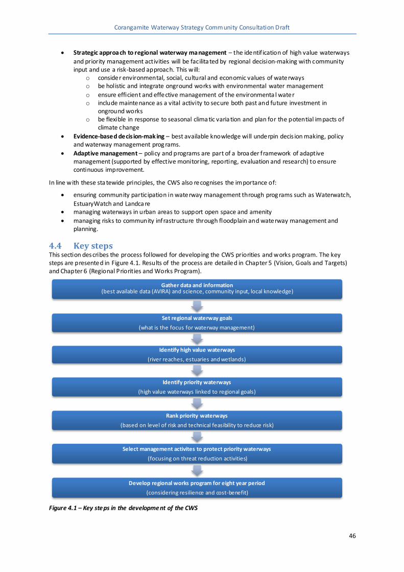
Corangamite Waterway Strategy Community Consultation Draft
46
Strategic approach to regional waterway management – the identif ication of high value waterways
and priority management activities will be facilita ted by regional decision-making with community input and use a risk-based approach. This will:
o consider environmental, social, cultural and economic values of waterways o be holistic and integrate onground works with environmental water management
o ensure efficient and effective management of the environmenta l water o include maintenance as a vital activity to secure both past and future investment in
onground works o be flexible in response to seasonal clima tic varia tion and plan for the potential impacts of
climate change
Evidence-based decis ion-mak ing – best available knowledge will underpin decis ion making, policy and waterway management prog rams.
Adaptive management – policy and programs are part of a broa der framework of adaptive management (supported by effective monitoring, reporting, evaluation and research) to ensure continuous improvement.
In line with these sta tewide principles, the CWS also recognises the importance of:
ensuring community participation in waterway management through prog rams such as Waterwatch,
EstuaryWatch and Landca re managing waterways in urban areas to support open space and amenity
managing risks to community infrastructure through floodplain and waterway management and planning.
4.4 Key steps This section describes the process followed for developing the CWS priorities and works program. The key steps are presented in Figure 4.1. Results of the process are detailed in Chapter 5 (Vision, Goals and Targets) and Chapter 6 (Regional Priorities and Works Program).
Figure 4.1 – Key steps in the development of the CWS
Gather data and information (best available data (AVIRA) and science, community input, local knowledge)
Set regional waterway goals
(what is the focus for waterway management)
Identify high value waterways
(river reaches, estuaries and wetlands)
Identify priority waterways
(high value waterways linked to regional goals)
Rank priority waterways
(based on level of risk and technical feasibility to reduce risk)
Select management activites to protect priority waterways
(focusing on threat reduction activities)
Develop regional works program for eight year period
(considering resilience and cost-benefit)

Corangamite Waterway Strategy Community Consultation Draft
47
4.4.1 Vision and regional goals To set broad directions for management and to identify priority waterways in the Corangamite region, a vision and high-level regiona l goals were developed. The goals needed to:
apply to a timeframe generally longer than 20 years
account for the environmental, cultural, socia l, and economic importance of wa terways
have conceptual or qua litative links to management outcomes link to the Cora ngamite RCS and VWMS
be region wide.
The regional goals are presented in Chapter 5.2 and guide the following steps in the priority setting process.
4.4.2 Identifying and ranking priority waterways Waterways within the Corangamite region provide a wide array of values to the community. These values contribute to why a waterway is considered a priority and include environmenta l, e.g. native fish, vegetation, economic, e.g. water supply, supporting agriculture and production, cultural, and socia l, e.g. recreation, aesthetics, values (Figure 4.2). There are also a number of threats which currently impact, and have further
potential to impact, on these values. Management actions will target these threats in order to protect, maintain or enhance the values of an asset.
Figure 4.2 – Types of waterways depending on the ir values, condition and typical use (source: DEPI, 2013)
While we would like to address the health of all waterways in the region, we don’t have the necessary resources (people, dollars, time) to complete such a task. Therefore, we have to find some way of allocating

Corangamite Waterway Strategy Community Consultation Draft
48
the available resources to the region’s highest priority waterways, i.e. those waterways with greater inherent ‘value’.
The key purpose of the CWS is to identify priority waterways for investment during the next eight years to
ensure the condition of these systems is maintained and enhanced. This will in turn secure the values they provide to the environment, the economy and the community into the future.
Assets Identifying and ranking priority waterways in the Corangamite region was informed by the Aquatic Value Identification and Risk Assessment (AVIRA) decision support tool. AVIRA is an asset inventory, which:
documents the environmental, social and economic values and threats associated with waterway
assets (river reaches, wetlands and estuaries) assesses risks to values to assist in the planning for wa terway management activities.
For the Corangamite region, 118 river reaches, 17 estua ries and 81 wetlands were assessed. To assess each waterway, data was required on more than 30 different types of values and up to 21 different threats. Much of the data was from the Index of Stream Condition (ISC) and Index of Wetland Condition (IWC). This data was considered the best and most comprehensive information available. In addition, some data was sought from
regional and local agencies and local knowledge was used where required. A comprehensive list of values and threats that were assessed for each waterway can be found in Appendix H.
One of the limitations of the AVIRA decision support tool is it can only assess waterways where a large amount of data exists. At this stage there is not an avenue to include waterways in the assessment process that do not
have this data. To address this limita tion the CWS recognises the importance of ongoing community participation in waterway management and aims to encourage continued action in both priority and other waterways as outlined in Section 3.2.1.
Landscape zones Waterways are presented in the CWS (Chapter 6) in landscape zones (refer to Figure 6.1). Landsca pe zones a re geographic units used for Corangamite CMA planning purposes. They were developed based on:
major waterway sub-ca tchments
bioregions
existing remnant vegetation existing and potential community capacity to implement on-ground works (i.e. Landcare group
bounda ries).
There are 15 landsca pe zones:
Lake Corangamite Basin - comprises the Lismore, Stony Rises and Woady Yaloak landscape zones Barwon Basin - comprises of the Leigh, Murdeduke, Upper Barwon, Mid Barwon and Bellarine
landscape zones Moorabool Basin - includes the Moorabool and Hovells landscape zones
Otway Coast Basin - includes the Curdies, Gellibrand, Aire, Otway Coast and Thompsons landscape
zones which drain into the Southern Ocean and Bass Strait east of Cape Otway.
Identifying high value waterways
Approach The VWMS states that waterways will be considered high value if they have one, or more, of the following
characteristics:
formally recognised significance
presence of highly threatened or rare species and communities high naturalness values (for example, aquatic invertebrate communities and riparian vegetation) or
special waterway features (for example, drought refuges and important bird habitat) high socia l, cultural and economic values (for example, recreationa l fishing, Aboriginal cultural
heritage, urban/rural water sources).
Corangamite Waterway Strategy Community Consultation Draft
49
For waterway assets in AVIRA, the above cha racteristics can be assessed using specific scoring rules as detailed in Appendix I. If a waterway meets one or more of these scoring rules, it is considered to be a high value waterway.
Results Using the scoring rules detailed in Appendix I:
116 of 118 river reaches in the Corangamite region were identified as high value waterways all 17 estuaries in the Corangamite region were identified as high value waterways
80 of 81 wetlands in the Corangamite region were identif ied as high value waterways.
For the full list of high value waterways refer to Appendix J.
Identifying priority waterways
Approach As outlined in Section 4.2.2, almost all waterways within the Corangamite region were identified as high value
waterways. In order to develop a realis tic e ight-year regional work program, this percentage must be reduced and prioritised.
The approach adopted was to identify which high value waterways were linked to the regional goals. This involved the identifica tion of relevant and/or a ttributa ble AVIRA values and determination of scoring cut-offs (or rules).
AVIRA rules for linking high value waterways to regional goals a re deta iled in Appendix K.
Results Using the AVIRA rules described in Appendix K, the 213 high value waterways were refined to 155 priority waterways. The following refinements were made:
river reaches - from 116 high value river reaches to 75 river reaches.
Estuaries - from 17 high value estua ries to 14 priority estuaries. Wetlands - from 80 high value wetlands to 65 priority wetlands.
These results are shown on Figure 4.3 and compared to the high value wa terways for the region. Priority waterways are deta iled f urther in each landscape zone description provided in Chapter 6.
Ranking priority waterways
Assessing Risks Within AVIRA, a risk assessment is undertaken for each of the 155 priority waterways. These risk assessments determine which threats need to be reduced, i.e. managed, in order to protect or enhance the values. It
considers how much inf luence a threat might have on any one value (association), how likely it is that it will have an impact, and the consequence of those impacts. All values are assessed against all threats, e.g. for each priority wetland, each one of 33 different values a re assessed against all 11 threats, resulting in 363 risk level assessments.
Considering technical feasibility The risks for specific values (values that link to the regional goals) were the focus for considering technical feasibility. These values will be targeted through the CWS and therefore the focus for the works program is to manage any threats to these values.
For each identified threa t, a ‘first cut’ of the technical feasibility (high, medium, low) of reducing each threat, i.e. implementing on-ground actions, was determined. This step a llowed us to focus on the threats known to have feasible solutions. Threats that had a ‘low’ association with a value were not assessed for feasibility. There is only a remote possibility that these threats will have an impact. Social and/or economic factors were
assessed later when developing the works prog ram.
An example output is shown in Appendix L.

Corangamite Waterway Strategy Community Consultation Draft
50
Figure 4.3 – High value and priority waterways in the Corangamite region
Calculating a priority waterway score This step enables waterways comparisons based on the potential for threats to impact the waterway (risk level) and how likely we a re to reduce this impact (feasibility). To calculate the score for a priority waterway, raw scores were calculated for each risk/feasibility combination as follows:
raw score = risk level x feasibility
where: risk level = 5–very high, 4-high, 3-moderate, 2-low, 1-very low
feasibility score = 3–high, 2–medium, 1–low
All raw scores for a waterway were then added and the total divided by the number of raw scores ca lculated. This produced a priority waterway score (ranging from 0 and 15).
Once priority waterway scores were calculated for each priority waterway, the wa terways could be ranked from highest score to lowest score. A higher score means that, theoretically, we would have a higher chance of benefiting from management actions (a nd gain a higher return on investment).
Priority waterway scores can be seen in Appendix M. The Corangamite CMA has chosen to include all priority waterways with feasible actions in the next stage (developing the works program), regardless of their ranking
scores, to ensure they can be considered for future funding and investment opportunities.

Corangamite Waterway Strategy Community Consultation Draft
51
Other waterways The Corangamite CMA recognises there a re a number of waterways in the region that were not identified as a priority wa terway under this s trategy but are of signif icant value to the local communities living nea r these waterways.
The VWMS provides direction for the management of these waterways, highlighting that in some cases,
management activities may be undertaken if:
they are a source of threats to other priority waterways, e.g. downstream priority waterways they provide important connectivity between priority waterways
there is a serious risk to public infrastructure from waterway processes or an opportunity to reduce
risks associated with extreme events, e.g. floods there is strong community commitment to improving the condition of their local waterway
work is required to meet statutory or regulatory obligations.
While these other wa terways are not receiving direct attention under the CWS, we will continue to support the local management of these waterways through other avenues such as La ndcare, Waterwatch and CMA extension, local catchment planning and assistance with exploring alterna tive funding . Further informa tion on these opportunities will be provided in each of the landscape zone descriptions (see Chapter 6).
4.4.3 Developing the works program
Selecting management activities Management activities are chosen based on informa tion from the risks assessments, i.e. which threats we need to act on to reduce impacts to a wa terway's values. A series of technical workshops were held with key CMA staff, to identify management activities that can address these threats. These were identified for all
priority wa terways and are planned for implementa tion over the eight-year period of the CWS.
Depending on the level of risk, management activities focused on either protecting the current environmental condition or reducing threats to improve condition over time.
Logic models were used to help se lect appropria te management activities, based on the best available knowledge. The models provide consistent, and as far as possible, evidence-based, assumptions on:
the re lationships between values and threats the management objectives to reduce the threats to values
the management activities available to achieve particular specified outcomes e.g. reducing threats to
values.
Developing the eight-year works program Based on the identified management activities, an eight -year works program was developed for each priority waterway. A summary of the works prog ram is presented in Chapter 6 and the full works program can be viewed in Appendix A of the CWS. The information is presented by landscape zone and includes:
Resource Condition Targets (RCT) – l inking the values that make a waterway a priority to the regional
goals the Management Outcome Targets required to achieve the RCTs (refer to Section 7.4)
the key waterway values that link to the regional goals
a summary of threats addressed through implementing the works program
details of the management activities to be undertaken (including quantities, lead and partner agencies/groups required to deliver the activities and specific threats addressed by the activities)
an overall cost estimate for an e ight-year work program budget including monitoring and
maintenance.
4.4.4 Process limitations Through the process of identifying and ranking priority waterways and developing the works prog ram for the Corangamite region under the statewide process, a number of limitations were identified:
Waterways assessed. The CWS has assessed over 216 individual wa terways, however there a re still many other waterways tha t could not be assessed. This was due to a lack of sufficient data to be able
to provide an assessment of wa terway condition, as well as limitations in the number of waterways

Corangamite Waterway Strategy Community Consultation Draft
52
that could feasibly be addressed through the strategy. The process relied solely on condition information available through the Index of Stream Condition (ISC) and Index of Wetland Condition (IWC) to provide this assessment and inform the priority setting process. At this stage there is not a
process available to include other smaller waterways for assessment. To a ddress this limitation the Corangamite CMA has actively sought information from the community on waterways of local importance during the strategy development, and encourages action on waterways that are not considered in the assessment process (refer to the landscape zone summaries in Chapter 6,). Addition of other waterways to the next iteration of ISC and IWC should also be considered for future
strategies. Index of Wetland Condition. Ramsar and DIWA (Directory of Important Wetlands in Australia) listed
wetlands a re assessed under IWC to give an overall indication of wetland condition in the region. However, there are a large number of other wetlands scattered throughout the region that are not assessed and are not factored into the overall IWC condition. Assessing these ‘other’ wetlands, which do not necessarily have the same high value as Ramsar and DIWA wetlands, could change the overall condition results. To address this in the short term, a number of wetlands that Corangamite CMA has
condition data for were included in the strategy (in addition to Ramsar and DIWA). It is recognised there a re signif icant knowledge gaps on the condition of wetlands overall, and research is required over the longer term to close these gaps and help direct future investments in wetland management.
Social va lues. The da ta within AVIRA considered a range of different types of social values (activities)
and these were scored accordingly. However, when using this data to set priorities a waterway needed to have multiple types of activities, and the data did not allow for a waterway to become a priority based on the number of users or visitors (regardless of their activities). For example, the
Yarrowee River through Ballarat services a major population centre and has high user numbers, but it meets only one of the four required values (or activities) and could not be considered a priority under the social goal. User or visitor numbers need to be included in the data and assessment process for future stra tegies to allow for a more comprehens ive assessment of socially important wa terways.
4.5 Program logic The prog ram logic provides the rationale for how the CWS will contribute to the regiona l goals and ultimately the vision for Victoria’s waterways, identified in the Victorian Wa terway Management Strategy and the Corangamite CMA region’s vision, identified in the Corangamite CMA Regional Catchment Strategy.
Vision for Victoria’s wate rways - “Victoria’s rivers, estuaries and wetlands are valued,
healthy and well-managed; supporting environmental, social, cultural and economic values that are able to be enjoyed by all communities” (DEPI, 2013)
Vision for the Corangamite region – “A healthy Corangamite ca tchment valued by engaged communities”
The simplif ied program logic for the CWS is illustrated in Figure 4.4. It describes how each year, specific
management activities (outputs) are delivered by regional agencies across the Corangamite region in order to achieve particula r management outcomes. Over the eight -year planning period, these outputs and outcomes, set as management outcome targets, collectively contribute to either maintaining or improving the environmental condition of wa terways (demonstrated by resource condition targets). In the long-term, this will ensure that the region’s goals can be met and wa terways can continue to support environmental, socia l,
cultural and economic values.

Corangamite Waterway Strategy Community Consultation Draft
53
Figure 4.4 – Simplified program logic for the Corangamite Waterway Strategy (Adapted from DEPI, 2013)
4.6 Consultation The Corangamite CMA recognises the knowledge, skills and expertise of the local community and the value of
their input in identifying issues and informing decis ions within the region. During the development of the CWS opportunities were taken to both inform and consult with the community and key agencies.
A project review group with CMA staff and board members was set up to oversee and provide advice on the development of the CWS, including the pre-draft consultation and public consultation planning.
General consultation There were numerous meetings and presentations with partners and agencies including local government, water corporations, Landca re networks and Committees of Management informing them of the development
of the CWS. In addition an information sheet was developed and distributed to inform people of the strategy's purpose and development. This information sheet was updated and redistributed as the s trategy progressed.
Data collected for AVIRA included consultation with key agencies to gain up to date datasets and input of local knowledge to cross-check the data. Data collation included a survey with more than 200 responses, to determine the region's flagship species.
The Corangamite RCS was endorsed in 2013 and involved an extensive consulta tion process with the regional community about the region’s goals and regionally important environmental assets including rivers, estua ries and wetlands. Information obtained through the RCS consultation process was used to develop regional goals, principles and relevant management activities for the region’s waterways.
Pre draft community sessions In 2013 and 2014 the Corangamite CMA invited the community to take part in some pre-draft community sessions across the catchment to identify the values, threats and aspirations people have for their local
waterways. These sessions were run in conjunction with the local Landcare networks in 10 separa te locations across the region. More than 200 community members attended the sessions. Information obtained from the sessions was used to cross-check AVIRA data (especially where major gaps were identified) and provide information for each landscape zone description (see Cha pter 6). The sessions also provided the Corangamite

Corangamite Waterway Strategy Community Consultation Draft
54
CMA with information on waterways that are important to loca l communities, but may not be a focus of the CWS works program.
Indigenous engagement Input was sought from three Aboriginal organisations (Wathua rong Aboriginal Corporation, Eastern Maar Aboriginal Corporation and Kuuyang Maar Aboriginal Corporation) to identify their aspirations for rivers,
estuaries and wetlands, on their country. Specifically:
the importa nce of waterways and any specific values to identify any individual waterways of particular significance and/or importance.
The Wathuarong Aboriginal Corpora tion was able to identify aspirations and opportunities for Indigenous people to be involved in waterway management and CWS delivery. This information is presented in
Section 3.2.


Corangamite Waterway Strategy Community Consultation Draft
56
5 Vision, regional goals and targets
5.1 Vision The purpose of the Corangamite Waterway Strategy (CWS) is to deliver the aspirations a nd objectives for Victoria’s waterways, identif ied in the Victorian Waterway Management Strategy (VWMS) and the Corangamite CMA region’s vision, identified in the Corangamite CMA Regional Catchment Strategy (RCS).
Vision for Victoria’s wate rways - “Victoria’s rivers, estuaries and wetlands are valued, healthy and well-managed; supporting environmental, social, cultural and economic values
that are able to be enjoyed by all communities” (DEPI, 2013)
Vision for the Corangamite region – “A healthy Corangamite catchment valued by engaged communities”
These visions have been used to guide the CWS and therefore the regional goals.
5.2 Regional goals The goals for the CWS are aspirational and apply to a 20+ year timeframe, they ref lect the VWMS approach and are consistent with the intent of the Corangamite RCS. The goals are presente d in Table 5.1.
The goals are based on the objectives detailed in the Corangamite RCS for:
rivers, estuaries and f loodplains
wetlands.
Other Corangamite RCS objectives associated with categories such as native vegetation and threatened flora and fauna are a lso likely to benefit from actions under the CWS, however it is not proposed to directly target these goals within the CWS.
The CWS will also deliver on the Corangamite RCS’ Foundations for Change, with a specific focus on increasing
the breadth a nd depth of participation through mechanisms such as joint action and community monitoring programs. This is also likely to incorporate actions around the engagement of indigenous communities in the planning and management of the region’s waterways (see Section 3.2).
5.3 Targets
5.3.1 Resource condition targets Resource condition targets were developed based on the prog ram logic structure (see Section 4.5). They predict the change expected in the values aimed to be protected, maintained or improved through the CWS
works program. They align to the CWS goals and, given that cha nge in environmental condition occurs over a long period of time, they have been set for a timeframe of greater than eight years (see Table 5.1).
In developing the RCTs they were linked to either the values in AVIRA or condition assessments in the various indices, i.e. Index of Wetland Condition, Index of Stream Condition, Index of Estuary Condition. In some
instances the AVIRA data did not provide a good basis for target setting, e.g. threatened species or other values with a presence or absence rating. Where RCTs were set for pa rticular species, they were based on long term objectives from an exis ting action statement for that species or other s imilar basis.
In response to a review of 2006-2011 River Health Strategy and backed by advice from the expert scientific panel who worked with DEPI on the VWMS, it was determined that it is not practical to quantitatively measure
these types of targets within the timeframes proposed. This is on the basis tha t the information and current knowledge required to accurately report on waterway condition is only likely to be sufficient to support general, descriptive (qualitative) predictions about the directional changes in condition, e.g. declining, maintaining or improving.

Corangamite Waterway Strategy Community Consultation Draft
57
Table 5.1 – Goals and resource condition targets for the CWS Ref Regional Goals Resource Condition Targets
S1 Maintain or improve waterway
condition where it supports high social and community values.
1. High value social attributes of waterways are maintained.
EC1 Secure and manage waterways that provide significant economic benefits to the region.
2. Waterways within special water supply catchments are managed to provide quality water for urban water supplies.
3. Waterways that support licensed diversions for irrigated agriculture are man aged to protect the quality and viability of the resource.
ENV1 Maintain the viability of populations of threatened native fish species
4. Known populations and habitat of Australian mudfish are protected and enhanced.
5. The condition of sites where Yarra pigmy p erch currently occur show no further decline.
6. The probability that important dwarf galaxias populations become self-sustaining is increased.
7. The probability that important Australian grayling populations become self-sustaining is increased.
ENV2 Maintain or improve the resilience of other threatened waterway dependent species
8. Known habitat and breeding sites for populations of threatened wetland dependent bird species are secured from further environmental degradation.
9. All extant populations of the Corangamite water skink are maintained in systems of reserves and/or areas managed specifically for their conservation.
10. Populations of growling grass frog are secured, particularly those occurring in known breeding habitats.
11. All extant populations of Otway crayfish are secured.
ENV3 Secure and manage water for the environment to improve waterway condition.
12. Environmental water entitlements for priority waterways are managed to maximise environmental outcomes.
ENV4 Maintain or improve waterways
with formally recognised significance.
13. The ecological character of Ramsar wetlands is maintained or improved.
14. The condition of values of nationally important wetlands are maintained or improved.
15. The listed values of heritage rivers are maintained or improved.
ENV5 Maintain the extent and
condition of other significant wetlands (by type).
16. The condition of wetlands supporting the plains grassy wetland EVC is maintained or improved.
ENV6 Protect waterways in near natural condition.
17. All environmental values of near natural rivers and estuaries are protected.

Corangamite Waterway Strategy Community Consultation Draft
58
5.3.2 Management outcome targets Management outcomes a re the expected and measurable changes over an eight-year works period in response to specific threats to priority waterways. These changes are the result of implementing the required management activities identified in the works program.
Management outcome targets have been set for all threats identified in the s trategy, except water quality
which has been excluded as we would not expect to see measurable change within the eight-year CWS timeframe.
These targets are presented in the regional works program (see appendix A), and as recommended through the review of the Corangamite River Heath Strategy, will be the basis for measuring success of the CWS.
It should be noted that the rollout of management activities will occur over the eight-year implementation
period of the strategy and therefore some management outcomes, those that occur later in the eight -year implementa tion phase, may not be measurable when the s trategy is reviewed.