co‐opting conservation: migrant resource control...
TRANSCRIPT
Co-opting Conservation: Migrant Resource Control
and Access to National Park Management in the
Philippine Uplands
Wolfram H. Dressler
ABSTRACT
The history of political and economic inequality in forest villages can shape
how and why resource use conflicts arise during the evolution of national
parks management. In the Philippine uplands, indigenous peoples and
migrant settlers co-exist, compete over land and forest resources, and shape
how managers preserve forests through national parks. This article examines
how migrants have claimed lands and changed production and exchange
relations among the indigenous Tagbanua to build on and benefit from
otherwise coercive park management on Palawan Island, the Philippines.
Migrant control over productive resources has influenced who, within each
group, could sustain agriculture in the face of the state’s dominant conserva-
tion narrative — valorizing migrant paddy rice and criminalizing Tagbanua
swiddens. Upon settling, migrant farmers used new political and economic
strengths to tap into provincial political networks in order to be hired at a
national park. As a result, they were able to steer management to support
paddy rice at the expense of swidden cultivation. While state conservation
policy shapes how national parks impact upon local resource access and use,
older political economic inequalities in forest villages build on such policies to
influence how management affects the livelihoods of poor households.
INTRODUCTION
The Philippine uplands are contested spaces. Colonial policies andideologies carried over from Spanish and American rule (1521–1946)produced dichotomies that shaped who could access and use upland forests.Often perceived as marginal zones, the uplands were occupied by ‘peopleclassified as ethnic minorities to those groups that define national cultureand imagination’ — the Christian lowland majority (Vandergeest, 2003: 19).
This research was made possible through an IDRC Doctoral Fellowship, CIDA Treelink
Grant, and the FQRSC grant of Dr Thomas Meredith. The author is indebted to two
anonymous reviewers for offering critical insights on local level politics in the Philippines.
The author thanks Christian Abizaid, Christian Lund, Melanie McDermott and Fiona Wilson
for comments on earlier drafts of the text.
Development and Change 37(2): 401–426 (2006). # Institute of Social Studies 2006.Published by Blackwell Publishing, 9600 Garsington Road, Oxford OX4 2DQ, UK and350 Main St., Malden, MA 02148, USA
Colonial institutions simplified an otherwise complex society into ‘uplander’and ‘lowlander’ peoples according to ethnic lines, agricultural practices andelevation. Land titles and legitimacy were reserved for Filipino lowlanderswho cultivated ‘productive’ agriculture, while ‘tribal’ uplanders were illegi-timate farmers who cultivated ‘primitive’ agriculture without title. Stateforesters found such divisions useful: by expanding territory up-land, theycould protect forests from uplanders by legally framing occupied areas asvaluable political economic domain (Peluso and Vandergeest, 2001: 762–3).The Philippine state thus confined uplanders and defined their agriculture
through ideology and physical boundaries; state officials expressed powerthrough ‘boundaries that could move, shape, or reorganize human beings atlarge scales’ (Sack, 1983: 87). Boundaries formed and partitioned territory toassign value and meaning onto the uplands in order to regulate how residentscould use forests there (Goldman, 2003). From the outset, colonial constructsof identity and resource uses in physical spaces took shape as ‘political forests’,perhaps the largest of which evolved as national parks (Peluso andVandergeest, 2001: 762). Different state agencies at different levels maintainednational parks by reinforcing exclusion, that is, communicating the physicalexistence and meaning of boundaries to upland residents. This was donecoercively through zones that reasserted control over the values placed onforests inside national parks — a process that upheld, reproduced and pro-jected state ideologies (Sack, 1983). The state’s use of national parks as ‘new’territory extended its reach to control resource access and use in the uplands.Underlying park expansion, however, is the more tangible reality of how
social relations of production and exchange unfold as lowlanders and uplanderscompete over forest resources. In many cases, national parks expand stateterritory upland to protect resources as lowland migrants co-mingle and com-pete with indigenous peoples over forests on ancestral lands. While lowlandmigrants move upland due to displacement or in search of new resources, theydispossess and marginalize their indigenous ‘hosts’, as national parks overlapwith older resource use conflicts (Cruz et al., 1992;Hirtz, 1998). Local disparitiesare often exacerbated as park management ensures a productive advantage forthe migrant majority by denying the indigenous minority access to land andforest resources. Minority peoples negotiate similar situations throughoutSoutheast Asia (cf. Evrard and Goudineau, 2004; Li, 2002).While many studies have explored migrant–indigenous relations (for
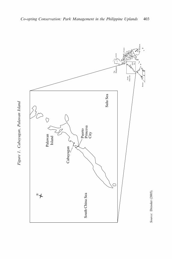
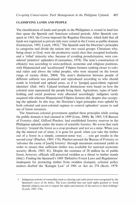
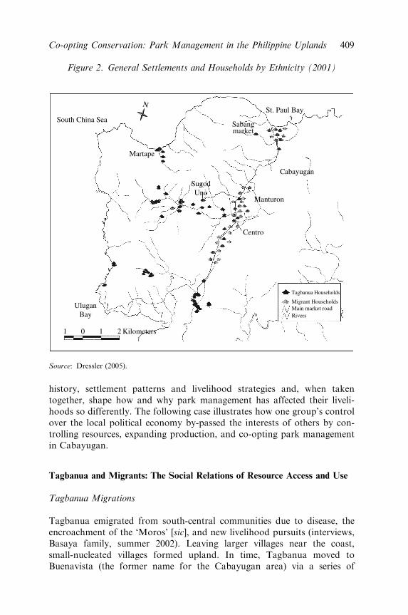
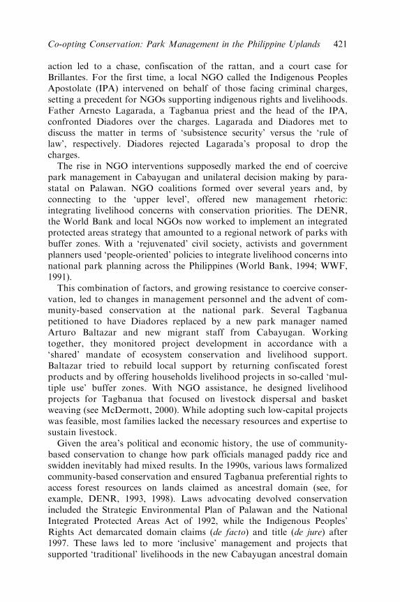
example, Conelly, 1983; Eder, 1987; McDermott, 2000), particularly in termsof occupation and displacement, few offer a detailed genealogy of how eachgroup’s use of upland resources intersects to shape conservation. Even fewerstudies have considered the inverse of this relationship. This article attempts tofill this void by examining how early park management — characterized bycoercive conservation that excludes people — has shaped settlement patterns,resource production, and commodity exchanges between social groups onPalawan Island, the Philippines (Peluso, 1993) (see Figure 1). Migrants fromover-populated, resource scarce islands have settled in the uplands of Palawan
402 Wolfram H. Dressler
Figure
1.Cabayugan,PalawanIsland
N
Pala
wan
Is
land Pu
erto
Pr
ince
saC
ity
Cab
ayug
an
The
Ph
ilipp
ines
Bor
neo
Sout
hC
hina
Sea
Sulu
Se
a
#
Vis
ayas
#
Luz
on
Min
dana
o
Sulu
Sea
Sout
h C
hina
Sea
Source:
Dressler(2005).
Co-opting Conservation: Park Management in the Philippine Uplands 403
and now compete with indigenous peoples over forest resources that nationalparks conserve (cf. Pelzer, 1948; Spencer, 1966). The socio-political dynamicsbetween migrants and indigenous peoples adds a new layer of control that tiesinto and arises from coercive conservation.Following an ethnographic approach, this article explores the dialectical
relations between state conservation interests, the local political economyand changes in national park management.1 It shows how the co-evolutionof early conservation ideology and local resource production and exchangehas shaped the management outcomes at Puerto Princesa SubterraneanRiver National Park, Palawan’s flagship protected area. Oral historiesfrom migrant farmers and the indigenous Tagbanua are used to reconstructhow settlement and trade relations shaped park management in the studysite of Cabayugan, Palawan. The article will describe how changing liveli-hoods strategies have tied into management efforts to deflect enforcementaway from paddy rice (basakan) and toward swidden cultivation (kaingin).2
Three questions frame how this sequence unfolded. (1) What broaderpolitical economic conditions drive state preferences for agriculture fromdifferent social groups? (2) How does the political economy ofconservation affect migration and trade among settlers and indigenouspeoples on Palawan? (3) How are the patterns of production and exchangebetween each social group affected by local–state linkages and shifts innational park management?This article answers these questions by first describing how American
and Philippine forestry laws and policy criminalized swidden throughcentralized and coercive parks management. It then introduces the casestudy area, and describes Tagbanua and migrant settlement periods. Thesesections trace how social and economic differences evolved between the twogroups by contrasting social relations of production and exchange before,during and after their migration periods. The following section then examineshow the history of settler migration enabled wealthier migrants to build onand use coercive conservation to support paddy rice by criminalizing theswiddens of Tagbanua and poorer migrants. The article concludes thatmanagers must reconsider their perceptions and management of livelihoodsif ‘devolved’ conservation is to reduce disparities among resource dependentpeoples.
1. Research was conducted from 2001 to 2004. Methods included a livelihood questionnaire
(N ¼ 157), key-informant interviews, and archival work at various institutions. Data were
cross-validated. Pseudonyms are used throughout.
2. Swidden involves a rotational cycle in which forest is cleared, burned and planted with dry
rice, root crops and vegetables. After harvest, fields are often left fallow for several years
to allow forest cover to regenerate. Swidden supports the subsistence, religion and
cosmology of many indigenous peoples throughout Southeast Asia.
404 Wolfram H. Dressler
CLASSIFYING LANDS AND PEOPLE
The classification of lands and people in the Philippines is rooted in land lawthat spans the Spanish and American colonial periods. After Spanish con-quest in 1565, the Crown imposed the Regalian Doctrine, which held that alllands not registered as private title were vested in the Crown as public domain(Gatmaytan, 1992; Lynch, 1982).3 The Spanish used the Doctrine’s principlesto categorize and divide the nation into two social groups: Christians who,being closer to God, were the productive social class that occupied lowlands;and a ‘tribal’ minority who, because of avoiding proselytization, were con-sidered ‘primitive’ uplanders (Constantino, 1978). The state’s construction ofethnicity was according to socio-political, economic and religious positions,with Hispanicized and ‘acculturated’ Filipino farmers ranking closer to colo-nial rulers and above the tribal peoples, who were situated on the lowestrungs of society (Eder, 2004). The state’s distinction between people ofdifferent cultures was produced and reproduced according to who shouldreside in lowland and upland areas, as if to ‘[assign] quasi-ethnic regionalidentities’ (ibid.: 641). Upland–lowland distinctions were based on how thecolonial state represented the people living there. Agriculture, types of land-holding and social positions were allocated accordingly: indigenes rarelyacquired title whereas Hispanicized Filipino farmers did, despite also occupy-ing the uplands. In this way, the Doctrine’s legal principles were upheld byboth colonial and post-colonial regimes to control uplanders’ access to anduse of forest resources.
The American colonial government applied these principles while zoningthe public domain it had claimed in 1899 (Linn, 2000). By 1903, US Bureauof Forestry chief, Gifford Pinchot, had established forestry reserves in thePhilippine uplands under the tenets of scientific forestry. He wrote that suchforestry: ‘treated the forest as a crop producer and not as a mine. When youdig the mineral out of mine, it is gone for good; when you take the timberout of a forest in a simple, common-sense way . . . you get results in thesecond crop’ (Pinchot, 1903: 176). Pinchot pressed the Bureau of Forestry to‘advance the cause of [such] forestry’ through maximum sustained yields inorder to ensure that sufficient timber was available for national economicsecurity (Roth, 1983: 41). Despite the existence of 20 million ha of publicforest, however, officials still perceived swidden as a threat to timber stands(ibid.). Finding the Spaniard’s 1889 ‘Definitive Forest Laws and Regulations’inadequate for protecting timber from swidden (kaingin), colonial policymakers drafted the ‘Kaingin Law’ of 1901 or Act no 274 (Scott, 1979:
3. Indigenous notions of ownership (such as clearing and cultivation) were recognized by the
Spaniard’s Laws of the Indies. The Laws clarified that any land rights granted to ‘loyal
Spanish subjects was not to impair the rights and interests of the natives to their holdings’
(Lynch, 1982: 274).
Co-opting Conservation: Park Management in the Philippine Uplands 405
59–60). The law included stiffer fines and prison sentences, but did little todeter ‘illegal’ swidden cultivation.The colonial regime clung tenaciously to defending upland forests from
swidden cultivators through an agenda of resource territorialization. From1903 to 1944, the policies regulating swidden also applied to forestryreserves being rezoned as national parks (Anderson, 1983). Initial endea-vours to classify public lands as ‘national parks’ came in 1932 under the Actfor the Establishment of National Parks. Upland areas could now be‘reserved and withdraw[n] from settlement, occupancy, or disposal [fortheir] panoramic, historical, scientific or aesthetic values’ (National ParksAct No 3915, 1932: 2). This meant that farmers without private title priorto boundary delineation, including entire indigenous populations, couldno longer legally occupy the uplands (Gatmaytan, 1992). American-style‘fences and fines’ park management was now firmly entrenched in thePhilippines.Upon independence in 1946, managers tried eradicating swidden farming
on 86,692 ha of public domain that was now designated as either forestreserve or national park. As the Philippine government was zoning nationalparks it secured further control over kaingineros4 by drafting a RevisedKaingin Law in 1963 (Scott, 1979). Two years later, a ‘Kaingin CouncilMeeting’ and ‘National Conference on the Kaingin Problem’ suggested thatswidden farmers be identified, managed and/or resettled. Additional enfor-cements were also recommended as ‘the rate of forest destruction by kain-gineros outpaced the number of forest guards available for forest protection’(Population Center Foundation, 1980: 11). While such policy rhetoricechoed earlier conservation discourse, claiming that swidden ‘destroyed’state timber reserves and forest aesthetics, meetings concluded that illegaloccupancy and expanding swidden involved more than enforcement.Containing swidden required new insights into the social and economicaspirations of upland farmers.By 1972, the government had delineated thirty-five national parks
totalling 121,586 ha. Few parks, however, had enabling legislation andinfrastructure (Anderson, 1983). In 1975, Marcos’s Presidential Decree705 (Republic of the Philippines, 1975) regulated swidden through nationalparks by reclassifying the management and use of public forests. Nationalparks became a distinct category of forest reserve from which ‘occupants’could be evicted (NRMC and MNR, 1983: 9). The Forest OccupancyManagement Programme, for example, implemented the anti-swiddenpolicies of Presidential Decree 705 by moving ‘squatters’ to ‘other areasdesignated for resettlement and relocation purposes’ (Population CenterFoundation, 1980: 44). Failing this, the programme set out to ‘manageoccupancy’ or ‘settlement’ through permanent agriculture and land leases
4. The term kaingineros is used in a pejorative sense to describe swidden cultivators.
406 Wolfram H. Dressler
such as paddy rice farming on fixed plots. Managers offered de facto tenure tokainginero families in order to appease their distaste for punitive measures anddesire for secure tenure, and to convert them into sedentary agriculturalists.So-called ‘qualified forest occupants’ could only remain on unclassified publiclands on the condition they permanently reforest and/or intercrop their fields(Population Center Foundation, 1980: 45). Various other ‘social forestry’policies now offered twenty-five year leases to farmland under the expectationthat swidden would eventually be ‘phased out’ (Gatmaytan, 1992).
The Philippine Constitution of 1987 and land use laws further incorpor-ated the Doctrine’s principle by classifying all land over an 18 per cent slopeas public domain. State agencies had full control over upland forests, andthose inhabiting them were still defined as squatters (Gatmaytan, 1992).Below a slope of 18 per cent, the state prioritized the release of lands fromthe public domain as ‘alienable and disposable’ to allow individuals to applyfor private title and/or hold usufruct plots. Lowlanders occupying suchlands could apply for private title to the plots, and upon securing owner-ship, could defend their title and agriculture against park management. Newland laws and geography thus sustained an upland–lowland divide accord-ing to the state’s political and economic preferences.
PALAWAN AND THE CABAYUGAN CASE STUDY
How, then, did state interventions affect the ability of migrants and indi-genous peoples to access and use resources and how did their livelihoodstrategies affect conservation on Palawan? This section focuses on twosocial groups living near Puerto Princesa Subterranean River NationalPark to illustrate how broader political economic conditions affected theinterplay between livelihood changes and shifts in national park manage-ment. The case is unique for several reasons. First, the park is one of few inthe Philippines experiencing sustained and rigorous enforcement. It is notjust another ‘paper park’. Since the 1970s, the national park has been thesubject of infrastructure and management plans that steered enforcementaccording to social hierarchies and land use ideals. Second, the park repre-sents a flagship protected area as it conserves large tracts of forest onPalawan, the last ‘ecological frontier’ in the Philippines. Various groupsnow stake a claim over resources in the national park: conservationists tryto preserve forests, indigenous peoples claim ancestral rights to uplandareas, and, increasingly, migrants seek political and economic opportunities.
The contiguous tracts of ‘primary’ rainforest and the high levels ofendemism for which Palawan is famous are protected by Puerto PrincesaSubterranean River National Park (Diamond and Gilpin, 1983; Ma Dulid,1998). The park protects one of the largest and most diverse blocks offorests on the island: lowland dipterocarp and molave forests connectwith dense karst and montane forests at higher elevations (Ganapin Jr.,
Co-opting Conservation: Park Management in the Philippine Uplands 407
1992).5 Lowland forests were cleared by indigenous Tagbanua and bymigrants for swidden, paddy rice cultivation and tree crops, while por-tions of the molave forest (such as Pterocarpus indicus) were felled byillegal loggers (Eder and Fernandez, 1996; Kummer, 1992). Clearingsand burns created an anthropogenic mosaic of differently aged forestsand species, making foresters’ claims of conserving old growth somewhatdubious: the forests were far from pristine.Indigenous to Palawan, Tagbanua are swidden cultivators who engage
in a mixed economy (Fox, 1954; McDermott, 2000; Warner, 1979).Numbering over 500 in Cabayugan, they are Catholic and animist, aresimilar to lowland Filipinos, but are educated to comparatively low levels.6
Tagbanua cultivate swidden to produce upland rice, root crops, vegetablesand sometimes tree crops. Swidden harvests, however, are insufficient tomeet year-round subsistence and familial needs, forcing farmers to seek cashor payment in kind. Cash income comes from wage labour, timber harvest-ing and collecting non-timber forest products,7 particularly rattan andhoney (cf. McDermott, 2000).8 Swidden farming and forest extractionoccurs on ancestral lands that now flank the national park.Cabayugan includes Sugod Uno, Cabayugan Centro and Manturon.
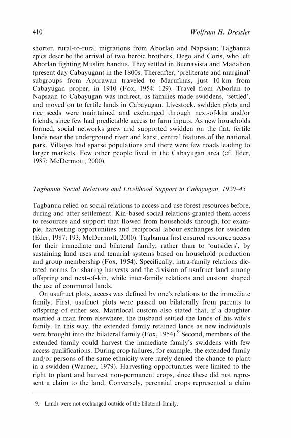
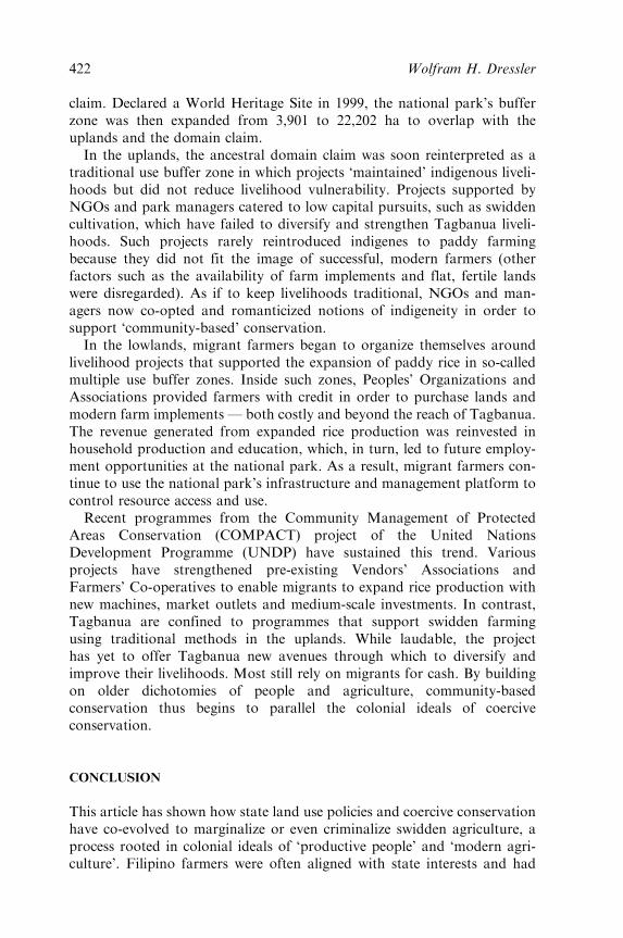
Although Cabayugan’s population is heterogeneous, with intermarriageand in-migration increasing rapidly, settlement patterns and resource usesare still differentiated along ethnic lines and elevation. In 2001, mostmigrant households occupied and cultivated paddy rice in the flat centralvalley of Manturon (fifty-three households) and Cabayugan Centro (thirty-one households); see Figure 2. Using modern farm implements such as handtractors, farmers have raised productivity from one to three croppings peryear and produce a rice surplus annually. Surplus rice is transported fromManturon to Puerto Princesa City, the provincial capital, for sale in largermarkets. Fewer and mostly poorer migrant households (twenty-nine house-holds) were located in Sugod Uno. In contrast, all Tagbanua households(forty-four households) occupy the undulating uplands of Sugod Uno(literally Upland 1) where steep slopes and clay soils make even swiddenfarming difficult. Tagbanua access to flat lands and productive resourcesremains limited due to migrants claiming low-lying areas for paddy rice.While identity and economic status are clearly not fixed, migrant and
Tagbanua socio-political structures, cultures and economic positions dodiffer considerably. Such differences are rooted in each group’s migration
5. Penetrating the main karst mountains is the (7 km long) navigable underground river.
6. Based on a 157 household questionnaire conducted during the summer of 2002.
7. Tagbanua have traded non-timber forest products with merchants from China and the
Muslim south for centuries (Hutterer, 1977).
8. Rattans are climbing palms (mostly Calamus spp.) from which cane products are derived.
Honey, wild pig, avifauna, wild fruits and orchids are also sold for cash, as well as
collected for subsistence, medicinal, and ceremonial purposes (McDermott, 1994, 2000).
408 Wolfram H. Dressler
history, settlement patterns and livelihood strategies and, when takentogether, shape how and why park management has affected their liveli-hoods so differently. The following case illustrates how one group’s controlover the local political economy by-passed the interests of others by con-trolling resources, expanding production, and co-opting park managementin Cabayugan.
Tagbanua and Migrants: The Social Relations of Resource Access and Use
Tagbanua Migrations
Tagbanua emigrated from south-central communities due to disease, theencroachment of the ‘Moros’ [sic], and new livelihood pursuits (interviews,Basaya family, summer 2002). Leaving larger villages near the coast,small-nucleated villages formed upland. In time, Tagbanua moved toBuenavista (the former name for the Cabayugan area) via a series of
Figure 2. General Settlements and Households by Ethnicity (2001)
South China Sea
Martape
SugodUno
St. Paul Bay
Cabayugan
Manturon
Centro
Tagbanua Households
Migrant HouseholdsMain market roadRivers
UluganBay
1 2 Kilometers0 1
Sabangmarket
N
Source: Dressler (2005).
Co-opting Conservation: Park Management in the Philippine Uplands 409
shorter, rural-to-rural migrations from Aborlan and Napsaan; Tagbanuaepics describe the arrival of two heroic brothers, Dego and Coris, who leftAborlan fighting Muslim bandits. They settled in Buenavista and Madahon(present day Cabayugan) in the 1800s. Thereafter, ‘preliterate and marginal’subgroups from Apurawan traveled to Marufinas, just 10 km fromCabayugan proper, in 1910 (Fox, 1954: 129). Travel from Aborlan toNapsaan to Cabayugan was indirect, as families made swiddens, ‘settled’,and moved on to fertile lands in Cabayugan. Livestock, swidden plots andrice seeds were maintained and exchanged through next-of-kin and/orfriends, since few had predictable access to farm inputs. As new householdsformed, social networks grew and supported swidden on the flat, fertilelands near the underground river and karst, central features of the nationalpark. Villages had sparse populations and there were few roads leading tolarger markets. Few other people lived in the Cabayugan area (cf. Eder,1987; McDermott, 2000).
Tagbanua Social Relations and Livelihood Support in Cabayugan, 1920–45
Tagbanua relied on social relations to access and use forest resources before,during and after settlement. Kin-based social relations granted them accessto resources and support that flowed from households through, for exam-ple, harvesting opportunities and reciprocal labour exchanges for swidden(Eder, 1987: 193; McDermott, 2000). Tagbanua first ensured resource accessfor their immediate and bilateral family, rather than to ‘outsiders’, bysustaining land uses and tenurial systems based on household productionand group membership (Fox, 1954). Specifically, intra-family relations dic-tated norms for sharing harvests and the division of usufruct land amongoffspring and next-of-kin, while inter-family relations and custom shapedthe use of communal lands.On usufruct plots, access was defined by one’s relations to the immediate
family. First, usufruct plots were passed on bilaterally from parents tooffspring of either sex. Matrilocal custom also stated that, if a daughtermarried a man from elsewhere, the husband settled the lands of his wife’sfamily. In this way, the extended family retained lands as new individualswere brought into the bilateral family (Fox, 1954).9 Second, members of theextended family could harvest the immediate family’s swiddens with fewaccess qualifications. During crop failures, for example, the extended familyand/or persons of the same ethnicity were rarely denied the chance to plantin a swidden (Warner, 1979). Harvesting opportunities were limited to theright to plant and harvest non-permanent crops, since these did not repre-sent a claim to the land. Conversely, perennial crops represented a claim
9. Lands were not exchanged outside of the bilateral family.
410 Wolfram H. Dressler
since they were permanent and ‘held’ land. Crop varieties and labourexpenditures thus represented a claim to land that attenuated over time(McDermott, 2000). Third, reciprocal labour exchanges involved familymembers taking turns assisting each other to clear and cultivate theirswiddens. Farmers who assisted in tending a swidden expected assistancefrom the owner at a later date, reciprocity which speeded up work anddistributed rice harvests. Requests for assistance were seldom denied (cf.Warner, 1979; McDermott, 2000).
On common lands, Tagbanua shared hunting areas, bodies of water anduncultivated forests. Generally, only individuals of the same ethnicity couldaccess and use the commons, while ‘outsiders’ were often excluded (Warner,1979). However, qualifying for access to resources was not absolute; rules,norms and identities were fluid. Defending usufruct plots and communallands became more difficult upon the arrival of migrants in the 1950s.
Two Waves of Migrants: Altering Social Relations from the 1950s
When compared to other Philippine islands, Palawan of the 1950s was arelatively peaceful and undeveloped forest frontier (Kerkvliet, 1977). Thefirst wave of settlers came to Palawan to escape an exhausted resource base,land shortages and civil unrest in their home provinces; others migrated dueto state incentives.10 Migrant pioneers were Christian; they typically tra-veled on their own initiative, and followed indirect routes before settling inCabayugan. Using money earned elsewhere, many settled in peri-urbansites, such as Santa Lourdes and Sicsican, with few farm implements andno support from next-of-kin. They worked a variety of jobs, includingfishing, bricklaying and teaching. In time, however, those living inSicsican and Santa Lourdes established political ties with prominentmigrants living near Cabayugan.
The first migrant to arrive in the Cabayugan area, in 1951, was PedrosAlvarado, a retired military official. His military background and wealthwere the key to political networks that supported his appointment asBarangay Captain, displacing the first and last Tagbanua to hold thispost. As Captain, Alvarado persuaded the families in Sicsican and SantaLourdes to transfer to Cabayugan Centro by offering them land and farmimplements. They quickly saw the advantages of claiming the flat, fertilelands of the central valley for paddy rice farming; few considered thatTagbanua had already claimed these lands. Forests were cleared in a ‘free-for-all’ manner; the more farmers cleared, the more they could claim.
10. Based on author’s questionnaire (N ¼ 157), Cabayugan, summer 2002. For an overview
of the resettlement process to Palawan, and particularly resettlements related to NARRA
(the National Resettlement and Rehabilitation Administration project) in 1954, see Lopez
(1987).
Co-opting Conservation: Park Management in the Philippine Uplands 411
Although the ‘official’ release of lands was pending, farmers staked theirclaim by maintaining clearings and cultivating flat fields for swidden andthen paddy rice. As one migrant elder explained:
That is why I came here, because we heard that Palawan still had vast uncultivated lands. We
were two who ventured here, my brother and I. It was true. When we arrived here, the part
of the forest you clean, it’s yours — nobody can get it. The Barangay Captain here before is
already old now, he is Mr Pedros Alvarado. He told us, ‘you can make your kaingin
(swidden), if it’s already clean, that will be yours’. It was true. (Interview, Eduardo
Castillo, Cabayugan Centro, summer 2002)
The second wave of migrants to settle consisted of the relatives of pioneermigrants. They left Luzon between 1960 and 1968 to settle among family inSicsican and Cabayugan who informed them (by letter or word-of-mouth)that Palawan had abundant lands and fishing grounds to exploit. Relativessupported new arrivals by offering them small loans and/or lands to share-crop or cultivate. Farmers banded together to petition Alvarado for therelease of 378 ha of public domain (as ‘alienable and disposable’) inCabayugan Centro.11 New farmers relied on social and political networks,often based on family names and personal relations (such as gratitude, utangng loob), to cultivate their lands and secure farm assets. Harnessing suchnetworks allowed them to access land and capital in order to supportagricultural productivity. Frequent reinvestments of political authorityand wealth into local institutions further shaped who could access and useforest resources, land and productive capital.
The Growth of Commodity Relations in the 1960s and 1970s
During the late 1960s, commodity relations and new interventionssharpened social and economic differentiation within and between house-holds in each social group.12 Increasingly, state support of migrant paddyfarming and the farmers’ socio-political assertiveness enabled them tocontrol private title, wage labour and trade relations. Migrant land holdingsand paddy rice were no longer just cleared and cultivated through reciprocallabour exchanges. Having once taught migrants how to hunt and farm
11. The lands were officially released under LC Map No 2598, Project 1-T, certified in July
1966.
12. According to Bernstein (1979), commoditization arises from the ‘penetration’ of new
capital and market relations, and serves as the catalyst for processes that lead to differ-
entiation. This process arises during the commercial exchange of goods where something
that had a ‘use value’ acquires an ‘exchange value’ (McDermott, 2000). Differentiation
refers to the ‘process of change in the ways in which different groups in rural society . . .
gain access to the products of their own or others’ labour, based on their differential
control over production resources and often . . . on increasing inequalities in access to
land’ (White, 1989: 20).
412 Wolfram H. Dressler
swiddens, Tagbanua now produced goods for migrant-owned markets andtended their paddy fields.
The multiple processes leading up to differentiation unfolded gradually —despite the activities of foresters and surveyors that exacerbated localdisparities. Upon settling, both Tagbanua and migrant livelihoods involvedlow capital, income-yielding activities such as rattan and swidden harvest-ing. Few investments were required to harvest rattan, making it an easilyattainable, though modest source of cash income. Rattan sales oftensupported household incomes when rice yields were insufficient. Whileboth migrant and Tagbanua cultivated swiddens, most migrants consideredswidden as an initial livelihood coping strategy. Many abandoned theirswidden fields after overcoming the ‘establishment costs’ of paddy farming(Connelly, 1983).
Migrant farmers continued to expand paddy rice by carving up flatsections of the forest commons. They often acquired lands in exchange forsundries or small amounts of cash; at other times they grabbed landsdirectly while share-cropping with Tagbanua. One strategy involvedmigrants planting tree crops to ‘hold’ and convert lands into paddy fields.Sustaining such claims involved hiring Tagbanua to uproot trees for deeperand wider ploughing in order to enhance rice yields. After cultivating lands,migrants could pay land taxes and receive a ‘tax certificate’ as a de factoclaim of ownership.13 Provincial foresters saw few problems with suchlandholdings because they supported ‘permanent’ settlement and paddyrice cultivation — further evidence of migrants aligning with state agencies.Such policies, however, only reinforced the uplander–lowlander dichotomy.
By this time, migrant social networks and ownership regulated access toand use of productive resources among Tagbanua and poorer migranthouseholds. For example, two prominent migrants — Alvarado andConstantino — regulated the flow and form of farm capital. Alvaradowas known to breed, distribute and sell carabao (water buffalo), whileConstantino was expert in welding ploughs. In each case, next-of-kin werethe first to receive capital in order to cultivate paddy fields and diversifytheir livelihoods. The more flat lands and farm implements migrantsretained, the harder it became for Tagbanua to access productive resourcesand reinvest in their livelihoods; few Tagbanua could pursue paddy ricefarming in the 1960s. Although they learnt some techniques while workingon migrant fields, not many indigenous households could sustain theirpaddy fields. Cultural differences aside, they lacked the expertise, hadinsufficient savings, experienced difficulty accessing farm implements, andfarmed hummocky fields in narrow sub-valleys. Compared to the lowlands,the undulating uplands had nutrient-poor clay soils which made proper
13. Tax assessment certificates denote use rather than legal title to the land.
Co-opting Conservation: Park Management in the Philippine Uplands 413
irrigation difficult, if not impossible. As a result, most Tagbanua haddifficulty completing the swidden-to-paddy rice transition.The late 1970s saw an increase in migrant households, paddy rice fields
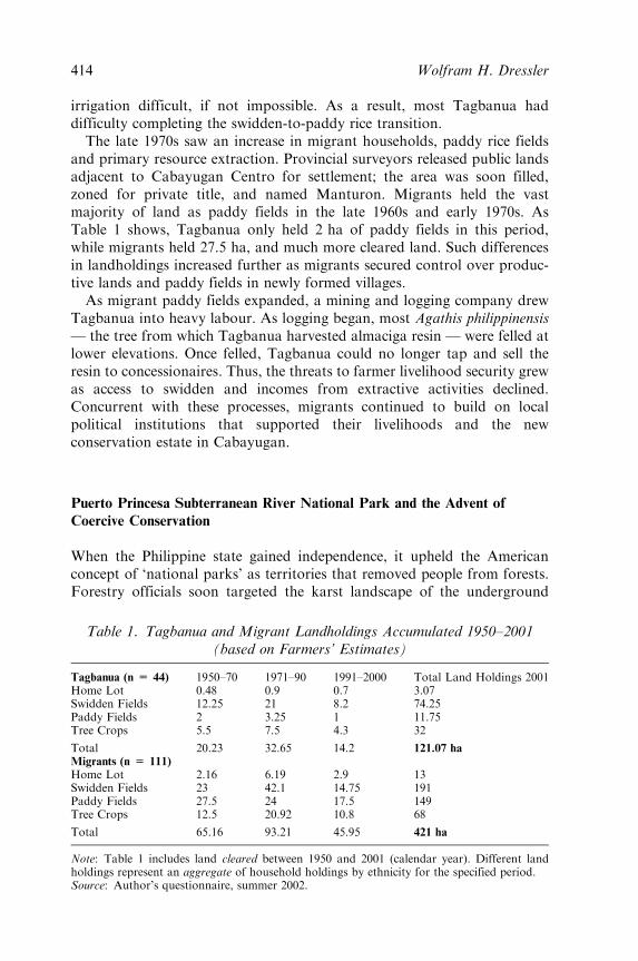
and primary resource extraction. Provincial surveyors released public landsadjacent to Cabayugan Centro for settlement; the area was soon filled,zoned for private title, and named Manturon. Migrants held the vastmajority of land as paddy fields in the late 1960s and early 1970s. AsTable 1 shows, Tagbanua only held 2 ha of paddy fields in this period,while migrants held 27.5 ha, and much more cleared land. Such differencesin landholdings increased further as migrants secured control over produc-tive lands and paddy fields in newly formed villages.As migrant paddy fields expanded, a mining and logging company drew
Tagbanua into heavy labour. As logging began, most Agathis philippinensis— the tree from which Tagbanua harvested almaciga resin — were felled atlower elevations. Once felled, Tagbanua could no longer tap and sell theresin to concessionaires. Thus, the threats to farmer livelihood security grewas access to swidden and incomes from extractive activities declined.Concurrent with these processes, migrants continued to build on localpolitical institutions that supported their livelihoods and the newconservation estate in Cabayugan.
Puerto Princesa Subterranean River National Park and the Advent of
Coercive Conservation
When the Philippine state gained independence, it upheld the Americanconcept of ‘national parks’ as territories that removed people from forests.Forestry officials soon targeted the karst landscape of the underground
Table 1. Tagbanua and Migrant Landholdings Accumulated 1950–2001(based on Farmers’ Estimates)
Tagbanua (n = 44) 1950–70 1971–90 1991–2000 Total Land Holdings 2001Home Lot 0.48 0.9 0.7 3.07Swidden Fields 12.25 21 8.2 74.25Paddy Fields 2 3.25 1 11.75Tree Crops 5.5 7.5 4.3 32
Total 20.23 32.65 14.2 121.07 ha
Migrants (n = 111)
Home Lot 2.16 6.19 2.9 13Swidden Fields 23 42.1 14.75 191Paddy Fields 27.5 24 17.5 149Tree Crops 12.5 20.92 10.8 68
Total 65.16 93.21 45.95 421 ha
Note: Table 1 includes land cleared between 1950 and 2001 (calendar year). Different landholdings represent an aggregate of household holdings by ethnicity for the specified period.Source: Author’s questionnaire, summer 2002.
414 Wolfram H. Dressler
river and surrounding forests as a national park, restricting local access toforest resources in Cabayugan. In the late 1940s, provincial officials spear-headed a draft proclamation that led to the creation of Puerto Princesa(then St Paul’s) Subterranean River National Park. In 1949, Alfredo M.Abueg, Governor of Palawan, recommended to the President of thePhilippines that the area be proclaimed a national park.14 Officials at theBureau of Forestry supported this request by first drafting PresidentialDecree No 835 in the 1960s, and eventually promulgating the Decree in1971 under Act No 3915 (Republic of the Philippines, 1971). The parkclaimed 3,901 ha of ancestral lands from the Tagbanua and allowedforesters to control the ‘scientific, panoramic and aesthetic’ value of thecentral karst landscape. Foresters fulfilled this remit by enforcing a ‘people-free’ landscape.
Colonial conservation ideals of a people-free landscape were stillentrenched in the Bureau of Forestry and bolstered the authority ofmanagers to eradicate swidden and support paddy rice cultivation. Whilemigrants cleared ‘alienable and disposable’ lands in the late 1960s, uplandforests were zoned and subject to vigorous enforcement. Ignoring theexpanding paddy fields, foresters used state regulations to curb swiddenfarming among indigenes and poorer migrants. Since foresters and wealthiermigrants were from the Christian majority and ‘appreciated’ the value offixed paddy rice, few disputes arose as migrants claimed land for paddy ricefarming. Migrant property claims and binding state laws converged as partof a ‘locally recognized political order’ (Lund and Wardell, forthcoming).
Promoting Paddy Rice and Criminalizing Swidden Cultivation throughCoercive Conservation
Park managers began to ‘officially’ criminalize swidden and valorize paddyrice from 1971 onwards. Provincial foresters began by mapping the parkcore zone to demarcate its boundary with brush cuttings and signs aroundthe central karst in Cabayugan. Survey errors meant that park boundariesactually overlapped with rice paddies and swiddens, rather than flanking thekarst as was intended. Ambiguous zoning kept resource users unsure ofwhere and what they could harvest on their lands. Nevertheless, foresterssoon informed migrants and Tagbanua that the national park would engulftheir paddy and swidden fields.
Migrants were clearly more vocal than Tagbanua in opposing the parkboundaries. Although park boundaries overlapped with migrant paddyfields, farmers continued to clear forest for swidden and paddy rice by thecentral karst. Farmers with lands in the contested area argued that foresters
14. ‘Letter to the President of the Philippines regarding a Proposal for the Proclamation of
St. Paul Subterranean River National Park. Dated: March 22, 1963.’
Co-opting Conservation: Park Management in the Philippine Uplands 415
had no legal right to interfere with their application for title since the landswere released as alienable and disposable. A few prominent migrant familiesfollowed this lead by applying political pressure, and eventually claimed titleon large paddy fields in Manturon (between 5 and 14 ha per family), asbeing occupied and cultivated since 11 July 1966 (as per License Number2598 in 1966, see footnote 11). Migrants thus acquired their landholdings inthe same way that landlords did in their home provinces (cf. Hirtz, 1998).The failure of most migrant farmers to obtain private title did not prevent
their access to land and forest resources. Rather, the lack of closure overland titles granted migrants new political space in which to negotiate withsurveyors and managers over their pending claims. Most were savvy enoughto maneuver politically when dealing with provincial surveyors and a widerange of land use policies. Cultivation continued despite the lack of title andabsence of trees in paddy fields. Such rule bending was accepted becausepaddy rice production sustained local incomes and generated revenue forthe state through taxation and rice sales to the National Food Authority. In1978, for example, the Regional Director of Forestry tried to resolve theboundary dispute by ‘zoning around’ the farmers’ plots to maintain the‘economic contribution’ of paddy rice cultivation. Boundaries were nowreinterpreted to allow migrants to retain lands inside the park when usedfor ‘agricultural purposes’; accommodating the economic needs of thefarmers became a ‘practical’ matter.15 The purported benefits of migrantfarms offset the need to resettle them for the purpose of conserving ‘oldgrowth’ forests. No such allowances were made for Tagbanua, however.Swidden cultivation by Tagbanua and poorer migrants was subject to
punitive management that was aided further by ambiguous park zoning.Foresters used their political authority to enforce regulations subjectively,targeting swidden in forests they considered to be ‘old growth’. Tagbanuaelders complained that all enforcement focused on eradicating swiddenwhere this overlapped with the boundaries of old growth forest. In orderto ascertain where they could cultivate swidden, most had to distinguishbetween first and secondary growth forest. The forest guards enforced jailterms to punish any farmer caught cultivating swidden in the wrong place.Although foresters had permitted some migrants to cut ‘secondary growth’for conversion to paddy rice, few allowances were made for cultivatingswidden in similar forests. Tagbanua and those poor migrant farmers whoremained title-less by working swidden on public lands bore the brunt ofthis enforcement strategy.Post-colonial forest management had followed colonial conservation
ideals and only those high in the local social order were exempt from therules and regulations of earlier management periods. Forestry officials tried
15. ‘Memorandum to the Director of Forestry, Bureau of Forest Development, dated: March
15, 1978.’
416 Wolfram H. Dressler
hard to outlaw swidden among Tagbanua, considering it primitive andunproductive. The opposite was true for migrants who could expandpaddy farms, as this was considered modern and productive. Tagbanuafarmers’ first encounters with park regulators added new layers ofrestrictions over the displacement, dispossession and servitude that migrantshad introduced.
Institutionalizing Punitive Park Management in the late 1970s
The late 1970s gave rise to a more defined and rigorous managementapproach. The Bureau of Forest Development institutionalized newmanagement procedures and a staffing structure that enabled regularmonitoring and enforcement. Bureau staff began by recruiting early migrantsettlers as new forest rangers in Cabayugan Centro and Manturon, whilesenior positions went to politically prominent migrants. Damar Diadoresfits this description: he was part of the local elite and part of the manage-ment bureaucracy. While Diadores was busy clearing swidden fields alongthe park boundary he was also employed as a forester whose managementjurisdiction stretched from Bahilie to St Vicente. Upon completing hisduties, he was appointed by the District Director of Forestry, Ponce deLeon, as the ‘Official Officer in Charge’ at the national park. From 1979until 1991, Diadores and his head Game Warden adopted a militaristicenforcement strategy by claiming to adhere to international standards forpark management — strict ecosystem conservation (IUCN, 1971).16
From 1979 onwards, this policy guided management priorities and thedevelopment of an Action Plan to strengthen enforcement at the nationalpark.17 Additional migrants were recruited to serve as volunteer rangers tocarry out the Plan’s first objective — ‘Parks and wildlife protection forpatrolling and confiscating forest products and disseminating laws andregulations for the park’. As many as eighteen park rangers formed anenforcement network grounded in kin ties and/or political connections.Not only did this network criminalize Tagbanua swidden farming but italso excluded them from participating in park management on grounds ofethnicity: Tagbanua were hired only as labourers.
The dynamics of migrant political relations made it difficult for Tagbanuato resist the force of these strict rules and regulations. The ability ofmigrants to control park infrastructure grew out of their wealth and
16. The Philippine Conservation Strategy of 1985 (FAO), the Debt-for-Nature Swap in 1988
(WWF-US), and the Integrated Protected Areas Strategy in 1991 (World Bank) all
influenced the national park’s management.
17. ‘An Action Plan for the Saint Paul [. . .] National Park for 1979. R-4-6. Allotment.
Created by OIC, Parks, Range, and Wildlife Unit. Date: November, 1979.’ Puerto
Princesa City, summer 2002.
Co-opting Conservation: Park Management in the Philippine Uplands 417
allegiance with those who, by doubling as park rangers, held political powerthrough links with the state. Prominent migrant farmers were political alliesof park managers and could influence management outcomes, such ascontinuing rice production. Farmers who liaised with managers and sup-ported their political preferences were hired at the national park. Aselsewhere in the Philippines, personal relations dominated patron–clientrelations and farmers acquired power through family ties and politicalnetworks (Rood, 1998). Local politics and management were intertwined.Under Diadores, volunteer migrant rangers were trained and deputized to
officially replace forestry officers and park guards. Migrant rangers couldnow legally confiscate forest products and control swidden around thenational park, which further bolstered their political authority andeconomic position (Glass and Glass, 1978). Taking orders from de Leonand Diadores, the new rangers began to ‘advertise’ park boundaries to thosestill living by the coastal karst. Communicating boundaries involved erect-ing ‘boundary signs’ and monitoring ‘critical boundaries’ on a monthlybasis (ibid.). Patrols began and illegal harvesting activities were registeredand reported to de Leon and Diadores. After receiving such reports, deLeon wrote a memo to a local forestry officer, emphasizing with urgencythat illegal deforestation might compromise the integrity of the park’sboundaries. In January 1979, he wrote:18
Reports reached this Office that destruction of a portion of St Paul Subterranean River
National Park still continues. Please advise all concerned to stop immediately any further
destruction until there is a ruling from higher authorities on this case. We are requesting
legal assistance on the matter. Warn them of the possible consequences of their forest
destruction if they continue in spite of your advice. Illegal destruction of forestland has a
minimum of two years imprisonment and . . . other penalties.
One incident illustrates how the local Officer in Charge used similarconservation rhetoric and authority to justify the displacement of aTagbanua elder in order to claim land. During a monthly patrol, a rangerwas told to investigate a Tagbanua elder, Gilberto Pamentel, with whom deLeon had made an agreement allowing him to cultivate, but not expand hisswidden in the park. After seeing smoke billow from the canopy, the rangersought out its origin and reported that Pamentel had expanded swiddennear the park’s underground river. Since the agreement was breached, theranger was instructed to visit Pamentel again, in order to recommend onPamentel’s ‘displacement, location, remuneration agreements’ (Glass andGlass, 1978). This did not, however, lead to Pamentel’s eviction. Theofficer’s information suggested that the new Officer in Charge, Damar
18. ‘A Memorandum from District Forester Ponce de Leon to Forester Amboam, Subject on
the Destruction of St Paul Subterranean River National Park. Office of the District
Forester, Puerto Princesa City, Palawan, Bureau of Forest Development. January 17,
1978’.
418 Wolfram H. Dressler
Diadores, had paid Pamentel ‘to clear all land between his current clearingand the river’, an area that overlapped with the park boundary (ibid.). Afterpaying Pamentel to clear forest for swidden, Diadores claimed the land, andthen employed him for field maintenance. Diadores soon dismissedPamentel and then secured private title over the lands; Pamentel thenmoved inland to Marufinas (north of the underground river). Diadores’motives were clear: he could easily acquire valuable ancestral lands withinthe park core zone. Few obstacles stood in his way, since most indigenesheld no private title and were unaware of the park boundaries.
After hearing about the incident, provincial officials informed all forestryofficers to adhere to monitoring procedures inside and outside the parkboundaries. Enforcement grew stricter as monitoring continued. ManongAbrea, a Tagbanua elder, lamented Diadores’ enforcement style:
When it came time that there were restrictions to us, that was the time the crisis came to us.
That’s what I know until today. Until now, even the land that we have to plant on, we
cannot broaden/extend it because it’s restricted, but even then nobody lived there except for
us. But for the wealthy [migrants] there are no park problems. (Interview, Manong Abrea,
summer 2002)
His position encapsulates how employment at the national park now sup-ported the interests of elite migrant farmers in clearing lands, cultivatingpaddy rice, and generating wealth. With the power to confiscate and appre-hend, migrant rangers used their political appointments to influence the useand management of forest resources and property around the national park.Certain local elites working for the park used their position to sustain paddyrice cultivation on fields located within the park. Provincial officials allowedfarmers continued use of these fields, tolerating those violating rules ofaccess. Given the farmers’ political influence, few officials considered suchcultivation improper; holding onto their lands, most blamed the faultysurvey for the fields falling inside the park. By owning large stretches ofproductive paddy rice and employing Tagbanua as labourers, migrantscould shape the production and exchange of rice and non-timber forestproducts. The few households with such power used their political influenceand control to adjust and augment restrictions imposed by park authorities.Tagbanua had few opportunities to resist such enforcement as their accessto forest resources gradually diminished. Management thus built on colonialideologies and land use policies in a way that reinforced social and economicdifferentiation in Cabayugan, only to further marginalize the Tagbanua.
Modernizing Park Enforcement: The Rise of NGO and Community-basedInterventions
After the 1986 Revolution ousted Marcos, the number and diversity of non-governmental organizations proliferated in the Philippines and on Palawan(Eder and Fernandez, 1996; Vitug, 2000). Environmental NGOs moved to
Co-opting Conservation: Park Management in the Philippine Uplands 419
conserve the island’s rain forests as indigenous rights organizations‘mobilized’ indigenous peoples in the uplands. In 1988, a nationwideenvironmental campaign secured a US$ 2 million Debt-for-Nature Swapinvolving the Haribon Foundation, the WWF-US and the PhilippineDepartment of Environment and Natural Resources (DENR) (WWF,1991).19 Funds were allocated to improve the infrastructure and enforce-ment capabilities at the national park under the condition that managementpreserve forests that support ‘major faunal regions’ and ‘environmentaloutreach programs’ (WWF, 1991: 10). The park now had a well-financedenvironmental programme and sufficient funds for the construction of fourranger stations. The ranger stations were built using timber confiscatedfrom ‘illegally’ cleared swidden and were located at four strategic entryand exit points used by rattan and almaciga collectors. Rangers receivedtraining and were outfitted with ‘pump-boats’ (motor-driven outriggercanoes) and hand radio-sets for patrolling the park boundaries. With newpark infrastructure, the DENR arbitrarily expanded the park from 3,901 to5,753 ha in 1988.20 While Tagbanua offered little resistance to suchencroachment, migrant farmers stopped the demarcation crew in its tracksas it approached their rice paddies (McDermott, 2000). The park nowemployed fifty people, the majority of whom had migrated to Cabayuganin the 1950s.Coercive enforcement continued into the 1980s. Diadores described in a
report how ‘constant foot patrol surveys . . . [and] apprehension’ led to anentanglement over competing rights of access to rattan groves flanking thenational park. In late 1988, when a Tagbanua named Brillantes expandedhis rattan harvests, Diadores and his rangers warned him repeatedly to stopcollecting, stressing that ‘Brillantes knew the boundary’ and knew not to‘encroach on the boundary’.21 Brillantes, however, continued to cross thepark boundary, gathered the rattan poles, and sold them to buyers in PuertoPrincesa City. Learning about his intentions, Diadores’ team moved tointercept Brillantes.Brillantes considered himself as the rightful owner of the rattan, regard-
less of where it had been collected. During one interview, he argued therattan was harvested legally, well beyond the park boundary. Given hisposition, it came as no surprise that, after being released by the rangers, hepromptly returned to reclaim his prize from beneath the ranger station. His
19. Following the 1986 People Power Revolution, the Ministry of Natural Resources, which
contained the Bureau of Forest Development, was reorganized into the Department of
Environment and Natural Resources (DENR). The DENR’s parallel agencies including
the Protected Areas and Wildlife Bureau and the Forest Management Bureau.
20. Although, to date, there is no official map or proclamation that delineates the national
park’s expanded core zone.
21. ‘NRCO-SPSRNP, Parks and Wildlife Office (1988) Accomplishment Report, Puerto
Princesa City.’
420 Wolfram H. Dressler
action led to a chase, confiscation of the rattan, and a court case forBrillantes. For the first time, a local NGO called the Indigenous PeoplesApostolate (IPA) intervened on behalf of those facing criminal charges,setting a precedent for NGOs supporting indigenous rights and livelihoods.Father Arnesto Lagarada, a Tagbanua priest and the head of the IPA,confronted Diadores over the charges. Lagarada and Diadores met todiscuss the matter in terms of ‘subsistence security’ versus the ‘rule oflaw’, respectively. Diadores rejected Lagarada’s proposal to drop thecharges.
The rise in NGO interventions supposedly marked the end of coercivepark management in Cabayugan and unilateral decision making by para-statal on Palawan. NGO coalitions formed over several years and, byconnecting to the ‘upper level’, offered new management rhetoric:integrating livelihood concerns with conservation priorities. The DENR,the World Bank and local NGOs now worked to implement an integratedprotected areas strategy that amounted to a regional network of parks withbuffer zones. With a ‘rejuvenated’ civil society, activists and governmentplanners used ‘people-oriented’ policies to integrate livelihood concerns intonational park planning across the Philippines (World Bank, 1994; WWF,1991).
This combination of factors, and growing resistance to coercive conser-vation, led to changes in management personnel and the advent of com-munity-based conservation at the national park. Several Tagbanuapetitioned to have Diadores replaced by a new park manager namedArturo Baltazar and new migrant staff from Cabayugan. Workingtogether, they monitored project development in accordance with a‘shared’ mandate of ecosystem conservation and livelihood support.Baltazar tried to rebuild local support by returning confiscated forestproducts and by offering households livelihood projects in so-called ‘mul-tiple use’ buffer zones. With NGO assistance, he designed livelihoodprojects for Tagbanua that focused on livestock dispersal and basketweaving (see McDermott, 2000). While adopting such low-capital projectswas feasible, most families lacked the necessary resources and expertise tosustain livestock.
Given the area’s political and economic history, the use of community-based conservation to change how park officials managed paddy rice andswidden inevitably had mixed results. In the 1990s, various laws formalizedcommunity-based conservation and ensured Tagbanua preferential rights toaccess forest resources on lands claimed as ancestral domain (see, forexample, DENR, 1993, 1998). Laws advocating devolved conservationincluded the Strategic Environmental Plan of Palawan and the NationalIntegrated Protected Areas Act of 1992, while the Indigenous Peoples’Rights Act demarcated domain claims (de facto) and title (de jure) after1997. These laws led to more ‘inclusive’ management and projects thatsupported ‘traditional’ livelihoods in the new Cabayugan ancestral domain
Co-opting Conservation: Park Management in the Philippine Uplands 421
claim. Declared a World Heritage Site in 1999, the national park’s bufferzone was then expanded from 3,901 to 22,202 ha to overlap with theuplands and the domain claim.In the uplands, the ancestral domain claim was soon reinterpreted as a
traditional use buffer zone in which projects ‘maintained’ indigenous liveli-hoods but did not reduce livelihood vulnerability. Projects supported byNGOs and park managers catered to low capital pursuits, such as swiddencultivation, which have failed to diversify and strengthen Tagbanua liveli-hoods. Such projects rarely reintroduced indigenes to paddy farmingbecause they did not fit the image of successful, modern farmers (otherfactors such as the availability of farm implements and flat, fertile landswere disregarded). As if to keep livelihoods traditional, NGOs and man-agers now co-opted and romanticized notions of indigeneity in order tosupport ‘community-based’ conservation.In the lowlands, migrant farmers began to organize themselves around
livelihood projects that supported the expansion of paddy rice in so-calledmultiple use buffer zones. Inside such zones, Peoples’ Organizations andAssociations provided farmers with credit in order to purchase lands andmodern farm implements — both costly and beyond the reach of Tagbanua.The revenue generated from expanded rice production was reinvested inhousehold production and education, which, in turn, led to future employ-ment opportunities at the national park. As a result, migrant farmers con-tinue to use the national park’s infrastructure and management platform tocontrol resource access and use.Recent programmes from the Community Management of Protected
Areas Conservation (COMPACT) project of the United NationsDevelopment Programme (UNDP) have sustained this trend. Variousprojects have strengthened pre-existing Vendors’ Associations andFarmers’ Co-operatives to enable migrants to expand rice production withnew machines, market outlets and medium-scale investments. In contrast,Tagbanua are confined to programmes that support swidden farmingusing traditional methods in the uplands. While laudable, the projecthas yet to offer Tagbanua new avenues through which to diversify andimprove their livelihoods. Most still rely on migrants for cash. By buildingon older dichotomies of people and agriculture, community-basedconservation thus begins to parallel the colonial ideals of coerciveconservation.
CONCLUSION
This article has shown how state land use policies and coercive conservationhave co-evolved to marginalize or even criminalize swidden agriculture, aprocess rooted in colonial ideals of ‘productive people’ and ‘modern agri-culture’. Filipino farmers were often aligned with state interests and had
422 Wolfram H. Dressler
relatively unfettered access to the lowlands, which they titled and cultivatedas ‘productive’ paddy rice. ‘Tribal’ upland minorities were subjugated by thestate and cultivated ‘unproductive’ swiddens on usufruct plots. As theAmerican administration built on Spanish land law to control uplandresources, foresters gave birth to new political territories such as nationalparks — boundaries that upheld colonial abstractions of people and agri-culture. State managers used stereotypes to confine uplanders and definetheir farming practices through boundaries. A dialectical relationshipformed whereby national parks expanded upland and supported the pro-duction of dominant social groups who, in turn, stood to benefit fromcolonial conservation.
The Philippine government followed similar political and economic idealsin order to facilitate forest conservation on Palawan. The infrastructure andinstitutions that supported colonial conservation, infused with social andeconomic bias, grew to shape how agriculture, trade and park managementunfolded in Cabayugan. Migrant settlers had few difficulties cultivating flatlands as swidden and then paddy fields, while income from rice sales flowedinto state coffers (Ocampo, 1996).
Paddy farmers invested further in productive resources and the politicalopportunities that enabled them to steer park management away frompaddy rice and toward swidden cultivation. The results were clear: thestate’s own doctrine of criminalizing swidden grew locally in order toprotect ‘old growth’ forest. Ironically, while migrants expanded paddies aspermanent clear cuts, Tagbanua faced boundary enforcement that aimed toeradicate swidden in regenerated forests. Historical antecedents that con-structed social, political and economic hierarchies through unequalproduction, exchange and unilateral management thus drove how stateconservation agendas unfolded locally.
The importance of swidden to the subsistence base, culture and symbo-lism of uplanders was neglected in favour of resource profits and territorialcontrol. Early on, coercive conservation at the national park dealt lesswith conservation than with maintaining control over people and theforests they occupied. Farmers closest to the state merged with govern-ment institutions locally in order to participate in and benefit from thestate’s agenda of protecting valuable resources. Building on the state’stolerance of paddy farming, they could uphold the virtues of paddy riceas ‘non-destructive’ agriculture that supposedly supported their forestmanagement campaign. Migrant paddy farmers qualified as ‘good’ farm-ers, protecting the state’s economic interests at the local level. Indigenesand poorer migrants were ‘bad’ farmers; they offered burnt, scarred land-scapes that violated state economic interests (cf. Neumann, 2000). That thegovernment still considers swidden cultivation a threat reflects its ownignorance and serves to justify the ‘expropriation . . . of rural lands [andthe] extension of external control into the territories of swidden agricul-turalists’ (Dove, 1983: 95).
Co-opting Conservation: Park Management in the Philippine Uplands 423
The recent shift to community-based conservation has yet to redress thenegative impacts arising from coercive conservation — a managementparadigm that persists on Palawan. Park managers fail to consider howthey might work with, rather than against, upland farmers in Palawan.Managing swidden so that it remains productive and sustainable wouldfacilitate cultural continuity and potentially re-open opportunities tosecure access to productive resources, such as flat, titled lands. Shoulddevolved conservation deny indigenous residents access to productivecapital for more lucrative agriculture, differentiation between migrantsand Tagbanua is likely to be exacerbated. Underlying conditions ofinequality must be explicitly recognized and incorporated into devolvedconservation so that programmes move beyond assumptions and empowermarginalized households.
REFERENCES
Anderson, M. (1983) A Compilation of Laws Pertaining to the Management, Administration and
Reservation of National Parks Vol. 2. Manila: Resource Policy and Strategy Research
Division.
Bernstein, H. (1979) ‘African Peasantries: A Theoretical Framework’, Journal of Peasant
Studies 6: 420–43.
Conelly, T. (1983) ‘Upland Development in the Tropics: Alternative Economic Strategies in a
Philippine Frontier Community’. PhD dissertation, University of California at Santa
Barbara.
Constantino, R. (1978) Neocolonial Identity and Counter Consciousness. London: Merlin Press.
Cruz, M, M. Carrie, R. Repetto and R. Woodward (1992) Population Growth, Poverty and
Environmental Stress: Frontier Migration in the Philippines and Costa Rica. Washington,
DC: World Resources Institute, OAS.
DENR (1993) ‘Departmental Administrative Order No. 02 S, 1993’. Manila: Department of
Environment and Natural Resources.
DENR (1998) A Compilation of Policies on Community-based Forest Management. Manila:
Community-based Forest Management Office.
Dove, M. (1983) ‘Theories of Swidden Agriculture and the Political Economy of Ignorance’,
Agroforestry Systems 1: 85–99.
Diamond, J. and M. Gilpin (1983) ‘Biographical Value (Umbilkin) and the Origin of the
Philippine Avifauna’, Oikos 41: 307–21.
Dressler, W. (2005) ‘Old Thoughts in New Ideas: State Conservation Measures and Tagbanua
Resource Use at Puerto Princesa Subterranean River National Park’. PhD dissertation,
McGill University.
Eder, J. (1987) On the Road to Tribal Extinction. Berkeley, CA: University of California Press.
Eder, J. (2004) ‘Who are the Cuyonon?’, Journal of Asian Studies 63(3): 625–47.
Eder, J. and J. Fernandez (1996) ‘Palawan, a Last Frontier’, in J. Fernandez and J. Eder
(eds) Palawan at the Crossroads: Development and the Environment on a Philippine Frontier,
pp. 1–23. Quezon City: Ateneo de Manila University Press.
Evrard, O. and Y. Goudineau (2004) ‘Planned Resettlement, Unexpected Migrations and
Cultural Trauma in Laos’, Development and Change 35(5): 937–62.
Fox, R. (1954) Tagbanua Religion and Society. Chicago, IL: University of Chicago Press.
Ganapin Jr., D. (1992) ‘Original Nomination Dossier for St Paul Park’ (UNESCO). Pasay City,
Philippines: National Commission of the Philippines.
424 Wolfram H. Dressler
Gatmaytan, D. (1992) ‘Land Rights and Land Tenure Situations of Indigenous Peoples in the
Philippines’, Philippine Natural Resources Law Journal 5(1): 5–41.
Glass, P. and Elena Glass (1978) ‘Annual Progress Report on the Management of St Paul
Subterranean River National Park’. Palawan, Philippines: US Peace Corps Wildlife
Biologists.
Goldman, M. (2003) ‘Partitioned Nature, Privileged Knowledge: Community-based Conservation
in Tanzania’, Development and Change 34(5): 833–62.
Hirtz, F. (1998) ‘The Discourse that Silences: Beneficiaries’ Ambivalence Towards Redistributive
Land Reform in The Philippines’, Development and Change 29(2): 247–75.
Hutterer, K. (1977) Economic Exchange and Social Interaction in Southeast Asia. Ann Arbor,
MI: Center for South and Southeast Asian Studies, University of Michigan.
IUCN (1971) UN List of National Parks and Equivalent Reserves. Brussels: IUCN Publication
Series.
Kerkvliet, B. (1977) The Huk Rebellion. Berkeley, CA: University of California Press.
Kummer, D. (1992) Deforestation in the Postwar Philippines. Chicago, IL: University of
Chicago Press.
Li, T. (2002) ‘Local Histories, Global Markets: Cocoa and Class in Upland Sulawesi’,
Development and Change 33(3): 415–37.
Linn, B. (2000) The Philippine War: 1899–1902. Lawrence, KS: University of Kansas Press.
Lopez, M. (1987) ‘The Politics of Land at Risk in a Philippine Frontier’, in P. D. Little,
M. Horowitz and A. E. Nyerges (eds) Lands at Risk in the Third World: Local Level
Perspectives, pp. 213–29. Boulder, CO: Westview Press.
Lund, C. and A. Wardell (forthcoming) ‘Governing Access to Forests in Northern Ghana:
Micro-politics and the Rent of Non-enforcement’, World Development
Lynch, O. (1982) ‘Native Title, Private Right and Tribal Land Law’, Philippine Law Journal 57:
268–305.
Ma Dulid, D. (1998) ‘Floristic and Faunistic Survey and Assessment of St Paul Subterranean
River National Park’. Palawan, Philippines: Palawan Tropical Forest Protection Plan.
McDermott, M. (1994) ‘Conservation Assessment Report (Annex)’. Manila: World Wildlife
Fund, Tribal Filipino Apostolate, NATRIPAL and PANLIPI.
McDermott, M. (2000) ‘Boundaries and Pathways: Indigenous Identity, Ancestral Domain and
Forest Use in Palawan, The Philippines’. PhD dissertation, University of California at
Berkeley.
National Parks Act No 3915 (1932) ‘An Act for the Establishment of National Parks’. Manila:
Commonwealth of the Philippines.
Neumann, R. (2000) ‘Primitive Ideas: Protected Area Buffer Zones and the Politics of Land in
Africa’, in V. Broch-Due and R. Schroeder (eds) Producing Nature and Poverty in Africa,
pp. 220–42. Stockholm: Nordiska Afrikainstitutet.
NRMC and MNR (1983) An Analysis of Laws and Enactments Pertaining to National Parks
Volume 1. Quezon City: Natural Resources Management Center, Ministry of Natural
Resources.
Ocampo, N. (1996) ‘A History of Palawan’, in J. Eder and J. Fernandez. (eds) Palawan at the
Crossroads, pp. 23–37. Quezon City: Ateneo de Manila University Press.
Peluso, N. (1993) ‘Coercing Conservation’, Global Environmental Change 3(1): 199–218.
Peluso, N. and P. Vandergeest (2001) ‘Genealogies of the Political Forest and Customary
Rights in Indonesia, Malaysia and Thailand’, Journal of Asian Studies 60(3): 761–812.
Pelzer, K. (1948) Pioneer Settlement in the Asiatic Tropics American. American Geographical
Society Special Publication No 29. New York: American Geographical Society.
Pinchot, G. (1903) ‘The Forester and the Lumberman’, Forestry and Irrigation: 176–8.
Population Center Foundation (1980) Kaingineros: The Philippine Boat People. Population/
Environment Planning for Communities Practicing Shifting Cultivation: The Philippine
Component. Phase 1. Metro Manila: Makati.
Co-opting Conservation: Park Management in the Philippine Uplands 425
Republic of the Philippines, Congress of the Philippines (1971) Proclamation No. 835
(‘Reserving a Parcel of the Public Domain for National Park Purposes to be known as
the St Paul Subterranean (River) National Park’). Manila, Philippines.
Republic of the Philippines, Congress of the Philippines (1975) Presidential Proclamation 705
(Revised Forestry Code PD 705). Manila, Philippines.
Rood, S. (1998) ‘Decentralization, Democracy, and Development’, in D. Timberman (ed.)
The Philippines: New Directions in Domestic Policy and Foreign Relations. New York:
Asia Society. Available online: http://www.asiasociety.org/publications/philippines/
decentralization.html
Roth, D. (1983) ‘Philippine Forests and Forestry, 1565–1920’, in R. Tucker and J. Richards
(eds) Global Deforestation and the Nineteenth Century World Economy, pp. 30–49. Durham,
NC: Duke Press Policy Studies.
Sack, R. (1983) Human Territoriality: Its Theory and History. Cambridge: Cambridge
University Press.
Scott, G. (1979) ‘Kaingin Management in the Republic of the Philippines’, Philippine
Geographical Journal 23(2): 58–73.
Spencer, J. E. (1966) Shifting Cultivation in Southeastern Asia. Berkeley, CA: University of
California Press.
Vandergeest, P. (2003) ‘Racialization and Citizenship in Thai Forest Politics’, Society and
Natural Resources 16: 19–37.
Vitug, M. (2000) ‘Forest Policy and National Politics’, in P. Utting (ed.) Forest Policy and
Politics in the Philippines, pp. 11–40. Quezon City: Anteneo De Manila University Press.
Warner, K. (1979) ‘Walking on Two Feet: Tagbanuwa Adaptation to Philippine Society’. PhD
dissertation, University of California at Santa Barbara.
White, B. (1989) ‘Problems in the Empirical Analysis of Agrarian Differentiation’, in G. Hart,
A. Turton and B. White (eds) Agrarian Transformations, pp. 15–30. Berkeley, CA:
University of California Press.
World Bank (1994) ‘Global Environmental Facility, Memorandum and Recommendation of
the Director for CPPAP Implementation’. Agriculture and Natural Resources Operation
Division. Washington, DC: The World Bank.
WWF (1991) ‘Inception Report: Integrated Protected Areas System of the Philippines’.
Washington, DC: World Wildlife Fund.
Wolfram H. Dressler is a Lecturer in Social Anthropology in the School ofSocial Sciences, University of Queensland, St Lucia, Qld 4072, Australia(e-mail: [email protected]). His research focuses on indigenouspeoples’ rights, rural livelihoods, and the political economy of conservation.Research areas include the Philippines, South Africa and Canada’s far north.
426 Wolfram H. Dressler