conwy valley flood alleviation scheme: llanrwst, gwynedd · 873 gat project no. 1877 report no. 873...
TRANSCRIPT

873
GAT Project No. 1877
Report No. 873June, 2010
Conwy Valley Flood Alleviation Scheme:
Ymddiriedolaeth Archaeolegol Gwynedd
Gwynedd Archaeological TrustCraig Beuno, Ffordd y Garth, Bangor, Gwynedd, LL57 2RT
Llanrwst, Gwynedd
Archaeological Excavation

Report No. 873
Prepared for The Environment Agency
June 2010
By
Robert Evans
Archaeological Excavation:
Ymddiriedolaeth Archaeolegol Gwynedd
Gwynedd Archaeological TrustCraig Beuno, Ffordd y Garth, Bangor, Gwynedd, LL57 2RT
Demountable Trenches 1-3 Llanrwst

CONWY VALLEY FLOOD ALLEVIATION SCHEME LLANRWST DEMOUNTABLE TRENCHES 1-3 ARCHAEOLOGICAL EXCAVATION (G1877) Gwynedd Archaeological Trust Report No. 873 CONTENTS Page Summary 3 1. Introduction 3 2. Specification and Project Design 3 3. Methods and Techniques 3 4. Archaeological Background 4 5. Results of the Excavation 5 6. Summary and Conclusions 7 7. Site Archive 8 8. References 8 Appendix 1 Contexts Summary Appendix 2 Mortar Sample Report; Llanrwst Bridge parapet by Martin Locock BA MIFA
and Jenny Hall BSc MIFA FIGURES Fig. 1. Location map Fig. 2 1st edition 25 inch Ordnance Survey map of 1875, Denbighshire sheets XI.13 and XI.14, showing the location of demountable trenches in red Fig. 3 Buckler print of Llanrwst Bridge by John Buckler (NLW Drawing Volume 85) Fig. 4 Tithe Map of Llanrwst, dating to 1839, showing area of demountable trenches (DRO TM/73/7) Fig. 5 Location of demountables 1-3 overlain on Mostyn estate maps of the 1770s (Mostyn MSS S8535) Fig. 6 Demountable Trenches overlain on Mostyn MSS 8534 The Market Town of Llanrwst, Denbighshire. Area of town discussed in text outlined in red Fig. 7 Demountable Trench 1, Western end Fig. 8 Trench 3, Demountable 2 Cobbled road surface Fig. 9 Plan of Demountable 1, Trench 2 Fig. 10 South East Facing Section through Demountable 1, Trench 2
1

PLATES Plate 1 Llanrwst Bridge from the west, showing area of Demountable 1 on the east bank of the river Conwy above 1794 parapet. Plate 2 The 1636 Bridge parapet (right foreground) and 1794 revetment (background). Scale 1m Plate 3 Revetment wall (1001), and parapet (1002) from the east. Scale 1m Plate 4 Detail showing smooth face of 1636 parapet wall Plate 5 View looking west showing capstones for the culvert (031). Scale 2m with 50cm divisions Plate 6 The culvert walling (033) with capstone (031) removed. Scale 1m Plate 7 The cobbled surface (022), below make-up layer (021) in Demountable 2 looking south. Scales 2m with 50cm divisions. Plate 8 View from the north of the cobbled surface with cross trenches excavated. Scales 2m with 50cm divisions and 1m Plate 9 View from the south showing infilled cellar to Llewelyn’s Accountants. Scale 50cm with 10cm divisions
2

CONWY VALLEY FLOOD ALLEVIATION SCHEME LLANRWST DEMOUNTABLE TRENCHES 1-3 ARCHAEOLOGICAL EXCAVATION (G1877) Summary Gwynedd Archaeological Trust has carried out an excavation within the flood plain of the Conwy Valley in the town of Llanrwst in connection with ground works that formed part of the Dyffryn Conwy Flood Allieviation Scheme, on behalf of the Environment Agency. This also forms part of wider archaeological work associated with the scheme, carried out on both banks of the river Conwy. Three trenches were examined. In demountable trench 1, surviving fragments of the17th century bridge parapet was observed. This had been truncated by the building of a river side embankment to protect the town in 1794. The pre 1794 road surface were observed in the deposits, buried by later make-up layers, which had the effect of raising the ground surface up to that of the current A470. Evidence for a drainage culvert was noted, which has been shown to date from 1794, was observed. In demountable trench 2 a cobbled surface was observed, which probably formed part of the same pre 1794 road surface seen in trench 1. On the south side of Conwy Terrace, only disturbed ground associated with modern services and a motor garage was observed. This area was open fields until well into the 19th century. 1. INTRODUCTION Gwynedd Archaeological Trust (GAT) has been asked by The Environment Agency to undertake an archaeological excavation within the town of Llanrwst as a part of the Dyffryn Conwy Flood Alleviation Scheme. This took place during the excavation of foundation trenches for the stanchions for demountable flood barriers at the junction of Bridge Street with the A470 close to the Bont Fawr (NGR SH 79876151), Llanrwst, and also to the south on either side of the junction of the A470 with Conwy Terrace (Fig. 1, centred on SH 79916148). This formed part of a wider scheme of archaeological work associated with the Dyffryn Conwy Valley Flood Alleviation Scheme (Davidson 2005), test pitting (Roberts 2006) and including work on the Trefriw Borrow Pit area (Kenney 2009; Evans 2010). 1.1 Acknowledgements The assistance of Ashley Batten of Gwynedd Archaeological Planning Service (GAPS) and Ed Wilson, Environment Agency Archaeologist, is gratefully acknowledged. The assistance of the staff of the contractors, May Gurney who provided the plant for the excavation and carried out much of the excavating work is gratefully acknowledged. 2. SPECIFICATION AND PROJECT DESIGN There was no specific brief for this work. The work undertaken followed a previously agreed project design and conforms to the guidelines specified in Standard and Guidance for Archaeological Excavation (Institute of Field Archaeologists, 1994, rev. 2001). The work was monitored by the Environment Agency, with recommendations given by the Senior Archaeologist, National Environmental Assessment Service (West Team), along with Ashley Batten of Gwynedd Archaeological Planning Service (GAPS). 3. METHODS AND TECHNIQUES 3.1 Introduction The excavations within the demountable trenches in Llanrwst were carried out in conjunction with the ground works for the foundations of the demountable trenches, and were carried out in various stages to fit in with this work. This involved the excavation of the western half of demountable 1 trench in June 2009 (Trench 1), which consisted of an area 6.5m long by 2.46m wide, which was excavated to a
3

depth of 1.1m. This section of the trench contained the remnants of the bridge parapet. In July 2009 the eastern half of the demountable 1 trench was excavated, which involved work by two archaeologists. In late July 2009work began on the trenches for demountable 2 (Trench 3). The commenced around the north west corner of Conwy Terrace at its junction with the A470, adjacent to T. Llewellyn Hughes Solicitors, and was dug to a depth of 1.55m. This work continued until August 2009. 3.2 Work Method 3.2.1 Excavation Three demountable trenches were excavated on the eastern bank of the Afon Conwy. Demountable 1 was located across the A470 road, known at this point as Trem yr Orsedd, immediately east of the Pont Fawr, Llanrwst and close to its junction with Bridge Street (Fig. 1). Demoutables 2 and 3 were located about 70m south of Demountable 1, orientated north-west south-east along Trem yr Orsedd on the road pavement either side and across Conwy Terrace. Most of the excavation work was carried out by the contractors, May Gurney, although significant archaeological contexts were cleaned, drawn and photographed by the archaeological team. The excavation areas were cleaned by hand tools onto the archaeological deposits and planned in relation to the whole site and scale plans at a scale of 1:20 were drawn. Sections across relevant features were drawn at a scale of 1:10, and a photographic record was maintained. Each distinct layer or evidence of archaeological activity was given its own unique context number and a descriptive record made, and these are referred to throughout the discussion of the results below in brackets. Their relationships to each other were shown on the scale drawings and a photographic record was maintained. The locations of the deposits were surveyed and related to the nearest Ordnance Survey bench mark. 3.2.2 Reporting and archiving This report describes the results of the evaluation and presents a description and interpretation of features and deposits recorded. A full list of contexts and their descriptions, including the earthworks, is given in appendix I. 4. HISTORICAL AND ARCHAEOLOGICAL BACKGROUND The town of Llanrwst owes its location to being the first place where the Afon Conwy could be crossed by means of a ford, which would have encouraged early settlement, and had probably encouraged the foundation of St. Grwst’s church on the eastern the river bank. The river formed the boundary between the post Edwardian conquest counties of Denbighshire and Caernarfonshire, Llanrwst being located on the Denbighsire side. The town is referred to in the Norwich taxation of 1254 and the Lincoln taxation of 1291, and reference to a market is first recorded in 1328. By the 14th century there was a borough on the site, but there is no record of its foundation, and the majority of the burgesses were Welsh (Soulsby 1983, 172). Glyndwr’s attack on the town in 1401 ‘brought such a desolacion that greene grasse grewe on the market place…and the deare fed in the churchyard’ (Ballinger 1927, 52-53). The parish church appears to have been rebuilt in early Tudor times, as the town recovered after the Glyndwr uprising. By the early 17th century Llanrwst was beginning to recover its position in the locality, and had a flourishing market. Construction of Llanrwst Bridge (Bont Fawr) began in 1636, and was a vital link for the Wynns of Gwydir, linking their estate with disparate portions of it at Cae’r Melwyr and Berth Ddu (Tucker 2002, 20). The bridge has three cutwaters, which are extended to coping level where they form refuges for pedestrians, and stone panels rise over the apex of the central arch. The south panel bears the Stuart Royal arms and is dated 1636. The west arch of the bridge collapsed in 1675, possibly weakened by damage to it sustained during the civil war, and emergency repairs were carried out (Gwynedd Archives, Caernarfon, Quarter Sessions Papers). Further repair work was carried out in 1703, when the western arch of the bridge gained its current appearance (Bingley 1814, 302). The road, later turnpiked, into the town from the south (Mostyn MSS 8534; Mostyn MSS S8535; Figs. 4 and 5) had a metalled cobbled surface in the 18th century, and rose steeply as it approached the Bridge, and Bridge Street leading into the town, which is shown on the late 18th century print (Fig. 3).
4
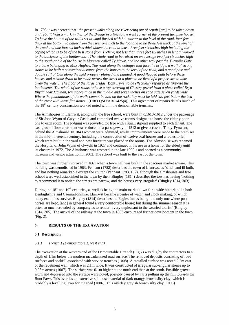
In 1793 it was decreed that ‘the present walls along the river being out of repair [are] to be taken down and rebuilt from a mark in the…of the Bridge in a line to the west corner of the present turnpike house. To have the bottom of the walls set in ..and flushed with hot mortar to the level of the road, four feet thick at the bottom, to batter from the river one inch to the foot and to be three feet thick at the level of the road and one foot six inches thick above the road at least three feet six inches high including the coping which is to be of the best stone from Trefriw, not less than three feet six inches in length worked to the thickness of the battlement… The whole road to be raised on an average two feet six inches high to the south gable of the house in Llanrwst called Ty Mawr, and the other way past the Turnpike Gate to a barn belonging to Miss Hughes. The road along the cottages that face the bridge, a wall of strong stones to be built a convenient distance from the houses to the level of the road, and a good post and double rail of Oak along the said property plained and painted. A good flagged path before these houses and a stone drain to be made across the street at a place to be fixed of a proper size to take away the water…The floor of the large bridge [Bont Fawr] to be effectually repaired as likewise the battlements. The whole of the roads to have a top covering of Chestry gravel from a place called Bryn Rhydd near Maynan, ten inches thick in the middle and seven inches on each side seven yards wide. Where the foundations of the walls cannot be laid on the rock they must be laid two feet below the bed of the river with large flat stones…(DRO QSD/AB/1/425(a)). This agreement of repairs details much of the 18th century construction worked noted within the demountable trenches. The Almshouses in Llanrwst, along with the free school, were built in c.1610-1612 under the patronage of Sir John Wynn of Gwydir Castle and comprised twelve rooms designed to house the elderly poor, one to each room. The lodging was provided for free with a small stipend supplied to each tenant. The east ground floor apartment was reduced to a passageway in 1812 to give access to Tan-y-Fynwent, behind the Almshouse. In 1843 women were admitted, whilst improvements were made to the premises in the mid-nineteenth century, including the construction of twelve coal houses and a ladies toilet, which were built in the yard and new furniture was placed in the rooms. The Almshouse was renamed the Hospital of John Wynn of Gwydir in 1927 and continued in its use as a home for the elderly until its closure in 1972. The Almshouse was restored in the late 1990’s and opened as a community museum and visitor attraction in 2002. The school was built to the east of the town. The town was further improved in 1661 when a town hall was built in the spacious market square. This building was demolished in 1963. Pennant (1782) describes the town of Llanrwst as ‘small and ill built, and has nothing remarkable except the church (Pennant 1783, 152), although the almshouses and free school were well established in the town by then. Bingley (1814) describes the town as having ‘nothing to recommend it to notice: the streets are narrow, and the houses very irregular’ (Bingley 1814, 303). During the 18th and 19th centuries, as well as being the main market town for a wide hinterland in both Denbighshire and Caernarfonshire, Llanrwst became a centre of watch and clock making, of which many examples survive. Bingley (1814) describes the Eagles Inn as being ‘the only one where post horses are kept, [and] in general found a very comfortable house; but during the summer season it is often so much crowded by company as to render it very unpleasant to the wearied tourist’ (Bingley 1814, 305). The arrival of the railway at the town in 1863 encouraged further development in the town (Fig. 2). 5. RESULTS OF THE EXCAVATION 5.1 Description 5.1.1 Trench 1 (Demountable 1, west end) The excavation at the western end of the Demountable 1 trench (Fig.7) was dug by the contractors to a depth of 1.1m below the modern macadamised road surface. The removed deposits consisting of road surfaces and backfill associated with service trenches (1008). A metalled surface was noted 2.2m east of the revetment wall, which was 2.1m wide. It was constructed of irregular sub-angular stones up to 0.25m across (1007). The surface was 0.1m higher at the north end than at the south. Possible groves worn and depressed into the surface were noted, possibly caused by carts pulling up the hill towards the Bont Fawr. This overlies an extensive sub-base material of dark orangy brown silty clay, which is probably a levelling layer for the road (1006). This overlay greyish brown silty clay (1005)
5

A mid reddish brown sandy clay silt overlay the stones belonging to the foundations of the revetment wall [1001] (Plate 3), which was built in 1794 (DRO QSD/AB/1/425(a). This was shown to overlie a stub of the bridge parapet of the Bont Fawr, dating from 1636 [1002] (Plates 2-4). This consisted of coursed rubble masonry, with blocks up to 0.8m square, and observed to a depth of 0.21m. Mortar samples from these two deposits have been analysed, and the results of this are shown in Appendix 2. 5.1.1.1 Mortar Report (Appendix 2) The mortar from the 1794 revetment wall (1001) and the 1636 Bridge parapet were sampled and analysed. The mortars were found to have similar composition, probably reflecting an informal formula of one part lime to two parts gravel and sand. The later mortar (1002) contained a significant quantity of bulking agents such as coal, ash and charcoal, which only became commonplace in the later part of the 18th century, but became an established part of the building tradition of the time. 5.1.2 Trench 2 (Demountable 1, east end) At the eastern end of the Demountable 1 trench (Fig.9) a hard road sub surface (004) overlay a mid orangey brown silty clay make-up layer (005). Cut into this deposit were a number of modern service trenches (006, 007), including a British Telecom service trench [009] with its fill (008). Layer (005) overlies a deposit of stones, on a north-west south-east alignment. This consisted of sub angular stones, up to 0.8m by 0.4m in size, making up the foundation core of a wall [010]. It appeared to lie directly on the probable alluvial deposit (030), and appears to be associated with the probable floor surface (014) which butts up against it, and runs parallel with a culvert [032], approximately 1m to the north east. There was infill material (011) within it, consisting of a mid greyish brown silty clay with gravel. A make-up layer (013=005), surviving to a depth of 0.44m, of a mid orangey brown silty clay which overlay the possible floor surface, is probably the same deposit as (005). The area of possible floor surface 0.8m by 0.26m, was apparently constructed at the same time as the culvert [032], as it overlies the south west wall lining, but is then partly covered with capstones [031] (Plate 6). Wall [010] overlay and culvert [032] cut into a stony demolition layer (042) (Fig. 10). This overlay a mid grey clayey sand, 0.35m deep (030). This is probably an alluvial silt, which overlies a stony make up layer (029) of sandy gravel. This overlies 0.35m of dark brownish grey gravel (046), which was probably an alluvial deposit, overlying a mid orangey-brown silty sand natural subsoil (045). 5.1.3 Trench 3 (Demountable 2) Below a grey gravel sub surface (002), a make-up deposit, 0.6m thick, a dark orangey brown silty clay with medium rounded and sub angular stones (021), which had been removed by the contractors overlay a cobbled floor surface (022), made of rounded stones up to 0.4m across (Fig. 8; Plates 7-8). The extent of the cobbled surface was difficult to determine as it extended over the full open area of the trench, however it was cut by the construction cut of the building to the east, currently a solicitor’s office. The cobbled surface was laid on a bed of sand (039) on a make-up layer of dark brownish grey silty clay (040), 0.68m deep, with small to large rounded and sub angular stones. This overlay mid orangy brown silty clay, probably caused by alluvial silting, which is of unknown depth (041). It is likely that this was caused by periodic flooding of the Afon Conwy. The trench was cut by a number of patches of later disturbance [024], filled with (025) and (026), and [027], filled by (028). At the eastern end of the trench, as it turned eastwards along Conwy Terrace, the ground was entirely disturbed as a result of the digging of the foundations and cellar of the current accountants building (Plate 9). 5.1.4 Trench 4 (Demountable 3) The area of pavement to the south of Conwy Terrace consisted entirely of disturbed ground and service trenches, and make up layers. These overlay a mid orangy brown silty clay, which was noted at a depth of 1.1m. 5.2 Finds
6

The only material that was recovered from the demountable trenches was modern material associated with service trenches, which was not retained. . 5.3 Interpretation Demountable 1 (Figs. 6, 8 and 9) The road surface noted 1.1m below the ground surface in trench 1 is probably the road that pre-dates the raising of the embankment by the building of the retaining wall in 1794 (DRO QSD/AB/1/425(a)). The presence of grooves marked by cart wheels in the metalled surface of the road can probably be explained by the friction caused by carts needing to pull up the relatively steep incline towards the Bont Fawr. This incline was lessened after the raising of the ground surface with a substantial make up layer (021), behind a revetment wall 1.9m high. This activity, carried out in 1794 involved the truncation of the 17th century bridge parapet (1001), and the construction of a revetment wall (1002), and subsequent make up and road sub surface layers. The eastern end of the Demountable 1 trench contained a large stone lined culvert [032] cut into the natural sub soils (045), overlaid with capping stones and an adjacent floor surface. This is clearly earlier than the make up layer (005) and subsequent road surfaces and service trenches, and is cut into a demolition layer (042). This demolition layer is probably associated with the construction of the revetment wall, and suggests that the stone-lined culvert post-dates, or is contemporary with, the raising of the ground surface in 1794, as suggested by the documentary evidence (ibid.). Demountables 2 and 3(Fig. 7) A cobbled road surface (022) was noted below a substantial make-up layer (021). This is likely to be the same road surface seen in the demountable 1 trench, and shown on the mid 18th century estate map (Fig. 3). To the south in demountable 3 the area was open fields until into the 20th century (Fig. 4) and no archaeological deposits were encountered. This overlay a deep make-up clay deposit where the bottom of the deposit was not seen (041). This would appear to have been created by a long period of alluvial silting, as suggests that prior to the construction of the road the river was wider at this southern part of the town. The lack of other archaeological features in trench 4 (Demountable 3) can be explained by the fact that the area was an open field, as shown on figs. 5 and 6, and there is no evidence for development in this area until the garage and other services arrived in the mid 20th century. 6. DISCUSSION AND CONCLUSIONS The identification of the parapet of the 1636 Bont Fawr indicates that there has been significant survival of the original angled bridged parapet, which is shown on the Buckler print (Fig. 3), and many other late 18th century images. Archaeological evidence for the raising of the river bank and the revetment wall in 1794 was also evidenced. The archaeological evidence uncovered along the banks of the Afon Conwy in Llanrwst demonstrates that significant evidence for the cobbled road from the south on the east bank of the river, shown on the 18th century estate map, surviving below the raising of the embankment after 1794. Some evidence for drainage from the town, in the form of stone lined culverts, was also encountered, and these are thought to date from a similar time to the building of the revetment wall. Significant evidence for alluvial silting predating the road was also encountered, suggesting that the river was wider in medieval and earlier times south of the Bont Fawr. The analysis of the mortar revealed distinct characteristics in the two mortar samples, particularly with the late 18th century characteristics in the mortar associated with the revetment wall.
7

7. SITE ARCHIVE The site archive consists of 47 context sheets, five A2 sheets containing, plans of the site drawn at a scale of 1:20 and six sections drawn at a scale of 1:10, and 83 digital images. They are currently held by GAT under project code G1877. Three copies of the bound report will be sent to Ed Wilson at the Environment Agency, a copy to Ashley Batten at GAPS, and a further copy sent to the HER Archaeologist at the curatorial division of Gwynedd Archaeological Trust, Bangor, for deposition in the Regional HER. A copy of the report will be provided to the National Monument Record, Royal Commission on the Ancient and Historic Monuments of Wales, Aberystwyth. 8. SOURCES CONSULTED 8.1 Primary Sources Denbighshire Record Office, Rhuthin Agreement and Repairs for Llanrwst Bridge 1793 (QSD/AB/1/425(a) Tithe map for the parish of Llanrwst 1839 (TM/73/7) Ordnance Survey County Series Caernarvonshire Sheet XIV.13, First edition 1889 University Archives, Bangor Mostyn MSS 8534 c.1834 The Market Town of Llanrwst, Denbighshire Mostyn MSS S8535 c.1770 Map of Properties in the Town of Llanrwst Mostyn MSS 8536 Berth Du Estate. Map of the Houses and Premises in the Town of Llanrwst 7.2 Secondary Sources Ballinger, J. 1927 History of the Gwydir Family (Cardiff) Berks, T. 2007. Dyffryn Conwy Flood Alleviation Scheme: Archaeological Watching brief (GAT
Report 696) Bingley, Rev. W 1814 North Wales Davidson, A. 2005. Dyffryn Conwy Flood Alleviation Scheme: Archaeological Assessment (GAT
Report 618) Evans, R.T.J. 2010 Trefriw Borrow Pit. Archaeological Excavation (GAT Report No. 864) IFA. 2001. Institute of Field Archaeologists 2001 Standard and Guidance for an archaeological
excavation. http://www.archaeologists.net/ Jones, E. G., 1952 (ed.) A description of Caernarvonshire 1809-11 by E. Hyde Hall. Kenney, J. 2009 Conwy Valley Flood Alleviation Scheme: Trefriw Borrow Pit. Report on an Archaeological Evaluation (unpublished GAT Report No. 784) Lewis, E.A. 1912, The Medieval Boroughs of Snowdonia. Pennant, T., 1783 A Tour in Wales 1770
8

Roberts, J. 2006. Dyffryn Conwy Flood Alleviation Scheme: Archaeological Watching Brief (GAT Report 622)
Soulsby, I. 1983 The Towns of Medieval Wales (Chichester) Tucker, N. 2002 Llanrwst: The History of a Market Town (Ashbourne)
9


Fig.
3 P
rint o
f Lla
nrw
st B
ridge
by
John
Buc
kler
(NLW
Dra
win
g Vo
lum
e 85
)

Fig.
4 T
ithe
Map
of L
lanr
wst
, dat
ing
to 1
839,
sho
win
g ar
ea o
f dem
ount
able
tren
ches
(DRO
TM
/73/
7)

Fig.
5 L
ocat
ion
of d
emou
ntab
les
1-3
over
lain
on
Mos
tyn
esta
te m
aps
of th
e 17
70s
(Mos
tyn
MSS
S85
35)
1
2
3

Fig.
6 D
emou
ntab
le T
renc
hes
over
lain
on
Mos
tyn
MSS
853
4 Th
e M
arke
t Tow
n of
Lla
nrw
st, D
enbi
ghsh
ire. A
rea
of to
wn
disc
usse
d in
text
out
lined
in re
d


APPENDIX 1
Context List
Trench
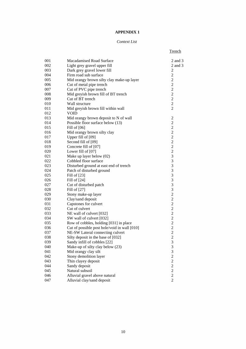
001 Macadamised Road Surface 2 and 3 002 Light grey gravel upper fill 2 and 3 003 Dark grey gravel lower fill 2 004 Firm road sub surface 2 005 Mid orangy brown silty clay make-up layer 2 006 Cut of metal pipe trench 2 007 Cut of PVC pipe trench 2 008 Mid greyish brown fill of BT trench 2 009 Cut of BT trench 2 010 Wall structure 2 011 Mid greyish brown fill within wall 2 012 VOID 013 Mid orangy brown deposit to N of wall 2 014 Possible floor surface below (13) 2 015 Fill of [06] 2 016 Mid orangy brown silty clay 2 017 Upper fill of [09] 2 018 Second fill of [09] 2 019 Concrete fill of [07] 2 020 Lower fill of [07] 2 021 Make up layer below (02) 3 022 Cobbled floor surface 3 023 Disturbed ground at east end of trench 3 024 Patch of disturbed ground 3 025 Fill of [23] 3 026 Fill of [24] 3 027 Cut of disturbed patch 3 028 Fill of [27] 3 029 Stony make-up layer 2 030 Clay/sand deposit 2 031 Capstones for culvert 2 032 Cut of culvert 2 033 NE wall of culvert [032] 2 034 SW wall of culvert [032] 2 035 Row of cobbles, holding [031] in place 2 036 Cut of possible post hole/void in wall [010] 2 037 NE-SW Lateral connecting culvert 2 038 Silty deposit in the base of [032] 2 039 Sandy infill of cobbles [22] 3 040 Make-up of silty clay below (23) 3 041 Mid orangy clay silt 3 042 Stony demolition layer 2 043 Thin clayey deposit 2 044 Sandy deposit 2 045 Natural subsoil 2 046 Alluvial gravel above natural 2 047 Alluvial clay/sand deposit 2
10

APPENDIX 2 MORTAR SAMPLE REPORT
Llanrwst Bridge parapet
Mortar
By Martin Locock BA MIFA and Jenny Hall BSc MIFA
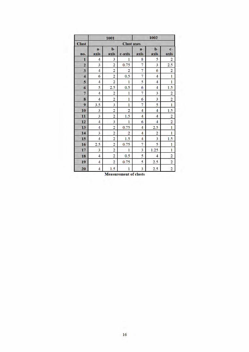
1 Introduction Two samples of mortar were recovered from archaeological mitigation works on the structure of Pont Fawr (Llanrwst Bridge), Llanrwst, Conwy, and submitted for analysis. Sample 1001 was derived from a rebuilding of the bridge parapet, and 1002 from the original parapet. An initial report was prepared based on physical appearance; quantitative analysis and characterisation was then undertaken. 2 Methodology The samples were crushed and coarse aggregate larger than 2mm were removed. A subsample of the remainder was then dissolved in dilute hydrochloric acid as recommended by (Cadw 2004, 2), dried and weighed to establish the lime content. The aggregate was then examined visually and characterised by size and shape using the Wentworth scale and roundness as defined by Powers (1953). Twenty grains from each sample were then characterised by sphericity and the length, width and depth analysed using Tri-Plot developed by Graham and Midgley (2000) and classified according to Sneed & Folk (1958). The results were tabulated and tri-plotted using http://www.lboro.ac.uk/research/phys-geog/tri-plot/index.html. Overall composition of the mortar was calculated from the coarse and fine aggregate and soluble (lime) components.
11

3 Catalogue of samples Context Description Date 1001 Hard grey-brown mortar with lime lumps Late 18th century 1002 Moderately hard pale brown mortar Pre 18th century 4 Component analysis Both mortars were non-uniform in material, and contained coarse aggregate of diverse size and shape. These large stones were therefore removed from the samples after crushing. Sample Coarse aggregate (g) Fine aggregate and lime (g) Total (g) 1001 47 89 136 1002 80 123 203 A subsample was then extracted from the remaining fine components. Sample Fine aggregate
(g) Lime (g) Total subsample
(g) %lime
1001 8 7 15 46.67 1002 10 11 21 52.38
12

5 Assessment of size and roundness of individual grains
Sample 1001 Sample 1002 Wentworth Scale % by
visual assessment
Roundness Description % by visual assessment
Roundness Description
Pebble (4mm-64mm)
<5%
Sub-rounded
<1 % quartz Remainder – Indeterminate dark grey., grey and grey/brown rock
20%
Sub-rounded
<5% , Black, vesicular material, light in weight; <1% quartz; Remainder Indeterminate grey and grey/brown rock
Gravel (2mm-4mm)
10% Sub-rounded
20%
Sub-rounded
Very Coarse Sand (1.00mm-2.00mm)
10%
Sub-rounded
10%
Sub-rounded
Coarse Sand (0.5mm – 1.00mm)
10% Sub-rounded
10%
Sub-rounded
Medium sand (0.25mm – 0.50mm)
10%
5%
Fine sand (0.125mm – 0.25mm)
10%
5%
Very fine sand (0.125mm – 0.0625mm)
15%
5%
Coarse Silt (0.0625mm - 0.039mm)
15%
5%
Clay (less than 0.0039mm)
15%
Not Assessed
10%
Not assessed
13


18
9 References Cadw 2004 The use of lime mortar in historic structures (Technical
Conservation Note 2) (Cadw, Cardiff).
Graham, D J, and Midgley, N G
2000 Graphical representation of particle shape using triangular diagrams: an Excel spreadsheet method. Earth Surface Processes and Landforms 25 (13): 1473-1477.
Locock, M 2010 Bricks and mortar: post-medieval buildings archaeology in Wales. The Archaeologist 75: 37.
Peate, I C 1946 The Welsh House: A study in folk culture (Brython Press, Liverpool).
Powers, R C 1953 A new roundness scale for sedimentary particles. Journal of Sedimentary Research; June 1953; 23 (2): 117-119.
Sneed, E D, and Folk, R L
1958 Pebbles in the lower Colorado River, Texas: a study of particle morphogenesis. Journal of Geology 66 (2): 114–150.

YMDDIRIEDOLAETHARCHAEOLEGOL
GWYNEDD
GWYNEDDARCHAEOLOGICALTRUST
Craig Beuno, Ffordd y Garth, Bangor, Gwynedd. LL57 2RT
Ffon: 01248 352535. Ffacs: 01248 370925. email:[email protected]