conservation of the old city of damascus: syrian arab republic
TRANSCRIPT
SYRIAN ARAB Technical Report RP/1986-1987/X1.1.3 REPUBLIC
International technical co-operation and advisory services for the preservation of the cultural heritage
Conservation of the Old City of Damascus
by Stefano Bianca
Serial No. FMFUCC/CH/87/114 (r
I I JAN. 1988 United Nations Educational, Scientific and Cultural Organization
Paris, 1987

CONSERVATION OF 'I$3 OLD CITY OF DAKASCUS
by Stefano Bianca
Report prepared for the Government of the Syrian Arab Republic by the United Nations * Educational, Scientific and Cultural Organization (Unesoo)
,
UNE*SCO

Technical Report w/19864987/xi. 1.3 lWR/CC/CH/87/114(Bianca) 22 June 1987
0 Unesco 1987 Printed in Prance
The designations employed and the presentation of the material in this document do not imply the expi-ession of any opinion whatsoever on the part of the United Nations Educational, Scientific and Cultural Organization concerning the legal or constitutional status of any country, territory or sea area, or concerning the delimitation of frontiers.
,..-. -..

(i) TABLE OF CONTENTS
I. INTRODUCTION. ..........................
II. THEOLDCITYITITSURBANCONTEXT .... .-. ..........
Historical background ...................... The structure of the urban system ................ The 1968 Masterplan .......................
III. MAJOR PROBLEMS AND PRELIMINARY RECOMMENDATIONS ..........
IV.
V.
Traffic and transportation impact ........... . . . . . Commercial activities ................. . . . . . Tourism ........................ . . . . .
EVALUATION OF PREVIOUS AND ONGOING CONSERVATION EFFORTS . . . . .
Urban conservation ................... . . . . . Restoration of monuments ................ . . . . . Conclusions ...................... . . . . .
ACTIONPLAN ...................... . . . . .
Strategic scenario for the historic districts ..... . . . . . Suggested planning measures .............. . . . . . Composition of the team and manpower needed ...... . . . . . Priorities for action ................. . . . . . Financial implications ................. . . . l .
ANNEXES
ANNEX1 - LIST OF PERSONS CONSULTED . . . . . . . . . . . . . . .
ANNEXII- BIBLIOGRAPHY . . . . . . . . . . . . . . . . . . . . .
MAPS AND PLANS
Fig. 1
Fig. 2
Fig. 3
Fig. 4
Fig. 5
Fig. 6
Fig. 7
Plan showing historic growth of Damascus . . . . . . . .
Plan showing age structure of historic Damascus . . . . .
Street map of Damascus today . . . . . . . . . . . . . .
Plan marking modern interventions in the historic fabric of the walled city . . . . . . . . . . . . . . . .
The 1968 Masterplan . . . . . . . . . . . . . . . . . . .
Development plan for the walled city (from 1968 Masterplan) . . . . . . . . . . . . . . . . . . . . . . .
Highway network in the city centre according to 1968 Masterplan and critical node around Hejjaz Railway Station . . . . . . . . . . . . . . . . . . . . .
h3!z
1
3
3 3 6
9
9 11 13
17
17 20 21
25
25 28 29 30 31
33
35
37
38
39
40
41
42
43

PHOTOGRAPHS
Pane
The continuation of the main street of Hariqa into the historic fabric and ‘fragmentation* of the Madrasa of Nur ed-Din . . . . . -
Traffic congestion on the continuation of Thawra Street, along the western edge of the walled city . . . . . . . . . . . . . . .
Congestion in the suqs caused by vehicular traffic . . . . . . a .
Khan Asad Pasha during restoration (1984) . . . . . . . . . . . .
The courtyard of the Citadel . . . . . . . . . . . . . . . . . . .
Newly cut street leading from the Citadel to Omayyad Mosque . . .
The new open square in front of the western entry gate to the Omayyad Mosque . . . . . . . . . . . . . . . . . . . . . . . . . .
Threat by unadapted redevelopment (Thawra Street along Suq Sarouja) . . e . . . . . . . .- . . . . . a . o . . . . . . . .
The main artery of the surviving eastern part of Suq Sarouja . . .
Typical areas for future adapted redevelopment extra muros: The old French vegetable market . . . . . . . . . . . . . . . An area near Bab as-Salaam . . . . . . . . . . . . . . . . .
Encroachment on monuments and example of unadapted redevelopment in the southern suburb of Midan . . . . . . . . ; . . . . . . . .
45
46
46
47
47
48
48
49
49
50 50
51
-l-
I. INTRODUCTION
1. The mission described in the present report was carried out in September 1986 at the request of the Government of the Syrian Arab Republic, and was funded by Unesco under its regular programme for 1986-1987.
2. The purpose of the mission was:
(a) to establish a base study concerning the urban development, with special attention to historic the old city;
(b) to establish a description of traditional architecture;
monuments and traditional housing in
the base characteristics of the
(c) to establish an action plan for the preservation of the old city, including a preliminary conservation budget together with a list of priorities.
3. The present report, based on the fieldwork undertaken during the last three weeks of September 1986 is to respond to the above objectives. It should be noted, however, that a certain change in emphasis has occured: after reviewing existing publications and being introduced to the detailed his- torical surveys organized by the German and the French Institutes of Damascus, the consultant realized that a complete record of the surviving 200-300 monuments in the historic districts has already been established, and that more work in this direction could only result in useless duplication. Therefore, greater emphasis was put on the urbanistic context of conservation, which appeared to have been rather neglected so far, while being responsible for some of the major problems facing the conservation of the old city.

-3-
11. THE OLD CITY IN ITS URBAN CONTEXT
Historical backnround
4. This report will not dwell at length on the well-known facts about the history of Damascus which have been dealt with by authors such as Watzinger/ Wulzinger, Sauvaget and Dettmann (see Annex II). It may be recalled, however,‘- that the present physical pattern of the city intra muros is the outcome of an ‘overlay’ of Islamic period structures on a Roman-Hellenistic grid system. The famous Omayyad Mosque occupied the enclosed precinct of the Greco-Roman temple, and many archeological traces of the pre-Islamic period have survived, partly hidden under later structures.
5. The city owes its site to the oasis of the Ghouta, which is irrigated by the various branches of the river Barrada descending from the slopes of Mount Cassioun. The exceptional potential of this site was certainly a reason which decided the Omayyad princes to choose the city as the new capital of the rapidly grown Islamic Empire. Except for the Great Mosque, one of the earliest surviving monuments of Islam, no architectural traces of the Omayyad period (661-750 AD) when Damascus was at the peak of its cultural and political importance are left.
6. With the rise of the Abbasids the centre of the empire was shifted to Baghdad, and it was only during the periods of the crusades that Damascus regained some of its previous importance, due to its key position at the crossroads between East and West. The Seljuks, their Atabys and most of all the Ayyubids brought new political strength and architectural achievements, leaving buildings such as the Citadel, and a large number of madrasahs and funerary buildings.
7. Under Mamluks the first Mongol invasion was defeated and Syria became part of the Mamluk Sultanate of Egypt (1250-1516). As during the Ayyubid period, a rich cultural exchange between both countries took place. During the earlier years Syria was more the giving partner than Egypt, yet the City of the Nile, being the capital has kept an even richer record of monuments. After the second Mongol invasion under Tamerlane (1401) and later with the advent of the Ottoman dynasty (1516-1918) Damascus fell back into the position of a provincial city. Though commerce remained an important function, as witnessed by a number of khans and rich merchant houses. Damascus was outdone by its rival sister Aleppo.
8. The shift from a medieval city into a modem metropolis was prepared in the late Ottoman period, when the Turks, inspired by European models, reformed their colonial administration, established a railway network an initiated new Western-oriented urbanization processes. This development continued under the French Protectorate after the First World War and gained an almost explosive momentum after independance, when Damascus became the capital of modem Syria.
The structure of the urban svstem
9. In the following, the report shall concentrate on the analysis of the various components of the old.urban fabric and their changing function and position with regard to the rapidly growing overall urban system.
10. Prior to the late Ottoman period (end of nineteenth century), Damascus included the following components:

(a>
(b)
(cl
Cd>
(4
(0
11.
The tits intra muros, which is the oldest and historically most important part, containing the religious centre and the central markets in its western sector and the residential districts in the eastern sector. It features the main bulk of monuments including archeological remains from the Roman period, the Omayyad Mosque, a number of important Ayyubid and Zengid Madrasahs, the Ayyubid Citadel, a few important Ottoman khans and a number of representative private houses and palaces. The average houses which form the predominant part of the urban tissue are courtyard houses, attached to each other and built in mudbrick technique with timber framing. Occasionally, stone is used. The walled city also features a Christian quarter on its north-eastern comer, near Bab Thouma, including a number of churches.
The northern suburbs of Okeibe and Sua Sarouja which evolved as exten- sions of the old city, attached to its three northern gates and the corresponding traffic arteries. Their development started in the twelfth/thirteenth century AD, when Damascus, due to the efforts of Nut ed-Din Zengi and the Ayyubid princes, started flourishing again. These suburbs had their own mosques and markets. Under the Mamluks, the development of the horse market and related commercial activities in an open space north of the Citadel gave further growth impulses to Suq Sarouja.
The southern suburb of Shasur al-Barrant, which developed in a way similar to its northern counterparts.
The south-western suburbs now known under the names Sueika and Oanawat, which developed from a thirteenth century extension extra muros attached to the western end of the old Via Recta. This was also the arrival/ departure point for the routes to Egypt and the Hejjaz. With reference to the pilgrims the place was first called Qasr al-Hajjaj, and its focal position was highlighted by a number of Mamluk mosques. In the late Ottoman period it extended further north and south, so as to connect with the new Ottoman city centre and the district of Midan.
The district of Midan, extending from Sueika to the south-west, along the road to the Hauran and to the Hejjaz. It started developing as an iso- lated nucleus during the Mamluk period and its growth in north-south direction was very much related to the reorganization of travelling to the holy places, as this became the place where pilgrims from the north- em part of the Islamic world assembled to form a common caravan to Makkah and Madinah. The economic and religious importance of this dis- trict in Mamluk and Ottoman times was expressed by a large number of grain stores, pilgrim markets, funerary monuments and rich merchants* residences , partly built in black basalt stone from the Hauran.
The district of Salihiva which was founded in the twelfth century AD at some distance from the old city, on the slope of Mount Cassioun, to accommodate refugees from Palestine expulsed by the Crusaders. The out- post quickly developed into an autonomous district with its own Friday mosque, but without fortifications. It was considered as a city of learn- ing, with a number of mainly Ayyubid mosques and madrasahs attached to funerary buildings of rulers, learned men and mystics.
These five main components together represented the ‘medieval’ Damascus, as based on the traditional urban system of the pre-industrial Arab city, with its specific circulation system, commercial structures and building typol- ogies, which were perpetuated for centuries with only minor variations.
-5-
12. A first departure from this system took place during the late Ottoman period in the second half of the nineteenth century. At this time the Turkish rulers started introducing modem European-type city administrations every- where in the Ottoman Empire, combined with corresponding Western-type urban- ization models. In Damascus, this led to the development of a new Ottoman city centre east of the Citadel, around Merjeh Square and the Serai. This new district gained further importance after the opening of the railway link with the holy cities, which resulted in the construction of the IVasr Avenue. This large, representative avenue was in continuity with the Suq al-Hamidiyeh, leading from the Citadel to the Omayyad Mosque, and thus became part of the main artery connecting both city centres. A side effect of this operation may have been to help move the centre of commercial activities in the old city more northwards, i.e. nearer the Omayyad Mosque and Suq al-Hamidiyeh, while before it was located near the old Via Recta.
13. During the same period, some significant urban renewal projects also took place within the’walled city. They concerned the reorganization, enlargement and covering of a number of suq sections. The most important of these ope- rations was the Suq Midhat Pasha on the western part of the old Via Recta. The new covered suqs from this period conveyed a new, more monumental sense of space to the old markets and provided an orderly framework as opposed to the more vernacular and improvised arrangements of shops which often encroach upon the street space. Yet, in modern times the available street width of 8-10 meters in these new covered suqs has caused car, bus and truck traffic to take possession of the space, with undesirable side effects of congestion and pollution.
14. During the Ottoman period, i.e. up to the First World War, the walled city remained demographically and commercially the most important part of Damascus. The ‘Turkish City’ adjacent to it, although the new centre of decision-making and of much higher social status, was physically a mere appen- dix of the old city. This situation started changing during the period of the French mandate, when the new colonial power established its own city centre on the other side of the Barrada river, north-west of Merjeh Square and the Ottoman downtown area. From now on, this became the new focus of town plan- ning. The explosive growth of the modern metropolis during the past 30-40 years has resulted in a much reduced importance of the old city, which has become but a small part of the agglomeration.
15. At the same time there has been a trend towards social downgrading of the old city: its residential areas are considered as *poor* districts and most of the original inhabitants have left, with the usual consequences of lack of maintenance and deteriorating building stock. Its commercial areas are now catering for a popular clientele of lower- and middle-income groups, while more prestigious Western-type shopping areas are located in the modem city centre. However, as lower- and middle-class income groups are the large majority of the metropolitan population, this means that the suqs in the old city are to cope with a demand which is many times the size of the resident population. The developing bazar economy with all its related activities (wholesale, stocking, manufacturing) is therefore occupying large sectors of the walled city and the old suburbs, spreading into former residential areas and making abuse of the historical building stock. As many of these commercial and industrial activities depend on heavy vehicle access (pick-ups or trucks), this creates additional problems with regard to the morphology of the old city.

-6-
16. All these trends, together with the redevelopment pressures emanating from the modem city centre have necessarily affected the physical structure of the historic districts. However, their impact was different for each of the components of the medieval urban system. The most affected part was the suburb of Sua Saroula after being cut by Thawra Street: its western half being adjac- ent to the heart of the modem central business district and being surrounded by important traffic arteries from all four sides is practically condemned to total demolition and is at present being redeveloped step by step as an exten- sion of the modem city centre, with building regulations allowing for up to 30 floors. Its eastern half still stands up comparatively well, but it is threatened by a lo-year old development plan which would mean total transform- ation similar to the western part. Its conservation will depend on how redevelopment pressures can be contained and controlled, and whether it will be possible to keep Feisal Street as a local commercial artery. For its transformation into a metropolitan highway would probably cut all connections between Suq Sarouja and the walled city and condemn the eastern sector of Suq Sarouja and Okeibe, too.
17. The south-western suburbs are in a similar, though less dramatic situ- ation to Suq Sarouja: Bidan has been cut into a northern and southern half by the construction of the two-level highway which acts as a bypass to the city centre (Beirut-Aleppo highway). Being at a greater distance from the Central Building of Damascus (C.B.D.), the commercial redevelopment pressures may be less dynamic, yet the traditional urban fabric is disintegrating at a rapid pace; many apartment blocks are being built on ruined sites, which over-use the plot, do not adapt to the historic context, and often even encroach upon remaining monuments.
18. As far as the walled city is concerned, it still features most of its traditional urban fabric, although many buildings are in rather poor struc- tural condition. The major redevelopment intra muros is the new Hariqa Suq district, built after the Second World War on an area south of the Citadel which had been demolished during political struggles in 1925/1926. It has become a most vital commercial area, complementing the old suqs from a func- tional point of view, but different in scale and physical structure, as it is conceived for vehicular circulation. Other modem interventions concern the widening of Hassan Kharrarat Street inside Bab as-Seghir, and of the central section of the old Via Recta. Very recently, a new square in front of the main entry to the Omayyad Mosque has been cut out by demolishing a number of hous es, and this was combined with the opening of a new vehicular access from the eastern wall of the Citadel to the Omayyad Mosque. Furthermore, an exten- sion of the Shiite sanctuary of Sayda Ruqaia is now under construction which also involved the destruction of several old houses.
The 1968 Masterolan
19. The Masterplan established by M. Ecochard and 6. Banshoua in 1968 was the main instrument for controlling the growth of the metropolitan area and the interface between the old city and the other parts of the urban system during the past two decades. As far as the city intra muros is concerned, it was implemented to a very small extent, only. However, it has created problems in areas adjacent to the old city with repercussions which are still far from being solved. As the establishment of a new or revised Masterplan is now over- due after a lapse of 18 years, it seems suitable to analyse the main short- comings of the Masterplan with special reference to the old city.

-7-
20. The salient characteristics of the Masterplan may be summarized as follows:
Like most plans of this period, it grossly underestimated population growth resulting from rural emigration: it assumed a maximum population of 1.5 million in 1984, while the actual present figure must be near to 3.0 million. This of course also means that transportation problems and economic activities were underestimated.
Corresponding to the then prevailing ideology, it was mainly transportation-oriented, turning the very function of vehicular traffic into the determining factor to which all other functions were subordinated.
As far as the traffic network and building regulations are concerned, it did not sufficiently take into account the fundamental differences in morphology between the various components of the urban system, old and new.
Although concerned about a number of key monuments and their setting, it did not care very much for the specific qualities of the traditional Islamic city, isolating the monuments from their urban context, for the sake of vehicular accessibility.
21. The Masterplan intended to cut a vehicular traffic network through the old urban fabric, inspired from the rectangular alignment of the old Roman grid. Some of the roads would end with parking lots in the centre of the old city, around the main suqs and the Omayyad Mosque. Others were connected to form a bent thoroughfare surrounding the monumental core and separating the western from the eastern half of the old city. The Omayyad Mosque was suggested to be totally cleared from adjacent buildings. In the eastern districts several areas were allocated to comprehensive redevelopment without specifying any criteria concerning type and character of architectural structure and traffic network. (These areas, by the way, are still standing today, 20 years after the Masterplan and constitute a valuable residential district.) In addition, the natural river landscape of the Barrada, along the northern walls of the old city was proposed to be destroyed through canal- ization combined with a new highway.
22. The results of these interventions, had they been executed, are easy to imagine:
The thoroughfare through the old city would have been used as a con- venient alternative north-south connection within the metropolitan system of Damascus , parallel to Thawra Street, attracting a lot of additional traffic.
Once the old city opened to vehicular access, further development and redevelopment would have been dictated by traffic needs: congestion would lead to widening of the roads which in turn would bring further traffic, etc., establishing a dangerous circular vitiosus.
The old pedestrian network, cut into small sections and crossed with the vehicular system would lose its consistency. Once its integrity is lost, it could hardly withstand entering cars on its larger sections and press- ures for widening on its narrower sections.

-8-
The cellular tissue of the old urban fabric would disintegrate with every new street cut. Traditionally, it is composed of attached courtyard houses and integrates the traffic network into its overall structure. Its cohesion is derived from the introverted structure of the agglutinated units, which form a multinuclear pattern focused on a multitude of courtyards. The cutting of linear street axes introduces a totally dif- ferent system of references: the ‘magnetic field’ of the multinuclear pattern is disrupted by linear street spaces intended for the ‘extra- verted’ street-front development. The edges of new street alignments always involve scores of demolished, fragmented or heavily damaged build- ings on the destroyed fringe of the old urban fabric.
Increase in vehicular accessibility is the starting point for economic processes which are extremely difficult to control. Mostly they result in speculative redevelopment of new street-front buildings which are not compatible with the traditional morphology, yet tend to impose dangerous new development standards for the old city.
23. An illustration of the above conflicts is provided by the development of the Hariqa district which replaced parts of the old urban fabric in the late 1940s. Implementation of the Ecochard Masterplan would practically have meant to extend this type of development into the old city, implying the progressive destruction and replacement of the historic fabric. In fact, the central west-east main artery of Hariqa ~88 extended according to the Ecochard plan, and the results were: the fragmentation of the Maristan IVureddin, unsuitable new commercial blocks coming up adjacent to major historic monuments, and a traffic congestion typical for uncontrolled increase of accessibility.
24. All in all, it can be said that this Masterplan, if fully executed, would probably have destroyed the character and the unity of the walled city. The planners * attitude was based on European concepts of ‘misc en valeur’ which are opposed to the structuring principles of Arab Islamic cities. Here, archi- tectural consistency depends on the integrity of the urban context, and does therefore not allow for the isolation of individual buildings. The somewhat romantic attitude towards the archeological vestiges of the Roman street net- work combined with the idea of making it a tool for the introduction of modem vehicular traffic led the planners to disregard the essential values of the living historic city.
25. As no detailed plot-by-plot survey of the historic housing stock was available at the period of the Masterplan, the suggested surgery would have represented a rather irresponsible intervention, for there was not enough knowledge about the existing tissue and its components, nor did the plan suggest any measures to control negative side effects on the open fringe of the disrupted urban structure. These shortcomings could have been partly com- pensated, if sensible detail development plans had been worked out for the historic districts after 1968. This, however was not the case. The only detail plan in the historic areas was the one for Suq Sarouja from 1976, which was responsible for the total demolition and redevelopment of the western part of this district.

-9-
111. MAJOR PROBLEMS AND PRELIMINARY RECOMMENDATIONS
26. This chapter outlines the various types of pressures which affect the conservation of the old city. As far concerning specific issues. However, problems will have to be provided by
-- action plan (Chapter V).
Traffic and transnortation imoact
as possible recommendations are made final and more detailed answers to these future studies, as suggested in the
27. Penetration of the pedestrian network by vehicular traffic is a general problem in the old city. It occurs whenever the streets are wide enough to allow for it, as little or no traffic control measures are applied by the authorities. The problem becomes most acute in places where the traffic load is not generated by the residents, but by the impact from the overall metro- politan system. For better understanding of the issue it will therefore be necessary to analyse the structure of the metropolitan transportation system in its relation to the old city.
28. The main thoroughfare of the Damascus road network, as foreseen by the 1968 Masterplan, is the Aleppo-Beirut highway which passes at a distance of around 1 kilometre east and south of the walled city, cutting through the district of Midan. From both ends of this L-shaped bypass, a number of arteries parallel to the slopes of Mount Kassioun lead into the modem dis- tricts of Damascus north of the Barrada, establishing a series of west-east traffic streams which do not fundamentally conflict with the structure of the old city.
29. The most problematic traffic flows are those in the north-south direc- tion, coming from or going to Deraa and the airport. Being channelled through Khaled Ibn Walid Road and Thawra Road they have to cross the west-east artery of Kouwatly Street (along the Barrada), enclosing between them the old Ottoman city centre around Nasr Avenue. Khaled Ibn Walid Road is continued by Port Said Avenue after reaching the Hejjaz Railway Station, leading into the heart of the modem C.B.D. So far, it has no direct incidence on the old city. Thawra Road, after coming down in front of the Citadel, has to squeeze through a bottleneck between the walled city and the south-western suburb, where a number of suqs meet to form an important node, enhanced by several Mamluk mosques.
30. Accordingly, major congestions occur all day long in this focal area on the south-western comer of the walled city: heavy traffic flows in north- south direction try to find their way to the comer of Bab Seghir cemetery, where they bifurcate towards Bab Mussalla and the airport circle. Vehicular traffic clashes with equally heavy pedestrian streams in east-west direction, connecting the Hariqa and Hamidiyeh suqs with Nasr Avenue and the western city centre, as well as Suq Midhat Pasha with the Bab al-Zabieth suq.
31. Corollary to this congestion on the western edge of the walled city is the even more problematic situation in certain areas inside the walled city, where through-traffic in the opposite direction (from south to north) tries to force its way through Hassan Kharrat Road, the old suqs and Hariqa, to meet Thawra Street in front of Suq Hamidiyeh. This route is also the way out for service traffic which enters the old city centre through the large covered Midhat Pasha suq. Congestion and pollution in the affected sections of the covered suqs have exceeded by far normal tolerance levels.

- 10 -
32. The crucial importance of Thawra Street is underlined by the fact that the circular road around the walls of the old city is attached like a loop to this tangential traffic channel. The heavier the load of north-south traffic, the more pressure will therefore also be exerted on the ringroad, with the effect of functionally and physically disconnecting the suburbs from the old city.
33. At the present moment parts of the metropolitan road network of the 1968 Masterplan are still under construction or have not been implemented. We shall discuss three such sections with regard to their specific impact on the old city.
The DrODOSed south-north connection through the old city
34. In terms of mere traffic efficiency, this new road suggested by the 1968 Masterplan would probably help relieve the bottleneck of Thawra Street near the Hariqa suqs. However, for reasons explained in paragraphs 19-25, it would mean the destruction of the integrity of the historic fabric intra muros and entail far-reaching consequences which would never make up for the only tem- porary improvement of traffic conditions. It is therefore a fortunate coinci- dence that this road section has been abandoned, but it still needs to be cancelled by formal government decision.
The southern hinhwav access to the citv centre
35. The Masterplan had foreseen the construction of a new high-capacity high- way parallel to Khaled Ibn al-Walid Street, leading from the south into the heart of the Ottoman city centre and connected with Thawra Street through Nasr Avenue. Construction of this new highway is under way, but not completed at its northern end, as the junctions around Hejjaz Railway Station and the continuation across the Barrada are not resolved as yet. Constructing the highway until Hejjaz station only and pumping the increas.ed traffic load into the existing street networks would be no solution. For it would only increase the already high congestion in the former Ottoman city centre to a level which would have repercussions on the old city, while also blocking the through- traffic flows and therefore preventing the north-south connection from fulfil- ling its function.
36. Therefore, there are only two alternatives to be considered:
Alternative (a): Continuation of the highway in the northern direction across the Barrada with the same traffic capacity. Given the dense struc- ture of the modem city centre it is, however, hard to see where the highway could interconnect with the normal street system (Yussuf al-Azmeh Square? Central Bank Square?). The financial costs and the environmental damage of such an operation would probably be prohibitive.
Alternative (b): To stop construction at the present point and divert traffic flows into the circular roads of Abu Bakr as-Sedik and Ibn Assaker. This would mean abandoning the north-south expressway through the city centre and improving the circular routes around the city centre, from which peripheral access to downtown areas would be given. The criti- cal points of this circular system would then probably become the Omayyad Square, the circle in front of Suq al-Hal and Central Bank Square, which would have to be improved, possibly by subways.

- 11 -
37. The choice between these two alternatives is a strategic issue with far- reaching consequences for the future of the Damascus downtown area and should therefore not be delayed. At any rate, the massive absorption of traffic into the centre without prior knowledge of how to distribute it on the existing network should be avoided. The possibility of a ‘fork’, i.e. splitting the traffic load between Port Said Road and Thawra Road by using Nasr Street as a distributor should be excluded, as it will not provide a valid long-term sol- ution, while adversely affecting the old city through increase of traffic on the Thawra channel.
38. An additional point worth considering is the historical value of the Hejjaz station and the mall of Nasr Street. Implementing a major traffic node in this area would necessarily mean the partial or total destruction of one of the most interesting and most consistent urban spaces in modem Damascus, which is representative of the pre-First World War period. the old railway station could easily be rehabilitated and converted into a cultural, govem- mental, or semi-commercial complex. Within the layout of the modem city centre it is a welcome counterpoint to the Central Bank Building, as the two define both ends of the most representative commercial artery of modem Damascus.
The last section of the Beirut-AleDDo hinhwav
39. This highway was conceived as the main channel of through-traffic flows around the city centre, through an area which suffered from less urbanization pressures. Yet, its potential as a bypass, and especially as relief for Ibn Assaker Avenue and the circular road around the old city cannot be effective as long as its last eastern section, between Airport Road and the beginning of the Aleppo highway is not implemented. The construction of this missing link is therefore of vital importance for the protection of the old city, es- pecially in view of the congestions which occur on the eastern edge of the old city, near Bab Thouma, as long as the circular road (Ibn Assaker) has to cope with transiting regional traffic.
Commercial activities
40. As previously stated, the urban bazaar economy of Damascus underwent major quantitative and qualitative changes: quantitative in a sense that goods manufactured and/or sold in the historic districts now cater for a population many times larger than in the Ottoman period. Quantitative in the sense that materials, manufacturing processes, supply methods and transportation have radically changed. Only a small proportion of goods is still locally manu- factured as in the old days of the traditional crafts, but import of foreign merchandise and repair or partial manufacturing of technical equipment have filled the gap and have rapidly expanded into a metropolitan and even regional scale of activities.
41. As is the case in many comparable cities, economic activities in Damascus fall into two basically different, although not totally separate categories - the ‘formal’ and the *informal* sector. Both operate in different ways, but are to some extent complementary or even compete with each other. The ‘formal’ sector is mainly composed of large corporate and semi-governmental entreprises with firm administrative structure, high capital investment and high degree of technology, representing the modem western-type production. The ‘informal’ sector is a continuation of the old bazaar-economy, adapting to changed cir- cumstances and developing according to new needs, but operating along the traditional suq patterns, with only minor transformations. Its main charac- teristics are:

- 12 -
aggregation according to professional branches and their functional interdependences;
vicinity of home and working place and easy availability of labour;
closeness of production, wholesale and retail markets; - small-scale, family-type operation based on individual ownership rather than corporate systems;
flexibility in adaptation to technologies, space requirements and market needs ;
skills acquired outside the formal school system.
42. These characteristics make it clear that the activities of the *informal sector* have a natural affinity to the old city which offers them important locational advantages. For most of them difficulties in vehicular access are not a major problem as long as cheap labour (porters) is available; in fact this remoteness offers the advantage of casting a veil over the operations and protecting them from governmental control, which largely compensates for lack of accessibility. In addition, rents are cheaper than in the new city, which increases the competitiveness of the bazaar economy.
43. While the transformed bazaar economy seems to work well from a merely economic point of view and in a way contributes to the liveliness of the old city, it also poses a threat to conservation. The major dangers are:
disorder in the traditional land-use patterns by occupation of resi- dential districts for commercial activities;
intrusion of functions into buildings which are typologically not fit to accommodate them;
abuse of traditional building stock and even monuments by lack of main- tenance, transformation or inadequate repair;
vehicular traffic generated for loading/unloading of merchandise, wher- ever the width of the pedestrian network allows for it.
44. In principle, the modem bazaar economy is not totally incompatible with the conservation of the old city. Its survival is even needed to secure the viability and attraction of the historic districts. Therefore, comprehensive relocation of wholesale and industrial activities in remote districts of the metropolis are not a real solution, except for a few branches which tend towards heavy industrial processes, are in need of larger spaces and have no vital interdependances with the old city. Yet, a thorough reorganization of the various economic activities within the boundaries of the historic dis- tricts is urgently needed in order to ensure compatibility with the physical ‘shell’ and control ongoing transformations.
45. This means that the historic area has to be divided into certain types of zones, according to morphological categories, and for each one of these zones criteria must be established concerning permitted types of activities. The typology of activities must consider the involved size of merchandise, stock- ing or production items, the turnover, the transportation requirements, noise and vibration level, etc., in order to match various categories of the archi- tectural typology.

- 13 -
46. In view of such a reorganization it should be kept in mind that the his- toric suburbs offer a much better level of accessibility and that most of them are less homogeneous than the old city, or partly ruined. This may provide a certain potential for transformation which is not available in the city intra muros. In addition, there are a number of redevelopment opportunities such as the former colonial vegetable market (‘Les Halles’) in Suq Sarouja and Feisal Road. These areas should not be given away to redevelopment without establish- ing a comprehensive study for their reorganization, as they may provide a unique chance for relocation of certain activities from the old city within the boundaries of the historic districts.
Tourism
47. In spite of its important historic heritage, Syria has so far not become a country of mass tourism such as Egypt and Greece, but the government is now undertaking major efforts to promote tourism. Recently there has been a yearly increase of visitors by around 15 per cent, which means that in the future tourism may become an important economic factor.
48. The old city is the major asset for the touristic development of Damascus. Tourism at present is supported by European and American visitors on the one hand and religious groups from Islamic, mainly Shiite countries, on the other hand. The first type of tourists are mainly interested in the Omayyad Mosque and the nearby monuments, the Roman vestiges and the suqs in the walled city. The second type of tourists visit the Omayyad Mosque, the Shiite shrines, the cemetery of Bab as-Seghir and possibly the mosque of Ibn Arabi in Salihiya.
49. The impact of tourism on conservation is an ambiguous one: it may help to finance conservation, but it may also disturb or even destroy the historic or natural integrity of a place. As witnessed by many touristic sites in Europe, there is always a danger that tourism undermines its own resources by overuse or by lack of consideration for the fragile nature of its very poles of attraction. This can also occur in a historic city such as Damascus, and there are indicators that this negative impact is already taking place. To illus- trate this problem in greater detail, we will discuss three recent projects.
The hotel in the Khan Asad Pasha
50. This early Ottoman khan is the most beautiful example of a historic carawanserail in Damascus. It is centrally located near to the Via Recta, the main suqs, the Omayyad Mosque and the Azem Palace, and has just been restored to its original features by the Antiquities Department. The current project of converting it into a five-star hotel, however, will result in an unfortunate transformation, for it cannot but discredit the previous restoration, while at the same time falling short of the standards expected from a modem de-luxe hotel. This is for the following reasons:
infrastructure, electricity, plumbing and air-conditioning will necessi- tate structural interventions which will alter the aspect of the historic monument in an irreversible way;
access to the monument will be restricted to a wealthy foreign clientele who is more interested in refined comfort than in real experience of the traditional building and its surroundings;

- 14 -
the service rooms needed for a hotel of this standard (kitchen, laundry, personnel, etc.) will require the construction of a modem annex which will involve demolition in the historic fabric around the khan;
the required car, taxi and pick-up access to and from the hotel will cause congestion and pollution in the covered suqs at all times of the day; it will establish a dangerous prejudice, compromising any future pedestrianization policy;
the presence of a potent foreign clientele will destroy the aspect and the balance of the Suq Bzouriyeh, transforming it gradually into a mere touristic bazaar;
the rooms of the hotel now being arranged in the cells along the corri- dors of the first floor will not satisfy the standards of natural light- ing, privacy and accoustic insulation required for a five-star hotel, as the main room windows all look onto the corridor;
accessibility standards do not correspond to the requirements of a modem luxury hotel, as parking is not available and all access routes will suffer from congestion.
51. Unfortunately, this project now seems too advanced to be stopped. How- ever, it is important to note that it is a step in the wrong direction, and that more similar projects would serve the destruction rather than the rehabilitation of the old city. In case a change of the project is still possible, it is recommended to maintain the ground-floor part of the hotel only, with restaurant and cafeteria, to convert the rooms into craft shops and/or exhibition rooms , and to reduce or cancel the service annexes.
The Sitta Rukava Shrine extension
52. The shrine is located north of the Omayyad Mosque, adjacent to the gate of Bab al-Amaarah, and is now much visited by religious tourists from Iran. Recently, about eight houses around the shrine have been bought and demolished to build a large new mosque which is now under construction. The consultant was unable to see plans of this new building, to judge whether it will be compatible with the surrounding urban fabric.
The Citadel and the new sauare in front of the main entrance to the Omawad Mosaue
53. The opening of a new street between the Citadel and the Omayyad Mosque as well as the clearance of two houses in front of the western entry gate of the Omayyad Mosque are at least partly based on the recommendations of the 1968 Masterplan and may have more than just touristic implications. Now that those interventions are made, best possible use should be made of them.
54. It seems undesirable to open these streets for tourist cars or to general vehicular access (except for VIP visits), because they would then be misused as parking spaces, as is already happening on the cleared Qibla wall of the Grand Mosque. On the other hand, the new street could provide a good unob- structed pedestrian entry into the old city from the Citadel. In this context it may be worthwhile considering the use of the large open courtyard of the Citadel as a starting and ending point of tourist visits. The Citadel has been vacated from military occupation and is now under restoration. The courtyard could easily contain gardens, an information office, restaurants or cafeterias and serve as a drop-off and pick-up point for tourists. It would be much

- 15 -
easier to reach from the modem city centre than any other point of the old city, and tourists could continue without being exposed to the hassle of the Hariqa suqs and Suq Hamidiyeh.
55. The weak point of these new street openings and widenings is that they were implemented without giving any thought to townscape repair and improve- ment. At present the cuts are poorly masked by blind walls or cheap decorative elements. With respect to the historic importance and the representative character of this area, a sensitive redesign and beautification of the edges and open spaces should be undertaken. Improvement of elevations should be combined with the introduction of additional functions along the edges in order to give these spaces the required lively urban character.
56. As a rule, future interventions of this type (i.e. street widening or creation of open spaces) should only be tackled within the framework of an integrated project, relating the operation to the surrounding buildings and considering all functional, economic and aesthetic implications.

- 17 -
IV. EVALUATION OF PREVIOUS AND ONGOING CONSERVATION EFFORTS
Urban conservation
57. Efforts for the conservation of the city intra muros as a whole started in 1974/1975, when the site, on the request of the Directorate of Antiquities, was inscribed in the World Heritage List. Although not effective in legal terms, this decision provided some sort of protection due to international recognition of the importance of the traditional urban structure. At the same time, a special department for the old city of Damascus was created within the Antiquities Organization, with its own office near Merjeh Square, as well as a local society of the *Friends of the Old City’, which was to give public support to the cause of conservation.
58. In 1977, an International Committee for the Preservation of Damascus under the presidency of H.E. the Prime Minister was founded; among its members were mainly personalities from the academic world, as well as the Directors of the French and German Institutes in Damascus. The main achievement of this committee was to initiate the comprehensive surveys on historic buildings in all historic districts of Damascus which are now being concluded. The German Institute was responsible for the city intra muros and Salihiya, while the French Institute took care of all the historic suburbs.
59. It may be regretted that the two teams did not follow the same method- ology: the German survey was more monument-oriented in its output, while the French survey considered the monuments in the context of the complete urban fabric, producing a full plot-by-plot coverage. The results have however led to the identification of a great number of hitherto forgotten historic build- ings, and accordingly the record of listed monuments which now total about 250 structures could be completed by the Antiquities Department.
60. Surveying, recording and listing are important premises to conservation. Yet, the practical implementation of conservation can only be done through the channel of town-planning decisions and corresponding legal instruments. In view of this fact, co-ordination with the various technical departments of the municipality was sought through the establishment of a governmental committee for the old city, which included representatives from the Antiquities Depart- ment, from the municipality and each of its technical departments, from the Ministry of Tourism, from the Pious Foundations (Awqaf) and from the Univer- sity (Architectural School).
61. Founded in 1978, this governmental committee has recently been successful in establishing the following protective measures:
(a) Repulations for the old citv intra muros
62. A new set of regulations was discussed by the committee in 1985 and accepted in 1986 to control building activities in the old city. The most relevant points of these regulations, which replace the old masterplan directives are the following:
Replacement of ruined buildings and infill projects must follow the plot sizes of the old cadastral map from 1930.
Reconstruction and restoration of all buildings must be done with the original materials, i.e. stone brick, wood, gypsum and traditional plastering.

- 18 -
Stone buildings or walls must be maintained and cannot be replaced.
New buildings are allowed with a ground floor and one upper floor only.
Illegally added second and third floors in existing buildings must be demolished.
Renewal, reconstruction and restoration are only possible after submittal and approval of a complete project documentation, determining size, value, elevations, materials, etc. Approval is needed by both the Antiquity Organization and the municipality.
Land and building use intra muros is restricted to housing, culture, religious functions and education, arts and crafts, commerce and tourism. The opening of new shops and workshops is subject to governmental licenses. Wholesale and industrial manufacturing processes are to be banned from the old city as far as they are harmful. Tourism is to be promoted by suitable infrastructure improvements (hotels, restaurants, arts and craft shops, etc.).
63. These regulations confirm the intention of the authorities to deal with area conservation and not only with individual monuments, at least as far as the city intra muros is concerned. Their eventual success will, however, depend on actual implementation, which implies continuous monitoring and, if needed, ready enforcement by the authorities.
64. In the future, much will depend on whether the private land owners can be lured to join in the conservation effort of the government. The clearly stated conservation and improvement objectives, together with a number of govemment- financed projects in the old city will provide incentives and may set a new general trend towards upgrading and enhancement.
65. Concerning the promotion of tourism as an agent for conservation the principle may be right, but much depends on how it is materialized. The problems discussed in paragraphs 47-49 prove that touristic development can also be harmful, if not appropriately steered and controlled. As a rule, it is required that touristic functions must adapt to the morphology and specific conditions of the traditional urban fabric and not vice versa. Hotels, for instance, may be an excellent tool for rehabilitating certain old buildings which are too large for maintaining residential functions; however, they should not impinge on the architectural substance of the building and should appeal to a class of clients who prefer authentic values to a combination of superficial folklore and American five-star comfort.
(b) Foundation of a walled citv municinalitv
66. In accordance with the current governmental practice of establishing submunicipalities in the various districts of Damascus, such an organization has also been set up for the walled city, with its offices in the police station building near Bab Thouma and with a documentation centre in a cen- trally located old private palace, which also serves as a cultural centre (Maktab Anbar). This organization is still at its beginnings, but it is to be hoped that it could be staffed in order to fulfil its specific monitoring and controlling function. This is clearly a much more complex and sophisticated task than in other districts of Damascus and will therefore require the con- tinuous presence (over many years) of a number of architects and technicians specialized in the problems of the old city.

- 19 -
(c) Fnvironmental nrotection of monuments in the historic suburbs (Midan, Sueika, Shaghur, Suq Sarouja east)
67. .Under the current masterplan regulations from 1968, the suburbs fall into zone K which has called for street widening and free redevelopment of individ- ual or combined plots with a building height of up to 14 metres. Alarmed by the results of this type of redevelopment, the municipality has now suggested to establish a protection zone with a 25 m radius around listed monuments. Within this protection zone, redevelopment is subject to a more severe control as regards its compatibility with the historic structures, building height, bulk and elevations. Special permissions will be issued after approval by the Antiquities Organization and the municipality.
68. This rule has not been given force of law so far, but may be implemented in the near future. Its success will depend on the consistent use of the right design criteria and their actual enforcement by the authorities. Assuming that this can be achieved, the new rule is certainly an improvement compared to the present situation; yet, it is not sufficient to guide the inevitable evolution and transformation of the historic suburbs as a whole. In addition it should be noted that the 25 m circle is a rather abstract concept, which is difficult to apply in reality. It would therefore be preferable, as a second step, to identify precise conservation zones around the major monuments, referring to the cadastral map and issuing specific development constraints according to each individual situation.
69. It should be noted that the historic suburbs not only lack comprehensive protection, but that the ten years old redevelopment plan for Suq Sarouja is still threatening the eastern half of the district which has so far escaped wholesale demolition. This plan should be formally cancelled, in order to give way to a more adapted evolutionary rehabilitation concept.
(d) Protection of Salihiva
70. The narrow and elongated nucleus of Salihiya is now totally surrounded by the recent urban development climbing up the slope of Mount Cassioun. It is to be foreseen, therefore, that redevelopment pressures will increase very soon, especially as the present masterplan allows for 14 m high buildings without any specific conservation constraints. In 1984, the municipality established a 40 m wide protection strip along both sides of the main spine, with similar rules as in the 25 m circle mentioned in the previous paragraph. Again, this measure is a positive first step, but it should be followed up by a more detailed and less abstract conservation plan, responding to the actual geo- graphical and architectural site conditions, and specifying the regulation applicable for each sub-zone (including the relatively well preserved resi- dential districts around the monuments).
(e) Pilot uroiect in the Hamrawi district
71. In 1983/1984, when certain portions of the historic fabric around the Omayyad Mosque were cleared, there was a danger that the whole block south of the mosque (the Hamrawi district) would also be cleared as a ‘slum area’. A public outcry of the concerned inhabitants, a campaign of professional circles committed to conservation, and the intervention of the Antiquities Organiz- ation eventually succeeded in stopping the demolition. Later, the Antiquities Organization carried out an environmental improvement scheme in the alley-ways of this residential district, including repair of elevation elements and new plastering of the exterior walls.

- 20 -
72. This first emergency measure may be of a somewhat ‘cosmetic’ character, and the white paint of the elevations may not fully correspond to the local tradition. Nevertheless, it was an important political signal, underlining the determination of the government to commit itself to the case of conservation. It will now be followed up by a more complete interior renovation of the houses, with a total budget of two million Syrian Pounds being allocated to this project for 1987 and 1988.
73. The upgrading of the Hamrawi district will therefore be the first exer- cise in area conservation to be carried out in Damascus. It is hoped that it may provide lessons and experiences which can later be applied to other areas. Should the operation be successful, it would be desirable to maintain the team of craftsmen or workers in order to constitute a permanent ‘task force’ for such projects.
Restoration of monuments
74. Simultaneously with the surveys mentioned in paragraphs 57-61 the Antiquities Organization has started and partly achieved a number of important restoration projects over the past ten years. Many of these operations con- cerned collapsed or heavily damaged buildings and have resulted in full or partial reconstruction rather than restoration. In some cases the principles and methodology of restoration would seem worthwhile to evaluate by a resto- ration specialist, in view of providing consistent and valid guidelines for similar future projects. Yet, on the whole, the effort in itself is very posi- tive and demonstrates that the authorities are willing to take care of the historical heritage, in spite of limited available funds. In the following, we shall list the major recent restoration projects.
The Omawad Mosaue
75. After clearance of abutting shops on the southern and western walls, the structure of the Roman-Hellenistic stone masonry with its various inclusions has become visible. However, the newly opened square in front of the main entrance is not to the advantage of the mosque: the treatment of surrounding walls and the pavement shows no traces of a coherent design concept, and most of all the open space itself is detrimental to the experience of the courtyard of the mosque, as contrasting with the narrow old alley-ways.
me Citadel
76. This monument which marks the resurgence of Damascus in the twelfth/ thirteenth century is now being given due attention. Gates, walls and most of the 12 towers are being restored, while the missing tower on the prominant south-western comer, adjacent to the entry into Suq Hamidiyeh is being reconstructed after the model of its counterparts. Special thought should be given to an appropriate functional rehabilitation of this space which is the largest open space within the old city. It should not become a ‘dead’ space, but a focus of public interest for both residents and tourists (see also para. 53).
Heit S’bai and Beit Nizam
77. These two buildings are examples of wealthy private residences which have been taken over and restored by the Antiquities Organization. Certain details, such as the mix-up of modem and antique structures and materials (e.g. the projecting roof elements in Beit Nizam), or the obtrusive electric wiring, may be improved in future restorations.

- 21 -
78. The prestigious private residences of which a large number have been identified in the survey of the German and the French Institutes pose a tricky rehabilitation problem: the medium- and small-size houses with less important artistic decoration are much easier to maintain and renew for private housing purposes, while the larger ones can only be saved if acquired by the govem- ment and allocated to a public or semi-public function (culture1 centre, school, museum, old city administration, guest-house). Yet, the available resources and sustainable functions are limited. Therefore, it will be necess- ary to search for private groups and non-governmental investors who may be interested to take over and maintain former private residences.
JChan Asad Pasha
79. Comments on this building and its conversion into a hotel are to be found in paragraph 50.
Beit Shami
80. This old residential complex in Suq Sarouja is similar in character to Beit S’Bai and Beit Nizam, but larger and even richer in decoration, almost comparable to the Azem Palace, with which it also shares the function of a folklore museum. It was planned to establish an arts and crafts school, but this, however, does not seem to have succeeded, as yet.
Punerarv monuments of Salihiva
81. During the past ten years, the Antiquities Organization has restored/ reconstructed seven of the mostly Ayyubid tombs and small madrasahs along the main artery of Salihia. Some of these restorations may appear slightly over- done, but as the writer of this report is not a specialist in restoration and could not see the previous conditions, he is not in a position to make a professional statement.
Conclusions
Surveys and documentation
82. The surveys prepared by the French and the German Institutes will provide an excellent basis for future conservation work in the old city. The German survey on the city intra muros is already mapped and published. Its handicap is that it provides detailed information on historically or architecturally prominent buildings only, and that the remaining structures which complete the urban fabric have not been processed. The French survey on the suburbs had a larger scope of work, covering the complete urban fabric. However, due to its greater complexity, the results have not yet been fully mapped and published.
83. To have the necessary basis for an urban conservation masterplan, all the historic districts, including the city intra muros, should be covered by a plot-by-plot survey, specifying building age, historic importance, architec- tural typology, physical condition and present use. It would therefore be desirable to have the German survey completed and restructured along similar criteria as the French survey, and to have a graphic synthesis on a composite map covering all historic districts. This would, first of all, imply that a new updated base man is established, which at present does not seem to exist. In fact both the Antiquities Organization and the Municipality still operate with base maps of the old city and its surroundings which must date from 1968 or before.

- 22 -
84. Concerning the identification and listing of monuments the Antiquities Organization should make sure that it extracted all relevant information from the surveys. A question which comes up in this context is whether some of the nineteenth/twentieth century buildings of the late Ottoman period.(e.g. the Hejjaz station and the *ensemble* of Nasr Avenue) should be protected or whether protection applies only to the earlier buildings. As these later Ottoman-buildings also account for a very characteristic aspect of Damascus, it is recommended that this question be debated before it is too late.
Urban conservation and masternlan
85. The historic districts are today a small part of a much larger metro- politan system and are therefore exposed to manifold outer pressures, especially concerning transportation, commercial activities and speculative redevelopment. It is therefore impossible to conceive conservation of the historic districts without analysing and sometimes restructuring the overall urban context.
86. In the past, a number of conflicts between conservation efforts and town- planning requirements have arisen, mainly because the 1968 Masterplan did not sufficiently respect the basically different structure of the historic quar- ters, using a somewhat crude and simplistic approach to deal with a much more complex reality. For similar reasons co-operation between the Antiquities Organization and the municipality departments did not take place with the necessary intensity: one side concentrated on documentation and restoration of single monuments, while the other side was involved with major town-planning decisions without always realizing the implications for the old city.
87. To be successful urban conservation must be considered an integral part of the comprehensive town-planning process. Interdependences and repercussions can be adequately mastered only if there is a close co-ordination between both activities. The recent formation of a governmental committee for the old city, gathering professionals from both ends is an important step towards achieving this co-operation. The first decisions such as suspension of the 1968 Master- plan for the old city, the new building regulations and the constitution of a special walled city administration have provided the basis for a new start, at least as far as the city intra muros is concerned.
88. The critical issue which still remains to be solved is the combined conservation/adopted redevelopment of the historic suburbs, which are most exposed to transportation and redevelopment pressures. This problem can only be tackled in the context of a comprehensive masterplan revision, involving the co-operation of conservation specialists.
89. As a revision of the 1968 Masterplan is now overdue, the opportunity arises to rethink certain strategic planning issues on the metropolitan level simultaneously with a comprehensive conservation strategy for the old city. Such a conservation strategy must consider transportation and commercial activities together with the physical historic structures; it must take into account the full range of possible interventions, reaching from adapted redevelopment to restoration, according to the variety of specific situations in the old city. Close co-operation between the municipality and the Antiquities Organization is therefore a necessity. (For more details on this strategy see the suggested Action Plan in Chapter V.)

- 23 -
Restoration of monuments
90. The short duration of this mission and the consultant’s professional orientation to the urban aspects of conservation did not allow for a complete review of restoration problems in Damascus. However, it may be useful to point out a number of critical issues which should be discussed and resolved soon:
(a) Comprehensive restoration strategy
Now that a complete record of surviving monuments and their present conditions is available due to the efforts of the French and the German Institutes, the main question which arises is how to set priorities. Given the limited resources available it should be ensured that the coming restoration efforts are spent on those monuments which are both unique or representative and in critical physical conditions.
(b) Restoration methodology
Given the importance of the architectual heritage of Damascus explicit restoration criteria concerning specific historic styles, building materials and types of buildings should be developed, which could be applied consistently in all conservation work, whether financed by the government or private persons. Such guidelines should apply to the special situation of Damascus and combine international restoration expertise with know-how of local artisans and craftsmen.
(c) Specialized task force for restoration
In order to apply a consistent methodology it is essential to rely on a continuous team of restorers and craftsmen who can accumulate and perpetuate the right professional experience. Leaving‘ complex restoration work to contractors who are not used to dealing with delicate historic structures involves big risks and may cause irreversible losses.
(d) Fund raising
Given the present economic situation of Syria, it may be difficult to find the funds commensurate to the conservation task.

- 25 -
V. ACTION PLAN
Strategic scenario for the historic districts
91. The following schematic concept is a hypothesis concerning the ideal functional reorganization of the old city in its metropolitan context. It may be helpful in order to discuss development objectives, especially in the context of the future masterplan revision. However, it is to be verified and confirmed by more detailed planning studies which should come as a follow-up to these preliminary assumptions.
The walled citv
92. The walled city, as the core of the historic districts, shall be main- tained as a traditional residential ‘island’ within the metropolitan system of Damascus - a ‘city within the city’, as it were. In order to respect its fundamentally different urban structure, it will not be directly connected to the metropolitan transportation system, but its main access point will be served by public transport, taxis and service vehicles. Penetration for emerg- ency would be possible at all times, while supply of commercial premises would be restricted to certain hours of the day. The size of the walled city is such that the resulting walking distances are tolerable. In addition, the limi- tations in accessibility are more than compensated by the locational advan- tages of an environmentally attractive residential district in the immediate vicinity of the metropolitan city centre.
93. The main function of the walled city would thus be housing, with the exception of the suq areas west and south of the Omayyad Mosque, where com- mercial, cultural and touristic activities would prevail. Due to the above- mentioned locational advantages it is expected that the social level of residents should be enhanced with a strong predominance of middle-class population who are interested and capable of maintaining and renewing the traditional building stock. Clearly set conservation policies, plus govem- mental investments, infrastructure improvement, and enhancement of public amenities, as well as a number of pilot projects in rehabilitation will provide encouragement for private owners to invest in adapted renewal of their houses. The criteria for renovation will be established in the form of a ‘manual’ and the technical staff of the municipality will assist with advice, but also monitoring the development. Private houses of special historic sig- nificance may be eligible for government grants and subsidies. In addition special loans (or tax exemptions) may be provided as incentives in the case of average houses. A number of important private residences would be taken over and operated by the government or by private and public institutions, serving as schools, cultural centres, guest houses, etc.
94. The main streets of the residential districts may accommodate a number of neighbourhood shops and workshops, as far as they are compatible with the tra- ditional physical fabric in terms of size, turnover, transportation needs and environmental impact. Detailed compatibility criteria will be established by the old city municipality for the various branches of commerce, wholesale and manufacturing, relating to the respective type of physical structures avail- able in the walled city. In cases where compatibility is not granted, no new activities of this type will be given licenses intra muros; existing ones will be discouraged to continue by access restriction and heavy taxation.

- 26 -
Location of commercial activities
95. As a general rule, the following three categories of industrial activi- ties will be distinguished:
(a) space-consuming, fully mechanized activities tending towards modem industrial production and needing heavy transportation means (‘formal sector’);
(b) partly mechanized activities developing from previous artisanal production, relatively flexible and adaptable, with low capital investment, moderate space consumption and light transportation needs (*informal sector’);
(c) traditional crafts based on manual work and simple tools, operating as small-scale entreprises with very low space and transportation needs.
96. In principle, activities belonging to or developing into category (a) should be relocated in new industrial districts. Activities belonging to category (b) mostly have a functional interrelation with the old city, its markets and its population. They should therefore be reorganized in the historic suburbs, where more space and better access is available than in the walled city. Activities belonging to category (c) may remain in the walled city. A similar differentiation should be applied to wholesale, according to transportation needs, turnover and size of merchandise, but with due consider- ation of functional relations between wholesale and retail markets.
e historic suburbs
97. Being much more exposed to the growth of the modem metropolis and its various impacts, the suburbs are already involved in a far-reaching transform- ation process. Full-scale conservation as in the walled city is no longer possible; nor may it be meaningful, as the urban fabric has become too hetero- geneous and the density of monuments is less. Yet, it will be essential to steer transformation in such a way that the suburbs, although different in character, remain *satellites’ of the old city, in close functional relation with it and with an urban fabric which represents an ‘evolutionary’ version of the old city.
98. For, if the suburbs were to be totally swallowed up by the expanding modem metropolis, this would mean that the ‘buffer zones’ between the walled city and the modem C.B.D. disappear and that the historic fabric would be directly confronted with the pressures of the metropolitan system, without any protection from intermediate areas. In addition, the old city would lose the opportunity of relocating certain of its activities in the suburbs, which would equally compromise its chances for survival.
99. While in the walled city the majority of the housing stock would be used for residential purposes (except the central suqs), in the suburbs the empha- sis would therefore be on manufacturing (informal sector), wholesale and trade in goods, which require better access to transportation facilities. Land use in the suburbs would therefore complement the walled city and satisfy the demands of the growing informal sector.
- 27 -
100. In the future, more attention should be given by the government to this sector, as it represents a valuable asset of the national economy which requires only limited investment of governmental funds. Its internal dynamics, linked to private entreprise, should be encouraged and at the same time clear guidelines for the physical shaping of the environment should be established. Thus, private initiative could be turned into a driving force for adapted redevelopment in the suburbs. If properly planned, the activities of the ’ informal sector’ can be arranged in a physical setting which represents an evolution of the traditional Arab city, with a related scale and character, but better accessibility.
101. The emphasis on semi-industrial and commercial activities does not, however, exclude the survival of a number of residential clusters within the historic suburbs. Wherever consistent groups of traditional houses have survived in reasonable physical conditions, they should be preserved and improved. In the redevelopment areas mixed-use schemes with housing in the upper floors may also be envisaged, provided that the environmental conditions (noise, vibrations, etc.) allow for it.
102. Increased care and attention must be given to the immediate surroundings of major groups of monuments. Here, it may not be sufficient to establish development constraints in terms of height, bulk and materials; special project perimeters may be established by the municipality together with preliminary projects for adapted redevelopment of the most critical structures around the monuments. This type of more active guidance could then be exerted by acquiring the respective plots and redeveloping them on behalf of the government, or by imposing the project guidelines to private redevelopment.
Conclusions
103. The walled city and the suburbs are two complementary entities, which together form a distinct subsystem of the metropolitan system of Damascus. This subsystem has very specific physical and functional characteristics, which are related both to its historic character and to the present type of activities of the inhabitants. These characteristics must be respected when dealing with overall planning decisions, namely transportation, so as to main- tain the cohesion and the viability of the historic districts.
104. Although closely correlated, the walled city and the suburbs must follow different types and grades of conservation: the city intra muros is to obey to extremely rigid conservation criteria, in order to maintain the morphological character of its fabric, the typology of its individual buildings and the historic features of its monuments. In the suburbs, a much wider range of interventions is needed in order to respond to its present heterogeneous con- ditions and to accommodate the necessary evolutionary processes which are excluded in the walled city. There, interventions will therefore include adapted redevelopment of no longer viable or heavy damaged areas, as well as conservation of individual monuments and groups of buildings, as far as this is still feasible.
105. In strategic terms, the conservation of the historic districts as a whole must start with the rehabilitation of the suburbs. Action in these outer zones is essential to secure the ‘glacis’ of the walled city against further expan- sion of the urban structures of the modem C.B.D., but also in order to set the framework for relocating certain activities which must be transferred from the walled city into the suburbs. Without this relocation, full-size conser- vation of the walled city can hardly be successful. The very sequence of the operation therefore requires that conservation of the walled city proceeds from outside to inside, starting with a new consistent planning framework for the suburbs.

- 28 -
Sunnested ulanninn measures
106. To achieve the goals implied in the foregoing *strategic scenario’, a co-ordinated action is needed, involving three levels of planning. While action on these levels is not necessarily simultaneous, the levels are inter- dependent; shortcomings on the upper hierarchic levels will necessarily affect projects on the lower levels and may even compromise their success.
MetrODOlitan COnteXt level
107. The survival of the historic districts requires that the metropolitan system, namely the transportation network and the modern C.B.D. areas adjacent to the old city, be planned and controlled in order to become compatible with the historic fabric. Interior reorganization and functional rehabilitation of the historic districts, which are the basis for physical conservation, will only be possible if exterior pressures can be contained and relieved.
108. To this end, it will be necessary to rethink and revise the 1968 Plaster- plan from the point of view of urban conservation. If conservation of the old city is an accepted goal, it should result in a number of develoDment con- straints which must be respected by the city-wide masterplan. Such constraints will concern the layout of the metropolitan transportation system, as well as land use and building regulations in critical C.B.D. areas.
109. A number of preliminary remarks regarding these issues have already been made in this report (paras. 34-46), but should be developed in greater detail during the masterplan revision. As this revision is scheduled by the munici- pality for 1987, it should provide a unique opportunity to deal with general planning policies and conservation simultaneously, considering all inter- dependent factors. To achieve this, it will be necessary to establish a studv on the urban context reauirements of the old city, which will formulate the necessary development constraints as a feed-back to the masterplan. The study should involve the co-operation of an urbanist, a transportation planner and an economist, who are well acquainted both with the specific conditions of historic Arab cities and with advanced *post-modern’ planning techniques, especially in the field of traffic management, pedestrian shopping areas, etc.
Historic fabric level
110. Conservation and restoration of individual buildings can be successful only if the respective structures remain part of a lively and well functioning urban environment, and if the development in their surroundings is adapted to the historic character. To ensure the viability of conservation it is there- fore necessary to control the renewal, evolution or transformation of the comolete urban fabric in the historic districts. This means that detailed plot-by-Dlot clans for the historic districts have to be established, deter- mining the future use and degree of conservation/transformation for each component of the urban fabric. Guidelines and examples in the form of a manual must establish clear criteria for the various cases of restoration, renewal or substitution of individual buildings, according to the specific circumstances. As already mentioned, these circumstances are not the same intra muros and extra muros. In the suburbs, where greater transformations are expected, the plot-by-plot plan must be complemented by a number of adapted area redevelop- ment projects, which give precise planning, land use and urban design guide- lines for each redevelopment zone within the respective historic districts.
111. The basis for this combined conservation and develooment control nlan shall be the plot-by-plot surveys started by the French and the German Insti- tutes, finalized and complemented according to the needs of the project (see

- 29 -
remarks in paras. 81-84). To direct the completion of this base map and estab- lish the integrated conservation/development plan, at least one architect experienced in both urban conservation and adapted urban renewal will be needed, supported by a group of surveyors and junior architects.
Individual buildings’ level
112. Once the setting of historic buildings is secured by the above planning measures and corresponding legal back-up, restoration and rehabilitation of individual buildings and building complexes can be tackled with much greater ease. The detailed study of their urban context may help in establishing the priorities and fixing appropriate uses for restored or renovated structures (see also para. 90).
113. In addition to restoration urojects for individual monuments and monumen- tal complexes, a number of environmental imnrovement nroriects should be estab- lished, concerning such critical points as the city gates, the square in front of the Omayyad Mosque, the natural riverbed of the Barrada and the old indus- trial structures (mills) etc.
114. These projects would need the involvement of a highly sensitive architect-restorer well acquainted with the typical styles and materials of Damascene architecture, and possibly a landscape architect. A permanent group of masons and craftsmen specialized in restoration should be established by the Antiquities Organization under the direction of the architect-restorer (see also para. 90).
ComDosition of the team and mannower needed
115. It is estimated that the revision of the masterplan and the establishment of the above conservation/development control plan for the historic districts would imply approximately 11/2 to 2 years of work. Instead, it is suggested to maximize local resources by pooling all available local know-how (munici- pality, Antiquities Organization and Architectural School) and reinforce it with foreign expertise in certain sectors.
116. For general town-planning matters (level l), the leadership would be with the municipality and its technical departments. The above-mentioned ‘Urban context requirements’ report (see para. 109) could, however, be established by a team of three Dart-time olanninn exoerts (urbanist/transport planner/ economist), to be recruited via Unesco. They would operate in close co- operation with the municipality staff, benefiting from accumulated local knowledge while also feeding international experience and advice into the masterplan revision. Two to three missions of three to four weeks each would be the minimum to achieve the needed results.
117. For urban conservation work on the historic fabric as a whole (level 2), no specialist with the required experience seems to be available within the Antiquities Organization or the municipality. It is therefore suggested to entrust a SDecialized architect/urbanist with this task, via Unesco or one of the two foreign institutes. 11/2 to 2 years.
His task would require a a permanent presence for If the person recruited was already involved in the
previous surveys, this would be a great advantage. The task would include the formation and training of a group of younger local architects who could be recruited from university postgraduate courses and then be employed by the municipality or the Antiquities Organization. The continuity of this team would be essen- tial to ensure the necessary follow-up within the administration and to pro- vide local team leaders after the departure of the expert. In the early phases of the work for the conservation/redevelopment plan, the expert would also be assisted by the urbanist, the transport planner and economist working on level 1.
--- 30 -
118. For restoration and rehabilitation matters (level 3), the leadership would be with the Antiquities Organization. Technical assistance could be pro- vided by specialized consultants or by regular visits of a aualified restorer. If he could be available as a resident expert, for an initial period of one to two years, this would be a great advantage. His task would include the train- ing of the permanent ‘task force’ for restoration and monitoring all ongoing restoration work in Damascus, to ensure that consistent criteria are applied.
Priorities for action
119. The above planning measures and their translation into estimated expert man-months (see para. 120) are an absolute minimum to implement area conser- vation in the historic districts. As they are mutually dependent upon each other, no priorities can be fixed in terms of choices or options, i.e. things to do and things to leave out. However, there are some basic decisions and certain urgent studies which can be listed in terms of priorities:
(i) MmiCiDality
Formal cancellation of the 1968 Masterplan for the old city.
Formal cancellation of the 1976 development plan for the surviving part of Suq Sarouja.
Completion of the last missing section of the Beirut-Aleppo highway (see para. 39).
Reconsideration of the southern highway entry into the Ottoman city centre (see paras. 35-38).
Suspension of any further road planning on Thawra Street, Feisal Street and Badawi Street until a complete and integrated planning framework for the historic districts is established in the context of the new conservation/redevelopment plan for the walled city and the suburbs.
Temporary freeze of 8 to 12 months for redevelopment projects in the historic suburbs, until new regulations are established in the context of the comprehensive conservation/redevelopment plan.
Discussion of critical planning issues to be resolved by the masterplan revision.
(ii) Unesco team of Dart-time olanninv exoerts
First field visit, detailed assessment of problems on the basis of the present report, and first recommendations to the municipality concerning critical issues for the masterplan revision.
(iii) Unesco expert for urban conservation. in co-ooeration with French and German Institutes
Completion of the plot-by-plot surveys in the walled city and the suburbs and graphic presentation of updated base maps (estimated work: 3-4 months).
Establishment of detailed working programme for combined conservation/redevelopment plan for the historic districts; assess- ment of manpower needed and structuring of the future team.
- 31 -
(iv) Antiauities Ornanizatioq
Completion of listing of protected monuments, according to latest survey results received from German and French Institutes.
Establishment of a monument priority list for restoration, in co-operation with specialists from the French and German Institutes.
Contacts with a specialized institution concerning a first mission for the evaluation of technical problems in the field of restoration (see para. 90, Restoration methodology).
Start of fund raising activities.
Financial imulications
120. The following budget figures refer to international expert participation only, assuming an involvement over a period of 11/2 to 2 years according to the specifications given in paragraphs 115-119:
us $ (i> Part-time olanninn exoerts
Two missions of three specialists four weeks each, totalling 24 man-weeks 17,400
S ix journeys 9,700
Six times per diem for three weeks field visit equalling 18 weeks 12,000
Subtotal 39,100
(ii) Full-time urban conservation exoert
11/2 years salary
Housing allocation
Travelling costs (two journeys)
54,000
18,000
3,200
(iii) Architect-restorer
Subtotal 75,200
Three missions of four to six weeks, totalling about 15 weeks of work
Three journeys
Per diem for 15 weeks of field work
10,900
4,800
10,000
Subtotal 25,700
Grand total 140,000

- 32 -
121. These figures are estimates based on present Unesco rates for honorarium which, however, do not fully correspond to normal European standards. For the travel expenses, average return fares from and to Paris have been calculated (economy class).
122. Financial aid will have to be sought to cover the above needs.

- 33 -
ANNEX1
LIST OF PERSONS CONSULTED
(a) Directorate of Monuments and Museums for Syria
Dr Afif Bahnassi, Director-General Mr Kassem Toueir, Deputy Director Mr Mahmoud Qassar, Director of the Old City Conservation Office Mr Akram Mesto, Architect Mr Mattar Kashan, Inspector
(b) Municioalitv of Damascus
His Excellency the Governor of Damascus, Mr Ghassan al-Halaby Dr Khalil Ayash, Director of Technical Departments Mr Ghoufari, Architect, Director of Town-Planning Section Mr Nasri, Assistant Director of Town-Planning Section Mrs Misrabi, Director of Traffic and Transportation Section Mr Dhabi, Assistant Director of Traffic and Transportation Section
(c) University of Damascus
Dr Talal Akili, Dean of the Architectural School Mrs Ir&ne Labeyrie, Architect, ex-member of the French Institute
(d) German Institute (D.A.I.). Damascus Station
Dr Michael Meinecke, Director Dr Victoria Meinecke-Berg
(e) French Institute (I.F.A.O.). Damascus
Dr Jean-Paul Pascual, Director (absent at the time of the consultant's field visit) Mr Denis Piponnier, Restorer Mrs Sarab Atassi, Historian
(f) United Nations Office (PNUD). Damascus
Mr Ali Bedwi, Deputy Resident Representative Mrs Nadia Kozak, Project Officer
- 35 -
ANNEX11
BIBLIOGRAPHY
the production of the graphics in this report.
The following list contains a number of publications relevant to the subject which have-been consulted before or during the mission. Some of them have been used for
Bahnassi, A.
Baehrel, E.
'Damas', Damascus, 1982
*Protection et Mise en Valeur des Quartiers Historiques de Damas', Rapport Unesco, 1976 (FMR/CC/CH/76/130)
'Plan Directeur de Damas, Rapport Justificatif', 1968 Ecochard, M.
Dettmann, K.
Meinecke, M.
Rihawi, A.
Sack, D.
Sauvaget, J.
Wulzinger K./ Waltzinger C.
'Damaskus - Eine orientalische Stadt zwischen Tradition und Moderne', Erlangen 1969
'Der Survey des Damaszener Altstadtviertels as-Salihiya', Damaszener Mitteilungen I, 1983
*Damascus, its History, Development and Artistic Heritage*, Damascus, 1977
'Damaskus, die Stadt intra muros', Damaszener Mitteilungen II, 1985
'Esquisse d'une Histoire de la Ville de Damas', R.E.I. 1934
'Le Plan Antique de Damas', Syria 26, 1949
'Damaskus, die Islamische Stadt', Leipzing, 1924


- 38 -
DAMASKUS
Mittdolterluhe und nmxwtbche Stadtauw.Wnq (In AnCwthmg .n so&mg*l1~3L.?bnchr xI.Bx.X.lD)
Fig.2 Plan showing age structure of historic Damascus (from K. Dettmann)
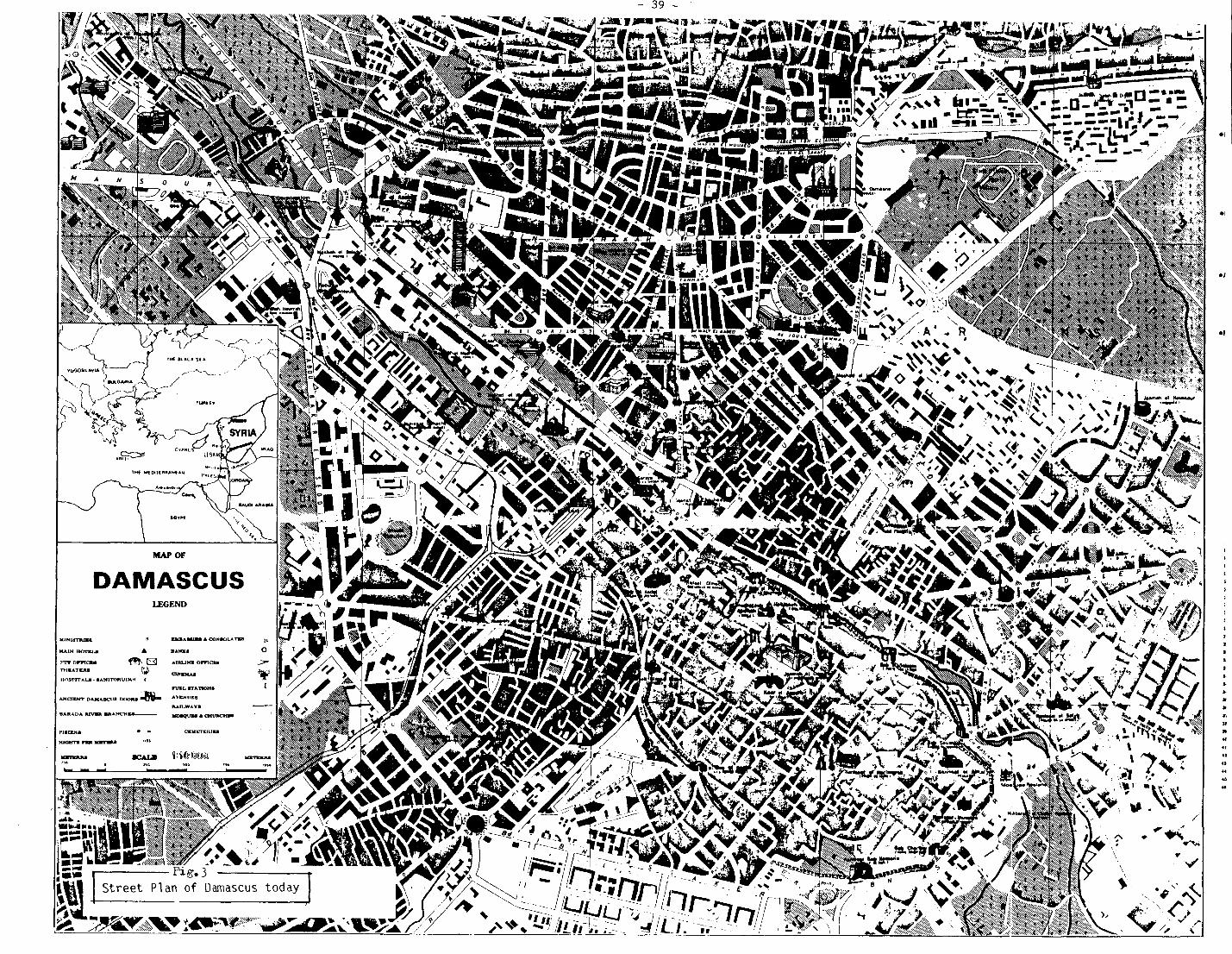
- 39 -

‘11
’ ! \
C
J
I

- 41 -
Fig.5 The 1968 Masterplan


3.g.: Highway network in the city centre, according to 1968 masterplan and critical node around Hejjaz Railway Station
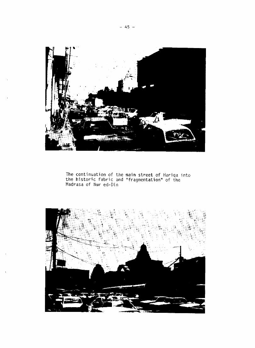
- 45 -
The continuation of the main street of Hariqa into the historic fabric and "fragmentation" of the Madrasa of Nur ed-Din
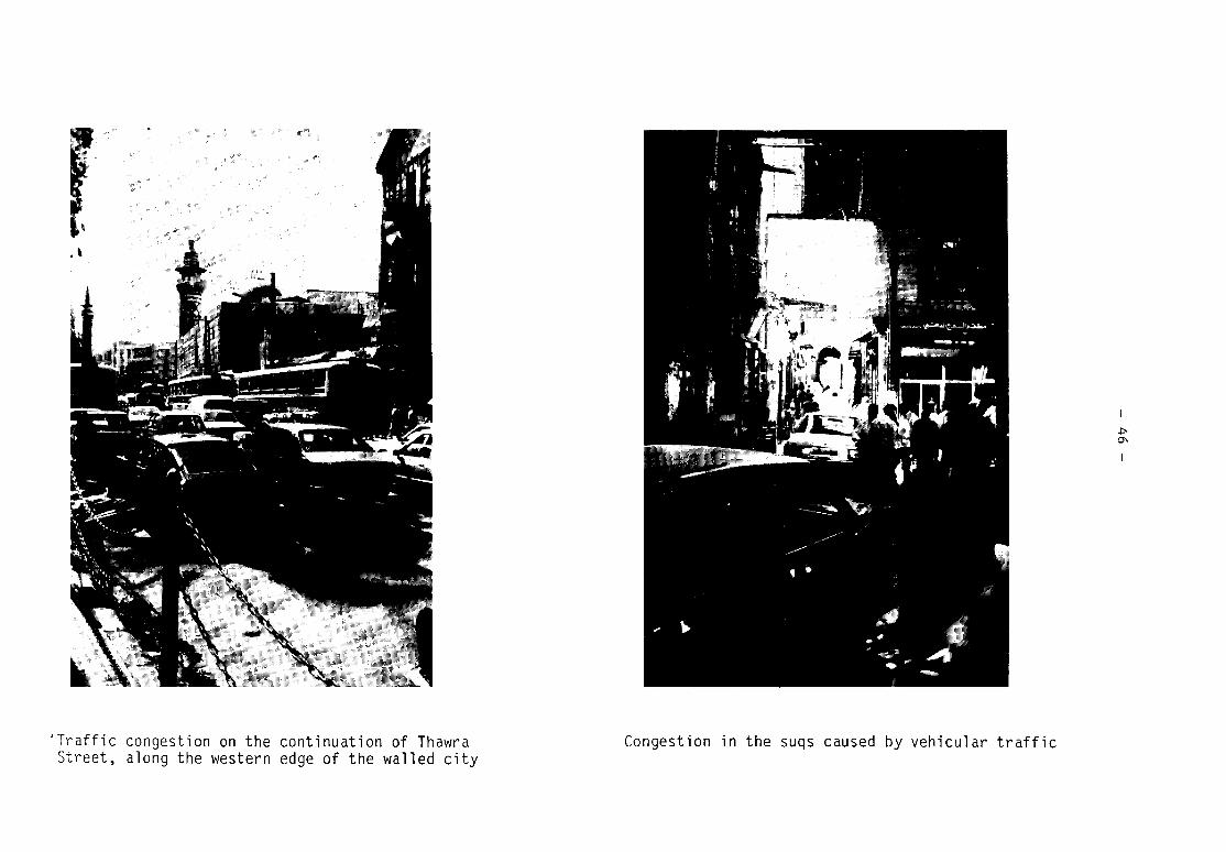
'Traffic congestion on the continuation of Thawra Street, along the western edge of the walled city
Congestion in the suqs caused by vehicular traffic

- 47 -
Above: Khan Asad Pasha during restoration (1984) Below: The courtyard of the Citadel

- 48 -
Above: Newly cut street leading from the Citadel to the Omayyad Mosque
Below: The new open square in front of the western entry gate to the Omayyad Mosque
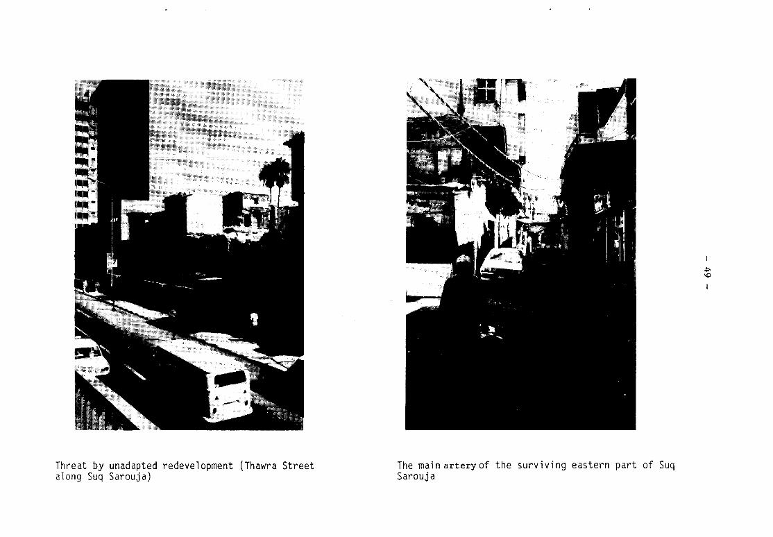
Threat by unadapted redevelopment (Thawra Street along Suq Sarouja)
The main arteryof the surviving eastern part of Suq Sarouja
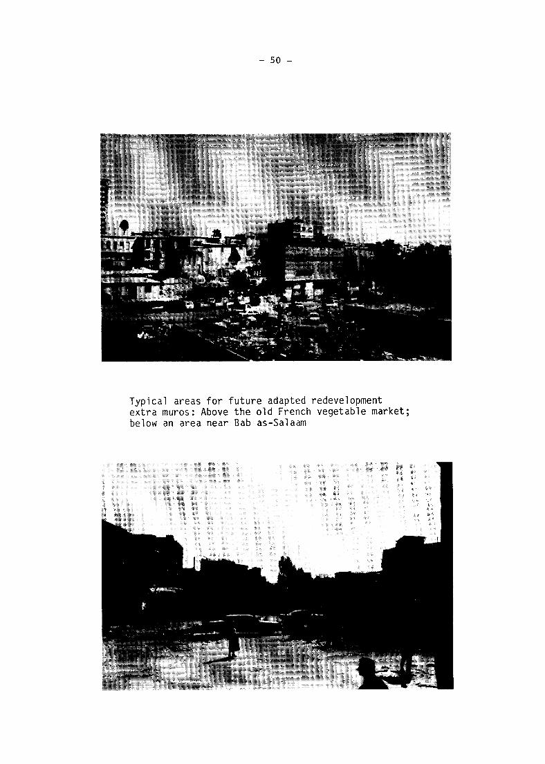
- 50 -
Typical areas for future adapted redevelopment extra muros: Above the old French vegetable market; below an area near Bab as-Salaam
.

- 51 -
Encroachment on monuments and example of unadapted redevelopment in the southern suburb of Midan