computer tutorial on misr satellite image data...
TRANSCRIPT

Computer Tutorial on MISR Satellite Image Data Products
Brian E. Rheingans!Jet Propulsion Laboratory, California Institute of Technology!
Quantitative Research Methods in Human Dimensions of Environmental Change within Eastern Europe!
Valmiera, Latvia!August 2010!

Agenda
Background and terminology
Obtaining data, MISR browse tool and subsetting procedures
Data extraction and processing
Solving problems discussed in handout
Information about re-projection tools

MISR Background
Four MISR images over Appalachain Mountains Nadir, 45.6 deg, 60.0 deg, 70.5 deg forward viewing cameras
To make use of angular as well as spectral information all (9 cameras X 4 bands = 36) pixels must be accurately co-registered
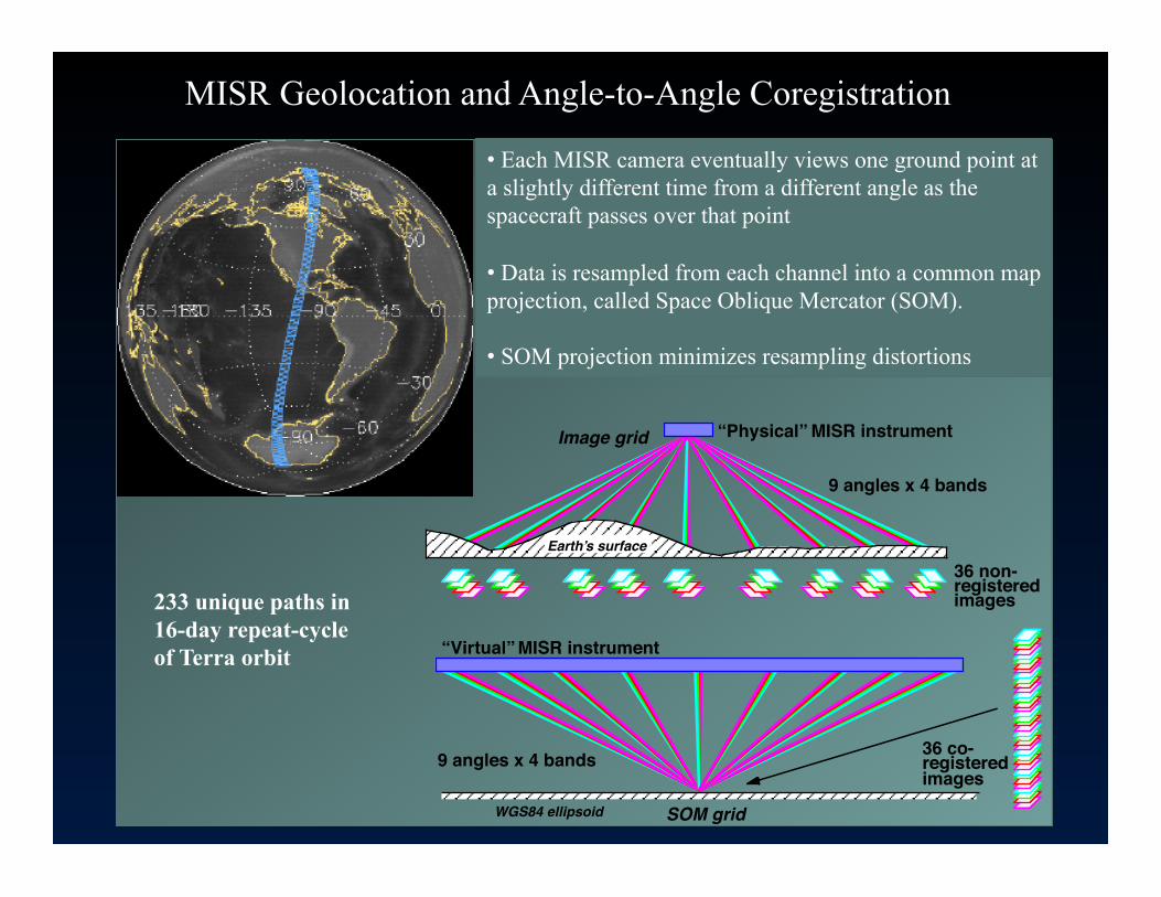
“Physical” MISR instrument
9 angles x 4 bands
36 non-registeredimages
Image grid
“Virtual” MISR instrument
9 angles x 4 bands 36 co-registeredimages
SOM gridWGS84 ellipsoid
Earthʼs surface
SPACE OBLIQUE MERCATORPROJECTION
• Each MISR camera eventually views one ground point at a slightly different time from a different angle as the spacecraft passes over that point
• Data is resampled from each channel into a common map projection, called Space Oblique Mercator (SOM).
• SOM projection minimizes resampling distortions
233 unique paths in 16-day repeat-cycle of Terra orbit
MISR Geolocation and Angle-to-Angle Coregistration

SOM Background
The Space Oblique Mercator (SOM) map projection was developed to support satellite which covers the same large geographic extent as MISR.
SOM was designed to minimize the shape distortion and scale errors throughout the length of the MISR swath near the satellite ground track.
SOM X is in the direction of the Spacecraft ground track and SOM Y is perpendicular X

SOM Projection Path, Orbit and Block definitions
• Terra satellite / MISR instrument follows a pattern of orbital cycles which repeats after 233 unique orbits • Each of the 233 possible orbital cycle is called a path • Paths numbers are always fixed in geographic position • SOM defines a separate projection for each of these paths • For MISR, a path begins at a particular longitude as the satellite crosses the ascending node • Each path implies a specific longitude of ascending node, which implies a specific SOM projection • Orbit number implies overpass time • Orbit number increases throughout the mission • Path number repeats every 233 orbits, 16 day coverage • Block number subdivides each path in the North/South direction

Primary Level 1 Standard Products
Ancillary products Ancillary Geographic Product MISR_AM1_AGP_P028_F01_24.hdf
Level 1 standard products Level 1B2 browse (JPEG) MISR_AM1_GRP_ELLIPSOID_BR_GM_P028_O002510_AN_F03_0024.jpg
Level 1B2 geometric parameters MISR_AM1_GP_GMP_P028_O002510_F03_0013.hdf
Level 1B2 radiometric camera-by-camera cloud mask MISR_AM1_GRP_RCCM_GM_P067_O023963_AN_F04_0025.hdf
Level 1B2 georectified radiance product, global and local modes, organized by camera view angle (Df, Cf, Bf, Af, An, Aa, Ba, Ca, Da): ν Ellipsoid projected MISR_AM1_GRP_ELLIPSOID_GM_P028_O002510_AN_F03_0024.hdf
ν Terrain (blocks containing land only) projected MISR_AM1_GRP_TERRAIN_GM_P028_O002510_AN_F03_0024.hdf
Level 1 processing operates on each camera individually

Level 2 standard products""Level 2AS aerosol MISR_AM1_AS_AEROSOL_P028_O002510_F12_0022.hdf
Level 2AS land surface MISR_AM1_AS_LAND_P028_O002510_F07_0022.hdf
Level 2TC stereo MISR_AM1_TC_STEREO_P028_O002510_F07_0022.hdf
Level 2TC top-of-atmosphere albedo MISR_AM1_TC_ALBEDO_P028_O002510_F07_0022.hdf
Level 2TC classifiers MISR_AM1_TC_CLASSIFIERS_P028_O002510_F07_0022.hdf
Level 3 Global Summaries "
http://eosweb.larc.nasa.gov/PRODOCS/misr/level3/overview.html"
Primary Level 2 Standard Products
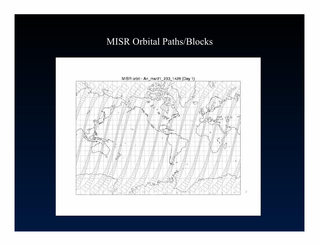
MISR Orbital Paths/Blocks"

MISR File format HDF-EOS “Stacked Block”
• 180 blocks are defined for every MISR product to make block index absolute
• However, roughly 142 blocks have data for any given orbit. The extra blocks are to allow for seasonal variation
• Files are in HDF-EOS format and are stored as a “stack” of blocks
• HDF-EOS routines do NOT assemble the blocks. That is left for the application or the MISR Toolkit
• MISR data subsetted by block can be ordered using the MISR order tool to reduce data bulk

Agenda
Background and terminology
Obtaining data, MISR browse tool and subsetting procedures
Data extraction and processing
Solving problems discussed in handout
Information about re-projection tools

Finding Information and Ordering MISR Data
• Obtaining MISR information – Documentation – Data Products – Data Processing
• Ordering, customizing and subsetting MISR data
• Tools available from the ASDC • MISR Browse Tool


ASDC Web Site
MISR Imagery
MISR Data and Information
MISR Order Tool
Where to Begin?

How to obtain MISR Data and Information

Continued …


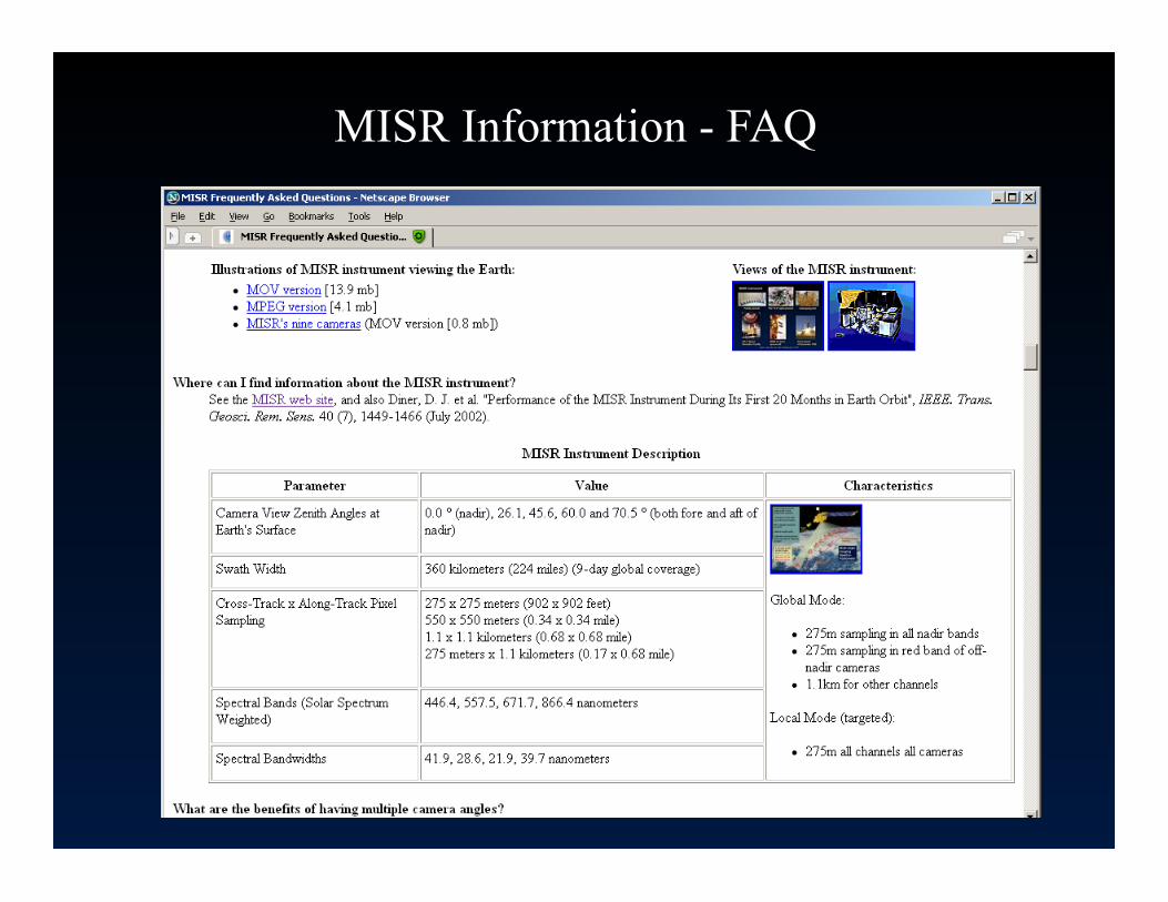
MISR Information - FAQ


MISR Information – Data Product Specification

Detailed Product History
Data Products
MISR Information - Data Product Versioning


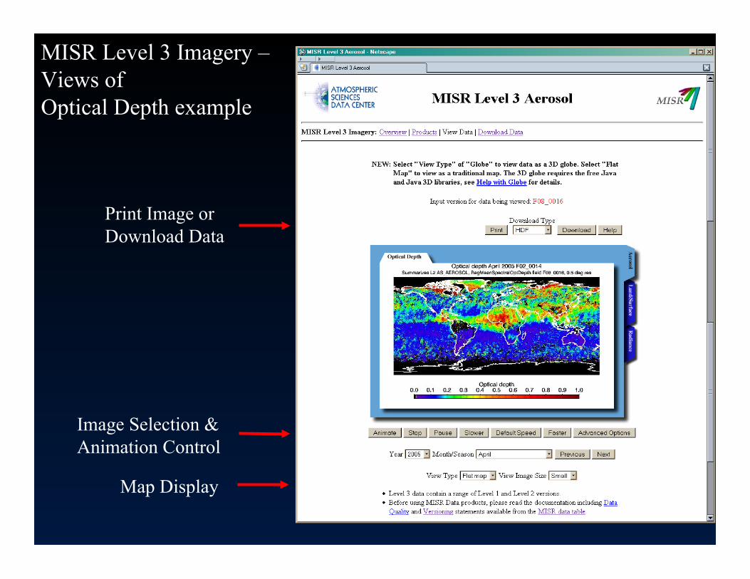
MISR Level 3 Imagery – Views of Optical Depth example
Print Image or Download Data
Image Selection & Animation Control
Map Display

How to Order – MISR Order and Customization Tool


MISR Order and Customization Tool Simple & Intuitive Order Interface

Refine Data Products By Discipline
Select File Version
Order Tool - Search
Continued next slide

Select Search Criteria Temporal and/or Spatial
Optional Camera Search
Search
Order Tool - Search

1 Data Product, for 1 day, over Australia, & latest File Version
Select Products to Display
Order Tool – Search Results

Select Files to order &/or customize
Order selected files or subset/customize
Save this search
Order Tool – Search Results

Select files to customize
Continued next slide
Order Tool – Customization

Select Parameter
Select Date(s)
Add lat/lon layers Unpack/Unscale
Continued next slide
Select Region
Order Tool – Customization

Output format
Submit
Save Customization
Order Tool – Customization

Review Orders
Select Delivery Method
Submit Order
Order Tool – Review & Order

Request for Contact
Order Tool –

Order Details
Order Tool –

Order Confirmation Order Tool –

Order Pickup Notification
Order Tool –

Tools available from ASDC to work with MISR Data


MISR Browse Tool


MISR Browse Tool


MISR browse tool demo


Agenda
Background and terminology
Obtaining data, MISR browse tool and subsetting procedures
Data extraction and processing
Solving problems discussed in handout
Information about re-projection tools

MISRView
• Maps path/orbit to time and date • Assembles MISR blocks • Reports Lat/Lon using the AGP • Displays true color MISR imagery • Can reproject MISR imagery • Requires IDL or IDL VM
• Perspective tool • Band slider tool • Scroll tool • Vector overlay tool • Reprojection tool • Color / Contrast tools

MISRView – Main Menu

MISRView – L1B2 imagery

MISRView – MISR Vision (R-Ba, G-An, B-Bf)

Introduction to the MISR Toolkit API • The MISR Toolkit API provides simplified MISR data
access and geolocation functionality utilizing the GCTP metadata, instead of an ancillary data set lookup
• Abstract MISR “stacked block HDF-EOS grid” to a geolocated SOM projected plane with blocks assembled and fields unpacked and unscaled
• Reads all MISR ancillary, L1B2 and L2 products
• There are no other tools available that simultaneously make use of the GCTP geolocation metadata and are aware of the MISR “stacked block” format for all of the MISR products
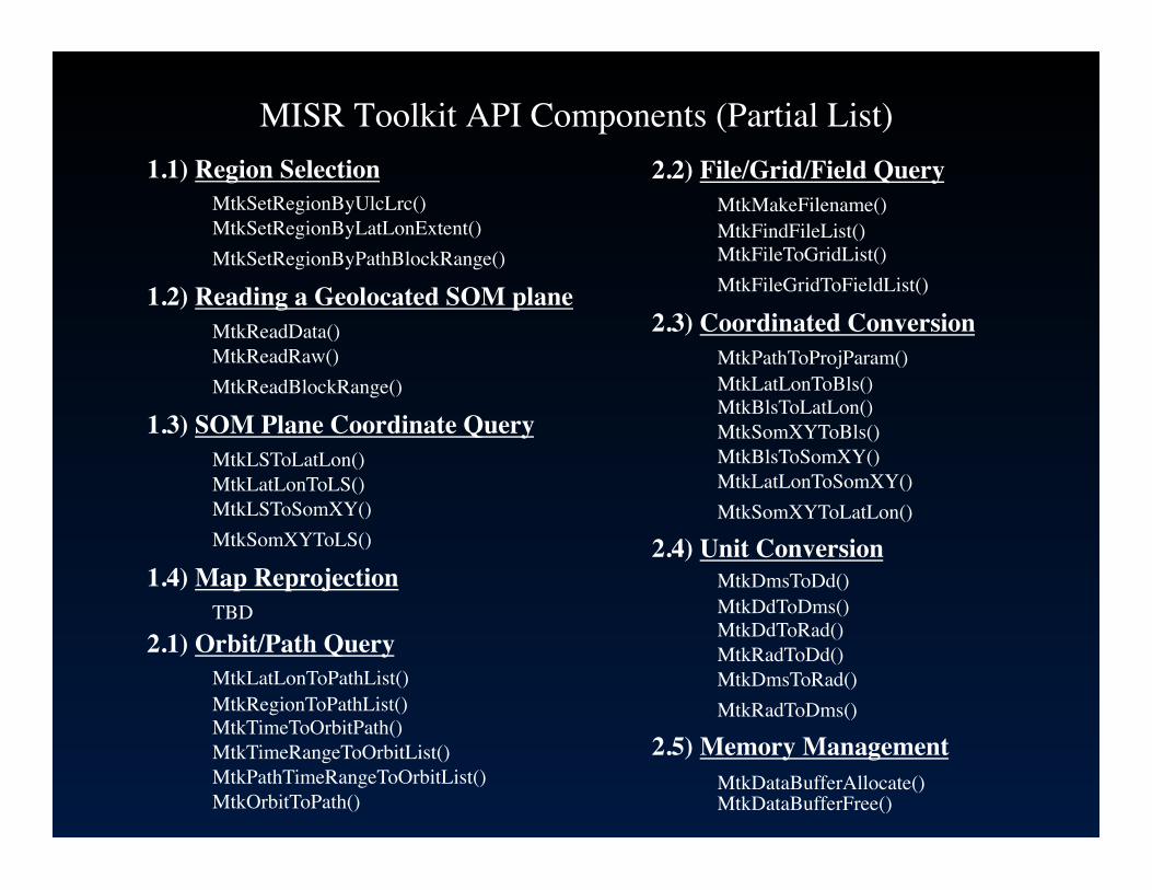
MISR Toolkit API Components (Partial List) 1.1) Region Selection
MtkSetRegionByUlcLrc() MtkSetRegionByLatLonExtent() MtkSetRegionByPathBlockRange()
1.2) Reading a Geolocated SOM plane MtkReadData() MtkReadRaw() MtkReadBlockRange()
1.3) SOM Plane Coordinate Query MtkLSToLatLon() MtkLatLonToLS() MtkLSToSomXY() MtkSomXYToLS()
1.4) Map Reprojection TBD
2.1) Orbit/Path Query MtkLatLonToPathList() MtkRegionToPathList() MtkTimeToOrbitPath() MtkTimeRangeToOrbitList() MtkPathTimeRangeToOrbitList() MtkOrbitToPath()
2.2) File/Grid/Field Query MtkMakeFilename() MtkFindFileList() MtkFileToGridList() MtkFileGridToFieldList()
2.3) Coordinated Conversion MtkPathToProjParam() MtkLatLonToBls() MtkBlsToLatLon() MtkSomXYToBls() MtkBlsToSomXY() MtkLatLonToSomXY() MtkSomXYToLatLon()
2.4) Unit Conversion MtkDmsToDd() MtkDdToDms() MtkDdToRad() MtkRadToDd() MtkDmsToRad() MtkRadToDms()
2.5) Memory Management MtkDataBufferAllocate() MtkDataBufferFree()
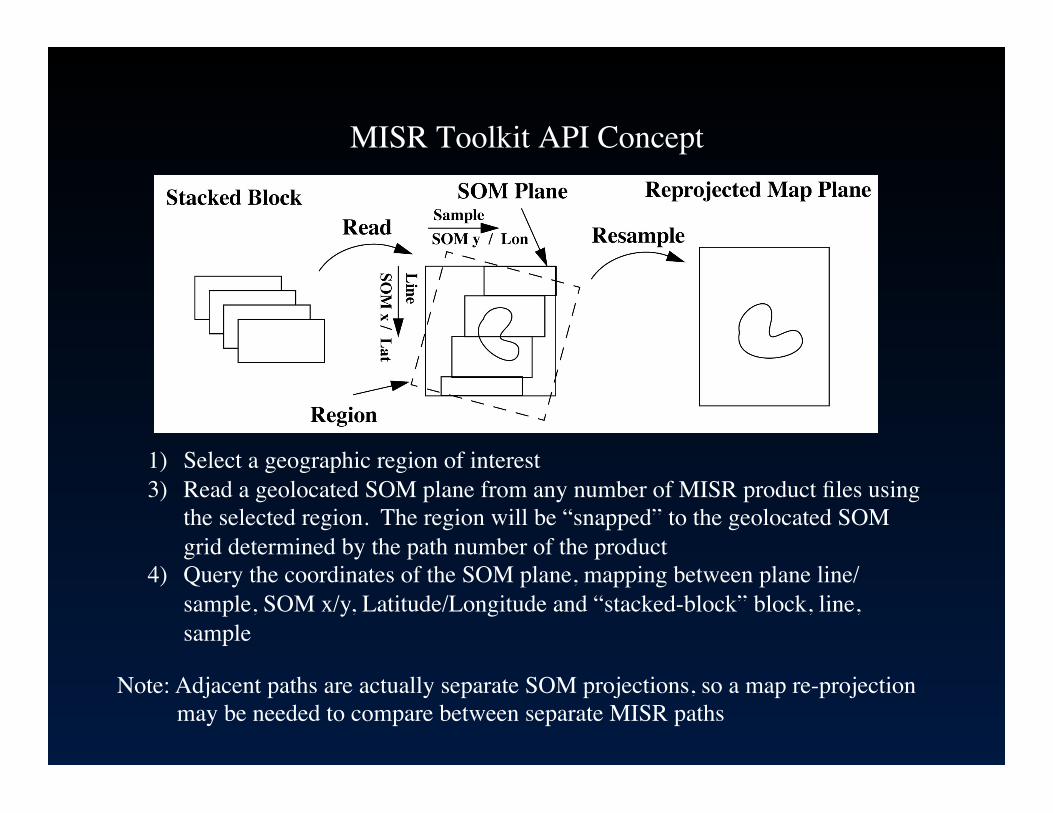
MISR Toolkit API Concept
1) Select a geographic region of interest 3) Read a geolocated SOM plane from any number of MISR product files using
the selected region. The region will be “snapped” to the geolocated SOM grid determined by the path number of the product
4) Query the coordinates of the SOM plane, mapping between plane line/sample, SOM x/y, Latitude/Longitude and “stacked-block” block, line, sample
Note: Adjacent paths are actually separate SOM projections, so a map re-projection may be needed to compare between separate MISR paths

MISR Toolkit API Concept (cont.)
In addition to L1B2, L2 and Conventional MISR data access the MISR toolkit has the ability to
• Perform coordinate conversions between lat/lon <->SOM x/y <-> line/sample <-> block/line/sample
• Inter-compare MISR data with other data sets geographically • Query a MISR product file to retrieve such information as block range, file version,
file type, grid list, field list (including unpacked/unscaled fields), dimension list, metadata, etc.
• Construct MISR filenames and search a directory tree for the file • Convert between path, orbit and time range • Determine which paths/orbits cross a particular geographic location or region
within a given time range

MISR Toolkit Platform and Language���Availability
Platforms and Languages Available (version 1.2.0)
• C library on Linux, Mac OS X and Windows XP
• IDL on all platforms via dynamically loadable library
• Python bindings for Linux, Mac OS X and Windows XP
• Command line utilities on Linux and Mac OS X (Useful for scripting or function usage examples)

Agenda
Background and terminology
Obtaining data, MISR browse tool and subsetting procedures
Data extraction and processing
Solving problems discussed in handout
Information about re-projection tools

MISR problem solving demo

Agenda
Obtaining data, MISR browse tool and subsetting procedures
Data extraction and processing
Solving problems discussed in handout
Information about re-projection tools

What are the coordinates of a pixel within the MISR HDF-EOS “Stacked Block” File Format?
• Inside the HDF-EOS “stacked block grid” = (block, line, sample) • Convert (block, line, sample) <-> SOM (x,y)
– Requires several metadata values and some arithmetic. • Convert SOM (x,y) <-> Lat/Lon
– Requires use of GCTP map projection coordinate conversion library in HDF-EOS distribution.
• Units: Integral block, fractional line/sample; meters x/y; decimal degrees Lat/Lon.
• This process is described in the MISR Data Product Specification, Appendix A. Also routines are provided in the MISR Toolkit.
• Or simply look up the Lat/Lon of the corresponding block, line, sample in the Ancillary Geographic Product (AGP) datasets (1.1km).

MISR Toolkit IDL example to convert to ENVI pro convert2envi, filename, envifilename
path = 0 status = mtk_file_to_path(filename, path) if (status ne 0) then exit
status = mtk_file_to_blockrange(filename, start_block, end_block) if (status ne 0) then exit
status = mtk_file_to_gridlist(filename, ngrid, gridlist) if (status ne 0) then exit gridname = gridlist[0]
status = mtk_file_grid_to_fieldlist(filename, gridlist[igrid], nfield, fieldlist) if (status ne 0) then exit fieldname = fieldlist[0]
status = mtk_file_grid_field_to_dimlist(filename, gridname, fieldname, ndim, dimnames, dimsizes) if (status ne 0) then exit
status = mtk_setregion_by_path_blockrange(path, start_block, end_block,region) if (status ne 0) then exit
status = mtk_readdata(filename, gridname, fieldname, region, databuf, mapinfo) if (status ne 0) then exit
status = mtk_write_envi_file(envifilename, databuf, mapinfo, filename, gridname, fieldname) if (status ne 0) then exit
end

MISR data loaded in ENVI preserving geolocation information

MISR SOM data reprojected to Geographic Lat/Lon using ENVI
