coastal areas and infrastructure - cepal c3... · beach and shoreline erosion ... general knowledge...
TRANSCRIPT

88
Section C3 Coastal Areas and Infrastructure
ECLAC Subregional Headquarters for the Caribbean – Disaster Assessment Training Manual (DATM)
89
Objectives
❑ To describe, in some detail, the impacts on coastal infrastructure caused by natural disasters, notablyhurricanes.
❑ To detail the list of information that must be collected, in the assessment of damages to coastal infrastructure,
as a result of natural disasters.
❑ To provide guidelines as to the methods that can be used in quantifying these damages.
❑ To provide some input as to the range of applicable costs associated with these damages.
ECLAC Subregional Headquarters for the Caribbean – Disaster Assessment Training Manual (DATM)
90
Coastal Infrastructure: An Introduction This section focuses on the impacts on coastal infrastructure caused by a disaster. It describes the types of impacts that may be expected, and as well, the assessment of these impacts. For Small Island Developing States (SIDS), natural phenomena such as hurricanes can be very damaging. Because most of these island states are small, their coastal zone occupies a disproportionately large part of their landmass. To make matters worse, in many of these islands the majority of the infrastructure is concentrated in the coastal zone. This often includes: urban developments (including critical infrastructure such as hospitals, police stations, utilities); industrial developments; port infrastructure; marinas; fishing communities; and tourism development among others. In the Caribbean region, and in particular in the Lesser Antilles, the islands are generally either volcanic in origin, or are composed of coral caps. For the former group, the mountainous interiors often force development to be within a relatively narrow band along the coastline, with sporadic development of the interior. For the latter group, development tends to be spread out more evenly across the island landscape. For both groups, however, there tends to be a concentration of coastal roads, which link the urban centres with the areas of tourism development. Damage to these various infrastructural types can often lead to devastating effects on the small island economies, and in some cases have led to major hardship for up to a year or more, as the various sectors are rehabilitated. Because this manual must, of needs, be as general as possible, it attempts to address as many of the areas of coastal infrastructure as possible. In spite of this, however, there may be types of coastal infrastructure that are not covered in the manual, which may be encountered on a field mission. It is the intention of the authors of the manual that the methodologies presented herein may be applied to these cases. As is the case with other aspects of the ECLAC methodology, it is important that the assessment be done after the disaster has occurred. For the Caribbean region in particular, which is characterized by Small Island developing states, hurricanes tend to be the most devastating, certainly from the perspective of frequency of occurrence. After the passage of a particularly devastating hurricane event, the emergency stage rehabilitation work will likely last for a minimum of two weeks and possibly three. In Central America, Belize for example, the passage of a hurricane with a lot of rainfall potential, can mean that rising river levels often follow the initial devastation. It is important, therefore, for the evaluation team to be in touch with the appropriate emergency response agency, so that the correct time for the evaluation can be arrived at in an informed manner.
ECLAC Subregional Headquarters for the Caribbean – Disaster Assessment Training Manual (DATM)

91
Prior to the commencement of the mission, it is of great importance for the specialist team member to be in touch with the appropriate relevant agency personnel. In the case of coastal infrastructure, this may require liaison with several government agencies in the islands or impacted region. These may include: Port Authorities, Public Works Departments, etc., which will provide information on: the severity of the disaster; the most affected areas; and the quantification of damage. Finally, in the carrying out of the evaluation, it will be absolutely essential that a field visit be done. For small island states, this may be best done by a combination of three methods; by small airplane, by boat and/or by road. For Central American countries, field evaluations may best be done by a combination of small airplane and by road. In cases where roads are impassable (bridges washed out, etc.) it may be necessary to rely on aerial reconnaissance alone (either by helicopter or by small airplane).
ECLAC Subregional Headquarters for the Caribbean – Disaster Assessment Training Manual (DATM)
92
Assessment Procedure
In order to collect data for the assessment, it will be necessary to access cross-sectoral information. Within the context of coastal infrastructure, as described in the preceding section, information will most likely need to be obtained from a variety of sources. It will be important for the sectoral specialist to ascertain, prior to the visit, the physical extents of the damage, as well as the agencies that are involved in the reconstruction and rehabilitation efforts. If at all possible, technical data showing the pre-disaster conditions should be collected, as these will aid significantly in the estimation of direct damage costs.
Information Requirements
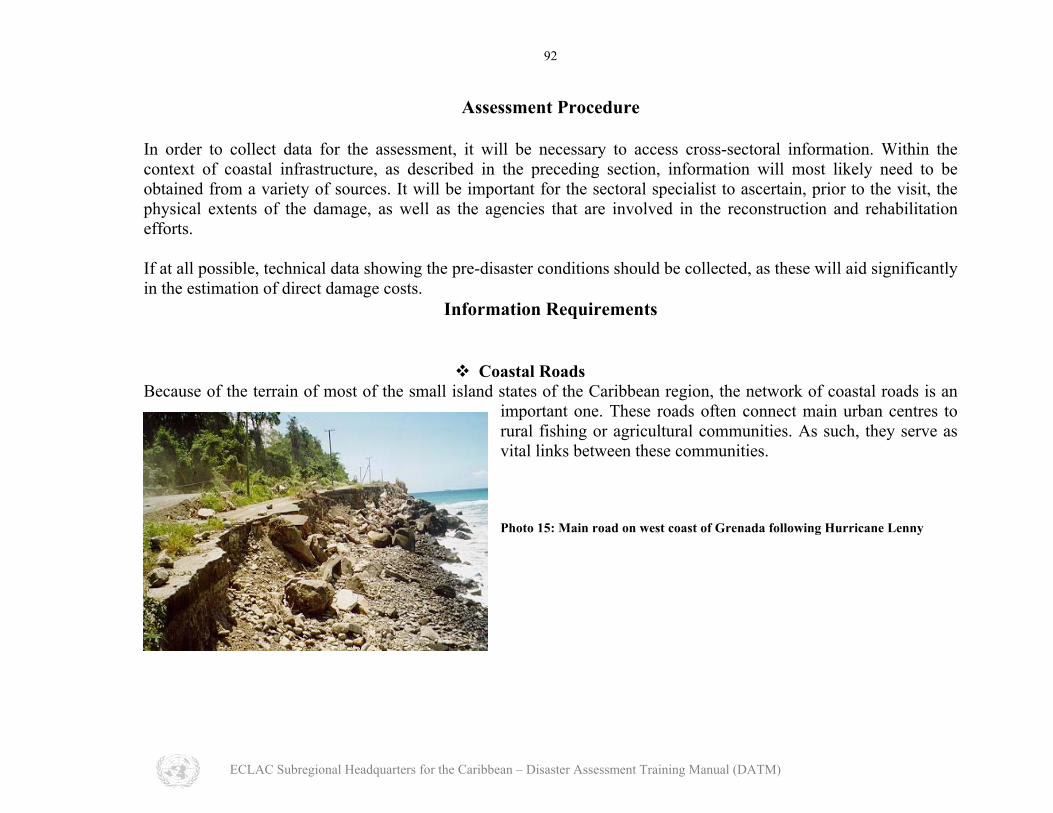
Coastal Roads
Because of the terrain of most of the small island states of the Caribbean region, the network of coastal roads is an important one. These roads often connect main urban centres to rural fishing or agricultural communities. As such, they serve as vital links between these communities. Photo 15: Main road on west coast of Grenada following Hurricane Lenny
ECLAC Subregional Headquarters for the Caribbean – Disaster Assessment Training Manual (DATM)
93
In the collection of data during a damage assessment, the following minimum information is required: • The agency (or agencies) that deals with the construction and/or repair of main and arterial roads; • The physical extent of damaged roadway; • The actual volume of material removed or of road and sub-base damaged or destroyed; • The importance of the damaged road to the network of roadways linking towns to rural centers; • The volume and types of traffic that would typically use this road; • The extent of any utilities that may have been damaged as a result of the disaster; • Knowledge of the general topography and seabed bathymetry of the area; • Knowledge of the hurricane wave conditions that may have caused the damage; • Knowledge of building code requirements and the criteria for design of coastal infrastructure (in the wider
Caribbean the 1 in 50 year hurricane wave is typically used as the design criterion for non-essential infrastructure);
• Estimation of the need for coastal defense works in the rehabilitation exercise; • Replacement or repair of seawalls or revetments.
ECLAC Subregional Headquarters for the Caribbean – Disaster Assessment Training Manual (DATM)

94
Harbours and Marinas
Within the Caribbean region, particularly with the growth of the tourism sector, many harbour facilities have been developed to handle the cruise shipping industry. In some instances, cruise shipping facilities have been combined, in the same port area, with other general port operations.
Photo 16: Port Zante in St. Kitts following the passage of Hurricane Lenny
ECLAC Subregional Headquarters for the Caribbean – Disaster Assessment Training Manual (DATM)

95
In addition, marinas have developed across the region, so as to cater to the yachting fraternity. These marinas vary in size greatly and can offer berthing facilities for vessels ranging from dinghies up to mega-yachts. The distribution of marinas varies widely throughout the Caribbean, however, the Lesser Antilles has a significant number of small craft marinas. One increasing trend that should be noted is the provision of berthing space for mega-yacht vessels. For both harbours and marinas, shelter against waves is often provided by breakwater-type structures, unless the facility is located in a naturally sheltered site. These facilities may therefore function as “hurricane holes”. Data requirements in the assessment of damages for these facilities include:
• Knowledge of the agency in charge of port operations; • Plans or maps showing the layout of facilities prior to the disaster; • The physical extent of the damage; • An inventory of damage to the specific equipment, if applicable; • An inventory of damage to the berthing structures; • Knowledge of the hurricane storm wave conditions that led up to the disaster; • General knowledge of the seabed bathymetry in the area of the facility; • Rehabilitation/repair requirements, including the appropriate type of structure, and the approximate quantities
of materials involved; • Availability of materials to be used in the reconstruction process; • Need for importation of foreign materials, labour and special equipment in the reconstruction process. • Was there any siltation as a result of the disaster (i.e. is there a need for post-disaster dredging)?
ECLAC Subregional Headquarters for the Caribbean – Disaster Assessment Training Manual (DATM)
Beac The existenctourism secthurricane wabeach is alsoaddition, for
Lenny
96
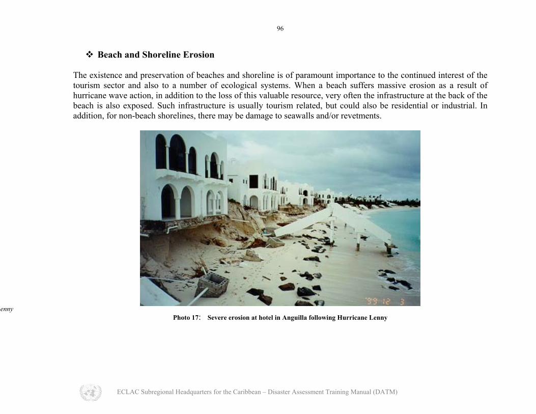
h and Shoreline Erosion
e and preservation of beaches and shoreline is of paramount importance to the continued interest of the or and also to a number of ecological systems. When a beach suffers massive erosion as a result of ve action, in addition to the loss of this valuable resource, very often the infrastructure at the back of the exposed. Such infrastructure is usually tourism related, but could also be residential or industrial. In
non-beach shorelines, there may be damage to seawalls and/or revetments.
Photo 17: Severe erosion at hotel in Anguilla following Hurricane Lenny
ECLAC Subregional Headquarters for the Caribbean – Disaster Assessment Training Manual (DATM)
97
On the ecological side, beaches may often serve as nesting sites for endangered turtles. Further, when massive beach erosion takes place, the displaced sand may smother offshore seagrass beds and/or coral reefs. Recovery of the beach can occur naturally, however, it may have to be helped along in the rehabilitation process. Data requirements in the assessment of damage include:
• Knowledge of any set-back regulations required by the local environmental planning agency. Physical extent of the damaged shoreline. •
• • • • • • • •
• •
Volume of beach material lost and/or volume of shoreline eroded. General idea of the fate of the eroded material. General knowledge of the seabed bathymetry in the investigation area and of the prevailing coastal processes. General background of prevailing wave climate. Storm wave action that resulted in the shoreline damage. Appropriate types of rehabilitation strategies, including the “do-nothing” approach. Availability of dredging equipment locally, or the need to import. Availability of quarried armour stone which may be required in the construction of special structures to ensure future beach and/or shoreline stability. General knowledge of coral reef and seagrass bed areas and extents in the vicinity of the damaged shoreline. Approximate evaluation of habitat loss.
ECLAC Subregional Headquarters for the Caribbean – Disaster Assessment Training Manual (DATM)

98
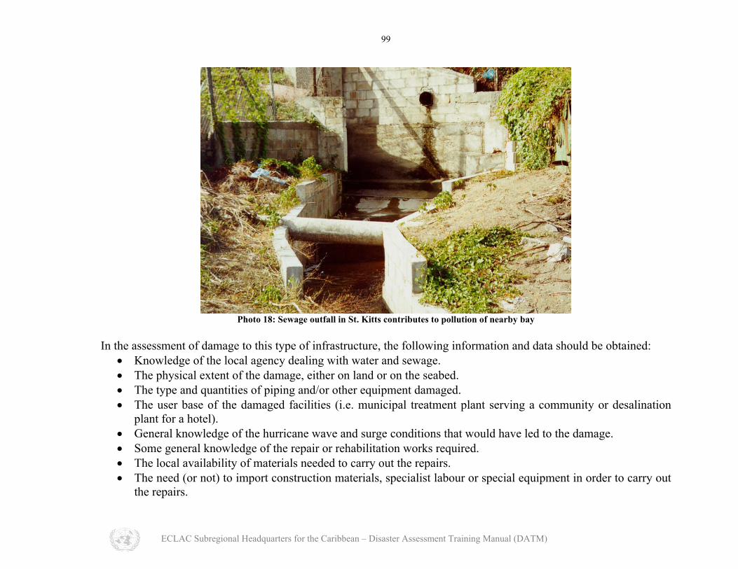
Water Intake and Effluent Outlet Structures
In many Caribbean islands, the absence of adequate rainfall, or of ground water resources, means that potable water must be extracted from brackish, or saline water. To this end, many island states, or individual developments have installed desalination plants. These plants often require inflows of brackish water and discharge a brine solution. This discharge may be either into the ground or to the sea via outlet pipes. Some power plants also have cooling water intakes that, unless properly designed, can be severely damaged during a storm. In addition, the treatment of sewage at a municipal or project specific level, often call for the discharge of treated effluent to the sea. For sewage that is effectively treated only at a primary level, discharge is often to the sea through a deep-sea outfall. For sewage that is treated to a secondary or tertiary level, discharge may be occasionally to the sea, but may be reused on land for irrigation. Damage to effluent discharge or to water intake structures can have serious consequences for a community (either large or small), as it can impact in a major way on the post-disaster health of the community.
ECLAC Subregional Headquarters for the Caribbean – Disaster Assessment Training Manual (DATM)
99
Photo 18: Sewage outfall in St. Kitts contributes to pollution of nearby bay
In the assessment of damage to this type of infrastructure, the following information and data should be obtained:
• Knowledge of the local agency dealing with water and sewage. The physical extent of the damage, either on land or on the seabed. •
• •
• • • •
The type and quantities of piping and/or other equipment damaged. The user base of the damaged facilities (i.e. municipal treatment plant serving a community or desalination plant for a hotel). General knowledge of the hurricane wave and surge conditions that would have led to the damage. Some general knowledge of the repair or rehabilitation works required. The local availability of materials needed to carry out the repairs. The need (or not) to import construction materials, specialist labour or special equipment in order to carry out the repairs.
ECLAC Subregional Headquarters for the Caribbean – Disaster Assessment Training Manual (DATM)
100
Sources of Information
Public Works Departments and Ministry of Transport; • • • • • • • • • • •
Public utilities; Port authorities; Survey departments; Engineering regulatory institutions; Contractors; Quarry operators; Material suppliers; Hotel and tourism agencies; Water and sewerage agencies; Environmental regulatory agencies.
ECLAC Subregional Headquarters for the Caribbean – Disaster Assessment Training Manual (DATM)
101
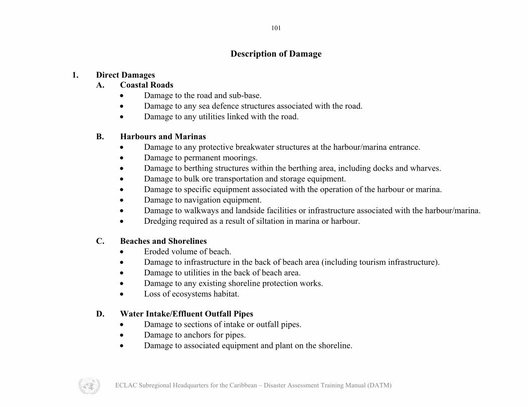
Description of Damage 1. Direct Damages A. Coastal Roads
• Damage to the road and sub-base. Damage to any sea defence structures associated with the road. •
•
• • • • • • •
• • • •
• •
Damage to any utilities linked with the road.
B. Harbours and Marinas • Damage to any protective breakwater structures at the harbour/marina entrance.
Damage to permanent moorings. Damage to berthing structures within the berthing area, including docks and wharves. Damage to bulk ore transportation and storage equipment. Damage to specific equipment associated with the operation of the harbour or marina. Damage to navigation equipment. Damage to walkways and landside facilities or infrastructure associated with the harbour/marina. Dredging required as a result of siltation in marina or harbour.
C. Beaches and Shorelines
• Eroded volume of beach. Damage to infrastructure in the back of beach area (including tourism infrastructure). Damage to utilities in the back of beach area. Damage to any existing shoreline protection works. Loss of ecosystems habitat.
D. Water Intake/Effluent Outfall Pipes
• Damage to sections of intake or outfall pipes. Damage to anchors for pipes. Damage to associated equipment and plant on the shoreline.
ECLAC Subregional Headquarters for the Caribbean – Disaster Assessment Training Manual (DATM)
102
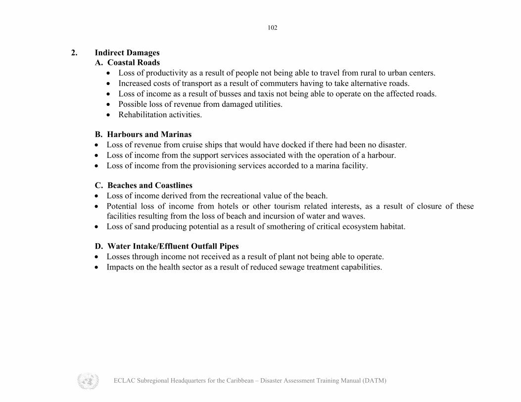
2. Indirect Damages A. Coastal Roads
• Loss of productivity as a result of people not being able to travel from rural to urban centers. • Increased costs of transport as a result of commuters having to take alternative roads. • Loss of income as a result of busses and taxis not being able to operate on the affected roads. • Possible loss of revenue from damaged utilities. • Rehabilitation activities.
B. Harbours and Marinas • Loss of revenue from cruise ships that would have docked if there had been no disaster. • Loss of income from the support services associated with the operation of a harbour. • Loss of income from the provisioning services accorded to a marina facility.
C. Beaches and Coastlines • Loss of income derived from the recreational value of the beach. • Potential loss of income from hotels or other tourism related interests, as a result of closure of these
facilities resulting from the loss of beach and incursion of water and waves. • Loss of sand producing potential as a result of smothering of critical ecosystem habitat.
D. Water Intake/Effluent Outfall Pipes • Losses through income not received as a result of plant not being able to operate. • Impacts on the health sector as a result of reduced sewage treatment capabilities.
ECLAC Subregional Headquarters for the Caribbean – Disaster Assessment Training Manual (DATM)

103
Quantification of Damage Direct Damage
In the quantification of damage during the assessment process, the mission expert must liaise with personnel from the agencies that will be involved in the rehabilitation or repair works, or agencies that are directly involved with the operation of the damaged facilities. This will facilitate a better estimate of the actual volumes of material damaged, or to be brought in to carry out the repair works. In quantifying the direct damage for coastal roads; harbours and marinas; beaches and shorelines; and intake/outlet structures, as listed in the preceding sections, the following procedure is recommended.
• Obtain up to date survey maps, at scale ranging from 1:25,000 down to 1:2,500, depending on the country in question.
• In conjunction with relevant local personnel, and through confirmation by field visit, determine the physical extents of the damage.
• Compute the actual volumes of road and sub-base damaged, or destroyed. • Estimate whether or not repairs are possible, or if total replacement will be required. • Evaluate the repair/replacement costs, incorporating a factor to account for partial repairs, where this is
applicable. • Evaluate the cost of rehabilitation, using as a guide, the cost of similar roadwork within the affected country,
or region. • Evaluate whether or not sea defence works will have to be a part of the rehabilitation procedure. If yes, then: • Estimate the design wave height at the shoreline, and estimate the required size and volume of sea defence
works required. • Estimate the requirement for repair and/or replacement of damaged utilities.
ECLAC Subregional Headquarters for the Caribbean – Disaster Assessment Training Manual (DATM)
104
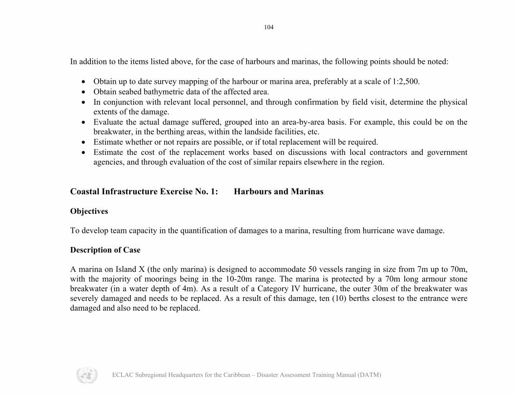
In addition to the items listed above, for the case of harbours and marinas, the following points should be noted:
• Obtain up to date survey mapping of the harbour or marina area, preferably at a scale of 1:2,500. • Obtain seabed bathymetric data of the affected area. • In conjunction with relevant local personnel, and through confirmation by field visit, determine the physical
extents of the damage. • Evaluate the actual damage suffered, grouped into an area-by-area basis. For example, this could be on the
breakwater, in the berthing areas, within the landside facilities, etc. • Estimate whether or not repairs are possible, or if total replacement will be required. • Estimate the cost of the replacement works based on discussions with local contractors and government
agencies, and through evaluation of the cost of similar repairs elsewhere in the region. Coastal Infrastructure Exercise No. 1: Harbours and Marinas Objectives To develop team capacity in the quantification of damages to a marina, resulting from hurricane wave damage. Description of Case A marina on Island X (the only marina) is designed to accommodate 50 vessels ranging in size from 7m up to 70m, with the majority of moorings being in the 10-20m range. The marina is protected by a 70m long armour stone breakwater (in a water depth of 4m). As a result of a Category IV hurricane, the outer 30m of the breakwater was severely damaged and needs to be replaced. As a result of this damage, ten (10) berths closest to the entrance were damaged and also need to be replaced.
ECLAC Subregional Headquarters for the Caribbean – Disaster Assessment Training Manual (DATM)

105
Specific Tasks The specific tasks are:
1. Assess the vulnerability of the marina in relation to damages and costs (direct, indirect and secondary); 2. Indicate what an appropriate reconstruction strategy should be.
Notes on vulnerability assessment
• Direct costs will be related to the reconstruction costs of the breakwater and the repairs/rehabilitation of the damaged berths.
• Indirect costs will be related to loss of revenues from berthing fees, etc. • Secondary costs will result from loss of services to the wider community.
Data Needs These will include:
Map/chart of the area. • • • • • • • • •
Description of hurricane and return frequency estimate. Design assumption (if any) for damaged breakwater. Cross-sectional dimensions of breakwater volumetric estimates of required material. Construction costs related to provision and placement of armour stones. Typical costs per square metre for dock construction. Berthing dues. Range of services offered and typical income received from the provision of such services. Contribution of marina revenues to tourism sector.
ECLAC Subregional Headquarters for the Caribbean – Disaster Assessment Training Manual (DATM)

106
Quantifying Direct Damage for Beaches and Shorelines For beaches and shorelines, quantification of damage should include among others:
• Volume of beach lost. • Cost of replacing beach, likely
through dredging of sand from an identified offshore reserve and placing this sand onto the damaged shoreline.
• The need for any hard engineering structures to ensure shoreline stability, such as revetments and/or seawalls.
Photo 19: Severe erosion at the Four Seasons Hotel in Nevis following Hurricane Lenny in 1999
ECLAC Subregional Headquarters for the Caribbean – Disaster Assessment Training Manual (DATM)

107
Coastal Infrastructure Exercise No. 2: Beach Erosion Objective To develop team capacity in the quantification of beach erosion damages resulting from hurricane waves. Description of Case A resort area on the west of the island of St. Lucia is badly damaged as a result of large waves (from sea and swell) generated by Hurricane Lenny in 1999. After the hurricane has passed, the beach erosion was found to have caused significant damage to hotel infrastructure, leading to the shut-down of the hotel for a six (6) month period. Following are some of the details of this disaster:
Beach was eroded by up to 15m landwards of its typical high water line. • • •
•
Total estimated volume of beach erosion was 3,500 m3. Damage to infrastructure included demolition of approximately a 50m length of seaside restaurant with concrete decking (7 metres wide). Total number of hotel workers was 160, and hotel had to close down for the winter season in order to implement repair works.
ECLAC Subregional Headquarters for the Caribbean – Disaster Assessment Training Manual (DATM)

108
Specific Tasks The specific tasks to be carried out include:
1. Assess the costs of the beach erosion, in terms of direct, indirect and secondary impacts. 2. Indicate what an appropriate reconstruction strategy might be.
Data Needs These will include:
A survey plan of the area (either detailed or rough). • • • • • • •
Cross-sectional profiles to confirm the lost volume of sand. An assessment of the fate of the sand. Is it likely to return, or is it lost from the beach system. Cost of dredging sand from adjacent offshore reserves and placing it on the eroded beach. Cost of repairing damaged concrete decking, on a per square foot basis. Wages of hotel workers. Contribution of hotel revenues to tourism sector of GDP.
Quantifying Direct Damage for Intake and/or Outflow Structures Finally, for intake and/or outflow structures, estimation of direct damage will include:
• Size of damaged piping. • Length of pipe damaged. • Associated infrastructure on land that may also have been damaged. • Anchoring systems for the pipe that may have been ripped out as a result of the disaster.
ECLAC Subregional Headquarters for the Caribbean – Disaster Assessment Training Manual (DATM)

109
Indirect Damage Indirect damages are expected to occur for the overall period during which the assessment, repair and rehabilitation is being carried out. Quantification of these damages will require the acquisition and analysis of data from a number of sources as outlined previously and will mean that the mission specialist will have to target the proper sources of data within a fairly short period of time. The procedure required for the quantification of indirect damages for the types of coastal infrastructure described will depend on the following data collection and analyses:
• Collected traffic flow data along the affected roadway, prior to the damage. • Knowledge of typical commuter fares, cost of petrol or diesel, typical number of commuters that would
normally travel the affected route. • Loss of income estimates from affected utilities. • Number of cruise ships that would typically call to affected port. • Number of visitors typically expected during each cruise ship visit. • Cruise shipping fees and average spend rate per visitor. • Number of general cargo or container vessels that would ordinarily call at port. • Tariffs or dues typically payable. • Loss of revenue estimates from shipping lines. • Number of yachts that would typically moor in the marina. • Average berthing fees. • Loss of revenue estimates from vendors who would provision the yachts. • Number of vendors and water sports operators who would normally operate on a beach, along with loss of
revenue estimates from them. • Number of hotel or tourism related staff that may be out of work while the rehabilitation works are being
carried out, along with average earning rate estimates. • Loss of revenue estimates from water supply companies, where desalination intake lines have been damaged. • Loss of income estimates from Water and Sewerage Authorities, where effluent discharge lines have been
damaged. • Cost of providing alternative water supply or disposal of sewage.
ECLAC Subregional Headquarters for the Caribbean – Disaster Assessment Training Manual (DATM)
110
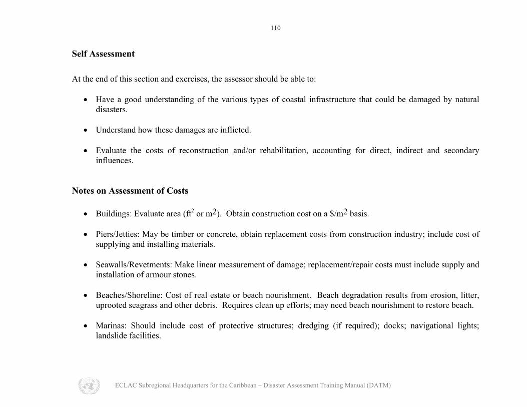
Self Assessment At the end of this section and exercises, the assessor should be able to:
Have a good understanding of the various types of coastal infrastructure that could be damaged by natural disasters.
•
•
•
Understand how these damages are inflicted.
Evaluate the costs of reconstruction and/or rehabilitation, accounting for direct, indirect and secondary influences.
Notes on Assessment of Costs
• Buildings: Evaluate area (ft2 or m2). Obtain construction cost on a $/m2 basis.
• Piers/Jetties: May be timber or concrete, obtain replacement costs from construction industry; include cost of supplying and installing materials.
• Seawalls/Revetments: Make linear measurement of damage; replacement/repair costs must include supply and
installation of armour stones. • Beaches/Shoreline: Cost of real estate or beach nourishment. Beach degradation results from erosion, litter,
uprooted seagrass and other debris. Requires clean up efforts; may need beach nourishment to restore beach. • Marinas: Should include cost of protective structures; dredging (if required); docks; navigational lights;
landslide facilities.
ECLAC Subregional Headquarters for the Caribbean – Disaster Assessment Training Manual (DATM)