coal canals › 2017 › ... · known deposit of anthracite coal at the base of broad mountain near...
TRANSCRIPT
Pennsylvania Magazine | July/August 2017 3534 Vol. 40, No. 4 | www.pa-mag.com
Coal & CanalsTraveling the Schuylkill River Trail from Pottsville to ReadingText and photographs by Cindy Ross
Our cycling adventure along the Schuylkill River, traveling south to-ward Philadelphia, begins in Schuylkill County, where in 1790, a hunter named Necho Allen discovered the largest
known deposit of anthracite coal at the base of Broad Mountain near Pottsville.
Over the following decades, millions of tons of coal would be mined and shipped via canals (and later railroads) along the Schuylkill River. Ironworks, foundries, mills, blast furnaces, rail yards, warehouses and train stations sprang up along the valley, changing the landscape from bucolic farm pastures to bustling company towns.
Today, the coal boom is over, the canal era has faded into oblivion and almost all of the rails of the Pennsylvania Railroad have been removed or paved over. For 130 miles from Pottsville to Philadelphia, the Schuylkill River Trail (SRT) serves as both a recreational opportunity for cyclists and a history lesson about a time when coal reigned supreme in these parts.
To date, about half of the crushed-stone, multi-use trail is complete, while the remain-ing miles will take us along rural roads (ample directional
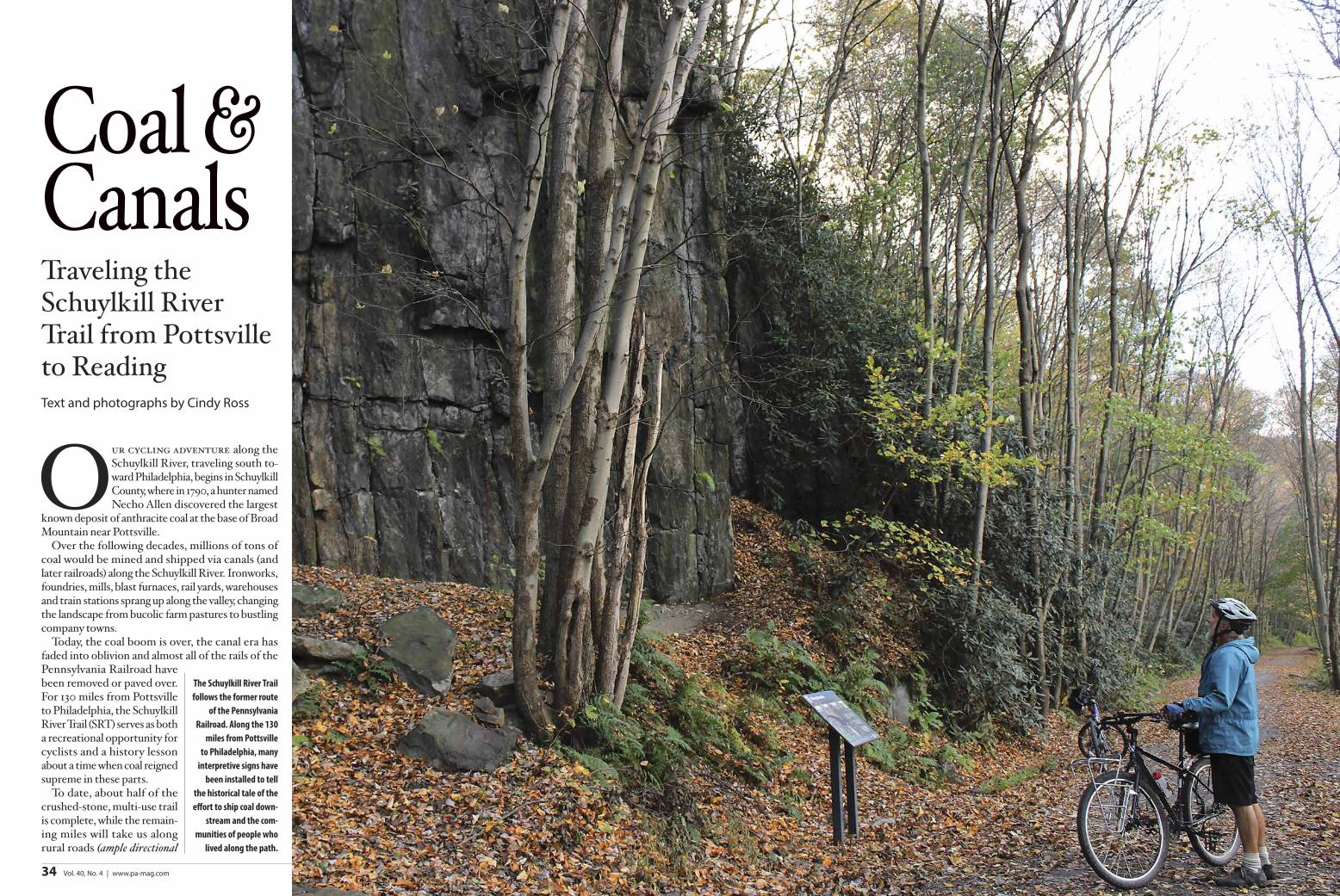
The Schuylkill River Trail follows the former route
of the Pennsylvania Railroad. Along the 130
miles from Pottsville to Philadelphia, many
interpretive signs have been installed to tell
the historical tale of the effort to ship coal down-
stream and the com-munities of people who
lived along the path.
SRT markers show the way). If you want to follow the river in one continuous jour-ney, you could easily spend a week cycling the trail while exploring the hamlets and cities along the way. Or you could plan a shorter trip by scheduling your bike ride around a single festival (see box on page 39) or sampling a specific section of the trail in an afternoon.
Whatever your preference, unload your bicycles and mount up for your ride.
The John B. Bartram SectionOn ThiS firST SecTiOn of the developed Schuylkill River Trail, the landscape around the Landingville marsh rings with bird song (211 species of breeding birds have been counted here), and wildflowers line the route. We travel the 1.5-mile trail, which joins up with a one-mile-long fisherman’s trail, to circumvent the watery basin. Along the way, we spy ospreys, herons, bald eagles and ducks.
The three northern segments of the Schuylkill River Trail are called the John B. Bartram Trail, in honor of a local pedia-trician who supported the Schuylkill River Greenway Association and was largely responsible for the original purchase of the Pennsylvania Railroad properties, on which this section of trail resides. He is a direct descendent of 18th century naturalist John Bartram, “the Father of American Botany,” whose home on the west bank of the Schuylkill River in Philadelphia, where the trail ends, is the oldest surviving botanical garden in America.
Bartram made a series of botanical journeys to distant parts of the country, but his first in 1736 was to the source of the Schuylkill River, where our trail today begins and where his distant descendent came to live. Fittingly, this 130-mile journey will begin and end with the Bartram family, only hundreds of years apart.
At the trail’s beginning on Main Street in Landingville, a restored arched railroad bridge crosses over Mahannon Creek. At the far end of the section is the Auburn Tunnel, the nation’s first transportation tunnel, which was cut into the rock by the Schuylkill Navigation Co. in 1818 and opened in 1856. An interpretive panel at the site explains the tunnel.
Walkers and cyclists opting for the short loop will head west toward the dammed-up
Schuylkill River to join the fisherman’s trail, while those going further south on the trail will exit onto Tunnel Road and follow blacktop roads to the Auburn trailhead.
The Auburn Dam in Landingville is the first sediment basin on the Schuylkill River. Years ago, coal was washed in the river to remove the dirt and silt from the sizeable coal, and the fine particles left behind contributed to an enormous load of sediment. In the mid-20th century, dams were constructed to serve as silt traps, and the dredged sediment was poured into desilting basins and later reclaimed.
The next short section, less than a mile in length, from Auburn south is narrow and pretty. It ends on River Road, which continues past the remnants of an old lock on the right. When the coal rush began, men were so eager for the riches the coal industry offered that they hauled the early canal boats themselves, pulling them along from shore by tying ropes to stout sticks slung across their chests. When the canal opened its full length in 1825, mules on tow-paths were used instead to pull the boats.
The 6.5-mile route of the John B. Bar-tram Trail from Hamburg to the Auburn Railroad Bridge is arguably the most beautiful section, with great walls of dense rhododendron, forest floors covered in hay-scented ferns and shady pitch pines that carpet the trail in soft, peach-colored needles. In June, when the rhododendrons are in bloom, the whole mountainside is speckled with massive white bouquets of flowers.
This section of the trail hugs the Blue Mountain and looks down on the Schuylkill River and across the drainage to the far ridge. Not far from the start, an iron truss bridge, constructed between 1890 and 1905, crosses over the active rail line below.
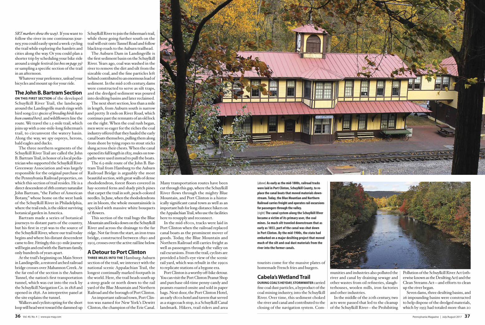
A Detour to Port clintonThree mileS inTO The Hamburg-Auburn section of the trail, we intersect with the national scenic Appalachian Trail, the longest continually marked footpath in the world. Here, the trail heads south up a steep grade or north down to the rail yard of the Blue Mountain and Northern Railroad and the borough of Port Clinton.
An important railroad town, Port Clin-ton was named for New York’s Dewitt Clinton, the champion of the Erie Canal.
Many transportation routes have been cut through this gap, where the Schuylkill River flows through the mighty Blue Mountain, and Port Clinton is a histor-ically significant canal town as well as an important hub for long-distance hikers on the Appalachian Trail, who use the facilities here to resupply and reconnect.
In the mid-1800s, tracks were laid in Port Clinton when the railroad replaced canal boats as the prominent mover of goods. Today, the Blue Mountain and Northern Railroad still carries freight as well as passengers through the valley on rail excursions. From the trail, cyclists are provided a bird’s-eye view of the scenic rail yard, which was rebuilt in the 1990s to replicate stations of a bygone era.
Port Clinton is a worthy off-bike detour. You can visit the Port Clinton Peanut Shop and purchase old-time penny candy and peanuts roasted onsite and sold in paper bags. Next door, the Port Clinton Hotel, an early 1800s hotel and tavern that served as a stagecoach stop, is a Schuylkill Canal landmark. Hikers, trail riders and area
tourists come for the massive plates of homemade French fries and burgers.
cabela’s Wetland TrailDuring cOAl’S heyDAy, STOrmWATer carried fine coal dust particles, a byproduct of the coal mining industry, into the Schuylkill River. Over time, this sediment choked the river and canal and contributed to the closing of the navigation system. Com-
munities and industries also polluted the river and canal by draining sewage and other wastes from oil refineries, slaugh-terhouses, woolen mills, iron factories and other industries.
In the middle of the 20th century, two acts were passed that led to the cleanup of the Schuylkill River—the Prohibiting
Pollution of the Schuylkill River Act (oth-erwise known as the Desilting Act) and the Clean Streams Act—and efforts to clean up the river began.
Seven dams, three desilting basins, and 26 impounding basins were constructed to help dispose of the dredged materials, which by 1955 had totaled more than 20
(above) As early as the mid-1800s, railroad tracks were laid in Port Clinton, Schuylkill County, to re-place the canal boats that moved materials down-stream. Today, the Blue Mountian and Northern Railroad carries freight and operates rail excursions for passengers through the valley. (right) The canal system along the Schuylkill RIver became a victim of its primary user, the coal mines. So much silt traveled downstream that as early as 1853, part of the canal was shut down in Port Clinton. By the mid-1900s, the state had embarked on a major desilting project that moved much of the silt and coal dust materials from the river into the former canals.
Pennsylvania Magazine | July/August 2017 3736 Vol. 40, No. 4 | www.pa-mag.com
million cubic yards of coal waste. The joint government cleanup project would serve as a model for other polluted rivers.
At the Auburn Railroad bridge, we peer down at the thundering chute on the now-clean Schuylkill River before returning to the parking lot. From here, we can head out to explore other trails, including an-other section of the John B. Bartram Trail, a beautiful two-mile side route that first enters the Cabela’s Wetland Trail.
The Cabela’s Wetland Trail snakes through the Kernsville Dam desilting basin, which is now maintained as a wild-life sanctuary by Blue Mountain Wildlife. The accumulated silt that was dredged and collected in the basin was later hauled away by a local company to make char-
coal briquettes. Today, the call of the red-winged blackbird can be heard alongside many other birds, including the elusive woodcock. Furry cattails rise in the basin, and small mammal tracks cover the mud-rimmed pools.
From the Wetland Trail, we turn onto the Therman Madiera Switchback Trail and ride a mile to where the trail crosses the Schuylkill River before entering Hamburg. The borough’s riverside park was once the site of dry-docked canal boats, as long as 80 feet, that carried in excess of 200 tons of cargo. At that time, the round trip by boat from Hamburg to Philadelphia took about a week.
Continuing along the river, the trail crosses under the Route 61 highway and becomes a beautifully preserved stretch of towpath. Here, the separate bodies of water can be clearly seen—the river on one side and the water-filled canal with its sun-bathing turtles on the other. Before leaving Hamburg, we pay a visit to the Reading Railroad Heritage Mu-seum on Third Street to learn the story
of this freight railroad, made famous by the property of the same name in the game of Monopoly.
hamburg to readingThe nexT yeT-TO-Be-DevelOPeD SecTiOn of the Schuylkill Rail Trail travels from Hamburg to Reading on quiet country roads with signed SRT markers. Until the remainder of the trail is built, this route temporarily connects to the Union Canal spur at the Blue Marsh Lake silting basin in Lower Heidelburg Township. The highlight of this stretch is the beau-tifully preserved Leesport Lock House in Leesport Borough.
The newly constructed, two-mile, off-and-on road section of the SRT, which ends at the restored Herbine’s Lock, makes a great loop, if you incorporate some flat cycling along River Road. Be sure to check pa-mag.com/SRT for links.
Near the hamlet of Dauberville, the route goes by an open field where an ice-house once stood. Blocks of ice were cut from a dam on the river and shipped in
refrigerated cars to Philadelphia to be sold to city-dwellers who used the ice to cool their food in the summer.
The lock in Leesport ensured transpor-tation was big business there. Merchants would dock their boats in the large basin, stay overnight in the lock tender’s house and buy goods in town to take back to Phil-adelphia on their canal boats. An unusual 1820 whale oil lantern that once swung on a hinge is on display in the lockhouse as are a bugle and conch shell, which individual canal boat captains used to alert the lock tender to their approaching boat. Today, visitors may explore the remains of a lock that sit adjacent to the lockhouse.
From the trailhead on Palisades Drive at the Blue Marsh Lake desilting basin, we follow the connecting trail for two miles until we join up with the Union Canal Towpath for another 4½ miles and then finally meet up with the Schuylkill River Trail at Stonecliff Park. The Union Canal National Scenic Trail, a narrow and shallow-constructed canal that once ran from Reading for nearly 80 miles to the Susquehanna River, is quite a contrast to the Schuylkill Navigation System. It follows the Tulpehocken Creek through a 306-acre county park. Many historic struc-tures withstood the test of time, and 12 historic stops are highlighted along the way.
Be sure to stop at the C. Howard Heister Canal Center and Gruber Wagon Works (1882), located at the Berks County Heri-tage Center. Here too, the historic Deppen Cemetery contains the remains of 20 to 30 Irish immigrants who died of “canal fever” (dysentery) while digging the canal. The cemetery was relocated to the heritage center in 1978 from Mt. Pleasant during the construction of Blue Marsh Lake.
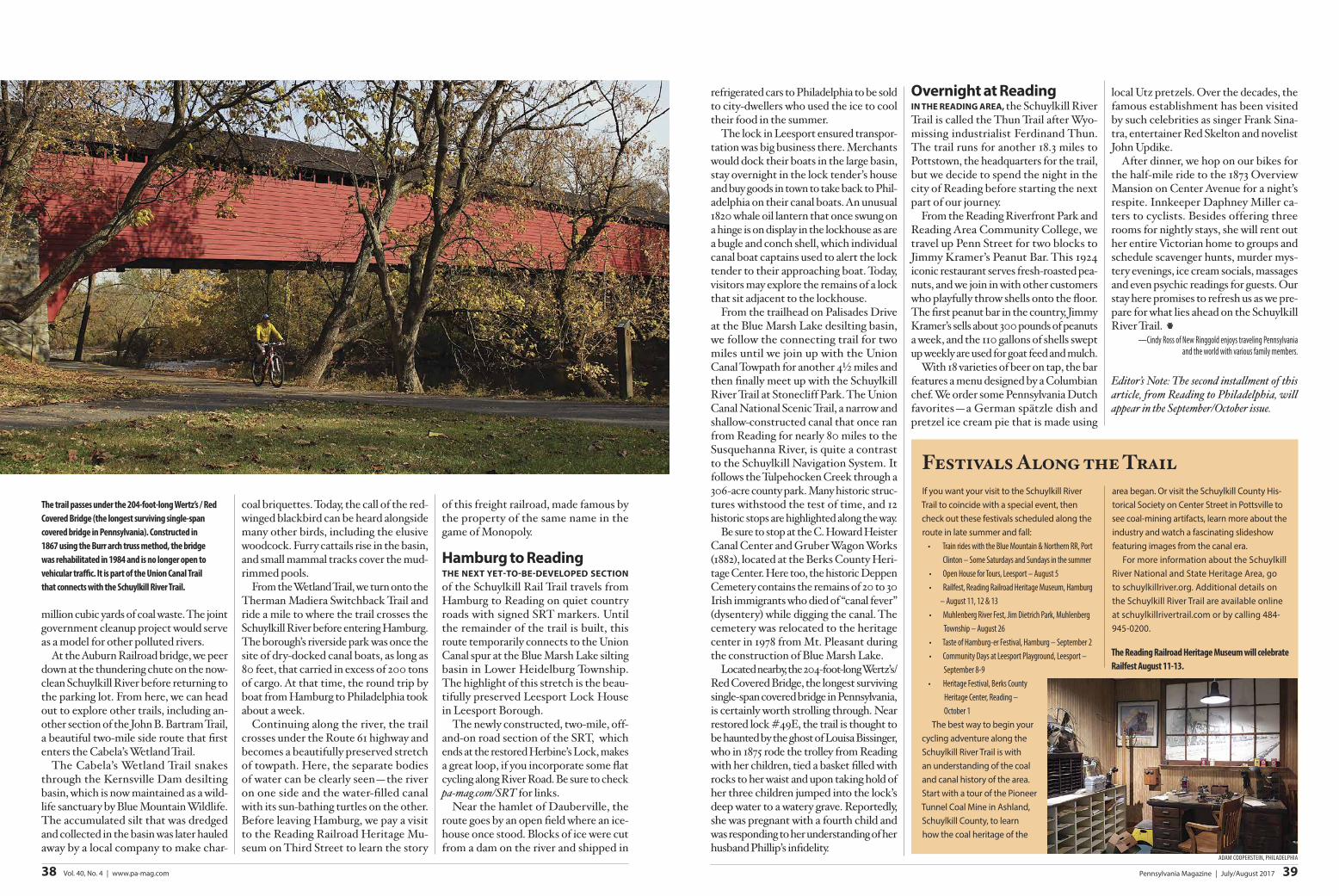
Located nearby, the 204-foot-long Wertz’s/Red Covered Bridge, the longest surviving single-span covered bridge in Pennsylvania, is certainly worth strolling through. Near restored lock #49E, the trail is thought to be haunted by the ghost of Louisa Bissinger, who in 1875 rode the trolley from Reading with her children, tied a basket filled with rocks to her waist and upon taking hold of her three children jumped into the lock’s deep water to a watery grave. Reportedly, she was pregnant with a fourth child and was responding to her understanding of her husband Phillip’s infidelity.
Overnight at readingin The reADing AreA, the Schuylkill River Trail is called the Thun Trail after Wyo-missing industrialist Ferdinand Thun. The trail runs for another 18.3 miles to Pottstown, the headquarters for the trail, but we decide to spend the night in the city of Reading before starting the next part of our journey.
From the Reading Riverfront Park and Reading Area Community College, we travel up Penn Street for two blocks to Jimmy Kramer’s Peanut Bar. This 1924 iconic restaurant serves fresh-roasted pea-nuts, and we join in with other customers who playfully throw shells onto the floor. The first peanut bar in the country, Jimmy Kramer’s sells about 300 pounds of peanuts a week, and the 110 gallons of shells swept up weekly are used for goat feed and mulch.
With 18 varieties of beer on tap, the bar features a menu designed by a Columbian chef. We order some Pennsylvania Dutch favorites—a German spätzle dish and pretzel ice cream pie that is made using
local Utz pretzels. Over the decades, the famous establishment has been visited by such celebrities as singer Frank Sina-tra, entertainer Red Skelton and novelist John Updike.
After dinner, we hop on our bikes for the half-mile ride to the 1873 Overview Mansion on Center Avenue for a night’s respite. Innkeeper Daphney Miller ca-ters to cyclists. Besides offering three rooms for nightly stays, she will rent out her entire Victorian home to groups and schedule scavenger hunts, murder mys-tery evenings, ice cream socials, massages and even psychic readings for guests. Our stay here promises to refresh us as we pre-pare for what lies ahead on the Schuylkill River Trail.
—Cindy Ross of New Ringgold enjoys traveling Pennsylvania and the world with various family members.
Editor’s Note: The second installment of this article, from Reading to Philadelphia, will appear in the September/October issue.
Festivals Along the TrailIf you want your visit to the Schuylkill River Trail to coincide with a special event, then check out these festivals scheduled along the route in late summer and fall:• Train rides with the Blue Mountain & Northern RR, Port
Clinton – Some Saturdays and Sundays in the summer• Open House for Tours, Leesport – August 5• Railfest, Reading Railroad Heritage Museum, Hamburg
– August 11, 12 & 13• Muhlenberg River Fest, Jim Dietrich Park, Muhlenberg
Township – August 26• Taste of Hamburg-er Festival, Hamburg – September 2• Community Days at Leesport Playground, Leesport –
September 8-9• Heritage Festival, Berks County
Heritage Center, Reading – October 1
The best way to begin your cycling adventure along the Schuylkill River Trail is with an understanding of the coal and canal history of the area. Start with a tour of the Pioneer Tunnel Coal Mine in Ashland, Schuylkill County, to learn how the coal heritage of the
area began. Or visit the Schuylkill County His-torical Society on Center Street in Pottsville to see coal-mining artifacts, learn more about the industry and watch a fascinating slideshow featuring images from the canal era.
For more information about the Schuylkill River National and State Heritage Area, go to schuylkillriver.org. Additional details on the Schuylkill River Trail are available online at schuylkillrivertrail.com or by calling 484-945-0200.
The trail passes under the 204-foot-long Wertz’s / Red Covered Bridge (the longest surviving single-span covered bridge in Pennsylvania). Constructed in 1867 using the Burr arch truss method, the bridge was rehabilitated in 1984 and is no longer open to vehicular traffic. It is part of the Union Canal Trail that connects with the Schuylkill River Trail.
ADAM COOPeRSTeiN, PHiLADeLPHiA
Pennsylvania Magazine | July/August 2017 3938 Vol. 40, No. 4 | www.pa-mag.com
The Reading Railroad Heritage Museum will celebrate Railfest August 11-13.