cl. -32251vi i tala - search geologyontario · 2.8596 macgregor 010 vlf - survey of mining claims...
TRANSCRIPT
2.8596 MACGREGOR 010
VLF - Survey of Mining Claims 829212, 829213, 829214, and 645041
on Parcel 8Z in MacGregor Township in the Mining District of Thunder Bay
by:
Reino L. Vi i talac- 32251
for:
Alpo Karkkainen E-29047
October, 1985

(i) 2.6596 MACGREGOR O1OC
CONTENTS
PURPOSE
METHOD
Instrumentation
Grid
RESULTS AND DISCUSSION
2
2
FIGURE 1. Index Map
FIGURE 2. Dip Angle Coutours Map
FIGURE 3. Field Strength Contours Map
FIGURE 4. Line D - Profiles
7
8
9
APPENDIX A.
Field Notes
Report of Work Forms
PURPOSE
This survey was undertaken by request from
Mr. Alpo Karkkainen, the claim holder, to delineate any conductive
axis that may be associated with his recent amethyst discovery on
these claims. Secondly, the VLF survey information will be used as
background towards a bedrock geology map of the area. Bedrock struc
tural interpretation can also be confirmed by this survey.
The area is located in MacGregor Township, approximately
10 miles east of Thunder Bay along Highway 11 and 17 east {Figure 1).
Work was performed under work permit #87 for 1985 held by Mr. Alpo
Karkkainen.

- 2 -
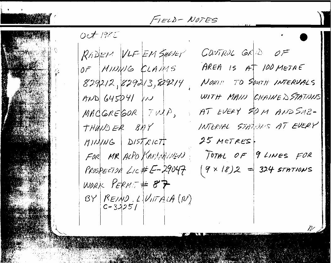
METHOD
Instrumentation
Radem VLF-EM receiver was tuned to receive 21.4 KHZ
transmitted from Annapolis, Maryland, U.S.A. (AM). This station
favoured signal strength due to the general strike of the geology
in the area. It was cross-checked with Culter, Maine (CM) period
ically. Dip angle incliometer accuracy is plus or minus half degree.
Field strength accuracy is plus or minus half percent. Instrument
was field checked at #2 post location of claim 829213 before and after
each day's survey. This area had a strong field and -10 south dip
angle.
Grid
A control grid, running south to north was established
on the claims area at 100 metre intervals. Each line has major
stations at 50 metre intervals and sub-stations at each 25 metres
where all readings were taken. Grid was blazed open, measured with
the aid of Brunton compass and chained for distances. Each major
station at 50 metres was flagged with tape and fixed with a metal
tag showing station number. Lines are alphabetical along horizontal
axis and numerical vertically. Each line has 18 stations along it.

- 3 -
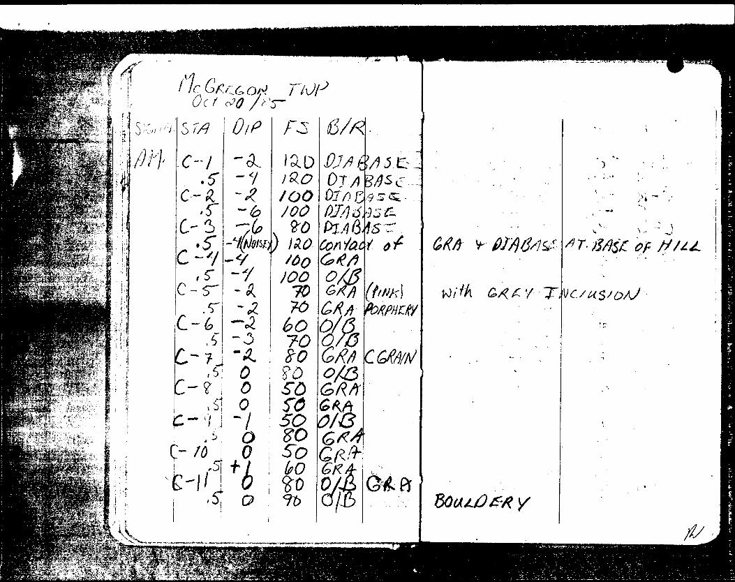
Field notes recorded station, dip angle, field
strength, and notes on observations and bedrock geology. Survey
was favoured by dry, cool fall weather. Survey proceeded with a
two lines per day rate with readings at every 25 metres along the
grid lines.
RESULTS AND DISCUSSION
Four separate zones are distinguished by this survey.
In the southern central region of the 4 claim group, an intrusion
of diabase (gabbro) results in strong southerly dipping angles and
above 30(^ field strength. These readings in this southern central
area are also influenced by the volcanics immediately off the southern
boundary of the claims. These volcanics consist of basaltic flows
into old sediments with amethyst veins occurring in a general N.E.
strike direction. The surrounding granite bedrock is altered by these
events into porpheritic and stringers of quartz and amethyst veins
cutting the porphery. Zone two is the granitic porphery area immed
iately adjacent to the intrusive diabase and granite contact in a
loop around the central portion of claims 829213 and 645041. This
zone is a host to some amethyst and quartz veining found on claim
645041. Zone three running N.W. across the central portion of this
4 claim group is a possible fault-zone associated with broken bed
rock of basically granitic texture. The fourth zone lies adjacent to
zone three to the north and consists of coarse grained granite. These

- 4 -
zones can be deduced from Figure 2.
Field strength contours (Figure 3) show the diabase
intrusion in the southern central portion as distinct from the gran
itic background of the remaining area. It is interesting to note
the effect of the fault-zone to the coarse grained granite contact
in the upper two claims 829212 and 829214 as possessing additional
field strength to stand out above background. Isolated dip changes
and field strength increases can be attributed to some small bouldery,
swampy and creekbed zones in several locations within the 4-claim
group.
Figure 4 shows dip-angle and field strength profiles
along grid control line-D. It displays the changes in rock type
and their resultant affects. The cross-over created by the fault-zone
is quite broad and of low dip angle. Mineralization potential is
best in the regions around the diabase/granitic porphery contact.
From observations in the amethyst occurrence on claim 645041 and
areas south of these claims, it is mainly iron metallics and trace
sulphides that are associated with the amethyst veins. These contact
areas warrant further study to determine possible association with
silver in the area with amethyst occurrences. The results from this
survey can help determine areas for future trenching (shallow soils to
bedrock) and reconnaissance drilling locations.

- 5 -
Qualifications on file with:
E.F. Anderson, Director, Lands Management Branch, Whitney Block, Room 6450, Queen's Park, Toronto, M7A 1W3
Reino L. Vi i tala, October, 1985.

An
\s^X
*lsry
ma/3 W&HIL
ff
OF
Fig 1.
Index map of mining claimSCALE: #829212, 829213
829214^645041DRAWN BY
Thunder Bay Mining District
Mac G regor TwpDRAWING NUMBER
• Vi X II PRINTED ON NO. 1OOOH-B CLEARPRINT FADE-OUT


i.': j-
mf-^-^iff^f.^.-'M^-:-'..:--:' iJ^Afe/v'-.:1'.'**:^' jr^-jjV *1*-'1"'''~ '"'- ''. '
SiSfe&ffilJ!: :'ffes: ,^;1. i
••..."•-ft ..-:' ..'.'y-.••.fa:':--:*l -•.'jiS32~
o^r*
k/
f/MW
0,L
y ay y
ri"' ^ .li
r G i
'S
^ *s
M 615/79
W H
y///
JO
.-'-'-••li-.V'Tti'JJf

I|8*!8SBi^*"™ " : '-f "'--a*. .*
!•t&Ss&t r ' ' - ' fiffffi-" ;. - fP^afej::^^-"' , 1P*P^™*HWfl*ywB* IN L/%™*' . ' f
iSBfflfe*p®'?*8-*' '
' :
^Mml''lii^^.:'^ - !
B^BB^aB|^s^^mB^aH^BffiM|sfe^-Sl
B^BlPJiBJEP^-'
•P^*;.''-.-
u vS* ;' : - llv;.-: ' f- •v: T:
' j . i ;. .. f*jjjl^yyiv ; . - J
Ifflc'JMBRrtv,-. "- -:- - ' ' S
mEfem*2~ziZ3-2ti.X!~ijA
fi
'' ;
? ,
f-\ ^
" ^'
' J : C H\"'A'f!
i i :j iit}
A ^ '
i ' '
| j
\
:
tV,
//^ c ̂OcX-
"ZTft
A)-//7 ""* 0A-&
.5
.5ft ' *t
c/4-5-
.5A ' fe
.5/\-7.5"
/i V*5"
A * ^4i5*
A- /On " H
'' -6^/-/^".^'
blP
. 0000DO00C0000
1 Oke/"btl-i- 11 14- ;41
0
i fa j^ -r' :a
F&
IOQ50SO^050fd60
i JO70SO?0?07070//O
KQoO
/oo//o/DO130
. /y^C
3M
Get ~
/js 6 vaO/ QO/&0/6GR ft -6k A ~~0/0O/&0/0G/^y^
0/3d/^S0/60/& '0 //iO/&
CM-bRn
W(fc
y]
M-^W|,.ii
C fi/c/f//^
^ 1*1 ^^ ̂"'k
C^v,'fc.
C &WC 6A/9/A/
6ftC6SdiAJ
*
AAi~C.GttWAj.i
^•Gfl/i/'v -*
(-f s
*O /x-

WjT~'"V
-ir/ o2j.N'o.c
(7 ~u f-/ *x
c
r///!/
•Jg /oIXV9
•7//0
9/0 rao&/C?
o^Oi05 ,-~l '^. ^
v/..,^ /'
os go/O if'l
o// o//05'OS f
coe Q/,/ o? j
''-'OOf-i-71-V
"My
*"1^g \cSil
/-".•.-l/^/'V/-f .-.r
^
X*/r 4- J?'
c*l if -f
4-14l-hl f
9/-V
•l/:
.^K!;w-#j;e5pf*:.'^'iV'-S/'
••••i;':,-..;;^ mM " ^i^M•';^s.|?3 :eiifi
..?-^iaji
f . '-f.-^ei. (-•^''-SfKiA
4:'*-.***3R' ^-'-' --T^;.ii;!VtS
-;f :^*.:-s^i;y^y^ S';-? "."j o

/l/
j
A/ f t
tt 8 191(1
rtftfQr -f p' -s. Mto.fr :.yv
LN'Qfl '5 O/
V
VV9
sypO/O
09 Oi
o (Ho/r
os 0-L 01
Oio*
Q OO QO O
Tf/.
A"0SoV(il
o^f-.5
0
d "f
:^d
w/~^l H

//r/S,
iftD
o-6
,p
O
O
-ST
7-060
-6
* 3i'/o foo
o/Q
X "iOf,oroo/ BG Mo j B
!OC300*- P ,l
(Xea'
p
\

"df
i
fl/0
car U
oofOf)
08
QOfoo/ CO/oil021
QU
oQ
oe\ o
M-'-
ci S 'HP i //-jf/^ r H/
o
o
i'.i
l-h—
c
'9
L/ir
iY
lil

o fs
0/.
mGft-
A
-/Li

•y /s
•*Vf^'---.! - ^?- f-l-
PSifp?'- ;?i^"••^ifriyptffc-?^; ' ;*^j^,
jCH,i x-^Y^^if- - 4^- ' -fer-;^^:....:^i^ !te
1 A- /"/f/
tilt*ooooo
K O -JLOJ*sO
\-a.—
y \-^)Mr
~*J
f-
f '9/ti'M-t
/ODSO *d
5. Q sb
STo70bo
tor-^^
-/dX i L'C t(sV30
,. K
o//;v/?3
J:
QA0/fl
c
c/sn y
/D;
0 J.
\

*tf!
•jfc,ste
,~
psgi;
9**
,'*'
"*
:-*S
--.^
-•-wt
V.
N
X
rv(\
S
X "
•j-*
—-^
^
^
lN
VJ
KS,
VVi
T- - --fTT
iVJ
tz
X
^ K
^
^3
^O
^
^^^'Q
D 3
^i
C
's—, ter. S
^ J
SL^;
-'^5:
VVQ
vS
~^T~—
" i]
p
•SC
rrc*a*rraMi
^•A^r -i
s^i93ff-~
:*e,;
,^a-c"-; -f-1-
l^*f
t .*
"". --
' :*
;#"

""""TiPJ -̂ '-.- i i r . r A
Hir
tifjf*-)^ti-^rt*fs*:; sgfpt^ g-*y r*
fc:. l
if
; '- - f-S--'-*...;!*.. - l
j
*40/?*-'
FS•-/Z
C- li
S'+lf A -t- 5
O
76
.51-f- 3
/TO
-l? 1*0
d?& GRfl
0/6(5s /2 0/5
wt'-~MTstXCA
"o
:CJ\
O . ^ v" -!' "\ ':*.
't)
x /^


Hf S'i
MrOct 6(1 / fri
6D^^7fkJp
s r/)/y-3,5T-^ W- f-
,5T
//-/o.5*
If-fil
^ ^
oO
0
^5MO
/OO
/^O*PO
/OD
10/0. 0/s* tp
?D•too
00;oo
/OD\Ho
11
GMOf P)0/6
)\W 0/&
c - v**-.
\ - •"v:..

rf'
felfl
rb-/
sr/j
6F
/aa/Ano i-
V M1 /; j
-y AWx•/o
H x
rf M l/ ; ^ /tt- /r -rT^/lti
V.

'/•e? 1
,/-
C
PoAh
via
T ' ?
s

li/ ivi
l l
Is
r
^ -;
-X'.
i V
i
i f
o
'\
J CSn.n
nm
^y I
W
'AS,
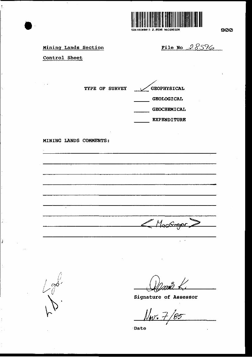
S2A18SWM11 a.8596 MACGREGOR
Mining Lands Section
Control Sheet
900
File No J?.
TYPE OF SURVEY \̂ GEOPHYSICAL
GEOLOGICAL
GEOCHEMICAL
EXPENDITURE
MINING LANDS COMMENTS:
\ Signature of Assessor
Date

Ministry of Report of WorkNorthern Affairs
ad Mines (Geophysical, Geological, Ontario a^B Geochemical and Expenditures)
Inrtructioni: - ftasl type or print.—If number of mining claims traversed
exceeds space on this form, attach s list. Not*: — Only days credits calculated in the
"Expenditures" section may be entered in the "Expend. Days Cr." columns.
- Do not use shaded areas below.Township or Area
^.-———————- Prospector's Licence No.
Name and Address of Author (of Geo-Technical report)
Credits Requested per Each Claim in Columns at riSpecial Provisions
For first survey:Enter 40 days. (This includes line cutting)
For each additional survey^, using the same grid: 'fjj \*
Enter 20 days (for each)
W
Man Days .VfttM
Complete reverse side and enter total (s) here
Airborne Credits
Note: Special provisions credits do not apply to Airborne Surveys.
Geophysical
- Electromagnetic
- Magnetometer
r t Ft8tfm*r*^- Other
^orogk,^
Geochemical -. t-(Vf\f. . Mr\c; SV,\i'*vr \ PvW0^edfWysical
- Electromagnetic
- Magnetometer
- Radiometric
- Other4
Geological
Geochemical
Electromagnetic
Magnetometer
Radiometric
Days perClaim
to
|H-Days per Claim
^rDays per
Claim '
Mining Claims Traversed (List in numerical sequence)Mining Claim
Prefix NumberExpend. Da y t Cr.
Expenditures (excludes power stripping)Type of Work Performed
Performed on Claim(i) , i \.
Calculation of Expendi
Total Expenditures"' ' .
,ys Creditsv f 'in^ '-' s-
InitruTotal Days Credits may be apportioned at the claim holder's choke. Enter number of days credits per claim selected in columns at right.
Mining ClaimPrefix Number
71
Expend. Days Cr.
Total number of mining claims covered by this report of work.
Date
Certification Verifying Repprt of Workl hereby certify that l have a personal and intimate knowledge of the facts set forth in the Report of Work annexed hereto, having performed the work or witnessed same during and/or after its completion and the annexed report is true.
Name and Postal Address of Person Certifying
-Te-cjfrscKJ6tS7Date Certified Certified by (Signature)
V-. x*.1362 (85/9)

REFERENCES
On
ion
Lake
A r
e a
Ta r
tan
La k
e
Are
a
\s
LO r- CO l O H .c W) o o
K E
:
52
A1
*SW
00
n
2.8
596
MAC
GR
EGO
R2O
O
AR
EA
S W
ITH
DR
AW
N F
RO
M D
ISP
OS
ITIO
N
S.R
. -
SU
RF
AC
E R
IGH
TS
M
.R.
-MIN
ING
RIG
HT
S
Des
crip
tion
Ord
er N
o. ^
D
ate
Difp
otiti
on ^
. f U
g_ -
-w
(?l)
W.4
3/7
5
15/8
/75
S.R
.BM
.R.
J68
32
SA
ND
A
ND
G
RA
VE
L
GR
AV
EL
GR
AV
EL
M.T
.C.
PH
2
E-6
FIL
E
820
3
" 1
50
98
7
H 9
171
4
Land
Und
er L
ake
Sup
erio
r W
ithdr
awn
From
Sto
king
By
Ord
er i
n C
ounc
il D
ated
A
pril,
191
2.
Lim
its
Of
Lake
heod
Har
bour
Sho
wn
Thus
As
Def
ined
By
La
kehe
ad C
omm
issi
oner
s Ac
*.
7 E
liza
beth
!l,
Chapte
r 34
{
Can
ada
l
LEG
END
H i r,
H W
o
: M t
H
MIN
ING
Ci
AIM
^ f-
, .1 T
i
Pi
X
T H
A V
V
DISP
OSI
TIO
N OF
CRO
WN
1/N
L.S
TY
Pt
OF
UU
CU
MhN
PA
I t
N '
M
'H
t A
, t
A M
i'.. '
.
'. ••
- A
O
!' "'^
M i
N i
", '
. ^
l ' - "
'
-
l P
AS
E
b'J
hi
.-..
t 1
M:',
'.
SVM
BOL rt te T
NO
TE
SC
Ai
if'
(.H
AIN
S
TO
WN
SH
IP
MA
CG
REG
OR
M
N R
AH
MIN
lST
ftM
IVt
DIS
TR
ICT
THU
ND
ER
BA
YM
iNlN
i,
THU
ND
ER
BA
YLA
ND
iilltS
/ R
EG
ISTR
Y
DIV
ISIO
N
THU
ND
ER
BA
YM
inis
try O
f L
an
d
Na
t* f
ra!
Man
agem
ent
Re
SO
urc
eS
B
ran
chO
ntar
io_
_ ̂
-.-
-
. . --
-.
J\4f
ci
Da"
MA
RC
H
1982
W j
*n b
* '
G-6
72