city of redmond final comprehensive flood hazard
TRANSCRIPT

City of Redmond Final Comprehensive Flood
Hazard Management Plan
Prepared for: City of Redmond
Public Works Department PO Box 97010, MS 2NPW
Redmond, WA 98073-9710
Prepared by: Otak, Inc.
6 South 2nd Street Suite 605
Yakima, WA 98901 Otak Project No. 30759
November 17, 2009

Acknowledgements
City of Redmond Final Comprehensive Flood Hazard Management Plan
Submitted to: City of Redmond Public Works Department Prepared by: Otak, Inc. John Knutson, PE Project Manager
Laurie Wood GIS Specialist and Planner
City of Redmond Comprehensive Flood Hazard Management Plan
Table of Contents
R e d m o n d C o m p r e h e n s i v e F l o o d H a z a r d M a n a g e m e n t P l a n i otak
Y:\Project\30000\30759\Reports\Final CFHMP 09_1117\Final CFHMP 09_1117.doc
Executive Summary .................................................................................................. E-1 Section 1—Introduction ......................................................................................... 1-1 Section 2—Goals and Objectives ......................................................................... 2-1 Section 3—Study Area Characteristics ............................................................... 3-1 Section 4—Regulatory Review .............................................................................. 4-1 Section 5—Study Area Hydrology and Flood History .................................... 5-1 Section 6—Identified Flooding Problems and Need for Flood Hazard
Management Measures ...................................................................... 6-1 Section 7—Flood Management Alternatives ...................................................... 7-1 Section 8—Implementation of the Recommended Flood Management
Alternative .......................................................................................... 8-1 Section 9—References ............................................................................................ 9-1
City of Redmond Comprehensive Flood Hazard Management Plan
List of Figures
R e d m o n d C o m p r e h e n s i v e F l o o d H a z a r d M a n a g e m e n t P l a n ii otak
Y:\Project\30000\30759\Reports\Final CFHMP 09_1117\Final CFHMP 09_1117.doc
Figure 1-1—Vicinity Map ........................................................................................................ 1-3
Figure 1-2—Flood Hazard Areas and Floodplain .............................................................. 1-5
Figure 1-3—Comprehensive Flood Hazard Management Plan Development ............ 1-9
Figure 3-1—Redmond Watershed Map .............................................................................. 3-2
Figure 3-2—Redmond Wetland Map ................................................................................. 3-17
Figure 3-3—Zoning Map ....................................................................................................... 3-23
Figure 4-1—CFHMP Schematic ............................................................................................ 4-6
Figure 4-2—Frequently Flooded Areas Map .................................................................... 4-19
Figure 5-1—Redmond Floodplain ......................................................................................... 5-6
Figure 5-2—Floodway Schematic ......................................................................................... 5-8
Figure 6-1—FMAC Identified Flood Problems .................................................................. 6-2
Figure 7-1—Selecting a Preferred CFHMP Alternative ................................................... 7-1
Figure 8-1—City of Redmond Neighborhoods ................................................................. 8-9

City of Redmond Comprehensive Flood Hazard Management Plan
List of Tables
R e d m o n d C o m p r e h e n s i v e F l o o d H a z a r d M a n a g e m e n t P l a n iii otak
Y:\Project\30000\30759\Reports\Final CFHMP 09_1117\Final CFHMP 09_1117.doc
Table 1-1—City of Redmond CFHMP Advisory Committee ...................................... 1-11
Table 1-2—Summary of Advisory Committee Meetings .............................................. 1-12
Table 2-1—Short-Term Goals and Objectives for Redmond CFHMP ........................ 2-1
Table 2-2—Long-Term Goals and Objectives for Redmond CFHMP ......................... 2-2
Table 3-1—Physical Characteristics of Sammamish River Basin in CFHMP Study Area ........................................................................................................... 3-1
Table 3-2—Climate Data for the City of Redmond ........................................................ 3-6
Table 3-3—City of Redmond Population History .......................................................... 3-20
Table 3-4—Zoning Distribution Within the Floodplains of the City of Redmond ............................................................................................................ 3-21
Table 4-1—CRS Premium Discounts .................................................................................. 4-4
Table 4-2—Riparian Stream Corridor Classification Stream Buffer Width ............. 4-23
Table 5-1—Summary of Some Major Storm Event Peak Flows .................................... 5-3
Table 5-2—National Flood Insurance Program Participants in the CFHMP Study Area ........................................................................................................... 5-8
Table 5-3—Flow Gauging Stations Near the Study Area ............................................. 5-10
Table 6-1—Summary of Recommendations Made in Previous Studies ....................... 6-6
Table 7-1—Redmond FMAC Alternative ........................................................................... 7-4
Table 8-1—Redmond FMAC Alternative Implementation Guidance and Cost Estimation ............................................................................................................ 8-2

City of Redmond Comprehensive Flood Hazard Management Plan
List of Acronyms
R e d m o n d C o m p r e h e n s i v e F l o o d H a z a r d M a n a g e m e n t P l a n iv otak
Y:\Project\30000\30759\Reports\Final CFHMP 09_1117\Final CFHMP 09_1117.doc
B
BMP Best Management Practice
C
CAO Critical Areas Ordinance
CFHMP Comprehensive Flood Hazard Management Plan
CIP Capital Improvement Project
CRS Community Rating System
CTED . State Department of Community, Trade, and Economic Development
CWA Clean Water Act
D
DNR Washington State Department of Natural Resources
DOE Washington State Department of Ecology
E
EIS Environmental Impact Study
EPA United States Environmental Protection Agency
F
FCAAP Flood Control Assistance Accounts Program
FEMA Federal Emergency Management Agency
FHBM Flood Hazard Boundary Map
FIA Flood Insurance Administration
FIRM Flood Insurance Rate Map
FIS Flood Insurance Study
FMAC Flood Management Advisory Committee

City of Redmond Comprehensive Flood Hazard Management Plan
List of Acronyms
R e d m o n d C o m p r e h e n s i v e F l o o d H a z a r d M a n a g e m e n t P l a n v otak
Y:\Project\30000\30759\Reports\Final CFHMP 09_1117\Final CFHMP 09_1117.doc
G
GIS Geographic Information System
GMA Growth Management Act
H
HPA Hydraulic Project Approval
L
LID Low Impact Development
LSRA Locally Significant Resource Area
N
NEPA National Environmental Policy Act
NFIA National Flood Insurance Act
NFIP National Flood Insurance Program
R
RCW Revised Code of Washington
RSRA Regionally Significant Resources Area
S
SEPA State Environmental Policy Act
SMA Washington State Shoreline Management Act
U
USACE United States Army Corps of Engineers
W
WAC Washington Administrative Code
WDFW Washington Department of Fish and Wildlife
WRIA Water Resources Inventory Area
WSDOT Washington State Department of Transportation

E x e c u t i v e S u m m a r y

Executive Summary
R e d m o n d C o m p r e h e n s i v e F l o o d H a z a r d M a n a g e m e n t P l a n E-1 otak
Y:\Project\30000\30759\Reports\Final CFHMP 09_1117\Final CFHMP 09_1117.doc
Introduction Because of the flood modifications to the Sammamish River channel made by the U.S. Army Corps of Engineers (USACE), the current impacts of flooding within the City of Redmond (City) pose little risk to public safety and relatively low risk to existing public and private development. Redmond, though, faces the potential for an increase in flood hazard risks as a result of the tremendous population and development growth occurring in the region. This growth is placing increasing demands on the floodplains of the Sammamish River and its tributaries. It is also important to ensure the continued functioning of the Sammamish River flood project, while also working to restore lost floodplain functions created by the original USACE modifications. Redmond is presently experiencing frequent drainage flooding throughout the city. Without adequate comprehensive flood hazard management planning, Redmond could see an increase in flood risks to public safety and damages to private property, businesses, and city infrastructure. The Redmond Comprehensive Flood Hazard Management (CFHMP) plan seeks to address the flood hazard issues facing the City in a comprehensive, watershed-wide basis.
The geographic scope of the CFHMP is the city limits of Redmond; the primary focus being the floodplains of the Sammamish River and Bear and Evans Creek. Since watersheds typically cross jurisdictional boundaries, areas outside the city limits which affect flooding within Redmond were also examined. The Redmond CFHMP addresses ways to collaborate with other jurisdictions to solve regional/watershed problems. Since Redmond represents a very small portion of the area that contributes to the flows in Bear Creek and the Sammamish River, this collaboration is of paramount importance.
Planning Process The development of the Redmond CFHMP followed the requirements defined in Chapter 86.26 Revised Code of Washington (RCW) and Chapter 173-145 Washington Administrative Code (WAC) and the guidelines listed in the Washington State Department of Ecology (Ecology) Publication #91-44. Since Redmond is located within King County, the Redmond CFHMP was also developed to be consistent with the 2006 King County Flood Hazard Management Plan, a requirement of RCW 86.12.210. For a CFHMP to be effective, public participation is crucial during the planning process. A Flood Management Advisory Committee (FMAC) was formed of community members representing a variety of interests and affected governmental agencies. The FMAC was an integral participant and decision maker in identifying flood problems, establishing goals and objectives, developing solutions to existing flood problems, and selecting the preferred flood management alternative.

Executive Summary Continued
R e d m o n d C o m p r e h e n s i v e F l o o d H a z a r d M a n a g e m e n t P l a n E-2 otak
Y:\Project\30000\30759\Reports\Final CFHMP 09_1117\Final CFHMP 09_1117.doc
The long term goals of the Redmond CFHMP are as follows: • Prevent the loss of life, the creation of public health or safety problems, and damage to
public and private property from floods. • Maintain the varied uses of existing drainage pathways and floodplains within the City. • Minimize pollution hazards to surface and groundwater occurring during flood events. • Implement watershed-based strategies for flood hazard management that balance
engineering, economic, environmental, and social factors. • Restore properly functioning conditions for degraded floodplains. • Coordinate flood hazard planning and management with interested and affected parties
in both public and private sectors. • Increase the public’s understanding of flood hazard issues. • Have a comprehensive understanding of Redmond’s floodplains and flood hazards. • Have a stable, adequate, and publicly acceptable long-term source of financing flood
hazard management work. • Reduce the long-term costs of flood hazard management. • Maintain an updated and accurate plan over time. Objectives were developed describing specific actions to be taken to meet these goals. These objectives are listed in Section 2, Table 2-2. A preferred flood management alternative and implementation plan were then developed to meet the goals and objectives of the City’s CFHMP.
Flood Management Alternative and Implementation Plan The recommended flood management alternative and implementation plan focus on protection and restoration of important floodplain functions through non-structural floodplain management and regulatory activities, multi-jurisdictional floodplain restoration projects, and small restoration and preventative city projects. No significant structural flood protection projects are proposed for the City, with the exception of coordinating with others to study and potentially execute floodplain restoration projects in the future.
In recent history, Redmond has had limited property damage from flooding events, despite the fact that a significant portion of its land, including its downtown core, lies within the 100-year floodplains of the Sammamish River and its tributaries. This could change if the pressures on the region’s floodplains, caused by increased population and development growth, are not managed effectively. It could also change if the Sammamish River ever overtops its banks or breaches the sidewalls of the flood channel, which would result in the inundation of large portions of the City. The preferred alternative focuses on restoration of the floodplain functions of the Sammamish River and the lower portions of Bear Creek near the City’s downtown area, and

Executive Summary Continued
R e d m o n d C o m p r e h e n s i v e F l o o d H a z a r d M a n a g e m e n t P l a n E-3 otak
Y:\Project\30000\30759\Reports\Final CFHMP 09_1117\Final CFHMP 09_1117.doc
preservation of the floodplain functions of the rest of Bear Creek, Evans Creek, and other tributaries of the Sammamish River. Proposed projects involve reconnecting the rivers and streams with their floodplains, increasing channel complexity, and restoring riparian vegetation. The Sammamish River is considered a flood control facility. It is therefore important that any restoration project constructed along the Sammamish River maintain the river’s flood control capabilities. King County is required by the USACE to maintain the flood control functions of the Sammamish River within specific guidelines. The City should continue to coordinate with King County and USACE on constructing restoration projects along the Sammamish River. These projects should maintain or improve flood protection levels while also restoring important environmental resources. The lower portions of Bear Creek border King County and State Route 520. It is important that the City collaborate with King County and the Washington State Department of Transportation (WSDOT) to solve flooding problems in this region and construct restorations projects. Successful floodplain management requires current and accurate data identifying areas of flood risks. The Redmond CFHMP recommends supporting King County, the Department of Ecology, and the Federal Emergency Management Agency (FEMA) in their efforts to update the Flood Insurance Rate Maps (FIRMs) of the Sammamish River. This information would help ensure that flood hazard zones governing flood insurance rates are correct. The City should also investigate the need for updated flood mapping within the tributaries of the Sammamish River. Flooding trends in the region should be monitored through photos and documentation of flood events, particularly flow and flood stages. FEMA initially approved the City of Redmond’s flood insurance study in 1974. Since that time, according to 2006 FEMA data, only 9 insurance claims within the Redmond area have been filed for 527 policies. None of these claims have been along the Sammamish River. This CFHMP recommends the City investigate the potential for the Sammamish River to qualify as a 100-year protection facility. This would remove areas within Redmond with no flooding history from the regulatory floodplain. The Redmond CFHMP also recommends the City participates in the National Flood Insurance Plan Community Rating System (CRS) to reduce the area’s flood insurance rates. Public education regarding the risks of flood hazards and ways to reduce these risks is an important component of the Redmond CFHMP. It is recommended that the City integrate flood education with its stormwater public outreach programs and collaborate with King County, other jurisdictions, and conservation and recreation groups to educate the public.

Executive Summary Continued
R e d m o n d C o m p r e h e n s i v e F l o o d H a z a r d M a n a g e m e n t P l a n E-4 otak
Y:\Project\30000\30759\Reports\Final CFHMP 09_1117\Final CFHMP 09_1117.doc
Redmond’s Hazard Mitigation Plan The Redmond CFHMP is a flood-focused element of the broader Hazard Mitigation Plan (HMP) developed and administered by the City’s Office of Emergency Management. Many of the strategies for addressing flood hazards apply to other hazards the City may face. Adoption of the Redmond CFHMP is being coordinated with updates to Redmond’s HMP. Estimated Costs and Funding Strategies The estimated annual cost for implementing the Redmond CFHMP is $56,500. The estimated one-time costs range from $296,000 to $476,000 depending on the projects chosen for implementation. These costs could significantly increase if grants or King County Flood Control Zone District (FCZD) funds are not available to assist with some of the implementation plan programs and projects. Most of the actions listed in the implementation plan can be integrated into existing City programs and budgets and workloads, but some components may require reprioritization of some activities, or some increase in staffing. It is suggested that the City incorporate floodplain management activities into their surface water management programs that focus on stormwater and habitat management. Floodplain management is a natural extension of the surface water management program. Many of the surface water management activities result in controlling the impacts of development on flooding and improving floodplain or riparian function. More funding opportunities would be available through this collaboration since state and federal agencies prefer to fund projects that are comprehensive, multi-objective, and sustainable. Once the Redmond CFHMP is adopted, the City becomes eligible for additional funding for flood control projects and studies through Ecology’s Flood Control Assistance Account Program (FCAAP).

Section 1—Introduction
R e d m o n d C o m p r e h e n s i v e F l o o d H a z a r d M a n a g e m e n t P l a n 1-1 otak
Y:\Project\30000\30759\Reports\Final CFHMP 09_1117\Final CFHMP 09_1117.doc
The purpose of Redmond’s Comprehensive Flood Hazard Management Plan (CFHMP) is to provide a document that: • describes the City’s flood hazard management program; • evaluates the program’s effectiveness; and • identifies projects or programmatic improvements that will reduce flood hazards and
improve floodplain management within the jurisdictional boundaries of Redmond. Since flooding issues overlap jurisdictional boundaries, the CFHMP addresses flood hazards in a comprehensive, watershed-wide manner to prevent flooding problems from simply being transferred to another location within the watershed. Since flooding issues hold much in common with other types of hazards, the CFHMP is coordinated with the City’s broader Hazard Mitigation Plan (HMP), developed and administered by the City’s Office of Emergency Management. To meet the purpose described above, this CFHMP is divided into eight sections. The CFHMP, through these eight sections:
1. gives a brief background and goes on to describe the process of developing the CFHMP;
2. identifies the goals and objectives of the CFHMP as developed by the Flood Management Advisory Committee;
3. characterizes the study area; 4. reviews the various applicable regulatory policies; 5. outlines the City’s history of flooding; 6. identifies flood related issues that should be addressed within the CFHMP; 7. develops flood management alternatives to address those issues; and 8. provides guidance for implementation of the recommended approach.
The CFHMP has been developed by the City and its consulting firm, Otak, Inc. (Otak) with input from the general public, neighboring jurisdictions, King County, the City’s Planning Department, the Natural Resources Division of the Public Works Department, the City’s Stormwater Maintenance Division, and the City’s Office of Emergency Management. It presents a balanced approach to flood hazard protection and reduction, resource protection, environmental enhancement, and land development. This approach is consistent with the City’s Comprehensive Plan’s “…policy of striving ‘towards no net loss of the structure, value, and functions of natural systems constituting frequently flooded areas.’” (City of Redmond, 2005b).

Section 1—Introduction Continued
R e d m o n d C o m p r e h e n s i v e F l o o d H a z a r d M a n a g e m e n t P l a n 1-2 otak
Y:\Project\30000\30759\Reports\Final CFHMP 09_1117\Final CFHMP 09_1117.doc
1.1 Background The City of Redmond lies in northwest-central King County. It is bordered by Kirkland to the west, Bellevue to the southwest, and Sammamish to the southeast. Unincorporated King County lies to the north and east. Redmond is situated on the north end of Lake Sammamish, with the Sammamish River running through its center. It encompasses an area of about 16.85 square miles (City of Redmond, 2008b). See Figure 1-1, Vicinity Map. Redmond is the seventh most populous city in King County and the sixteenth most populous city in the state of Washington, with a residential population estimate of approximately 51,320 in 2008 (City of Redmond, 2008b). Redmond is a major employment center, ranking fourth in the central Puget Sound region (City of Redmond, 2005a). At the end of 2006 there were approximately 68,433 workers employed and 5,046 businesses located within the city limits (City of Redmond, 2007). This rapid growth of Redmond has happened in the midst of rapid growth throughout the region, and a large increase in the amount of impervious area within the watershed that drains to the Sammamish River. Studies have shown that such a large increase in impervious area will result in a related increase in erosive flows and flooding in streams and rivers (May, et.al., 1996) Redmond primarily lies on the valley floor of the Sammamish River Basin at an elevation 50 feet above sea level. The upper reach of the Sammamish River flows through Redmond from the outlet of Lake Sammamish. Water flowing from the lake comes from a contributing area of 94.4 square miles. Water flowing from the Bear-Evans Creek subbasin comes from a contributing area of 49.8 square miles. Redmond’s 16.8 square miles of largely urban commercial and residential development contributes modestly to the flows entering the Sammamish River. With Redmond representing such a small portion of the watershed, but being located downstream of such a large contributing area, it is important that Redmond work with King County and other neighboring jurisdictions on regional planning efforts. This lower area of the watershed that is located within Redmond is the primary focus of this CFHMP. Section 3 of the CFHMP goes into more detail about the characteristics of this study area.

Section 1—Introduction Continued
R e d m o n d C o m p r e h e n s i v e F l o o d H a z a r d M a n a g e m e n t P l a n 1-3 otak
Y:\Project\30000\30759\Reports\Final CFHMP 09_1117\Final CFHMP 09_1117.doc
Figure 1-1—Vicinity Map

Section 1—Introduction Continued
R e d m o n d C o m p r e h e n s i v e F l o o d H a z a r d M a n a g e m e n t P l a n 1-4 otak
Y:\Project\30000\30759\Reports\Final CFHMP 09_1117\Final CFHMP 09_1117.doc
1.1.1 Flooding Issues in the Study Area Nearly 9 percent of Redmond, including much of its downtown core, lies within the FEMA 100-year floodplain of the Sammamish River (Figure 1-2). The Sammamish River flows between two lowland lakes. The entire Sammamish River is considered a flood protection facility that was constructed by the USACE through dredging and straightening in the mid-1960s.
Over the last forty years, flooding along the Sammamish River, Bear Creek, and Evans Creek has been minimal, despite rapid growth within the region. This is largely due to construction of the USACE flood control project. Recent flooding has occurred primarily adjacent to the tributary inlets where the channel berm created by side-casting dredged material is interrupted (FEMA, 2005). More detail about historic flooding of Bear Creek and the Sammamish River can be found in Section 5. Presently, Redmond is experiencing frequent drainage system flooding throughout the city. The City has identified 40 flood-related capital improvement projects (CIPs) to address storm drainage system flooding issues. The City has also identified 723 acres of chronically flooding areas, with about 10 miles of road and 96 culverts (City of Redmond, 2008a). Figure 1-2 shows the flood hazard areas as defined by the City. Identified flood problems are further discussed in Section 6, and some flood management alternatives are described in Section 7.
Nintendo Buildings at 150th Avenue NE Oakridge Business Park December 3, 2007 January 28, 2004

Section 1—Introduction Continued
R e d m o n d C o m p r e h e n s i v e F l o o d H a z a r d M a n a g e m e n t P l a n 1-5 otak
Y:\Project\30000\30759\Reports\Final CFHMP 09_1117\Final CFHMP 09_1117.doc
Figure 1-2—Flood Hazard Areas and Floodplain

Section 1—Introduction Continued
R e d m o n d C o m p r e h e n s i v e F l o o d H a z a r d M a n a g e m e n t P l a n 1-6 otak
Y:\Project\30000\30759\Reports\Final CFHMP 09_1117\Final CFHMP 09_1117.doc
1.1.2 Principles of Flood Hazard Management The terms flood control, floodplain management, stormwater management, and flood hazard management are commonly used to describe ways to minimize or prevent flood damages: • Flood control is usually comprised of the structural techniques used to protect land and
people from flood waters, such as levees, walls, reservoirs, etc. Typically, nonstructural techniques, such as land use regulations and growth management, are not considered part of flood control.
• Floodplain management is the operation of a program that promotes the “wise use” of floodplains in order to minimize flood risks, reduce losses from floods, protect public health and safety, and improve the quality of life for a community. “Wise use” means both reduced flood losses and protection of the natural resources and functions of floodplains (FEMA, n.d.). Management activities generally include requirements for zoning, subdivision or building, and special-purpose floodplain ordinances.
• Stormwater management involves the efforts to reduce the impacts of increased runoff from urban development to receiving waters. These efforts include the application of site design principles, construction techniques, source controls and treatment of runoff to reduce pollutants, and the impact of altered hydrology.
• Flood hazard management includes both the structural flood control management and the non-structural floodplain management techniques. Flood hazard management seeks a comprehensive approach to reducing flood damage.
Effective flood hazard management must encompass the entire river system, its floodplain, and watershed. Upstream uses of land and water within a river’s watershed can have adverse impacts downstream, including the potential for increased flooding. Flood control measures are more likely to be successful if the relationships between the hydrological, geological and biological features of a watershed, and how human activity can affect these relationships, are understood and addressed. When addressing flood hazards, it is important to consider the fact that watersheds do not follow jurisdictional boundaries. Cooperative floodplain management among neighboring cities and counties is necessary to effectively reduce flood risks and impacts to natural resources.

Section 1—Introduction Continued
R e d m o n d C o m p r e h e n s i v e F l o o d H a z a r d M a n a g e m e n t P l a n 1-7 otak
Y:\Project\30000\30759\Reports\Final CFHMP 09_1117\Final CFHMP 09_1117.doc
1.1.3 Authority and Scope for the City of Redmond CFHMP On February 21, 2006, the City contracted with Otak to assist in the development of a CFHMP for the Sammamish Watershed within the city boundaries of Redmond, Washington. The CFHMP was prepared in accordance with the RCW Chapter 86.26, the WAC Chapter 173-158, and Chapter 173-145 WAC. These rules and codes define the state’s participation in, and requirements for, floodplain management and administration of the FCAAP. Funding for the CFHMP was provided under an agreement between Ecology and the City, with Ecology contributing to the project funding through FCAAP, and the City contributing the remainder from stormwater utility funds. Under the authority of RCW 86.26, Ecology administers FCAAP to provide financial assistance for development of flood hazard management plans, emergency repairs to flood control structures, and to perform maintenance of flood control structures. By adopting the CFHMP, the City becomes eligible for additional Washington State funds for emergency and non-emergency activities that reduce the risks from flood hazards. The scope for the development of the CFHMP included:
1. review of the study area characteristics (Section 3) and flood history (Section 5); 2. identification of specific flooding problems and causes (Section 6); 3. review of the City’s regulatory and planning programs and their relationships to
floodplain management (Section 4); 4. identification of structural and/or nonstructural solutions (Section 7); 5. evaluation of alternatives (Section 7); 6. identification and prioritization of recommended projects (Section 8); and 7. investigation of funding and implementation issues (Section 8).
In addition, a State Environmental Policy Act (SEPA) checklist was completed to address environmental impacts related specifically to the adoption of the CFHMP, and that SEPA checklist was submitted to the City’s Planning Department as part of the adoption process. It is expected that any structural projects recommended in the CFHMP will require a project level SEPA checklist or other environmental analysis.

Section 1—Introduction Continued
R e d m o n d C o m p r e h e n s i v e F l o o d H a z a r d M a n a g e m e n t P l a n 1-8 otak
Y:\Project\30000\30759\Reports\Final CFHMP 09_1117\Final CFHMP 09_1117.doc
1.2 Plan Development Process Figure 1-4 diagrams the process involved in the development of the CFHMP. This process was based on the guidelines of Ecology’s “Comprehensive Planning for Flood Hazard Management Guidebook” (1991) and conformed to RCW Chapter 86.26: State Participation in Flood Control Maintenance, and WAC Chapter 173-145: Administration of the FCAAP. The steps of the CFHMP planning process included the following (Ecology, 1991):
1. Establish a citizen and agency participation process. 2. Set short- and long-term goals and objectives for flood hazard management. 3. Develop an inventory and analysis of physical conditions. 4. Determine the need for flood hazard management measures. 5. Review existing regulations that impact flood hazard management. 6. Identify alternative flood hazard management measures. 7. Evaluate alternative measures. 8. Hold Advisory Committee meetings for evaluation of alternatives. 9. Develop a flood hazard management strategy. 10. Complete the draft CFHMP and submit to Ecology. 11. Submit the final CFHMP to Ecology. 12. Hold a public hearing and adopt the CFHMP. 13. Notify Ecology the final plan is adopted.

Section 1—Introduction Continued
R e d m o n d C o m p r e h e n s i v e F l o o d H a z a r d M a n a g e m e n t P l a n 1-9 otak
Y:\Project\30000\30759\Reports\Final CFHMP 09_1117\Final CFHMP 09_1117.doc
(Modified from Ecology, 1991)
Figure 1-3—Comprehensive Flood Hazard Management Plan Development

Section 1—Introduction Continued
R e d m o n d C o m p r e h e n s i v e F l o o d H a z a r d M a n a g e m e n t P l a n 1-10 otak
Y:\Project\30000\30759\Reports\Final CFHMP 09_1117\Final CFHMP 09_1117.doc
1.2.1 Citizen and Agency Participation Public and agency participation is critical to the success of a CFHMP for the following reasons (Ecology, 1991): • Proposed measures will affect local property owners and their support will be needed to
take action. • WAC 173-145-070 calls for review of all FCAAP projects by state agencies including the
Washington Department of Fish and Wildlife (WDFW) and the Washington Department of Natural Resources (DNR), as well as by affected Native American tribes and other public entities; all of these parties should be involved in formulating the plan.
• Special interest groups, such as recreation clubs, real estate development interests, environmental groups, and business organizations, may have an interest in the plan, and their objectives should be considered.
• Since watersheds typically cross jurisdictional lines, representatives from neighboring local governments should be incorporated into the process.
• As the plan must be adopted by the local government, it is important to build support among the local constituency.
The planning process offers an opportunity to educate the public on the issues, opportunities, and public responsibilities of flood hazard management. The City’s CFHMP process utilized two different methods to achieve citizen and agency involvement. First, a Flood Management Advisory Committee (FMAC) was formed whose members, representatives of public and private organizations and agency representatives, provided input through meetings and document review. Table 1-1 lists Advisory Committee Members and their affiliations. Several of these members also represented local and regional environmental groups, including Water Tenders, Northwest Earth Institute, and King County Master Recycler/Composter. Table 1-2 lists the FMAC meeting dates and topics discussed. Next, the draft CFHMP was made available on the City’s website for review by the FMAC and the public. During this final review period, City staff evaluated the various recommendations to more fully determine how they could be implemented through existing programs without greatly increasing demands upon staff time or cost to Redmond taxpayers.

Section 1—Introduction Continued
R e d m o n d C o m p r e h e n s i v e F l o o d H a z a r d M a n a g e m e n t P l a n 1-11 otak
Y:\Project\30000\30759\Reports\Final CFHMP 09_1117\Final CFHMP 09_1117.doc
Table 1-1
City of Redmond CFHMP Advisory Committee
Committee Member Affiliation
Ray Anspach Resident, Condo Association
Kim Dietz City of Redmond, Planning Department
Howard Harrison Resident, Business Owner
Steve Hitch, PE City of Redmond, Senior Stormwater Engineer
Leon Hussey Resident, Small Business Owner, Property Developer
Priscilla Kaufmann King County Floodplain Management Unit and King County CFHMP
John Knutson Otak, Inc., Consultant
Marie McEwen Resident, Condo Association
Richard Morris Resident
Chuck Steele Washington State Department of Ecology
Bob Yoder Resident, participant in Redmond planning processes related to natural resources

Section 1—Introduction Continued
R e d m o n d C o m p r e h e n s i v e F l o o d H a z a r d M a n a g e m e n t P l a n 1-12 otak
Y:\Project\30000\30759\Reports\Final CFHMP 09_1117\Final CFHMP 09_1117.doc
Table 1-2 Summary of Advisory Committee Activities
Meeting 1 January 31, 2007
Introduce the project team and committee members; review the project background, purpose, and process; discuss the Committee’s role, expectations on their time, and frequency of meetings; begin identification of existing flood problems; and seek initial feedback from them regarding their concerns, goals, and objectives.
Meeting 2 March 28, 2007
Review city flooding history and characteristics; complete list of identified existing problems and begin to categorize by problem types; and begin discussion of CFHMP goals and objectives.
Meeting 3 June 6, 2007
Review draft flood hazard management goals and objectives and discuss, edit, and finalize goals and objectives.
Meeting 4 September 5, 2007
Review draft hazard alternative descriptions and evaluation; discuss the alternatives and evaluation process; and finalize the selection of the preferred alternative.
Draft Review February 2008
Draft CFHMP submitted to Ecology and posted to City website for review by FMAC. City staff performed review of draft and incorporation of comments by FMAC.
Final Draft January 2009
All comments incorporated into draft CFHMP. Final draft CFHMP posted to City website. Final draft submitted to Ecology and Advisory Committee. City staff prepare for adoption of CFHMP.

Section 1—Introduction Continued
R e d m o n d C o m p r e h e n s i v e F l o o d H a z a r d M a n a g e m e n t P l a n 1-13 otak
Y:\Project\30000\30759\Reports\Final CFHMP 09_1117\Final CFHMP 09_1117.doc
1.2.2 Data Collection Background information for the CFHMP was compiled from a variety of sources including the City, King County, state and federal agencies, and FMAC members. Information used in defining the study area’s physical, social, and historical characteristics included:
• FIRMs and FISs. • City Geographic Information System (GIS) maps including:
- Land Use/Zoning - Critical Areas - Frequently Flooded Areas - Storm and Habitat CIP - Wellhead Protection Zones - Geographical Hazards - Stormwater System - Topographic
• Aerial photography. • Information describing the physical setting, including climate, soil, vegetation,
hydrology, water quality, fisheries, and wildlife. • Population data. • The findings of past flood-related studies performed by the USACE and FEMA. • King County Comprehensive Flood Hazard Management Plan 2006. • City Flood Hazard Ordinance. • City Critical Areas Frequently Flooded Areas Code. • City Comprehensive Plan background documents. • Records of historical flood control activities. • Flood photos.
Other sources of data were existing local, state, and federal regulations pertaining to flood hazard management, historical documents, and interviews with local officials and citizens. The FMAC continually provided valuable information throughout the CFHMP development.

Section 1—Introduction Continued
R e d m o n d C o m p r e h e n s i v e F l o o d H a z a r d M a n a g e m e n t P l a n 1-14 otak
Y:\Project\30000\30759\Reports\Final CFHMP 09_1117\Final CFHMP 09_1117.doc
1.3 Plan Adoption Process Adoption of the CFHMP is a public process that began with development of the CFHMP by the Flood Management Advisory Committee through a series of public meetings identified in Table 1-2. The CFHMP process was advertised through the City’s Focus Magazine, on the City’s website, and advertised in the Redmond Reporter newspaper at various times throughout the project. The draft and final draft CFHMP was posted to the City’s website for comment and review. Hard copies of these draft documents were provided to the FMAC for comment. Once the final draft CFHMP was completed, City Staff prepared a report to the City Council about the plan and its implications. The outcome of staff briefing to the City Council will be adoption of the Plan by the City Council by resolution. The final adopted plan, as approved by the City Council, will be annexed into the City’s Hazards Mitigation Plan, in its entirety.

Section 2—Goals and Objectives
R e d m o n d C o m p r e h e n s i v e F l o o d H a z a r d M a n a g e m e n t P l a n 2-1 otak
Y:\Project\30000\30759\Reports\Final CFHMP 09_1117\Final CFHMP 09_1117.doc
Goals and objectives provide both the vision and the framework for the development of the CFHMP. In relationship to the CFHMP, “goals” are seen as the broadest expressions of a community’s desires and needs. Goals describe the results and benefits the CFHMP is trying to achieve. “Objectives” are more specific targets to be attained or actions to be taken in the implementation of the identified goals. Goals tend to have long-term purposes, whereas objectives tend to indicate how goals will be accomplished (Ecology, 1991). Objectives relate to the tasks and activities which need to be accomplished in order to meet the goals. Goals and objectives also provide criteria to evaluate different alternative flood hazard management measures. The success of a CFHMP is measured by the extent to which its goals and objectives are met. Therefore, it is important to set performance standards or provide measurable targets when defining CFHMP goals and objectives.
The City’s CFHMP goals and objectives were developed through the FMAC process after a committee review of Redmond’s flood history and identified existing and potential flood problems. The specific short-term and long-term goals and objectives of the CFHMP are presented in Table 2-1 and Table 2-2. Short-term goals and objectives include activities and actions to be conducted prior to or immediately after approval of the CFHMP. Long-term goals and objectives include all subsequent activities and actions.
Table 2-1 Short-Term Goals and Objectives for Redmond CFHMP
Goals Objectives
1.0 Have a well thought out plan to guide the management of floodplains and flood hazards.
1.1 Prepare a comprehensive flood hazard management plan to:
• Identify existing flooding problems.
• Identify the causes contributing to flooding and flood damages.
• Review existing City regulations and ensure consistency with state and federal laws.
• Establish clear City flood hazard management goals and objectives.
• Identify and select flood hazard management alternatives that most meet the City’s goals and objectives.
• Identify a funding strategy to implement the City’s flood plan.
2.0 Ensure that pending and near-term development proposals are consistent with the goals and objectives of the CFHMP.
2.1 City communicates to private developers and City staff to convey the results of any interim CFHMP analyses which may affect proposed development parcels.
2.2 City will use the best available information, including analysis conducted during preparation of the CFHMP, when reviewing near term development proposals.

Section 2—Goals and Objectives Continued
R e d m o n d C o m p r e h e n s i v e F l o o d H a z a r d M a n a g e m e n t P l a n 2-2 otak
Y:\Project\30000\30759\Reports\Final CFHMP 09_1117\Final CFHMP 09_1117.doc
Table 2-2 Long-Term Goals and Objectives for Redmond CFHMP
Goals Objectives
1.0 Prevent the loss of life, creation of public health or safety problems, and damage to public and private property from floods.
1.1 Implement flood hazard management measures as approved in the CFHMP.
1.2 Give preference to nonstructural measures such as regulations and preservation of existing drainage corridors to avoid increasing problems.
1.3 Continue application of NFIP building standards. 1.4 Integrate King County early warning systems into City’s
Emergency Operations Plan. 1.5 Ensure safe transportation routes and access to critical facilities
during floods (protect City infrastructure during flood events). 1.6 Evaluate need for public and private access to flood fight
supplies. 1.7 Manage land uses in flood hazard areas in order to prevent
creation of new flood risks. 2.0 Maintain the varied uses
of existing drainage pathways and floodplains within the City.
2.1 Preserve opportunities for floodplain uses that are compatible with periodic flooding. Discourage land uses in the floodplain that are incompatible with periodic flooding.
2.2 Adopt flood control measures that preserve or enhance existing fishery, wildlife, and other natural uses of channels and riparian zones.
2.3 Wherever possible ensure that changes in land use within drainage corridors restore the natural character of floodplains and riparian areas as part of their mitigation requirements.
3.0 Minimize pollution hazards to surface and groundwater occurring during flood events.
3.1 Integrate flood control needs with water quality needs. 3.2 Prevent release of hazardous material into surface and
groundwater during flood events.
4.0 Implement watershed-based strategies for flood hazard management that balance engineering, economic, environmental, and social factors.
4.1 Integrate CFHMP goals, objectives, and recommendations into the City’s comprehensive plans (under the Growth Management Act) and related ordinances and codes.
4.2 Preserve natural drainage areas, especially known floodplains. 4.3 Adopt development codes that reflect CFHMP policies on
flood hazard management. 4.4 Promote Low Impact Development (LID) principles and
practices; including:
• Utilization of compost amended soils.
• Preservation of native vegetation.
• Maintenance of infiltration, where appropriate.

Section 2—Goals and Objectives Continued
R e d m o n d C o m p r e h e n s i v e F l o o d H a z a r d M a n a g e m e n t P l a n 2-3 otak
Y:\Project\30000\30759\Reports\Final CFHMP 09_1117\Final CFHMP 09_1117.doc
Table 2-2 (cont.) Long-Term Goals and Objectives for Redmond CFHMP
Goals Objectives
5.0 Restore properly functioning conditions for degraded floodplains.
5.1 Remove or retrofit existing river facilities or modify maintenance practices to protect, restore or enhance riparian habitat to support recovery of species listed under the Endangered Species Act.
5.2 Where possible increase habitat areas, floodplain connectivity and channel complexity along the Sammamish River, lower Bear Creek, and their tributaries.
5.3 Work with King County and USACE to restore natural vegetation and habitat along the Sammamish River, yet still meet USACE flood facility maintenance guidelines.
6.0 Coordinate flood hazard planning and management with interested and affected parties in both public and private sectors.
6.1 Coordinate across City of Redmond departments and with other jurisdictions to provide consistency in flood hazard management and disaster response activities.
6.2 Coordinate with King County, USACE, WSDOT, and neighboring cities to solve mutual flooding problems.
6.3 Coordinate with existing conservation and recreation groups. 6.4 Maintain consistency with King County’s CFHMP
7.0 Increase the public’s understanding of flood hazard issues.
7.1 Sponsor and support public outreach and education activities to improve awareness of flood hazards, and recommend actions property owners can take to reduce risks to themselves and others and to protect the environment.
7.2 Educate the public and businesses on flood protection and prevention measures.
7.3 Integrate flood education with the City’s Stormwater Plan, and work with King County, other jurisdictions, and conservations groups.
7.4 Consider floodplain signage along Bear Creek Trail.
8.0 Have a comprehensive understanding of Redmond’s floodplains and flood hazards.
8.1 Evaluate the capacity of the existing Sammamish River and create new FIRM maps (identified need in King County’s Flood Hazard Management Plan).
8.2 Investigate the need for updated flood mapping within tributaries to the Sammamish River.
9.0 Have a stable, adequate, and publicly acceptable long-term source of financing flood hazard management work.
9.1 Use City stormwater utility funds to help implement the CFHMP.
9.2 Seek grants for floodplain management work to reduce costs to the City.
9.3 Cooperate with neighboring jurisdictions and others to reduce the financial impact of flood projects on the City.
9.4 Ensure adequate floodplain code enforcement through development staff availability.

Section 2—Goals and Objectives Continued
R e d m o n d C o m p r e h e n s i v e F l o o d H a z a r d M a n a g e m e n t P l a n 2-4 otak
Y:\Project\30000\30759\Reports\Final CFHMP 09_1117\Final CFHMP 09_1117.doc
Table 2-2 (cont.) Long-Term Goals and Objectives for Redmond CFHMP
Goals Objectives
10.0 Reduce the long-term costs of flood hazard management.
10.1 Develop structural and nonstructural measures to prevent or minimize current and future flood problems that are the responsibility of the city.
10.2 Update regulations if needed to prevent new development from causing flood damage or from being susceptible to damage by floods.
10.3 Reduce flood insurance rates by participating in NFIP CRS.
11.0 Maintain an updated and accurate plan over time.
11.1 Update the CFHMP regularly and employ adaptive management strategies to take full advantage of scientific and technological advances, and to use the best available floodplain management practices, principles and information.
11.2 Partner with others to examine potential impacts of predicted effects of climate change on flooding problems, function of flood protection facilities, and accuracy of floodplain maps.
11.3 Monitor flooding trends through photo and other documentation of flows and flood stages.
11.4 Evaluate goals and objectives every five years to maintain consistency with current policy.

Section 3—Study Area Characteristics
R e d m o n d C o m p r e h e n s i v e F l o o d H a z a r d M a n a g e m e n t P l a n 3-1 otak
Y:\Project\30000\30759\Reports\Final CFHMP 09_1117\Final CFHMP 09_1117.doc
3.1 Watersheds A watershed is an area of land where topographic features such as hills and valleys cause water to flow toward a single major river or other body of water. The study area of the CFHMP is a portion of the Sammamish River Watershed, itself a portion of the WRIA08 Cedar-Sammamish Watershed that includes all the water that eventually drains from Lake Washington. Within the study area, topographic and man-made features can be mapped to divide the area into ever-smaller watersheds to help engineers and scientists focus a study. There are more than sixty such watersheds that have been identified as draining to the Sammamish River within Redmond (Figure 3-1), each averaging about 200 acres. Of particular interest to this plan are the Sammamish River, Bear Creek, and Evans Creek, because these are the bodies of water that have been mapped by FEMA with 100-year floodplains. Table 3-1 describes some characteristics of these areas.
Table 3-1 Physical Characteristics of Sammamish River Basin in CFHMP Study Area
Description Sammamish River
Bear Creek Basin
Evans Creek Basin
River Channel Length (miles) within Redmond City Limits
3.4
2.3
0.7
100-year Floodplain Area (acres) within Redmond City Limits
862 309 27
Total area (acres) 1,198
Sources: Calculated from GIS data provided by the City on January 16, 2008. The largest contributing areas to the Sammamish River within Redmond are: • Lake Sammamish • Bear-Evans Creek • Peters Creek • Willows Creek

Section 3—Study Area Characteristics Continued
R e d m o n d C o m p r e h e n s i v e F l o o d H a z a r d M a n a g e m e n t P l a n 3-2 otak
Y:\Project\30000\30759\Reports\Final CFHMP 09_1117\Final CFHMP 09_1117.doc
Figure 3-1—Redmond Watershed Map

Section 3—Study Area Characteristics Continued
R e d m o n d C o m p r e h e n s i v e F l o o d H a z a r d M a n a g e m e n t P l a n 3-3 otak
Y:\Project\30000\30759\Reports\Final CFHMP 09_1117\Final CFHMP 09_1117.doc
3.1.1 Upper Reach Sammamish River—Lake Sammamish to the Northern Boundary of the City of Redmond
The Sammamish River is located in the lowest portion of the Sammamish Basin. The river “flows approximately 14 miles from the weir at the outlet of Lake Sammamish to its mouth in Lake Washington and drains roughly 240 square miles” (King County,2007c, page 175). The river length from the Lake Sammamish weir to the north Redmond City limits is approximately 4.2 miles (3.4 miles is within Redmond, the south 0.8 miles is in unincorporated King County’s Marymoor Park). The Sammamish River is slow flowing. The river drops only 14 feet in elevation over its 15 mile length, an approximate gradient of 0.02 percent (King County, 2007c, page 175). The Sammamish River floodplain varies in width from nearly a mile in the upper two-thirds, covering much of the valley floor, to approximately 1,000 feet wide near Bothell (Tetra Tech, Inc., 2002). Major tributaries to the upper reach of the Sammamish River include Bear, Peters, and Willows Creeks. 3.1.2 Lake Sammamish Lake Sammamish is the sixth largest lake in Washington and the second largest in King County. It is one of the region’s major recreational lakes with high use by fishermen, boaters, water skiers, swimmers, and picnickers. There are City, County, and State parks along the shore, and the lake has been designated a water of statewide significance. Lake Sammamish is 4,897 acres in area with a volume of 283,860 acre-feet. Its main inflow is from Issaquah Creek and its total watershed area is 63,000 Acres. Its outflow is through a control weir into the Sammamish River. The watershed of Lake Sammamish, has had some of the highest rates of development in the region. Historically, agricultural lands were scattered throughout the basin and urban and suburban uses concentrated in a few small communities such as Issaquah, Redmond, and east Bellevue. However, large areas of the basin have experienced rapid urban and suburban development as part of the overall growth in King County. New roads, housing developments, and urban areas are transforming the lake's forested watershed into urban and suburban land uses. These impacts, associated with changing land use, present a challenge to maintaining the high quality of this lake. (King County, 2008)

Section 3—Study Area Characteristics Continued
R e d m o n d C o m p r e h e n s i v e F l o o d H a z a r d M a n a g e m e n t P l a n 3-4 otak
Y:\Project\30000\30759\Reports\Final CFHMP 09_1117\Final CFHMP 09_1117.doc
3.1.2 Bear-Evans Creek Basin The Bear-Evans Creek Basin lies northeast of Lake Sammamish, south of Maltby in Snohomish County, and just east of Woodinville and Redmond (King County, Snohomish County, City of Redmond, 1989). The Basin is comprised of approximately 32,100 acres (about 51 square miles of drainage area) and is divided into three major sub-basins: Bear Creek at 14,300 acres; Cottage Lake Creek at 8,000 acres; and Evans Creek at 9,800 acres. All together there are over 100 miles of streams including Bear Creek at approximately 12.4 miles, Cottage Lake Creek at approximately 6.7 miles, and Evans Creek running approximately 8.2 miles. There are 9 lakes and over 2,000 acres of wetlands (King County, 2007b). The headwaters originate at elevations of 180 feet above sea level (Bear Creek) in southern Snohomish County, and 100 feet above sea level (Evans Creek) in King County. The confluence of the 2 creeks, in the eastern portion of Redmond, is at 50 feet above sea level. Evans Creek discharges into Bear Creek in southeast Redmond. Bear Creek drains west to the Sammamish River through Redmond (King County, 2007b).
The lowest portion of the Bear-Evans Creek floodplain is generally flat and ranges in width from approximately 250 feet wide downstream of Union Hill Road to nearly 1,800 feet wide downstream of the confluence of Bear and Evans Creeks (FEMA, 2005). “The lowest mile of Bear Creek is tightly constrained within a narrow corridor between State Route 520 and Marymoor Park to the south, and the Redmond Town Center, one of Redmond’s largest shopping centers and business parks, to the north” (Ecology, 2006, page 8). 3.1.2 Peters Creek Basin Peters Creek is located on the west side of the City and discharges to the Sammamish River. The Peters Creek Basin is about 1,100 acres in area (though 360 acres of this drains to a high flow bypass diversion). Most of Upper Peters Creek watershed was developed prior to modern stormwater quality and detention requirements. The lack of stormwater controls in this basin led to bank erosion and channel incision. Previous uncontrolled stormwater flows destabilized the creek’s banks, incised the creek bottom, eroded significant amounts of material, and reduced salmon and trout spawning and rearing habitat. Untreated runoff from streets, parks and yards has led to degraded water quality. This means that on the Benthic Index of Biotic Integrity (BIBI), this stream gets a “poor” rating for stream health. Most urban streams fall toward the “poor” rating. Redmond has completed a number of capital improvement projects within Peters Creek, including a high-flow bypass that directs high stormwater flows directly to the Sammamish River. Projects also include stabilization and habitat enhancements in headwaters reaches;

Section 3—Study Area Characteristics Continued
R e d m o n d C o m p r e h e n s i v e F l o o d H a z a r d M a n a g e m e n t P l a n 3-5 otak
Y:\Project\30000\30759\Reports\Final CFHMP 09_1117\Final CFHMP 09_1117.doc
retrofitting the outfall for fish passage; and projects to restore native vegetation cover, enhance channel capacity and improve habitat in the lower half mile of the channel. Flooding of business parks along the channel on the valley floor as the stream approaches the Sammamish River is an ongoing problem. 3.1.2 Willows Creek Basin The 306 acre Willows Creek Basin lies on the west side of Redmond, north of Peters Creek. This basin has perhaps the best water quality of Redmond’s tributary streams. This means that on the Benthic Index of Biotic Integrity (BIBI), this stream gets a “fair” rating for stream health. Most of Willows Creek’s headwater areas are protected from development due to large tracts of native growth protection easement and the Puget Sound Energy (PSE) utility corridors. Many hillside seeps in these open spaces provide cool clean water to the stream system. However, large areas where trees have been removed by PSE under power lines limit the stream’s ability to maintain a stable channel, and water temperatures increase due to lack of cover. While the upper basin is relatively natural, the lower stream runs through a business park. Much of this reach is elevated above parking lots between berms. This limits in-stream diversity in the reach and the channel has little cover, but the elevated channel keeps dirty stormwater from the parking areas out of the stream. Localized flooding is a common problem near this stream reach due to the confined channel. The lowest half mile of the channel was recently daylighted and is protected within a narrow corridor of established native plants. Coho salmon spawn and rear in Willows Creek. 3.2 Physical Characteristics 3.2.1 Climate Redmond lies in the Puget Sound lowlands of Western Washington. The climate of this area is predominately a mid-latitude, west coast, marine type. Most of the air masses that reach the Puget Sound area originate over the Pacific Ocean. Summers are cool and comparatively dry, and winters are mild, wet, and cloudy. In late fall and winter these masses are moist and about the same temperature as the ocean surface. Orographic effects caused by lifting and cooling of air masses moving inland result in a wide range of precipitation patterns over the area. Fifty percent of the annual precipitation typically occurs in the 4-month period of October through January, and 75 percent occurs in the 6 months from October through March. Below 1,500 feet in elevation, the winter precipitation normally falls as rain, occasionally interrupted by periods of snow. During the wet season, rainfall is usually a light to moderate

Section 3—Study Area Characteristics Continued
R e d m o n d C o m p r e h e n s i v e F l o o d H a z a r d M a n a g e m e n t P l a n 3-6 otak
Y:\Project\30000\30759\Reports\Final CFHMP 09_1117\Final CFHMP 09_1117.doc
intensity and continuous over a period of time rather than heavy downpours for brief periods. Maximum rainfall intensities to expect in one out of ten years are: 0.6 to 1.0 inch in one hour; 1.5 to 2.5 inches in three hours; 1.5 to 5.0 inches in six hours; and 2.0 to 7.0 inches in 12 hours. The heavier intensities occur along the western slopes of the mountains (Western Regional Climate Center, 2007).
Table 3-2 Climate Data for the City of Redmond
Month
Temperature Precipitation Snowfall
Avg Daily Max (F)
Avg Daily Min (F)
Monthly Avg (in)
Max on Record
(in)
Min on Record
(in)
Monthly Avg (in)
Max on Record
(in)
Min on Record
(in)
January 47.3 37.2 5.14 10.12 2.20 0.4 2.50 0.00
February 50.4 37.0 3.02 7.00 0.63 0.4 4.30 0.00
March 54.1 39.5 3.67 7.80 1.62 0.0 0.00 0.00
April 59.3 43.4 2.94 6.27 0.64 0.0 0.00 0.00
May 64.8 48.4 2.09 3.52 0.64 0.0 0.00 0.00
June 70.1 52.5 1.54 2.82 0.04 0.0 0.00 0.00
July 75.4 56.0 0.81 2.11 0.00 0.0 0.00 0.00
August 76.1 56.8 1.02 3.05 0.18 0.0 0.00 0.00
September 71.3 52.8 1.24 2.98 0.02 0.0 0.00 0.00
October 60.9 47.0 3.17 6.98 0.28 0.0 0.00 0.00
November 52.0 41.3 5.30 9.74 2.72 0.0 0.00 0.00
December 46.5 36.9 5.25 10.85 2.43 2.3 17.90 0.00
Annual 60.7 45.7 35.20 41.50 28.42 3.1 4.30 0.00
Source: Western Regional Climate Center, 2006 (National Weather Station 457470 for period 1986 to 2005).
Climate data for Redmond (Table 3-2) is recorded at the National Weather Service Station #457470 in Seattle at Sand Point Weather Service Forecast Office. The city’s annual average precipitation is approximately 35 inches. Until 2006, the wettest month was December 1996, when the city received 10.85 inches of precipitation. The city’s annual average snowfall is 3.10 inches. The largest monthly amount of snowfall occurred in December 1996 when the city received 17.90 inches. Temperatures range from an average low of 37 F in February to an average high of 76 F in August.

Section 3—Study Area Characteristics Continued
R e d m o n d C o m p r e h e n s i v e F l o o d H a z a r d M a n a g e m e n t P l a n 3-7 otak
Y:\Project\30000\30759\Reports\Final CFHMP 09_1117\Final CFHMP 09_1117.doc
3.2.2 Hydrology and Hydraulics The Sammamish River was once called the Sammamish Slough, a widely meandering, low-gradient river bordered by extensive wetlands and floodplains. The Sammamish Slough was the primary tributary to Lake Washington, linking Lakes Washington and Sammamish.
Sammamish Slough
ca. 1906 In 1912, the level of Lake Washington was lowered by 9 feet by the construction of the Lake Washington Ship Canal. Before the construction of the Ship Canal, the level of Lake Washington would fluctuate annually by several feet (Tetra Tech, Inc., 2002). The elevation of the Sammamish Slough and the level of Lake Sammamish were tied to the level of Lake Washington (Tetra Tech, Inc., 2002). “During high water conditions, the entire river valley would be flooded” (Tetra Tech, Inc., 2002, page 6). After the level of Lake Washington was lowered, “property owners along the slough formed a drainage district to straighten and deepen the channel in order to reclaim the adjacent lands for agriculture. Lands along the renamed Sammamish River were converted into agricultural use, but from the beginning, they were subjected to almost annual flooding from spring runoff” (King County, 2007c, page 179). In 1944, Congress initiated flood control studies for the Sammamish River. To reduce flooding on agricultural land, in 1966, the USACE completed the Sammamish River flood control project for King County. Nearly 14 miles of the Sammamish River was dredged to approximately 15 feet deep and widened from approximately 15 feet to 32 to 50 feet (King County, 2007c). Excavated material was used to construct levees. The river banks were armored and all riparian vegetation was removed and replaced by grass.

Section 3—Study Area Characteristics Continued
R e d m o n d C o m p r e h e n s i v e F l o o d H a z a r d M a n a g e m e n t P l a n 3-8 otak
Y:\Project\30000\30759\Reports\Final CFHMP 09_1117\Final CFHMP 09_1117.doc
Sammamish River at Marymoor Farm
ca. 1966
To maintain the level of Lake Sammamish, a weir was constructed at the outlet of Lake Sammamish. During low-flow periods, the release from Lake Sammamish is slowed. During high flows, the weir is completely submerged by the river and acts as an uncontrolled spillway. “The project was designed to pass approximately a 40-year springtime flood, equivalent to a 10-year winter storm, over the weir without the water surface elevation in Lake Sammamish exceeding 29.0 feet” (King County, 2007c, page 179). Today the entire Sammamish River is considered a flood protection facility. King County, under contract with the USACE, is responsible for maintaining the river channel, including removing any riparian vegetation. Maintenance practices most often consist of thinning or managing bank vegetation in a manner that will allow thorough inspection of the flood protection facility and will ensure sufficient conveyance of flood flows. Less frequently, these practices entail dredging within the channel or delta where deposition has impaired conveyance. The dredging and wholesale

Section 3—Study Area Characteristics Continued
R e d m o n d C o m p r e h e n s i v e F l o o d H a z a r d M a n a g e m e n t P l a n 3-9 otak
Y:\Project\30000\30759\Reports\Final CFHMP 09_1117\Final CFHMP 09_1117.doc
clearing of vegetation growing on the rock-lined banks, typical of historical maintenance practices, has led to a riparian buffer dominated by relatively low growing, non-native vegetation, a lack of instream diversity, and degraded water quality. Such practices are not consistent with many newer regulations, programs, and regional needs, including the recovery of Endangered Species Act-listed native salmonid species. More contemporary maintenance practices address flood protection needs while remaining consistent with salmon habitat recovery plans. These practices can include hand-cutting of vegetation within select areas, mowing stands of invasive vegetation on the banks or along flood protection facility access areas, benching back the banks to provide a greater channel cross-sectional area, replacing stands of invasive plants with native vegetation, and occasionally sediment removal. Within the Bear-Evans Creek Basin, only the lower portions of Bear Creek have been channelized, straightened, and possibly dredged for flood control. As a result, the Creek’s gradient was increased. In many areas, the banks have been hardened with rock, riparian vegetation was removed, and the channels were cleared of large woody debris (King County, 1990). King County and the City of Redmond have facilitated construction of numerous channel restoration projects. Projects to restore the channel complexity and meanders of lower Bear Creek are currently in design, with phased construction planned starting in 2009.
Bear Creek Straightened to Discharge to the Sammamish River
November 1964

Section 3—Study Area Characteristics Continued
R e d m o n d C o m p r e h e n s i v e F l o o d H a z a r d M a n a g e m e n t P l a n 3-10 otak
Y:\Project\30000\30759\Reports\Final CFHMP 09_1117\Final CFHMP 09_1117.doc
The densest area of development occurs along the lower reaches of Bear Creek. In this area numerous bridges cross over the creek. Many of these bridges are private crossings with restrictions that limit capacities and increase upstream flood levels. Debris collecting at these structures during major rain events has the potential to increase flood damages to roadways and adjacent structures (FEMA, 2005).
Bear Creek Skanska Bridge Over Evans Creek January 9, 2006 December 3, 2007 The flood season for the Sammamish River Basin and Evans-Bear Creek Basin is typically between October and March. Along the Sammamish River, the primary areas of flooding occur at the tributary inlets where the river is not bermed. Flooding along the lower reaches of Bear Creek is not extensive. Flood problems in this region are generally “a result of development encroaching upon and altering the natural drainage system” (King County, 1990, page 77). A more detailed discussion of the flood history of this region can be found in Section 5.1. 3.2.3 Geology and Geomorphology “The Sammamish River lies between two lowland lakes, Lake Sammamish and Lake Washington, and does not drain high elevation bedrock-dominated headwaters. There are no bedrock exposures in the Sammamish Basin of any consequence with regard to flooding characteristics. The entire Sammamish River flood hazard management corridor lies within a landscape shaped primarily by continental glaciation and subsequently by fluvial erosion and deposition. The valley walls along the Sammamish River are composed mostly of glacial and inter-glacial sediments. The present-day river is a single thread channel with a mildly meandering constructed channel pattern. Landward of the armored riverbanks is a floodplain of young alluvium and older terraces.”

Section 3—Study Area Characteristics Continued
R e d m o n d C o m p r e h e n s i v e F l o o d H a z a r d M a n a g e m e n t P l a n 3-11 otak
Y:\Project\30000\30759\Reports\Final CFHMP 09_1117\Final CFHMP 09_1117.doc
“Lake Sammamish and the Sammamish River Valley are an example of a glacial trough, probably carved by sub-glacial meltwater during continental glaciation (Booth, 1994). The historically sinuous channel meandering through a wide, low-gradient valley bottom with sand and silt channel substrate is consistent with the glacial trough features seen in the lower Snoqualmie River (Collins, et al., 2003). As such, naturally slow rates of lateral channel migration could be expected even before the massive alterations that have revised the Sammamish River channel floodplain. With the entire river now channelized and locked in place by bank armoring, there is little likelihood of channel movement.” (King County, 2007c, page 179) The Bear-Evans Creek Basin was formed by millennia of water and ice activity occurring during glacial and nonglacial periods. The most recent glacial period culminated about 15,000 years ago and lasted approximately 2,000 years. This period left deposits of recessional outwash, deposits of gravel and sand left by the retreating ice sheet; till, a concrete-like mixture of clay, silt, sand, and gravel laid down beneath the ice sheet; and advance outwash, sand with rare gravel deposited early in the glaciation by meltwater streams in front of the advancing ice margin. Nonglacial conditions existed in the lowland areas prior to this glacial period and lasted several tens of thousands of years. Evidence of the nonglacial period is found in the lowest, oldest portion of the basin’s geological layers, deposits of lightly to moderately oxidized sand and gravel left by rivers and streams. Between the glacial and nonglacial geological layers can be seen laminated silt and clay. These layers represent the “transitional period” of the basin where there was widespread lowland ponding. The Bear-Evans Creek Basin is composed of two major valleys and is bordered on the east by a ridge running roughly north and south. The upper/northern valley contains Bear and Cottage Lake Creeks. The valley floor is layered with recessional outwash. The valley is surrounded by gentle sideslopes. The uplands are composed of till thinly covered with a layer of recessional outwash. Development in this region is not yet extensive. The rate of stormwater runoff in this region is slowed by both the terrain and the permeability of the soil which has developed on the till. The other major valley within the Bear-Evans Creek Basin runs roughly east and west. This valley contains Evans Creek, draining west, and Patterson Creek, draining east away from the valley. The valley sidewalls are steep and underlain with easily eroded advance outwash deposits. The upland plateaus are layered with till. Runoff from these plateaus creates drainage courses that plunge over the steep slopes. During the millennia since deglaciation, these upland drainage courses have excavated substantial sideslope ravines with voluminous

Section 3—Study Area Characteristics Continued
R e d m o n d C o m p r e h e n s i v e F l o o d H a z a r d M a n a g e m e n t P l a n 3-12 otak
Y:\Project\30000\30759\Reports\Final CFHMP 09_1117\Final CFHMP 09_1117.doc
alluvial fans deposited on the main valley floor at their mouths. Development in the valley uplands has increased the rate and total amount of discharge leaving these areas. New discharge points have been created. The result has been an increase rate in the excavation of the sideslope ravines Another problem within this valley is slope instability. Fine-grained transitional beds underlie the advance outwash and are exposed low on the sidewalls. This layer retards downward groundwater migration and causes extensive zones of saturation and seepage in the overlying advance outwash resulting in undercutting of the ravine banks (King County, 1990). Overall, the hillslopes of the Evans Creek subbasin are the most sensitive of the Bear-Evans Creek Basin. Lower Evans Creek is highly susceptible to the settlement of sediment from the upper sub-basin (King County, 1990). “Lower Bear and Evans Creeks are less sensitive to increased flows and increased human population. The lower valleys are composed of widespread permeable gravel and sand that absorb much of the water from local precipitation and inflowing streams buffering the hydrologic impact of continued urbanization throughout the basin. The buffering of flows depends on a sufficient low density of development such that pervious areas are not entirely paved over. The portions of remaining undisturbed riparian corridor that now remain are also at risk from adjacent high-density occupation.” (King County, Snohomish County, City of Redmond, 1989). 3.2.4 Groundwater Shallow aquifers are located below the valley floor of the basin. (Ecology, 2006) Redmond operates five production wells that draw groundwater from the Alluvial Aquifer just 5-20 feet beneath the downtown and industrial core of the City. Clean drinking water from these wells is delivered to homes, businesses and industries to the area east of the Sammamish River. The City produces this water at about half the cost of water purchased from the Seattle regional water system. Nearly 40% of Redmond's water supply comes from groundwater. Protection of this groundwater is discussed in Section 4. 3.2.5 Vegetation Much of the original riparian vegetation in the Sammamish River Basin has been removed. In the late 1800’s and early 1900’s, the Sammamish River Valley was extensively logged. All riparian vegetation was removed when the river was dredged and straightened by the USACE in the early 1960s. The river channel was lined with grass, which King County is now required to maintain (Tetra Tech, Inc., 2002).

Section 3—Study Area Characteristics Continued
R e d m o n d C o m p r e h e n s i v e F l o o d H a z a r d M a n a g e m e n t P l a n 3-13 otak
Y:\Project\30000\30759\Reports\Final CFHMP 09_1117\Final CFHMP 09_1117.doc
Sammamish River Logging
Summer 1917
Today, the width of the river’s riparian vegetation is about fifty feet. Very few trees exist. In some areas of urban development, vegetation is non-existent. In areas where vegetation does exist, it consists primarily of non-native species (Tetra Tech, Inc., 2002).
Sammamish River at PSE Evans Creek Floodplain Crossing Looking North Looking North January 13, 2006 January 10, 2006
Redmond has constructed numerous large-scale restoration projects to improve the ecological aesthetic conditions in the river. Many of the city parks along the river have been improved, including revegetation of the river banks (King County, 2007c, page 175).

Section 3—Study Area Characteristics Continued
R e d m o n d C o m p r e h e n s i v e F l o o d H a z a r d M a n a g e m e n t P l a n 3-14 otak
Y:\Project\30000\30759\Reports\Final CFHMP 09_1117\Final CFHMP 09_1117.doc
Along the lower portions of Bear Creek, riparian vegetation has been removed. The creek in this area has also been cleared of all woody debris. Since 1990 “King County and the City of Redmond have facilitated construction of numerous stream restoration projects in the Bear Creek Restoration Plan” (King County, 2007b). Stream restoration efforts are ongoing. The undisturbed land cover is dominated by dense conifer forests, with some grass covered prairie-like areas in the lowlands. However, those lowland areas are interspersed with scattered stands of Douglas fir and Oregon white oak. Scotch broom and other shrubs and seasonal groundcover are typical of those areas. Fresh water marshes commonly have cover consisting of cattails, rushes, and sedges. Big leaf maple trees and red alder are very common between the foothills and Puget Sound. 3.2.6 Wetlands Historically, the Sammamish Basin was a place of vast wetlands. Wetlands resulted from the low-gradient, meandering, and frequently flooded characteristics of the Sammamish River. As a result of the construction of the river’s flood control project and its agricultural and urban development, much of the wetlands have been eliminated. The Sammamish River Corridor Action Plan (Tetra Tech, Inc., 2002) states that, “it appears only about 150 acres of wetland remain in the corridor (since many parts of the historic valley were wetland, the historic acreage was likely more than 3000 acres).” Presently, in the Bear-Evans Creek Basin there are over 2000 acres of wetlands (King County, 2007b). Over 100 wetlands have been identified and range in size from one acre to more than 80 acres. The majority of the wetlands are located in the upper plateau regions or along the valley floor (King County, 1990). Wetlands, as defined in RCW 36.070A.030 and in the City of Redmond’s Ordinance 2259, “are inundated or saturated by surface water or ground water at a frequency and duration sufficient to support, and that under normal circumstances do support, a prevalence of vegetation typically adapted for life in saturated soil conditions. Wetlands generally include swamps, marshes, bogs, and similar areas. Wetlands do not include those artificial wetlands intentionally created from non-wetland sites, including, but not limited to, irrigation and drainage ditches, grass-lined swales, canals, detention facilities, wastewater treatment facilities, farm ponds, and landscape amenities, or those wetlands created after July 1, 1990, that were unintentionally created as a result of the construction of a road, street, or highway. Wetlands may include those artificial wetlands intentionally created from non-wetland areas created to mitigate conversion of wetlands.” “The U.S. Fish and Wildlife Service wetland classification scheme uses a hierarchy of systems, subsystems, classes and subclasses to describe wetland types (refer to for a complete
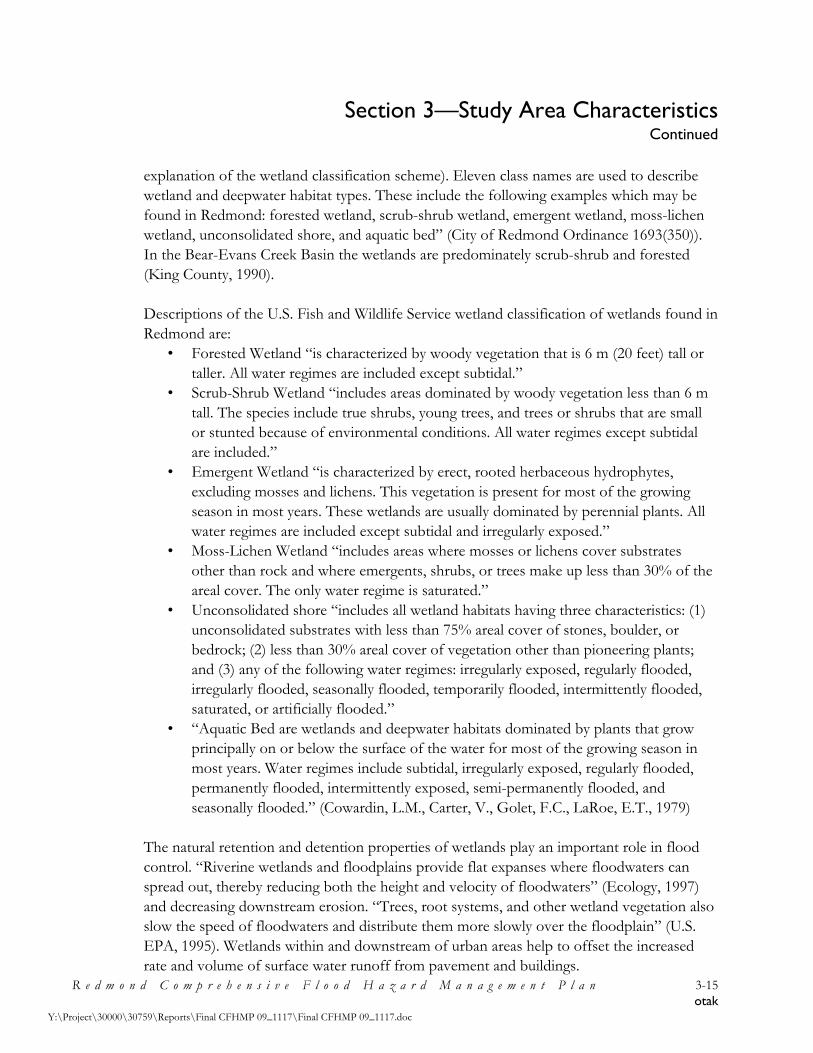
Section 3—Study Area Characteristics Continued
R e d m o n d C o m p r e h e n s i v e F l o o d H a z a r d M a n a g e m e n t P l a n 3-15 otak
Y:\Project\30000\30759\Reports\Final CFHMP 09_1117\Final CFHMP 09_1117.doc
explanation of the wetland classification scheme). Eleven class names are used to describe wetland and deepwater habitat types. These include the following examples which may be found in Redmond: forested wetland, scrub-shrub wetland, emergent wetland, moss-lichen wetland, unconsolidated shore, and aquatic bed” (City of Redmond Ordinance 1693(350)). In the Bear-Evans Creek Basin the wetlands are predominately scrub-shrub and forested (King County, 1990). Descriptions of the U.S. Fish and Wildlife Service wetland classification of wetlands found in Redmond are:
• Forested Wetland “is characterized by woody vegetation that is 6 m (20 feet) tall or taller. All water regimes are included except subtidal.”
• Scrub-Shrub Wetland “includes areas dominated by woody vegetation less than 6 m tall. The species include true shrubs, young trees, and trees or shrubs that are small or stunted because of environmental conditions. All water regimes except subtidal are included.”
• Emergent Wetland “is characterized by erect, rooted herbaceous hydrophytes, excluding mosses and lichens. This vegetation is present for most of the growing season in most years. These wetlands are usually dominated by perennial plants. All water regimes are included except subtidal and irregularly exposed.”
• Moss-Lichen Wetland “includes areas where mosses or lichens cover substrates other than rock and where emergents, shrubs, or trees make up less than 30% of the areal cover. The only water regime is saturated.”
• Unconsolidated shore “includes all wetland habitats having three characteristics: (1) unconsolidated substrates with less than 75% areal cover of stones, boulder, or bedrock; (2) less than 30% areal cover of vegetation other than pioneering plants; and (3) any of the following water regimes: irregularly exposed, regularly flooded, irregularly flooded, seasonally flooded, temporarily flooded, intermittently flooded, saturated, or artificially flooded.”
• “Aquatic Bed are wetlands and deepwater habitats dominated by plants that grow principally on or below the surface of the water for most of the growing season in most years. Water regimes include subtidal, irregularly exposed, regularly flooded, permanently flooded, intermittently exposed, semi-permanently flooded, and seasonally flooded.” (Cowardin, L.M., Carter, V., Golet, F.C., LaRoe, E.T., 1979)
The natural retention and detention properties of wetlands play an important role in flood control. “Riverine wetlands and floodplains provide flat expanses where floodwaters can spread out, thereby reducing both the height and velocity of floodwaters” (Ecology, 1997) and decreasing downstream erosion. “Trees, root systems, and other wetland vegetation also slow the speed of floodwaters and distribute them more slowly over the floodplain” (U.S. EPA, 1995). Wetlands within and downstream of urban areas help to offset the increased rate and volume of surface water runoff from pavement and buildings.

Section 3—Study Area Characteristics Continued
R e d m o n d C o m p r e h e n s i v e F l o o d H a z a r d M a n a g e m e n t P l a n 3-16 otak
Y:\Project\30000\30759\Reports\Final CFHMP 09_1117\Final CFHMP 09_1117.doc
Wetlands provide habitat for a wide range of plants and animals. The soil and vegetation in wetlands can help purify floodwaters and storm run-off. Water stored in wetlands can infiltrate and recharge groundwater aquifers. Figure 3-2, Redmond Wetland Map, gives a general representation of where the City’s major wetland areas are located. The City has not prepared a comprehensive inventory of the City’s wetlands. “Preserving and restoring wetlands, together with other water retention, can often provide the level of flood control otherwise provided by expensive dredge operations and levees” (U.S. EPA, 1995). “Studies have shown that flood peaks may be as much as 80 percent higher in watersheds without wetlands than in similar basins with large wetland areas” (Ecology, 1997). “Maintaining wetlands, particularly those located in floodplains, is one of the most cost-effective ways to reduce the adverse effects of flooding and erosion and to support healthy ecosystems” (U.S. EPA, 1995). 3.2.7 Fisheries and Wildlife The Sammamish River’s “most important ecological role (is) as a link between other habitats. It is primarily a link between Lakes Washington and Sammamish, but it also links major tributaries and upland habitats with each other and with the lakes.” (Tetra Tech, Inc., 2002, page i). The river “is used by federal Endangered Species Act-listed (Chinook) salmon, as well as coho, and sockeye salmon, including kokanee salmon, and rainbow and cutthroat trout” (King County, 2007c, page 181). Little or no salmonid spawning occurs in the Sammamish River; rather, “the river serves as a migration and rearing corridor for spawning streams such as Bear, Issaquah, Little Bear, North and Swamp Creeks and a myriad of smaller streams that still retain some salmon use” (King County, 2007c, page 181). As described above, the Sammamish River has undergone dramatic changes. From its historic conditions, the river has been modified by:
• logging in 1800’s and early 1900’s; • the 1912 construction of the Lake Washington Ship Canal that lowered the level of
Lake Washington by nine feet; • widespread agriculture development that drained wetlands; and • the conversion of the river to a flood control facility in 1966.
These actions have eliminated connections between the river and its floodplain, reduced the acreage of wetlands, and altered sediment transport. The quantity and diversity of the river’s riparian habitat has been reduced, and the quality has been degraded. Presently, the river’s pool habitat is less than one percent, and its water temperature is extremely high during the summer and fall (King County, 2007c, page 180-181).

Section 3—Study Area Characteristics Continued
R e d m o n d C o m p r e h e n s i v e F l o o d H a z a r d M a n a g e m e n t P l a n 3-17 otak
Y:\Project\30000\30759\Reports\Final CFHMP 09_1117\Final CFHMP 09_1117.doc
Figure 3-2—Redmond Wetland Map

Section 3—Study Area Characteristics Continued
R e d m o n d C o m p r e h e n s i v e F l o o d H a z a r d M a n a g e m e n t P l a n 3-18 otak
Y:\Project\30000\30759\Reports\Final CFHMP 09_1117\Final CFHMP 09_1117.doc
“To assist in North Lake Washington salmon recovery, the salmon habitat recovery plan for Water Resource Inventory Area 8, Lake Washington/Cedar/Sammamish Watershed (WRIA 8) Chinook Salmon Conservation Plan (WRIA 8 Forum and Steering Committee 2005) recommends restoring floodplain connectivity and channel meander as well as riparian forest and large woody debris to the Sammamish River channel. The plan also recommends enhancements at the mouths of tributaries to create cool refuge pools. These actions would help support survival and productivity of salmon spawned in upstream areas by reducing temperature problems and increasing habitat complexity, such as pools and hiding cover along their migratory pathway.” (King County, 2007c, page 181). Also, to improve the ecological role of the Sammamish River, the Sammamish River Corridor Action Plan (Tetra Tech, Inc., 2002) recommends the following program steps: 1. Restore riparian areas throughout the river corridor to provide shade, cover and
enhanced habitat for all native fish and wildlife; 2. Create and enhance pools in the river channel to provide cool-water refuge and cover,
particularly for migrating adult salmon; 3. Explore engineered solutions to cool the river upstream of the Bear Creek confluence to
reduce thermal stress for migrating adult salmon where it is greatest; 4. Protect all major tributaries to the river, particularly Bear Creek, as sources of cool water
for the river and as habitat for other life stages of fish and wildlife using the river; and 5. Systematically apply adaptive management across jurisdictions, monitoring projects
closely compared both to each other and to baseline conditions, to identify features of greatest value to include in future projects.
The Bear-Evans Creek Basin provides habitat for “Chinook, sockeye, coho, kokanee, coastal cutthroat, and steelhead salmonids, as well as extensive freshwater mussel populations, freshwater sponges, river otters, crayfish, and a good representation of aquatic insects.” A unique resource in the Basin is Cold Creek, a cold-water spring. This spring is 5 to 7 degrees centigrade colder than the rest of Bear Creek and is partially responsible for the cooler water temperatures of the Sammamish River downstream of its confluence during summer and early fall (King County, 2007b). “The Bear Creek Basin Plan, completed in 1990, designated Regionally Significant Resource Areas (RSRAs) along Bear and Cottage Lake Creeks.” (King County, 2007b). RSRAs “contribute to the resource base of the entire southern Puget Sound Region by virtue of exceptional species and habitat diversity and abundance when compared to basins of similar size and structure elsewhere in the region” (King County, 1990, page 30). Also, “due to its diversity, the Bear-Evans Creek Basin was listed as one of the top six natural resource basins in King County in the Waterways 2000 program.” (King County, 2007b).

Section 3—Study Area Characteristics Continued
R e d m o n d C o m p r e h e n s i v e F l o o d H a z a r d M a n a g e m e n t P l a n 3-19 otak
Y:\Project\30000\30759\Reports\Final CFHMP 09_1117\Final CFHMP 09_1117.doc
The lower reaches of Bear-Evans Creek Basin are designated as Locally Significant Resource Areas (LSRAs). This region serves as an area for “upstream staging, downstream migration and rearing, and as a refuge for salmonids escaping the warmer waters of the Sammamish River. All anadromous salmonids in the system pass through these reaches on their way to Cottage Lake Creek and Upper Bear Creek, both Regionally Significant Resource Areas.” (King County, 1990, page 77) LSRAs are a lower classification than Regionally Significant Resource Areas (RSRAs). In these areas habitat is considered good but not exceptional. Watershed structure and function have been altered by clearing, stream and wetland loss, but wetland and riparian corridors remain generally intact and flow conditions and habitat stability are adequate for spawning or rearing. Salmonid diversity and abundance is less. (King County, 1990, page 35) Some areas of the Basin are outside both the LSRA and RSRA classification. “These areas generally show significant habitat alteration and/or degradation although there exists localized areas of valuable habitat for salmonids and other species” (King County, 1990, page 35). 3.3 Socioeconomic Characteristics 3.3.1 Jurisdictional Boundaries The study area lies within the city boundaries of Redmond. Redmond is located within King County (see Figure 1-1). Most of the Sammamish River Basin lies in incorporated areas. Local jurisdictions include: unincorporated King County and the cities of Redmond, Woodville, and Bothell. Local jurisdictions within the Bear-Evans Creek Basin include: unincorporated King County, unincorporated Snohomish County, the City of Redmond, the City of Sammamish, and the City of Woodinville. 3.3.2 Population
Redmond rests in the Sammamish River Basin which was initially inhabited by Native populations which utilized the abundant salmon found along the Sammamish River and Bear Creek. By the late 1800s, the Native populations had been reduced by the diseases brought by early hunters, trappers, and explorers. Early settlers arrived in the 1870s to homestead. The 1880 Census listed 50 people, of which 13 were Native American (Table 3-3). In the 1880s, loggers arrived to help clear the land of trees for the early homesteaders. In 1888 the rail line reached Redmond which further aided the growth of the timber industry.

Section 3—Study Area Characteristics Continued
R e d m o n d C o m p r e h e n s i v e F l o o d H a z a r d M a n a g e m e n t P l a n 3-20 otak
Y:\Project\30000\30759\Reports\Final CFHMP 09_1117\Final CFHMP 09_1117.doc
Redmond incorporated in 1912 and had a population of 300. Incorporation resulted from the community’s desire to license and tax its thriving saloons and to develop a modern water system. In the 1920’s, the logging industry began to fade. Agriculture replaced logging as the main economical base of the region. During the next several decades population growth was small. In the 1940s, the Lake Washington Shipyards developed. In the 1950s, the military Nike bases were installed. By 1960, Redmond’s population was only 1,426.
Source: City of Redmond, Redmond Comprehensive Plan, 2005. Redmond’s population grew substantially from 1960 to 1990, increasing to 35,800. Much of this population growth resulted from the development of the transportation system within the region. In August 1963, the Evergreen Point floating bridge was opened. SR 520 was then extended to 148th Avenue NE, opening up the area to residential development. In the late 1970s, a section of SR 520 bridging the Sammamish River to Redmond Way was completed. In the early 1980s, the link between SR 520 at 148th Avenue NE and the bridge over the Sammamish River was completed. During the 1970s and 1980s, Redmond’s high-tech industry started to grow. Other major industries moved into the area as well. In 2004, Redmond had a population of 46,900 and was considered a major suburb of the Seattle region. Many people commute to Redmond for employment. In 2004, Redmond’s “day” population increased to an estimated 96,000, a
Table 3-3 City of Redmond Population History
Year Population % Change
1912 300 --
1920 438 46.0
1930 460 5.0
1940 530 15.2
1950 573 8.1
1960 1,426 148.9
1970 11,031 673.6
1980 23,318 111.4
1990 35,800 53.5
2000 45,256 26.4
2004 46,900 3.6

Section 3—Study Area Characteristics Continued
R e d m o n d C o m p r e h e n s i v e F l o o d H a z a r d M a n a g e m e n t P l a n 3-21 otak
Y:\Project\30000\30759\Reports\Final CFHMP 09_1117\Final CFHMP 09_1117.doc
combination of at home residents and employees. Redmond is predicted to continue to grow as more residents and businesses are attracted to the region. 3.3.3 Land Use—Current Zoning in the Floodplain Approximately 9 percent of Redmond, 1,198 acres, lies within the Sammamish River and Evans-Bear Creek 100-year floodplain. Land uses within this region are primarily Urban Recreation, Park and Open Space, Downtown Mixed-Use, and Manufacturing Park. The current City Zoning Map is shown in Figure 3-3. Zoning distributions within the floodplains are shown in Table 3-4.
Table 3-4 Zoning Distribution Within the Floodplains of the City of Redmond
Zoning Classification Sammamish River Basin
Bear-Evans Creek Basin Combined
Acreage % of Floodplain
Acreage % of Floodplain
Acreage % of Floodplain
Agriculture (A) 69.8 8.1 69.8 5.8
Bear Creek Design District (BCDD1), (BCDD2)
113.2 33.5 113.2 9.5
Business Park (BP) 42.3 4.9 36.4 10.8 78.7 6.6
Downtown Districts (AP), (BC), (CTR), (OT), (RVBD), (RVT), (SMT), (TR), (TSQ), (TWNC), (VV)
114.6 13.3 72.2 21.3 186.8 15.6
General Commercial (GC) 7.2 2.1 7.2 0.6
Gateway Design District (GDD1), (GDD2)
6.6 2.0 6.6 0.6
Manufacturing Park (MP) 150.2 17.5 4.2 1.2 154.4 12.9
Industry (I) 13.3 3.9 13.3 1.1
Neighborhood Commercial (NC)
2.2 0.7 2.2 0.2
Large Lot Residential (R-1) 5.7 0.7 0.1 0.0 5.8 0.5
Low-Moderate Density Residential (R-4), (R-6)
0.8 0.1 19.9 5.9 20.7 1.7

Section 3—Study Area Characteristics Continued
R e d m o n d C o m p r e h e n s i v e F l o o d H a z a r d M a n a g e m e n t P l a n 3-22 otak
Y:\Project\30000\30759\Reports\Final CFHMP 09_1117\Final CFHMP 09_1117.doc
Table 3-4 (cont.) Zoning Distribution Within the Floodplains of the City of Redmond
Zoning Classification Sammamish River Basin
Bear-Evans Creek Basin Combined
Acreage % of Floodplain
Acreage % of Floodplain
Acreage % of Floodplain
Moderate Density Residential (R-12), (R-18)
70.0 8.1 4.3 1.3 74.2 6.2
High Density Residential (R-30)
7.8 0.9 7.8 0.7
Semi-Rural Zones (RA-5) 57.4 17.0 57.4 4.8
Urban Recreation (UR) 398.6 46.4 1.4 0.4 400.0 33.4
Total 859.9 100.0 338.3 100.0 1198.2 100.0
Source: GIS data provided by Redmond on January 16, 2008. Over 46% of the Sammamish River floodplain is zoned Urban Recreation. This area is located in North Redmond and includes the Willows Run Golf Course and Sixty Acres Park. The land bordering the Sammamish River is designated Park and Open Space and includes the Sammamish River Trail. Manufacturing Park is located in the middle region of the Sammamish River floodplain and comprises over 17% of the floodplain. Redmond’s Downtown is zoned Downtown Districts and is bordered to the west by the Sammamish River and the south by Bear Creek. The Downtown Districts comprise over 13% of the Sammamish River and 21% of the Bear-Evan Creek floodplains. Large areas of the Bear-Evans Creek floodplain are zoned Bear Creek Design District and Semi-Rural (RA-5), comprising over 33% and 17% of the floodplain respectively. Almost 11% of the floodplain is zoned Business Park. Significant areas of the Bear-Evans Creek floodplain are designated Park and Open Space. Redmond’s Zoning Ordinance is described further in Section 4. Detailed descriptions of each Zoning Classification can be found in the City’s Community Development Guide, 20C Land Use Regulations, and is available online through the City’s website.
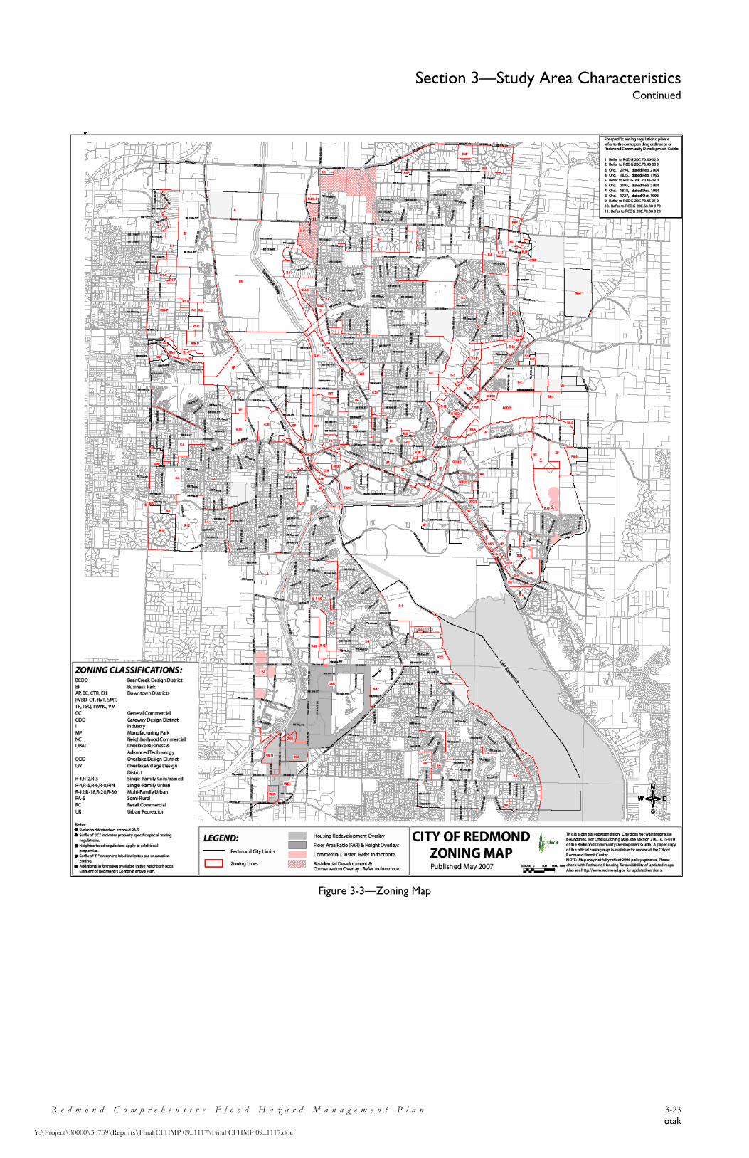
Section 3—Study Area Characteristics Continued
R e d m o n d C o m p r e h e n s i v e F l o o d H a z a r d M a n a g e m e n t P l a n 3-23 otak
Y:\Project\30000\30759\Reports\Final CFHMP 09_1117\Final CFHMP 09_1117.doc
Figure 3-3—Zoning Map

Section 4—Regulatory Review
R e d m o n d C o m p r e h e n s i v e F l o o d H a z a r d M a n a g e m e n t P l a n 4-1 otak
Y:\Project\30000\30759\Reports\Final CFHMP 09_1117\Final CFHMP 09_1117.doc
4.1 Overview Federal, state, and local regulatory policies directly affect flood hazard management. Regulatory methods for managing flood control are designed to address a range of land use issues in flood-prone areas, including: existing and proposed development, recreational opportunities, agricultural practices, historic and cultural preservation, and utility corridor placement. Regulatory programs may also affect community and economic developmental issues, such as industrial location, environmental degradation issues, water quality maintenance, and sensitive habitat areas protection. Methods for controlling land use in flood-prone areas vary in scale and scope. Large-scale regulatory programs include federal and state environmental protection acts; federal, state, and county farmland; sensitive areas and/or wetland preservation acts or ordinances; and local jurisdictions’ comprehensive land use plans. Smaller-scale programs include county and city ordinances, such as flood damage prevention, zoning, grading, building, and drainage ordinances, designed to control specific development activities. This section of the CFHMP provides a summary of the regulatory programs relevant to floodplain management within Redmond. 4.2 Federal Flood Hazard Management Policies and Regulations Federal regulations and programs most applicable to flood control in Redmond include: • National Environmental Policy Act (NEPA). NEPA is implemented by various public
agencies and affects federally funded projects. • Section 404 of the Clean Water Act (CWA). CWA is implemented through a permit
review process by the USACE and affects projects requiring dredging and filling of wetlands.
• National Flood Insurance Act (NFIA). NFIA is administered by FEMA and affects projects located within the 100-year floodplain.
• 1970 and 1974 Disaster Relief Acts set up to provide relief in the event of a disaster. The 1974 act requires that hazard mitigation actions be taken, before or after a disaster, as a condition of receipt of relief funds.
Most of the normal requirements of the federal regulations are administered through state programs. 4.2.1 National Environmental Policy Act (NEPA) NEPA (42 U.S. C. 4321 et seq.) established a process requiring federal agencies to consider environmental impacts of both development projects sponsored by the agency and those privately sponsored projects that require permits and approval. NEPA also established requirements for full disclosure of environmental impacts and project alternatives through

Section 4—Regulatory Review Continued
R e d m o n d C o m p r e h e n s i v e F l o o d H a z a r d M a n a g e m e n t P l a n 4-2 otak
Y:\Project\30000\30759\Reports\Final CFHMP 09_1117\Final CFHMP 09_1117.doc
the Environmental Impact Statement (EIS) and public review. NEPA requires an EIS be prepared for any major federal action that would have significant adverse environmental impacts. Permits issued by a federal agency are considered to be federal actions which may require an EIS. The applicability of the NEPA process to potential flood reduction measures associated with this CFHMP will relate to the source of funding. If a project is federally funded then the NEPA process is required. 4.2.2 Clean Water Act (CWA) – Section 404 The USACE is charged with regulating the "navigable waters" of the United States. "Navigable waters" include all presently, historically, and reasonably potential navigable waters, and all waters subject to ebb and flow of the tide up to mean higher high water in tidal waters and up to ordinary high water in fresh water areas. In recent years, however, USACE jurisdiction under the CWA has been broadened to include regulation of dredged or fill material discharges into “waters of the United States”. “Waters of the United States” include adjacent wetlands and tributaries to navigable waters and other waters, the degradation or destruction of which could affect interstate or foreign commerce. USACE jurisdiction also includes wetlands not connected to another water body by a tributary or stream. Section 404 of the CWA requires a permit for the discharge of dredged or fill material into waters of the United States. Dredged material is defined as material removed from the nation's waters, and fill material is defined as material used for replacing aquatic areas with dry land or changing the bottom elevation of a water body. Floodplain activities may require one or both of the two types of permits required by Section 404. Nationwide Permit 26 can be appropriate for fills involving less than 10 acres of isolated wetlands or adjacent wetlands located above the headwaters (adjacent to a water body that has an average annual flow of less than 5 cubic feet per second). The permit review process entails USACE review of the project for potential environmental impacts and notification of, and review by, the US Fish and Wildlife Service, National Marine Fisheries Service, US EPA, and the WDFW and Ecology. An Individual Permit is appropriate for discharge of dredged or fill material within USACE jurisdiction which is not covered under the Nationwide Permit 26. Review under the Individual Permit application process requires USACE to decide whether the benefits of the project outweigh the potential environmental impacts and requires a 30-day public review period. USACE makes a NEPA determination at the end of the review period.

Section 4—Regulatory Review Continued
R e d m o n d C o m p r e h e n s i v e F l o o d H a z a r d M a n a g e m e n t P l a n 4-3 otak
Y:\Project\30000\30759\Reports\Final CFHMP 09_1117\Final CFHMP 09_1117.doc
4.2.3 National Flood Insurance The federal National Flood Insurance Act (1968) initiated the National Flood Insurance Program (NFIP). The purpose of this program is to make affordable flood insurance available to communities that adopt comprehensive floodplain management regulations. The City is a participant in the NFIP program. Communities which do not participate in the NFIP program of comprehensive floodplain management are not eligible for government funded flood disaster relief. The NFIP is administered by the FEMA through the Federal Insurance Administration (FIA) office. Historically, the NFIP has been administered in two phases, the emergency program and the regular program. The emergency program is initiated when the FIA notifies a community that it has been identified as a flood-prone area. Notification is provided in the form of a Flood Hazard Boundary Map (FHBM), a preliminary delineation of flood hazard areas with no elevations shown. After receiving the FHBM, a community may apply to the FIA for limited amounts of insurance. The community is required to adopt minimum floodplain management regulations and establish flood elevations. A community may enter the regular program upon completion and adoption of a technical flood insurance study which includes hydrologic and hydraulic analyses. The study must provide flood profiles, a Flood Boundary-Floodway Map, and the water surface elevation of the base flood. The maps and report are useful tools for floodplain planning. FEMA also allows reductions in flood insurance premiums based on disaster preparedness activities and programs undertaken by counties and communities that exceed the minimum standards. This program is the Community Rating System (CRS). The City is not currently involved in the CRS. Given the City’s involvement in various flood hazard management activities which exceed the minimum state and federal standards, it is recommended that they become active in the CRS. Upon entry into CRS, all communities start out with a Class 10 rating (which provides no flood insurance premium discount). There are 10 CRS classes: Class 1 requires the most credit points and gives the greatest premium reductions; Class 10 identifies a community that does not apply for the CRS, or does not obtain a minimum number of credit points and receives no discount. There are 18 activities recognized as measures for eliminating exposure to floods. Credit points are assigned to each activity. The activities are organized under four main categories: Public Information, Mapping and Regulation, Flood Damage Reduction, and Flood Preparedness. Once a community applies to the appropriate FEMA region for the CRS program and its implementation is verified, FIA sets the CRS classification based upon the credit points. This classification determines the premium discount for policyholders. Premium discounts ranging from 5 percent to a maximum of 45 percent will be applied to every policy written in a community as recognition of the floodplain management activities instituted (see Table 4-1). This is a voluntary program.

Section 4—Regulatory Review Continued
R e d m o n d C o m p r e h e n s i v e F l o o d H a z a r d M a n a g e m e n t P l a n 4-4 otak
Y:\Project\30000\30759\Reports\Final CFHMP 09_1117\Final CFHMP 09_1117.doc
Table 4-1 CRS Premium Discounts
Class Discount Class Discount
1
2
3
4
5
45%
40%
35%
30%
25%
6
7
8
9
10
20%
15%
10%
5%
---
SFHA (Zones A, AE, A1-A30, V, V1-V30, AO, AH, and elevation-rated AR, AR/A, AR/AE, AR/A1-A-30, AR/AH, AR/AO): Credit varies depending on class. Non-SFHA (Zones B, C, X, D, A99 and non-elevation-rated AR, AR/A, AR/AE, AR/A1-A-30, AR/AH, AR/AO): 5% credit for Classes 1-9.
4.3 State Flood Hazard Management Policies and Regulations Washington State regulations applicable to flood planning and management include: • Growth Management Act • Floodplain Management Program • State Environmental Policy Act (SEPA) • Water Resources Program • Shoreline Management Act of 1971 • Sections 208 and 319 of the Clean Water Act, insofar as they pertain to State
management of pollution from agriculture, forestry practices and underground storage tanks
• State Hydraulic Code • Section 401 of the Clean Water Act. • State Subdivision Law Among the features that trigger implementation of these regulations and programs are the size and type of a proposed project, a project’s location in proximity to specified shorelines or river systems, and a project’s potential for impacts on water quality and fish and wildlife habitat. For example, projects that divert streams into culverts, build structures in floodways which reduce flood storage, or increase sedimentation and surface runoff may be subject to state regulations.

Section 4—Regulatory Review Continued
R e d m o n d C o m p r e h e n s i v e F l o o d H a z a r d M a n a g e m e n t P l a n 4-5 otak
Y:\Project\30000\30759\Reports\Final CFHMP 09_1117\Final CFHMP 09_1117.doc
4.3.1 Growth Management Act The Growth Management Act (GMA) was enacted by the Washington State Legislature in 1990 in response to rapid population growth and development pressures in the state. The Legislature found that “uncoordinated and unplanned growth, together with a lack of common goals…pose a threat to the environment, sustainable economic development, and the health, safety, and high quality of life enjoyed by residents of this state. It is in the public interest that citizens, communities, local governments, and the private sector cooperate and coordinate with one another in comprehensive land use planning.” (RCW 36.70A.010). The Act requires local governments in fast growing and densely populated areas to adopt comprehensive plans and development regulations. The GMA also provides a framework for coordination among local governments. The GMA has been amended several times between 1991 and 2005 and is primarily codified in Chapter 36.70A RCW. “The GMA establishes the primacy of the comprehensive plan. The comprehensive plan is the starting point of any planning process and the centerpiece of local planning. Development regulations (zoning, subdivision, and other controls) must be consistent with comprehensive plans.” (www.mrsc.org/subjects/planning/compplan.aspx) The State Department of Community, Trade, and Economic Development (CTED) administers the GMA. The Act has 13 general goals for comprehensive plans and development regulations (Part 1, Section 2 of the GMA). The GMA goals which correspond to surface water and floodplain management in the City of Redmond are: • Encourage the retention of open space and development of recreational opportunities;
conserve fish and wildlife habitat; increase access to natural resource lands; and develop parks.
• Maintain and enhance natural resource-based industries, including productive timber, agriculture, and fisheries industries. Encourage the conservation of productive forests and productive agricultural lands, and discourage incompatible uses.
• Protect the environment and enhance the state’s high quality of life, including air and water quality and the availability of water.
To meet the GMA goals each comprehensive plan must contain five components (Part 1, Section 7 of the GMA): 1) Land use; 2) Housing; 3) Transportation; 4) Capital facilities; and 5) Utilities. The required land use element of the comprehensive plan has particular relevance to floodplain management. Besides designating the general distribution, location, and extent of land development, the land use element must also provide for the protection of the quality and quantity of surface and groundwater used for public water supplies. The land use

Section 4—Regulatory Review Continued
R e d m o n d C o m p r e h e n s i v e F l o o d H a z a r d M a n a g e m e n t P l a n 4-6 otak
Y:\Project\30000\30759\Reports\Final CFHMP 09_1117\Final CFHMP 09_1117.doc
component also relates to the review of drainage, flooding, and stormwater runoff patterns and provides guidance for corrective actions to mitigate or treat discharges that pollute waters of the state.
As part of the GMA, local governments are required to identify, designate, and classify resource lands of long-term commercial significance and critical areas. Resource lands include areas of agricultural, forest, and mineral resources. The City’s Comprehensive Plan and related zoning and critical areas ordinances will be described further below.
Land development in flood hazard areas can affect flood problems in several ways, including:
1. Restricting conveyance capacity of the floodway channel. Development can encroach upon the waterway so that floodway capacity during flood stage is gradually reduced to the point where flow rates which once caused no flooding now produce considerable inundation
2. Exacerbating the pattern of runoff by reducing the permeability and holding potential of soils (e.g. paved areas).
3. Increasing runoff by vegetation removal. 4. Reducing the natural storage capacity of floodplains through filling of wetlands,
floodway fringe areas, overflow channels or sloughs. 5. Increasing monetary flood losses by placing capital investment in “flood-prone”
zones. 6. Building new developments that are flood-prone, thereby necessitating further
structural controls. (Ecology, 1991)
City of Redmond
Development Regulations
City of Redmond CFHMP
Growth Management
Act
City of Redmond
Comprehensive Plan
Figure 4-1—CFHMP Schematic

Section 4—Regulatory Review Continued
R e d m o n d C o m p r e h e n s i v e F l o o d H a z a r d M a n a g e m e n t P l a n 4-7 otak
Y:\Project\30000\30759\Reports\Final CFHMP 09_1117\Final CFHMP 09_1117.doc
The relationship between the GMA and the City’s Comprehensive Plan, CFHMP, and development and critical areas ordinances is shown schematically in Figure 4-1. The GMA provides guidelines for the development of the City’s Comprehensive Plan. The goals, objectives, and policy statements of the Comprehensive Plan are met through the development and critical area ordinances. These development regulations govern many of the activities within the floodplain. The adoption of the CFHMP will provide a basis for revisiting flood and floodplain related goals and policies in future updated versions of the Comprehensive Plan and related ordinances. 4.3.2 Floodplain Management Program The state's floodplain program seeks to integrate federal, state and local regulatory programs in a comprehensive effort to reduce flood damages. The core of the state's program is the adoption by local jurisdictions of a flood damage prevention ordinance based upon federal standards contained in the NFIP. Property owners in flood-prone jurisdictions with such an ordinance are eligible for federal insurance. Ecology administers the State floodplain management program. Ecology provides both financial and technical assistance to counties, cities, towns, and other special districts for flood and watershed management activities. Through the Flood Control Accounts Assistance Program (FCAAP), Ecology provides financial assistance for: • Emergency actions (up to 80% of cost or $150,000 for all jurisdictions in any one
county). • Preparation of flood hazard management plans (up to 75% of cost). • Maintenance of flood control structures (up to 50% of cost). • Other flood planning activities such as GIS development, preparedness activities, and
hazard reduction actions.
Emergency funds are only available if the local jurisdiction declares an emergency. Maintenance grants are provided to counties which then may enter into agreements with local jurisdictions. FCAAP maintenance funds may also be sought for activities related to restoring or preserving natural systems. FCAAP assistance is available only to jurisdictions participating in the NFIP. Assistance for other activities may be sought on a case by case basis. Ecology also provides guidance and assistance to those seeking a FIRM revision or development of resource and land management ordinances. Ecology provides general support and assistance for various natural resource and watershed management.
For a detailed description of FCAAP program and eligibility information see Chapter 86.26 RCW and Chapter 173-145 WAC.

Section 4—Regulatory Review Continued
R e d m o n d C o m p r e h e n s i v e F l o o d H a z a r d M a n a g e m e n t P l a n 4-8 otak
Y:\Project\30000\30759\Reports\Final CFHMP 09_1117\Final CFHMP 09_1117.doc
4.3.3 State Environmental Policy Act (SEPA) Washington, along with numerous other states, has used NEPA as a model for a state process to disclose and analyze environmental impacts of projects. The State Environmental Policy Act (SEPA) is not a permit, but requires an EIS and public review process for those projects deemed likely to result in significant adverse environmental impacts. Under SEPA rules, consistency of a proposed project with existing plans and policies may be evaluated. Completion of the SEPA process may be required before Hydraulic Project Approval (HPA), Shoreline Substantial Development permits, or many other permits are approved.
Examples of projects exempt from the SEPA process include single family homes, small parking lots, and small landfills or excavations. Local jurisdictions are allowed to set size criteria for five categories of exemptions; however, the size criteria must be within the limits established through SEPA and if a project is located in an environmentally sensitive area, the project cannot be categorically exempt from SEPA requirements. 4.3.4 Water Resources Program Ecology administers the state's comprehensive water resources program. The primary goal of the program is to ensure that waters of the state are properly allocated to achieve full utilization for the greatest benefit to the people of the state, and to regulate uses in accordance with established rights. Ecology's responsibilities under this program include surface and ground water planning and management, water rights adjudication, project assistance, and water well technology. Ecology often works cooperatively with other groups involved with water resources management.
4.3.5 Washington Shoreline Management Act of 1971 The Washington State Shoreline Management Act (SMA) of 1971 (Chapter 90.58 RCW) establishes a policy of protection against “adverse effects to the public health, land and its vegetation and wildlife, and the waters of the state and their aquatic life”. The SMA describes and defines shoreline designations and requires a permit for development along shorelines if the value exceeds $2,500 or interferes with the normal public use of the water or shorelines of the state. Permits are issued by local governments and reviewed by Ecology to ensure that proposed developments are consistent with local shoreline master programs (Chapter 173-16 WAC) and the SMA. The SMA also provides guidance to Ecology and local jurisdictions for developing rules, procedures and plans for activities in shoreline areas. Certain objectives are provided in the SMA to guide implementing jurisdictions in prioritizing use within shoreline areas. These criteria include: 1) protection of state-wide interest over local interest; 2) preservation of the natural character of the shoreline; 3) consideration of the long term benefits over the short term benefits; 4) protection of the

Section 4—Regulatory Review Continued
R e d m o n d C o m p r e h e n s i v e F l o o d H a z a r d M a n a g e m e n t P l a n 4-9 otak
Y:\Project\30000\30759\Reports\Final CFHMP 09_1117\Final CFHMP 09_1117.doc
resources and ecology of the shoreline; 5) increased public access and recreational opportunities in the shoreline zones; and 6) provisions for uses which have been found acceptable based on technical studies. The SMA requires the development of master programs for regulation of the uses of “shorelines” and “shorelines of statewide significance. The Shoreline Act applies to: all marine water; streams with a mean annual flow greater than 20 cubic feet per second; water areas of the state larger than 20 acres; and upland areas called “shorelands” 200 feet landward from the edge of these waters. The SMA also applies to the following areas when associated with one of the above: biological wetlands and river deltas; and some or all of the 100-year floodplain including all wetlands within the entire floodplain. In Western Washington “shorelines of statewide significance” are defined as: the Pacific Coast, Hood Canal and certain Puget Sound shorelines; all waters of Puget Sound and the Straight of Juan de Fuca; lakes or reservoirs with more than 1,000 surface acres; larger rivers (1,000 cubic feet per second or greater); and wetlands associated with all the above (Ecology, 1999). “Shorelines of the state” are the total of all shorelines and shorelines of statewide significance. The shorelines of the State in Redmond include: all lands extending landward 200 feet of the ordinary high water mark on the Sammamish River; Lake Sammamish, its underlying land, associated wetlands and all areas within the 100-year floodplain together with those lands extending landward 200 feet from the ordinary high water mark; Bear Creek and Evans Creek where the mean annual flow is 20 cubic feet per second or greater and the land underlying the creek in those areas, associated wetlands, and all lands extending landward 200 feet from the ordinary high water mark on both sides of Bear Creek west of Avondale Road; all lands extending landward 200 feet from the ordinary high water mark on the south sides of Bear Creek east of Avondale Road and Evans Creek; and all land extending landward 200 feet from the ordinary high water mark on the north side of Bear and Evans Creek plus all areas within the 100-year floodplain (City of Redmond, 2007). Under the SMA, each city and county adopts a Shoreline Master Program (SMP) that is based on state guidelines but tailored to the specific needs of the community. “While the primary responsibility to enforce the SMA rests with local governments, Ecology has a duty to ‘insure compliance.’ This is done through a variety of means, including technical assistance visits, notices of correction, orders, and penalties.” (Ecology, 1999) The SMP developed for the City of Redmond will be discussed later in this section.

Section 4—Regulatory Review Continued
R e d m o n d C o m p r e h e n s i v e F l o o d H a z a r d M a n a g e m e n t P l a n 4-10 otak
Y:\Project\30000\30759\Reports\Final CFHMP 09_1117\Final CFHMP 09_1117.doc
4.3.6 Clean Water Act - Sections 208 and 319: Non-point Source Controls National attention became focused on non-point source pollution with the enactment of the federal Clean Water Act (P.L. 92-500) in 1972. Section 208 of the CWA directed states to conduct planning for water quality management, including control of non-point sources. In 1981, Ecology prepared the Non-point Source Water Quality Plan, which presented a summary of Washington's 208 non-point planning efforts and charted future efforts. A keystone of Ecology's 208 plan is the preparation of separate plans for agricultural practices, forest practices, urban runoff, and other non-point sources. In 1987, the Clean Water Act was re-authorized and contained a new provision, Section 319, addressing non-point sources. Section 319 requires each state to assess the impact of non-point source pollution and develop a management program for controlling non-point sources. The primary strategy employed by Ecology in addressing non-point sources has been the implementation of Best Management Practices (BMPs). BMPs refer to “methods for preventing or reducing the amount of pollution generated by non-point sources to a level compatible with water quality goals”.
Agricultural Practices The pollutants most often associated with agricultural practices are sediment, nutrients, salts, organic materials, pesticides, and pathogens. BMPs for agricultural practices, like other non-point sources, can be grouped into two basic categories, structural and behavioral. Structural BMPs, such as manure lagoons, fenced buffers, roofed confinement areas, and alternative watering systems, usually attempt to control non-point pollutants at their sources through artificially constructed systems which reduce pollutant-rainwater contact, or treats the surface runoff. Depending on their size, location and numbers in a watershed, these pollution control systems also can attenuate flood flows.
Forest Practices Rules, and Regulations Forest practices have been addressed through the Clean Water Act (Section 208), the Washington State Forest Practices Act (Chapter 76.09 RCW) and the Forest Practices Rules (Title 222 WAC). The primary purpose of these rules and regulations is to protect water quality through application of BMPs. Sediment and drainage controls and requirements for reforestation are included in the rules and regulations. Forest practice regulations are developed by Ecology and the state Forest Practices Board. In accordance with the state Water Pollution Control Act (Chapter 90.48, RCW), the state forest practice regulations are designed to ensure compliance with federal clean water standards. The Washington State Department of Natural Resources (DNR) administers the Forest Practices Rules and Regulations. The Forest Practices Rules and Regulations were revised in 1988 based on the 1987 Timber, Fish and Wildlife Agreement. The revision strengthened protection of
Section 4—Regulatory Review Continued
R e d m o n d C o m p r e h e n s i v e F l o o d H a z a r d M a n a g e m e n t P l a n 4-11 otak
Y:\Project\30000\30759\Reports\Final CFHMP 09_1117\Final CFHMP 09_1117.doc
riparian habitat and non-commodity values while providing increased flexibility in forest management. These rules apply to state and private land and address road building, harvest regeneration and chemical application.
Urban Runoff Urban runoff can be a major source of sediments and other pollutants. Erosion from stormwater can cut away banks and carry sediment which can pollute wetlands, destroy fish spawning habitat, and damage property. Water quality of local streams and lakes can also be degraded by urban runoff. As stormwater flows across impervious surfaces such as parking lots and streets, the water can pick up oils, heavy metals, nitrogen, phosphorus, bacteria, and particulates which impair water quality.
Until recently, urban runoff was considered a non-point source of pollution. Under the present regulatory structure, however, urban runoff can be considered both a non-point and point source. The Environmental Protection Agency (EPA) has revised the National Pollutant Discharge Elimination System (NPDES) regulations to include stormwater point sources such as pipes, conduits, ditches, channels and other artificially constructed systems used for collecting and conveying stormwater runoff. Once it enters these conveyance structures, urban runoff can be considered a point source subject to NPDES permit requirements.
Ecology administers the NPDES program and has developed regulations, supplemental guidelines, and model ordinances for urban runoff in the Puget Sound area. Ecology has developed the “Stormwater Management Manual for Western Washington” for use by local jurisdictions in the Puget Sound area. “The objective of this manual is to provide a commonly accepted set of technical standards and guidance on stormwater management measures that will control the quantity and quality of stormwater produced by new development and redevelopment” (Ecology, 2005, Foreword).
4.3.7 National Pollutant Discharge Elimination Systems (NPDES) Permit
With the passage of amendments to the Federal Clean Water Act in 1987, the EPA was required to implement a program to regulate the discharge of storm water from industrial and construction sites under the National Pollutant Discharge Elimination System (NPDES). Large and medium municipalities were also required to obtain permits for their storm water discharges. EPA regulations rolled out to small municipalities like Redmond (phase II regulations) in early 2003. These regulations apply to all regulated small municipal separate storm sewer systems. On January 17, 2007 Ecology issued the phase II municipal stormwater permit for western Washington. Redmond completed the required documentation to apply for coverage with Ecology under this permit.
Section 4—Regulatory Review Continued
R e d m o n d C o m p r e h e n s i v e F l o o d H a z a r d M a n a g e m e n t P l a n 4-12 otak
Y:\Project\30000\30759\Reports\Final CFHMP 09_1117\Final CFHMP 09_1117.doc
4.3.8 Washington State Hydraulic Code of 1949 The Washington State Hydraulic Code regulates projects within the state's fresh and salt waters. The purpose of the code is to preserve fish life and supporting habitat in and around the waters of the state. Hydraulic projects are defined in the code as construction or performance of work that will use, divert, obstruct, or change the natural flow or bed of any of the fresh or salt waters of the state. The code is administered by the state Department of Fish and Wildlife.
Activities which fall within the definition of a hydraulic project (examples include: levee repair, stream restoration projects, new flood gates, etc.) require an HPA. Application for an HPA consists of submitting a completed form to the proper agency accompanied by plans of the proposed hydraulic project. Review of the application generally takes up to forty-five days, and may be denied if the project is deemed harmful to fish life and adequate mitigation cannot be assured by conditioning the approval or modifying the project. 4.3.9 Clean Water Act – Section 401 Ecology administers the federal Section 401 Water Quality Certification process. Under this process, Ecology certifies that an activity requiring a federal permit complies with state water quality standards and discharge limits (Chapter 173-201 WAC). The certification is a prerequisite to obtaining a federal permit and may require a modification of water quality criteria if water quality standards cannot be met during the construction phase of a project. 4.3.10 State Subdivision Law The Revised Code of Washington (RCW 58.17.120) requires a city, town, or county legislative body to consider the physical characteristics of a proposed subdivision and to disallow the subdivision based on flooding potential. The state law also requires that any plat situated in a flood control zone be approved by Ecology.
4.4 County Flood Hazard Management Policies and Regulations 4.4.1 King County Countywide Planning Policies Under the GMA, counties are to work with their cities to develop and adopt countywide planning policies. These policies guide regional issues. In addition, these policies provide a common framework for local planning efforts and comprehensive plan development within the counties.
Section 4—Regulatory Review Continued
R e d m o n d C o m p r e h e n s i v e F l o o d H a z a r d M a n a g e m e n t P l a n 4-13 otak
Y:\Project\30000\30759\Reports\Final CFHMP 09_1117\Final CFHMP 09_1117.doc
King County adopted Phase I of its Countywide Planning Policies in July 1992 and Phase II in May 1994. King County Countywide Planning Policies were developed by the Growth Management Planning Council which consisted of elected officials from Seattle, the suburban cities and King County. Policy CA-12 of King County Countywide Planning Policies regarding Frequently Flooded Areas is most relevant to Redmond’s Comprehensive Flood Hazard Management Plan. This policy states that “The cities and the County should closely plan and coordinate implementation of their flood hazard reduction activities within the major river basins (the Snoqualmie, Skykomish, Sammamish, Cedar, Green, and White). a) Comprehensive plan policies, regulations, and programs of jurisdictions in any of the six
major river basins should be consistent with the King County Flood Hazard Reduction Plan (FHRP) Policies.
b) Each jurisdiction’s policies, regulations, and programs should effectively prevent new development and other actions from causing significant adverse impacts on major river flooding, erosion, and natural resources outside their jurisdiction.”
(King County, 2007a) 4.4.2 Comprehensive Flood Control Management Plan—Participation of Local
Officials—Arbitration of Disputed Issues. (RCW 86.12.210) RCW 86.12.210 spells out the relationship between a County and the Cities within a CFHMP planning area:
“A comprehensive flood control management plan that includes an area within which a city or town, or a special district subject to chapter 85.38 RCW, is located shall be developed by the county with the full participation of officials from the city, town, or special district, including conservation districts, and appropriate state and federal agencies. Following adoption by the county, city, or town, a comprehensive flood control management plan shall be binding on each jurisdiction and special district that is located within an area included in the plan. If within one hundred twenty days of the county's adoption, a city or town does not adopt the comprehensive flood control management plan, the city or county shall request arbitration on the issue or issues in dispute. The cost of the arbitrator shall be shared equally by the participating parties and the arbitrator's decision shall be binding. Any land use regulations and restrictions on construction activities contained in a comprehensive flood control management plan applicable to a city or town shall be minimum standards that the city or town may exceed. A city or town undertaking flood or storm water control

Section 4—Regulatory Review Continued
R e d m o n d C o m p r e h e n s i v e F l o o d H a z a r d M a n a g e m e n t P l a n 4-14 otak
Y:\Project\30000\30759\Reports\Final CFHMP 09_1117\Final CFHMP 09_1117.doc
activities consistent with the comprehensive flood control management plan shall retain authority over such activities.”
Essentially RCW 86.12.210 requires that Redmond adopt the King County CFHMP or adopt a City CFHMP that is consistent with King County’s CFHMP. The King County CFHMP is a broad document that encompasses areas beyond those affected by Redmond, and includes policies and actions that the County does not expect all cities to adopt. The 2006 King County Flood Hazard Management Plan policies were carefully crafted to allow cities to adopt King County's plan, or develop their own plan, without having to meet the same higher standards adopted for the unincorporated King County. For example, King County Code requires full compensatory storage for any fill placed in the floodplain. Some cities are not willing to adopt that standard, so the King County Plan does not require that. Instead, the policies require that a city meet the minimum NFIP and state standards and encourages a city to adopt higher standards.
Policy G-11: Minimum State Standards Cities and towns located within the geographic scope of this Plan shall meet the minimum standards of the National Flood Insurance Program and the minimum state requirements adopted pursuant to RCW 86.16.041. Policy G-12: Higher Regulatory Standards King County should encourage cities and towns to adopt policies and regulations that meet or exceed the standards contained in Floodplain Management: Higher Regulatory Standards, prepared by the FEMA, Region 10.
Policy G-13: No Adverse Impact Floodplain Management King County and cities and towns should work cooperatively to manage floodplain resources. King County staff should provide ongoing technical and planning flood risk reduction assistance to cities and towns, as requested, to ensure that development within each jurisdiction will not have an adverse impact on upstream or downstream property owners.
Ensuring consistency with King County’s CFHMP is an important aspect of the City of Redmond CFHMP.
In addition to the County flood management policies discussed above, it is important to note that the County also has more specific policies and regulations associated with GMA (Comprehensive Plan, Zoning, Critical Areas), SMA (Shoreline Master Program), and the NFIP (Building Codes).

Section 4—Regulatory Review Continued
R e d m o n d C o m p r e h e n s i v e F l o o d H a z a r d M a n a g e m e n t P l a n 4-15 otak
Y:\Project\30000\30759\Reports\Final CFHMP 09_1117\Final CFHMP 09_1117.doc
4.5 City Flood Hazard Management Policies and Regulations
4.5.1 City of Redmond’s Comprehensive Plan As discussed above, the Washington State GMA requires the City to develop a Comprehensive Plan and implement the plan through Zoning and Critical Areas Ordinances. Every year the City’s Comprehensive Plan 2022 is updated. The recommendations within the CFHMP should be incorporated into future Comprehensive Plan updates and related ordinance revisions.
Plan 2022 is mandated under the GMA, which requires planning by all cities within counties with a population of 50,000 or more, or a population increase of 17 percent or more over the last 10 years. Both apply to the City. Plan 2022 was approved by the City’s Planning Commission, and goes through a yearly review and amendment process. Plan 2022 balances growth and development needs with environmental objectives and guides growth in the city limits of Redmond.
The City’s Comprehensive Plan provides protection for water resources and plans for flooding and needed surface water runoff controls. Therefore, CFHMP and GMA planning have common goals. The following elements of the GMA process facilitate CFHMP development (Ecology, 1991): • Population forecasts and development projections to predict increased stormwater
runoff and flooding problems. • Floodplain information, such as the identification of critical areas. • Definition of urban growth boundaries which, if properly located, can minimize the need
for flood control structures. • Integration of flood hazard management measures into a capital improvement program
to adequately service new growth. 4.5.2 Zoning Ordinances The purpose of a zoning ordinance is to implement the growth management policies of the Comprehensive Plan. “Zoning sets the density and standards of development and has the ability to direct growth in such a way as to minimize the impact on floodplains. Development diminishes the ability of soils to absorb precipitation and recharge groundwater. This removal of pervious soil increases the loads on drainage systems and elevates the frequency and extent of flooding. Similarly, development constructed on fill intended to withstand a 100-year storm reduces the floodplain’s capacity to carry the increased flow by displacing volume. Setting zoning regulations that address the impacts of development assist in the management of floodplains.” (Ecology, 1991).

Section 4—Regulatory Review Continued
R e d m o n d C o m p r e h e n s i v e F l o o d H a z a r d M a n a g e m e n t P l a n 4-16 otak
Y:\Project\30000\30759\Reports\Final CFHMP 09_1117\Final CFHMP 09_1117.doc
The City’s Zoning Ordinance governs the types of land use and density of development within floodplains.
Land Use—Current Zoning in the Floodplain Land uses within the 100-year floodplain of the Sammamish River and the Bear-Evans Creek basin are predominately Urban Recreation, Park and Open Space, Downtown Mixed-Use, and Manufacturing Park. Additional land uses within the Bear-Evans Creek floodplain include Design District and Semi-Rural. Descriptions of the predominant land use designations and zoning classifications are listed below. A current City of Redmond Zoning Map is shown in Figure 3-3.
“The Urban Recreation zoning district is applied to areas with significant levels of environmental hazards or natural resources, where the area has not been previously designated for uses that require large areas of impervious surfaces or buildings with the potential to be damaged by natural hazards unless the buildings are needed by traditional uses of the Northern Sammamish Valley, and the City does not have adequate plans to serve the area with transportation facilities, water facilities, or sewer facilities.”
The Urban Recreation “area should be used for recreational, open space, or resource uses which do not require extensive fills, large areas of impervious surfaces, or place high demands on the transportation, water, or sewer systems. (Ord. 2105; Ord. 1917)” (City of Redmond, 2007, 20C.20.10-010).
The purpose of the Park and Open Space land use designation is “to identify large public parks, large public open space or private land dedicated to open space, and potentially major sites identified for acquisition as a public park, open space, or trail.” The allowed uses include “public and private parks, public and private open space, golf courses, primarily non-motorized recreational uses and areas, campgrounds, other public and private non-motorized recreational activities and associated commercial uses.” This designation is implemented “by allowing parks and open space in all zones” (City of Redmond, 2005a, page 5-24).
The City’s Downtown is designated Downtown Mixed-Use and is divided into twelve Downtown Districts zones; “Anderson Park,” “Bear Creek,” “Carter,” “East Hill,” “Old Town,” “River Bend,” “River Trail,” “Sammamish Trail,” “Town Center,” “Town Square,” Trestle,” and “Valley View”. These individual districts are “characterized by different building heights, designs and land uses, distinctive entrance corridors, streetscapes, roadway designs, landscaping and amenities” (City of Redmond, 2007, 20C.40.10-010).

Section 4—Regulatory Review Continued
R e d m o n d C o m p r e h e n s i v e F l o o d H a z a r d M a n a g e m e n t P l a n 4-17 otak
Y:\Project\30000\30759\Reports\Final CFHMP 09_1117\Final CFHMP 09_1117.doc
The purpose of the Downtown Mixed-Use designation is to encourage the “development of the Downtown as a place that: meets the community needs for employment, shopping, recreation, civic activities, and cultural and night life opportunities; provides attractive and safe places to live close to amenities, such as restaurants and cafes, a wide selection of stores and services, frequent transit service, and plazas, parks and art; emphasizes access for pedestrians and bicycles, with attractive ‘local’ streets appropriate for a destination; enhances its urban feel by retaining a rich natural setting, including open space, trees and other landscaping, and a focus on the Sammamish River; and invites people to enjoy it, and maintains its small-town feel and sense of Redmond’s history and historic buildings.” Allowed uses within these districts include “personal, professional and corporate offices; retail uses; restaurants; compatible advanced technology industries; services; hotels; multi-family residences; and entertainment and cultural uses.” (City of Redmond, 2005a, pages 5-15 and 5-16).
“The Manufacturing Park (MP) zone is intended to provide areas for primarily manufacturing, and related research and development, wholesale, membership wholesale/retail warehouse (limited to Southeast Redmond), and assembly and distribution uses. Uses that require significant space for indoor and outdoor storage of materials and equipment are also allowed. Offices are limited to those that support the primary uses noted above. Residential uses, except secure community transition facilities, are not allowed…Retail sales of goods, materials, resources and products are allowed, given that they are mined, extracted, assembled or processed on the property, or are sold through a membership wholesale/retail warehouse use. (Ord. 2352; Ord. 2152; Ord. 2027).” (City of Redmond, 2007, 20C.60.15-020).
“The purpose of the Bear Creek Design District is to provide development potential on the upland portion of the Bear Creek Design District in the northwest portion of the site in a comprehensive master plan that would allow for the permanent protection of Bear Creek, its riparian corridor, and associated wetlands and floodplains. The Design District provides for the location of Retirement Residence facilities, associated limited support services, and affordable employee multi-family housing. The Design District will provide critical links in the Bear Evans Creek Greenway System, an important planned regional trail along Bear and Evans Creeks. The balance of the undevelopable portion of this District shall be established as a wetland mitigation banking site. (Ord. 2369; Ord. 2370).” (City of Redmond, 2007, 20C.70.70.-010).
“The Semi-Rural (RA-5) zone maintains low semi-rural residential densities within the Urban Growth Area on lands not suited to intense urban uses and not already characterized by urban development. Densities in this zone shall not exceed one unit

Section 4—Regulatory Review Continued
R e d m o n d C o m p r e h e n s i v e F l o o d H a z a r d M a n a g e m e n t P l a n 4-18 otak
Y:\Project\30000\30759\Reports\Final CFHMP 09_1117\Final CFHMP 09_1117.doc
per five acres, exclusive of density bonuses. The Semi-Rural zone may be used to maintain the semi-rural character of lands with significant amounts of sensitive areas that make the land unsuited to urban development, that are not characterized by urban development, and that are not appropriate for long-term agriculture or forestry use. Land uses other than residential that may be appropriate and are allowed in the Semi-Rural zone would include uses that do not impact the primarily residential character and uses of the zone. (Ordinance 2126; Ordinance 1901):” (City of Redmond, 2007, 20C.30.15-020).
A more detailed description of Redmond’s Zoning Ordinance, including a complete list of Zoning Classifications, can be found in the City’s Community Development Guide, 20C Land Use Regulations, and is available online through the City’s website.
4.5.3 Critical Areas Ordinances The Critical Areas Ordinance (CAO) includes restrictions and permitting requirements on frequently flooded areas and other environmentally sensitive areas. Redmond contains no designated resource lands. Critical areas include: • frequently flooded areas (Figure 4-2); • fish and wildlife habitat conservation areas; • wellhead protection zones; • wetlands; and • erosion and landslide hazard areas.
The management of many of the designated critical areas affects flood hazards and floodplain management; however, the discussion here will focus on frequently flooded areas, see the City’s full Critical Areas Ordinance (ORD 2259) for additional information.

Section 4—Regulatory Review Continued
R e d m o n d C o m p r e h e n s i v e F l o o d H a z a r d M a n a g e m e n t P l a n 4-19 otak
Y:\Project\30000\30759\Reports\Final CFHMP 09_1117\Final CFHMP 09_1117.doc
Figure 4-2—Frequently Flooded Areas Map

Section 4—Regulatory Review Continued
R e d m o n d C o m p r e h e n s i v e F l o o d H a z a r d M a n a g e m e n t P l a n 4-20 otak
Y:\Project\30000\30759\Reports\Final CFHMP 09_1117\Final CFHMP 09_1117.doc
4.5.4 Policies Governing Frequently Flooded Areas Frequently Flooded Areas are open channel and overbank areas within the 100-year floodplain that are frequently inundated with floodwater. Floodplains are generally flat, low-lying areas adjacent to rivers or streams that periodically flood during storm events. These areas move large volumes of water and debris downstream during storms. FEMA delineates flood hazards along major river and stream corridors to identify areas at risk from floodwater. This information is used for both floodplain management and insurance rating. Flooding can damage structures in the floodplain. Persons living or working within a floodplain are at risk of injury from floods and the disease that can spread from flood waters. The City’s policies regarding Frequently Flooded Areas are described below. • NE-40 Employ no net impact floodplain management to avoid impacts to both
upstream and downstream properties. • NE-41 Strive towards no net loss of the structure, value, and functions of natural
systems constituting Frequently Flooded Areas. • NE-42 Regulate development in the 100-year floodplain to avoid substantial risk and
damage to public and private property and loss of life. Ensure these regulations, as a minimum, comply with state and federal requirements for floodplain regulations.
• NE-43 Direct uses that require substantial improvements or structures away from areas within the 100-year floodplain.
• NE-44 Locate public facilities outside of the 100-year floodplain unless needed to serve development within areas characterized by urban development or because efficiencies from locating near existing public facilities already within the 100-year floodplain would clearly outweigh the risk of damage to the facility.
• NE-45 Require that construction, maintenance, and operation of development in the 100-year floodplain minimize hazards to persons and property within the 100-year floodplain and the entire community.
• NE-46 Update policies and development regulations to incorporate more detailed data on the extent of flood hazards as it becomes available.
• NE-47 Cooperate with flood hazard reduction planning carried out by King County and update policies and development regulations to incorporate appropriate recommendations from these studies.
• NE-48 Require compensatory floodplain storage for all projects constructed within the 100-year floodplain, except for Downtown development in the 100-year floodplain of the Sammamish River.
• NE-49 Include areas where compensatory floodplain storage is not required when the hydraulics and hydrology of the Sammamish River are reanalyzed.
As development occurs within a basin, the 100-year floodplain will expand, exposing some properties that were previously outside the floodplain to potential flood damage. These effects occur because as a basin develops the amount of impervious surfaces increase,

Section 4—Regulatory Review Continued
R e d m o n d C o m p r e h e n s i v e F l o o d H a z a r d M a n a g e m e n t P l a n 4-21 otak
Y:\Project\30000\30759\Reports\Final CFHMP 09_1117\Final CFHMP 09_1117.doc
increasing runoff and therefore flood depths. While the stormwater management policies in this element and in King County will reduce these effects, they will not prevent them entirely. One way of anticipating and responding to these changes is to identify the future-conditions floodplain. The future-conditions floodplain is the area that will be inundated by a 100-year flood when the basin is fully developed. FEMA flood hazard maps are based on current and historic conditions, not built-out. Additional work is needed to identify the future-conditions floodplain. • NE-50 Include flood flow estimates representing future conditions build-out into the
City’s floodplain regulations as it becomes available. • NE-51 Consider reductions in the FEMA floodway only if future flows have been
considered and adequately accommodated. Properties outside the 100-year floodplain can also aggravate flooding and flood damages. Development in landslide or erosion prone areas can lead to the clogging of streams and drainage systems, increasing flooding within and outside the 100-year floodplain. As areas outside the 100-year floodplain develop, increased impervious surfaces may increase runoff during storms and thus increase flood heights within the 100-year floodplain and cause flooding outside the existing 100-year floodplain. Increased stormwater runoff can significantly impact salmon and steelhead habitat by literally washing it away. Reducing the amount of impervious surfaces and implementing stormwater detention can help reduce these impacts, but not eliminate them entirely. • NE-52 Limit impervious surfaces outside the Downtown to reduce the possibility of
flooding, to protect the environment, and to allow for ground water recharge. • NE-53 Explore new methods to limit impervious surface to protect environmental
resources such as streams and allow for groundwater recharge, allow for efficient land use, and accommodate the level of development intensity planned for the area.
Clearing and grading for developments also can increase stormwater runoff by removing vegetation and organic soils that absorb rain water. Excessive erosion can be very damaging to water quality on adjacent and downstream waterbodies, including those that support salmonid fish and other fish species. To prevent these negative impacts, the City should continue to adopt and enforce clearing and grading requirements to minimize runoff and erosion. • NE-54 Maintain and update clearing and grading regulations to minimize the overall
impact of the activity on the environment. Generally, limit clearing to the parts of site that will be developed.

Section 4—Regulatory Review Continued
R e d m o n d C o m p r e h e n s i v e F l o o d H a z a r d M a n a g e m e n t P l a n 4-22 otak
Y:\Project\30000\30759\Reports\Final CFHMP 09_1117\Final CFHMP 09_1117.doc
4.5.4 Classification and Rating of Frequently Flooded Areas Frequently Flooded Areas are classified into one of four categories that provide increased protections where flood risk is increased, generally as properties get closer to where flood waters move. 1. Floodplain. Properties located within the floodplain are subject to some restrictions and
insurance requirements. The floodplain is the total area subject to inundation by the base flood (the flood that has a one percent chance of occurring in any given year).
2. Flood Fringe. The outer limits of the floodplain is the area of least risk of damage during flood events. This area, known as the “flood fringe” is generally covered by flood waters during the base flood, but is generally associated with standing water rather than rapidly flowing water. Development is somewhat restricted in these areas.
3. Zero-Rise Floodway. Development in areas immediately adjacent to streams can result in an increase of flood damage risk through raising of the base flood elevation. Within some jurisdictions, including Redmond, a “zero-rise floodway” is identified and restrictions are placed on development to prevent an increase in the base flood elevation. The zero-rise floodway will always include the FEMA floodway. Some development may occur with proper mitigation in these areas.
4. FEMA Floodway. FEMA has identified the highest risk area as the area where the water flows during a flood. This is an area of great restriction to development. FEMA mandates regulation of this area, which consist of the channel of the stream and that portion of the adjoining floodplain which is necessary to contain and discharge the FEMA base flood flow without increasing the FEMA base flood elevation more than one foot. No development is generally permitted in these areas.
Frequently Flooded Areas are classified in Redmond using the following criteria which is listed in the City’s Code 20D.140.40: 1. “Maps adopted pursuant to this chapter including the Frequently Flooded Areas map,
which identified the approximate location and extent of the 100 year floodplain. This map shall be used as a general guide only for the assistance of property owners and other interested parties; boundaries are generalized. The actual type, extent, and boundaries of Frequently Flooded Areas shall be determined in the field by a qualified consultant according to the procedures, definition, and criteria established by this Chapter. The City will employ hydrologic models to define the extent of the zero-rise floodway. If the zero-rise floodway has not yet been defined for the property in question, the applicant will be responsible for modeling the base flood elevation and delineating the extent of the zero-rise floodway, consistent with the assumptions in the Bear Creek Basin Plan as adopted by the City. In the absence of a City hydrologic model, FEMA data will be acceptable.”
2. “Flood Insurance Rate Maps published by the Federal Emergency Management Agency.”

Section 4—Regulatory Review Continued
R e d m o n d C o m p r e h e n s i v e F l o o d H a z a r d M a n a g e m e n t P l a n 4-23 otak
Y:\Project\30000\30759\Reports\Final CFHMP 09_1117\Final CFHMP 09_1117.doc
3. “Application of the criteria contained in these regulations.” 4. “Consideration of the technical reports submitted by qualified consultants in connection
with applications subject to these regulations.”
4.5.5 Development Restrictions Within Frequently Flooded Areas 1. Floodplain and Flood Hazard Areas Generally.
For all new structures or substantial improvements, the applicant must provide certification by a qualified consultant of the actual as-built elevation of the lowest floor, including basement, and, if applicable, the actual as-built elevation to which the structure is flood-proofed. If the structure has a basement, this must be indicated. Along with other restrictions, buffers are an important way that the City controls the impact of development on streams and floodplains. The City has established stream buffers (many overlap with the buffers required under the City’s Shoreline Master Program) as outlined in Table 4-2.
2. The Flood Fringe (Outside the Zero-Rise Floodway).
a. Except for downtown development along the Sammamish River in the 100 year floodplain from the Puget Sound Energy transmission line crossing to SR 520, development shall not reduce the effective base flood storage volume of the
Table 4-2 Riparian Stream Corridor Classification Stream Buffer Width
Class I Sammamish River north of PSE powerline crossing Sammamish River south of PSE powerline crossing Bear Creek west of Avondale Road Bear Creek east of Avondale Road Evans Creek
150’ inner buffer + 50’ outer buffer 150’ 150’ 150’ inner buffer + 50’ outer buffer 150’ inner buffer + 50’ outer buffer
Class II 100’ + 50’ outer buffer
Class III 100’
Class IV Perennial Intermittent
36’ 25’

Section 4—Regulatory Review Continued
R e d m o n d C o m p r e h e n s i v e F l o o d H a z a r d M a n a g e m e n t P l a n 4-24 otak
Y:\Project\30000\30759\Reports\Final CFHMP 09_1117\Final CFHMP 09_1117.doc
floodplain. Grading or other activity which would reduce the effective storage volume must be mitigated by creating compensatory storage on the site. Off-site compensatory storage may be permitted if binding legal arrangements assure that the effective compensatory storage volume will be preserved over time.
b. No structure shall be allowed which would be at risk due to stream bank destabilization including that associated with channel relocation or meandering.
c. All elevated construction must be designed and certified by a professional structural engineer registered in the State of Washington and must be approved by the City prior to construction.
d. Subdivisions, short subdivisions, binding site plans, site plan review, special development permits, and general development permits shall follow the following requirements: i. New building lots shall contain 3,600 square feet or more of buildable land
outside the zero rise floodway and building setback lines shall be shown on the face of the plat to restrict permanent structures to the area so defined;
ii. All utilities and facilities such as a sewer, gas, electrical, telephone, cable communications and water systems shall be located and constructed consistent with paragraph (2)(i) below;
iii. Base flood data and flood hazard notes shall be shown on the face of the recorded plat, including, but not limited to, the base flood elevation, required flood protection elevations, and the boundaries of the floodplain and the floodway, if determined;
iv. The following note shall be recorded with the King County Department of Records and Elections for all affected lots: NOTICE - Lots and structures located within flood hazard areas may be inaccessible by emergency vehicles during flood events. Residents and property owners should take appropriate advance precautions.
e. New residential construction and substantial improvement shall meet the following criteria: i. The lowest floor shall be elevated to the flood protection elevation. ii. Portions of the building that are below the flood protection elevation shall not
be fully enclosed. The areas below the lowest floor shall be designed to automatically equalize hydrodynamic flood forces on exterior walls by allowing the entry and exit of floodwaters. Designs for meeting this requirement must meet or exceed the following minimum criteria: (A) Minimum of two openings on opposite walls having a total open area of not less than one square inch for every square foot of enclosed area subject to flooding shall be provided; (B) The bottom of all openings shall be no higher than one foot above grade.
iii. Openings may be equipped with screens, louvers, or other coverings or devices provided that they permit the unrestricted entry and exit of floodwaters.

Section 4—Regulatory Review Continued
R e d m o n d C o m p r e h e n s i v e F l o o d H a z a r d M a n a g e m e n t P l a n 4-25 otak
Y:\Project\30000\30759\Reports\Final CFHMP 09_1117\Final CFHMP 09_1117.doc
f. New nonresidential construction and substantial improvement of any existing commercial, industrial, or other nonresidential structure shall meet the elevation requirements of residential construction.
g. All new construction and substantial improvements shall be anchored to prevent flotation, collapse, or lateral movement of the structure.
h. For all mobile and manufactured homes, all standards for flood hazard protection for conventional residential construction shall apply. All manufactured and mobile homes must be anchored and shall be installed using methods and practices that minimize flood damage. All new and replacement water supply systems shall be designed to minimize or eliminate infiltration of flood waters into the system.
i. Utilities shall meet the following criteria: i. All new and replacement utilities, including sewage treatment facilities, shall be
flood-proofed to, or elevated above, the flood protection elevation. ii. New on-site sewage disposal systems shall be located outside the limits of the
100-year floodplain. The installation of new on-site sewage disposal systems in the floodplain is prohibited.
iii. Sewage and agricultural waste storage facilities shall be flood-proofed to the base flood elevation plus three feet.
iv. Above-ground utility transmission lines, other than electrical transmission lines, shall only be allowed for the transport of non-hazardous substances.
v. Buried utility transmission lines transporting hazardous substances (as defined by the Washington State Hazardous Waste Management Act in RCW 70.105.005) shall be buried at a minimum depth of four feet below the maximum depth of scour for the base flood predicted by a professional civil engineer licensed by the State of Washington and shall achieve sufficient negative buoyancy so that any potential for flotation or upward migration is eliminated.
j. Critical facilities may be allowed within the flood fringe of the floodplain. All such proposed uses shall be evaluated through a special development permit. Critical facilities constructed within the flood fringe shall have the lowest floor elevated to three or more feet above the base flood elevation. Flood-proofing and sealing measures must be taken to ensure that hazardous or toxic substances will not be displaced by or released into floodwaters. Access routes elevated to the flood protection elevation shall be provided to all critical facilities to the nearest maintained public street or roadway located outside of the floodplain.
k. The Committee shall review all development permits to determine that all necessary permits have been obtained as required by Federal or State law, including Section 404 of the Federal Water Pollution Control Act Amendments of 1972, 33 U.S.C. 1334, as required by Section 60.3(a)(2) of 44 CFR.
l. Storage and containment of hazardous or dangerous chemicals, substances or materials, as those terms are determined by applicable State and Federal regulations,

Section 4—Regulatory Review Continued
R e d m o n d C o m p r e h e n s i v e F l o o d H a z a r d M a n a g e m e n t P l a n 4-26 otak
Y:\Project\30000\30759\Reports\Final CFHMP 09_1117\Final CFHMP 09_1117.doc
shall be prohibited provided that existing uses involving storage, etc., shall conform to the flood protection elevation when applying for any permit.
3. Zero-Rise Floodway (includes FEMA Floodway).
a. Activities allowed within the zero-rise floodway must conform to the requirements of this section, as well as the requirements that apply to the flood fringe outside the zero-rise floodway as identified in subsection (2).
b. No development activity shall reduce the effective storage volume of the floodplain. c. No development, including permitted new construction or reconstruction shall cause
any increase in the zero rise base flood elevation. d. No temporary structures or storage of materials hazardous to public health, safety
and welfare shall be permitted in the zero-rise floodway. e. Construction of new residential or nonresidential structures is permitted in the zero-
rise floodway only in the following circumstances: i. The structure must be on a lot legally in existence at the time the ordinance
codified in this chapter becomes effective. ii. The structure must be on a lot that contains less than 3,600 square feet of
buildable land outside the zero-rise floodway. iii. The structure must meet the construction standards set forth in subsections (2)
and (3)(b), (3)(c), and (3)(d). f. New lots that include part of the zero-rise floodway may be created only if the lots
meet the requirements of subsection (2)(d) and administrative rules, or are declared as non-building lots on the face of the plat.
g. The following circumstances are presumed to produce no increase in base flood elevation and shall not require special studies to establish this fact: i. Substantial improvement on existing residential structures outside the zero-rise
floodway where the building footprint is not increased. ii. Substantial improvement of an existing residential structure shall meet the
requirements for new residential construction set forth in subsection (2)(e). h. Reconstruction of an existing residential structure shall meet the requirements for
new residential construction set forth in subsection (2)(e). i. Utilities and roads are permitted in the zero-rise floodway only when no other
location is practicable, or when mitigating measures achieve zero-rise floodway elevations, and shall meet the minimum criteria set forth in subsection (2)(i) and the following requirements: i. Construction of sewage treatment facilities shall be prohibited. ii. Utility transmission lines transporting hazardous substances shall be buried at a
minimum depth of four feet below the maximum depth of scour for the base flood as predicted by a professional civil engineer licensed by the State of Washington and shall achieve sufficient negative buoyancy so that any potential for flotation or upward migration is eliminated.

Section 4—Regulatory Review Continued
R e d m o n d C o m p r e h e n s i v e F l o o d H a z a r d M a n a g e m e n t P l a n 4-27 otak
Y:\Project\30000\30759\Reports\Final CFHMP 09_1117\Final CFHMP 09_1117.doc
j. Critical facilities shall not be constructed in the zero-rise floodway. k. Floodway Dependent Structures: Installations or structures that are floodway
dependent may be located in the floodway provided that the development proposal receives approval from all other agencies with jurisdiction and meets all standards in RCDG 20D.140.20-040 and 20D.140.30-030. Such installations include but are not limited to: i. Dams or diversions for water supply, flood control, hydroelectric production,
irrigation or fisheries enhancement. ii. Flood damage reduction facilities such as levees and pumping stations. iii. Stream bank stabilization structures where no feasible alternative exists to
protecting public or private property. iv. Stormwater conveyance facilities subject to the requirements of the development
standards for streams and wetlands, and other relevant City of Redmond development standards.
v. Boat launches, docks and related recreation structures. vi. Bridge piers and abutments. vii. Fisheries enhancement or stream restoration projects.
l. Development of the area located downstream of Redmond Way on Bear Creek may be allowed when (a) mitigating measures achieve zero-rise floodway elevations, or (b) when surface water elevations are not increased over one foot provided no significant unmitigated upstream, downstream, or on-site environmental impacts are created.
4. FEMA Floodway.
a. Construction or placement of new residential or nonresidential structures is prohibited within the FEMA floodway. Shoreline protective structures, bridges, roads, trails and railroads are permitted within the FEMA floodway.
b. No development subject to these regulations, including permitted new construction or reconstruction, shall cause any increase in the FEMA base flood elevation.
c. Substantial improvement of an existing residential structure located in the floodway must meet the requirements set out in WAC 173-158-070 as amended. Such substantial improvement is presumed to produce no increase in base flood elevation and shall not require special studies to establish this fact.
4.5.6 Redmond Building Code - Flood Related Along with the Critical Areas Ordinance, Redmond implements many of its floodplain management polices and the requirements of the National Flood Insurance Program through its Building Code (Section 15.04). The code applies to all areas of special flood hazard in the City limits (100 year floodplains) and is implemented by the designated City Building Official. It is the purpose of this City’s flood related building codes to promote the

Section 4—Regulatory Review Continued
R e d m o n d C o m p r e h e n s i v e F l o o d H a z a r d M a n a g e m e n t P l a n 4-28 otak
Y:\Project\30000\30759\Reports\Final CFHMP 09_1117\Final CFHMP 09_1117.doc
public health, safety, and general welfare, and to minimize public and private losses due to flood conditions in specific areas by methods and provisions designed for: 1. Restricting or prohibiting uses which are dangerous to health, safety, and property due to
water or erosion hazards, or which result in damaging increases in erosion or in flood heights or velocities.
2. Requiring that uses vulnerable to floods, including facilities which serve such uses, be protected against flood damage at the time of initial construction.
3. Controlling the alteration of natural floodplains, stream channels, and natural protective barriers, which help accommodate or channel floodwaters.
4. Controlling filling, grading, dredging, and other development which may increase flood damage.
5. Preventing or regulating the construction of flood barriers, which will unnaturally divert floodwaters or which may increase flood hazards in other areas.
The City’s flood related building code is summarized below.
15.04.090 Anchoring. 1. All new construction and substantial improvements shall be anchored to prevent
flotation, collapse or lateral movement of the structure. 2. All manufactured and mobile homes shall be anchored to prevent flotation, collapse
or lateral movement of the structure by providing over-the-top and frame ties to ground anchors. Specific requirements shall be that: (1) Over-the-top ties be provided at each of the four corners of the mobile home, with two additional ties per side at intermediate locations, with mobile homes less than fifty feet long requiring one additional tie per side; (2) Frame ties be provided at each corner of the home with five additional ties per side; at intermediate points, with mobile homes less than fifty feet long requiring four additional ties per side; (3) All components of the anchoring system be capable of carrying a force of four thousand eight hundred pounds; and (4) Any additions to the mobile home be similarly anchored.
3. An alternative method of anchoring involving a system designed to withstand a wind force of ninety miles per hour or greater may be permitted. Certification must be provided to the Building Official that this standard has been met.
15.04.100 Construction materials and methods. 1. All new construction and substantial improvements shall be constructed with
materials and utility equipment resistant to flood damage. 2. All new construction and substantial improvements shall be constructed using
methods and practices that minimize flood damage. 3. Electrical, heating, ventilation, plumbing, and air-conditioning equipment and other
service facilities shall be designed and/or otherwise elevated or located so as to

Section 4—Regulatory Review Continued
R e d m o n d C o m p r e h e n s i v e F l o o d H a z a r d M a n a g e m e n t P l a n 4-29 otak
Y:\Project\30000\30759\Reports\Final CFHMP 09_1117\Final CFHMP 09_1117.doc
prevent water from entering or accumulating within the components during conditions of flooding.
15.04.110 Utilities. 1. All new and replacement water supply systems shall be designed to minimize or
eliminate infiltration of floodwaters into the system. 2. New and replacement sanitary sewage systems shall be designed to minimize or
eliminate infiltration of floodwaters into the systems and discharge from the systems into floodwaters.
3. On-site waste disposal systems are prohibited. 15.04.120 Subdivision proposals. 1. All subdivision proposals shall be consistent with the need to minimize flood
damage; 2. All subdivision proposals shall have public utilities and facilities such as sewer, gas,
electrical, and water systems located and constructed to minimize flood damage; 3. All subdivision proposals shall have adequate drainage provided to reduce exposure
to flood damage; and 4. Base flood elevation data shall be provided by the applicant for subdivision and short
subdivision proposals and other proposed development which contain at least fifty lots or five acres (whichever is less).
15.04.130 Residential construction. Fully enclosed areas below the lowest floor that are subject to flooding are prohibited or shall be designed to automatically equalize hydrostatic flood forces on exterior walls by allowing for the entry and exit of floodwaters. Designs for meeting this requirement must either be certified by a registered professional engineer or architect or must meet or exceed the following minimum criteria: 1. A minimum of two openings having a total net area of not less than one square inch
for every square foot of enclosed area subject to flooding shall be provided. 2. The bottom of all openings shall be no higher than one foot above grade. 3. Openings may be equipped with screens, louvers, or other coverings or devices;
provided, that they permit the automatic entry and exit of floodwaters. 15.04.140 Nonresidential construction. Nonresidential structures that are elevated, not flood-proofed, must meet the same standards for space below the lowest floor as described in RMC 15.04.130. 1. Be flood-proofed so that below one foot above the base flood level the structure is
watertight with walls substantially impermeable to the passage of water. 2. Have structural components capable of resisting hydrostatic and hydrodynamic loads
and effects of buoyancy; and

Section 4—Regulatory Review Continued
R e d m o n d C o m p r e h e n s i v e F l o o d H a z a r d M a n a g e m e n t P l a n 4-30 otak
Y:\Project\30000\30759\Reports\Final CFHMP 09_1117\Final CFHMP 09_1117.doc
3. Be certified by a registered professional engineer or architect that the design and methods of construction are in accordance with accepted standards or practice for meeting provisions of this subsection based on their development and/or review of the structural design, specifications and plans. Such certificates shall be provided to the Building Official.
15.04.150 Manufactured homes. 1. All manufactured homes to be placed or substantially improved on sites: a) Outside
of a manufactured home park or subdivision; b) In a new manufactured home park or subdivision; c) In an expansion to an existing manufactured home park or subdivision; or d) In an existing manufactured home park or subdivision on which a manufactured home has incurred "substantial damage" as the result of a flood; shall be elevated on a permanent foundation such that the lowest floor of the manufactured home is elevated one foot or more above the base flood elevation and be securely anchored to an adequately designed foundation system to resist flotation, collapse and lateral movement.
2. Manufactured homes to be placed or substantially improved on sites in an existing manufactured home park or subdivision that are not subject to the above manufactured home provisions be elevated so that either: a) The lowest floor of the manufactured home is elevated one foot or more above the base flood elevation, or b) The manufactured home chassis is supported by reinforced piers or other foundation elements of at least equivalent strength that are not less than 36 inches in height above grade and be securely anchored to an adequately designed foundation system to resist flotation, collapse, and lateral movement.
15.04.155 Recreational vehicles. Recreational vehicles placed on sites are required to either: 1. Be on the site for fewer than 180 consecutive days; 2. Be fully licensed and ready for highway use, on their wheels or jacking system,
attached to the site only by quick-disconnect-type utilities and security devices, and have no permanently attached additions; or
3. Meet the requirements of RMC 15.04.150 and the elevation and anchoring requirements for manufactured homes.
15.04.160 Floodway/floodway fringe. Special restrictions with respect to floodways and floodway fringe areas shall be as follows: 1. Floodway. Located within areas of special flood hazard established in RMC
15.04.040 are areas designated as floodways. Since the floodway is an extremely hazardous area due to the velocity of floodwaters which carry debris, potential projectiles, and erosion potential, the following are not permitted in the floodway:

Section 4—Regulatory Review Continued
R e d m o n d C o m p r e h e n s i v e F l o o d H a z a r d M a n a g e m e n t P l a n 4-31 otak
Y:\Project\30000\30759\Reports\Final CFHMP 09_1117\Final CFHMP 09_1117.doc
structures, developments, or landfills, other than for shoreline protective structures, bridges, roads, trails, and railroads. Prohibit encroachments, including fill, new construction, substantial improvements, and other development unless certification by a registered professional engineer is provided, demonstrating through hydrologic and hydraulic analyses performed in accordance with standard engineering practice that the proposed encroachment would not result in any increase in flood levels during the occurrence of the base flood discharge.
2. Floodway Fringe Restrictions. The following are not permitted in a floodway fringe: (a) Except in areas designated "urban environment" in the Redmond shoreline master program, any structure, development or landfill which would: reduce the natural floodwater storage capacity of the area of special flood hazard; pollute or contribute materially to the turbidity of floodwater at the base flood stage; significantly change the existing base flood hydraulic characteristics, or alter the temperature characteristics of the water body unless an improvement in fish habitats would result; and (b) Any structure which is not fully protected from water damage at the base flood stage by having the lowest usable habitable or storage floor or level raised at least one foot above the base flood stage level, and by flood-proofing in a manner complying with the requirements of this chapter.
4.5.7 Redmond’s Shoreline Master Program - State Shoreline Management Act (SMA) As discussed above, the SMA requires permits for any “substantial development” within the two hundred foot shoreline jurisdictions. SMA is implemented by Cities and Counties with local regulations used as an overlay to zoning. To accomplish this, Redmond has established a Shoreline Master Program for the Sammamish River, Lake Sammamish, and portions of Bear and Evans Creeks. 4.5.8 Shoreline Master Program Redmond has developed its Shoreline Master Program, updated in 2008 (ORD 2410) for the purpose of protecting the public’s shoreline resources. As Ecology reviews the City’s program, the 1979 program remains in effect. Information below reflects the 2008 update. The City’s program directs land use and activities along shorelines, sets design criteria to ensure best management practices, and provides the enforcement mechanisms. Portions of Redmond’s Shoreline Master Program are provided below, see the City’s full Shoreline Master Program for a complete description of polices and standards.
“The shorelines of the state are defined by state law and in Redmond include: all lands extending landward 200 feet of the ordinary high water mark on the Sammamish River;

Section 4—Regulatory Review Continued
R e d m o n d C o m p r e h e n s i v e F l o o d H a z a r d M a n a g e m e n t P l a n 4-32 otak
Y:\Project\30000\30759\Reports\Final CFHMP 09_1117\Final CFHMP 09_1117.doc
Lake Sammamish, its underlying land, associated wetlands and all areas within the one percent numerical probability floodplain (100-year floodplain) as defined by the most recent Federal Emergency Management Agency map or study, together with those lands extending landward 200 feet from the ordinary high water mark; Bear Creek and Evans Creek where the mean annual flow is 20.0 cubic feet per second or greater and the land underlying the creek in those areas, associated wetlands, and all lands extending landward 200 feet from the ordinary high water mark on both sides of Bear Creek west of Avondale Road; all lands extending landward 200 feet from the ordinary high water mark on the south sides of Bear Creek east of Avondale Road and Evans Creek; and all lands extending landward 200 feet from the ordinary high water mark on the north side of Bear and Evans Creek plus all areas within the one-percent numerical probability floodplain (100-year floodplain) as defined by the most recent Federal Emergency Management Agency map or study.”
There are six shoreline environments: Aquatic; Natural; Urban Conservancy; Low Intensity; Shoreline Residential; High Intensity/Mixed Use. An array of restrictions and requirements apply within each shoreline environment. 1. Sammamish River North of the Puget Sound Energy Right-of-Way: Designate the
200 feet of shoreline jurisdiction immediately along the river and associated wetlands Urban Conservancy on both sides of the river.
2. Sammamish River South of the Puget Sound Energy Right-of-Way to Lake
Sammamish: Designate the King County Sammamish River Park as Urban Conservancy and designate the balance of the adjacent property within the 200 foot shoreline jurisdiction as High Intensity/Multi-Use. This designation shall be coincidental with the King County park property as of January 1, 2008. The area south of Marymoor Park (west side of river) is designated as Urban Conservancy.
3. Lake Sammamish: Designate the shoreline as Shoreline Residential and the water
surface as Aquatic. Associated wetlands at the north end of the lake should be designated Urban Conservancy.
4. Bear and Evans Creek:
• West of Avondale Road, designate a 150-foot wide Urban Conservancy strip with the balance (outer 50 feet) of the shoreline designated as High Intensity/Multi-Use. This should be modified to reflect the SR 520 right-of-way south of Bear Creek.
• East of Avondale Road, designate a 150-foot strip Natural along both sides of the creeks, with the balance of the wetland and 100-year floodplain outside of this 150-foot corridor on the north side of the creeks as Urban Conservancy environment.

Section 4—Regulatory Review Continued
R e d m o n d C o m p r e h e n s i v e F l o o d H a z a r d M a n a g e m e n t P l a n 4-33 otak
Y:\Project\30000\30759\Reports\Final CFHMP 09_1117\Final CFHMP 09_1117.doc
• The area designated for residential density transfers near Avondale Green (near Avondale Road) should be designated Shoreline Residential.
• South of Bear Creek the remainder (outer 50 feet) of the shoreline jurisdiction outside of the 150-foot Natural designation should be High-Intensity/Multi-Use.
• Evans Creek south of Union Hill road should be entirely Natural. Provided however, that for the heavily developed Reach 2 of Evans Creek, extending east from 188th Avenue NE, then south to NE Union Hill Road, designate a 25 foot wide strip Natural along both sides of the creek, and designate the remainder 175 foot wide strip as High Intensity/Multi-Use. Where the Shoreline Jurisdiction extends beyond 200 feet, on the north (or east) side of the Creek, the Shoreline Jurisdiction shall be designated as High Intensity/Multi-Use where, as of January 1, 2008, the land is disturbed by clearing or grading (not associated with agriculture but associated with the business operations at the site), industrial uses, commercial uses, structures, or pavement and Natural for all distance beyond the line of development.
Along with land use restrictions, the major impact of the City’s Shoreline Master Program is the application of buffers along designated shorelines.
Shoreline Master Program Buffers Continuous buffers of riparian and lakeshore vegetation are essential to protecting wildlife, water quality, and critical fish habitat. Buffers reduce water quality impacts by providing for filtering of sediments and pollutants from runoff, and by reducing dust deposition from parking areas and other actively used areas. In addition to providing essential food and shelter, the trees and shrubs in buffers also screen fish and wildlife from noise, glare, and other adverse impacts of development and nearby human activity. Of the remaining wildlife corridors in the community, most are along shoreline buffers. For humans, the green corridors of shoreline vegetation provide areas for physical, mental and emotional rejuvenation. Redmond's shorelines would not be the valuable natural and cultural amenities that they are without vegetated shoreline buffers.
Not all of Redmond's shorelines are equally developed, nor equally vulnerable to the pressures of development. For example, semi-rural areas along upper Bear Creek contrast sharply with the intense commercial development that characterizes the creek's path through downtown. The Sammamish River and Lake Sammamish, with their greater area and volume, are less sensitive to development impacts than are the diminutive Bear and Evans Creeks. Redmond's shoreline buffer policies reflect these variations between shoreline areas. Given the local and regional significance of Redmond's shorelines for fish and wildlife habitat, shoreline buffer policies are based on the recommendations of fish and wildlife habitat managers and scientists throughout western Washington. At the same time, Redmond's buffer policies balance the evolving knowledge of habitat managers with local development conditions. Where shorelines

Section 4—Regulatory Review Continued
R e d m o n d C o m p r e h e n s i v e F l o o d H a z a r d M a n a g e m e n t P l a n 4-34 otak
Y:\Project\30000\30759\Reports\Final CFHMP 09_1117\Final CFHMP 09_1117.doc
have already been intensely developed, Redmond's buffer policies generally reflect existing setbacks and anticipated levels of growth, while maintaining most natural functions of the shoreline corridor. • SL-20 Provide native vegetated buffers on the Sammamish River, Bear Creek, and
Evans Creek sufficient to protect the water body and its fish and wildlife resources from the adverse effects of development adjacent to the water body, with the goal of achieving a mixed mature riparian forest.
• SL-21 Allow development flexibility where private development incorporates the restoration of shoreline buffers and habitat features, through such incentives as reduced building setbacks, or other modifications of site development standards that do not reduce buffer widths.
• SL-22 Remove invasive species from the shoreline buffer area from multi-family residential, commercial, office, research and development, manufacturing, industry or similar uses where the uses are located adjacent to the Sammamish River, Bear Creek or Evans Creek. Replant the buffer area with native trees and understory vegetation upon development or redevelopment.
• SL-23 Use the shoreline variance process for review of development of shoreline property that is largely encumbered by shoreline regulations in order to achieve reasonable use.
• SL-24 Sammamish River: o North of the Puget Sound Energy powerline crossing the shoreline buffer
shall consist of a 150-foot inner buffer plus a 50-foot outer buffer, measured from the ordinary high water mark.
o South of the Puget Sound Energy powerline crossing to Lake Sammamish
the shoreline buffer shall be a minimum of 150 feet, measured from the ordinary high water mark.
o Trails and other public access features may be located in the Sammamish River buffers, but should generally be no closer than 75 feet to the ordinary high water mark. View points, spur trails, boat launches and similar public access features that provide visual access and direct water contact may be allowed closer than 75 feet.
• SL-25 Bear and Evans Creeks: o West of Avondale Road the shoreline buffer shall be a minimum of 150 feet,
measured from the ordinary high water mark. o East of Avondale Road the shoreline buffer consist of a 150-foot inner
buffer plus a 50-foot outer buffer, measured from the ordinary high water mark.
o Trails and other public access features may be located in the Bear and Evans Creeks buffers but shall be no closer than 100 feet to the ordinary high water mark. View points, spur trails, multi-use non-motorized trails and trail
Section 4—Regulatory Review Continued
R e d m o n d C o m p r e h e n s i v e F l o o d H a z a r d M a n a g e m e n t P l a n 4-35 otak
Y:\Project\30000\30759\Reports\Final CFHMP 09_1117\Final CFHMP 09_1117.doc
crossings as identified on an adopted City plan, and similar low-impact public access features that provide visual or controlled access to the creeks may be allowed closer than 100 feet.
One of the most damaging, long-term impacts to Redmond's salmon and steelhead habitat has been the loss of vegetated shoreline buffers. In addition to the on-going efforts by the City and other agencies to restore buffers, private development that impacts buffers must also play a role in their restoration. Shoreline provisions require the restoration of a minimum buffer. This will help eliminate on-going gaps in the protection of the shoreline natural environment within specified, near-term time period.
• SL-26 Encourage the establishment of 50-foot wide vegetated buffers along the Sammamish River, Bear Creek and Evans Creek where no buffer or a buffer of less than 50 feet now exists. Encourage this on a cooperative, incentive-based approach, fostering partnerships with the City, property owners, and other organizations if appropriate. Periodically evaluate for success in achieving this goal in a ten year planning horizon.
• SL-27 Establish the setback on Lake Sammamish as 35 feet wide measured from the Ordinary High Water Mark. Allow reduction of the building setbacks if the setback area is revegetated with primarily native vegetation. Establish uses within the setback in the Shoreline Regulations.

Section 5—Study Area Hydrology and Flood History
R e d m o n d C o m p r e h e n s i v e F l o o d H a z a r d M a n a g e m e n t P l a n 5-1 otak
Y:\Project\30000\30759\Reports\Final CFHMP 09_1117\Final CFHMP 09_1117.doc
Since the construction of the USACE flood control project, flooding along the Sammamish River has been minimal. Historically, flooding within the lower Bear-Evans Creek Basin has been minor primarily as a result of the existing geology and geomorphology, the lower density of development in the upper reaches of the basin, and the channelization, straightening and possible dredging of lower Bear Creek. Presently, the City is experiencing intermittent drainage system flooding throughout Redmond. Continued development within the region has the potential to increase the flooding problems within the lower reaches of the Evans Creek – Bear Creek drainage. Over the last 30 years, Redmond and surrounding communities have experienced substantial population growth and development. Between 1990 and 2006, Redmond has added over 10,000 residents and grown approximately 33 percent, while all of King County has added over 325,000 residents and grown approximately 22 percent (Washington State Office of Financial Management, 2006). Ongoing development within the region has the potential to exacerbate flooding problems. While major river flooding has become an infrequent occurrence since the river was deepened and straightened, ongoing development continues, potentially reducing flood storage areas throughout the watershed, and increasing runoff volumes and peak flows. Many land uses in the Sammamish River floodplain, such as recreation and agriculture, are largely compatible with infrequent, short-term, and low-velocity flooding. Questions exist regarding the accuracy of FEMA FIRMs in the Water Resources Inventory Area (WRIA) 08 watershed. The FIRMs reflect floodplain and floodway delineations defined by hydraulic modeling using topographic and hydrologic data collected in the 1960s. Sammamish River modeling is based largely on river gage data collected between 1940 and 1957. Much has changed in the watershed since that time. The last update to the FIRMs occurred in April 28, 1994 when the elevations, floodplain and floodway boundary delineations, and zone designations along Bear Creek from its confluence with the Sammamish River to SR 202 (Redmond Way) were modified. While there is uncertainty in the FIRM accuracy, one thing is certain: if the Sammamish River was to flood its banks, Redmond would experience catastrophic consequences (see Figure 5-1—Redmond Floodplain).

Section 5—Study Area Hydrology and Flood History Continued
R e d m o n d C o m p r e h e n s i v e F l o o d H a z a r d M a n a g e m e n t P l a n 5-2 otak
Y:\Project\30000\30759\Reports\Final CFHMP 09_1117\Final CFHMP 09_1117.doc
5.1 Flood History The flood season for the Sammamish River Basin is typically between October and March. Flooding in the basin occurs in response to the timing and distribution of precipitation in the watershed. The Sammamish River lies between two lowland lakes, Lake Washington and Lake Sammamish. The river does not generally exhibit high flows in response to rain-on-snow events observed by other rivers whose headwaters are located at higher elevations (King County, 2007c). In addition, the river’s flow is moderated by the natural storage capacity of Lake Sammamish (FEMA, 2005). Within Redmond, within a series of storms, peak flows from Bear Creek generally exceed peak flows from Lake Sammamish into the river, although the duration of high flows from the lake exceed high flows from Bear Creek. The USACE flood control project significantly reduced the severity and frequency of flooding along the Sammamish River. The channelization of the Sammamish River involved dredge materials being deposited along the river, which effectively created a low berm that tends to increase the flood carrying capacity of the channel. The primary areas of flooding within Redmond occur adjacent to the tributary inlets of the Sammamish River where the channel berm is interrupted (FEMA, 2005). Flooding predominantly affects the agricultural and recreational lands occupying the wide central Sammamish River floodplain.
Sammamish River Stroll
Looking North December 4, 2007
The largest flood event for the present-day Sammamish River channel occurred on January 3, 1997. During this event, flooding primarily involved overbank inundation in the central
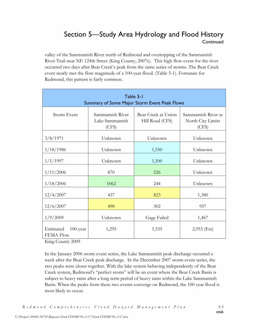
Section 5—Study Area Hydrology and Flood History Continued
R e d m o n d C o m p r e h e n s i v e F l o o d H a z a r d M a n a g e m e n t P l a n 5-3 otak
Y:\Project\30000\30759\Reports\Final CFHMP 09_1117\Final CFHMP 09_1117.doc
valley of the Sammamish River north of Redmond and overtopping of the Sammamish River Trail near NE 124th Street (King County, 2007c). This high flow event for the river occurred two days after Bear Creek’s peak from the same series of storms. The Bear Creek event nearly met the flow magnitude of a 100-year flood. (Table 5-1). Fortunate for Redmond, this pattern is fairly common.
Table 5-1 Summary of Some Major Storm Event Peak Flows
Storm Event Sammamish River Lake Sammamish
(CFS)
Bear Creek at Union Hill Road (CFS)
Sammamish River at North City Limits
(CFS)
3/8/1971 Unknown Unknown Unknown
1/18/1986 Unknown 1,550 Unknown
1/1/1997 Unknown 1,500 Unknown
1/11/2006 870 526 Unknown
1/18/2006 1062 244 Unknown
12/4/2007 437 823 1,380
12/6/2007 490 302 957
1/9/2009 Unknown Gage Failed 1,467
Estimated 100-year FEMA Flow
1,295 1,535 2,953 (Est)
King County 2009 In the January 2006 storm event series, the Lake Sammamish peak discharge occurred a week after the Bear Creek peak discharge. In the December 2007 storm event series, the two peaks were closer together. With the lake system behaving independently of the Bear Creek system, Redmond’s “perfect storm” will be an event where the Bear Creek Basin is subject to heavy rains after a long term period of heavy rains within the Lake Sammamish Basin. When the peaks from these two events converge on Redmond, the 100-year flood is most likely to occur.

Section 5—Study Area Hydrology and Flood History Continued
R e d m o n d C o m p r e h e n s i v e F l o o d H a z a r d M a n a g e m e n t P l a n 5-4 otak
Y:\Project\30000\30759\Reports\Final CFHMP 09_1117\Final CFHMP 09_1117.doc
Sammamish River Trail
Under Leary Way NE Bridge January 9, 2009
Flooding in the Bear-Evans Creek Basin generally results from rainstorm events, though melting snow may occasionally increase the severity of the flooding. “Storm runoff in the Bear Creek Basin is comparatively slow because of the moderate terrain, the natural condition of the channels, and the small amount of residential commercial developments in the watershed. As a rule, the stream rises to a peak stage within a day and the duration of flooding is less than a week” (FEMA, 2005, page 28).

Section 5—Study Area Hydrology and Flood History Continued
R e d m o n d C o m p r e h e n s i v e F l o o d H a z a r d M a n a g e m e n t P l a n 5-5 otak
Y:\Project\30000\30759\Reports\Final CFHMP 09_1117\Final CFHMP 09_1117.doc
Bear Creek at Friendly Village
January 9, 2006 The largest recorded flood flow on Bear Creek within the period of gage record was an event on January 18, 1986, with estimated provisional peak flows 1,550 cfs at the USGS gage (12124500) at Redmond, upstream of the Sammamish River confluence”, an estimated event of approximately 40-50 years (FEMA, 2005, pages 28 – 29). Flood damage during this event was not extensive. Roadways were overtopped at a few stream crossings including sections of Union Hill Road upstream of Avondale Road N.E. and “a mobile home park was flooded and had to be evacuated along the lower reaches of Bear Creek” (FEMA, 2005, page 29).
Bear Creek Rail Trestle
March 8, 1971
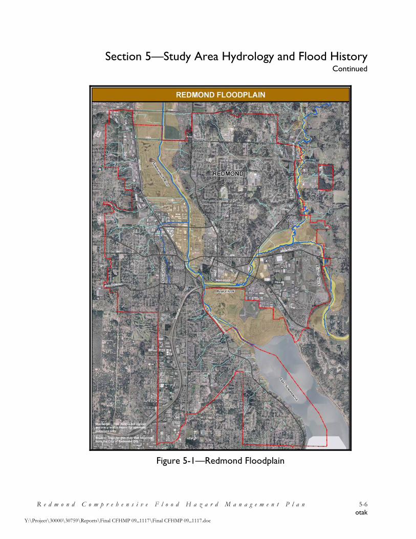
Section 5—Study Area Hydrology and Flood History Continued
R e d m o n d C o m p r e h e n s i v e F l o o d H a z a r d M a n a g e m e n t P l a n 5-6 otak
Y:\Project\30000\30759\Reports\Final CFHMP 09_1117\Final CFHMP 09_1117.doc
Figure 5-1—Redmond Floodplain

Section 5—Study Area Hydrology and Flood History Continued
R e d m o n d C o m p r e h e n s i v e F l o o d H a z a r d M a n a g e m e n t P l a n 5-7 otak
Y:\Project\30000\30759\Reports\Final CFHMP 09_1117\Final CFHMP 09_1117.doc
5.2 FEMA Flood Insurance Study, King County, Washington (Revised: April 19, 2005)
In general, the FEMA FIS is a document that contains information regarding flooding in a community and is developed in conjunction with the FIRM. The FIS, also known as a flood elevation study, frequently contains a narrative of the flood history of a community and discusses the engineering methods used to develop the FIRMs. The study also contains flood profiles for studied flooding sources and can be used to determine Base Flood Elevations (BFEs) for some areas.” (FEMA, 2006). The FIS also designates floodways and risk zones. The FIS aids in the administration of the National Flood Insurance Act of 1968 and the Flood Disaster Protection Act of 1973. The FIS contains flood risk data that is used to establish actuarial flood insurance rates and to assist communities within the study area in their floodplain management efforts. Communities use this information to update existing floodplain regulations as part of the Regular Phase of the NFIP. The information also is used by local regional planners to further promote sound land use and floodplain development. The source of authority for the FIS is the National Flood Insurance Act of 1968 and the flood disaster Protection Act of 1973 (FEMA, 2005). 5.2.1 Flood Insurance Rate Maps, Floodway Maps, and Flood Boundary Maps FEMA has adopted the 100-year flood (one percent annual chance) as the base flood for floodplain management purposes. The 500-year flood (0.2 percent annual chance) is used to indicate additional areas of flood risk for the community. The results of the FIS are used to prepare the FIRMs identifying special flood hazard areas—areas subject to inundation by the 100-year and 500-year flood. The FIRMs show different types of flood hazard areas, or zones, based on the location of the 100-year floodplain and the type of analysis used to predict water surface elevations. Flood hazard zones are used to determine insurance rates. Flood zones within the 100-year floodplain include Zones A, AE, A1-30, AH, AO, VE, and V1-30. Mortgage lenders require that flood insurance be carried by all property owners living within these zones. However, property owners without mortgages/loans are not required to obtain flood insurance. Table 5-2 lists the historical flood insurance data for Redmond. The100-year floodplain is divided into a floodway and a floodway fringe. These areas and how they are regulated are described in detail in Section 4.

Section 5—Study Area Hydrology and Flood History Continued
R e d m o n d C o m p r e h e n s i v e F l o o d H a z a r d M a n a g e m e n t P l a n 5-8 otak
Y:\Project\30000\30759\Reports\Final CFHMP 09_1117\Final CFHMP 09_1117.doc
Table 5-2 National Flood Insurance Program Participants in the CFHMP Study Area
Community Date of
Coverage No. of Policies
Annual Premium
Coverage (x1,000)
Total Claims
Since 1978
Dollars Paid Since
1978 City of
Redmond 02/01/74 527 $182,036 $103,824 9 $21,543
Source: FEMA, 2006.
Figure 5-2—Floodway Schematic (FEMA, 2005) To maintain insurance coverage, communities must prohibit development within the designated floodway that would cause any increase in the 100-year flood elevation. Floodway and flood boundary maps, like FIRMs, show 100-year flood boundaries, as well as the floodway as determined by FEMA. The FIRMs for the Sammamish River reflect floodplain and floodway delineations defined by hydraulic modeling using topographic and hydrologic data collected in the 1960s. There have been multiple flood events since the 1960’s that would normally indicate that the old delineations are inaccurate. The additional flood protection being provided by the Sammamish River berms, while helping flooding problems, may be an unreliable source of security. The last significant FIS revisions involving the lower reaches of Evans and Bear Creeks occurred in 1998 and were based on models using data from 1986 to 1995.

Section 5—Study Area Hydrology and Flood History Continued
R e d m o n d C o m p r e h e n s i v e F l o o d H a z a r d M a n a g e m e n t P l a n 5-9 otak
Y:\Project\30000\30759\Reports\Final CFHMP 09_1117\Final CFHMP 09_1117.doc
5.2.2 FEMA Estimated Flood Discharges This FIS investigates the existence and severity of flood hazards in the geographic area of unincorporated and incorporated King County, including the City of Redmond (FEMA, 2005). Detailed hydrologic and hydraulic analyses were used to model the estimated flood discharges given 10, 50, 100, and 500 year return periods. One over the return period (1/10, 1/50, etc.) can be interpreted as the statistically estimated average frequency of a flood event of a given magnitude. For instance, a 100 year flood is one which is estimated to occur, on average, once every hundred years. It should be recognized that it is possible to have several “statistically infrequent” events over a short time period, especially when natural global weather patterns and longer term cycles are involved. In other words, it is possible to have multiple major floods in any year or over a series of a few years. The peak discharges of the Sammamish River and Bear and Evans Creeks for the 10-, 50-, 100-, and 500-year flood events are listed below in Table 5-3.
Sammamish River near 85th Street Looking North
December 4, 2007

Section 5—Study Area Hydrology and Flood History Continued
R e d m o n d C o m p r e h e n s i v e F l o o d H a z a r d M a n a g e m e n t P l a n 5-10 otak
Y:\Project\30000\30759\Reports\Final CFHMP 09_1117\Final CFHMP 09_1117.doc
Table 5-3 Flow Gauging Stations Near the Study Area
Flooding Source and Location
Drainage Area
(Square Miles)
Peak Discharges (Cubic Feet Per Second)
10-Year 50-Year 100 -Year
500-Year
Sammamish River At Redmond (downstream of Bear Creek)
144.0 1,740 2,480 2,830 3,820
Bear Creek At State Route 202 Above Evans Creek Confluence At River Mile 2.4 At N.E. 95th Street At River Mile 3.5
49.8 33.6 32.2 30.1 29.3
1,060 774 742 710 689
1,365 996 956 915 887
1,535 1,121 1,075 1,028 998
2,000 1,460 1,400 1.340 1,300
Evans Creek Above Bear Creek Confluence (Including Bear Creek Split-flow Return)At River Mile 0.4 Near Redmond, at R.M.O. 8
NA
15.3 13.0
314
280 280
476
360 360
581
400 400
905
496 496
Source: FEMA, 2005 It should be noted some of the 10, 50, 100, and 500 year peak discharges were estimated using data acquired in the 1960’s. The peak discharges could actually be higher in some areas than those listed. The FIRMs reflect floodplain and floodway delineations defined by hydraulic modeling using topographic and hydrologic data collected in the 1960s. The potential for increases in base flood magnitude should be recognized and reflected by proactive planning.

Section 6—Identified Flooding Problems and Need for Flood Hazard Management Measures
R e d m o n d C o m p r e h e n s i v e F l o o d H a z a r d M a n a g e m e n t P l a n 6-1 otak
Y:\Project\30000\30759\Reports\Final CFHMP 09_1117\Final CFHMP 09_1117.doc
6.1 Identified Redmond Flooding Problems and Needs One of the early tasks of the Redmond FMAC was to identify existing flood problems within the Redmond area. During the first FMAC meeting, several large maps of Redmond were laid out on tables. Committee members were asked to mark on the maps the location and description of known flooding issues. All comments and locations were compiled into one map (See Figure 6-1). At the second FMAC meeting these maps were used to initiate further discussions regarding known flood problems. Several conclusions were drawn from reviewing the identified flood problems: inundation in the region did not appear to be a major problem; and most problems were related to development and drainage issues and the loss of floodplain connectivity, channel meanders, and native riparian vegetation. Both the Sammamish River and lower reaches of Bear Creek have been cleared of woody debris. Below is a list of the existing flood problems and needs for flood hazard management measures developed by the FMAC:
1. Flood insurance rates should be lower. • According to FEMA records only 9 claims per 537 policies in Redmond since 1978;
none are related to Sammamish River flooding. • The FMAC would like the City to help lower rates, mainly though participation in
CRS.
2. Inaccurate and outdated flood maps. • Existing floodplain maps are based on outdated data; some data dates back to the
1960’s.
3. Lack of floodplain connectivity and channel complexity along the Sammamish River.
Sammamish River at Marymoor Park
Looking North January 13, 2007

Section 6—Identified Flooding Problems and Need for Flood Hazard Management Measures
Continued
R e d m o n d C o m p r e h e n s i v e F l o o d H a z a r d M a n a g e m e n t P l a n 6-2 otak
Y:\Project\30000\30759\Reports\Final CFHMP 09_1117\Final CFHMP 09_1117.doc
Figure 6-1—FMAC Identified Flood Problems

Section 6—Identified Flooding Problems and Need for Flood Hazard Management Measures
Continued
R e d m o n d C o m p r e h e n s i v e F l o o d H a z a r d M a n a g e m e n t P l a n 6-3 otak
Y:\Project\30000\30759\Reports\Final CFHMP 09_1117\Final CFHMP 09_1117.doc
4. Loss of floodplain riparian buffers along the Sammamish River leads to an increase in water quality issues. • USACE maintenance guidelines conflict with proper riparian vegetation
management.
5. Degradation of watershed habitat. • Lack of natural vegetation along Sammamish River; channelization of Sammamish
River; loss of channel complexity; loss of large woody debris; loss of wetland-channel complexity; and loss of meanders, oxbows, and side channels.
6. Potential urbanization in and along floodplains could increase flood problems. • Protect Bear Creek, in particular, from impact of ongoing urbanization. • Investigation abandoned detention facilities in upper Bear Creek.
Bear Creek next to SR 520
(Creek came within 20 feet of SR520) December 4, 2007
7. Increase in runoff and flooding in North Redmond region west of 180th Avenue NE, east of Avondale Road NE, and north of NE 116th Street.
8. Need to ensure ongoing consistency with King County and neighboring cities (CFHMP, flood management policies, etc.).
9. Funding for additional development staff. • Staff time for development office to foster LID approaches and Native Vegetation
program. • Funding needed for education of development staff regarding flooding issues and
CFHMP recommendations.

Section 6—Identified Flooding Problems and Need for Flood Hazard Management Measures
Continued
R e d m o n d C o m p r e h e n s i v e F l o o d H a z a r d M a n a g e m e n t P l a n 6-4 otak
Y:\Project\30000\30759\Reports\Final CFHMP 09_1117\Final CFHMP 09_1117.doc
10. North Redmond Neighborhood/Education Hill development—impact of development south of NE 124th Street and North of NE 116th Street; build out expected in 5 – 6 years.
11. Impact of Keller Farm development on the floodplain of the confluence of Bear and Evans Creek (NE Union Hill Road and Avondale Road NE).
Bear Creek Floodplain at Millenium Evans and Bear Creek Fork Looking South off of Union Hill January 10, 2006 January 30, 2006
12. Investigate potential stream channel stability problems created by the abandoned detention pond in upper Bear Creek.
13. Restoration of Class 3 stream located on property in English Hill area.
6.2 Other Studies Since the initial FIS was accepted by King County in 1988, several studies have been conducted that have addressed flooding and ecological issues in the study area. Table 6-1 summarizes the studies, their recommendations, and their implementation status in regards to issues that affect the floodplain of the area.

Section 6—Identified Flooding Problems and Need for Flood Hazard Management Measures
Continued
R e d m o n d C o m p r e h e n s i v e F l o o d H a z a r d M a n a g e m e n t P l a n 6-5 otak
Y:\Project\30000\30759\Reports\Final CFHMP 09_1117\Final CFHMP 09_1117.doc
6.2.1 Bear Creek Basin Plan In 1990 the Bear Basin Creek Plan was released. The study region included a 51 square mile area of Bear and Evans Creek Basins in eastern Redmond, northern King County, and southern Snohomish County. The goal of the plan was to evaluate the condition of the basin today and predict future changes based on existing development patterns. Recommendations were made to protect the valuable stream, wetland, and fishery habitat and reduce flooding, erosion and sedimentation. “The plan recommends a comprehensive basin management program to be jointly implemented by King County, Snohomish County, and the City of Redmond. Most of the drainage problems described in this plan are the result of land clearing and development” (King County, 1990, pg. 2). Because no single approach effectively addresses the broad range of surface water issues in the basin, a combination of basin management approaches is recommended.
Bear Creek Trail Behind Safeway
December 3, 2007 6.3 Ongoing Projects Related to Flood Hazard Management Recommended projects from Bear Creek Basin Plan are still being completed by King County and the City of Redmond. See Table 6-1 below.

Section 6—Identified Flooding Problems and Need for Flood Hazard Management Measures
Continued
R e d m o n d C o m p r e h e n s i v e F l o o d H a z a r d M a n a g e m e n t P l a n 6-6 otak
Y:\Project\30000\30759\Reports\Final CFHMP 09_1117\Final CFHMP 09_1117.doc
Table 6-1 Summary of Recommendations Made in Previous Studies
Study (Source) Description of Recommendations or Problems Identified Status
King County Comprehensive Flood Hazard Management Plan (King County 2006)
Sammamish River Flood Study – Prepare flood study and corresponding FEMA Flood Insurance Studies and Flood Insurance Rate Maps for the Sammamish River.
Willowmoor Floodplain Restoration – Reconfigure outflow from Lake Sammamish to maintain or reduced current level of flood risk along the lake in a manner that reduces impacts on fish and wildlife in the transition zone between the lake and the Sammamish River. Project is required mitigation for current maintenance practices required by the USACE.
Sammamish Bank Restoration – Set back banks to accommodate riparian vegetation while maintaining flood protection. Re-vegetate denuded areas with native species, install additional instream features and create cool water refuge areas to support habitat within the river corridor.
Proposed (In K.C. CFHMP Action Plan)
Preliminary Design Phase (In K.C. CFHMP Action Plan)
Proposed (Not in K.C. CFHMP Action Plan)
Lake Washington/ Cedar/Sammamish Watershed (WRIA 8) Chinook Salmon Conservation Plan (July 2005)
Sammamish River - Restore floodplain connections and channel meanders. Restore backwater pools, large woody debris, and riparian vegetation.
Bear and Evans Creeks – Reduce confinement of channel and increase in-channel complexity. Restore sources of large woody debris and riparian vegetation. Protect floodplain and wetlands from further development.
Redmond projects completed and proposed in all of these areas.
Sammamish River Corridor Action Plan (King County 2002)
Sammamish River (Reach 4 – 145th St. Bridge to the upstream end of the Willows Run Golf Course) – Restore channel complexity, floodplain connectivity, and riparian area. Possibly relocate some areas of Sammamish River Trail away from river to increase buffer, add large woody debris and riparian vegetation.
Sammamish River (Reach 5 – downstream end of Willows Run Golf Course to Bear Creek Confluence) – Restoration of the lower Bear Creek floodplain and riparian area.
Only Recommendations
Bear Creek Basin Plan (King County Surface Water Management Division – July 1990)
Comprehensive basin management program to be implemented by King County, Snohomish County, and the City of Redmond. Recommendations includes: • Land Use Controls • Regulations • Stream Steward • Enforcement and Penalties • Education and Incentives • Projects • Monitoring
Status Unknown

Section 7—Flood Management Alternatives
R e d m o n d C o m p r e h e n s i v e F l o o d H a z a r d M a n a g e m e n t P l a n 7-1 otak
Y:\Project\30000\30759\Reports\Final CFHMP 09_1117\Final CFHMP 09_1117.doc
7.1 Background
The purpose of this section is to develop flood management alternatives for the study area, evaluate the alternatives, and select the preferred alternative for the City to implement. The term “flood management” as used here, includes non-structural floodplain management and regulatory activities as well as floodplain restoration projects and any structural flood protection project needs. No significant structural flood protection project needs were established as a City responsibility during the development of the CFHMP, however it is recommended that the City coordinate with others and contribute to multi-jurisdictional efforts to restore floodplain connectivity along the Sammamish River.
Alternatives are developed using: (1) information about flood damage problem spots and needs; (2) floodplain management priorities established by the City and FMAC; and (3) identified data and information needs. Alternatives are evaluated by considering how well they meet the CFHMP Goals and Objectives established by the City and FMAC, with the preferred alternative being the one that is most consistent with the Goals and Objectives (Figure 7-1). Flooding and floodplain management problems and needs are discussed in Section 6, and Floodplain management priorities and CFHMP Goals and Objectives are discussed in Section 2.
Figure 7-1—Selecting a Preferred CFHMP Alternative
Flood Damage Problems & Needs
Floodplain Management Priorities
Flood Data/Information Needs
FMAC Goals and Objectives
DevelopFlood
Management Alternatives
EvaluateFlood
Management Alternatives
Preferred Flood
Management Alternative

Section 7—Flood Management Alternatives Continued
R e d m o n d C o m p r e h e n s i v e F l o o d H a z a r d M a n a g e m e n t P l a n 7-2 otak
Y:\Project\30000\30759\Reports\Final CFHMP 09_1117\Final CFHMP 09_1117.doc
7.2 Number of Alternatives Needed Many CFHMPs are prepared for areas experiencing significant and repeated flood damages. In such areas it is necessary to consider options for carrying out large and costly capital projects to solve flood damage problems. For example, a city might need to consider whether it should solve a documented flooding problem by either: (a) building a new levee along the river; (b) building a new set-back levee away from the river; (c) replacing a flow-constricting bridge; or (d) purchasing and removing homes and businesses. Each approach can solve the same problem, and each approach is the major component of discrete alternatives. However, this is not the situation in Redmond, where there is no recent history of significant flood damages, yet there are large areas of land located within the regulatory floodplain. Redmond’s identified flood management needs are primarily floodplain management related activities, coordination on multi-jurisdictional floodplain restoration projects, and relatively small restoration and preventive City projects. Therefore, only two alternatives will be considered: (1) No Change Alternative – continue with the existing City flood/floodplain management
program. (2) FMAC Alternative – Implement the activities and projects identified and recommended
by the City and FMAC. 7.3 Description of CFHMP Alternatives This section will describe the components of the No Change Alternative and the FMAC Alternative. 7.3.1 No Change Alternative This alternative would continue the City’s existing flood/floodplain management program. The City does conduct an array of floodplain management activities, implement floodplain regulations, build floodplain habitat restoration projects, and coordinate with neighboring jurisdictions on larger floodplain restoration projects (for more detail on the City’s existing flood management activities see Section 4 and Section 6).

Section 7—Flood Management Alternatives Continued
R e d m o n d C o m p r e h e n s i v e F l o o d H a z a r d M a n a g e m e n t P l a n 7-3 otak
Y:\Project\30000\30759\Reports\Final CFHMP 09_1117\Final CFHMP 09_1117.doc
7.3.2 FMAC Alternative The FMAC Alternative is built from several components established during the CFHMP development process: (1) Identified Redmond flooding problems and needs (Section 6). (2) Flood management related recommendations from other studies (Section 6). (3) Recommendations articulated during development of goals and objective (Section 2).
These components have been compiled and slightly adjusted to categorize them, ensure consistency, avoid redundancy, and remove projects already underway (and regulatory driven programs that will likely be continued), with the results presented below in Table 7-1. Specific recommendations are grouped according to their ability to meet established goals (in many cases the objectives found in Section 2 have been converted into a recommendation). The recommendations are then identified as Structural/Non-Structural and assigned a type (Recommended: Policy, Regulatory Standard, Educational Activity, Additional Study, Project, Funding Effort, and Intergovernmental Coordination).
More detail concerning how the alternative will be implemented and what it may cost is presented in Section 8.

Section 7—Flood Management Alternatives Continued
R e d m o n d C o m p r e h e n s i v e F l o o d H a z a r d M a n a g e m e n t P l a n 7-4 otak
Y:\Project\30000\30759\Reports\Final CFHMP 09_1117\Final CFHMP 09_1117.doc
Table 7-1 Redmond FMAC Alternative
Category of Recommendations and Specific Recommendations Structural or
Non-Structural Type
1. Recommendations to prevent the loss of life, creation of public health or safety problems, and damage to public and private property from floods.
1.1. Use regulations and preservation of existing drainage corridors to avoid increasing flooding problems.
Non-structural 1
1.2. Integrate King County early warning systems into City’s Emergency Operations Plan. Non-structural 4
1.3. Ensure safe transportation routes and access to critical facilities during floods (protect City infrastructure during flood events).
Non-structural 4
1.4. Evaluate need for public and private access to flood fight supplies, provide notification and supplies if deemed necessary by the City.
Non-structural 4
1.5. Manage land uses in flood hazard areas in order to prevent creation of new flood risks, investigate and adjust zoning of undeveloped floodplains as needed.
Non-structural 4
1.6. Ensure continued proper operation and maintenance of the Sammamish River Flood Protection Facility to avoid failure during a flood event.
Non-structural 1
1.7. Ensure that any modifications to the Sammamish River Flood Protection Facility results in a facility that provides at least the same level of flood protection as the existing facility.
Non-structural 1
Recommendation Types: 1 = Policy, 2 = Regulatory Standard, 3 = Educational Activity, 4 = Additional Study, 5 = Project, 6 = Funding Effort, 7 = Intergovernmental Coordination

Section 7—Flood Management Alternatives Continued
R e d m o n d C o m p r e h e n s i v e F l o o d H a z a r d M a n a g e m e n t P l a n 7-5 otak
Y:\Project\30000\30759\Reports\Final CFHMP 09_1117\Final CFHMP 09_1117.doc
Table 7-1 (cont.) Redmond FMAC Alternative
Category of Recommendations and Specific Recommendations Structural or
Non-Structural Type
1.8. Develop estimates of flood discharges for Sammamish River tributaries that include full build-out within the designated watersheds. Use build out discharges to determine if existing flood maps need to be expanded to prevent properties currently outside the mapped floodplains from eventually being flooded, and ensure that new structures address potential increases in flooding depths as build-out occurs.
Non-structural 2/4/7
1.9. Investigate potential increase in runoff and flooding in North Redmond region west of 180th Avenue NE, east of Avondale Road NE, and north of NE 116th Street, develop and implement solutions as needed.
Non-structural/ Structural
4/5
1.10. Investigate effect of abandoned detention facilities in upper Bear Creek and work with King County to implement any needed projects to resolve channel down-cutting and bank instability.
Non-structural/ Structural
4/5
1.11. Protect Bear Creek, in particular, from impact of ongoing urbanization by implementing the Bear Creak Basin Plan recommendations for the City of Redmond.
Non-structural 1/4
1.12. Investigate the potential flood related impact of the North Redmond Neighborhood/Education Hill development activity (south of NE 124th Street and North of NE 116th Street); require developers to apply solutions as needed.
Non-structural 4/2
1.13. Investigate the potential flood related impact of Keller Farm development on the floodplain of the confluence of Bear and Evans Creek (NE Union Hill Road and Avondale Road NE); require developers to apply solutions as needed.
Non-structural 4/2
Recommendation Types: 1 = Policy, 2 = Regulatory Standard, 3 = Educational Activity, 4 = Additional Study, 5 = Project, 6 = Funding Effort, 7 = Intergovernmental Coordination

Section 7—Flood Management Alternatives Continued
R e d m o n d C o m p r e h e n s i v e F l o o d H a z a r d M a n a g e m e n t P l a n 7-6 otak
Y:\Project\30000\30759\Reports\Final CFHMP 09_1117\Final CFHMP 09_1117.doc
Table 7-1 (cont.) Redmond FMAC Alternative
Category of Recommendations and Specific Recommendations Structural or
Non-Structural Type
2. Recommendations to maintain the varied uses of existing drainage pathways and floodplains within the City.
2.1. Preserve opportunities for floodplain uses that are compatible with periodic flooding. Discourage land uses in the floodplain that are incompatible with periodic flooding.
Non-structural 1
2.2. Support public and private flood control measures that preserve or enhance existing fishery, wildlife, and other natural uses of channels and riparian zones, discourage those that don’t. Non-structural 1
2.3. Wherever possible ensure that changes in land use within drainage corridors restore the natural character of floodplains and riparian areas as part of their mitigation requirements. Non-structural 1
3. Recommendations to minimize pollution hazards to surface and groundwater during flood events.
3.1. Integrate flood control needs with water quality needs by supporting King County’s efforts to work with the USACE to develop a Sammamish Project maintenance program that protects/improves water quality.
Non-structural 7
3.2. Prevent release of hazardous material from City facilities and new development into surface and groundwater during flood events.
Non-structural 4/2
3.3. Work to restore floodplain riparian buffers along the Sammamish River to improve water quality.
Non-structural 4/5/7
Recommendation Types: 1 = Policy, 2 = Regulatory Standard, 3 = Educational Activity, 4 = Additional Study, 5 = Project, 6 = Funding Effort, 7 = Intergovernmental Coordination

Section 7—Flood Management Alternatives Continued
R e d m o n d C o m p r e h e n s i v e F l o o d H a z a r d M a n a g e m e n t P l a n 7-7 otak
Y:\Project\30000\30759\Reports\Final CFHMP 09_1117\Final CFHMP 09_1117.doc
Table 7-1 (cont.) Redmond FMAC Alternative
Category of Recommendations and Specific Recommendations Structural or
Non-Structural Type
4. Recommendations that promote watershed-based flood management strategies that balance engineering, economic, environmental, and social factors.
4.1. Integrate CFHMP goals, objectives, and recommendations into the City’s comprehensive plans (under the Growth Management Act) and related ordinances and codes.
Non-structural 1
4.2. Preserve natural drainage areas, especially known floodplains, using incentives (development right transfers) and acquisition programs first and regulatory approaches second.
Non-structural 1/2
4.3. Update development codes so they reflect CFHMP established policies for flood hazard management.
Non-structural 1/2
4.4. Promote Low Impact Development (LID) principles and practices that minimize runoff and maintain infiltration including: utilization of compost amended soils and preservation of native vegetation;
Non-structural 1/2
4.5. Ensure adequate dedication of City staff time for development office to foster LID approaches and Native Vegetation program.
Non-structural 6
5. Recommendations that restore properly functioning conditions for degraded floodplains.
5.1. Remove or retrofit existing river facilities or modify maintenance practices to protect, restore or enhance riparian habitat to support recovery of species listed under the Endangered Species Act.
Non-structural 4/5
Recommendation Types: 1 = Policy, 2 = Regulatory Standard, 3 = Educational Activity, 4 = Additional Study, 5 = Project, 6 = Funding Effort, 7 = Intergovernmental Coordination

Section 7—Flood Management Alternatives Continued
R e d m o n d C o m p r e h e n s i v e F l o o d H a z a r d M a n a g e m e n t P l a n 7-8 otak
Y:\Project\30000\30759\Reports\Final CFHMP 09_1117\Final CFHMP 09_1117.doc
Table 7-1 (cont.) Redmond FMAC Alternative
Category of Recommendations and Specific Recommendations Structural or
Non-Structural Type
5.2. Where possible increase habitat areas, floodplain connectivity and channel complexity along the Sammamish River, lower Bear Creek, and their tributaries (restoration issues include: lack of natural vegetation along Sammamish River; channelization of Sammamish River; loss of channel complexity; loss of large woody debris; loss of wetland-channel complexity; loss of meanders, oxbows, and side channels).
Non-structural 4/5
5.3. Work with King County and USACE to restore natural vegetation and habitat along the Sammamish River, yet still meet USACE flood facility maintenance guidelines.
Non-structural 4/5
5.4. Investigate if the location for wetland and side channel restoration project on right bank across from Willows Run Golf Course will have potential conflicts with future King County wastewater treatment plant (proposed sewer pipe under trail could make construction of an open channel for reconnection more difficult depending on pipe elevation).
Non-structural 4/5
6. Recommendations that coordinate flood hazard planning and management with interested and affected parties in both public and private sectors.
6.1. Coordinate across City of Redmond departments and with other jurisdictions to provide consistency in flood hazard management and disaster response activities.
Non-structural 7
6.2. Coordinate with King County, USACE, WSDOT, and neighboring cities to solve mutual flooding problems and promote consistency of approaches, messages, and standards.
Non-structural 7
6.3. Coordinate with existing conservation and recreation groups. Non-structural 7
6.4. Maintain consistency with King County’s CFHMP. Non-structural 7
Recommendation Types: 1 = Policy, 2 = Regulatory Standard, 3 = Educational Activity, 4 = Additional Study, 5 = Project, 6 = Funding Effort, 7 = Intergovernmental Coordination

Section 7—Flood Management Alternatives Continued
R e d m o n d C o m p r e h e n s i v e F l o o d H a z a r d M a n a g e m e n t P l a n 7-9 otak
Y:\Project\30000\30759\Reports\Final CFHMP 09_1117\Final CFHMP 09_1117.doc
Table 7-1 (cont.) Redmond FMAC Alternative
Category of Recommendations and Specific Recommendations Structural or
Non-Structural Type
7. Recommendations that increase the public’s understanding of flood hazard issues.
7.1. Sponsor and support public outreach and education activities to improve awareness of flood hazards, and recommend actions property owners can take to reduce risks to themselves and others and to protect the environment.
Non-structural 3
7.2. Educate the public and businesses on flood protection and prevention measures. Non-structural 3
7.3. Integrate flood education with the City’s Stormwater Plan, and work with King County, other jurisdictions, and conservations groups.
Non-structural 3
7.4. Provide floodplain signage along Bear Creek Trail. Non-structural 3
7.5. Ensure adequate funding for education of City development staff regarding flooding issues and CFHMP recommendations.
Non-structural 3
8. Recommendations that promote a comprehensive understanding of Redmond’s floodplains and flood hazards.
8.1. Evaluate the capacity of the existing Sammamish River and create new FIRM maps to replace the outdated maps (identified need in King County’s Flood Hazard Management Plan).
Non-structural 4
8.2. Investigate the need for updated flood mapping within tributaries to the Sammamish River. Non-structural 4
Recommendation Types: 1 = Policy, 2 = Regulatory Standard, 3 = Educational Activity, 4 = Additional Study, 5 = Project, 6 = Funding Effort, 7 = Intergovernmental Coordination

Section 7—Flood Management Alternatives Continued
R e d m o n d C o m p r e h e n s i v e F l o o d H a z a r d M a n a g e m e n t P l a n 7-10 otak
Y:\Project\30000\30759\Reports\Final CFHMP 09_1117\Final CFHMP 09_1117.doc
Table 7-1 (cont.) Redmond FMAC Alternative
Category of Recommendations and Specific Recommendations Structural or
Non-Structural Type
9. Recommendations that promote a stable, adequate, and publicly acceptable long-term source of financing flood hazard management work.
9.1. Use City stormwater utility funds to help implement the CFHMP. Non-structural 6
9.2. Seek grants for floodplain management work to reduce costs to the City. Non-structural 6
9.3. Cooperate with neighboring jurisdictions and others to reduce the financial impact of flood projects on the City.
Non-structural 6
9.4. Ensure adequate floodplain code enforcement through development staff availability. Non-structural 6/7
10. Recommendations that reduce the long-term costs of flood hazard management.
10.1. Reduce flood insurance rates by participating in NFIP Community Rating System (CRS). Non-structural 1/2/3/7
10.2. Ensure that flood hazard zones governing flood insurance rates are correct (via new flood hydraulic analysis and mapping by King County, particularly for Sammamish River where very few NFIP claims are ever made).
Non-structural 4
10.3. Investigate potential for the Sammamish River Project to qualify as a 100 year protection facility (which would remove areas with no flooding history from the regulatory floodplain), work with King County to implement any improvements.
Non-structural/ Structural
4/5
Recommendation Types: 1 = Policy, 2 = Regulatory Standard, 3 = Educational Activity, 4 = Additional Study, 5 = Project, 6 = Funding Effort, 7 = Intergovernmental Coordination

Section 7—Flood Management Alternatives Continued
R e d m o n d C o m p r e h e n s i v e F l o o d H a z a r d M a n a g e m e n t P l a n 7-11 otak
Y:\Project\30000\30759\Reports\Final CFHMP 09_1117\Final CFHMP 09_1117.doc
Table 7-1 (cont.) Redmond FMAC Alternative
Category of Recommendations and Specific Recommendations Structural or
Non-Structural Type
11. Recommendations to maintain an updated and accurate plan over time.
11.1. Update the CFHMP regularly and employ adaptive management strategies to take full advantage of scientific and technological advances, and to use the best available floodplain management practices, principles and information.
Non-structural 4
11.2. Partner with others to examine potential impacts of predicted effects of global warming on flooding problems, function of flood protection facilities, and accuracy of floodplain maps.
Non-structural 4
11.3. Monitor flooding trends through photo and other documentation of flows and flood stages. Non-structural 4
11.4. Evaluate goals and objectives every five years to maintain consistency with current policy. Non-structural 4
Recommendation Types: 1 = Policy, 2 = Regulatory Standard, 3 = Educational Activity, 4 = Additional Study, 5 = Project, 6 = Funding Effort, 7 = Intergovernmental Coordination

Section 7—Flood Management Alternatives Continued
R e d m o n d C o m p r e h e n s i v e F l o o d H a z a r d M a n a g e m e n t P l a n 7-12 otak
Y:\Project\30000\30759\Reports\Final CFHMP 09_1117\Final CFHMP 09_1117.doc
7.4 Evaluation and Selection of Preferred Alternative The City currently implements a comprehensive surface water management program, with the emphasis being on stormwater and habitat management. Many of the City’s efforts also result in controlling the impacts of development on flooding and improving floodplain or riparian function. It is a natural extension of the City’s ongoing programs to deliberately incorporate floodplain management activities into them. Doing so will open up additional funding opportunities, particularly state and federal grants. The state and federal agencies providing grant funds prefer to see the money used on projects that are comprehensive, multi-objective, and sustainable. Given the City’s and FMAC’s desire to enhance the City’s floodplain management program, it is recommended that the City choose and implement the FMAC Alternative rather than the No-Change Alternative. As discussed earlier, it is common for areas with major flood damages to develop multiple costly flood reduction project alternatives and evaluate them against the CFHMP goals and objectives. However, the City’s CFHMP is mostly non-structural based and the alternatives are either: (1) No-Change; or (2) implement the FMAC Alternative. The FMAC Alternative was crafted based upon FMAC input and the established goals and objectives; therefore, it is entirely consistent with the goals and objectives and thus meets the evaluation criteria.

Section 8—Implementation of the Recommended Flood Management Alternative
R e d m o n d C o m p r e h e n s i v e F l o o d H a z a r d M a n a g e m e n t P l a n 8-1 otak
Y:\Project\30000\30759\Reports\Final CFHMP 09_1117\Final CFHMP 09_1117.doc
8.1 Background The purpose of this section is to provide guidance on how the recommended flood management alternative for the study area may be implemented and to provide an estimate of the cost of implementation. Costs will primarily be at the planning level and will normally assume City staff will lead the implementation effort. It should be recognized that the implementation guidance is general and represents the typical process that a community would need to execute, however the City may need to slightly adjust the implementation process and responsibilities to reflect their specific organizational structure and distribution of responsibilities within Redmond’s City government.
8.2 Implementation of the Recommended CFHMP Alternative Table 8.1 presents the implementation and cost estimates for each element of the recommended CFHMP Alternative. 8.3 Summary of CFHMP Alternative Costs The bulk of the cost for implementing the recommended CFHMP alternative is generally for staff time. It is expected that some of the work will be integrated into existing City programs and budgets and staff workloads. However, it is likely that enhancing the City’s flood management activities will require adding staff capacity. When and how staffing is addressed should be handled by City management and leadership as the first step in implementing the CFHMP. It is recommended that City department/division managers be consulted to develop a schedule and budget for integrating CFHMP recommended activities into their programs. A simple summary of annual and one-time costs is provided below. Annual Costs – $56,500. One-time Costs (sometime occurring over up to several years) – from $296,000 (excluding project costs) to $476,000 (depending on projects chosen for implementation). Costs could increase significantly if no grant or King County (FCZD) funds are available to assist the City with technical studies.

Section 8—Implementation of the Recommended Flood Management Alternative Continued
R e d m o n d C o m p r e h e n s i v e F l o o d H a z a r d M a n a g e m e n t P l a n 8-2 otak
Y:\Project\30000\30759\Reports\Final CFHMP 09_1117\Final CFHMP 09_1117.doc
Table 8-1 Redmond FMAC Alternative Implementation Guidance and Cost Estimation
Category of Recommendations and Specific Recommendations Structural or Non-Structural Type Implementation Guidance Cost
1. Recommendations to prevent the loss of life, creation of public health or safety problems, and damage to public and private property from floods.
1.1. Use regulations and preservation of existing drainage corridors to avoid increasing flooding problems.
Non-structural 1 City Planning to incorporate this policy within the appropriate section of the City’s Comprehensive Plan during Comprehensive Plan update.
$1000 Cost for staff time
1.2. Integrate King County early warning systems into City’s Emergency Operations Plan. Non-structural 4/7 City Emergency Management and Public Works to interface with King County regarding the early warning system. Integrate the early warning system protocols into the City’s Emergency Operations Plan. Notify the appropriate Emergency Operations Center Staff and Responders regarding level of alerts and required responses.
$10,000 Cost for EM and PW staff time over a couple years.
1.3. Ensure safe transportation routes and access to critical facilities during floods (protect City infrastructure during flood events).
Non-structural 4 City Emergency Management and Public Works to review access routes to critical facilities versus flood inundation areas and potential road closures. Use the 100 year flood as the criteria. Based upon results of analysis, consider projects to assure safe access or relocation of City owned critical facilities to accessible locations.
$10,000 Cost for EM and PW
staff time over a couple years, not incl.
projects.
1.4. Evaluate need for public and private access to flood fight supplies, provide notification and supplies if deemed necessary by the City.
Non-structural 4 City Surface Water Management Staff to prepare white paper on issues and costs related to the potential provision of sand bags and sand to the public, potentially including purchase of an automatic sand bag filling machine and supporting equipment. Present white paper to senior management and City elected leaders to obtain direction.
$5,000 Cost for SWM staff
time. Equipment would cost more (up
to $40K).
1.5. Manage land uses in flood hazard areas in order to prevent creation of new flood risks, investigate and adjust zoning of undeveloped floodplains as needed.
Non-structural 1/4
City Planning to incorporate this policy within the appropriate section of the City’s Comprehensive Plan. Follow-up with review of zoning and pursue zoning modifications in areas where it would result in avoidance of new flooding problems. Work with planning commission and public as necessary while recognizing/supporting the advisory body role of the FMAC in developing this policy recommendation.
$5,000 Cost for Planning staff time. Assume
ongoing management costs are covered by
normal planning budgets.
1.6. Ensure continued proper operation and maintenance of the Sammamish River Flood Protection Facility to avoid failure during a flood event.
Non-structural 1/7 City Surface Water Management Staff to interface with King County regarding the current O&M procedures being used for the Sammamish River project, cross-check procedures versus COE requirements, and obtain documentation that shows the O&M procedures are approved by COE.
$5,000 Cost for SWM staff
time.
1.7. Ensure that any modifications to the Sammamish River Flood Protection Facility results in a facility that provides at least the same level of flood protection as the existing facility.
Non-structural 1/7
City Planning to incorporate this policy within the appropriate section of the City’s Comprehensive Plan. City Surface Water Management Staff to interface with King County regarding ongoing and known future projects and request assurances and documentation illustrating that projects will not reduce protection level provided by the facility. Also ensure that the effects of projects on flood elevations is properly documented and, if needed, FEMA/NFIP procedures are followed to formally amend FIRMs.
$9000 $1000 for Planning
Staff. $8000 for SWM Staff over a couple
years.
Recommendation Types: 1 = Policy, 2 = Regulatory Standard, 3 = Educational Activity, 4 = Additional Study, 5 = Project, 6 = Funding Effort, 7 = Intergovernmental Coordination

Section 8—Implementation of the Recommended Flood Management Alternative Continued
R e d m o n d C o m p r e h e n s i v e F l o o d H a z a r d M a n a g e m e n t P l a n 8-3 otak
Y:\Project\30000\30759\Reports\Final CFHMP 09_1117\Final CFHMP 09_1117.doc
Table 8-1 (cont.) Redmond FMAC Alternative Implementation Guidance and Cost Estimation
Category of Recommendations and Specific Recommendations Structural or Non-Structural Type Implementation Guidance Cost
1.8. Develop estimates of flood discharges for Sammamish River tributaries that include full build-out within the designated watersheds. Use build out discharges to determine if existing flood maps need to be expanded to prevent properties currently outside the mapped floodplains from eventually being flooded, and ensure that new structures address potential increases in flooding depths as build-out occurs.
Non-structural 2/4/7
City Surface Water Management Staff to investigate the potential for tributary build-out to affect flood discharges, elevations, and extents. Coordinate with King County for remapping work. Seek cooperative grants for hydrology/hydraulics work.
$20,000 Cost for SWM staff time to investigate potential build-out
impacts. Actual modeling/mapping costs assumed to be covered by grants with contributions from King County.
1.9. Investigate the potential flood related impact of the North Redmond Neighborhood/Education Hill development activity (see figure 8-1); require developers to apply solutions as needed.
Non-structural 4/5/2
City Surface Water Management Staff to incorporate this concern into ongoing basin studies and definition of stormwater projects as warranted through engineering analysis. Fund CIPs as part of the City’s ongoing stormwater capital improvement program. Consider applying increased stormwater development standards and/or System Development Charges (SDCs) if area is designated as a drainage problem area and regional facilities are needed to prevent/solve problems.
Assume covered by ongoing SW Program
budgets
1.10. Investigate potential increase in runoff and flooding in North Redmond Neighborhood region (see figure 8-1), develop and implement solutions as needed.
Non-structural/ Structural
4/2/5
City Surface Water Management Staff to incorporate this concern into ongoing basin studies and definition of stormwater projects as warranted through engineering analysis. Fund CIPs as part of the City’s ongoing stormwater capital improvement program. Consider applying increased stormwater development standards and/or SDCs if area is designated as a drainage problem area and regional facilities are needed to prevent/solve problems.
Assume covered by ongoing SW Program
budgets
1.11. Investigate effect of abandoned detention facilities in upper Bear Creek and work with King County to implement any needed projects to resolve channel down-cutting and bank instability.
Non-structural/ Structural
4/5/7
City Surface Water Management Staff to interface with King County staff to investigate this concern. Work with King County to conduct analysis of effect of abandoned facility on stream channel and determine if a cause and effect relationship exists between stream channel degradation and lack of detention facility operation. Request that King County repair and restore proper functioning of the facility if it will benefit the creek.
$10,000 Cost for SWM staff
time. Project contribution would
cost more (up to $140K?).
1.12. Protect Bear Creek, in particular, from impact of ongoing urbanization by implementing the remaining Bear Creak Basin Plan recommendations for the City of Redmond.
Non-structural 1/4 Expected that many components are being implemented, however City Surface Water Management Staff to review the plan and embed outstanding City responsibilities into ongoing work plans (urge King County to do the same for their responsibilities if needed).
$3,000 Cost for SWM staff
time. Assume projects covered by
ongoing SW Program budgets
1.13. Investigate the potential flood related impact of Keller Farm development on the floodplain of the confluence of Bear and Evans Creek (NE Union Hill Road and Avondale Road NE); require developers to apply solutions as needed. Look for opportunities to increase storage capacity as part of mitigation needs.
Non-structural 4/2
City Surface Water Management Staff to incorporate this concern into ongoing basin studies and definition of stormwater projects as warranted through engineering analysis. Fund CIPs as part of the City’s ongoing stormwater capital improvement program. Consider applying increased stormwater development standards and/or SDCs if area is designated as a drainage problem area and regional facilities are needed to prevent/solve problems.
Assume covered by ongoing SW Program
budgets
Recommendation Types: 1 = Policy, 2 = Regulatory Standard, 3 = Educational Activity, 4 = Additional Study, 5 = Project, 6 = Funding Effort, 7 = Intergovernmental Coordination

Section 8—Implementation of the Recommended Flood Management Alternative Continued
R e d m o n d C o m p r e h e n s i v e F l o o d H a z a r d M a n a g e m e n t P l a n 8-4 otak
Y:\Project\30000\30759\Reports\Final CFHMP 09_1117\Final CFHMP 09_1117.doc
Table 8-1 (cont.) Redmond FMAC Alternative Implementation Guidance and Cost Estimation
Category of Recommendations and Specific Recommendations Structural or Non-Structural Type Implementation Guidance Cost
2. Recommendations to maintain the varied uses of existing drainage pathways and floodplains within the City.
2.1. Preserve opportunities for floodplain uses that are compatible with periodic flooding. Discourage land uses in the floodplain that are incompatible with periodic flooding.
Non-structural 1 City Planning to incorporate this policy within the appropriate section of the City’s Comprehensive Plan. Cross-check existing codes and standards to ensure consistency with the new policy.
$5,000 Cost for Planning staff
time.
2.2. Support public and private flood control measures that preserve or enhance existing fishery, wildlife, and other natural uses of channels and riparian zones, discourage those that don’t.
Non-structural 1 City Planning to incorporate this policy within the appropriate section of the City’s Comprehensive Plan. Cross-check existing codes and standards to ensure consistency with the new policy.
$5,000 Cost for Planning staff
time.
2.3. Wherever possible ensure that changes in land use within drainage corridors restore the natural character of floodplains and riparian areas as part of their mitigation requirements.
Non-structural 1 City Planning to incorporate this policy within the appropriate section of the City’s Comprehensive Plan. Cross-check existing codes and standards to ensure consistency with the new policy.
$5,000 Cost for Planning staff
time.
3. Recommendations to minimize pollution hazards to surface and groundwater during flood events.
3.1. Integrate flood control needs with water quality needs by supporting King County’s efforts to work with the USACE to develop a Sammamish Project maintenance program that protects/improves water quality.
Non-structural 7 City Surface Water Management Staff to contact King County’s lead for Sammamish River Project O&M, find out what efforts are ongoing that would reduce the water quality impacts of O&M activities, and provide written support for improvements in practices that King County could present to the COE as they work to obtain acceptance of the revised practices.
$3,000 Cost for SWM staff
time. Assume projects covered by
ongoing SW Program budgets
3.2. Prevent release of hazardous material from City facilities and private development into surface and groundwater during flood events.
Non-structural 2/4 Assume this is addressed by City’s existing development review procedures, flood hazard and critical areas ordinance, and NPDES permit good housekeeping requirements.
Assume no costs.
3.3. Work to restore floodplain riparian buffers along the Sammamish River to improve water quality.
Non-structural 4/5/7 Assume that this is addressed by ongoing projects being pursued by the City and King County.
Assume no costs.
4. Recommendations that promote watershed-based flood management strategies that balance engineering, economic, environmental, and social factors.
4.1. Integrate CFHMP goals, objectives, and recommendations into the City’s comprehensive plans (under the Growth Management Act) and related ordinances and codes.
Non-structural 1 City Planning to incorporate CFHMP policies within the appropriate section of the City’s Comprehensive Plan and cross-check existing codes and standards to ensure consistency with the new policies.
$5,000 Cost for Planning
staff time.
4.2. Preserve natural drainage areas, especially known floodplains, using incentives (transfer of development rights) and acquisition programs first and regulatory approaches second.
Non-structural 1/2 City Planning to incorporate this policy within the appropriate section of the City’s Comprehensive Plan. Cross-check existing codes and standards to ensure consistency with the new policy.
$5,000 Cost for Planning
staff time.
Recommendation Types: 1 = Policy, 2 = Regulatory Standard, 3 = Educational Activity, 4 = Additional Study, 5 = Project, 6 = Funding Effort, 7 = Intergovernmental Coordination
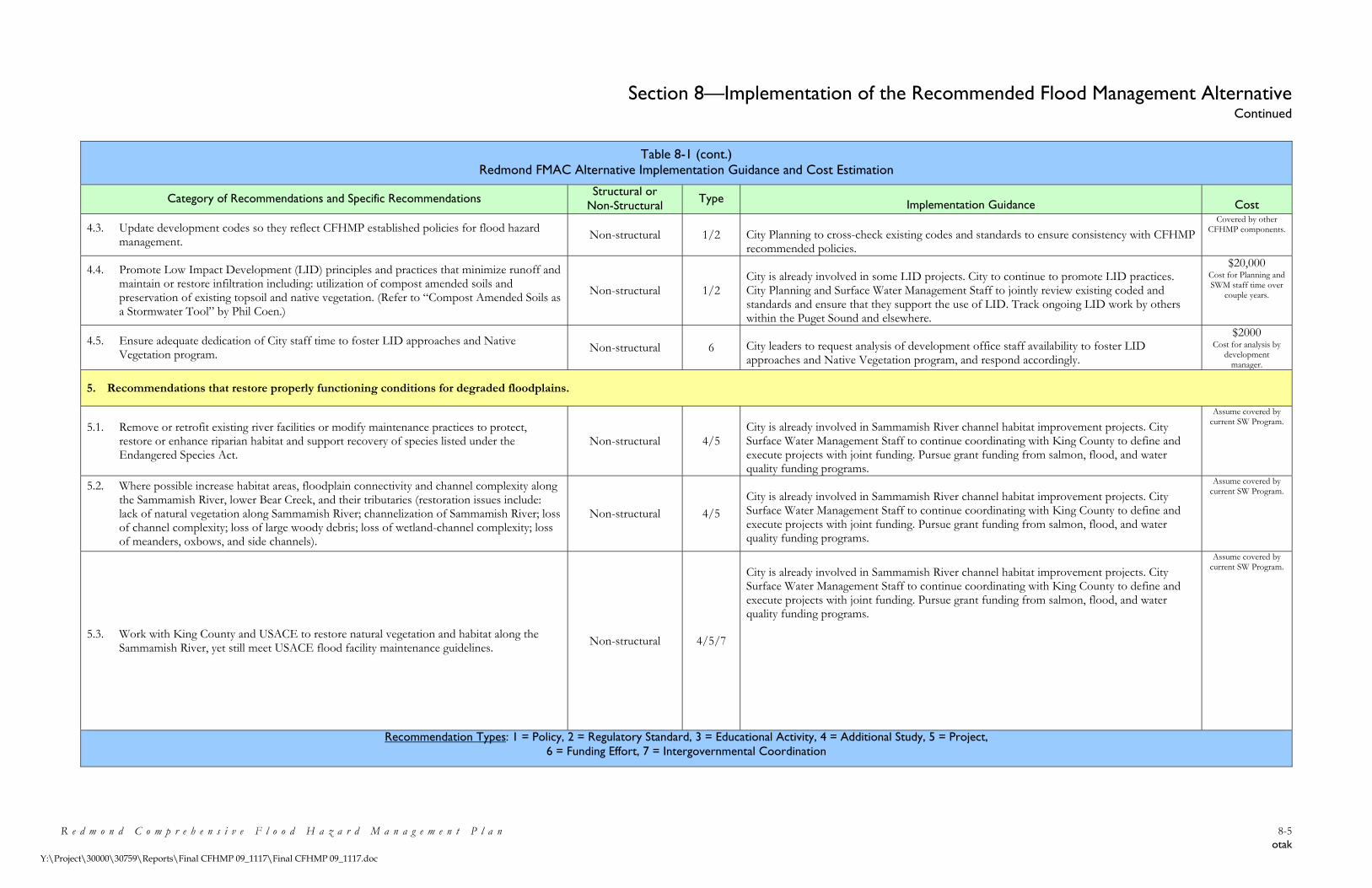
Section 8—Implementation of the Recommended Flood Management Alternative Continued
R e d m o n d C o m p r e h e n s i v e F l o o d H a z a r d M a n a g e m e n t P l a n 8-5 otak
Y:\Project\30000\30759\Reports\Final CFHMP 09_1117\Final CFHMP 09_1117.doc
Table 8-1 (cont.) Redmond FMAC Alternative Implementation Guidance and Cost Estimation
Category of Recommendations and Specific Recommendations Structural or Non-Structural Type Implementation Guidance Cost
4.3. Update development codes so they reflect CFHMP established policies for flood hazard management.
Non-structural 1/2 City Planning to cross-check existing codes and standards to ensure consistency with CFHMP recommended policies.
Covered by other CFHMP components.
4.4. Promote Low Impact Development (LID) principles and practices that minimize runoff and maintain or restore infiltration including: utilization of compost amended soils and preservation of existing topsoil and native vegetation. (Refer to “Compost Amended Soils as a Stormwater Tool” by Phil Coen.)
Non-structural 1/2 City is already involved in some LID projects. City to continue to promote LID practices. City Planning and Surface Water Management Staff to jointly review existing coded and standards and ensure that they support the use of LID. Track ongoing LID work by others within the Puget Sound and elsewhere.
$20,000 Cost for Planning and SWM staff time over
couple years.
4.5. Ensure adequate dedication of City staff time to foster LID approaches and Native Vegetation program.
Non-structural 6 City leaders to request analysis of development office staff availability to foster LID approaches and Native Vegetation program, and respond accordingly.
$2000 Cost for analysis by
development manager.
5. Recommendations that restore properly functioning conditions for degraded floodplains.
5.1. Remove or retrofit existing river facilities or modify maintenance practices to protect, restore or enhance riparian habitat and support recovery of species listed under the Endangered Species Act.
Non-structural 4/5 City is already involved in Sammamish River channel habitat improvement projects. City Surface Water Management Staff to continue coordinating with King County to define and execute projects with joint funding. Pursue grant funding from salmon, flood, and water quality funding programs.
Assume covered by current SW Program.
5.2. Where possible increase habitat areas, floodplain connectivity and channel complexity along the Sammamish River, lower Bear Creek, and their tributaries (restoration issues include: lack of natural vegetation along Sammamish River; channelization of Sammamish River; loss of channel complexity; loss of large woody debris; loss of wetland-channel complexity; loss of meanders, oxbows, and side channels).
Non-structural 4/5 City is already involved in Sammamish River channel habitat improvement projects. City Surface Water Management Staff to continue coordinating with King County to define and execute projects with joint funding. Pursue grant funding from salmon, flood, and water quality funding programs.
Assume covered by current SW Program.
5.3. Work with King County and USACE to restore natural vegetation and habitat along the Sammamish River, yet still meet USACE flood facility maintenance guidelines.
Non-structural 4/5/7
City is already involved in Sammamish River channel habitat improvement projects. City Surface Water Management Staff to continue coordinating with King County to define and execute projects with joint funding. Pursue grant funding from salmon, flood, and water quality funding programs.
Assume covered by current SW Program.
Recommendation Types: 1 = Policy, 2 = Regulatory Standard, 3 = Educational Activity, 4 = Additional Study, 5 = Project, 6 = Funding Effort, 7 = Intergovernmental Coordination
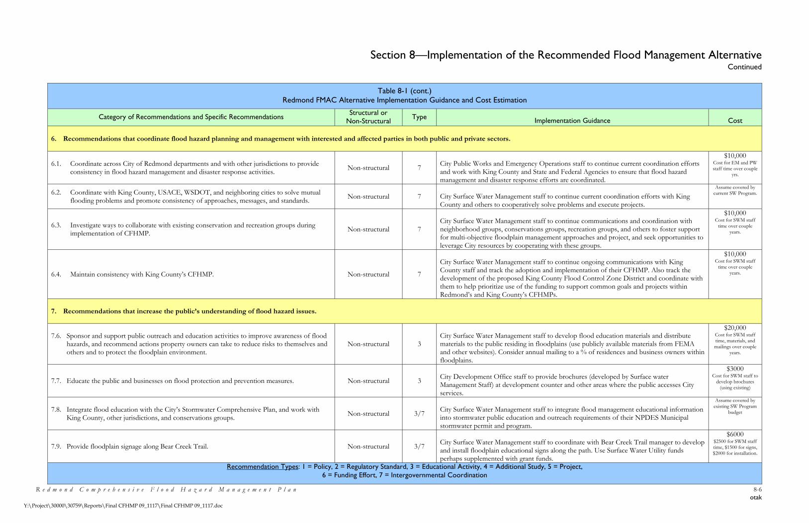
Section 8—Implementation of the Recommended Flood Management Alternative Continued
R e d m o n d C o m p r e h e n s i v e F l o o d H a z a r d M a n a g e m e n t P l a n 8-6 otak
Y:\Project\30000\30759\Reports\Final CFHMP 09_1117\Final CFHMP 09_1117.doc
Table 8-1 (cont.) Redmond FMAC Alternative Implementation Guidance and Cost Estimation
Category of Recommendations and Specific Recommendations Structural or Non-Structural Type Implementation Guidance Cost
6. Recommendations that coordinate flood hazard planning and management with interested and affected parties in both public and private sectors.
6.1. Coordinate across City of Redmond departments and with other jurisdictions to provide consistency in flood hazard management and disaster response activities.
Non-structural 7 City Public Works and Emergency Operations staff to continue current coordination efforts and work with King County and State and Federal Agencies to ensure that flood hazard management and disaster response efforts are coordinated.
$10,000 Cost for EM and PW staff time over couple
yrs.
6.2. Coordinate with King County, USACE, WSDOT, and neighboring cities to solve mutual flooding problems and promote consistency of approaches, messages, and standards.
Non-structural 7 City Surface Water Management staff to continue current coordination efforts with King County and others to cooperatively solve problems and execute projects.
Assume covered by current SW Program.
6.3. Investigate ways to collaborate with existing conservation and recreation groups during implementation of CFHMP.
Non-structural 7 City Surface Water Management staff to continue communications and coordination with neighborhood groups, conservations groups, recreation groups, and others to foster support for multi-objective floodplain management approaches and project, and seek opportunities to leverage City resources by cooperating with these groups.
$10,000 Cost for SWM staff
time over couple years.
6.4. Maintain consistency with King County’s CFHMP. Non-structural 7
City Surface Water Management staff to continue ongoing communications with King County staff and track the adoption and implementation of their CFHMP. Also track the development of the proposed King County Flood Control Zone District and coordinate with them to help prioritize use of the funding to support common goals and projects within Redmond’s and King County’s CFHMPs.
$10,000 Cost for SWM staff
time over couple years.
7. Recommendations that increase the public’s understanding of flood hazard issues.
7.6. Sponsor and support public outreach and education activities to improve awareness of flood hazards, and recommend actions property owners can take to reduce risks to themselves and others and to protect the floodplain environment.
Non-structural 3 City Surface Water Management staff to develop flood education materials and distribute materials to the public residing in floodplains (use publicly available materials from FEMA and other websites). Consider annual mailing to a % of residences and business owners within floodplains.
$20,000 Cost for SWM staff time, materials, and mailings over couple
years.
7.7. Educate the public and businesses on flood protection and prevention measures. Non-structural 3 City Development Office staff to provide brochures (developed by Surface water Management Staff) at development counter and other areas where the public accesses City services.
$3000 Cost for SWM staff to
develop brochures (using existing)
7.8. Integrate flood education with the City’s Stormwater Comprehensive Plan, and work with King County, other jurisdictions, and conservations groups.
Non-structural 3/7 City Surface Water Management staff to integrate flood management educational information into stormwater public education and outreach requirements of their NPDES Municipal stormwater permit and program.
Assume covered by existing SW Program
budget
7.9. Provide floodplain signage along Bear Creek Trail. Non-structural 3/7 City Surface Water Management staff to coordinate with Bear Creek Trail manager to develop and install floodplain educational signs along the path. Use Surface Water Utility funds perhaps supplemented with grant funds.
$6000 $2500 for SWM staff time, $1500 for signs, $2000 for installation.
Recommendation Types: 1 = Policy, 2 = Regulatory Standard, 3 = Educational Activity, 4 = Additional Study, 5 = Project, 6 = Funding Effort, 7 = Intergovernmental Coordination

Section 8—Implementation of the Recommended Flood Management Alternative Continued
R e d m o n d C o m p r e h e n s i v e F l o o d H a z a r d M a n a g e m e n t P l a n 8-7 otak
Y:\Project\30000\30759\Reports\Final CFHMP 09_1117\Final CFHMP 09_1117.doc
Table 8-1 (cont.) Redmond FMAC Alternative Implementation Guidance and Cost Estimation
Category of Recommendations and Specific Recommendations Structural or Non-Structural Type Implementation Guidance Cost
7.10. Ensure adequate funding for education of City development staff regarding flooding issues and CFHMP recommendations.
Non-structural 3/6 City leaders to request analysis of need for development office staff education on flooding issues, flood mapping projects, floodplain restoration efforts, NFIP requirements, etc. and respond accordingly.
$2000 Cost for analysis by
development manager.
7.11. Investigate the potential for the City to provide incentives to property owners to reduce their impacts on floods and floodplains through the use of visible projects that educate other members of the public.
Non-structural 3 City leaders to request analysis of need for development office staff education on flooding issues, flood mapping projects, floodplain restoration efforts, NFIP requirements, etc. and respond accordingly.
$2000 Cost for analysis by
development manager.
8. Recommendations that promote a comprehensive understanding of Redmond’s floodplains and flood hazards.
8.3. Evaluate the capacity of the existing Sammamish River and create new FIRM maps to replace the outdated maps (identified need in King County’s Flood Hazard Management Plan).
Non-structural 4/7 Surface Water Management staff to coordinate with King County as they conduct a re-study of the Sammamish River ( Sam. River Restudy is high priority for restudy).
$10,000 Cost for SWM staff
time over couple years. Restudy cost covered by K. Co. and FEMA/DOE.
8.4. Investigate the need for updated flood mapping within tributaries to the Sammamish River. Non-structural 4/7
Surface Water Management staff to investigate history of problems with mapping within Sammamish River tributaries (claims, development issues, etc.). If problem history indicates that current mapping is in error, then consider integrating tributary mapping into the Sammamish River restudy – coordinate with King County re: timing and funding.
$10,000 Cost for SWM staff time over couple years. Cost for any restudy assumed to be Grant with SWM utility match and King County contribution.
9. Recommendations that promote a stable, adequate, and publicly acceptable long-term source of financing flood hazard management work.
9.5. Use City stormwater utility funds to help implement the CFHMP. Non-structural 6 Surface Water Management staff to discuss funding priorities and CFHMP funding needs with City management and elected leaders. CFHMP implementation may require additional staff time.
$3000 Cost for SWM staff to
work with Utility Manager and City
leaders.
9.6. Seek grants for floodplain management work to reduce costs to the City. Non-structural 6
Surface Water Management staff to prepare and submit grant applications to help fund CFHMP implementation. Use multi-objective projects to seek grant funding from Salmon Recovery Fund (SRF) Board, Flood Control Assistance Account Program (FCAAP), and Centennial/Clean Water Funds. Use SW Utility funds and/or staff labor to meet match requirements.
$5000 Cost for SWM staff to
prepare grant applications (per year
cost).
9.7. Cooperate with neighboring jurisdictions and others to reduce the financial impact of flood projects on the City.
Non-structural 6/7 Surface Water Management staff to continue cooperation and coordination with King County in particular, to cost-share on projects that cross jurisdictional boundaries and/or benefit both jurisdictions.
Assume costs covered as part of other
CFHMP coordination recommendations.
9.8. Ensure adequate floodplain code enforcement through development staff availability. Non-structural 6 City leaders to request analysis of need for additional development office staff to consistently enforce NFIP and Critical Area Ordinance (CAO) requirements and respond accordingly.
$2000 Cost for analysis by
development manager.
Recommendation Types: 1 = Policy, 2 = Regulatory Standard, 3 = Educational Activity, 4 = Additional Study, 5 = Project, 6 = Funding Effort, 7 = Intergovernmental Coordination

Section 8—Implementation of the Recommended Flood Management Alternative Continued
R e d m o n d C o m p r e h e n s i v e F l o o d H a z a r d M a n a g e m e n t P l a n 8-8 otak
Y:\Project\30000\30759\Reports\Final CFHMP 09_1117\Final CFHMP 09_1117.doc
Table 8-1 (cont.) Redmond FMAC Alternative Implementation Guidance and Cost Estimation
Category of Recommendations and Specific Recommendations Structural or Non-Structural Type Implementation Guidance Cost
10. Recommendations that reduce the long-term costs of flood hazard management.
10.4. Reduce flood insurance rates by participating in NFIP Community Rating System (CRS). Non-structural 1/2/3/7
Surface Water Management staff to obtain approval to enter City into CRS program. Complete application documentation. CRS requires ongoing dedication of staff time to conduct CRS activities and keep necessary records. Learn from King County’s experience with their CRS program and use similar approaches where possible. Note that many other CFHMP recommendations will contribute to CRS program.
$50,000 Annual cost for SWM staff to enter CRS and
lead CRS activities while coordinating with other affected
departments/divisions
10.5. Ensure that flood hazard zones governing flood insurance rates are correct (via new flood hydraulic analysis and mapping by King County, particularly for Sammamish River where very few NFIP claims are ever made).
Non-structural 4/7 Surface Water Management staff to coordinate with King County as they conduct a re-study of the Sammamish River ( Sam. River Restudy is high priority for restudy). Seek downgrading of Sammamish River floodplain if warranted.
Assume covered by other CFHMP
Sammamish River restudy coord. work.
10.6. Investigate potential for the Sammamish River Project to qualify as a 100 year protection facility (which would remove areas with no flooding history from the regulatory floodplain), work with King County to implement any improvements.
Non-structural/ Structural
4/5/7 Surface Water Management staff to coordinate with King County as they conduct a re-study of the Sammamish River ( Sam. River Restudy is high priority for restudy). Seek downgrading of Sammamish River floodplain if warranted.
Assume covered by other CFHMP
Sammamish River restudy coord. work.
11. Recommendations to maintain an updated and accurate plan over time.
11.5. Update the CFHMP regularly and employ adaptive management strategies to take full advantage of scientific and technological advances, and to use the best available floodplain management practices, principles and information.
Non-structural 4 Surface Water Management staff to review CFHMP every 5 years (or as needed based on City code revisions, flood events, or development of new information) and update the document as needed to ensure consistency with current conditions.
$50,000 Once every 5 years for
SWM staff to update CFHMP and have
adopted by Council.
11.6. Partner with others to examine potential impacts of predicted effects of global warming on flooding problems, function of flood protection facilities, and accuracy of floodplain maps.
Non-structural 4/7 Surface Water Management staff to monitor the predicted and actual impacts of global warming over the longer term.
$1500 Annual cost for SWM
staff time.
11.7. Monitor flooding trends through photo and other documentation of flows and flood stages. Non-structural 4
Surface Water Management staff to conduct field work during flood events to gather documentation, including surveying high water marks after events.
$30,000Establish fund for this to occur with unknown freq. Covers SWM staff time and some survey crew or GPS work.
11.8. Evaluate goals and objectives every five years to maintain consistency with current policy. Non-structural 4 Addressed as part of 11.1 above. Assume addressed
above.
Recommendation Types: 1 = Policy, 2 = Regulatory Standard, 3 = Educational Activity, 4 = Additional Study, 5 = Project, 6 = Funding Effort, 7 = Intergovernmental Coordination

Section 8—Implementation of the Recommended Flood Management Alternative Continued
R e d m o n d C o m p r e h e n s i v e F l o o d H a z a r d M a n a g e m e n t P l a n 8-9 otak
Y:\Project\30000\30759\Reports\Final CFHMP 09_1117\Final CFHMP 09_1117.doc
Figure 8-1—City of Redmond Neighborhoods

Section 9—References
R e d m o n d C o m p r e h e n s i v e F l o o d H a z a r d M a n a g e m e n t P l a n 9-1 otak
Y:\Project\30000\30759\Reports\Final CFHMP 09_1117\Final CFHMP 09_1117.doc
City of Redmond. (2008a). Stormwater CIP Project Tracking Database.
City of Redmond. (2008b). General Information. From http://www.ci.redmond.wa.us/aboutredmond/general.asp
City of Redmond. (2007). Redmond Community Development Guide.
City of Redmond. (2005a). Redmond Comprehensive Plan.
City of Redmond. (2005b). Washington State Department of Ecology Shorelines and Environmental Assistance Program FCAAP Grant Application for the 2005-2007 Biennium, City of Redmond, Comprehensive Flood Hazard Management Plan.
Federal Emergency Management Agency. (2006). Flood Insurance Studies. From http://www.fema.gov/hazard/map/fis.htm
Federal Emergency Management Agency. (2005). “Flood Insurance Study, King County, Washington and Incorporated Areas.” Flood Insurance Study Number 53033CV001A.
Federal Emergency Management Agency. (n.d.). “NFIP Floodplain Management Requirements: A Study Guide and Desk Reference for Local Officials”
King County, Water and Land Resources Division (2009). Hydrologic Information Center. From http://green.kingcounty.gov/WLR/Waterres/hydrology/ SummaryDataTables.aspx?G_ID=41
King County, Department of Natural Resources and Parks, Water and Land Resources Division. (2008). Lake Sammamish Overview. From http://green.kingcounty.gov/lakes/LakeSammamish.htm
King County, Department of Development and Environmental Services. (2007a). “King County, County-Wide Planning Policies”. From http://www.metrokc.gov/ddes/compplan/CPP-current.pdf
King County, Department of Natural Resources and Parks, Water and Land Resources Division. (2007b). Bear-Evans Creek (Bear Creek Sites - 0484, C484, J484; Evans Creek Sites - B484, S484; and Cottage Lake Creek Site - N484). From http://dnr.metrokc.gov/wlr/waterres/streamsdata/Bear-Evans.htm
King County, Department of Natural Resources and Parks, Water and Land Resources Division. (2007c). “2006 King County Flood Hazard Management Plan.” King County River and Floodplain Management Program. Final Plan, January 2007.

Section 9—References Continued
R e d m o n d C o m p r e h e n s i v e F l o o d H a z a r d M a n a g e m e n t P l a n 9-2 otak
Y:\Project\30000\30759\Reports\Final CFHMP 09_1117\Final CFHMP 09_1117.doc
King County, Surface Water Management Division. (1990). “Proposed Bear Creek Basin Plan.”
King County, Surface Water Management Division; Snohomish County, Surface Water Management Division; City of Redmond, Public Works. (1989). “Bear Creek Basin, Current and Future Conditions Analysis.”
Lake Washington/Cedar/Sammamish Watershed. (2005). “Final Lake Washington/Cedar/Sammamish Watershed (WRIA 8), Chinook Salmon Conservation Plan.”
May, C., C. Cooper, R. Horner, J. Karr, B. Mar, E. Welch, and A. Wydzga. (1996). “Assessment of Cumulative Effects of Urbanization of Small Streams in the Puget Sound Lowland Ecoregion.” A paper presented at the Urban Streams Conference held at Arcata, CA on November 15-17, 1996.
Tetra Tech, Inc. (2002). “Sammamish River Corridor Action Plan Final Report.” Prepared for U.S. Army Corps of Engineers, Seattle District and King County Department of Natural Resources and Parks, Water and Land Resources Division.
U.S. Army Corps of Engineers, Seattle District. (1997). “Post Event Report: Winter Storm of 1996-97, Federal Disaster DR 1159 Western Washington Summary.” Prepared for Federal Emergency Management Agency, Region X.
U.S. Environmental Protection Agency. (1995). “America's wetlands: Our vital link between land and water.” Office of Water, Office of Wetlands, Oceans and Watersheds. EPA843-K-95-001
Cowardin, L.M., Carter, V., Golet, F.C., LaRoe, E.T. (1979). “Classification of Wetlands and Deepwater Habitats of the United States”.
Washington State Department of Ecology. (2006). “Sampling and Analysis Plan and Quality Assurance Project Plan: Bear/Evans Watershed Temperature and Dissolved Oxygen Total Maximum Daily Load Study.” Publication 06-03-107.
Washington State Department of Ecology. (2005). “Stormwater Manual for Western Washington.” Publication 99-11 through 99-15.
Washington State Department of Ecology. (1999). “Introduction to Washington’s Shoreline Management Act, RCW 90.58.” Publication 99-113.
Washington State Department of Ecology. (1997). “The Economic Value of Wetlands, Wetlands’ Role in Flood Protection in Western Washington.” Publication 97-100.

Section 9—References Continued
R e d m o n d C o m p r e h e n s i v e F l o o d H a z a r d M a n a g e m e n t P l a n 9-3 otak
Y:\Project\30000\30759\Reports\Final CFHMP 09_1117\Final CFHMP 09_1117.doc
Washington State Department of Ecology. (1991). “Comprehensive Planning for Flood Hazard Management Guidebook.” First Edition. Publication 91-44.
Washington State Office of Financial Management. (2006). From http://www.ofm.wa.gov
Western Regional Climate Center. (2007). From http://www.wrcc.dri.edu/narratives/WASHINGTON.htm.