city of astoria development code - oregon.gov · 7.030 location ..... 7 - 2 . 7.040 fractional...
TRANSCRIPT

CITY OF ASTORIA DEVELOPMENT CODE Volume 2
Article 4 COLUMBIA RIVER ESTUARY - SHORELAND REGIONAL STANDARDS Article 5 IMPACT ASSESSMENT - RESOURCE CAPABILITY DETERMINATION Article 6 HISTORIC PROPERTIES Article 7 PARKING AND LOADING Article 8 SIGNS
Adopted 10-8-92
Revised July, 2012

Volume 2 Table of Contents P. 1
TABLE OF CONTENTS
Volume 2
ARTICLE 4
COLUMBIA RIVER ESTUARY AND SHORELAND REGIONAL STANDARDS
4.010 Introduction .................................................................................. 4 - 1 4.020 Agriculture and Forestry ............................................................... 4 - 1 4.030 Deep - Water Navigation, Port and Industrial Development ........ 4 - 1 4.040 Diking ........................................................................................... 4 - 3 4.050 Dredging and Dredged Material Disposal .................................... 4 - 5 4.060 Estuarine Construction: Piling and Dolphin Installation, Shoreline Stabilization and Navigational Structures ..................... 4 - 11 4.070 Filling of Aquatic Area and Wetlands ........................................... 4 - 14 4.080 Fish and Wildlife Habitat .............................................................. 4 - 16 4.090 Fisheries and Aquaculture ........................................................... 4 - 17 4.100 Land Transportation Systems ...................................................... 4 - 18 4.110 Log Storage.................................................................................. 4 - 19 4.120 Mining and Mineral Extraction ...................................................... 4 - 20 4.130 Mitigation and Restoration ........................................................... 4 - 21 4.140 Public Access to the Estuary and its Shoreline ............................ 4 - 27 4.150 Recreation and Tourism ............................................................... 4 - 28 4.160 Residential, Commercial and Industrial Development .................. 4 - 28 4.170 Shallow Draft Ports and Marinas .................................................. 4 - 30 4.180 Shoreland Hazard Areas .............................................................. 4 - 31 4.190 Significant Areas .......................................................................... 4 - 32 4.200 Water Quality Maintenance .......................................................... 4 - 32 4.210 Water - Dependent Development Areas ...................................... 4 - 33 4.220 Water - Dependent and Water - Related Use Criteria ................. 4 - 34
ARTICLE 5
IMPACT ASSESSMENT AND RESOURCE CAPABILITY DETERMINATION
5.010 Impact Assessment Procedure .................................................... 5 - 1 5.020 Resource Capability Determination .............................................. 5 - 3 5.030 Coastal Zone Consistency Review ............................................... 5 - 5

Volume 2 Table of Contents P. 2
ARTICLE 6
HISTORIC PROPERTIES 6.010 Purpose ........................................................................................ 6 - 1 6.020 Special Provisions ........................................................................ 6 - 1 6.030 Historic District Establishment ...................................................... 6 - 1 6.040 Historic Landmark Establishment ................................................. 6 - 2 6.050 Exterior Alteration ......................................................................... 6 - 4 6.070 New Construction ......................................................................... 6 - 11 6.080 Demolition and Moving ................................................................. 6 - 11 6.090 Administrative Procedures ........................................................... 6 - 14
ARTICLE 7
PARKING AND LOADING 7.010 Parking and Loading Areas Required .......................................... 7 - 1 7.020 Reduction of Parking Area Prohibited; Exception ........................ 7 - 1 7.030 Location ....................................................................................... 7 - 2 7.040 Fractional Measurements ............................................................. 7 - 2 7.050 Ownership of Parking and Loading Areas .................................... 7 - 2 7.060 Off - Street Vehicle Parking Requirements .................................. 7 - 3 7.062 Special Exceptions to Off-Street Vehicle Parking Requirements . 7 - 3 7.070 Joint Use of Parking Areas ........................................................... 7 - 4 7.080 Classification of Uses For Purposes of Joint Use Parking ........... 7 - 5 7.090 Off - Street Loading ...................................................................... 7 - 6 7.100 Minimum Parking Space Requirements ....................................... 7 - 7 7.110 Parking and Loading Area Development Requirements .............. 7 - 12 7.120 Driveway Development Standards ............................................... 7 - 14 7.130 Outdoor Storage Area Surfacing .................................................. 7 - 14 7.140 Parking Plan Required ................................................................. 7 - 14 7.150 Disabled People Parking Requirements....................................... 7 - 14 7.160 Minimum Loading Space Requirements ...................................... 7 - 16 7.170 Landscaping of Outdoor Storage or Parking Areas...................... 7 - 17 7.180 Parking in the Downtown Area ..................................................... 7 - 17
Volume 2 Table of Contents P. 3
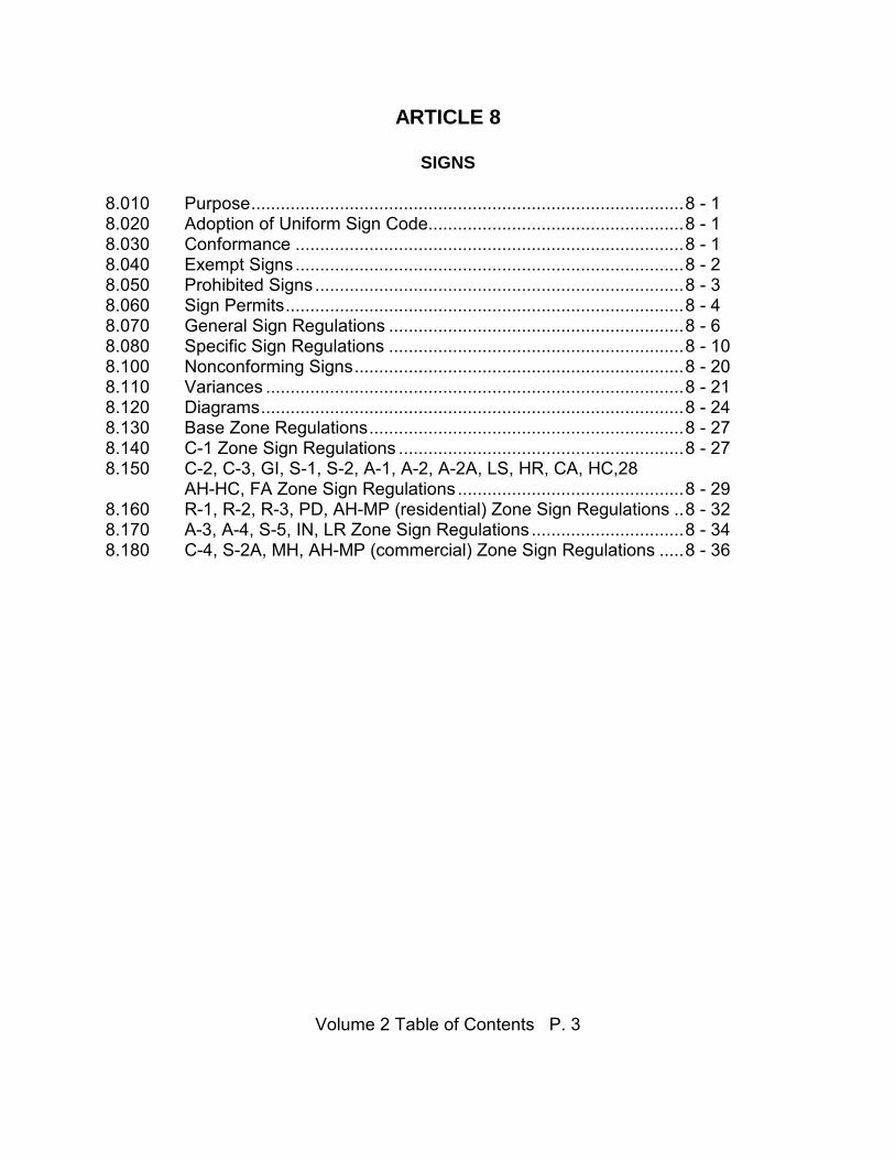
ARTICLE 8
SIGNS 8.010 Purpose ........................................................................................ 8 - 1 8.020 Adoption of Uniform Sign Code.................................................... 8 - 1 8.030 Conformance ............................................................................... 8 - 1 8.040 Exempt Signs ............................................................................... 8 - 2 8.050 Prohibited Signs ........................................................................... 8 - 3 8.060 Sign Permits ................................................................................. 8 - 4 8.070 General Sign Regulations ............................................................ 8 - 6 8.080 Specific Sign Regulations ............................................................ 8 - 10 8.100 Nonconforming Signs ................................................................... 8 - 20 8.110 Variances ..................................................................................... 8 - 21 8.120 Diagrams ...................................................................................... 8 - 24 8.130 Base Zone Regulations ................................................................ 8 - 27 8.140 C-1 Zone Sign Regulations .......................................................... 8 - 27 8.150 C-2, C-3, GI, S-1, S-2, A-1, A-2, A-2A, LS, HR, CA, HC,28 AH-HC, FA Zone Sign Regulations .............................................. 8 - 29 8.160 R-1, R-2, R-3, PD, AH-MP (residential) Zone Sign Regulations .. 8 - 32 8.170 A-3, A-4, S-5, IN, LR Zone Sign Regulations ............................... 8 - 34 8.180 C-4, S-2A, MH, AH-MP (commercial) Zone Sign Regulations ..... 8 - 36

City of Astoria Development Code
Article 4 p. 1
ARTICLE 4
COLUMBIA RIVER ESTUARY AND SHORELAND REGIONAL STANDARDS 4.010. INTRODUCTION. Article 4 establishes use and activity standards for developments in Columbia River estuary aquatic areas and shorelands. Some apply only to the estuary's waters and tidal wetlands: These are indicated by the qualifying phrase "aquatic areas" or "aquatic designations." Standards applicable only to estuary shorelands, including associated non-tidal wetland areas, are so indicated by the phrase "shoreland areas" or "shoreland designations." Return to Table of Contents, Article 4 4.020. AGRICULTURE AND FORESTRY. Standards in this subsection are applicable to agricultural and forestry activities on Columbia River Estuary shorelands. Activities outside of the coastal shorelands boundary are not covered by this subsection. Certain activities associated with agriculture and forestry, such as log storage, dike maintenance, and shipping facilities for agricultural and forestry products, are covered under different subsections. 1. Tillage and drainage practices should minimize sedimentation and control
surface water runoff of animal wastes, fertilizers, and pesticides. Agricultural chemicals shall be applied in a manner that minimizes the amount lost to the aquatic environment.
2. Runoff from feed lots or other confinement lots for livestock shall be controlled
with diversion structures, settling ponds or other land management practices. 3. Forest practices and forest road building will comply with rules established
under the Oregon Forest Practices Act, administered by the Oregon Department of Forestry.
4.030. DEEP-WATER NAVIGATION, PORT AND INDUSTRIAL DEVELOPMENT. The standards in this subsection apply to port and industrial development occurring in and over Columbia River Estuary waters, and on adjacent shorelands. This section also applies to navigation projects related to deep-draft maritime activities, such as channel, anchorage and turning basin development or expansion. 1. Port or industrial development in or over estuarine aquatic areas involving the
following activities shall be subject to an impact assessment.

City of Astoria Development Code
Article 4 p. 2
a. Dredging b. Aquatic area fill c. In-water structures d. Structural shoreline stabilization e. New in-water log storage areas f. Water intake pipes g. In-water dredged material disposal h. Beach nourishment i. Other activity which could adversely affect estuarine physical or
biological resources. 2. Shoreland and aquatic area facilities for the storage or transmission of
petroleum products must have on-site equipment for the containment of oil spills.
3. Deep-water navigation, port or industrial development requiring aquatic area
dredging or filling may be allowed only if all of the following criteria are met: a. The proposed use is required for navigation or other water-dependent
use requiring an estuarine location, or if specifically allowed in the applicable aquatic designation; and
b. A substantial public benefit is demonstrated; and c. The proposed use does not unreasonably interfere with public trust
rights; and d. Feasible alternative upland locations do not exist; and e. Potential adverse impacts are minimized. 4. Deep-water navigation, port or industrial development requiring new piling or
dolphin installation, construction of pile-supported structures, or other uses or activities which could alter the estuary may be permitted only if all of the following criteria are met:
a. A substantial public benefit is demonstrated; and

City of Astoria Development Code
Article 4 p. 3
b. The proposed use does not unreasonably interfere with public trust rights; and
c. Feasible alternative upland locations do not exist; and d. Potential adverse impacts are minimized. 5. Off-street parking may only be located over an aquatic area if all of the
following conditions are met: a. Parking will be on an existing pile-supported structure; and b. Suitable shoreland areas are not available; and c. The amount of aquatic area committed to parking is minimized; and d. The aquatic area is in a Development designation. Return to Table of Contents, Article 4 4.040. DIKING. The standards in this subsection apply to the construction, maintenance and repair of flood control dikes in Columbia River Estuary shoreland and aquatic areas. These do not apply to dredged material containment dikes. 1. Dikes which have been inadvertently breached may be repaired, subject to
State and Federal permit requirements, if the repair is completed within 36 months of the breach.
2. Dike maintenance and repair shall be allowed for: a. Existing serviceable dikes (including those that allow some seasonal
inundation); or b. Dikes that have been damaged by flooding, erosion or tidegate failure
where the property has not reverted to estuarine habitat; or c. Dikes that have been damaged by flooding, erosion or tidegate failure
where the property has reverted to estuarine habitat (as determined by the U. S. Army Corps of Engineers and the Division of State Lands) provided that the property has been in agricultural use for 3 of the last 5 years and reversion to estuarine habitat has not occurred more than 5 years prior.

City of Astoria Development Code
Article 4 p. 4
3. Dike maintenance and repair are distinguished from new dike construction. To
qualify as maintenance and repair, changes in the location, size, configuration, orientation and alignment of the dike must be limited to the minimum amount necessary to retain or restore its operation or function or to meet current engineering standards. Filling aquatic areas for dike maintenance may be allowed only if it can be clearly demonstrated that there are no feasible engineering alternatives which would avoid the use of aquatic area fill.
4. The outside dike face shall be suitably protected from erosion during
construction and maintenance operations. Shoreline stabilization standards shall be met.
5. New dikes in aquatic areas may be permitted either; a. As part of an approved fill project; or b. As a temporary flood protection measure needed to promote public
safety and welfare, subject to applicable U. S. Army Corps of Engineers, and Oregon Division of State Lands rules; or
c. Subject to an exception to Statewide Planning Goal 16. 6. Dredging of subtidal estuarine aquatic areas as a source of fill material for
dike maintenance may be allowed pursuant to the exception to Statewide Planning Goal 16 if all of the following conditions are met:
a. Alternative methods of accomplishing dike maintenance are infeasible
(i.e., dikes proposed for receiving dredged material are remote from upland sources of fill material or land-based heavy equipment access to the dike area is not possible); and
b. Dredging in all cases is limited to that necessary to maintain the dikes.
Dredging as a source of fill material for dike maintenance does not include enlarging or changing the bottom contour of natural aquatic areas for navigation or any other aquatic area use; and
c. Dredging will not disturb or excavate emergent vegetation, intertidal
flats, or other adjacent intertidal estuarine resources; and d. Dredging as a source of fill material for dike maintenance will, in all
cases, take place in subtidal aquatic areas, and shall be limited to the deepest subtidal aquatic area accessible to float-mounted dredging equipment. In narrow tributary areas of the estuary, dredging shall be limited to the deepest subtidal areas nearest the center line of the

City of Astoria Development Code
Article 4 p. 5
waterway. In reaches of the estuary exceeding 200 feet in width, dredging shall be limited to subtidal areas more than 80 feet from the waterward toe of the dike. The intent of this standard is to protect the dike structures from sloughing, maintain existing berms and shoal water immediately adjacent to dikes, and limit dredge excavations to subtidal areas below the level of effective light penetration; and
e. Dredging will not be confined to localized areas of river bottom. All
excavations as a source of fill material shall be linearly dispersed along the entire dike maintenance area. Dredging shall not alter the existing contour of the river bottom such that deep trenches and pockets capable of stranding or impeding estuarine life forms will be created; and
f. Dredging operations shall be consistent with State and Federal permit
conditions and the requirements of local governments to ensure that project timing and dredging conditions protect estuarine resources (e.g., fish runs, spawning activity, benthic productivity, wildlife habitat, etc.).
Return to Table of Contents, Article 4 4.050. DREDGING AND DREDGED MATERIAL DISPOSAL. Standards in this subsection are applicable to all estuarine dredging operations and to both estuarine shoreland and aquatic dredged material disposal in the Columbia River Estuary. 1. Dredging in estuarine aquatic areas, subject to dredging and dredged material
disposal policies and standards, shall be allowed only: a. If specifically allowed by the applicable management unit and required
for one or more of following uses and activities: 1) Navigation or navigational access; 2) An approved water dependent use of aquatic areas or adjacent
shorelands that require an estuarine location; 3) An approved restoration project; 4) Mining or mineral extraction; 5) Excavation necessary for approved bridge crossing support
structures, or pipeline, cable, or utility crossing;

City of Astoria Development Code
Article 4 p. 6
6) Obtaining fill material for dike maintenance where a Statewide
Planning Goal 16 exception has been approved; 7) Maintenance of existing tidegates and tidegate drainage
channels where a Statewide Planning Goal 16 exception has been approved;
8) Aquaculture facilities; and b. If a need (i.e., a substantial public benefit) is demonstrated and the use
or alteration does not unreasonably interfere with public trust rights; and
c. If no feasible alternative upland locations exist; and d. If adverse impacts are minimized. 2. When dredging is permitted, the dredging shall be the minimum necessary to
accomplish the proposed use. 3. Erosion, sedimentation, increased flood hazard, and other undesirable
changes in circulation shall be avoided in dredging and the disposal of dredged material.
4. The timing of dredging and dredged material disposal operations shall be
coordinated with State and Federal resource agencies, local governments, and private interests to protect estuarine aquatic and shoreland resources, minimize interference with commercial and recreational fishing, and insure proper flushing of sediment and other materials introduced into the water by the project.
5. Bottom sediments in the dredging area shall be characterized by the applicant
in accordance with U.S. Environmental Protection Agency, Washington Department of Ecology, and Oregon Department of Environmental Quality standards. Information that may be required includes, but is not limited to, sediment grain size distribution, organic content, oil and grease, selected heavy metals, pesticides, and benthic biological studies.
6. Adverse short-term effects of dredging and aquatic area disposal such as
increased turbidity, release of organic and inorganic materials or toxic substances, depletion of dissolved oxygen, disruption of the food chain, loss of benthic productivity, and disturbance of fish runs and important localized biological communities shall be minimized.
7. Impacts on areas adjacent to the dredging site such as destabilization of fine-

City of Astoria Development Code
Article 4 p. 7
textured sediments, erosion, siltation, and other undesirable changes in circulation patterns shall be minimized.
8. The effects of both initial and subsequent maintenance dredging, as well as
dredging equipment marshalling and staging, shall be considered prior to approval of new projects or expansion of existing projects. Projects will not be approved unless disposal sites with adequate capacity to meet initial excavation dredging and at least five years of expected maintenance dredging requirements are available.
9. Minor dredging of existing tidegate drainage channels and drainage ways is
limited to the amount necessary to maintain and restore flow capacity essential for the function (the drainage service provided by the tidegate) of tidegates and to allow drainage and protection of agricultural and developed areas. Tidegate maintenance dredging does not include enlarging or extending the dimensions of, or changing the bottom elevations of, the affected tidegate drainage channel or drainage way as it existed prior to the accumulation of sediments.
10. Dredging of subtidal estuarine areas as a source of fill material for dike
maintenance, in all aquatic area designations, may be allowed upon the applicant's demonstration that:
a. Alternative methods of accomplishing dike maintenance are infeasible
(i.e., dikes proposed for receiving dredged material are remote from upland sources of fill material and that land-based heavy equipment access to the dike area is not possible);
b. Dredging in all cases will be limited to that necessary to maintain the
dikes. Dredging as a source of fill material for dike maintenance does not include enlarging or changing the bottom contour of natural aquatic areas for navigation of any other aquatic area use;
c. Dredging will not disturb or excavate emergent vegetation, intertidal
flats, or other adjacent intertidal estuarine resources; d. Dredging as a source of fill material for dike maintenance will, in all
cases, take place in subtidal aquatic areas, and shall be limited to the deepest subtidal aquatic area accessible to float-mounted dredging equipment. In narrow tributary areas of the estuary, dredging shall be limited to the deepest subtidal areas nearest the centerline of the waterway. In reaches of the estuary exceeding 200 feet in width, dredging shall be limited to subtidal areas greater than 80 feet in distance from the waterward toe of the dikes. The intent of this standard is to protect the dike structures from sloughing, maintain existing berms and shoal water immediately adjacent to dikes, and limit

City of Astoria Development Code
Article 4 p. 8
dredge excavations to subtidal areas below the level of effective light penetration.
e. Dredging will not be confined to localized areas of river bottom. All
excavations as a source of fill material shall be linearly dispersed along the entire dike maintenance area. Dredging shall not alter the existing contour of the river bottom such that deep trenches and pockets capable of stranding or impeding estuarine life forms will be created.
f. Dredging operations shall be consistent with State and Federal
resource agency conditions, the requirements of local governments, and concerns of private interests, to ensure that project timing and dredging conditions protect estuarine resources (e.g., fish runs, spawning activity, benthic productivity, wildlife habitat, etc.).
11. Dredging for mining and mineral extraction, including sand extraction, shall
only be allowed in areas deeper that 10 feet below MLLW where the project sponsor demonstrates that mining and mineral extraction in aquatic areas is necessary because no feasible upland sites exist and that the project will not significantly impact estuarine resources. The estuary bottom at the project site shall be sloped so that sediments from areas shallower than 10 feet below MLLW and other areas not included in the project's impact assessment do not slough into the dredged area. Dredging as part of an approved dredging project which also provides fill for an approved fill project shall not be subject to the mining and mineral extraction policies and standards.
12. When proposing dredging for sand extraction, the project sponsor shall first
consider obtaining the material from a shoaled area within a Federally-authorized navigation channel that is currently shallower that its authorized depth. Said dredging shall be coordinated with the U.S. Army Corps of Engineers. The dredging depth shall not exceed the authorized channel depth plus any overdredging that the Corps would normally perform while maintaining the site.
13. Dredged material disposal shall occur only at designated sites or at new sites
which meet the requirements of the Dredged Material Disposal Site Selection Policies.
14. Proposals for in-water disposal of dredged materials, including flowlane
disposal, beach nourishment, estuarine open-water disposal, and ocean disposal, shall:
a. Demonstrate the need for the proposed action and that there are no
alternative disposal sites or methods that entail less damaging environmental impacts; and

City of Astoria Development Code
Article 4 p. 9
b. Demonstrate that the dredged sediments meet State and Federal sediment testing requirements and water quality standards; and
c. Not be permitted in the vicinity of a public water intake. 15. Flowlane disposal and estuarine open water disposal shall be monitored to
assure that estuarine sedimentation is consistent with the resource capabilities and purpose of affected natural and conservation management units. The monitoring program shall be established prior to undertaking disposal. The program shall be designed to both characterize baseline conditions prior to disposal and monitor the effects of the disposal. For projects that involve disposal on three year or shorter intervals, this requirement may be waived by the affected jurisdiction(s) after adequate monitoring has been conducted to demonstrate that estuarine sedimentation is consistent with the resource capabilities and purpose of the affected natural and conservation management units. If more that three years has elapsed since the previous disposal action or if disposal amounts have increased substantially over the previous disposal volume this requirement shall not be waived.
16. Flowlane disposal sites shall be in areas identified as low in benthic
productivity and use of these sites shall not have adverse hydraulic effects. Use of disposal sites in the estuary shall be allowed only when no feasible alternative land or ocean disposal sites can be identified and the biological and physical impacts of flowlane disposal are demonstrated to be insignificant. Long term use of a flowlane disposal site may only be allowed if monitoring confirms that the impacts are insignificant. Flowlane disposal is contingent upon demonstration that:
a. Adverse effects due to changes in biological and physical estuarine
properties will not result; b. Flowlane disposal sites shall be shown able to transport sediment
downstream without excessive shoaling, interference with recreational and commercial fishing operations, including the removal of snags from gillnet drifts, undesirable hydraulic effects, or adverse effects on estuarine resources (fish runs, spawning activity, benthic productivity, wildlife habitat, etc.).
17. Ocean disposal shall be conducted such that: a. The amount of material deposited at a site is compatible with benthic
populations, other marine resources, and other uses of the area; b. Interference with sport and commercial fishing is minimized;

City of Astoria Development Code
Article 4 p. 10
c. Disposal is strictly confined to the sites designated by the U.S. Environmental Protection Agency; and
d. The disposal site does not shoal excessively and create dangerous
wave and swell conditions. 18. Except for flowlane disposal and beach nourishment, disposal of dredged
materials inside the estuary shall be substituted for ocean disposal only when the use of ocean disposal sites is not feasible.
19. Beach nourishment shall only be conducted at sites identified in the dredged
material disposal plan. New sites may be added to the Plan by ordinance amendment after a Statewide Planning Goal 16 exception for the site has been approved. Beach nourishment shall be conducted such that:
a. The beach is not widened beyond its historical profile. The historical
profile shall be defined as the widest beach profile that existed prior to June 1986.
b. The material placed on the beach consists of sand of equal or greater
grain size than the sand existing on the beach. c. Placement and subsequent erosion of the materials does not adversely
impact tidal marshes or productive intertidal and shallow subtidal areas. d. Efforts shall be made to maintain a stable beach profile. e. Dredged material is graded at a uniform slope and contoured to
minimize juvenile fish stranding and hazards to beach users. 20. Except as noted below, land disposal and site preparation shall be conducted
such that: a. Surface runoff from disposal sites is controlled to protect water quality
and prevent sedimentation of adjacent water bodies, wetlands, and drainage ways. Disposal runoff water must enter the receiving waterway through a controlled outfall at a location with adequate circulation and flushing characteristics. Underground springs and aquifers must be identified and protected;
b. Dikes are constructed according to accepted engineering standards;
are adequate to support and contain the maximum potential height and volume of dredged materials at the site; and form a sufficiently large containment area to encourage proper ponding and to prevent the return of dredged materials into the waterway or estuary. Containment ponds and outfall weirs shall be designed to maintain adequate

City of Astoria Development Code
Article 4 p. 11
standing water at all times to further encourage settling of dredged materials. The dikes shall be constructed within the boundaries of the disposal site and shall be constructed of material obtained from within the site or other approved source.
Clean dredged material placed on land disposal sites located directly adjacent
to designated beach nourishment sites may be allowed to flow directly into the waterway without conforming to Items 1 and 2, above, provided that all policies and standards for in-water disposal and beach nourishment are met and the dredged materials are not allowed to enter wetlands or the waterway in areas other than the designated beach nourishment site.
21. Land disposal sites which are not intended for dredged material disposal or
development use within a two year period following disposal shall be revegetated as soon as site and weather conditions allow, unless habitat management plans agreed upon by resource management agencies specify that open sand areas should remain at the site. The project sponsor shall notify the local jurisdiction and State and Federal permitting and resource management agencies when disposal is completed and shall coordinate revegetation with these agencies. The notification shall be sent to at least the following agencies: the local jurisdiction, U.S. Army Corps of Engineers, Soil Conservation Service, Division of State Lands, and Oregon Department of Fish and Wildlife. Revegetation of a disposal site does not preclude future uses of the sites for dredged material disposal.
22. The final height and slope after each use of a land dredged material disposal
site shall be such that: a. The site does not enlarge itself by sloughing and erosion into adjacent
areas; b. Loss of materials from the site during storms and freshets is minimized; c. Interference with the view from nearby residences, scenic points, and
parks does not occur. Return to Table of Contents, Article 4 4.060. ESTUARINE CONSTRUCTION: PILING AND DOLPHIN INSTALLATION,
SHORELINE STABILIZATION AND NAVIGATIONAL STRUCTURES. The standards in this subsection apply to over-the-water and in-water structures such as docks, bulkheads, moorages, boat ramps, boat houses, jetties, pile dikes, breakwaters and other structures involving installation of piling or placement of riprap in Columbia River

City of Astoria Development Code
Article 4 p. 12
Estuary aquatic areas. Also covered under these standards are shoreline stabilization and aquatic area fills. This section does not apply to structures located entirely on shorelands or uplands, but does apply to structures, such as boat ramps, that are in both aquatic and shoreland designations. 1. Where land use management practices and vegetative stabilization is shown
not to be feasible (in terms of cost, effectiveness or other factors), structural means may be approved subject to applicable policies, standards and designation use restrictions.
2. Where structural shoreline stabilization is shown to be necessary and
vegetative means are infeasible, the choice among various structural means shall be made on a case by case basis. Factors to be considered include, but are not limited to:
a. Hydraulic features; b. Shoreland habitat; c. Adjacent land and water uses; d. Aquatic habitat; e. Water quality; f. Engineering feasibility; g. Navigation; h. Impacts on public shoreline access. 3. Jetties, groins and breakwaters shall be constructed of clean, erosion-
resistant materials from upland sources. In-stream gravel shall not be used, unless part of an approved mining project. Material size shall be appropriate for predicted wave, tide and current conditions.
4. Where a jetty, groin, breakwater or other in-water structure is proposed for
erosion or flood control, the applicant shall demonstrate that non-structural solutions, such as land use management practices, will not adequately address the problem.
5. Piling or dolphin installation, structural shoreline stabilization, and other
structures not involving dredge or fill, but which could alter the estuary may be allowed only if all of the following criteria are met:
a. A substantial public benefit is demonstrated; and

City of Astoria Development Code
Article 4 p. 13
b. The proposed use does not unreasonably interfere with public trust
rights; and c. Feasible alternative upland locations do not exist; and d. Potential adverse impacts, as identified in the impact assessment, are
minimized. 6. Jetties, groins, breakwaters and piers requiring aquatic area fill may be
allowed only if all of the following criteria are met: a. The proposed use is required for navigation or other water-dependent
use requiring an estuarine location, or if specifically allowed in the applicable aquatic designation; and
b. A substantial public benefit is demonstrated; and c. The proposed use does not unreasonably interfere with public trust
rights; and d. Feasible alternative upland locations do not exist; and e. Potential adverse impacts, as identified in the impact assessment, are
minimized. 7. Proposals for bulkheads may be approved only if it is demonstrated that
sloped riprap will not adequately fulfill the project's objectives. 8. Proposals for bulkheads or for riprap bankline slopes steeper than 1.5 to 1
(horizontal to vertical) must demonstrate that adequate shallow areas will be available for juvenile fish shelter, or that the area is not typically used for juvenile fish shelter.
9. Plant species utilized for vegetative stabilization shall be selected on the basis
of potential sediment containment and fish and wildlife habitat values. Trees, shrubs and grasses native to the region should be considered for vegetative stabilization; however, plant species and vegetation stabilization techniques approved by the Soil Conservation Service, the U.S. Army Corps of Engineers and other participating Federal and State resource agencies are also appropriate. Stabilization of dike slopes must not include vegetation (particularly trees) which jeopardize the dike.
10. Riprap bank protection must be appropriately designed with respect to slope,
rock size, placement, underlying material and expected hydraulic conditions. Project design by a licensed engineer shall meet this requirement. The local

City of Astoria Development Code
Article 4 p. 14
government may also find that riprap projects designed by other individuals, such as experienced contractors, soil conservation service personnel or others, meets this standard.
11. Shoreline stabilization measures shall not restrict existing public access to
public shorelines. 12. Shoreline stabilization shall not be used to increase land surface area. Where
an avulsion has occurred, fill may be used to restore the previous bankline, so long as the corrective action is initiated within one year of the date of the avulsion. Any other extension of the bankline into aquatic areas shall be subject to the policies and standards for fill.
13. Construction of structural shoreline stabilization measures shall be
coordinated with State and Federal agencies to minimize adverse effects on aquatic and shoreland resources and habitats.
14. As a shoreland stabilization and protective measure, bulkheads shall be
designed and constructed to minimize adverse physical effects (i.e., erosion, shoaling, reflection of wave energy or interferences with sediment transport in adjacent shoreline areas) resulting from their placement.
15. Emergency maintenance, for the purpose of making repairs or for the purpose
of preventing irreparable harm, injury or damage to persons, property or shoreline stabilization facilities is permitted, not with standing the other requirements in these standards and subject to those regulations imposed by the U.S. Army Corps of Engineers.
16. Revegetated shoreline areas shall be protected from excessive livestock
grazing or other activities that would prevent development of effective stabilizing plant cover.
17. Docks and piers shall be built no larger than required for their proposed use. Return to Table of Contents, Article 4 4.070. FILLING OF AQUATIC AREAS AND WETLANDS. This subsection applies to the placement of fill material in the tidal wetlands and waters of the Columbia River Estuary. 1. Fill in estuarine aquatic areas may be permitted only if all of the following
criteria are met:

City of Astoria Development Code
Article 4 p. 15
a. If required for navigation or for other water-dependent uses requiring an estuarine location, or if specifically allowed under the applicable aquatic designation; and
b. A substantial public benefit is demonstrated; and c. The proposed fill does not unreasonably interfere with public trust
rights; and d. Feasible upland alternative locations do not exist; and e. Adverse impacts, as identified in the impact assessment, are
minimized. 2. A fill shall cover no more than the minimum necessary to accomplish the
proposed use. 3. Aquatic area fills using either dredged material or other easily erodible
material shall be surrounded by appropriately stabilized dikes. 4. Aquatic areas shall not be used for disposal of solid waste. 5. Projects involving fill may be approved only if the following alternatives are
examined and found to be infeasible: a. Construct some or all of the project on piling; b. Conduct some or all of the proposed activity on existing upland; c. Approve the project at a feasible alternative site where adverse impacts
are less significant. 6. Fill in Natural designations is limited to: a. Riprap for protection of uses existing as of October 7, 1977, unique
natural resources, historical and archeological values, and public facilities;
b. Communications facilities; and c. Temporary alterations. d. Improvements and facilities provided for by exception to Statewide
Planning Goals. 7. Fill in Conservation designations is limited to:

City of Astoria Development Code
Article 4 p. 16
a. Riprap for protection of uses existing as of October 7, 1977, unique
natural resources, historical and archeological values, and public facilities;
b. Communications facilities; and c. Temporary alterations; d. High-intensity water-dependent recreation; e. Aquaculture; f. Minor navigational improvements; g. Active restoration; h. Bridge crossing support structures. i. Improvements and facilities provided for by exception to Statewide
Planning Goals. Return to Table of Contents, Article 4 4.080. FISH AND WILDLIFE HABITAT. This subsection applies to uses and activities with potential adverse impacts on fish or wildlife habitat, both in Columbia River estuarine aquatic areas and in estuarine shorelands. 1. Projects affecting endangered, threatened or sensitive species habitat, as
identified by the USFWS or ODFW, shall be designed to minimize potential adverse impacts. This shall be accomplished by one or more of the following:
a. Soliciting and incorporating agency recommendations into local permit
reviews; b. Dedicating and setting aside undeveloped on-site areas for habitat; c. Providing on or off-site compensation for lost or degraded habitat; d. Retaining key habitat features (for example; roosting trees, riparian
vegetation, feeding areas). 2. In-water construction activity in aquatic areas shall follow the

City of Astoria Development Code
Article 4 p. 17
recommendations of State and Federal fisheries agencies with respect to project timing to avoid unnecessary impacts on migratory fish.
3. Uses and activities with the potential for adversely affecting fish and wildlife
habitat may be approved only upon a demonstration that the following impact mitigation actions are incorporated into the permit where feasible. These impact mitigation actions are listed from highest to lowest priority:
a. Avoiding the impact altogether by not taking a certain action or parts of
an action; b. Minimizing impacts by limiting the degree or magnitude of an action
and it's implementation; c. Rectifying the impact by repairing, rehabilitating, or restoring the
affected environment (this may include removing wetland fills, rehabilitation of a resource use and/or extraction site when its economic life is terminated, etc.);
d. Reducing or eliminating the impact over time by preservation and
maintenance operations. 4. Projects involving subtidal or intertidal aquatic area fill or intertidal aquatic
dredging with the potential for adversely affecting aquatic habitat must provide compensatory mitigation, consistent with the Mitigation and Restoration Plan for the Columbia River Estuary.
Return to Table of Contents, Article 4 4.090. FISHERIES AND AQUACULTURE. The standards in this subsection apply to all projects that could conceivably affect fisheries (either commercial or recreational) or aquaculture in the Columbia River Estuary. This subsection is also applicable to the development of aquaculture facilities and to fisheries enhancement projects. 1. Water diversion structures or man made spawning channels shall be designed
and built to maintain minimum stream flows for aquatic life in affected streams.
2. Water discharge from an aquaculture facility shall meet all Federal and State
water quality standards and any conditions attached to the waste discharge permit.

City of Astoria Development Code
Article 4 p. 18
3. Aquaculture facilities shall be located far enough from sanitary sewer outfalls to avoid potential health hazards.
4. Aquaculture facilities shall be constructed to blend in with and not detract from
the aesthetic qualities of the area. In developed areas, views from upland property shall be given consideration in facility design.
5. Operation of a private salmon hatchery requires a permit from the Oregon
Department of Fish and Wildlife. 6. In-water construction activity in aquatic areas shall follow the
recommendations of State and Federal fisheries agencies with respect to project timing to avoid unnecessary impacts on migratory fish.
7. Commercial fish drifts shall be protected from conflicting in-water activity,
including dredging, in-water dredge material disposal, and aquatic area mining and mineral extraction, during the fishing season.
8. Prior to undertaking in-water dredged material disposal or other in-water
activity that could potentially disrupt commercial fishing, the project sponsor shall consult with the local drift captain, Columbia River Fisherman's Protective Union, the N.W. Gillnetters Association, and the State fishery agency to determine project timing that will minimize impacts to the gillnet fishery.
Return to Table of Contents, Article 4 4.100. LAND TRANSPORTATION SYSTEMS. Standards in this subsection are applicable to the maintenance and construction of railroads, roads and bridges in Columbia River estuary shoreland and aquatic areas. Public, as well as private facilities are covered under this subsection. Forest roads, however, are excluded. 1. New or relocated land transportation routes shall be designed and sited so as
to: a. Enhance development shoreland areas when possible; and b. Direct urban expansion toward areas identified as being suitable for
development; and c. Take maximum advantage of the natural topography and cause
minimum shoreline disruption; and

City of Astoria Development Code
Article 4 p. 19
d. Preserve or improve public estuary access where existing or potential
access sites are identified; and e. Avoid cutting off high-intensity waterfront use areas from water access.
2. Maintenance and repair of roads and railroads and maintenance and
replacement of bridges shall be permitted regardless of the plan designation through which the road or railroad passes, provided:
a. The same alignment is maintained; and b. The same width is maintained, except that minor enlargements to meet
current safety and engineering standards may be permitted. 3. Fill-supported causeways or bridge approach fills across aquatic areas or
across significant nontidal wetlands in shoreland areas shall not be permitted; bridge abutments may, however, be approved.
4. Removal of riparian vegetation along transportation right-of-ways may be
permitted in order to maintain clear vision. Return to Table of Contents, Article 4 4.110. LOG STORAGE. This subsection establishes standards for the establishment of new, and the expansion of existing, log storage and sorting areas in Columbia River Estuary aquatic and shoreland areas. 1. New aquatic log storage areas shall be located such that logs will not go
aground during tidal changes or during low flow periods. 2. Proposals for reestablishment of previously used aquatic log storage areas
must meet standards applied to new log storage areas, unless such areas have been abandoned for fewer than 36 months.
3. New aquatic log storage areas shall not be located in areas which would
conflict with active gillnet fish drifts or with other commercial or recreational fishing activities.
4. New aquatic log storage areas shall be located where water quality
degradation will be minimal and where good flushing conditions prevail.

City of Astoria Development Code
Article 4 p. 20
5. Unpaved shoreland log yards underlaid by permeable soils shall have at least four feet of separation between the yard surface and the winter water table.
6. Log storage and sorting facilities in water-dependent development shorelands
shall not preclude or conflict with existing or possible future water-dependent uses at the site or in the vicinity, unless the log storage or sorting facility is itself an essential part of a water-dependent facility.
Return to Table of Contents, Article 4 4.120. MINING AND MINERAL EXTRACTION. Standards in this subsection are applicable to the extraction of sand, gravel, petroleum products and other minerals from both submerged lands under aquatic areas and from shoreland areas in the Columbia River Estuary. 1. Aquatic area mining and mineral extraction shall only occur in aquatic areas
deeper than ten feet below MLLW, where estuarine resource values are low, and when no feasible upland sources exist.
2. Proposed mining and mineral extraction activities with potential impacts on
estuary shoreland and aquatic areas shall provide the local government with a copy of a proposed or approved surface mining plan.
3. Project sponsors proposing estuarine shoreland or aquatic area mining or
mineral extraction shall demonstrate that the activity is sited, designed and operated to minimize adverse impacts on the following:
a. Significant fish and wildlife habitat; and b. Hydraulic characteristics; and c. Water quality. 4. Petroleum extraction and drilling operations shall not be allowed in aquatic
areas. Petroleum may, however, be extracted from beneath aquatic areas using equipment located on shorelands or uplands. Petroleum exploration activities, with the exception of exploratory drilling, may be permitted in estuarine aquatic areas and in estuarine shoreland areas.
5. Unless part of an approved fill project, spoils and other material removed from
aquatic areas shall be subject to dredged material disposal policies and standards.

City of Astoria Development Code
Article 4 p. 21
Return to Table of Contents, Article 4 4.130. MITIGATION AND RESTORATION. Standards in this section are applicable to estuarine restoration and mitigation projects on Columbia River Estuary aquatic areas and shorelands. 1. Any fill activities that are permitted in estuarine aquatic areas or dredging
activities in intertidal and shallow to medium depth estuarine subtidal areas shall be mitigated through project design and/or compensatory mitigation (creation, restoration or enhancement of another area) to ensure that the integrity of the estuary ecosystem is maintained. The Comprehensive Plan shall designate and protect specific sites for mitigation which generally correspond to the types and quantity of aquatic area proposed for dredging or filling.
2. Mitigation for fill in the aquatic areas or dredging in intertidal and shallow to
medium depth subtidal areas shall be implemented, to the extent feasible, through the following mitigation actions:
a. Project Design Mitigation Actions. 1) Avoiding the impact altogether by not taking a certain action or
parts of an action; 2) Minimizing impacts by limiting the degree or magnitude of action
and its implementation; 3) Rectifying the impact by repairing, rehabilitating, or restoring the
affected environment (this would include removing wetland fills, rehabilitation of a resource use and/or extraction site when its economic life is terminated, etc.);
4) Reducing or eliminating the impact over time by preservation
and maintenance operations; b. Compensatory Mitigation Actions. 1) Creation, restoration, or enhancement of an estuarine area to
maintain the functional characteristics and processes of the estuary, such as its natural biological productivity, habitats, and species diversity, unique features and water quality.

City of Astoria Development Code
Article 4 p. 22
Any combination of the above actions may be required to implement
mitigation requirements. The compensatory mitigation actions listed in Subsection 2(a) shall only be considered when, after consideration of impact avoidance, reduction or rectification, there are still unavoidable impacts.
3. If compensatory mitigation actions are required, the U. S. Fish and Wildlife
Service shall be asked to make a Resource Category determination for the site proposed for development. The classification shall be listed on the permit application and review notice. If the area subject to impact is in a Resource Category 2 or lower (4 = lowest), the following sequence of mitigation options shall be considered:
a. In-Kind/On-Site; b. In-Kind/Off-Site; c. Out-of-Kind/On-Site; d. Out-of-Kind/Off-Site; Generally, the requirements for considering each option before moving on to
the next shall be stricter for higher Resource Categories. The following list summarizes the mitigation goal for each resource category:
Resource Category 1: Habitat to be impacted is of high value for
evaluation species and is unique and irreplaceable on a national basis or in the Columbia River Estuary area. Mitigation Goal: No loss of existing habitat value.
Resource Category 2: Habitat to be impacted is of high value for
evaluation species and is relatively scarce or becoming scarce on a national basis or in the Columbia River Estuary area. Mitigation Goal: No net loss of in-kind habitat value.
Resource Category 3: Habitat to be impacted is of high to medium
value for evaluation species and is relatively abundant on a national basis and in the Columbia River Estuary area. Mitigation Goal: No net loss of habitat value while minimizing loss of in-kind habitat value.
Resource Category 4: Habitat to be impacted is of medium to low
value for evaluation species. Mitigation Goal: Minimize loss of habitat value.
4. Permit applicants shall submit a mitigation plan for each project proposal that
requires mitigation. The mitigation plan shall define specific goals and

City of Astoria Development Code
Article 4 p. 23
objectives of the proposed mitigation action. The plan shall also address where applicable, performance specifications that include but are not necessarily limited to the following:
a. Starting date; b. Completion date; c. Grade specifications; d. Area and elevation specifications; e. Channel specifications; f. Buffers; g. Vegetation plantings; h. Monitoring; i. Contingency plan (outline of potential remedial work and specific
remedial contingency actions); j. Accountability requirements (e.g., bonding or any mechanism that
serves as a bond). Goals, objectives and performance specifications shall be defined for both
project design and compensatory mitigation. These components of the plan shall be developed in cooperation with relevant State and Federal resource and regulatory agencies.
5. Each mitigation action shall be reviewed against its goals, objectives, and
performance specifications. 6. All compensatory mitigation site plans shall include a contingency plan. The
contingency plan shall include corrective measures to be taken in the event of suboptimal project performance (based on project goals and objectives). A list of remedial follow-up action strategies shall be specified in the contingency plan. These remedial strategies shall specifically address the goals, objectives and performance specifications of the mitigation site plan.
7. Post-mitigation monitoring for project design mitigation, when relevant, and
compensatory mitigation shall be required over a 2 to 5 year time period, depending on the size and complexity of the mitigation project. Local governments, in coordination with State and Federal resource agencies, shall design and implement the monitoring. Monitoring requirements may be

City of Astoria Development Code
Article 4 p. 24
waived as follows: a. A waiver of the 2 to 5 year monitoring requirement shall be granted if,
at any time during the 2 to 5 year period, the project is judged successful; or
b. If a mitigation project fails to satisfy the original goals and objectives
after the designated time period, and the developer has met all the site design and contingency plan requirements, then the developer is not responsible for remedial action. However monitoring may still be required up to a predetermined time period to help agencies determine workable strategies for future mitigation efforts.
8. All mitigation actions shall begin prior to or concurrent with the associated
development action. 9. For estuarine wetlands, once a compensatory mitigation action is required,
the habitat types displayed in OAR 141-85-254 shall provide the basis for comparing development activities and possible mitigation areas. The mitigation trade method described in OAR 141-85-256 shall be used to determine acreage and credit requirements for mitigation sites.
10. For non-tidal wetlands, once a compensatory mitigation action is required,
habitat trade requirements shall be determined in coordination with appropriate State and Federal agencies. Mitigation requirements shall be made on a case by case basis using determinations made by these agencies.
11. Removal and fill actions potentially exempt from estuarine mitigation requirements include:
a. Removal or fill of less than 50 cubic yards of material; b. Filling for repair and maintenance of existing functional dikes where
there is negligible physical or biological damage to tidal marsh or intertidal area;
c. Riprap to allow protection of existing bank line with clean, durable
erosion resistant material provided that the need for riprap protection is demonstrated and that this need cannot be met with natural vegetation, and no appreciable increase in upland occurs;
d. Filling for repair and maintenance of existing roads where there is
negligible physical or biological damage to tidal marsh or intertidal areas;
e. Dredging for authorized navigation channels, jetty or navigational aid

City of Astoria Development Code
Article 4 p. 25
installation, repair or maintenance contract with the Army Corps of Engineers;
f. Any proposed alteration that would have negligible adverse physical or
biological impact on estuarine resources. g. Dredging or filling required as part of an estuarine resource creation,
restoration, or enhancement project agreed to by local, State, and Federal agencies; and
h. Beach nourishment, subject to Dredging and Dredged Material
Disposal Standards, Section 5.250. Any waiver of mitigation shall be coordinated with State and Federal agencies. 12. Activities that do not require mitigation even though they involve intertidal
removal include: a. Maintenance dredging - dredging a channel basin, or other facility
which has been dredged before and is currently in use or operation or has been in use or operation sometime during the past five years, provided that the dredging does not deepen the facility beyond its previously authorized or approved depth plus customary over-dredging; and
b. Aggregate mining - provided the site has historically been used for
aggregate removal on a periodic basis. 13. Actions not considered as mitigation include: a. As a general rule, conversion of an existing wetland type to another
wetland type as mitigation for impacts on another wetland shall not be allowed. However, diked non-tidal wetlands with low wildlife value can be discounted and restored to tidal influence as mitigation for impacts in diked non-tidal wetlands. Also, enhancement of an existing wetland can be considered mitigation for impacts in another wetland;
b. Transfer of ownership of existing wetlands to public ownership; c. Dedication of existing wetlands for natural uses; d. Provision of funds for research; or e. Monetary compensation for lost wetlands except where monies are
used to purchase mitigation credits at a mitigation bank.

City of Astoria Development Code
Article 4 p. 26
14. The following criteria shall be considered when selecting and including potential mitigation sites in the Mitigation and Restoration Plan for the Columbia River Estuary (not in order of priority):
a. Proximity to potential development sites; b. Opportunity to create or restore habitat conditions and other values
similar to those at the impacted sites or historically and presently scarce habitat types;
c. Character of potential sites (e.g., low habitat value and no conflicting
uses); d. Potential for protection through zoning; and e. Amount of new dike requirements, if any. 15. A plan amendment shall be required to remove any mitigation site from the
mitigation plan. For a Priority 1 mitigation site the plan amendment shall require a demonstration that there is no longer a need for the site or that a suitable alternative mitigation site has been designated and protected. A Priority 2, Level 3 site shall be partially or totally removed from the mitigation plan if the landowner proposes a development that would preclude all or part of its use for mitigation and, 30 days after the permit application has been circulated, a negotiated agreement to sell the land, or certain landownership rights, for mitigation use has not been made. The negotiation shall be between the landowner and any interested buyer. The site shall not be removed from the plan until the development is completed. A Priority 2, Level 4 or a Priority 3 site shall be partially or totally removed from the mitigation plan if the landowner chooses to develop part or all of the site to a degree that would preclude its availability for mitigation use.
16. Astoria shall make the determination of whether a development will preclude
all or some of the potential use of the site for mitigation purposes. 17. After a mitigation action takes place, Astoria shall amend its plan and change
the designation to reflect its aquatic character. 18. The developer implementing a mitigation action shall be responsible for all
costs associated with the mitigation project unless an alternative agreement for cost responsibility is negotiated between the landowner and the developer.
19. Shorelands in the Marine Industrial Shorelands Zone can only be used for
mitigation subject to a finding that the use of the site for mitigation will not preclude or conflict with water-dependent uses.

City of Astoria Development Code
Article 4 p. 27
20. Significant Statewide Planning Goal 17 resource areas (major marshes, significant wildlife habitat, and exceptional aesthetic resources) can only be used for mitigation subject to a finding that the use of the site for mitigation will be consistent with protection of natural values.
21. Shorelands in the Marine Industrial Shorelands Zone can only be used for
restoration subject to a finding that the use of the site for restoration will not preclude or conflict with water-dependent uses.
22. Priority 2, Level 3 and 4 mitigation sites shall be designated as mitigation sites
until they are proposed for restoration outside of the context of mitigation. At this time restoration shall be considered an allowed use subject to the 30 day freeze restrictions presented in mitigation standard 15. Restoration shall only be allowed at Priority 2 sites subject to a finding that the site is no longer required for mitigation.
23. Priority 3, Level 4 mitigation sites shall be designated as mitigation sites until
they are specified for restoration outside of the context of mitigation. At this time, restoration shall be considered an allowed use. Restoration shall only be allowed at Priority 3 sites subject to a finding that the site is no longer required for mitigation.
24. Significant Statewide Planning Goal 17 resource areas (major marshes,
significant wildlife habitat, and exceptional aesthetic resources) can only be used for restoration subject to a finding that the use of the site for restoration will be consistent with protection of its natural values.
Return to Table of Contents, Article 4 4.140. PUBLIC ACCESS TO THE ESTUARY AND ITS SHORELINE. Standards in this subsection apply to all uses and activities in Columbia River Estuary shoreland and aquatic areas which directly or indirectly affect public access. "Public access" is used broadly here to include direct physical access to estuary aquatic areas (boat ramps, for example), aesthetic access (viewing opportunities, for example), and other facilities that provide some degree of public access to Columbia River Estuary shorelands and aquatic areas. 1. Projects to improve public access shall be designed to assure that adjacent
privately owned shoreland is protected from public encroachment. 2. The City shall review, under ORS 271.080 through 271.230, proposals for the
vacation of public easements or right-of-ways which provide access to or

City of Astoria Development Code
Article 4 p. 28
along estuarine waters. The City shall review under the provisions of ORS 271.300 through 271.360 proposals for the sale, exchange or transfer of public ownership which provides access to estuarine waters. Existing public ownerships, right-of-ways, and similar public easements which provide access to or along estuary waters shall be retained or replaced if sold, exchanged or transferred.
3. Right-of-ways may be vacated to permit redevelopment of existing developed
shoreland areas provided public access across the affected site is retained. Return to Table of Contents, Article 4 4.150. RECREATION AND TOURISM. Standards in this subsection are applicable to recreational and tourist-oriented facilities in Columbia River estuary shoreland and aquatic areas. 1. Off-street parking may only be located over an aquatic area if all of the
following conditions are met: a. Parking will be on an existing pile-supported structure; and b. Suitable shoreland areas are not available; and c. The amount of aquatic area committed to parking is minimized; and d. The aquatic area is in a Development designation. 2. New or expanded recreation developments shall be designed to minimize
adverse effects on surface and ground water quality. Adverse effects of storm run-off from parking lots shall be minimized.
3. New or expanded recreational developments shall be designed and located
so as not to unduly interfere with adjacent land uses. Return to Table of Contents, Article 4 4.160. RESIDENTIAL, COMMERCIAL AND INDUSTRIAL DEVELOPMENT. The standards in this subsection are applicable to construction or expansion of residential, commercial or industrial facilities in Columbia River Estuary shoreland and aquatic areas. Within the context of this subsection, residential uses include single and multi-family structures, mobile homes, and floating residences (subject to an exception). Duck shacks,

City of Astoria Development Code
Article 4 p. 29
recreational vehicles, hotels, motels and bed-and-breakfast facilities are not considered residential structures for purposes of this subsection. Commercial structures and uses include all retail or wholesale storage, service or sales facilities and uses, whether water-dependent, water-related, or non-dependent, non-related. Industrial uses and activities include facilities for fabrication, assembly, and processing, whether water-dependent, water-related or non-dependent non-related. 1. Sign placement shall not impair views of water areas. Signs shall be
constructed against existing buildings whenever feasible. Off-premise outdoor advertising shall not be allowed in aquatic areas.
2. Off-street parking may only be located over an aquatic area if all of the
following conditions are met: a. Parking will be on an existing pile-supported structure; and b. Suitable shoreland areas are not available; and c. The amount of aquatic area committed to parking is minimized; and d. The aquatic area is in a Development designation. 3. Joint use of parking, moorage and other commercial support facility is
encouraged where feasible and where consistent with local Code requirements.
4. Uses on floating structures shall be located in areas protected from currents
and wave action, and shall not rest on the bottom during low tidal cycles or low flow periods.
5. Aquatic areas or significant non-tidal wetlands in shoreland areas may not be
used to compute the lot area or density for residential development in shoreland areas.
6. Where groundwater is or may be used as a water supply, the ground-water
table shall not be significantly lowered by drainage facilities, or be affected by salt water intrusion due to groundwater mining.
7. Fill in estuarine aquatic areas or in significant non-tidal wetlands in shoreland
areas shall not be permitted for residential uses. 8. Piling or dolphin installation, structural shoreline stabilization, and other
structures not involving dredge or fill, but which could alter the estuary may be allowed only if all of the following criteria are met:
a. A substantial public benefit is demonstrated; and

City of Astoria Development Code
Article 4 p. 30
b. The proposed use does not unreasonably interfere with public trust
rights; and c. Feasible alternative upland locations do not exist; and d. Potential adverse impacts, as identified in the impact assessment, are
minimized. Return to Table of Contents, Article 4 4.170. SHALLOW-DRAFT PORTS AND MARINAS. The standards in this subsection apply to development of new marinas and improvement of existing marinas in aquatic areas of the Columbia River Estuary. Also covered are adjacent shoreland support facilities that are in conjunction with or incidental to the marina. Included under this subsection's coverage are both public and private marinas for either recreational, charter or commercial shallow draft vessels. 1. New marinas may be approved only when existing marinas are inadequate
with respect to location, support services or size; or cannot expand to meet area moorage needs.
2. New marinas shall be located in or adjacent to areas of extensive boat usage,
and in areas capable of providing necessary support services (including street access, upland parking, water, electricity and waste disposal).
3. The feasibility of upland boat storage shall be evaluated concurrent with
proposals for new or expanded marina facilities. 4. Marina development and expansion may require some filling and dredging of
presently undeveloped areas. Significant aquatic and shorelands resources shall be protected from preventable adverse impacts in the design, construction, and maintenance of marina facilities.
5. Marina development requiring filling or dredging in estuarine aquatic areas may be permitted only if all of the following criteria are met:
a. If required for navigation or for other water-dependent uses requiring an
estuarine location, or if specifically allowed under the applicable aquatic designation; and
b. A substantial public benefit is demonstrated; and c. The proposed dredging or filling does not unreasonably interfere with

City of Astoria Development Code
Article 4 p. 31
public trust rights; and d. Feasible upland alternative sites do not exist; and e. Adverse impacts are minimized. 6. New, expanded or renovated marinas shall be designed to assure adequate
water circulation and flushing. 7. New marinas shall provide facilities for emptying holding tanks so that these
wastes are not placed in the river. 8. Covered moorages may be permitted in marinas subject to the following
requirements: a. Information on existing water quality and habitat conditions in the
aquatic area proposed for the covered moorage; and b. Data on existing aquatic vegetation, and an analysis of the proposed
covered moorages' impact on aquatic vegetation; and c. Information on light penetration, both with and without the proposed
covered moorage; and d. No more than 20% of the marina's aquatic surface is occupied by the
covered moorages. 9. New or expanded marina fuel docks shall maintain on-site equipment for the
containment of spilled fuel. 10. Floating docks in marinas shall be located such that they do not rest on the
bottom during low tides. 11. New individual docks outside of marinas may only be built when it is shown
that existing marinas cannot accommodate the proposed use. Return to Table of Contents, Article 4 4.180. SHORELAND HAZARD AREAS. The standards in this subsection apply to development in Columbia River Estuary shoreland areas with identified hazards to development. These hazards are identified in subarea plans, and include areas susceptible to erosion, soil movement, and flooding. 1. Proposed shoreland area development shall be evaluated prior to construction

City of Astoria Development Code
Article 4 p. 32
to assure that new hazards are not created or existing hazards are not worsened on adjacent property.
Return to Table of Contents, Article 4 4.190. SIGNIFICANT AREAS. The standards in this subsection are intended to protect certain shoreland and aquatic resources with estuary-wide significance. Significant shoreland resources are identified as such in subarea plans. Significant aquatic resources are found in Natural Aquatic areas. This subsection applies only to activities and uses that potentially affect significant shoreland or aquatic resources. Other resources without estuary-wide significance are not covered by this subsection. 1. Temporary removal of riparian vegetation may be permitted in conjunction
with a water-dependent use where direct access to the water is required for construction or for a temporary use. Riparian vegetation removed for these reasons must be replaced upon project completion.
2. Permanent removal of riparian vegetation may be permitted along
transportation right-of-ways for purposes of maintaining clear vision. 3. Public access to significant scenic areas shall be provided in a manner
consistent with the preservation of the scenic area and other significant resources.
4. Tidegated sloughs and drainage ditches identified as having significant
aquatic habitat value, significant riparian vegetation, or other significant shoreland resource value may be maintained with respect to depth, but their bankline location and configuration may not be altered, unless part of an approved fill or shoreline stabilization project.
5. A setback of 50 feet from significant riparian vegetation shall be required for
all new structures. Return to Table of Contents, Article 4 4.200. WATER QUALITY MAINTENANCE. The standards in this subsection are intended to help protect and enhance the quality of water in the Columbia River Estuary. Impacts on water quality in aquatic areas and in tidegated sloughs in shoreland areas are covered by these standards.

City of Astoria Development Code
Article 4 p. 33
1. New marinas shall provide facilities for emptying holding tanks so that these
wastes are not placed in the river. 2. Thermal effluent shall be cooled before they are returned to the estuary. 3. The potential adverse impacts on water quality of dredging, fill, in-water
dredged material disposal, in-water log storage, water intake or withdrawal, and slip or marina development will be assessed during permit review. Parameters to be addressed include:
a. Turbidity; b. Dissolved oxygen; c. Biochemical oxygen demand; d. Contaminated sediments; e. Salinity; f. Water temperature; g. Flushing; 4. New or expanded marine fuel docks must provide on-site equipment for the
containment of fuel spills. 5. New point-source waste water discharges into the Columbia River will be
controlled through the National Pollution Discharge Elimination System (NPDES) permit program.
6. Estuarine Aquatic or Shoreland area pesticide application will be controlled by
the State Department of Agriculture and the Department of Environmental Quality.
Return to Table of Contents, Article 4 4.210. WATER-DEPENDENT DEVELOPMENT AREAS. Standards in this subsection are applicable only to those Columbia River Estuary Shorelands designated as Especially Suited for Water-Dependent Development. The purpose of these standards is to assure that adequate sites are available for water-dependent uses.

City of Astoria Development Code
Article 4 p. 34
1. The only new uses allowed in Marine Industrial Shorelands are: a. Water-dependent recreational uses; b. Water-dependent commercial uses; c. Water-dependent industrial uses; d. Temporary uses involving minimal capital investment and no
permanent structures; and e. A use in conjunction with and incidental to a water-dependent use. 4.220. WATER-DEPENDENT AND WATER-RELATED USE CRITERIA. The following criteria are applicable when determining whether a use is water-dependent, water-related, or non-dependent, non-related. A. Water-Dependent Use. A use is water-dependent when it can only be accomplished on, in, or adjacent to
water. The location or access is required for one of the following: 1. Water-borne transportation (such as navigation; moorage, fueling and
servicing of ships or boats; terminal and transfer facilities; fish or other material receiving and shipping); or
2. Recreation (active recreation such as swimming, boating and fishing, or
passive recreation such as viewing and walking); or 3. A source of water (such as energy production, cooling or industrial equipment
or wastewater, other industrial processes, aquaculture operations; or 4. Marine research or education (such as observation, sampling, recording
information, conducting field experiments and teaching). B. Water-Related Use. 1. Provides goods and/or services that are directly associated with water-
dependent uses, supplying materials to, or using products of, water-dependent commercial and industrial uses; or offering services directly tied to the functions of water-dependent uses; and
2. If not located adjacent to water, would experience a public loss of quality in

City of Astoria Development Code
Article 4 p. 35
the goods and services offered (evaluation of public loss of quality will involve subjective consideration of economic, social and environmental values).
Return to Table of Contents Article 4

City of Astoria Development Code
Article 6 p. 36
ARTICLE 5 IMPACT ASSESSMENT AND RESOURCE CAPABILITY DETERMINATION 5.010. IMPACT ASSESSMENT PROCEDURE. The purpose of this section is to provide an assessment process for development alterations which could potentially alter the estuarine ecosystem. A. Impact Assessment Requirements. An Impact Assessment in accordance with the provisions of this section shall be
required for the following uses in estuarine aquatic areas. 1. Dredging; 2. Aquatic area fill; 3. In-water structures; 4. Riprap; 5. New in-water log storage areas; 6. Water intake pipes; 7. Effluent discharge pipes; 8. In-water dredged material disposal; 9. Beach nourishment; 10. Other uses or activities which could affect estuarine physical or biological
resources; and 11. Uses or activities that require a Resource Capability Determination. B. Use of Impact Assessment. 1. Information contained in an Impact Assessment shall be used in the
evaluation of a use or activity's significant impacts on the estuarine ecosystem; in determining whether potential impacts can be avoided or minimized; and for providing a factual base of information needed to address applicable standards in Article 4.

City of Astoria Development Code
Article 6 p. 37
2. Where a use requires a Resource Capability Determination, information in the Impact Assessment can be used to satisfy the requirements of 5.020.
C. Information to be Provided in the Impact Assessment. 1. Aquatic life forms and habitat, including information on both the extent of and
impacts on: habitat type and use, species present (including threatened or endangered species), seasonal abundance, sediments, and vegetation.
2. Shoreland life forms and habitat, including information on both the extent of
and impacts on: habitat type and use, species present (including threatened or endangered species), seasonal abundance, soil types and characteristics, and vegetation present.
3. Water quality, including information on: sedimentation and turbidity, dissolved
oxygen, biochemical oxygen demand, contaminated sediments, salinity, water temperatures, and expected changes due to the proposed use or activity.
4. Hydraulic characteristics, including information on: water circulation, shoaling
patterns, potential for erosion or accretion in adjacent areas, changes in flood levels, flushing capacity, and water flow rates.
5. Air quality, including information on quantities of particulates and expected
airborne pollutants. 6. Public access to the estuary and shoreline, including information on: proximity
to publicly-owned shorelands and public street ends; effect on public boat launches, marinas and docks; and impact on inventoried public access opportunities.
7. Navigation, including information on: distance from navigation channels,
turning basins and anchorages; proximity to range markers. 8. Demonstration that proposed structures or devices are properly engineered. 9. Demonstration that the project's potential public benefits will equal or exceed
expected adverse impacts. 10. Demonstration that non-water-dependent uses will not preempt existing or
future water-dependent utilization of the area. 11. Determination of methods for mitigation and accommodation of the proposed
development, based on items 1 through 10 above, in order to avoid or minimize preventable adverse impacts.
D. Impact Assessment Findings.

City of Astoria Development Code
Article 6 p. 38
The information in Subsection C above shall be used to reach one of the conclusions
listed below: 1. The proposed uses and activities do not represent a potential degradation of
reduction of estuarine resource. 2. The proposed uses and activities represent a potential degradation or
reduction of estuarine resources. The impact assessment identifies reasonable alterations or conditions that will eliminate or minimize to an acceptable level expected adverse impacts.
3. The proposed uses and activities will result in unacceptable losses. The
proposed development represents irreversible changes and actions and unacceptable degradation or reduction of estuarine resource properties will result.
4. Available information is insufficient for predicting and evaluating potential
impacts. Return to Table of Contents Article 5 5.020. RESOURCE CAPABILITY DETERMINATION. A. Purpose. Certain uses and activities in Aquatic Natural and Aquatic Conservation zones are
allowed only if determined to meet the resource capability and purpose of the zone in which the use or activity occurs. Certain uses and activities in a Aquatic Development Zone are allowed only if determined to meet the purpose of the zone in which the use or activity occurs.
B. Definition of Resource Capability. In a Natural Aquatic estuarine designation, a use or activity is consistent with the
resource capabilities of the area when either the impacts of the use on estuarine species, habitats, biological productivity, and water quality are not significant or if the resources of the areas are able to assimilate the use and activity and their effects and continue to function in a manner which protects significant wildlife habitat, natural biological productivity, and values for scientific research and education.
In a Conservation Aquatic estuarine designation, a use or activity is consistent with
the resource capabilities of the area when either the impacts of the use on estuarine species, habitats, biological productivity, and water quality are not significant or if the resources of the area are able to assimilate the use and activity and their effects and

City of Astoria Development Code
Article 6 p. 39
continue to function in a manner which conserves long-term renewable resources, natural biologic productivity, recreational and aesthetic values and aquaculture.
C. Purpose of Different Estuarine Zones. 1. Aquatic Conservation Zone: Conservation Aquatic areas are designated for long-term uses of renewable
resources that do not require major alterations of the estuary, except for the purpose of restoration. They are managed for the protection and conservation of the resources found in these areas. The Conservation Aquatic designation includes areas needed for the maintenance and enhancement of biological productivity, recreational resources, aesthetic features and aquaculture. The Conservation Aquatic designation includes areas that are smaller or of less biological importance than Natural Aquatic areas. Areas that are partially altered and adjacent to existing moderate intensity development which do not possess the resource characteristics of other aquatic areas are also included in this designation.
2. Aquatic Natural Zone: Natural Aquatic areas are designated to assure the protection of significant
fish and wildlife habitats; of continued biological productivity within the estuary; and of scientific, research, and educational needs. These areas are managed to preserve natural resources in recognition of dynamic, natural, geological, and evolutionary processes. Natural Aquatic areas include all major tidal marshes, tideflats, and seagrass and algae beds. The designation is intended to preserve those aquatic natural resource systems existing relatively free of human influence.
D. Resource Capability Procedure. 1. Identification of the affected area's zone, and its purpose. 2. Identification of the types and extent of estuarine resources present and
expected adverse impacts. This information is included in the Impact Assessment, Section 5.010.
3. A determination of whether the use or activity is consistent with the resource
capabilities of the affected designation. A use or activity is consistent with the resource capabilities of the area when either:
a. Impacts on estuarine resources are not significant; or b. Resources of the area will be able to assimilate the use and activity and
their effects and continue to function in a manner which:

City of Astoria Development Code
Article 6 p. 40
(1) In Natural Aquatic Zones, protects significant wildlife habitats,
natural biological productivity, and values for scientific research and education; or
(2) In Conservation Aquatic Zones, conserves long-term use of
renewable resources, natural biological productivity, recreation and aesthetic values and aquaculture.
4. For temporary alterations, the Resource Capability Determination must also
include: a. Determination that potential short-term damage to estuary and
shoreland resources is consistent with the resource capabilities of the area; and
b. Determination that the area and affected resources can be restored to
their original condition. E. Determining Consistency With the Purpose of the Zone. Certain uses in the Aquatic Development (A-1, A-2, A-2A), Aquatic Conservation (A-
3), and Aquatic Natural (A-4) Zones may be permitted only if they are consistent with the purpose of the aquatic zone in which they occur. This determination is made as follows:
1. Identification of the affected zone, and its purpose. 2. Description of the proposals potential impact on the purposes of the affected
zone. 3. Determination that the proposal is either: a. consistent with the purpose of the affected zone; or b. conditionally consistent with the purpose of the affected zone; or c. inconsistent with the purpose of the affected zone. Return to Table of Contents Article 5 5.030. COASTAL ZONE CONSISTENCY REVIEW. A. Applicability.

City of Astoria Development Code
Article 6 p. 41
This section applies to the following activities that directly affect the coastal zone: 1. actions requiring Federal permits or licenses 2. Federal activities and development projects 3. outer continental shelf activities 4. Federal grants or financial assistance. B. Consistency Review Procedure for Activities Requiring Federal Permits or Licenses. Applicants for activities in Astoria's coastal zone which require a Federal permit or
license shall submit a copy of: the completed permit application, other supporting material provided to the Federal permit granting agency and a set of findings which demonstrate that the development would be consistent with the applicable elements of the Comprehensive Plan and this Code.
If the activity requires a local permit, the applicant shall apply for the local permit
under the established permit program. Approval of the permit shall constitute a ruling that the action is consistent with the applicable elements of the Comprehensive Plan and Development Code. If the action does not require a local permit, the Community Development Director may make an investigation to provide information on the project's conformance with the Plan and Code standards and provisions. The investigation can be done administratively or through public hearings.
The Community Development Director shall respond to the State or Federal permit
granting agency within seven working days of the local actions. The response shall contain a statement of whether the Federal permit is consistent with the applicable elements of the Comprehensive Plan, the reasons the development is or is not consistent, standards and conditions which apply if the permit is granted, and the need for local permits for developments associated with the activity.
C. Consistency Review Procedure for Federal Activities and Development Projects. Federal activities in the Coastal Zone are not subject to the established City permit
procedures. Federal activities which directly affect the coastal zone of the City must be consistent, to the maximum extent practicable, with the coastal zone management program. The coastal zone management program includes the Comprehensive Plan and Development Code. The Federal consistency determination is reviewed by the Oregon Department of Land Conservation and Development.
D. Outer Continental Shelf Activities. Federally licensed or permitted activities described in Outer Continental Shelf plans

City of Astoria Development Code
Article 6 p. 42
and which affect Astoria's coastal Zone shall be conducted in a manner consistent with the coastal zone management program. The applicant's consistency certification is reviewed by the Oregon Department of Land Conservation and Development. The Community Development Director may communicate concurrence or disagreement with the consistency certification to the Oregon Department of Land Conservation and Development within the time specified on the Oregon Department of Land Conservation and Development notice for the activities.
E. Federal Grants and Financial Assistance. Federal financial assistance or grants to State agencies, cities, counties, special
purpose districts, or regional bodies, for activities which affect the Astoria coastal zone shall be granted only when the activities are consistent with the coastal zone management program. The Community Development Director may review the grants and financial assistance for consistency with the Plan and Development Code. The review may be done administratively or through public hearings.
Return to Table of Contents Article 5
ARTICLE 6
HISTORIC PROPERTIES
6.010. PURPOSE. It is the purpose of the City to promote and encourage the preservation, restoration, rehabilitation, and adaptive use of buildings, structures, appurtenances, objects, sites, and districts that are indicative of Astoria's historical heritage; to carry out certain provisions of the Land Conservation and Development Commission Goal 5 "Open Spaces, Scenic and Historic Areas, and Natural Resources"; to establish a historic design review process for historic structures, and to assist in providing the means by which property owners may qualify for Federal and State financial assistance programs assisting historical properties. [6.010 amended by Ordinance 13-08, 8-19-2013] Return to Table of Contents Article 6 6.020. SPECIAL PROVISIONS. A. Signs. 1. Signs or plaques denoting a historic District, building or site will be permitted
in accordance with the sign regulations for the zone in which it is located.

City of Astoria Development Code
Article 6 p. 43
Such signs will be of dignified design and positioned in a manner that is compatible with the building or site.
2. Any signs constructed or placed on or in association with a historic building
will be reviewed by the Historic Preservation Officer to ensure that they are in scale and relate well to the architectural style of the building.
3. Restoration or reconstruction of historic signs are encouraged and will be
reviewed by the Historic Preservation Officer to verify that they are a historic restoration or reconstruction. Any change in design and/or wording is not considered to be a historic sign restoration/reconstruction and would be subject to the Sign Ordinance regulations.
[6.020.A.3 added by Ordinance 13-08, 8-19-2013] 6.030. HISTORIC DISTRICT ESTABLISHMENT. A. The Historic Landmarks Commission, the City Council, or the owners of at least one-
third of the privately owned property within a proposed District may initiate the proceedings for designation of a Historic District. If there is multiple ownership in a property, each consenting owner shall be counted as a fraction equal to the interest the owner holds in that property.
A request that an area be designated as a Historic District will be considered by the
Historic Landmarks Commission following receipt of a complete application by the Historic Preservation Officer. The Historic Landmarks Commission will transmit its recommendation of the area as a Historic District to the City Council. The City Council shall hold a public hearing in accordance with the procedures set forth in 9.010 through 9.100 except that notices of the hearing date will be mailed only to owners of property lying on or within the boundaries of the proposed District.
Upon receipt of the Historic Landmark Commission's recommendation, the City
Council may authorize submittal of a nomination for Historic District status to the State Advisory Committee on Historic Preservation.
Return to Table of Contents Article 6 6.040. HISTORIC LANDMARK ESTABLISHMENT. A. Application. The Historic Landmarks Commission, City Council or a property owner may initiate
the proceedings for designation of a Historic Landmark. The application should include the following information as applicable: history of the

City of Astoria Development Code
Article 6 p. 44
structure; tenants both residential and commercial; exterior features and materials; alterations to the structure; architect; date of construction; outbuildings; photographs, both historic and current; and any other information available.
[6.040.A amended by Ordinance 13-08, 8-19-2013] B. Existing Listings on the National Register of Historic Places. For the purposes of Historic Landmark designation, buildings, structures,
appurtenances, objects, signs, sites and districts which are listed on the National Register of Historic Places shall be automatically considered a Historic Landmark.
C. Primary, Secondary, Eligible/Significant, and Eligible/Contributing Classifications. For the purposes of Historic Landmark designation, buildings, structures,
appurtenances, objects, signs, sites and districts which are classified as Primary, Secondary, Eligible/Significant, or Eligible/Contributing shall be automatically considered a Historic Landmark.
[6.040.C amended by Ordinance 13-08, 8-19-2013] D. Procedures.
Upon receipt of a complete application requesting that a building, structure, appurtenance, object, sign, or site be designated historic, the Historic Landmarks Commission shall consider the request. The Historic Landmarks Commission shall hold a public hearing on the request in accordance with the procedures set forth in Article 9.
The Historic Landmarks Commission may approve, modify or reject such request in
accordance with Section 9.030 based on the criteria in Section 6.040.E. [6.040.D added by Ordinance 13-08, 8-19-2013] E. Criteria for Historic Landmark Designation. The Historic Landmarks Commission shall consider and weigh the following criteria
in making a determination of potential historic significance: 1. Physical Integrity. Property is essentially as constructed on original site. Sufficient original
workmanship and material remain to serve as instruction in period fabrication. 2. Architectural Significance.

City of Astoria Development Code
Article 6 p. 45
Rarity of type and/or style. Property is a prime example of a stylistic or
structural type, or is representative of a type once common and is among the last examples surviving in the City. Property is a prototype or significant work of an architect, builder, or engineer noted in the history of architecture and construction.
3. Historical Significance. Property is associated with significant past events, personages, trends or
values and has the capacity to evoke one or more of the dominant themes of national or local history.
4. Importance to Neighborhood. Property’s presence contributes and provides continuity in the historical and
cultural development of the area. 5. Symbolic Value. Through public notice, interest, sentiment, uniqueness or other factors,
property has come to connote an ideal, institution, political entity or period. 6. Chronology. Property was developed early in the relative scale of local history or was early
expression of type/style. The age of the building, structure, site, or object should be at least 50 years, unless determined to be of exceptional significance.
7. The request shall be consistent with the applicable goals and policies of the
Comprehensive Plan. [6.040.E added by Ordinance 13-08, 8-19-2013] Return to Table of Contents Article 6 6.050. EXTERIOR ALTERATION. A. Exemptions. Nothing in this Section shall be construed to prevent ordinary maintenance of a
structure listed or identified as a Historic Landmark as described in Section 6.040. The following are considered to be normal maintenance and repair and are not subject to this Section including, but not limited to:

City of Astoria Development Code
Article 6 p. 46
[6.050.A amended by Ordinance 13-08, 8-19-2013] 1. Replacement of gutters and downspouts, or the addition of gutters and
downspouts, using materials that match those that were typically used on similar style buildings.
2. Repairing, or providing a new foundation that does not result in raising or
lowering the building elevation more than one foot unless the foundation materials and/or craftsmanship contribute to the historical and architectural significance of the landmark.
[6.050.A.2 amended by Ordinance 13-08, 8-19-2013] 3. Replacement of wood siding, when required due to deterioration of material,
with wood material that matches the original siding in size, dimension, and material.
[6.050.A.3 amended by Ordinance 13-08, 8-19-2013] 4. Repair and/or replacement of roof materials with the same kind of roof
materials existing, or with materials which are in character with those of the original roof.
5. Application of storm windows made with wood, bronze or flat finished
anodized aluminum, or baked enamel frames which complement or match the color detail and proportions of the building.
6. Replacement of existing sashes with new sashes, when using material which
is consistent with the original historic material, dimensions, and appearance. [6.050.A.6 amended by Ordinance 13-08, 8-19-2013] 7. Painting and related preparation. 8. Installation of decorative stained and/or leaded glass in existing windows. [6.050.A.8 added by Ordinance 13-08, 8-19-2013] 9. Fences, retaining walls, and/or landscaping features unless the existing
features are noted in the historic designation as contributing features to the historic property.
[6.050.A.9 added by Ordinance 13-08, 8-19-2013] B. Certificate of Appropriateness.

City of Astoria Development Code
Article 6 p. 47
Unless otherwise exempted, no person, corporation, or other entity shall change, add to, or modify a building, structure, appurtenance, object, sign, or site in such a way as to affect its exterior appearance, if such structure is listed or identified as a Historic Landmark as described in Section 6.040 without first obtaining a Certificate of Appropriateness.
In obtaining a Certificate of Appropriateness, the applicant shall file an application on
a form furnished for that purpose with the Community Development Department. [6.050.B amended by Ordinance 13-08, 8-19-2013] C. Type I Certificate of Appropriateness - Immediate Approval.
Projects that are limited in scope or minor alterations that meet the criteria listed below are classified as Type I Certificate of Appropriateness permits. Historic Design review performed by the Historic Preservation Officer or designee shall be administrative and shall not require public hearing nor public notice.
[6.050.C amended by Ordinance 13-08, 8-19-2013] 1. The Historic Preservation Officer shall review and approve the following Type I
permit requests: a. There is no change in historic character, appearance or material
composition from the existing structure or feature; or b. The proposed alteration duplicates the affected building features as
determined from a photograph taken during either the Primary or Secondary development periods, original building plans, or other evidence of original building features; or
c. The proposed alteration is required for the public safety due to an
unsafe or dangerous condition; or d. The proposed alteration relates to signage in scale to the architectural
style of the building. [6.050.C.1 amended by Ordinance 13-08, 8-19-2013] 2. In addition to the Type I permit reviews listed in Section 1 above, the Historic
Preservation Officer shall review and approve the following Type I permit requests if it meets the following:
a. Criteria.
1) Located on the rear or interior side yard, not adjacent to a public

City of Astoria Development Code
Article 6 p. 48
right-of-way, except as noted below; and/or 2) Reconstruction and/or replacement of porch and/or stairs on any
elevation; and/or 3) Will not result in an increase in building footprint or envelope
except for mechanical venting. b. Type I Permit Requests:
1) Installation of mechanical equipment and venting located on other than the primary facade or streetscape, or of less than one square foot if located on a non-primary facade street side. Ground mounted equipment shall be screened from view to the maximum extent practicable if visible from a City right-of-way.
2) Installation of contemporary composite material on the flat
decking area of porches, decks, and/or stair treads. 3) Replacement of roofing material as follows: a) With similar material and/or composition shingles. b) Flat roofing not visible from the street scape may be a
contemporary material. c) Original roof wood shingle or shakes, should be
maintained in place whenever possible. Composition roofing is allowed as a substitute for wood shingles in a complete replacement.
d) Original roof tile, slate, or rolled composition roofing
should be maintained in place whenever possible. Imitation slate and wood are allowed as a substitute for original materials in a complete replacement.
4) Removal of an utilitarian chimney that is not a character defining
feature. 5) Replacement of skirting material with fiber cement material or
other compatible contemporary material. 6) Installation of roof and/or soffit vents. 7) Replacement of existing columns with similar design and
dimension of contemporary material other than vinyl material.

City of Astoria Development Code
Article 6 p. 49
8) Installation of television microwave receiving dish. 9) Construction of stairs and railings on any elevation that are not
attached to a building. [6.050.C.2 added by Ordinance 13-08, 8-19-2013] D. Type II Certificate of Appropriateness - Administrative Review.
Projects that are limited in scope or minor alterations that meet the criteria below are classified as Type II Certificate of Appropriateness permits. Historic Design review performed by the Historic Preservation Officer or designee shall be administrative and shall not require public hearing before the Historic Landmarks Commission. These reviews shall be considered as a limited land use decision and shall require a public notice and opportunity for appeal in accordance with Article 9 of the Astoria Development Code. The Historic Preservation Officer shall review and approve the following Type II permit requests if it meets the following: 1. Criteria. a. Located on the rear or interior side yard, not adjacent to a public right-
of-way, except as noted below; and/or
b. Reconstruction and/or replacement of porch and/or stairs on any elevation; and/or
c. May result in an increase in building footprint of no more than 10%, and
will not result in an increase in building envelope except for mechanical venting.
2. Type II Permit Requests: a. Construction of outbuildings or enclosures (less than 200 square feet). b. Awnings on residential property. c. Awnings on any elevation of a commercial property. d. Handicap accessible ramps on any elevation. e. Reconfiguration with not more than 10% increase in footprint, and/or
reconstruction of existing decks or porches with similar materials and/or with a change in materials.

City of Astoria Development Code
Article 6 p. 50
f. Reconstruction of existing stairs and balustrades with a historic design. g. Replacement and/or reconfiguration of basement windows on any
elevation. h. Installation of flat mounted skylight located on other than the primary
facade or street scape. i. Changes to fences, retaining walls, and/or landscaping features that
are noted in the historic designation as contributing features to the historic property.
j. Replacement of non-historic features such as aluminum or vinyl
windows or siding, steel or fiberglass doors, etc. with a design, size, and material that is consistent with the existing historic features of the structure.
k. Removal of a chimney that is considered as a character defining
feature as noted in the historic designation. l. Solid waste disposal area enclosure. m. Construction of stairs and railings on any elevation that are attached to
a building. [6.050.D added by Ordinance 13-08, 8-19-2013]
E. Type III Certificate of Appropriateness – Historic Landmarks Commission Review. Projects that do not meet the criteria for a Type I or Type II review are classified as
Type III Certificate of Appropriateness permits. Historic Design review performed by the Historic Landmarks Commission based upon the standards in the Development Code shall be considered discretionary and shall require a public hearing, notice, and opportunity for appeal in accordance with Article 9 of the Astoria Development Code.
[6.050.E added by Ordinance 13-08, 8-19-2013] F. Historic Design Review Criteria. Type II and Type III Certificate of Appropriateness exterior alteration requests shall
be reviewed by the Historic Landmarks Commission or Historic Preservation Officer as indicated in Section 6.050 following receipt of a complete application.
The following standards, in compliance with the Secretary of the Interior’s Standards

City of Astoria Development Code
Article 6 p. 51
for Historic Preservation, shall be used to review Type II and Type III exterior alteration requests. The standards summarized below involve the balancing of competing and conflicting interests. The standards are intended to be used as a guide in the Historic Landmark Commission's deliberations and/or the Historic Preservation Officer’s decision.
[6.050.F amended by Ordinance 13-08, 8-19-2013] 1. Every reasonable effort shall be made to provide a compatible use for a
property which requires minimal alteration of the building, structure, or site and its environment, or to use a property for its originally intended purpose.
2. The distinguishing original qualities or character of a building, structure, or site
and its environment shall not be destroyed. The removal or alteration of any historic material or distinctive architectural features should be avoided when possible.
3. All buildings, structures, and sites shall be recognized as products of their own
time. Alterations that have no historical basis and which seek to create an earlier appearance shall be discouraged.
4. Changes which may have taken place in the course of time are evidence of
the history and development of a building, structure, or site and its environment. These changes may have acquired significance in their own right, and this significance shall be recognized and respected.
5. Distinctive stylistic features or examples of skilled craftsmanship which
characterize a building, structure, or site shall be treated with sensitivity. 6. Deteriorated architectural features shall be repaired rather than replaced,
wherever possible. In the event replacement is necessary, the new material should match the material being replaced in composition, design, color, texture, and other visual qualities. Repair or replacement of missing architectural features should be based on accurate duplications of features, substantiated by historic, physical, or pictorial evidence rather than on conjectural designs or the availability of different architectural elements from other buildings or structures.
7. The surface cleaning of structures shall be undertaken with the gentlest
means possible. Sandblasting and other cleaning methods that will damage the historic building materials shall not be undertaken.
8. Every reasonable effort shall be made to protect and preserve archaeological
resources affected by or adjacent to any project. 9. Contemporary design for alterations and additions to existing properties shall

City of Astoria Development Code
Article 6 p. 52
not be discouraged when such alterations and addition do not destroy significant historical, architectural, or cultural material, and such design is compatible with the size, scale, color, material, and character of the property, neighborhood or environment.
10. Wherever possible, new additions or alterations to structures shall be done in
such a manner that if such additions or alterations were to be removed in the future, the essential form and integrity of the structure would be unimpaired.
Return to Table of Contents Article 6 6.070. NEW CONSTRUCTION. A. Certificate of Appropriateness. No person, corporation, or other entity shall construct a new structure adjacent to or
across a public right-of-way from a Historic Landmark as described in Section 6.040, without first obtaining a Certificate of Appropriateness from the Historic Landmarks Commission.
In obtaining a Certificate of Appropriateness as required above, the applicant shall
file an application on a form furnished for that purpose with the Community Development Department.
[6.070.A amended by Ordinance 13-08, 8-19-2013] B. Historic Landmarks Commission Historic Design Review Criteria. A request to construct a new structure shall be reviewed by the Historic Landmarks
Commission following receipt of the request. In reviewing the request, the Historic Landmarks Commission shall consider and weigh the following criteria:
1. The design of the proposed structure is compatible with the design of adjacent
historic structures considering scale, style, height, architectural detail and materials.
2. The location and orientation of the new structure on the site is consistent with
the typical location and orientation of adjacent structures considering setbacks, distances between structures, location of entrances and similar siting considerations.
[6.070.B title amended by Ordinance 13-08, 8-19-2013] Return to Table of Contents Article 6

City of Astoria Development Code
Article 6 p. 53
6.080. DEMOLITION AND MOVING. A. Certificate of Appropriateness. No person, firm, or corporation shall move, demolish, or cause to be demolished any
structure listed or identified as a Historic Landmark as described in Section 6.040 without first obtaining a Certificate of Appropriateness.
In obtaining a Certificate of Appropriateness, the applicant shall file an application on
a form provided for that purpose with the Community Development Department. [6.080.A amended by Ordinance 13-08, 8-19-2013] B. Criteria for Immediate Approval. The Historic Preservation Officer shall issue a Certificate of Appropriateness for
moving or demolition if any of the following conditions exist: 1. The structure has been damaged in excess of 70% of its assessed value by
fire, flood, wind, or other natural disaster or by vandalism; or 2. The Building Official finds the structure to be an immediate and real threat to
the public health, safety and welfare. All other requests will be reviewed by the Historic Landmarks Commission. C. Historic Landmarks Commission Review Criteria. Those demolition/moving requests not meeting the conditions for immediate approval
shall be reviewed by the Historic Landmarks Commission following receipt of an applicant's request. In reviewing the request, the Historic Landmarks Commission shall consider and weigh all of the following criteria:
1. The structure cannot be economically rehabilitated on the site to provide a
reasonable income or residential environment compared to structures in the general area.
2. There is demonstrated public need for a new use, if any is proposed, which
outweighs the benefit which might be served by preserving the subject building(s) on the site due to the building's contribution to the overall integrity and viability of the historic district.
3. The proposed development, if any, is compatible with the surrounding area
considering such factors as location, use, bulk, landscaping, and exterior design.

City of Astoria Development Code
Article 6 p. 54
4. If the building is proposed to be moved, the new site and surrounding area will benefit from the move.
Any review shall be completed and a decision rendered within 75 days of the date
the City received a complete application. Failure of the Historic Landmarks Commission to meet the time lines set forth above shall cause the request to be referred to the City Council for review. All actions of the Historic Landmarks Commission can be appealed to the City Council. The Historic Landmarks Commission will follow the procedural requirements set forth in Article 9.
D. Conditions for Demolition Approval. As a condition for approval of a demolition permit, the Historic Landmarks
Commission may: 1. Require photographic documentation, and other graphic data or history as it
deems necessary to preserve an accurate record of the resource. The historical documentation materials shall be the property of the City or other party determined appropriated by the Commission.
2. Require that the property owner document that the Historic Preservation
League of Oregon or other local preservation group has given the opportunity to salvage and record the resource within 90 days.
E. Appeal - Extension of Review Period. On appeal or referral, the City Council may extend the review period for
demolition/moving requests a maximum of an additional 120 days from the date of receipt of an application upon a finding that one of the following conditions exists:
1. The applicant has not submitted sufficient information to determine if an
immediate demolition or moving should be allowed. 2. There has been little or no activity, within a reasonable amount of time, by the
permit applicant to explore other viable alternatives. 3. There is a project under way which could result in public or private acquisition
of the historic building or site and the preservation or restoration of such building or site, and that there is reasonable grounds to believe that the program or project may be successful.
If, at the end of an extended review period, any program or project is demonstrated
to the City Council to be unsuccessful and the applicant has not withdrawn his/her application for a moving or demolition permit, the Community Development Director shall issue the permit if the application otherwise complies with the code and ordinances of the City.

City of Astoria Development Code
Article 6 p. 55
F. Exception. In any case where the City Council has ordered the removal or demolition of any
structure determined to be dangerous, nothing contained in this chapter shall be construed as making it unlawful for any person without prior approval of the Historic Landmarks Commission, pursuant to this chapter, to comply with such order.
Return to Table of Contents Article 6 6.090. ADMINISTRATIVE PROCEDURES. A. The Historic Landmarks Commission and/or Historic Preservation Officer will follow
the procedural requirements set forth in Article 9 with regard to application, public notice, quasi-judicial public hearing procedure, appeals, action on applications, filing fees, and additional costs.
[6.090.A amended by Ordinance 13-08, 8-19-2013] B. In the consideration of an exterior alteration, demolition or moving request, the
Historic Landmarks Commission and/or Historic Preservation Officer will approve or deny the request or recommend changes in the proposal which would enable it to be approved. The property owner will be notified of the Historic Landmarks Commission's and/or Historic Preservation Officer’s decision within 10 working days of the date of action. The applicant may resubmit proposals for which changes have been recommended by the Historic Landmarks Commission.
[6.090.B amended by Ordinance 13-08, 8-19-2013] C. In approving an exterior alteration, demolition or moving request, the Historic
Landmarks Commission and/or Historic Preservation Officer may attach conditions which are appropriate for the promotion and/or preservation of the historic or architectural integrity of the structure, appurtenance, object, site, or district. All decisions to approve, approve with conditions, or deny shall specify the basis of the decision. A decision of the Historic Preservation Officer may be appealed to the Historic Landmarks Commission. A decision of the Historic Landmarks Commission may be appealed to the City Council.
[6.090.C amended by Ordinance 13-08, 8-19-2013] Return to Table of Contents Article 6

City of Astoria Development Code
Article 6 p. 56
ARTICLE 7
OFF-STREET PARKING AND LOADING 7.010. PARKING AND LOADING AREAS REQUIRED. A. Off-street parking areas and off-street loading areas meeting the applicable
requirements of this Section shall be provided and maintained: 1. For each separate use in any building or structure erected after the adoption
of this ordinance. 2. For additional seating capacity, floor area, guest rooms, or dwelling units
added to any existing structure or lot. 3. When the use of the structure or portion thereof is changed. B. Where a structure is added to, or a portion thereof changes in use such that
additional parking or loading is required, only the number of additional spaces required under Sections 7.100 and 7.160 for the area added or changed in use need be provided. Nevertheless, if the lot or structure as used prior to the addition or change of use did not have the number of parking and loading spaces required by Sections 7.100 and 7.160 and such deficiency was not lawfully nonconforming, parking for the entire building or use shall be provided as required by Sections 7.100 through 7.160.
C. When additional parking or loading area is required or added to an existing
nonconforming parking or loading area, the entire parking and loading area shall be improved as provided in Section 7.110 and landscaped setbacks from streets shall be provided as required in Section 7.170.
7.020. REDUCTION OF PARKING AREA PROHIBITED; EXCEPTION. Off-street parking and loading areas which existed on the effective date of this ordinance or which are provided as required by this Section shall be maintained, or equivalent parking and loading areas provided; except that if this ordinance reduces the number of required off-street parking or loading spaces, an affected use may diminish its parking and loading area to the new requirements.

City of Astoria Development Code
Article 6 p. 57
7.030. LOCATION. A. Off-street parking and loading areas required by this ordinance shall be provided on
the same lot with the use except that: 1. In any residential zone, up to 50% of vehicle parking spaces for dwellings and
other uses permitted in a residential zone may be located on contiguous lots or on a lot across a street or other right-of-way from the lot with the primary use.
2. In non-residential zones, up to 50% of the required parking area may be
located off the site of the primary use or structure provided it is within 300 feet of such site.
B. Off-street parking is incidental to the use which it serves. As such, it shall be located
in a zone appropriate to that use, or where a public parking area is a specific permitted use.
7.040. FRACTIONAL MEASUREMENTS. When calculations for determining the number of required off-street parking or loading spaces result in a requirement of fractional space, any fraction of a space less than one-half shall be disregarded, and a fraction of one-half or greater shall be counted as one full space. 7.050. OWNERSHIP OF PARKING AND LOADING AREAS. A. Except as provided for joint use parking in Section 7.070, the land to be provided for
off-street parking and loading areas, including driveways, aisles, and maneuvering areas shall be:
1. Owned by the owner of the property served by the parking; or 2. In commercial and industrial zones, the parking may be provided by a
permanent and irrevocable easement appurtenant to the property served by the parking; or
3. Be leased for a minimum term of five (5) years, provided that upon expiration
or termination of the lease, the parking requirements of this ordinance shall otherwise be fully met within 90 days or the use discontinued until such requirements are met.

City of Astoria Development Code
Article 6 p. 58
7.060. OFF-STREET VEHICLE PARKING REQUIREMENTS. A. Except as otherwise specifically provided in this ordinance, off-street parking spaces
shall be provided in amounts not less than those set forth in Section 7.100. B. For any proposed use not listed in Section 7.100, the Community Development
Director shall determine the parking space requirement for the most nearly similar use listed in Section 7.100 with regard to traffic generation.
7.062 SPECIAL EXCEPTIONS TO OFF-STREET VEHICLE PARKING
REQUIREMENTS. A. Developed Sites Exemption. Existing buildings which encompass all or a major portion of a lot with little or no
possibility of providing off-street parking in compliance with City Code may apply to the Community Development Director for authority to participate in a program whereby, in lieu of providing required off-street parking, annual payments would be made to the City for the purpose of supporting mass transit, and development of public parking. As an alternative to making annual cash payments, the applicant may, with approval of the City Council, provide a public service of equal or greater value than the cash payment.
1. Participation in the Program. The Director shall approve participation in the program upon a finding that the
lack of required off-street parking will not result in a public safety hazard. Participation involving the provision of compensation in the form of public service in lieu of cash payments also requires the concurrence of the City Council.
2. Location. This exception shall apply to any change of use or expansion of a use in all
zones except those areas where the provision of off-street parking is otherwise exempted.
3. Compensation. a. Cash Payments. The fee to be paid for each parking space not provided shall be
$180.00 per year.

City of Astoria Development Code
Article 6 p. 59
The fee shall be paid annually on a per space basis. The number of spaces subject to a fee shall be the difference between the number of off-street spaces provided and the number required by the Astoria Development Code, or, where a Variance is issued, the number of spaces authorized by Variance.
Payments shall be made to the City of Astoria at the beginning of each
year the applicant is involved in the program, and shall be made, in accordance with a payment schedule to be established by the Community Development Department.
b. Compensation in Lieu of Cash Payments. Compensation in lieu of cash payments may be accepted only upon a
finding by the City Council that there is both a need for the proposed public service, and that the value of the service is equivalent to or greater than the cash payment described in Section 3(a) above.
(Section 7.062 Added by Ordinance 93-08, 10-18-93; amended by Ordinance 96-04,
5-6-96) 7.070. JOINT USE OF PARKING AREAS. A. The Community Development Director may authorize the joint use of parking areas
by the following uses or activities as a Conditional Use in every zone under the following conditions:
1. Up to 50% of the off-street parking spaces required by this ordinance for a
church, auditorium in a school, theater, bowling alley, night club, eating or drinking establishment may be satisfied by the off-street parking spaces provided by uses occupied only during the daytime on weekdays.
2. Up to 50% of the off-street parking spaces required by this ordinance for any
daytime use may be satisfied by the parking spaces provided for nighttime or Sunday uses.
3. All jointly used spaces shall be located with relation to all uses relying on such
spaces within the applicable distance set forth in Section 7.030. 4. The Planning Commission must find that there is no substantial conflict in the
principal operating hours of the buildings or uses for which joint use of off-street parking facilities is proposed.

City of Astoria Development Code
Article 6 p. 60
5. A properly drawn legal instrument executed by the parties concerned with joint use of off-street parking facilities, approved as to form and manner of execution by Legal Counsel, shall be filed with the Community Development Director. Joint use parking privileges shall continue in effect only so long as such an instrument, binding on all parties, remains in force. If such instrument becomes legally ineffective, then parking shall be provided as otherwise required in this ordinance within 60 days.
7.080. CLASSIFICATION OF USES FOR PURPOSES OF JOINT USE PARKING. A. The following uses are considered daytime uses for purposes of Section 7.070: 1. Bank or other financial institution. 2. Business service establishment. 3. Clothing, shoe repair, or service establishment. 4. Household equipment or furniture store. 5. Manufacturing or wholesale building. 6. Personal service establishment. 7. Retail store. 8. Other similar primarily daytime uses as determined by the Community
Development Director. B. The following uses are considered nighttime or Sunday uses for purposes of Section
7.070: 1. Auditoriums incidental to a public or private school. 2. Church. 3. Eating and drinking establishment, only open after 5:00 p.m. 4. Night Club. 5. Theater. 6. Other similar primarily nighttime uses as determined by the Community
Development Director.

City of Astoria Development Code
Article 6 p. 61
7.090. OFF-STREET LOADING. A. Except as otherwise specifically provided in this ordinance, off-street loading shall be
provided in amounts not less than those set forth in Section 7.160. B. A parking area meeting the requirements of Sections 7.100 through 7.110 may also
be used for loading when the use does not require a delivery vehicle which exceeds a combined vehicle and load rating of 20,000 pounds, and when the parking area is within 25 feet of the building or use which it serves.
7.100. MINIMUM PARKING SPACE REQUIREMENTS. USE MINIMUM NO. OF SPACES A. Amusement. Indoor amusement and recreation One space per 400 square feet services, amusement park, of gross floor area, or one ball field, motion picture space per five seats or ten theater, stadium ten feet of bench length Golf course One space per green Library and information One space per 500 square center feet of gross floor area Meeting room One space per five seats Mixed use retail/indoor amusement One space per 400 square feet of gross floor area, plus one space per two employees Museum, art gallery One space per 600 square feet of gross floor area Tennis court, racquetball One space per court plus court, or handball court one space per ten feet of bench length or five seats B. Automotive Services. Automotive and Recreational One space per 1,500 square Vehicle/Manufactured Home dealer feet of gross floor area

City of Astoria Development Code
Article 6 p. 62
Automotive repair, service, One space per 1,500 square gasoline service, and garage feet of gross floor area C. Business and Professional Services. Business office or services, One space per 500 public office or services, square feet of gross professional office or services, area financial services, real estate services, insurance services, repair services, educational services not elsewhere classified D. Churches and Institutions. Correctional institution One space per 2,000 square feet of gross floor area General meeting facility One space per three seats, or six feet of bench length, or 100 square feet of gross floor area Membership organization, club Spaces to meet the combined or lodge requirements of the uses being conducted, such as hotel, restaurant, auditorium, etc. Religious organization One space per five seats, or ten feet of bench length, or 100 square feet of floor area not containing fixed seats in the sanctuary E. Health Services Health services One space per 500 square feet of gross floor area Hospital 1.5 spaces per bed Nursing and personal care facility One space per three beds

City of Astoria Development Code
Article 6 p. 63
F. Industrial and Utilities. Mining, manufacturing, transportation The greater of the following: communications, electric, gas, and sanitary services 1) .75 spaces per employee 2) 0 - 49,999 square feet of gross floor area - one space per 5,000 square feet 3) 50,000 - 99,999 square feet of gross floor area - one space per 10,000 square feet 4) 100,000 or greater square feet of gross floor area - one space per 15,000 square feet Marina One space per boat berth or docking space Wholesale, warehousing, and One space per 1,500 square similar use feet gross floor area G. Personal Services. Funeral service or crematory One space per three seats or six feet of bench length in chapels Laundry, cleaning and garment One space per 1,000 square service feet of gross floor area Personal services One space per 500 square feet of gross floor area Veterinary and animal One space per 500 square services feet of gross floor area

City of Astoria Development Code
Article 6 p. 64
H. Residential and Dwellings. Single-family dwelling unit, Two spaces per dwelling unit duplex, or triplex Multi-family dwelling containing One and one-half spaces per four or more dwelling units dwelling unit Multi-family dwelling restricted 1.25 spaces per dwelling to one bedroom units Bed and breakfast or home stay One space per bedroom plus lodging two spaces for owner/manager unit Hotel, or motel 1.1 spaces per guest room or suite, plus two for the manager Inn One space per bedroom plus two spaces for owner/manager unit, plus one space per three seats or six feet of bench length or 100 square feet of gross floor area used for conduct of associated business activity Housing designed for and used by elderly One space per four dwelling or special needs groups, congregate care units Retirement center One space per two dwelling units I. Retail. Building material, hardware, garden One space per 1,000 square supply, furniture, home furnishings feet of gross floor area or home equipment store Eating and drinking One space per 250 square establishment feet of gross floor area General merchandise store, food store, One space per 500 square apparel and accessory store, and feet of gross floor area miscellaneous retail

City of Astoria Development Code
Article 6 p. 65
J. Schools. College, university, One space per four students professional school and for which the school is junior college designed to accommodate Day care, preschool, or nursery One space per employee Elementary school Two spaces per classroom Secondary school One space per six students for which the school is designed to accommodate Vocational and correspondence One space per 500 square school, and educational services feet of gross floor area not elsewhere classified For any uses not listed above, the Community Development Director shall make an interpretation of the parking space requirements as per Section 7.060. 7.110. PARKING AND LOADING AREA DEVELOPMENT REQUIREMENTS. All parking and loading areas required under this ordinance, except those for a single family dwelling on a lot, shall be developed and maintained as follows: A. Location on site. Required yards adjacent to a street shall not be used for such areas unless
otherwise specifically permitted in this ordinance. Side and rear yards which are not adjacent to a street may be used for such areas when developed and maintained as required in this ordinance.
B. Surfacing. All parking and loading areas and driveways thereto shall be paved with asphalt,
concrete or other hard surface approved by the City Engineer. Parking and loading areas shall be adequately designed, graded, and drained.
C. Bumper guards or wheel barriers. Permanently affixed bumper guards or wheel barriers are required and shall be so
installed that no portion of a vehicle will project into a public right-of-way or over adjoining property. The area beyond the wheel barriers or bumper guards shall be

City of Astoria Development Code
Article 6 p. 66
surfaced as required in Section 7.110(B) or landscaped. D. Size of parking spaces and maneuvering areas. The parking area, each parking space and all maneuvering areas shall be of
sufficient size and all curves and corners of sufficient radius as determined by the City Engineer to permit the safe operation of a standard size vehicle subject to the following minimum requirements:
1. Full size parking spaces shall be nine and one half (9.5) feet wide and 20 feet
long. 2. Compact parking spaces shall be eight and one half (8.5) feet wide and 16
feet long for no more than 50% of the parking spaces required. E. Access. Parking or loading areas having more than four (4) spaces shall be designed so that
vehicles do not back into public streets, or do not use public streets for maneuvering. All entrances and exits onto public streets shall first have a Driveway Permit from the Engineering Department and shall be designed and constructed to City standards.
F. Lighting. Parking or loading areas that will be used at nighttime shall be lighted. Outdoor
lighting shall be directed away from any adjacent residential zone or public street. G. Landscaping. Landscaping shall be provided as required in Section 7.170 and Sections 3.105
through 3.120. H. Additional Requirements. 1. Where a landscaped area, fence or wall is adjacent to a parking space, the
parking space shall be ten (10) feet wide. 2. Directional signs and pavement marking shall be used to control vehicle
movement in parking area. 3. Required landscaped yards shall not be used for parking. I. Aisle Widths
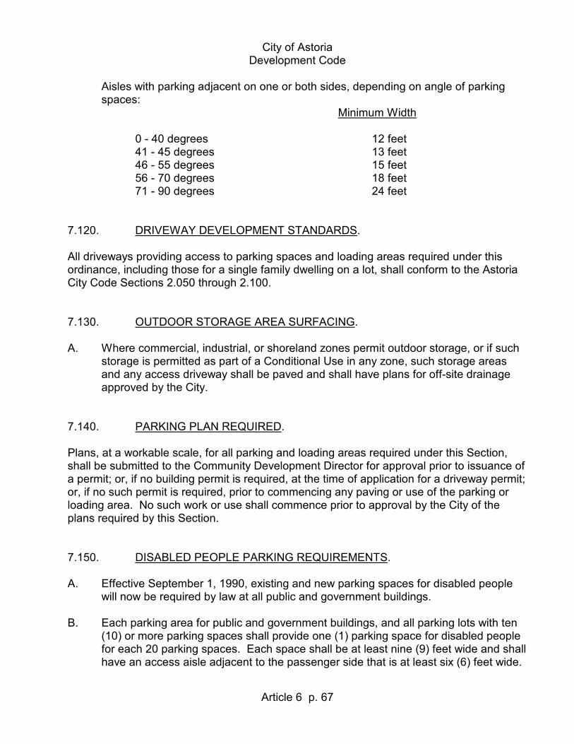
City of Astoria Development Code
Article 6 p. 67
Aisles with parking adjacent on one or both sides, depending on angle of parking spaces:
Minimum Width 0 - 40 degrees 12 feet 41 - 45 degrees 13 feet 46 - 55 degrees 15 feet 56 - 70 degrees 18 feet 71 - 90 degrees 24 feet 7.120. DRIVEWAY DEVELOPMENT STANDARDS. All driveways providing access to parking spaces and loading areas required under this ordinance, including those for a single family dwelling on a lot, shall conform to the Astoria City Code Sections 2.050 through 2.100. 7.130. OUTDOOR STORAGE AREA SURFACING. A. Where commercial, industrial, or shoreland zones permit outdoor storage, or if such
storage is permitted as part of a Conditional Use in any zone, such storage areas and any access driveway shall be paved and shall have plans for off-site drainage approved by the City.
7.140. PARKING PLAN REQUIRED. Plans, at a workable scale, for all parking and loading areas required under this Section, shall be submitted to the Community Development Director for approval prior to issuance of a permit; or, if no building permit is required, at the time of application for a driveway permit; or, if no such permit is required, prior to commencing any paving or use of the parking or loading area. No such work or use shall commence prior to approval by the City of the plans required by this Section. 7.150. DISABLED PEOPLE PARKING REQUIREMENTS. A. Effective September 1, 1990, existing and new parking spaces for disabled people
will now be required by law at all public and government buildings. B. Each parking area for public and government buildings, and all parking lots with ten
(10) or more parking spaces shall provide one (1) parking space for disabled people for each 20 parking spaces. Each space shall be at least nine (9) feet wide and shall have an access aisle adjacent to the passenger side that is at least six (6) feet wide.

City of Astoria Development Code
Article 6 p. 68
The adjacent aisle shall be part of the accessible route to the building or facility. C. In accordance with ORS 447.233, each parking area for public use shall provide one
(1) "van accessible" parking space. One (1) additional van accessible parking space shall be provided for every eight (8) handicapped accessible spaces provided.

City of Astoria Development Code
7.160
Article 6 p. 69
7.160. MINIMUM LOADING SPACE REQUIREMENTS. USE OR GROSS SQUARE MINIMUM MINIMUM SIZE OF SPACE FOOTAGE OF FLOOR AREA NO. OF SPACES WIDTH LENGTH HEIGHT A. Multi-Family Dwelling Units. 0 - 49 Units 0 12 ft 19 ft 12 ft 50 - 99 Units 1 " " " 100 - 199 Units 2 " " " 200 and over Units 3 " " " If a recreational or service building is provided, at least one of the required loading
spaces shall be located in conjunction with the recreational or service building. B. For Buildings Used Entirely for Office Occupancy. Under 5,000 sq ft 0 12 ft 30 ft 14 ft 5,000 - 59,999 sq ft 1 " " " 60,000 - 249,999 sq ft 2 " " " For each additional 100,000 square feet of any portion thereof over 250,000 square
feet, one additional loading space. C. Commercial, Non-office, Public and Semi-Public. Under 5,000 sq ft 0 12 ft 55 ft 14 ft 5,000 - 59,999 sq ft 1 " " " 60,000 - 249,999 sq ft 2 " " " For each additional 100,000 square feet of any portion thereof over 250,000 square
feet, one additional loading space. D. Industrial. Under 5,000 sq ft 0 12 ft 55 ft 14 ft 5,000 - 99,999 sq ft 1 " " " 100,000 - 239,999 sq ft 3 " " " 240,000 - 319,000 sq ft 5 " " " 320,000 - 399,000 sq ft 6 " " " 400,000 - 489,999 sq ft 7 " " " 490,000 - 579,999 sq ft 8 " " " 580,000 - 669,999 sq ft 9 " " " 670,000 - 759,999 sq ft 10 " " " For each additional 100,000 square feet or any portion thereof over 760,000 square
feet, an additional loading space is required.

City of Astoria Development Code
7.160
Article 6 p. 70
7.170. LANDSCAPING OF OUTDOOR STORAGE OR PARKING AREAS. A minimum of 5% of the gross parking lot area shall be designed and maintained as landscaped area, subject to the standards in Sections 3.105 through 3.120. This requirement shall apply to all parking lots with an area of 600 square feet or greater. Approved sight obscuring fences or vegetative buffers shall be constructed where commercial parking lots abut Residential Zones. The minimum 5% landscaping shall be counted as part of the total landscaping required for the property. 7.180. PARKING IN THE DOWNTOWN AREA. Uses in the C-4 Zone (Central Commercial) and uses between 8th and 14th Streets in the A-2 (Acquatic Two Development) and S-2A Zones (Tourist Oriented Shoreland) are not required to provide off-street parking or loading. Exception: In the C-4 Zone, off-street parking and loading requirements shall apply to Lots 1, 2, 3, Block 40, McClure’s Addition (south side of 600 Block Duane Street). (7.180 Exception added by Ordinance 99-21, 11-1-99) Return to Article 7 Return to Table of Contents

City of Astoria Development Code
Article 8 - Page 71 (Adopted 10-8-92)
ARTICLE 8
SIGN REGULATIONS 8.010. PURPOSE. The purpose of this Section is to regulate the number, size, placement and physical characteristics of signs in order to achieve the following objectives: 1. The maintenance of public safety and traffic safety by ensuring that signs are
appropriately designed, constructed, installed and maintained. 2. The enhancement of the operation of businesses in the City by promoting the
reasonable, orderly and effective display of signs. 3. The enhancement of the City's physical appearance by promoting signs which
are visually compatible with their surroundings and preserve the visual integrity of the area.
(Section 8.010.3 amended by Ordinance 04-04, 5-3-04) 8.020. ADOPTION OF UNIFORM SIGN CODE. The City of Astoria enforces the State building code per ORS Chapter 455 and the rules adopted there under by reference, except as modified in this Code. (Section 8.020 amended by Ordinance 04-04, 5-3-04) 8.030. CONFORMANCE. No sign may be erected or allowed to remain unless it conforms with the regulations of Sections 8.010 through 8.180. Sign permits, as required by 8.060, must be approved prior to the placement of a sign. All signs in historic districts, or in conjunction with historic buildings or sites subject to the Historic Landmarks Code must be approved through the review process outlined in Sections 6.050 and 6.090. (Section 8.030 amended by Ordinance 04-04, 5-3-04)

City of Astoria Development Code
Article 8 - Page 72 (Adopted 10-8-92)
8.040. EXEMPT SIGNS. A. The following signs are permitted and are exempt from the requirements of this
Code: 1. Building plaque, cornerstone, or similar building identification which is an
integral and normal part of a building. 2. House and building numbers, not to exceed four (4) square feet, with numbers
not exceeding 12 inches in height. 3. Decorative banners in residential zones not exceeding six (6) square feet. 4. Official informational signs, traffic signs, kiosks, signals, notices, and
decorative and event banners. 5. Historical markers erected or maintained by public authority or by a
recognized historical organization. 6. Historical signs, and reproductions of historic signs. (Section 8.040.A.6 amended by Ordinance 04-04, 5-3-04) 7. A wall sign for an approved home occupation not exceeding one (1) square
foot. 8. Directional signs, each not exceeding four (4) square feet. 9. Flags of local, state, or national origin. 10. Signs located within a building, except window signs. 11. Informational signs, such as hours of operation, accepted cards, and similar
signs not exceeding one (1) square foot for groups of related signage. Open and closed signs not exceeding 1.5 square feet.
(Section 8.040.A.11 amended by Ordinance 04-04, 5-3-04) 12. Signs, not exceeding 24 square feet, in residential zones which are used for
the identification of public and semi-public uses. 13. One short term real estate sign for each street frontage located on the
premises for sale, lease or rent, not exceeding six (6) square feet, provided they are removed within 14 days after the transaction has been completed.

City of Astoria Development Code
Article 8 - Page 73 (Adopted 10-8-92)
(Section 8.040.A.13 amended by Ordinance 04-04, 5-3-04) 14. Political signs, located on private property. Political signs related to an
election shall be removed 14 days after the election. Political signs not meeting this exemption shall comply with the sign code regulations and permit process.
(Section 8.040.A.14 amended by Ordinance 04-04, 5-3-04) 15. Signs located on buildings in aquatic zones not visible from a public street or
right-or-way, not exceeding 32 square feet. 16. Signs affixed to the face of individual gas pumps located at gasoline service
station. 17. Portable signs which are located within a street right-of-way in accordance
with City Code Section 5.060. (Section 8.040.A.17 added by Ordinance 00-11, 12-4-00) 18. Short term signs, in the nature of decorations, clearly incidental to and
customarily and commonly associated with any national, local, or religious holiday.
(Section 8.040.A.18 added by Ordinance 04-04, 5-3-04) 8.050. PROHIBITED SIGNS. A. The following signs are prohibited: 1. Strobe lights and signs containing strobe lights. 2. Spot lights and beacons, except for special community wide events by permit. 3. Signs which flash, revolve, rotate, swing, undulate or otherwise attract
attention through the movement or flashing of parts of the sign, including inflatable signs, large balloons, flags, pennants, or similar devices.
This prohibition does not include the following signs: a. barber poles of maximum of 4’ in total fixture height may rotate; b. changeable text signs;

City of Astoria Development Code
Article 8 - Page 74 (Adopted 10-8-92)
c. time and temperature signs. (Section 8.050.A.3 amended by Ordinance 04-04, 5-3-04; amended by
Ordinance 12-03, 1-3-12) 4. (Section 8.050.A.4 deleted by Ordinance 04-04, 5-3-04) 5. Abandoned or deteriorated signs. 6. Public address systems or sound devices for advertising purposes. 7. Backlit awning signage is prohibited in the area bounded by Exchange Street
on the south, the pierhead line on the north, 8th Street on the west, and 16th Street on the east; or within the Gateway Master Plan Area.
(Section 8.050.A.7 amended by Ordinance 04-04, 5-3-04) 8. No unofficial sign which purports to be, is an imitation of, or resembles an
official traffic sign or signal, or which attempts to direct the movement of traffic, or which hides from view any official traffic sign or signal.
9. Animation Signs. (Section 8.050.A.9 added by Ordinance 04-04, 5-3-04) 10. Changeable text signs on a vacant lot. (Section 8.050.A.10 added by Ordinance 04-04, 5-3-04) 11. Off-premise changeable text signs. (Section 8.050.A.11 added by Ordinance 04-04, 5-3-04) 8.060. SIGN PERMITS. A. Sign Permit Required. A sign permit is required for the erection of any new sign or the structural alteration
of an existing sign, except those signs that are exempt in Section 8.040. A sign permit is required for modification or alteration of the sign face, or any portion of the sign or supporting structure.
(Section 8.060.A amended by Ordinance 04-04, 5-3-04)

City of Astoria Development Code
Article 8 - Page 75 (Adopted 10-8-92)
B. Required Information For a Sign Permit. For purposes of review by the Community Development Director, a scale drawing of
the proposed sign shall be submitted. The drawing shall include: 1. The dimensions of the sign; 2. Location of the sign; 3. Any structural elements of the proposed sign; and 4. The size, location, and dimensions of any other sign(s) located on the
applicant's building or property. (Section 8.060.B.4 amended by Ordinance 04-04, 5-3-04) 5. A site plan indicating the dimension of the building frontage and/or site
frontage. (Section 8.060.B.5 added by Ordinance 04-04, 5-3-04) 6. In addition to any other application requirements listed above, all changeable
text sign applications shall include the following: a. Manufacturer’s information on the operation, illumination, and ability of
the sign to comply with the regulations and standards in this Code. b. Diagram with at least two sample messages for the proposed activity
utilizing the lighting capabilities of the proposed sign. (Section 8.060.B.6 added by Ordinance 04-04, 5-3-04) C. Sign Permit Fee. The fee for a sign permit shall be established by Resolution. (Section 8.060.C amended by Ordinance 04-04, 5-3-04)

City of Astoria Development Code
8.120
Article 8 - Page 76 (Adopted 10-8-92)
8.070. GENERAL SIGN REGULATIONS. The following general provisions shall govern all signs, in addition to all other applicable provisions pertaining to signs: A. Sign Face Area. 1. The area of sign faces enclosed in frames or cabinets is determined based on
the outer dimensions of the frame or cabinet surrounding the sign face [See 8.120(A.1), Figure 1]. Sign area does not include foundations, supports, and other essential structures which do not serve as a backdrop or border to the sign. Only one (1) side of a double faced sign is counted in measuring the sign face area, except for a double faced changeable text sign.
(Section 8.070.A.1 amended by Ordinance 04-04, 5-3-04) 2. When signs are constructed of individual elements attached to a building wall,
the sign area is determined by calculating the area of an imaginary rectangle drawn around the sign elements [See 8.120(A.2), Figure 2].
3. Several businesses may use one sign as long as the area they each use does
not exceed their own allowable square footage, and the total area of the sign does not exceed that allowed in the zone.
4. The area of sign faces for round or three dimensional signs is determined by
the maximum sign face area visible at one time. 5. When a sign is incorporated into an awning or marquee, only the sign area as
determined by a perimeter drawn around the individual elements is counted as the sign face.
6. For sign structures containing multiple sign modules oriented in the same
direction, the sign area is determined by calculating the area of an imaginary rectangle drawn around the sign elements [See 8.120(A.3), Figure 3].
7. Sign area square footage is based on frontage. Freestanding and monument
signs are based on the site frontage, all other signs are based on the building frontage.
(Section 8.070.A.7 added by Ordinance 12-03, 1-3-12) B. Height of Signs. The overall height of a sign or sign structure is measured from the existing grade

City of Astoria Development Code
8.120
Article 8 - Page 77 (Adopted 10-8-92)
directly below the sign to the highest point of the sign or sign structure [See 8.120(B.1), Figure 4].
C. Clearances. Clearances are measured from the existing grade directly below the sign to the
bottom of the sign structure enclosing the sign face [See 8.120(C.1), Figure 5]. D. Corner Signs. Corner signs facing more than one (1) street shall be assigned to a frontage by the
applicant. The sign must meet all provisions for the frontage it is assigned to. E. Sign Placement. 1. Placement. All signs and sign structures shall be erected and attached totally
within the site except when allowed to extend into the right-of-way. 2. Frontages. Signs allowed based on the length of one (1) site frontage may
not be placed on another site frontage. a. Exception. If a portion of a building facade or site line is more suited for signage
than the allowable frontage, an applicant may choose to use that building facade or site line in lieu of the allowable frontage. The square footage of the sign shall be calculated on the length of the newly selected building facade or site line or on the allowable frontage, whichever is smaller. In choosing this exception, the applicant shall relinquish the right to install signage on the other allowable frontage unless a variance is granted.
(Section 8.070.E.2 amended by Ordinance 04-04, 5-3-04) 3. Vision Clearance Areas. No sign may be located within a vision clearance
area as defined in Section 3.045. No support structure(s) for a sign may be located in a vision clearance area unless the combined total width is 12 inches or less and the combined total depth is 12 inches or less.
4. Vehicle Area Clearances. When a sign extends over a private area where
vehicles travel or are parked, the bottom of the sign structure shall be at least 14 feet above the ground. Vehicle areas include driveways, alleys, parking lots, and loading and maneuvering areas.
5. Pedestrian Area Clearances. When a sign extends over sidewalks, walkways

City of Astoria Development Code
8.120
Article 8 - Page 78 (Adopted 10-8-92)
or other spaces accessible to pedestrians, the bottom of the sign structure shall be at least eight (8) feet above the grade except for pedestrian signs located below marquees, canopies, or awnings which shall be at least seven and one half (7.5) feet above the grade.
(Section 8.070.E.5 amended by Ordinance 04-04, 5-3-04) 6. Required Yards and Setbacks. Signs may be erected in required yards and
setbacks. F. Signs Not to Constitute a Traffic Hazard. Signs or sign supporting structures shall not be located so as to detract from a
motorist's view of vehicular or pedestrian traffic or a traffic sign. G. Glare. All signs shall be so designed and located so as to prevent the casting of glare or
direct light from artificial illumination upon adjacent publicly dedicated roadways and surrounding property.
H. Removal of Abandoned Sign. It is the responsibility of the property owner to remove any abandoned sign within 90
days of cessation of use. I. Materials. A sign subject to a permit shall meet the material and construction methods
requirements of the Uniform Sign Code. J. Maintenance. All signs, together with their supporting structures, shall be kept in good repair and
maintenance. Signs shall be kept free from excessive rust, corrosion, peeling paint, or other surface deterioration. The display surfaces and vegetation surrounding all signs shall be kept in a neat appearance.
K. Through the Block Signage. Buildings which contain frontage on two parallel arterial streets, or on an arterial
street and a waterway, shall be entitled to twice the allowable total square footage for the zone in which it is placed. [See 8.070(E.2)]. This double allowance affects only the overall total square footage for the site. The maximum square footage of each individual sign, the square footage for the frontage, the number of signs, location,

City of Astoria Development Code
8.120
Article 8 - Page 79 (Adopted 10-8-92)
and other attributes of the sign are not affected by this allowance. (Section 8.070.K amended by Ordinance 04-04, 5-3-04) 8.080. SPECIFIC SIGN REGULATIONS (Applicable to All Zones). A. Wall or Roof Signs. 1. Projection. Signs may project a maximum of 12 inches from the face of the
building to which they are attached, provided the lowest portion of the sign is at least eight (8) feet above grade. Any portion lower than eight (8) feet may only project four (4) inches.
2. Extension above roof line. Unless otherwise specified, signs may not project
more than four (4) feet above the eaves of the primary roof structure of a pitched roofed building, or more than two (2) feet above the eave or parapet of the primary roof structure of a flat roofed building.
B. Marquee, Canopy or Awning Signs. 1. Projection. Signs attached to the face of a marquee, canopy, or awning shall
not project more than three (3) inches from the surface. 2. Projection of pedestrian signs. Pedestrian signs may not project beyond or
above the face of the marquee, canopy, or awning. 3. Height. Pedestrian signs shall have a maximum face height of nine (9)
inches. 4. Clearance above grade. The lowest portion of a sign attached to a marquee,
canopy, or awning shall not be less than seven and one-half (7.5) feet above grade.
C. Projecting Signs. 1. Projection. Signs may project from the face of the building to which they are
attached as follows: a. A maximum of one (1) foot if located eight (8) feet above grade; b. Two (2) feet if located nine (9) feet above grade; or c. Four and one-half (4.5) feet if located ten (10) feet or more above

City of Astoria Development Code
8.120
Article 8 - Page 80 (Adopted 10-8-92)
grade. d. Six (6) feet if located 12 feet or more above grade. They must be mounted at a right angle to the plane of the building facade
except signs located on the corner of a building. (Section 8.080.C.1 amended by Ordinance 04-04, 5-3-04) 2. Height and extension above roof line. Signs shall not extend above the eaves
of the primary roof structure of any pitched roof building to which they are attached, or be lower than eight (8) feet above grade. Signs may extend a maximum of two (2) feet above the facade or parapet of the primary roof structure of any flat roofed building.
3. Clearance above grade. Projecting signs not occurring under marquees,
canopies, or awnings shall maintain a clearance of not less than eight (8) feet from the underlying sidewalk.
4. Angle of sign. The angle between the two sides of a projecting sign may not
be greater than 30o, and the two sides may not be visible at the same time from adjacent properties or streets. Signs that are greater than 30o shall be counted as two signs in number and square footage.
(Section 8.080.C.4 added by Ordinance 04-04, 5-3-04) D. Freestanding Signs. 1. Signs may extend into the right-of-way a maximum of four and one-half (4.5)
feet, and shall not be less than ten (10) feet from the underlying sidewalk. (Section 8.080.D.1 amended by Ordinance 04-04, 5-3-04) 2. Diagonal corner signs may extend into the right-of-way to a point that is
determined by extending a line from the maximum points allowed for a standard projecting sign on the same site frontage.
3. Supporting structures shall be located within the property line. E. Wall Graphics. 1. Except as noted in Section E.3 below, designs shall be evaluated by the
Planning Commission on a case by case basis in order to determine appropriateness to the area. The Planning Commission may approve, deny, or modify requests, in accordance with Sections 9.010 through 9.100, based

City of Astoria Development Code
8.120
Article 8 - Page 81 (Adopted 10-8-92)
on their evaluation of: a. The appropriateness of the work in terms of color, scale, location and
design; and b. The impact on surrounding buildings, views and vistas. (Section 8.080.E.1 amended by Ordinance 04-04, 5-3-04) 2. The square footage of a wall graphics is not calculated as part of the
allowable area of signage or number of signs associated with a business site, use, or activity.
3. A wall graphic proposed to be located on a historic structure or site, adjacent
to or across the right-of-way from a historic structure or site, within a National Register Historic District, or adjacent to or across the right-of-way from a National Register Historic District shall be evaluated by the Historic Landmarks Commission on a case by case basis in order to determine appropriateness to the area. The Historic Landmarks Commission may approve, deny, or modify requests, in accordance with Sections 9.010 through 9.100, based on their evaluation of:
a. The appropriateness of the work in terms of color, scale, location and
design; and b. The impact on surrounding historic structures or sites; and c. The impact on surrounding buildings, views and vistas. (Section 8.080.E.3 added by Ordinance 04-04, 5-3-04) F. Removal of Signs. When a sign is proposed, or when roadways are widened, or other improvements
made in the right-of-way, which create unsafe conditions due to a sign extending into the right-of-way, the City Engineer may protect the public safety by requiring the sign to be modified or removed. The modification or removal shall be at the owner's expense.
G. Permanent Window Signs. Permanent window signs shall be included and calculated as “wall signs” except as
follows: 1. Number. Permanent window signage less than twelve (12) square feet is

City of Astoria Development Code
8.120
Article 8 - Page 82 (Adopted 10-8-92)
exempt from the total number of signs per frontage. 2. Area. All permanent window signage shall be included in the total allowable
wall sign area for the business, building, use or activity. (Section 8.080.G added by Ordinance 04-04, 5-3-04) H. Directional Signs. Directional signs, where allowed, shall meet the provisions listed below. Directional
signs shall be designed only for non-changing messages or displays. 1. Maximum Sign Face Area. Six (6) square feet. 2. Types of Signs Allowed. Freestanding, wall, projecting, monument. (Section 8.080.H.2 amended by Ordinance 04-04, 5-3-04) 3. Maximum Height. Freestanding or monument not to exceed 42 inches; wall
not to exceed eight (8) feet; and projecting not to exceed ten (10) feet. (Section 8.080.H.3 amended by Ordinance 04-04, 5-3-04) 4. Extensions into Right-of-way. Not Allowed. 5. Lighting. Indirect or Internal. 6. Flashing Lights. Not allowed. 7. Changeable Text Signs or Electronic Message Centers. Not Allowed. (Section 8.080.H.7 amended by Ordinance 04-04, 5-3-04) 8. Moving or Rotating Parts. Not Allowed. I. Clear Vision Area. Refer to Section 3.045. J. Signs on Historic Properties or in Historic Districts. Refer to Article 6. Also see specific requirements as noted in various sections of
Article 8. (Section 8.080.J amended by Ordinance 04-04, 5-3-04)

City of Astoria Development Code
8.120
Article 8 - Page 83 (Adopted 10-8-92)
K. Temporary Signs. 1. Time Limit. Temporary signs and support structures, if any, must be removed
within 30 days of date of erection. Temporary signs erected for longer than 30 days are considered permanent signs and subject to the regulations for permanent signs.
2. Waiting Period. There shall be a 30 day waiting period before another exterior
temporary sign, including banners, shall be displayed. 3. Attachment. Temporary signs may not be permanently attached to the
ground, buildings, or other structures. Temporary signs are not required to be located on a frontage.
3. Lawn Signs. Lawn signs may not be greater than nine (9) square feet in area
and may not be over 40 inches in height. 4. Banners. One banner is allowed per building frontage and may not exceed 24
square feet. 5. Opening or Coming Soon Signs. a. Temporary signs indicating an upcoming opening may not exceed 24
square feet and shall comply with the other requirements for temporary signage.
b. Short term signs indicating an upcoming construction of a new building
or expansion of an existing building may not exceed 32 square feet. These signs may remain for a maximum of one year and shall be removed within 30 days of the building occupancy. These signs are not required to be located on a frontage.
(Section 8.080.K.5 added by Ordinance 04-04, 5-3-04) 6. Permits. Temporary banner style signs and lawn signs shall not require a
sign permit. All other temporary or short term signs affixed to a building or site require a permit and shall be subject to the requirements of Section 8.060.
(Section 8.080.K.6 added by Ordinance 04-04, 5-3-04) L. Portable Signs. 1. Exemption.

City of Astoria Development Code
8.120
Article 8 - Page 84 (Adopted 10-8-92)
a. Portable Signs which are located within a street right-of-way shall comply with City Code Section 5.060, “Obstructions in Passageways”, and are exempt from the requirements of the Sign Code in Astoria Development Code Article 8.
b. Temporary Portable Signs which are in conjunction with a community-
wide event or festival such as, but not limited to, the Scandinavian Festival or Regatta are exempt from the requirements of the Sign Code in Astoria Development Code Article 8.
2. Standards. All portable signs, except those exempted in subsection (1)
above, shall be in accordance with the following: a. Location. The sign shall not be located within a street right-of-way. b. Number of Signs. Only one non-exempt Portable Sign shall be allowed
for each business, use, or activity. Sites without buildings shall be allowed no more than one non-exempt Portable Sign. The sign shall not be included in the total number of signs allowed.
c. Area. 1) A sign of eight (8) square feet or less on each side with a
maximum height not to exceed four (4) feet and a maximum width not to exceed two (2) feet shall be exempt from the total square footage of sign area allowed.
2) A sign exceeding eight (8) square feet on each side or a height
greater than four (4) feet or a maximum width greater than two (2) feet shall be included in the total square footage of sign area allowed for the site.
d. Frontage. The sign may be located on any elevation of a business,
use, activity, or site and is exempt from the requirement that signs be located on a frontage.
e. Lighting. The sign shall not be electric nor internally illuminated. f. Enforcement. In addition to any other method of enforcement available
to the City, this ordinance may be enforced by the removal of the sign by the City. The City will notify the permittee to reclaim the sign. If the sign is not claimed within 30 days after the permittee is notified, the City may dispose of the sign.
(Section 8.080.L added by Ordinance 00-11, 12-4-00)

City of Astoria Development Code
8.120
Article 8 - Page 85 (Adopted 10-8-92)
M. Changeable Text Signs. 1. Exception. Electronic signs that display time and temperature only are exempt from the
requirements of Section 8.080(M). 2. Design Review. a. Astoria Planning Commission. All changeable text signs shall be reviewed as a Miscellaneous Review
permit by the Astoria Planning Commission in accordance with Article 9 of the Astoria Development Code.
b. Historic Landmarks Commission. All changeable text signs located on a site designated as historic, within
a National Register Historic District, on adjacent to or across a right-of-way from a historic site or National Register Historic District shall be reviewed by the Historic Landmarks Commission in accordance with Article 9 of the Astoria Development Code.
c. Sign Permit Application. In addition to any other application requirements listed in the Astoria
Development Code, all changeable text sign applications shall include manufacturer’s information on the operation, illumination, and ability of the sign to comply with the regulations and standards in this Code. The applicant shall also submit a diagram with at least two sample messages for the proposed activity utilizing the lighting capabilities of the proposed sign.
3. Design Review Standards. a. Astoria Planning Commission: The Astoria Planning Commission may approve a changeable text sign
if it is compatible with the overall character to be achieved in the area and shall base its compatibility determination on the following criteria:
1) The relationship of the scale and placement of the sign to the
building or premises on which it is displayed.

City of Astoria Development Code
8.120
Article 8 - Page 86 (Adopted 10-8-92)
2) The similarity or dissimilarity of the sign’s size and shape to the size and shape of other conforming signs in the area.
3) The compatibility of the type and intensity of the illumination of
the sign with the type and intensity of other conforming illuminations in the area.
4) The compatibility of the sign to the form and architectural
character of the building in which the activity is located and the compatibility of the sign with existing adjacent activities.
5) The sign illumination shall not unreasonably intrude into
residential zones. 6) The sign shall not unreasonably block nor visually impair scenic
or historic views. b. Historic Landmarks Commission: The Historic Landmarks Commission may approve a changeable text
sign if it is compatible with the overall character to be achieved in the area and shall base its compatibility determination on the following criteria:
1) Placement of the sign will have the least possible loss of historic
material. 2) Placement of the sign will not obscure, damage, or destroy
character defining features. 3) The sign structure shall reference design motifs from the historic
building or historic signs found on similar architectural style buildings. However, the sign structure shall be clearly differentiated from the historic building features.
4) The compatibility of the sign to the form and architectural
character of the building in which the activity is located and the compatibility of the sign with existing adjacent activities.
4. Standards. All changeable text signs, except those exempted in Section 8.080(M.1)
above, shall be in accordance with the following: a. Type of Sign. The sign shall be limited to monument, wall, or projecting

City of Astoria Development Code
8.120
Article 8 - Page 87 (Adopted 10-8-92)
sign. 1) An approved freestanding changeable text sign existing prior to
January 1, 2004 shall be allowed with a maximum height of 10’. b. Location. 1) The sign shall be located only in areas along a street or highway
having a speed limit of 35 miles per hour or less. 2) The sign shall not be located within 3,000 feet of another
changeable text sign. The distance shall be determined at a 360o radius from the location of the sign.
3) The sign shall not be located on a vacant lot. c. Number of Signs. 1) Only one changeable text sign shall be allowed for each
business, use, or activity. 2) A changeable text sign shall not be allowed in conjunction with
any other freestanding sign. 3) A monument or projecting changeable text sign shall not be
allowed in conjunction with another sign of the same type (i.e. another monument or projecting sign).
d. Area. 1) The area of a sign with changeable text on more than one
independent side of the sign shall be calculated for each side of the changeable text sign. However, both sides will be counted as just one sign for calculating the number of signs.
2) In addition to other area requirements of the specific zones, the
maximum total square footage of changeable text signs shall be as follows:
a) Monument sign shall be limited to 30 square feet for one
side. This limitation is for the changeable text portion of the sign only. A two sided changeable text sign shall be allowed 30 square feet on each side.
b) Projecting sign shall be limited to 15 square feet for one

City of Astoria Development Code
8.120
Article 8 - Page 88 (Adopted 10-8-92)
side. This limitation is for the changeable text portion of the sign only. A two sided changeable text sign shall be allowed 15 square feet on each side.
e. Operation of Sign. 1) Each sign or message shall remain fixed for at least ten
seconds. No sign shall contain animation. 2) When a message is changed, it shall be accomplished
immediately and shall not scroll, move, or otherwise change gradually.
3) The sign shall contain a default design that will freeze the sign in
one position if a malfunction occurs. (Section 8.080.M added by Ordinance 04-04, 5-3-04) N. Signs for Upper or Basement Floors. 1. Street Frontage. a. Number. The total number of signs for a separate business, use or
activity in an upper story or basement of a building with street frontage shall be the same as buildings at street level. An upper floor or basement may have one sign at street level identifying the upstairs or basement activity.
b. Area. The total area of signs for an upper story or basement of a
building with street frontage shall not exceed 20% of the lineal footage of the building facade occupied by the business, use or activity, or the maximum allowed by the zone, whichever is less. A street level sign shall not exceed four (4) square feet.
2. Without Street Frontage. a. Number. The total number of signs for a separate business, use or
activity in an upper story or basement of a building without street frontage shall be one sign.
b. Area. The total area of signs for an upper story or basement of a
building without street frontage shall not exceed four (4) square feet. (Section 8.080.N added by Ordinance 04-04, 5-3-04)

City of Astoria Development Code
8.120
Article 8 - Page 89 (Adopted 10-8-92)
(Section 8.090 deleted by Ordinance 00-11, 12-4-00) 8.100. NONCONFORMING SIGNS. For the purpose of this Section, a non-conforming sign shall be defined as a lawfully erected sign existing at the effective date of this Chapter which could not be erected under the terms of this Chapter. The following requirements shall apply to non-conforming signs: A. Non-conforming signs in all zones: Non-conforming signs shall be altered to conform
to the provisions of this Section by January 1, 1995. B. No non-conforming sign may be enlarged or altered in a way which increases its
non-conformity. C. Should any non-conforming sign be damaged by any means to an extent of more
than 50% of its replacement costs at the time of damage, it shall be reconstructed in conformity with the provisions of this Section.
D. Any variance to sign standards, legally granted after January 1, 1982, shall be valid
notwithstanding other provisions of this Code. 8.110. VARIANCES. A. Astoria Planning Commission: Variances to the sign regulations of this Section may be approved by the Planning
Commission following the procedures of Section 12.060 to 12.120 where the Planning Commission finds that the variance meets the following criteria:
1. One of the following factors exists: a. The variance would permit the placement of a sign with an exceptional
design or style. b. The variance would permit the placement of a sign which is more
consistent with the architecture, and development of the site. c. The existence of an unusual site characteristic, such as topography,
existing development, or adjacent development, which precludes an allowable sign from being effectively visible from the public roadway adjacent to the site.
d. The requirement to remove a sign under Section 8.100(A) would
constitute a severe or extreme economic hardship to the business or
City of Astoria Development Code
8.120
Article 8 - Page 90 (Adopted 10-8-92)
activity involved. 2. The granting of the variance would not be detrimental to abutting properties. 3. The granting of the variance would not create a traffic or safety hazard. 4. Sign variances are exempt from Sections 12.030 through 12.040. 5. In addition to the criteria above, a sign variance for changeable text sign
relative to location within 3,000’ of another changeable text sign shall meet the following criteria:
a. No more than one sign shall be visible at the same time from any
location. Visible shall be defined as “discernable by the naked eye as a changeable text sign.”
b. The total number of changeable text signs in the City shall not exceed
eight (8) signs. (Section 8.110.A.5 added by Ordinance 04-04, 5-3-04) B. Prohibited Variances: 1. A variance shall not be granted for changeable text signs for any requirement
or limitation listed in Section 8.080(M) for the following: a. Location. 1). Relative to speed limit (see 8.080.M.4.b). 2). Relative to location on a vacant lot (see 8.080.M.4.b.3). b. Number of Signs (see 8.080.M.4.c). {This will limit the number of signs and how they relate to other types of
signage.} c. Operation of Sign (see 8.080.M.4.e). (Section 8.110.B added by Ordinance 04-04, 5-3-04) C. Administrative: Variances to the sign regulations of this Section may be reviewed administratively by
the Community Development Director following the procedures of Section 12.060 to

City of Astoria Development Code
8.120
Article 8 - Page 91 (Adopted 10-8-92)
12.120. The variance shall meet the following criteria for approval: 1. The variance shall be limited to the following: a. Location on a frontage; b. Number of signs increased by only one additional sign; c. Other quantitative standards of 10% or less. 2. One of the following factors exists: a. The variance would permit the placement of a sign with an exceptional
design or style. b. The variance would permit the placement of a sign which is more
consistent with the architecture, and development of the site. c. The existence of an unusual site characteristic, such as topography,
existing development, or adjacent development, which precludes an allowable sign from being effectively visible from the public roadway adjacent to the site.
d. The requirement to remove a sign under Section 8.100(A) would
constitute a severe or extreme economic hardship to the business or activity involved.
3. The granting of the variance would not be detrimental to abutting properties. 4. The granting of the variance would not create a traffic or safety hazard. 5. Sign variances are exempt from Sections 12.030 through 12.040. (Section 8.110.C added by Ordinance 04-04, 5-3-04) 8.120. DIAGRAMS. The following diagrams shall be used for determining sign and building measurements. A. Sign Face Measurement. 1. Figure 1.

City of Astoria Development Code
8.120
Article 8 - Page 92 (Adopted 10-8-92)
2. Figure 2. 3. Figure 3.
(π = 3.14)

City of Astoria Development Code
8.120
Article 8 - Page 93 (Adopted 10-8-92)
B. Sign Height. 1. Figure 4. A = Height. C. Sign Clearance. 1. Figure 5. B = Clearance.

City of Astoria Development Code
8.120
Article 8 - Page 94 (Adopted 10-8-92)
D. Building Frontage Measurement. 1. Figure 6. 2. Figure 7. 3. Figure 8. (Section 8.120.D amended by Ordinance 12-03, 1-3-12)
Allowable Building Frontage: 40’ on north side 40’ on west side
Allowable Building Frontage: 160’ on north side 100’ on east side 100’ on west side
100’
Allowable Building Frontage: 90’ on north side 30’ on east side
NO
RTH
NO
RTH
N
OR
TH

City of Astoria Development Code
SBHO Zone
Article 8 - Page 95 (Adopted 10-8-92)
8.130. BASE ZONE REGULATIONS. In addition to conformance with the sign regulations of Sections 8.020 through 8.180, all uses and sites within a specific zone shall conform to the types, numbers, sizes, and features of signs allowed in that specific zone. 8.140. C-1 ZONE SIGN REGULATIONS. For all uses and sites in the C-1 Zone (Neighborhood Commercial), the following types, numbers, sizes, and features of signs are allowed. All allowed signs must also be in conformance with the sign regulations of Sections 8.070 through 8.080. A. Total Square Footage Permitted. The total square feet of all signage associates with a business site, use, activity,
or site shall not exceed 32 square feet. B. Freestanding or Monument Signs. 1. Number. One (1) freestanding or monument sign is allowed per site. 2. Area. Freestanding or monument signs are allowed based on one (1)
square foot of sign face area per lineal foot of site frontage, up to a maximum of 32 square feet.
3. Height. The maximum height of a freestanding or monument sign shall be
six (6) feet. (Section 8.140.B amended by Ordinance 04-04, 5-3-04) C. Signs Attached to Buildings. 1. Number. The number of signs is limited to two (2). Only one (1)
projecting sign, or wall sign is allowed per building frontage. 2. Area. The total allowable area for all permanent signs attached to the
building shall be one (1) square foot of sign face area per lineal foot of the building frontage, or 32 square feet, whichever is less.

City of Astoria Development Code
SBHO Zone
Article 8 - Page 96 (Adopted 10-8-92)
3. Types of signs. Wall, projecting, marquee, awning and window signs are allowed.
(Section 8.140.C.3 amended by Ordinance 04-04, 5-3-04) D. Number of Signs. The number of signs within the total allowable area is limited to one (1) sign per
building frontage. E. Temporary Signs. Temporary signs not exceeding a total of six (6) square feet are allowed. F. Portable Signs. Portable Signs are allowed in accordance with Development Code Sections
8.040 and 8.080. (Section 8.140.F added by Ordinance 00-11, 12-4-00) 8.150. C-2, C-3, GI, S-1, S-2, A-1, A-2, A-2A, LS, HR, CA, HC, AH-HC, FA
ZONE SIGN REGULATIONS. For all uses and sites in the C-2 (Tourist Commercial), C-3 (General Commercial), S-1 (Marine Industrial Shorelands), S-2 (General Development Shorelands), A-1 (Aquatic One Development), A-2 (Aquatic Two Development), A-2A (Aquatic Two A Development), LS (Local Service), HR (Hospitality/Recreation), CA (Education/Research/Health Care Campus), HC (Health Care), AH-HC (Attached Housing - Health Care), and FA (Family Activity) Zones, the following types, numbers, sizes and features of signs are allowed. All allowed signs must also be in conformance with the sign regulations of Sections 8.070 through 8.080. (Section 8.150 amended by Ordinance 04-04, 5-3-04) A. Total Square Footage Permitted. The total square footage of all signage associated with a business site, use, or
activity shall not exceed 150 square feet, with no single sign exceeding 100 square feet.

City of Astoria Development Code
SBHO Zone
Article 8 - Page 97 (Adopted 10-8-92)
B. Freestanding Signs. 1. Number. One (1) sign shall be permitted for each site devoted to a single
business, building, use or activity. (Section 8.150.B.1 amended by Ordinance 04-04, 5-3-04) 2. Area. Total sign area shall not exceed one (1) square foot of sign area for
one (1) lineal foot of site frontage that is not already utilized by other signs on the site or attached to buildings. Freestanding signs are allowed up to a maximum of 100 square feet. Allowable area on sites without buildings shall not exceed 32 square feet.
(Section 8.150.B.2 amended by Ordinance 04-04, 5-3-04; amended by
Ordinance 12-03, 1-3-12) 3. Height. The maximum height of a freestanding sign shall be 24 feet. 4. Business Complex Signs. Two or more businesses or activities which are
part of a business complex, strip mall or similar shared premises are permitted to erect one (1) freestanding sign within the allowable limit described in 8.150(B.1). Each individual business or activity shall not exceed 24 square feet of signage.
C. Wall, Roof Mounted, or Projecting Signs. 1. Area. The total allowable area for all permanent signs attached to the
building is determined as follows: a. A wall, roof mounted, or projecting sign of one (1) square foot per
lineal foot of building frontage is allowed. b. Individual sign face area. The maximum size of an individual sign
within the total allowable area limits is 100 square feet. D. Number of Signs. The number of signs within the total allowable area is limited to two (2) signs per
building frontage.

City of Astoria Development Code
SBHO Zone
Article 8 - Page 98 (Adopted 10-8-92)
E. Temporary Signs. One (1) temporary sign not exceeding 24 square feet is allowed. F. Portable Signs. Portable Signs are allowed in accordance with Development Code Sections
8.040 and 8.080. (Section 8.150.F added by Ordinance 00-11, 12-4-00) G. Changeable Text Sign. 1. Changeable text signs shall be allowed in the C-3 and S-2 Zones only and
in accordance with Section 8.080(M). (Section 8.150.G added by Ordinance 04-04, 5-3-04) H. Monument Sign. 1. Number. One (1) sign shall be permitted for each site devoted to a single
business, building, use or activity with a street frontage of up to 200 lineal feet. Lots with frontage in excess of 200 lineal feet may have a maximum of two (2) monument signs. Corner lots can count two (2) street frontages.
2. Area. Total sign area shall not exceed one (1) square foot of sign area for
one (1) lineal foot of site frontage that is not already utilized by other signs on the site or attached to buildings. Monument signs are allowed up to a maximum of 100 square feet. Allowable area on sites without buildings shall not exceed 32 square feet.
(Section 8.150.H.2 amended by Ordinance 12-03, 1-3-12) 3. Height. The maximum height of a monument sign shall be 10 feet. 4. Business Complex Signs. Two or more businesses or activities which are
part of a business complex, strip mall or similar shared premises are permitted to erect one (1) monument sign within the allowable limit described in 8.150(H). Each individual business or activity shall not exceed 24 square feet of signage.
City of Astoria Development Code
SBHO Zone
Article 8 - Page 99 (Adopted 10-8-92)
(Section 8.150.H added by Ordinance 04-04, 5-3-04) 8.160. R-1, R-2, R-3, AH-MP, AND PD ZONES SIGN REGULATIONS. For all uses and sites in the R-1 (Low Density Residential), R-2 (Medium Density Residential), R-3 (High Density Residential), AH-MP (Attached Housing - Mill Pond for residential uses), and PD (Planned Development) Zones, the sign regulations of Table 1 apply. All allowed signs must also be in conformance with the sign regulations of Sections 8.070 through 8.080. (Section 8.160 amended by Ordinance 04-04, 5-3-04) A. Permanent Signs. 1. Sites with 1 or 2 dwelling units in a building and Home Occupations. a. Number. One (1) sign is allowed per building or site. b. Area. A maximum of two (2) square feet. c. Type of Sign. Wall. 2. Sites with 3 or more dwelling units in a building. a. Number. One (1) sign is allowed per building or site. b. Area. A maximum of ten (10) square feet. c. Type of Sign. Wall, awning, window, freestanding, monument. d. Height. The maximum height of a freestanding or monument sign
is four (4) feet. (Section 8.160.A.2 amended by Ordinance 04-04, 5-3-04) 3. Conditional Uses. a. Number. One (1) sign is allowed per frontage.

City of Astoria Development Code
SBHO Zone
Article 8 - Page 100 (Adopted 10-8-92)
b. Area. A maximum of 24 square feet. c. Type of Sign. Wall, awning, window, freestanding, monument. d. Height. The maximum height of a freestanding or monument sign
is six (6) feet. (Section 8.160.A.3 amended by Ordinance 04-04, 5-3-04) 4. Residential Subdivisions, Planned Unit Developments, and Vacant Lots. a. Number. One (1) sign is allowed per site entrance with a maximum
of four (4) for the site. b. Area. A maximum of ten (10) square feet for each sign. c. Type of Sign. Wall, awning, window, freestanding, monument. d. Height. The maximum height of a freestanding or monument sign
is six (6) feet. (Section 8.160.A.4 amended by Ordinance 04-04, 5-3-04) B. Signs shall also meet the following standards: 1. No extension in the right-of-way. 2. The total square footage of temporary and short term signs is limited to
nine (9) square feet. (Section 8.160.B amended by Ordinance 04-04, 5-3-04) 8.170. A-3, A-4, S-5, IN & LR ZONES SIGN REGULATIONS. For all uses and sites in the A-3 (Aquatic Conservation), A-4 (Aquatic Natural), S-5 (Natural Shorelands), IN (Institutional) and LR (Land Reserve) Zones, the following types, numbers, sizes and features of signs are allowed. All allowed signs must also be in conformance with the sign regulations of Sections 8.070 through 8.080. A. Total Square Footage Permitted.

City of Astoria Development Code
SBHO Zone
Article 8 - Page 101 (Adopted 10-8-92)
The total allowable sign area for all permanent signs shall be 24 square feet. B. Height of Signs. 1. Freestanding sign shall not exceed five (5) feet in height. 2. Monument sign shall not exceed five (5) feet in height. (Section 8.170.B amended by Ordinance 04-04, 5-3-04) C. Number of Signs. The number of signs within the total allowable area is limited to one (1) per tax
lot or aggregate thereof. D. Type of Sign. The following permanent signs may be allowed: 1. Wall. 2. Window. 3. Freestanding. 4. Portable Sign in accordance with Development Code Sections 8.040 and
8.080. (Section 8.170(D.4) added by Ordinance 00-11, 12-4-00) 5. Monument. (Section 8.170.D.5 added by Ordinance 04-04, 5-3-04) 6. Changeable text signs shall be allowed in the IN Zone only and in
accordance with Section 8.080(M). (Section 8.170.D.6 added by Ordinance 04-04, 5-3-04)

City of Astoria Development Code
SBHO Zone
Article 8 - Page 102 (Adopted 10-8-92)
8.180. C-4, S-2A, MH, AND AH-MP ZONE SIGN REGULATIONS. For all uses and sites in the C-4 (Central Commercial), S-2A (Tourist Oriented Shoreland), MH (Maritime Heritage), and AH-MP (Attached Housing - Mill Pond for commercial uses) Zones, the following types, numbers, sizes and features of signs are allowed. All allowed signs must also be in conformance with the sign regulations of Sections 8.070 through 8.080. (Section 8.180 amended by Ordinance 04-04, 5-3-04) A. Total Square Footage Permitted. The total square footage of all signage associated with a business site, use,
activity, or site shall not exceed 64 square feet. For S-2A Zone areas outside Downtown between 6th and 16th Street, the total
square footage of all signage associated with a business site, use, or activity shall not exceed 150 square feet, with no single sign exceeding 100 square feet.
(Section 8.180.A amended by Ordinance 12-03, 1-3-12) B. Number of Signs. The maximum number of signs shall not exceed two (2) per frontage. (Section 8.180.B amended by Ordinance 04-04, 5-3-04) C. Freestanding Signs. 1. Number. One (1) sign shall be permitted for each site devoted to a single
business, building, use or activity with a street frontage of at least 100 lineal feet.
(Section 8.180.C.1 amended by Ordinance 04-04, 5-3-04) 2. Area. Total sign area shall not exceed one (1) square foot of sign area for
one (1) lineal foot of site frontage that is not already utilized by other signs on the site or attached to a building. The maximum area of any individual freestanding sign is 32 square feet.

City of Astoria Development Code
SBHO Zone
Article 8 - Page 103 (Adopted 10-8-92)
For S-2A Zone areas outside Downtown between 6th and 16th Street, freestanding signs are allowed up to a maximum of 100 square feet. Allowable area on sites without buildings shall not exceed 32 square feet.
(Section 8.180.C.2 amended by Ordinance 04-04, 5-3-04; amended by
Ordinance 12-03, 1-3-12) 3. Height. The maximum height of a freestanding sign shall be 18 feet. D. Wall or Roof Signs. 1. Number. One (1) sign per frontage shall be permitted for each business,
building, use, activity, or site, and one (1) sign per frontage for a group of businesses, uses, or activities occupying a single common space or suite.
(Section 8.180.D.1 amended by Ordinance 04-04, 5-3-04) 2. Area. Total sign area shall not exceed one (1) square foot of sign area for
one (1) lineal foot of building frontage of a business, use, activity or site. However, a building with 16 feet or less lineal building frontage may be allowed a maximum of 16 square feet.
a. Wall Sign. The area of a wall sign shall not exceed 64 square feet. For S-2A Zone areas outside Downtown between 6th and 16th
Street, the area of a wall sign shall not exceed 100 square feet. b. Roof Mounted Sign. The area of a roof mounted sign shall not
exceed 32 square feet. For S-2A Zone areas outside Downtown between 6th and 16th Street, the
area of a roof mounted sign shall not exceed 100 square feet. a. Wall Sign. The area of a wall sign shall not exceed 64 square feet. b. Roof Mounted Sign. The area of a roof mounted sign shall not
exceed 32 square feet. (Section 8.180.D.1 amended by Ordinance 04-04, 5-3-04; amended by
Ordinance 12-03, 1-3-12)

City of Astoria Development Code
SBHO Zone
Article 8 - Page 104 (Adopted 10-8-92)
3. Extension Above Roof Line. On flat-roofed buildings, roof signs are prohibited and wall signs may not project above the facade or parapet. On a pitched roof building, wall or roof signs shall not project more than four (4) feet above the eaves of the primary roof structure.
E. Marquee, Canopy or Awning Signs. 1. Area. Total signage of marquee, canopy, or awning signs shall not
exceed the permitted total sign area not taken up by other signs on the site or attached to the building. Signs on awnings and canopies shall be limited to the skirting or valance.
(Section 8.180.E.1 amended by Ordinance 04-04, 5-3-04) 2. Height. Pedestrian signs shall have a maximum face height of nine (9)
inches if placed below the marquee. 3. Clearance above grade. The lowest portion of a sign attached to a
marquee, canopy, or awning shall not be less than seven and one half (7.5) feet above grade.
4. Backlit Awning Signage. Backlit awning signage is prohibited in the area
bounded by Exchange Street on the south, the pierhead line on the north, 8th Street on the west, and 16th Street on the east, and within the Gateway Master Plan Area.
(Section 8.180.E.4 amended by Ordinance 04-04, 5-3-04) F. Projecting Signs. 1. Number. One (1) sign shall be permitted for each frontage. 2. Area. A projecting sign shall not exceed an area of one (1) square foot for
one (1) foot of lineal building frontage. The maximum area of any projecting sign shall be 15 square feet.
For S-2A Zone areas outside Downtown between 6th and 16th Street, the
area of a projecting sign shall not exceed 100 square feet. (Section 8.180.F.2 amended by Ordinance 12-03, 1-3-12)

City of Astoria Development Code
SBHO Zone
Article 8 - Page 105 (Adopted 10-8-92)
3. Clearance above grade. Projecting signs not occurring under marquees, canopies, or awnings shall maintain a clearance of not less than eight (8) feet from the underlying sidewalk [See 8.080(C)].
G. Portable Signs. Portable signs are allowed in accordance with Development Code Sections
8.040 and 8.080. (Section 8.180(G) amended by Ordinance 00-11, 12-4-00) H. Temporary Signage. 1. Area. Individual temporary signs shall not exceed one (1) square foot per
lineal foot of building frontage, not to exceed 12 square feet except as noted in Section 8.080(K.5) concerning “opening or coming soon signs”.
For S-2A Zone areas outside Downtown between 6th and 16th Street, a
temporary sign shall not exceed 24 square feet. (Section 8.180.H.1 amended by Ordinance 04-04, 5-3-04; amended by
Ordinance 12-03, 1-3-12) I. Monument Sign. 1. Number. One (1) sign shall be permitted for each site devoted to a single
business, building, use or activity with a street frontage of up to 200 lineal feet. Lots with frontage in excess of 200 lineal feet may have a maximum of two (2) monument signs.
2. Area. Total sign area shall not exceed one (1) square foot of sign area for
one (1) lineal foot of site frontage that is not already utilized by other signs on the site or attached to buildings. Monument signs are allowed up to a maximum of 32 square feet.
For S-2A Zone areas outside Downtown between 6th and 16th Street,
monument signs are allowed up to a maximum of 100 square feet. Allowable area on sites without buildings shall not exceed 32 square feet.
(Section 8.180.I.2 amended by Ordinance 12-03, 1-3-12)
City of Astoria Development Code
SBHO Zone
Article 8 - Page 106 (Adopted 10-8-92)
3. Height. The maximum height of a monument sign shall be 10 feet. 4. Business Complex Signs. Two or more businesses or activities which are
part of a business complex, strip mall or similar shared premises are permitted to erect one (1) monument sign within the allowable limit described in 8.180(K). Each individual business or activity shall not exceed 24 square feet of signage.
(Section 8.180.I amended by Ordinance 04-04, 5-3-04) J. Changeable Text Sign. 1. Changeable text signs shall be allowed in the C-4 and S-2A Zones only
and in accordance with Section 8.080(M). (Section 8.180.J.1 added by Ordinance 04-04, 5-3-04) Return to Article 8 Return to Table of Contents