chocolate poodle railway bridge - wiltshire...chocolate poodle railway bridge feasibility study –...
TRANSCRIPT
Job_Name4
© Mouchel 2010
Chocolate Poodle Railway Bridge Feasibility Study – Advance Signing
Options Report
1029551/R/001
November 2010
For Wiltshire Council
Prepared by Jamie Adkins Derby Court Epsom Square Epsom Road White Horse Business Park Trowbridge Wiltshire
BA14 0XG T 01225 756 600 F 01225 756 611
E Jamie. [email protected]
Location

Job_Name4
© Mouchel 2010
Document Control Sheet
Project Title Chocolate Poodle Railway Bridge
Report Title Feasibility Study –Advance Signing Options Report
Report Reference 1029551/R/001
Version A
Issue Date 3rd
November 2010
Record of Issue
Version Status Author & Date Checked & Date Authorised & Date
A Issue Jamie Adkins
November 3rd 2010
David Swann
November 3rd 2010
Simon Burgess
November 3rd 2010
Distribution
Organisation Contact Format Copies
Wiltshire Council Peter Binley E,P 1
Wiltshire Council Julian Haines E,P 1

Job_Name4
© Mouchel 2010
Contents
1 Introduction .......................................................................................................... 1
1.1 Background ................................................................................................ 1
1.2 Location Plan.............................................................................................. 2
1.3 Scheme Overview ...................................................................................... 2
2 Desk Study .......................................................................................................... 3
2.1 Methodology............................................................................................... 3
2.2 Sources of Information................................................................................ 3
2.3 Existing route – A360 between Devizes & the A303 ................................... 4
2.4 Alternative routes for HGV’s exceeding 13’ 6’’ ............................................ 6
3 Design Options....................................................................................................... 7
3.1 Option 1 - Western route using the A361, A350, A36 and A303 ................. 7
3.2 Option 2 - Eastern route using the A342, A345 and A303........................... 9
4 Summary ........................................................................................................ 12
4.1 Route distance ......................................................................................... 12
4.2 Traffic counts............................................................................................ 12
4.3 Structures................................................................................................. 12
4.4 Traffic Orders and signing requirements................................................... 12
4.5 Conclusion................................................................................................ 13
Appendix A ........................................................................................................ 14

Job_Name4
© Mouchel 2010 1
1 Introduction
1.1 Background
Chocolate Poodle Bridge is a single span structure carrying the twin track Stert
to Westbury (SWY) rail line over the A360 at Littleton Panell. The bridge has a
measured head room of 14’ 0’’ and signed headroom of 13’ 6’’.
Standard headroom to be maintained on the national highway network is 16’ 6’’,
to allow free passage of high vehicles. Restrictions below this height have to be
signed to indicate the maximum safe height of vehicles able to pass under the
bridge; the signed height should be between 3’’ and 6’’ below the actual height
to allow for slight bouncing of vehicles and inaccuracies in the road surface.
In 2004 Network Rail expressed concern about the number of over height
vehicles colliding with the bridge deck and subsequently installed a Collision
Protection Beam.
Ringway Parkman undertook a headroom survey in January 2005; on receipt of
this information the Wiltshire Council arranged to sign the bridge at 13’ 6’’.
Heavy Goods Vehicles (HGV’s) exceeding the signed height are diverted
around the low structure via the network of adjacent minor roads through Great
Cheverell (Ref to 1.2 – Location plan).
Cheverell Magna Parish Council have complained about an increase in HGV
traffic through their village and have asked Wiltshire Council to investigate the
matter to see if measures could be put in place to reduce the volume.

Job_Name4
© Mouchel 2010 2
1.2 Location Plan
1.3 Scheme Overview
Wiltshire Council instructed Mouchel to provide two feasibility reports:-
a) Advance Signing Options Report
A study of alternative routes for HGV’s (Exceeding 13’ 6’’ in height) to
travel between Devizes and the A303, avoiding the A360 and the
diversion route through Great Cheverell. This report reviews signing
requirements and suitability of alternative routes.
b) Carriageway Lowering Options Report
A study investigating the construction requirements and cost
implications of lowering the carriageway under Chocolate Poodle
Railway Bridge.
This report provides a summary of advance signing options; Refer to
1029551/R/002 for the carriageway lowering options report.
Chocolate Poodle
Railway Bridge
A360 Salisbury
A360 Devizes
Diversion route for HGV’s,
through Great Cheverell -
Avoiding low bridge
Job_Name4
© Mouchel 2010 3
2 Desk Study
2.1 Methodology
The following items were reviewed to identify viable alternative routes for
vehicles exceeding 13’ 6’’: -
• Traffic Orders along routes leading to or from the A360, restricting
vehicles by weight, height and width.
• A list of ‘A class’ roads providing an alternative route to the east and
west of the A360.
• Locations and details of existing signs at the north and south of the
existing route.
• Structures along the alternative routes for appropriate loading capacity
(40 tonnes) and geometry (headroom (16’ 6’’ (5.03m + sag curve
radius), and width to TD27/05).
• Total distance of route.
• HGV traffic counts and analysis to identify the requirement for diversion
of high vehicles.
2.2 Sources of Information
Table 1: Details of all Sources Used to obtain relevant Information
Information Type Title / Source
Existing Signs and Route Information Site Survey
Traffic Data Devizes Traffic Counts undertaken in March 2006; 12 hour AADT.
TRL PR T 079/04 – 3.3 – Measures to Reduce the Frequency of Over-Height Vehicles Striking Bridges’ : -
- Data from this report has been used for HGV height distribution data.
Bridges Information Yellow Files – Wiltshire Structures Team / Network Rail.

Job_Name4
© Mouchel 2010 4
2.3 Existing route – A360 between Devizes & the A303
2.3.1 Location Plan
2.3.2 Route distance
The existing route distance for vehicles exceeding 13’ 6’’ is 18.9 miles long
(including the diversion through Great Cheverell).

Job_Name4
© Mouchel 2010 5
2.3.3 Devizes Traffic Count 2006
Destinations /
Directions of traffic
Total Number of
Vehicles (12 Hour
AADT)
Total no. of HGV’s HGV’s with a height
exceeding 13‘6’’
Devizes � Potterne
(A360 South)
3687 109 21
Potterne � Devizes
(A360 North)
3877 160 30
Two Way 7574
269 51
Notes: -
1. The total number of HGV’s has been distributed by height to TRL
report PR T/079/04, 3.3. The percentage of HGV’s equal to or
exceeding 13’ 6’’ = 18.6%
2. It is assumed that all HGV’s equal to or exceeding 13’ 6’’ use the
signed diversion route through Great Cheverell.
3. Count data is taken from the nearest available site in Potterne, this is
2.4 miles north of Chocolate Poodle Bridge. Adjacent minor roads have
traffic orders restricting HGV’s, except the B3098 Westbury to West
Lavington.
4. For the purpose of this report it has been assumed that the origin and
destination for all HGV’s listed in the count data is between Devizes
and the A360 / A303 junction near Winterbourne Stoke.
5. A classified traffic count for the A360, the diversion route through Great
Cheverell and adjoining roads would improve the accuracy of the count
data.

Job_Name4
© Mouchel 2010 6
2.3.4 Traffic Orders & Existing signs
a) Weight limit restrictions
• Traffic orders and signs along routes leading to or from the A360,
restricting vehicles by weight, are shown on drawing 1029551-D-002.
b) Height limit restrictions
• Traffic orders restricting vehicles by height are located prior to the
diversion route (Refer to 1.2).
• There are signs providing advance warning of the restricted headroom
structure (Chocolate Poodle), located in Devizes (Approximately 4
miles north of Chocolate Poodle)
• There are no advance warning signs of the restricted headroom
structure (Chocolate Poodle) located at the A303 / A360 junction
(Approximately 5 miles south of Chocolate Poodle)
• There are no advance alternative routes for vehicles exceeding 13’ 6’’
located in Devizes or at the A303 / A360 junction.
c) Existing height restriction signs:-
i) Warning signs on approach to low bridge – Southbound approach:-
There is another height restriction sign mounted on the bridge deck soffit on the
northbound approach. There are advance warning height restriction signs 100
yards prior to the structure on the northbound and southbound approach.
2.4 Alternative routes for HGV’s exceeding 13’ 6’’
There are two alternative routes using A class roads:-
a) Option 1 - Western route using the A361, A350, A36 and A303
b) Option 2 – Eastern route using the A342, A345 and A303.

Job_Name4
© Mouchel 2010 7
3 Design Options
3.1 Option 1 - Western route using the A361, A350, A36 and A303
3.1.1 Location plan
3.1.2 Route distance
Option 1 diverts high vehicles to the west of the existing route. The diversion
route is listed below:-
- Devizes along the A361
- Joins the A350 southbound at Semington
- Through Westbury and joins the A36 southbound
- Joins the A303 eastbound at Wyle.
This route is 36.1 miles long. This is an increased distance of 17.2 miles.
Job_Name4
© Mouchel 2010 8
3.1.3 Traffic Counts
The western diversion route for high vehicles is a Wiltshire County Primary and
Trunk Road route.
The anticipated increase in volume is 21 HGV’s southbound and 30 HGV’s
northbound during a 12 hour weekday period between 7am and 7pm; this will
not have a significant impact on existing road / junction capacity.
3.1.4 Traffic Orders and Signing requirements
Additional signing would be required in Devizes, Westbury and all major
junctions along the A350, A36 and A303.
3.1.5 Structures
Structures along this route do not restrict HGV traffic by weight, height or width.
Job_Name4
© Mouchel 2010 9
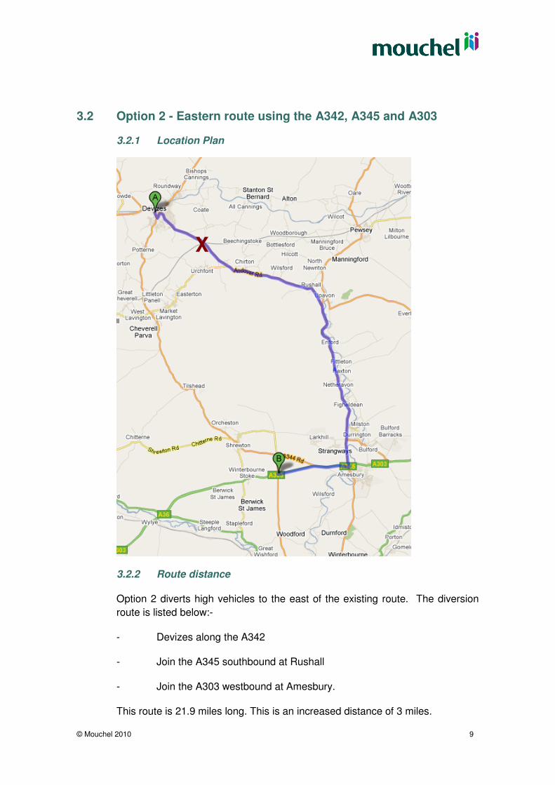
3.2 Option 2 - Eastern route using the A342, A345 and A303
3.2.1 Location Plan
3.2.2 Route distance
Option 2 diverts high vehicles to the east of the existing route. The diversion
route is listed below:-
- Devizes along the A342
- Join the A345 southbound at Rushall
- Join the A303 westbound at Amesbury.
This route is 21.9 miles long. This is an increased distance of 3 miles.
X
Job_Name4
© Mouchel 2010 10
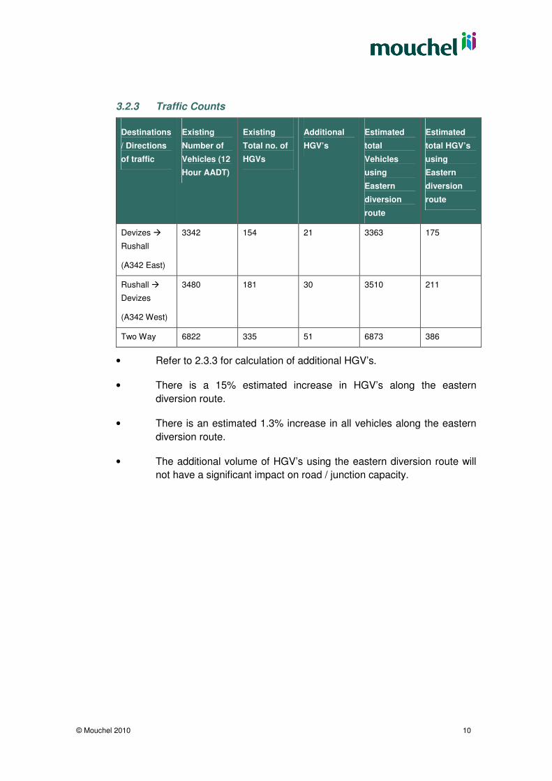
3.2.3 Traffic Counts
Destinations
/ Directions
of traffic
Existing
Number of
Vehicles (12
Hour AADT)
Existing
Total no. of
HGVs
Additional
HGV’s
Estimated
total
Vehicles
using
Eastern
diversion
route
Estimated
total HGV’s
using
Eastern
diversion
route
Devizes �
Rushall
(A342 East)
3342 154 21 3363 175
Rushall �
Devizes
(A342 West)
3480 181 30 3510 211
Two Way 6822 335 51 6873 386
• Refer to 2.3.3 for calculation of additional HGV’s.
• There is a 15% estimated increase in HGV’s along the eastern
diversion route.
• There is an estimated 1.3% increase in all vehicles along the eastern
diversion route.
• The additional volume of HGV’s using the eastern diversion route will
not have a significant impact on road / junction capacity.
Job_Name4
© Mouchel 2010 11
3.2.4 Traffic orders and signing requirements
Additional signing would be required in Devizes, the A342 / A345 junction and
the A345 / A303 junction.
A preliminary sign layout is shown on drawing 1029551-1200-001.
The principle is to introduce a minimum number of new signs around the control
locations (A & B) in order to guide target vehicles along the alternative route.
The preliminary design layout includes the following sign types:-
- Miscellaneous Informatory signs
- Alternative route direction/trigger signs,
- A series of small symbol signs at all major junctions along the alternative
route.
There are numerous direction signs along the A303 including Off Network
Diversion Route (ONDR) signs; these must be considered when specifying the
use of diversion route symbols to ensure clarity of each diversion route and
prevent conflicting symbols.
3.2.5 Structures
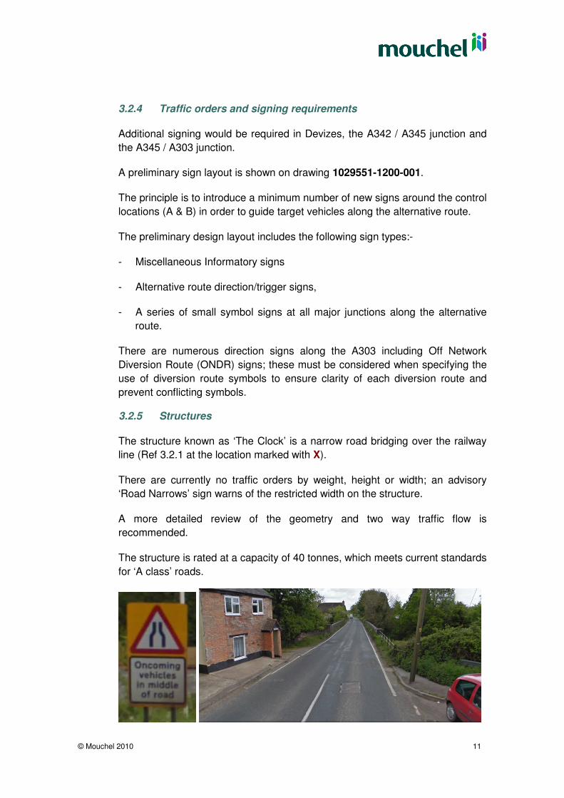
The structure known as ‘The Clock’ is a narrow road bridging over the railway
line (Ref 3.2.1 at the location marked with X).
There are currently no traffic orders by weight, height or width; an advisory
‘Road Narrows’ sign warns of the restricted width on the structure.
A more detailed review of the geometry and two way traffic flow is
recommended.
The structure is rated at a capacity of 40 tonnes, which meets current standards
for ‘A class’ roads.
Job_Name4
© Mouchel 2010 12
4 Summary
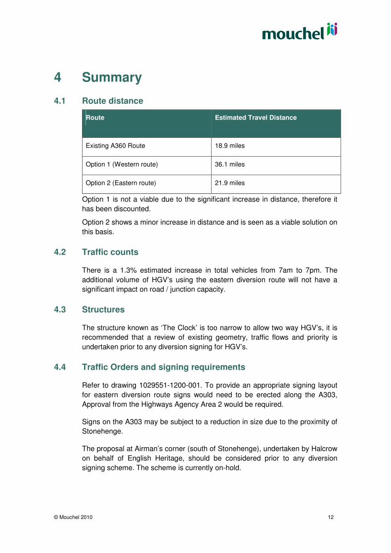
4.1 Route distance
Route Estimated Travel Distance
Existing A360 Route 18.9 miles
Option 1 (Western route) 36.1 miles
Option 2 (Eastern route) 21.9 miles
Option 1 is not a viable due to the significant increase in distance, therefore it
has been discounted.
Option 2 shows a minor increase in distance and is seen as a viable solution on
this basis.
4.2 Traffic counts
There is a 1.3% estimated increase in total vehicles from 7am to 7pm. The
additional volume of HGV’s using the eastern diversion route will not have a
significant impact on road / junction capacity.
4.3 Structures
The structure known as ‘The Clock’ is too narrow to allow two way HGV’s, it is
recommended that a review of existing geometry, traffic flows and priority is
undertaken prior to any diversion signing for HGV’s.
4.4 Traffic Orders and signing requirements
Refer to drawing 1029551-1200-001. To provide an appropriate signing layout
for eastern diversion route signs would need to be erected along the A303,
Approval from the Highways Agency Area 2 would be required.
Signs on the A303 may be subject to a reduction in size due to the proximity of
Stonehenge.
The proposal at Airman’s corner (south of Stonehenge), undertaken by Halcrow
on behalf of English Heritage, should be considered prior to any diversion
signing scheme. The scheme is currently on-hold.

Job_Name4
© Mouchel 2010 13
4.5 Conclusion
The diversion route to the east of the A360 is a viable solution to divert vehicles
exceeding 13’ 6’’, and reduce the flow of heavy goods vehicles through Great
Cheverell.
Traffic flows, accident data and geometry at the structure known as ‘The Clock’
should be reviewed prior to any diversion signing scheme.
It should be noted that Satellite Navigation systems can lead motorists to
unsuitable routes; reliance by many drivers on such systems reduces the
benefits of any signing scheme.

Job_Name4
© Mouchel 2010 14
Appendix A Scheme drawings:-
1029551-D001 Alternative Diversion Route – Layout Plan
1029551-D002 Existing Weight Limits
1029551-1200-001 Diversion Route for vehicles exceeding 13’ 6’’
– Sign Layout & Details