china’s mars exploration mission and science investigation
TRANSCRIPT
Space Science Reviews (2021) 217:57https://doi.org/10.1007/s11214-021-00832-9
China’s Mars Exploration Mission and Science Investigation
Chunlai Li1,2 · Rongqiao Zhang3 · Dengyun Yu4 · Guangliang Dong5 · Jianjun Liu1,2 ·Yan Geng3 · Zezhou Sun6 · Wei Yan1 · Xin Ren1 · Yan Su1,2 · Wei Zuo1,2 ·Tielong Zhang7,8 · Jinbin Cao9 · Guangyou Fang10 · Jianfeng Yang11 · Rong Shu12 ·Yangting Lin13 · Yongliao Zou14 · Dawei Liu1 · Bin Liu1 · Deqing Kong1 · Xinying Zhu1 ·Ziyuan Ouyang1,15
Received: 31 August 2020 / Accepted: 11 May 2021 / Published online: 25 May 2021© The Author(s) 2021
AbstractChina’s first Mars exploration mission (HuoXing-1) has been named as ‘Tianwen-1’ mean-ing Heaven Inquiry. Tianwen-1 was launched on July 23, 2020. In this paper, the scientificobjectives of earlier and current Mars exploration missions worldwide are reviewed, and thescientific objectives, payloads and preliminary scientific investigation plan of China’s firstMars exploration mission are introduced, and expected scientific achievements are analyzed.
Keywords Mars exploration · Payloads · Remote sensing exploration · In-situ exploration ·Scientific investigation plan
1 Introduction
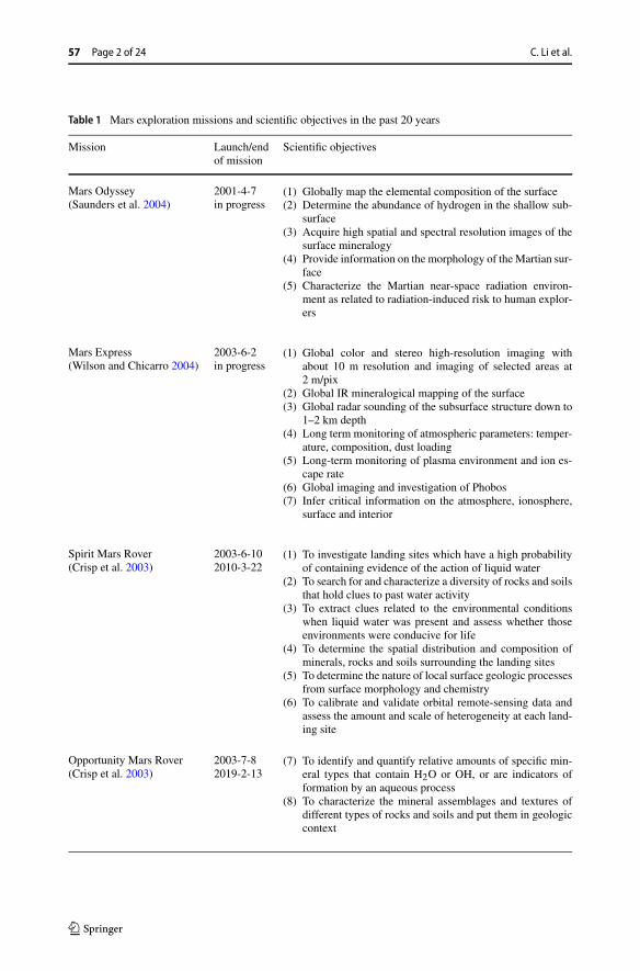
As the neighbor of the Earth, the Mars evolution is of significant importance for understand-ing the history and future evolution of the Earth. Since 1960s, more than 40 Mars explorationmissions have been implemented, and some more are in progress. According to the collecteddata, there may have been life and liquid water on Mars, which makes the Mars a potentialhabitable planet in the solar system, providing new hope for human’s migration to Mars andopening up new living space. Exploring information regarding life on Mars, whether lifeever existed in the past, and the environment suited for living becomes hot topic of Marsexploration at present (Ouyang and Xiao 2011; Ouyang and Liu 2009). Scientific objectivesin the past 20 years (Table 1) provide reference for China’s Mars exploration. The scientificobjectives and results of recent Mars missions are focused on the following aspects:
(1) Mars atmosphere characteristics and climate change: to examine the structure and com-position of Mars neutral atmosphere, meteorology, climate characteristics and changes;to search for evidence on past climate change, and to study the evolution history and fu-ture trends of Mars meteorology and climate (Gómez-Elvira et al. 2012; Mahaffy et al.2013; Barlow 2014; Jakosky et al. 2015).
The Huoxing-1 (HX-1) / Tianwen-1 (TW-1) mission to MarsEdited by Chunlai Li and Jianjun Liu
Extended author information available on the last page of the article
57 Page 2 of 24 C. Li et al.
Table 1 Mars exploration missions and scientific objectives in the past 20 years
Mission Launch/endof mission
Scientific objectives
Mars Odyssey(Saunders et al. 2004)
2001-4-7in progress
(1) Globally map the elemental composition of the surface(2) Determine the abundance of hydrogen in the shallow sub-
surface(3) Acquire high spatial and spectral resolution images of the
surface mineralogy(4) Provide information on the morphology of the Martian sur-
face(5) Characterize the Martian near-space radiation environ-
ment as related to radiation-induced risk to human explor-ers
Mars Express(Wilson and Chicarro 2004)
2003-6-2in progress
(1) Global color and stereo high-resolution imaging withabout 10 m resolution and imaging of selected areas at2 m/pix
(2) Global IR mineralogical mapping of the surface(3) Global radar sounding of the subsurface structure down to
1–2 km depth(4) Long term monitoring of atmospheric parameters: temper-
ature, composition, dust loading(5) Long-term monitoring of plasma environment and ion es-
cape rate(6) Global imaging and investigation of Phobos(7) Infer critical information on the atmosphere, ionosphere,
surface and interior
Spirit Mars Rover(Crisp et al. 2003)
2003-6-102010-3-22
(1) To investigate landing sites which have a high probabilityof containing evidence of the action of liquid water
(2) To search for and characterize a diversity of rocks and soilsthat hold clues to past water activity
(3) To extract clues related to the environmental conditionswhen liquid water was present and assess whether thoseenvironments were conducive for life
(4) To determine the spatial distribution and composition ofminerals, rocks and soils surrounding the landing sites
(5) To determine the nature of local surface geologic processesfrom surface morphology and chemistry
(6) To calibrate and validate orbital remote-sensing data andassess the amount and scale of heterogeneity at each land-ing site
Opportunity Mars Rover(Crisp et al. 2003)
2003-7-82019-2-13
(7) To identify and quantify relative amounts of specific min-eral types that contain H2O or OH, or are indicators offormation by an aqueous process
(8) To characterize the mineral assemblages and textures ofdifferent types of rocks and soils and put them in geologiccontext

China’s Mars Exploration Mission and Science Investigation Page 3 of 24 57
Table 1 (Continued)
Mission Launch/endof mission
Scientific objectives
Mars ReconnaissanceOrbiter(Graf et al. 2005)
2005-08-12in progress
(1) Characterize Mars’s seasonal cycles and diurnal variationsof water, dust, and carbon dioxide
(2) Characterize Mars’s global atmospheric structure, trans-port and surface changes
(3) Search sites for evidence of aqueous and/or hydrothermalactivity
(4) Observe and characterize the detailed stratigraphy, geo-logic structure, and composition of Mars surface features
(5) Probe the near-surface Martian crust to detect subsurfacestructure, including layering and potential reservoirs ofwater and/or water ice
(6) Characterize the Martian gravity field in greater detail rel-ative to previous Mars missions to improve knowledge ofthe Martian crust, lithosphere, and potentially atmosphericmass variation
(7) Identify and characterize numerous globally distributedlanding sites with a high potential for scientific discoveryby future missions
Phoenix Mars Lander(Smith et al. 2008)
2007-8-42008-11-2
(1) To study the history of the ice and its emplacement mech-anisms
(2) To address the affect that subsurface ice has on the localgeomorphology of the surface and any layering beneaththe surface
(3) To understand local climate and weather(4) The question of the habitability of the icy soil
Mars Science Laboratory(NASA 2011; Webster et al.2015)
2011-11-26in progress
(1) Determine the nature and inventory of organic carboncompounds
(2) Investigate the chemical building blocks of life (carbon,hydrogen, nitrogen, oxygen, phosphorus, and sulfur)
(3) Identify features that may represent the effects of biologi-cal processes (biosignatures)
(4) Investigate the chemical, isotopic, and mineralogical com-position of the Martian surface and near-surface geologicalmaterials
(5) Interpret the processes that have formed and modifiedrocks and soils
(6) Assess long-timescale (i.e., 4-billion-year) Martian atmo-spheric evolution processes
(7) Determine present state, distribution, and cycling of waterand carbon dioxide
(8) Characterize the broad spectrum of surface radiation, in-cluding cosmic radiation, solar particle events and sec-ondary neutrons
57 Page 4 of 24 C. Li et al.
Table 1 (Continued)
Mission Launch/endof mission
Scientific objectives
Mars Atmosphere andVolatile Evolution(Jakosky et al. 2015)
2013-11-18in progress
(1) Measure the composition and structure of the upper atmo-sphere and ionosphere today, and determine the processesresponsible for controlling them
(2) Measure the rate of loss of gas from the top of the atmo-sphere to space, and determine the processes responsiblefor controlling them
(3) Determine properties and characteristics that will allowus to extrapolate backwards in time to determine the in-tegrated loss to space over the four-billion-year historyrecorded in the geological record
Mars Orbiter Mission(MOM)(Kumar and Chauhan 2014)
2013-11-5in progress
(1) Exploration of Mars surface features, morphology,(2) mineralogy and Martian atmosphere by five scientific in-
struments
ExoMars 2016 Trace GasOrbiter(ESA 2014)
2016-3-14in progress
(1) Investigation of the water/geochemical environment as afunction of depth in the shallow sub-surface
(2) Study of martian atmospheric trace gases and their sources(3) Surface stereo and color imaging at ∼ 6 m/px resolution
InSight Mars lander(NASA 2018; Banerdt et al.2020)
2018-5-5in progress
(1) Formation & Evolution: Understand the formation andevolution of terrestrial planets through investigation of theinterior structure and processes of Mars
(2) Tectonic Activity: Determine the present level of tectonicactivity and meteorite impact rate on Mars
Hope(Sharaf et al. 2020)
2020-7-20in progress
(1) characterize the weather system in the lower atmosphere ofMars, providing a comprehensive understanding of diurnalchanges across the planet and across all seasons
(2) measure the distribution of hydrogen and oxygen in thehighest portions of the atmosphere (the collisionless exo-sphere)
(3) correlate the processes within the lower atmosphere withrates of atmospheric escape from the exosphere
Mars 2020(NASA 2020)
2020-7-30in progress
(1) Identify past environments capable of supporting micro-bial life
(2) Seek signs of possible past microbial life in those habit-able environments, particularly in special rocks known topreserve signs of life over time
(3) Collect core rock and “soil” samples and store them on theMartian surface
(4) Test oxygen production from the Martian atmosphere

China’s Mars Exploration Mission and Science Investigation Page 5 of 24 57
(2) Ionosphere, aeronomy, plasma environment and escape processes: to measure the com-position and structure of the upper atmosphere and ionosphere, and the rate of loss ofgas from the top of the atmosphere to space (Jakosky et al. 2015; Pätzold et al. 2016).
(3) Landform and geological structure: to investigate the Mars topography and geomor-phology, geological structure, soil and rock composition and element, sediment rockdistribution and relative age, polar water ice distribution and variation; to study the ge-ological history and surface evolution (Carr 1981; Head et al. 1999; Smith et al. 1999;Gendrin et al. 2005; Bibring et al. 2005, 2006; Barlow 2014; Head and Pieters 2018).
(4) Magnetic fields, gravity fields and interiors: to explore Mars crustal and time-varyingmagnetic fields, Mars’ core and magnetism, its gravity field; to comparatively study theinterior structure of Mars and the Earth, and to explore the evolution of the earth-likeplanet (Stevenson 2001; Barlow 2014; Johnson et al. 2020).
(5) Water and life: to search for water on Mars; to study the water body evolution; to seeksigns of habitable conditions on Mars in the ancient past, and to search for evidence ofancient life (Grotzinger 2014; Freissinet et al. 2015; Webster et al. 2015, 2018; Oroseiet al. 2018; Salese et al. 2019).
(6) Mars science observation station and laboratory: to set up scientific observation stationon Mars; to monitor and study the change of Martian surface and climate environment;to explore the possible resources on Mars and to provides scientific basis for the explo-ration and utilization of resources (Zeitlin et al. 2013; Hassler et al. 2014).
China announced its planetary exploration programme beyond the Earth–Moon system in2016. Benefiting from the engineering heritage of China’s lunar exploration programme, theChinese national strategy sets Mars as the next target for planetary exploration. China’s firstMars exploration mission (HuoXing-1) aims at completing orbiting, landing and roving inone mission, and has been named as Tianwen-1 (TW-1) which means Heaven Inquiry (Wanet al. 2020). TW-1 was launched on July 23, 2020. Here the scientific objectives of earlierand current Mars exploration missions worldwide are reviewed, and the scientific objec-tives, payloads and preliminary scientific exploration plan of China’s first Mars explorationmission are introduced, and expected scientific outcomes are analyzed.
2 China’s First Mars Exploration Mission
China’s first Mars mission can be divided into launch phase, Earth–Mars transfer phase,Mars capture orbit phase, Mars parking orbit phase, EDL (Entry, Descent, Landing) phaseand scientific exploration phase. The probe is launched into the Earth–Mars transfer trajec-tory and will travel for 6 and a half months in this transfer trajectory. After captured by Mars,the probe will enter an ellipsoid Mars orbit of 10 sols. After orbit maneuver at the apoareon,the probe will be adjusted to the circumpolar orbit and then enter the mars parking orbit witha period of about 2 days after three times of periareon braking. Two to three months later,the rover will be released by the orbiter and land on the surface to start in-situ exploration.After releasing of the rover, the orbiter will perform orbit maneuver, enter relay and surveyorbit with a period of about 8.2 hours, communicate with the rover and start its scientificexploration. 90 sols later, global reconnaissance orbit phase will start after orbit adjustmentand last for one martian year (Fig. 1).
Global reconnaissance orbit is a large ellipse with the altitudes of periareon and apoareonabout 265 km and 11900 km, respectively. The orbit inclination is 90◦ ± 5, and the orbitalperiod is 7.8 hours.

57 Page 6 of 24 C. Li et al.
Fig. 1 China’s first Mars Mission profile and flight orbit strategy
Fig. 2 Configuration of TW-1 probe. (a) The TW-1 probe consists of an orbiter and an EDL sectionin which is the rover and landing infrastructure. (b) is the illustration of TW-1 probe model. Its size is13.6 m×4.2 m×1.6 m with solar panels open. There are two pairs of radar antennas with 5 m length, a mag-netometer boom with 3 m length and communication antenna with 2.5 m diameter, respectively. (Redrawaccording to Ye et al. 2017)
2.1 System Components
The mission consists of five systems: probe, launch vehicle, launch site, telemetry track andcommand (TT&C), and ground research and application system (GRAS).
The probe consists of an orbiter and an EDL section which is made up of an entry capsule,landing infrastructure and rover (Fig. 2). The orbiter transfers data to the Earth through Xband signal with code rate of 16 kbps–4096 kbps. The communication between the orbiterand the rover are through UHF band and X band signals. The probe has been launchedwith Long March 5 carrier rocket at Wenchang launch site in Hainan province on July 23,2020. The TT&C system is responsible for the measurement and control of the probe. TheGRAS includes a headquarters and three ground stations at Miyun, Wuqing and Kunming.Its responsibility involves the formulation of in-orbit scientific exploration plan, payloads

China’s Mars Exploration Mission and Science Investigation Page 7 of 24 57
operation, the receiving, processing, interpretation and management of scientific detectiondata, and the application and research of scientific data.
The Advanced Science Research Team was formed by China National Space Adminis-tration (CNSA) to participate in the research on scientific objectives of Mars explorationmission. An academic seminar had been held every year to promote the communicationbetween engineering team and science community from 2017.
2.2 Scientific Objectives
According to the general plan of China’s deep space exploration and the progress of inter-national Mars exploration, the scientific objectives of China’s first Mars exploration missioninclude the following. The objectives will focus on two scientific problems regarding theenvironment in which the life existed, and the origin and evolution of Mars and the solarsystem.
(1) To map the morphology and geological structure: to map the global topography andgeomorphology, to obtain the high-precision topography of typical regions, and to studythe formation and evolution of the Mars geological structure. Geology and topographywill be investigated by context imaging at 100 m/px resolution complemented by high-resolution imaging of key selected areas at 0.5 m/px resolution.
(2) To investigate the surface regolith characteristics and water-ice distribution: toinvestigate the regolith types, weathering and sedimentary characteristics and globaldistribution, to measure the subsurface structure, to search for the water and ice infor-mation, and to study the stratification structure of regolith profile. Subsurface structureand water ice distribution will be investigated by two sets of Radar on orbiter and rover.The orbiter subsurface penetrating radar sounding of the subsurface structure down tothe depth of 100 m with vertical resolution of meter level will add the third dimensionto the surface investigations. The rover subsurface penetrating radar sounding of thesubsurface structure can down to the depth of 10 m and 3 m with vertical resolution ofmeter level and centimeter level, respectively.
(3) To analyze the surface material composition: to identify the rock types and the min-erals on the Martian surface, and to analyze the mineral composition. The mineral androck types and their distribution on the Mars’ surface will be investigated by hyperspec-tral remote sensing in the wavelength range from 0.45 to 3.4 µm. The distribution ofmajor mineral elements will be investigated by in-situ Laser-induced Breakdown Spec-troscopy (LIBS) with the detection accuracy better than 10%.
(4) To measure the ionosphere and the characteristics of the Martian climate and en-vironment at the surface: to measure the space environment, the temperature, pressureand wind fields. To study structure, composition dynamics of the neutral atmosphere;aeronomy, plasma environment and escape; seasonal changes of surface weather. Inter-planetary space and plasma environment will be investigated by Ion and Neutral Par-ticle Analyzer, Energetic Particles Analyzer and Very Low Frequency Radio Receiver.Ion energy range is 5 eV–25 KeV, neutral particle energy range is 50 eV–3 KeV, elec-tron energy range is 0.1–12 Mev, proton energy range is 2–100 Mev, and heavy ionenergy range is 25–300 Mev. Very Low Frequency Radio receiver frequency range is10 kHz–10 MHz.
(5) To perceive the physical fields (electromagnetic, gravitational) and internal struc-ture of Mars: to measure the Mars magnetic properties and study the early geologicalevolution history, the mass distribution and gravity field. The detection range of Mars

57 Page 8 of 24 C. Li et al.
Fig. 3 Candidate landing areas of China’s Mars Exploration Mission. Base image is from MOLA DEM(https://astrogeology.usgs.gov/search/details/Mars/GlobalSurveyor/MOLA/Mars_MGS_MOLA_DEM_mosaic_global_463m)
space magnetic intensity is ±10000 nT with the resolution better than 0.01 nT. The de-tection range of Martian surface magnetic field measurement is ±2000 nT dynamic, and±65000 nT compensation. The resolution is better than 0.01 nT.
The above five scientific objectives will be achieved by remote and in-situ investigationsjointly. The investigations from orbit will focus on the integrated and comprehensive ex-ploration of Mars, and to establish an overall scientific context of Mars. The investigationsfrom rover will focus on the high precision and resolution detection and in situ analysis ofthe Mars key areas.
Through the synergistic exploration of the orbiter and the rover as well as simultaneousspace-ground exploration, the Mars topography, regolith properties, material composition,water-ice distribution, ionosphere and magnetic field will be investigated.
2.3 Candidate Landing Area
Two landing areas for China’s first Mars exploration mission are preselected based on thefollowing engineering criteria and scientific objectives (Fig. 3).
Engineering criteria of landing site selection include (Ye et al. 2017):
(1) Latitude: landing area should be between 5–30 ◦N;(2) Altitude: the lower the better, the elevation of landing site should be at least −2 km;(3) Slope: avoid steep slopes area, choose relative flat area;(4) Surface condition: should avoid dusty area and choose area with less dust cover;(5) Rock distribution: should avoid area of abundant rocks, and choose area with less
amount of rocks;(6) Local wind speed: landing area with lower wind speeds are preferred;(7) Visibility requirements during the landing process: the EDL process should be sched-
uled on the side of Mars that is visible from Earth at the time of landing.

China’s Mars Exploration Mission and Science Investigation Page 9 of 24 57
Key scientific objectives required to be considered:
(1) Geology: the landing area should have as diverse geology as possible;(2) Soil structure and water ice distribution: choose potential area that has the highest op-
portunity to find water ice or ground water;(3) Surface elements, mineral, and rock distribution: choose potential area that has higher
possibility to find diverse element, mineral and rocks;(4) Magnetic field detection: choose the area favourable for Mars Magnetic field.
There are multiple rounds of selection during the landing area selection process to balancethe technical feasibility and scientific interests. Firstly, landing areas meeting the strict crite-rion of engineering constraints would be selected and introduced. Then, the scientists wouldpropose some interested landing sites from the selected areas according to the scientific ob-jectives of the mission. After that, the proposed landing sites would be evaluated. In eachround, the suggestion from the engineers and scientists will be thoroughly discussed.
(1) Preselected landing area 1 The primary landing area 1 is located in the Chryse Planitiaplain, close to dihotomy boundary. The landing site of Viking-1 is located in the west, whilethe landing site of Pathfinder, ESA pre-selected Oxia Planum and Mawrth Vallis landingzones are located in the south. The topography shows there may be water-formed channels.Geologic units Hto (Hesperian transition outflow unit), lHt (Late Hesperian transition unit)and lHl (late Hesperian lowland unit) are close to the pre-selected area 1.
(2) Preselected landing area 2 The pre-selected area 2 is located partly in Isidis Planitiaand partly in Utopia Planitia. Isidis Planitia is the third largest basin on Mars, formed inthe Noachian geological era 3.9 billion years ago. This area is covered by Martian dust andbrighter in telescope image, making it as a typical reflectance feature on the Martian surface.Geologic units lHl (late Hesperian lowland unit) and AHv (amazonian and Hesperian vol-canic unit) are close to the preselected landing area 2. Landing site of ESA’s Beagle 2 in thelate Hesperian era is also located in this preselected landing area. The eastern side of landingarea is located in the volcanic region, a transition zone from Hesperian to Amazonian, withrelatively younger strata.
According to the current orbit design, we are more inclined to land on the surface ofsouthern Utopia planitia, adjacent to the west of Elysium Mon, where many water/ice re-lated landforms have been found such as domes/pitted cones, rampart crater, mound, andlava flow front. This landing area was selected because we aim to conduct scientific explo-ration regarding whether ancient ocean ever exist on the northern part of the Mars and thegeological evolution history of the Mars volcanos.
3 Payloads and Scientific Tasks
3.1 Payloads on the Orbiter
Remote sensing is an important exploration method which helps to obtain the global explo-ration data and to construct the global conception for Mars studies. Therefore, the investiga-tions from orbit is the preferred at the beginning stage of planetary exploration.
According to the scientific objectives of TW-1 mission, the experiences of internationalMars explorations and the scientific research progress, as well as the development of theChina’s aerospace science and technology, the scientific objectives of Mars orbiter includethe following five aspects: to analyze Martian ionosphere, plasma environment and escape
57 Page 10 of 24 C. Li et al.
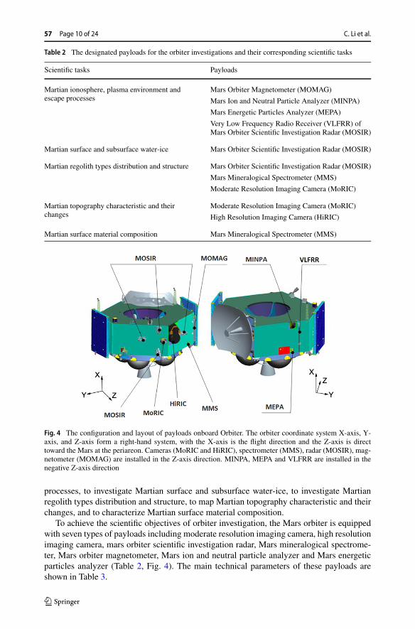
Table 2 The designated payloads for the orbiter investigations and their corresponding scientific tasks
Scientific tasks Payloads
Martian ionosphere, plasma environment andescape processes
Mars Orbiter Magnetometer (MOMAG)
Mars Ion and Neutral Particle Analyzer (MINPA)
Mars Energetic Particles Analyzer (MEPA)
Very Low Frequency Radio Receiver (VLFRR) ofMars Orbiter Scientific Investigation Radar (MOSIR)
Martian surface and subsurface water-ice Mars Orbiter Scientific Investigation Radar (MOSIR)
Martian regolith types distribution and structure Mars Orbiter Scientific Investigation Radar (MOSIR)
Mars Mineralogical Spectrometer (MMS)
Moderate Resolution Imaging Camera (MoRIC)
Martian topography characteristic and theirchanges
Moderate Resolution Imaging Camera (MoRIC)
High Resolution Imaging Camera (HiRIC)
Martian surface material composition Mars Mineralogical Spectrometer (MMS)
Fig. 4 The configuration and layout of payloads onboard Orbiter. The orbiter coordinate system X-axis, Y-axis, and Z-axis form a right-hand system, with the X-axis is the flight direction and the Z-axis is directtoward the Mars at the periareon. Cameras (MoRIC and HiRIC), spectrometer (MMS), radar (MOSIR), mag-netometer (MOMAG) are installed in the Z-axis direction. MINPA, MEPA and VLFRR are installed in thenegative Z-axis direction
processes, to investigate Martian surface and subsurface water-ice, to investigate Martianregolith types distribution and structure, to map Martian topography characteristic and theirchanges, and to characterize Martian surface material composition.
To achieve the scientific objectives of orbiter investigation, the Mars orbiter is equippedwith seven types of payloads including moderate resolution imaging camera, high resolutionimaging camera, mars orbiter scientific investigation radar, Mars mineralogical spectrome-ter, Mars orbiter magnetometer, Mars ion and neutral particle analyzer and Mars energeticparticles analyzer (Table 2, Fig. 4). The main technical parameters of these payloads areshown in Table 3.

China’s Mars Exploration Mission and Science Investigation Page 11 of 24 57
Table 3 Payload configuration and main technical parameters of TW-1 Mars Orbiter
Payloads Technical parameters
ModerateResolutionImaging Camera(MoRIC)
(1) Color: RGB
(2) Imaging Band: Visible
(3) Spatial resolution: 100 m@400 km
(4) Frame Width: 400 km@400 km
(5) Pixel: 4096 × 3072
(6) Field of View: 53.1◦ × 41.1◦ (diagonal 64◦)
High ResolutionImaging Camera(HiRIC)
(1) Resolution (@265 km altitude)
Panchromatic: better than 2.5 m, in key areas better than 0.5 m
Color: better than 10 m, in key areas better than 2.0 m
(2) Swath Width: 9 km@265 km
Mars OrbiterScientificInvestigationRadar (MOSIR)
(1) Mars subsurface structure and water ice exploration
Frequency: 10 MHz–20 MHz, 30 MHz–50 MHz
Polarization: HH, HV
Transmitter power: ≥ 100 W
Receiver sensitivity: ≤ −87 dBm
Detecting depth: Mars subsurface structure, ∼ 100 m (regolith, εγ = 3.0–4.0), Marspolar ice, ∼ 1000 m (ice, εγ = 3.0)
Thickness resolution: meter level
(2) Ranging precision: better than 10 m
(3) Interplanetary very low frequency radio spectrum detection
VLF receiver frequency: 10 kHz–10 MHz
VLF receiver resolution: better than 1 KHz (10 KHz–500 KHz), better than 20 KHz(500 KHz–10 MHz)
MarsMineralogicalSpectrometer(MMS)
(1) Spectral range (µm):
Visible-near infrared, 0.45–1.0 µm, intermediate infrared and near-infrared,1.00–3.40 µm
(2) Spectral resolution: visible-near infrared,better than 10 nm, intermediate infrared andnear-infrared, better than 12 [email protected] µm–2.0 µm, better than 25 [email protected] µm–3.4 µm.
Mars OrbiterMagnetometer(MOMAG)
(1) Measurement range: ±10000 nT
(2) Resolution: better than 0.01 nT
(3) Precision: 0.1 nT
(4) Noise level: ≤ 0.01 nT/√
Hz
(5) Stability: ≤ 0.01 nT/◦C
Mars Ions andNeutral ParticleAnalyzer(MINPA)
(1) Low energy ions:
Energy range: 5 eV–25 KeV
Energy resolution (�E/E): 15%
Mass: 1–70 amu
Field of view: 90◦ × 360◦Angular resolution: 11.2◦ × 22.5◦(2) Low energy neutral particles:
Energy range: 50 eV–3 KeV
Energy resolution (�E/E): 100%, Mass: 1–32 amu
Field of view: 15◦ × 160◦Angular resolution: 10◦ × 25◦Time resolution: 4 s

57 Page 12 of 24 C. Li et al.
Table 3 (Continued)
Payloads Technical parameters
Mars EnergeticParticlesAnalyzer(MEPA)
(1) Energy range:
Electronic: 0.1–12 MeV
Proton: 2–100 MeV
α-particle, heavy ion: 25–300 MeV
(2) Energy resolution (�E/E): 15%
(3) Flux range: 0–105 cm−2 s−1
(4) Elementary composition: H–Fe (1 ≤ Z ≤ 26)
(5) Heavy ion mass resolution (�m/m):
≤ 25% (Z ≤ 9, 25–300 MeV)
≤ 25% (10 ≤ Z ≤ 26, 100–300 MeV)
≤ 60% (10 ≤ Z ≤ 26, 25–100 MeV)
(6) Field of view: 60◦(7) Time resolution: 4 s (proton, electron, alpha particle), 60 s (heavy ion)
(1) Analyze Martian ionosphere, plasma environment and escape processes The orbiter isequipped with Mars orbiter magnetometer, Mars ion and neutral particle analyzer, Mars en-ergetic particles analyzer and very low frequency radio receiver to explore the ionosphereand interplanetary environment. Mars orbiter magnetometer is used to map Martian mag-netic field. The Mars ion and neutral particle analyzer measures the flux of ions in spaceenvironment, distinguishes the main ions and obtains their physical parameters such as thedensity, velocity and temperature. In addition, it measures the flux of neutral energy particlesand distinguishes the main neutral particle components such as H, He and O. Mars energeticparticles analyzer obtains the energy spectrum, flux and elemental composition of energyelectrons, protons, α particles and ions. Very low frequency radio receivers acquire the verylow frequency radio spectrum data in the interplanetary space during the cruise phase.
A highly elliptical orbit will be adopted by the mission with a periareon of 265 km wherethe orbit enters the Mars ionosphere (110 km–400 km) and an apoareon of 11900 km whichcrosses the complex and variable magnetic field boundaries such as the bow shock wave(towards the sun), the magnetosheath layer, the boundary of the magnetic accumulationzone, the magnetic accumulation zone and the induced magnetic tail (back of the sun). It isexpected to obtain the space magnetic field survey data at 2.8–4.3 Rm (Radius of Mars) tofill the gap in existing Mars exploration (MGS/MAVEN) in the far magnetic tail region, andto partially fill the gap of observation in the position of bow shock wave. New data of theionosphere ions of 5 eV–several KeV will be obtained to fill in the blank of 50 eV–3 KeVions detection of MAVEN ionosphere mode.
(2) Investigate Martian surface and subsurface water-ice The orbiter is equipped with Marsorbiter scientific investigation radar to investigate the Martian surface and subsurface water-ice. It aims to explore water-ice by means of the dual-polarization echo characteristics ofradar. When the radar is below the 800 km orbital altitude during the Mars-orbiting phase,the altimetry mode, ionospheric detection mode and subsurface detection mode will be used.
(3) Investigate Martian regolith types distribution and structure The orbiter is equippedwith Mars orbiter scientific investigation radar and Mars mineralogical spectrometer. The

China’s Mars Exploration Mission and Science Investigation Page 13 of 24 57
Table 4 Scientific tasks and the designated payloads for in-situ exploration
Scientific tasks Payloads
Surface morphology and geology Navigation and Terrain Camera (NaTeCam)
Subsurface structure and water ice distribution Mars Rover Penetrating Radar (RoPeR)
Surface elemental composition and mineralogy Mars surface Composition Detector (MarSCoDe)
Multispectral Camera (MSCam)
Magnetic field Mars Rover Magnetometer (RoMAG)
Atmospheric properties and meteorology Mars Climate Station (MCS)
Mars orbiter scientific investigation radar data, combined with the optical image and com-positional information acquired by Mars mineralogical spectrometer, will be used to inves-tigate the distribution of regolith types and subsurface structure of Mars.
(4) Map Martian topography characteristic and their changes The orbiter is equipped withmoderate resolution imaging camera, high resolution imaging camera and Mars orbiter sci-entific investigation radar to characterize the topographic and geomorphological features ofMars and their changes. Moderate resolution imaging camera can obtain the global geo-morphic data with a spatial resolution of about 100 m. The images overlap along the flightdirection is up to 60%, and the side overlap between adjacent orbits is up to 15%, satisfyingthe need of three-dimensional imaging. High resolution imaging camera can acquire high-resolution images and perform detailed surveys on key areas and landing area, and obtain thelandform data with spatial resolution of 0.5 m. The elevation can be measured by the Marsorbiter scientific investigation radar. Based on these three payloads, the formation processof Mars geological features, such as geomorphology of landing site, flow, volcano, erosion,impact crater and polar glacier will be studied.
(5) Characterize Martian surface material composition The orbiter is equipped with Marsmineralogical spectrometer, which utilizes the visible and near infrared imaging spectrom-eter with detection wavelengths ranging from 0.45 to 3.4 µm to investigate and analyze theMartian surface composition.
3.2 Payloads on the Rover
The mission will combine remote sensing and detailed in-situ exploration to advance ourscientific understanding of Mars. The rover will undertake the following four scientific tasksin landing sites: to map morphology and geology, to investigate subsurface structure andpossible water-ice, to analyze surface elements, minerals and rock types, and to measureatmosphere physical characteristics and surface environment.
In order to complete these scientific tasks, the Mars rover is equipped with six instru-ments (Table 4, Fig. 5) including the Mars surface composition detector, multispectral cam-era, navigation and terrain camera, Mars rover penetrating radar, Mars rover magnetometer,and Mars meteorological instrument. The technical parameters of these payloads are shownin Table 5.
(1) Surface morphology and geology of landing sties High-resolution 3D panoramic imageswill be obtained with two navigation topography cameras onboard the rover. These datawill be used to construct topography maps, extract parameters such as slope, undulation
57 Page 14 of 24 C. Li et al.
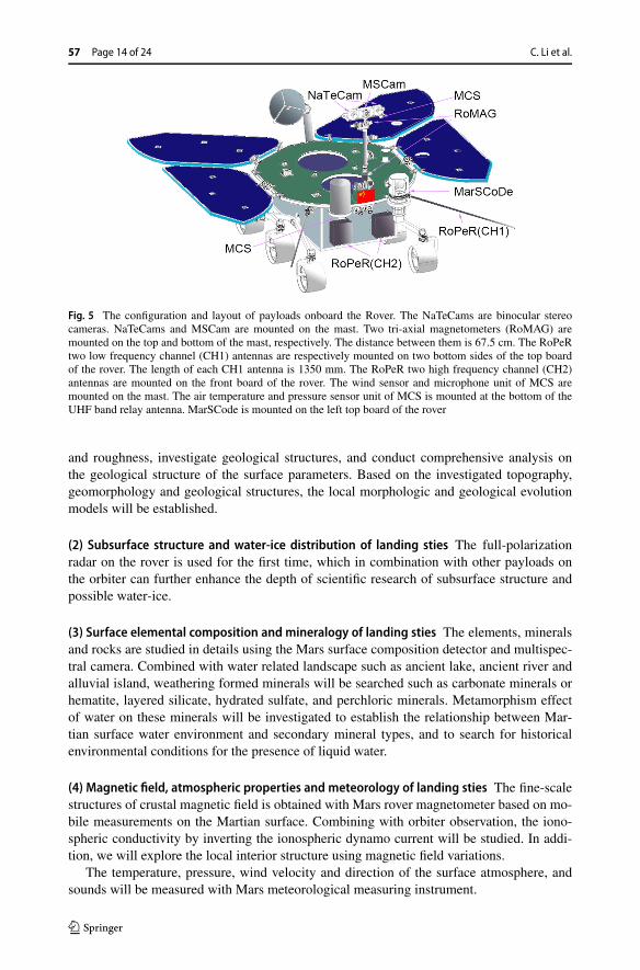
Fig. 5 The configuration and layout of payloads onboard the Rover. The NaTeCams are binocular stereocameras. NaTeCams and MSCam are mounted on the mast. Two tri-axial magnetometers (RoMAG) aremounted on the top and bottom of the mast, respectively. The distance between them is 67.5 cm. The RoPeRtwo low frequency channel (CH1) antennas are respectively mounted on two bottom sides of the top boardof the rover. The length of each CH1 antenna is 1350 mm. The RoPeR two high frequency channel (CH2)antennas are mounted on the front board of the rover. The wind sensor and microphone unit of MCS aremounted on the mast. The air temperature and pressure sensor unit of MCS is mounted at the bottom of theUHF band relay antenna. MarSCode is mounted on the left top board of the rover
and roughness, investigate geological structures, and conduct comprehensive analysis onthe geological structure of the surface parameters. Based on the investigated topography,geomorphology and geological structures, the local morphologic and geological evolutionmodels will be established.
(2) Subsurface structure and water-ice distribution of landing sties The full-polarizationradar on the rover is used for the first time, which in combination with other payloads onthe orbiter can further enhance the depth of scientific research of subsurface structure andpossible water-ice.
(3) Surface elemental composition and mineralogy of landing sties The elements, mineralsand rocks are studied in details using the Mars surface composition detector and multispec-tral camera. Combined with water related landscape such as ancient lake, ancient river andalluvial island, weathering formed minerals will be searched such as carbonate minerals orhematite, layered silicate, hydrated sulfate, and perchloric minerals. Metamorphism effectof water on these minerals will be investigated to establish the relationship between Mar-tian surface water environment and secondary mineral types, and to search for historicalenvironmental conditions for the presence of liquid water.
(4) Magnetic field, atmospheric properties and meteorology of landing sties The fine-scalestructures of crustal magnetic field is obtained with Mars rover magnetometer based on mo-bile measurements on the Martian surface. Combining with orbiter observation, the iono-spheric conductivity by inverting the ionospheric dynamo current will be studied. In addi-tion, we will explore the local interior structure using magnetic field variations.
The temperature, pressure, wind velocity and direction of the surface atmosphere, andsounds will be measured with Mars meteorological measuring instrument.

China’s Mars Exploration Mission and Science Investigation Page 15 of 24 57
Table 5 Payload configuration and main technical parameters of Mars rover
Payloads Main technical parameters
Navigation andTerrain Camera(NaTeCam)
(1) Color: RGB
(2) Spectral range: visible
(3) Normal imaging distance: 0.5 m–∞(4) Pixel: 2048 × 2048
MultispectralCamera(MSCam)
(1) Spectral range (nm): there are 9 bands, which are 480(20), 525(20), 650(12),700(15), 800(25), 900(30), 950(50), 1000(50), and panchromatic
The figures in brackets are the filters bandpasses (full width at half maximum)
(2) Color: multi-spectral
(3) Normal imaging distance: 1.5 m–∞(4) Pixel: 2048 × 2048
Mars RoverPenetratingRadar (RoPeR)
(1) The first channel (CH1):
Frequency: 15–95 MHz
Polarization: HH
Penetration thickness: meter level
Detection depth: ≥ 100 m (ice, εr = 3.0), ≥ 10 m (regolith, εr = 3.0–4.0)
(2) The second channel (CH2):
Frequency: 450–2150 MHz
Polarization: HH, HV, VH, VV
Penetration thickness: centimeter level
Detection depth: ≥ 10 m (ice, εr = 3.0), ≥ 3 m (regolith, εr = 3.0–4.0)
Mars surfaceCompositionDetector(MarSCoDe)
(1) LIBS detection
Element type: no less than 10 elements (Si, Al, Fe, Mg, Ca, Na, O, C, H, Mn, Ti, S, etc.)
Detection distance: 2–5 m (best detection distance), with the largest distance of 10 m
(2) Microscopic camera
Image resolution: ≤ 100 µrad (0.20 mm@2 m, 0.50 mm@5 m)
Field of view: ≥ 1 mrad
Short-wave infrared spectral detection
Spectral range: 850–2400 nm
Spectral resolution: ≤ 12 nm
Band: no less than 130 bands
Mars RoverMagnetometer(RoMAG)
(1) Measurement range: ±2000 nT dynamic; ±65000 nT compensation
(2) Resolution: better than 0.01 nT
(3) Precision: 0.1 nT
(4) Noise level: ≤ 0.01 nT/√
Hz
(5) Stability: ≤ 0.01 nT/◦C
(6) sampling rate: 1 Hz, 16 Hz, 32 Hz, 128 Hz
Mars ClimateStation (MCS)
(1) Temperature: range −120 ◦C– + 50 ◦C; resolution 0.1 ◦C;
(2) Air pressure: range 1–1500 Pa; resolution 0.1 Pa;
(3) Wind speed: range 0–70 m/s; resolution 0.5 m/s;
(4) Wind direction: range 0–360◦; resolution 5◦;
(5) Sound: frequency range: 20 Hz–2.5 kHz, 2.5 kHz–20 kHz; sensitive: better than50 mV/Pa; dynamic range: ≥ 90 dB

57 Page 16 of 24 C. Li et al.
4 Preliminary Scientific Investigation Plan
4.1 Scientific Investigation Plan of the Orbiter
The orbiter will begin scientific investigation during the Earth–Mars transfer. The rover willbe released after Mars orbit insertion and 2–3 months of the orbit adjustment in the parkingorbit. After that, the orbiter performs maneuver, enters relay orbit, communicates with therover, and conduct scientific exploration at the same time. After 90 sols of the rover mission,the orbiter enters the reconnaissance orbit for the orbiting investigations and rover data relay.The scientific investigation plans of the orbiter are presented in Table 6.
The payloads of the orbiter do not work in the launch phase, capture phase, and off-orbitlanding phase.
Earth–Mars transfer orbit Mars orbiter scientific investigation radar (very low frequencydetection), Mars ions and neutral particle analyzer, and Mars energetic particle analyzercontinuously operate during Earth–Mars transfer. Moderate resolution imaging camera willwork at selected time to image the Earth, the Moon and Mars. Other payloads will choosetime to carry out self-check.
Mars parking orbit, relay and survey orbit After captured by Mars, the payloads on obiterwill start on-orbit test work. The moderate resolution imaging camera, high resolution imag-ing camera and Mars mineralogical spectrometer will focus on investigation of pre-selectedlanding areas. The rover will start a 90 sols in-situ exploration after the lander is released.The orbiter will perform orbit maneuver and enter one Martian year global reconnaissanceorbit after the rover works on Mars for 90 sols.
Global reconnaissance orbit Moderate resolution imaging camera, high resolution imagingcamera, Mars orbiter scientific investigation radar and the Mars mineralogical spectrome-ter will operate below the 800 km altitude. The Mars orbiter magnetometer, Mars ion andneutral particle analyzer and the Mars energetic particles analyzer work continuously.
4.2 Scientific Investigation Plan of the Rover
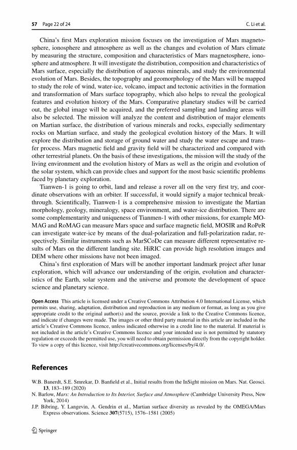
The working life of the rover on the Martian surface is designed to be 90 sols. After landing,the rover will extend its solar panels, establish direction control of the Earth-point antennaand report its initial status. The orbiter will be located in a relay and survey orbit to supportthe rover’s scientific investigation of Mars. The Mars rover penetrating radar works duringthe roving. The Mars surface composition detector, Multispectral Camera, Navigation andTerrain Camera begin to work when the rover stops after reaching the study target. Both theMars rover magnetometer and Mars climate station work during the roving or when it stops.
Every three sols are defined as one operation period. The basic process of each operationperiod is as following (Fig. 6):
(1) On the first sol of operations period, the Navigation and Terrain Camera obtains thestereo image pairs of the study target and downlinks them for operations plan of therover and the selection of the next study target;
(2) On the second sol of operations period, each payload performs scientific exploration onthe study target according to the operations plan, and downlinks the data;
(3) On the third sol, the rover moves to the next study target, and Mars Rover PenetratingRadar, Mars Climate Station work until it arrives at the next study target. The roverpayloads complete a operations period and downlinks the data.

China’s Mars Exploration Mission and Science Investigation Page 17 of 24 57
Table 6 Scientific investigation plans by the orbiter payloads
Payloads Earth–Mars transferorbit
Mars parking orbit, relayand survey orbit
Global reconnaissance orbit
MoRIC (1) Self-check oncea month(2) Select the timeto start working,imaging the Earth,the Moon and Mars
(1) On-orbit calibration atthe apoareon once amonth, and data downlink(2) 3D images of thelanding area fromperiareon
(1) On-orbit calibration at the apoareononce a month(2) Images are captured when the orbitaltitude is below 800 km and sunelevation angle is larger than 5 degree,with the average work time of 26minutes and the imaging interval of20 s–66 s(3) In order to achieve the coverage, theimages can be obtained with off-nadirpointing of the spacecraft
HiRIC Self-check once amonth
(1) Self-check once amonth(2) 3D images of thelanding area fromperiareon
(1) High resolution imaging when theorbit altitude is below 800 km and sunelevation angle is larger than 10 degree(2) In order to achieve the coverage, theimages can be obtained with off-nadirpointing of the spacecraft
MOSIR After the separationof satellite androcket, the VLFantenna selects timeto explore theinterplanetary radio
(1) Select time to deploythe radar antennaincluding the transmitantenna and receiveantenna(2) Subsurfaceinvestigations of thelanding area fromperiareon(3) Subsurfaceinvestigations of polar icecaps and other areas ofinterest when the orbit ishigher than 800 km andthe requirements aresatisfied
(1) Calibration of equipment lasts about70 s before the probe enters theperiareon section above the orbitaltitude of 800 km(2) After the calibration, the radar startsto work with the mode selected fromthe on-orbit working mode list (withaverage working time of 26 minutes)
MMS Self-check once atselected time
(1) Self-check once atselected time(2) Spectral observation ofthe landing area fromperiareon(3) On-orbit calibration atthe apoareon
(1) Continuous multi-unit spectralobservation. The spectral data areobtained at an altitude below 800 km,and MMS work for 21 minutes eachtime(2) Investigation of interested regions(3) On-orbit calibration at the apoareonand work once to twice each month
MOMAG Self-check twice atselected time
Select time to deploy theboom, same workingmode as that used in theglobal reconnaissanceorbit
Works continuously(1) Work with the 32 HZ sampling rate0.5 h before and after reaching theapoareon(2) Work with the 32 HZ sampling rate1 h before and after reaching theperiareon(3) Work with the 1 HZ sampling ratein other orbit sections
57 Page 18 of 24 C. Li et al.
Table 6 (Continued)
Payloads Earth–Mars transferorbit
Mars parking orbit, relayand survey orbit
Global reconnaissance orbit
MINPA After entering theEarth–Mars transferorbit, thehigh-voltagedebugging starts inthe first month, afterwhich the payloadcarries out theinterplanetary solarwind detectioncontinuously
(1) After entering theparking orbit, workingcontinuously, and turnedoff before the separationof the lander(2) Work continuouslyafter entering the relayand survey orbit andpowers off before the endof the mission
Works continuously(1) Work with the ionospheric modebelow the orbit altitude of 800 km(2) Work with the default mode above800 km(3) Switch to magnetic-tail mode 30minutes before the apoareon and switchback to the default mode 30 minutesafter the apoareon as required
MEPA Continuous working Continuous working Continuous working
Table 7 Scientific data products categorization
Data level Data description
Level 0 Level 0A Source packet data that are generated after ground demodulation, framesynchronization, descrambling, channel decoding, demultiplexing and otherprocessing of the data sent back from a spacecraft and received at a singleground station for each payload
Level 0B Data collected by each payload, which are generated after package structureremoving and decompressing (where applicable) of the source packet data;those source packet data are, on the basis of Level 0A, generated aftercombining (where applicable), sorting and deduplicating of the data frommultiple ground receiving stations
Level 1 Level 1 Data that are generated, on the basis of Level 0B, after numerically convertingtemperature, voltage, current and other instrument parameters, and reorganizingaccording to observation periods
Level 2 Level 2A/2B/2C Data in physical units that are generated, on the basis of level 1, after applyingcalibration, and provide geometric positioning information. Level 2 dataproducts are divided into several sub-levels, level 2A, level 2B and level 2C(where applicable)
Level 3 Digital orthophoto maps, digital elevation models, mineralogical maps, etc.
4.3 Data Products
Focusing on the five scientific objectives of China’s first Mars exploration mission, the or-biter is equipped with 7 instruments and the rover is equipped with 6 instruments for sci-entific exploration. The obtained exploration data will be preprocessed according to thefollowing levels (Table 7). Level 0 data products are stored in binary file format, while level1 and level 2 data products are stored in standard PDS4.0 format. Levels 3 is high level sci-ence maps, including digital orthophoto maps, digital elevation models and mineralogicalmaps, etc.
GRAS and the instruments teams will expect to follow the data release policy proposedby CNSA based on an official 5–6 months’ proprietary period that is used by the teams tovalidate, calibrate, and perform preliminary scientific data exploration. After all the proce-
China’s Mars Exploration Mission and Science Investigation Page 19 of 24 57
Fig. 6 Process of rover scientific investigation
dures are complete, the data will be released to the scientific community from the website(http://moon.bao.ac.cn/index_en.jsp).
4.4 Expected Scientific Achievements
According to the preliminary scientific investigation plan, the expected scientific achieve-ments of China’s first Mars exploration mission are as following (Table 8).

57 Page 20 of 24 C. Li et al.
Table 8 Expected scientific achievements and scientific objectives of China’s first Mars exploration mission
Payloads Expected scientific data Expected scientific achievements Scientific objectives
MoRIC 1. Global orthophoto imageswith spatial resolution of66 m–200 m/pixel2. Global DEM with spatialresolution of200 m–600 m/pixel
Global topography andgeomorphology as well as theirvariations, such as polar cap, sanddunes, layered deposit
To map Martiantopography, landform andtheir changes, and toobtain the basicinformation on Marsevolution
HiRIC The key area images withspatial resolution of0.5 m–1.5 m/pixel
Detailed investigation of key areas,such as geomorphology of flow,volcano, erosion, impact crater andpolar glacier
NaTeCam Stereo images, panoramicmosaic and 3D topographicmap of landing areas
1. Geomorphology of landing areas2. High-resolution digital elevationmodels of landing areas3. Geology characteristic
RoPeR 1. Acquire subsurface echodata of low-frequency channelradar (15–95 MHz) andhigh-frequency channelfull-polarization radar(450–2150 MHz) in landingareas2. Obtain the subsurfacestructure and possiblewater-ice of landing areas
1. Subsurface structure of landingareas2. Possible water-ice of landingareas
To investigate the regolithcharacteristics andwater-ice distribution onthe Martian surface, andto obtain the conditionsand environmentalinformation of life
MOSIR 1. Acquire echo data ofdual-frequencydual-polarization radar ofMartian surface and subsurface(10–20 MHz, 30–50 MHz)2. Obtain the subsurfacestructure and possiblewater-ice of exploration areas
1. Subsurface water-ice distributionat Mars medium and high latitudes2. Water-ice exploration in theMars polar regions
1. Regolith type and distribution2. Regolith subsurface structure
1. Spectral data of ultra-lowfrequency detection in theEarth–Mars transfer orbitsection (10 KHz–10 MHz)2. Detection data ofionosphere (TEC) in theMars-orbiting section(10–20 MHz, 30–50 MHz)
1. Mars atmosphere escapeprocesses2. Interplanetary very lowfrequency radio3. The conductivity and verticalstructure and variability of theionosphere
To measure thecharacteristics of Marsionosphere, plasmaenvironment and escapeprocesses, surfaceatmospheric propertiesand meteorology;
MINPA 1. The data of Mars ions andneutral particles2. Physical parameters of Marsspace environment such asdensity, velocity andtemperature of main ioncomponents3. Distinguish the main neutralparticle components such as H,He and O
plasma environment To study the Marsmagnetic field and interiorstructure and obtain thelaw of interaction betweensolar activity and Mars
MEPA The data of interactionbetween solar wind,high-energy particles and Mars
3D spatial distribution of radiationenergy spectrum and componentsof high-energy particles

China’s Mars Exploration Mission and Science Investigation Page 21 of 24 57
Table 8 (Continued)
Payloads Expected scientific data Expected scientific achievements Scientific objectives
MOMAG magnetic field data within3.5 Rm above the Martiansurface, and to make a spatialdistribution map of Marsmagnetic field
Based on the positions of theorbiter and the rover as well as themeasured magnetic field, Marsionosphere height, current strength,distribution and othercharacteristics are to be retrievedRoMAG Mars surface magnetic field
MCS Basic characteristics and timevariation of atmospherictemperature, pressure andwind field. Meteorologicalparameters and acoustic dataat particular times (such asdust storms)
Martian surface wind field and airpressure measurement
/ Mars orbit data Mars gravity field
MMS 1. 72 bands spectral imageswith spatial resolution of1.06 km–3.2 km/pixel andspectral range of450 nm–3400 nm2. 72 bands and full bandsspectral images covering theinterested regions with spatialresolution of265 m–3.2 km/pixel andspectral range of450 nm–3400 nm3. Mineral type anddistribution of the whole Marsand regions of interest
1. Large-scale survey of majorminerals2. Major type and distribution ofMars rocks types3. Mineral resources andenrichment areas on the Martiansurface
To analyze the Martiansurface materialscomposition and to obtainthe basic information onthe chemical evolution
MSCam 1. Multi-spectral data of 8bands visible near-infraredspectra of the landing area2. True color and false colorimages of the landing areafrom 1.5 m to infinity
1. Martian surface rock lithology2. Martian surface minerals3. Martian surface secondaryminerals
MarSCoDe 1. High-resolution LIBSspectral data of study targetsof the landing area from240 nm to 850 nm2. Elemental compositionidentification and theircontent, major minerals of thelanding area
5 Summary
With the development of science and technology, especially the space technology, solarsystem has been explored by many countries using a variety of methods, including the Moon,terrestrial planets and their satellites, asteroids, comets and etc. The geological backgroundand space environment of celestial bodies in the solar system are deeply investigated tostudy the formation and evolution history of solar system which are the most fundamentalscientific problems of planetary research.
57 Page 22 of 24 C. Li et al.
China’s first Mars exploration mission focuses on the investigation of Mars magneto-sphere, ionosphere and atmosphere as well as the changes and evolution of Mars climateby measuring the structure, composition and characteristics of Mars magnetosphere, iono-sphere and atmosphere. It will investigate the distribution, composition and characteristics ofMars surface, especially the distribution of aqueous minerals, and study the environmentalevolution of Mars. Besides, the topography and geomorphology of the Mars will be mappedto study the role of wind, water-ice, volcano, impact and tectonic activities in the formationand transformation of Mars surface topography, which also helps to reveal the geologicalfeatures and evolution history of the Mars. Comparative planetary studies will be carriedout, the global image will be acquired, and the preferred sampling and landing areas willalso be selected. The mission will analyze the content and distribution of major elementson Martian surface, the distribution of various minerals and rocks, especially sedimentaryrocks on Martian surface, and study the geological evolution history of the Mars. It willexplore the distribution and storage of ground water and study the water escape and trans-fer process. Mars magnetic field and gravity field will be characterized and compared withother terrestrial planets. On the basis of these investigations, the mission will the study of theliving environment and the evolution history of Mars as well as the origin and evolution ofthe solar system, which can provide clues and support for the most basic scientific problemsfaced by planetary exploration.
Tianwen-1 is going to orbit, land and release a rover all on the very first try, and coor-dinate observations with an orbiter. If successful, it would signify a major technical break-through. Scientifically, Tianwen-1 is a comprehensive mission to investigate the Martianmorphology, geology, mineralogy, space environment, and water-ice distribution. There aresome complementarity and uniqueness of Tianmen-1 with other missions, for example MO-MAG and RoMAG can measure Mars space and surface magnetic field, MOSIR and RoPeRcan investigate water-ice by means of the dual-polarization and full-polarization radar, re-spectively. Similar instruments such as MarSCoDe can measure different representative re-sults of Mars on the different landing site. HiRIC can provide high resolution images andDEM where other missions have not been imaged.
China’s first exploration of Mars will be another important landmark project after lunarexploration, which will advance our understanding of the origin, evolution and character-istics of the Earth, solar system and the universe and promote the development of spacescience and planetary science.
Open Access This article is licensed under a Creative Commons Attribution 4.0 International License, whichpermits use, sharing, adaptation, distribution and reproduction in any medium or format, as long as you giveappropriate credit to the original author(s) and the source, provide a link to the Creative Commons licence,and indicate if changes were made. The images or other third party material in this article are included in thearticle’s Creative Commons licence, unless indicated otherwise in a credit line to the material. If material isnot included in the article’s Creative Commons licence and your intended use is not permitted by statutoryregulation or exceeds the permitted use, you will need to obtain permission directly from the copyright holder.To view a copy of this licence, visit http://creativecommons.org/licenses/by/4.0/.
References
W.B. Banerdt, S.E. Smrekar, D. Banfield et al., Initial results from the InSight mission on Mars. Nat. Geosci.13, 183–189 (2020)
N. Barlow, Mars: An Introduction to Its Interior, Surface and Atmosphere (Cambridge University Press, NewYork, 2014)
J.P. Bibring, Y. Langevin, A. Gendrin et al., Martian surface diversity as revealed by the OMEGA/MarsExpress observations. Science 307(5715), 1576–1581 (2005)

China’s Mars Exploration Mission and Science Investigation Page 23 of 24 57
J.P. Bibring, Y. Langevin, J.F. Mustard et al., Global mineralogical and aqueous Mars history derived fromOMEGA/Mars Express data. Science 312, 400–404 (2006)
M.H. Carr, The Surface of Mars (Yale University Press, New Haven, 1981)J.A. Crisp, M. Adler, J.R. Matijevic et al., Mars Exploration Rover mission. J. Geophys. Res., Planets
108(E12), 8061 (2003)ESA, ExoMars-Science Management Plan, http://exploration.esa.int/science-e/www/object/doc.cfm?
fobjectid=46850, accessed 2014C. Freissinet, D.P. Glavin, P.R. Mahaffy et al., Organic molecules in the Sheepbed Mudstone, Gale Crater,
Mars. J. Geophys. Res., Planets 120(3), 495–514 (2015)A. Gendrin, N. Mangold, J.P. Bibring et al., Sulfate in Martian layered terrains: the OMEGA/Mars Express
view. Science 307(5717), 1587–1591 (2005)J. Gómez-Elvira, C. Armiens, L. Castañer et al., REMS: the environmental sensor suite for the Mars Science
Laboratory Rover. Space Sci. Rev. 170(1–4), 583–640 (2012)J.E. Graf, R.W. Zurek, H.J. Eisen et al., The Mars Reconnaissance Orbiter mission. Acta Astronaut. 57(2–8),
566–578 (2005)J.P. Grotzinger, Habitability, taphonomy, and the search for organic carbon on Mars. Science 343(6169),
386–387 (2014)D.M. Hassler, C. Zeitlin, R.F. Wimmer-Schweingruber et al., Mars’ surface radiation environment measured
with the Mars Science Laboratory’s Curiosity rover. Science 343(6169), 1244797 (2014)J.W. Head III, C. Pieters, Geological evolution of the terrestrial planets: 60 years of exploration and discovery,
in Sputnik: 60 Years Along the Path of Discoveries (2018), pp. 199–223J.W. Head III, H. Hiesinger, M.A. Ivanov et al., Possible ancient oceans on Mars: evidence from Mars Orbiter
Laser Altimeter data. Science 286(5447), 2134–2137 (1999)B.M. Jakosky, R.P. Lin, J.M. Grebowsky et al., The Mars Atmosphere and Volatile Evolution (MAVEN)
mission. Space Sci. Rev. 195(1–4), 3–48 (2015)C.L. Johnson, A. Mittelholz, B. Langlais et al., Crustal and time-varying magnetic fields at the InSight landing
site on Mars. Nat. Geosci. (2020). https://doi.org/10.1038/s41561-020-0537-xA.S.K. Kumar, P. Chauhan, Scientific exploration of Mars by first Indian interplanetary space probe: Mars
Orbiter Mission. Curr. Sci. 107(7), 1096–1097 (2014)P.R. Mahaffy, C.R. Webster, S.K. Atreya et al., Abundance and isotopic composition of gases in the Martian
atmosphere from the Curiosity rover. Science 341(6143), 263–266 (2013)NASA, Mars Curiosity Rover, https://mars.nasa.gov/msl/mission/science/objectives/, accessed 2011NASA, InSight Mission Overview, https://mars.nasa.gov/insight/mission/overview/, accessed 2018NASA, Mars 2020 Mission Overview, https://mars.nasa.gov/mars2020/mission/overview/, accessed 2020R. Orosei, S.E. Lauro, E. Pettinelli et al., Radar evidence of subglacial liquid water on Mars. Science
361(6401), 490–493 (2018)Z.Y. Ouyang, Q. Liu, Another Earth: Road to Mars (Beijing Institute of Technology Press, Beijing, 2009)Z.Y. Ouyang, F.G. Xiao, Major scientific issues involved in Mars exploration. Spacecr. Environ. Eng. 28(3),
205–217 (2011)M. Pätzold, B. Häusler, G.L. Tyler et al., Mars Express 10 years at Mars: observations by the Mars Express
Radio Science Experiment (MaRS). Planet. Space Sci. 127, 44–90 (2016)F. Salese, M. Pondrelli, A. Neeseman et al., Geological evidence of planet-wide groundwater system on Mars.
J. Geophys. Res., Planets (2019). https://doi.org/10.1029/2018JE005802R.S. Saunders, R.E. Arvidson, G.D. Badhwar et al., 2001 Mars Odyssey mission summary. Space Sci. Rev.
110(1–2), 1–36 (2004)O. Sharaf, S. Amiri, S. AlDhafri et al., Sending hope to Mars. Nat. Astron. 4, 722 (2020). https://doi.org/10.
1038/s41550-020-1151-yD.E. Smith, M.T. Zuber, S.C. Solomon et al., The global topography of Mars and implications for surface
evolution. Science 284, 1495–1503 (1999)P.H. Smith, L. Tamppari, R.E. Arvidson et al., Introduction to special section on the Phoenix Mission: land-
ing site characterization experiments, mission overviews, and expected science. J. Geophys. Res. 113,E00A18 (2008)
D.J. Stevenson, Mars’ core and magnetism. Nature 412(6843), 214–219 (2001)W.X. Wan, C. Wang, C.L. Li et al., China’s first mission to Mars. Nat. Astron. 4, 721 (2020)C.R. Webster, P.R. Mahaffy, S.K. Atreya et al., Mars methane detection and variability at Gale crater. Science
347(6220), 415–417 (2015)C.R. Webster, P.R. Mahaffy, A.K. Atreya et al., Background levels of methane in Mars’ atmosphere show
strong seasonal variations. Science 360(6393), 1093–1096 (2018)A. Wilson, A. Chicarro, Mars Express: the scientific payload. ESA Publications Division (2004)P.J. Ye, Z.Z. Sun, W. Rao et al., Mission overview and key technologies of the first Mars probe of China. Sci.
China, Technol. Sci. 60(5), 649–657 (2017)C. Zeitlin, D.M. Hassler, F.A. Cucinotta et al., Measurements of energetic particle radiation in transit to Mars
on the Mars Science Laboratory. Science 340(6136), 1080–1084 (2013)
57 Page 24 of 24 C. Li et al.
Publisher’s Note Springer Nature remains neutral with regard to jurisdictional claims in published maps andinstitutional affiliations.
Authors and Affiliations
Chunlai Li1,2 · Rongqiao Zhang3 · Dengyun Yu4 · Guangliang Dong5 · Jianjun Liu1,2 ·Yan Geng3 · Zezhou Sun6 · Wei Yan1 · Xin Ren1 · Yan Su1,2 · Wei Zuo1,2 ·Tielong Zhang7,8 · Jinbin Cao9 · Guangyou Fang10 · Jianfeng Yang11 · Rong Shu12 ·Yangting Lin13 · Yongliao Zou14 · Dawei Liu1 · Bin Liu1 · Deqing Kong1 · Xinying Zhu1 ·Ziyuan Ouyang1,15
� C. [email protected]
� J. [email protected]
1 Key Laboratory of Lunar and Deep Space Exploration, National Astronomical Observatories,Chinese Academy of Sciences, Beijing 100101, China
2 University of Chinese Academy of Sciences, Beijing 100049, China
3 Lunar Exploration and Space Engineering Center, Beijing 100190, China
4 China Aerospace Science and Technology Corporation, Beijing 100048, China
5 Beijing Institute of Tracking and Telecommunications Technology, Beijing 100094, China
6 Beijing Institute of Spacecraft System Engineering, Beijing 100094, China
7 University of Science and Technology of China, Hefei 230026, China
8 Space Research Institute, Austrian Academy of Sciences, Graz, Austria
9 Beihang University, Beijing 100191, China
10 Aerospace Information Research Institute, Chinese Academy of Sciences, Beijing 100190, China
11 Xi’an Institute of Optics and Precision Mechanics, Chinese Academy of Sciences, Xi’an 710119,China
12 Shanghai Institute of Technical Physics, Chinese Academy of Sciences, Shanghai 200083, China
13 Institute of Geology and Geophysics, Chinese Academy of Sciences, Beijing 100029, China
14 State Key Laboratory of Space Weather, National Space Science Center, Chinese Academy ofSciences, Beijing 100190, China
15 Institute of Geochemistry, Chinese Academy of Sciences, Guiyang 550081, China